border contracts border conflicts: examples from northern … · jana moser: border contracts –...
TRANSCRIPT
Jana Moser: Border Contracts – Border Conflicts: Examples from Northern Namibia Page 1 of 11
Symposium on “Shifting Boundaries”: Cartography of the 19th and 20th Centuries. ICA Commission on the History of Cartography
Symposium on “Shifting Boundaries: Cartography in the 19th and 20th centuries” Portsmouth University, Portsmouth, United Kingdom, 10-12 September 2008 ICA Commission on the History of Cartography International Cartographic Association (ICA-ACI)
Border Contracts – Border Conflicts:
Examples from Northern Namibia
Jana Moser Saxon Academy of Sciences, Dresden
ABSTRACT The northern border of Namibia (former German South West Africa) between the mouth of the Cunene River and the Caprivi Strip was defined by two contracts, one between Portugal and Germany in 1886, and the other between Great Britain and Germany in 1890. The stipulations of both these contracts very clearly indicated the random decisions which had been reached by various governments around the tables of Europe, apparently without any knowledge of the geographical and ethnical characteristics of the region concerned, and even without maps. Because of this, some localities along the border of Namibia became zones of conflict between the neighbouring countries. Especially problematic was the starting point of the northern border running along the Cunene River, the different claims to islands in the Okavango River, and the position of the southern border of the Caprivi Strip. The latter dispute resulted from the overlapping of border lines as stipulated by the two contracts because of the poor knowledge of the then existing geographical situation on the ground. The paper discusses the political background to these border problems, as well as the difficulties of demarcation, and the fact that Germany was not interested in a quick and permanent demarcation of the northern border of Namibia. An important reason for this attitude of Germany was the possibility of future German expansion into southern Angola, or towards Lake Ngami in Botswana/British-Bechuanaland. INTRODUCTION Like the borders of many other African countries, the present Namibian borders are the result of the colonial tradition and the demarcation process which took place at European map tables. The southern border with South Africa is defined by the northern high-water level of the Orange River as far as the 20° East meridian, from where it follows this meridian north- wards as far as the 22° South line of latitude. From here it turns east again as far as 21° East. The border
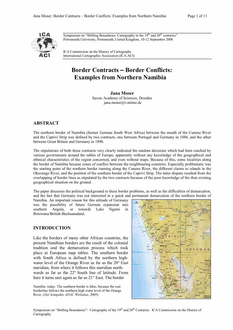
Namibia today. The southern border is false, because the real borderline follows the northern high water level of the Orange River. (Der kompakte ADAC Weltatlas, 2005)
Jana Moser: Border Contracts – Border Conflicts: Examples from Northern Namibia Page 2 of 11
Symposium on “Shifting Boundaries”: Cartography of the 19th and 20th Centuries. ICA Commission on the History of Cartography
then follows this meridian to the north until it reaches the Caprivi Strip which gives the country a connection to the Zambesi River. The northern borders with Zambia and Angola are, from east to west, partly defined by the Zambesi, the Okavango and the Cunene rivers with straight lines in between. This paper discusses some aspects of the northern borders of Namibia including the Caprivi Strip. Apart from defining the border lines between the former colonial powers, it also explains the conflicts which resulted, and the reasons why these came about. Some German examples will illustrate the concept of border representation from the German point of view. BORDER CONTRACTS FOR SOUTH WEST AFRICA (NAMIBIA) The Namibian border was originally defined by two contracts. The first, which specified the northern border of the colony, was signed between Germany and Portugal on 30 December 1886. On 1 July 1890 the second contract between Germany and Great Britain was agreed on with regards to the southern, eastern and northeastern borders. This paper will not attempt to describe the overall history of all the negotiations preceding these contracts, or the ensuing conflicts between Germany and Portugal on the one hand, and Germany and Great Britain on the other. For this there exist adequate and very detailed books by authors such as Demhardt and Hangula. The article of the German-Portuguese contract describing the border between Namibia and Angola from the Cunene to the Zambesi River was of special importance to Namibia. After extensive negotiations, the mouth of the Cunene River was decided on as the starting point of the border line. In the early 1880th, Portugal, because of its process of colonisation, claimed the 18° South line of latitude as the border separating its sphere of influence from that of the British Empire in Southern Africa. However, by 1884 the exercise of German influence in the ‘ownerless’ land between the Orange and the Cunene River, compelled Portugal to again define its sphere of influence. At that time everybody wanted to acquire as much land as possible and especially the Ovambo region was both interesting and problematic. Because of the uncertainty about the correct geographical position of this region, the contract defined that the border would follow the Cunene River “from its mouth to the cataracts which are formed by that river to the south of Humbe when crossing the range of Canná Hills” (Hangula, 1993, p. 19). From this point a line would run along this parallel as far as the River Cubango which meant that the most Ovambo tribes would be divided between the two states. Further east, the line would follow the Cubango/Okavango River until Andara which should remain within the German sphere of interest. From Andara, the contract specified a straight border line to the Katima Mulilo rapids in the Zambesi River which marked the terminal point of this precise definition. From 1889 onwards, Captain Curt von François, the commanding officer of the German troops in South West Africa, undertook various reconnaissance travels through the country as far as Lake Ngami (today Botswana) in the east. This country, which is now called Botswana, was unoccupied at that time and the Germans wanted to also extend their influence into this region. The Cape Colony, however, moved swiftly when it realised that the German colony in the west and the Boer Republics in the east of British South Africa might join forces and obstruct the English dream of a closed British corridor from the Cape to Cairo. On 9 September 1885 Britain’s first move was to lay a claim to the southern Kalahari as the newly created Bechuanaland Protectorate, a territory lying east of 20° East and south of 22° South. However, north 22° South there was still a gap leading to the Lake Ngami. Von François brought back a large number of records and sketch maps and finalised the German claim to the region around Lake Ngami. The British negotiators on the boundary commission realised that the Lake Ngami region was “one of the most valuable portions of South Central Africa” because it was “rich in timber, splendid grasses, and also rich in minerals …” (Demhardt, p. 337), and therefore very valuable to the British Empire, especially because of the possibility of a railway connection between Cape Town and Cairo.
Jana Moser: Border Contracts – Border Conflicts: Examples from Northern Namibia Page 3 of 11
Symposium on “Shifting Boundaries”: Cartography of the 19th and 20th Centuries. ICA Commission on the History of Cartography
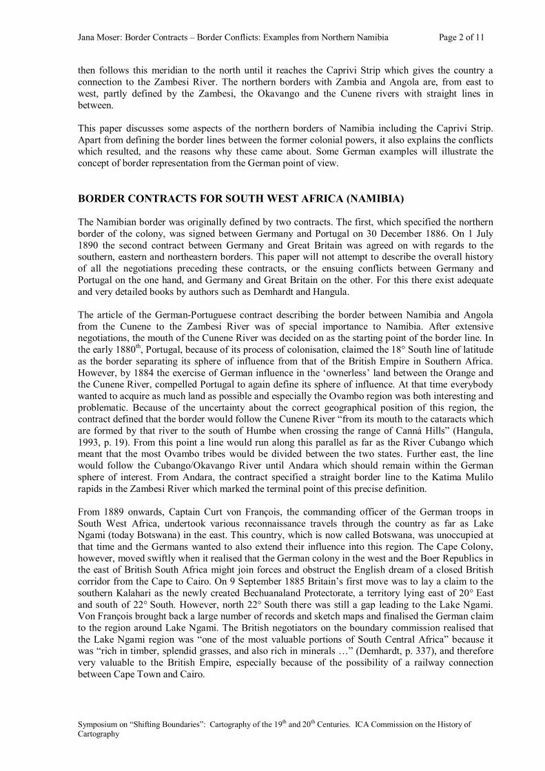
For the contractual negotiations between Germany and Great Britain, the area around Lake Ngami and the Okavango Delta, and especially the sphere of influence to which it pertained, was very important. The British did not want to have the Germans as neighbours in this part of the world, but they had no choice as there were also other controversial regions between Germany and Great Britain in other parts of the world, such as Helgoland, Zanzibar and Walfish Bay. Likewise Germany also wanted to obtain a part of the British hemisphere in Togo, and to achieve this, Germany was willing to make concessions with regards to Lake Ngami. From 22° South northwards, the border would run along 21° East, far away from Lake Ngami and the Okavango Delta. According to the original agreement, the border line had to go up to 18° South and from there eastwards as far as the Chobe River, which it would then follow as far as its confluence with the Zambesi. However, shortly before the signing of the contract, the negotiating parties received information from the area in question that 18° South line of latitude would stand in conflict with the specifications of the German-Portuguese contract as the specified point near Andara was apparently situated slightly south of 18° South. The result would be a gap between the borders as specified by the two contracts – a fact directly attributable to the poor geographical knowledge of the time. To save the contract from failure, a last regulation was introduced, specifying that Germany should have free access from its Protectorate to the Zambesi River and that the Strip should be nowhere less than 20 English miles wide. The fact that this region was unsuitable for permanent European settlement because of its humidity and periodical floods, was an important factor during the difficulties which were encountered during the ensuing years. Many missionaries, soldiers and traders died here because of malaria or other tropical diseases. The geographical knowledge of the whole region was poor, and astronomical observations were rare. The contract with Portugal was, for instance, based upon a small-scale Portuguese map, and the course of the green-table border between Germany and Great Britain in Africa fixed using a map which had been compiled for the British government in 1889. („Der Verlauf dieser Grünen-Tisch-Grenze wurde nach Maßgabe einer Karte festgelegt, welche im Jahr 1889 amtlich für die britische Regierung angefertigt wurde“ (Hangula 1991, p. 205). POINTS OF CONTENTION ALONG THE NORTHERN BORDER AND ITS MAP-REPRESENTATION Points of contention There are three interesting localities along the northern border of Namibia which were not clearly defined by the contracts and which, in the period 1887 to 1914, created many border conflicts and political negotiations between Germany and Portugal.
Map of the border conflicts in northern Namibia (1900: German South West Africa). Green lines show the conventionbetween Germany and Portugal from 1886, Red lines show the convention between Germany and Great Britain from 1890.
Jana Moser: Border Contracts – Border Conflicts: Examples from Northern Namibia Page 4 of 11
Symposium on “Shifting Boundaries”: Cartography of the 19th and 20th Centuries. ICA Commission on the History of Cartography
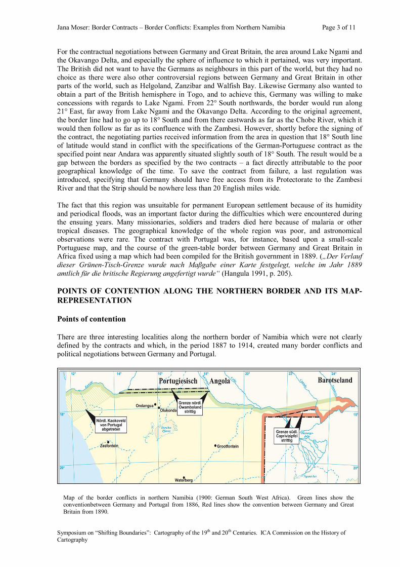
The first of these localities is the starting point of the straight line through the Ovambo region from the Cunene River to the Cubango River. Acording to the contract, this point was situated at the cataracts south of Humbe where the Cunene flows through the so-called Serra Canna. However, after some investigations by both Germany and Portugal, there was still no agreement as to where the correct starting point was located. Portugal specified the cataracts of Kambele (or Ruacana) as the correct location, whereas Germany proposed the cataracts of Kazombua further north. Between these two positions there exists a gap of about 5’58” or 11 km. In this critical zone of more than 400 km long live thousands of inhabitants and the gap caused the same problems at the Cubango River where the straight line terminates. In 1909 the German surveyor Schmidt was sent to the Cunene River to survey the relevant region. He completed a map of the area and also took some photographs. The photos show that the Portuguese “Serra Canna” was an invented phenomenon as there are no mountains or higher rocks near the cataracts of Ruacana. Because of this uncertainty, many indigenous tribes and thousands of potential workers were not sure to which of the two countries they belong. The conflict at the Cunene River caused also some border conflicts at the Okavango River. Germany namely recommended that the controversial 11 km should be respected as neutral, but Portugal at the Okavango erected structures not only within the neutral zone, but also directly on German territory. The second critical locality occurred where the border line was supposed to leave the Okavango River to follow a straight line to the Katima Mulilo rapids in the Zambesi River. According to the contract, the settlement called Andara had to be under German authority. Andara was the residence of the chief of the Mbukushu and was situated on the isle of Sibanana in the Okavango River. From the German side, the region north of the “red line” (the animal disease-protection fence), especially the Ovamboland and Caprivi Strip, was not under direct control or administration. In 1909 Portugal began to subordinate the tribes by force and to erect posts at every tribe. In the meantime the old chief of the Mbukushu had died, after which the new chief established his residence at a place called Libebe, situated a few kilometres south of the ancestral seat. It was here that the Portuguese built a fort on a locality which was clearly situated on German territory. The presence of this fort caused serious conflict with German patrols whereas Portugal excused its actions by pretending ignorance about the real location of Andara. According to Portugal, Andara and Libebe were the same place. It was natural that the German government would be scared by these actions as it was afraid that Portugal would take
Map of the location of the places Andara and Libebe at the Okawango River, 1909. (Namibia National Archives, Windhoek, ZBU-1010)
Jana Moser: Border Contracts – Border Conflicts: Examples from Northern Namibia Page 5 of 11
Symposium on “Shifting Boundaries”: Cartography of the 19th and 20th Centuries. ICA Commission on the History of Cartography
possession of the land by establishing facts and influencing the inhabitants. Because of the lack of geographical knowledge of the area, the negotiators of the contracts were under the false impression that the line between Andara (the Okavango River) and the rapids of Katima Mulilo (Zambesi) more or less followed a parallel. The third critical section of the border of northern Namibia was the southern border of the Caprivi Strip which became contentious because of the differences between Germany and Great Britain. As carried out earlier, the original idea was to follow the 18° South line of latitude eastwards as far as the Cuito River. However, according to the German-Portuguese-Contract, Andara was already situated south of 18° South. The paragraph on the at least 20 miles-wide corridor between the German Protectorate and the Zambesi River which had been inserted into the contract, was interpreted differently by the two opponents. The eventual German position was to insist that the smallest area should be 20 miles and that from there it should be a parallel (see below), whereas Britain wanted a parallel line of 20 miles to the Andara–Katima Mulilo border. The Caprivi Strip only came under German administration in 1909 when the British complained that the region was a source of illegal black and white ‘elements’ such as murderers, traders and hunters. Borderline presentation on German maps The borderlines of northern Namibia, especially the contentious points and regions, were depicted very differently on early German maps which, in turn, showed different realities from what appeared on Portuguese and British maps.
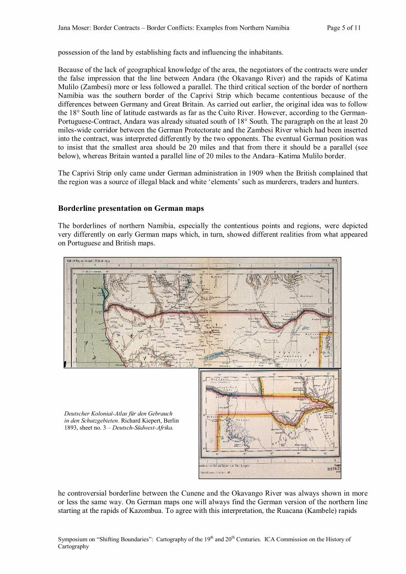
he controversial borderline between the Cunene and the Okavango River was always shown in more or less the same way. On German maps one will always find the German version of the northern line starting at the rapids of Kazombua. To agree with this interpretation, the Ruacana (Kambele) rapids
Deutscher Kolonial-Atlas für den Gebrauch in den Schutzgebieten. Richard Kiepert, Berlin 1893, sheet no. 3 – Deutsch-Südwest-Afrika.
Jana Moser: Border Contracts – Border Conflicts: Examples from Northern Namibia Page 6 of 11
Symposium on “Shifting Boundaries”: Cartography of the 19th and 20th Centuries. ICA Commission on the History of Cartography
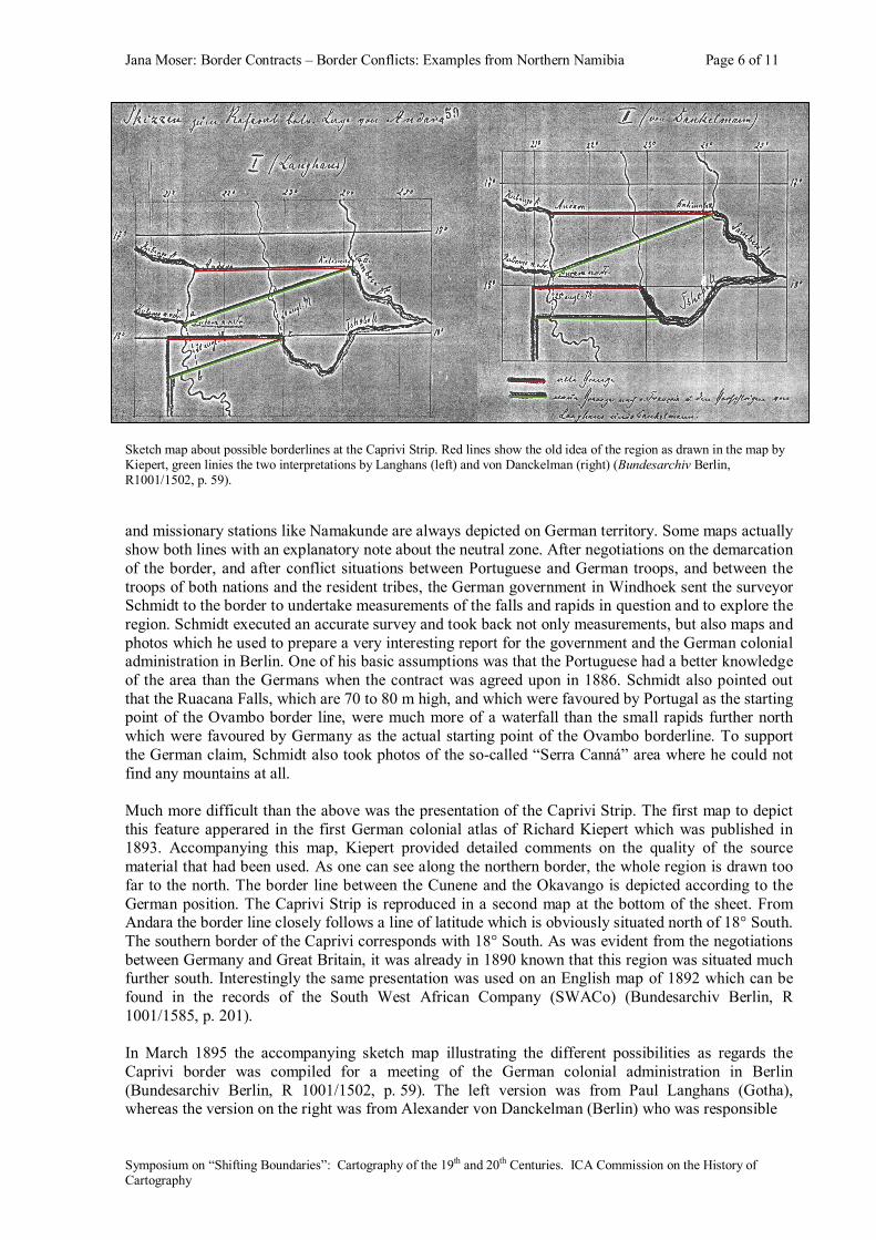
Sketch map about possible borderlines at the Caprivi Strip. Red lines show the old idea of the region as drawn in the map by Kiepert, green linies the two interpretations by Langhans (left) and von Danckelman (right) (Bundesarchiv Berlin, R1001/1502, p. 59). and missionary stations like Namakunde are always depicted on German territory. Some maps actually show both lines with an explanatory note about the neutral zone. After negotiations on the demarcation of the border, and after conflict situations between Portuguese and German troops, and between the troops of both nations and the resident tribes, the German government in Windhoek sent the surveyor Schmidt to the border to undertake measurements of the falls and rapids in question and to explore the region. Schmidt executed an accurate survey and took back not only measurements, but also maps and photos which he used to prepare a very interesting report for the government and the German colonial administration in Berlin. One of his basic assumptions was that the Portuguese had a better knowledge of the area than the Germans when the contract was agreed upon in 1886. Schmidt also pointed out that the Ruacana Falls, which are 70 to 80 m high, and which were favoured by Portugal as the starting point of the Ovambo border line, were much more of a waterfall than the small rapids further north which were favoured by Germany as the actual starting point of the Ovambo borderline. To support the German claim, Schmidt also took photos of the so-called “Serra Canná” area where he could not find any mountains at all. Much more difficult than the above was the presentation of the Caprivi Strip. The first map to depict this feature apperared in the first German colonial atlas of Richard Kiepert which was published in 1893. Accompanying this map, Kiepert provided detailed comments on the quality of the source material that had been used. As one can see along the northern border, the whole region is drawn too far to the north. The border line between the Cunene and the Okavango is depicted according to the German position. The Caprivi Strip is reproduced in a second map at the bottom of the sheet. From Andara the border line closely follows a line of latitude which is obviously situated north of 18° South. The southern border of the Caprivi corresponds with 18° South. As was evident from the negotiations between Germany and Great Britain, it was already in 1890 known that this region was situated much further south. Interestingly the same presentation was used on an English map of 1892 which can be found in the records of the South West African Company (SWACo) (Bundesarchiv Berlin, R 1001/1585, p. 201). In March 1895 the accompanying sketch map illustrating the different possibilities as regards the Caprivi border was compiled for a meeting of the German colonial administration in Berlin (Bundesarchiv Berlin, R 1001/1502, p. 59). The left version was from Paul Langhans (Gotha), whereas the version on the right was from Alexander von Danckelman (Berlin) who was responsible
Jana Moser: Border Contracts – Border Conflicts: Examples from Northern Namibia Page 7 of 11
Symposium on “Shifting Boundaries”: Cartography of the 19th and 20th Centuries. ICA Commission on the History of Cartography
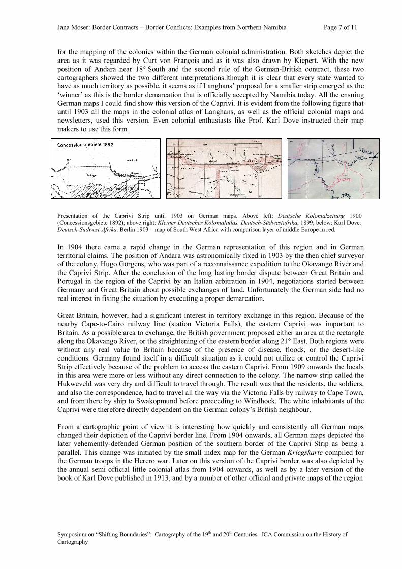
for the mapping of the colonies within the German colonial administration. Both sketches depict the area as it was regarded by Curt von François and as it was also drawn by Kiepert. With the new position of Andara near 18° South and the second rule of the German-British contract, these two cartographers showed the two different interpretations.lthough it is clear that every state wanted to have as much territory as possible, it seems as if Langhans’ proposal for a smaller strip emerged as the ‘winner’ as this is the border demarcation that is officially accepted by Namibia today. All the ensuing German maps I could find show this version of the Caprivi. It is evident from the following figure that until 1903 all the maps in the colonial atlas of Langhans, as well as the official colonial maps and newsletters, used this version. Even colonial enthusiasts like Prof. Karl Dove instructed their map makers to use this form.
In 1904 there came a rapid change in the German representation of this region and in German territorial claims. The position of Andara was astronomically fixed in 1903 by the then chief surveyor of the colony, Hugo Görgens, who was part of a reconnaissance expedition to the Okavango River and the Caprivi Strip. After the conclusion of the long lasting border dispute between Great Britain and Portugal in the region of the Caprivi by an Italian arbitration in 1904, negotiations started between Germany and Great Britain about possible exchanges of land. Unfortunately the German side had no real interest in fixing the situation by executing a proper demarcation. Great Britain, however, had a significant interest in territory exchange in this region. Because of the nearby Cape-to-Cairo railway line (station Victoria Falls), the eastern Caprivi was important to Britain. As a possible area to exchange, the British government proposed either an area at the rectangle along the Okavango River, or the straightening of the eastern border along 21° East. Both regions were without any real value to Britain because of the presence of disease, floods, or the desert-like conditions. Germany found itself in a difficult situation as it could not utilize or control the Caprivi Strip effectively because of the problem to access the eastern Caprivi. From 1909 onwards the locals in this area were more or less without any direct connection to the colony. The narrow strip called the Hukweveld was very dry and difficult to travel through. The result was that the residents, the soldiers, and also the correspondence, had to travel all the way via the Victoria Falls by railway to Cape Town, and from there by ship to Swakopmund before proceeding to Windhoek. The white inhabitants of the Caprivi were therefore directly dependent on the German colony’s British neighbour. From a cartographic point of view it is interesting how quickly and consistently all German maps changed their depiction of the Caprivi border line. From 1904 onwards, all German maps depicted the later vehemently-defended German position of the southern border of the Caprivi Strip as being a parallel. This change was initiated by the small index map for the German Kriegskarte compiled for the German troops in the Herero war. Later on this version of the Caprivi border was also depicted by the annual semi-official little colonial atlas from 1904 onwards, as well as by a later version of the book of Karl Dove published in 1913, and by a number of other official and private maps of the region
Presentation of the Caprivi Strip until 1903 on German maps. Above left: Deutsche Kolonialzeitung 1900 (Concessionsgebiete 1892); above right: Kleiner Deutscher Kolonialatlas, Deutsch-Südwestafrika, 1899; below: Karl Dove: Deutsch-Südwest-Afrika. Berlin 1903 – map of South West Africa with comparison layer of middle Europe in red.
Jana Moser: Border Contracts – Border Conflicts: Examples from Northern Namibia Page 8 of 11
Symposium on “Shifting Boundaries”: Cartography of the 19th and 20th Centuries. ICA Commission on the History of Cartography
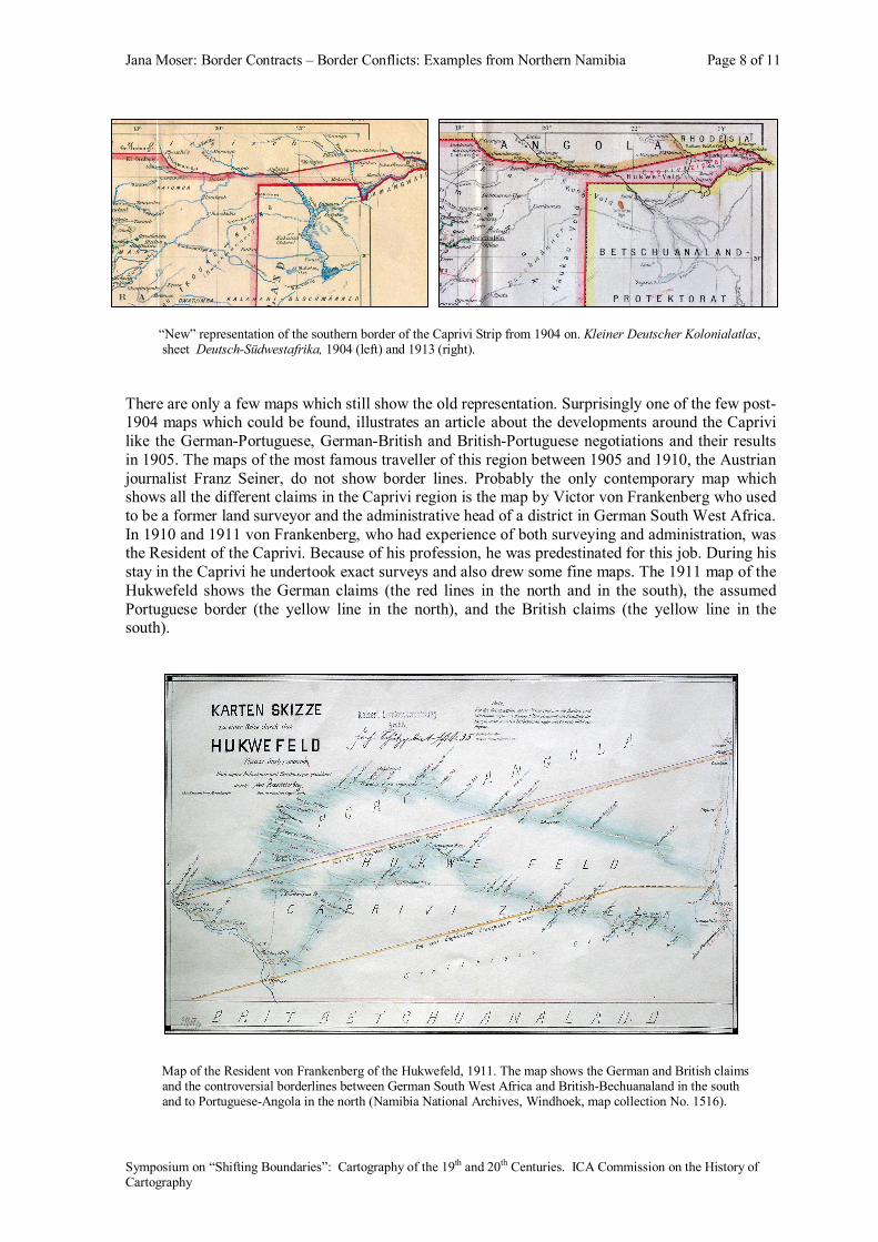
“New” representation of the southern border of the Caprivi Strip from 1904 on. Kleiner Deutscher Kolonialatlas, sheet Deutsch-Südwestafrika, 1904 (left) and 1913 (right). There are only a few maps which still show the old representation. Surprisingly one of the few post-1904 maps which could be found, illustrates an article about the developments around the Caprivi like the German-Portuguese, German-British and British-Portuguese negotiations and their results in 1905. The maps of the most famous traveller of this region between 1905 and 1910, the Austrian journalist Franz Seiner, do not show border lines. Probably the only contemporary map which shows all the different claims in the Caprivi region is the map by Victor von Frankenberg who used to be a former land surveyor and the administrative head of a district in German South West Africa. In 1910 and 1911 von Frankenberg, who had experience of both surveying and administration, was the Resident of the Caprivi. Because of his profession, he was predestinated for this job. During his stay in the Caprivi he undertook exact surveys and also drew some fine maps. The 1911 map of the Hukwefeld shows the German claims (the red lines in the north and in the south), the assumed Portuguese border (the yellow line in the north), and the British claims (the yellow line in the south).
Map of the Resident von Frankenberg of the Hukwefeld, 1911. The map shows the German and British claims and the controversial borderlines between German South West Africa and British-Bechuanaland in the south and to Portuguese-Angola in the north (Namibia National Archives, Windhoek, map collection No. 1516).
Jana Moser: Border Contracts – Border Conflicts: Examples from Northern Namibia Page 9 of 11
Symposium on “Shifting Boundaries”: Cartography of the 19th and 20th Centuries. ICA Commission on the History of Cartography
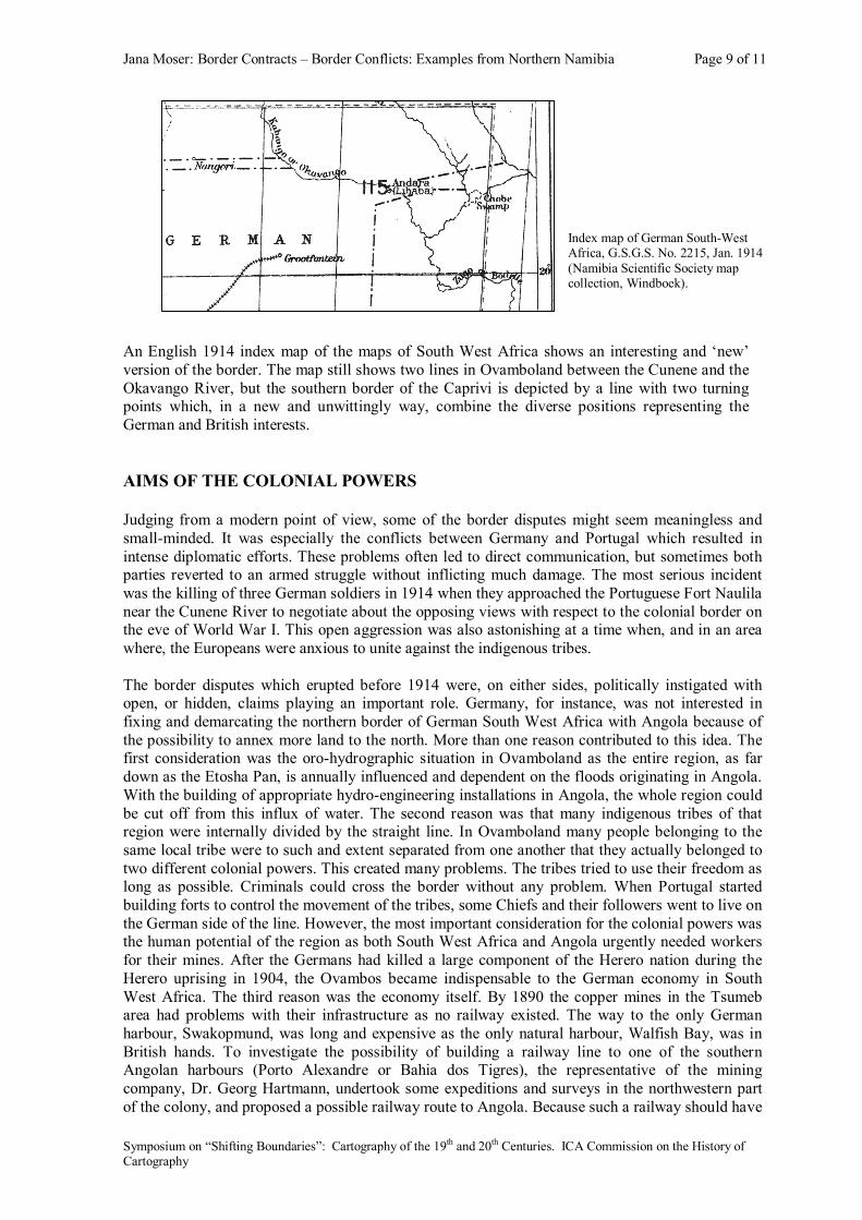
Index map of German South-West Africa, G.S.G.S. No. 2215, Jan. 1914 (Namibia Scientific Society map collection, Windboek).
An English 1914 index map of the maps of South West Africa shows an interesting and ‘new’ version of the border. The map still shows two lines in Ovamboland between the Cunene and the Okavango River, but the southern border of the Caprivi is depicted by a line with two turning points which, in a new and unwittingly way, combine the diverse positions representing the German and British interests. AIMS OF THE COLONIAL POWERS Judging from a modern point of view, some of the border disputes might seem meaningless and small-minded. It was especially the conflicts between Germany and Portugal which resulted in intense diplomatic efforts. These problems often led to direct communication, but sometimes both parties reverted to an armed struggle without inflicting much damage. The most serious incident was the killing of three German soldiers in 1914 when they approached the Portuguese Fort Naulila near the Cunene River to negotiate about the opposing views with respect to the colonial border on the eve of World War I. This open aggression was also astonishing at a time when, and in an area where, the Europeans were anxious to unite against the indigenous tribes. The border disputes which erupted before 1914 were, on either sides, politically instigated with open, or hidden, claims playing an important role. Germany, for instance, was not interested in fixing and demarcating the northern border of German South West Africa with Angola because of the possibility to annex more land to the north. More than one reason contributed to this idea. The first consideration was the oro-hydrographic situation in Ovamboland as the entire region, as far down as the Etosha Pan, is annually influenced and dependent on the floods originating in Angola. With the building of appropriate hydro-engineering installations in Angola, the whole region could be cut off from this influx of water. The second reason was that many indigenous tribes of that region were internally divided by the straight line. In Ovamboland many people belonging to the same local tribe were to such and extent separated from one another that they actually belonged to two different colonial powers. This created many problems. The tribes tried to use their freedom as long as possible. Criminals could cross the border without any problem. When Portugal started building forts to control the movement of the tribes, some Chiefs and their followers went to live on the German side of the line. However, the most important consideration for the colonial powers was the human potential of the region as both South West Africa and Angola urgently needed workers for their mines. After the Germans had killed a large component of the Herero nation during the Herero uprising in 1904, the Ovambos became indispensable to the German economy in South West Africa. The third reason was the economy itself. By 1890 the copper mines in the Tsumeb area had problems with their infrastructure as no railway existed. The way to the only German harbour, Swakopmund, was long and expensive as the only natural harbour, Walfish Bay, was in British hands. To investigate the possibility of building a railway line to one of the southern Angolan harbours (Porto Alexandre or Bahia dos Tigres), the representative of the mining company, Dr. Georg Hartmann, undertook some expeditions and surveys in the northwestern part of the colony, and proposed a possible railway route to Angola. Because such a railway should have
Jana Moser: Border Contracts – Border Conflicts: Examples from Northern Namibia Page 10 of 11
Symposium on “Shifting Boundaries”: Cartography of the 19th and 20th Centuries. ICA Commission on the History of Cartography
ideally been in German hands, Germany was very interested in the southern parts of Angola. All these reasons contributed to the fact that Germany was not interested in a definite solution of the border line problem. As part of its propaganda campaign against Portugal, Germany maintained that the Portuguese nation would not be able to colonise any further areas and that they would not be able to defend the territory agains the native inhabitants. A similar situation existed inside the Caprivi Strip. Here the main problem for Germany was the lack of information and geographical knowledge of the region. Whilst the Britains built a railway line a few kilometres off the eastern border of German South West Africa, the Germans were completely ignorant about the country and its inhabitants. Having access to the eastern parts of the Caprivi was much easier via British territory than by crossing the dry and dangerous Hukwefeld inside the Strip. The Caprivi was therefore of more interest to the Britains than to the Germans. Instead of suggesting a fair territorial exchange with, for instance, Walfish Bay which was the only real harbour in South West Africa and a British enclave, Britain only offered dry and useless land. The result was that Germany, knowing that the Zambesi was not navigable in this area, adhered to its access to the Zambesi River and the possible connection to German East Africa RESULTS, SURVEYING AND DEMARCATION It is evident from the above that neither Germany, nor Great Britain, or Portugal, was interested to, even temporarily, fix, survey or demarcate the controversial borders. Whenever one party expressed its interest, the others stalled the process by asking for more time. Apart from the political problems, the topography and climate also made it difficult to undertake accurate measurements to demarcate the border line in the landscape. Because of all these problems no demarcation of the northern borders of Namibia took place until the outbreak of World War I in 1914. After the War and with the end of the German colonial period, and with the beginning of the Mandatory Administration of South Africa in South West Africa, there was a huge interest to solve the border line problems as quickly as possible and to inequivocally fix the borders on the ground. When South Africa took charge of the administration, the South African government ignored all discussions and agreements between Germany and Portugal in favour of Portugal’s claims. The decision on the position of the southern border of the Caprivi was, of course, according to Britain’s claims with the result that the negotiations were concluded relatively quickly. The surveying of the northern border of the Caprivi Strip could only start in 1930. Because of the costs involved, the surveying and mapping of the southern border of the Caprivi could not begin until 1958 with the result that the demarcation was only completed in 1965. The negotiations between Portugal and the South African Administration on the Ovamboland border between the Cunene and the Okavango River commenced as early as 1920 and was concluded in 1926. The convention of Cape Town assigned the whole neutral zone to Angola and the demarcation was done in 1927 and 1928 by a surveying commission with representatives from both countries. Today the Caprivi Strip is regarded as a direct result of the demarcation of borders by European countries having no knowledge of local conditions. When deciding about the borders, nobody spoke on behalf of the natives with the result that their tribal lands were severely partitioned. Today the local people of the Caprivi are not only far away from their government, but also differ in both culture and language from the other inhabitants of Namibia. REFERENCES Demhardt, Imre Josef: Deutsche Kolonialgrenzen in Afrika – Historisch geographische Untersuchungen ausgewählter Grenzräume von Deutsch-Südwestafrika und Deutsch-Ostafrika. Hildesheim/Zürich/New York, 1997.
Jana Moser: Border Contracts – Border Conflicts: Examples from Northern Namibia Page 11 of 11
Symposium on “Shifting Boundaries”: Cartography of the 19th and 20th Centuries. ICA Commission on the History of Cartography
Hangula, Lazarus: Die Grenzziehungen in den afrikanischen Kolonien Englands, Deutschlands und Portugals im Zeitalter des Imperialismus 1880–1914. Frankfurt a. M. 1991. Hangula, Lazarus: The International Boundary of Namibia. Windhoek 1993. BIOGRAPHY Dr Jana Moser studied Cartography at the University of Applied Sciences in Dresden from 1994 to 1998. Since 2004 she is employed as a project manager at the Saxon Academy of Sciences in Dresden on the project “Atlas for History and Applied Geography of Saxony”. Her dissertation deals with the “Mapping history of South West Africa / Namibia from the beginning up to independence in 1990”.