book cliffs coal field - usgs · reconnaissance of the book cliffs coal field, between grand riyer,...
TRANSCRIPT

DEPARTMENT OF THE 1NTEKIOK
UNITED STATES GEOLOGICAL SURVEYGEORGE OTIS SMITH, DIRECTOR
IX 371
RECONNAISSANCE
Of THE
BOOK CLIFFS COAL FIELD
BETWEEN GRAND RIVER, COLORADOAND SUNNYSIDE, UTAH
BY
G. B. RICHARDSON
WASHINGTONGOVERNMENT .PRINTING OFFICE
1909


CONTENTS.
Page.Introduction.............................................................. 5Topography............................................................... 7
Relief and drainage.................................................... 8Lowland at base of Book Cliffs......................................... 9Book Cliffs............................................................. 10Book or Tavaputs Plateau.............................................. 10
Climate and culture ........................................................ 11Descriptive geology........................................................ 11
Stratigraphy.......................................................... 11Cretaceous system................................................. 12
Dakota sandstone.............................................. 12Mancos shale.................................................. 14Mesaverde formation........................................... 16
Tertiary system Eocene series..................................... 19Structure.............................................................. 21
Coal....................................................................... 23General statement...................................................... 23Occurrence and thickness............................................... 24Amount of available coal............................................... 42Character and use of Book Cliffs coal..................................... 42
Physical properties................................................ 42Chemical composition.............................................. 43Market and use.................................................... 47
Development.......................................................... 48Index................................................................... 53

ILLUSTRATIONS.
Page. PLATE I. Map of part of the Book Cliffs coal field............................ 5
II. A, Bench at base of Book Cliffs, east of Thompsons; B, Fault inMesaverde formation, 2 miles south of Carbonera.................. 10
III. Generalized columnar section of the rocks of the Book Cliffs coalfield.......................................................... 12
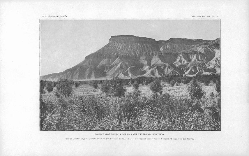
IV. Mount Garfield, 9 miles east of Grand Junction..................... 14V. A, Typical exposure of Mesaverde formation, north of Thompsons:
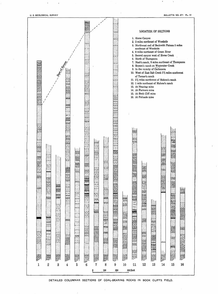
B, Outcrop of coal in valley of Saleratus Creek.................... 1(5VI. Detailed columnar sections of coal-bearing rocks in Book Cliffs field.. 22
VII. Little Book Cliffs and Grand River northeast of Palisades........... 24VIII. Coal sections in Book Cliffs coal field.............................. 24
IX. A, Ballard's coal mine, north of Thompsons; B, Outcrop of coal atentrance to Ballard's mine, showing jointing of coal.............. 38
X. Property of the Book Cliff Mine Company at the base of the cliffsnorth of Grand Junction........................................ 48
FIGUKB 1. Map showing relation of the Book Cliffs field to adjacent coal fields. 7

U.S.GEOLOGICAL SURVEY GEORGE OTIS SMITH, DIRECTOR BULLETIN NO. 371 PL.I.
:TjaH,FIEI.D COCO.
I , I I h
LIST OF MINES AND PHOKPKOTS
1. Cameo mine.2. Prospect on upper coal.
. Mt. Lincoln mine.4. Riverside mine.5. Prospect on upper coal.6. Palisade mine.7. Garfleld mine.S. Prospect on lower coal.9. Old Book Cliff mine.
10. Book Cliff mine.11. Keystone or Steele mine
. Black Diamond mine.13. Farmers mine.14. Bob Cat mine.15. Excelsior mine.16. Corcoraa mine17. Hunter mine.18. Kiel or Gross mine.19. Nugent mine. 90. Nearing mine.31. Mott prospect.32. Johnson mine.
. Lane mine.34. Prospect.35. Uinta Railroad Company's mine26. Coal outcrop.27. Coal outcrop. 38. Coal outcrop. 29. Ballard mine. 80. Prospect.31. Prospect.32. Black Baby mine 38. Peterson's prospect 94. Prospect. 35. Prospect.
. Horse Canyon mine. r
B E C K W 1 T H
5° 113° HI* 109° 107° |O5° !O3 10!
Eocene Mesavraxle formation Maneos shale Dakota, sandstone In Book. Cliff's area.) Alternating >mff sand- Bleuiktx) daifcolay sliale, Buff sandstone and con
Varicolored, shales,'baft' stone and dark shale fevrlense.s of limestone, ^loiriei'atje,occa,siorj alsaiidstoTLe,thiii_liaitistc»iie.J witKTforkablftlieds of aiulth.iit'becls of loiiff shale andlo^w-gi'ad.e coal.andbasal con^lomeracbe coal in the; "lower part saxid.stone at the top
Prospect
15 so miles
..-____13' III" 109° 107s IO5° 1O3
Base compiled froTi Hayden and Poweil surveys . U.S. Land Office and railroad maps
i 10°! 30'
feet .OD QOO./f
_ r- 8 000- o ooo 4 OOO
2000
RECONNAISSANCE .MAI' AND CROSS SECTION OF PART OF THE BOOK CLIFFS COAL FIELD, COLORADO AND UTAHBy CiB-Kiekardscm and L.J.Pe;ppe,rberg, LHO6
19O8

RECONNAISSANCE OF THE BOOK CLIFFS COAL FIELD, BETWEEN GRAND RIYER, COLORADO, AND SUNNY- SIDE, UTAH. ____
By G. B. RICHARDSON.
INTRODUCTION."
The Book Cliffs coal field is part of the southern rim of the Uinta Basin, which is an immense structural trough in western Colorado and eastern Utah, around whose margin the outcrop of coal-bearing rocks can be traced for more than 500 miles. (See fig. 1.) From the vicinity of Mount Hilgard, in central Utah, northward to Castle- gate, the coal measures form the eastern escarpment of the Wasatch Plateau. Thence they trend southeastward to Grand River, out cropping in the Book Cliffs. Beyond Grand River they continue eastward, forming the southern face of Grand Mesa, to the vicinity of Crested Butte. From this point the coal-bearing rocks trend northward and cross Grand River again near Newcastle. North of Grand River they form the Grand Hogback, and beyond the Dan- forth Hills the trend is westward along the southern flank of ther\ "
Uinta Mountains. This great basin of coal-bearing rocks has been but partially prospected, arid mines are in operation in only a few localities, but enough of the area has been explored to prove that it is one of the most important coal reserves of the Rocky Mountain region. As a whole, this area is a distinct unit, but for convenience of study and description, it is divided into several parts. The Book Cliffs field is that portion of the southern rim of the Uinta Basin which includes the Book'Cliffs and lies between Grand River, Colo rado, and the Wasatch Plateau, Utah.
The geology of the Book Cliffs was first studied by A. C. Peale,* of the Hayden Survey, who in 1876 examined the eastern part of the field. The western part was included in G. H. Eldridge's map of the Uinta Basin published in connection with his study of asphalt and bituminous rock deposits/ Until recently these papers have
<j An abstractor this report was printed in Contributions to Economic Geology, 1906, Part II: Bull. U. S. Geol. Survey No. 316, 1907.
ftPeale, A. C., Geological report on the Grand River district: Tenth Ann. Kept. U. S. Geol. and Gcog. " Survey Terr., 1878, pp. 170-185.
cEldridge, G. H., Asphalt and bituminous rock deposits of the United States: Twenty-second Ann. Kept. U. S. Geol. Survey, pt. 1, 1901, p. 332.
5

6 THE BOOK CLIFFS COAL FIELD.
been the only available systematic geologic reports of the region. The presence of coal in the Book Cliffs has long been known. The deposits are mentioned by R. C. Hills 0 in his report on the coal fields of Colorado, and by L. S. Storrs 6 in his paper on the Rocky Mountain coal fields. Arthur Lakes has also referred to part of the area c and has described the Book Cliff mine.d But the coal field was not examined in detail until 1905, when J. A. Taff, e of the United States Geological Survey, studied the western part of the field from the vicinity of Sunnyside to Castlegate, Utah, and its southern con tinuation along the escarpment of the Wasatch Plateau.
During three months of the season of 1906 the writer, assisted by W. D. Neal, L. J. Pepperberg, and C. D. Perrin, made a recon naissance survey of the eastern part of the Book Cliffs field from Grand River westward to the termination of Taff's work. The attention of the party was devoted mainly to a study of the occur rence of the coal. The boundary between the Mancos shale and the Mesaverde formation the most easily recognized horizon near est the coal was followed throughout the field, but in the time available detailed mapping of the formations could not be attempted. The location of the Dakota sandstone outcrop below the Mancos shale and the position of the base of the Eocene above the Mesaverde forma tion were determined only at certain localities, and the boundary between these formations, shown on Plate I by a dotted line, is only approximately located.
TOPOGRAPHY.
The Book Cliffs form the southern margin of the Book or TavaputsPlateau, which is situated in the central part of the Colorado Plateauprovince, between the Rocky Mountains and the Wasatch Range.The southward-facing cliffs, which, extend in a great east-west linefrom Grand River to Castlegate, lie north of and generally in sightof the Denver and Rio Grande Railroad and are one of the most
I striking topographic features along that railroad. The cliffs do notI form an unbroken wall, but locally are deeply cut by small streamsUnto a series of spurs which, although much lower than the mainmass of the plateau to the north, tower above and dominate thegreat plain at their base. This plain is eroded in the soft shaleunderlying the coal-bearing rocks, and it affords a route for therailroad which closely skirts the foot of the cliffs throughout most
. "Hills, R. C., Coal fields of Colorado: Mineral Resources U. S. for 1892, U. S. Geol. Survey, 1893, p. 353.*> Storrs, L. S., The Rocky Mountain coal field: Twenty-second Ann. Kept. U.S. Geol. Survey, pt. 3,1901,
p. 436.c Lakes, Arthur, The Grand River coal field: Mining Reporter, vol. 51, 1905, pp. 379-381.d Lakes, Arthur, The Book Cliffs coal mine: Mines and Minerals, vol. 24, 1904, pp. 289-291.eTaff, J. A., The Book Cliffs coal field: Bull. U. S. Geol. Survey No. 285, 1906, pp. 289-302.

TOPOGRAPHY. 7
of their extent. South of this broad valley stratigraphically lower i and harder rocks are exposed in the Uncompahgre Plateau and the '
San Rafael Swell, two great anticlinal uplifts south of the Uinta Basin.

8 THE BOOK CLIFFS COAL FIELD.
RELIEF AND DRAINAGE.
The altitude of the surface throughout the Book Cliffs field ranges from about 4,000 feet in the lowlands to 8,000 and 9,000 feet above sea level on the plateau. The area is drained by Green and Grand rivers, which unite to form the Colorado about 60 miles south of the Book Cliffs.
Green River, after leaving the Uinta Mountains, flows in a south westerly direction across the Uinta Basin and cuts through the Tavaputs Plateau in a steep, narrow gorge known as " Desolation Canyon." M the mouth of the canyon in the Book Cliffs the stream emerges into the lowlands, where it meanders in a broad valley for 10 or 12 miles. It flows across the belt of lowland and enters an other canyon on its way to its junction with the Grand. Green River receives a number of large tributaries in the Uinta Basin Yampa and White rivers on the east and Uinta and Duchesne on the west; but in its canyon course through the Tavaputs Plateau the only important branch is Price River, and in the lowland south of the Book Cliffs there is no addition to its flow. East of Desolation Canyon the plateau drains northward by Kwiant and Yogowotsi creeks, which, rising near the rim of the Book Cliffs, enter the river a few miles below the mouth of White River.
Price River rises on the Wasatch Plateau, flows southeastward, and emerges from the canyon it has cut in the plateau at Castlegate. Thence it flows along the broad lowland valley at the base of the Book Cliffs for a distance of 25 miles. Instead of continuing in the lowland, however, it crosses the northern end of the San Raf ael Swell, flows directly across the lowland valley again, cuts a deep canyon which separates Beckwith Plateau from the Tavaputs Plateau, and finally enters Green River about 6 miles above the mouth of Desola tion Canyon.
Grand River, rising near the Continental Divide, on the Front Range of the Rocky Mountains, in Middle Park, Colorado, flows southwestward and enters the area under consideration at the mouth of Roan Creek in a relatively broad valley. A few miles below Roan Creek the river enters Hogback Canyon, in which it flows through the Little Book Cliffs and emerges into the lowland immediately above the town of Palisades. The river crosses the lowland, a distance of about 13 miles, to the town of Grand Junction, where it is joined by Gunnison River. The Grand then turns abruptly northwestward and follows the south ern margin of the lowland for 18 miles. Below Fruita it leaves the lowland, and again flowing southwestward cuts across the northern end of the Uncompahgre Plateau, and continuing southwestward, mostly in a canyon course, finally joins the Green.
With the exception of the Gunnison, Grand River receives no large tributaries in the Book Cliffs field. The most important is Roan

TOPOGRAPHY. 9
Creek, which drains the area between the Little Book Cliffs and the Book Plateau northwest of De Beque. The streams which flow south ward from the Book Plateau are small, and on account of the slight precipitation and limited drainage area flow intermittently through out the year. During the dry months the discharge even within the highlands almost ceases and the stream beds across the lowlands are dry.
The relation of the through-flowing streams to the lowland indi cates that their general courses were defined before the development of the present topography, for there is little adjustment between the drainage and the outcrops of the hard and soft formations. Grand River conforms only partially with the trend of the lowland; Green River maintains its way directly across the shale belt; Price River, flowing alternately over hard and soft rocks, instead of continuously in the shale lowland, is a good example of superimposed drainage.
LOWLAND AT BASE OF BOOK CLIFFS.
The lowland at the base of the Book Cliffs extends in a curved but general westerly direction from Palisades, Colo., to Helper, Utah, a distance of 190 miles. From Palisades it continues southeastward between the Uncompahgre Plateau and Grand Mesa, and from Helper the lowland extends southward between the San Rafael Swell and the Wasatch Plateau, where it is known as Castle Valley. Throughout its extent the lowland is underlain by shale and is not a stream valley in the sense of being carved and occupied by a single master stream; instead, the lowland has been eroded in soft rock by general subaerial action and forms part of several drainage basins. The lowland has been widened by the gradual recession of the Book Cliffs northward due to the weathering of the soft shale and the undermining of the overlying hard sandstone which forms the cliffs. By this process the cliffs have retreated, but they have maintained a fairly regular front.
The average width of the lowland is about 12 miles, having a maxi mum of 23 miles, in the vicinity of Cisco, and a minimum of 4 miles, near Woodside. The lowland is an undulating plain that rises gently toward the bordering highlands and extends between the Book Cliffs on the north and a belt of sandstone hills on the south. It practically coincides with the outcrop of the Mancos shale. The small streams that head in the Book Cliffs and cross the lowland have carved steep arroyos, which impede travel. In the vicinity of the cliffs there are outlying buttes and the shale is eroded into badlands. Adjoining the cliffs there are local fringing remnants of an old outwash gravel- covered plain into which the streams have cut their way 100 feet or more, and south of Grand River, near Palisades, a number of terraces are well developed. The largest, about 150 feet above the river, is

10 THE BOOK CLIFFS COAL FIELD.
between a quarter and a half mile wide, and traces of several other less distinct terraces have been found above this one.
BOOK CLIFFS.
The Book Cliffs occupy a belt from 1 to 10 miles wide and rise above the adjacent lowland from 2,000 to 6,000 feet. In places the rise is abrupt in one or two sharp precipices; elsewhere it is accomplished by a series of cliffs and intervening benches. The rocks composing the escarpment are alternating beds of sandstone and shale dipping slightly northward, and the strata present the appearance of the leaves of a book lying flat, hence the name.
In the area here discussed the cliffs extend in an S-shaped belt from Palisades to Sunnyside. At the east they are much dissected by Roan Creek, and a subordinate escarpment known as the Little Book Cliffs extends northwestward from the mouth of Hogback Canyon. The top of the Little Book Cliffs marks the crest of a ridge whose northeastern flank constitutes a dip slope, and the area between Little Book Cliffs and Roan Creek is a gentle northeastward-sloping mono cline dissected by southeastward-flowing streams.
West of the headwaters of Roan Creek the Book Cliffs proper extend to the end of the area mapped. Erosion by East and West Salt creeks has caused the rim of the plateau to recede so much that a few miles east of the Utah-Colorado boundary the distance between the lowlands and the plateau is unusually great. Between the State line and Green River the average distance is about 10 miles. Here a low bench, caused by a great lens of sandstone in the shale, forms the base of the cliffs, as shown in Plate II, A. Above this lowest bench there is a succession of dissected platforms and escarpments up to the summit of the plateau.
Green River has cut another embayment in the cliffs, and PriceRiver in its canyon course separates a small area, known as the Beck- with Plateau, from the main mass of the upland. The Beckwith Plateau is considerably dissected on the north and east, but faces the lowland on the west in a practically unbroken scarp more'than 1,500 feet high. Beyond Price River a similar line of cliffs extends at least as far as Sunnyside. The surface at the summit of this cliff slopes eastward and forms a platform upon which another but more dissected line of cliffs rises 1,500 feet higher.
BOOK OR TAVAPUTS PLATEAU.
The crest of the Book cliffs forms the southern rim of the Book Plateau, or, as it is known in Utah, the Tavaputs Plateau, which viewed from the south, forms an even-topped sky line. The plateau slopes gently northward toward the axis of the Uinta Basin, but is much dissected by deep canyons.

U. S. GEOLOGICAL SURVEY BULLETIN NO. 371 PL.
A. BENCH AT BASE OF BOOK CLIFFS, EAST OF THOMPSONS.
S. FAULT IN MESAVERDE FORMATION, 2 MILES SOUTH OF CARBONERA,

STRATIGRAPHY. 11
CLIMATE AND CULTURE.
The climate of the region is arid, the mean annual rainfall at Grand Junction being only 7.8 inches. The vegetation, therefore, is of the desert type, and the shale lowland in its natural state is practically bare or yields a meager growth of desert plants. The uplands receive more rain and support stunted conifers, oaks, etc. In gen eral, timber suitable for mining purposes is scarce. In the Grand Junction region timber for this purpose is imported, but in the western part of the field it is more plentiful. In the valleys where irrigation is practiced the desert has been converted into a garden, and por tions of the area rival in productiveness any part of the country. The mean annual temperature is 53°, the summers being warm and the winters usually mild. The percentage of sunshine is 75 and gen eral climatic conditions are delightful. In the irrigated areas con- tigUOUS to Grand, Green, and Price rivers there are a number of thriving settlements where fruit growing is an important industry. Grand Junction, the most important place in the field, is a typically progressive western town. The lowland is traversed in an east-west direction by the main line of the Denver and Rio Grande Railroad.
DESCRIPTIVE GEOLOGY.
STRATIGRAPHY.
The general sequence of formations in the coal fields of the Uinta Basin, as determined by recent work of the United States Geological Survey,a is shown in the following table:
Geologic formations in Uinta Basin.
System.
Tertiary.
Series.
Eocene.
Formation.
Green Kiver formation.Wasatch formation.Fort Union or older (?).
Unconformity.
Cretaceous. Upper Cretaceous. Mesaverde formation. Mancos shale. Dakota sandstone.
Unconformity.
Jurassic.
To the subdivisions of the Cretaceous are given the names intro duced by Whitman Cross for southwestern Colorado.6 This classi-
a Tafl, J. A., Pleasant Valley coal district, Utah, and Gale, Hoyt S., Coal fields of the Danforth Hills and Grand Hogback, Colorado: Bull. U. S. Geol. Survey No. 316,1907.
& Cross, Whitman, La Plata folio (No. GO), Geologic Atlas U. S., U. S. Geol. Survey, 1899.

12 THE BOOK CLIFFS COAL FIELD.
fication differs from that of Peale, of the Hay.den Survey, who in his report on the Book Cliffs field 0 separated the rocks here assigned to the Mesaverde formation into the "Fox Hills" and the "Laramie." It was recognized by the Hayden Survey that there is. no distinct lithologic break in the Book Cliffs between the "Laramie" and the "Fox Hills," and the nomenclature employed was an attempt to conform to subdivisions used in other fields. It has been found desir able, however, to restrict the use of the name "Fox Hills" to the origi nal area in South Dakota,6 and, as shown below, these rocks are not Laramie, but belong in the Montana group. The classification here adopted is based on the general stratigraphic and areal relations of the rocks and on fossil evidence, as explained on pages 17-19. The Uinta Basin section differs from that of southwestern Colorado and the Tampa coal field in northwestern Colorado 0 by the absence of the Lewis shale and the Laramie formation between the Mesaverde and the Eocene. This hiatus in the Book Cliffs field appears to be accounted for. by the unconformity at the base of the Eocene, which implies that these formations, if they were ever pres ent in the area under discussion, were removed by erosion previous to the deposition of the overlying Tertiary rocks.
In the Book Cliffs field the general character and sequence of the rocks is shown by the section in Plate III. The strata are separable into four distinct lithologic divisions, the three Cretaceous forma tions named and the Eocene rocks, all easily recognizable throughout the field by their physical character and sequence.
CRETACEOUS SYSTEM.
DAKtTTA SANDSTONE.
The Dakota sandstone in the area here considered possesses the char acteristic features common to the formation in this general region. It is composed of buff quartzitic sandstone, generally conglomeratic, and local beds of carbonaceous shale and low-grade coal are provisionally included in the formation, although no fossils have been found in them in the Book Cliffs field. The Dakota varies in thickness from about 200 feet to less than 25 feet. The outcrop forms a narrow belt of low hills parallel to and about 12 miles south of the Book Cliffs.
The formation is extremely variable in composition and arrangement of the beds, as shown by the following sections measured in different parts of the field. At the mouth of Gunnison River, south of Grand
« Peale, A. C., Geologic report on the Grand River district: Tenth Ann. Kept. U. S. Geol. and Geog. Survey Terr., 1878.
6 Stanton, T. W., Geology and paleontology of the Judith River beds: Bull. U. S. Geol. Survey No. 257, 1905, p. 66.
< Fenneman, N. M., and Gale, Hoyt S., The Tampa coal field: Bull. U. S. Geol. Survey No. 297,1906.

U. S. GEOLOGICAL SURVEY BULLETIN NO. 371 PL. Ill
AGE.
«c§
Cretaceous.
t4<Da a.P
I
i3 -J
FORMATION.
Mostly Wasatch.
Jlesaverde.
Mancoa shale.
Dakota sandstone.
Morrison.
SECTION.
gjgjfe^.s^^mrrr' . . -=-T-I r i j^» _j _ - j_
-.-/ - . -
.!!-_ -.^-: ' ^J,
^ ff^:-^^^ 14. -_.'. j-i;_i^-' ' ' ' ' ' '.iiii-iii:-.ij; _!_£ __ _L^^^ L-- -L^ U ' ' ' ' ' ' ' '
=£^^L=^=^ '-^ ^- ' ' ' '==k=-s=-=i=
- ' ' -=^=^^=
^i^=^^=^-
===^=^
_._ ^_^_ ._^_ ._._ ._
:=-r'=-:r==-::^
p|j==^= - -r=z
^=^^^^=
- i :
^^E^^^r:
~
-T _ =. - =
_ .
. =-
-
=^
THICKNESS,IN FEET.
1.200 to 2,200
3,000±
25 to 200
300+
DESCRIPTION.
Varicolored shales. ImfT sandstone, local basal conglomerate, and subordinate thin foedsot linic^
sections show diverse stratigraphy. These rocksform the highest clilts and constitute the floor of the Uintii Jiasin.
Alternating beds of buff sandstone and drab shalewith workable beds of coal in the lower part ofthe formation. Fossils occurut several horizons.
BookClilfs.
Fissile black to drab clay shale and local lenses of limestone. Thin beds of buff sandstone at the top mark the transition to the overlying formation.
tion. This shnle underlies the broad lowlandat the base of the Book dill's.
~ ~ "
Buffi sandstone, often conglomeratic.
Red, green, and purple shales with lensns and thin bedsof bun" sandstonecontainingdinosaur bones-
GENERALIZED COLUMNAR SECTION OF THE ROCKS OF THE BOOK CLIFFS COAL FIELD.

STRATIGRAPHY. 13
Junction, the following measurements were made, but no Dakota fos sils were found, and the limits- of the formation were not determined:
Section of strata south of Grand Junction.Feet.
Shale, drab (Mancos)............................. v..,..'....... 5Sandstone, buff, lens (Dakota?)...................................Shale, carbonaceous, containing thin layers of coal (Dakota?)....... 20Sandstone, massive, cross-bedded, cream-colored, quartzitic, includ- -
ing irregular lenses of conglomerate with rounded pebbles of chert and quartzite up to 1 inch in diameter (Dakota).................. 20
Shale, drab, probably below Dakota.............................. \.Sandstone, greenish drab, shaly................................... 2Shale, greenish drab............................................. 20+
68
Between Grand Junction and Fruita the outcrop of the Dakota lies immediately south of Grand River, but the formation is covered by sand and gravel at many places. In this locality the carbonaceous shale is well developed, and at several places there are coal prospects. In a creek about midway between Grand Junction and Fruita the fol lowing section is exposed:
Section of Dakota (?) coal beds in creek midway between Grand Junction andFruita.
Ft. in.Sandstone, buff............................................. 4Shale, carbonaceous........................................ 2
Coal.................................................... 1 6Shale, carbonaceous.................................... 1Coal (varies from 2 to 3 feet).............................. 2 GShale, carbonaceous.................................... 6Coal.................................................... 8
Shale, carbonaceous........................................ 8
12 10
The formation crosses the river west of Fruita and the following sec tion was measured south of Loma:'
Section of Dakota sandstone south of Loma.Feet.
Shale, dark with local carbonaceous layers (Colorado).Sandstone, buff, including thin layers of shale and lenses of conglom
erate with pebbles of chert and quartzite........................ 40Shale, greenish, sandy.......................................... 50Sandstone, bxiff, and conglomerate............................... 25Sandstone, white............................................... 20Shale, varicolored (Jurassic).
135
South of Thompsons, Utah, there are 100 feet of massive white and buff sandstones, cross-bedded and locally conglomeratic, lying between drab shale above and varicolored shale below. At this place the car bonaceous beds seem to be absent, and they were not found farther

14 THE BOOK CLIFFS COAL FIELD.
west in the area examined. Near Green River the formation is vari able. In places south of Elgin the sandstone thins out to a few feet and locally disappears, while nearby it thickens to 40 feet or more. Some exposures show considerable conglomerate, while others show but little conglomerate aiid much sandstone.
Characteristic Dakota leaves were found in the sandstone near Elgin and in the vicinity of Woodside. They were examined by F. H. Knowlton, who furnishes the following lists:
Dakota fossils from Woodside.
Laurus proteaefolia Lesq. Laurus modesta? Lesq.
Dakota fossils from Elgin.
ct. Pecopteris striata Heer, from the Unter Atanekerdluk (Cenomanian)beds of Greenland.
Gleichenia sp.? Torreya oblanceolataLesq. Pinus sp. (cone scales). Liquidambar integrifolium Lesq. Andromeda linearifolia? Lesq. Salix protesefolia Lesq.
The Dakota sandstone is underlain by several hundred feet of red, green, and purple shales with intercalated layers of buff sandstone and thin blue limestone. A number of dinosaur a bones have been found in these beds, which probably represent the Morrison formation. The contact between the Cretaceous (Dakota) and Jurassic is not every where distinct, but in several localities the former is exposed lying un- conformably on an undulating surface of varicolored Jurassic shale.
MANCOS SHALE.
The Mancos shale forms the base of the Book Cliffs (Mount Garfield, PI. IV), where it is sculptured into badland topography, and it underlies the broad valley between the cliffs and the hills of Dakota sandstone to the south. It is a fissile black, blue-gray, and drab clay shale, which contains local lenses of limestone, and, at the top, thin beds of buff sandstone. 'The shale constitutes a distinct lithologic unit in which there is little variation, though the color of the lower part is generally darker than the upper. It is much broken by cracks and joints, which frequently contain thin saline films. These locally effloresce in patches of white powder, some of which were found to consist chiefly of calcium carbonate, and the unreclaimed areas of shale are characteristically coated with " alkali." Lenses of blue-gray fossiliferous limestone, from several inches to a few feet in thickness,
oRiggs,E.S., The dinosaur beds of Grand River valley, Colorado: Field Columbian Mus.geol. series, vol.1, 1901,
U. S. GEOLOGICAL SURVEY BULLETIN NO. 371 PL. IV
MOUNT GARFIELD, 9 MILES EAST OF GRAND JUNCTION.
Shows weathering of Mancos shale at the base of Book Cliffs. The " lower coal " occurs beneath the massive sandstone.

STRATIGRAPHY. -15
occur at several horizons, but chiefly in the upper few hundred feet of the formation. This part of the formation is also characterized by beds of buff sandstone, usually thin bedded, by which the Mancos shale grades into the overlying Mesaverde formation.
From the nature of the exposures the thickness of the Mancos shale is difficult to determine. The best measurement was obtained from a drill hole near the upper terminus of the Book Cliffs Railroad, about 10 miles northeast of Grand Junction. This began about 200 feet below the top of the formation, and was stiirin shale when drilling was stopped at a depth of 2,600 feet, showing a minimum thickness of 2,800 feet. The dip of the shale in the valley can be only roughly estimated; but assuming an average of 2° and allowing 1,200 feet for the difference in elevation between the outcrops of base and top of the shale, and a width of outcrop of 11 miles, gives a thickness of about 3,200 feet.
Marine shells have been found in the shale at two general horizons, one near the base and the other near the top. The lower collections were obtained at several localities within 200 feet of the base of the formation, and among these T. W. Stanton has identified the follow ing forms:
Fossils from lower part of Mancos shale.
Anomia sp.Modiola sp.Ostrea lugubris Conrad.Inoceramus dimidius White.Inoceramus fragilis H. and M.Scaphites warreni M. and H.
Prionocyclus macombi Meek.Callista sp.Pyropsis? sp.Baculites gracilis Shumard?Gryphsea newberryi Stanton.
Most of the fossils from the upper part of the shale were found in limestone lenses about 250 feet below the lowest coal bed ; but a few specimens were obtained in sandstone only 50 feet below the coal. They include the following forms, identified by T. W. Stanton:
Fossils from upper part of Mancos shale.
Lucina sp.Baculites compressus Say.Baculites ovatus Say.Inoceramus cripsi var. barabini Morton.
Concerning these fossils Stanton reports as follows:
The fossils of the shale between the Dakota and the coal-bearing rocks indicate that two distinct faunas are represented, one, in the lower part, being characteristic of the Benton shale of the Colorado group, and the other, near the top, equally.characteristic of the Montana group. As this agrees'perfectly with the fauna of the Mancos shale in the type locality, and as there is also essential agreement in other respects, such as stratigraphic position, lithologic character, and thickness, it seems justifiable to apply the name Mancos to this shale.
16 THE BOOK CLIFFS COAL FIELD.
MESAVEKDE FORMATION.
Well-exposed sections in the face of the Book Cliffs (Pis. IV and X) show that the Mancos shale grades upward into the overlying Mesaverde formation with no apparent break in sedimentation. The transition is marked by the increasing prevalence of. sand in the upper part of the Mancos, and in the Book Cliffs field a sharp boundary can not be drawn between the formations. The Mesa verde consists of alternating beds of buff sandstone and drab or dark shale with workable beds of coal in the lower part (PI. V). These are the escarpment-making rocks of the Book Cliffs, and they are well exposed throughout the area.
The sections in Plate VI show the general character of the forma tion. About a third of it is composed of shale, most of which occurs in the lower half, while the upper part consists principally of sand stone. The areal distribution of the different strata is varied, and no two sections are exactly alike. Some beds of sandstone, however, are persistent for several miles. Coal is practically limited to the lower 700 feet of the formation, and throughout the field one or more beds ranging from 2 to 21 feet thick have been found, as described on pages 24-41, wherever prospecting has been done. The shale of the Mesaverde formation is commonly sandy and is drab in color, but where associated with the coal it is usually carbonaceous. The sandstone is generally buff, though occasionally it is almost white, and in places red. The bedding ranges from thin to massive, some of the layers being only a few inches while others are 50 feet thick, the usual thickness being between 2 and 5 feet. The sandstone is prevailingly fine textured and is conspicuously feldspathic, consist ing in general of rounded grains of quartz with considerable feldspar and subordinate mica. Exposed surfaces are often coated with efflorescing salts, and the sandstone locally shows honeycomb weath ering. The rocks of the Book Cliffs coal field are traversed by numerous joints, which are prominently developed in the sandstone. Two sets, at right angles, are commonly present.
At many places in the lower part of the formation the sandstone is distinctly red. The color is distributed in irregular patches, gen erally, if not always, a few feet above a coal bed, and usually at exposed jutting outcrops. There appears to be no difference in general composition between the normal buff sandstone and that colored red, and the distribution of the highly colored rocks is too irregular to be accounted for by differences in original deposition. Similar occurrences have been reported from several of the Rocky Mountain coal fields, and the color is believed to be due to the burning of coal in underlying beds, the formation of the color being analogous to that in the burning of bricks. In Horse Canyon, at the western limit of the present survey, the coal bed is about 16 feet

U. S. GEOLOGICAL SURVEY BULLETIN NO. 371 PL. V
l. TYPICAL EXPOSURE OF MESAVERDE FORMATION, 25 MILES NORTH OF THOMPSONS.
i'. OUTCROP OF COAL IN VALLEY OF SALERATUS CREEK.

STKATIGRAPHY. 17
thick and is normally overlain by buff sandstone. But south from the prospect near the mouth of the canyon, on the west side, the coal locally disappears' and its place is occupied by a thin deposit of whitish, ashlike material about a foot thick, and the overlying thin-bedded red sandstone is crumpled and broken, as if it had fallen consequent to the burning of the coal. Bits of slaglike material, clinkers, etc., are in the vicinity.
The thickness of the coal-bearing formation is variable and decreases toward the west. Immediately east of Grand River the entire for mation is exposed in steep cliffs, and a thickness of 2,200 feet was measured barometrically on the flanks of Grand Mesa. North of Thompsons, Utah, a thickness of about 1,800 feet was measured, but an allowance for dip makes this measurement' less reliable. At the mouth of Horse Canyon, in the west end of the field, the formation is only about 1,200 feet thick. As stated on page 19, the erosion of the Mesaverde before the deposition of the overlying Tertiary rocks is probably the cause of the observed difference in thickness.
Fossils occur in this formation at several horizons and include invertebrates, leaves, and a few bones. Shells were found in many localities between 200 feet above the lowest coal bed and 250 feet below the overlying varicolored deposits. Among the fossil shells Stanton has identified the following species:
Fossils from Mesaverde formation.
Ostrea sp.Ostrea glabra M. and H. Anomia gryphorhynchus Meek. Anornia micronema Meek. Modiola laticostata White? Modiola cf. regularis White. Unio, several species.
Corbula perundata M. and H.Corbula subtrigonalis M. and H.Corbicula cytheriformis M. and H.Campeloma? sp.Tulotoma thompsoni White.Goniobasis sp.Molluscan burrows in fossil wood.
A number of small lots of fossil leaves were collected from this for mation at several localities, and at a few places fairly good collec tions were obtained, which were identified by F. H. Knowlton as follows:
About a quarter of a mile northwest of the present Book Cliff mine, from a sandstone 30 feet above the upper coal, the following were col lected :
Fossil leaves from sandstone near the Book Cliff mine.
Sequoia Reichenbachi (Gein.) Heer. Eriocaulon? porosum Lesq. Palm (new).
Ficus latifolia (Lesq.) Knowlton. Myrica Torreyi Lesq. Magnolia sp.
Near the mine entry several specimens of Halymenites major Lvsq. were obtained.
63854 09 2

18 THE BOOK CLIFFS COAL FIELD.
Three-fourths of a mile northwest of Cameo, about 100 feet above the upper coal, a narrow leaf, apparently Salix, Sequoia Reichen- bachi'! (Gein.) Heer, and fragments of dicotyledons were found.
Fifty feet above Ballard's coal mine north of Thompsons Anemia elongata (Newb.) Knowlton and Myrica Torreyi Lesq. were found.
About 200 feet above the coal at Carbonera fragments of dicotyle dons, including Myrica Torreyil Lesq., were found.
About 8 miles north of Thompsons, 250 feet below the conglomer ate which is regarded as marking the base of the Eocene, the follow ing were obtained:
Fossil leaves from a locality about 8 miles north of Thompsons.
Sequoia Reichenbachi (Gein.) Heer. Sabalites Grayanus? Lesq. Ficus planicostata Lesq. Cinnamomum affine? Lesq.
Malapoenna new.Ficus sp., very large, apparently new. Dicotyledon, very large, with three ribs,
prominent teeth, etc., probably new.
The only fossil bones from this formation were obtained east of Green River, about 500 feet above the top of the Mancos shale. They were determined by J. W. Gidley, of the United States National Museum, to be the distal ends of femurs of a dinosaur.
There has been much misapprehension concerning the age of the coal-bearing rocks of the Uinta Basin. In the Book Cliffs field, as already stated, Peale mapped the rocks here referred to the Mesa- verde as two formations and correlated them respectively with the "Fox Hills" and the "Laramie." Later writers have considered the entire formation to be Laramie, because it overlies marine Cretaceous beds and in turn is overlain by Wasatch strata, and the fauna and flora were believed to belong to the Laramie.
Just what constitutes the Laramie has long been a problem with geologists, but recent studies of the Rocky Mountain coal fields by the United States Geological Survey have thrown new light on the subject. The reason for assigning the coal-bearing formation of the Book Cliffs to the Mesaverde is explained in the following extract from a letter of T. W. Stanton to the writer, reporting upon fossils collected from this field.
In northwestern Colorado, southern Wyoming, and elsewhere, many of the coal- bearing rocks previously called Laramie are really older and are overlain by marine Cretaceous formations, thus corresponding with the Mesaverde formation first described in southwestern Colorado. The Mesaverde formation has been identified in the Yampa field, where the stratigraphic evidence is satisfactory that it underlies a thick marine Cretaceous formation, correlated with the Lewis shale, which in turn is over lain by the Laramie and later formations. South of the Yampa field, in the Danforth Hills and the Grand Hogback, the Mesaverde is clearly recognizable, but here there is an erosional unconformity which cuts out the Lewis and the Laramie and brings the Mesaverde in contact with the Fort Uniona and possibly later formations.
"Gale, H. S., Coal fields of the Danforth Hills and Grand Hogback in northwestern Colorado: Bull. U. S. Geol. Survey, No. 316, 1907, pp. 264-301.
STRATIGRAPHY. 19
The invertebrate fauna of the Mesaverde includes two distinct elements; one con sisting of marine species is found chiefly in the lower portion, sometimes in beds alter nating with those containing the other, which consists of fresh-water and brackish- water forms. The marine element is a direct continuation of the upper Mancos fauna and is not safely distinguishable from it without full stratigraphic data. The non- marine fauna is closely related to that of the Laramie, with which "it has some species in common, especially in the genera Ostrea and Corbicula. During the past season [1907] .the fact has been established that Tulotoma thompsoni, hitherto regarded as a characteristic Laramie species, occurs in both the Laramie and the Mesaverde.
The invertebrate fossils that have been collected from the coal-bearing rocks of the Book Cliffs all occur in the Mesaverde of northwestern Colorado, and Doctor Knowlton finds that this is essentially true of the plants also. It is admitted that most of the fossils in question from the Book Cliffs would not seem out of place in the Laramie, yet their close agreement with those known to occur in the Mesaverde of a neighboring area, and the general stratigraphic and areal relations of the rocks in which they are found, make their reference to the Mesaverde most reasonable. The unconformable relations that doubtless exist between those rocks and the .overlying Wasatch will explain the absence of the later Cretaceous rocks from the area.
In the Book Cliffs field the unconformity between the Mesaverde and the overlying Eocene is marked not only by the absence of the Lewis shale and the Laramie, but also by the westward thinning of the Mesaverde formation (p. 17), by the basal Eocene conglomerate, and by the distinct general difference in stratigraphy between the underlying buff sandstones and shales, which are brackish-water and fresh-water deposits, and the overlying variegated formation which accumulated under more diverse conditions, probably in part sub- aerial and in part lacustrine.
TERTIARY SYSTEM EOCENE SERIES.
Strata of Eocene age cap the Book Cliffs and for several thousand square miles constitute the surface of the Uinta Basin to the north. In the east end of the basin the Hayden Survey 0 mapped the Wasatch, Green River, Bridger, and Uinta formations of the Eocene, and in the west end G. H. Eldridge 6 also recognized the same formations. The present reconnaissance survey was not extended north of the crest of the Book Cliffs, and the large area designated Eocene on the map is taken from the authorities above mentioned.
The lower Eocene beds in the area here considered are composed of local conglomerate, varicolored shale, buff sandstone, and subordinate thin lenses of limestone. The stratigraphy is characteristically varied and many adjacent sections are very unlike; in one place the varicolored shale predominates and in another it is inconspicuous. The conglomerate also is variable in occurrence. In some sections none was seen, while elsewhere there is considerable. One of the best exposures observed is north of Thompsons, where from 10 to 20 feet
"Hayden's Atlas of Colorado.6Eldridge, G. H., Asphalt and bituminous rock deposits of the United States: Twenty-second Ann.
Kept. TJ. S. Geol. Survey, pt. 1, 1901.

20 THE BOOK CLIFFS COAL FIELD.
of gray conglomerate rests upon an undulating surface of massive buff sandstone. The conglomerate is interbedded with lenses of fine red gandstone and is composed of rounded pebbles of quartz, quartz- ite, and chert, colored red, pink, black, and white, in a sandy matrix. Above the conglomerate north of Thompsons there are several beds of buff sandstone and drab shale and three thin intercalated layers of conglomerate, above which there are several hundred feet of red, pur ple, green and drab shales, including a few thin beds of drab siliceous limestone.
The following sections indicate general conditions, their upper limits marking no particular horizons.
Section of Eocene in Horse Canyon.
Feei.Shale, yellowish..................... 4Limestone, fine buff to white (rich in
fossils, p, 21)...................... 1Shale, drab.......................... 20Sandstone, calcareous.............. 1Shale, varicolored................... 10Sandstone, buff..................... 5Shale, green, purple, red............. 15Shale, drab........................ 20Shale, varicolored................... 10Shale, drab........................ 25Sandstone, buff..................... 4Shale, drab........................ 10Shale, varicolored................... 40Shale, drab.......................... 20Shale, varicolored................... 40Shale, drab........................ 20Sandstone, white.................... 10Shale, drab........................ 10Sandstone, greenish................ 1Shale, olive-drab, sandy............. 45Shale, buff to drab, sandy........... 25Conglomerate and sandstone......... 4Sandstone, massive, buff (Mesa-
verde?). . 340
Section of Eocene 5 miles north of Turner'sranch.
Feet.Sandstone, buff and white........... 20Shale, red.......................... 7Shale, purple....................... 2Sandstone, buff..... .^.............. 2Shale, purple....................... 3Shale, drab ....................... 12Shale, red......................... 7Shale, drab........................ 37Sandstone, buff..................... 15Concealed by talus................. 115Sandstone, buff..................... 25Shale, drab........................ 15Sandstone, gray....................'. 7Shale, purple....................... 7Shale, drab........................ 35Sandstone, buff..................... 15Shale, reddish...................... 18Sandstone, buff..................... 2Shale, drab........................ 25Sandstone, buff..................... 5Shale, drab........................ 25Shale, purple........................ 5Sandstone, buff..................... 5Shale, drab........................ 20Shale, red and purple............... 75Sandstone, massive, white (Mesa-
verde?). 504
At least 750 feet of the variegated beds are exposed in this area, but the top of the formation was not determined. Peale a gives the fol lowing measurements of the Eocene at White Mountain on Grand River north of De Beque: Green River, 2,282 feet; Wasatch, 1,650 feet; total Eocene, 3,932 feet.
nPealc, A. C., Geological report on the Grand River district: Tenth Ann. Kept. U. S. Geol. and Geog. Survey Terr., 1878, p. 190. . .' ,

STKUCTUEE. 21
Fossils are not abundant in the lower part of the Eocene series in the area under consideration, and collections were made in only two localities, each from thin beds or lenses of limestone. The following determinations were made by W. H. Ball:
Fossils collected near divide of Hay Creek, north of Turner's ranch, about 200 feet abovetop of Mesaverde.
Goniobasis tenera Hall var. carter! Conrad. Cast of Polygyra (aff. leidyi Hall). Impression of Unio sp.
Fossils from Horse Canyon, Utah, 200 and 350 feet above top of Mesaverde.
Physa, probably bridgerensis Meek. Vivipara panguitchensis White. Vivipara, probably wyomingensis Meek. Goniobasis sp.
Dall reports that these are fresh-water shells which do not indicate with much precision their horizon within the Eocene, though they are probably Wasatch. Probably part of the area colored as Eocene on the map includes other Eocene formations in addition to the Wasatch, but the region has not been studied in detail and their differentiation was not attempted.
The presence or absence of the Fort Union formation, which nor mally occurs beneath the Wasatch, has not been determined in the Book Cliffs field. In the Grand Hogback, northwest of Newcastle; Colo., T. W. Stanton and H. S. Gale collected fossil plants which F. H. Knowlton refers to the Fort Union, but Gale did not find it practicable to map the rocks containing these fossil.leaves distinct from the Wa satch. In the Book Cliffs field no Fort Union fossils have been found and the age of the thin, variable zone of conglomerate and buff sand stone at the base of the Eocene remains to be determined.
STRUCTURE.
The strata of the Book Cliffs coal field, forming as they do part of . the southern margin of the Uinta synclinal basin, dip gently north ward. The dip is not uniform, however, for this area, besides being included in the zone of folding of the Uinta Mountains and the Uinta Basin, is affected by the uplifts which produced the San Rafael Swell and the Uncompahgre Plateau. That part of the Book Cliffs coal field which is included in the present report is gently warped, the eastern part constituting the end of a low, northward-plunging anti cline, and the western part the end of a northward-plunging syncline. Conforming with this structure, the irregular S-shaped 'outline of the cliffs coincides with the strike of the rocks. There are, also, local faults of small displacement.

22 THE BOOK CLIFFS COAL FIELD.
The rocks in the foothills at the northern end of the Uncompahgre Plateau, near Grand Junction and Mack, dip northeastward at angles varying from 5° to 45°. Near the mouth of Gunnison River the Dakota sandstone dips 5°; west of Fruita the dip is 40° N. 40° E., and east of Mack it is 30° N. 55° E. Several miles west of Mack the direction of the Dakota outcrop turns and trends southwestward and the sandstone dips northwestward at angles ranging from 2° to 15°.
Between the Uncompahgre Plateau and the San Rafael Swell the rocks are irregularly disturbed, but little is known of the structure. South of the railroad between Cisco and Thompsons the Dakota out crop trends almost east-west and dips northward. Seven or eight miles southwest of Thompsons the trend turns abruptly southward, forming the nose of a northwestward-pitching anticline. The axis of this fold is eroded and the vari-colored shales of the Jurassic are exposed between ridges of Dakota sandstone which on the north dips 10° N. 25° E. South of the town of Green River the dip of the Dakota indicates the presence of another low northward-pitching 'anticline, the dips varying from 5° to 15°.
West of Green River the San Rafael uplift causes the highland to be fringed by prominent hogbacks formed by steeply dipping strata. The Dakota outcrop constitutes the outermost belt of foothills, in which the sandstone west of the town of Green River dips almost due east and in the vicinity of Price River northeast, the angles averaging about 10°.
The Mancos shale underlying the valley between the Dakota hills and the Book Cliffs doubtless conforms to the general structure of this region, but there are few opportunities for measuring the, dips. Locally, however, especially where interbedded limestone and sand stone outcrop, the dip is shown to be low, and throughout the valley it probably ranges between 1° and 5°.
On the other hand, the structure of the rocks that form the cliffs is well exposed. Between Palisades and Carbonera the general dip is northeastward, the usual angle being about 4°. But in the vicinity of the Book Cliff mine, north of Grand Junction, the dip is locally steep, amounting to 25° or 30° N. 50° E. This clip continues down the northeastern side of the Little Book Cliffs, forming a dip slope; the steep inclination soon changes, however, to the prevailing low dip.
Two miles north of Carbonera a local fold is exposed which causes a southwestward dip of 15°, but the extent of this disturbance was not determined. It is south of the zone of doming found by H. S. Gale a in the White River valley in 1907. From Carbonera to the vicinity of Thompsons the dip in the face of the cliffs is about 5° NW., but, as is general throughout the field, it becomes less toward the
a Gale, H. S.. Coal fields of northwestern Colorado and Utah: Bull. U. S. Geol. Survey No. 341. 1909.
U. S. GEOLOGICAL SURVEY BULLETIN NO. 371 PL. VI
m i
LOCATION. OF SE.QT.IONS
1. Horse Canyon2. 3 miles northeast of Woodside3. Northwest end of Beckwith Plateau 5 miles
southeast of Woodside4. 8 miles northeast of Green River5. Second canyon west of Horse Creek6. North of Thompsons7. Nash's ranch, 9 miles northeast of Thompsons8. Bryson's ranch on Westwater Creek9. In the vicinity of Carbonera
10. West of East Salt Creek 5% miles southwest of Turner's ranch
11. 2^ miles northwest of Malone's ranch12. 1 mile northeast of Malone's ranch13. At Nearing mine14. At Farmers mine15. At Book Cliff mine16. At Palisade mine
123456 7o. loo___200___300,.feet
DETAILED COLUMNAR SECTIONS OF COAL-BEARING ROCKS IN BOOK CLIFFS FIELD.
OCCURRENCE OF COAL. 28
plateau. Northwest of Thompsons, to the end of the area examined, the influence of the San Rafael Swell is felt and the dips are north eastward from 2 ° to 10°.
The rocks in the Book Cliffs are conspicuously jointed, two sets at right angles being well developed, one of which usually is parallel to the face of the cliffs. The escarpment is gradually being worn back by blocks of sandstone breaking along these cracks and falling down to the base of the cliffs.
Large faults have not been observed in the Book Cliffs coal field, but several small dislocations were found in the face of the escarp ment, a few of which will be mentioned. Between Sunnyside and Woodside the coal in the face of the cliffs is so distinctly offset that a fault can be seen at a distance of several miles, and there are several other faults in this vicinity. About 10 miles north of Woodside the plane of one fault strikes N. 65° W. and the displacement amounts to 120 feet. Another fault in the cliffs 3 miles northeast of Wood- side strikes N. 75° W. Here the displacement is only about 20 feet, but the fault is clearly exposed, for it involves a bed .of coal and the strafa are bent along the plane of dislocation. There is also a small development of breccia. Another fault is clearly exposed in the canyon 2£ miles below Carbonera. (See PI. II, B.} There the fault strikes N. 75° E. and the throw amounts to about 50 feet.
COAL.
GENERAL STATEMENT.
Coal of commercial importance occurs in the lower part of the Mesaverde formation at various horizons from 35 to 700 feet above its base. In some localities several beds are present, while in others only one or two have been found, but no single bed has been traced continuously for more than a few miles. (See PI. VI.) So little prospecting has been done that an unqualified statement can not be made, but so far as known one or more workable beds are present throughout the field here considered. The thickness of the coal ranges from a maximum of 21 feet down to mere films of carbonaceous matter. The beds outcrop in the face of the Book Cliffs commonly 100 feet or more abov6 their bases, and at distances from the Denver and Rio Grande Railroad which vary from close proximity to a maximum of about 15 miles. The dip is at a low angle northward and the coal underlies an immense area north of the cliffs. The coal is of good quality and compares favorably with that from the Rocky Mountain fields. It is but little prospected, however, and there are only four small mines with railroad connections between Grand River and Sunnyside.
24 THE BOOK CLIFFS COAL FIELD.
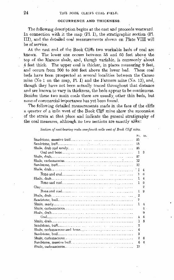
OCCURRENCE AND THICKNESS.
The following description begins at the east and proceeds westward. In connection with it the map (PI. I), the stratigraphic section (PI. Ill), and the detailed coal measurements shown on Plate VIII will be of service.
At the east end of the Book Cliffs two workable beds of coal are known. The lower one occurs between 35 and 60 feet above the top of the Mancos shale, and, though variable, is commonly about 4 feet thick. The upper coal is thicker, in places measuring 9 feet, and occurs from 200 to 500 feet above the lower bed. These coal beds have been prospected at several localities between the Cameo mine (No 1 on the map, PI. I) and the Farmers mine (No. 13), and, though they have not been actually traced throughout that distance and are known to vary in thickness, the beds appear to be continuous. Besides these two main coals there are usually other thin beds, but none of commercial importance has yet been found.
The following detailed measurements made in the face of the cliffs a quarter of a mile west of the Book Cliff mine show the succession of the strata at that place and indicate the general stratigraphy of the coal measures, although no two sections are exactly alike:
Section of coal-bearing rocks one-fourth mile west of Book Cliff mine.
Ft. in.
Sandstone, massive buff...................................... 35Sandstone, buff. ................... ......:.................... 15Shale, drab and sandy.......................... ............. 15
Coal and bone........................................... 1 3Shale, drab........................................ ......... 17Shale, carbonaceous.................,..................'...... 12Sandstone, buff............................................... 12Shale, drab.......-.---........^............................. '1 4
Bone and coal............................................. 1 6Shale, drab.................................................. 1 4
Bone and coal............................................. 1 9Clay..:....................................................... 2
Bone and coal............................................. 1 9Shale, drab.................................................. 2Sandstone, buff............................................... 7Shale, sandy... ............................................... 1 4Shale, carbonaceous.......................................... 6Shale, drab.................................................. 9
Coal...............'.............:.......................... 1 6Shale, drab. ..............................'................... 1 8Sandstone, buff............................................... 2Shale, carbonaceous and bone................................. 6Sandstone, buff............................................... 3Shale, carbonaceous.......................................... 2 6Sandstone, massive buff...................................... 6 6Shale, carbonaceous............................. ............ 17

U. S. GEOLOGICAL SURVEY IULLETIN NO, 371 PL. VII
LITTLE BOOK CLIFFS AND GRAND RIVER NORTHEAST OF PALISADES.
The Cameo coal outcrops on the lowest wooded bench and the Palisades coal appears 450 feet lower, immediately below the lowest heavy sandstone.

s U. S. GEOLOGICAL SURVEY
1 j. 2 , Horse Canyon 1 2 mil
T t ^ " ~ 1'1 *u ^ A6 ***
.Horse Canyon 1 z miles south of 7 miles north of Peterson'a Black Baby nine Prospect west of Ballard's mine lz miles west of' amilewestof Uinta R.R. mine Uinta RR. mine' SmilesSW.of 3 miles north of'unnel on W. side Horse Canyon Woodside prospect Ballard's mine .-,.._
section
8 . 9 e w
Nash's ranch Bryson's ranch
BULLETIN NO. 371 PL. VIII
12 ' 13 miles no
Turner's ranch Malone's ranch
2T
6"
,' r." I
180'C
9'2"
13'5" 180' 8'
g'4" Lane mine
24 Cameo coal 25Prospect north of « ,_ Riv&e mine Cameo coal
Prospect south of Cameo
2'S*
8'"
ft
15Johnson mine
2'2" 5'6"
16 Nearing mine
10"
4'6"
6" 5'4"
17 Hunter mine
1.00"
I'l"
6U
Cameo coal? 226. Near Steele mine
3'6"
_22
Cameo coalProspect north of
Palisades
18Prospect south ofHunter mine on
lower coal
Cameo coal? ,,P^^. Book Cliff mine, Mt. Lincoln mine 21'5"
5'6"
26Cameo coal Cameo mine
3'6"
8"
25'
27Cameo coal Cameo mine!
3'lO/r
4'3'
4'5'
7"
2"
Is'
97" ~~ \*>r - u
28'Palisade coal? Corcoran mine
2'6'
4'6"
124"
|2'2 Hi'8"
8"
2'2"
l" 4V
2'10"
5'6"
30Palisade coal? Steele mine
3'4A
34 '_ , , , Palisade coal Palisade coal ^3^ 2 miiea
limiles south of 5. of Book Cliff mineBook Cliff mine
3'10"
l fl»- 23
Cameo coal Prospect NE. of Palisade mine
U'6*
2'5"
7"36'
Palisade coal Palisade mine
29Palisade coal?Black Diamond
mine
2"
10" 3'J
2'2"
4'4'"
1 3' 10
2'
4'10"
4" ;== 4'11'/31
Palisade coal Prospect west of Book Cliff mine
8" 7'10"
32Palisade coal o'l Old Book CliiT
mine
35Palisade coal Garfield mine
2'7"
2'10" 37Palisade coal
Riverside mine
4'2" 9'6
4'6"
2'6"
1 6
4'6" 3'2" 6'6" 8" 3'
COAL SECTIONS IN BOOK CLIFFS COAL FIELD, COLORADO AND UTAH.

OCCURRENCE OF COAL. 25
Section of coal-bearing rocks one-fourth mile west of Book Cliff mine Continued.
Ft. in. Sandstone, brown............................................ 1 4Shale, sandy................................................ 1 6
Coal..................................................... 5Shale, drab................................................. 3 6Sandstone, gray.............................................. 3 6Shale, carbonaceous......................................... 11Sandstone, buff.............................................. 2Shale, carbonaceous......................................... 4 6Sandstone, buff...... ........................................ 1Shale, drab................>................................ 1Shale, carbonaceous......................................... 1 4Sandstone, drab.............................................. 2
Coal..................................................... 1Shale, drab................................................. 6Sandstone, drab.............................................. 4 6Shale, carbonaceous.......................................... 4
Coal "upper bed"....................................... 8 5Shale, carbonaceous......................................... 1 6Shale, drab, sandy.......................................... 14
Coal..................................................... 2 0Shale, carbonaceous......................................... 1 5
Coal..................................................... :i 10Bone..................................................... 2Coal..................................................... 8
Sandstone, carbonaceous...................................... 4Sandstone, massive, white.................................... 60Shale, drab.................................................. 10Sandstone, buff.............................................. 3Shale, drab................................................. 26Sandstone, brown............................................ 3Shale, drab....................................!............ 5Sandstone, massive, brown......'............................. 37Shale, sandy................................................ 16Sandstone, buff.............................................. 50Shale, drab................................................. 5
Coal.....................................................Shale, carbonaceous................................ ..........
Coal "lower bed"....................................... .1.Shale, carbonaceous, sandy.................................... .1.Sandstone, massive white.................................... 25Shale and sandstone, thin-bedded .t........................... 30Shale, Mancos.
519
The lower bed, known as the Palisades coal, outcrops at water level near the mouth of the Hogback Canyon of Grand River, about 1£ miles above Palisades (PL VII). Thence the coal bed rises rapidly above the valley and can be traced westward along the base of the Book Cliffs for several miles. At the Palisade mine (No. 6) the coal is about 150 feet above the valley, at the Garfield mine (No. 7) 800 feet, and at the old Book Cliff mine (No. 9) about 1,200 feet.

26 THE BOOK CLIFFS COAL FIELD.
Throughout this distance the coal can be easily followed. At many places it is exposed by erosion, appearing as a black streak in the cliffs, and it is usually underlain by a massive white sandstone which is conspicuous as the first heavy sandstone bed above the Mancos shale. This sandstone is not persistent, however, but locally thickens and thins and gives way to shaly beds. The Palisades coal varies in thick ness from a few inches to 6 feet. At the Riverside mine (No. 4), a mile northeast of Palisades, near the mouth of the entry, the following section is exposed:
Section of coal bed at Riverside mine. Shale. Ft. in.
Coal..................................................... 6Shale.....-............................................'..... 3
Coal.....................:..........................'.... 2 6
33
At the face of the workings the shale parting is 1^ inches thick and the lower bench of coal is 2 feet 10 inches thick.
At the Palisade mine (No. 6) there is from 3 feet 7 inches to 3 feet 10 inches of clean coal.
Two miles west, at the Garfield mine, the Palisades coal attains the greatest thickness yet measured. The following section is there exposed:
Section of coal bed at Garfield mine.
Sandstone, shaly. Ft. in.Coal..................................................... 1 1Bone.................................................... 2Coal...................................................... 1 9Bone. ............................ ............ ^......... ' JCoal..................................................... 3 2Bone................................:................... 9Coal.............................:....................... 1
Total coal bed......................................... 7 11J
About 2 miles south of the old Book Cliff mine (No. 9), in an aban doned prospect, the following section is exposed:
Section 2 miles south of old Book Cliff mine.
Shale. Ft. in.Coal...................................................... 2
Shale, carbonaceous.......................................... 2 1Coal and borie........................... ................. 2 7
Shale........................................................ 10Coal................. .................................... 3
Shale, sandy.................................................:. 1 6Sandstone. ______
Total coal bed........................................... 5 9

OCCURRENCE OF COAL. 27
In the vicinity of the old Book Cliff mine the lower coal is of variable thickness; in places it measures almost 5 feet, while near by it thins
. out to almost nothing, as shown by the following sections:
Section of coal bed at the old Book Cliff mine.Sandstone. Ft. in. Shale......................................................... 7
Coal....................................................... 4 6Shale......................................................... 8Sandstone.
5 9
Section of coal bed 1 mile southeast of old Boole Cliff mine.Shale. Ft. in.
Coal....................................................... 46"Shale......................................................... 8
Coal...................................................'.... 3 4Shale......................................................... 8Sandstone.
Total coalbecl........................................... 8 G
Section of coal bed 1 mile southeast of the above section.Shale. " Ft. in.
Coal...................................................... 1Shale........................................!............... G
.Coal...................................................... 2 10Shale........................................................ 2 6
Coal.........................................:............ 1 8Shale..................................................../.. 8Sandstone.
9 2
It is reported that in working the lower coal in the old Book Cliff mine several areas were encountered in which the coal is absent. Northwest of the old mine evidences of thinning are shown by the fol lowing section:
Section of lower coal bed near Book Cliff mine.Ft. in.
Shale, carbonaceous, interlaminated with thin coaly layers upto one-half inch............................................... G
. Coal....................................................... 2Shale, carbonaceous and bony.................................. 4Bone.......................................................... 2
Coal and bone.............................................. 9Shale, carbonaceous........................................... 7
Coal........................................................ 1 5Shale, carbonaceous........................................... 7Sandstone.

28 THE BOOK CLIFFS COAL FIELD.
About a quarter of a mile west of this place the following section is exposed at the same horizon:
Section of lower coal bed near Book Cliff" mine.Ft. in.
Shale........................................................... 6Coal....................................................... . 7
Bone.......................................................... %Coal....................................................... 1
Sandstone.................................................... 2Shale, carbonaceous........................................... 1Sandstone.
Totalcoal ............................................... 8J '
West of the Book Cliff mine less prospecting has been done than in the region to the east, but little variation in the thickness of the coal bed has been reported. At the Steele or Keystone mine (No. 11) there is 5 feet 3 inches of coal, including 4 inches of bone 1 foot from the top. The roof and floor are of shale, and the coal lies 3 feet above a bed of massive white sandstone.
At the Black Diamond mine (No. 12) the following section was measured:
Section of coal bed at Black Diamond mine.Shale. Ft. in.
Coal...................................................... 10Clay.......................................................... 2
Coal........................................................ 4 8Shale.
Totalcoal............................................... 5 6
Locally the coal bed is only 3 feet thick. At the Farmers mine the lower bed appears to be only 30 inches thick, but the upper coal is of greater value.
Except in two important mines, the Book Cliff (No. 10) and the Cameo (No. 1), the upper coal is not worked on a commercial scale in this locality, partly because the lower coal in general isof better quality, but chiefly because the lower coal is more accessible, occurring several hundred feet nearer the base of the cliffs.
The upper bed, known as the Cameo coal, outcrops at river level at Cameo, on the Denver and Rio Grande Railroad. To the southwest it rises, and north of Palisades is 650 feet above the valley, lying at the base of the second tier of cliffs. (See PI. VII.) From Palisades the outcrop extends northwestward to the vicinity of the Book Cliff mine, at a distance of about a mile and a half from the crest of the lower escarpment. Thence westward the bench below the upper coal dis appears and the two coal beds outcrop in the face of the cliffs, almost directly one above the other. The position of the upper coal is marked by a massive white sandstone almost immediately beneath it. This sandstone is locally 75 feet thick and can be traced for miles, but it is not constant and locally disappears.
OCCUEBENCE OF COAL. 29
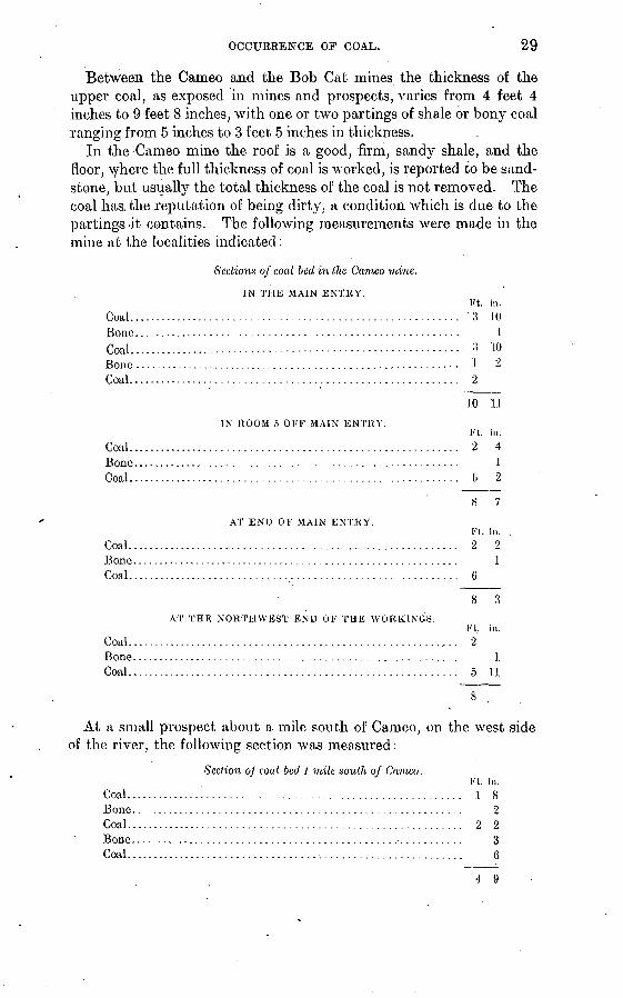
Between the Cameo and the Bob Cat mines the thickness of the upper coal, as exposed in mines and prospects, varies from 4 feet 4 inches to 9 feet 8 inches, with one or two partings of shale or bony coal ranging from 5 inches to 3 feet 5 inches in thickness.
In the Cameo mine the roof is a good, firm, sand}7" shale, and the floor, where the full thickness of coal is worked, is reported to be sand stone, but usually the total thickness of the coal is not removed. The coal has..the reputation of being dirty, a condition which is due to the partings-'it. contains. The following measurements were made in the mine at the localities indicated :
Sections of coal bed in the Cameo mine.
IN THE MAIN ENTRY.
Bone........... ...................Coal........ .............. .. -
Coal...............................
Ft. in. ........................... 3 10........................... 1........................... :j 10
....... 1 2........................... 2
.10 11
IN ROOM 5 OFF MAIN ENTRY.Ft. in.
Coal .......................................................... 2 4Bone. . ....................................................... .1Coal .......................................................... G 2
AT END OF MAIN ENTRY.Ft. in.
Coal....................................................:..... 2 2Bone. . ......................................................... 1Coal. . ........................................................ 6
8 3
AT THE NORTHWEST END OF THE WORKINGS.Ft, in.
Coal....................... .................................... 2Bone......................................................... 1Coal.......................................................... 5 11
At a small prospect about a mile south of Cameo, on the west side of the river, the following section was measured:
Section oj coal bed l milt south of Cameo.
Coal...... ..........................Bone............ ...................Coal.................... ............Bone. ..............................Coal................................
Ft. in. ........................... 1 8........................... 2
9 9
........................... 3
........................... 6
4 9
80 THE BOOK CLIFFS COAL FIELD.
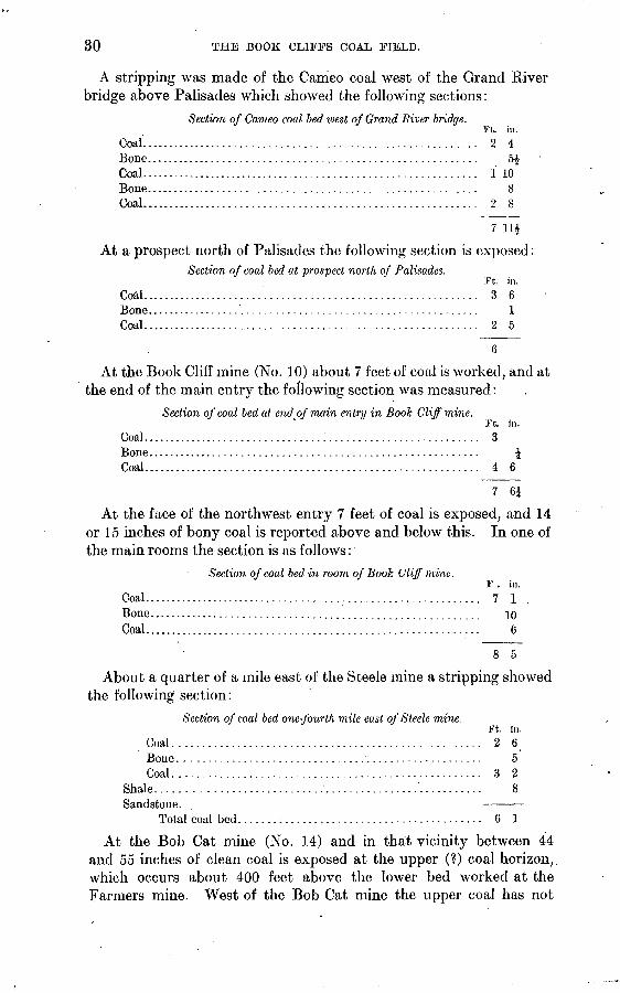
A stripping was made of the Cameo coal west of the Grand Kiver bridge above Palisades which showed the following sections:
Section of Cameo coal bed ivest of Grand River bridge.Ft. in.
Coal........................................................... 2 4Bone.......................................................... 5£Coal............................................................. 1 10Bone.......................................................... 8Coal................:.......................................... 2 8
7 114
At a prospect north of Palisades the following section is exposed:Section of coal bed at prospect north of Palisades.
Ft. in.Coal........................................................... 3 6Bone.......................................................... 1Coal........................................................... 2 5
6
At the Book Cliff mine (No. 10) about 7 feet of coal is worked, and at the end of the main entry the following section was measured:
Section of coal bed at end of main entry in Book Cliff" mine.Ft. in.
Coal................................:.......................... 3Bone.......................................................... \Coal........................................................... 4 6
7 6J
At the face of the northwest entry 7 feet of coal is exposed, and 14 or 15 inches of bony coal is reported above and below this. In one of the main rooms the section is as follows:
Section of coal bed in room of Book Cliff mine.F . in.
Coal............................................................ 7 1Bone.......................................................... 10Coal........................................................... 6
8 5
About a quarter of a mile east of the Steele mine a stripping showed the following section:
Section of coal bed one-fourth mile east of Steele mine.Ft. in.
Coal. .................................................... 2 6Bone. ................................................... 5Coal..................................................... 3 2
Shale....................................................... 8Sandstone.
Total coal bed.......................................... 6 1
At the Bob Cat mine (No. 14) and in that vicinity between 44 and 55 inches of clean coal is exposed at the upper (?) coal horizon, which occurs about 400 feet above the lower bed worked at the Farmers mine. West of the Bob Cat mine the upper coal has not

OCCURRENCE OF COAL. 31
been prospected and little is known of it for several miles. The coal outcrops high up in the face of the cliffs and the lower bed is more accessible.
There are two small openings on the lower coal west of the Fanners mine, which are known as the Excelsior and Corcoran mines. The Excelsior mine (No. 15) is located high up a hillside, near the head of a small gulch, where the coal is opened along the outcrop at several places. Here 4 feet 7 inches of coal is exposed at the entrance to the workings. Four feet above there is a 4-inch bed, and a foot and a half below there is 2 inches of coal, while 40 feet below the main coal there is an unprospected bed of coal and carbonaceous shale 6 feet thick. A mile west of the Excelsior mine there is a small abandoned prospect known as the Corcoran mine (No. 16). The workings have caved, but there is at least 4 feet of coal exposed near the entrance.
.For 5 miles northwest of the Corcoran property little or no pros pecting has been done, but at the next wide valley there are pros pects on two beds of coal. An opening on the lower bed shows the following section:
Section of coal bed 5 miles northwest of Corcoran mine.
Sandstone. Ft. in.§hale. ..............................:.....:................. 6
Coal..................................................... 3Bone.................................................... 4Coal...........................'.......................... 2
Shale. ...................................................... 4Sandstone. -
Total coal bed......................................... 5 4
Farther up the same valley an upper coal is well exposed and has been worked at the Hunter mine (No. 17), where the following section was obtained:
Section of coal, beds at Hunter mine.Sandstone. . Ft. in.
Coal....................................................... 2Bone....................................................... 4
Coal..................................................... 4 5Bone..................................................... 8Coal..................................................... 7
Sandstone.................................................. 25Coal. ..................................................... 2Bone.................................................... 1Coal..................................................... 3
Sandstone. 39
The Gross or Kiel mine is situated 5 miles northwest of the Hunter property, near the mouth of Kiel Canyon. Between these mines no prospecting has been done and no information was obtained regarding the coal beds. At the Kiel mine (No. 18) from 3 feet to 3 feet 9 inches of coal is exposed at the approximate horizon of the lower bed.

32 THE BOOK CLIFFS COAL FIELD.
The next opening is about a mile and half west of the Kiel, at the Nugent mine (No. 19). Here there are two openings on the lower (?) coal, on opposite sides of a gulch. The coal varies in thick ness from 4 feet 3 inches to 4 feet 8 inches.
At the Nearing mine (No. 20), three-quarters of a mile west of the Nugent, the same bed is also- worked. At the mouth of the mine the coal measures 4 feet to 4 feet 2 inches and contains a variable streak of bone up to 12 inches thick. At the end of the workings the bone disappears and the coal measures 4 feet 7 inches. The coal bed is here 45 feet above the top of the Mancos shale, and in this general vicinity the upper coal appears to be represented by only thin carbonaceous layers. Only one workable coal bed has been found in this locality. The following section was measured near this mine:
Section of coal-bearing rocks near Nearing mine.Ft. in
Sandstone, buff. .............................................. 40Shale, drab.........................,:....................... 10Sandstone, red................?............................... 10Shale, carbonaceous.......................................... 1 GShale, buff.................................................... 14
Coal...................................................... 8Sandstone, buff.......................... ..................... 7 Shale, buff.................................................... 30Shale, carbonaceous........................................... 1Sandstone, white and buff..................................... 33Shale, carbonaceous.......................................... 6Sandstone, white............................................... 18Shale, carbonaceous.......................................... 10
Coal, bony................................................ 8Sandstone, white.............................................. 15Shale, sandy................................................. 60Sandstone, white.............................................. 25Shale, buff.................................................... 30Shale, carbonaceous.......................................... 2 6Shale, buff.................................................... 10
Coal...................................................... 6Sandstone, white.............................................. 10Shale, buff.................................................... 7Sandstone, buff.......................................'........ 15Shale, carbonaceous.......................................... 8
Coal.........................'.........................-... 2Shale, carbonaceous.......................................... 2 6Shale, buff.................................................... 10Sandstone, buff............................................... 7.Shale, drab...............................................:.. 15Sandstone, buff. ................................................ 1 8
Coal...................................................... 4Shale, carbonaceous and drab... .............................. 11Sandstone, buff............................................... 10Shale, drab.................................................. 4Sandstone, buff............................................... 20Shale, Mancos, ;

OCCURRENCE OF COAL. 33
Openings have been made on a coal bed at the Lane and Johnson mines, on opposite sides of a creek about 2 miles northwest of the N earing property. At this place the following measurements weremade:
Section of coal bed at the Johnson mine (No. 22}.Sandstone. Ft. in.Shale, carbonaceous............................................ 5
Coal........................................................ 1 6Bone......................................................... 3Coal........................................................ 4
Total coal bed............................................ 5 9
Section of coal bed at the Lane mine (No. 23}.
Sandstone. ' Ft. in. Shale, sandy................................................... 4
Coal........................................................ 1 3Bone....................................................... 4Coal........................................................ 3
, Shale, carbonaceous............................................ 1Coal, bony.................................................. 1
Total coal bed............................................ 6 7
A mile and a half up the creek there are several coal beds which have not been prospected, but which have the following section:
Section of coal beds 1% miles east of Lane mine.
Shale. 'i?t. in. Coal..........................................:........... 1 4Bone and coal............................................. 8Coal...................................................... 1 3
Shale, carbonaceous.......................................... 2Coal...................................................... 3 10
Shale, carbonaceous.......................................... 18Coal...................................................... 8
Shale, carbonaceous.......................................... 7Coal...................................................... 4 1
Shale. 38 10
The following section was measured at about the same horizon north of Malone's ranch:
Section of coal beds 3 miles north of Malone's ranch.
Shale, carbonaceous. Ft. in.Coal...................................................... 1 4Bone..................................................... 6Coal...................................................... 2Bone..................................................... 5Coal...................................................... 5Bone..................................................... 4Coal...................................................... 3 10
Shale, sandy................................................. 7Coal...................................................... 3 1
18 11 63854 09 3
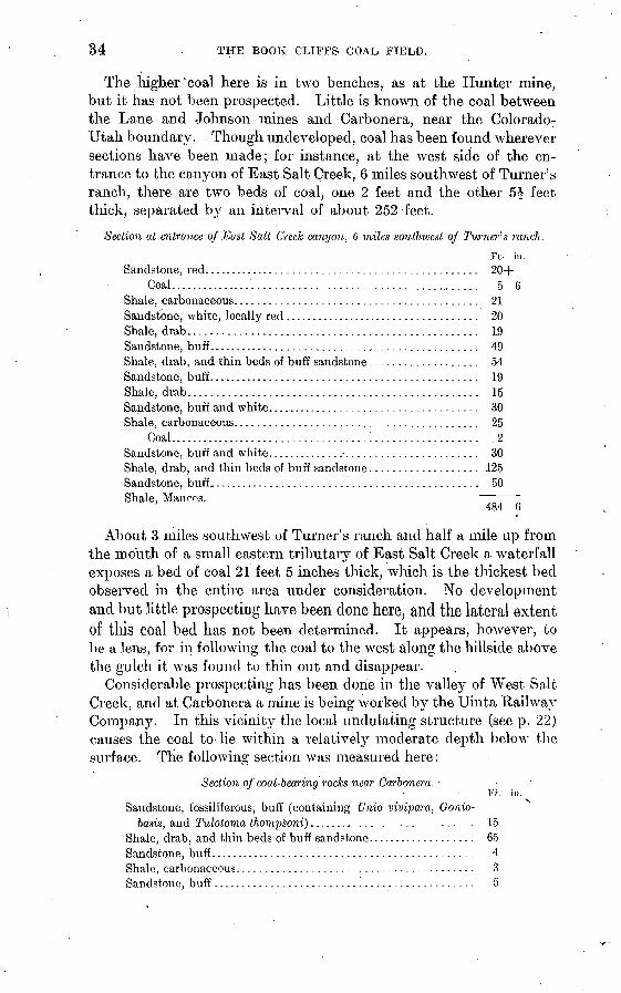
34 THE BOOK CLIFFS COAL FIELD.
The higher "coal here is in two benches, as at the Hunter mine, but it has not been prospected. Little is known of the coal between the Lane and Johnson mines and Carbonera, near the Colorado- Utah boundary. Though undeveloped, coal has been found wherever sections have been made; for instance, at the west side of the en trance to the canyon of East Salt Creek, 6 miles southwest of Turner's ranch, there are two beds of coal, one 2 feet and the other 5^ feet thick, separated by an interval of about 252 feet.
Section at entrance of East Salt Creek canyon, 6 miles southivest of Turner's ranch.
Ft in. Sandstone, red,............................................... 204-
Coal...............'........................................ 5 6Shale, carbonaceous.......................................... 21Sandstone, white, locally red ................................... 20Shale, drab.................................................. 19Sandstone, buff............................................... 49Shale, drab, and thin beds of buff sandstone................... 54Sandstone, buff............................................... 19Shale, drab.................................................. 15Sandstone, buff and white..................................... 30Shale, carbonaceous.......................................... 25
Coal..............:....................:.................. 2Sandstone, buff and white...................................... 30Shale, drab, and thin beds of buff sandstone................... 125Sandstone, buff,.............................................. 50Shale, Man cos.
484 6
About 3 miles southwest of Turner's ranch and half a mile up from the mouth of a small eastern tributary of East Salt Creek a waterfall exposes a bed of coal 21 feet 5 inches thick, which is the thickest bed observed in the entire area under consideration. No development and but little prospecting have been done here, and the lateral extent of tills coal bed has not been determined. It appears, however, to he a lens, for in following the coal to the west along the hillside above the gulch it was found to thin out and disappear.
Considerable prospecting has been done in the valley of West Salt Creek, and at Carbonera a mine is being worked by the Uinta Railway Company. In this vicinity the local undulating structure (see p. 22) causes the coal to- lie within a relatively moderate depth below the surface. The following section was measured here:
Section of coal-bearing rocks near Carbonera.Ft. in.
Sandstone, fossiliferous, buff (containing Unio vivipara. Gonio- basis, and Tulotoma thompsoni)............................. 15
Shale, drab, and thin beds of buff sandstone.................... 65Sandstone, buff.............................................. 4Shale, carbonaceous......................................... 3Sandstone, buff............................................. 5

OCCURRENCE OF COAL. 35
Section of coal-bearing rocks near Carbonera Continued.Ft. in.
Shale, drab................................................. 5Coal..................................................... 3 4
Shale, carbonaceous. .......................................... 2Sandstone, buff.............................................. 10
Coal..................................................... 3 10Shale, carbonaceous.........................................' 3Sandstone, buff...-..................................:....... 8
Coal and bone............................................ 2Sandstone, thin bedded, buff, and shale...................... :!5Sandstone, buff.............................................. 5Sandstone, buff, thin bedded, and shale.... r ................... 20
Coal............:........................................ '2Shale, carbonaceous......................................... 2Shale, drab, sandy.......................................... 10Sandstone, buff.............................................. 5Shale, carbonaceous......................................... 15Sandstone, buff............................................. 2Shale, drab................................................. 3Sandstone, buff.............................................. 7Shale, carbonaceous......................................... 18Sandstone, buff.............................................. 7Shale, drab.......'.......................................... 3Sandstone, buff.............................................. 10Shale, carbonaceous......................................... 2Sandstone, buff.............................................. 25Shale, carbonaceous......................................... 3Sandstone, shaly............................................. 5Shale, carbonaceous......................................... 5Sandstone, buff...............................:.............. 10Shale, drab................................................. .15Sandstone, shaly............................................ 10
Coal...................:..--............................. 6Shale, carbonaceous......................................... 2Sandstone, shaly............................................ 20Shale, carbonaceous......................................... 3
Coal..................................................... 10Shale, carbonaceous......................................... 1
Coal..................................................... 10Shale, carbonaceous.......................................... '\Sandstone, buff, shaly........................................ 2Shale, carbonaceous......................................... 4
Coal..................:..-.........................-..... 2Shale, carbonaceous.......................................... 5Sandstone, buff.............................................. 65Shale, drab, including several thin beds of buff sandstone...... 70Sandstone, massive, buff..................................... 60Shale, Mancos.
Within a distance of less than 500 feet above the top of the Mancos shale there are five beds of coal, each 2 feet or more thick, and several other thinner carbonaceous layers. At the Carbonera mine the coal bed measures more than 7 feet, but it is parted by two layers of bone,

36 THE BOOK CLIFFS COAL FIELD.
which greatly decreases the value. The following sections, measured in different parts of the mine, show the general condition of the coal bed:
Sections of coal bed in Carbonera mine.
Coal.. Bone. Coal.. Bone. Coal..
End of back
entry.
Ft. in. 2 1
1 10J
7 5*
Room No. 3.
Ft. in. 1 10
1 11 1 3 6
7 G
Near entrance.
Ft. in.2
1 S 4
4 3
In Utah within the area covered by this report there are no ship ping mines and the coal has been prospected in only a few places. The coal lands have not been surveyed by the. General Land Office, and the region is even more thinly populated than Colorado; between Carbonera, Colo., and Thompsons, Utah, a distance of more than 50 miles, there are only three ranches, which are situated near the^mouths of canyons at the base of the Book Cliffs, where feeble streams flow throughout the year. In Utah, as in Colorado, the Mesaverde forma tion constitutes the cliff-making rocks, and coal has been found at the usual horizon wherever sections have been studied. Near Bryson's ranch, on Westwater Creek, the following measurements were made:
Section of coal-bearing, rocks near Bryson's ranch, on Westwater Creek.
Ft. in. Sandstone, thick bedded, buff................................ 65Shale, carbonaceous......................................... 1
Coal..................................................... I
Shale, drab................................................. 2Sandstone, thick bedded, buff................................ 5Shale, carbonaceous..........................,..:............ 3Sandstone, thin bedded, buff................................. 40Shale, carbonaceous......................................... 3Sandstone, thin bedded, buff. ................................ 10
Coal.......................................'.............. 10Shale, carbonaceous......................................... 5Sandstone, thin bedded, buff................'................. 5Shale, carbonaceous......................................... 1
Coal..................................................... 1 10Shale, carbonaceous......................................... 2Sandstone, thick bedded, buff..:............................. 5Sandstone, shaly, buff........................................ 35Sandstone, thin bedded, buff................................. 4Sandstone, thick bedded, buff................................ 4Shale, carbonaceous......................................... 3
Coal..................................................... 2 9Shale, carbonaceous......................................... 4Sandstone, thin bedded, buff................................. 20

OCCUREENCE OF COAL. 37
Section of coal-bearing rocks near Bryson's ranch, on Westwater Creek Continued.Ft. in.
Sandstone, thick bedded, buff................................ 13Sandstone, thin bedded, buff................................. 3Shale, carbonaceous......................................... 7
Coal..............................:...................... 1 3Shale, carbonaceous......................................... 4Sandstone, thick bedded, buff................................ 3Sandstone, thin bedded, buff................................. 1.5Sandstone, thick bedded, buff................................ 1.0Sandstone, thin bedded, buff................................. 15Shale, carbonaceous......................................... 5
Coal..................................................... 2 10Shale, carbonaceous......................................... 3Sandstone, thin bedded....................................... 4
Coal..................................................... 2 5Shale, carbonaceous......................................... 3Sandstone, thin bedded, bull................................ 3Shale, carbonaceous......................................... 4
Coal..................................................... 1 3Shale, carbonaceous......................................... 5Sandstone, thin bedded, buff, and shale....................... 90Shale, Mancos.
417 3
Six beds of coal, ranging from 1 foot 3 inches to 2 feet 10 inches, were found in a zone 275 feet thick, the lowest coal occurring 95 feet above the top of the Mancos shale. From the Utah-Colorado bound ary to some miles west of Thompsons a bench about 100 feet in height and half a mile to a mile in width, caused by a thick lens of sandstone in the shale, extends along the base of the cliffs, and the coal outcrop therefore lies farther back in the cliffs than usual.
Near Harms's ranch (No. 28), at the mouth of Cottonwood Canyon, there is a bed of coal 1 foot 6 inches thick. Mr. Harms reports beds varying in thickness from 2 inches to 3 feet, but says that the coal contains much bone and is of poor quality.
About a mile and a half above N ash's ranch (No. 29), in a canyon, two beds of coal were observed, separated by an interval of about 60 feet. The lower bed is 1 foot 10 inches thick and occurs 350 feet above the top of the Mancos shale; the higher bed measures 4 feet 8 inches, but little attempt has been made to develop it.
More work has been done on the coal north of Thompsons than any where else in Utah in the area covered by this report, although the prospecting even in this locality has not been thorough. Several beds of coal are present. The following section .shows five beds more than 2£ feet thick within 125 feet of strata:
Section of coal-bearing-rocks north of Thompson*.Ft. in.
Sandstone, inassive, buff....'.................................. 25Coai.....................:................................ i
Shale, carbonaceous.......................................... 6Sandstone, thin bedded........'................................ 6
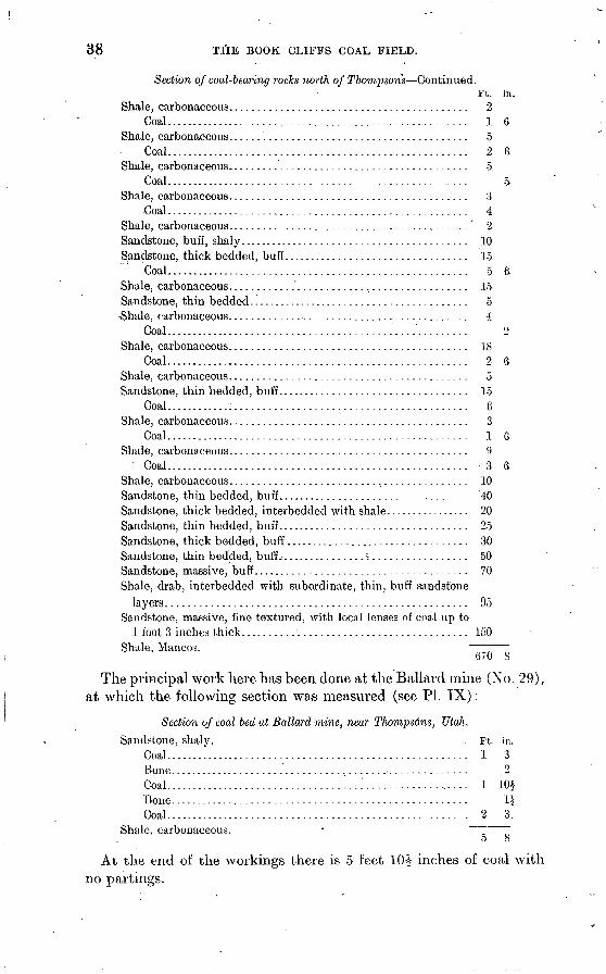
38 T&E BOOK CLIFFS COAL FIELD.
Section of coal-bearing rocks north of Thompson's Continued.Ft. in.
Shale, carbonaceous.......................................... 2Coal...................................................... 1 6
Shale, carbonaceous.......................................... 5Coal...................................................... 2 6
Shale, carbonaceous.......................................... 5Coal...................................................... 5
Shale, carbonaceous.......................................... 3Coal...................................................... 4
Shale, carbonaceous.......................................... 2Sandstone, buff, shaly......................................... 10 Sandstone, thick bedded, buff................................. 15
Coal...................................................... 5 6Shale, carbonaceous............'.............................. 15Sandstone, thin bedded. ....................................... 5 Shale, carbonaceous.......................................... 4
Coal.............................................'......... 2Shale, carbonaceous.......................................... 18
Coal...................................................... 2 6Shale, carbonaceous.......................................... 5Sandstone, thin bedded, buff. ................................. 15
Coal............:......................................... 6Shale, carbonaceous.......................................... 3
Coal...................................................... 1 6Shale, carbonaceous.......................................... 9
Coal...................................................... 3 6Shale, carbonaceous.......................................... 10Sandstone, thin bedded, buff.................................. 40Sandstone, thick bedded, interbedded with shale................ 20Sandstone, thin bedded, buff.................................. 25Sandstone, thick bedded, buff................................. 30Sandstone, thin bedded, buff................«................. 50Sandstone, massive, buff...................................... 70Shale, drab, interbedded with subordinate, thin, buff sandstone
layers..................................................... 95Sandstone, massive, fine textured, with local lenses of coal up to
1 foot 3 inches thick........................................ 150Shale, Mancos.
670 S
The principal work here has been done at the Ballard mine (No. 29), at which the following section was measured (see PI. IX):
Section of coal bed at Ballard mine, near Thomps6ns, Utah.
Sandstone, shaly. . Ft. in.Coal...................................................... 1 3Bone..................................................... 2Coal....'................................'................... 1 10iBone..................................................... 1JCoal...................................................... 2 3.
Shale, carbonaceous. o 8
At the end of the workings there is 5 feet 1(H inches of coal with no partings.

U. S. GEOLOGICAL SURVEY BULLETIN NO. 371 PL. IX
BALLARD'S COAL MINE, NORTH OF THOMPSONS.
B. OUTCROP OF COAL AT ENTRANCE TO BALLARD'S MINE, SHOWING JOINTING OF COAL.

OCCUBRENCE OF COAL. 39
At a prospect on the west side of.the gulch, opposite the Ballarcl mine, on a coal bed below the one there worked, the following section, was obtained:
Section of coal bed near Bollard mine.
Sandstone, shaly. - . Ft. in.Coal.................:..................................... 10Bone.............. ....................................... 4Sandstone............................................... 2Coal...................................................... 4 6
5 10
The thickness of the bone and shale partings is variable even in near-by sections.
A bed of coal a few inches to a foot and a half thick occurs in the first massive sandstone above the top of the Mancos shale, and shows up prominently from the valley as a black layer, but it is not thick enough to be of much importance.
Between Thompsons and Green River there is only one mine, the Black Baby, and almost no prospecting has been done. The few sections that were made did not reveal the presence of any beds more than 2 feet thick, but in the absence of prospecting little can be said of'the coal in this part of the field.
At the Black Baby mine (No. 32), about 10 miles northeast of the town of Green river, the following section was measured:
Section of coal bed at Blade Baby mine.
Shale, carbonaceous. Coal...........:......................Bone and shale. . ......................Coal..................................
Coal. . ................................
Ft. in. ..................... 3...................... 3..................... 2 3..................... 8
9
Bone and shale............................................. 1 3Coal....................................................... 1
7 8
The lowest coal passes beneath the level of Green River about 4 miles above the mouth of Price River, but no prospects were found in that vicinity.
West of Green River and south of Price River the coal occurs in an isolated area near the summit of the Beckwith Plateau, and north of Price River coal outcrops in the face of the cliffs high above the valley.
The following section was measured half a mile below the entrance to Price River canyon, at the northwest end of Beckwith Plateau. There are four beds of coal more than 2 feet thick, and three others

40 THE BOOK CLIFFS COAL FIELD.
more than 1 foot thick, the lowest occurring about 340 feet above the top of the Mancos shale.
Section at northwest end of Beckwith Plateau.Ft. iii.
Sandstone, massive, fine grained................................ 240Coal...................................................... 2
Shale, carbonaceous.......................................... 7 Sandstone, buff............................................... 5
Coal...................................................... 4Shale, carbonaceous.......................................... 6Sandstone, thin bedded........................................ 10
Coal...................................................... 4Shale, carbonaceous.......................................... 1
Coal...................................................... 1 6Shale, carbonaceous.......................................... 2Sandstone, carbonaceous....................................... 2Sandstone, thin bedded, buff.................................. 6Shale, buff.................................................... 6
Coal...................................................... 1 8Sandstone, carbonaceous....................................... 1
Coal..................................'.................... 2Shale, carbonaceous........................................... 8Sandstone, thick bedded....................................... 20
Coal...................................................... 3Shale, carbonaceous, drab...................................... 4Sandstone, carbonaceous....................................... 3Shale, carbonaceous...................................."...... 1
Coal...................................................... 1Sandstone, thin bedded, and shale............................. 10Shale, carbonaceous.......................................... 3
Coal...................................................... 1 2Shale, carbonaceous.......................................... 1Shale, buff, containing fossil plants............................ 2Sandstone, buff, containing Anomia micronema, Modiola laticos-
tata, and Corbula perundata. ................................ 3Shale, buff.................................................... 3Sandstone, buff, thick bedded................................. 45Sandstone, thin bedded, and shale............................. 140Sandstone, thick bedded, buff. ................................ 90
' Sandstone, thin bedded, and shale............................. 80Sandstone, thick bedded, buff................................. 65Sandstone, thin bedded, buff.................................. 30Shale.
805 2
At Peterson's prospect (No. 33), high up on the hillside, near the entrance to Price Canyon, the following section was measured:
Section at Peterson's prospect, near Price Canyon.Ft. in.
Shale, carbonaceous........................................... 8Bone.......................................................... 1 2
Coal....................................................... 4Shale, carbonaceous........................................... 10Sandstone.
6 8

OCCURRENCE OF COAL. 41
About 225 feet above this prospect, in a location that is difficult of approach, a bed 6 feet thick has been prospected.
Along the cliffs between Price Canyon and Horse Canyon coal out crops can be seen from the valley, but because of their situation high in the cliffs they are unprospected. Two beds of coal 4 feet thick and lying about 200 feet apart were measured about 10 miles north of Wooclside.
At the western end of the area under consideration, in the'vicinity of Horse Canyon, 6 miles south of Sunnyside, the coal has been con siderably prospected. A large bed has been opened, and probably before long a mine will be located in Horse Canyon, although as yet there is no railroad connection and the, property is 7 miles from the nearest point on the Denver and Rio Grande Railroad. The coal is between 250 and 300 feet above the top of the Mancos shale and is immediately underlain by a bed of massive white sandstone. Only one main bed of coal has been found in the vicinity of Horse Canyon, although at Sunnyside there are two beds; but neither is so thick as the one in Horse Canyon.
In the entry on the west side of Horse Canyon (No. 36) the following section was measured:
Section of coal bed in Horse Canyon.
Shale, carbonaceous. Ft. in.Coal..............................:........................ 2 1Bone....................................................... 6Sandstone and shale....................................... 1 6Bone...................................................... 1Coal....................................................... 13 5
Sandstone. 18 6
Section of coal bed at prospect No. 86.Sandstone, thin bedded. vt. in.
Coal....................................................... 2 4Sandstone and shale......................................... 1 6Coal....................................................... 9 2Bone...................................................... 2Coal.......'................................................ 6 4
19 6
At a prospect (No. 35) a mile east of the last, the following section was obtained:
Section of coal bed at prospect No. 85.Sandstone. ;i?t. j n .
Coal....................................................... 2 4Sandstone and shale.................................:......... 3
Coal........................................................ 6Bone...................................................... 3Coal....................................................... 10
Sandstone. i 21 7

42 THE BOOK CLIFFS COAL FIELD.
AMOUNT "OF AVAILABLE COAL.
Because coal outcrops in the region of which the Book Cliffs field forms a part have been traced for several hundred miles along the southern, eastern, and northern margins of the Uinta Basin shown in figure 1, it is probable that the entire area, consisting of about 14,000 square miles, is underlain by coal. It has been estimated, however, that in the center of the basin the Eocene rocks range from 4,000 to 6,500 feet in thickness, and as the coal is overlain by this great mass of barren strata and also by 1,000 feet or more of the Mesaverde for mation, the total covering of the coal in a large part of the basin is deeper than the workable limit. This, at present, under the most favorable conditions, is about 4,000 feet. The greater part, therefore, can not be considered available, and development is restricted to the vicinity of the outcrop.
A close approximation to the total amount of coal available in the Book Cliffs field can not now be made because of the present limit of knowledge. A rough estimate, however, can be arrived at by assum ing that the workable limit of the field is 6 miles back from the out crop and that the total amount of coal may be represented by a single bed 7 feet thick extending throughout the field. On this assumption, there are in the area considered in the present report 1,010 square miles of coal land, 360 of which are in Colorado and 650 in Utah. Since a cubic foot of coal of 1.3 specific gravity weighs 81.25 pounds, and a square mile of such coal 1 foot thick contains 1,132,560 short tons, on the above assumption the total amount is more than 8,000 million tons. These figures have little value beyond forcibly express ing the fact that there is here an immense coal reserve.
CHARACTER AND USE OF BOOK CLIFFS COAL.
PHYSICAL PROPERTIES.
Though differing somewhat from place to place, the coals of the Book Cliffs field possess a rather uniform appearance. They are full black, with a slightly "brownish streak, and are for the most part of a dull tone which commonly is varied by the presence of narrow lustrous bands. The coal is traversed by many joints, two sets at right angles being prominently developed (PI. IX, #), Accordingly, the coal breaks easily after it is mined, but in some of the workings the coa! is dense and hard to pick. The lumps, as mined, usualty range in size from 30 inches down, and there is a large amount of slack. Patches of a yellow resinous substance occur locally in tlie coal, and also infre quent small segregations of pyrite. A common feature is the presence in the cracks that traverse the coal of thin films of a whitish saline

CHARACTER OF COAL. 43
substance derived from the leaching of-the adjacent rocks. A test by George Steiger of some of this material from the coal in Horse Canyon, Utah, showed it to be a hydrous silicate of aluminum containing a small amount of calcium carbonate.
The moisture content of the coal is shown in the table of analyses on pages 44-46. The moisture in the ' 'sample as received," which repre sents the condition of the coal in the mine, ranges from 4.71 to 18.63 per cent. By air drying in the laboratory these samples lost between 0.10 and 5.30 per cent of their moisture. On exposure to the weather the coal becomes dull and breaks up along the joints into small prisms which finally crumble to powder. The rapidity with which disintegration occurs is not well known, for little coal is allowed to remain about the mines. A considerable amount, however, was found at the prospects in Horse Canyon; although this was reported to have lain in a heap exposed to the weather for more than a year, it showed little apparent deterioration.
CHEMICAL COMPOSITION.
The following analyses show the composition of a number of samples of coal from the eastern part of the Book Cliffs field. Samples were taken from the most important mines and prospects under uniform conditions, and represent the freshest available material. The sam ples were collected by cutting a channel across the face of the coal from roof to floor, partings more than a quarter of an inch in thickness being rejected. The material was gathered on canvas, crushed, mixed, and quartered down to about 3 pounds, and sent to the laboratory in sealed cans. The analyses were made at the fuel-testing plant of the United States Geological Survey at St.- Louis, under uniform con ditions prescribed by N. W. Lord/1
The analysis of each sample is tabulated in two forms, showing the composition of the air-dried sample and the sample as received at the- laboratory. The air-dried analysis shows the percentage of the several constituents of the coal after it has been powdered and allowed to lose the moisture that evaporates on exposure to the atmosphere of the laboratory until a constant weight results, the percentage of air-drying loss being shown in the table. The analysis of the sample as received shows the percentage of the several constituents of the coal, including the total amount of water contained in the sample as received at the laborator}^ and represents the condition of the coal in the mine. For general purposes the figures for the air-dried sample are best for comparison with other analyses. Proximate analyses of
a Prof. Paper U. S. Geol. Survey No. 4S, 1900, p. 174 ct seq.

44 THE BOOK CLIFFS COAL FIELD.
35 samples and ultimate analyses of 13 of the most nearly representa tive ones are given in the following tables:
Proximate analyses of coal samples from the Book Cliffs coalfield.
[F. M. Stanton, chemist in charge.]
Sample as received:
Ash.....................
Loss of moisture on air drying
Air-dried sample:
Ash.....................
Sample as received:
Ash .....................
Loss of moisture on air drying
Air-dried sample:
Volatile matter ..........
Ash.....................
Laboratory No. .............
Sample as received:
Ash ......................
Loss of moisture on air drying
Air-dried sample:
Ash.....................
1.
3550.
8.4233.3247.5310.73
.60
4.30
4.3034.8249.6711.21,'63
10.
3490.
11.4234. 2544.499.84.84
5.60
6.1736.28
10.42.89
19.
3587.
9 4435. 5149.335.721.02
5.50
4.1737.5852.206.051.08
2.
3547.
8.1733.6953 424.72.57
2.80
5.5234.6654.964.86.59
11.
3496.
10.7534.8347 586.84.55
3.50
7.5136.09
7.0957
20.
3585.
9.7335.2749.955.051 3fi
5.20
4.7837.2052.695.331 07
3.
3542.
7.5531.0748.2713.11
.57
2.60
5.0831.9049.5613.46
.59
12.
3494.
10.8934.1244 7710.221.09
5.20
6.0035.99
10.781.15
21.
3580.
8.2736.9048. 676.161.26
3.60
4.8438."2850 496.39i 31
4.
3540.
4.7134.6852.667.95.56
.10
4.6134.7252.717.96.56
13.
3581.
11.0335.9046.356.72.68
5.80
5.5538.11
7.13.72
22.
3584.
5.5536.0152.755.69
03
1.60
4.0136 6053.615.78
nr
5.
3546.
7.5733.5652.915.96.72
2.20
5.4934.3254.106.09.74
14.
3495.
9.5434.4946.339.64.78
3.10
6.6535.59
9.95.80
23.
3730.
18.6330.6146.284.48.38
9.10
10.4833.6850 91
4 <M
.42
6.
3541.
7.5236.0350.465.99.85
2.00
5.6336.7751.496.11
.87
15.
3493.
15.3932.5745.696.35.62
7.20
8.8335.10
6.84.67
24.
3728.
9.3233. 6449.527.52.51
3.00
6.5234.6851.05
7 71CO
7.
3549.
8.7736.5548.725.96.83
2.50
6.4337.4949.976.11.85
1C.
3489.
6.8634.2043.9015.04
.62
1.80
K IK
34.83
.63
25.
3729.
10 oft32.1942.4514.40
.48
4.50
6.7633 71dd At\
15.08.50
8.
3539.
9.0234.5150.895.58.67
3.10
6.1135.6152.525.76.69
17.
3488.
6.5235.7548.379.36.67
.CO
5.9635.96
9.42.67
20.
3732.
10.7733.6848.367.19.56
3.90
7.1535.05en oo
7.48,58
9.
3545.
13.9631.3048.736.01.63
4.40
10.0032.7450.986.28.66
18.
3640.
5.4033.3055. 575.73.49
.20
5.2133.3655.695.74.49
27.
3734.
1J.2331.5145.3111.95
.42
4 70
6.8533.07
12. 54.44
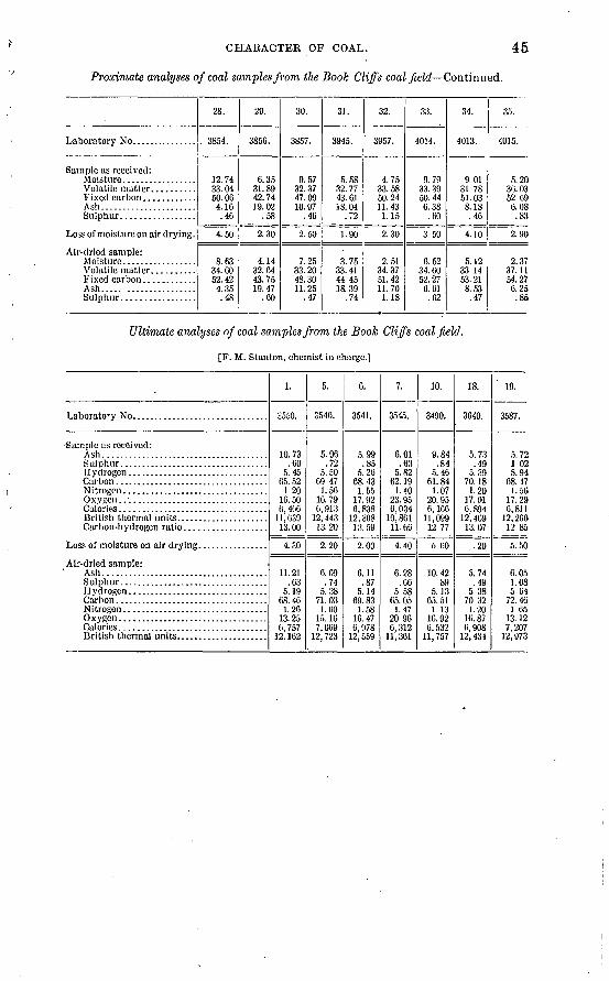
CHARACTER OF COAL. 45
Proximate analyses of coal samples from the Book Cliffs coalfield Continued.
Sample as received:
Ash......................
Loss of moisture on air drying.
Air-dried sample:
Ash..... ................
28.
. 3854.
12.7433.0460.064.16.46
4.50
8.6334.6052.424.35.48
29.
3856.
6.3531.8942.7419. 02
.58
2.30
4.1432.6443.7519.47
.60
30.
3857.
9.5732.3747.0910.97
.46
2.50
7.2533.2048.3011.25
.47
31.
3945.
5.5832.7743.6118.04
.72
1.90
3.7533.4144.4518. 39
.74
32.
3957.
4.7533.5850.2411.431.15
2.30
2.5134.3751.4211.701.18
33.
4014.
9.7933.3950 446.38.60
3 50
6.5234.6052.27
6.61.62
34.
4013.
9.0131.7851.038.18.46
4.10
5.1233.1453.218.53.47
3.r>.
4015.
5.2030.0352.096.08.83
2.90
2.3737.1154.276.25.86
Ultimate analyses of coal samples from the Book Cliffs coalfield.
[F. M. Stanton, chemist in charge.]
Laboratory No. ..............................
-Sample as received: Ash......................................
Carbon-hydrogen ratio ...................
Air-dried sample: Ash......................................Sulphur..................................
Oxygen ..................................
1.
2550.
10.73.60
5.4565.52
1 2016.506,406
11,63913.00
4.30
11.21.63
5.1968.461.26
13.25 6, 757
12.162
5.
3546.
5.96.72
5.5069. 471.56
16.796,913
12,44313.20
2.20
6.09.74
5.3871. 031.60
15. 16 7,069
12, 723
C.
3541.
5.99.85
5.2668.431.55
17.926,838
12, 30813.59
2.00
6.11.87
5.1469.831.58
16.47 6,978
12,559
7.
3545.
6.01.63
5.8262.191.40
23.956,034
10,86111.60
4.40
6.28.66
5 5865. 05
1.4720 96 6,312
11,361
10.
3490.
9.84.84
5.4661.841.07
20.956,166
11,09912 77
5 60
10.4289
5. 1365. 511.13
16.92 6,532
11,757
18.
3640.
5.73.49
5.3970.181.20
17.016.894
12, 40913.07
.20
5.74.49
5 3870 321.20
16.87 0,908
12,431
' 19.
3587.
5.721 025.94
68.171.56
17 296,811
12,26012 85
5.50
6.051.085 64
72.461 05
13.12 7.207
12,973
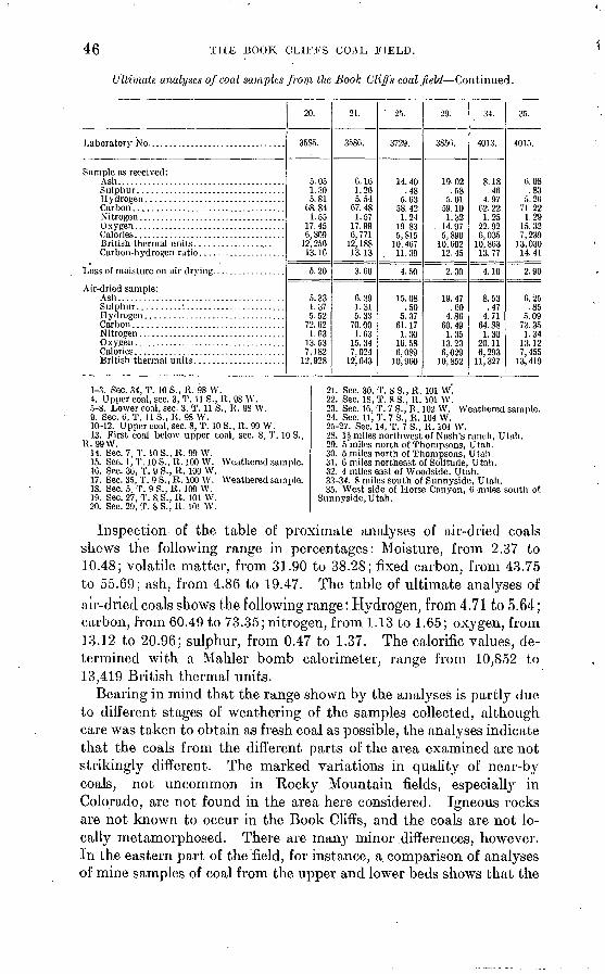
46 THE BOOK CLIFFS COAL FIELD.
Ultimate analyses of coal samples from the Book Cliffs coalfield Continued.
Sample as received: Ash.......................................
O wupn
Air-dried sample: Ash.......................................
Calories ...................................
20.
3585.
5.051.305.81
08.841.55
17.450,809
12,25013.16
5.20
5.331.375.52
72.621.63
13. 537,182
12,928
21.
3580.
C.1G1.265.54
07.481.57
17.996,771
12,18813.13
S 00
p> 901.315.33
TO nn1.63
1 c 04
7,02412, 043
' 25.
3729.
485.63
58.421.24
19 835,815
. 11. 39
4 ^n
15.08.50
fi ¥7
61.171 >!0
10.586, 089
10 960'
29.
3850.
1Q fi9
.58
en -m1 \9
14 07
5,89010,002
19 A*\
9 3ft
19 47ftrt
4.8600.49i w
1 3 93
6,02910, 852
34.
4013.
8.18
62. 221.25
22.92
13.77
4.10
8 ^9.47
4.7164.88
1 9ft
20.116,293n ooy
35.
4015.
(i.OS.83
5.2071.221.29
15. 327,239
13,03014.41
2 90
p. oe.85
5 no
73. 351 '<4
13 127,455
13, 419
1-3. Sec. 34, T. 10 S., R. 98 W.4. Upper coal, sec. 3,T. 11S..R. 98 W.5-8. Lower coal, sec. 3. T. 11 S., R. 98 W.9. Sec. 0, T. 11 S., R. 98 W.10-12. Upper coal, sec. 8, T. 10 S., R. 99 W.13. First coal below upper coal. sec. 8, T. 10 S..
R. 99 W.14. Sec. 7, T. 10 S., R. 99 W.15. Sec. 1, T. 10 S., R. 100 W. Weathered sample.16. Sec. 36, T. 9S.,R. 100 W.17. Sec. 35, T. 9 S., R. 100 W. Weathered sample.18. Sec. 5,T. 9S.,R. 100 W.19. Sec. 27, T. 8.S.,R. 101 W.20. Sec. 29, T. 8S.,R. 101 W.
21. Sec. 30, T. 8 S., R. 101 W.22. Sec. 18, T. 8S.,R. 101 W.23. Sec. 16, T. 7 S., R. 102 W. Weathered sample.24. Sec. 11, T. 7 S., R. 104 W. 25-27. Sec. 14, T. 7 S., R. 104 W.28. 1£ miles northwest of Nash's ranch, Utah.29. 5 miles north of Thompsons, Utah.30. 5 miles north of Thompsons, Utah.31. 6 miles northeast of Solitude, Utah.32. 4 miles east of Woodside, Utah. 33-34. 8 miles south of Snnnyside, Utah. 35. West side of Horse Canyon, 0 -miles south of
Sunnyside, Utah.
Inspection of the table of proximate analyses of air-dried coals shows the following range in percentages: Moisture, from 2.37 to 10.48; volatile matter, from 31.90 to 38.28; fixed carbon, from 43.75 to 55.69; ash, from. 4.86 to 19.47. The table of ultimate analyses ofair-dried coals shows the following range: Hydrogen, from 4.71 to 5.64; carbon, from 60.49 to 73.35; nitrogen, from 1.13 to 1.65; oxygen, from 13.12 to 20.96; sulphur, from 0.47 to 1.37. The calorific values, de termined with a Mahler bomb calorimeter, range from 10,852 to 13,419 British thermal units.
Bearing in mind that the range shown by the analyses is partly due to different stages of weathering of the samples collected, although care was taken to obtain as fresh coal as possible, the analyses indicate that the coals from the different parts of the area examined are not strikingly different. The marked variations in quality of near-by coals, not uncommon in Rocky Mountain fields, especially in Colorado, are not found in the area here considered. Igneous rocks are not known to occur in the Book Cliffs, and the coals are not lo cally metamorphosed. There are many minor differences, however. In the eastern part of the field, for instance, a comparison of analyses of mine samples of coal from the upper and lower beds shows that the

CHARACTER OF COAL. 47
upper bed contains more moisture and ash and less carbon than the lower coal, and that the lower coal has a greater efficiency as ex pressed by the calorific values. Judged by the analyses, the sample of coal showing the best results is the one from Horse Canyon, Utah, which, .with 6.25 per cent of ash, gave an efficiency of 13,419 British thermal units, while the best results obtained in the eastern end of the field were from the lower coal near the mouth of the Hogback Canyon' of Grand River, which, with 6.09 per cent of ash, showed an efficiency of 12,723 British thermal units.
An important difference is in the coking quality of these coals. The coal from Sunnyside, Utah, produces a coke of good grade,, whereas thus far coals from the vicinity of Grand- Junction yield such a low-grade product that they are classed as noncoking. Between these extreme locations, one at the eastern end of the area examined and the other beyond the western limit, no coking tests have beenmade; and it remains to be determined what coals, if any, in the east ern part of the Book Cliffs field will coke.
Comparison with analyses of other coals examined at the Govern ment fuel-testing plant shows that the coals from the eastern part of the Book Cliffs field rank favorably with the product of other fields in the Rocky Mountain region and the Mississippi Valley. The Book Cliffs coals are classed as medium-grade bituminous.
MARKET AND USE.
The part of the Book Cliffs field under consideration is situated between areas where coal of similar quality and greater thickness is already being developed. The mines in the vicinity of Newcastle, to the east, and those about Castlegate, to the west, are more favorably situated for the large markets than is the eastern part of the Book Cliffs field. However, because of the proximity of the Denver and Rio Grande Railroad, it probably will not be long before this, great reserve of coal will be more actively developed. Denver and Pueblo, Salt Lake City, and the Pacific coast are likety to be the most im portant outside markets, and there will be a growing local demand in connection with the increase of population and the development of Colorado and Utah mines. At present the local market is the only outlet.
There are only four mines with railroad connection in the field here discussed, and practically their entire product is used by the towns of Grand Junction, Palisades, and Fruita, and by the Uintah Rail way. These mines are the Cameo (No. 1), Palisade (No. 6), Book Cliff (No. 10), and Carbonera (No. 25). At Grand Junction, besides a considerable amount of coal used for domestic purposes and for the gas and electric light plants, a sugar-beet factory and a smelter use coal from the Book Cliffs field. The other mines are worked

48 THE BOOK CLIFFS COAL FIELD.
entirely for domestic purposes and the coal is transported by wagon. In 1906 the average cost of coal at the country mines was $1.75 a ton; at Palisades the price was quoted at $2.25 a ton, and at Grand Junction the retail price for lump coal not delivered was $3 a ton. Slack sold for between 50 and 75 cents a ton.
DEVELOPMENT.
Very little has been done in developing the eastern part of the Book Cliffs coal field. The four mines with railroad connections are reported to have produced in 1905 a total of only 5,300 tons, while the other mines are for the most part country banks that yield but a few hundred tons each a year.
The proximity of the field to a trunk railroad and the ease with which short branch Lines can be constructed across the shale plain to the base of the cliffs render the transportation problem comparatively easy. The situation of the coal, however, several hundred feet above the base of the cliffs, except in the creek valleys, makes it difficult of access and usually necessitates the construction of a steep tramway or an aerial cable. Favorable conditions for reaching the coal by shafts are rare, except in the broader valleys, and the greater part of the coal probably will be worked from the outcrop.
An important consideration is the lack of water, which will prove a detriment to the commercial development of a large part of the field. Throughout the greater portion of the year there is either no surface water in the vicinity of the cliffs, away from Grand River, or water is present in very small quantity. Springs are scarce and the prospect of obtaining sufficient supplies of underground water is not favorable. The Cameo, Riverside, and Palisade mines, being near Grand River, do not experience this difficulty, and the BookCliffs mine is located near one of the rare springs. Water is hauledfrom Atchee by the Uintah Railway for the men at the Carbonera mine. In the vicinity of several of the workings, as in Horse Creek, Utah, there is a small perennial stream, but for many miles along the cliffs there is insufficient water for mining purposes. Water from an irrigation canal is hauled by wagon to the mines north of Fruita, a distance of 8 or 10 miles.
The first development work on the coal in this area is said to have been in 1882 at the old Book Cliff mine, north of Grand Junction. The Cameo mine was opened about 1895, and the Palisade mine is reported to have been started also about that time. These are the chief mines of the area and they supply the needs of the settlements in Grand River valley. The Carbonera mine, the only other with railroad connections, was not opened until 1904, and is used entirely for the needs of the Uintah Railway, which is a short road from Mack, Colo., to the gilsonite deposits at Dragon, Utah. There are only

U. S. GEOLOGICAL SURVEY BULLETIN NO. 371 PL. X
PROPERTY OF THE BOOK CLIFF MINE COMPANY AT THE BASE OF THE CLIFFS NORTH OF GRAND JUNCTION.
The " lower coal " occurs at the base of the lowermost massive sandstone and the " upper coal " 200 feet higher, immediately above the conspicuous bed of white sandstone. The view shows the transition from the Mancos shale to the overlying Mesaverde formation.

COAL DEVELOPMENT. . * 49
about thirty other small mines and prospects of any consequence within the area here reported; these are listed and their locations are shown on the map, Plate I.
The coal is opened at or near the outcrop and generally is worked by the room and pillar system. Where the dip is appreciable entries are run with the strike and the rooms are opened principally up the rise. The long-wall system is used at only one mine, the Riverside. Both roof and floor are generally a firm, sandy shale. The workings usually are dry and little trouble is caused by water, but in a few instances, as at the Cameo mine, water level has been reached. Some of the workings are extremely dry and dusty and care must be taken to avoid explosion. Natural ventilation is chiefly depended on, though furnaces are used to some extent. Machines have not been introduced and in general the methods of mining are simple. The following brief descriptions will serve to indicate the present stage of development:
The Book Cliff mine, operated by the Book Cliff Coal Company, is situated in a small ravine in the Little Book Cliffs, about 12 miles north of Grand Junction. The mine is connected with the Denver and Rio Grande Railroad by a narrow-gage road, and the camp con- sists of a number of frame houses, a company store, workshop, etc. (See PI. X.) Good water is supplied in moderate quantity from a near-by spring, which was an important factor in determining the location of the mine.
Considerable prospecting has been done in this vicinity. The lower bed was formerly worked; it has the advantage over the upper bed of being slightly better in quality and of outcropping about 190 feet lower down the cliffs. The old mine 0 is situated in the ravine next south of the one in which the present workings are located, and was approached by a steeply inclined tramway. The coal was reached by a tunnel cut through the underlying sandstone. Development proved, however, that the low'er coal bed in this vicinity varies greatly in thickness, ranging from a few inches to about 4 feet, and after a few years work on the lower bed was abandoned. A considerable quan tity of coal was mined, however, the largest production of any one year being reported as 18,000 tons.
In the present mine, which was opened in 1903, the upper coal is worked. It is reached through a tunnel, the mouth of which is sit uated near the lower coal outcrop, about a quarter of a mile north east of the terminus of the branch railroad and some 200 feet above it. The tunnel extends northeastward through a heavy bed of sand stone a distance of 750 feet, where the upper coal is encountered. From the end of the tunnel entries extend northwest and southeast
a Lakes, Arthur, The Book ClifT coal mines: Mines and Minerals, vol. 24, 1904, p. 289. 63854 09 -4:

50 * THE BOOK CLIFFS COAL FIELD.
about 800 feet in each direction, and several rooms have been opened up the rise. The tunnel not only avoids climbing a precipitous ledge, but has a distinct advantage over an opening on the outcrop. A gravity incline can thus be operated and the workings can be pushed along the strike and up the rise, avoiding, in the early stage of develop- ment at least, a haul up the dip, which in this mine is very steep. In the workings the coal bed dips from 25° to 30° N. 55° E. ; and is trav ersed by prominent j oint planes, the most conspicuous of which strikes between N. 65° E. and N. 75° E. The bed averages about 7 feet thick, with a parting of sandstone, varying from one-fourth inch to 3 inches in thickness, about 3 feet from the top. The output of the mine for 1905 was reported as 6,000 tons.
The Cameo mine, operated by the Grand Junction Mining and Fuel Company, is situated at the mouth of a small creek which enters Grand River about 4 miles above. Palisades. The mine is connected with the Denver and Rio Grande Railroad' by a short spur. A number of cabins, a store, a shop, etc., have been constructed and water is supplied by a steam pump from a well near the river.
The coal worked is the upper or Cameo bed. At the entrance to the mine the coal is covered by a few feet of alluvium, and the bed is reached by a slope. Nine feet or more of coal is exposed, but only 5 or 6 feet is worked. The roof is a firm sandy shale, but owing to a number of partings the coal is dirty and-is reported to produce about 30 per cent of slack. The mine has been in operation eight or nine years.and the workings are extensive. The entries run north- west-southeast and the rooms extend northeast and southwest, both up and down the slope. The inclination of the coal is reported to be only about 3°, so that mules can pull the cars anywhere, but the workings are at such a distance from the mouth that much time is lost in transit. Some water is encountered, but when it is reached in going down the dip the workings are abandoned. It is proposed to introduce pumps and a system of electric lighting and haulage. The annual product of the mine is reported to be 24,000 tons.
The Palisade mine is located in the face of the cliffs about 150 feet above the valley, a mile northeast of the town of Palisades. The property is controlled by the Palisade Coal and Supply Com pany, which began operations about 1895. A short spur connects the terminus of the gravity tramway that leads to the mine with the Denver and Rio Grande Railroad. The mine is located on the out crop and the workings extend in about 1,600 feet. The lower coal, or Palisades bed, is worked, which averages in the mine about 3 feet 10 inches thick. No trouble is caused by water. The average output of the mine is reported to be 18,000 tons a year, about 35 per cent of which is slack.

COAL DEVELOPMENT. 51
The Carbonera mine has been in operation only two years (1906) and its output is used exclusively by the Uintah Railway Com pany. The mine is situated on the hillside above West Salt Creek, at the little mining settlement of Carbonera, where there are a few cabins, a shop, etc. Good mountain water is.hauled from Atchee and stored in a cistern. The entrance is on the outcrop and the main entry is about 600 feet long. The roof and floor are a firm sandy shale. About 5 feet of coal is mined. Two streaks of bone, from 1 inch to 1 foot in thickness, are present, so that the coal is dirty. The daily production is reported to be about 14 tons throughout the year.
The other mines and prospects in the area under consideration are small. They are all situated on the outcrop, and the workings at the largest are only a few hundred feet in extent. They are operated only during the winter months to supply the needs of near-by settlers.

r

INDEX.
B.Page.
Bollard mine, coal at, view of................ 38sections at and near..................... 38-39view of.................................. 38
Beckwith Plateau, description of............ 10section at................................ 39-40
Black Baby mine, section at................. 39Black Diamond mine, section at............. 28Bob Catmine, coal at....................... 30Book Cliffs bench, view of................... 10Book Cliff mine, coal of...................... 47
development at.......................... 49-50fossils from.............................. 17sections at and near............ 24-25,20-28,30view at.................................. 48
Book Plateau, description of................. 10Bryson's ranch, section near................. 36-37
C.
Cameo, fossils from.......................... 18Cameo coal, occurrence of.................... 28Cameo mine, coal of......................... 28-47
development of.......................... 50sections at and near..................... 29
Carbonera, fault near, view of................ 10fossils from..................*........... 18sections at and near..................... 34-30structure at.............................. 22-23
Carbonera mine, coal of...................... 47development of.......................... 51section in................................ 36
Climate, character of......................... 11Coal, amount of............................. 42
analyses of............................... 43-46character of.............................. 42-47development of.......................... 48-51faulting in............................... 23market and use for ...................... 47-48occurrence and distribution of........... 23-42sections of............................... 22-41
plate showing....................... 24thickness of............................. 24
Coal-bearing rocks, detailed sections of, plateshowing......................... 22
Coking, tests of.............................. 47Colorado, coal in............................. 5Columnar section, plate showing............. 12Corcoraii mine, coal of....................... . 31
section near............................. 31Cretaceous rocks, character and distribution
of................................ 12-19Cross, Whitman, rock classification by....... 11-12Culture, status of......................... 11,48-51
D.Page.
Dakota sandstone, character and distributionof............................ 11,12-14
fossils of................................. 14sections of............................... 13
Dall, W. H., character and distribution of... 21 Development, progress of.................... 48-51Drainage, description of..................... 8-9
East Salt Creek canyon, section in........... 34Eldridge, G. H., on Uinta Basin............. 5,19Elgin, fossils near............................ 14Eocene rocks, character and distribution of.. 19-21 Excelsior mine, coal of...................... 31
Faults, occurrence and character of.......... 23Fort Union, character and distribution of.... 11,21Fox Hills, restriction of..................... 12Fruita, section near......................... 13
G.
Gale, II. S., on Book Cliffs field............. 22Garfleld, Mount, view of..................... 14Garfleld mine, section at..................... 26Geology, description of...................... 11-23
study of................................. 5Gidley, J. W., character and distribution of.. IS Grand Junction; coal of.......... .*........... 47-48
sections of.............................. 13Grand River, coal of......................... 47
description of............................ 8-9view on................................. 24
Grand River bridge, section at.............. 30Green River, description of.................. 8,10Green River formation, character and dis
tribution of................... 11,19,20Gross mine. See Kiel mine.
H.
Harms's ranch, coal near.................... 37Hay Creek, fossils from...................... 21Hills, II. C., on Book Cliffs coal.............. 6History of field.............................. 5-6Hogback Canyon, coal of.................... 47Horse Canyon, coal of, analysis of......... 45,46,47
fossils from.............................. 21sections in and near..................... 20,41
Hunter mine, section at..................... 31
J.
Johnson mine, section at. 33
53

54 INDEX.
K.
Kiel mine, coal at........................... 31Knowlton, F. H., fossils determined by.... 14,
17,19,21 - L.
Lakes, Arthur, on Book Cliffs coal.......... CLaramie, restriction of.................... 12,18-19Lane mine, sections at and near............. 33Little Book Cliffs, description of............. 9,10
view of.................................. 24Location of field............................. 5Loma, section near.......................... 13Lord, N. W., analyses by................... 43Lowland, topography of..................... 9-10
M.
Malone's ranch, section near ................ 33Mancos.shale, character and distribution of. ' 9,
11,14-15 fossils from.............................. 15
Map of Book Cliffs field..................... 5showing location of Book Cliffs field..... 7
Mesaverde formation, character and distribu tion of...................... 11,16-19,36
coal in.................................. 23fault in.................................. 10
view of.............................. 10fossils from.............................. 17-19outcrop of, view of...................... 16
Mining, methods of.......................... 48-51
N. Nash's ranch, coal near...................... 37
coal near, analysis of..................... 45,46Neal, W. D., work of........................ 6Nearing mine, section near.................. 32Nugent mine, coal at........................ 32
P. Palisade mine, coal of....................... 47-48
development at......................... 50Palisades, section at......................... 30Palisades coal, occurrence of................ 25-26Peale, A. C., on Book Cliffs field......... 5,12,18,20Pepperberg, L. J., work of.................. 6Perrin, C. D., work of....................... 6Peterson's prospect, section at............... 40-41Price River, description of.................. 8,10Price River Canyon, section near ........... 39-41
R.Page.
Relief, description of........................ 8-9Riverside mine, coal at'...................... 28
section at................................ 26Roan Creek, description of.................. 8-9,10Rock formations, description of.............. 11-21
Saleratus Creek, coal near, view of........... 16San Rafacl uplift, structure of............... 22Section, columnar, plate showing............ 12Sections of coal.............................. 24-41
plate showing........................... 24Sections of coal-bearing rocks, plate showing. 22Solitude, coal near, analysis of............... 45,46S.tanton, T. .W., fossils determined by.. 15,17,18-19Steele mine, coal at.......................... 28
section at................................ 30Storrs, L. S., on Book Cliffs field............ 6Stratigraphy, description of................. 11-21Structure, description of..................... 21-23Sunnyside, coal near........................ 47
coal near, analysis of..................... 45,46
Taff, J.. A., on Book Cliffs field............... 6Tavaputs Plateau, description of............ 6,10Tertiary rocks, character and distribution of. 19-21 Thompsons, coal near, analyses of........... 45,46
fossils from......................'........ 18rocks near............................... 19-20
view of............................. 16section near............................. 37-39
Topography, description of.................. 6-11Turner's ranch, sections near................ 20,34
U.
Uinta Basin, coaMn......................... 5,42Utah, coal in................................ 5
W.
Wasatch formation, character and distribu tion of....................... 11,19-21
Water, lack of............................... 48Westwater Creek, section on................. 36-37Woodside, coal near......................... 41
faults near............................... 23fossils near.............................. 14
o