boglarka czellecz1 i. gÁbor, n. szopos, g. schiopu, l...
TRANSCRIPT

MINERAL WATERS FROM UPPER TROTUȘ RIVER BASIN
Boglarka CZELLECZ1, I. GÁBOR, N. SZOPOS, G. SCHIOPU, L. RAVASZ, L. GOMBOS
ABSTRACT. – Mineral waters from upper Trotuș river basin. Mineral waters from Ciucului Mountains are in a small number and sporadically distributed along the river valleys. In order to fill the lack in the bibliography of mineral waters described as sulfurous springs from Ciucului Mountains we gathered geographical and chemical information about the springs from upper Trotuș river basin by researching these sources. Eight water samples were analyzed in november, 2016. Springs located on our study area generally have low mineral content indicating their meteoric origin from shallow depths . On the western part of the study area springs have dissolved carbon dioxide, while in the center part they can be considered sulfurous. The majority of the spring waters are calcium-hydrogen carbonate type. Keywords: upper Trotuș river basin, mineral water, CO2, H2S 1. INTRODUCTION
It is a well known fact that Romania is very rich in different kind of mineral water resources. From the Eastern Carpathians the area of the Neogene volcanism is the most researched hydrogeologically. Parallel to the Neogene volcanic range, in the east, is to be found the Carpathian Flysch Belt zone where sulfurous mineral waters were described (Kisgyörgy and Kristó, 1978). In Ciucului Mountains sulfurous mineral waters are present mostly on the western slopes of the mountains (Jánosi, 2009) being related to the Sinaia Formation, Carpathian Inner Flysch Belt. The springs appear sporadically and in a small number. This could be one of the reasons why this kind of mineral waters are not so well documented. The aim of this study is to present and characterize the (sulfurous) mineral waters from upper Trotuș river basain – northwestern periphery of the Ciucului Mountains, between Comiat and Ghimeș settlements, Harghita County. Kisgyörgy and Kristó (1978) and Jánosi (2009) describe sulfurous, rarely carbon dioxide mineral waters in Ghimeș region. Probably because of their isolated location, mineral waters from the upper Trotuș river basin are not so well known and don’t have a large bibliography. They are even missing from the comprehensive materials published in the 19th centuries in the former Hungary. The hydrogeological background of Harghita County was briefly researched by Pricăjan (1974), even so the mineral waters from upper Trotuș river basin were out of the study.
1 "Babeş-Bolyai" University, Faculty of Geography, 400006 Cluj-Napoca, Romania, Corresponding author, e-mail: [email protected]
143

2. SULFUROUS MINERAL WATERS Sulfurous mineral waters are defined by many authors as waters having 1 mg/l titratable sulfur mostly in form of H2S (INRMFB; Preda and Țenu, 1981; Kisgyörgy and Kristó, 1978; ***, 1961). Bányai (1938) is talking about four types of sulfurous waters having different spatial distribution: (1) sulfurous freshwaters from the Carpathian Flysch Belt zone, (2) highly mineralized sulfurous and carbogazeous waters from Harghita Mountains area - postvolcanic origin of H2S, (3) sulfurous waters with high NaCl content from the Transylvanian Basin, (4) waters with carbonyl sulfide, ex. the mineral spring from Seiche Spa near Odorheiu-Secuiesc. Bányai (1934) puts the main source of H2S to the decomposition of pyrite or marcasite (inorganic origin). According to Kisgyörgy and Kristó (1978) in the Flysch Belt zone the location of sulfurous springs is related to underground layers containing easily decomposable sulfide minerals (inorganic origin). Preda and Țenu (1981) highlight the two major origins of H2S: (1) reduction of sulfates due to anaerobe bacteria, (2) reduction of organic rocks like bituminous slates – biogenic origin. Pricăjan (1985) focuses on sedimentary regions as well. In case of Băile Olănești and Călimănești-Căciulata he finds that H2S has an organic origin as a result of the reduction of sulfates by anaerobe microorganisms. In case of the sulfurous spring from Piscul Câinelui (Sinaia region) mineral water is accumulated in a sandstone reservoir belonging to the Sinaia Formation. At Soveja and Vizantea region (Muntenia) the H2S content of the waters is explained by the presence of bituminous schist rich in organic substances where anaerobe microorganisms are reducing the sulfates from meteoric waters. In saline environments the origin of H2S is related to the presence of hydrocarbons that facilitate the H2S production from gypsum. Related to the Carpathian Flysch zone, sulphurous mineral waters were also described in Poland, mostly within the Magura and Silesian Units. Four types of waters were identified: hydrogen carbonate-, chloride-, carbogazeous-, and sulphate-sulphurous waters (Rajchel, 2002). Differences within the chemical composition is a result of the lithology, the overthrusting of different units. The same author (Rajchel et al., 2002) has investigated the δ34S of dissolved sulphide and sulphate in order to explain the origin of H2S and reach to the conclusion of mantle origin in some of the cases. Comments on the article (Leśniak, 2007) argue that conclusions are not justified and point out that H2S is a reactive gas and can be easily generated from the SO4
2- reduction in the Flysch environment rich in organic matter or crustal solid sulphids can’t be excluded as well.
3. HYDROGEOLOGICAL BACKGROUND OF THE STUDY AREA
Mineral waters from Harghita County were briefly studied and grouped into four alignments by Pricăjan (1974). The occurrence of mineral waters that
144

form these alignments is determined by the geological background of the region, the most important factors being the crustal, regional and local fracture fields.
Mineral water springs from the upper Trotuș river basin belong to the II. mineral water alignment, their outcropping is related to the local l4 and l7 fractures (Fig. 1). The upper Trotuș river basin area is located at the intersection of these two fractures, l4 having a N-S orientation, while l7 a NE-SW orientation (Pricăjan, 1974). Along one main alignment mineral waters can be of different type, their chemical composition being influenced by the local geological layer that also plays an important role as the underground drainage basin of a group of springs.
According to the geological map 1:200 000 (L-34-XIV sheet) the lithology on the left bank of the Trotuș River corresponds mostly to the East Carpathian Crystaline-Metamorphics with the Lunca formation on the surface (argillaceous limestones and marls), respectively dolomites, limestones and jasper extended in narrow strips.
The right bank of the river is made up of the Internal Flysch Belt’s Ceahlău Unit – Sinaia Formation that is a sandstone-limestone flysch. Sinaia formation can be divided into three horizons in Ciucului Mountains differentiated by the predominance of the continental-costal (arenitic) sediments or marine (politic) sediments. The lower horizon is made up mostly of shale; at the mid horizon the calcareous sandstones are characteristic, while the upper horizon is made up of conglomerates and breccias (Mutihac and Ionesi, 1975). After the Valea Rece -
Trotuș river confluence, the main channel turns into the SE because of the presence of massive sandstones at the left bank of the river.
4. METHODOLOGY Eight water samples were analyzed completely and one sample partially from the upper Trotuș river basin in November, 2016. The approximate location of the springs were taken from Jánosi (2009) and the tourist map Ciucului Mountains and the Ghimeș (Zsigmond, 2009). The springs are located along the main left and
Figure 1. Location of the springs in correlation with the deep geological structure of the region
(reconstruction after Ariniei and Pricăjan, 1972)
145

right tributaries of Trotuș river, from up to downstream Curuț creek, Valea Întunecoasă and Antalok creeks, Boros creek, Muhos creek (trough Valea Rece creek) and Tărhăuși creek. For the measurement of temperature, electric conductivity (EC), total dissolved solids (TDS) and pH it was used the Thermo Orion 5 Star, a portable multiparameter device equipped with electrodes. S2 and total iron were determined by colorimetric method. For the analysis of dissolved CO2 and HCO3 content we applied for the classical analitical method, titration with pipettes using HCl and NaOH solutions and indicators as well. The Ca2+, Mg2+, K+ and Cl- ions were determined by using the Merck RQFlex plus 10 portable reflectometer, while the SO4
2- content was analyzed with Hanna portable photometer. The Na+ content was calculated based on the anion-cation balance (***, 1961).
4. RESULTS AND DISCUSSION The aim of our work was to give a presentation of the springs located in the upper Trotuș river basin trying to fill a lack in the Ciucului Mountains mineral water cadastre. On the other hand the spring’s mineralization and some physical and chemical properties will be given. The Kuruc spring is located along the Curuț creek, to about 1 km from the main road. It is a carbon dioxide mineral water rich in iron that is shown by limonite sediments around the spring (Fig. 2). There were visited three springs from Valea Întunecoasă river valley. The old spa is located approx. 1 km from the main road. It was an outside traditional health resort for local people (Jakab and Salamon, 1974). During the last decades the spa run down. On the inside walls of the spring’s reservoir the native sulfur is precipitated as white pudding-like sediment. Up the creek, the second spring is located to approx. 100 m distance from the first one. Unlike the first one, this spring has reddish limonite sediment and CO2 degassing can be observed. The third spring is to be found at the base of a slope, next to the local Vraja Munților mineral water bottling plant. The water accumulates in an interception reservoir than it is directed to the drip. It has limonite sediment and dissolved carbon dioxide. One of the highest discharges was observed at this source.
Figure 2. Set of pictures: The Kuruc spring (left) and the sulfurous spring from Antalok
creek (right)
146
Along the Antalok creek two springs were visited, but only one was analyzed. The first one (analyzed) is located to about 1 km distance from the main road. It is captured in a little, barrel-like reservoir; it discharges directly to the creek (Fig. 2). The white sediment characteristic to aqueous-sulfurous environment was the most accentuated here. The second spring is to be found to about 150 m distance from the first one, on a private property. It has thin limonite sediment and strong CO2 outgassing. Along the Boros creek one source was mapped. Local people described a very modest bathing place in the past. The white sediment was denoting the location of the former spring. This source is just a leakage now. There is one source along Muhos creek, left tributary of Tatroș River trough Valea Rece creek. A pension was built next to the spring where inside and outside bathing facilities were installed. It’s not a natural spring, but a manmade well on a hill with high discharge. White sediment is deposited on the pipe. The Saline spring is to be found in a small valley along the Tărhăuși creek. Because of its diffuse occurrence it is more like a leakage than a spring. The presence of different salts in the water is indicated by the lack of the vegetation.
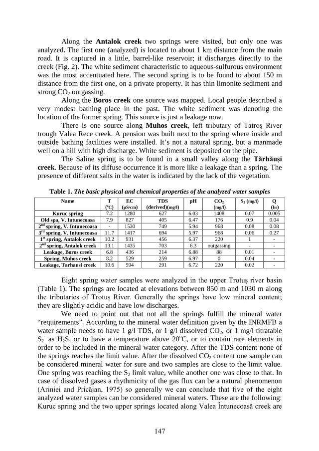
Table 1. The basic physical and chemical properties of the analyzed water samples
Eight spring water samples were analyzed in the upper Trotuș river basin (Table 1). The springs are located at elevations between 850 m and 1030 m along the tributaries of Trotuș River. Generally the springs have low mineral content; they are slightly acidic and have low discharges.
We need to point out that not all the springs fulfill the mineral water “requirements”. According to the mineral water definition given by the INRMFB a water sample needs to have 1 g/l TDS, or 1 g/l dissolved CO2, or 1 mg/l titratable S2
- as H2S, or to have a temperature above 20oC, or to contain rare elements in order to be included in the mineral water category. After the TDS content none of the springs reaches the limit value. After the dissolved CO2 content one sample can be considered mineral water for sure and two samples are close to the limit value. One spring was reaching the S2 limit value, while another one was close to that. In case of dissolved gases a rhythmicity of the gas flux can be a natural phenomenon (Ariniei and Pricăjan, 1975) so generally we can conclude that five of the eight analyzed water samples can be considered mineral waters. These are the following: Kuruc spring and the two upper springs located along Valea Întunecoasă creek are
Name T (oC)
EC (µS/cm)
TDS (derived)(mg/l)
pH CO2 (mg/l)
S2 (mg/l) Q (l/s)
Kuruc spring 7.2 1280 627 6.03 1408 0.07 0.005 Old spa, V. Intunecoasa 7.9 827 405 6.47 176 0.9 0.04
2nd spring, V. Intunecoasa - 1530 749 5.94 968 0.08 0.08 3rd spring, V. Intunecoasa 11.7 1417 694 5.97 968 0.06 0.27 1st spring, Antalok creek 10.2 931 456 6.37 220 1 - 2nd spring, Antalok creek 13.1 1435 703 6.3 outgassing - -
Leakage, Boros creek 6.8 436 214 6.88 88 0.01 - Spring, Muhos creek 8.2 529 259 6.97 0 0.04 -
Leakage, Tarhausi creek 10.6 594 291 6.72 220 0.02 -
147

carbon dioxide mineral waters, while the Old spa from Valea Întunecoasă creek and the downward located spring from Antalok creek are sulfur mineral waters.
There is a notable correlation between the springs CO2 content and the electric conductivity values (TDS, respectively). The highest values for EC are characteristic in those cases where the CO2 content is also high. The presence of carbon dioxide increases the solubility of water (Preda and Țenu, 1981).
Based on the geographical distribution of the springs and the geological background of the study area there are two observations to make. Springs occure along the local fault lines. The sources with significant CO2 content are located on the western part of the study area, on the eastern border of the so called mofettic aureola of the Harghita neogene eruptive structures (Ariniei and Pricăjan, 1975). CO2 gas circulation occurs along the fault systems, the l4 and l7 local fractures having an important role in transmitting the gases and distributing them along the local fault systems (Fig. 3).
The dissolved CO2 content is the highest in Kuruc spring (having the westernmost location), while it is decreasing eastward (lower CO2 content in springs from Valea Întunecoasă springs). CO2 present in spring waters of upper Trotuș river basin can have a postvolcanic origin, or on the other hand it is also possible to be originated from the alteration of carbonated rocks (also present on the western part of the study area). For the origin of the H2S we assume it could be the Sinaia Formation. On the whole area, where sulphurous waters occure, or where springs have white native sulphur sediment the Sinaia Formation is present on the surface or covered by other geological formations - the center and eastern part of the sudy area (L-34-XIV, L-34-XV geological maps). In Sinaia Formation there were
Figure 3. Location of the springs in correlation with a detailed geological background of the study area (based on Ianovici, 1968; Murgeanu, 1968)
148
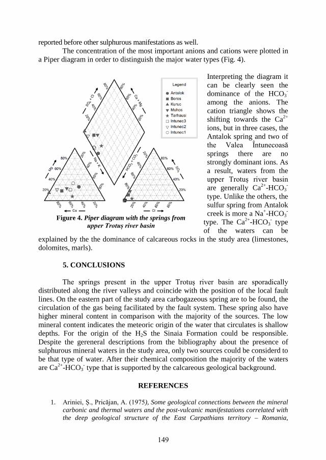
reported before other sulphurous manifestations as well. The concentration of the most important anions and cations were plotted in
a Piper diagram in order to distinguish the major water types (Fig. 4).
Interpreting the diagram it can be clearly seen the dominance of the HCO3
- among the anions. The cation triangle shows the shifting towards the Ca2+ ions, but in three cases, the Antalok spring and two of the Valea Întunecoasă springs there are no strongly dominant ions. As a result, waters from the upper Trotuș river basin are generally Ca2+-HCO3
- type. Unlike the others, the sulfur spring from Antalok creek is more a Na+-HCO3
- type. The Ca2+-HCO3
- type of the waters can be
explained by the the dominance of calcareous rocks in the study area (limestones, dolomites, marls).
5. CONCLUSIONS
The springs present in the upper Trotuș river basin are sporadically distributed along the river valleys and coincide with the position of the local fault lines. On the eastern part of the study area carbogazeous spring are to be found, the circulation of the gas being facilitated by the fault system. These spring also have higher mineral content in comparison with the majority of the sources. The low mineral content indicates the meteoric origin of the water that circulates is shallow depths. For the origin of the H2S the Sinaia Formation could be responsible. Despite the gereneral descriptions from the bibliography about the presence of sulphurous mineral waters in the study area, only two sources could be considerd to be that type of water. After their chemical composition the majority of the waters are Ca2+-HCO3
- type that is supported by the calcareous geological background.
REFERENCES
1. Ariniei, Ș., Pricăjan, A. (1975), Some geological connections between the mineral carbonic and thermal waters and the post-vulcanic manifestations correlated with the deep geological structure of the East Carpathians territory – Romania,
Figure 4. Piper diagram with the springs from upper Trotuș river basin
149

Institutul de Geologie și Geofizică, Studii Tehnice și Economice, Seria E, Hidrogeologie, nr. 12, București
2. Ariniei, Ș., Pricăjan, A. (1972), Corelații între strucutra geologică adâncă și aureola mofetică din jud. Harghita, cu privire la zonele de apariție a apelor minerale carbogazoase, in Studii și Cercetări Geol., Geof., Geogr., Seria Geologie, Vol. 17, nr. 2, București
3. Bányai, J. (1934), A székelyföldi ásványvizek eredete és forrásfoglalásai. EME vándorgyűlései Emlékkönyvei, Brassó
4. Bányai, J. (1938), A Székelyföld természeti kincsei és csodás ritkaságai, a Székelység melléklete, Székelyudvarhely
5. Ianovici, V., Rădulescu, D. (1968), Harta geologică L-35-XIV, Sheet nr. 20 – Odorhei, Institutul Geologic
6. Jakab, K., Salamon, M. (1974), Bogăție în resursele naturale balneoturistice terapeutice de interes local din depresiunea Ciucului inferior, Giurgeului, Bistricioarei și a Ghimeșului, Factorii terapeutici naturali din județul Harghita, Ed. Tipografia, Miercure Ciuc
7. Jánosi, Cs. (ed.) (2009), Székelyföld borvizei, publised by Polgár-Társ Alapítvány, Csíki Természetjáró és Természetvédő Egyesület, Csíkszereda
8. Kisgyörgy, Z., Kristó, A. (1978), Románia ásványvizei, Tudományos és Enciklopédiai Könyvkiadó, Bukarest
9. Leśniak, P. M. (2007), Comment on the paper Sulfur isotopic composition of H2S and SO4
2- from mineral springs in the Polish Carpathians, Isotopes in Environmental and Health Studies, Vol. 43, Issue 1
10. Murgeanu, G. (1968), Harta geologică L-35-XV, Sheet nr. 21 – Bacău, Institutul Geologic
11. Mutihac,V., Ionesi, I. (1975), Geologia României, Editura Tehnică, București 12. Preda, I. Țenu, A. (1981), Resursele de ape minerale și termale, București. 13. Pricăjan, A. (1974), Zestrea de ape minerale și gaze mofetice a județului Harghita,
Factorii terapeutici naturali din județul Harghita, Ed. Tipografia, Miercurea Ciuc 14. Pricăjan, A. (1985), Substanțe minerale terapeutice din România, Editura
Științifică și Enciclopedică, București 15. Rajchel, L. (2002), The occurrences of sulphurous waters in the Polish
Carpathians, Geologica Carpathica vol. 53 – Spetial Issue, Proceedings of XVII. Congress of Carpathian – Balkan Geological Association, Bratislava, Sept. 1-4
16. Rajchel, L., Rajchel, J., Szaran, J., Halas, S. (2002), Sulfur isotopic composition of H2S and SO4
2- from mineral springs in the Polish Carpathians, Isotopes in Environmental and Health Studies, Vol. 38, Issue 4
17. Zsigmond E. (2009), Munții Ciucului și zona Ghimeșului, tourist map, published by Dimap, Budapest
18. Institutul Național de Recuperare, Medicină Fizică și Balneoclimatologie: http://www.inrmfb.ro/consultanta/indicatii.html, accessed on January, 10, 2017
19. *** (1961), Apele minerale și nămolurile terapeutice din Republica Populară Română, published by Ministerul Sănătății și Prevederilor Sociale, Institutul de Balneologie și Fizioterapie
150