bluechart - long beach dive · 2007. 6. 28. · nautical data international, inc. garmin...
TRANSCRIPT
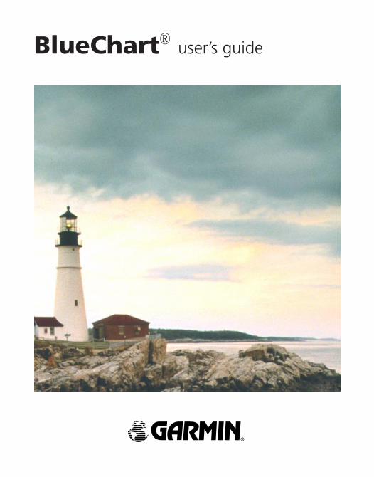
BlueChart® user’s guide
© Copyright 2001–2006 Garmin Ltd. or its subsidiariesGarmin International, Inc. 1200 East 151st Street, Olathe, Kansas 66062, U.S.A. Tel: 913/397.8200 or 800/800.1020, Fax: 913/397.8282, e-mail: [email protected] (Europe) Ltd. Unit 5, The Quadrangle, Abbey Park Industrial Estate, Romsey, SO51 9DL, U.K. Tel: 44/1794.519944, Fax: 44/1794.519222Garmin Corporation No. 68, Jangshu 2nd Road, Shijr, Taipei County, Taiwan Tel: 886/2.2642.9199, Fax: 886/2.2642.9099All rights reserved. Except as expressly provided herein, no part of this manual may be reproduced, copied, transmitted, disseminated, downloaded or stored in any storage medium, for any purpose without the express prior written consent of Garmin. Garmin hereby grants permission to download a single copy of this manual onto a hard drive or other electronic storage medium to be viewed and to print one copy of this manual or of any revision hereto, provided that such electronic or printed copy of this manual must contain the complete text of this copyright notice and provided further that any unauthorized commercial distribution of this manual or any revision hereto is strictly prohibited.Information in this document is subject to change without notice. Garmin reserves the right to change or improve its products and to make changes in the content without obligation to notify any person or organization of such changes or improvements. Visit the Garmin Web site (www.garmin.com) for current updates and supplemental information concerning the use and operation of this and other Garmin products.
Garmin®, BlueChart®, MapSource®, and G-Chart® are registered trademarks of Garmin Ltd. or its subsidiaries and may not be used without the express permission of Garmin.microSD™ and SD™ are trademarks of SanDisk Corporation, registered in the United States and other countries.
Microsoft® and Windows® are registered trademarks of Microsoft Corporation in the United States and/or other countries.
January 2006 Part Number 190-00246-00 Rev. F Printed in Taiwan

Portions of BlueChart data may be subject to the following copyrights and notices:© 2005 MapTech, Inc.The chart information in this product is reproduced, in whole or part, with the permission of the following national hydrographic offices and other organizations: Australian Hydrographic Service; Editrice Incontri Nautici (Bolina); Hydrographic Institute of the Republic of Croatia; Kort & Matrikelstyrelsen, Denmark, license no. G.9-2002; Hydrographic Office of Estonia; Finland Hydrographic Office, license no. FMA 877/721/2004; Service Hydrographique et Océanographique de la Marine (SHOM, www.shom.com), France, Contrat nº E 67/2005; Bundesamt für Seeschifffahrt und Hydrographie (BSH), Germany, license no. 8095-01/2004-02 ÖA03; Great Barrier Reef Marine Park Authority (GBRMPA); Hellenic Navy Hydrographic Service (Greece), license no. 171.7/22/03; Hydrographica chart data contained in this product is © 2005–2006 Hydrographica; Icelandic Coast Guard, license no. IS/16/01/2004; Imray Laurie Norie & Wilson Ltd. UK; Istituto Idrografico della Marina, Italy; Latvian Hydrographic Office; Hydrographic Office of the Netherlands, license no. NL AC-001-Garmin-20 December 2004; Land Information New Zealand (Crown copyright reserved); Norwegian Hydrographic Service, license no. NO24/021001/1; Instituto Hidrográfico, Portugal, license no. PT AC-001-Garmin-1 October 2005; Lewis Offshore Ltd. (© 2003–2006); Russian Hydrographic Office; South Africa Hydrographic Office; del Instituto Hidrografico de la Marina, Spain; Swedish Maritime Administration, license no. 03-01453; and the UK Hydrographic Office and the Controller of Her Majesty’s Stationery Office © the British Crown, 2001, GB AC-001-Garmin-24 March 2005. All rights reserved. Wavey Line charts are produced, in part, from products and with the agreement of Wavey Line Ltd.Some data and information contained in these Products are © Commonwealth of Australia, Australia Hydrographic Service. Certain zoning information in this product is © Great Barrier Reef Marine Park Authority; and is used under license with the permission of the Great Barrier Reef Marine Park Authority. All rights reserved. Apart from the uses permitted to the licensee under the license, the information may not be modified or exploited by reverse engineering of formats and encryption or copied, reproduced, translated, or reduced to any electronic medium or machine readable form, in whole or part, without the prior written consent of the Great Barrier Reef Marine Park Authority, and © 2002–2006 Her Majesty the Queen in Right of Canada, Canadian Hydrographic Service / Sa Majesté du chef en Canada, Service Hydrographique du Canada and/or Nautical Data International, Inc. Garmin International, Inc. is an authorized user and licensee of selected Australia Hydrographic Service data products under licensing agreement 0548FL and Nautical Data International Inc. data products under Licensing Agreement number 240502001-001/2 and 021704-087. Apart from the uses permitted to the licensee under the licensing Agreements, the information may not be modified or exploited by reverse engineering of formats or encryption or copied, reproduced, translated or reduced to any electronic medium or machine readable form, in whole or part.
iii

WARNING: The Great Barrier Reef Marine Park Authority (“the Authority”) does not check the information in this product and accepts no liability for the accuracy of copying or for any modifications that may have been made to the information which it has supplied. Use of and entry to the Great Barrier Reef Marine Park is controlled by the Great Barrier Reef Marine Park Act 1975 (Cth) (“the Act”). Penalties apply for use of or entry to a zone for a purpose other than for a purpose permitted under the Great Barrier Reef Marine Park Zoning Plan 2003 (“the Zoning Plan”) prepared by the Authority pursuant to section 32 of the Act. This product does not contain all information concerning permitted use or entry under the Zoning Plan. For purposes of use of or entry to the Great Barrier Reef Marine Park, this product should only be used in conjunction with the Zoning Plan and the Great Barrier Reef Marine Park Regulations 1983 (Cth). For purposes of navigation, users should consult official navigation charts released by relevant government authorities.Reeds Almanacs port services data contained in this product is © 2004-2006 Adlard Coles Nautical. Certain port services data contained in this product is © 2005-2006 Batmagasinet, © 2005-2006 BLOC MARINE Almanac & Cruising Guide, © 2004-2006 Bolina - Editrice Incontri Nautici, © 2005-2006 Gasthamnsguiden SXK AB, and © 2005-2006 Kort & Matrikelstyrelsen. The Explorer Charts logo is a registered trademark of Lewis Offshore Ltd., publishers of the Explorer Chartbook series.WARNING: No national hydrographic office has verified the information in this product, and none accept liability for the accuracy of reproduction or any modifications made thereafter. No national hydrographic office warrants that the product satisfies national or international regulations regarding the use of the appropriate products for navigation or that it contains the latest hydrographic information available.WARNING: All charts are digitized directly from existing government and other official charts and should not be used solely for navigation. Digital charts are intended to be used as an aid to traditional navigational charts, not as a replacement. Only official government charts and notices to mariners contain all information needed for the safety of navigation, and as always, the captain is responsible for their prudent use. A prudent navigator never relies on any single source of navigational information. Garmin strives to provide its customers with the most economical, accurate and up-to-date electronic maps available. However, features are continually changing, so the data may not reflect the latest modifications and/or additions in your area. Garmin makes no warranty as to the accuracy or completeness of the map data.WARNING: Garmin BlueChart data and bottom information are for navigation reference only, as bottom conditions are continually changing. This product is for general reference.WARNING: Some of the information in this product may have been produced, in part or whole, from withdrawn national hydrographic office products. New charts and/or NTM corrections will render this product obsolete and inaccurate.
iv

WARNING: The Licensee is hereby advised of the Canadian carriage regulations applicable to Canadian ships in all waters and to all ships in waters under Canadian jurisdiction which requires the master and owner of every ship to: have on board, in respect of each area in which the ship is to be navigated, the most recent editions of the charts, documents; or to have sufficient knowledge of specific information, such that safe and efficient navigation in the area where the ship is to be navigated is not compromised.WARNING: The tide and current predictions derived from this software are not to replace the Canadian Tide and Current Tables, which are required under the Charts and Nautical Publications Regulations of the Canada Shipping Act and which must be used for navigation within Canadian waters. Official Canadian Tide and Current Tables may be obtained from the following location:
Chart Distribution Office Canadian Hydrographic Service
Department of Fisheries and Oceans Institute of Ocean Sciences, Patricia Bay P.O. Box 6000, 9860 West Saanich Road
Sidney, British Columbia, V8L 4B2 Tel: (250) 363-6358; Fax: (250) 363-6841
E-mail: [email protected] Web: http://www.charts.gc.ca
Tide and current predictions derived from this software may not be used commercially without a license from the Canadian Hydrographic Service, Department of Fisheries and Oceans. Please contact the Chart Distribution Office at the above address for more information.
v

TABLE OF CONTENTS
Preface ............................................................................................................ 1Terminology ............................................................................................................1Warranty Information .............................................................................................1Product Registration ..............................................................................................1
Preprogrammed BlueChart Cards ..................................................................................... 1MapSource BlueChart Software ....................................................................................... 1
Contact Garmin ......................................................................................................1Introduction ..................................................................................................... 2
Understanding BlueChart Data .............................................................................2Getting Started ................................................................................................ 3
Installing a BlueChart Card ...................................................................................3Installing MapSource BlueChart Software ...........................................................4
BlueChart Card Caution and Unlock Disclaimer ............................................................. 4Using BlueChart ............................................................................................. 5
Viewing BlueChart Information .............................................................................5Getting Additional Object Information ............................................................................. 6Getting Paper-Chart-Specific Information ........................................................................ 7Using MapSource BlueChart ............................................................................................ 9
Viewing Tides and Marine Services Information ..................................................... 11Understanding the Differences Between Electronic and Paper Charts ..........13Reporting Chart Errors ........................................................................................13
Appendix ....................................................................................................... 14Caring for Your BlueChart Card ..........................................................................14Reading the ID Code on a BlueChart Card ........................................................14Exclusive Garmin Programs ...............................................................................15Software License Agreement ..............................................................................16Purchasing BlueChart Cards or MapSource BlueChart Software ...................16BlueChart® Data Card or microSD™ Card Order Form .....................................17
vi

PREFACE
TerminologyThis guide uses the following terminology:• Card—Garmin data card and microSD™ card.• Garmin unit—Garmin GPS unit and Garmin chartplotter.
Warranty InformationExamine your preprogrammed BlueChart card or MapSource BlueChart disk for damage immediately upon receipt. Garmin accepts returned cards within 10 days of the purchase date, if the card is found to be defective. Garmin accepts and replaces opened MapSource BlueChart disks within 10 days of purchase for defective software. Garmin does not refund or exchange opened software for reasons other than defect.
Product RegistrationHelp us better support you by completing our online registration today! Why should you register? By registering your purchase you are assured of notification of product updates or information about new products.
Preprogrammed BlueChart CardsHave the ID code of your preprogrammed BlueChart card handy, and connect to Garmin’s Web site at http://www.garmin.com. (See page 14 of this guide for information about the ID code.)From the Garmin home page, click on Product Registration on the left side of the page. Select Data Card (Pre-Programmed), and click on Next. Select BlueChart Data Card from the drop-down list, and click on Next. Complete the contact information, and then click on Next to complete the registration.
MapSource BlueChart SoftwareSee page 4 for information about unlocking MapSource BlueChart disks.
Contact GarminIf you encounter any difficulty while using BlueChart, or if you have any questions, in the U.S.A. contact Garmin Product Support by phone: 913/397.8200 or 800/800.1020, Monday–Friday, 8 AM–5 PM Central Time; or go to www.garmin.com/contactUs, and click on Technical Product Support; or send an e-mail to [email protected] Europe, contact Garmin (Europe) Ltd. at 44/0870.8501241.
1
2
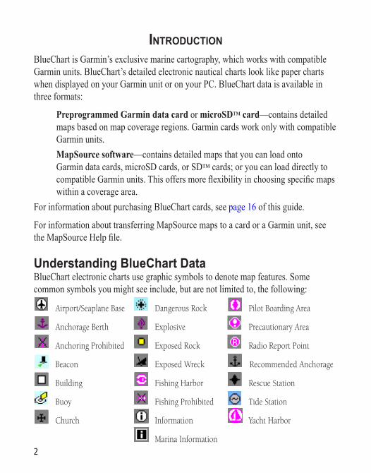
INTRODUCTIONBlueChart is Garmin’s exclusive marine cartography, which works with compatible Garmin units. BlueChart’s detailed electronic nautical charts look like paper charts when displayed on your Garmin unit or on your PC. BlueChart data is available in three formats:
Preprogrammed Garmin data card or microSD™ card—contains detailed maps based on map coverage regions. Garmin cards work only with compatible Garmin units.
MapSource software—contains detailed maps that you can load onto Garmin data cards, microSD cards, or SD™ cards; or you can load directly to compatible Garmin units. This offers more flexibility in choosing specific maps within a coverage area.
For information about purchasing BlueChart cards, see page 16 of this guide.
For information about transferring MapSource maps to a card or a Garmin unit, see the MapSource Help file.
Understanding BlueChart DataBlueChart electronic charts use graphic symbols to denote map features. Some common symbols you might see include, but are not limited to, the following:
Airport/Seaplane Base Dangerous Rock Pilot Boarding Area
Anchorage Berth Explosive Precautionary Area
Anchoring Prohibited Exposed Rock Radio Report Point
Beacon Exposed Wreck Recommended Anchorage
Building Fishing Harbor Rescue Station
Buoy Fishing Prohibited Tide Station
Church Information Yacht Harbor
Marina Information

3
Other features common to most BlueChart data include:
• Depth contour lines (with deep water represented in white)• Inter-tidal zones (displayed in green on color units)• Spot soundings, as depicted on the original paper chart• Navigational aids and symbols• Obstructions and cable areas
For more information about nautical chart symbols in the United States of America, see Chart No. 1 Nautical Chart Symbols Abbreviations and Terms at http://www.noaa.com.
GETTING STARTED
Installing a BlueChart CardLook for a compartment door or rubber weather cap on the bottom of your Garmin unit. Beneath that door is a slot for the BlueChart card.
To insert the card, place the card into the slot (connector end first) with the label facing toward the front of the Garmin unit. When the card is in place, close the compartment door, or reinsert the rubber weather cap. See your Garmin unit owner’s manual for specific card installation instructions.
CAUTION: Insert the connector end of the card into the card slot. Improper installation can result in damage to your Garmin unit and can void your warranty.

Installing MapSource BlueChart SoftwareWith MapSource software, you can view color maps on a PC. You can also create waypoints, routes, and map sets to transfer to your Garmin unit. MapSource BlueChart data is in locked regions within each of the three coverage areas (Americas, Atlantic, and Pacific). When you unlock a region, you can select the individual charts that you want to use.
Refer to the MapSource BlueChart software for installation instructions.
Refer to page 9 for information about using MapSource BlueChart software.
BlueChart Card Caution and Unlock DisclaimerCAUTION: Do not use preprogrammed BlueChart cards for saving MapSource maps. The preprogrammed data will be lost. Remove any BlueChart cards in your Garmin unit before transferring MapSource maps to the unit to avoid losing the preprogrammed data. If you overwrite the preprogrammed data on a BlueChart card, Garmin will not replace or recover the lost data.
DISCLAIMER: Your MapSource unlock code is valid for use with your own Garmin unit. You must have a separate unique unlock code for each Garmin unit. If you own more than one Garmin unit or upgrade to a new Garmin unit, you must have a separate code for each Garmin unit. If you personally own two Garmin units, you may obtain a second unlock code for the same region for your own personal use at no additional charge. Simply repeat the unlock process for the second unit. No more than two Garmin units may be unlocked with the purchase of a single unlock code. You must purchase a new unlock code if you have already unlocked two Garmin units. Information about obtaining additional unlock codes can be found at: http://www.garmin.com/unlock/. This agreement provides a one-user license and it is illegal to share this data with others. Garmin does not give refunds or exchanges for MapSource unlock codes.
4

5
USING BLUECHART
Viewing BlueChart InformationThe details and symbols in BlueChart cartography are almost identical whether you are looking at MapSource data on your PC screen or directly on your Garmin unit.
Viewing MapSource BlueChart on a PC
Viewing BlueChart on a Garmin Unit (GPSMAP 3006)

6
Getting Additional Object InformationFor many objects that you see on a BlueChart map, you can access additional information about that object.
To get additional information when using a Garmin unit: Place the unit’s cursor on an object, and press ENTER. A window appears with
additional information for the selected object.
To get additional information when using MapSource on a PC:1. Move the mouse cursor onto a map object. The map object name appears in a
white box.2. With the selection tool (press S on the keyboard), and click the right mouse
button on an object. If more than one object is at a given map location, a list of map object names appears first.
3. Select an object, and then select the Feature Properties option. A Properties window appears.

Getting Paper-Chart-Specific InformationBlueChart cartography also provides paper-chart-specific information, such as chart publisher, print date, edition date, NTM (Notice to Mariners) correction date, and scale. Additional notes are available for the paper charts.
To display paper chart-specific information on your Garmin unit: Place the unit’s cursor on an open area of the chart, and press ENTER. A
window displays the chart information and allows you to view additional notes about the chart area.
BlueChart electronic map detail is presented on a chart-by-chart basis. By providing paper chart-specific information, you can know exactly from which chart and scale each displayed feature is digitized. BlueChart electronic charts are a faithful reproduction of the published official paper charts that mariners are required to carry.
BlueChart data is not seamless. Just like the paper charts from which the data is derived, you might observe some discontinuity along chart borders, both on your Garmin unit and on your PC screen in MapSource. For example, if a contour is present on one chart, and not on the adjacent chart, the BlueChart data is represented on your Garmin unit or PC screen the same way. Likewise, if adjacent paper charts that generate BlueChart data are of different scales, you might encounter shaded areas on the Garmin unit. This can occur at any zoom level and can be easily remedied by zooming out one or two scale levels on the Garmin unit.
7

A feature of presenting data in a chart-by-chart manner is selecting only those paper charts that you have on hand or that you want displayed on the Garmin unit. By default, all available charts are displayed from preprogrammed cards. With MapSource, you can choose which charts to download. See your Garmin unit’s owner’s manual for specific steps, but the Garmin unit screen generally appears as shown.
From this screen, use the Garmin unit’s on-screen cursor and press the ENTER key to deselect (remove the check mark from the box) the individual paper charts that you do not want to display.
To display chart information on your PC screen using MapSource:1. Place the mouse cursor within a chart boundary, and (with the selection tool)
right-click the mouse. 2. Select the name of a chart, and then select Feature Properties. The
Properties window appears.
8

Using MapSource BlueChartWith MapSource software, you can view color maps on a PC. Use the zoom and pan functions for easy map browsing. With MapSource, you can also create waypoints, routes, and map sets to transfer to your Garmin unit (see the MapSource Help file for more information). In MapSource, BlueChart data is in locked regions within each of the three coverage areas (Americas, Atlantic, and Pacific). When you unlock a region, you can select the individual charts that you want to use.
9
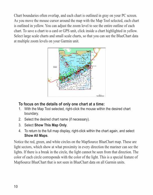
Chart boundaries often overlap, and each chart is outlined in gray on your PC screen. As you move the mouse cursor around the map with the Map Tool selected, each chart is outlined in yellow. You can adjust the zoom level to see the entire outline of each chart. To save a chart to a card or GPS unit, click inside a chart highlighted in yellow. Select large scale charts and small scale charts, so that you can see the BlueChart data at multiple zoom levels on your Garmin unit.
To focus on the details of only one chart at a time: 1. With the Map Tool selected, right-click the mouse within the desired chart
boundary.2. Select the desired chart name (if necessary).3. Select Show This Map Only.4. To return to the full map display, right-click within the chart again, and select
Show All Maps.Notice the red, green, and white circles on the MapSource BlueChart map. These are light sectors, which show at what proximity in every direction the mariner can see the lights. If there is a break in the circle, the light cannot be seen from that direction. The color of each circle corresponds with the color of the light. This is a special feature of MapSource BlueChart that is not seen in BlueChart data on all Garmin units.
10
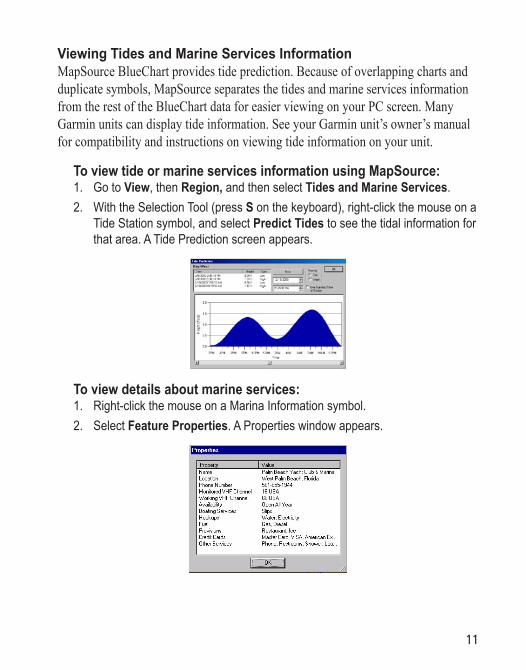
Viewing Tides and Marine Services InformationMapSource BlueChart provides tide prediction. Because of overlapping charts and duplicate symbols, MapSource separates the tides and marine services information from the rest of the BlueChart data for easier viewing on your PC screen. Many Garmin units can display tide information. See your Garmin unit’s owner’s manual for compatibility and instructions on viewing tide information on your unit.
To view tide or marine services information using MapSource:1. Go to View, then Region, and then select Tides and Marine Services. 2. With the Selection Tool (press S on the keyboard), right-click the mouse on a
Tide Station symbol, and select Predict Tides to see the tidal information for that area. A Tide Prediction screen appears.
To view details about marine services:1. Right-click the mouse on a Marina Information symbol.2. Select Feature Properties. A Properties window appears.
11

To view tides and marine services information on your Garmin unit:1. Select and download the desired tide and marine services maps the same way
you would with MapSource BlueChart maps. 2. To display the same marine properties information found in MapSource on your
Garmin unit, place the map cursor on the desired symbol, and press ENTER.
12
Understanding the Differences Between Electronic and Paper ChartsOccasionally, boaters notice that the BlueChart data does not duplicate a particular feature shown on the paper chart they are using. Garmin uses the best charts available and carefully turns the paper charts into a digital format for display on an electronic screen. If there are errors, omissions, or discrepancies on paper, they might occur electronically too.
On paper charts, sometimes even large features like a breakwater might not be shown clearly or at all. Large breakwaters are sometimes not shown on the harbor charts, but are shown on coastal charts—or vice versa! These decisions are made by the chart maker, such as NOAA/NOS. In some cases, bridges, or other features washed away in storms decades ago, are still shown on the paper charts. Recent changes in coastlines are often not reflected on paper charts for years.
The same is true for new marinas and ports. Sometimes, well-known local landmarks might be shown so small on the paper chart that they are indistinguishable from surrounding features to someone not familiar with the area. In these cases, a feature might not be accurately depicted on the electronic chart.
Reporting Chart ErrorsEven when a feature is shown on the paper chart, it can be overlooked or misspelled during the data entry process. These are small problems that can be easily corrected and do not affect the quality of the overall BlueChart data.
If you notice something missing or incorrect in the BlueChart data, first check the best available scale paper charts of the area to see how the feature is represented on the paper chart. If we have not represented it accurately, or if you know additional information about the feature, please visit Garmin’s Web site and fill out the online error report form. You can find this form at http://www.garmin.com/cartography/bluechart/errorForm.html.
13
APPENDIX
Caring for Your BlueChart CardBlueChart cards are not waterproof. When you are not using the card, keep it in the original packaging for safekeeping and store it away from exposure to sun and rain. BlueChart cards are susceptible to damage from static electricity. In low humidity environments, you should ground yourself on a large metal object before handling the card. The card packaging is sealed and does not contain any user-serviceable parts.
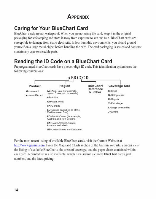
Reading the ID Code on a BlueChart CardPreprogrammed BlueChart cards have a seven-digit ID code. This identification system uses the following conventions:
A BB CCC D
ProductM=data card
X=microSD card
RegionAE=Asia, East (for example, Japan, China, and Indonesia)
AF= Africa
AW=Asia, West
CA=Canada
EU=Europe (including all of the Mediterranean Sea)
PC=Pacific Ocean (for example, Australia and New Zealand)
SA=South America, Central America, and Mexico
US=United States and Caribbean
BlueChart Reference Number
Coverage SizeS=Small
B=Bathymetric
R=Regular
X=Extra large
L=Large or extended
J=Jumbo
For the most recent listing of available BlueChart cards, visit the Garmin Web site at http://www.garmin.com. From the Maps and Charts section of the Garmin Web site, you can view the listing of available BlueCharts, the areas of coverage, and the paper charts contained within each card. A printed list is also available, which lists Garmin’s current BlueChart cards, part numbers, and the latest pricing.
14
Exclusive Garmin ProgramsThese programs apply to the U.S. market only. These programs are not available through our European or Asian offices. All programs listed are available directly from Garmin U.S. to end-users only.Garmin believes that updates are an extremely critical issue for Marine Cartography, and we are committed to providing our customers with regular semi-annual updates. As updates occur, we will make every effort to ensure that the areas of coverage for a given card or MapSource region remain the same. Updates may include new data or NTM (Notice to Mariners) changes. Any changes can be viewed on details page for each card.BUYER PROTECTION POLICY: (Applies ONLY to preprogrammed BlueChart cards.) If a BlueChart card is updated within 30 days of the original purchase date you may receive one free update. The identification number and coverage area must remain the same. UPDATE/TRADE-IN PROGRAM: (Applies ONLY to preprogrammed BlueChart cards.) Garmin will strive to offer semi-annual updates. If you own a factory preprogrammed BlueChart card that is outdated, or would like to purchase a card for a different coverage area, Garmin offers an Update/Trade-In program. Simply send us your old factory preprogrammed BlueChart card, and receive a 50% discount towards Garmin’s list price on any factory preprogrammed BlueChart card that includes sizes of S(mall), R(egular), L(arge), and B(athymetric). These sizes of cards can be interchangeable, for example, trade-in a Small BlueChart card for a Bathymetric card, or vice versa. For e(X)tra large cards, you may update or trade-in ONLY for the same extra large card (exact part number) or for a different extra large card (part number ends in X) for a 50% discount. For (J)umbo cards, you may update or trade-in ONLY for the same jumbo card (exact part number) or for a different jumbo card (part number ends in J) for a 50% discount. Only one update or trade-in per new BlueChart card is allowed. BlueChart pre-programmed cards CAN NOT be traded in for any MapSource BlueChart Software. To return BlueChart for update, contact Garmin Cartography at 800/800.1020 (or e-mail at: [email protected]) to obtain a Return Material Authorization (RMA) number. The return authorization number must appear on the outside of the shipping package, and the BlueChart card must be shipped freight prepaid to Garmin at: 1200 East 151st Street, Olathe, KS 66062.UPGRADING FROM G-CHARTS TO BLUECHARTS: If you have previously used Garmin’s G-Chart line of electronic maps, please note that we have discontinued support for that product line. Additionally, G-Charts will not work in our BlueChart-compatible chartplotter product line. The BlueChart line provides added flexibility, greater coverage and offers you cost savings. To encourage current Garmin customers to upgrade to our BlueChart line, Garmin provides a 25% discount on new BlueChart cards or MapSource BlueChart Software for end-users who send us an old G-Chart, excluding our Extra Large and Jumbo BlueChart cards. This is a one-for-one discount
15

16
available directly from Garmin only. To verify compatibility with BlueChart data, you will be asked to present proof of a new chartplotter purchase. (NOTE: BlueChart is not compatible with all Garmin models. Refer to http://www.garmin.com for more information.)
Software License AgreementBY USING BLUECHART, YOU AGREE TO BE BOUND BY THE TERMS AND CONDITIONS OF THE FOLLOWING SOFTWARE LICENSE AGREEMENT. PLEASE READ THIS AGREEMENT CAREFULLY.Garmin grants you a limited license to use the software embedded in this device (the “Software”) in binary executable form in the normal operation of the product. Title, ownership rights, and intellectual property rights in and to the Software remain in Garmin.You acknowledge that the Software is the property of Garmin and is protected under the United States of America copyright laws and international copyright treaties. You further acknowledge that the structure, organization, and code of the Software are valuable trade secrets of Garmin and that the Software in source code form remains a valuable trade secret of Garmin. You agree not to decompile, disassemble, modify, reverse assemble, reverse engineer, or reduce to human readable form the Software or any part thereof or create any derivative works based on the Software. You agree not to export or re-export the Software to any country in violation of the export control laws of the United States of America.
Purchasing BlueChart Cards or MapSource BlueChart SoftwareYou can purchase additional BlueChart cards or MapSource BlueChart software by contacting Garmin at one of the addresses or phone numbers listed on the copyright page of this guide. Three MapSource BlueChart disks are available: Americas, Atlantic, and Pacific. One disk contains BlueChart data for the specific coverage area purchased and is a convenient way to reprogram and use your BlueChart card in more than one area. MapSource BlueChart is a Microsoft® Windows®-based program which uses Garmin unlock technology, allowing you to use one coverage area from the disk when initially purchased and to purchase additional coverage areas as the need arises. (Internet access is recommended for completing the unlock process.) The disk is a cost-saving alternative to purchasing multiple BlueChart cards. Updates are distributed on new disks, providing a convenient method of acquiring the most recent chart data.
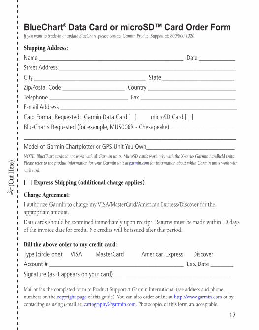
BlueChart® Data Card or microSD™ Card Order FormIf you want to trade-in or update BlueChart, please contact Garmin Product Support at: 800/800.1020.
Shipping Address:
Name ____________________________________________ Date ___________
Street Address ______________________________________________________
City __________________________________ State ______________________
Zip/Postal Code ___________________ Country ___________________________
Telephone ________________________ Fax _____________________________
E-mail Address ______________________________________________________
Card Format Requested: Garmin Data Card [ ] microSD Card [ ]
BlueCharts Requested (for example, MUS006R - Chesapeake) ____________________
_________________________________________________________________
Model of Garmin Chartplotter or GPS Unit You Own___________________________NOTE: BlueChart cards do not work with all Garmin units. MicroSD cards work only with the X-series Garmin handheld units. Please refer to the product information for your Garmin unit at garmin.com for information about which Garmin units work with
each card.
[ ] Express Shipping (additional charge applies)
Charge Agreement:
I authorize Garmin to charge my VISA/MasterCard/American Express/Discover for the appropriate amount.
Data cards should be examined immediately upon receipt. Returns must be made within 10 days of the invoice date for credit. No credits will be issued after this period.
Bill the above order to my credit card:
Type (circle one): VISA MasterCard American Express Discover
Account # _________________________________________ Exp. Date _______
Signature (as it appears on your card) ____________________________________
Mail or fax the completed form to Product Support at Garmin International (see address and phone numbers on the copyright page of this guide). You can also order online at http://www.garmin.com or by contacting us using e-mail at: [email protected]. Photocopies of this form are acceptable.
(Cut
Her
e)
17


© Copyright 2001–2006 Garmin Ltd. or its subsidiaries
Garmin International, Inc.1200 East 151st Street, Olathe, Kansas 66062, U.S.A.
Garmin (Europe) Ltd.Unit 5, The Quadrangle, Abbey Park Industrial Estate, Romsey, SO51 9DL, U.K.
Garmin CorporationNo. 68, Jangshu 2nd Road, Shijr, Taipei County, Taiwan
www.garmin.com
Part Number 190-00246-00 Rev. F
For the latest free software updates (excluding map data) throughout the life of your Garmin products, visit the Garmin web site at www.garmin.com.