black range cobalt, nickel, scandium and platinum ... · each of these flowsheets are compatible to...
TRANSCRIPT

ASX & Media Release
31 October 2017
ASX Symbol
ARL
Ardea Resources Limited
Suite 2, 45 Ord St West Perth WA 6005
PO Box 1433 West Perth WA 6872
Telephone
+61 8 6244 5136
Website
www.ardearesources.com.au
Directors
Katina Law Chair
Matt Painter Managing Director
Ian Buchhorn Technical Executive Director
Issued Capital
Shares 80,649,536
Unlisted options 12,310,022
Loyalty options 25,227,423
ABN 30 614 289 342
Black Range cobalt, nickel, scandium and platinum/palladium resources
New scandium, platinum, palladium accessory metal resources
complement cobalt-nickel resources, with excellent upside for further
extension along strike
• New scandium and platinum+palladium (PGM) resources are
defined for the Black Range cobalt-nickel deposit.
o The new resources cover only a portion of the strike length of
the deposit, so are initial estimates pending further data.
• The recently remodelled cobalt and nickel resources at Black Range
are 19.2 Mt at 0.09 % Co and 0.68 % Ni1. This is overlapped by
new Inferred scandium and PGM resources that will require mining
of the cobalt-nickel zone if they are to be exploited:
o a new inferred resource of 8.70 Mt at 65.6 g/t scandium2 partly
inside the 19.2 Mt cobalt-nickel zone; and
o a new inferred resource of 6.55 Mt at 0.54 g/t PGMs (0.33 g/t
platinum and 0.21 g/t palladium)3 partly inside both the cobalt-
nickel and scandium zones
• As each resource overlaps the other, the values presented cannot
be added to define a total resource.
• The limited spatial extent and therefore the tonnage of the scandium
and PGM resources is expected to be expanded by future drilling.
• Extraction of these metals is feasible using flowsheets presently
under assessment by the Company to extract cobalt and nickel.
1 Comprising Indicated and Inferred resources reported at a 0.5 % Ni cut-off JORC Category Cutoff Tonnage (Mt) Ni (%) Co (%)
Indicated 0.5% Ni 9.33 0.67 0.09 Inferred 0.5% Ni 9.89 0.69 0.10
Total 0.5% Ni 19.22 0.68 0.09
2 An inferred resource reported at a 50 g/t Sc cutoff 3 An Inferred resource reported at a 0.25 g/t Pt cutoff.
Initial Scandium and PGM resources, Black Range
2
Accessory metals from the KNP Cobalt Zone
It is the Company’s
philosophy that each and
every deposit within the KNP
Cobalt Zone must be
economic for cobalt and
nickel in its own right.
However, some of the
constituent deposits are
known to contain significant
accessory metals like
manganese (Mn), scandium
(Sc), platinum (Pt), palladium
(Pd) and chromium (Cr), both
within and above the defined
cobalt (Co) and nickel (Ni)
mineralisation. In such
cases, these metals will be
mined in any case to access
the cobalt and nickel, so can
either be stockpiled or, if
appropriate, processed.
Additionally, any associated
metals that enter the cobalt-
nickel hydrometallurgical
circuit are recoverable.
With this in mind, Ardea is
assessing these accessory
metals for monetisation
through the production of
potentially valuable by-
products. It must be noted
that these by-products will
only add value to already
economic deposits – no
deposit will require the
mining and processing of
these accessory metals in order to be economically viable.
A number of flowsheets are being assessed for the recovery of cobalt and nickel from the laterites of the
KNP Cobalt Zone. Each of these flowsheets are compatible to varying degrees with the recovery of
scandium, platinum and palladium. As such, there is no doubt that, under appropriate economic conditions,
these metals can be recovered from the Black Range deposit.
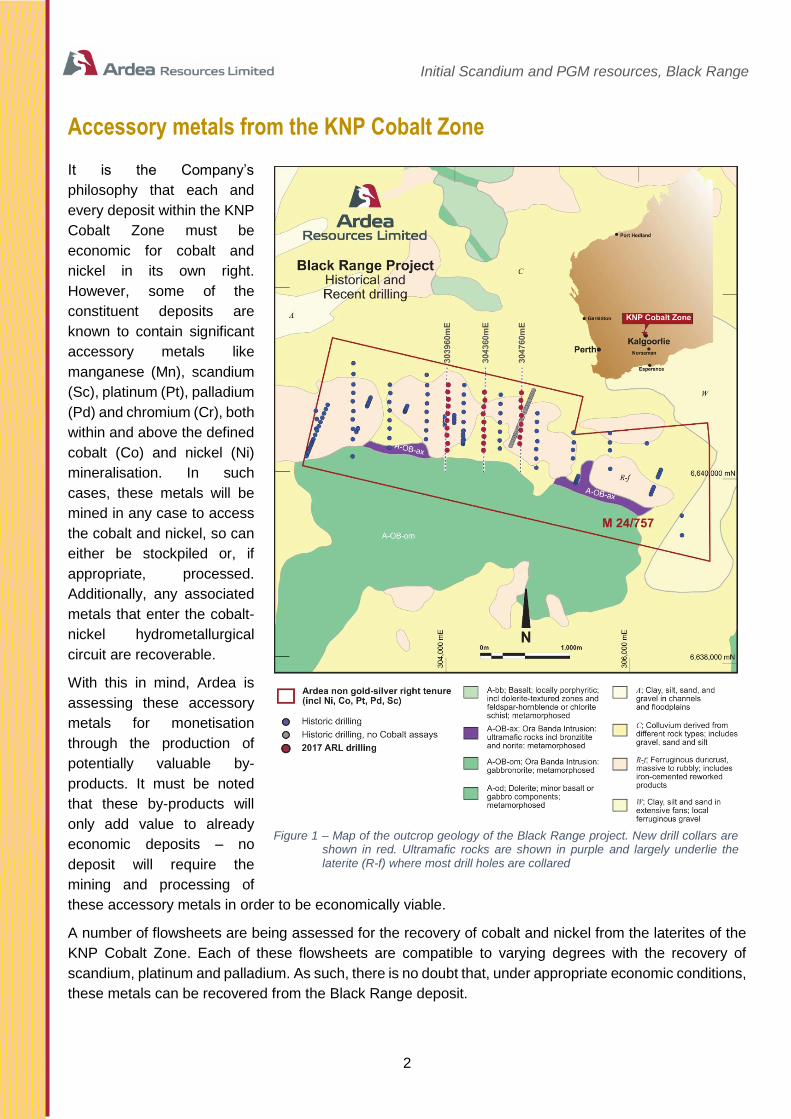
Figure 1 – Map of the outcrop geology of the Black Range project. New drill collars are
shown in red. Ultramafic rocks are shown in purple and largely underlie the laterite (R-f) where most drill holes are collared
Initial Scandium and PGM resources, Black Range
3
Scandium, platinum and palladium at Black Range
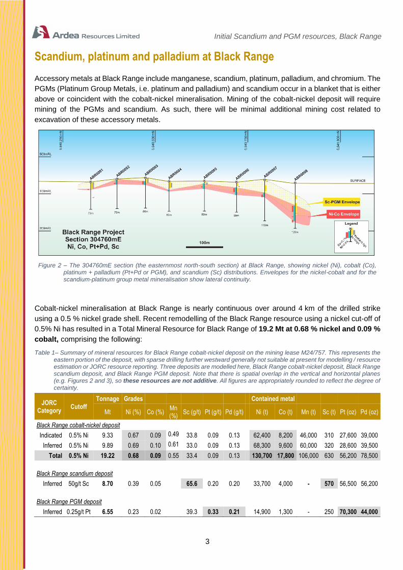
Accessory metals at Black Range include manganese, scandium, platinum, palladium, and chromium. The
PGMs (Platinum Group Metals, i.e. platinum and palladium) and scandium occur in a blanket that is either
above or coincident with the cobalt-nickel mineralisation. Mining of the cobalt-nickel deposit will require
mining of the PGMs and scandium. As such, there will be minimal additional mining cost related to
excavation of these accessory metals.
Figure 2 – The 304760mE section (the easternmost north-south section) at Black Range, showing nickel (Ni), cobalt (Co), platinum + palladium (Pt+Pd or PGM), and scandium (Sc) distributions. Envelopes for the nickel-cobalt and for the scandium-platinum group metal mineralisation show lateral continuity.
Cobalt-nickel mineralisation at Black Range is nearly continuous over around 4 km of the drilled strike
using a 0.5 % nickel grade shell. Recent remodelling of the Black Range resource using a nickel cut-off of
0.5% Ni has resulted in a Total Mineral Resource for Black Range of 19.2 Mt at 0.68 % nickel and 0.09 %
cobalt, comprising the following:
Table 1– Summary of mineral resources for Black Range cobalt-nickel deposit on the mining lease M24/757. This represents the eastern portion of the deposit, with sparse drilling further westward generally not suitable at present for modelling / resource estimation or JORC resource reporting. Three deposits are modelled here, Black Range cobalt-nickel deposit, Black Range scandium deposit, and Black Range PGM deposit. Note that there is spatial overlap in the vertical and horizontal planes (e.g. Figures 2 and 3), so these resources are not additive. All figures are appropriately rounded to reflect the degree of certainty.
JORC Category
Cutoff
Tonnage Grades Contained metal
Mt Ni (%) Co (%) Mn (%)
Sc (g/t) Pt (g/t) Pd (g/t) Ni (t) Co (t) Mn (t) Sc (t) Pt (oz) Pd (oz)
Black Range cobalt-nickel deposit
Indicated 0.5% Ni 9.33 0.67 0.09 0.49 33.8 0.09 0.13 62,400 8,200 46,000 310 27,600 39,000
Inferred 0.5% Ni 9.89 0.69 0.10 0.61 33.0 0.09 0.13 68,300 9,600 60,000 320 28,600 39,500
Total 0.5% Ni 19.22 0.68 0.09 0.55 33.4 0.09 0.13 130,700 17,800 106,000 630 56,200 78,500
Black Range scandium deposit
Inferred 50g/t Sc 8.70 0.39 0.05 65.6 0.20 0.20 33,700 4,000 - 570 56,500 56,200
Black Range PGM deposit
Inferred 0.25g/t Pt 6.55 0.23 0.02 39.3 0.33 0.21 14,900 1,300 - 250 70,300 44,000

Initial Scandium and PGM resources, Black Range
4
A spatially-limited initial scandium resource at Black Range
The zones with elevated scandium concentration at Black Range are situated spatially above and within
the uppermost parts of the cobalt and nickel resource (Figure 2). As such, scandium-bearing material will
be mined during the mining of the cobalt and nickel mineralisation.
Presently, the scandium resource is limited to the infill RC drill holes drilled by Ardea as a part of a program
of cobalt and nickel resource definition in April this year (see orange shell in Figure 3 below). Drilling was
conducted over a strike length of around 1,200 metres. The drilling has revealed an initial scandium
resource area which is expected will be expanded through collection of further data.
The identified scandium mineralised zone is contained within the footprint of the 19.2 Mt of 0.09 % cobalt
and 0.68 % nickel resource at Black Range. An inferred resource has been estimated at 8.70 Mt at 65.6 g/t
scandium using a 50 g/t scandium lower cut-off. (approximate total contained scandium metal content of
570,000 kg). Part of this resource is included in the cobalt-nickel resource.
Figure 3 –Extent of the scandium resource (orange), covering only the recent drill program by Ardea. (The Green shell is the
~0.5% Ni delineation wire-frame, and the purple wire-frame is a combined Pt&Pd wire-frame ~0.1ppm Pt and/or Pd delineation basis. The orange shell is the Scandium wire-frames (nominal Sc delineation cut-off of approximately
~30ppm Sc)).
With this new resource comprising only a small fraction of the strike length of the Black Range deposit
(Figure 3), it is seen as the first step to achieving the previously stated Exploration Target of 10–20 Mt at
50–80 g/t scandium. As per JORC 2012 requirements regarding Exploration Targets, we note that the
potential quantity and grade of this Exploration Target is currently conceptual in nature, that there has
been insufficient work to estimate a Mineral Resource at this point in time, and it is uncertain if further
exploration will result in the estimation of further Mineral Resources.
An initial PGM resource at Black Range
PGM data from Black Range is historically recorded for the 6 km strike length of the layered mafic intrusive
complex. Presently a Pt/Pd resource is located on the easternmost mining lease M24/0757 only, occurring
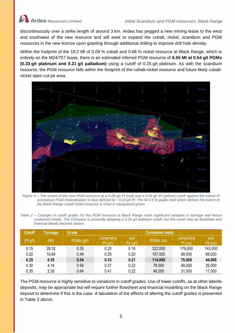
Initial Scandium and PGM resources, Black Range
5
discontinuously over a strike length of around 3 km. Ardea has pegged a new mining lease to the west
and southwest of the new resource and will seek to expand the cobalt, nickel, scandium and PGM
resources in the new licence upon granting through additional drilling to improve drill hole density.
Within the footprint of the 19.2 Mt of 0.09 % cobalt and 0.68 % nickel resource at Black Range, which is
entirely on the M24/757 lease, there is an estimated inferred PGM resource of 6.55 Mt at 0.54 g/t PGMs
(0.33 g/t platinum and 0.21 g/t palladium) using a cutoff of 0.25 g/t platinum. As with the scandium
resource, the PGM resource falls within the footprint of the cobalt-nickel resource and future likely cobalt-
nickel open cut-pit area.
Figure 4 – The extent of the new PGM resource at a 0.20 g/t Pt (red) and a 0.25 g/t Pt (yellow) cutoff against the extent of
anomalous PGM mineralisation in blue defined by ~0.10 g/t Pt. The Ni 0.5 % grade shell which defines the extent of the Black Range cobalt-nickel resource is show in transparent green.
Table 2 – Changes in cutoff grades for the PGM resource at Black Range mark significant variation in tonnage and hence contained metals. The Company is presently adopting a 0.25 g/t platinum cutoff, but this could vary as flowsheet and financial details become clearer.
Cutoff Tonnage Grade Contained metal
(Pt g/t) (Mt) PGMs (g/t) comprising
Pt (g/t) and
Pd (g/t) PGMs (oz)
comprising Pt (oz)
and Pd (oz)
0.15 28.32 0.35 0.20 0.16 322,000 179,000 143,000
0.20 10.64 0.49 0.29 0.20 167,000 99,000 68,000
0.25 6.55 0.54 0.33 0.21 114,000 70,000 44,000
0.30 4.14 0.59 0.37 0.22 78,000 49,000 29,000
0.35 2.35 0.64 0.41 0.22 48,000 31,000 17,000
The PGM resource is highly sensitive to variations in cutoff grades. Use of lower cutoffs, as at other laterite
deposits, may be appropriate but will require further flowsheet and financial modelling on the Black Range
deposit to determine if this is the case. A tabulation of the effects of altering the cutoff grades is presented
in Table 2 above.

Initial Scandium and PGM resources, Black Range
6
The new PGM resource comprises an incomplete portion of the Black Range deposit. Therefore, the
Company’s Exploration Target for PGMs at Black Range remains at 10–20 Mt at 0.4–0.6 g/t platinum +
palladium. As per JORC 2012 requirements regarding Exploration Targets, we note that the potential
quantity and grade of this Exploration Target is currently conceptual in nature, that there has been
insufficient work to estimate a Mineral Resource at this point in time, and it is uncertain if further exploration
will result in the estimation of further Mineral Resources.
This PGM target is not intended to be a stand-alone resource, but rather to be a subset of the cobalt-nickel
resource. A number of acid leach techniques that are currently being assessed for processing of the KNP
Cobalt Zone are compatible with extraction of low level PGM values from laterites, so it is intended that
test work be completed for recovering platinum and palladium as by-products of a mining operation at
Black Range.
Technical note: breakdown of the global resource at Black Range
Each of the cobalt-nickel, scandium, and PGM resources overlap with one another so it is not appropriate to add
each of the resources already defined to estimate an overall global resource for Black Range. This would result in
counting of the areas of overlap multiple times, giving a false impression of contained overall tonnages.
An overall global resource for Black Range has, however, been calculated and is structured as follows:
1. Cobalt-nickel resource, which includes parts of both the scandium and PGM resources
2. Scandium resource outside of the cobalt-nickel resource, which includes parts of the PGM resource. Most
of the scandium resource outside of the cobalt-nickel resource is immediately above it as depicted in the cross-
section in Figure 2.
3. PGM resource outside both the cobalt-nickel resource and the scandium resource. Most of the PGM
resource outside of the scandium resource is lateral to it as scandium has only been assayed in a limited number
of recent drill holes.
4. A summed total of all of the above listed components of the global resource.
With this structure in mind, the cumulative resource at Black Range is as follows:
Table 3 – Global resource for the Black Range deposit, showing the constituent portions of the resource as described above, and total global figures. NOTE: Manganese has not been modelled consistently outside of the Co-Ni resource, so numbers have been omitted until remodelling is complete. As such total values undercall the actual value. NOTE: Scandium assays are restricted to the limits of the Scandium resource only. Concentrations defined in the Co-Ni resource therefore undercall both the average grade and contained metal tonnes.
No. Constituent resource JORC
Classification Cutoff
Tonnage (Mt)
Grades
Ni % Co % Mn % Sc g/t Pt g/t Pd g/t
1 Co-Ni resource Inferred and indicated 0.5% Ni 19.22 0.68 0.09 0.55 33.4 0.09 0.13
2 Sc resource remainder Inferred 50g/t Sc 4.70 0.24 0.02 68.4 0.24 0.21
3 PGM resource remainder Inferred 0.25g/t Pt 3.00 0.15 0.01 0.35 0.15
4 TOTAL Inferred and indicated Various 26.92 0.54 0.07 0.39 35.9 0.15 0.14
Table 4 – Calculated contained metal contents of the global resource at Black Range (see Table 2 above). NOTE: Manganese and scandium metal contents are undercalled due to incomplete data distributions.
No. Constituent resource Cutoff Contained metal
Ni t Co t Mn t Sc t Pt oz Pd oz
1 Co-Ni resource 0.5% Ni 130,700 17,800 105,900 640 56,200 78,700
2 Sc resource remainder 50g/t Sc 11,500 1,000 320 35,800 32,000
3 PGM resource remainder 0.25g/t Pt 4,400 400 33,300 14,200
4 TOTAL Various 146,600 19,200 105,900 960 125,300 124,900

Initial Scandium and PGM resources, Black Range
7
For further information regarding Ardea, please visit www.ardearesources.com.au or
www.heronresources.com.au or contact:
Ardea Resources:
Dr Matt Painter
Managing Director, Ardea Resources Limited
Tel +61 8 6244 5136
Compliance Statement (JORC 2012)
A competent person’s statement for the purposes of Listing Rule 5.22 has previously been announced by the Company for:
1. Kalgoorlie Nickel Project on 21 October 2013 and 31 June 2014, October 2016, 2016 Heron Resources Annual Report and 6 January 2017;
2. KNP Cobalt Zone Study on 7 August 2017
The Company confirms that it is not aware of any new information or data that materially affects information included in previous announcements, and all material assumptions and technical parameters underpinning the estimates continue to apply and have not materially changed. All projects will be subject to new work programs following the listing of Ardea, notably drilling, metallurgy and JORC Code 2012 resource estimation as applicable.
The information in this report that relates to KNP Exploration Results is based on information originally compiled by previous and current full time employees of Heron Resources Limited. The Exploration Results and data collection processes have been reviewed, verified and re-interpreted by Mr Ian Buchhorn who is a Member of the Australasian Institute of Mining and Metallurgy and currently a director of Ardea Resources Limited. Mr Buchhorn has sufficient experience that is relevant to the style of mineralisation and type of deposit under consideration and to the exploration activities undertaken to qualify as a Competent Person as defined in the 2012 Edition of the ‘Australasian Code for Reporting of Exploration Results, Mineral Resources and Ore Reserves’. Mr Buchhorn consents to the inclusion in this report of the matters based on his information in the form and context that it appears.
The exploration and industry benchmarking summaries are based on information reviewed by Dr Matthew Painter, who is a Member of the Australian Institute of Geoscientists. Dr Painter is a full-time employee and a director of Ardea Resources Limited and has sufficient experience, which is relevant to the style of mineralisation and type of deposit under consideration and to the activity which he is undertaking to qualify as a Competent Person as defined in the 2012 edition of the Australasian Code for Reporting of Exploration Results, Mineral Resources and Ore Reserves’. Dr Painter has reviewed this press release and consents to the inclusion in this report of the information in the form and context in which it appears.
The information in this report that relates to Mineral Resources for the Black Range cobalt-nickel deposit contained within the KNP Cobalt Zone project area is based on information compiled by Mr Stephen Hyland who is a Fellow of the Australasian Institute of Mining and Metallurgy and who has provided expert guidance on resource modelling and resource estimation. Mr Hyland is a Principal Consultant Geologist at HGMC consultants and has sufficient experience relevant to the style of mineralisation and type of deposit under consideration and to the activity which he is undertaking to qualify as a Competent Person as defined in the 2012 Edition of the Australasian Code for Reporting of Exploration Results, Mineral Resources and Ore Reserves. Mr Hyland consents to the inclusion in the report of the matters based on this information in the form and context in which it appears.
CAUTIONARY NOTE REGARDING FORWARD-LOOKING INFORMATION
This news release contains forward-looking statements and forward-looking information within the meaning of applicable Australian securities laws, which are based on expectations, estimates and projections as of the date of this news release.
This forward-looking information includes, or may be based upon, without limitation, estimates, forecasts and statements as to management’s expectations with respect to, among other things, the timing and ability to complete the Ardea spin-out, the timing and amount of funding required to execute the Company’s exploration, development and business plans, capital and exploration expenditures, the effect on the Company of any changes to existing legislation or policy, government regulation of mining operations, the length of time required to obtain permits, certifications and approvals, the success of exploration, development and mining activities, the geology of the Company’s properties, environmental risks, the availability of labour, the focus of the Company in the future, demand and market outlook for precious metals and the prices thereof, progress in development of mineral properties, the Company’s ability to raise funding privately or on a public market in the future, the Company’s future growth, results of operations, performance, and business prospects and opportunities. Wherever possible, words such as “anticipate”, “believe”, “expect”, “intend”, “may” and similar expressions have been used to identify such forward-looking information. Forward-looking information is based on the opinions and estimates of management at the date the information

Initial Scandium and PGM resources, Black Range
8
is given, and on information available to management at such time. Forward-looking information involves significant risks, uncertainties, assumptions and other factors that could cause actual results, performance or achievements to differ materially from the results discussed or implied in the forward-looking information. These factors, including, but not limited to, the ability to complete the Ardea spin-out on the basis of the proposed terms and timing or at all, fluctuations in currency markets, fluctuations in commodity prices, the ability of the Company to access sufficient capital on favourable terms or at all, changes in national and local government legislation, taxation, controls, regulations, political or economic developments in Australia or other countries in which the Company does business or may carry on business in the future, operational or technical difficulties in connection with exploration or development activities, employee relations, the speculative nature of mineral exploration and development, obtaining necessary licenses and permits, diminishing quantities and grades of mineral reserves, contests over title to properties, especially title to undeveloped properties, the inherent risks involved in the exploration and development of mineral properties, the uncertainties involved in interpreting drill results and other geological data, environmental hazards, industrial accidents, unusual or unexpected formations, pressures, cave-ins and flooding, limitations of insurance coverage and the possibility of project cost overruns or unanticipated costs and expenses, and should be considered carefully. Many of these uncertainties and contingencies can affect the Company’s actual results and could cause actual results to differ materially from those expressed or implied in any forward-looking statements made by, or on behalf of, the Company. Prospective investors should not place undue reliance on any forward-looking information.
Although the forward-looking information contained in this news release is based upon what management believes, or believed at the time, to be reasonable assumptions, the Company cannot assure prospective purchasers that actual results will be consistent with such forward-looking information, as there may be other factors that cause results not to be as anticipated, estimated or intended, and neither the Company nor any other person assumes responsibility for the accuracy and completeness of any such forward-looking information. The Company does not undertake, and assumes no obligation, to update or revise any such forward-looking statements or forward-looking information contained herein to reflect new events or circumstances, except as may be required by law.
No stock exchange, regulation services provider, securities commission or other regulatory authority has approved or disapproved the information contained in this news release.
Initial Scandium and PGM resources, Black Range
9
Appendix 1 – Summary of Information Required according to ASX Listing Rule 5.8.1
Black Range Mineral Resources
Geology and Geological Interpretation
The nickel laterite mineralisation within the KNP areas is developed from the weathering and near surface
enrichment of Achaean-aged olivine-cumulate ultramafic units. The mineralisation is usually within 60
metres of surface and can be further sub divided on mineralogical and metallurgical characteristics into
upper iron-rich material and lower magnesium-rich material based on the ratios of iron to magnesium. The
deposits are analogous to many weathered ultramafic-hosted nickel-cobalt deposits both within Australia
and world-wide.
The total length of the main Black Range Area cobalt mineralisation domains is approximately 3,600
metres with observed widths of approximately 300 metres and up to 700 metres in places. Two (2) or more
semi-parallel mineralisation zones are observed are with variable thicknesses typically in the order of 5-
10 metres thick with some zones being in the range of 20 to 30 metres thick. Interpreted mineralisation
has been modelled from near topographic surface (440mRL) down to approximately the 375m RL
(approximately 65-70m vertical from surface).
Drilling Techniques
At Black Range the drilling grid is variable and ranges from approximately 80mE x 160mN out to 160mE
x 360mN or 400mE x 100mN in some places. Drill-holes for Black Range are Reverse Circulation (RC)
holes apart from one (1) Diamond Drill (DD) (BRDD001) drilled.
The Black Range holes are distributed on various grid spacings nominally between 40x80 metres and up
to 80x160 metre spacing or more. Extensive RC drilling programs by Anaconda Nickel and Heron during
years 1991, 1997, 2000, 2011, 2012 and then most recently by Ardea in 2017 account for all drilling carried
out in the area.
Drill hole collars were surveyed using an RTK DGPS system with either a 3 or 7 digit accuracy. The
coordinates are stored in the project exploration databases referenced to the MGA Zone 51 Datum GDA94.
Holes were usually vertical (-90 degree dip), designed to optimally intersect the sub-horizontal
mineralisation.
Sampling and Sub-sampling
Sampling procedures at Black Range were essentially the same in the historic drilling programs, with
majority of holes were sampled using mostly 2 metre and some 4 metre down-hole intervals. (With a few
1 metre sample intervals in some places). For the April 2017 drilling carried out by Ardea at Black Range,
the same sampling procedure approaches were used as in previous programs.
RC holes form the majority of the samples used in the resource calculation along with one diamond core
drill hole.
The RC drilling was performed with a face sampling hammer (bit diameter between 4½ and 5¼ inches)
and samples were collected by either a cone (majority) or riffle splitter using 2 metre composites. The April

Initial Scandium and PGM resources, Black Range
10
2017 RC drilling utilized a face sampling hammer also. Sample condition, sample recovery and sample
size were recorded for all drill samples collected. RC Drilling; 2 metre (and rarely 1 metre) composite
samples were recovered using a 15:1 rig mounted cone splitter or trailer mounted riffle splitter during
drilling into a calico sample bag.
Sample target weight was between 2 and 3kg. In the case of wet clay samples, the samples were collected
in poly-weave bags and allowed to settle and de-water to facilitate spear samples taken from sample return
pile. Wet samples stored separately from other samples in plastic/poly-weave bags and riffle split if
sufficiently dry.
For RC sampling QAQC was employed on all programs. A standard, blank or duplicate sample was
inserted into the sample stream 10 metres on a rotating basis. All standards were quantified industry
standard reference samples. Every 30th sample a duplicate sample was taken using the same sample
sub sample technique as the original sub sample. Sample sizes are appropriate for the nature of
Mineralisation. QAQC results were verified against each program prior to loading into the database. A
small percentage of holes were separately resampled post drilling to confirm the integrity of the different
sampling techniques employed.
Sample Analysis Method
All historic Heron and Vale / Inco samples were prepared and analysed by Ultratrace Laboratories in Perth
by silicate fusion / XRF analysis (lab method XRF202) for multiple grade attributes (Ni, Co, MgO, FeO,
Al2O3, SiO2, CaO, Mn, Cr, Cu, Zn, As, S and Cl).
Fusion / XRF analysis is an industry standard method used to analyse nickel laterite ores and Ultratrace
is a reputable commercial laboratory with extensive experience in assaying nickel laterite samples from
numerous Western Australian nickel laterite deposits.
All Ardea samples for the April 2017 RC drilling program were despatched by Kalgoorlie ALS laboratories
and transported to ALS Perth, where they were pulverised. Analysis at ALS Perth was by ICP utilising a
50g charge (lab method PGM-ICP24) for PGM suite elements (Au, Pt, Pd). Additional analysis was
undertaken by sending subsamples to ALS Brisbane where analysis by silicate fusion / XRF analysis (lab
method ME-XRF12n) for multiple grade attributes for laterite ores (Al2O3, As, BaO, CaO, Cl, Co, Cr2O3,
Cu, Fe2O3, Ga, K2O, MgO, MnO, Na2O, Ni, P2O5, Pb, Sc, SiO2, SO3, SrO, TiO2, V2O5, Zn, ZrO2).
Fusion / XRF analysis is an industry standard method used to analyse nickel laterite ores and ALS is a
reputable commercial laboratory with extensive experience in assaying nickel laterite samples from
numerous Western Australian nickel laterite deposits.
Estimation Methodology
A uniform block size of 20m east x 20m north x 2m(RL) block used at Black Range. No sub-blocks were
used in the Black Range model. Mineralised proportions of blocks were coded with a block percentage
code for volume estimation purposes. In total 90 benches at Black Range (280m to 460m RL) cover the
main mineralisation elevation ranges. The natural topographic surfaces are relatively flat.
Sample data utilised was first composited according to the main Co and Ni items to a 2m down-hole
composite length. The 2m composites were flagged using domain codes generated from 3D mineralisation
domains and geological surfaces. Grade continuity was measured using geostatistical techniques.
Directional variograms were modelled using traditional and normal score transformation semi-variograms.
Initial Scandium and PGM resources, Black Range
11
Grade estimation using Ordinary Kriging was completed for each reportable element – Co% and Ni% - as
well as Pt(ppm), Pd(ppm) and Sc(ppm) using MineSight® software. A model item specific single search
ellipsoid was used to interpolate / estimate each block.
The influence of extreme grade values was examined utilising top cutting analyst tools (grade histograms,
log probably plots and coefficients of variation). A variable Ni & Co% cut-off with a ‘restriction distance’
according to a set of 4 ‘Areas Domains’ at Black Range which were applied primarily to control block model
interpolation. A similar restriction was also applied to each of the Pt, Pd and Sc block model items.
Bulk densities were measured for Black Range used the previously used assumed bulk density assignment
values. Most of the mineralisation lies within the ‘clay’ material at each deposit area and was designated
as 1.40t/m3.
Resource Classification
The Resource model uses a classification scheme Black Range based upon block additional derived
estimation parameters including Kriging Variance, number of composites in search ellipsoid composite
distance to block centroid. These inputs were used to designate relative confidence levels or ‘quality of
estimate index’ (QLTY item) within the block model) which have a range of 1 to 3, where QLTY=1, 2 or 3
represents high, medium or low confidence respectively. The QLTY item values were further condensed
into an unbiased RCAT item describing the confidence of the localized resource base in the block model.
Preliminary Resource Classification Item – (RCAT) Values 2 or 3 – (Nominally ‘Ind’ and ‘Inf’ respectively–
Indicated and Inferred resources were defined for the Black Range resource areas. (No measured
resources are reported at this time).
Ultimate classification by the Competent Person has also taken into account a range of other modifying
factors commencing with the geological understanding of Black Range deposit area which is the primary
requirement for producing a robust resource estimation model. The Mineral Resource Estimates and
subsequent reporting have been carried out at Black Range in accordance with the JORC Code (2012
Edition) guidelines.
Cut-off Grade
For the Black Range deposit area HGMC considers that all mineralized material within 100m vertical depth
from surface will satisfy JORC modifying factors criteria relating to reasonable expectations that a part of
the resource is likely to be exploitable at a given foreseeable future time. HGMC’s opinion is that the 0.50
Ni(%) or the 0.08 Co(%) lower cut-off is an adequate lower reporting cut-off for open cut pit exploitable
nickel and cobalt mineral resources at Black Range and is done so in consideration of the JORC Code
requirements whereby resources are likely to be exploited by open cut mining methods within a nominal
100m of topographic surface.
HGMC cautions the reader that the reported resources for Black Range should also be viewed with direct
reference to the Auralia Mining Consultants Pre-Feasibility Study report for the nearby Scotia Dam,
Goongarrie South and Big Four deposit areas, and the use of the reporting lower cut-off’s stated are
contingent upon the findings and recommendations from pit optimisation studies and related findings as
stated in their report. These findings and recommendations may change at a future time due to fluctuations
in mining costs and nickel and cobalt market conditions.
Initial Scandium and PGM resources, Black Range
12
Mining and Metallurgical Methods and Parameters and other modifying factors
The Mining PFS study carried out by Auralia Mining Consultants combined with ongoing metallurgical
testwork reviews are consistent with a reasonable view that an open cut pit mining operation can be
employed to recover mineralised nickel and cobalt ores at Black Range with the possibility of platinum,
palladium and scandium being beneficial by-products. As part of the Mining PFS a series of strategic
mining schedules were also generated based on annualised production rates of Ni and Co only with an
aim to generally achieve maximum net revenue or value from the two main deposits.
Financial in-pit mining cost inputs and other processing cost parameters are applied on various base case
scheduling scenarios along with selected sensitivity adjustments to investigate the overall project
economics.

Initial Scandium and PGM resources, Black Range
13
Appendix 2 – JORC Code, 2012 Edition, Table 1 report
Section 1 Sampling Techniques and Data
(Criteria in this section applies to all succeeding sections)
Criteria JORC Code explanation Commentary
Sampling techniques
Note: Due to the similarity
of the deposit styles,
procedures and
estimations used this
table represents the
combined methods for all
Ardea Resources (ARL)
Cobalt and Nickel Laterite
Resources. Where data
not collected by ARL has
been used in the resource
calculations, variances in
techniques are noted.
• Nature and quality of sampling (e.g. cut channels, random chips, or specific specialised industry standard measurement tools appropriate to the minerals under investigation, such as down hole gamma sondes, or handheld XRF instruments, etc). These examples should not be taken as limiting the broad meaning of sampling.
• Include reference to measures taken to ensure sample representivity and the appropriate calibration of any measurement tools or systems used.
• Aspects of the determination of mineralisation that are Material to the Public Report.
• In cases where ‘industry standard’ work has been done this would be relatively simple (e.g. ‘reverse circulation drilling was used to obtain 1 m samples from which 3 kg was pulverised to produce a 30 g charge for fire assay’). In other cases more explanation may be required, such as where there is coarse gold that has inherent sampling problems. Unusual commodities or mineralisation types (e.g. submarine nodules) may warrant disclosure of detailed information.
• The nickel laterite resources were sampled by drilling using dominantly Reverse Circulation (RC) with one (1) Diamond
Drill (DD) (BRDD001) at Black Range distributed on various grid spacings nominally between 20x20 metres and up to
80x160 metre spacing or more. Holes were usually vertical (-90 degree dip), designed to optimally intersect the sub-
horizontal mineralisation. Most holes were sampled on 2 metre, or less commonly, 1 metre down hole intervals.
• RC holes form the majority of the samples used in the resource estimation.
• DD holes were drilled for a combination of:
• twin testing of RC drilling;
• density determination;
• geotechnical logging and test work;
• geological logging (structural logging); and
• metallurgical test work.
Where appropriate the results of diamond core sampling and assays were used in the resource estimate.
• Several bulk sample holes employing either Calweld (900 to 1200mm, large diameter well boring rig) or Sonic drilling techniques were also completed at Jump Up Dam, Goongarrie, Highway and Siberia Deposits. These holes were primarily for obtaining bulk samples for metallurgical studies and the assay results were not used in the resource estimation.
• Bulong East resources were estimated using the database of Bulong Mining Pty Ltd (in Receivership). Techniques
employed were broadly similar to those used by Heron.
• Goongarrie Hill, Goongarrie South, Highway and Siberia Deposits were all partially explored by Vale between 2002 and
2007. Vale/ Inco employed the same drilling and sampling techniques as Heron for these deposits.
Drilling techniques • Drill type (e.g. core, reverse circulation, open-hole hammer, rotary air blast, auger, Bangka, sonic, etc) and details (e.g. core diameter, triple or standard tube, depth of diamond tails, face-sampling bit or other type, whether core is oriented and if so, by what method, etc).
• RC drilling was performed with a face sampling hammer (bit diameter between 4½ and 5 ¼ inches) and samples were collected by either a cone (majority) or riffle splitter using 2 metre composites. Sample condition, sample recovery and sample size were recorded for all drill samples collected by HRR.
• DD holes were drilled with HQ triple tube. All material of sufficient competence was oriented using spear or Easymark™ techniques. All diamond holes were logged for geotechnical, geological and density. Where appropriate (holes not drilled for metallurgical purposes), holes were whole core sampled to geological boundaries (approximately 1 metre) and assayed.
• Calweld samples (not used in resource model but used for metallurgical testing) were collected in bulka bags on 1 metre down hole intervals.
• Sonic drill samples were collected as whole core samples, 6 inches diameter of up to 1 metre lengths in sealed clear plastic wrap. Sonic core of longer lengths was split as it was retrieved from the drill string to facilitate handling of the heavy samples.
Drill sample recovery • Method of recording and assessing core and chip sample recoveries and results assessed.
• Measures taken to maximise sample recovery and ensure representative nature of the
• RC chip sample recovery was recorded by visual estimation of the reject sample, expressed as a percentage recovery. Overall estimated recovery was approximately 80%, which is considered to be acceptable for nickel laterite deposits.

Initial Scandium and PGM resources, Black Range
14
Criteria JORC Code explanation Commentary
samples.
• Whether a relationship exists between sample recovery and grade and whether sample bias may have occurred due to preferential loss/gain of fine/coarse material.
RC Chip sample condition recorded using a three code system, D=Dry, M=Moist, W=Wet. DD Core recovery was recorded during logging. A small proportion of samples were moist or wet (11.5%), with the majority of these being associated with soft goethite clays, where water injection has been used to improve drill recovery.
• Measures taken to ensure maximum RC sample recoveries included maintaining a clean cyclone and drilling equipment, using water injection at times of reduced air circulation, as well as regular communication with the drillers and slowing drill advance rates when variable to poor ground conditions are encountered.
• For diamond drilling, drill runs were reduced to as little as 0.5 metre in poor ground conditions to maximise core recovery. Core recovery was excellent being over 90% for all deposits.
• Recovery from Sonic drilling was excellent with very good recoveries experienced in soft goethite clays where water injection was required in RC to facilitate acceptable recoveries.
• In Calweld drilling, drill bit diameter was changed to account for ground hardness to maximise sample recovery and bore hole penetration. A specialized shoot was constructed to maximise the recovery from the drill head. Samples were stored in bulka bags to prevent contamination or sample loss.
• A number of twin holes using both DD and RC methods were drilled to confirm that the RC sampling was repeatable and therefore representative and without significant bias. These twin holes included areas where wet ground conditions were experienced during RC drilling. No statistically significant bias was recorded in the results.
Logging • Whether core and chip samples have been geologically and geotechnically logged to a level of detail to support appropriate Mineral Resource estimation, mining studies and metallurgical studies.
• Whether logging is qualitative or quantitative in nature. Core (or costean, channel, etc) photography.
• The total length and percentage of the relevant intersections logged.
• For RC drilling, visual geological logging was completed for all RC drilling on 1 metre intervals. The logging system was developed by Heron specifically for the KNP and was designed to facilitate future geo-metallurgical studies. Logging was performed at the time of drilling, and planned drill hole target lengths adjusted by the geologist during drilling. The geologist also oversaw all sampling and drilling practices. A mixture of Heron employees and contract geologists supervised all drilling. A small selection of representative chips were also collected for every 1 metre interval and stored in chip-trays for future reference. Only drilling contractors with previous nickel laterite experience and suitable rigs were used.
• For DD holes, both visual geological and geotechnical logging were performed on all drill core. Core was also selectively sampled for both geological and metallurgical test work.
• Calweld and Sonic holes were visually geologically logged prior to being sampled for metallurgical test work.
• The geological legend used by Heron is a qualitative legend designed to capture the key physical and metallurgical features of the nickel laterite mineralisation. Logging captured the colour, regolith unit and mineralisation style, often accompanied by the logging of protolith, estimated percentage of free silica, texture, grain size and alteration. Logging correlated well with the geochemical algorithm developed by Heron for the Yerilla Nickel Project for material type prediction from multi-element assay data.
• Drilling conducted by Vale / Inco at Highway, Goongarrie and Siberia was logged in similar detail to Heron’s procedures, but used a slightly modified geological legend. There is a direct translation between the Vale /Inco and Heron logging legends.
Sub-sampling techniques
and sample preparation
• If core, whether cut or sawn and whether quarter, half or all core taken.
• If non-core, whether riffled, tube sampled, rotary split, etc and whether sampled wet or dry.
• For all sample types, the nature, quality and appropriateness of the sample preparation technique.
• Quality control procedures adopted for all sub-sampling stages to maximise representivity of samples.
• Measures taken to ensure that the sampling is representative of the in situ material collected, including for instance results for field duplicate/second-half sampling.
• Whether sample sizes are appropriate to the grain size of the material being sampled.
• RC Drilling; 2 metre (and rarely 1 metre) composite samples were recovered using a 15:1 rig mounted cone splitter or trailer mounted riffle splitter during drilling into a calico sample bag. Sample target weight was between 2 and 3kg. In the case of wet clay samples, grab samples taken from sample return pile, initially into a calico sample bag. Wet samples stored separately from other samples in plastic bags and riffle split once dry.
• For RC sampling QAQC was employed on all programs. A standard, blank or duplicate sample was inserted into the sample stream 10 metres on a rotating basis. Standards were either quantified industry standards, or standards made from homogenised bulk samples of the mineralisation being drilled (in the case of the Yerilla project). Every 30th sample a duplicate sample was taken using the same sample sub sample technique as the original sub sample. Sample sizes are appropriate for the nature of mineralization. QAQC results were verified against each program prior to loading into the database.
• A small percentage of holes were separately resampled post drilling to confirm the integrity of the different sampling techniques employed.
• For DD holes, where not required for metallurgical or geotechnical purposes, samples were taken using whole core,

Initial Scandium and PGM resources, Black Range
15
Criteria JORC Code explanation Commentary
and submitted for assay. No duplicates of core samples were taken, but standards and blanks were employed as for the RC drilling. Whole core sampling was used to increase the sample size to approximate the same sample mass as for the RC drilling for the purposes of comparing of twinned holes, and to eliminate difficulties in biasing of samples during the splitting of core, with its inherent variable hardness.
Quality of assay data and
laboratory tests
• The nature, quality and appropriateness of the assaying and laboratory procedures used and whether the technique is considered partial or total.
• For geophysical tools, spectrometers, handheld XRF instruments, etc, the parameters used in determining the analysis including instrument make and model, reading times, calibrations factors applied and their derivation, etc.
• Nature of quality control procedures adopted (e.g. standards, blanks, duplicates, external laboratory checks) and whether acceptable levels of accuracy (i.e. lack of bias) and precision have been established.
• All Heron and Vale / Inco samples were prepared and analysed by Ultratrace Laboratories in Perth by silicate fusion / XRF analysis (lab method XRF202) for multiple grade attributes (Ni, Co, MgO, FeO, Al2O3, SiO2, CaO, Mn, Cr, Cu, Zn, As, S and Cl). Fusion / XRF analysis is an industry standard method used to analyse nickel laterite ores and Ultratrace is a reputable commercial laboratory with extensive experience in assaying nickel laterite samples from numerous Western Australian nickel laterite deposits.
• Ultratrace routinely inserts analytical blanks, standards and duplicates into the client sample batches for laboratory QAQC performance monitoring.
• Heron also inserted QAQC samples into the sample stream at a 1 in 10 frequency, alternating between duplicates splits, blanks (quartz or garnet sands) and standard reference materials.
• All of the QAQC data has been statistically assessed and the precision and accuracy of the assay data for the important grade components has been found to be acceptable and suitable
• for use in resource estimation.
• A small number of historic samples at Bulong, Goongarrie and Highway were assayed by KAL Laboratory in Kalgoorlie using four acid digestion (4AD) and either AAS or ICP_OES finish for Ni, Co, MgO, FeO, Al2O3, CaO, Mn, Cr, Cu and Zn. XRF analysis of pressed powder (PP) for Ni. Co, MgO, FeO, Al2O3, SiO2, CaO, Mn, Cr, Cu and Zn was also used initially at Goongarrie. Nickel and cobalt assays of laboratory pulp duplicates show the analytical precision for all three methods to be acceptable. However, there is potentially significant bias in MgO, FeO, Al2O3, Mn and Cr assays based of 4AD_ICP_OES and PP_XRF analyses. Both four acid digest methods were unable to analyse for SiO2, due to incomplete digestion. As a result, whilst the nickel and cobalt results were suitable for use in modelling, the geochemical modelling of the Goongarrie deposits requires additional sampling and assaying, in particular for SiO2.
Verification of sampling
and assaying
• The verification of significant intersections by either independent or alternative company personnel.
• The use of twinned holes.
• Documentation of primary data, data entry procedures, data verification, data storage (physical and electronic) protocols.
• Discuss any adjustment to assay data.
• A selection of samples have been analysed at an alternate laboratory (SGS Analabs) using XRF fusion technique to verify the results reported by Ultratrace. The compared results show a high degree of precision and no systematic bias.
• Two metre composites for the twinned RC and DD or Sonic hole pairs have been statistically compared and determined to have similar unbiased chemical compositions for Jump Up Dam, Highway, Goongarrie deposits. Whilst there was some variability in the geology of the close spaced drill holes, the short range variance is typical of nickel laterite deposits in WA.
• Where geology agreed within the twinned holes, assays were generally similar between the different methods. There was a slight negative bias in the material reporting to the fines component of RC sampling (which includes Ni, Co, FeO, Al2O3 and Mn) compared to the Sonic drilling in some of the twinned holes at Goongarrie and Highway, and a corresponding upgrade in coarse material (calcrete, carbonates and siliceous material).
• Despite the evidence for grade differences in some of the twined holes related to the RC drilling process, overall, the RC drilling is still considered to provide samples that adequately represent the true geochemistry of the regolith which are suitable for the purpose of resource estimation.
• No adjustments have been made to the assay data.
Location of data points • Accuracy and quality of surveys used to locate drill holes (collar and down-hole surveys), trenches, mine workings and other locations used in Mineral Resource estimation.
• Specification of the grid system used.
• Quality and adequacy of topographic control.
• All drill holes surveyed using an RTK DGPS system with either a 3 or 7 digit accuracy. The coordinates are stored in the exploration database referenced to the MGA Zone 51 Datum GDA94.
• Most vertical holes used in the resource estimation were not down hole surveyed. The sub-horizontal orientation of the mineralisation, combined with the soft nature of host material would result in minimal deviation of vertical RC drill holes. All diamond holes were down hole surveyed by an external contactor. A small number of vertical open RC holes were check surveyed at Jump Up Dam, and found to have deviation over 60m of less than 1 metre, which is considered sufficiently accurate for this style of mineralisation.
• The grid system for all models is GDA94. Where historic data or mine grid data has been used it has been transformed
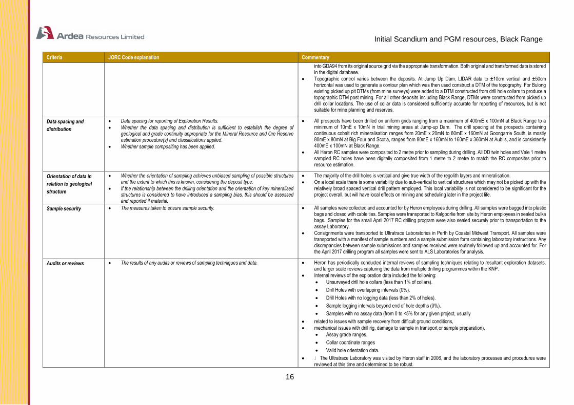
Initial Scandium and PGM resources, Black Range
16
Criteria JORC Code explanation Commentary
into GDA94 from its original source grid via the appropriate transformation. Both original and transformed data is stored in the digital database.
• Topographic control varies between the deposits. At Jump Up Dam, LIDAR data to ±10cm vertical and ±50cm horizontal was used to generate a contour plan which was then used construct a DTM of the topography. For Bulong existing picked up pit DTMs (from mine surveys) were added to a DTM constructed from drill hole collars to produce a topographic DTM post mining. For all other deposits including Black Range, DTMs were constructed from picked up drill collar locations. The use of collar data is considered sufficiently accurate for reporting of resources, but is not suitable for mine planning and reserves.
Data spacing and
distribution
• Data spacing for reporting of Exploration Results.
• Whether the data spacing and distribution is sufficient to establish the degree of geological and grade continuity appropriate for the Mineral Resource and Ore Reserve estimation procedure(s) and classifications applied.
• Whether sample compositing has been applied.
• All prospects have been drilled on uniform grids ranging from a maximum of 400mE x 100mN at Black Range to a minimum of 10mE x 10mN in trial mining areas at Jump-up Dam. The drill spacing at the prospects containing continuous cobalt rich mineralisation ranges from 20mE x 20mN to 80mE x 160mN at Goongarrie South, is mostly 80mE x 80mN at Big Four and Scotia, ranges from 80mE x 160mN to 160mE x 360mN at Aubils, and is consistently 400mE x 100mN at Black Range.
• All Heron RC samples were composited to 2 metre prior to sampling during drilling. All DD twin holes and Vale 1 metre sampled RC holes have been digitally composited from 1 metre to 2 metre to match the RC composites prior to resource estimation.
Orientation of data in
relation to geological
structure
• Whether the orientation of sampling achieves unbiased sampling of possible structures and the extent to which this is known, considering the deposit type.
• If the relationship between the drilling orientation and the orientation of key mineralised structures is considered to have introduced a sampling bias, this should be assessed and reported if material.
• The majority of the drill holes is vertical and give true width of the regolith layers and mineralisation.
• On a local scale there is some variability due to sub-vertical to vertical structures which may not be picked up with the relatively broad spaced vertical drill pattern employed. This local variability is not considered to be significant for the project overall, but will have local effects on mining and scheduling later in the project life.
Sample security • The measures taken to ensure sample security. • All samples were collected and accounted for by Heron employees during drilling. All samples were bagged into plastic bags and closed with cable ties. Samples were transported to Kalgoorlie from site by Heron employees in sealed bulka bags. Samples for the small April 2017 RC drilling program were also sealed securely prior to transportation to the assay Laboratory.
• Consignments were transported to Ultratrace Laboratories in Perth by Coastal Midwest Transport. All samples were transported with a manifest of sample numbers and a sample submission form containing laboratory instructions. Any discrepancies between sample submissions and samples received were routinely followed up and accounted for. For the April 2017 drilling program all samples were sent to ALS Laboratories for analysis.
Audits or reviews • The results of any audits or reviews of sampling techniques and data. • Heron has periodically conducted internal reviews of sampling techniques relating to resultant exploration datasets, and larger scale reviews capturing the data from multiple drilling programmes within the KNP.
• Internal reviews of the exploration data included the following:
• Unsurveyed drill hole collars (less than 1% of collars).
• Drill Holes with overlapping intervals (0%).
• Drill Holes with no logging data (less than 2% of holes).
• Sample logging intervals beyond end of hole depths (0%).
• Samples with no assay data (from 0 to <5% for any given project, usually
• related to issues with sample recovery from difficult ground conditions,
• mechanical issues with drill rig, damage to sample in transport or sample preparation).
• Assay grade ranges.
• Collar coordinate ranges
• Valid hole orientation data.
• The Ultratrace Laboratory was visited by Heron staff in 2006, and the laboratory processes and procedures were reviewed at this time and determined to be robust.

Initial Scandium and PGM resources, Black Range
17
Criteria JORC Code explanation Commentary
• The exploration data for the Siberia and Goongarrie Regions were initially reviewed in detail were by Heron in 2004 and subsequently by Vale / Inco in 2005
Section 2 - Reporting of Exploration Results
(Criteria listed in the preceding section also apply to this section.)
Criteria JORC Code explanation Commentary
Mineral tenement
and land tenure
status
• Type, reference name/number, location and ownership including agreements or material issues with third parties such as joint ventures, partnerships, overriding royalties, native title interests, historical sites, wilderness or national park and environmental settings.
• The security of the tenure held at the time of reporting along with any known impediments to obtaining a licence to operate in the area.
• The tenement and land tenure status for the KNP prospect areas containing continuous cobalt rich laterite mineralisation is summarised in Table 3 following and in the Ardea Prospectus, section 9 “Solicitor’s Report on Tenements”.
Exploration done by
other parties
• Acknowledgment and appraisal of exploration by other parties. • The Goongarrie South, Scotia, Aubils and Jump Up Dam deposits were discovered and explored by Heron Resources Limited.
• The Black Range deposit was initially discovered and drilled by Anaconda Nickel Limited.
• Vale Inco completed a prefeasibility study on the KNP which included extensive drilling of Black Range deposits relevant to the current updated resource reporting.
Geology • Deposit type, geological setting and style of mineralisation. • The KNP nickel laterite mineralisation, including cobalt rich areas is developed from the weathering and near surface enrichment of Achaean-aged olivine-cumulate ultramafic units. The mineralisation is usually within 60 metres of surface and can be further sub divided on mineralogical and metallurgical characteristics into upper iron-rich material and lower magnesium-rich material based on the ratios of iron to magnesium. The deposits are analogous to many weathered ultramafic-hosted nickel-cobalt deposits both within Australia and world-wide.
• Cobalt rich mineralisation is typically best developed in iron rich material in regions of deep weathering in close proximity to major shear zones or transfer shear structures and to a lesser extent as thin zones along the interface of ferruginous and saprolite boundaries at shallower depths proximal to shear structures.
• The Cobalt Zone is associated with a distinctive geo-metallurgical type defined as “Clay Upper Pyrolusitic”. Mineralogy is goethite, gibbsite and pyrolusite (strictly “asbolite” or “cobaltian wad”). The Cobalt Zones typically occur as sub-horizontal bodies at a palaeo-water table within the KNP (late stage supergene enrichment). This material is particularly well developed at Goongarrie South.
Drill hole Information • A summary of all information material to the understanding of the exploration results including a tabulation of the following information for all Material drill holes:
• easting and northing of the drill hole collar
• elevation or RL (Reduced Level – elevation above sea level in metres) of the drill hole
collar
• dip and azimuth of the hole
• down hole length and interception depth
• hole length.
• The drill hole data relating to the resource estimates reviewed in this study are all previously reported results Since 2008 no new drilling has been carried out excepting 27 new RC drill holes drilled in the central area of the Black Range deposit during April 2017. Ongoing studies for these prospect areas are focused on the metallurgical characteristics of the mineralisation and development of new process technology.
• Drill hole collar, geology and assay data for each prospect area investigated in this study are provided in the Vale Inco Pre-feasibility Study, 2009 and Heron Yerilla Pre-feasibility Study, 2010.
Drill hole Information • If the exclusion of this information is justified on the basis that the information is not Material and this exclusion does not detract from the
• understanding of the report, the Competent Person should clearly explain why this is the case.
• N/A
Initial Scandium and PGM resources, Black Range
18
Criteria JORC Code explanation Commentary
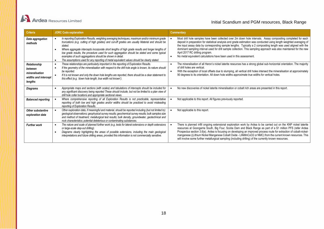
Data aggregation
methods
• In reporting Exploration Results, weighting averaging techniques, maximum and/or minimum grade truncations (e.g. cutting of high grades) and cut-off grades are usually Material and should be stated.
• Where aggregate intercepts incorporate short lengths of high grade results and longer lengths of low grade results, the procedure used for such aggregation should be stated and some typical examples of such aggregations should be shown in detail.
• The assumptions used for any reporting of metal equivalent values should be clearly stated.
• Most drill hole samples have been collected over 2m down hole intervals. Assay compositing completed for each deposit in preparation for statistical analysis and grade estimation was conducted using length weighted averaging of the input assay data by corresponding sample lengths. Typically a 2 compositing length was used aligned with the dominant sampling interval used for drill sample collection. This sampling approach was also maintained for the new April 2017 RC drilling program.
• No metal equivalent calculations have been used in this assessment.
Relationship
between
mineralisation
widths and intercept
lengths
• These relationships are particularly important in the reporting of Exploration Results.
• If the geometry of the mineralisation with respect to the drill hole angle is known, its nature should be reported.
• If it is not known and only the down hole lengths are reported, there should be a clear statement to this effect (e.g. ‘down hole length, true width not known’).
• The mineralisation of all Heron’s nickel laterite resources has a strong global sub-horizontal orientation. The majority of drill holes are vertical.
• With the exception of local offsets due to slumping, all vertical drill holes intersect the mineralisation at approximately 90 degrees to its orientation. All down hole widths approximate true widths for vertical holes.
Diagrams • Appropriate maps and sections (with scales) and tabulations of intercepts should be included for any significant discovery being reported These should include, but not be limited to a plan view of drill hole collar locations and appropriate sectional views.
• No new discoveries of nickel laterite mineralisation or cobalt rich areas are presented in this report.
Balanced reporting • Where comprehensive reporting of all Exploration Results is not practicable, representative reporting of both low and high grades and/or widths should be practiced to avoid misleading reporting of Exploration Results.
• Not applicable to this report. All figures previously reported.
Other substantive
exploration data
• Other exploration data, if meaningful and material, should be reported including (but not limited to): geological observations; geophysical survey results; geochemical survey results; bulk samples size and method of treatment; metallurgical test results; bulk density, groundwater, geotechnical and rock characteristics; potential deleterious or contaminating substances.
• Not applicable to this report.
Further work • The nature and scale of planned further work (e.g. tests for lateral extensions or depth extensions or large-scale step-out drilling).
• Diagrams clearly highlighting the areas of possible extensions, including the main geological interpretations and future drilling areas, provided this information is not commercially sensitive.
• There is planned infill ongoing extensional exploration work by Ardea to be carried out on the KNP nickel laterite resources at Goongarrie South, Big Four, Scotia Dam and Black Range as part of a $1 million PFS (refer Ardea Prospectus section 3.6(e). Ardea is focusing on developing an improved process route for extraction of cobalt-nickel-manganese ((Lithium Nickel Manganese Cobalt Oxide - LiNiMnCoO2 or NMC) from the current known resources. This will involve some further metallurgical sampling (including drilling) of the currently known resources.

Initial Scandium and PGM resources, Black Range
19
Section 3 Estimation and Reporting of Mineral Resources
(Criteria listed in section 1, and where relevant in section 2, also apply to this section.)
Criteria JORC Code explanation Commentary
Database integrity • Measures taken to ensure that data has not been corrupted by, for example, transcription or keying errors, between its initial collection and its use for Mineral Resource estimation purposes.
• Data validation procedures used.
• Heron employed a robust procedure for the collection of and storage of sample data. This included auto-validation of sample data on entry, cross checking of sample batches between the laboratory and the database and regular auditing of samples during the exploration phase.
• Sample numbers were both recorded manually and entered automatically. Discrepancies within batches (samples were batched on a daily basis) were field checked at the time of data entry, and resampled if errors could not be resolved after field inspection.
• HGMC reviewed the set of Microsoft Access data of the drilling information compiled for the Black Range deposit area which was extracted from. Ardea’s in-house Microsoft Access database. The databases supplied and used were dated July 2015, August 2015 and most recently August 2016. This is the most recent version of the database available
• Data validation procedures include digital validation of the database on entry (no acceptance of overlapping intervals, duplicate hole and sample ID, incorrect legend information, out of range assay results, incorrect pattern of QAQC in sampling stream, failed QAQC, missing assays, samples and geological logging).
• At the time of resource modelling all data was visually checked on screen, and manually validated against field notes. All changes to the database were verified by field checks.
• Ardea undertook a program of drill hole collar survey and validation. All drill holes were surveyed using DGPS with an established base station control stations in the vicinity of the Black Range deposit area.
• Drilling procedures used for the recent April 2017 program were robust and followed industry best practice procedures and included standard procedures for RC drilling, sampling, data entry and where tested, and confirmed results derived from earlier programs using alternate drilling methods.
• The drilling, sampling and geological practices were standardised for all deposits.
Site visits • Comment on any site visits undertaken by the Competent Person and the outcome of those visits.
• If no site visits have been undertaken indicate why this is the case.
• The Competent Person, James Ridley, is a previous employee of Heron Resources from 2004 to 2011 and has visited all of the KNP prospect areas. The drilling, sampling and geological practices were standardized for all deposits. RC drilling was generally effective, although there were some minor localised issues with sampling accuracy of wet puggy clays. Overall procedures were robust, including data entry, for the RC drilling, and where tested, repeatable by alternate drilling methods.
• The Competent Person, Ian Buchhorn, is a current employee of Heron Resources and has acquitted and visited all of the KNP prospect areas.
• No comment can be made on the validity of historic work by Helix, WMC and Anaconda, except to say that infill drilling has broadly similar results to the historic data. Due diligence by Ian Buchhorn at the time of acquisition by Heron confirmed acceptable QAQC by the various vendors.
• HGMC has carried out a general project and data review in April 2017.The review found that project development and management of data have been given appropriate attention. All of the previous drilling data and resource estimation work was also reviewed and found to be of a high standard
Initial Scandium and PGM resources, Black Range
20
Criteria JORC Code explanation Commentary
Geological
interpretation
• Confidence in (or conversely, the uncertainty of) the geological interpretation of the mineral deposit.
• Nature of the data used and of any assumptions made.
• The effect, if any, of alternative interpretations on Mineral Resource estimation.
• The use of geology in guiding and controlling Mineral Resource estimation.
• The factors affecting continuity both of grade and geology.
• There is a strong correlation between the geology of adjacent drill holes in the Black Range deposit area. There is also a strong global correlation between weathering profile, lithology and mineralisation intensity. On a local scale the changes in weathering profile is often discrete, but of a complex geometry. There is good confidence overall in the geological model, and this has been confirmed at Jump Up Dam by the trial mining of 20,000 tonnes of mineralisation.
• At Black Range the continuity of mineralisation is strongly controlled by bed rock alteration and palaeo water flow within the ultramafic host units. Areas of deep fracturing and water movement within the bedrock typically had higher grade and more extensive mineralisation in the overlying regolith. In the proximity of geological contacts between the ultramafic hosts and surrounding mafic or more felsic lithologies there is often a distinctive increase in grade and widths of mineralisation. Where the host regolith overlies olivine adcumulate lithologies there is an increase in siliceous material and a loss of the high magnesium mineralisation horizon. In areas where the host ultramafic was altered to talc, or talc-carbonate lithologies there is generally little or no development of nickel mineralisation with in the regolith profile. These areas typically form along shears, and sheared contacts within the bedrock.
• Two sets of Mineralisation domains (‘high and low’ grade’ were developed using a combination observed geological logging information and assay data.
• Cobalt and Nickel mineralization envelopes for the Black Range Area were based on drill (2m composite) intercepts of nominally >0.50% Ni or >1.0% Ni again using a 2m (2 samples) internal dilution definition regime. The logged geology and the local cobalt percentage (>0.05% or >0.10% Co and >0.50% Ni or >1.0% Ni) was used as a guide for construction mineralisation wireframes. The mineralised zone wireframes were extrapolated to the edges of the drilling along and perpendicular to the strike to maintain geological consistency. The majority of detailed logging of RC drill chips and diamond core logging information from drill programs completed during the years 1999 to 2008 and the recent April 2017 RC drilling for the Black Range area was transferred to geological logging database and this has provided a robust control for geology, material type interpretation and resource estimation and classification.
• All mineralised envelopes where aligned with the known interpreted mineralisation trend. No obvious fault systems were interpreted with sufficient reliability to warrant the modelling any significant off-sets to the observed mineralisation trends or extents.
Dimensions • The extent and variability of the Mineral Resource expressed as length (along strike or otherwise), plan width, and depth below surface to the upper and lower limits of the Mineral Resource.
• The total length of the main Black Range area nickel-cobalt mineralisation domains is approximately 3,600 metres with observed widths of approximately 300 and up to 700 metres. Two (2) or more semi-parallel Mineralisation zones are observed are with variable thicknesses typically in the order of 5-10 metres thick with some zones being in the range of 20 to 30 metres thick. Interpreted mineralisation has been modelled from near topographic surface (440mRL) down to approximately the 375m RL (approximately 65-70m vertical from surface).
Estimation and
modelling
techniques
• The nature and appropriateness of the estimation technique(s) applied and key assumptions, including treatment of extreme grade values, domaining, interpolation parameters and maximum distance of extrapolation from data points. If a computer assisted estimation method was chosen include a description of computer software and parameters used.
• The availability of check estimates, previous estimates and/or mine production records and whether the Mineral Resource estimate takes appropriate account of such data.
• The assumptions made regarding recovery of by-products.
• Estimation of deleterious elements or other non-grade variables of economic significance (e.g. sulphur for acid mine drainage characterisation).
• In the case of block model interpolation, the block size in relation to the average sample spacing and the search employed.
• Any assumptions behind modelling of selective mining units.
• Any assumptions about correlation between variables.
• Description of how the geological interpretation was used to control the resource estimates.
• Discussion of basis for using or not using grade cutting or capping.
• The process of validation, the checking process used, the comparison of model data to drill hole data, and use of reconciliation data if available.
• At Black Range block model items for Ni% and Co% were interpolated using Ordinary Kriging (OK). Additional Ordinary Kriging interpolation was also carried out for Pt(ppm) Pd(ppm) and Sc(ppm) as these are understood to be beneficial metals from a future mining and processing standpoint. Other contaminant or potentially deleterious elemental components such as Al2O3, Fe2O3, MgO and CaO were also interpolated.
• The various elements for both the Black Range deposit were estimated using MineSight® software.
• Block sizes for both the Black Range model based on drill spacing and deposit geometry as follows
• 20 x 20 x 2 metre Black Range
• (Uniform Block Size – No Sub-Blocks)
• All models used a zone code with an associated block percentage sub-division (1% precision) to maintain accurate volume reporting.
• At Black Range the Ni and Co are the principal economic elements modelled. Within the Black Range deposit, MgO, FeO, Al2O3 and SiO2 are all considered important analytical items with respect to the classification of the different geo-metallurgical styles of mineralisation which may affect materials handling and metallurgic extraction processes. As such a complete review and revision of all item, Ni, Co, MgO, Fe2O3, Al2O3, CaO, Mn, Cr, Sc, Pt and Pd have been reinterpreted and remodelled and are incorporated into the current (September 2017) block model.
• Accessory metals at Black Range include manganese, scandium, platinum, palladium, and chromium. The PGMs (Platinum Group Metals, i.e. platinum and palladium) and scandium occur in a blanket that is either above or coincident with the
Initial Scandium and PGM resources, Black Range
21
Criteria JORC Code explanation Commentary
cobalt-nickel mineralisation. Mining of the cobalt-nickel deposit will require mining of the PGMs and scandium. As such, there will be minimal additional mining costs related to excavation of these accessory metals.
• Some recovery of Pt, Pd and Sc is expected as part of currently understood mineral processing and metal extraction flow-sheets. The overall economic viability of the Black Range deposit is not expected to be reliant upon these minor elements.
• The domain boundary for mineralisation at Black Range a mineralization zone boundary definition was set nominally at the 0.50% Ni and 1.00% Ni threshold level for 2 different grade domains.
• The main two Ni and Co grade defined mineralisation domains at Black Range were geostatistically analysed and modelled separately.
• The block size parameters at Black Range were set at 20.0mE x 20.0mN x 2.0mRL.
• The minimum and maximum number of composites used during Ordinary Kriging interpolation was set at 1 and 24 respectively. (No sub-blocking or discretisation used - all domains).
• One search pass was used for the interpolation of grade into the blocks of each AREA domain. Any un-estimated blocks were left ‘as is’ and did not contribute to material summation. Hard boundaries were applied between all estimated domains.
• No detailed assumptions have been made with regard to modelling of selective mining units, except future mining is expected to be using standard excavator and truck methods. The block sized utilised is in line with the general mining method assumptions
• Refer to the Data Aggregation Methods criteria in Section 2 above. A range of outlier grade restriction was applied to all mineralised wireframes within given AREA domains. There were various restriction thresholds used separately for all interpolated items.
• The influence of extreme grade values was examined utilising top cutting analysis tools. (grade histograms, log probably plots and coefficients of variation examination).
• Some non-assayed intervals are present in the database. These have been interpreted as non-mineralised intervals and assigned zero grade for the purposes of block grade estimation. In situations where non-mineralised intervals are included within broader mineralised intervals these non-mineralised intervals are assumed to be mineralized, but grade level unknown. Interpolation from available from appropriately proximal data permitted in the interpreted zones concerned.
• Model validation for the Black Range deposit block model was carried out graphically and statistically to ensure that the block model grades accurately represent the input drill hole data. A number of methods were employed to validate the block model including: global mean comparison; visual comparison; trend plot comparison. The global mean comparison between drill composite grades and model grades within each of the mineralised zone wireframes shows that, globally, the estimates conform with the tenor of the input data and therefore validate well within all the well drilled (adequately-informed) domains for both deposits. Cross sections were viewed on-screen and showed a good comparison between the drill hole data and the block model grades. A volume comparison is also conducted to ensure match between the volume of the block model cells within each mineralised zone and the volume of the corresponding wireframe.
Moisture • Whether the tonnages are estimated on a dry basis or with natural moisture, and the method of determination of the moisture content.
• All tonnages reported are dry tonnes for all models. Dry density was determined from drill core and down hole gamma for the Jump Up Dam, Scotia, Highway and Goongarrie deposits. This dry tonnage was applied to the other deposits on a material type basis (see Bulk Density for more details).
• Cut-off
parameters
• The basis of the adopted cut-off grade(s) or quality parameters applied. • The 0.5% and 0.10% Ni cut-off used for the wireframe domains of the Black Range deposit was based on two observed step changes in the probability distribution of the nickel grades across the drill holes as well as general spatial distribution of those grades.
• Previous routine Mineral Resource reporting by Heron has used a 0.5%Ni cut-off grade applied to the resource block models. Additionally, a 0.08% Co reporting lower cut-off has been adopted for reporting cobalt resources. These cut-off levels are commonly used for resource reporting for typical Nickel Laterite deposits.
• HGMC has produced block model grade shells using a 0.08% Co cut-off and a 0.50% Ni cut-off in conjunction with a ‘Quality of Estimate’ parameter used to help provide guidance constraints for updated Mineral Resource reporting. The resource reporting processes and decisions are considered in terms of reliably defining regions of continuous cobalt and nickel mineralisation. The nickel and cobalt rich areas at Black Range are of particular interest to Heron as a potential source nickel-cobalt-manganese feed-stocks for the lithium ion battery industry.
Initial Scandium and PGM resources, Black Range
22
Criteria JORC Code explanation Commentary
Mining factors or
assumptions
• Assumptions made regarding possible mining methods, minimum mining dimensions and internal (or, if applicable, external) mining dilution. It is
• always necessary as part of the process of determining reasonable prospects for eventual economic extraction to consider potential mining
• methods, but the assumptions made regarding mining methods and
• parameters when estimating Mineral Resources may not always be rigorous. Where this is the case, this should be reported with an explanation of the basis of the mining assumptions made.
• Open pit mining via conventional dig and haul with minimum blasting is assumed for all deposits. Given the lateral extent of the models the selective mining unit SMU is likely to be smaller than the 20mx20x2m blocks used at Black Range.
• It is understood that removing a small amount of mineralization that unlikely to be an economic resource may be necessary at a future time. In a previous series of studies for Ardea’s nearby Goongarrie South and Big Four deposit areas, Auralia Mining Consultants carried out Whittle optimizations for these deposits using a US$10,000 per tonne nickel and US$55,000 per tonne cobalt price. Estimated Mining and processing costs, along with royalty and recovery factors were also updated by Auralia Mining Consultants for this process and such an evaluation process carried out on the Kriged nickel and cobalt grades for the Black Range Block model is also recommended.
Metallurgical
factors or
assumptions
• The basis for assumptions or predictions regarding metallurgical amenability. It is always necessary as part of the process of determining
• reasonable prospects for eventual economic extraction to consider potential
• metallurgical methods, but the assumptions regarding metallurgical treatment processes and parameters made when reporting Mineral Resources may not always be rigorous. Where this is the case, this should
• be reported with an explanation of the basis of the metallurgical
• assumptions made.
• The KNP Projects including the Black Range deposit are expected to undergo further metallurgical study. Processes being considered include, heap leaching, vat leaching, high pressure acid leaching, screen upgrades prior to leaching and pyrometallurgical methods. All methods are capable of processing Nickel Laterite ore types into saleable products and are currently in use at different deposits across the world.
• The current focus of studies into a preferred metallurgical approach is on atmospheric acid leaching methods with a particular focus on improving the recovery of reagents during processing to improve unit costs.
Environmental
factors or
assumptions
• Assumptions made regarding possible waste and process residue disposal options. It is always necessary as part of the process of determining
• reasonable prospects for eventual economic extraction to consider the
• potential environmental impacts of the mining and processing operation. While at this stage the determination of potential environmental impacts, particularly for a greenfields project, may not always be well advanced, the status of early consideration of these potential environmental impacts should be reported. Where these aspects have not been considered this should be reported with an explanation of the environmental assumptions made.
• It is expected that waste rock material from the Black Range deposit will largely be disposed of inside previously completed parts of the pits during the life of mine. Tailings disposal will consist of a mixture of conventional tailings dams and disposal in mined out pits. As all of the material mined will be of an oxidized nature and as such there is not expected to any acid generating minerals in the waste rock material. The processed tailings will need to be neutralized or recovered from the tailings stream prior to disposal in waste storage facilities. The expected land forms at the conclusion of the project will be of similar profile to the current land forms.
• Environmental studies for the project have been started with base line surveys for flora and fauna. However, as the final process route is currently subject to research, the final environmental plans are yet to be developed. It is reasonable, given the existing nickel laterite operations in WA that all environmental issues can be resolved and it will be possible to mine the resources within current environmental guidelines.
Bulk density • Whether assumed or determined. If assumed, the basis for the assumptions. If determined, the method used, whether wet or dry, the frequency of the measurements, the nature, size and representativeness of
• the samples.
• The bulk density for bulk material must have been measured by methods that adequately account for void spaces (vugs, porosity, etc), moisture and differences between rock and alteration zones within the deposit.
• Discuss assumptions for bulk density estimates used in the evaluation process of the different materials.
• Bulk densities for the Black Range deposit was not measured in the field. The default bulk density for Black Range it was set at 1.40t/m3. This bulk density value was based on and adopted from the measurements for Goongarrie South and similar nearby areas. These values are considered valid in application since there is a similar geology match for both of these deposits, both of which use a similar geochemical material classification scheme and average density for clay material has been considered and applied. HGMC has reviewed all previous bulk density assignment work for the KNP project area preserved previously used values and assumptions for use in the new Black Range block model.
Classification • The basis for the classification of the Mineral Resources into varying confidence categories.
• Whether appropriate account has been taken of all relevant factors (i.e. relative confidence in tonnage/grade estimations, reliability of input data,
• confidence in continuity of geology and metal values, quality, quantity and
• distribution of the data).
• Whether the result appropriately reflects the Competent Person’s view of
• the deposit.
• The classification approach used at the Black Range deposit area was based on a combination of drill hole spacing, number of composites, kriging variance and the ranges of mineralisation continuity (developed from variography studies), All these classification parameters were derived as a part of the ordinary kriging interpolation process applied to the cobalt estimates. These parameters were condensed into a ‘Quality of Estimate’ QLTY=1, 2 or 3) precursor reporting item
QLTY=1
• Drill spacing of 20x40 metre or less.
• Assays – Co only available for classification.
• Search ellipsoid distances 0-80m (Black Range).
• Composite numbers 0-10.
Initial Scandium and PGM resources, Black Range
23
Criteria JORC Code explanation Commentary
• Kriging Variance 0 - 0.04 (Black Range),
QLTY=2
• Drill spacing of 20x40 metre to 40x80 metre (depending on deposit and variography results).
• Assays – Co only available for classification.
• Search ellipsoid distances 80-120m (Black Range).
• Composite numbers 10-15.
• Kriging Variance 0.04-0.06 (Black Range),
QLTY=3
• Drill spacing of 40x40 metre to 80x80 metre (depending on deposit and variography results).
• Assays – Co only available for classification.
• Search ellipsoid distances 120m or greater (Black Range).
• Composite numbers 15 or greater numbers.
• Kriging Variance 0.06 (Black Range),
Classification – RCAT=1(Measured), 2(Indicated) & 3(Inferred)
• These three QLTY item parameters were further condensed into an unbiased RCAT item describing the confidence of the localized resource base in the block model. Preliminary Resource Classification Item – (RCAT) Values 1-3 – (Nominally (‘Meas’), ‘Ind’ and ‘Inf’ [(1), 2 or 3].
• For the Black Range Area, all QLTY=1 material is designated Indicated Resources (RCAT=2) with the remaining QLTY = 2 and 3 material being combined and designated as Inferred Resources. (RCAT=3).
• All resources have been reported contained within defined mineralisation wire-frame domains which have been defined according to a reliable level of mineralization continuity for both the Ni and Co elements.
• The mineralization modelling and subsequent resource estimation is in the opinion of the Competent Person a reasonable representation of the identifiable mineral resources present at Black Range given the various data available at the time of reporting.
Audits or reviews • The results of any audits or reviews of Mineral Resource estimates. • The previous resource estimates for Black Range generated in-house by Heron and Ardea have been validated against previous models created by Snowden. All models have been checked by Heron and Ardea are considered to be reasonable estimates of resources given the level of confidence applied to each model.
Discussion of
relative accuracy/
confidence
• Where appropriate a statement of the relative accuracy and confidence level in the Mineral Resource estimate using an approach or procedure
• deemed appropriate by the Competent Person. For example, the
• application of statistical or geostatistical procedures to quantify the relative accuracy of the resource within stated confidence limits, or, if such an approach is not deemed appropriate, a qualitative discussion of the factors that could affect the relative accuracy and confidence of the estimate.
• The statement should specify whether it relates to global or local estimates,
• and, if local, state the relevant tonnages, which should be relevant to
• technical and economic evaluation. Documentation should include assumptions made and the procedures used.
• These statements of relative accuracy and confidence of the estimate should be compared with production data, where available.
• The resource as reported from the Black Range block model provides reasonable global estimates of the available nickel and cobalt resources. Models have been validated visually against drilling for both the recoverable minerals cobalt and nickel.
• Overall the modelled resources present are considered a very reasonable global estimate of the resources for Co and Ni at the Black Range deposit area.