black forest regional park
TRANSCRIPT

Black Forest Regional Park
Master Plan Update
DRAFT August, 2017

Executive Summary
Background The Black Forest Regional Park Master Plan Update is a guiding document for the development of multiuse trails within the park. It serves to update the original Black Forest Regional Park Master Plan (2011), and acknowledges impacts to the park from the Black Forest Fire and post-fire flooding. Implementation of the master plan will compliment ongoing forestry and soil stabilization efforts within the park.
Planning Process The Black Forest Regional Park Master Plan Update was launched in May 2017 with the establishment of a project team, comprised of El Paso County staff members from both the Community Services Department (Planning, Park Operations) and Public Works (Engineering). County staff completed a review of existing documents, site inventory and analysis, and used input from the stakeholder group and public meeting comments to develop recommended improvements for consideration in the Master Plan Update. In addition to the public meeting held in July 2017, the Black Forest Regional Park Master Plan Update was presented at public hearings before the Park Advisory Board for endorsement and the Board of County Commissioners for final approvals, both in August 2017.
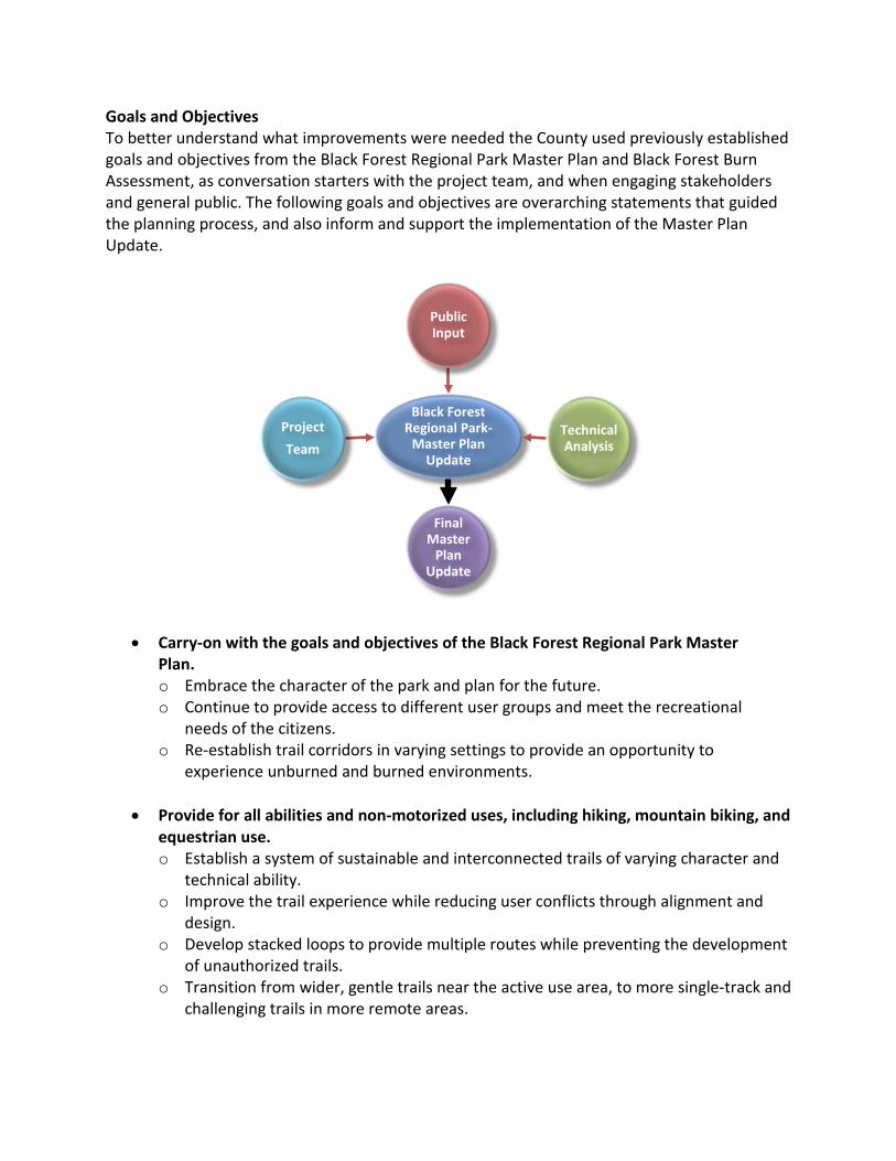
Goals and Objectives To better understand what improvements were needed the County used previously established goals and objectives from the Black Forest Regional Park Master Plan and Black Forest Burn Assessment, as conversation starters with the project team, and when engaging stakeholders and general public. The following goals and objectives are overarching statements that guided the planning process, and also inform and support the implementation of the Master Plan Update.
• Carry-on with the goals and objectives of the Black Forest Regional Park Master
Plan. o Embrace the character of the park and plan for the future. o Continue to provide access to different user groups and meet the recreational
needs of the citizens. o Re-establish trail corridors in varying settings to provide an opportunity to
experience unburned and burned environments.
• Provide for all abilities and non-motorized uses, including hiking, mountain biking, and equestrian use. o Establish a system of sustainable and interconnected trails of varying character and
technical ability. o Improve the trail experience while reducing user conflicts through alignment and
design. o Develop stacked loops to provide multiple routes while preventing the development
of unauthorized trails. o Transition from wider, gentle trails near the active use area, to more single-track and
challenging trails in more remote areas.
Black Forest Regional Park-
Master Plan Update
Public Input
Technical Analysis
Final Master
Plan Update
Project Team

• Protect the natural environment while allowing managed public use. o Identify and reroute trails that contribute to soil erosion. o Align trails to avoid significant wildlife habitat areas, such as stands of aspen,
drainages, and ephemeral drainages. o Minimize impacts to the landscape, and reduce construction and maintenance costs
by constructing appropriately sized trails.
• Continue to work with neighbors and stakeholders to improve and manage the park. o Establish and implement a signage program for the park, to include incorporation
of County trails within the Cathedral Pines subdivision. o Enhance interpretive opportunities regarding fire ecology, resiliency and
emergency preparedness. o Reroute trails away from fence lines, close redundant or social trails that along
property lines. Site Inventory and Analysis El Paso County completed several site visits in May 2017 to assess the current condition of trail corridors, landscape and general park environment. Since the Black Forest Fire, numerous hazard trees were felled, soil stabilization projects completed, and understory vegetation has had several seasons to regenerate. The site inventory and analysis documented these factors by recording the observable fire damage and potential flood damage along trail alignments. This information is summarized on the map below.
Trail Tread Erosion Check Dams in Trail Tread Hillside Rilling


Master Plan Update Concept Plans Upon completion of the site inventory and analysis, and with assistance from stakeholders and public, the following four trail concepts were developed for additional refinement. These concepts provided an opportunity to better understand how to implement the goals and objectives, and visualize the future trail system in the park. The following four trail concepts were developed and refined, with the goal of selecting a preferred concept for refinement and implementation. Each concept provided a different level of trail intensity allowing for critical thinking of construction costs, impacts to the environment, and overall trail user experience. A map of each of the four trail concepts are below.
~Rest of Page Intentionally Left Blank~

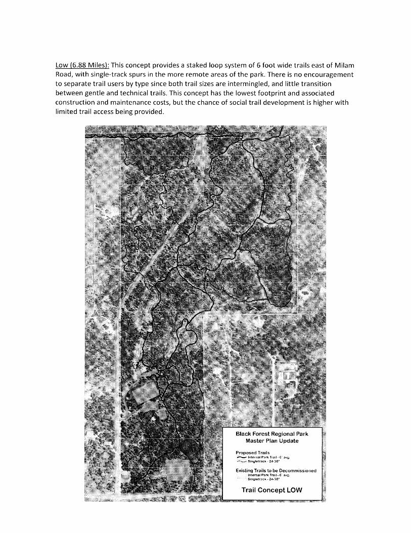
Low (6.88 Miles): This concept provides a staked loop system of 6 foot wide trails east of Milam Road, with single-track spurs in the more remote areas of the park. There is no encouragement to separate trail users by type since both trail sizes are intermingled, and little transition between gentle and technical trails. This concept has the lowest footprint and associated construction and maintenance costs, but the chance of social trail development is higher with limited trail access being provided.

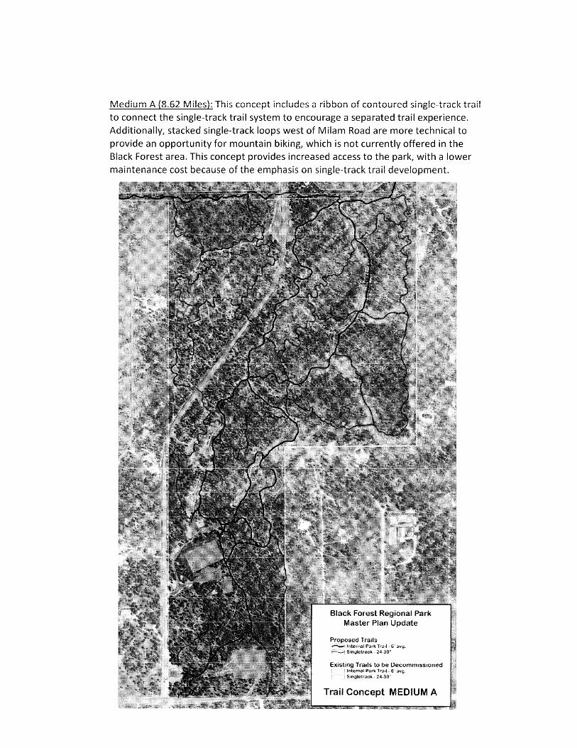
Medium A (8.62 Miles): This concept includes a ribbon of contoured single-track trail to connect the single-track trail system to encourage a separated trail experience. Additionally, stacked single-track loops west of Milam Road are more technical to provide an opportunity for mountain biking, which is not currently offered in the Black Forest area. This concept provides increased access to the park, with a lower maintenance cost because of the emphasis on single-track trail development.
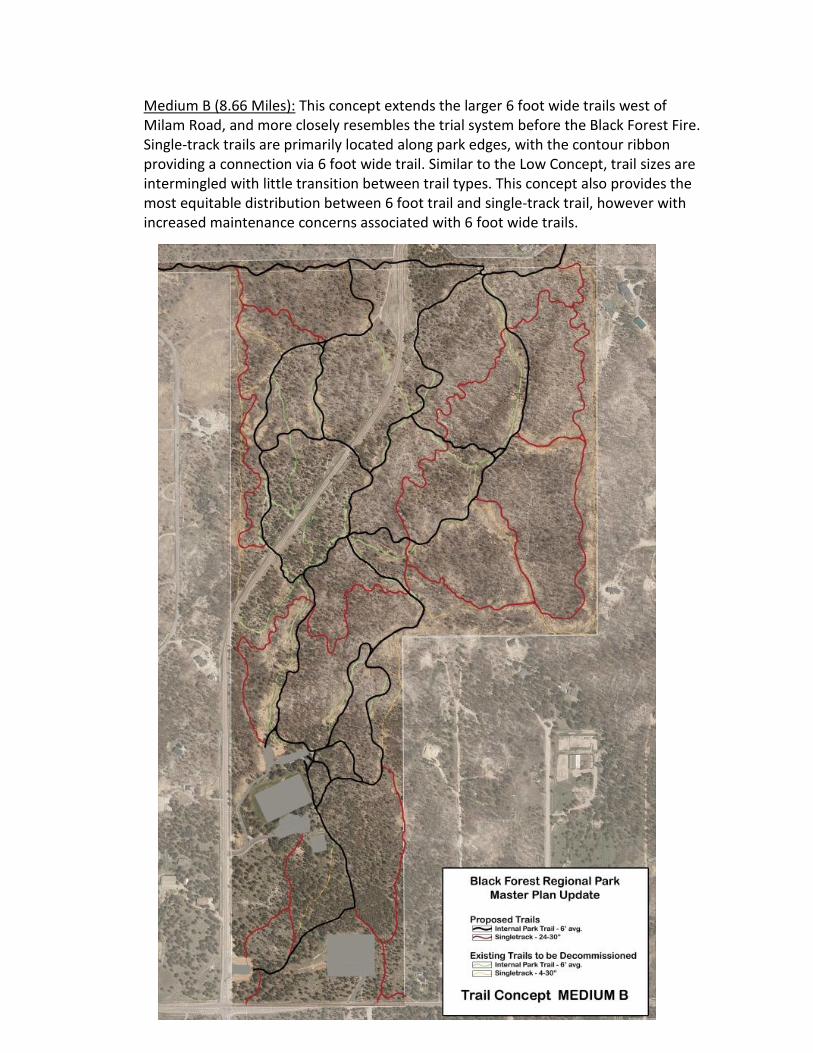
Medium B (8.66 Miles): This concept extends the larger 6 foot wide trails west of Milam Road, and more closely resembles the trial system before the Black Forest Fire. Single-track trails are primarily located along park edges, with the contour ribbon providing a connection via 6 foot wide trail. Similar to the Low Concept, trail sizes are intermingled with little transition between trail types. This concept also provides the most equitable distribution between 6 foot trail and single-track trail, however with increased maintenance concerns associated with 6 foot wide trails.

High (9.63 Miles): This concept provides highest level of trail development within the park by developing a 6 foot wide and separate single-track system. Both 6 foot wide and single-track trail loops are located throughout the park on both sides of Milam Road. This concept would have the highest construction and maintenance costs, and largest environmental footprint. There is also an increase chance of social trail development as wayfinding would be challenging with so many trail intersections.

Preferred Trail Concept After a thorough consideration of the concept plans and discussion with stakeholders, it was decided that trial concept “Medium A” best meets the goals and objectives established for this planning process. Trail concept “Medium A” provides an appropriate level of service to meet the recreation needs of the citizens, while the emphasis of single-track trail development re-establishes a system of sustainable trails in the post-fire environment. Conflicts between different trail user groups can also be addressed through trial design, skill qualifiers, and appropriate signage. Additionally, the opportunity to provide a more technical mountain biking experience west of Milam Road offers a unique opportunity currently not available within Black Forest. This will increase the overall level of recreational services to the citizens, and may also help spread-out the concentration of recreation users in Black Forest.

Funding and Implementation Several considerations were discussed throughout the planning process to better understand how to implement the recommendations of the Master Plan Update. This includes understanding repair costs to existing trail alignments vs. rerouting and decommissioning, what is the best way to prevent social trail development, and what trail corridors should be addressed first. Other issues that were discussed include available County funding and resources, how to utilize existing volunteer groups, and what partnerships should be explored. The end result of these discussions was that the Black Forest Regional Park Master Plan Update should not prioritizes each specific trail corridor for improvement, but rather provide some general statements based upon the goals and objectives, to guide implementation of the master plan update. This allows the County to retain flexibility when developing scopes of work for contracting purposes, or when seeking partnerships with volunteer groups and outdoor stewardship organizations.
• Prioritize trail repairs or short reroutes vs. new trail corridor construction.
• Trail development shall be logical, starting from existing trails, the active use area, or trail system from the Cathedral Pines Subdivision.
• Decommissioning of abandoned trails and/or social trails shall be completed
as part of any reroute or new trail construction activity.
• Soil stabilization and/or hazard tree removal shall be completed prior, or as part of any trail construction to prevent creating immediate maintenance issues.
• Updates to the overall park map and trail signage should be completed with
reroute and/or trail construction activity.