bituminous roadways roseville asphalt plant eaw · bituminous roadways roseville asphalt plant...
TRANSCRIPT
TDD (for hearing and speech impaired only): 651-282-5332 Printed on recycled paper containing 30% fibers from paper recycled by consumers
p-ear2-03a
ENVIRONMENTAL ASSESSMENT WORKSHEET
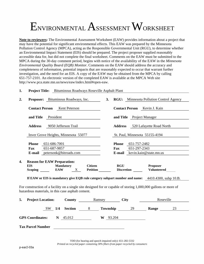
Note to reviewers: The Environmental Assessment Worksheet (EAW) provides information about a project that may have the potential for significant environmental effects. This EAW was prepared by the Minnesota Pollution Control Agency (MPCA), acting as the Responsible Governmental Unit (RGU), to determine whether an Environmental Impact Statement (EIS) should be prepared. The project proposer supplied reasonably accessible data for, but did not complete the final worksheet. Comments on the EAW must be submitted to the MPCA during the 30-day comment period, begins with notice of the availability of the EAW in the Minnesota Environmental Quality Board (EQB) Monitor. Comments on the EAW should address the accuracy and completeness of information, potential impacts that are reasonably expected to occur that warrant further investigation, and the need for an EIS. A copy of the EAW may be obtained from the MPCA by calling 651-757-2101. An electronic version of the completed EAW is available at the MPCA Web site http://www.pca.state.mn.us/news/eaw/index.html#open-eaw. 1. Project Title: Bituminous Roadways Roseville Asphalt Plant 2. Proposer: Bituminous Roadways, Inc. 3. RGU: Minnesota Pollution Control Agency Contact Person Kent Peterson Contact Person Kevin J. Kain and Title President and Title Project Manager Address 9050 Jefferson Trail Address 520 Lafayette Road North Inver Grove Heights, Minnesota 55077 St. Paul, Minnesota 55155-4194 Phone 651-686-7001 Phone 651-757-2482 Fax 651-687-9857 Fax 651-297-2343 E-mail [email protected] E-mail [email protected] 4. Reason for EAW Preparation:
EIS Scoping
Mandatory EAW
X
Citizen Petition
RGU Discretion
Proposer Volunteered
If EAW or EIS is mandatory give EQB rule category subpart number and name: 4410.4300, subp 10.B. For construction of a facility on a single site designed for or capable of storing 1,000,000 gallons or more of hazardous materials, in this case asphalt cement. 5. Project Location: County Ramsey City Roseville SW 1/4 Section 8 Township 29 Range 23 GPS Coordinates: N 45.012 W 93.204 Tax Parcel Number
Bituminous Roadways Roseville Asphalt Plant Environmental Assessment Roseville, Minnesota 2 Worksheet
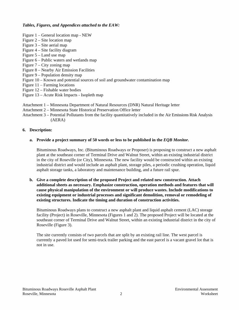
Tables, Figures, and Appendices attached to the EAW:
Figure 1 – General location map - NEW Figure 2 – Site location map Figure 3 – Site aerial map Figure 4 – Site facility diagram Figure 5 – Land use map Figure 6 – Public waters and wetlands map Figure 7 – City zoning map Figure 8 – Nearby Air Emission Facilities Figure 9 – Population density map Figure 10 – Known and potential sources of soil and groundwater contamination map Figure 11 – Farming locations Figure 12 – Fishable water bodies Figure 13 – Acute Risk Impacts - Isopleth map Attachment 1 – Minnesota Department of Natural Resources (DNR) Natural Heritage letter Attachment 2 – Minnesota State Historical Preservation Office letter Attachment 3 – Potential Pollutants from the facility quantitatively included in the Air Emissions Risk Analysis (AERA) 6. Description:
a. Provide a project summary of 50 words or less to be published in the EQB Monitor. Bituminous Roadways, Inc. (Bituminous Roadways or Proposer) is proposing to construct a new asphalt plant at the southeast corner of Terminal Drive and Walnut Street, within an existing industrial district in the city of Roseville (or City), Minnesota. The new facility would be constructed within an existing industrial district and would include an asphalt plant, storage piles, a periodic crushing operation, liquid asphalt storage tanks, a laboratory and maintenance building, and a future rail spur.
b. Give a complete description of the proposed Project and related new construction. Attach additional sheets as necessary. Emphasize construction, operation methods and features that will cause physical manipulation of the environment or will produce wastes. Include modifications to existing equipment or industrial processes and significant demolition, removal or remodeling of existing structures. Indicate the timing and duration of construction activities. Bituminous Roadways plans to construct a new asphalt plant and liquid asphalt cement (LAC) storage facility (Project) in Roseville, Minnesota (Figures 1 and 2). The proposed Project will be located at the southeast corner of Terminal Drive and Walnut Street, within an existing industrial district in the city of Roseville (Figure 3). The site currently consists of two parcels that are split by an existing rail line. The west parcel is currently a paved lot used for semi-truck trailer parking and the east parcel is a vacant gravel lot that is not in use.
Bituminous Roadways Roseville Asphalt Plant Environmental Assessment Roseville, Minnesota 3 Worksheet
As proposed, the west half of the new facility will include the asphalt hot mix plant, storage piles of asphalt rubble, crushed asphalt, asphalt millings, recycled shingles, and various aggregates (including sand), and a laboratory and maintenance building (Figure 4). The east portion of the facility will consist of three operations: an LAC storage facility, additional raw material storage and handling, and an asphalt production facility. The LAC storage facility is proposed to consist of the following:
• rail car and/or truck unloading • two 2.1-million-gallon LAC storage tanks - approximately 80 feet in diameter and 56 feet
high • one 200,000-gallon LAC transfer tank (day tank) - approximately 40 feet in diameter and
24 feet high • a new rail spur connection to the rail line to the east for LAC transfer • LAC truck load out equipment • heating equipment for LAC storage (natural gas fired)
The sizes and dimensions of the tanks are estimates at this time and additional smaller tanks may be included, if necessary, for improved functionality. The final size and dimensions of the tanks will be determined during final detailed engineering and will be included in the Above Ground Storage Tank Permit when submitted to the MPCA sometime in the future.
Raw material storage and handling will consist of the following:
• storage piles for concrete rubble waiting to be crushed, • a jaw crusher • a cone crusher • two screens to filter off-size material • conveyor belts • dryer • loaders • storage piles for crushed concrete and aggregate (Figure 4)
Across the facility the rubble piles will range from 15 to 38 feet in height. The Project as proposed is expected to produce approximately 300,000 tons of asphalt pavement per year. Crushing would be performed for an approximate two to three-week period, occurring twice annually.
The new asphalt pavement production plant would consist of:
• raw material storage (aggregate bins) • recycled asphalt pavement (RAP), liquid asphalt storage (asphalt cement or LAC) • asphalt drum/dryer/mixer, asphalt pavement storage silos • asphalt pavement load-out and ancillary equipment
The asphalt pavement production process is described generally as follows:
• Storage of raw materials: o aggregate piles and/or bins (sand and various sizes of crushed stone) o RAP – this is the material removed from a pavement project and re-used. It is a valuable
source of asphalt cement. RAP can also be derived from used shingles. RAP is typically used at approximately 25 percent by weight of the newly produced pavement.
o LAC – approximately 5 percent by weight of the newly produced asphalt pavement
Bituminous Roadways Roseville Asphalt Plant Environmental Assessment Roseville, Minnesota 4 Worksheet
• Asphalt production process: Aggregates are introduced into a rotating drum with a burner at one
end. This drum serves as a dryer and mixer. The heat from the burner dries the aggregates, which allows the aggregate to be coated with LAC later in the drum. In this case, the burner fuel will be natural gas.
• Introduce RAP into the drum – where it combines with aggregates. • Introduce LAC into the drum – where it combines with aggregate and RAP to make asphalt
pavement. • Move the product (asphalt pavement) into storage silos where it is stored until the pavement
project is ready for the material. o Asphalt pavement is typically stored for 0-6 hours prior to use. Silos are not used for
long-term storage. • Load asphalt pavement into trucks for use at a paving job.
Ancillary equipment and activities will consist of the following: • Hot oil heating system fueled by natural gas. This is an indirect heating system used to maintain
the temperature in the storage silos and the LAC tank so that the material can be handled appropriately.
• A laboratory for testing asphalt pavement samples as needed to meet pavement specifications. • A scale for weighing of trucks delivering raw materials and taking product to pavement jobs. • A control house for monitoring operations. • Periodically, a mobile crushing facility will come onto the site to crush and screen aggregates
and RAP to the required sizes and quality specifications. This is likely to be an operation that is contracted by Bituminous Roadways to another owner/operator.
The asphalt drum/dryer/mixer will have a fabric filter for control of air emissions. Air emissions from the drum consist of products of combustion of the burner fuel (in this case natural gas), dust and particles from aggregates, and some volatile gases from the LAC. As much as possible LAC is incorporated into the pavement product. Air emissions are discussed in more detail under Item 23 below.
Construction activities would generate minimal waste, with the exception of excess soil from site grading. Some of the soil excavated to create a flat bottom to the secondary containment area would be used to construct the side berms of the containment area, and some additional excess material would be stockpiled on site and used as a screening barrier. The remaining excess soil will be transported off site for re-use or proper disposal. Generally LAC will be received in the winter months and shipped out during the remainder of the year. Bituminous Roadways hot mix plants (at the proposed Roseville site as well as others) will be the primary, but not the only, receiver of LAC stored at the LAC storage facility. During the winter months, LAC would be unloaded from train cars and trucks by direct pumping via a pipe from the train car or truck to the storage tank. Steam will be used to heat the rail cars to facilitate the filling process. The asphalt cement (AC) is pumped into the top of the storage tank. As the tank is filled, an air release valve at the top of the tank expels the excess air from the tank. Tank farm storage tanks vent to a Carbon Bed Filter, which controls H2S emissions.
Bituminous Roadways Roseville Asphalt Plant Environmental Assessment Roseville, Minnesota 5 Worksheet
An average of ten times per day during the operating season, LAC would be unloaded from one of the storage tanks into tanker trucks. The LAC will be pumped from the storage tanks into the tanker trucks. The process for filling a tanker truck in this manner takes approximately 15 minutes. LAC for the proposed Project would be purchased based on availability and pricing and stored in the tanks until needed. In general, tanks will only be heated as needed, to conserve energy. Typically, the two large storage tanks would be heated to approximately 280°F from approximately April through November, with only one tank heated at a time. The smaller day tank, used to load the tanker trucks transporting the LAC off site, would be heated to approximately 350°F during the same season. The tanks would not be heated during the winter months. Project Phasing The LAC storage facility is a planned future phase of the project. Due to the tank size and material stored (above ground storage of more than one million gallons of LAC), the proposed Project requires a mandatory EAW. The time line for construction of the LAC storage facility is approximately two years after the asphalt pavement facility. Once begun, construction of the storage facility and related equipment would take four months. Operation would begin the winter following completion of construction. All phases of the project are addressed in this EAW. LAC from trucks and rail would be loaded into the LAC storage tanks (2.1 million gallons). LAC from the storage tanks would be transferred to the LAC day tank (200,000 gallons), from which trucks are loaded using the LAC loading rack. The rail spur will also not initially be constructed. The time frame for construction of the rail spur is expected to be within one year of completion of the asphalt production plant.
c. Explain the project purpose; if the project will be carried out by a governmental unit, explain the need for the project and identify its beneficiaries. The asphalt road construction business is served on a localized scale. Asphalt plants typically serve projects within a 10 to 15-mile radius. The location of the new asphalt plant in Roseville, Minnesota will allow Bituminous Roadways to competitively serve the north suburbs of Minneapolis and other communities in the north Metro.
d. Are future stages of this development including development on any other property planned or likely to happen? Yes No If yes, briefly describe future stages, relationship to present project, timeline and plans for environmental review. The LAC storage facility will not initially be constructed with the other components of the new facility. It is anticipated that the LAC storage tanks will be constructed within two years of the operation date of the completed asphalt plant. The LAC storage facility and rail spur are a part of this environmental review and will not need to be revisited unless significant changes are made to the Project that is described in this review.
e. Is this project a subsequent stage of an earlier project? Yes No
If yes, briefly describe the past development, timeline and any past environmental review.
Bituminous Roadways Roseville Asphalt Plant Environmental Assessment Roseville, Minnesota 6 Worksheet
7. Project Magnitude Data Total Project Area (acres) 14.6 or Length (miles)
Number of Residential Units:
Unattached
Attached
Maximum Units Per Building:
Commercial/Industrial/Institutional Building Area (gross floor space):
total square feet
Indicate area of specific uses (in square feet):
Office Manufacturing Retail Other Industrial 635,971 Warehouse Institutional Light Industrial Agricultural Other Commercial (specify) Building height 60-74 If over 2 stories, compare to heights of nearby buildings
The proposed 2.1 million gallon LAC tanks would be between 55 and 60 feet in height (currently estimated to be 56 feet). The silo at the asphalt plant is currently estimated to be 74 feet in height.
8. Permits and approvals required. List all known local, state and federal permits, approvals and financial assistance for the project. Include modifications of any existing permits, governmental review of plans, and all direct and indirect forms of public financial assistance including bond guarantees, Tax Increment Financing and infrastructure. All of these final decisions are prohibited until all appropriate environmental review has been completed. See Minn. R. 4410.3100.
Unit of Government Type of Application Status MPCA National Pollutant Discharge Elimination
System (NPDES) Construction Stormwater Permit
Application to be submitted
MPCA NPDES Industrial Stormwater Permit Application to be submitted MPCA Air Emissions Permit Public notice begins
July 12, 2010 MPCA Aboveground Storage Tank Permit To be applied for in the
future City of Roseville Conditional Use Permit Approval Application Submitted City of Roseville Commercial Building Permit Application to be submitted Rice Creek Watershed District Stormwater Discharge Permit Application Submitted
9. Land use. Describe current and recent past land use and development on the site and on adjacent
lands. Discuss project compatibility with adjacent and nearby land uses. Indicate whether any potential conflicts involve environmental matters. Identify any potential environmental hazards due to past site uses, such as soil contamination or abandoned storage tanks, or proximity to nearby hazardous liquid or gas pipelines. The proposed Project is located in a fully developed portion of the city of Roseville. The existing Project site consists of two parcels. The western parcel is large paved parking lot and the eastern parcel is a vacant gravel lot with some grassy areas at the fringe. A Minnesota Commercial Railway spur rail line bisects the Project site between the two parcels.
Bituminous Roadways Roseville Asphalt Plant Environmental Assessment Roseville, Minnesota 7 Worksheet
The existing rail line is currently used by businesses to the north of the property. It is likely that the businesses to the north of the site will continue to use the existing rail line as they do currently. Bituminous Roadways will construct a small extension to the existing rail spur to allow this rail line to serve the Project site. The new rail extension that will be constructed to serve the Project site will serve the purpose of transporting both LAC and aggregate to the site. Figure 4 (Site Facility Diagram) displays a ‘rail unloader’ on the south end of the east triangle parcel of the Project site that will be used to unload aggregate delivered to the site by rail. LAC will be loaded/unloaded on rail cars near the LAC storage tanks at the north end of the east parcel on the Project site. The Project site is located within an industrial park in Roseville and as a result the land uses immediately adjacent to the site are industrial uses (Figure 5). There are industrial facilities located immediately to the north and a vacant industrial site to the west of the Project site. There is a rail line located on the eastern edge of the Project site with commercial business located adjacent to the rail line. Interstate 35W and entrance ramps to State Highway 280 are located to the south of the Project site. Also, just south of the site, Highway 36 ends and feeds traffic into 35W, 280 or other local roads. Land uses in close proximity but not immediately adjacent to the Project site include a golf course to the west, commercial and industrial facilities and a petroleum tank farm to the north, commercial businesses to the east, and residential single-family homes to the south beyond Interstate 35W (Figure 7). A Phase I Environmental Site Assessment (ESA) was performed for the Project site in June 2009. The Phase I ESA identified historic environmental concerns for the Project site and the adjacent property to the west. The industrial site located immediately to the west of the Project site is owned by Meritex and previously housed two industrial buildings that were demolished in 2009. Environmental investigations at the west adjacent property have included 145 soil borings and the installation of five monitoring wells since 1988. Six underground storage tanks (four fuel oil, one diesel fuel, and one gasoline) previously existed at the property to the west and have been removed. Some petroleum impacted soil was encountered and left in place during tank removal. Five spill incidents are on record for the west property and all received closure through the MPCA. It is not known if these past activities at the west adjacent property or activities at other properties hydrologically upgradient of the Project site have impacted the soil or groundwater at the Project site. Monitoring well sample results from the west adjacent property has indicated contaminate concentrations below the MPCA’s Health Risk Limits. No Action Letters were issued by the MPCA for the west adjacent property and the Project site in June 2000 and November 2000, respectively. A subsurface geotechnical investigation was conducted on the proposed Project site in June 2009 in conjunction with the Phase I ESA. The geotechnical investigation consisted of five soil borings advanced to depths of eight feet below ground surface in the southwest portion of the Project site. This investigation indicated the presence of petroleum impacted soils within the upper two feet of soil in this area. The Project Proposer would address the impacted soil during site redevelopment and follow the proper procedures to receive site closure for the petroleum impacted soils through the MPCA. No other current recognized environmental conditions are identified for the Project site.
Bituminous Roadways Roseville Asphalt Plant Environmental Assessment Roseville, Minnesota 8 Worksheet
10. Cover Types. Estimate the acreage of the site with each of the following cover types before and after
development: Before After Before After Types 1-8 wetlands Lawn/landscaping 4.0 3.8 Wooded/forest Impervious Surfaces 10.6 10.3 Brush/grassland Stormwater pond 0 0.5 Cropland Other (describe) TOTAL 14.6 14.6
If before and after totals are not equal, explain why. 11. Fish, Wildlife, and Ecologically Sensitive Resources. a. Identify fish and wildlife resources and habitats on or near the site and describe how they would
be affected by the project. Describe any measures to be taken to minimize or avoid impacts. The existing Project site consists of a paved truck parking lot on the west half of the site and a vacant gravel lot on the east half of the site. The remainder of the Project site is covered by grassy areas. There are no water bodies or wetlands located within or adjacent to the Project site, which is located within a completely developed industrial district in the city of Roseville (Figure 9). There is no wildlife or fisheries habitat within or adjacent to the Project site. Due to the lack of fisheries or wildlife habitat at the Project site and the corresponding lack of wildlife use, the proposed Project will not result in impacts to fisheries or wildlife communities or populations. Langton Lake is a small, shallow basin located within the city of Roseville approximately 1.25 miles northeast of the proposed Project. The lake is approximately 30 acres in size with a maximum depth of five feet. Average depth across the basin is estimated to be approximately three feet. The lake is located within a city park and includes a fishing pier and canoe access. The lake is currently managed by the DNR as a kids fishing pond focusing mainly on panfish species. Due to the shallow nature of Langton Lake, it is prone to experiencing winter kill. As a result, the DNR annually stocks bluegills and black crappie to supplement the fishery. The DNR stocking report suggests that the stocked fish experience rapid growth within Langton Lake; however, due to the frequent winter kills the lake experiences, it is unlikely the fish within the lake survive for more than a few years, which results in the need to stock on an annual basis. Currently, there are no fish consumption advisory limits for the general population from Langton Lake specifically. The DNR does recommend that pregnant women and children under 15 years of age limit their fish consumption from Langton Lake to one meal per week, which is a general restriction for pregnant women and children under 15 for all Minnesota lakes. Recreational activity at Langton Lake or within the city park would not be impacted by the proposed Project.
b. Are any state (endangered or threatened) species, rare plant communities or other sensitive ecological resources on or near the site? Yes No
If yes, describe the resource and how it would be affected by the project.

Bituminous Roadways Roseville Asphalt Plant Environmental Assessment Roseville, Minnesota 9 Worksheet
Describe any measures that will be taken to minimize or avoid adverse impacts. Provide the
license agreement number (LA-___________) and/or Division of Ecological Resources contact number (ERDB________________) from which the data were obtained and attach the response letter from the DNR Division of Ecological Resources. Indicate if any additional survey work has been conducted within the site and describe the results. The DNR’s Natural Heritage Information System (NHIS) was queried to determine if known occurrences of rare, endangered, or special concern species or sensitive ecological habitats are present within or adjacent to the Project site. Results of the NHIS query returned no records of known occurrences of threatened, endangered, or special concern species or sensitive ecological habitats on the Project site. The search results indicated that two state listed invertebrate species (little white tiger beetle – threatened; and a jumping spider – species of special concern) and one state listed fungus species (mushroom - endangered) have been documented near the Project site. However, the invertebrates were documented more than one mile from the project site and the records were from 1924 and 1967. The fungus species was documented in 2004, but more than two miles from the Project site.
The Project site is in a completely developed portion of Roseville and contains no native habitat for threatened, endangered, or special concern species or sensitive ecological communities. Considering the lack of available habitat and the distances of known occurrences of threatened, endangered, or special concern species from the Project site, impacts to threatened, endangered, or special concern species from the proposed Project are not anticipated.
12. Physical Impacts on Water Resources. Will the project involve the physical or hydrologic alteration
(dredging, filling, stream diversion, outfall structure, diking, and impoundment) of any surface waters such as a lake, pond, wetland, stream or drainage ditch? Yes No If yes, identify water resource affected and give the DNR Public Waters Inventory (PWI) number(s) if the water resources affected are on the PWI. Describe alternatives considered and proposed mitigation measures to minimize impacts.
13. Water Use. Will the project involve installation or abandonment of any water wells, connection to or changes in any public water supply or appropriation of any ground or surface water (including dewatering)? Yes No If yes, as applicable, give location and purpose of any new wells; public supply affected, changes to be made, and water quantities to be used; the source, duration, quantity and purpose of any appropriations; and unique well numbers and DNR appropriation permit numbers, if known. Identify any existing and new wells on the site map. If there are no wells known on site, explain methodology used to determine. The proposed Project is located within an existing industrial park within the city of Roseville. As a result, access to all necessary utilities, including water, are readily available at the Project site. The laboratory and maintenance building for the proposed Project would be connected to the city of Roseville water supply through available connections within the industrial park. There are anticipated to be five full-time employees working at the site and water consumption would be similar to other businesses of this size for general use and sanitary purposes. Laboratory need for water is small. When producing warm mix asphalt (WMA), there is a small water requirement (0.12 percent of total mix). For example, at a production rate

Bituminous Roadways Roseville Asphalt Plant Environmental Assessment Roseville, Minnesota 10 Worksheet
of 300 tons WMA/hour, approximately 1.5 gallons/minute of water would be required. This is a level of supply that can easily be met by the city of Roseville water supply. For comparison, typical residential water use in a shower is two gallons/minute. The proposed Project will also use water for a process referred to as ‘steaming railcars.’ This process entails warming rail cars with steam to allow the liquid asphalt oil to be easily pumped from the rail cars during cool weather conditions. Steaming railcars is an activity that will occur occasionally at the site. The rail car steaming process consists of specifically designed rail cars that contain coils between the inner tank of the rail car and the outer jacket of the car, creating a closed loop system. A small natural gas fired steam boiler unit is used to generate steam, which is injected through fittings underneath the rail car. The steam is sent though the coils in the inner jacket of the rail car, which heats the liquid within the inner tank of the car. Typically, four rail cars would be steamed simultaneously, which would require approximately 12 to 15 gallons per minute of water. This volume of water can be easily met by the city of Roseville water system that supplies water to facilities within the industrial park. Another activity that will consume water at the Project site would be flushing the roads for dust control. The Project Proposer is exploring using water from the stormwater ponds that will be constructed on site, which was a process recommended by the City. However, in the event that the ponds do not have water during dry mid-summer conditions, City water would be used for dust control. The proposed Project will not consume or appropriate significant amounts of surface or groundwater. There are no known wells located on the Project site. The proposed Project will not require the construction or installation of new wells. In the event that existing wells are discovered on the Project site during construction, the Project Proposer will notify the Minnesota Department of Health and follow the proper closure procedures for well abandonment. Water will be used as spray on crusher and screens as part of their crushing dust mitigation, which is a requirement in the MPCA Draft Air Permit. Based in the information provided from the crushing contractor, the crushing operation will use approximately 1 to 3 gallons of water per minute for dust control, which is a volume that can easily be met by the City water utility supplied within the industrial area.
14. Water-related land use management districts. Does any part of the project involve a shoreland zoning district, a delineated 100-year flood plain, or a state or federally designated wild or scenic river land use district? Yes No If yes, identify the district and discuss project compatibility with district land use restrictions.
15. Water Surface Use. Will the project change the number or type of watercraft on any water body? Yes No
If yes, indicate the current and projected watercraft usage and discuss any potential overcrowding or conflicts with other uses.
Bituminous Roadways Roseville Asphalt Plant Environmental Assessment Roseville, Minnesota 11 Worksheet
16. Erosion and Sedimentation. Give the acreage to be graded or excavated and the cubic yards of soil to be moved: 14 acres; 35,000 cubic yards. Describe any steep slopes or highly erodible soils and identify them on the site map. Describe any erosion and sedimentation control
measures to be used during and after project construction. The proposed Project would disturb more than one acre of land. As a result, the Project Proposer would be required to obtain an NPDES Stormwater Construction Permit from the MPCA. The NPDES Permit requires that a Stormwater Pollution Prevention Plan (SWPPP) be developed and implemented for the Project site prior to project construction. The SWPPP will address erosion and sedimentation prevention measures. The proposed Project would utilize both temporary and permanent erosion and sediment control best management practices, as will be outlined in the site-specific SWPPP.
The existing site is generally flat, but would require a moderate amount of grading to achieve final elevations required for Project construction. Excavation and grading to prepare the site for construction will result in excess soil that will be transported off site. Additionally, minor excavation would take place at certain locations on the Project site to prepare for the construction of building and tank foundations. Excavation will also be required for construction of the surface-water management features, which include two stormwater detention basins, drainage swales (possibly including infiltration features), and perimeter berms. The construction procedures and best management practices outlined in the SWPPP developed for the site will minimize the potential for impacts resulting from erosion and sediment transport during construction. The proposed Project is located within the Rice Creek Watershed District (RCWD). The Project Proposer has applied for the appropriate permit for the Project through the RCWD. A preliminary Stormwater Management Plan has also been developed for the site. Following construction, the site will utilize drainage swales (possibly including infiltration features) and wet detention ponds as stormwater control measures to provide on-site stormwater volume control, rate control, and water quality treatment. The existing Project site is comprised mainly of a paved truck parking lot and an unused gravel parking lot, but does not currently have stormwater features to treat runoff prior to leaving the site. The addition of the proposed stormwater management features will provide flood storage, rate control, and water quality treatment, improving the quality of stormwater discharging from the Project site as compared to existing conditions. The NPDES Permit, SWPPP, Stormwater Management Plan, and erosion and sediment control measures will minimize impacts from the proposed Project. Impacts to surrounding water bodies are not anticipated.
17. Water Quality – Surface-water Runoff. a. Compare the quantity and quality of site runoff before and after the project. Describe
permanent controls to manage or treat runoff. Describe any storm-water pollution prevention plans. The existing Project site is approximately 14.6 acres, of which 10.6 acres is covered by impervious surface. Current surface water drainage at the site is primarily sheet-flow to the surrounding streets with no sediment control measures in place. The preliminary Stormwater Management Plan that has been developed by the Project Proposer outlines the use of drainage swales (that may include infiltration features) and wet detention ponds to address surface-water runoff. The preliminary plan indicates that drainage swales would be
Bituminous Roadways Roseville Asphalt Plant Environmental Assessment Roseville, Minnesota 12 Worksheet
constructed around the perimeter of the proposed operational area. The drainage swales may include an infiltration component (using drain tile and amended soils) to provide water quality treatment. However, the infiltration component is still under review until it can be determined if infiltration is appropriate for the site based on the proposed activities. These swales would direct surface-water runoff to the two wet detention ponds, one in the northeast portion of the site and the other in the southwest. The southwest pond would discharge into the existing ditch located next to the Minnesota Commercial Railway tracks and the northeast pond would discharge directly into the city of Roseville’s storm sewer system. The drainage swales and detention ponds would provide rate and volume control and provide water quality treatment (removing suspended sediment and nutrients) for water discharged from the site. The RCWD requires that 0.8 inches of runoff from the proposed Project be retained onsite. The 10.6 acres of impervious surface, therefore, require that 30,783 cubic feet of runoff be retained. The proposed drainage swales and wet detention ponds would provide 54,988 cubic feet of stormwater retention, which is sufficient to satisfy the RCWD requirements. The proposed management features would also reduce the surface-water runoff peak rates. Existing and proposed surface-water runoff peak rates for 24-hour, 2-year (2.8 inches of precipitation), 10-year (4.20 inches), and 100-year (6.00 inches) events from the Stormwater Management Plan submitted to the RCWD are provided in Table 1.
Table 1: Existing and Proposed Stormwater Runoff Peak Rates for the Project site
Storm Event Existing Peak Rates (CFS) Proposed Peak Rates (CFS) Q2 30.6 10.5 Q10 54.4 22.0 Q100 86.7 34.2
As indicated in Section 16, a SWPPP would be developed in accordance with the NPDES Permit requirements prior to construction.
b. Identify routes and receiving water bodies for runoff from the site; include major downstream water bodies as well as the immediate receiving waters. Estimate impact runoff on the quality of receiving waters. Stormwater runoff from the proposed Project would be managed as described in the above Item 17a. Stormwater discharges from the site would be directed into the existing stormwater conveyance system including a ditch along the Minnesota Commercial Railway tracks (to the south) and the city of Roseville’s storm sewer system (to the north). The drainage ditch located along the Minnesota Commercial Railway tracks is an unregulated ditch. The ditch carries water to the north and eventually discharges into Long Lake. The city of Roseville’s storm sewer system operates under the NPDES Program. The City is permitted through the MPCA to discharge stormwater from Small Municipal Separate Storm Sewer Systems to area wetlands, ponds, and lakes. The storm sewer system for the Project site discharges into Fulham Pond.
Bituminous Roadways Roseville Asphalt Plant Environmental Assessment Roseville, Minnesota 13 Worksheet
As there are currently no stormwater management features in place at the site, the water quality of stormwater runoff is expected to improve following construction of the stormwater management features for the proposed Project. Through the implementation of the proposed on-site stormwater management features, impacts to the water quality of the downstream receiving waters are not anticipated as a result of the proposed Project.
18. Water Quality – Wastewater. a. Describe sources, composition and quantities of all sanitary, municipal and industrial
wastewater produced or treated at the site. The proposed Project would generate sanitary wastewater from employees working at the laboratory and maintenance building. The asphalt production process, either hot mix asphalt (HMA) or WMA, does not produce wastewater. It is anticipated that the proposed Project would have five full-time employees working when the facility is in operation for asphalt production. Wastewater produced at the facility would be discharged into the city of Roseville’s sanitary sewer system, which routes wastewater to the Metropolitan Wastewater Treatment Plant in St. Paul, Minnesota. The amount of wastewater generated and discharged into the system from the proposed Project is estimated at 30 gallons per day per employee or 150 gallons per day for the facility. This small increase in wastewater generation from the proposed Project will not significantly impact the treatment capacity of Metropolitan Wastewater Treatment Plant. Portable toilets will be used during the construction process and will be serviced on a regular basis per state regulations. It is possible that pretreatment of the water used in the boiler to steam the rail cars may be required. Steam boilers typically require pretreatment to avoid scale or mechanical failure of the system. The proposed Project will use existing City water input to the steam boiler, which should require minimal pretreatment but may include pretreatment for items such as pH, hardness, or salinity. The wastewater from the pretreatment facility that may be required for the steam boiler will be discharged into the City wastewater sewer. The Project Proposer will install the necessary pretreatment system suggested by the steam boiler vendor that is selected for the Project and will obtain the necessary approvals or permits to discharge the pretreatment wastewater into the City wastewater sewer.
b. Describe waste treatment methods or pollution prevention efforts and give estimates of composition after treatment. Identify receiving waters, including major downstream water bodies (identifying any impaired waters), and estimate the discharge impact on the quality of receiving waters. If the project involves on-site sewage systems, discuss the suitability of site conditions for such systems. No on-site treatment of wastewater will occur with the proposed Project.
c. If wastes will be discharged into a publicly owned treatment facility, identify the facility, describe any pretreatment provisions and discuss the facility’s ability to handle the volume and composition of wastes, identifying any improvements necessary. Wastewater from the proposed Project would be treated at the Metropolitan Wastewater Treatment Plant in St. Paul, which is owned and operated by the Metropolitan Council. Wastewater from 65 communities is transported through a 332-mile network of interceptors to reach the treatment plant.
Bituminous Roadways Roseville Asphalt Plant Environmental Assessment Roseville, Minnesota 14 Worksheet
The plant has the capacity to treat up to 251 million gallons per day. The small wastewater volume contributed by the proposed Project would not affect the operating capacity of the Metropolitan Wastewater Treatment Plant.
19. Geologic hazards and soil conditions. a. Approximate depth (in feet) to Ground water: 60 minimum; 85 average. Bedrock: 100 minimum; 100 average. Describe any of the following geologic site hazards to ground water and also identify them on
the site map: sinkholes, shallow limestone formations or karst conditions. Describe measures to avoid or minimize environmental problems due to any of these hazards. Geologic site hazards, such as sinkholes, limestone formations, or karst conditions do not occur at the proposed Project site.
b. Describe the soils on the site, giving Natural Resources Conservation Service classifications, if known. Discuss soil texture and potential for ground-water contamination from wastes or chemicals spread or spilled onto the soils. Discuss any mitigation measures to prevent such contamination. Review of the Geologic Atlas of Ramsey County indicates that surficial materials on the Project site consist of Pleistocene glacial till. Bedrock in the area consists of Ordovician Platteville and Glenwood Formations, described as a fine-grained dolostone and limestone underlain by thin, green sandy shale, and can be found approximately 100 feet below ground surface. A geotechnical exploration consisting of 34 soil borings was performed by Stork Twin City Testing Corporation in June 2009. Soil borings indicate that surficial materials consist of fill, sandy lean clay, lean clay, clayey sand, and silty sand with gravel, to depths of 1 to 12 feet below ground surface. Soils beneath the fill layer consist of inter-bedded strata of glacial till (lean clay with sand, sandy lean clay with gravel) glacial outwash (clayey sand with gravel), and course alluvium (sand with gravel). The glacial till present is in a firm to hard condition and the glacial outwash a medium dense condition based on penetration values (N-values). A Phase I/II ESA for the Project site, prepared by DPRA Incorporated, indicates that soil contamination is present in the southwest portion of the site in the form of petroleum-impacted soils. The Project Proposer plans to develop a Response Action Plan and manage the petroleum contaminated soil during redevelopment of the Project site with the objective of receiving site closure of the petroleum impacted soil. Groundwater contamination may be present at the Project site due to soil and water impacts at the adjoining property to the west. These soil and groundwater impacts have been identified and reported to the MPCA and No Action Letters were issued to both the Project site and the west adjacent property. Contamination may also be present due to impacted sites hydrogeologically upgradient of the Project site. However, due to the depth below ground surface to the water table, as well as the distance from the subject property, contamination potential is believed to be minimal. The potential for future impacts to the soil and groundwater at the Project site due to the proposed asphalt plant activities are minimal. The majority of the site would be covered in impervious surfaces. Also, due to the depth below grade to the water table (~60-85 feet) as well as the soil types (i.e., predominance of clay that retards seepage of groundwater) below the ground surface, the
Bituminous Roadways Roseville Asphalt Plant Environmental Assessment Roseville, Minnesota 15 Worksheet
potential for contamination to reach the groundwater table is minimal. As required by the MPCA tank permit conditions, secondary containment measures would be utilized at all aboveground storage tanks to mitigate potential impacts that could be associated with tank spills or leaks. The Project Proposer would also have a spill prevention plan in place and would follow all regulatory MPCA required actions in the event of a spill to minimize the potential for environmental impacts.
20. Solid Wastes, Hazardous Wastes, Storage Tanks. a. Describe types, amounts and compositions of solid or hazardous wastes, including solid animal
manure, sludge and ash, produced during construction and operation. Identify method and location of disposal. For projects generating municipal solid waste, indicate if there is a source separation plan; describe how the project will be modified for recycling. If hazardous waste is generated, indicate if there is a hazardous waste minimization plan and routine hazardous waste reduction assessments. The proposed Project is not anticipated to produce significant quantities of solid waste or hazardous waste during construction. Following construction, asphalt plant operations would not produce significant quantities of solid waste or hazardous materials, as the asphalt generation process consumes all of the input materials. On-site waste production during facility operations is anticipated to be limited to municipal solid waste from office operations. Waste that is generated on site would be disposed of or recycled in an appropriate manner. There will be a truck spray down area where truck beds are coated with a soap-like material to prevent hot mix asphalt/warm mix asphalt (HMA/WMA) from ‘sticking’ to the truck bed. The material used to coat the truck beds (Asphalt Release; manufactured by Chem-Tech) is a water based bio-degradable liquid that is free of petroleum distillates or diesel fuel. The majority of this material stays in the truck box. Over-spray material that falls outside of the truck bed would drain into the on-site storm sewer system.
b. Identify any toxic or hazardous materials to be used or present at the site and identify measures to be used to prevent them from contaminating ground water. If the use of toxic or hazardous materials will lead to a regulated waste, discharge or emission, discuss any alternatives considered to minimize or eliminate the waste, discharge or emission. LAC is considered a hazardous material when in liquid form. It is maintained in its liquid form through heat. It must be kept at 300°F or greater in order to be sufficiently fluid to handle. Once it becomes cooler, it quickly begins to solidify. LAC is a very thick substance – virtually solid at ambient temperatures. Thus, in the event of a spill, instead of seeping through the soil into the groundwater or running off, it hardens and stays at the surface, and can be cleaned up relatively easily. The secondary containment berms would keep spilled product from moving overland past the limits of the containment. Prior to construction, an MPCA Aboveground Storage Tank Permit will be required. That permit will include all aboveground storage tank rule requirements applicable under rules current at that time. Currently, an MPCA Aboveground Storage Tank Permit for a LAC storage facility would require weekly visual monitoring of the tank(s) to check for releases. This would involve a visual observation around the entire circumference of the tanks and secondary containment area to check for any evidence of a release. The Aboveground Storage Tank Permit would also require monthly in-service inspections of each tank in accordance with American Petroleum Institute standards. This would involve a close visual inspection of the tank’s exterior surface for releases and conditions that could lead to a release, such as shell distortion, edge settlement, and corrosion.
Bituminous Roadways Roseville Asphalt Plant Environmental Assessment Roseville, Minnesota 16 Worksheet
The transfer area would be built on an asphalt pad, and would incorporate a containment area designed to contain 100 percent of the capacity of the largest transport vehicle compartment used for transfers in the event of a spill. Additionally, the Project Proposer will create and maintain written procedures for the prevention of releases during substance transfer operations into and out of each tank at the facility. The written procedures include discussions of vehicle positioning, location and use of spill boxes and response materials, assignment of responsibility, the need for physical presence, observation and communication, emergency shut-off techniques, and spill reporting and response procedures. All piping would be inspected for leaks on a regular basis. The frequency and method of inspection will depend on whether the pipe is above ground or buried but would comply with the requirements of the MPCA Aboveground Storage Tank Permit. Because LAC hardens quickly upon release, and given the additional monitoring and containment safeguards described above, the risk of groundwater contamination from the product proposed to be stored at the site is believed to be minimal.
c. Indicate the number, location, size and use of any above or below ground tanks to store petroleum products or other materials, except water. Describe any emergency response containment plans. The Project site would contain a number of aboveground storage tanks. The preliminary site design includes three LAC storage tanks to be located in the northeast corner of the site (Figure 4 lower left). The HMA/WMA plant will include three, 30,000-gallon LAC tanks. The site will also include several equipment fuel tanks to be located in the production operation area. The preliminary tank sizes and contained materials are indicated in the table below:
Table 2: Aboveground Storage Tanks Tank Size (Gal) AC Storage Facility: Liquid Asphalt Storage Tank #1 2,100,000 Liquid Asphalt Storage Tank #2 2,100,000 Liquid Asphalt Storage Tank #3 200,000 HMA/WMA Plant: Liquid Asphalt Storage Tank – HMA/WMA Plant
3 @ 30,000
Off Road Diesel Tank 1,000 On Road Diesel Tank 1,000 Gasoline Tank 500
Due the facility including one or more regulated aboveground storage tanks with a total liquid substance storage capacity in excess of one million gallons, an individual Aboveground Storage Tank Permit is required from the MPCA prior to construction of the LAC storage facility tanks (tanks 1, 2, and 3). An Aboveground Storage Tank Permit is not required prior to construction of the remainder of the tanks, although MPCA aboveground storage tank rules apply to those tanks. The MPCA permit conditions require a variety of control measures to prevent environmental impacts including: regular visual inspections, external inspections, internal inspections, secondary containment for each tank, an overfill prevention system, and operation and maintenance procedure.
Bituminous Roadways Roseville Asphalt Plant Environmental Assessment Roseville, Minnesota 17 Worksheet
The Project Proposer would follow the appropriate guidelines. Tanks 1, 2, and 3 would be located within a concrete containment area to follow secondary containment regulations. The Project Proposer would also implement a spill prevention plan for containing and reporting any spills. No underground storage tanks would be constructed as part of the proposed Project.
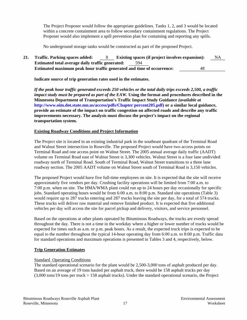
21. Traffic. Parking spaces added: 8 Existing spaces (if project involves expansion): NA Estimated total average daily traffic generated: 594 Estimated maximum peak hour traffic generated and time of occurrence: 48
Indicate source of trip generation rates used in the estimates.
If the peak hour traffic generated exceeds 250 vehicles or the total daily trips exceeds 2,500, a traffic impact study must be prepared as part of the EAW. Using the format and procedures described in the Minnesota Department of Transportation’s Traffic Impact Study Guidance (available at http://www.oim.dot.state.mn.us/access/pdfs/Chapter percent205.pdf) or a similar local guidance, provide an estimate of the impact on traffic congestion on affected roads and describe any traffic improvements necessary. The analysis must discuss the project’s impact on the regional transportation system. Existing Roadway Conditions and Project Information The Project site is located in an existing industrial park in the southeast quadrant of the Terminal Road and Walnut Street intersection in Roseville. The proposed Project would have two access points on Terminal Road and one access point on Walnut Street. The 2005 annual average daily traffic (AADT) volume on Terminal Road east of Walnut Street is 3,300 vehicles. Walnut Street is a four lane undivided roadway north of Terminal Road. South of Terminal Road, Walnut Street transitions to a three lane roadway section. The 2005 AADT volume on Walnut Street south of Terminal Road is 3,150 vehicles. The proposed Project would have five full-time employees on site. It is expected that the site will receive approximately five vendors per day. Crushing facility operations will be limited from 7:00 a.m. to 7:00 p.m. when on site. The HMA/WMA plant could run up to 24 hours per day occasionally for specific jobs. Standard operating hours would be from 6:00 a.m. to 8:00 p.m. Standard site operations (Table 3) would require up to 287 trucks entering and 287 trucks leaving the site per day, for a total of 574 trucks. These trucks will deliver raw material and remove finished product. It is expected that five additional vehicles per day will access the site for parcel pickup and delivery, visitors, and service personnel. Based on the operations at other plants operated by Bituminous Roadways, the trucks are evenly spread throughout the day. There is not a time in the workday where a higher or lower number of trucks would be expected for times such as a.m. or p.m. peak hours. As a result, the expected truck trips is expected to be equal to the number throughout the typical 14-hour operating day from 6:00 a.m. to 8:00 p.m. Traffic data for standard operations and maximum operations is presented in Tables 3 and 4, respectively, below. Trip Generation Estimates
Standard Operating Conditions The standard operational scenario for the plant would be 2,500-3,000 tons of asphalt produced per day. Based on an average of 19 tons hauled per asphalt truck, there would be 158 asphalt trucks per day (3,000 tons/19 tons per truck = 158 asphalt trucks). Under the standard operational scenario, the Project
Bituminous Roadways Roseville Asphalt Plant Environmental Assessment Roseville, Minnesota 18 Worksheet
site would receive a large number of raw materials, including aggregate, on a daily basis. The total number of aggregate trucks under the standard operating scenario would be 130 per day. As a result, on a typical day, there would be 288 trucks per day, which results in 576 truck trips per day. Spaced over a 14-hour work day, this equates to 41 truck trips per hour (see Table 3). Additionally, there will be five employees entering and leaving the site each day generating ten total trips per day, and there is expected to be five vendors entering and exiting the site each day generating ten total trips per day (see Table 3). Table 3: Weekday Traffic Trip Generation Based on the Standard Production Scenario* AM
6:00 – 12:00 PM
12:00 – 8:00 Total Daily
In Out In Out Total Employees 5 0 0 5 10 Trucks (hourly) 21 20 20 21 574 Vendors 2 2 3 3 10** Total 296 296 594
* The total trips generated per day are based on the proposed standard 14-hour operating day from 6:00 a.m. to 8:00 p.m. Trucks transporting asphalt and aggregate to and from the site would be spaced evenly throughout the day.
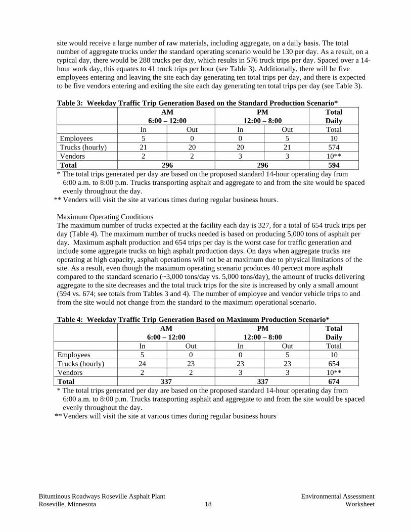
** Venders will visit the site at various times during regular business hours. Maximum Operating Conditions The maximum number of trucks expected at the facility each day is 327, for a total of 654 truck trips per day (Table 4). The maximum number of trucks needed is based on producing 5,000 tons of asphalt per day. Maximum asphalt production and 654 trips per day is the worst case for traffic generation and include some aggregate trucks on high asphalt production days. On days when aggregate trucks are operating at high capacity, asphalt operations will not be at maximum due to physical limitations of the site. As a result, even though the maximum operating scenario produces 40 percent more asphalt compared to the standard scenario (~3,000 tons/day vs. 5,000 tons/day), the amount of trucks delivering aggregate to the site decreases and the total truck trips for the site is increased by only a small amount (594 vs. 674; see totals from Tables 3 and 4). The number of employee and vendor vehicle trips to and from the site would not change from the standard to the maximum operational scenario. Table 4: Weekday Traffic Trip Generation Based on Maximum Production Scenario* AM
6:00 – 12:00 PM
12:00 – 8:00 Total Daily
In Out In Out Total Employees 5 0 0 5 10 Trucks (hourly) 24 23 23 23 654 Vendors 2 2 3 3 10** Total 337 337 674 * The total trips generated per day are based on the proposed standard 14-hour operating day from
6:00 a.m. to 8:00 p.m. Trucks transporting asphalt and aggregate to and from the site would be spaced evenly throughout the day.
** Venders will visit the site at various times during regular business hours
Bituminous Roadways Roseville Asphalt Plant Environmental Assessment Roseville, Minnesota 19 Worksheet
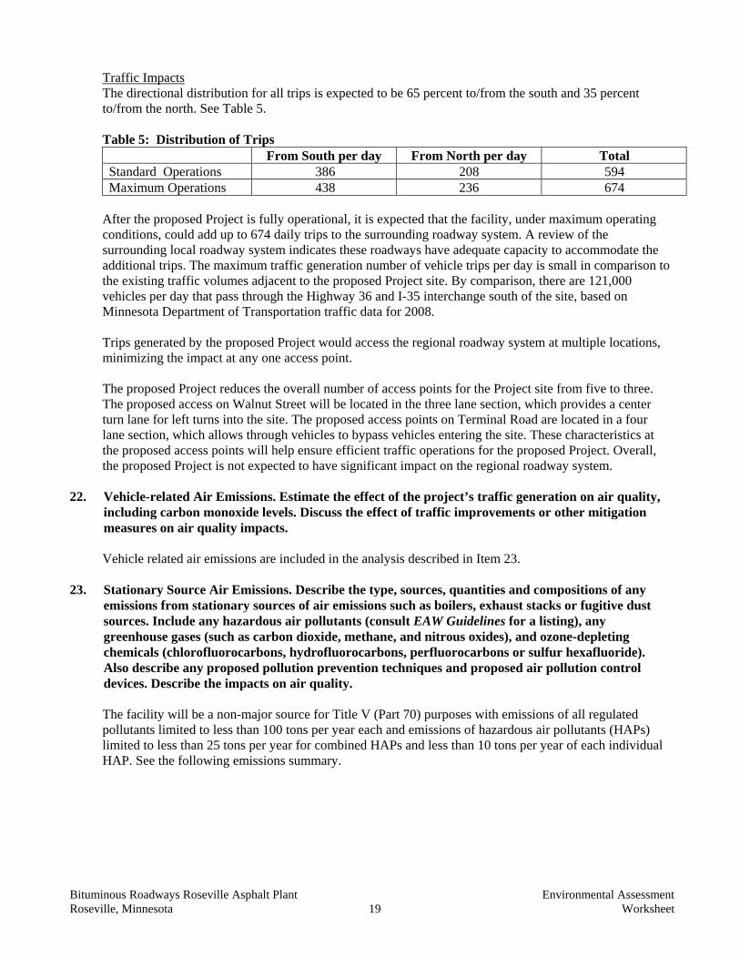
Traffic Impacts The directional distribution for all trips is expected to be 65 percent to/from the south and 35 percent to/from the north. See Table 5. Table 5: Distribution of Trips
From South per day From North per day Total Standard Operations 386 208 594 Maximum Operations 438 236 674
After the proposed Project is fully operational, it is expected that the facility, under maximum operating conditions, could add up to 674 daily trips to the surrounding roadway system. A review of the surrounding local roadway system indicates these roadways have adequate capacity to accommodate the additional trips. The maximum traffic generation number of vehicle trips per day is small in comparison to the existing traffic volumes adjacent to the proposed Project site. By comparison, there are 121,000 vehicles per day that pass through the Highway 36 and I-35 interchange south of the site, based on Minnesota Department of Transportation traffic data for 2008. Trips generated by the proposed Project would access the regional roadway system at multiple locations, minimizing the impact at any one access point. The proposed Project reduces the overall number of access points for the Project site from five to three. The proposed access on Walnut Street will be located in the three lane section, which provides a center turn lane for left turns into the site. The proposed access points on Terminal Road are located in a four lane section, which allows through vehicles to bypass vehicles entering the site. These characteristics at the proposed access points will help ensure efficient traffic operations for the proposed Project. Overall, the proposed Project is not expected to have significant impact on the regional roadway system.
22. Vehicle-related Air Emissions. Estimate the effect of the project’s traffic generation on air quality, including carbon monoxide levels. Discuss the effect of traffic improvements or other mitigation measures on air quality impacts. Vehicle related air emissions are included in the analysis described in Item 23.
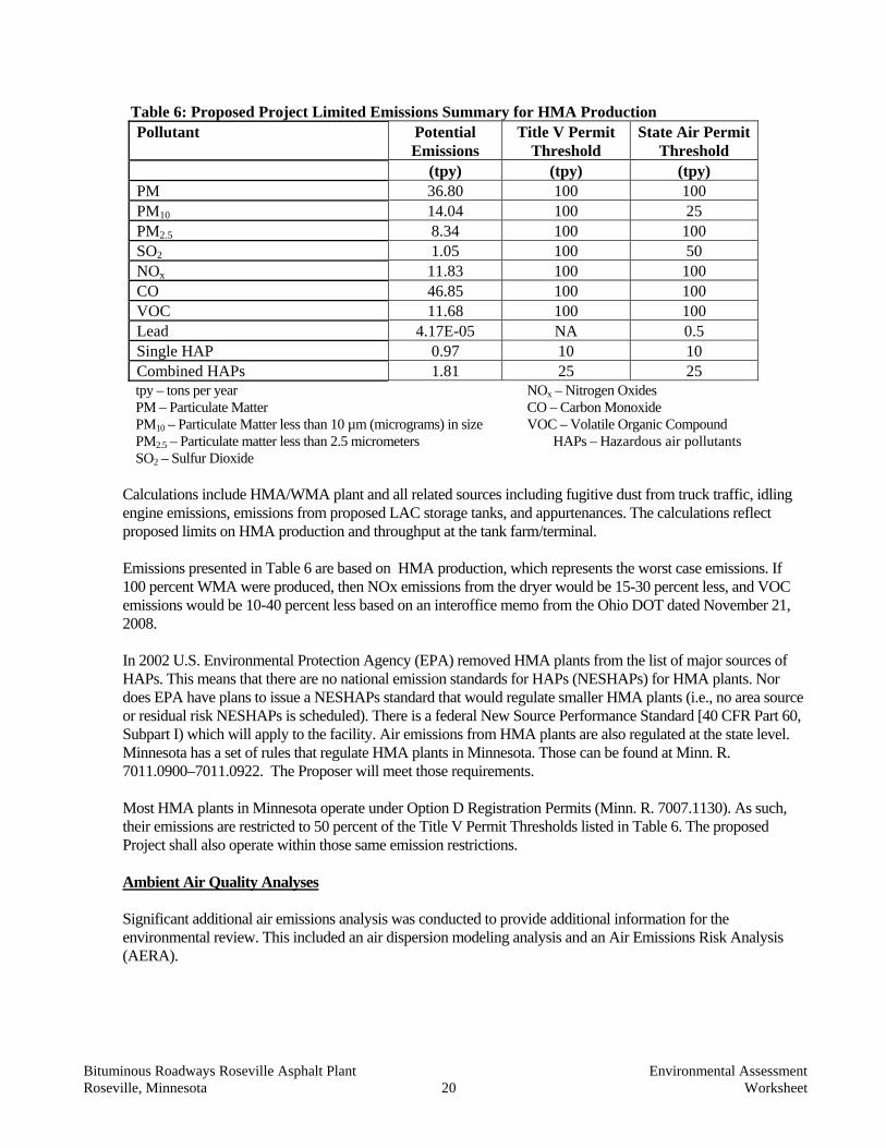
23. Stationary Source Air Emissions. Describe the type, sources, quantities and compositions of any emissions from stationary sources of air emissions such as boilers, exhaust stacks or fugitive dust sources. Include any hazardous air pollutants (consult EAW Guidelines for a listing), any greenhouse gases (such as carbon dioxide, methane, and nitrous oxides), and ozone-depleting chemicals (chlorofluorocarbons, hydrofluorocarbons, perfluorocarbons or sulfur hexafluoride). Also describe any proposed pollution prevention techniques and proposed air pollution control devices. Describe the impacts on air quality. The facility will be a non-major source for Title V (Part 70) purposes with emissions of all regulated pollutants limited to less than 100 tons per year each and emissions of hazardous air pollutants (HAPs) limited to less than 25 tons per year for combined HAPs and less than 10 tons per year of each individual HAP. See the following emissions summary.
Bituminous Roadways Roseville Asphalt Plant Environmental Assessment Roseville, Minnesota 20 Worksheet
Table 6: Proposed Project Limited Emissions Summary for HMA Production
Pollutant Potential Emissions
Title V Permit Threshold
State Air Permit Threshold
(tpy) (tpy) (tpy) PM 36.80 100 100 PM10 14.04 100 25 PM2.5 8.34 100 100 SO2 1.05 100 50 NOx 11.83 100 100 CO 46.85 100 100 VOC 11.68 100 100 Lead 4.17E-05 NA 0.5 Single HAP 0.97 10 10 Combined HAPs 1.81 25 25
tpy – tons per year NOx – Nitrogen Oxides PM – Particulate Matter CO – Carbon Monoxide PM10 – Particulate Matter less than 10 µm (micrograms) in size VOC – Volatile Organic Compound PM2.5 – Particulate matter less than 2.5 micrometers HAPs – Hazardous air pollutants SO2 – Sulfur Dioxide
Calculations include HMA/WMA plant and all related sources including fugitive dust from truck traffic, idling engine emissions, emissions from proposed LAC storage tanks, and appurtenances. The calculations reflect proposed limits on HMA production and throughput at the tank farm/terminal. Emissions presented in Table 6 are based on HMA production, which represents the worst case emissions. If 100 percent WMA were produced, then NOx emissions from the dryer would be 15-30 percent less, and VOC emissions would be 10-40 percent less based on an interoffice memo from the Ohio DOT dated November 21, 2008.
In 2002 U.S. Environmental Protection Agency (EPA) removed HMA plants from the list of major sources of HAPs. This means that there are no national emission standards for HAPs (NESHAPs) for HMA plants. Nor does EPA have plans to issue a NESHAPs standard that would regulate smaller HMA plants (i.e., no area source or residual risk NESHAPs is scheduled). There is a federal New Source Performance Standard [40 CFR Part 60, Subpart I) which will apply to the facility. Air emissions from HMA plants are also regulated at the state level. Minnesota has a set of rules that regulate HMA plants in Minnesota. Those can be found at Minn. R. 7011.0900–7011.0922. The Proposer will meet those requirements. Most HMA plants in Minnesota operate under Option D Registration Permits (Minn. R. 7007.1130). As such, their emissions are restricted to 50 percent of the Title V Permit Thresholds listed in Table 6. The proposed Project shall also operate within those same emission restrictions. Ambient Air Quality Analyses Significant additional air emissions analysis was conducted to provide additional information for the environmental review. This included an air dispersion modeling analysis and an Air Emissions Risk Analysis (AERA).
Bituminous Roadways Roseville Asphalt Plant Environmental Assessment Roseville, Minnesota 21 Worksheet
Bituminous Roadways performed air dispersion modeling of all proposed Project sources for all regulated pollutants. The purpose of the modeling was to support the EAW and AERA by demonstrating compliance with the applicable Minnesota and National Ambient Air Quality Standards (MAAQS and NAAQS. Bituminous Roadways also performed Class II Increment Standards modeling. The air dispersion modeling analysis used the AMS/EPA Regulatory Modeling with Plume Rise Model Enhancements (AERMOD), version 07026 to estimate concentrations at and around Bituminous Roadways. AERMOD version 09292 was used to complete additional refinements to modeling for PM10, PM2.5 and NO2. The dispersion modeling was completed using surface meteorological data from the Minneapolis/St. Paul, Minnesota National Weather Service Station (NWS) with upper air data from the St. Cloud, Minnesota NWS station for the years 1986 through 1990. Building downwash was assessed in the modeling analysis using the EPA Building Profile Input Program – Plume Rise Model Enhancements (BPIP-PRIME), version 04274. Receptor locations were developed using MPCA guidance. Receptor elevations were determined using the AERMOD Terrain preprocessor (AERMAP), version 06341, and U.S. Geological Survey 1/3 arc-second (~10 meter) resolution National Elevation Dataset files. The results of the air dispersion modeling analysis for Bituminous Roadway sources demonstrate compliance with NAAQS and MAAQS and Class II Increment Standards. Results are summarized in Table 7. Results in Table 7 represent the highest results of multiple operating scenarios analyzed. Tailpipe emissions have been included in the analyses.
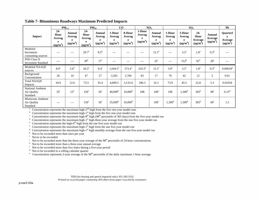
TDD (for hearing and speech impaired only): 651-282-5332 Printed on recycled paper containing 30% fibers from paper recycled by consumers
p-ear2-03a
Table 7- Bituminous Roadways Maximum Predicted Impacts
Impact
PM2.5 PM10 CO NO2 SO2 Pb 24-
Hour Averag
e (μg/m3)
Annual Averag
e (μg/m3)
24-Hour
Average
(μg/m3)
Annual Averag
e (μg/m3)
1-Hour Averag
e (μg/m3)
8-Hour Averag
e (μg/m3)
1-Hour Averag
e (μg/m3)
Annual Averag
e (μg/m3)
1-Hour Averag
e (μg/m3)
3-Hour Averag
e (μg/m3)
24-Hour
Average (μg/m3)
Annual Average (μg/m3)
Quarterly
Average (μg/m3)
Modeled Increment-consuming sources
--- --- 29.7a 8.5b --- --- --- 15.1b --- 3.5a 1.8a 0.3b ---
PSD Class II Increment Standard --- --- 30h 17i --- --- --- 25i --- 512h 91h 20i ---
Modeled NAAQS sources 8.9c 2.6d 26.5e 8.4f 1,044.5a 373.4a 103.3n 15.1f 3.9a 3.5a 1.8a 0.3b 0.00034g
Background Concentration 26 10 47 27 3,565 2,760 83 17 70 42 21 5 0.01
Total NAAQS Impacts 34.9 12.6 73.5 35.4 4,609.5 3,133.4 186.3 32.1 73.9 45.5 22.8 5.3 0.01034
National Ambient Air Quality Standard
35j 15k 150l 50i 40,000h 10,000h 188 100i 196 1,300h 365h 80i 0.15m
Minnesota Ambient Air Quality Standard
--- --- 150l 50i 35,000h 10,000h 100i 1,300h 1,300h 365h 60i 1.5
a Concentration represents the maximum high-2nd high from the five one-year model runs b Concentration represents the maximum high-1st high from the five one-year model runs c Concentration represents the maximum high-8th high (98th percentile of 365 days) from the five-year model run d Concentration represents the maximum high-1st high three-year average from the one five-year model run e Concentration represents the high-6th high from the one five-year model run f Concentration represents the maximum high-1st high from the one five-year model run g Concentration represents the maximum high-1st high monthly average from the one five-year model run h Not to be exceeded more than once per year i Never to be exceeded j Not to be exceeded more than the three-year average of the 98th percentile of 24-hour concentrations k Not to be exceeded more than a three-year annual average l Not to be exceeded more than five times during a five-year period m Not to be exceeded in a rolling calendar quarter n Concentration represents 3-year average of the 98th percentile of the daily maximum 1-hour average.
Bituminous Roadways Roseville Asphalt Plant Environmental Assessment Roseville, Minnesota 23 Worksheet
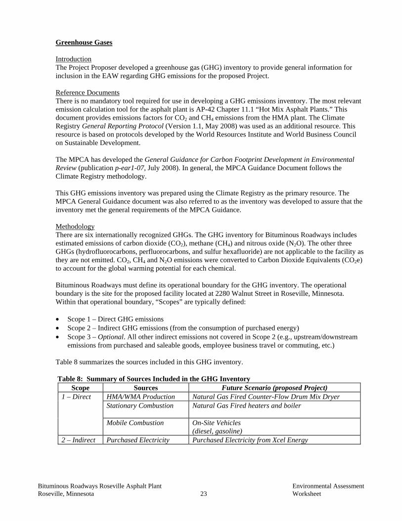
Greenhouse Gases Introduction The Project Proposer developed a greenhouse gas (GHG) inventory to provide general information for inclusion in the EAW regarding GHG emissions for the proposed Project. Reference Documents There is no mandatory tool required for use in developing a GHG emissions inventory. The most relevant emission calculation tool for the asphalt plant is AP-42 Chapter 11.1 “Hot Mix Asphalt Plants.” This document provides emissions factors for CO2 and CH4 emissions from the HMA plant. The Climate Registry General Reporting Protocol (Version 1.1, May 2008) was used as an additional resource. This resource is based on protocols developed by the World Resources Institute and World Business Council on Sustainable Development. The MPCA has developed the General Guidance for Carbon Footprint Development in Environmental Review (publication p-ear1-07, July 2008). In general, the MPCA Guidance Document follows the Climate Registry methodology. This GHG emissions inventory was prepared using the Climate Registry as the primary resource. The MPCA General Guidance document was also referred to as the inventory was developed to assure that the inventory met the general requirements of the MPCA Guidance. Methodology There are six internationally recognized GHGs. The GHG inventory for Bituminous Roadways includes estimated emissions of carbon dioxide (CO2), methane (CH4) and nitrous oxide (N2O). The other three GHGs (hydrofluorocarbons, perfluorocarbons, and sulfur hexafluoride) are not applicable to the facility as they are not emitted. CO2, CH4 and N2O emissions were converted to Carbon Dioxide Equivalents (CO2e) to account for the global warming potential for each chemical.
Bituminous Roadways must define its operational boundary for the GHG inventory. The operational boundary is the site for the proposed facility located at 2280 Walnut Street in Roseville, Minnesota. Within that operational boundary, “Scopes” are typically defined: • Scope 1 – Direct GHG emissions • Scope 2 – Indirect GHG emissions (from the consumption of purchased energy) • Scope 3 – Optional. All other indirect emissions not covered in Scope 2 (e.g., upstream/downstream
emissions from purchased and saleable goods, employee business travel or commuting, etc.) Table 8 summarizes the sources included in this GHG inventory.
Table 8: Summary of Sources Included in the GHG Inventory
Scope Sources Future Scenario (proposed Project) 1 – Direct HMA/WMA Production Natural Gas Fired Counter-Flow Drum Mix Dryer
Stationary Combustion
Natural Gas Fired heaters and boiler
Mobile Combustion On-Site Vehicles (diesel, gasoline)
2 – Indirect Purchased Electricity Purchased Electricity from Xcel Energy
Bituminous Roadways Roseville Asphalt Plant Environmental Assessment Roseville, Minnesota 24 Worksheet
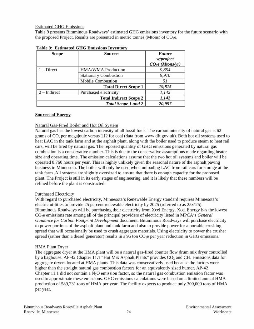
Estimated GHG Emissions Table 9 presents Bituminous Roadways’ estimated GHG emissions inventory for the future scenario with the proposed Project. Results are presented in metric tonnes (Mtons) of CO2e.
Table 9: Estimated GHG Emissions Inventory
Scope Sources Future w/project
CO2e (Mtons/yr) 1 – Direct HMA/WMA Production 9,854
Stationary Combustion 9,910 Mobile Combustion 51
Total Direct Scope 1 19,815 2 – Indirect Purchased electricity 1,142
Total Indirect Scope 2 1,142 Total Scope 1 and 2 20,957
Sources of Energy Natural Gas-Fired Boiler and Hot Oil System Natural gas has the lowest carbon intensity of all fossil fuels. The carbon intensity of natural gas is 62 grams of CO2 per megajoule versus 112 for coal (data from www.dft.gov.uk). Both hot oil systems used to heat LAC in the tank farm and at the asphalt plant, along with the boiler used to produce steam to heat rail cars, will be fired by natural gas. The reported quantity of GHG emissions generated by natural gas combustion is a conservative number. This is due to the conservative assumptions made regarding heater size and operating time. The emission calculations assume that the two hot oil systems and boiler will be operated 8,760 hours per year. This is highly unlikely given the seasonal nature of the asphalt paving business in Minnesota. The boiler will only be used when unloading LAC from rail cars for storage at the tank farm. All systems are slightly oversized to ensure that there is enough capacity for the proposed plant. The Project is still in its early stages of engineering, and it is likely that these numbers will be refined before the plant is constructed. Purchased Electricity With regard to purchased electricity, Minnesota’s Renewable Energy standard requires Minnesota’s electric utilities to provide 25 percent renewable electricity by 2025 (referred to as 25x’25). Bituminous Roadways will be purchasing their electricity from Xcel Energy. Xcel Energy has the lowest CO2e emissions rate among all of the principal providers of electricity listed in MPCA’s General Guidance for Carbon Footprint Development document. Bituminous Roadways will purchase electricity to power portions of the asphalt plant and tank farm and also to provide power for a portable crushing spread that will occasionally be used to crush aggregate materials. Using electricity to power the crusher spread (rather than a diesel generator) results in a 95 ton CO2e per year reduction in GHG emissions. HMA Plant Dryer The aggregate dryer at the HMA plant will be a natural gas-fired counter flow drum mix dryer controlled by a baghouse. AP-42 Chapter 11.1 “Hot Mix Asphalt Plants” provides CO2 and CH4 emissions data for aggregate dryers located at HMA plants. This data was conservatively used because the factors were higher than the straight natural gas combustion factors for an equivalently sized burner. AP-42 Chapter 11.1 did not contain a N2O emission factor, so the natural gas combustion emission factor was used to approximate these emissions. GHG emissions calculations were based on a limited annual HMA production of 589,231 tons of HMA per year. The facility expects to produce only 300,000 tons of HMA per year.
Bituminous Roadways Roseville Asphalt Plant Environmental Assessment Roseville, Minnesota 25 Worksheet
Bituminous Roadways hopes to produce at least 50 percent WMA. WMA is produced at a lower temperature (approximately 25°F lower) than HMA, resulting in lower energy costs and lower emissions. Test results obtained in a study in 2008 conducted by the Ohio Department of Transportation indicate that typical CO2 results are 10-20 percent lower when producing WMA. Mobile Combustion Trucks are used at the facility to transport aggregate materials, asphalt concrete binder, and the finished asphalt product. In addition, a loader is used to transport aggregate materials around the facility. A rail spur is planned to be constructed in the future to reduce truck traffic, but the calculations assume that 100 percent of the materials required to produce the asphalt product are transported by truck. GHG emissions were calculated based on an estimated amount of diesel fuel required for all transport operations. Mobile combustion emissions include vehicle travel at the plant only; emissions associated with transporting material to and from the plant are not included. Conclusions The quantity of GHG emissions produced by the proposed Project was determined using some conservative assumptions. GHG emissions generated by the proposed Project are expected to be well below the 25,000 ton per year CO2e reporting threshold set by the recently finalized Greenhouse Gas Reporting rule, 40 CFR Part 98. Air Emissions Risk Assessment (AERA) The MPCA has developed an AERA process to provide for: (1) a streamlined health review of facility air emissions; and (2) a consistent format for presenting the quantitative risk estimates, along with qualitative information to provide context to these risk estimates. An AERA estimates cancer and non-cancer risks to human health from a proposed project and/or an existing facility. In general, facility risk guidelines have been developed by the MPCA in consultation with the Minnesota Department of Health that are consistent with EPA guidance. The guidelines were established such that the increased chance of a person getting cancer over the course of their lifetime from exposure to the carcinogenic chemical emissions from a given facility should be equal to or less than 1 in 100,000 (1E-05). The facility guideline for non-carcinogenic chemicals is that the sum of the risks (called “hazard indices”) should not exceed 1. If emissions from a facility result in estimated risks in excess of these levels, MPCA staff evaluates whether further refinement, future investigation, or modifications are warranted. Interested readers can find more detailed information on the air risk analysis process at http://www.pca.state.mn.us/air/aera.html . Proposed Project Bituminous Roadways characterized potential health risks from the proposed hot asphalt plant and LAC storage facility in Roseville, Minnesota using the AERA screening process for over 40 pollutants. A list of these pollutants can be found in Appendix 3. Potential risk estimates for the proposed facility included emission estimates from the HMA plant, fiber bed filter (capturing silo filling and HMA loadout), emissions from the hot oil heater, the LAC day tank and storage tanks, the rail heater, tank heater, and rail cars being heated. These emission estimates were based on EPA AP-42 tables from Volume I Chapter 11 Section 1 Hot Mix Asphalt Plants, Volume I Chapter 1 Section 4 Natural Gas Combustion or EPA’s Tanks 4.09D Program, depending on the emission source. Since hydrogen sulfide (H2S) emission factors are not included in the AP-42 chapters, H2S emission estimates for the HMA dryer, Fiber Bed Filter (that includes the HMA Silo Filling and HMA Loadout), and HMA Plant tanks used results from a 2004 study conducted by the National Asphalt Pavement Association (NAPA), and emission estimates

Bituminous Roadways Roseville Asphalt Plant Environmental Assessment Roseville, Minnesota 26 Worksheet
from the controlled tank farm (including a day tank, north tank, and south tank), the tank farm rack and rail cars being heated used test results from a 2003 study of asphalt terminals conducted by the North Carolina Department of Environmental and Natural Resources. The facility does not foresee having the equivalent of two or more trucks idling continuously for an hour or longer and have included an idling prevention plan in the permit. As is standard MPCA practice, tail pipe emissions from truck traffic moving on the property were not included in the AERA. To maintain CO emissions from all plant sources to less than 50 tpy, the facility is restricted to producing less than or equal to 589,231 tons of HMA on an annual basis and this is what was assumed for the AERA. The facility expects to produce only 300,000 tons of HMA per year. Screening level potential risk estimates (Table 10) for the proposed facility were below MPCA facility risk guidelines at maximally impacted areas. The maximally impacted areas are predicted to be in the immediate vicinity of the proposed facility at the northern fenceline with risk estimates decreasing with distance from the facility. The risk drivers (pollutants with a hazard index of > 0.1 or 1 in 1,000,000 cancer risk) in the analysis were formaldehyde, H2S, and nitrogen dioxide contributing about equally to the acute facility inhalation risk depending on the location. Other pollutants contributing to the cancer and non-cancer risks were below risk driver levels. More refined Q/CHI modeling was done to better estimate the potential spatial distribution of acute respiratory risks, the results of which can be also be seen in Table 10. Since the asphalt drum baghouse, hot oil heater, fiberbed control system, asphalt loadout and oil containment tank vent will not be operating in the winter the analysis did not include emissions from these sources in the winter. The AERA process typically includes a screening farmer scenario risk estimate. The farmer screening scenario includes worst-case assumptions that, in addition to risks from inhalation and vegetable consumption, the farmer raises and eats beef, pork, and chicken and consumes milk and eggs produced from animals raised on forage grown at the location of the maximum predicted impact. Since the most impacted area, which is estimated to occur at the western fence line of the facility, is zoned industrial and no farming is done in the immediate area, a screening farmer scenario at the most impacted area was not included in this analysis. Farmer risk estimates were analyzed at the potentially most impacted residential area in order to screen for potential risks from homegrown chicken egg consumption. Potential health risks from fish consumption were not evaluated quantitatively because of the distance to fishable water bodies and levels of emissions. More specifically, Langton Lake is the closest potentially fished water body in the immediate area. According to the DNR Lake Finder Web site, “Langton Lake is managed as a Kid's Fishing Pond. Shore and pier fishing are available. The lake is subject to winterkill, and therefore is annually stocked with panfish in the spring.” Since risks are expected to dissipate quickly with distance from the proposed facility, the distance from the facility to Langton Lake minimizes potential impacts. Since the lake is subject to winter kill and is stocked, this reduces the potential for bio-accumulation of pollutants from the proposed facility. Further, the lake is stocked with pan fish, which are not top predator species and, therefore, are not as susceptible to bio-accumulation of pollutants by ingestion of other fish. A cumulative potential effects analysis for potential air emissions from the facility, in combination with potential background risk estimates, was conducted and is explained in Section 29 of this EAW.

Bituminous Roadways Roseville Asphalt Plant Environmental Assessment Roseville, Minnesota 27 Worksheet
Table 10: Air Toxics Screening Results
Total Inhalation Screening Hazard Indices and Cancer Risks
Acute** Subchronic Non-cancer
Chronic Non-cancer Cancer
From proposed Project at maximum impacts 0.52 0.01 0.1 0.3E-5 From proposed Project at potential maximally impacted residential area 0.14 <0.01 0.02 0.04E-5 Guidelines* 1 1 1 1E-5 Total Indirect Pathway Screening Hazard Indices and Cancer Risks
Farmer Non-cancer Farmer Cancer
Resident Non-cancer
Resident Cancer
From proposed Project at maximum impacts N/A N/A <0.01 0.06E-5 From proposed Project at potential maximally impacted residential area <0.01 0.06E-5 <0.01 <0.01E-5 Guidelines* 1 1E-5 1 1E-5 Total Multipathway Screening Hazard Indices and Cancer Risks
Farmer Non-cancer Farmer Cancer
Resident Non-cancer
Resident Cancer
From proposed Project at maximum impacts N/A N/A 0.1 0.4E-5 From proposed Project at potential maximally impacted residential area 0.02 0.1E-5 0.02 0.04E-5 Guidelines* 1 1E-5 1 1E-5
* Note: The hazard index against which facility risks are compared for acute, sub-chronic and chronic non-cancer risks is 1. The cancer risk against which facility risks are compared is 1 E-5 (or 1 chance in 100,000). These facility risk guidelines are risk management-based. They are not a discrete indicator of observed adverse effect. If a risk estimate falls below facility risk guidelines, the MPCA may, without further investigation, conclude that a proposed action does not present an unacceptable risk. A risk estimate that exceeds these guidelines, however, would not, in and of itself, necessarily indicate that the proposed action is not safe or that it presents an unacceptable risk. Rather, a risk estimate that exceeds a guideline triggers further careful consideration.
** Note: Acute results reflect more detailed analysis using Q/CHI methodology.
Bituminous Roadways Roseville Asphalt Plant Environmental Assessment Roseville, Minnesota 28 Worksheet
24. Odors, noise and dust. Will the project generate odors, noise or dust during construction or during
operation? Yes No
If yes, describe sources, characteristics, duration, quantities or intensity and any proposed measures to mitigate adverse impacts. Also identify locations of nearby sensitive receptors and estimate impacts on them. Discuss potential impacts on human health or quality of life. (Note: fugitive dust generated by operations may be discussed at item 23 instead of here.) Asphalt processing plants, which typically include storage piles of aggregate materials and rubble crushing operations, must operate within MPCA permit requirements and other State and Federal agency requirements pertaining to air emissions, noise, odors, and dust. Odors The state of Minnesota does not currently have rules that limit odor emissions. An analysis of the potential for the proposed Project to contribute odor emissions in the Project area is provided. HMA/WMA production and LAC storage and handling has the potential to produce odors, traced primarily to H2S (hydrogen sulfide) in LAC. H2S can be present due to sulfur in crude oil. To address the potential for H2S impacts from the proposed operation, an odor impact analysis for the proposed Project was conducted. This analysis considered the potential for odors from the LAC storage facility (including unloading, loading, and tank storage) and from the HMA/WMA plant (including the drum/dryer, LAC tank, HMA/WMA silos, and HMA/WMA loadout). The state of Minnesota has an ambient air quality standard for H2S of 30 parts per billion (ppb) (equivalent to 42 micrograms/cubic meter [µg/m3]) (Minn. R. 7009.0080). This standard is for protection of public health, which is not the same as limiting odors. The odor threshold (generally the level that an odor can be detected) for H2S is very low. An odor threshold value of 8 ppb (11 µg/m3) was used in this analysis. Another measure of odor impact is the level at which an odor becomes bothersome – called the odor nuisance level. An odor nuisance level of 40 ppb (56 µg/m3) was used in this analysis. The initial analysis showed that odors from the LAC storage facility and from the HMA/WMA silos and HMA/WMA loadout should be controlled through the proposed facility operations. The Project Proposer plans to vent fumes from those activities to equipment that will remove odors. Three odor elimination systems will be installed – one at the LAC storage facility when it is constructed and two for HMA/WMA sources at the HMA/WMA plant. HMA/WMA Plant: A fiber bed filter will be installed at the HMA/WMA plant. The fiber bed filter has a knockout area where vapors are condensed prior to entering into a second filtering area where filterable emissions are removed. Emissions from the silo filling and HMA/WMA load-out are vented to the fiber bed filter. The LAC tanks at the HMA/WMA plant are controlled by vent condensers. These vent condensers use ambient air to cool vapors, thus condensing out some of the odor causing compounds present in the LAC vapor. The HMA/WMA dryer is not a significant source of H2S emissions. LAC Storage: There will be a carbon bed filter installed at the LAC storage facility. Emissions from the loading rack and tanks at the LAC storage facility will be vented to this control equipment. In a carbon bed filter, activated carbon provides surface area for materials to condense and be removed from the vapor stream. A minimum 90 percent reduction in H2S emissions is expected for the carbon bed filter.

Bituminous Roadways Roseville Asphalt Plant Environmental Assessment Roseville, Minnesota 29 Worksheet
Due to the portable nature of the rail cars and the small amount of emissions generated, it is not feasible to control the rail cars as they are being heated. Emissions associated with pumping LAC from the rail cars are controlled by the carbon filter at the tanks and loading rack. In general, all of the controls mentioned above are not specific to just H2S and, therefore, other components of the vapor that are odorous will also be removed. With controls in place, H2S impacts at the property line and nearest residence are not expected to be significant. The results are summarized below: Table 11: H2S Impacts Location H2S – µg/m3 (One-Hour
Average Maximum Impacts)Property Line – occurs in a very small, non-residential area on the NE corner of the site and dissipates rapidly.
21.54
Golf course Maximum 3.63 Nearest Residence 2.95
Odor Nuisance threshold = 56 µg/m3. State ambient air quality standards = 42 µg/m3 Odor Detection threshold = 11 µg/m3 Noise Noise is defined as unwanted sound. Sound travels in wave motion and produces a sound pressure level. This sound pressure level is commonly measured in decibels dB(A). A sound increase of 3 dB(A) is barely perceptible to the human ear, a 5 dB(A) increase is clearly noticeable, and a 10 dB(A) increase is heard twice as loud. Current noise standards for the state of Minnesota are located in Minn. R. 7030.0040, subp. 2. The rules for permissible noise vary according to which “Noise Area Classification” is involved. In a residential setting, for example, the noise restrictions are more stringent than in an industrial setting. The rules also distinguish between nighttime and daytime noise, with less noise permitted at night. The standards list the sound levels not to be exceeded for more than 10 and 50 percent of the time in a one-hour survey (L10 and L50) for each noise area classification, are as follows:
Table 12: Applicable Minnesota Noise Standards
Noise Area Classification Noise Standard, dB(A)
Daytime (7 am to 10 pm) Nighttime (10 pm to 7 am) L50 L10 L50 L10
1 Residential 60 65 50 55 2 Commercial 65 70 65 70 3 Industrial 75 80 75 80
The standards are given in terms of the percent of time during a measurement period (typically one hour) beyond which a particular dB(A) level may not be exceeded. A daytime L50 of 60 dB(A), for example, means that during the daytime, noise levels may not exceed 60 dB(A) more than 50 percent of the time (i.e., 30 minutes of an hour).

Bituminous Roadways Roseville Asphalt Plant Environmental Assessment Roseville, Minnesota 30 Worksheet
The Project site is required to operate in compliance with Minnesota Noise Standards: at a residence, the residential standard must be met; at a commercial facility, the commercial standard must be met. For example, this means that if a noise meter was installed on a residential property, the residential standard applies at that location. If noise impacts are above standards, potential contributions would be analyzed to determine the primary sources and identify the best ways to reduce noise. Noise would be generated during construction of the proposed Project. Noise generated by construction activities is not anticipated to have an adverse effect on the surrounding area. The proposed facility is located in an existing industrial park, north and west of Interstate Highway 35W. The nearest residential neighborhood is approximately one-quarter mile away to the south, across the confluence of State Highway 36 and Interstate Highway 35W. In addition to interstate highway traffic noise, other existing sources of noise include other commercial and industrial operations in the area, as well as local street traffic. Sources of noise during construction include haul trucks, cranes, dozers, and fabrication equipment, such as pneumatic wrenches, saws, and welding equipment. Construction noise would occur intermittently for approximately six months until construction is completed. During operations, the proposed Project would generate noise primarily from vehicles and equipment used on site, haul trucks, and crushing equipment. Crushing activities would generate the most noise at the facility. Portable crushing plants would be used to periodically crush stockpiled reclaimed rubble asphalt and rubble concrete for use in the recycling process to create new asphalt and/or base material. Crushing would be performed for an approximately two to three-week period, occurring twice annually. A noise analysis was completed for a concrete plant by the city of New Brighton. The equipment at the concrete plant included a jaw crusher, a cone crusher, two screens to filter off-size material, conveyor belts, and loaders. The noise levels measured at 50 feet from the crusher during operation were approximately 82 dB(A). This is similar to the sound levels provided by the manufacturer of mobile concrete crushing equipment (Hitachi HR320G), indicating that sound levels would range from 75 to 81 dB(A) at distances of 25 to 50 feet from the unit. Using the noise levels generated during the noise study of the concrete plant in New Brighton, estimates can be made of the potential noise levels from the operation at the nearest commercial and residential receptors. The formula used to estimate noise levels at increasing distances from the source is as follows:
dB(A)2 = dB(A)1 – 20 log10 (D2/D1).
Where dBA1 is the known noise level at distance one, dBA2 is the noise level at the new distance two; D1 is distance one and D2 is distance two. According to parcel data for the city of Roseville, the property boundary of nearest the commercial property is located at 2361 Highway 36 West, approximately 600 feet from the Project site. The estimated noise levels from the crushing operation at the commercial receptor are estimated as follows:
dB(A)600 = 82 dB(A)50 – 20 log10 (600/50)
= 60.4 dB(A)600
Bituminous Roadways Roseville Asphalt Plant Environmental Assessment Roseville, Minnesota 31 Worksheet
The nearest residential property is located on Eustis Avenue, approximately 800 feet south of the Project site. The estimated noise levels from the crushing operation at the residential receptor are estimated as follows:
dB(A)800 = 82 dB(A)50 – 20 log10 (800/50)
= 57.9 dB(A)800 Compared to the noise standards for commercial properties listed in Table 12, the estimated noise from the crushing operation at the nearest commercial receptor would be below both the daytime and nighttime L10 and L50 standards. For the nearest residential receptors, the estimated noise levels from the crushing operation would be below the daytime L10 and L50 standards. The estimated noise levels are above the nighttime noise standards for residential areas; however, the above formula used to estimate noise is a conservative worst case estimate as it does not take into account elevation or atmospheric changes, and also does not account for barriers that could impede noise. However, the Project Proposer plans to limit crushing operations to the time period between 7:00 a.m. and 7:00 p.m. and, therefore, crushing activities are not likely to be a source of noise at night. Time of operation and number of days the crushing equipment can be operated and how much material can be crushed annually were limits by the city of Roseville and were not placed in the MPCA Draft Air Permit. Limits and mitigation per the alternative operating scenarios were placed in the MPCA Draft Air Permit as well as NSPS subp. OOO limits and requirements and non-NSPS opacity limits (see FS005 in the MPCA Draft Air Permit). The proposed Project would contribute to the existing noise in the vicinity of the Project site. However, due to the distances and barriers between the Project site and the nearest residential and commercial receptors, significant noise impacts are not anticipated if crushing operations are limited to between the hours of 7:00 a.m. and 7:00 p.m., and if noise controls for plant operation and truck traffic are implemented. Berms would provide further noise mitigation. Dust Dust may be generated by: • Crushing activities • Material transfer • Wind erosion on piles • Traffic All of these potential sources of dust are included in the air quality analyses discussed in Question 23: Portable Crushing Spread (FS005), Material Handling (FS002), Aggregate Storage Piles (FS001), Paved Roads (FS003 (Traffic)). In general, the raw materials have a relatively high moisture content (three percent or greater), which helps to control dust generation in crushing, material transfer, and wind erosion. Particle size is also generally large, which helps to minimize wind erosion. All traffic areas will be paved in order to minimize dust from truck traffic. The MPCA Draft Air Permit also requires that piles shall not be disturbed from December 1 to March 31 of each calendar year (FS001). Also see Table 1 of Appendix C to the permit which lists mitigation steps for the operating scenarios.
Bituminous Roadways Roseville Asphalt Plant Environmental Assessment Roseville, Minnesota 32 Worksheet
25. Nearby resources. Are any of the following resources on or in proximity to the site? a. Archaeological, historical, or architectural resources? Yes No b. Prime or unique farmlands or land within an agricultural preserve? Yes No c. Designated parks, recreation areas, or trails? Yes No d. Scenic views and vistas? Yes No e. Other unique resources? Yes No If yes, describe the resource and identify any project-related impacts on the resources. Describe any
measures to minimize or avoid adverse impacts. The proposed Project is a redevelopment of a previously disturbed site. The Project site consists of both impervious surface and gravel surface within an existing industrial park. The proposed Project is not anticipated to result in disturbance of previously undeveloped or disturbed areas, and no cultural resources are known to exist on the Project site. The Minnesota State Historical Preservation Office (SHPO) was consulted and information was requested regarding whether any historic or archaeological resources were present adjacent to the Project site or nearby. The search of the SHPO database was conducted for Township 29 North, Range 23 West, Sections 7, 8, 9, 17, and 18. Based on the results of the SHPO query to the Minnesota Archaeological Inventory and Historic Structures Inventory, the nearest historic or archaeological resource is approximately 0.75 miles away from the proposed Project property boundary. The nearest known resources listed in the SHPO query results include the Sunset Funeral Home and Mausoleum to the west and a historic house to the east. (See Appendix 2 for a copy of the SHPO response.) The nearest recreational resources are two golf courses, one located to the south and one west of the Project site. Francis A. Gross Golf Course is located to the west, approximately one-quarter mile. This golf course is adjacent to existing industrial park buildings. The Midland Hills Country Club is located south of the Project site approximately one-half mile and is south of Interstate Highway 35W. Direct impacts from the proposed Project to historic, archaeological, or recreational resources on or within proximity to the Project site are not anticipated. As a result, no adverse impacts to nearby resources are anticipated from the proposed Project. Further discussion on potential odor, noise, and dust impacts is provided in Item 24. Further discussion on the potential for visual impacts is provided in Item 26.
26. Visual impacts. Will the project create adverse visual impacts during construction or operation?
Such as glare from intense lights, lights visible in wilderness areas and large visible plumes from cooling towers or exhaust stacks? Yes No If yes, explain. The Project site currently consists of a paved parking lot for semi-truck trailers and a vacant gravel lot. The proposed Project, as described in Item 6, includes the construction of an asphalt plant, aggregate material storage piles, a mobile crushing operation, large LAC storage tanks, and a laboratory and maintenance building. The storage piles would consist of a variety of materials used for asphalt production and road construction projects including asphalt millings, asphalt rubble, concrete rubble, sand, crushed asphalt, recycled shingles, and aggregate. The storage piles would be between 15 and 38 feet tall.
Bituminous Roadways Roseville Asphalt Plant Environmental Assessment Roseville, Minnesota 33 Worksheet
As described in Item 27, the proposed Project is being reviewed by the city of Roseville for a Conditional Use Permit (CUP). The City Code for the city of Roseville requires screening of at least eight feet in height as part of the CUP for outdoor storage of materials and equipment in an industrial zone. The Project Proposer has indicated that an approximately three-foot high earthen berm, an eight-foot high opaque fence and/or perimeter landscaping would be used as screening along County Road B2 and Walnut Street. These combined features would provide over ten feet of visual screening, satisfying the requirements of the City Code. Due to the size of the aggregate storage piles and location of the Project site, the Planning Commission determined that property line setbacks for buildings would be required for the aggregate storage piles as part of CUP approval. The storage piles would be set back a minimum of 40 feet from property lines adjacent to public streets and a minimum of 20 feet from a rear or side property line. According to the city of Roseville the preliminary site plan indicates that the proposed Project would be in compliance with the City setback requirements. The Project Proposer has indicated that all internal pavement would be set back a minimum of 40 feet from the right-of-way. The proposed Project would produce a visible air emission plume generated from the asphalt drum/dryer as moisture evaporates from the aggregate in the drum. The air emission plume would begin at the drum/dryer stack height of 50 feet high. The persistence of this plume is dependent on prevailing weather conditions such as temperature, relative humidity, and wind speed. Dispersion is primarily dependent on wind speed, meaning dispersion would occur more quickly on days with greater wind speeds. The plume would be more persistent and most visible during winter months when the difference between the exhaust gas temperature and the ambient air temperature is highest. However, the drum/dryer would not operate in December, January, and February, and would not likely operate in March. Operation of the drum/dryer the remainder of the year would be dependent on market conditions and demand for paving projects. As stated in the MPCA Draft Air Permit, units with seasonal operation limits will not be in operation from December 1 to March 31. There is the potential for the steam plume to be visible while the asphalt drum/dryer is in operation in residential areas located south of the Project site. However, there are mature trees growing within the neighborhoods as well as some screening along I-35W that may affect the visibility of the steam plume within the residential areas. Operation of the asphalt drum/dryer would occur primarily in the spring, summer, and fall, when conditions for creating a visible plume are less than during cold winter months.
27. Compatibility with plans and land use regulations. Is the project subject to an adopted local comprehensive plan, land use plan or regulation, or other applicable land use, water, or resource management plan of a local, regional, state or federal agency? Yes No
If yes, describe the plan, discuss its compatibility with the project and explain how any conflicts will be resolved. If no, explain. The proposed Project site is located within the limits of the city of Roseville and is, therefore, subject to the zoning and planning requirements of the City. The Project site for the new asphalt plant is zoned as General Industrial (Zoning District I-2). The I-2 General Industrial District is structured to permit the manufacturing, processing, and compounding of semi-finished or finished products from raw material, as well as from previously prepared material (see Figure 6). The proposed activities of the asphalt plant fall within the confines of the zoning requirements and are compatible with the current property uses within the I-2 Zone.

Bituminous Roadways Roseville Asphalt Plant Environmental Assessment Roseville, Minnesota 34 Worksheet
Outdoor storage of materials and equipment is necessary for the asphalt production activities and is allowed as a conditional use in the I-2 District. The Project Proposer has applied for conditional use approval at the site for outdoor storage of aggregate material and heavy equipment. Conditional use approval was recommended by the Planning Commission prior to the submittal of a petition for an EAW. Planned site use is compatible with the industrial designation of the City’s Comprehensive Plan.
28. Impact on infrastructure and public services. Will new or expanded utilities, roads, other infrastructure or public services be required to serve the project? Yes No If yes, describe the new or additional infrastructure or services needed. (Note: any infrastructure that is a connected action with respect to the project must be assessed in the EAW; see EAW Guidelines for details.) The existing infrastructure and public services can accommodate the proposed Project. No improvements to or creation of roadways or roadway access would be necessary for the proposed Project. Increased demand for emergency management services, such as police, fire, and medical services are not anticipated.
29. Cumulative potential effects. Minn. R. 4410.1700, subp. 7, item B requires that the RGU consider the “cumulative potential effects of related or anticipated future projects” when determining the need for an environmental impact statement. Identify any past, present or reasonably foreseeable future projects that may interact with the project described in this EAW in such a way as to cause cumulative potential effects. (Such future projects would be those that are actually planned or for which a basis of expectation has been laid.) Describe the nature of the cumulative potential effects and summarize any other available information relevant to determining whether there is potential for significant environmental effects due to these cumulative effects (or discuss each cumulative effect under appropriate item(s) elsewhere on this form). The following is a summary of the issues included in the overall cumulative effect analysis. Traffic The Project site is located within an existing industrial park and the surrounding local roadway system has adequate capacity to accommodate the additional trips. Traffic will increase as a result of the proposed Project due to trucks hauling asphalt traveling to and from the facility. After the proposed Project is fully operational, it is expected that the facility, under maximum operating conditions, could add up to 674 daily trips to the surrounding roadway system. The majority of these trips will occur during the facility’s operational hours that will be generally occur between 6:00 a.m. to 8:00 p.m. during road construction season. Trips generated by the proposed Project would access the regional roadway system at multiple locations, minimizing the impact at any one access point. By reducing the number of access points at the Project site, the proposed Project will help ensure efficient traffic operations in the area. Overall, the proposed Project is expected to have only a minor impact on traffic patterns and the regional roadway system. Noise The proposed Project would contribute to the existing noise in the vicinity of the Project site. The daily operation of the asphalt plant will not result in noticeable increases in noise near the Project site. The crushing operations will occur temporarily at the Project site and result in noise levels estimated to be approximately 82 dB(A) near the unit while in operation. However, the Project site is located within an existing industrial park. Noise levels off of the Project site at adjacent industrial properties are estimated as follows:

Bituminous Roadways Roseville Asphalt Plant Environmental Assessment Roseville, Minnesota 35 Worksheet
dB(A)150 = 82 dB(A)50 – 20 log10 (150/50)
= 72.5 dB(A)150 This estimated value of 72.5 dB(A) is within the MPCA noise standards for industrial areas. The noise from the temporary crushing operations is not anticipated to create nuisance noise levels for the existing industrial facilities adjacent to the Project site. As detailed under Item 24, noise levels from the temporary crushing operations will be limited to approximately a two-week period, two times per year, with crushing taking place between the hours of 7:00 a.m. to 7:00 p.m. and are not expected to exceed noise standards for the nearest commercial or residential properties. During the normal day-to-day operations at the asphalt plant, noise levels will be considerably less than the noise levels estimated during crushing operations. Noise generated by the proposed Project will have a minimal impact on the existing noise levels in the area. Air Quality Nearby Point Sources – Figure 8 identifies a number of facilities within 1.5 kilometers as point sources of air emissions. Of these, three have air emission permits issued by the MPCA, and are available on the MPCA Web site (under the names listed). Those three are Metz Baking, Magellan Pipeline, and Valero LP. Metz Baking primarily emits volatiles associated with bread baking. Magellan and Valero operate bulk terminals for petroleum products. Valero’s permit is for a state only permit with potential emissions below Title V levels, with emissions primarily of volatiles associated with handling and storing petroleum products. Magellan’s permit is for a Title V source with emissions primarily of volatiles associated with handling and storage of petroleum products. Of the three sources with permits, none is expected to have significant additive impacts with the proposed operation. For criteria pollutants (see below and Question 23) for the proposed Project, the pollutants with results closest to standards are particulates (dust) emissions that will settle close to the facility. Smaller particles may travel farther. The three permitted facilities do not have significant emissions of smaller particles. For non-criteria (air toxics) pollutants, the effect of these three facilities should be reasonably reflected in background data (see below) as emissions from petroleum handling and combustion are ubiquitous. In addition, there is no indication using the Minnesota Risk Screening Tool (MNRiskS) that the emissions from these facilities would contribute to risk estimates above risk driver levels in the area of the proposed Project. MNRiskS is an interactive database created for the MPCA to help compare modeled potential human health risks from all inventoried sources of air pollution in the state. Thus, the potential risks from these facilities were characterized as being included in the background risks estimated from monitoring data. Criteria Pollutants – For criteria air pollutants (see Table 7 in response to Question 23), background air concentrations were used following MPCA guidance. Those background air concentrations are intended to address cumulative impacts. See above for discussion of nearby facilities. Air Toxics or Non-Criteria Pollutants – In general, air toxics emissions in Minnesota can be attributed as follows (percent of total mass statewide): 22 percent point sources (manufacturing, power generation, etc.) 26 percent area sources (gas stations, dry cleaners, home heating, etc.) and 52 percent from mobile sources (Appendix B, Figure 1. Air Quality in Minnesota: Into the Future, MPCA Legislative Report March 2003).

Bituminous Roadways Roseville Asphalt Plant Environmental Assessment Roseville, Minnesota 36 Worksheet
To form a more complete picture of potential cumulative health risks from inhaling outside air pollution in the vicinity of the proposed facility, monitoring data from intermediate monitoring stations with similar population density was considered along with potential risks from the proposed facility (Table 11). These risk estimates reflect emissions from industrial facilities, traffic, gas stations, wood-burning stoves, etc. and distant emissions sources that contribute to a regional level of pollutants that have been detected at similar levels across Minnesota. The intermediate monitoring based risk estimates used in the cumulative analysis are very similar to what has been calculated as an average of 2006-2008 urban monitors (Cancer 4E-5, Non-cancer 1, acute 0.7). Cumulative inhalation risks estimates were at or below facility risk guidelines except for cancer risks, which are above facility risk guidelines throughout the state.
Table 13: Potential Cumulative Inhalation Health Risk Estimates (from Bituminous Roadways and Monitored Data) Row ID
Max Acute Respiratory Inhalation
Hazard Index
Max Chronic Non-Cancer Inhalation
Hazard Index
Max Cancer Inhalation
Risk A Risk estimates from intermediate
population monitoring data** 0.57 1.3 4E-5 B Total facility estimates at the site
of maximum impact (At nearest potentially impacted residential area or golf course)
0.52
(0.14 or 0.17)
0.1
(< 0.1)*
0.3E-5
(< 0.3 E-5)*
C = A+B Total Cumulative Sum at the site of maximum impact (At nearest potentially impacted residential area or golf course)
1.1
(0.7)
1.4
(1.3–1.4)
4.3E-5
(4.0E-5– 4.3E-5)
D = B/C Percent contribution from proposed project (At area of potentially impacted residential area)
47 percent
(20 percent)
7 percent (< 7 percent)
7 percent (< 7 percent)
* Value not determined due to low level of impact at site of maximum impact **Source - MPCA 30. Other Potential Environmental Impacts. If the project may cause any adverse environmental impacts
not addressed by items 1 to 28, identify and discuss them here, along with any proposed mitigation. No other potential environmental impacts were identified.
31. Summary of issues. (Do not complete this section if the EAW is being done for EIS scoping; instead, address relevant issues in the Draft Scoping Decision Document, which must accompany the EAW.) List any impacts and issues identified above that may require further investigation before the project is begun. Discuss any alternatives or mitigative measures that have been or may be considered for these impacts and issues, including those that have been or may be ordered as permit conditions. No impacts that require additional investigation.
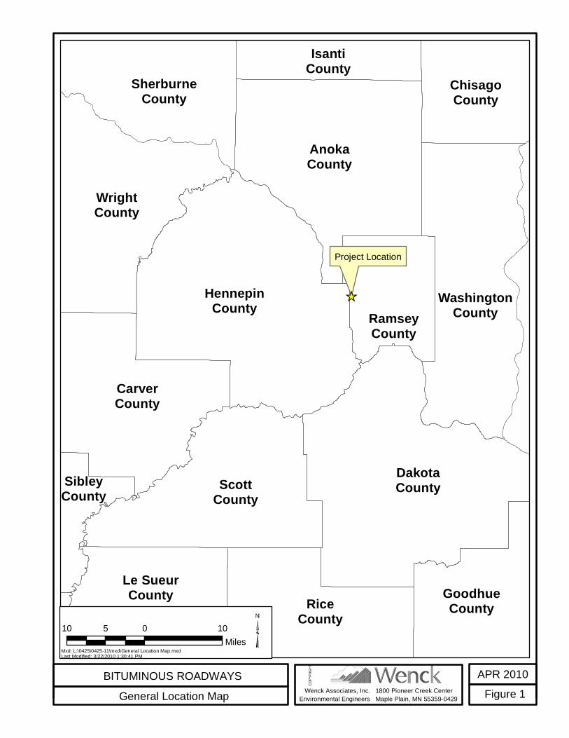
Wenck Associates, Inc.Environmental Engineers
Project Location
DakotaCounty
HennepinCounty
AnokaCounty
ScottCounty
WrightCounty
CarverCounty
RiceCounty
WashingtonCounty
Le SueurCounty
SherburneCounty
GoodhueCounty
ChisagoCounty
RamseyCounty
IsantiCounty
SibleyCounty
NicolletCounty
BITUMINOUS ROADWAYSGeneral Location Map
APR 2010Figure 11800 Pioneer Creek Center
Maple Plain, MN 55359-0429
COPY
RIGH
T
10 0 105Miles
Mxd: L:\0425\0425-11\mxd\General Location Map.mxdLast Modified: 3/22/2010 1:30:41 PM
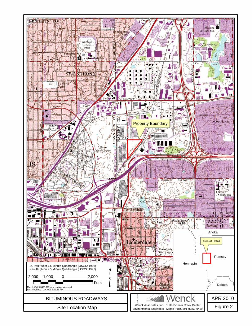
Wenck Associates, Inc.Environmental Engineers
Property Boundary
BITUMINOUS ROADWAYSSite Location Map
APR 2010Figure 21800 Pioneer Creek Center
Maple Plain, MN 55359-0429
COPY
RIGH
T
2,000 0 2,0001,000Feet
Mxd: L:\0425\0425-11\mxd\Location Map.mxdLast Modified: 7/29/2009 2:21:41 PM
St. Paul West 7.5 Minute Quadrangle (USGS: 1993)New Brighton 7.5 Minute Quadrangle (USGS: 1997)
Area of Detail
HennepinRamsey
Anoka
Dakota
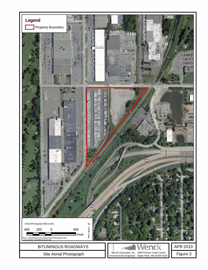
Wenck Associates, Inc.Environmental Engineers
BITUMINOUS ROADWAYSSite Aerial Photograph
APR 2010Figure 31800 Pioneer Creek Center
Maple Plain, MN 55359-0429
COPY
RIGH
T
400 0 400200Feet
Aerial Photograph (Microsoft)
LegendProperty Boundary
Mxd: L:\0425\0425-11\mxd\Site Aerial Photograph.mxdLast Modified: 9/9/2009 8:46:46 AM
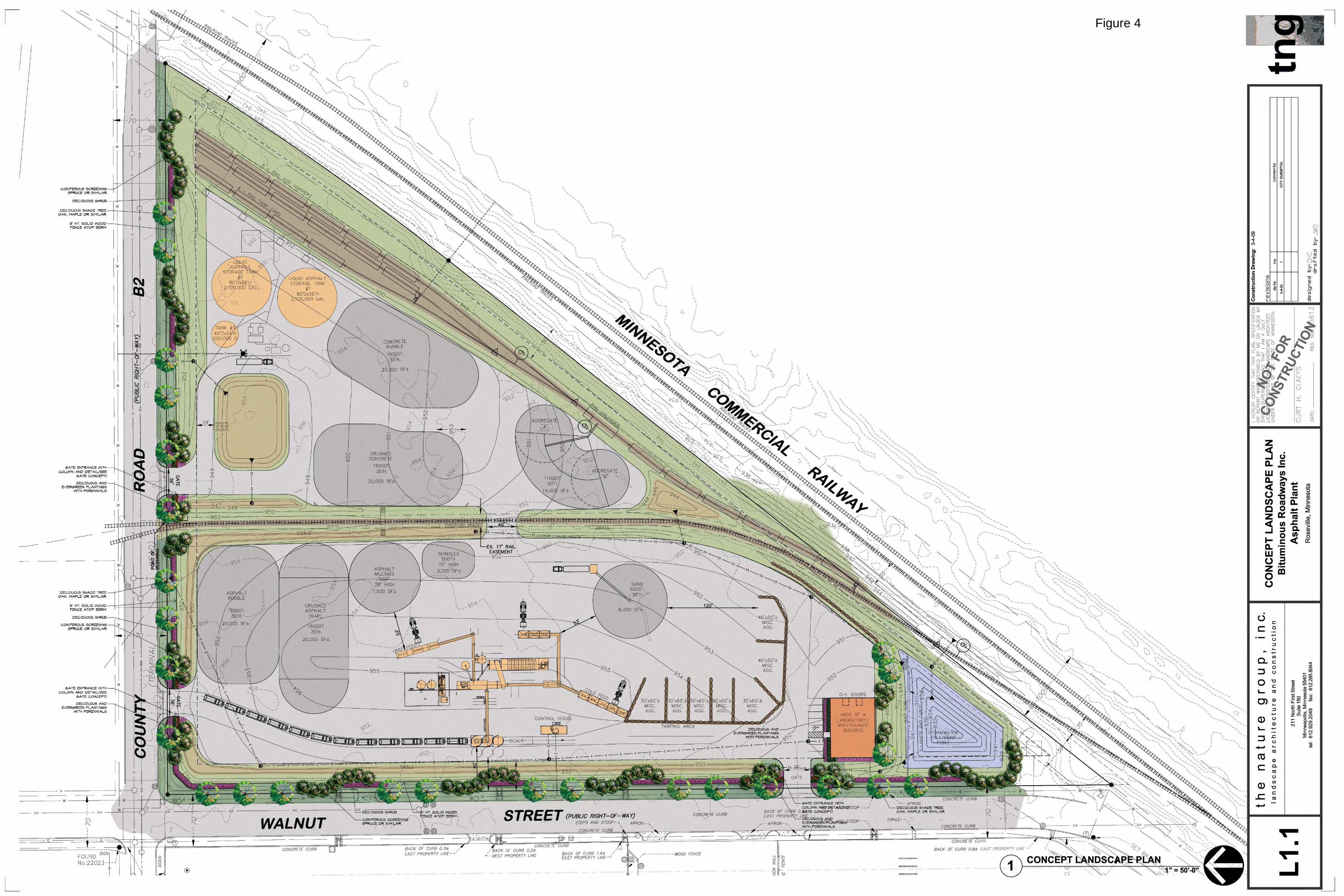
Figure 4
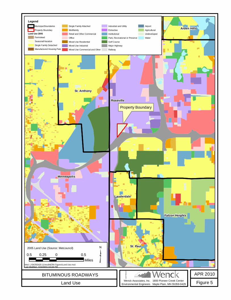
Wenck Associates, Inc.Environmental Engineers
Property BoundaryRoseville
Minneapolis
St. Anthony
St. Paul
Falcon Heights
Lauderdale
Arden HillsSt. Anthony New BrightonColumbia Heights
BITUMINOUS ROADWAYSLand Use
APR 2010Figure 51800 Pioneer Creek Center
Maple Plain, MN 55359-0429
COPY
RIGH
T
0.5 0 0.50.25Miles
LegendMunicipal BoundariesProperty Boundary
Land Use 2005FarmsteadSeasonal/VacationSingle Family DetachedManufactured Housing Park
Single Family AttachedMultifamilyRetail and Other CommercialOfficeMixed Use ResidentialMixed Use IndustrialMixed Use Commercial and Other
Industrial and UtilityExtractiveInstitutionalPark, Recreational or PreserveGolf CourseMajor HighwayRailway
AirportAgriculturalUndevelopedWater
Mxd: L:\0425\0425-11\mxd\AERA Figures\Land Use.mxdLast Modified: 7/20/2009 2:43:44 PM
2005 Land Use (Source: Metcouncil)
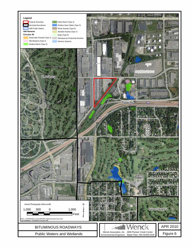
Wenck Associates, Inc.Environmental Engineers
Roseville
St. Anthony
Minneapolis
LauderdaleFalcon Heights
BITUMINOUS ROADWAYSPublic Waters and Wetlands
APR 2010Figure 61800 Pioneer Creek Center
Maple Plain, MN 55359-0429
COPY
RIGH
T
1,000 0 1,000500Feet
LegendProperty BoundaryMunicipal BoundariesDNR Public Waters
NWI WetlandsCircular 39
Seasonally Flooded (Type 1)Wet Meadow (Type 2)Shallow Marsh (Type 3)
Deep Marsh (Type 4)Shallow Open Water (Type 5)Shrub Swamp (Type 6)Wooded Swamp (Type 7)Bogs (Type 8)Municipal and Industrial ActivitiesRiverine Systems
Mxd: L:\0425\0425-11\mxd\AERA Figures\Land Use.mxdLast Modified: 7/20/2009 2:43:44 PM
Aerial Photograph (Microsoft)
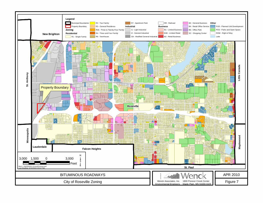
Property Boundary
Roseville
Falcon Heights
St. Paul
ShoreviewArden Hills
Lauderdale
New Brighton
St. A
ntho
ny
Little
Can
ada
Minn
eapo
lis
Maple
wood
BITUMINOUS ROADWAYSCity of Roseville Zoning
APR 2010Figure 7
3,000 0 3,0001,500Feet
1800 Pioneer Creek CenterMaple Plain, MN 55359-0429
Wenck Associates, Inc.Environmental Engineers
COPY
RIGH
T
Mxd: L:\0425\0425-11\mxd\Zoning.mxdLast Modified: 9/15/2009 8:54:07 AM
LegendMunicipal BoundariesProperty Boundary
ZoningResidential
R1 - Single Family
R2 - Two FamilyR3 - General ResidenceR3A - Three to Twenty-Four FamilyR4 - Three and Four FamilyR6 - Townhouse
R7 - Apartment ParkIndustrial
I1 - Light IndustrialI2 - General IndustrialI2A - Modified General Industrial
RR - RailroadBusiness
B1 - Limited BusinessB1B - Limited RetailB2 - Retail Business
B3 - General BusinessB4 - Retail Office ServiceB6 - Office ParkSC - Shopping Center
OtherPUD - Planned Unit DevelopmentPOS - Parks and Open SpaceROW - Right of WayLake

Wenck Associates, Inc.Environmental Engineers
1.5 KM Radius
Property Boundary
CastCalValero LP
PACAL LLC
Unicircuit
Unisys Corp
Honeywell Inc
Metz Baking Co
Weyerhaeuser Co
Bureau of Engraving
Meritex Enterprises
Artistic Finishes Inc
Magellan Pipeline Co LP
Advanced Web Technologies
Old Dutch Foods Inc
BITUMINOUS ROADWAYSNearby Air Emission Facilities
APR 2010Figure 81800 Pioneer Creek Center
Maple Plain, MN 55359-0429
COPY
RIGH
T
1,500 0 1,500750Feet
2008 Aerial Photograph (Source: Microsoft) Legend1.5 KM RadiusPoint Source EmissionsBituminous Roadways Property BoundaryMxd: L:\0425\0425-11\mxd\AERA Figures\Nearby Air Emission Facilities.mxd
Last Modified: 7/20/2009 2:29:00 PM
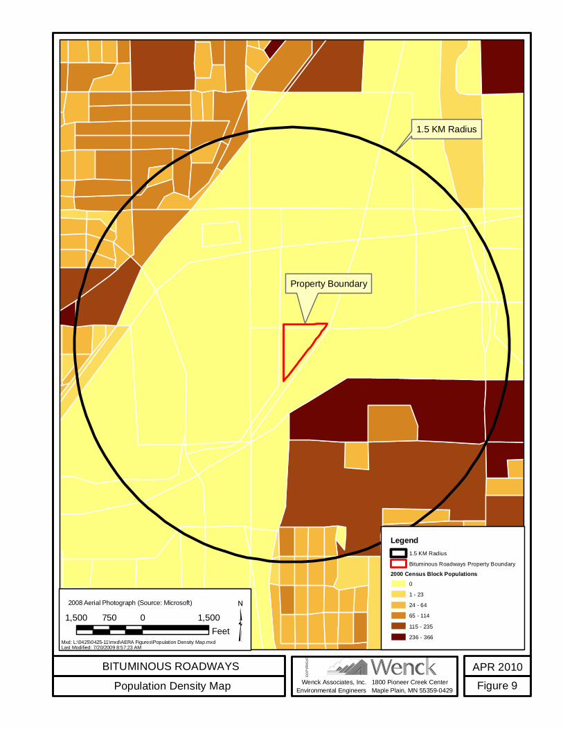
Wenck Associates, Inc.Environmental Engineers
1.5 KM Radius
Property Boundary
BITUMINOUS ROADWAYSPopulation Density Map
APR 2010Figure 91800 Pioneer Creek Center
Maple Plain, MN 55359-0429
COPY
RIGH
T
1,500 0 1,500750Feet
2008 Aerial Photograph (Source: Microsoft)
Legend1.5 KM RadiusBituminous Roadways Property Boundary
2000 Census Block Populations01 - 2324 - 6465 - 114115 - 235236 - 366Mxd: L:\0425\0425-11\mxd\AERA Figures\Population Density Map.mxd
Last Modified: 7/20/2009 8:57:23 AM
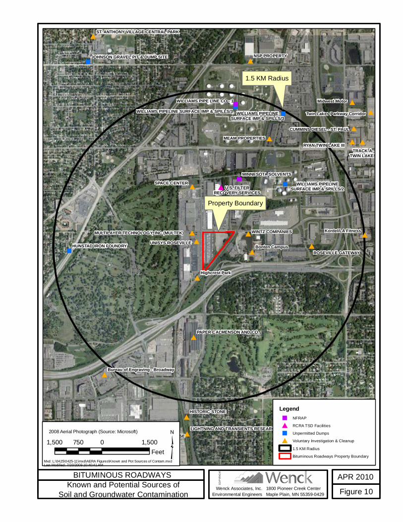
Wenck Associates, Inc.Environmental Engineers
1.5 KM Radius
Property Boundary
Midwest Motor
WILLIAMS PIPELINESURFACE IMP & SPILLS/3
NSP PROPERTY
SPACE CENTER
Bonten Campus
HISTORIC STONE
Highcrest Park
WINTZ COMPANIES
MEAM PROPERTIES
UNISYS ROSEVILLE
Kordel/LA Fitness
ROSEVILLE GATEWAY
MINNESOTA SOLVENTS
TRACK-A-TWIN LAKES
RYAN TWIN LAKE III
HUNSTAD IRON FOUNDRY
NORTHWESTERN WAREHOUSE
PAPER CALMENSON AND CO.
WILLIAMS PIPE LINE CO - 1
D.R. Tool and Die Company
CUMMINS DIESEL - ST. PAUL
Twin Lakes Parkway Corridor
U.S. FILTERRECOVERY SERVICES
Bureau of Engraving - Broadway
JOHNSON GRAVEL PIT & DUMP SITE
ST. ANTHONY VILLAGE CENTRAL PARK
LIGHTNING AND TRANSIENTS RESEARCH
MULTILAYER TECHNOLOGY, INC (MULTEK)
WILLIAMS PIPELINESURFACE IMP & SPILLS/2
WILLIAMS PIPELINE SURFACE IMP & SPILLS/3
BITUMINOUS ROADWAYSKnown and Potential Sources of
Soil and Groundwater ContaminationAPR 2010Figure 101800 Pioneer Creek Center
Maple Plain, MN 55359-0429
COPY
RIGH
T
1,500 0 1,500750Feet
2008 Aerial Photograph (Source: Microsoft)
LegendNFRAPRCRA TSD FacilitiesUnpermitted DumpsVoluntary Investigation & Cleanup1.5 KM RadiusBituminous Roadways Property Boundary
Mxd: L:\0425\0425-11\mxd\AERA Figures\Known and Pot Sources of Contam.mxdLast Modified: 7/20/2009 10:40:41 AM
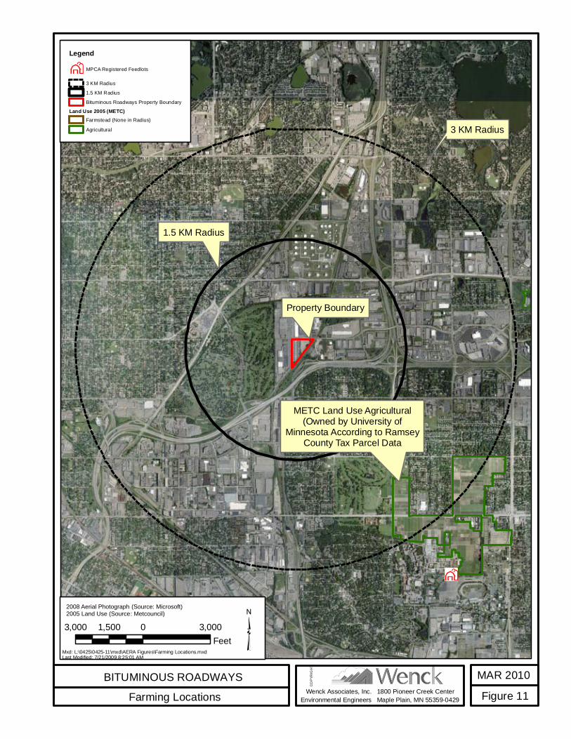
Wenck Associates, Inc.Environmental Engineers
Property Boundary
1.5 KM Radius
METC Land Use Agricultural(Owned by University of
Minnesota According to RamseyCounty Tax Parcel Data
3 KM Radius
BITUMINOUS ROADWAYSFarming Locations
MAR 2010Figure 111800 Pioneer Creek Center
Maple Plain, MN 55359-0429
COPY
RIGH
T
3,000 0 3,0001,500Feet
LegendMPCA Registered Feedlots
3 KM Radius1.5 KM RadiusBituminous Roadways Property Boundary
Land Use 2005 (METC)Farmstead (None in Radius)Agricultural
2008 Aerial Photograph (Source: Microsoft)2005 Land Use (Source: Metcouncil)
Mxd: L:\0425\0425-11\mxd\AERA Figures\Farming Locations.mxdLast Modified: 7/21/2009 8:25:01 AM
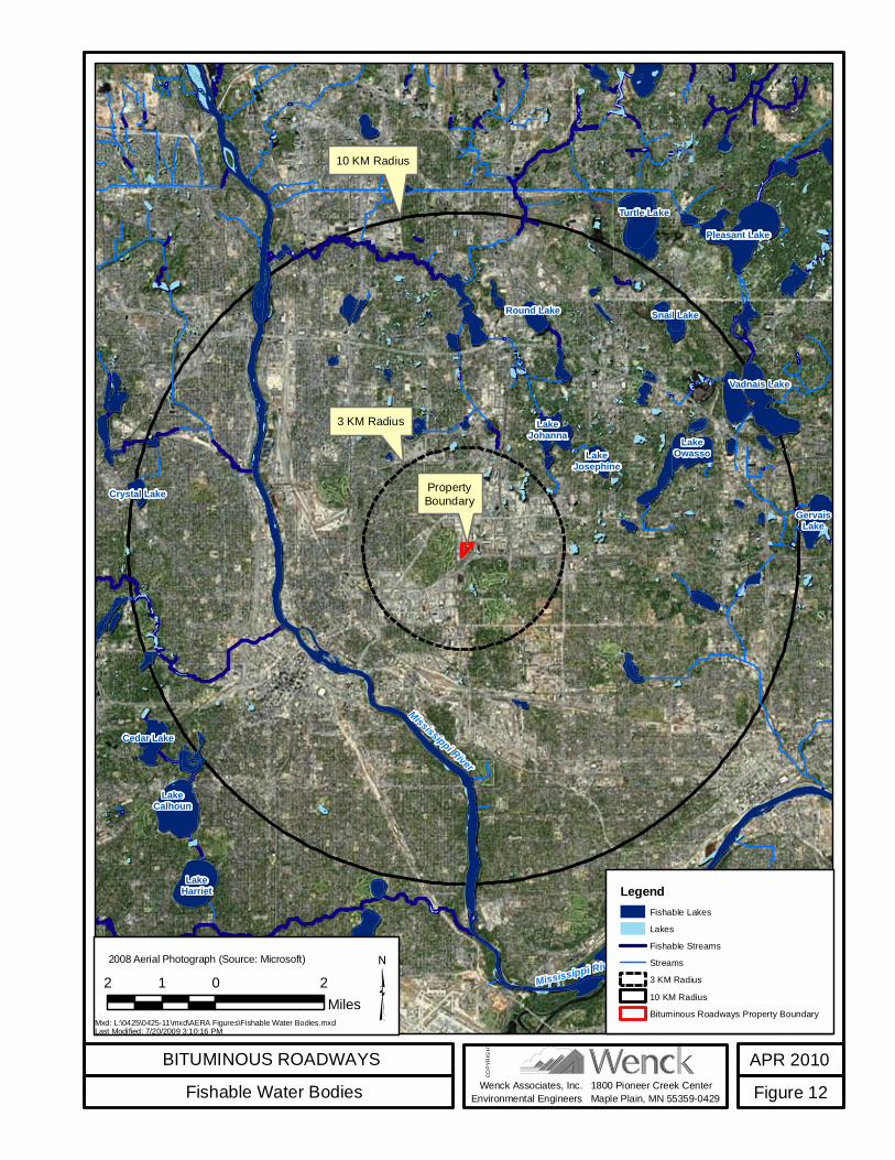
Wenck Associates, Inc.Environmental Engineers
PropertyBoundary
LakeOwasso
3 KM Radius
LakeCalhoun
LakeHarriet
Cedar Lake
LakeJohanna
LakeJosephine
Turtle LakePleasant Lake
Vadnais Lake
GervaisLake
Round Lake
Crystal Lake
Snail Lake
10 KM Radius
Mississippi River
Mississippi River
BITUMINOUS ROADWAYSFishable Water Bodies
APR 2010Figure 121800 Pioneer Creek Center
Maple Plain, MN 55359-0429
COPY
RIGH
T
2 0 21Miles
2008 Aerial Photograph (Source: Microsoft)
LegendFishable LakesLakesFishable StreamsStreams3 KM Radius10 KM RadiusBituminous Roadways Property Boundary
Mxd: L:\0425\0425-11\mxd\AERA Figures\Fishable Water Bodies.mxdLast Modified: 7/20/2009 3:10:16 PM

Wenck Associates, Inc.Environmental Engineers
Max Acute RiskValue (0.46)
Max Acute Risk Value onGolf Course Property (0.16)
Nearest Resident (0.12)0.02
0.04
0.1
0.06
0.08
0.12
0.14
0.16
0.2
0.18
0.22
0.02
0.02
0.22
0.02
BITUMINOUS ROADWAYSAcute Risk Impacts
APR 2010Figure 131800 Pioneer Creek Center
Maple Plain, MN 55359-0429
COPY
RIGH
T
1,500 0 1,500750Feet
Aerial Photograph (Source: Bing Maps)
LegendProperty BoundaryMax Acute Risk Value (0.46)Max Acute Risk Value onGolf Course Property (0.16)Acute Risk Value ContoursNearest Resident (0.12)
Mxd: L:\0425\0425-11\mxd\Acute Risk Impacts Rev0410.mxdLast Modified: 4/23/2010 2:02:36 PM

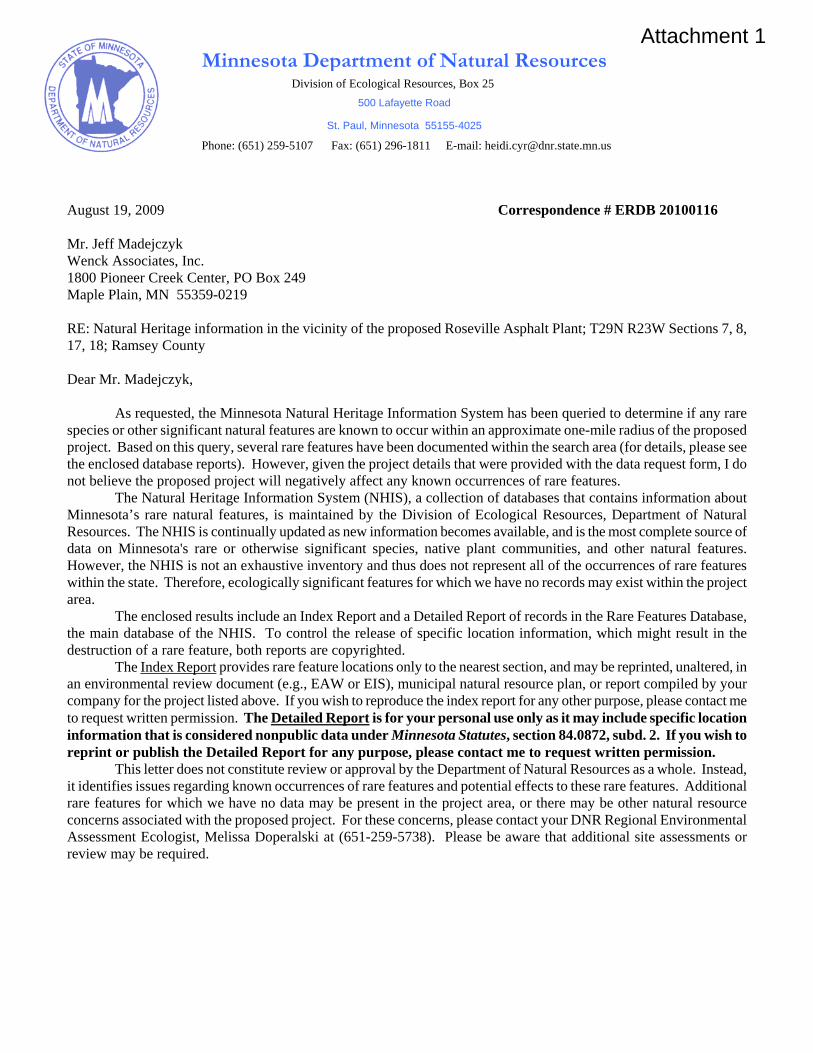
Division of Ecological Resources, Box 25
Phone: (651) 259-5107 Fax: (651) 296-1811 E-mail: [email protected]
August 19, 2009 Correspondence # ERDB 20100116 Mr. Jeff Madejczyk Wenck Associates, Inc. 1800 Pioneer Creek Center, PO Box 249 Maple Plain, MN 55359-0219 RE: Natural Heritage information in the vicinity of the proposed Roseville Asphalt Plant; T29N R23W Sections 7, 8, 17, 18; Ramsey County Dear Mr. Madejczyk,
As requested, the Minnesota Natural Heritage Information System has been queried to determine if any rare species or other significant natural features are known to occur within an approximate one-mile radius of the proposed project. Based on this query, several rare features have been documented within the search area (for details, please see the enclosed database reports). However, given the project details that were provided with the data request form, I do not believe the proposed project will negatively affect any known occurrences of rare features.
The Natural Heritage Information System (NHIS), a collection of databases that contains information about Minnesota’s rare natural features, is maintained by the Division of Ecological Resources, Department of Natural Resources. The NHIS is continually updated as new information becomes available, and is the most complete source of data on Minnesota's rare or otherwise significant species, native plant communities, and other natural features. However, the NHIS is not an exhaustive inventory and thus does not represent all of the occurrences of rare features within the state. Therefore, ecologically significant features for which we have no records may exist within the project area.
The enclosed results include an Index Report and a Detailed Report of records in the Rare Features Database, the main database of the NHIS. To control the release of specific location information, which might result in the destruction of a rare feature, both reports are copyrighted.
The Index Report provides rare feature locations only to the nearest section, and may be reprinted, unaltered, in an environmental review document (e.g., EAW or EIS), municipal natural resource plan, or report compiled by your company for the project listed above. If you wish to reproduce the index report for any other purpose, please contact me to request written permission. The Detailed Report is for your personal use only as it may include specific location information that is considered nonpublic data under Minnesota Statutes, section 84.0872, subd. 2. If you wish to reprint or publish the Detailed Report for any purpose, please contact me to request written permission.
This letter does not constitute review or approval by the Department of Natural Resources as a whole. Instead, it identifies issues regarding known occurrences of rare features and potential effects to these rare features. Additional rare features for which we have no data may be present in the project area, or there may be other natural resource concerns associated with the proposed project. For these concerns, please contact your DNR Regional Environmental Assessment Ecologist, Melissa Doperalski at (651-259-5738). Please be aware that additional site assessments or review may be required.
Minnesota Department of Natural Resources
500 Lafayette Road
St. Paul, Minnesota 55155-4025
Attachment 1
Thank you for consulting us on this matter, and for your interest in preserving Minnesota's rare natural resources. An invoice will be mailed to you under separate cover. Sincerely,
Heidi Cyr Endangered Species Environmental Review Specialist enc. Rare Features Database: Index Report Rare Features Database: Detail Report Rare Features Database Reports: An Explanation of Fields

From: Cinadr, Thomas [mailto:[email protected]] Sent: Wednesday, August 05, 2009 7:45 AM To: Jeff C. Madejczyk Subject: RE: SHPO Request
THIS EMAIL IS NOT A PROJECT CLEARANCE.
This message simply reports the results of the cultural resources database search you requested. The database search produced results for only previously known archaeological sites and historic properties. Please read the note below carefully. Archaeological sites and historic properties were identified in a search of the Minnesota Archaeological Inventory and Historic Structures Inventory for the search area requested. Reports containing the results of the search are attached. The result of this database search provides a listing of recorded archaeological sites and historic architectural properties that are included in the current SHPO databases. Because the majority of archaeological sites in the state and many historic architectural properties have not been recorded, important sites or structures may exist within the search area and may be affected by development projects within that area. Additional research, including field survey, may be necessary to adequately assess the area’s potential to contain historic properties. If you require a comprehensive assessment of a project’s potential to impact archaeological sites or historic architectural properties, you may need to hire a qualified archaeologist and/or historian. If you need assistance with a project review, please contact Kelly Gragg-Johnson in Review and Compliance @ 651-259-3455 or by email at [email protected]. The Minnesota SHPO Survey Manuals and Database Metadata and Contractor Lists can be found at http://www.mnhs.org/shpo/survey/inventories.htm SHPO research hours are 8:00 AM – 4:00 PM Tuesday-Friday. The Office is closed on Mondays.
Attachment 2

Tom Cinadr Survey and Information Management Coordinator Minnesota State Historic Preservation Office Minnesota Historical Society 345 Kellogg Blvd. West St. Paul, MN 55102 651-259-3453
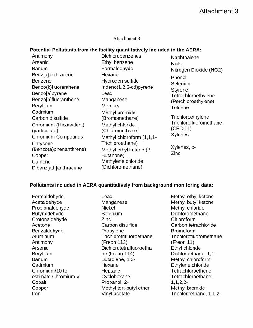
Attachment 3
Potential Pollutants from the facility quantitatively included in the AERA: Antimony Arsenic Barium Benz[a]anthracene Benzene Benzo(k)fluoranthene Benzo[a]pyrene Benzo[b]fluoranthene Beryllium Cadmium Carbon disulfide Chromium (Hexavalent) (particulate) Chromium Compounds Chrysene (Benzo(a)phenanthrene) Copper Cumene Dibenz[a,h]anthracene
Dichlorobenzenes Ethyl benzene Formaldehyde Hexane Hydrogen sulfide Indeno(1,2,3-cd)pyrene Lead Manganese Mercury Methyl bromide (Bromomethane) Methyl chloride (Chloromethane) Methyl chloroform (1,1,1-Trichloroethane) Methyl ethyl ketone (2-Butanone) Methylene chloride (Dichloromethane)
Naphthalene Nickel Nitrogen Dioxide (NO2) Phenol Selenium Styrene Tetrachloroethylene (Perchloroethylene) Toluene
Trichloroethylene Trichlorofluoromethane (CFC-11) Xylenes
Xylenes, o- Zinc
Pollutants included in AERA quantitatively from background monitoring data:
Formaldehyde Acetaldehyde Propionaldehyde Butyraldehyde Crotonaldehyde Acetone Benzaldehyde Aluminum Antimony Arsenic Beryllium Barium Cadmium Chromium/10 to estimate Chromium V Cobalt Copper Iron
Lead Manganese Nickel Selenium Zinc Carbon disulfide Propylene Trichlorotrifluoroethane (Freon 113) Dichlorotetrafluoroethane (Freon 114) Butadiene, 1,3- Hexane Heptane Cyclohexane Propanol, 2- Methyl tert-butyl ether Vinyl acetate
Methyl ethyl ketone Methyl butyl ketone Methyl chloride Dichloromethane Chloroform Carbon tetrachloride Bromoform Trichlorofluoromethane (Freon 11) Ethyl chloride Dichloroethane, 1,1- Methyl chloroform Ethylene chloride Tetrachloroethene Tetrachloroethane, 1,1,2,2- Methyl bromide Trichloroethane, 1,1,2-
Attachment 3
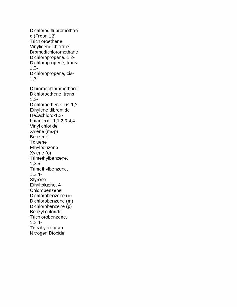
Dichlorodifluoromethane (Freon 12) Trichloroethene Vinylidene chloride Bromodichloromethane Dichloropropane, 1,2- Dichloropropene, trans-1,3- Dichloropropene, cis-1,3-
Dibromochloromethane Dichloroethene, trans-1,2- Dichloroethene, cis-1,2- Ethylene dibromide Hexachloro-1,3-butadiene, 1,1,2,3,4,4- Vinyl chloride Xylene (m&p) Benzene Toluene Ethylbenzene Xylene (o) Trimethylbenzene, 1,3,5- Trimethylbenzene, 1,2,4- Styrene Ethyltoluene, 4- Chlorobenzene Dichlorobenzene (o) Dichlorobenzene (m) Dichlorobenzene (p) Benzyl chloride Trichlorobenzene, 1,2,4- Tetrahydrofuran Nitrogen Dioxide