bilet (tigray, ethiopia) - hypotheses.org...bilet (tigray, ethiopia). preliminary report excavations...
TRANSCRIPT

ERC project HornEast
Connections, Mobility and Exchange betweenthe Horn of Africa and the Middle East in the Middle Ages
Preliminary ReportExcavations and Surveys
Bilet (Tigray, Ethiopia)
1-20 December 2018
Presented byJ. Loiseau, S. Dorso, Y. Gleize, D. Ollivier,
A. Chekroun, B. Hirsch, D. Ayenachew
Tothe Authority of Research & Conservation of Cultural Heritage
(ARCCH)
July 2019


— 3 —
Bilet (Tigray, Ethiopia). Preliminary Report Excavations and Surveys
TEAM COMPOSITION
Prof. Julien Loiseau (Aix-Marseille University): historian, team leader Yared Assefa (ARCCH, Addis Ababa): archaeological expert Dr. Deresse Ayenachew (Debre Berhan University, Aix-Marseille University): historian Fesseha Berhe (PhD candidate, Mekelle University): historian Dr. Hiluf Berhe (Mekelle University): archaeologist Dr. Amélie Chekroun (CNRS, Aix-Marseille University): historian Simon Dorso (PhD candidate, University Lyon-2): archaeologist Yohannes Gebresellassié (PhD candidate, Paris-1 Sorbonne University): historian Dr. Yves Gleize (INRAP, Bordeaux University): archaeologist, anthropologist, co-leader Prof. Bertrand Hirsch (Paris-1 Sorbonne University): historian Dr. David Ollivier (CNRS, Aix-Marseille University): archaeologist, topographer Dr. Hélène Réveillas (Bordeaux-Métropole): archaeologist, anthropologist GueshTsehaye(CultureandTourismOfficeofTigray):archaeologicalexpert Camille Vanhove (Archéodunum): archaeologist, anthropologist
NotethatseveralstudentsinarchaeologyfromMekelleUniversitytookparttothefieldworkunderthe supervision of their teacher, Dr. Hiluf Berhe. Ten workers from Kwiḥawerehiredforthedurationofthefieldwork,accordingtoinstructionsofGoitomBesrat,headofthekebele,andworkedunderthesupervisionof Neguse Hagos.


— 5 —
Bilet (Tigray, Ethiopia). Preliminary Report Excavations and Surveys
ACKNOWLEDGMENTS1
The mission wishes to thank several institutions and individuals for their support and the valuable help they provided during the campaign:
the Authority of Research & Conservation of Cultural Heritage (ARCCH), its Cultural Heritage Research Directorate Director Ato Demerew Dagne, and its archaeological expert Yared Assefa
theOfficeofCultureandTourismofTigray(Mekelle),itsDirectorMadamBrekti,itsDeputyDirectorMadam Zenebu Halefom and its archaeological expert Guesh Tsehaye
the Institute of Ethiopian Studies (University of Addis Ababa) and its former director Dr Ahmed Hassen Omer
the University of Mekelle and among its scholars Dr Hiluf Berhe, Dr Wolbert Smidt and Fesseha Berhe
theKebeleofKwiḥaanditsheadGoitomBesrat
the French Embassy in Ethiopia and its counsellor for cooperation and cultural action Hubert Tardy-Joubert
the French Centre for Ethiopian Studies (CFEE), its Director Madam Marie Bridonneau and its team (Clément Ménard, Abera Solomon, Hanna Siyum Tadesse)
the Institute for research and studies of the Arab and Muslim Worlds (IREMAM, Aix-Marseille Uni-versity) and its director Richard Jacquemond
the Laboratory of Medieval and Modern Archaeology in the Mediterranean (LA3M, Aix-Marseille University), its Director Madam Anne Mailloux, its Deputy director David Ollivier and in its team Laurent Maggiori
Aix-Marseille University, its branch Protisvalor and in its team Jonathan Bartoli, Hélène Helluin, Séverine Pitel in Addis Ababa, Prof. Fesseha Abraham
in Mekelle, Yohannes Gebresellasié; the Debre Amo Guest House, its owner Desta and her team
in Kwiḥa,NeguseHagosandhisfamily,andtheteamofworkers
inAdigudemandArra,ShaykhʿAbdal-RaḥmanʿAbdal-Qādir,imāmofAdigudem,YāsinAḥmad,ʿAbdal-QādirKuhlay,ʿAbdal-QādirṢāliḥKahsayandMuḥammadʿAlīKahsay
in Aix-en-Provence, Lamia Mellal (junior coordinator of the ERC project HornEast)
the European Research Council (ERC)
1 This research has received funding from the Eu’s Horizon 2020 research and innovation programme under Grant Agreement no 726206.


— 7 —
Bilet (Tigray, Ethiopia). Preliminary Report Excavations and Surveys
OFFICIAL AUTHORIZATIONS
Afieldresearchpermitfor«ArchaeologicalExcavationatBiletMedievalcemeteryanditssurroun-dings (Tigray regional state, Ethiopia) has been issued by the ARCCH, and signed by Ato Demerew Dagne, on18September2018(Ref.No.08/RL-8-2/003:seeAppendix6),withpermissiontoconductfieldworkfrom 1 to 20 December 2018.
Leaving Addis Abeba on 29 November 2018, the team was joined by Yared Assefa, assigned to the mission as archaeological expert for the ARCCH. Upon our arrival in Mekelle on 30 November 2018, theteamwasintroducedtoMadamZenebuHalefom,deputydirectoroftheCultureandTourismOfficeofTigray.GueshTsehaye,archaeologistintheCultureandTourismOfficeofTigray,wasassignedtothemis-sionasarchaeologicalexpertfortheOffice.AletterhasbeenprovidedbytheOfficetofacilitatetheintro-duction of the mission to the local authorities of Kwiḥakebele(Ref.No.799/55:seeAppendix8).
On the same day, 30 November 2018, the team has been introduced to Goitom Besrat, head of Kwiḥakebele,whowaswellinformedofthemission’sobjectivessincethefieldworkconductedinMarch2018which he strongly supported. Local authorities of Kwiḥakebelehavebeen insofar informedof theupco-mingbeginningofthefieldwork.TheteamhasalsorequestedthehelpofGoitomBesrattohireateamof10workersforthewholedurationofthemission.Finally,thankstoGoitomBesrat’sfacilitation,afinancialagreementhasbeenfoundwithAbadiKelele,landownerofthefieldwhereexcavationshavebeenplanned:the plot has been rented for one year by the mission for the amount of 8 000 ETB.
Attheendofthefieldwork,permissionhasbeengrantedbyMadamBrekti,DirectoroftheCultureandTourismOfficeofTigray(RefNo.941/31&945/79:seeAppendix9-10) 1. to move the archaeological material (ceramics, animal bones, human remains, shells, metal arte-facts) to the storages of the ARCCH in Addis Abeba for purpose of study in its laboratory facilities 2. to take samples of animal bones, human remains, sediments, and charcoals, for purpose of des-tructive analysis to be conducted in France 3. to export by loan to France a piece of Islamic ceramic for purpose of study
Finally, upon departure from the country, permission has been granted to the mission by the ARCCH to export to France the samples intended for destructive analysis, along with the sample of Islamic ceramic selected for purpose of study (Ref. No. 11/CH-8-3/036, see Appendix 11).


— 9 —
Bilet (Tigray, Ethiopia). Preliminary Report Excavations and Surveys
FIELDWORK OBJECTIVES
ThisfirstfieldworkseasononBilet,themedievalcemeteryanditssurroundings,followedasurveypreviouslyconductedinMarch2018byJulienLoiseau,AmélieChekrounandBertrandHirsch,withofficialletterandpermitoftheARCCHandsupportoftheCultureandTourismOfficeofTigray,andauthorizationof the kebele.
This survey made it possible to identify the probable location of the cemetery from which came 17 Arabic funerary stelae found in the area of Kwiḥabetweenthe1930’sandtheearly2000’s.ThisprobableidentificationisbasedonthefindinginMarch2018of21Arabicfunerarystelae,orfragmentsofstele,mostoftheminreuseamongstonealignmentsalongfieldsandpaths,thelastthreemostlikelyfoundinsituinvertical position.
This survey also resulted in highlighting the remains of an important settlement on the hill where the present church of KwiḥaKirkosislocated.Theareaisknownforitsruinsfirstdescribedin1937byCarloConti Rossini, which consist in 30 broken columns and dressed stones. Whenever these stones were carved, they are currently lying on top of an archaeological tell covered with pottery. Several walls have been also documented in March 2018 in the tell’s periphery, along with human and animal bones visible out the ground.
FollowingthesurveyofMarch2018,theobjectivesofBilet’sfirstfieldworkseasonweremanifold:
1. to check the location of Bilet’s medieval cemetery, to excavate a sample of graves and to assess its surface area by test pits 2. to excavate a ruined building located about 200 meters south of the probable location of the ceme-tery, which was described by local inhabitants in March 2018 as a domed structure and might have coincided with the Muslim mausoleum (qubba) mentioned by C. Conti Rossini as already ruined in 1937 3.toopentestpitsintheareaofthepresentchurchofKwiḥaKirkosinordertogetevidenceofda-tation of the tell’s occupation 4. to carry on conducting prospections inBilet’s surroundings and in other locations inEasternTigray in order to identify unknown ancient Muslim settlements
MedievalMuslimcemeterieshavealreadybeenidentifiedinotherareasofEthiopia.Uptonow,however, no Muslim cemetery has ever been excavated in Ethiopia. Excavations of Bilet cemetery, provi-dedthatitsexactlocationhasbeenidentified,wouldbethefirstofitskindinEthiopiaandwouldprovidea valuable insight into funerary practices and anthropological data of a medieval Muslim community from Ethiopia.
As for the archaeological tell of KwiḥaKirkos,thequestionatstakeistofigureoutwetherornotthesettlementwasinhabitedatthesametimethattheMuslimcemeterywasinuse.Insuchacase,itwouldofferthe unique opportunity to excavate a medieval urban settlement on the Ethiopian highlands.Finally, in line with the visit of Nägash paid in March 2018, prospections will help to better understand the medieval environment of Bilet, in the surroundings of the site as well in a larger area along the North-South route leading from the Red Sea shore to the very heart of the medieval Christian kingdom.


— 11 —
Bilet (Tigray, Ethiopia). Preliminary Report Excavations and Surveys
REPORT SUMMARY
Following the identificationof themedieval IslamiccemeteryofBilet (Kwiḥa,Tigray) inMarch2018(Hirsch2018;Loiseauetal.2019),afirstseasonofexcavationtookplaceonthesitebetweenthe1st and 19th December 2018. The main goals of this campaign were 1) to confirm the extent and state of preservation of the cemetery, 2) to collect dating material in relation with the tombs, and 3) to initiate a comprehensive study of its environment, especially the relationship between the cemetery itself and the archaeological tell of Kwiha Kirkos.
Three areas have been excavated in the course of the campaign. Area 1 (128 sq. metres) (the ceme-tery) is located in the vale known as Bilet where funerary inscriptions were discovered during the survey of March 2018. Area 2 (36 sq. metres) was implanted on the north-eastern slope of tell Kirkos where outcrop-ping walls and pottery were spotted during a preliminary survey. Area 3 (100 sq. metres) is located on the agricultural terraces overlooking the cemetery from the south, where remains of a collapsed building were designatedbylocalinhabitantsasa«qubba»,anArabictermgenerallyreferringtoadomedbuildingwitha funerary function (Conti Rossini 1937 ; Hirsch 2018).
In parallel to the excavation proper, a systematic survey of the tell and its immediate surroundings wasinitiatedandpotteryhasbeencollectedinordertoproduceafirstmasterplanofthesiteandtoassessitssequence of occupation.
Short report by areas
Area 1: The archaeological soundings in the cemetery brought evidences of important lootings of the site probablyatdifferenttimes.Differentplundertrenchesandpitswereobservedandthearchaeologicalstructureswere found covered by a large pile of stone, mainly in the northern part of the main sounding (sounding 1). Within this sounding, at least 8 funerary substructures, one burial and one wall were discovered. In the northern part of the sounding, a wall (F1028) - 7.3 m long and 0.85 wide - was exposed. It is mainly oriented north and south and turns east in its southern part. It is possible that the wall was interrupted in its northern part allowing passage between the two areas. To the south, it presents a curve and then turns east to enclose a space. Within this space at least one fu-nerary substructure (F1080) was discovered, oriented est-west. In the sediment around this tomb, a unique glazed potsherd was discovered among other common sherds. This sherd resembles Egyptian Fatimid productions. It is possible that the wall corresponds to an enclosure in which grave F1080 was installed. On the western side of the wall – opposite of F1080 - a second funerary substructure (F1017) follows the same orientation as F1080. South of the southern part of the wall stands another grave, the only structures having delivered human remains. The orientation and position of the skeleton in primary deposit follow Muslim practices. Bones in the secondary posi-tion found around the skeleton testify to the overlap or reuse of an older tomb. Further south, a third rectangular substructure is partially surrounded by a crown of basalt blocks to the west. It could be originally surrounded by a circle of blocks because the areas to the east and north were destroyed during the various lootings. Finally, in the southwest part of the sounding, four other rectangular substructures are aligned and oriented east-south-east/west-north-west. One of them (F1051) was originally surrounded by a circle of basalt blocks and an inscribed stele was placed to its eastern end. At the same place, the structure further north presented an arrangement for a stele that was no longer present (location of a stele found in March 2018?). Finally, an uninscribed stele was observed at the eastern end of the southernmost structure. The presence of an inscribed stele, the overall orientation of these structures and the position of the body are good evidence of Muslim burials.
The excavations of the rectangular substructures did not expose any human remains. It can be ex-plained by their looting. However, the presence of several ceramic deposits (F1017, F1051 and F1058) in their periphery informs on some funerary practices operated around the tombs. Finally, at least the remains oftwocirculationlevelswereobservedbetweenF1054andF1058.
To the East, two test pits attested the continuity of the cemetery. At least 6 graves were exposed in sounding 2 and at least 8 in sounding 3. None of those structure were excavated. Visible substructures had east-west orientations, like the tombs of the northern part of sounding 1. In sounding 2, fewer scattered blocks were present and one (or two) grave had two vertical uninscribed stelae at both ends.

— 12 —
Bilet (Tigray, Ethiopia). Preliminary Report Excavations and Surveys
These soundings attest to the presence of the Muslim cemetery, which continues eastward. The ex-cavation showed that the great majority of the graves were looted. However, information on the orientation, the architecture of the tombs and distinct practices could be recorded allowing to study the organization of the funeral space.
Area 2: In area 2, the remains of a monumental wall running from WNW to ESE were partly ex-posed,consistingofafinemasonryworkofsmallirregularblocks(Wall2001,width:80cm).Thewallispreserved to a maximum height of c. 2.8 meters (c. 30 courses) and was destroyed or collapsed toward the East i.e. in direction of the slope. So far, the plan, nature and function of this wall are unknown. Hypothesis for the dating could come from regional parallels through the distinctive feature of recess courses and the type of the masonry.
It is fairly possible that this wall only represents the foundation or substructures of a building as in the south it seems to be cutting through thick layers containing pottery, stone debris and animal bones. This stratigraphyratherconfirmsthelongoccupationofthetellpriortotheedificationofthebuilding,thefoun-dation trench of which is clearly visible in section. Four earlier circulation levels were discerned south of thewallcomposedofathicklayerofbackfillcoveredbyachalkylayer.Itisnotclearwhethertheselayersbelong to earlier occupations or if they are contemporaneous of the construction of the building.
Structures postdating the wall were also exposed. On the top and against the wall to the south, a pit has beendugthroughalayerabuttingthewall.Itwasfilledwithburntlayersanditsedgeisarrangedwiththreecoursesoffieldstones,seeminglyattestingitsuseasafireplace.Northofthewall,severalphasesofoccupa-tionwerenoted,allofthempostdatingWall2001.Atleasttwobadlypreservedbasaltflagstonefloorswereexposedattwodifferentlevel,theupperonebeinginrelationwithasecondwall(Wall2002)perpendicularto Wall 2001. Wall 2002, abuts the large wall and possibly divides the inner space of the building. A nearly completepotterywasfoundlyingonthefloor,atthecornerformedbythetwowalls.Thisisfurtherevidencethat the remains preserved north of the wall belong to an inner space, the function of which is still unknown.
Due to the short duration of the excavation in this area (3 days) and its limited extent, only prelimi-naryconclusionscanbereached.Althoughnoabsolutedatationswereobtained,thesoundingconfirmtheexistence of monumental remains on the tell, and the stratigraphy points toward a long and complex occupa-tion in this area.
Area 3: After the clearance of the large pile of stone, the foundation of the north-eastern corner of a square or rectangular building was exposed. It appears that the southwestern part of the building was des-troyedbytheinstallationofathreshingfloor.Thestonesremovedduringtheclearancebelongedforsomeofthem to the ruined building, the others having been piled there by local farmers to clean their parcels and the threshing area. The building seems to have been built of roughly rectangular blocks of c. 20x10 cm, some of which were found reused in the nearby terrace walls. Unfortunately, the clearance has shown that the buil-dinghadbeenalmostutterlydismantled,anditsinnerhard-packedsurfacefloorwasreachedvirginofanyarchaeologicalmaterial.Theruin/collapse/pileofstonesdeliveredafairamountofpottery,metalfindsandcattle bones as well as modern plastic and fragmented metal tools indicating recent activities and perturbations in the area. Potsherds belonging to a partly complete pottery were found in the shallow foundation trench of boththewesternandnorthernwallsofthebuilding.Consideringthelocationofthosefinds,andthefactthatthe sherds belong to the same pot and can be re-assembled, it seems consistent with a foundation deposit. East of the square building, the remains of a later circular house were exposed, abutting the so-called “Qubba”.Itconsistsoftwoparallelandcircularrowsofstonesformingtheinnerpartofthehouse,andpro-bably supporting a wall made of stones or a lighter mix of wood and earth. A roof should have been supported byacentralpillarmaintainedbyblocksofbasalt.Thefloorofthehouseconsistedofhard-packedgroundandarectangularfireplaceaswellastwocompletepotterieswerefoundinplace.Thediameterofthehousecouldnothave been less than 3,5m, although it was not entirely exposed. The domestic function of the house is attested bythefireplaceandpotteries,butitsmodestdimensionsmightfitforasingleinhabitantratherthanafamily.Suchhouseswerepreviouslystudiedandtheirplandoesnotbelongtoaspecificperiod,regionorpopulation.Charcoals samples from the pottery deposits will hopefully date the last occupation of this housing unit.

— 13 —
Bilet (Tigray, Ethiopia). Preliminary Report Excavations and Surveys
Fig. 1: Bilet and the Horn of Africa
INTRODUCTION & BACKGROUND
The archaeological site of Bilet-Kirkos is located on the northern fringe of the town of Kwiḥa,EastofMekelle(Tigray,Ethiopia)inEnderta(seefig.1).DuringtheMiddleAges,theregionwasinhabitedbyChristiansandMuslimsandcameundertheinfluenceoftheZagwedynastybetweenthe11th-13th century (Derat 2010).
The existence of an Islamic community in the area is evidenced by Arabic inscriptions dated between the 10th and 12th century but virtually nothing is known neither about the importance, origin or so-cial/political organisation of this community, nor about the date of its arrival in the highlands of northern Ethiopia (Loiseau et al. 2019). All the Arabic inscriptions but one are funerary stelae bearing similarities to other sites such as the large necropolis of the Dahlak archipelagos in modern Eritrea (Conti Rossini 1937;Schneider1967;1976;2009;Smidt2004;2009;2010;Fauvelle-Aymar,Hirsch2008;Smidt,Rashidy 2012). The non-funerary Arabic inscription discovered in Wekro Kirkos is so far the only exa-mple of monumental Islamic epigraphy in northern Ethiopia dating from the Middle Ages (Smidt 2009 ; 2010 ; 2011).
Due to the importance of the Islamic necropolis of Dahlak, Islamic presence in Enderta has been regarded as an extension of the Islamic sultanate established on this island around the 11th century. Conside-ring that before 2018, only three sites with Arabic inscriptions were known for the whole Ethiopia, scholars have suggested that Bilet, from where most of the inscriptions (22 known prior to 2018) came from, could have been a trading post connected to Dahlak (Fauvelle-Aymar, Hirsch 2008). The location of the inscrip-tions along a North-South axis allowed to consider the existence of a medieval trading route following the easternedgeoftheTigrayplateau(Fauvelle-Aymar,Hirsch2011)(seefig.2).

— 14 —
Bilet (Tigray, Ethiopia). Preliminary Report Excavations and Surveys
Fig. 2: Medieval Arabic epigraphy along the Eastern Tigray Road
The discovery of at least three previously unknown Muslim cemeteries (see below) along the road further south during our campaign sheds new light on the importance of the Islamic network in northern Ethiopia. The proximity of those cemeteries also implies that Islamic communities were far more numerous than previously thought in the area. The discovery of more Islamic sites can be expected from future surveys in the region.

— 15 —
Bilet (Tigray, Ethiopia). Preliminary Report Excavations and Surveys
So far, the ongoing study of the inscriptions from Arra, Habera and Mayda Zeylegat tends to stren-gthen the chronological sequence of Islamic presence in Tigray where Muslim cemeteries are documented between the 10th and 13th century. Hopefully excavations in Bilet will bring more information regarding the identity and social structure of the Muslim communities and about their relations with the neighbouring Christian communities.
The common hypothesis presenting the Muslims buried in Bilet as merchants should now be re-considered in the light of the recent discoveries. The existence of previously unknown sites South of Mekelle shows that Bilet was not isolated but probably belonged to a network of permanent communities attestedatleastduringthreecenturiesintheregion.Thosenewsitesoffervaluableopportunitiestoengagecomparativeanalysisofthemedievalfunerarypractices.Preliminaryobservationstestifiesofseveraltypesof tombs architecture in use by Muslims during the period. It should also be compared to contemporary Christianpracticesandinrelationtothedwellingareasandcultplaces(seefigs.3-4).
Relying on the names and surname of some of the deceased mentioned by the inscriptions from Bi-let, Madeleine Schneider suggested that some of them were converts of local origin (Schneider 1967). It also seemsthatindividualsfromBiletreferedontheirfuneraryinscriptionstoacommonancestor:Ḥafsb.ʿUmaral-Yamāmī,buriedinDahlak(Schneider2009).Hopefully,theincreasingnumberofinscriptionswillprovidemore evidence of such connexions not only with Dahlak but also between the Tigrayan sites themselves. Evi-dence for conversion of local inhabitants bearing non Arabic names attest a complex process of islamization and question the extent and linearity of Christianisation in northern Ethiopia at the turn of the Millennium.
While encouraging, the recent advances also come with a number of challenges. At this stage only the funerary dimension of the Islamic communities is documented and one still has to look for domestic structures and villages sites, as well as religious buildings. This will be achieved by new surveys.An important question mark relates to the genesis of Islamic communities in the region following the decline ofAksumandwhileaChristianStateemergedintheregion.AksumiteinfluenceisevidencedonthetellofKwiha Kirkos, through pottery (Breton, Aytenew Ayele 2015 ; Breton 2018), lithic industry (especially obsi-dian) but before all through monumental remains exposed in December 2018 .
This sequence of occupation and the question of transition between Aksumite and Medieval period istobedealtwithcaution.Indeed,itisobviousthattheareaofMekellereceivedlong-lastinginfluencefrom the somewhat distant Aksumite centres, and some of the characters of Aksumite culture both in ma-terial culture and religious or public architecture might have persisted during later period (Negash 2006 ; Dugast,Gajda2014a;2014b).Ingeneral,evidencesforalonghumanpresenceinKwiḥaalsoquestionthenatureofthesiteanditsnaturaladvantages.ThepossiblecontinuousoccupationofthesiteduringthefirstMillennium makes it a valuable case study to investigate major social and cultural changes and in particular thedevelopmentofChristianityandIslamininlandEthiopia(seefig.5).

— 16 —
Bilet (Tigray, Ethiopia). Preliminary Report Excavations and Surveys
Fig. 3: Tombs typology

— 17 —
Bilet (Tigray, Ethiopia). Preliminary Report Excavations and Surveys
Fig. 4: Tombs typology

— 18 —
Bilet (Tigray, Ethiopia). Preliminary Report Excavations and Surveys
Fig. 5: Bilet in its Historical and Monumental Environment
— 19 —
Bilet (Tigray, Ethiopia). Preliminary Report Excavations and Surveys
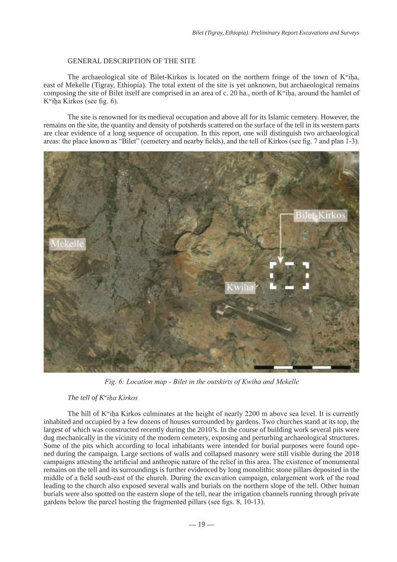
GENERAL DESCRIPTION OF THE SITE
The archaeological site of Bilet-Kirkos is located on the northern fringe of the town of Kwiḥa,east of Mekelle (Tigray, Ethiopia). The total extent of the site is yet unknown, but archaeological remains composing the site of Bilet itself are comprised in an area of c. 20 ha., north of Kwiḥa,aroundthehamletofKwiḥaKirkos(seefig.6).
The site is renowned for its medieval occupation and above all for its Islamic cemetery. However, the remains on the site, the quantity and density of potsherds scattered on the surface of the tell in its western parts are clear evidence of a long sequence of occupation. In this report, one will distinguish two archaeological areas:theplaceknownas“Bilet”(cemeteryandnearbyfields),andthetellofKirkos(seefig.7andplan1-3).
The tell of Kwiḥa Kirkos
The hill of KwiḥaKirkosculminatesattheheightofnearly2200mabovesealevel.Itiscurrentlyinhabited and occupied by a few dozens of houses surrounded by gardens. Two churches stand at its top, the largest of which was constructed recently during the 2010’s. In the course of building work several pits were dug mechanically in the vicinity of the modern cemetery, exposing and perturbing archaeological structures. Some of the pits which according to local inhabitants were intended for burial purposes were found ope-ned during the campaign. Large sections of walls and collapsed masonry were still visible during the 2018 campaignsattestingtheartificialandanthropicnatureofthereliefinthisarea.Theexistenceofmonumentalremains on the tell and its surroundings is further evidenced by long monolithic stone pillars deposited in the middleofafieldsouth-eastofthechurch.Duringtheexcavationcampaign,enlargementworkoftheroadleading to the church also exposed several walls and burials on the northern slope of the tell. Other human burials were also spotted on the eastern slope of the tell, near the irrigation channels running through private gardensbelowtheparcelhostingthefragmentedpillars(seefigs.8,10-13).
Fig. 6: Location map - Bilet in the outskirts of Kwiha and Mekelle

— 20 —
Bilet (Tigray, Ethiopia). Preliminary Report Excavations and Surveys
Fig. 7: Bilet Satellite wiew of the site and location of its major components
Fig. 8: Tell Kirkos

— 21 —
Bilet (Tigray, Ethiopia). Preliminary Report Excavations and Surveys
1998.05 m 1997.67 m
1998.09 m
1997.49 m
1998.66 m1998.27 m
S21998.08 m
S.31999.32 m
S.12000.00 m
S.42011.04 m
2011.76 m
2011.39 m
0 100 m
Area 1 : cimetery
Area 3 :
Level curves, local geo-referencing system (D. Ollivier LA3M - AMU/CNRS)
Coupe
Coupe
B’
A’
A
B
c
c’
F1006
F1054
F1058
F1060
F1017F1080
Tranchée
Dépôt de céramique
US1050
Sondage 3
Sondage 2
F1009
US1056
US1062
F1065F1051
N
F1039 ?
2000
2002
2004
2006
2008
2010
2012
2014
1998
1996
Plan 1
Fig. 9: Bilet, the cemetery in its environment-01

— 22 —
Bilet (Tigray, Ethiopia). Preliminary Report Excavations and Surveys
Figs. 10-13 Bilet cemetery
The place called Bilet is situated some 700 meters east of the tell, beyond road n°2 (Asmara-Addis Abeba).Theplacenamewasrememberedbylocalinhabitantsasaparcelinthemiddleofcropsfields,alocation corroborated by the discovery of several fragments of Arabic funerary inscriptions in March and December2018(seefig.9)InMarch2018,localfamersalsodesignatedapileofstonesontheslopesouthof Bilet as being the ruins of a qubba mentioned in Italian sources of the 1930’s (Conti Rossini 1937). Previous studies and the identification of Bilet cemetery
Presence of Arabic inscriptions near Igre Hariba (also Egär Hariba, Wegär Hariba, Wäger Hariba, EgerHariba,UogherHariba,WoberHariba)wasfirstmentionnedbytheBritishtravellerNathanielPearceinthefirstquarterofthenineteenthcentury(Pearce1831).BetweenPearce’sjourneyandthesurveyofMarch2018, 22 stelae bearing Arabic inscriptions had been spotted around Igre Hariba and Kwiḥa:
•1bytheItaliansin1935-1936,which,accordingtoCarloContiRossini(1937-1939:399-408),wasbrought to Brescia (Italy). Its present location is unknown.
•4byCarloContiRossiniin1937(ContiRossini,1937-1939:399-408).Theirpresentlocationisunknown.
•14byFrencharchaeologistsin1962and1966(amongwhich11arepreservedintheNationalMu-seum of Ethiopia, Addis Ababa) (Schneider, 1967)
•2byProf.TekleHagos(AddisAbabaUniversity)in1993.Theyarecurrentlypreservedinthemu-seumoftheTourismandCultureOfficeofTigray,Mekelle.(Loiseau2018)

— 23 —
Bilet (Tigray, Ethiopia). Preliminary Report Excavations and Surveys
•1byDr.WolbertSmidtin2000(preservedinthechurchofKwiḥaKirkos)(Smidt,2004)
15 stelae (out of 22) were published and translated:
•2byCostantinoPanserain1945(revisedbyMadeleineSchneiderin2009)
•12byMadeleineSchneiderin1967
•1byWolbertSmidtin2004(revisedbyFrédéricBaudenin2011) However, until March 2018, the original location of the stelae was not precisely known. According toN.Pearce,WagarḤaribā/IgreHaribawasthemainsiteofthearea,whereanimportantleaderoftheregion, thebrotherofWaldaSellāśē,choosetosettle.Thesamewitness locatedtheoriginalplaceof thestelaenearthevillageof“Quened”.Morethanacenturylater,CarloContiRossinididnotrecognizethesitedescribed by N. Pearce and was unable to identify the original location of the stelae. Like his successors (the French archaeologists in the 1960’s and W. Smidt in the 2000’s), he only had access to displaced and reused stelae,comingfromaplacenamed“Bilet”.Inthe1930’s,accordingtoContiRossini,themainlocalityofthe area was already Kwiḥa,followingtheconstructionoftheroadbetweenAsmaraandAddisAbababytheItalians who also built a new fountain around the local spring.
Between 2011 and 2017, Dr. Jean-François Breton and students of the Archaeology Department of Mekelle University carried various surveys in the area of KwiḥaKirkos.Theycollectedpotterybutdidnotinvestigate further the matter of the Arabic inscriptions or medieval artefacts, nor did they identify the place of the Muslim cemetery. The pottery collected by Dr. Breton is now kept at the Mekelle University (Breton, Aytenew Ayele 2015 ; Breton 2018).
OneoftheinscribedstelaewaskeptinthechurchwhereWolbertSmidtfirstwitnesseditin2000.He published its Arabic inscription from its own drawing made on site. According to him, the inscription wasbelievedtobewritteninHebrewbytheinhabitants,wholookedatitasrelicof“AncientIsrael”.Forthis reason, it was kept inside the church mäqdas.LocalopinionaboutthestonechangedafterSmidt’sfirstobservations.ItsArabicscriptbeingidentified,thestonewasmovedtoalesserprestigiouslocationinsidethechurch. Eventually, according to oral tradition, a nun used the stone for cooking and the latter broke because of the heat, explaining the current state of the stela from which a part is missing.
In March 2018, with the permission of the ARCCH, a team composed of Julien Loiseau, Bertrand Hirsch and Amélie Chekroun surveyed the area in order to identify the original location of the stelae (Loiseau et al. 2019). The team was introduced to Ato Neguse Hagos, a farmer living in the vicinity of the KwiḥaKirkoschurch.Heconfirmedthelocationoftheplacename“Bilet”,ontheEasternsideoftheroadandhealsoin-formedusthatastonebearinganArabicinscriptionwascurrentlylyinginthefieldsofBilet,usedwithotherstones to delineate paths and plots of land.
With the help of Ato Neguse Hagos, Ato Goitom Besrat, Ato Ephrem Kidane, Ato Kibrom Belay, and of inhabitants of the area, 15 stelae and 6 fragments of stele bearing Arabic inscriptions were found in four days of survey. Most of them were used to mark the limits of parcels, but one fragment of limestone was found on the ground. The last three ones were in vertical position and probably found in situ.
TheidentificationoftheexactlocationoftheMuslimcemeteryofBiletallowedforthefirsttimethestudy of Muslim burials from the Middle Ages in Ethiopia.
Environment
The cemetery lies near the bottom of a shallow vale delimited in the south by low hills used as agricultural terraces. The area is currently exploited by farmer to grow crops as well as grazing land for cattle.Severalcircularthreshingfloorsarestillinuseseasonally,someofwhichcoveringandperturbingthearchaeological remains. The closest perennial spring is located some 500 metres from the vale to the west, alimenting a brook at the foot of the tell.

— 24 —
Bilet (Tigray, Ethiopia). Preliminary Report Excavations and Surveys
The entire geological substrate in this area seem to belong to the antalo group, mostly composed of marls, shale and limestone. Most of the rock used in houses building, medieval tombs and inscriptions have been extracted in the vicinity.
Due to the recent economic development of Kwiḥa,andtheproximityoftheregionalairport,theareahas experienced rapid and dramatic changes in the course of the last decade. To the North, the parcel hosting the cemetery stops at the fence of a military camp. To the North-East, several factories were also established, and a new one might be built on the cemetery in the coming years. To the South East, East of the road, the hillside is used as a small-size quarry for limestone and the road itself has been broadened. This heavy work have impacted considerably the site and its environment. Both the cemetery and the tell are threatened by new projects including the creation of the road leading to the new church of Kirkos and the extension of the industrial compound to the north and south.

— 25 —
Bilet (Tigray, Ethiopia). Preliminary Report Excavations and Surveys
AIMS OF THE EXCAVATIONS (DECEMBER 2018)
Themainobjectivesofthefirstarchaeologicalwereto locate and evaluate the preservation and organisation of the medieval cemetery of Bilet and to survey its immediate environment.The firststepconsistedinfindingandassessingthestateofconservationofthegravescorrespondingtothefuneraryinscriptions visible in surface and to collect information about the organisation of the funerary space, fu-nerarypracticesandidentityofthedeceased(age,sex,socialstatusandreligiousaffiliation).Asecondaimconsisted to collect dating material (pottery, charcoals, and human bones) to clarify the chronology of the site and locate a potential dwelling area contemporaneous of the cemetery.
The ruins designated as a “qubba”also required an investigation as the name would consistently indicate a possible building in direct relation with the cemetery.
Eventually, the tell of Kwiḥa Kirkos also required an exploration in order to evaluate the extent of the site and its potential relationship with the cemetery. Surface collection and limited soundings were plannedinordertobuildafirstreferentialofthematerialcultureofferingopportunityofcomparisonswiththe cemetery.
METHODS AND ORGANISATION OF THE EXCAVATION
Excavation work was carried out simultaneously in three areas (Areas 1, 2 and 3). The campaign started on December 1st and ended on December 19th (19 days). The work was operated manually with tradi-tional tools (picks, shovels, trowels and dentist tools for the burials). Samples of mineral and organic material werekeptinsealedplasticbags.Attheendofthecampaign,thethreesoundingswerecompletelybackfilled.
Recording and documentation
A unique recording protocol was followed in the three areas (see documentation in Appendix). Stra-tigraphic Units (US) were distinguished as well as Archaeological Facts (Faits), the latter sometimes in-corporatingseveralUS.AdescriptivefilewascreatedforeachUSandFait.TheyarepresentedinaHarrisMatrix(seeAppendix2and4).
Drawings, plans and photographs were numbered according to Area, as well as the sketches used as recordings for the othophotographs. At the end of the campaign, the raw documentation was gathered and scanned by the team in Aix-en-Provence (MMSH). A digital copy will be kept in the CFEE in Addis Ababa.
Archaeological artefacts
The artefacts from the excavations were packed in sealed plastic bags according to Areas and US. A total of 9 boxes were sent to the National Archaeological Museum for storage and awaits further specialized study(seeAppendix10).SamplesfordestructiveanalysiswereshippedtoFrance(C14DatationLaboratory,Lyon), and sediment samples are kept in Aix-en-Provence for further analysis (see Appendix 9). Epigraphic stelae discovered during the March and December campaigns were numbered, documented and deposited in thestorageoftheRegionalOfficeoftheTigrayAntiquitiesinMekelle(figs.101-102)
Bilet Cemetery (Area 1)
The excavation focused where the majority of stelae and stelae fragments had been discovered in March 2018. Area 1 was excavated during 19 days by 16 archaeologists and workers. One main sounding alongside the western fence and two test pits further east were opened. The totality of these areas were cleanedmanually.Archaeologicalandgeologicallayerswereidentifiedaswellasdifferentarchaeologicalstructures including a burial located on the northern limit of the main sounding.
— 26 —
Bilet (Tigray, Ethiopia). Preliminary Report Excavations and Surveys
After photographic, graphic and photogrammetric recording of the potential gravestones, the tombs wereexcavatedandpreciselydocumented(descriptionofthefills,drawingsoftheplanandsections,pho-tographic recording…). The graves and human remains were analyzed according to archaeothanatological methods (Duday 2009). Based on a critical study of bones position inside the grave, these methods aim to discuss the mode of deposition of the bones, to determine in the case of a primary deposit the original po-sition of the body, the position of the funerary artefacts, the relative chronology of the deposits within the grave(s)andthearchitectureoftheburial.Aftertheexcavation,firstbiologicaldatawillbestudied(ageofdeath, sex and pathology). The same excavation and anthropological methods were used during the excava-tionofthecemeteryofQedemtatLalibela(Gleizeetal.2015).
The maximum extent of the main sounding (128 sq. metres) was only reached at the end of the cam-paign as the sounding was successively extended in order to encompass most of the visible structures to the southandtothewest.Oncecompleted,theareawasentirelybackfilled.Twotest-pits(16sq.metreseach)confirmedthecontinuationofthecemeterytowardtheEast.Theneighbouringparcelwasleasedforoneyearto prevent any disturbance before its future excavation.
Kwiḥa Kirkos Tell (Area 2)
During the campaign, heavy groundwork was carried out in relation to the enlargement of road n°1 and to build a new access to the main church. It cut part of the tell in the north-west, exposing remains of wallsandancientburialsalongtheroadleadingtothesummitofthetell(seefig.12).
Fearing more damage, a systematic survey was carried out on the tell to collect pottery from the surface. This survey led to the discovery of a wall and nearly complete pottery on the eastern slope of the tell (seefigs.47and49).Asoundingwasimplantedatthespotattheendofthecampaigninordertoexposethewall and a stratigraphic section. Only three days and 5 to 6 workers supervised by three archaeologists were devoted to this limited excavation.
Northern terraces and “Qubba” (Area 3)
The stone pile designated by local farmers as the “qubba”wascleaned,allowingtheexposureoftwo badly preserved stone walls forming the corner of a building. To the east, the sounding was extended to includepartofanotherstructurelateridentifiedwiththeremainsofacircularhouse.Thishousewasonlypartially excavated. 8 to 10 workers were employed in Area 3 during a total of 8 days.Mapping and topographical survey
Plans and sections were produced for each Areas, as well as orthophotographs for Area 1 and 3 (plan 1). A general plan of the site was produced including a micro-topography of the areas surroundings.

— 27 —
Bilet (Tigray, Ethiopia). Preliminary Report Excavations and Surveys
N
0 5mD. Ollivier LA3M - AMU/CNRS
Bilet (Tigray, Ethiopie)Area 1Orthophotogpahie (S. Dorso, D. Ollivier, 2018)
Ortho 1
RESULTS OF DECEMBER 2018 CAMPAIGN
Archaeological soundings
Area 1: the Muslim cemetery
The discovery in March 2018 of several Muslim funerary stelae, some of them which remained insituinafield,allowstoselectanareatoexcavateseveralsoundingsandassesstheconservationoftheremains and the extent of the funeral space. The site has a slight slope to the north and it is bordered by a militaryareaboundedbyafence.Thereisaslopefractureonthewesternedgeofthefieldmostlikelycausedby anthropic digging in the military compound rather than to a geological discontinuity.
Inthisarea,threesoundingswereimplanted(seeortho1andplan2).Thefirstwaslocatedintheareawheresteleswerediscoverednearthewesternfence(fig.14).Itfollowedtheslopeandencompasses128sq.meters.Theothertwosoundings,eachmeasuring16sq.meters,werelocatedfurthereasttoconfirmthe continuation of cemetery towards this direction. The excavation focused on sounding 1. For the other two areas, only surface observations were made.

— 28 —
Bilet (Tigray, Ethiopia). Preliminary Report Excavations and Surveys
1998.05 m 1997.67 m
1998.09 m
1997.49 m
1998.66 m1998.27 m
Coupe
Coupe
B’
A’
A
B
c
c’
F1006
F1054
F1058
F1060
F1017F1080
Tranchée
Dépôt de céramique
US1050
F1009
US1056
US1062
F1065F1051
N
F1039 ?
Stèle ou emplacement de stèle
Porte
0 5mD. Ollivier LA3M - AMU/CNRS
Area 1: cimetery
Plan 2
Fig. 14
— 29 —
Bilet (Tigray, Ethiopia). Preliminary Report Excavations and Surveys
Fig. 15
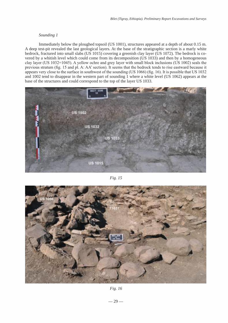
Sounding 1
Immediately below the ploughed topsoil (US 1001), structures appeared at a depth of about 0.15 m. A deep test-pit revealed the last geological layers. At the base of the stratigraphic section is a marly white bedrock, fractured into small slabs (US 1015) covering a greenish clay layer (US 1072). The bedrock is co-vered by a whitish level which could come from its decomposition (US 1033) and then by a homogeneous claylayer(US1032=1045).Ayellowochreandgreylayerwithsmallblockinclusions(US1002)sealsthepreviousstratum(fig.15andpl.A:AA’section).Itseemsthatthebedrocktendstoriseeastwardbecauseitappearsveryclosetothesurfaceinsouthwestofthesounding(US1066)(fig.16).ItispossiblethatUS1032and 1002 tend to disappear in the western part of sounding 1 where a white level (US 1062) appears at the base of the structures and could correspond to the top of the layer US 1033.
Fig. 16

— 30 —
Bilet (Tigray, Ethiopia). Preliminary Report Excavations and Surveys
The stripped area is evidence of many disturbances. In the south part of sounding 1, the geological levels are largely destroyed and penetrated beyond the surface of the bedrock. This includes a large digging (US1035),filledwithblocks(US1024)andseveralrecentsedimentaryphases(US1024,1036and1037).Themorphologyofthisexcavationanditsfillingisconsistentwithadestructionbyamechanicalengine.Another modern disturbance (F1005) was also observed at the northeast boundary of sounding 1. Finally, at thenorthwesterncornerofthesounding,allbedrockslabsweretornoff(US1098)andthisexcavationwasthenrefilledbyapileofblocks(US1093).
Location of archaeological structures
In the northern part of sounding 1, the archaeological structures (F1017, F1028 and F1080) are sealed byalayer(US1003)ofbasaltblocksandslabslinkedwithsediment,withnoparticularorganization(fig.17).This layer attests ancient destructions of archaeological structures because it was cut at the east by a trench F1005 and possibly by another one in the south. Despite these destructions, at least 9 structures could be dis-tinguished: at least 8 looted funerary rectangular superstructures sometimes surrounded by a crown of blocks, a burial (F1008) and a wall consisting of two sidings (F1028). This wall is located in the northern part of soun-ding 1. Most of the preserved part is oriented north-south and divided the area in two. There could be an inter-ruption in its northern part allowing passage between the two zones. In its southern part, it is curve and turns east to close the east area. Inside this area was discovered at least one tomb (F1080), perhaps even a second further north of which there would be only a few blocks left. West of F1028 is a second substructure (F1017). Bothsubstructuresleanagainstthewallandarethereforepost-construction(fig.18).
Immediately south of the curved wall, is the only burial that delivered bones during the campaign (F1008)(fig.19).Furthersouth,thereisathirdrectangularsubstructure(F1068)surroundedtothewestbybasalt blocks (US 1013). They could originally correspond to a circular structure partially destroyed by soun-ding F1035. Some of blocks exposed in the eastern limit of the sounding may be part of the same structures. TheareabetweenF1068andF1017isprobablydisturbed(US1040)andanalignmentofblocks(US1039)couldpossiblybetheremainsofafuneralstructure(fig.20).
Fig. 17

— 31 —
Bilet (Tigray, Ethiopia). Preliminary Report Excavations and Surveys
Fig. 18
Finally,eastofF1068,arowofatleast4rectangularstructures(F1060,1051,1054and1058)wasidentified.WestofF1060,therecouldbeafifthstructure(F1065).Itdidnotensuretheexistenceofthisfu-neralstructurebecausetheblocksofF1065areatthelimitofsoundingbutalsoinabreakinslope(fig.21).
Wall F1028
Part of a wall (F1028) was exposed in the northern part of sounding 1. The wall is oriented nor-th-south(5mlong)anditssouthernpartiscurvedandturnstowardstheeast(about2mlong)(seefig.22).Trench F1005 destroyed its eastern extremity. The wall is preserved on more than 5 courses and was exposed toitsfoundation:itspreservedheightisaround0.45m(fig.23).Thewallisbuiltwithmarlylimestoneslabswithout mortar. The foundation trench (US 1027) cuts the geological layer US 1002 (see pl. A: CC’ section).
Fig. 19

— 32 —
Bilet (Tigray, Ethiopia). Preliminary Report Excavations and Surveys
Fig. 20
Fig. 21

— 33 —
Bilet (Tigray, Ethiopia). Preliminary Report Excavations and Surveys
ItssouthernpartcutanundeterminedstructureF1046whichcouldcontinuetothesouthandcuttombF1008(fig.24).Thecurvedwallmayhavebeeninstalledonadualnorth-southandeast-westslope,orevenanexis-tingslopefracture(seesections).Initsnorthernpart,ahiatus(c.0.98mwide)isfilledbycollapsedblocks(US1061)(fig.25).Thisinterruptioncouldhavebeenc.0.20mnarrower.Indeed,ifthenorthernjambofthepossible entrance seems preserved, its southern jamb collapsed towards to the north.
Funerary monuments and funeral practices
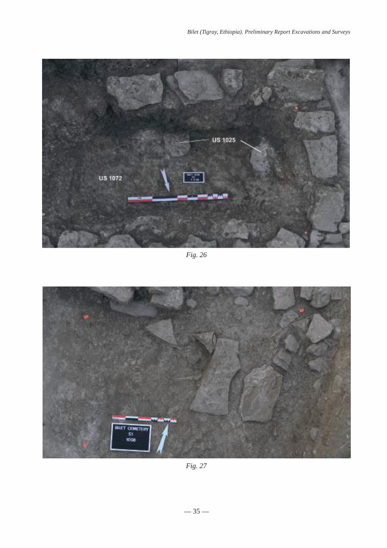
The majority of the archaeological structures in sounding 1 are platforms. They have a rectangular planandtheirdimensionsrangefrom2.06to3.04mlongandfrom1.08to1.92mwide(seetable).Allthesestructureshavebeenlootedintheircenter,sometimesbeyondbedrock(F1068,fig.26).Itisthereforeimpos-
Fig. 22
Fig. 23

— 34 —
Bilet (Tigray, Ethiopia). Preliminary Report Excavations and Surveys
Fig. 24
Fig. 25
sible to precise what they contained. They are built with small slabs linked with sediment – from one course (F1068) to 5 courses (F1051 and F1080) can be preserved. Following the lootings, their walls collapsed inside thelootingpitbutalsonorthwardinthedirectionofthegroundslope(F1054andF1080)(F1080,fig.27).
— 35 —
Bilet (Tigray, Ethiopia). Preliminary Report Excavations and Surveys
Fig. 26
Fig. 27

— 36 —
Bilet (Tigray, Ethiopia). Preliminary Report Excavations and Surveys
Fig. 28
Plan Length (m) Width (m) Orientation stele/structure for stele
F1017 rectangular 2,16 E/W ?
F1051 rectangular 3,04 1,92 ESE/WNW stele
F1054 rectangular 2,06 1,08 ESE/WNW structure for stele
F1060 rectangular 2,72 ? ESE/WNW stele
F1065 rectangular ? ? ? ?
F1068 rectangular 2,71 1,67 ESE/WNW
F1080 rectangular ? E/W
F1058 ? 2,21 ESE/WNW
F1008 ? ? ? E/W ?
Twostelae,oneofwhichisepigraphed(F1051:B24andF1060),werefoundattheeasternendoftworectangularsubstructuresfromthesouthwesternpartofsounding1(F1060,fig.28).Thesediscoveriesattest that, despite the looting, some elements remain in place. The two stelae were placed vertically in an empty space in the middle of the substructure eastern side. Such a structure is observed in the eastern wall ofF1054andcouldindicatethelocationofastelediscoveredinMarch2018(F1054,fig.29).Finally,somesubstructures are surrounded by a circle of basalt boulders: US 1013 around F1068 with a maximum radius of 3.2 m and US 1053 around F1051 with a maximum radius of 2.2 m. A few blocks on the south side of F1017couldbetheremainsofasimilarstructure,whichhasbeendestroyedbythedifferentlooting.

— 37 —
Bilet (Tigray, Ethiopia). Preliminary Report Excavations and Surveys
Fig. 29
Fig. 30
Outside funerary deposits
The excavation inside the monuments had not delivered any material. However, several concentra-tionsofpotsherds(US1044and1030–F1017(fig.30),US1042,US1042,US1048andUS1049–F1017,US1099–F1058(fig.31)orevenpot(US1063–F1051,fig.32)wereexposedaroundandagainstthesubstructures (see plans 1-2).

— 38 —
Bilet (Tigray, Ethiopia). Preliminary Report Excavations and Surveys
Fig. 31
Fig. 32

— 39 —
Bilet (Tigray, Ethiopia). Preliminary Report Excavations and Surveys
Fig. 33
Fig. 34
These fragmented ceramic elements are mostly located East of the structures (F1017, F1051 and may-beF1058)andattheirbaseclosetotheoriginalsurfacelevel.ForF1017andF1051,potsherdswereconfinedbetween the rectangular substructure and the crown US 1053 or the wall F1028. The presence of ceramics thus does not seem fortuitous and it could be linked to commemoration rites around the tombs. Note the discovery ofaglazedpotsherdbetweengravesF1080andwallF1028inalevelofdestruction(US1041,figs.33-34)Inthis case, its stratigraphic location does not allow to attribute the same utility in funeral practices.
Burial F1008
GraveF1008istheonlystructurethatdeliveredhumanbones.Nosubstructurewasidentifiedonitssurface.Buttheskeletonwascoveredbyseverallimestoneslabs(US1011,fig.35).Theburialpit(US1008)wasduguntilthebedrock(US1015)anditispossiblethatitswesternendwascutbytheF1046structure(tibias and feet of the skeleton US 1009 are missing). However, it was not possible to specify the limits of the burial pit. It contains the primary deposit of a female - between 18 and 22 years old at death - individual (US 1009). The body was originally buried on the right side with the upper limbs extended, placed in front of thebody(fig.36).Severalmovementsofthebones(leftfemur,righthumerus…)outsidetheoriginalvolumeof the corpse attest a decay in empty space. The lateral pressures observed on the skeleton could be due to the pit walls and/or a shroud. The segmentation of the anatomical areas observed on the excavated skeleton and the reversal of some bones (skull, vertebrae, scapula…) could attest the collapse of the bones due to the decayofwoodboardsorfloororiginallyunderthebodyinthegrave(fig.37).Despitethereversaloftheupper part of the skeleton, the global position of the bones attests that the face of the dead was towards the north or the north-east. After the burial of the body, the limestone slabs could close the pit.
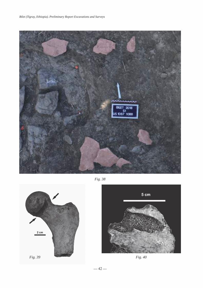
Several bones (US 1016) from a second individual (adult with undetermined sex) are also present in the burial pit, placed against the skeleton in primary deposit. The absence of anatomical logic and of connections attest to a secondary deposit, that is, these bones were deposited dry in the burial pit during the interment of the body (US 1009). Two alignments of limestone blocks east of F1008 (US 1087 and 1088) are the same level and couldbetheremainsofstonescoverfromadestroyedgrave(fig.38).ThediggingoftheburialF1008couldcutthis previous grave and bones in the secondary position (US 1016) could possibly come from this structure.
The bones in primary and secondary positions globally are bad preserved. Several taphonomic de-fects-astunneling,gnawingandperforations-wereobservedmainlyontheboneextremities(fig.39)andpelvicbones(fig.40).TheseosteolyticlesionscouldbeduetosubterraneantermitesasIhadalreadyob-serveditatQedemt(Lalibela).Theobservationoftermitecolonyinthenorthpartofsounding1(US1072)testifiedtheirpresenceatBilet.Termiteactioncouldalsoexplaintheabsenceofbonesinoraroundthelootedgraves. These structures were looted until the bedrock whose the upper part – the marly white slabs (US 1015) – were removed. As we saw, in the F1008, the body was buried on this layer and it could be maybe the same in the other graves. So the bones from the structures could be removed during these destructions. The looting could thus expose human remains and facilitate termite access to bones and their destruction.

— 40 —
Bilet (Tigray, Ethiopia). Preliminary Report Excavations and Surveys
Fig. 35
Fig. 36

— 41 —
Bilet (Tigray, Ethiopia). Preliminary Report Excavations and Surveys
Fig. 37
— 42 —
Bilet (Tigray, Ethiopia). Preliminary Report Excavations and Surveys
Fig. 38
Fig. 39 Fig. 40

— 43 —
Bilet (Tigray, Ethiopia). Preliminary Report Excavations and Surveys
Fig. 41 Fig. 42
Possible circulation levels
Significantdestructionofthesitemakesitdifficultthepreservationofsoilorcirculationlevels.Howe-ver,betweenstructuresF1054andF1058,severallayerscontainingflatceramicwereexposed:US1050(fig.41)andUS1074(fig.42).Thefirstisposteriortothesecondandthebotharelocatedonaclaylevel(US1075)whichcontainsrareflatslabs.Thesetwolevelsmaybecontemporarytotheuseofthecemetery.Underthesubstructure(US1055)ofthegraveF1054,anotherlayercontainingceramic(US1086)couldbeequivalenttoUS1074.SoUS1050couldbeacirculationlevelcontemporaneousorposteriortoF1054.
ThecirculationlevelUS1074couldthusbealevelpriortothegraveF1054.ItalsoseemsthatF1054can overlap the blocks circle around F1051. This level could eventually use as the same time F1051. Unfor-tunatelybetweenF1054andF1051,levelUS1074doesnotseemtocontinuebecauseonlyflatslabs(US1092)(fig.43)wereobservedunderthecollapse(US1056)oftheF1051substructure.ButitisfairlypossiblethatUS1094slabsareequivalenttoUS1075,presentbelowUS1050andUS1074circulationlevels.
Finally, a white level (US 1033) was exposed west of boulders edge (US 1013) of F1068. It contained some potsherds and ceramic (US 1099) in front of the east side of F1058. This level seems to be equivalent tothelevelUS1062,locatedsouthofF1051(fig.44).Theselevelsareatthebaseofthesemonumentsandsurely close to the circulation level around them.
Datation
Forthemoment,theonlyprecisechronologicaldataisprovidedbytheB24steleofthestructureF1051whichdatesbackto431AH.(1039-1040CE).ThestratigraphicrelationbetweenF1051andF1054couldindicatethatF1054datesfromthemiddleofthe11thcentury.Theceramicsdiscoveredaretypolo-gically similar to material known on other medieval Ethiopian sites. However, the lack of typochronology for medieval ceramics in Ethiopia does not allow for any additional conclusion at this time. The exogenous glazed potsherd found in the northern part of sounding 1 could be dated between ninth and the eleventh cen-tury. For this same zone, we are waiting for the radiocarbon dating of the two distinct individuals of tomb F1008.IfthetrenchF1046properlycutsthetombF1008,thisrelationcouldgiveaterminus postquem to thewallF1028thatcoversF1046.Nostratigraphicrelationshipcouldbeestablishedbetweenthesouthernand northern parts of the sounding. As we saw, the orientation of the funerary structures are distinct in these two area: E/O in the north and ESE/ONO in the south. But it is not yet possible to specify whether this is a chronologicaldifferenceorachangeduetothepresenceofthewallortothegroundtopography.

— 44 —
Bilet (Tigray, Ethiopia). Preliminary Report Excavations and Surveys
Fig. 43
Fig. 44

— 45 —
Bilet (Tigray, Ethiopia). Preliminary Report Excavations and Surveys
Muslim practices and specificities of the cemetery
ThediscoveryofanewstelewithMusliminscriptioninplaceconfirmsoncemorethepresenceofMuslim tombs on the Bilet site. In addition, the position of the body of the only skeleton in primary position respects certain classical Muslim rites, burial on the right side with the face towards the qibla (here towards the north). The two main orientations of the substructures (E/W and ESE/WNW) on the site are quite com-patible for bodies buried according to these rites.
The organization of the graves in this part of the cemetery presents a certain diversity. Some graves couldhavefollowedrowsoralleys(F1051,F1054,F1058andF1060).F1080andF1017substructuresleanagainst the wall F1028 and are therefore more recent. This wall may have been used as a burial enclosure wall with an entrance to circulate between two areas.
Extensions of the cemetery to the East
Soundings 2 and 3 attest the continuity of the cemetery towards the east. In sounding 2, fewer scat-teredblocksarepresentandatleast4east-westorientedgraveswereexposed.One(ortwo)grave(s)havetwoverticalstelaenotinscribedatitsends(fig.45).Insounding3asinsounding1,alotofspreadstoneswasexposed(fig.46).Amongthem,atleast6east-westorientedgraveshavebeenobserved.
The results from the pits tests attest that the cemetery extends further east. In addition, the discovery of several scattered steles several tens of meters to the south and several hundreds of meters to the east raises the question of the continuity of the site or of the existence of several burial spaces.
Fig. 45

— 46 —
Bilet (Tigray, Ethiopia). Preliminary Report Excavations and Surveys
Fig. 46
These preliminary results indicate that the medieval Muslim cemetery of Bilet has probably been largely looted. It will therefore be impossible to realize a broad analysis of funeral practices. Given the des-tructions, it is improbable also to have biological data for monumental graves. But, the discovery of the tomb F1008 attests that simpler tombs could be partially preserved. It seems important to continue the exploration ofthecemeterytogetabetterideaofitsplananditsextensionbutalsotohighlightdifferentsubstructuressuch as in Sounding 2.

— 47 —
Bilet (Tigray, Ethiopia). Preliminary Report Excavations and Surveys
AREA2 : “KIRKOS”TELL (Pl. B: Plan 3, Pl. C: section 1, Appendix 2)
Stratigraphy and structures
First phase: A monumental building
During the survey of the area, outcrop-pingwallswerespotted(figs.47-49).Theybe-long to a monumental building, two walls of which have been excavated.
The main wall (W 2001) is preserved on more than 30 courses and was exposed to its foundations(figs.50-52).Thepreservedheightof the wall inside the sounding reached 2,8 m. Wall 2001 is oriented WNW-ESE and does not followalinearcourse,forminga“Z”shape.Al-though it doesn’t employ mortar, its masonry is rather fine, using small calibrated but unwor-kedfieldstonesbondedtogetherwithearth.Itshows regular steps and recessed sections of 51 cm, setting back about 6-8 cm, and separated from other recessed courses by flagstone ofslateorschistformingsteps(figs.53-54).
The preservation of the wall follows the slope of the hill and it is better preserved in the north than in the south-east. Only 5 courses are preserved in its southern end, and it is pos-sible that the southern section functioned as a buttress wall in order to strengthen the main section to the north in direction of the slope.The stratigraphic sequence of the area north ofWall 2001 totally differs from the one tothe south, suggesting the existence of an inner space to the north.
To the south, Wall 2001 is founded in a thick layer of dark clay marked in surface by a level of pebbles (US2016, alt. sup. 2097,4m). This stratum is cut by the foundation trench (US 2018) which is clearly visible both in plan andsections(fig.55).
On top of US 2016 a succession of grey layers of slit are covered by a c. 3-5 cm thick layerofwhitelime.US2029,2024,2026,2023,2025 and 2025 (altitude 2097,5 ; 2097,7 ; 2098,2 m)maycorrespondtoseveralcirculationfloor,oroccupation/workingfloorsthatweresucces-sively raised, possibly to level the eastern slope of the tell. The fact that foundation trench 2018 cuts through all of them as well as US 12 indi-cates that the three lowest recessed sections of the wall were not visible and belonged to the
Fig. 47
Fig. 48
Fig. 49

— 48 —
Bilet (Tigray, Ethiopia). Preliminary Report Excavations and Surveys
Fig. 50 Fig. 51
Fig. 52 Fig. 53
Fig. 54

— 49 —
Bilet (Tigray, Ethiopia). Preliminary Report Excavations and Surveys
Fig. 55
foundation of the Wall. US 2012 is a very thick and packed whitish layer presenting a slope similar to the telli.e.towardtheeast(.Itcanbeassumedthatitssurfaceservedascirculationfloorduringtheerectionofthe building (altitude 2098,7-2098,3 m). It is covered by another thick greyish layer possibly of sedimentary nature(US2021)(fig.56).
To the North, the limited time devoted to the excavation of the area didn’t allow to reach the foundation of Wall 2001. The stratigraphy is also more complex than south of the wall. Its north-eastern limit appear unclear. Theouterfaceofthewallishardertofollowandabatchofmortarisfoundagainstit(US2014,figs.57-58).
A second wall comes abutting Wall 2001 perpendicularly in a SSW-NNE direction. Wall 2002 (width c. 50 cm) is preserved on 12 courses. Although using the same technic as Wall 2001 (small irregular fieldstonebondedtogetherwithearth)itisoflowerfacture(fig.59).
AtleasttwoflagstonefloorshavebeenexposednorthofWall2001andeastofWall2002(US2013,US2011).US2013isbadlypreservedandappearsirregular(alt.sup.2098,05-2097,82m,fig.60).Itisnotsure if it functioned with Wall 2002, since the lower courses of Wall 2002 were not exposed. Therefore it maybecontemporaneousorearlier.Itsealsathicklayerofbackfill(US2028)whichlaysonadarklayerofclay (US 2017). It is possible that US 2017 equals US 2016 south of Wall 2001 and that US 2028 served as a platform to level the ground inside a building, and hosting the foundation of Wall 2002, but limited time prevented to check this relationship.

— 50 —
Bilet (Tigray, Ethiopia). Preliminary Report Excavations and Surveys
Fig. 56
Fig. 57 Fig. 58
Fig. 59 Fig. 60

— 51 —
Bilet (Tigray, Ethiopia). Preliminary Report Excavations and Surveys
Atsomepoint,thefloorlevelnorthofWall2001wasraisedofc.50cmwithalayerofwhitishandcompactsoil(US2005).Insomeplacesbutnoteverywherefloor2011(alt.sup.2098,25m)waspreservedontopofUS2005(fig.61).Itclearlypostdatestheerectionofwall2002andlargepotsherdswerefoundlyingonbothUS2005andfloor2011(US2003,figs.62and63).
US 2015 in the eastern corner of the sounding correspond to a level of destruction or ruins, which naturallycollapsedalongtheslopeofthetell(fig.64).
Later phases
Structures and layers postdating the monumental phase were exposed on both side of wall 2001. To the south, a large and deep pit was dug against the outer face of the wall through US 2021 (US 2020, c. 1 mdeep,figs.65and66).Inthesurface,asortofedgewallwaspreservedonthreecourses,madeofsmallirregularfield-stones(US2010)anditispossiblebutunsurethatthecontemporaneouscirculationlevelwasalsocoveredbystones(fig.67).
Thepitpresentsamulti-layeredfill.Thefirstlayer(US2009-d,c.70cmthick)iscomposedofmixedlayercontainingnumerousfieldstonesandashes(fig.68).Thentwolayersofreddishburntsoilcontainingpotsherds (US 2009-c and a) are separated by a 10 cm thick layer of ashes (US 2009-b). Inside the pit, the outerfaceofWall2001wasprotectedbyflagstoneandlargepotsherds(US2017).
Thepitstructurewasfoundcoveredbysoil(US2004)andwhatmaybelongtoabadlypreservedflagstonefloornorthandabovewall2001(US2030,fig.69).
Datation and interpretation
Firstphase:Themonumentalbuildingpresentsclearcharacteristicsofso-called“Aksumite”archi-tecture, namely its masonry type with recessed sections and string courses of stone slabs. Even the regular
Fig. 61

— 52 —
Bilet (Tigray, Ethiopia). Preliminary Report Excavations and Surveys
Fig. 62
Fig. 63

— 53 —
Bilet (Tigray, Ethiopia). Preliminary Report Excavations and Surveys
Fig. 64
Fig. 65

— 54 —
Bilet (Tigray, Ethiopia). Preliminary Report Excavations and Surveys
Fig. 66
Fig. 67

— 55 —
Bilet (Tigray, Ethiopia). Preliminary Report Excavations and Surveys
Fig. 68
Fig. 69

— 56 —
Bilet (Tigray, Ethiopia). Preliminary Report Excavations and Surveys
Fig. 70: Berik Audi, «palace» Fig. 71: King’s grave at Aksum
Fig. 72: Parallel Piers fo the northern aisle in Arbaetu Ensesa church, Aksum (Agos 2011)
heightofthesections(here51cm)appearsveryclosetothestandardmoduleof48cmoftheclassicalmo-numentalAksumitearchitecture(Braukâmper2007).ClosecomparisonsareofferedbywallsofresidentialunitsinAksumorinWakarida(Gajdaetal.2015;Benoistetal.2016,figs.70-77).
Despite these characteristics, and until the associated material has been studied, one need to be very cautious as regard to the dating of the building, since the chronological sequence of the “Aksumite millennium”isstilldebated(Phillipson2008).RecentstudieshavealsopointedoutthelastinginfluenceofAksumite architectural style in later monumental buildings, especially in ecclesiastical monuments until the medievalperiod(Phillipson2004).
At this stage the function of the monumental building from Area 2 remains unclear, and its plan needs to be investigated further. The stratigraphic sequence shows that several phases of occupation occurred beforetheabandonordismantlementofthebuilding,andmaterialassociatedwiththefloorsmightprovidedates for those occupations.

— 57 —
Bilet (Tigray, Ethiopia). Preliminary Report Excavations and Surveys
Fig. 73: Building D2, Wakarida(Dugast, Gadja 2013)
Fig. 74: Area 1, Wakarida(Dugast, Gadja 2013)
Fig. 75: Building D2, Wakarida(Dugast, Gadja 2013)
Fig. 76: Corner of a Monumental platformin Aksum (Chittick 1974)
Fig. 77: Aggula Kirkos, general view of the site (Conti-Rossini 1928)

— 58 —
Bilet (Tigray, Ethiopia). Preliminary Report Excavations and Surveys
Later phases:
After the building ceased to be used, several arrangements were made in the area. The top of Wall 2001obviouslyservedassupportforafiringstructure,possiblyasemi-buriedovenoranopenfireplace.Thisfireplaceservedseveraltimesbeforeitsabandonandpotsherdsusedtoprotecttheouterfaceofthewall or found in the burnt layers should be associated with this phase. It is not very clear yet how the area waseventuallycovered,andifaflooreventuallysealedtheremains.Ruinsofnearbybuildingseemtohavecollapsed along the slope toward the east. Natural sedimentation appears to be very thin.

— 59 —
Bilet (Tigray, Ethiopia). Preliminary Report Excavations and Surveys
AREA 3 : THE NORTHERN TERRACES AND THE “QUBBA”(pl.D:plan4-1,Appendix4)
Stratigraphy and structures
Phase 1: A quadrangular building (pl. E: plan 4-2)
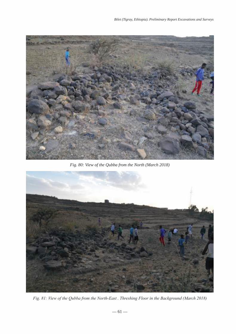
Thestonepiledesignatedasa“Qubba”isformedbytheruinofasmallbuildingandbasaltblocksdepositedtherebythefarmersinordertocleartheirparcels(figs.78-80).TotheWest,remainsofthebuil-dingshavedisappearedduetotheestablishmentofathreshingfloor(fig.81).
After cleaning the structure, two walls were exposed. Wall 3005 is orientated W-E and is perpendi-culartoWall3004orientatedN-S,formingthenorth-easterncornerofthebuilding(figs.82-85).Bothwallsareverybadlypreservedabove their foundations.Onlyfourblocksofonecourseswere identifiedonW3005. It suggests that the wall was built with small undressed but roughly rectangular blocks (c. 20x10cm) of local basalt bonded together with earth or light mortar. The width of the wall was no larger than 30 cm. It was founded with one course of raw basalt blocks laid in a slightly larger and shallow trench (US 3003 and3004.).Boththewidthofthefoundationanditsdepthsuggestalimitedelevationandagroundstoreybuilding. Potsherds belonging to a unique vessel have been collected in connection with the foundation of thebuildinginthefillingofthefoundationtrenchalongthenorthernandwesternwallsofthebuilding(US3013and3014).Thosesherdscanbeinterpretedasadeliberatefoundationdeposit.
Nospecificentranceorthresholdwaspreserved,anditismostlikelytohavebeenlocatedonthewestern and southern missing sides of the building.Due to its state of preservation, it is impossible to recons-tructtheextentofthebuildinginnerspaceoritsroofing.Howeveritshouldhavebeenoneofarelativelysmallsize,eachsidenotexceeding4.5-5meters.Suchaspace(c.20m²)couldhaveeasilybeencoveredbya small dome, even with dry stones.
After thecompletionof thecleaning, the innerfloorof thebuildingwas reached,madeofearthpacked ground (US 3017). It was covered by the collapse and/or ruin of the building containing modern plasticandmetalartefactsaswellasfragmentedvesselsalongthenorthernwall(US3008,3015;fig.86).This material is most likely dated after the abandonment of the building, when its ruins were squatted by far-mersorshepherds.Thefloorofthebuilding(US3017)wastotallyvirginofmaterial,indicatingthebuildingwas cleaned and emptied before its abandonment.
Twodeepersoundingswereopenedtransversallytowalls3004and3005,reachingthebedrock(US3019) under a level of yellowish clay (US 3018). It can be assume that this area was not occupied prior to the erection of the building or that its erection destroyed any evidence related to an earlier occupation.
Phase 2: A circular house (pl.F:plan4-3)
After the ruin or dismantlement of the square building, a circular house was built on its northern fringe. The house was not entirely excavated but its diameter can be reconstructed as c. 3,20-3,5 m providing andinnerspaceofc.10m².
The outer wall of the house (Wall 3006) is irregularly preserved on two courses of stones arranged intwocladdingrowsofsmallirregularblocksoffieldstones,someofwhichmayhavebeenretrievedfromtheruinofthesquarebuilding.ThetotalwidthofWall3006is45cm.Itispossiblethatthewallwasentirelybuilt of dry stones but also that Wall 3006 supported an elevation made of earth and wood.

— 60 —
Bilet (Tigray, Ethiopia). Preliminary Report Excavations and Surveys
Fig. 78: View of the Qubba from the North-East (March 2018)
Fig. 79: View of the Qubba from the South-West(March 2018)
— 61 —
Bilet (Tigray, Ethiopia). Preliminary Report Excavations and Surveys
Fig. 80: View of the Qubba from the North (March 2018)
Fig. 81: View of the Qubba from the North-East . Threshing Floor in the Background (March 2018)

— 62 —
Bilet (Tigray, Ethiopia). Preliminary Report Excavations and Surveys
Fig. 82: View of the Qubba from the south after surface cleaning (March 2018)
Fig. 83: View of the Qubba from the North-West looking at W3006

— 63 —
Bilet (Tigray, Ethiopia). Preliminary Report Excavations and Surveys
Fig. 84: View of the Qubba from the East while excavting W3004.Inner space of the circular house in the Foreground
Fig. 85: View of the corner formed by W 3004 and 3005 looking from the North-East

— 64 —
Bilet (Tigray, Ethiopia). Preliminary Report Excavations and Surveys
Fig. 86: Pottery (us 3015) from the ruins of the quadrangular building (US 3008)
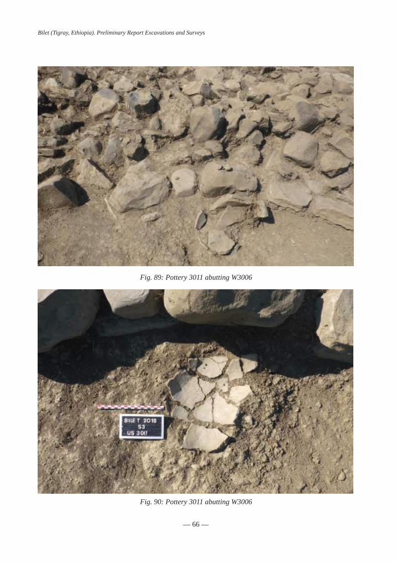
No entrance or threshold was located inside the sounding, possibly due to the bad preservation of the building, or because it was located outside the excavation limits. Inside the house, the level occupation level (US3002)ischaracterizedbyaverydenselayerofpackedearthwithawhitishsurface(figs.87and88).Severalpotsherdsandcharcoalswerefoundlyingonthefloor.Anearlycompletejar(US3011)wasfoundonthefloorabuttingthewallofthehousetotheWest(figs.89and90).
Atleastthreestructureswereidentifiedinsidethehouse(fig.91):1)afireplaceconsistingoftwoelongatedblocksretainingathicklayerofashes(US3009),2)aplatformorwallmadeofseveralflatbasaltblocks and which may have supported a central pillar supporting the roof (US 3010, 3016) and 3) a large basalt block integrated to the house, the function is yet unknown.
TotheWestthehousewasinstalledonthesquarebuilding,Wall3006coveringpartofWall3004andindicatingthehousewasbuiltafterthesquarebuildingwasdismantled(fig.92-94).
At an unknown date, the house was also dismantled to the south, where only a few stones of Wall 3006remain.Inthisarea,floor3002isnotpreservedandadarkerlayerwasfound(US3007).Inthesouthernlimit of the sounding, several blocks of basalt were found, possibly organised in rows orientated SW-NE (US 3012,fig.95).Thisstructurewasnotinvestigatedfurther,butsomefaunalremainswerefoundaboveit.

— 65 —
Bilet (Tigray, Ethiopia). Preliminary Report Excavations and Surveys
Fig. 87: View of the interior of the house looking from the West
Fig. 88: The house looking from the East
— 66 —
Bilet (Tigray, Ethiopia). Preliminary Report Excavations and Surveys
Fig. 89: Pottery 3011 abutting W3006
Fig. 90: Pottery 3011 abutting W3006

— 67 —
Bilet (Tigray, Ethiopia). Preliminary Report Excavations and Surveys
Fig. 91: Inner structures of the house note the fire place to the right
Fig. 92: The circular house installed on the eastern wall of the quadrangular building.Note the slight inclination of wall 3006

— 68 —
Bilet (Tigray, Ethiopia). Preliminary Report Excavations and Surveys
Fig. 93: The circular house installed on the eastern wall of the quadrangular building looking south
Fig. 94: Walls 3004 and 3006 looking north.Note the hole corresponding to the foundation trench of Wall 3004

— 69 —
Bilet (Tigray, Ethiopia). Preliminary Report Excavations and Surveys
Datation
Phase1:Theonlyvaluabledatingmaterialforphase1arethepotsherds(US3013and3014)relatedto the erection of the building itself.
Phase 2 can be dated by charcoals samples collected inside the housing unit. Those samples will provide dates for the pottery associated with the charcoals and should be regarded as contemporary to the last period of use of the house.
Comparisons and interpretation
Phase1:ItisdifficulttoassesswhetherthequadrangularbuildingisindeedtheonedescribedbyContiRossiniasa“Qubba”.Ifso,itcouldwellhavebeenrelatedtothecemetery,overlookingitfromthesouth.
Phase 2: Circular houses are very common in Ethiopia from ancient time until today and not only in Tigray. The most widespread type, called tukul have a conical roof supported by a central pillar and sometime by poles outside (Braukâmper2007).Severalexampleswereidentifiedandsometimesexcavatedfurthersouthdatingfromthemedievalandmodernperiod,notablyinFäqiDäbbis(Poissonnieretal.2011)andinMesḥalaMāryām(Lottietal.2012).
TherelativelysmalldimensionsofthehouseinArea3anditslackofinternaldivisionwouldbestfitto an individual lodging, for a poor family or rather for a single adult or a widow. Inner arrangements clearly indicatethedomesticfunctionofthebuilding.Itcouldhaveservedforstoringandcookingfoodandoffereda rudimentary shelter for the night. It is not clear whether the nearby structure were related to the house, maybe as an outside kitchen or for outdoor activities such as butchering.
Fig. 95: Unidentified stone structure in the south eastern corner of Area 3 (US 3012) looking west


— 71 —
Bilet (Tigray, Ethiopia). Preliminary Report Excavations and Surveys
SURVEYS AND EPIGRAPHIC FINDINGS
Fieldwork conducted in Bilet in December 2018 also gave the opportunity to carry out prospections with two objectives: 1. to increase the corpus of Arabic inscriptions coming from Bilet by looking for stelae or fragments of stele in reuse. As a reminder, during the survey conducted in the area in March 2018, 18 stelae or frag-mentsofstelewerefoundinreuseamongstonealignmentsalongfieldsandpaths,inadditiontothreestelaefound in situ. 2. to identify unknown ancient Muslim settlements in Eastern Tigray that might have been linked to Bilet.
New epigraphic findings from Bilet
EpigraphicfindingsintheareaofBiletinDecember2018havenotbeenasnumerousastheywereduringthefirstprospectionsconductedinMarch2018.Threefragmentsofstele,withfewlettersvisible,havebeenfoundinthevicinityofSector1.Theyarenumberedbyorderoffindingincontinuitywiththestelae previously found (B0011 to B0021):
B022(fig.96).FragmentofsteleonbasaltstonefoundinaheapofstonesimmediatelytotheNorthof Sector 1.
GPScoordinates:lat=13.487720lon=39.554520
Dimensions:Height:8-13cm.Width:3-9cm.Thickness:4-5cm
Comments: this fragment comes from the same stele than B 11, a fragment found in March 2018, and partly completes the original artefact.
10 cm
Fig. 96

— 72 —
Bilet (Tigray, Ethiopia). Preliminary Report Excavations and Surveys
B023(fig.97).Fragmentofsteleonlimestonefoundinreuseinstonealigmentalongthepathlo-cated 30 m. south of Sector 1.
GPScoordinates:lat=13.487233lon=39.554756
Dimensions:Height:11-13cm.Width:16cm.Thickness:4-4.5cm
B025(fig.98).Fragmentofsteleonlimestonefoundinreuseinstonealignmentabout200m.Sou-th-East of Sector 1.
GPScoordinates:lat=13.4866663lon=39.5558294
Dimensions: Height: 13 cm. Width: 8-9 cm. Thickness: 3 cm
10 cm
Fig. 97
10 cm
Fig. 98

— 73 —
Bilet (Tigray, Ethiopia). Preliminary Report Excavations and Surveys
In addition to these three fragments, a complete albeit damaged stele on basalt stone has been found in situ during excavations, as part of a tomb surface marker (US 1052, tomb F1501) in the South-West area ofSector1.Thisimportantfindinggivesforthefirsttimeevidenceofthestele’sinstallationinthetomb’sbuilding.AccordingtotheArabicinscription,thesteledatesbacktotheyear431AH.(1039-1040CE).
B024(figs.99-100).CompletesteleonbasaltstonefoundduringexcavationsofSector1.
GPScoordinates:lat=13.4876161lon=39.5543607
Dimensions:Height:41cm.Width:23-31cm.Thickness:14-19cm
Fig. 99
Fig. 100
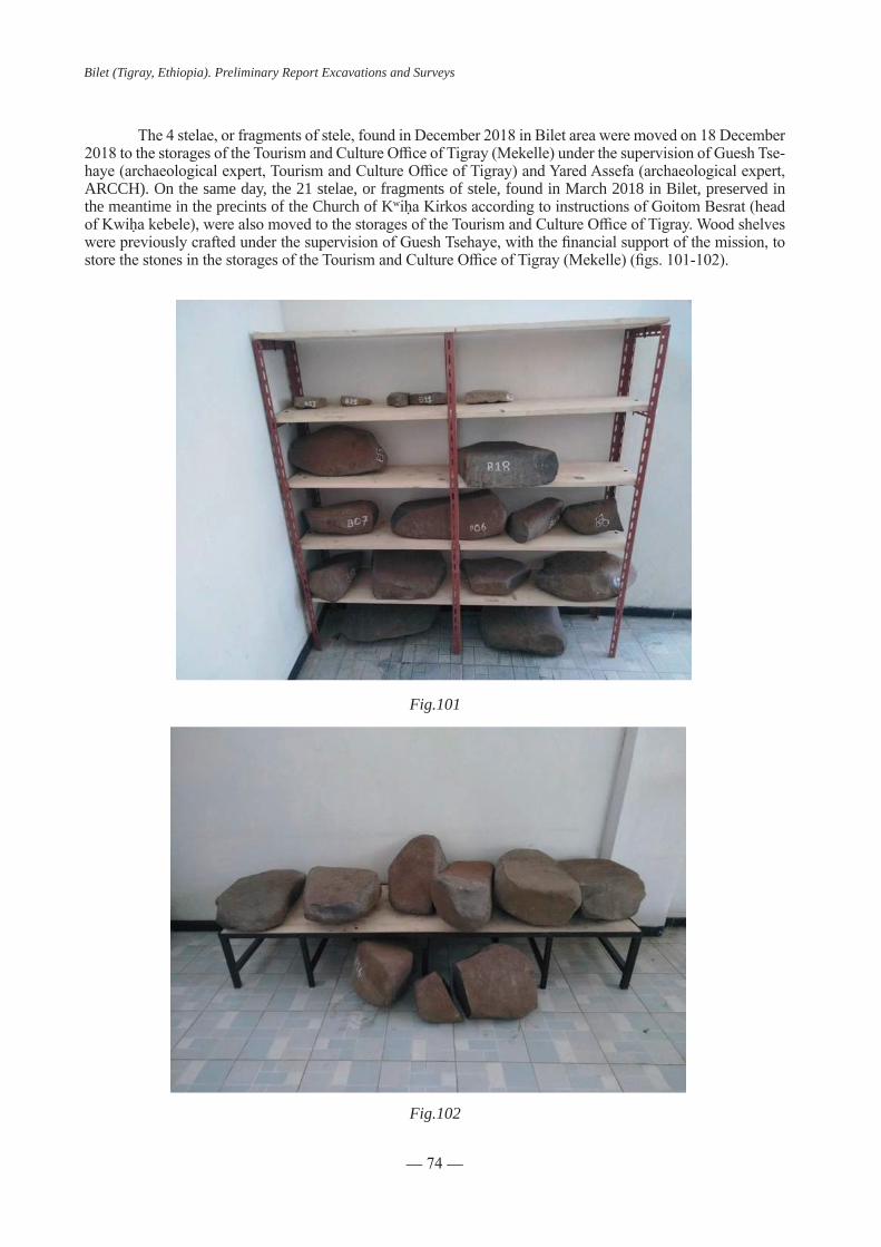
— 74 —
Bilet (Tigray, Ethiopia). Preliminary Report Excavations and Surveys
The4stelae,orfragmentsofstele,foundinDecember2018inBiletareaweremovedon18December2018tothestoragesoftheTourismandCultureOfficeofTigray(Mekelle)underthesupervisionofGueshTse-haye(archaeologicalexpert,TourismandCultureOfficeofTigray)andYaredAssefa(archaeologicalexpert,ARCCH). On the same day, the 21 stelae, or fragments of stele, found in March 2018 in Bilet, preserved in the meantime in the precints of the Church of KwiḥaKirkosaccordingtoinstructionsofGoitomBesrat(headofKwiḥakebele),werealsomovedtothestoragesoftheTourismandCultureOfficeofTigray.WoodshelveswerepreviouslycraftedunderthesupervisionofGueshTsehaye,withthefinancialsupportofthemission,tostorethestonesinthestoragesoftheTourismandCultureOfficeofTigray(Mekelle)(figs.101-102).
Fig.101
Fig.102

— 75 —
Bilet (Tigray, Ethiopia). Preliminary Report Excavations and Surveys
Surveys in the area of Arra (Adigudem district, Tigray)
Information suggesting the presence of archaeological remains of an ancient Muslim community in thevillageofArra(30km.southofKwiḥa,districtofAdigudem,EasternTigray,seefig.103:aerialviewofArra) have been provided to the team by Prof. Fesseha Abraham (Addis Ababa University) while attending the presentation of Bilet Mission during a workshop held on 29 November 2018 at the French Centre for Ethiopian Studies (CFEE, Addis, Ababa). Thanks to this valuable insight, prospections have been conducted in the village of Arra and in its area on two occasions.
On12December2018,afirstvisitwaspaidtothevillageofArrainattendanceofShaykhʿAbdal-RaḥmanʿAbdal-Qādir,imāmofAdigudem;ofYāsinAḥmad,ʿAbdal-QādirKuhlayandʿAbdal-QādirṢāliḥKahsay, representativesofAdigudemMuslimcommunity;andfinally,ofMuḥammadʿAlīKahsay,substitute of the imāmofAdigudem forArraMuslim community.Teammembers presentwere the fol-lowing:GueshTsehaye(TourismandCultureOfficeofTigray),DeresseAyenachew(DebreBerhanUniver-sity), Fesseha Berhe (PhD candidate, Mekelle University), Bertrand Hirsch and Julien Loiseau.
The team visited the ancient mosque of Arra, abandoned since the late 1980’s and the building of a new and largermosque(fig.104).Theprayerhalliscurrentlydividedintworoomsbyastonewall.Theqiblawallanditsmiḥrābcanbeseenfromthetopofthemosqueasaresultofthepartialcollapseoftheroof(fig.105).Theplaceisstillconside-red by the Muslim community as a revered one. According to the local shaykhs, ancient stones with Arabic inscriptions used to be stored in its precints and displayed during Muslim festivals. No stele was to be found during the visit.
Thesameday,MuḥammadʿAlīKahsay,substituteoftheimāmofAdigudemforArraMuslimcom-munity, displayed to the team an Arabic funerary stele preserved in his home and supposed to come, accor-ding to his testimony, from Arra Muslim cemetery. According to the Arabic inscription, it dates back to the year564AH.(1169CE).ThisartefactopenstheserieofArrafuneraryinscriptions(A):
Fig.103: Aerial view of Arra, the Muslim cemetery in the middle

— 76 —
Bilet (Tigray, Ethiopia). Preliminary Report Excavations and Surveys
Fig.104: Arra ancient mosque’s front and entrance
Fig.105: The miḥrāb seen from the top of the mosque. GPS Coordinates 13°15’19”N 39°34’43”E

— 77 —
Bilet (Tigray, Ethiopia). Preliminary Report Excavations and Surveys
A001(fig.106).Completesteleon limestone,supposed tocomefromArraMuslimcemetery,currentlypreservedinMuḥammadʿAlīKahsay’shome.
Dimensions:Height:37cm.Width:23-29cm.Thickness:9-4cm
On 16 December 2018, a second visit was paid to the village of Arra and its neighborhood in at-tendanceofShaykhʿAbdal-RaḥmanʿAbdal-Qādir,imāmofAdigudemandMuḥammadʿAlīKahsay,hissubstitute for Arra Muslim community. Team members present were the following: Guesh Tsehaye (Tourism andCultureOfficeofTigray),YaredAssefa (ARCCH),DeresseAyenachew (DebreBerhanUniversity),Hiluf Berhe (Mekelle University, department of Archaeology), Fesseha Berhe (PhD candidate, Mekelle Uni-versity), Simon Dorso, Yves Gleize, David Ollivier and Julien Loiseau.
A second visit was paid to the ancient mosque of Arra. No stele was to be found, once again, in its vicinity,butafragmentofstelewasbroughttothemosquebyMuḥammadʿAlīKahsay
A002(fig.107).Fragmentofsteleonlimestone,supposedtocomefromArraMuslimcemetery,currentlypreservedinMuḥammadʿAlīKahsay’shome.Textispartlyerased
Dimensions: Height: 16 cm. Width: 27 cm. Thickness: 8 cm
The visit of the present Muslim cemetery of Arra has proved to be most informative. Located east of Arra, be-neath the village and along a wadi, the cemetery takes place in the same kind of environment than did Bilet cemetery (figs.108a-b,109).RecenttombsdisplaythesamekindofstonesurfacemarkerthandidthetombsexcavatedinBilet.In absence of any evidence, beside the stelae A 01 and A 02 that are supposed to come from the same place, no data-tion of the cemetery can be provided. However, one can hypothesize than the ancient Muslim cemetery of Arra has been used up to now, with or without interruption, by the local Muslim community. Indeed, the way in which Muslim tomb’s surface markers have been built in Eastern Tigray since the 11th century seems to have been vernacular.
Fig.106
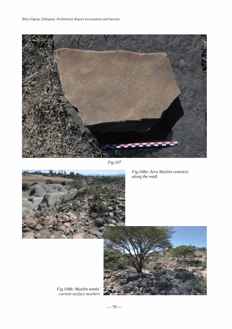
— 78 —
Bilet (Tigray, Ethiopia). Preliminary Report Excavations and Surveys
Fig.107
Fig.108a: Arra Muslim cemeteryalong the wadi
Fig.108b: Muslim tombs’current surface markers

— 79 —
Bilet (Tigray, Ethiopia). Preliminary Report Excavations and Surveys
Meida Zelegat
Thesameday,followingtheindicationsofMuḥammadʿAlīKahsayandinattendanceofShaykhʿAbdal-RaḥmanʿAbdal-Qādir,theteamsurveyedanancientMuslimcemeteryinaplacecalledMeidaZe-legat,locatedthreekm.north-eastofArra,atthefootofacliff,inthevicinityofarailwayconstructionsite.Coordinates:13.26.614latitude,39.60.677longitude(figs.109,110-111).
Fig.109: Meida Zelegat cemetery seen from the cliff
Fig.110

— 80 —
Bilet (Tigray, Ethiopia). Preliminary Report Excavations and Surveys
The survey of Meida Zelegat cemete-ryresultedinthefindingof8Arabicfunerarystelae,orfragmentsofstele(fig.112).Theyopen the serie of Meida Zelegat funerary ins-criptions (MZ). According to its Arabic ins-cription, one of these stelae (MZ 07) dates back to the year 657 H. (1259 CE), whereas the latest stelae found in Bilet date back to the middle of the 12th century. After study in situ, the 8 stelae have been moved to the mosque of Adigudem under the supervision of Guesh Tsehaye (Tourism and Culture Of-ficeofTigray)andYaredAssefa (ARCCH),following instructions of Shaykh ʿAbdal-RaḥmanʿAbdal-Qādir.
Fig.111
Fig.112

— 81 —
Bilet (Tigray, Ethiopia). Preliminary Report Excavations and Surveys
MZ001(fig.113).Fragmentofsteleonbasaltstone.
Dimensions: Height: 16 cm. Width: 16 cm. Thickness: 3 cm
MZ002(fig.114).Fragmentofsteleonlimestone.
Dimensions: Height: 10 cm. Width: 10 cm. Thickness: 1 cm
MZ003(fig.115).Fragmentofsteleonlimestone.
Dimensions: Height: 4 cm. Width: 3,5 cm.Thickness: 0,5 cm
Fig.113
Fig.114
Fig.115

— 82 —
Bilet (Tigray, Ethiopia). Preliminary Report Excavations and Surveys
MZ 004 (fig. 116). Complete stele on basaltstone.
Dimensions: Height: 34 cm. Width: 18 cm.Thickness: 5,5 cm
MZ005(fig.117).CompletesteleonbasaltstoneadornedwithSolomon’s seals.
Dimensions:Height:45cm.Width:17-29cm.Thickness:6cm
MZ006(fig.118).Completesteleonbasaltstone.
Dimensions:Height:42,5cm.Width:11-26,5cm.Thickness:5,5cm
Fig.116
Fig.117
Fig.118

— 83 —
Bilet (Tigray, Ethiopia). Preliminary Report Excavations and Surveys
MZ 007 (fig. 119). Complete stele on basaltstone.
Dimensions: Height: 24 cm. Width: 22 cm.Thickness: 2,5 cm
MZ008(fig.120).Fragmentofsteleonbasaltstone.
Dimensions: Height: 11,5 cm. Width: 12-15,5 cm. Thickness: 2 cm
Fig.119
Fig.120

— 84 —
Bilet (Tigray, Ethiopia). Preliminary Report Excavations and Surveys
Fig.121
Fig.122: Ḥabera Muslim cemetery
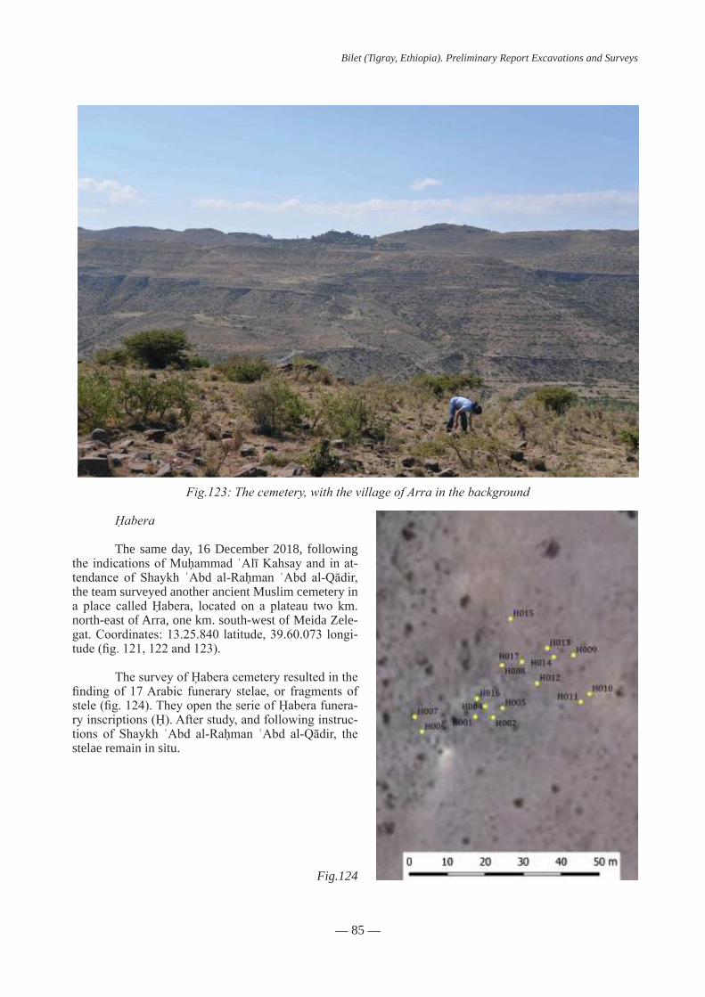
— 85 —
Bilet (Tigray, Ethiopia). Preliminary Report Excavations and Surveys
Fig.123: The cemetery, with the village of Arra in the background
Fig.124
Ḥabera
The same day, 16 December 2018, following the indicationsofMuḥammadʿAlīKahsayandinat-tendance of Shaykh ʿAbd al-Raḥman ʿAbd al-Qādir,the team surveyed another ancient Muslim cemetery in a place calledḤabera, located on a plateau two km.north-east of Arra, one km. south-west of Meida Zele-gat.Coordinates:13.25.840latitude,39.60.073longi-tude(fig.121,122and123).
ThesurveyofḤaberacemeteryresultedinthefindingof 17Arabic funerary stelae, or fragments ofstele(fig.124).TheyopentheserieofḤaberafunera-ryinscriptions(Ḥ).Afterstudy,andfollowinginstruc-tions of Shaykh ʿAbd al-Raḥman ʿAbd al-Qādir, thestelae remain in situ.

— 86 —
Bilet (Tigray, Ethiopia). Preliminary Report Excavations and Surveys
Fig.125
Fig.126
Fig.127
Ḥ001(fig.125).Completesteleonbasaltstone.
Dimensions: Height: 40 cm. Width: 29 cm.Thickness: 10 cm
Ḥ002(fig.126).Completesteleonbasaltstone.
Dimensions: Height: 53 cm. Width: 32 cm. Thickness: 8 cm
Ḥ003(fig.127).Completesteleonbasaltstone.
Dimensions:Height:46cm.Width:22cm.Thickness:11cm

— 87 —
Bilet (Tigray, Ethiopia). Preliminary Report Excavations and Surveys
Fig.128
Fig.129
Fig.130
Ḥ004(fig.128).Fragmentofsteleonlimestone.
Dimensions: Height: 7-20 cm. Width: 28,5 cm. Thickness: 5 cm
Ḥ005(fig.129).Completesteleonbasaltstone.
Dimensions: Height: 33 cm. Width: 21,5 cm. Thickness: 7 cm
Ḥ006(fig.130).Completesteleonbasaltstone.
Dimensions:Height:45cm.Width:37cm.Thickness:5,5cm

— 88 —
Bilet (Tigray, Ethiopia). Preliminary Report Excavations and Surveys
Fig.131
Fig.132
Fig.133
Ḥ007(fig.131).Fragmentofsteleonlimestone.
Dimensions:Width:3-14cm
Ḥ008(fig.132).Completesteleonbasaltstone.
Dimensions: Height: 38,5 cm. Width: 12-23-35 cm.
Ḥ009(fig.133).Fragmentofsteleonlimestone.
Dimensions: Height: 32,5 cm. Width: 10-20-27 cm. Thickness: 5 cm

— 89 —
Bilet (Tigray, Ethiopia). Preliminary Report Excavations and Surveys
Fig.134
Fig.135
Fig.136
Fig.137
Ḥ010(fig.134).Fragmentofsteleonlimestonepartly buried.
Dimensions: Height (visible): 25 cm. Width: 26,5cm.Thickness:4,5cm
Ḥ011(fig.135).Fragmentofsteleonlimestone.
Dimensions: Height: 21 cm. Width: 15,5 cm. Thickness:4cm
Ḥ012(fig.136).Fragmentofsteleonlimestonepartly buried.
Dimensions: Height (visible): 26 cm. Width (visible):8,5cm.Thickness:4cm
Ḥ013(fig.137).Completesteleonbasaltstonepartly buried.
Dimensions: Height (visible): 30 cm. Width (visible): 19 cm. Thickness (visible): 3

— 90 —
Bilet (Tigray, Ethiopia). Preliminary Report Excavations and Surveys
Fig.138
Fig.139
Fig.140
Ḥ014(fig.138).Fragmentofsteleonlimestone.
Dimensions: Height: 12 cm. Width: 16 cm. Thickness:4,5cm
Ḥ015(fig.139).Fragmentofsteleonlimestone.
Dimensions: Height: 8 cm. Width: 19,5 cm. Thickness: 7 cm
Ḥ016(fig.140).Completesteleonbasaltstonepartlyburied.
Dimensions:Height:39cm.Width:43cm.Thickness:3

— 91 —
Bilet (Tigray, Ethiopia). Preliminary Report Excavations and Surveys
Fig.141
Fig.142
Ḥ 017 (fig. 141). Fragment of stele on basaltstone.
Dimensions: Height: 29 cm. Width: 24 cm.Thickness: 2
The three ancientMuslim cemeteries ofArra,MeidaZelegat andḤabera,were unknown to thescientificcommunitypriortoourinvestigations.TheirArabicfuneraryinscriptions(27itemsdocumentedtodate) attest the existence of several Muslim communities in the same neighborhood, at least during the 12th-13thcenturies(fig.142).However,thesettlementsrelatedtothesethreecemeteriesarestilltobeidentified,with the probable exception of Arra if one assume that the modern village is located on the same place than themedievalsettlement(fig.143).Bethatasitmaybe,thepresenceofseveralMuslimcommunitiesinthisarea of Eastern Tigray has most likely to be related to the North-South route leading from the Red Sea shore to the heart of the Zagwé Christian kingdom. Note that the archaeological site of Bilet was located about 30 km North on the same route. Their presence in the neighborhood of Arra has also to do with the vicinity of Nazret Maryam, a medieval site associated to the residency of the Ethiopian church metropolites at the time of the Zagwé kingdom.

— 92 —
Bilet (Tigray, Ethiopia). Preliminary Report Excavations and Surveys
Fig.143

— 93 —
Bilet (Tigray, Ethiopia). Preliminary Report Excavations and Surveys
GENERAL CONCLUSIONS
ThefirstcampaignoftheEthiopian-FrenchmissiononBiletmedievalcemeteryanditssurroundingstook place from the 1st to the 20thDecember2018.ItconfirmsseveralhypothesisraisedbythesurveyofMarch 2018 and opens promising avenues of research.
The Muslim cemetery from which comes the largest corpus of medieval Arabic inscriptions known for Ethiopia(47,including25stelaeorfragmentsofstelefoundbythemissionin2018)hasbeendefinitivelyidenti-fied.SoundingsopenedduringthecampaigninArea1madepossiblethediscoveryandexcavationof8funerarysubstructures, one of them adorned with a complete funerary stelae, along with a wall that might have enclosed some graves. However, only one burial has been discovered so far, leading to the conclusion that most of graves were at some point plundered. Excavations and soundings in Area 1 have brought important data on funerary ar-chitecture of the Muslim community of Bilet and a preliminary assessment of the cemetery’s extension.
ExcavationsconductedinAreas2&3haveproducedprovisionalresultsonly,waitingfor14Cda-tation of samples and further investigations. In Area 2, a monumental wall has been partly exposed, along withpostdatingstructures.Nointerpretationoftheseremainsispossiblefornow.Butthesefirstdiscoveriespoint out a long and complex occupation of the tell of KwiḥaKirkos,whosechronologyisawaitingfurtherinvestigations.InArea3,clearanceandexcavationoftheruinedstructurecanconfirmfornowneitherthebuilding form nor its functions. But it makes possible to identify a housing unit postdating the dismantled buildingandwaitingfor14Cdatation.
Finally, survey of the area, and of previously unknown ancient Muslim cemeteries located about 30 km south, allows a better understanding of Bilet’s medieval environment and opens promising avenues of research by providing comparative data about funerary architecture and new corpus of Arabic inscriptions.


— 95 —
Bilet (Tigray, Ethiopia). Preliminary Report Excavations and Surveys
RESEARCH PROSPECTS AND FUTURE CAMPAIGNS
TheresultsachievedbythefirstcampaignoftheEthiopian-FrenchmissiononBiletmedievalceme-tery and its surroundings are promising and call for further investigations.
The extension of Bilet Muslim cemetery has still to be assessed by new soundings beyond Area 1. The question remains to know if most of its graves have been plundered, and when, or if some of them have been left undisturbed, opening the possibility to bring additional funerary and anthropological data. The occupation of KwiḥaKirkos’tellanditschronologyhavestilltobeassessedbythefullexcavationofthemonumentalwallbrieflyexposedduringthecampaign,andbyseveralnewsoundingsinthearea.Thequestion remains to know if the tell was or not settled and inhabited at the same time that the Muslim ceme-tery was in use.
The discovery and survey of three previously unknown Muslim cemeteries (in Arra, Meida Zelgat andḤabera)callforasystematicsurveyofsouthernEndertainordertoplaceBiletinitspropermedievalcontext.
Forall thesereasons,theEthiopian-FrenchonBiletplanstosubmittotheARCCHtwodifferentprojects for the coming year: a survey mission in southern Enderta led by Amelie Chekroun (CNRS) and a second campaign on Bilet cemetery and its surroundings led by Julien Loiseau (Aix-Marseille University).


— 97 —
Bilet (Tigray, Ethiopia). Preliminary Report Excavations and Surveys
BIBLIOGRAPHY
Bauden 2011 BAUDENF.,«Inscriptionsarabesd’Éthiopie»,AnnalesIslamologiques45,pp.285-306.
Benoist et al. 2016 BENOISTA.,CHARBONNIERJ.,GAJDAI.,«InvestigatingtheEasternEdgeoftheKingdomofAksum:ArchitectureandPotteryfromWakarida»,inSTARKEYJ.,ELMAZO.(éd.),ProceedingsoftheSeminarforArabianStudiesVolume46,2016:Papersfromtheforty-seventhmeetingoftheSeminarforAra-bianStudiesheldattheBritishMuseum,London,24to26July2015,Archaeopress,Oxford:s.n.,pp.1-16.
Braukâmper 2007 BRAUKÂMPERU.,«HousesinsouthernEthiopia»,inUHLIGS.,BAUSIA.,BAYEYIMAM,CRUMMEY D., FIACCADORI G. (éd.), Encyclopaedia Aethiopica. Volume 3, He-N, Wiesbaden : Harras-sowitz Verlag, pp. 78-81.
Breton 2018 BRETON J.-F., The Ancient Site of Kwiha (Tigray) [en ligne], s.l. : HAL-SHS, URL : https://halshs.archives-ouvertes.fr/halshs-01879618/document [lien valide au 20 avril 2019].
Breton, Aytenew Ayele 2015 BRETONJ.-F.,AYTENEWAYELEY.,PreliminaryReportontheSurveyofQwihaAncientTerrito-ry April 2015 [en ligne], Survey Report, Mekelle : Mekelle University, Department of History and Heritage Managment, URL : https://www.academia.edu/37203101/PRELIMINARY_REPORT_ON_THE_SUR-VEY_OF_QWIHA_ANCIENT_TERRITORY_APRIL_2015[lienvalideau20avril2019].
Conti Rossini 1937 CONTIROSSINIC.,«NecropolimusulmanaedanticachiesacristianapressoUogrìHaribànell’En-derta»,Rivistadeglistudiorientali,17,pp.399-408.
Derat 2010 DERATM.-L.,«TheZāgwēdynasty(11-13thcenturies)andKingYemreḥannaKrestos»,Annalesd’Éthiopie,25,1,pp.157-196.
Duday 2009 DUDAY H., The archaeology of the dead: lectures in archaeothanatology, Oxbow Books, Oxford : s.n.
Dugast, Gajda 2014a DUGASTF.,GAJDAI.,«ArchaeologicalSurveyintheAreaofMeqeleandtheEasternEdgeoftheHighlandsinTigraiRegion»,Annalesd’Éthiopie,29,1,pp.275-277.
Dugast, Gajda 2014b DUGASTF.,GAJDAI.,«ProspectionsarchéologiquesdanslarégiondeMeqeleetlescontrefortsorientauxduTigray»,Annalesd’Éthiopie,29,1,pp.179-197.
Fauvelle-Aymar, Hirsch 2008 FAUVELLE-AYMARF.-X.,HIRSCHB., «Etablissements et formations politiquesmusulmansd’Ethiopieetdelacornedel’AfriqueauMoyenÂge:versunereconstruction.»,Annalesislamologiques,42,pp.339-375.
Fauvelle-Aymar, Hirsch 2011 FAUVELLE-AYMARF.-X.,HIRSCHB.,«Enguised’introduction.Surlestracesdel’islaman-cienenEthiopieetdanslaCornedel’Afrique»,inFAUVELLE-AYMARF.-X.,HIRSCHB.(éd.),EspacesmusulmansdelaCornedel’AfriqueauMoyenÂge,CentreFrançaisdesÉtudesÉthiopiennes-ÉditionsdeBoccard, Paris : s.n.

— 98 —
Bilet (Tigray, Ethiopia). Preliminary Report Excavations and Surveys
Gajda et al. 2015 GAJDA I., BENOIST A., CHARBONNIER J., ANTONINI S., PEIXOTO X., VERDELLET C., BERNARDV.,BARGEO.,REGAGNONE.,CALLOTY.,«Wakarida,unsiteaksumiteàl’estduTigray:fouillesetprospections2011-2014/Wakarida,anAksumiteSiteinEasternTigray:ExcavationsandSurveys2011-2014»,Annalesd’Éthiopie,30,1,pp.177-224.
Gleize et al. 2015 GLEIZE Y., BOSC-TIESSE C., DERAT M.-L., ROUZIC M., SEVE S., ZIEGLER L., GOUJON A.-L.,MENSANR.,BERNARDR.,BELAYG.,«LecimetièremédiévaldeQedemt(Lālibalā):donnéespréliminairesissuesdescampagnes2010et2012/TheMedievalCemeteryatQedemt(Lālibalā):Prelimi-naryResultsofthe2010and2012ExcavationCampaigns»,Annalesd’Éthiopie,30,1,pp.225-260.
Hirsch 2018 HIRSCHB.,«Àlarecherchedesstèlesmusulmanesdel’Enderta.LessitesdeWagerHaribaetKwiha»,ProjetERCCOGHornEast[enligne],URL:http://horneast.hypotheses.org/files/2018/04/A%CC%80-la-re-cherche-des-ste%CC%80les-musulmanes-de-l%E2%80%99Enderta%CC%84.-Les-sites-de-Wager-H%C-C%A3ariba%CC%84-et-Kwih%CC%A3a%CC%84-1.pdf[lienvalideau17juin2019].
Loiseau et al. 2019 LOISEAU J., HIRSCH B., CHEKROUN A., Archaeological Survey around Igre Hariba (Ethiopia, Tigray). Fieldwork Preliminary Report, 8-15 March 2018., Survey Report, Aix-en-Provence : Aix-Marseille Université,CentreFrançaisd’ÉtudesÉthiopiennes,ERCHornEasr.
Lotti et al. 2012 LOTTIP.,CHAMPAGNEF.,POISSONNIERB.,HINGUANTS.,«Le“camproyal”:structuresetarchéologiecomparée»,inDERATM.-L.,JOUQUANDA.-M.(éd.),Gabriel,uneéglisemédiévaled’Éthio-pie:interprétationshistoriquesetarchéologiquesdesiteschrétiensautourdeMeshālaMāryām(Manz,Éthio-pie) XVe-XVIIe siècle, Paris : De Boccard, pp. 65-100.
Negash 2006 NEGASHT.,«TheZagwePeriodandtheZenithofUrbanCultureinEthiopia,ca.930-1270AD»,Africa: Rivista trimestrale di studi e documentazione dell’Istituto italiano per l’Africa e l’Oriente, 61, 1, pp. 120-137, JSTOR.
Pearce 1831 PEARCE N., The Life and Adventures of Nathaniel Pearce, written by himself during a Residence in Abyssinia, from the years 1810 to 1819, Henry Colburn and Richard Bentley, Londres : s.n.
Phillipson 2004 PHILLIPSOND.W.,«TheAksumiterootsofMedievalEthiopia»,Azania:ArchaeologicalRe-search in Africa, 39, 1, pp. 77-89.
Phillipson 2008 PHILLIPSOND.W.,«ChangingSettlementPatternsinNorthernEthiopia:AnArchaeologicalSur-veyEvaluated»,Azania:ArchaeologicalResearchinAfrica,43,1,pp.133-145.
Poissonnier et al. 2011 POISSONNIERB.,AYENACHEWD.,BERNARDR.,HIRSCHB.,«LesmosquéesmédiévalesdeGozeetFäqiDäbbis»,inFAUVELLE-AYMARF.-X.,HIRSCHB.(éd.),EspacesmusulmansdelaCornedel’AfriqueauMoyenÂge,CentreFrançaisdesÉtudesÉthiopiennes-ÉditionsdeBoccard,Paris:s.n.,pp.103-139.
Schneider 1967 SCHNEIDERM.,«StèlesfunérairesarabesdeQuiha»,Annalesd’Éthiopie,7,1,pp.107-122.

— 99 —
Bilet (Tigray, Ethiopia). Preliminary Report Excavations and Surveys
Schneider 1976 SCHNEIDERM.,«StèlesfunérairesmusulmanesdesÎlesDahlak(MerRouge)»,Annuairesdel’Écolepratiquedeshautesétudes,108,1,pp.1117-1118.
Schneider 2009 SCHNEIDERM.,«DesYamāmīdansl’Enderta(Tigre)»,LeMuséon,122,1-2,pp.131-148.
Smidt 2004 SMIDTW.G.C.,«EinearabischeInschriftinKwiḥa,Tigray»,inBÖLLV.,NOSNITDIND.,RAVE T., SMIDT W. G. C., SOKOLINSKAIA E. (éd.), Studia Aethiopica in Honour of Siegbert Uhlig on the Occasion of His 65th Birthday, Harrassowitz, Wiesbaden : s.n., pp. 259-268.
Smidt 2010 SMIDTW.G.C.,«AnotherunknownArabicinscriptionfromtheeasternTigrayantraderoute:IndicationforaMuslimcultsiteduringthe‘DarkAge’?»,inRAUNIGW.,ASFA-WOSSENA.(éd.),Orbis Aethiopicus. Beiträge zur Geschichte, Religion und Kunst Äthiopiens.In memoriam Peter Roenpage. Juden,ChristenundMuslimeinÄthiopien-einBeispielfürabrahamischeÖkumene.,J.H.Röll,Dettelbach : s.n., pp. 179-191.
Smidt 2011 SMIDTW.G.C.,«ANoteontheIslamicHeritageofTigray:theCurrentSituationoftheArabicInscriptionofWuqro»,Ityopis,1,pp.151-154.
Smidt, Rashidy 2012 SMIDTW.G.C.,RASHIDYM.M.H.,«AnotherArabicinscriptionfromtheeasternTigrayantraderoute(III):themalikal-ḤabašainNegaš»,Ityopis,2,pp.123-130.
Smidt, Wolbert G. C. 2009 SMIDT,WOLBERTG.C.,«EineweiterearabischeInschriftvonderosttigrayischenHandelsroute:HinweisaufeinemuslimicheKutstätteinder“dunklenPeriode”?»,Aethiopica,12,pp.126-135.


— 101 —
Bilet (Tigray, Ethiopia). Preliminary Report Excavations and Surveys
APPENDIXES
APPENDIX 1: Listing US (Area 1)
N° US N° Fait Nature de l’US
1001 couche de surface -terre agricole labourée
1002 couche compacte de cailloutis ocre/jaune
1003 niveau de blocs de pierres en limite nord du sondage 1
1004 F1005 comblement d’une tranchée moderne
1005 F1005 creusement d’une perturbation moderne
1006 F1068 plateforme rectangulaire orientée E/O
1007 niveau blanc crayeux contre l’us 1006
1008 F1008 creusement de la sépulture
1009 F1008 squelette en dépôt primaire
1010 F1008 comblement de la sépulture
1011 F1008 dalles de couverture de la sépulture
1012 encaissant de la sépulture F1008
1013 F1068 structure semi-circulaire composée de gros blocs de basalte
1014 F1051 stèleB24àl’extrémitéorientaledelastructure
1015 substrat rocheux fracturé en petites dallettes
1016 F1008 dépôt secondaire d’ossements dans la sépulture
1017 F1017 creusement de la sépulture
1018 F1017 squelette en dépôt primaire (absent)
1019 F1017 comblement de la sépulture
1020 F1017 dalles de couverture de la sépulture
1021 F1017 parois latérales de la structure rectangulaires
1022 F1035 blocs de surface dans une perturbation moderne
1023 F1017 comblement inférieur de la sépulture
1024 F1035 comblement blanc de la perturbation moderne
1025 dallesàplataufonddelafossedepillagedeF1068

— 102 —
Bilet (Tigray, Ethiopia). Preliminary Report Excavations and Surveys
1026 remblaisous1003àl’estdumurF1028
1027 F1028 creusement de la tranchée de fondation du mur
1028 F1028 fondation et élévation du mur
1029 F1028 comblement de la tranchée us 1027
1030 céramique entre F1017 et F1028
1031 F1060 assisedeblocsquadrangulaires(àl’angleSOdusondage1)
1032 niveau argileux homogène sous us 1002
1033 niveau de marne blanc crayeux
1034 lambeau de couche de pierres conservé dans l’angle sud-est du sondage 1
1035 F1035 creusement d’une perturbation moderne dans la partie sud
1036 F1035 comblementargileuxsurlesblocsus1024
1037 F1035 comblement hétérogène argileux blanc
1038 massif de blocs et dallettes sur blocs us 1013
1039 alignement de blocs (vestige d’une structure funéraire?)
1040 blocsàl’estdeus1039
1041 remblai conre la courbe du mur F1028 (au sud de 1026)
1042 F1051 céramiqueàl’angleSud-EstdeF1051
1043 F1051 céramiqueàl’angleSud-OuestdeF1051
1044 céramiqueàl’estdeF1017
1045 argile brune compacte
1046 F1046 creusement (sous mur 1028)
1047 F1046 comblement
1048 F1051 céramiqueàl’estdelastèle
1049 F1051 céramique au sud de F1051
1050 «niveaudecirculation»aveccéramiquesaunorddeF1054
1051 F1051 creusement de la structure
1052 F1051 substructure rectangulaire
1053 F1051 couronne de blocs en basalte

— 103 —
Bilet (Tigray, Ethiopia). Preliminary Report Excavations and Surveys
1054 F1054 creusement de la structure
1055 F1054 substructure rectangulaire
1056 couchededallettesàplatentreF1051etF1054
1057 blocsdebasalteàl’ouestdeF1054
1058 F1058 creusement de la structure
1059 F1058 substructure rectangulaire
1060 F1060 creusement de la structure
1061 couchededémolitionetd’effondrementaunorddusondage
1062 niveau marne blanchâtre au sud de F1051
1063 F1051 vaseencéramiqueàl’anglesud-estdeF1051
1064 F1051 sédiment dans le vase 1063
1065 substructurerectangulaire?àl’anglesud-ouestdusondage
1066 dalles de substrat dans l’angle sud-ouest du sondage
1067 niveau recouvrant F1060 (présence de quelques tessons)
1068 F1068 creusement originel (non visible)
1069 F1068 comblement de la fosse de pillage
1070 F1068? blocs de basalte hors emprise
1071 F1068 creusment de la fosse de pillage
1072 substrat sous le banc marneux fracturé us 1015
1073 F1068 comblement originel de la structure
1074 couche argilo-organique sous us 1050
1075 niveaudecirculationavecderaresdedallesàplat
1076 F1051 couche sédimentaire devant la stèle avec quelques tessons
1077 F1054couche de blocs de pierres pris dans un sédiment argilieux au sommet de la
substructure
1078 F1054 couche indurée sous us 1077
1079 F1080 niveau dans le comblement de F1080 avec quelques tessons
1080 F1080 creusement
1081 F1080 substructure rectangulaire

— 104 —
Bilet (Tigray, Ethiopia). Preliminary Report Excavations and Surveys
1082 concentrationdemobilieràl’estdeF1080
1083 F1051comblement entre la couronne de blocs et la substructure sur un niveau de
dallettes
1084 nettoyageàl’ouestdeF1054(céramiqueetossements)
1085 ensemble de pierres plates le long du mur F1028 (partie sud): dallage?
1086 F1054 niveausouslasubstructuredeF1054,présencedetessonsdecéramique
1087 alignementdeblocsàl’estdeF1008(vestiged’unestructurefunéraire?)
1088 alignementdeblocsàl’estdeF1008(vestiged’unestructurefunéraire?)
1089 mandibuled’ovin-caprinsouslesblocseffondrésdeF1017
1090 F1051 creusement de la fosse de pillage
1091 F1051 comblement de la fosse de pillage
1092 dallage sous us 1056
1093 remblai du démantellement du bedrock
1094 F1017 creusement de la fosse de pillage
1095 niveau de dallettes contre la paroi sud de F1080
1096 F1080 creusement de la fosse de pillage
1097 F1054 creusement de la fosse de pillage
1098 creusement de la perturbation au nord-ouest
1099 Céramique du point topgraphique 105

— 105 —
Bilet (Tigray, Ethiopia). Preliminary Report Excavations and Surveys
APPENDIX 2: Harris Matrix (Area 2)


— 107 —
Bilet (Tigray, Ethiopia). Preliminary Report Excavations and Surveys
APPENDIX 3: Listing US (Area 2)
N° US N° Fait Nature de l’US Notes
2001 2001 Mur orienté Est-Ouest, pendage Est
2002 Mur orienté Nord-Sud
2003 Céramique en place sur 2011
2004 Passe arbitraire, décapage de surfaceàl’ouestde2002
2005 Niveau blanchâtre induré au nord de 2001
2006 Décapage au sud de 2001
2007 Décapage au nord de 2001
2008 2001 Ressaut du mur 2001 au sud(forme un angle)
2009 2009 Comblement fosse 2020(distinguer 3 niveaux)
PrélèvementspourdatationsC14
2010 2009 Niveau de pierres sur 2021. Aménagement semi-circulaire en surface de 2009
2011 Niveau de pierres au nord du sondage et contre2001,àl’estcontre2002
2012 Niveau blanc induré sous 2021au sud de 2001, occupation
2013 Niveau de dallettes sous 2005 au nord de 2001
2014 2001 Couche de mortier en limite nord-estdu sondage vers le nord
2015 Effondremente,limitenord-estdusondage
2016 Niveau d’argile brun sombre accueillant fondation de 2001
2017 2009 Aménagement de dallettes contre 2001 au sud en relation avec 2009
2018 2001 Tranchée de fondation du mur 2001 –creusement
2019 2001 Comblement de la tranchée de fondationdu mur 2001

— 108 —
Bilet (Tigray, Ethiopia). Preliminary Report Excavations and Surveys
2020 2009 Creusement de la fosse comblé par 2009
2021 Niveau gris, remblai, creusé par 2020
2022 Niveau blanc crayeux c. 15 cm d’épaisseur sous 2012 – occupation
2023 Niveau blanc crayeux c. 5 cm d’épaisseur sous 2025 – occupation
2024 Niveau blanc crayeux c. 3 cm d’épaisseur sous 2026 – occupation
Charbon, cendres, obsidienne
2025 Niveau gris limoneux, homogène(remblai sous 2022)
2026 Niveau gris limoneux, homogène(remblai sous 2023)
2027 Niveau blanc crayeux indurécontenant du mortier sous 2028
2028 Niveau limoneux gris/brun sous 2023et sur 2027
2029 Niveaulimoneuxgrissous2024sur2016
2030 Reliquatdedallagesur2004?

— 109 —
Bilet (Tigray, Ethiopia). Preliminary Report Excavations and Surveys
APPENDIX4:Harris Matrix (Area 3)
APPENDIX 5: Listing US (Area 3)
N° US N° Fait Nature de l’US Notes
3001 Couche de surface – terre agricole
3002 Niveaublancetinduréàl’estde3006(espace intérieur)
Sacs céram. 301, 302 er 303 (voir plan)
3003 3004 Creusement tranchée de fondation
3004 3004 Blocs de fondation débordante
3005 3004 Mur nord du bâtiment quadrangulaire
3006 3006 Aménagement semi-circulaire conservé sur 2 assises
3007 Niveau indéterminé au sud-est du secteur
3008 3008 Ruineeteffondrementdubâtiment3004
Mobilier important toute période confondue
3009 Foyer
3010 Aménagement de blocsquadrangulaires
3011 Céramique brisée en place contre 3006 et sur 3002
Prél. Charbon n° 300 002.Céram. àrestaurer.
3012 Concentration de blocs de blocs de basalte en limite SE du sondage

— 110 —
Bilet (Tigray, Ethiopia). Preliminary Report Excavations and Surveys
3013 3004 Céramiquedans3004–voir3014 Céram.àrestaureravec3014
3014 3004 Céramiquedans3004–voir3013 Céram.àrestaureravec3013
3015 Céramique contre mur NS du bât.,àl’intérieursous3008
Prél. Charbon n° 300 001.Céram. àrestaurer
3016 3006 Aménagement de blocs de basalte en limite E du Sond., mur intérieur
de la structure circulaire
3017 Niveau induré sous la ruine du bât. 3004,viergedeblocs
3018 Niveau d’argile jaune-ocre , vierge sur 3019
3019 Sol géologique - Bedrock

— 111 —
Bilet (Tigray, Ethiopia). Preliminary Report Excavations and Surveys
APPENDIX 6: ARRCH Research Permit


— 113 —
Bilet (Tigray, Ethiopia). Preliminary Report Excavations and Surveys
APPENDIX 7: ARRCH Permit for Samples Exportation


— 115 —
Bilet (Tigray, Ethiopia). Preliminary Report Excavations and Surveys
APPENDIX 8: Mekelle Office Introductory Letter


— 117 —
Bilet (Tigray, Ethiopia). Preliminary Report Excavations and Surveys
APPENDIX 9: Mekelle Office Permit for Export


— 119 —
Bilet (Tigray, Ethiopia). Preliminary Report Excavations and Surveys
APPENDIX 10: Mekelle Office Permit for Destructive Analysis

— 120 —
Bilet (Tigray, Ethiopia). Preliminary Report Excavations and Surveys

— 121 —
Bilet (Tigray, Ethiopia). Preliminary Report Excavations and Surveys

— 122 —
Bilet (Tigray, Ethiopia). Preliminary Report Excavations and Surveys
— 123 —
Bilet (Tigray, Ethiopia). Preliminary Report Excavations and Surveys
APPENDIX 11: List of Samples
