big bend ranch state park public use plan · public draft for discussion big bend ranch state park...
TRANSCRIPT

Public Draft for Discussion
BIG BEND RANCH
STATE PARK
PUBLIC USE PLAN January 2007
d:\projects\bbr_p152\ww\bbr_pup_rev2.doc 1/19/07 4:26 pm Page 1 of 37

Public Draft for Discussion
Table of Contents
Purpose of Document..................................................................................................................... 4 Introduction.................................................................................................................................... 4
Significance of Big Bend Ranch State Park ................................................................................ 4 Purpose of Big Bend Ranch State Park ....................................................................................... 5 Site Mission ................................................................................................................................. 5
General Background...................................................................................................................... 6 Proposed Public Access and Use................................................................................................. 6 Current Operations and Visitor Use ............................................................................................ 6
Current Activities .................................................................................................................... 6 Current Routes and Campsites ................................................................................................ 6
Permit System ................................................................................................................................ 8 Public Permits.............................................................................................................................. 8
Day Use Permits...................................................................................................................... 8 Designated Campsites ............................................................................................................. 8 Back Country At-Large Camping ........................................................................................... 8
Commercial Permits .................................................................................................................... 9 Backcountry Commercial Use Permit Criteria........................................................................ 9 Release of Commercial Retention........................................................................................... 9
Public Use and Management Zones ........................................................................................... 10 Use Zones .................................................................................................................................. 10
Front Country Zones (FCZ) .................................................................................................. 10 Backcountry Zones (BCZ) .................................................................................................... 10
Zone Capacities ......................................................................................................................... 12 Overnight Visitation .................................................................................................................. 13
Designated Camping ............................................................................................................. 13 Designated Vehicle Camping Use Limits - Front and Backcountry Sites ............................ 16 At-Large Backcountry Camping ........................................................................................... 18 At-Large Backcountry Camping Use Limits......................................................................... 18
Trail System and Cross-country Hiking .................................................................................... 19 Trailheads .................................................................................................................................. 22 Backcountry Caches .................................................................................................................. 24 Day Use ..................................................................................................................................... 25
Use Limits ............................................................................................................................. 25 Hiking.................................................................................................................................... 25 Mountain Biking (MTB) ....................................................................................................... 25
Pack and Saddle Stock Use ....................................................................................................... 25 Climbing and Bouldering .......................................................................................................... 26 Local Area Closures .................................................................................................................. 26 Access........................................................................................................................................ 26
Facilities and Operation .............................................................................................................. 27 Fires ........................................................................................................................................... 27
Front Country ........................................................................................................................ 27 Backcountry .......................................................................................................................... 27
Road Maintenance and Development........................................................................................ 27 Road Closures ....................................................................................................................... 27
Signage ...................................................................................................................................... 29 Location & Information ........................................................................................................ 29 Boundary ............................................................................................................................... 29
Trash .......................................................................................................................................... 29 Pets ............................................................................................................................................ 29
d:\projects\bbr_p152\ww\bbr_pup_rev2.doc 1/19/07 4:26 pm Page 2 of 37

Public Draft for Discussion
Noise.......................................................................................................................................... 29 Light and Night Sky .................................................................................................................. 29 Water Use .................................................................................................................................. 30 Grazing ...................................................................................................................................... 30 Commercially Guided Tours ..................................................................................................... 30 Educational/Nonprofit Groups .................................................................................................. 31 Special Use Permits ................................................................................................................... 31 Research .................................................................................................................................... 31 Boundary Adjustments, Inholdings, and Rights-of-Way .......................................................... 31
Natural and Cultural Resources Overview ............................................................................... 32 Overview ................................................................................................................................... 32 Natural Resources...................................................................................................................... 32 Water and Hydrology ................................................................................................................ 32 Vegetation.................................................................................................................................. 32 Wildlife...................................................................................................................................... 33 Cultural Resources..................................................................................................................... 33
Appendix....................................................................................................................................... 36 Scientific Research Permit Procedure ....................................................................................... 36
Table of Figures
Figure 1 -Existing Conditions Map .................................................................................... 7 Figure 2 -Backcountry Zones Map ................................................................................... 11 Figure 3 -Campsite Map ................................................................................................... 17 Figure 4 -Trail System Map.............................................................................................. 21 Figure 5 -Trailhead Map ................................................................................................... 23 Figure 6 -Road System Map ............................................................................................. 28
Table of Tables Table 1 – Backcountry Zones ........................................................................................... 12 Table 2 – Individual Designated Backcountry Campsites................................................ 13 Table 3 – Equestrian Oriented Designated Backcountry Campsites ................................ 14 Table 4 – Group Oriented Designated Backcountry Campsites ....................................... 14 Table 5 – Designated Front Country Campsites ............................................................... 15 Table 6 – At-Large Backcountry Campsite Selection Criteria ......................................... 18 Table 7 – Trail System...................................................................................................... 19 Table 8 – Trailheads.......................................................................................................... 22
d:\projects\bbr_p152\ww\bbr_pup_rev2.doc 1/19/07 4:26 pm Page 3 of 37

DRAFT - Purpose of Document
Purpose of Document This Public Use Plan will direct the expansion of public access and recreational use in Big Bend Ranch State Park (BBRSP. This plan shall remain in effect until it is superceded by future planning documents. Until that time this Public Use Plan may be updated based on recognized needs or changes in management activities, public use or resource preservation. Through implementation of this plan, the Texas Parks and Wildlife Department (TPWD) will increase public access and recreational opportunities by opening additional roads, trails and backcountry to park visitors. The proposed uses and activities will promote informed stewardship and the conservation and protection of natural and cultural resources through on-site education of visitors and staff. It is the intention of TPWD to manage BBRSP as a unique Texas experience, one that conveys the expansiveness and remoteness of the landscape to the visitor. TPWD does not intend to develop this park as a modern-day resort destination as such destinations are readily available elsewhere in the Big Bend region. Through this plan, TPWD will provide the visitor with single and multi-day recreational opportunities such as hiking, backpacking, backcountry camping, horseback adventures, four-wheel drive touring, mountain biking, hunting, rafting, and canoeing. This plan also promotes scientific investigation of the park’s natural and cultural resources in order to better educate the visitor about those resources and foster informed decision-making by park management staff. The proposed changes in past operation of the park will preserve and promote a unique Texas-Big Bend experience: an experience of remoteness and solitude in the rugged Chihuahuan Desert of Texas and a sense of human history in the region. This Public Use Plan is intended to be a dynamic document that will be subject to modification as visitor use patterns change. To better conserve and protect the park’s natural and cultural resources, changes may be made to the plan when documented monitoring programs indicate unacceptable damage to park resources. Changed or unforeseen circumstances might also precipitate a need for plan revision over the life of the plan. Accordingly, the State Park Regional Director will initiate a review of this Plan no less than every five years from the date of the plan’s approval. Should the review team propose changes in types of use or management of the park, such proposed changes will be made available to the public for comment prior to their implementation. Introduction Significance of Big Bend Ranch State Park Big Bend Ranch State Park, the largest state park in Texas, encompasses over 300,000 acres of Chihuahuan Desert in a remarkably rugged, remote and unpopulated setting. The area has been a crossroads of human activities for over 11,000 years, as diverse people and cultures have been drawn by the abundant resources of the Rio Grande/Rio Bravo corridor. The park is significant for:
o Its exposed geologic history spanning 600 million years, including the feature known as o The Solitario, a symmetrical laccolith caldera (collapsed lava dome) that is among the
largest known in the world at nearly 10 miles across. Within the Solitario is the southernmost exposure of the ancient Ouachita Mountains.
o Twenty-three miles of Rio Grande/Rio Bravo frontage, which forms the US-Mexico border.
d:\projects\bbr_p152\ww\bbr_pup_rev2.doc 1/19/07 4:26 pm Page 4 of 37

DRAFT - Introduction
o The unique hydrology of the central plateau (Bofecillos Highlands), which feeds most of the 134 active springs and three of the four highest waterfalls in Texas.
o Populations of the federally Threatened Lloyd’s Mariposa cactus (Sclerocactus mariposensis) and Hinckley oak (Quercus hinckleyi), as well as other plant species of conservation concern.
o The occurrence of over 300 bird species, more than any other state park in Texas, including several of national and/or statewide conservation concern such as Zone-tailed Hawk, Peregrine Falcon, Elf Owl, Yellow-billed Cuckoo, and Bell’s Vireo.
o The occurrence of 16 of the 24 species of bats found in the Trans-Pecos region. o The diverse herpetofauna (reptiles and amphibians), including 32 species of snakes. o Over 360 known archeological sites that document 11,000 years of human habitation,
beginning in the Late Paleoindian period. o Extremely remote location and solitude.
Purpose of Big Bend Ranch State Park Big Bend Ranch State Park conserves over 300,000 acres of the Chihuahuan Desert, containing diverse natural and cultural resources. The park is important because it includes 23 miles of the Rio Grande/Rio Bravo corridor and numerous springs, which have served to shape the people and heritage of this cross-cultural region. The site’s purpose is to conserve and manage these resources while providing opportunities for resource-compatible activities that facilitate their appreciation, understanding and stewardship. Site Mission The mission of Big Bend Ranch State Park is to conserve and manage its resources while providing visitors meaningful and diverse experiences that foster an appreciation for the Chihuahuan Desert and cultures of the Rio Grande/Rio Bravo corridor. Through these experiences, Texas Parks and Wildlife Department strives to promote advocacy and ensure stewardship of the natural and cultural heritage of the Big Bend region. The BBRSP is an administrative part of TPWD’s Big Bend Ranch Complex. The complex headquarters is in Presidio, Texas and includes the Barton Warnock Environmental Education Center, Chinati Mountains State Natural Area and Fort Leaton State Historical Site.
d:\projects\bbr_p152\ww\bbr_pup_rev2.doc 1/19/07 4:26 pm Page 5 of 37

DRAFT - General Background
General Background Proposed Public Access and Use Fundamental to expanding BBRSP public visitation is the a) evaluation of existing roads, extant ranch facilities, b) the locations of desirable recreational destinations, c) identification of sensitive critical resource areas and, d) the establishment and preparation of recreational facilities/locations and site infrastructure to accommodate public use. Current Operations and Visitor Use Current Activities Big Bend Ranch State Park was acquired in 1988. When first opened to the public, the park provided limited opportunities for river access, hiking and bus tours into the interior. As funding allowed, a few trails and primitive campsites were opened. Bus tours were discontinued but guided trips by BBRSP staff and private outfitters are currently available for tours into several areas of the park. Visitors may also travel the two-wheel drive roads and hike a few designated trails unescorted. Hunting programs were added in 1999. Currently, activities for visitors include:
o Guided jeep/four-wheel and horseback tours. o Guided hunts. o Multi-use recreational activities such as hiking, backpacking, horseback riding and
mountain biking on trails along River Road and the interior. o Camping in primitive campsites. o River access, canoeing, kayaking and rafting. o Mountain bike and horse rentals at La Sauceda. o Lodging and meals at the bunkhouse and lodging at the "Big House" at the Sauceda
Ranch complex. o Visitor centers at Barton Warnock Environmental Education Center, Fort Leaton State
Historical Park and the Sauceda Ranch. o A semi-annual longhorn cattle roundup. o Picnic areas. o Roadside exhibits. o Fishing on the Rio Grande. o An airstrip for "fly-in’s". o A variety of interpretive-educational programs. o Birding. o Stargazing.
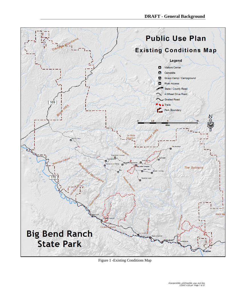
Current Routes and Campsites The Existing Conditions map, Figure 1, depicts the locations and spatial arrangements of the current recreational elements at the park. Presently there are:
o ±39 miles of graded road o ±16 miles of 4-wheeled drive road o ±68 miles of trail o 12 Individual primitive campsites o 2 Group campsites o 2 Campgrounds
d:\projects\bbr_p152\ww\bbr_pup_rev2.doc 1/19/07 4:26 pm Page 6 of 37
DRAFT - General Background
Figure 1 -Existing Conditions Map
d:\projects\bbr_p152\ww\bbr_pup_rev2.doc 1/19/07 4:26 pm Page 7 of 37

DRAFT - Permit System
Permit System Public access will be allowed only under a permit system. Permits will be issued at four locations; the Big Bend Ranch Complex office and the Ft. Leaton State Historic Site in Presidio, in Barton Warnock Environmental Education Center in Lajitas, and the park headquarters at Sauceda, or may be reserved in advance. Use permits will be classified into two categories, Public and Commercial. Public Permits Permits will be required for all public use. Permits authorizing overnight use will be issued for designated campsites and At-Large use in backcountry zones. Day use permits will be allocated at-large. Entry permits will require a fee payment. Entry permit fees for public and commercial use may utilize differing fee schedules. Any unreserved permits or any cancelled permits will be made available to visitors appearing in person at one of the BBRSP permit sales locations on a first-come, first-served basis. Reviewing orientation materials or viewing an orientation video on the proper use of BBRSP and respect for private lands, followed by signature acknowledgement, is a requirement for receiving any overnight backcountry permit.
Day Use Permits Entry permits allowing day use activities will be issued at-large, i.e. usable for all locations in BBRSP. Designated Campsites A Permit is required to conduct an overnight stay at a Designated Campsite. Permits will be issued for specific Designated Campsites as identified on BBRSP maps and listed in Table 5. Permits may be reserved in advance. Overnight visitors are required to stay in the reserved or assigned designated campsite of their choosing, or available. If the visitor itinerary includes multiple campsites the permit must include the list of campsites and date(s) of occupancy. Back Country At-Large Camping Public permits are available for overnight visitation in Back Country Zones. Table 1 details the breakout of permits per Zone. The permit allows At-Large camping anywhere in a specific Zone subject to the campsite selection criteria defined in this document and /or amended by the superintendent of BBRSP. Continuous overnight use in a single Zone may not exceed seven nights. Total overnight use is limited to fourteen consecutive days. Back Country Zone overnight group size is limited to six (6) persons. A permit must include the Zone(s) and date(s) of visitation.
d:\projects\bbr_p152\ww\bbr_pup_rev2.doc 1/19/07 4:26 pm Page 8 of 37

DRAFT - Permit System
Commercial Permits Commercial permits will only be issued to outfitters possessing a concession contract with Texas Parks & Wildlife to operate in the BBRSP. To expand visitor opportunities in experiencing BBRSP, and assist in sustaining successful private enterprise consistent with the mission of TPWD, one overnight permit per Zone may be retained by the park superintendent for commercial ventures providing guided use of the area. The following criteria apply to all commercial use regardless of the number of licensed commercial outfitters operating in BBRSP.
Backcountry Commercial Use Permit Criteria Limit of one reserved permit per zone per commercial outfitter.
Release of Commercial Retention Calendar dates not reserved under commercial permits for Backcountry Zones at least two days prior to trip initiation will revert to Public Permits. A Public Permit issued under this circumstance will terminate when a prior commercial reservation applies.
d:\projects\bbr_p152\ww\bbr_pup_rev2.doc 1/19/07 4:26 pm Page 9 of 37
DRAFT - Public Use and Management Zones
Public Use and Management Zones Use Zones Twenty Use Zones have been defined for BBRSP by existing ranch-heritage fence lines, geographic features (escarpments and drainages) and existing roads. Each zone has been named for a prominent geographic feature or a vernacular legacy name. The Zones are listed in Table 1 below. All visitor management, uses and capacities will be defined in terms of these Zones.
Front Country Zones (FCZ) Front Country Zones are an overlay zone defined as those lands within one-quarter mile of publicly accessible roads or land tightly circumscribed by these roads. Overnight use in the Front Country will occur only in designated locations. Backcountry Zones (BCZ) Backcountry at BBRSP is defined as lands not within one-quarter mile of open publicly accessible Front Country roads. Backcountry Zones will initially provide defined trails developed by historic use, primarily remnant double track roads and game trails. Future trail and campsite development is proposed to enhance visitor use of the park. These zones offer an eminent opportunity to experience an environment showcasing minimal imposition by modern human occupation and a high potential for solitude. Overnight use is programmed to occur At-Large in each BCZ, subject to defined restrictions and as limited by available permits.
d:\projects\bbr_p152\ww\bbr_pup_rev2.doc 1/19/07 4:26 pm Page 10 of 37

DRAFT - Public Use and Management Zones
Figure 2 -Backcountry Zones Map
d:\projects\bbr_p152\ww\bbr_pup_rev2.doc 1/19/07 4:26 pm Page 11 of 37

DRAFT - Public Use and Management Zones
Zone Capacities Backcountry Zone capacities were established to protect the park visitor’s feeling of solitude and remoteness. A density of 2.5 people per 1000 acres was established as the target population. In comparison, the Big Bend National Park averages a 3 people per 1000 acres density in backcountry zones. The capacity value was then divided by the established maximum backcountry group size of 6 individuals to establish the number of backcountry permits per zone. In all instances the resultant value was rounded. The permits address overnight At-Large backcountry use only. Day visitors or overnight visitors occupying Designated Campsites are not subject to the At-Large permit system.
Table 1 – Backcountry Zones
Backcountry Zones Zone Name Acres At-Large Permits
Agua Adentro 20,158 8 Alamito 21,015 9 Blue Range 17,639 7 Bofecillos 17,875 7 Botella 22,609 9 Calera 13,858 6 Cienega 14,549 6 Contrabando 21,981 9 Fresno 15,973 7 Javalin 16,964 7 Leyva 17,036 7 Llano 13,619 6 Los Alamos 9,475 4 Palo Amarillo 21,987 9 Panther 17,676 7 Rio Bravo 18,388 8 Santana 20,397 8 Solitario 12,199 5 Terneros 15,966 7 Upper Fresno 9,191 4
d:\projects\bbr_p152\ww\bbr_pup_rev2.doc 1/19/07 4:26 pm Page 12 of 37

DRAFT - Public Use and Management Zones
Overnight Visitation All overnight uses will require a use permit. Permits will be issued at four locations; the Big Bend Ranch Complex office and the Ft. Leaton State Historic Site in Presidio, in Barton Warnock Environmental Education Center in Lajitas, and the park headquarters at Sauceda, or may be reserved in advance. Any unallocated permits or any cancelled permits will be made available to visitors appearing in person at the Big Bend Ranch Office Complex on a first-come, first-served basis. The maximum stay per permit is 14 nights.
Designated Camping Sixty-two locations have been designated in fourteen backcountry zones for vehicle accessible camping. These campsites are situated with immediate or adjacent vehicle access to the campsite. The explicit designation of campsites confines intensive use to already-disturbed areas, provides a distinctly defined location and extent where camping is acceptable, and limits any adverse impact to resources and other campers. Short spur roads may be constructed in instances where old roads are not available. Located in an attractive location, each site will include a defined parking pad, a clear area for a tent, picnic table and fire ring. Campers will be required to place tents only in the designated area and will also be required to use self-supplied portable toilet facilities. These campsites may be reserved and used by any park visitor for overnight use.
Table 2 – Individual Designated Backcountry Campsites
Individual Campsites - Backcountry Camp Name Type Water Status Phase Backcountry Zone
Calcite Campsite New Initial Llano Cat Springs Campsite Yes New Future Alamito Cerro Boludo Campsite New Initial Llano Cienega 1 Campsite New Future Cienega Cienega 2 Campsite New Future Cienega Cienega 3 Campsite New Future Cienega Elephante Campsite New Initial Panther Escondido 1 Campsite New Initial Leyva Escondido 2 Campsite New Initial Leyva Fresno 1 Campsite New Future Fresno Fresno 2 Campsite New Future Fresno Guale 1 Campsite New Future Panther Guale 2 Campsite New Future Bofecillos Guale 3 Campsite New Future Bofecillos Jackson 1 Campsite New Future Upper Fresno Jackson 2 Campsite New Future Upper Fresno Jackson 3 Campsite New Initial Upper Fresno Jackson 4 Campsite New Initial Upper Fresno Javaline 1 Campsite New Initial Panther Javaline 2 Campsite New Future Javalin La Mota 1 Campsite New Initial Leyva La Mota 2 Campsite New Initial Leyva La Posta 1 Campsite New Initial Upper Fresno La Posta 2 Campsite New Future Upper Fresno
d:\projects\bbr_p152\ww\bbr_pup_rev2.doc 1/19/07 4:26 pm Page 13 of 37

DRAFT - Public Use and Management Zones
Individual Campsites - Backcountry Camp Name Type Water Status Phase Backcountry Zone
La Posta 3 Campsite New Future Upper Fresno La Posta 4 Campsite New Future Upper Fresno Las Burras 1 Campsite New Initial Agua Adentro Las Burras 2 Campsite New Initial Bofecillos Las Burras 3 Campsite New Initial Bofecillos Las Burras 5 Campsite New Initial Bofecillos Los Alamos 1 Campsite New Initial Los Alamos Mexicano 1 Campsite New Future Javalin Mexicano 2 Campsite New Future Javalin Mexicano 3 Campsite New Future Javalin Mexicano 4 Campsite New Future Javalin Mexicano 5 Campsite New Future Javalin Papalote Llano Campsite Yes Existing Initial Llano Papalote Nuevo Campsite Yes New Initial Upper Fresno Rancharias 1 Campsite New Future Panther Rancharias 2 Campsite New Future Panther Rancharias 3 Campsite New Future Panther Tascate 1 Campsite New Initial Panther Tascate 2 Campsite New Initial Panther Tascate 3 Campsite New Initial Panther Yedra 1 Campsite New Initial Agua Adentro Yedra 2 Campsite New Initial Agua Adentro
Table 3 – Equestrian Oriented Designated Backcountry Campsites
Equestrian Oriented Campsites - Backcountry
Camp Name Type Water Status Phase Backcountry Zone
Jackson Pens Equestrian Staging Campsite Yes New Initial Los Alamos
Javaline Camp Equestrian Staging Campsite Yes New Initial Javalin
Table 4 – Group Oriented Designated Backcountry Campsites
Group Campsites - Backcountry
Camp Name Type Water Status Phase Backcountry Zone
Chupadero Springs Group Camp Yes New Future Cienega Escondido 3 Group Camp New Initial Leyva Las Burras 4 Group Camp New Initial Bofecillos Los Alamos 2 Group Camp New Initial Los Alamos Tres Papalotes Group Camp Yes New Initial Solitario
d:\projects\bbr_p152\ww\bbr_pup_rev2.doc 1/19/07 4:26 pm Page 14 of 37

DRAFT - Public Use and Management Zones
Table 5 – Designated Front Country Campsites
Front Country Campsites
Name Type Water Status Phase Backcountry Zone
Bofecillos Arrival Campground New Initial Calera
Madera Canyon Campground Composting Toilet Existing Initial Santana
Grassy Banks Campground Composting Toilet Existing Initial Santana
Colorado Canyon Campground Composting Toilet Existing Initial Rio Bravo
Puerto Llano Campsite New Initial Agua Adentro Encino Campsite New Initial Upper Fresno Papalotito Colorado Campsite Yes Existing Initial Agua Adentro
Agua Adentro Pens
Equestrian Staging Campsite Yes Existing Initial Agua Adentro
Botella Pens Equestrian Staging Campsite Yes New Initial Botella
Cienega Pens Equestrian Staging Campsite Yes New Future Cienega
Contrabando Group Camp None Existing Initial Controbando
Arenosa Group Camp Composting Toilet Existing Initial Rio Bravo
Pila Montoya Group Camp Existing Initial Upper Fresno South Leyva Group Camp Existing Initial Leyva
d:\projects\bbr_p152\ww\bbr_pup_rev2.doc 1/19/07 4:26 pm Page 15 of 37

DRAFT - Public Use and Management Zones
Designated Vehicle Camping Use Limits - Front and Backcountry Sites Individual Campsites
Permit required, one permit per campsite Up to 8-person occupancy Three-vehicle limit Maximum length of stay is fourteen days Use of generators is prohibited Must utilize self-supplied toilet facility Pack-out all trash
Group Camps
Permit required, one permit per campsite Up to 12-person occupancy Five-vehicle limit Maximum length of stay is 14 days Use of generators is prohibited Must utilize self-supplied toilet facility Pack-out all trash
Equestrian Staging Campsites
Permit required, one permit per campsite Up to 24-person occupancy Twelve-vehicle limit Maximum length of stay is 14 days Use of generators is prohibited Must utilize self-supplied toilet facility Pack-out all trash
d:\projects\bbr_p152\ww\bbr_pup_rev2.doc 1/19/07 4:26 pm Page 16 of 37

DRAFT - Public Use and Management Zones
Figure 3 -Campsite Map
d:\projects\bbr_p152\ww\bbr_pup_rev2.doc 1/19/07 4:26 pm Page 17 of 37

DRAFT - Public Use and Management Zones
At-Large Backcountry Camping At-large or undesignated site camping will be allowed in backcountry zones in BBRSP. At-Large camping allows the overnight visitor to select their own campsite, based upon certain required conditions. These requirements for campsite selection are listed in Table 6. When feasible, designated sites may be developed in the various Backcountry Zones accompanied by changes in the prescribed public use in these zones. Backcountry overnight permits will be issued for specific zones. Visitor travel plans that include multiple zones must include all affected zones on the permit. The Table1 lists the number of At-Large overnight permits allowed in each Zone. Table 8 lists the number of parking space allocations for each trailhead. In frequently used backcountry campsites, human waste is not only an aesthetic issue, but also can result in unacceptable resource impacts and public health problems. Under the present scope of this plan backcountry campers may dispose of solid human waste in a ‘cathole.’ Used toilet paper, feminine hygiene products, diapers, or any other product must be carried out of the park in a sanitary manner, such as self-sealing plastic bags. Burning toilet paper is prohibited due to high potential for wildfire.
At-Large Backcountry Camping Use Limits
Permit required, one permit per group Up to 6-person group size Two-vehicle limit Maximum length of stay is seven consecutive
days in any one zone, total limit of fourteen consecutive days of overnight use
Pack-out all trash
Table 6 – At-Large Backcountry Campsite Selection Criteria
At-Large Backcountry Campsite Selection Criteria
Independent campsites may be no closer than ¼ mile to any other existing campsite 300 feet from water sources, including seeps, potholes, springs, and streams 300 feet away from all prehistoric or historic cultural sites, including alcoves,
pictographs & petroglyphs, identifiable surface scatters of lithics or ceramics, partial or complete structures or ruins
At least one mile from trail heads or roads Within the zone for which the permit was issued Left with the least possible evidence of use and the least possible environmental
degradation Accessed by the least impacting route, i.e., visitors should use game trails, arroyo’s,
or unvegetated areas to reach campsites Selected on previously disturbed areas, surfaces without cryptobiotic soil crusts,
and in visually non-prominent locations
A cathole, by definition, should be a small hole excavated 6 to 8 inches deep and at least 300 feet from water sources (included seeps, potholes, springs, streams) or potential water sources (arroyos or dry washes) that is covered after use.
d:\projects\bbr_p152\ww\bbr_pup_rev2.doc 1/19/07 4:26 pm Page 18 of 37

DRAFT - Public Use and Management Zones
Trail System and Cross-country Hiking The proposed trail system at BBRSP is an extensive and ambitious one. It encompasses the current existing trails and extends that system out across large expanses of the park. A goal of this proposed trail system is to provide trails and routes that capture the spirit of the land and are accessible where practicable, challenging, educational, and scenic. The intent of the trail system is to establish and maintain trails that provide interpretive, educational, and enjoyable opportunities to the broadest practicable spectrum of visitors who have chosen to leave paved sidewalks and roads behind. The trails here offer varying levels of accessibility and challenge to persons of all ages and abilities. Cross-country hiking will be allowed in all Backcountry zones. However, TPWD may restrict off trail hiking to protect sensitive resources. The current trail system comprised of various trails, totals 68 miles in length. The bulk of the system is found in the Rancharias Loop, and the Contrabando area of the park. The Initial phase of the plan details an addition of 83 miles of trail. The Future phase adds another 90 miles to the park. Ultimately the trail system will consist of 242 miles of interconnected trails.
Trails and walks provide the only means of accessing many areas within a State Park. However, trails are not simply avenues for getting from one place to another. Trails offer park visitors a more intimate rapport with the outdoors and the opportunity to participate in numerous recreational activities. Trail users have special interests and desires to pursue specific trail related activities. These pursuits may range from observing scenic views, to socializing with others sharing a common interest, to nature study and outdoor education, to personal solitude and reflection. The primary goal of a quality trail is providing opportunities and enjoyable access to a variety of areas while protecting the resource. Ideally, a trail should reflect the mood and atmosphere of the area it traverses without compromising the adjacent resources.
Trail System Name Status Phase Miles
Arroyo Primero Existing Future 5.56 Bofecillos Loop New Future 6.54 Bofecillos Peak New Future 2.7 Bofecillos Spur New Future 0.33 Botella Existing Initial 17.35 Burnt Camp Existing Future 4.43 Camino Viejo Existing Current 9.91 Casa Ramon East Existing Future 4.87 Casa Ramon West Existing Initial 2.9 Chimney Rock Existing Future 6.39 Cienega Existing Initial 10.16 Cinco Tinajas Existing Current 0.9 Closed Canyon Existing Current 0.71 Controbandista's Existing Current 1.2 Controbando Creek Loop Existing Current 3.49 Controbando Dome Existing Current 4.49 Controbando System Existing Current 0.9 Crystal Existing Current 1.49 Cueva Larga Existing Initial 0.17
Table 7 – Trail System
d:\projects\bbr_p152\ww\bbr_pup_rev2.doc 1/19/07 4:26 pm Page 19 of 37

DRAFT - Public Use and Management Zones
Trail System Name Status Phase Miles
Dog Cholla Existing Current 1.4 East Yedra Existing Initial 1.39 East Yedra Spur Existing Initial 0.2 Encino Existing Current 7.99 Guale Connector Existing Initial 0.6 Guale Overlook Existing Initial 0.71 Horsetrap Spring Existing Current 4.71 Jackson Existing Initial 1.59 Leyva Canyon Existing Future 4.06 Leyva Loop Existing Future 1.31 Limestone Vista Existing Current 0.16 Los Alamos Cutoff Existing Initial 1.38 Lower Shutup New Future 3.97 Lower Shutup Existing Future 0.75 Madrid House Existing Future 6.39 Manzanillo Existing Future 8.9 Masada Existing Future 10.36 Ojito Adentro Existing Current 0.66 Ojito Adentro Cutoff Existing Future 1.78 Old Entrance Road Existing Initial 7.65 Panther Existing Initial 5.51 Rancharias Canyon Existing Current 4.96 Rancharias Connector - North Existing Current 0.75 Rancharias Connector - South Existing Current 0.25 Rancharias Loop Existing Current 20.61 Rancho Viejo Existing Current 0.6 Right Hand Shutup New Future 3.37 Rock Quarry Existing Current 1.05 Sauceda Nature Loop Existing Current 0.77 Severo Loop Existing Future 8.49 Severo Loop Cutoff Existing Future 0.13 Smith/Crawford Existing Future 8.02 Solitario Loop Existing Initial 11.79 Stone Corral Bypass Existing Current 1.46 Terneros Existing Initial 9.19 Terneros Connector Existing Initial 0.79 Twin Walls Existing Initial 3.74 Upper Leyva Existing Initial 2.15 West Yedra Existing Future 2.09 Yedra Canyon Existing Initial 4.19 Yedra Jump Existing Initial 1.7 Sub Totals
Current 68.46 Initial 83.16 Future 90.44
Total Trail System 242.06
d:\projects\bbr_p152\ww\bbr_pup_rev2.doc 1/19/07 4:26 pm Page 20 of 37

DRAFT - Public Use and Management Zones
Figure 4 -Trail System Map
d:\projects\bbr_p152\ww\bbr_pup_rev2.doc 1/19/07 4:26 pm Page 21 of 37

DRAFT - Public Use and Management Zones
Trailheads Trailheads, perhaps more than any other aspect of the park, create the jumping off point for visitors and thus set the stage backcountry experiences. Trailhead capacity was established by relating the allocated backcountry permits per Backcountry Zone served by each trailhead to the respective trailhead.
Table 8 – Trailheads
Trailheads
Name
Permitted Vehicle Count Status Phase
Arroyo Primero Trailhead 12 New Future Barton Warnock Trailhead 12 Existing Initial Bofecillos Trailhead 12 New Initial Botella Trailhead 18 New Initial Casa Piedra Road Trailhead 18 New Initial Cienega Trailhead 12 New Future Cinco Tinajas Trailhead 6 Existing Initial Closed Canyon Trailhead 6 Existing Initial Fresno Canyon Trailhead 12 Existing Initial Jackson Pens Trailhead 12 New Initial JavalinaTrailhead 12 New Initial Las Burras Trailhead 6 New Initial Leyva Trailhead 6 New Initial McGurks Tanks Trailhead 12 New Initial Napalero Trailhead 6 New Initial Ojito Adentro Trailhead 6 Existing Initial Puerto Chilicote Trailhead 6 New Initial Rancharias East Trailhead 6 Existing Initial Rancharias West Trailhead 12 Existing Initial Rancho Viejo Trailhead 12 Existing Initial Right Hand Shutup Trailhead 12 New Initial Rincon Trailhead 6 New Future Tres Papalotes Trailhead 18 New Initial Yedra Trailhead 12 New Initial
d:\projects\bbr_p152\ww\bbr_pup_rev2.doc 1/19/07 4:26 pm Page 22 of 37

DRAFT - Public Use and Management Zones
Figure 5 -Trailhead Map
d:\projects\bbr_p152\ww\bbr_pup_rev2.doc 1/19/07 4:26 pm Page 23 of 37

DRAFT - Public Use and Management Zones
Backcountry Caches Extended backcountry trips in BBRSP may be facilitated by caching food and water supplies. Backcountry users are encouraged to carry or cache sufficient food and water to ensure successful completion of their trip. Caches must be secured in a manner that does not damage natural or cultural resources. Caching of food and water requires written permission of the Site Superintendent. Cache permits, along with Backcountry Use Permits, may be obtained at four locations; the Big Bend Ranch Complex office and the Ft. Leaton State Historic Site in Presidio, in Barton Warnock Environmental Education Center in Lajitas, and the park headquarters at Sauceda. The owner’s name and address and the date the cache is to be retrieved by the owner must be clearly visible on the cache. Caches not retrieved within 30 days of the date posted on the cache may be picked up and disposed of by park staff without notice to the owner. The owner may be billed for cleanup of the cache and is subject to citation for abandoning property within the park.
d:\projects\bbr_p152\ww\bbr_pup_rev2.doc 1/19/07 4:26 pm Page 24 of 37

DRAFT - Public Use and Management Zones
Day Use Permits will be required for all day use entry into BBRSP. Permits may be acquired at four locations; the Big Bend Ranch Complex office and the Ft. Leaton State Historic Site in Presidio, in Barton Warnock Environmental Education Center in Lajitas, and the park headquarters at Sauceda.
Use Limits Day Use permits will be regulated by the available number of parking spaces at the designated trailheads. The number of day-use permits is limited to 2/3 of the allocated spaces per each trailhead.
Hiking Hiking is encouraged and represents a remarkable approach to view and appreciate BBRSP. It is recommended that Day visitors employ existing trails, and the open and closed roads for non-motorized travel in the park. However, cross-country hiking is permitted. Mountain Biking (MTB) In general, mountain biking will be allowed on all existing roads including those closed to vehicular traffic and existing trails. Additionally, TPWD staff may limit access to selected trails where continued use is not consistent with resource management or is deemed a health and safety issue. Competition-based or intensive sport trail riding and mountain biking will not be permitted. Cross-country biking is not permitted.
Pack and Saddle Stock Use Horseback represents an additional method to view and appreciate BBRSP. Equestrian activities will be allowed in all areas of the park unless specifically designated for exclusion. Pack and saddle stock is defined as horses, burros or mules. All pack and saddle stock users must obtain a backcountry use permit, whether for day-use or overnight. Overnight permits are regulated by the available permits per backcountry zone. Day-Use permits are regulated by number of available parking spaces at the designated trailheads, in the same vein as other park visitors. Overnight use by pack and saddle stock is allowed at all designated campsites. Pack and saddle stock must be tethered a minimum of 75 feet outside of the core campsite. The core campsite is defined as the grouping of the campsite’s picnic table, fire ring and tent pad area. Campers are required to disperse manure before vacating the campsite. If sanitation or safety problems develop, this policy may be modified. Group size for designated campsites is limited to the specific campsite’s designation. For overnight At-Large camping, group sizes are limited to the standard backcountry group size of six individuals with the addition of 10 animals. Day Use group size is limited to 10 individuals and 10 animals. Existing windmills will be evaluated to determine if they would be useful to equestrians for stock watering. All pack and saddle stock are required to be fed pelletized feed or weed free hay for 48 hours in advance of and for the duration of the trip to prevent the spread of exotic plant species. Park vegetation may not be consumed.
d:\projects\bbr_p152\ww\bbr_pup_rev2.doc 1/19/07 4:26 pm Page 25 of 37

DRAFT - Public Use and Management Zones
Climbing and Bouldering Rugged craggy highly fractured rock is common at BBRSP. Predominantly, the rock does not offer favorable approaches and most bluffs are unstable. Notwithstanding, technical and free climbing will be allowed by permit. Any and all climbing activities are prohibited in rock shelters or at petroglyphs / pictograph sites. To preserve the beauty of the SP and offer the opportunity for climbers to experience solitude, sport and the challenge of climbing on “undeveloped rock”, rock climbing is permitted under the following regulations:
Use of removable anchors only. Fixed anchors / bolts are prohibited Associated camping must be by permit and campsite selection must follow requirements
for At-Large camping. Limited use of chalk (white, without additives.) No climbing where archaeological sites, fragile vegetation or soils and wildlife
populations would be impacted or in areas defined as No Climb Zones by TPWD staff. Climbers must remove all protection from each climbing route upon conclusion of the
climb. Permits are required and a limited number issued per year. Commercially guided climbing is permitted subject to all applicable use requirements
described in this document. Local Area Closures Restrictions that span all management zones are:
the use of soap/detergents is prohibited in springs, natural pools, or flowing waterways the defiling of caves and rock shelters the entering into mines, adits, or associated earth works, or any other area specifically delineated as closed to limited or all public use.
Access Access to BBRSP will be through controlled gates at all entry points.
d:\projects\bbr_p152\ww\bbr_pup_rev2.doc 1/19/07 4:26 pm Page 26 of 37

DRAFT - Facilities and Operation
Facilities and Operation Fires
Front Country Fires are permitted at Designated Vehicle Camping campsites only. The collection of wood for any purpose is specifically prohibited. Firewood in a desert environment is sparse and is critical to desert ecology. Charcoal cooking fires and containerized fuel stoves will be allowed at Designated Vehicle Camping campsites only. All fires must be built in the supplied fire ring at the campsite. The park manager may limit or suspend the authorization to have charcoal fires. Backcountry Fires are permitted at Designated Vehicle Camping campsites only. No open fires are permitted in At-Large camping in the Backcountry. Use of containerized fuel stoves is permitted. Backcountry users must pack-out any empty fuel bottles, cans, or cells used to store fuel.
Road Maintenance and Development Presently ±621 miles of road, in various drivable states, exist in the park. This Use Plan specifies the continued use of just over 129 miles of road for front and backcountry access. The main park road is currently maintained as a two-lane graded gravel/dirt road passable by most vehicles. The remaining roads are in various states of accessibility traveling these roads will require four-wheel drive vehicles. These four-wheel drive roads will remain unimproved. Only in circumstances where the roads become impassable will maintenance and repairs be considered. BBRSP visitors must be mindful of this level of road maintenance, the proper vehicle to traverse these roads, and the likely impact to the vehicles appearance and mechanical components from the road conditions. Although these are designated roads, the BBRSP is considered a primitive state park with a road system reflecting that nature. Beyond the extant roads, only short campsite spurs will be established, where necessary, to provide access to the designated drive-in campsites. Each campsite spur shall have the required environmental and cultural resource clearances prior to construction. The use of public motorized vehicles is limited to designated roads and only utilizing vehicles licensed and inspected as authorized by Texas Motor Vehicle Laws. All terrain vehicles (ATV’s) and Off-road Vehicles (ORV’s) are not permitted.
Road Closures Existing roads/double track routes not identified as part of the road system will be closed to public motorized vehicular traffic. A majority of these will be incorporated into the trail system. In general, closed roads shall be managed towards conversion to a single-track trail. Roads not authorized for public motorized vehicle traffic will be clearly designated on site. Selected routes may be retained for administrative vehicular access.
d:\projects\bbr_p152\ww\bbr_pup_rev2.doc 1/19/07 4:26 pm Page 27 of 37

DRAFT - Facilities and Operation
Figure 6 -Road System Map
d:\projects\bbr_p152\ww\bbr_pup_rev2.doc 1/19/07 4:26 pm Page 28 of 37

DRAFT - Facilities and Operation
Signage Signage design consistent with TPWD standards will be installed. Signage should be kept to the minimal number of signs required to direct and inform the general public.
Location & Information Each designated facility or location shall be identified with appropriate signage. Trailhead signage should incorporate trail logs for visitor and administrative use. Boundary Standard TPWD boundary markers should be installed on existing fencing where the fencing corresponds to property boundaries. Boundary information signs shall be placed in locations where cross-country travel is anticipated and errant trespass might occur without other visual landmarks. These locations are most likely associated with drainage ways extending up remote canyons, along established fence lines, and at double-track road intersections.
Trash All backcountry visitors to BBRSP will pack out all trash and garbage (including toilet paper). Garbage cans will be available for visitor use while occupying the Sauceda Lodge and the Big House. Pets All pets are prohibited in the backcountry of BBRSP. In front country areas the Rules and Regulations for State Parks apply. Guide or assistance dogs accompanying a person with disabilities are not considered pets and are not prohibited. Noise BBRSP is a primitive state park. A central premise to the site is the opportunity to experience nature and solitude. Sound travels great distances in this desert and mountain setting. Noise generated by camp activities must not be at such a level to be heard by or disturb other visitors. At no time should audio devices be audible outside of a vehicle or campsite. Quiet hours are from 10 P.M. to 6: A.M. local time. Operation of generators in the backcountry is strictly prohibited.
“And the natural world - our traditional source of direct insights - is rapidly disappearing. Modern city-dwellers cannot even see the stars at night. This humbling reminder of man's place in the greater scheme of things, which human beings formerly saw once every twenty-four hours, is denied them. It's no wonder that people lose their bearings, that they lose track of who they really are, and what their lives are really about.”
- Michael Crichton
Light and Night Sky Light pollution has become an increasing concern, not only to those studying the stars but also to the general public. The glow of urban lights has removed the beauty of the night sky, the universe, from most of the public. Consistent with the solitude and wilderness of BBRSP, lighting requirements will be enacted to protect the night sky for all visitors. Improper night
d:\projects\bbr_p152\ww\bbr_pup_rev2.doc 1/19/07 4:26 pm Page 29 of 37

DRAFT - Facilities and Operation
illumination causes not only “Light Trespass” but has also been associated with adverse effects on wildlife such as disorientation, attraction, fixation and repulsion. All lighting used in developed campsites will be required to use shielding to limit illumination to immediate local of the site. Lantern hangers installed by TPWD will incorporate shield or fixture mountings to direct all light at an angle below the horizon. Lighting utilized in the backcountry is under similar restrictions to confine nighttime illumination to only what is needed. Water Use Water resources are scarce in this desert environment, yet vital to all forms of life. The following regulations for human use of water help to protect the water sources for all:
All campsites, unless designated by the TPWD, must be at least 300 feet away from water sources (including seeps, potholes, springs, and streams).
Saddle and pack stock must be staked at least 300 feet from water sources where possible.
Only biodegradable soaps may be used, and they must be used at least 100 feet away from water sources.
The use of soap/detergents is prohibited in springs, natural pools, or flowing waterways. Rinsing dishes or other equipment directly into water sources is prohibited. A water source may not be emptied or depleted for human use.
Grazing Livestock grazing is not permitted. Programs will be implemented to restore the landscape to a natural condition. The existing Big Bend Ranch longhorn herd is excepted from this provision. Commercially Guided Tours The Department believes that commercially guided tours on the State Park can promote public access for those individuals apprehensive of such a primitive site or who may be looking for a recreational experience that they are unable to facilitate themselves. Texas Parks and Wildlife Department may issue a Request for Proposals (RFP) to provide commercial guide service in Big Bend Ranch State Park. Potential services may include: equestrian trips, mountain bike tours, camp outs, nature/birding hikes and art and photography classes. Guided commercial tours will also provide an additional source of revenue for the Department. Commercially guided tours are defined as organized trips with one or more accompanying guides leading an individual or group of individuals onto the state park for the purpose of profit or where there has been public advertising to attract paying participants. Commercial use is subject to all restrictions and regulations required of the general public in addition to those required through concession contracts. All commercial operations must be authorized through a concession contract administered by the Parks Division. New activities that develop over time can be added to the list of allowable guide service activities after review by TPWD. Criteria will be established to evaluate applicant’s ability to provide the proposed service and to make appropriate selections. Insurance requirements and any other conditions of business conducted on State-owned property will follow the Standard Guide Service Concession Contract policy.
d:\projects\bbr_p152\ww\bbr_pup_rev2.doc 1/19/07 4:26 pm Page 30 of 37

DRAFT - Facilities and Operation
Educational/Nonprofit Groups Texas Parks and Wildlife Department may establish guidelines for the use of BBRSP by educational and nonprofit organizations. Use by organizations in these categories will be encouraged. Criteria to evaluate requests for fee waivers will be established, and in general, any waiver or reduction granted in the use fee must be offset by in-kind services such as trail or sign maintenance and research activities. Special Use Permits Texas Parks and Wildlife Department will establish guidelines and protocols to deal with requests for special uses of the park. All special use requests must demonstrate that the proposed activities are compatible with Department programs and the park’s purpose. All special uses will be managed through a permit system and shall not adversely impact resources or displace other user groups. Fees for Special Use Permits will be set to cover the cost associated with the administration of the permit or activity. Research Texas Parks and Wildlife Department has established guidelines and protocols to allow scientific research in the park. All research activity addressing natural resources shall require a Scientific Research Permit issued by the Parks Division Natural Resources Program (in Appendix). Proposals for cultural research projects or programs must contact the State Parks Division Cultural Resources Program Director. All cultural investigations are subject to the provisions of the Antiquities Code of Texas. Boundary Adjustments, Inholdings, and Rights-of-Way Agreements will be negotiated with willing adjacent landowners with the goal of establishing existing fence lines nearest the park boundary as management boundaries for all recreational use. Such agreements may also provide for fence maintenance by park staff to control livestock. In critical locations, new fence may be constructed for delineating public use areas and protecting park resources and adjacent private lands. Presently there are private property inholdings inside the park’s administrative boundary.
d:\projects\bbr_p152\ww\bbr_pup_rev2.doc 1/19/07 4:26 pm Page 31 of 37

DRAFT - Natural and Cultural Resources Overview
Natural and Cultural Resources Overview Overview Big Bend Ranch State Park in Presidio and Brewster Counties between Presidio and Lajitas, Texas is in the northern Chihuahuan Desert. The park contains almost 300,000 acres and has about 23 miles of river frontage along the Rio Grande, the international boundary between Texas and Mexico. Elevations range from about 2,350 feet along the Rio Grande to over 5,000 feet at Oso Mountain and Fresno Peak. Climate is typical of a high desert setting with hot summers, mild winters and low annual precipitation. The geologic history of Big Bend Ranch ranges over 600 million years and presents a unique geologic story. Big Bend Ranch State Park contains bedrock exposures ranging from Paleozoic deep-marine sediments to tuffs, rhyolites and basalts that resulted from Tertiary igneous activity. Tectonic activity from the Marathon-Ouachita and Laramide orogenies and present day Basin-and-Range extension has created faults, folds, horsts and grabens to form the rugged terrain that characterizes the landscape. Along with these upheavals were many intrusions and several volcanoes. Deep layers of sedimentary and volcanic deposits between igneous layers capture water thus forming small, perched aquifers. Larger bolsons (self-drained grabens) capture larger amounts of water forming larger, though local, aquifers. These geologic controls provide Big Bend Ranch State Park with many springs despite its desert setting. The relative abundance of groundwater, riparian areas, and the Rio Grande attracted humans to the area as early as 9,000 to 10,000 years ago and, more recently, encouraged sheep, goat and cattle ranchers to settle and work the area. The Big Bend Ranch area is one of the better-watered areas of Trans-Pecos Texas. Natural Resources
Water and Hydrology Springs are a key natural resource of BBRSP. Over 100 springs, mostly in the Fresno and Terneros Creek drainages, have been recorded. It is probable that more await discovery around the Bofecillos volcanic platform. Many of the park’s creeks are ephemeral in nature. However, the larger drainages, such as Alamito and Cienega Creeks, have permanent stream flow. All of the drainages in BBRSP are part of the Rio Grande drainage basin; all are subject to flash flooding. A census of wells and windmills is in progress in the park. An inventory of wells and water levels and a spring survey will provide much needed information about groundwater reserves in local aquifers. Vegetation Big Bend Ranch State Park is located in the Trans-Pecos Vegetation Area (Hatch et al., 1990). The flora and fauna are represented by a rich assemblage of species because of the high diversity of life found in the northern Chihuahuan Desert. The natural plant communities at BBRSP can be grouped into four major types:
o A riparian zone found near springs, along drainages and in the Rio Grande corridor. o Mixed desert scrub characterized by an abundance of creosote, ocotillo, cacti and
lechuguilla, a Chihuahuan Desert indicator species. o Desert grassland.
d:\projects\bbr_p152\ww\bbr_pup_rev2.doc 1/19/07 4:26 pm Page 32 of 37

DRAFT - Natural and Cultural Resources Overview
o Open juniper woodland, occurring in only the highest elevations. The mixed desert scrub is by far the most widespread of these communities. It has largely replaced the once dominant desert grasslands. The riparian corridors are of particular importance as areas of high biological diversity. The flora of the park is influenced by elevation and past land use. Overgrazing and browsing, primarily by livestock, has degraded the plant communities within the BBRSP. Even so, fifteen plant community types have been identified. Uplands throughout much of BBRSP are dominated by an open desert scrub habitat with whitethorn acacia (Acacia constricta), mariola (Parthenium incanum) and creosote (Larrea tridentata) being the most common components. Along arroyos and other specialized areas (i.e. along the bases of cliffs) there is dense woody scrub. In areas with deeper soils and on slopes where the effects of livestock grazing were less intrusive, open desert grassland with extensive woody vegetation invasion can be found. Listed threatened species in BBRSP include: Lloyd's Mariposa Cactus (Neolloydia mariposensis) and Hinckley's Oak (Quercus hinckleyi). Wildlife The fauna of Big Bend Ranch State Park is also varied, particularly the mammalian and herpto faunas. Forty-eight species of mammals have been documented from the park, including 16 species of bats with an additional eight more species of bats having the potential to occur within the park. There are at least 30 species of snakes and over 300 species of birds reported from BBRSP and the immediate vicinity. The park is home to a number of state-listed taxa including the zone-tailed hawk (Buteo albonotatus), reticulated gecko (Coleonyx reticulatus), Trans-Pecos black-headed snake (Tantilla cucullata), Texas lyre snake (Trimorphodon biscutatus) and Chihuahua shiner (Notropis chihuahua). Other mammals of interest that have been documented within the boundaries of the park include black bear (Ursus americanus), mountain lions (Felis concolor) and white-nosed coati (Nasua narica). Game species such as mule deer (Odocoileus hemionus) and collared peccary, or javelina, (Tayassu tajacu) are common and offer limited hunting opportunity. Rapidly becoming a threat to soil, water and vegetation resources are increasing populations of aoudad and feral hogs. To date, the hogs are found in the Cienega area along Alamito Creek and aoudad are near the Rio Grande, especially in Tapado Canyon. Cultural Resources Big Bend Ranch Sate Park offers some of the most interesting archeology and history in the region. Only a small percentage of the park has been systematically surveyed for archeological sites; nonetheless, there are presently about 400 documented sites on the property. Many of the known sites are located near water sources but sites also occur on upland areas away from any obvious drainages, springs or tinajas. There is both need and potential at BBRSP for additional archaeological research to be conducted. Current cultural resource inventories for the Park include:
o Location and recordings of prehistoric and historic archaeological sites and features. o Recordings of historic structures, roads and trails linking them to local trade centers. o Audio tape recordings of oral histories from people knowledgeable about the Ranch
before it became part of the Texas Parks and Wildlife system.
d:\projects\bbr_p152\ww\bbr_pup_rev2.doc 1/19/07 4:26 pm Page 33 of 37

DRAFT - Natural and Cultural Resources Overview
o Documentation of past land use patterns. o Documentation of past and present place names and natural features for feature location,
management, and interpretation. The earliest artifacts identified within BBRSP indicate that Native Americans traversed the area by about 9,000 to 10,000 years ago, and continued to do so well into the 19th century. Native American site types attributable to the prehistoric era include open campsites, open camps associated with rock shelters, rock shelters, quarries, lithic scatters, Late Prehistoric Cielo complex (ca. A.D. 1250-1680) sites, rock art sites (primarily pictographs, or rock paintings) and special-use or ritual sites. Many pictographs that have been recorded within the Park are monochromatic red, black, or white. Bichrome and polychrome (red, black, yellow, white) figures also occur. The figures include humans, animals, insects, tally marks, double zigzags, hourglass chains, star patterns and various other abstract motifs. Most of these pictographs were probably painted during the Late Archaic (ca. 1000 B.C. - A.D. 1000) or Late Prehistoric (A.D. 1000 - 1535) periods. Other pictographs represented by human figures on horses, longhorn cattle, Spanish saddles and crosses date to the Protohistoric (ca. A.D. 1535-1700) period or later. Though no early Spanish sites have yet been identified within the park, archival documents indicate that Pedro de Rabago y Teran traveled through the area in 1747 during his search for suitable sites to construct presidios. Beginning in the late 1840’s, subsequent explorers, surveyors, missionaries, traders and freighters followed the Texas Chihuahua Trail which followed Alamito Creek through what is now the northwestern portion of the park. In 1860, topographical engineer 2nd Lieutenant William H. Echols probably led his experimental caravan of 24 camels, 25 pack mules and 31 soldiers down the Terneros Creek valley, which extends across the western and northern areas of BBRSP. This experiment was authorized in the 1850’s by Secretary of War Jefferson Davis to determine if camels could have military applications on the arid western frontier. By the 1880’s several area ranches had been established and Texas Longhorn cattle, goats and sheep became a common sight on the landscape. The local communities of Terlingua and Shafter quickly sprang up in the late 19th- and early 20th centuries with the discoveries of silver and cinnabar. No silver was mined within the boundaries of present-day park, but there are several former cinnabar mines and prospects in the area. Another industrial endeavor pursued in the area was rendering of wax from the native candelilla plant. The ruins of wax-rendering operations, most of which probably date to the first half of the twentieth century, can be seen in the eastern portion of the park. In addition to archeological sites, a number of extant historic structures are located within BBRSP. Among these structures are the buildings at the La Sauceda Ranch complex. The Sauceda ranch house or the “Big House” as it is known today, was constructed in 1908 and remodeled in the 1940’s. Other structures of the historic Sauceda Ranch complex include a former bunkhouse, wool barn, tack barn, stock tank, corrals and various other features. All areas proposed for visitor use in this Public Use Plan will be surveyed for cultural resources in accordance with standards set forth by the Texas Historical Commission. Protection of archeological sites will be achieved primarily through site avoidance, restricting public access, fencing and public education.
d:\projects\bbr_p152\ww\bbr_pup_rev2.doc 1/19/07 4:26 pm Page 34 of 37

DRAFT -
Trails and campsites will be selected after considering their location and proximity to cultural resources. If cultural resources are found along proposed trails or campsites, TPWD will consider revising trail routes or campsite locations to avoid impact to archeological or historical sites. Sites will be monitored to determine impacts that might be caused by public use. Guidelines for treatment of cultural resources are outlined in Texas Natural Resource Code (1977), Title 9, Chapter 191. The Code and Council of Texas Archaeologists guidelines for reporting artifacts and curation will be followed and interpreted for particular applications in the Public Use Plan. The natural and cultural resources of Big Bend Ranch State Park are protected by law. Collection of plants, animals, rocks, or artifacts of any type or quantity is strictly forbidden and can result in fines and/or incarceration.
d:\projects\bbr_p152\ww\bbr_pup_rev2.doc 1/19/07 4:26 pm Page 35 of 37

DRAFT - Appendix
Appendix Scientific Research Permit Procedure Texas State Parks Revised 15 April 2004 DHR/wc 1:34 PM A permit, issued by the TPWD Parks Natural Resources Program, is required for ALL RESEARCH, COLLECTION, AND SCIENTIFIC INVESTIGATION ON LANDS ADMINISTERED BY THE STATE PARKS DIVISION: PARKS, NATURAL AREAS, AND HISTORIC SITES.
Parks Natural Resources Program
Permitting authority is vested in TAC §59.134 (c), (e)(1), (i), (bb), (cc), and (dd). Research objectives and methods must be consistent with park and Department policies and procedures. Investigation/research on or proximate to archaeological or historic resources or where the research requires ground disturbance may require additional permitting authority from the Texas Historical Commission after vetting through the TPW Cultural Resources Program. Requests for permit(s) will be reviewed by the Natural Resources Program staff and/or the park manager on a case by case basis after the following information has been provided:
Name and full contact information for principal investigator and all project participants;
Purpose and benefits of proposed research; potential impacts to any park resources or operations;
Full methods description, including proposed timeframe for fieldwork, exact locations on USGS 7.5’
topographical maps as well as additional maps which may clarify review of the proposal;
Collection deposit location (curated facilities preferred); and,
Timeframe for interim and/or final reports, dissertations/theses, and/or publication.
Permits are issued only for problem-oriented research. Requests for collecting are considered if collection data are needed to supplement baseline inventory. Special access, or in some cases collecting methods and locations, are subject to approval by the site manager. All catch and release activities, including those involving photography, also require permits. These include, but are not limited to, bird/bat mist netting and banding, mammal trapping, fish seining, and reptile and amphibian capture. Permits usually are issued on a calendar year basis, but may be issued for longer or shorter periods depending on the specific project. Permit renewal is not automatic and must be requested. THE PERMITTEE IS REQUIRED TO PROVIDE THE NATURAL RESOURCES PROGRAM WITH A REPORT OR PUBLICATION ON THE RESEARCH PROJECT. Depending on the type of research request, federal and/or TPW Scientific Permits also may be required. If a TPW statewide Scientific Permit is issued, a State Park Research permit is still required for any work on state parks and may have more restrictive provisions than the statewide permit. The statewide permit is the umbrella permit, but contains a clause (13c) that states the permit is not valid on State Parks. Researchers conducting investigations for other state or federal agencies or who may be conducting investigations under contract to the Natural Resources Program also are issued permits.
Permits are generally issued within 2 weeks, once the required information is provided (e-mail preferred).
Requests for State Park Research Permits may be made via e-mail to [email protected]
FAX 512/389-4495 or by a letter to David H. Riskind, Natural Resources Program
Texas Parks and Wildlife, 4200 Smith School Road, Austin TX 78744

January 2007
Dispersal of this publication conforms to the Texas State Documents Depository Law, and it is available at Texas State Publications Clearinghouse and Texas Depository Libraries.