beu strategic fire plan 2012 -...
TRANSCRIPT

Last update: 14 June 2012
Unit Strategic Fire Plan
San Benito-Monterey

i
Last update: 14 June 2012
UNIT STRATEGIC FIRE PLAN AMENDMENTS
Date Section Updated Page Numbers
Updated Description of Update
Updated By

ii
Last update: 14 June 2012
Table of Contents
Table of Contents ........................................................................................................................ ii
SIGNATURE PAGE ................................................................................................................... 1
EXECUTIVE SUMMARY ........................................................................................................... 2
SECTION I: UNIT OVERVIEW .................................................................................................. 3
UNIT DESCRIPTION ........................................................................................................... 3
UNIT PREPAREDNESS AND FIREFIGHTING CAPABILITIES ........................................... 4
SECTION II: COLLABORATION ............................................................................................... 6
COMMUNITY / AGENCIES / FIRE SAFE COUNCILS ......................................................... 6
A: VALUES .......................................................................................................................... 7
B: COMMUNITIES ....................................................................................................................17
SECTION IV: PRE-FIRE MANAGEMENT STRATEGIES..........................................................18
A: FIRE PREVENTION .............................................................................................................18
ENGINEERING & STRUCTURE IGNITABILITY .......................................................................19
INFORMATION AND EDUCATION ...........................................................................................20
B. VEGETATION MANAGEMENT ............................................................................................21
SECTION V: PRE- FIRE MANAGEMENT TACTICS ................................................................24
DIVISION / BATTALION / PROGRAM PLANS ..........................................................................24
APPENDIX A: PRE- FIRE PROJECTS ....................................................................................36
APPENDIX B: UNIT GOALS AND OBJECTIVES ......................................................................51
APPENDICES C-Z ....................................................................................................................52
EXHIBITS: MAPS .....................................................................................................................53
SUPPLEMENT: 2012 ...............................................................................................................62

1
Last update: 14 June 2012
SIGNATURE PAGE
Unit Strategic Fire Plan developed for San Benito-Monterey Unit:
This Plan:
Was collaboratively developed. Interested parties, Federal, State, City, and County agencies within the Unit have been consulted and are listed in the plan.
Identifies and prioritizes pre fire and post fire management strategies and tactics meant to reduce the loss of values at risk within the Unit.
Is intended for use as a planning and assessment tool only. It is the responsibility of those implementing the projects to ensure that all environmental compliance and permitting processes are met as necessary.
Unit Chief Date
Richard C. Hutchinson, Jr.
Pre-Fire Engineer Date
Catey S. Trenner

2
Last update: 14 June 2012
EXECUTIVE SUMMARY
California’s Strategic Fire Plan is the state’s road map for reducing the risk of wildfire. By placing the emphasis on what needs to be done long before a fire starts, the Strategic Fire Plan seeks to reduce firefighting costs and property losses, increase firefighter safety, and to contribute to ecosystem health. The San Benito – Monterey Unit, with the cooperation of key stakeholders, has designed a plan with the intention of meeting the goals set by both the stakeholders and the California Strategic Fire Plan. Pre-fire management projects are designed to reduce costs and losses, especially during periods of severe fire weather. With the use of fire resistant landscaping, mechanical fuels treatment, prescribed burns, building construction standards, infrastructure, land use planning and pre-fire safety zones and escape plans, the Unit strives to keep what would otherwise be a large, catastrophic fire, to smaller fire with less intensity, reducing suppression costs and property loss. The San Benito-Monterey Unit management intends to support the Fire Plan and make it successful by meeting the following objectives:
Collect, analyze and prepare data to assess communities at risk and in need of fuel reduction or other projects
Work with grant writers and stakeholders to secure funds to implement projects.
Utilize CAL FIRE personnel and resources in conjunction with other public and private
efforts to assist with the project work on the ground.
Educate the public on fire prevention and incorporating fire resistant landscaping and construction to their property, as well as hazardous fuel reduction to keep their lives, homes, property and natural resources safe from catastrophic wildfires.
With these goals in mind, the Unit strives to reduce fire suppression costs, property loss and damage to our environment and local ecosystems in the San Benito-Monterey Unit through our pre-fire work and by protecting life, property and the environment from destructive wildfires.

3
Last update: 14 June 2012
SECTION I: UNIT OVERVIEW
UNIT DESCRIPTION
The San Benito-Monterey Unit is located along the central coast between San Luis Obispo County to the south and Santa Cruz and Santa Clara counties to the north. The Pacific Ocean abuts the western side of the Unit and the Diablo Mountains and the San Joaquin Valley lie to the east. The Los Padres National Forest lies along the coast south of the Carmel Highlands encompassing the Ventana Wilderness and the Silver Peak Wilderness. The community of the former Ft. Ord also lies within the Unit and has largely become Bureau of Land Management (BLM) land for public recreational use. The Pinnacles National Monument is centered in the Unit in both Monterey and San Benito counties. The Unit encompasses over 3 million acres, in which 2.1 million acres are State Responsibility Area (SRA), representing one of the largest state responsibility jurisdictions in CAL FIRE. The topography of the unit varies from steep and rugged mountains with moderate to heavy vegetative cover to rolling hills used for livestock grazing. Plant species vary by aspect, slope, elevation, soil type, past fire history and distance from the coast. The predominant vegetation types are coastal sage, chaparral, and oak/grass woodland, with the Monterey Peninsula supporting stands of various coastal tree species. The weather in the unit is divided into two basic patterns. The northwestern area of the unit experiences a common coastal weather pattern with low clouds and fog which by mid-day give way to temperatures in the mid 70’s to 80’s, recovering in the evening with the marine layer moving in. This tends to keep fires near the coast to the first burn period. The eastern and southern areas of the unit generally have less fog and temperatures commonly reach the 90 to 100 degree range with strong afternoon valley winds upwards to 10 -15 mph. Fires in the eastern and southern parts of the Unit have greater potential of going into extended attack, especially late in the fire season when heavier fuels are dry. Winters are mild with rainfall from 7 to 30+ inches. Wind speed and direction is variable, but is predominantly northwest at 7-10 MPH. The coastal weather influence, together with periods of extreme fire weather conditions, provides a window for extreme wildland fire behavior in areas of potentially high dollar loss. These conditions combine with the expanding wildland interface and urban population to yield the potential for large, damaging and costly wildfires. These areas at risk are defined further in the “Priority Landscapes” section of the Strategic Fire Plan. The unit has an overall fire hazard rating of High (56% of Unit) in the State Responsibility Area (SRA), while 30% is rated Very High and 14% is in the Moderate Fire Hazard Severity Zone. Fire history in the San Benito-Monterey Unit is collected for every fire 10 acres and larger. The majority of the fire history is in the Los Padres National Forest on the west side of the Unit, primarily due to lightning and camp fires. Fires in the foothills of the Salinas Valley in light, flashy fuels tend to be afternoon, wind driven incidents ranging from under 100 acres to over a thousand depending on temperatures, wind speed and topography. There have been several “Priority Landscapes” identified in the Unit, shown in Appendix D, which are further addressed in the Battalion priorities where fuel reduction projects and public education are discussed. Primary businesses in the Unit include farming, industry, and tourism.

4
Last update: 14 June 2012
UNIT PREPAREDNESS AND FIREFIGHTING CAPABILITIES
The San Benito-Monterey Unit is operationally divided into three divisions and further into seven battalions offering a wide variety of programs which includes: Fire Prevention, Resource Management, Law Enforcement, Air Attack, Helitack, Conservation Camp, Emergency Command Center (communications) and Cooperative Fire Protection.
FIREFIGHTING RESOURCES
Fire Stations – CAL FIRE ......................................................................... 11 Fire Stations – Cooperative Fire ................................................................. 7 Air Attack Base .......................................................................................... 1 Helitack Base ............................................................................................. 1 Conservation Camp ................................................................................... 1 Volunteer Fire Companies ......................................................................... 5
EQUIPMENT
Engines – CAL FIRE .................................................................................. 17 Engines – Cooperative Fire ........................................................................ 14 Dozers – CAL FIRE ................................................................................... 3 Water Tenders – Cooperative Fire ............................................................. 3 Ladder truck 75’ – Cooperative Fire ........................................................... 1 Patrol – Cooperative Fire ........................................................................... 2 Rescue – Cooperative Fire ........................................................................ 2 Com van – CAL FIRE ................................................................................. 1 Airtankers – CAL FIRE ............................................................................... 2 Helicopter – CAL FIRE ............................................................................... 1 Air Attack plane – CAL FIRE ...................................................................... 1
PERSONNEL
Permanent – CDF ...................................................................................... 165 Seasonal – CDF ......................................................................................... 104 Volunteer FF .............................................................................................. 110 Volunteers in Prevention ............................................................................ 10 Firefighters (inmate) ................................................................................... 131 Inmate Crews ............................................................................................. 6
COOPERATIVE FIRE PROTECTION AGREEMENTS Pebble Beach Community Services District Cypress Fire Protection District Carmel Highlands Fire Protection District Aromas Tri-County Fire Protection District South Monterey County Fire Protection District San Benito County Fire Protection District Soledad Fire Department

5
Last update: 14 June 2012
DISPATCH AGREEMENTS Cachagua Volunteer Fire Department Mid Coast Volunteer Fire Brigade Monterey Airport Fire District MUTUAL THREAT ZONE RESPONSE AREAS Fort Hunter Liggett AUTOMATIC / MUTUAL AID AGREEMENTS CAL FIRE maintains several Automatic and Mutual Aid Agreements itself and through the Cooperative Fire Protection agreements in the Unit. All agencies in Monterey County are party to a countywide mutual aid agreement. Many of our contract districts maintain automatic aid agreements with neighboring jurisdictions such as: Cypress Fire Protection District has Auto Aid with: Pebble Beach Fire Department Carmel Highlands Fire Protection District Carmel Fire Department Monterey Airport Fire District Monterey Fire Department Monterey County Regional Fire Protection District Pebble Beach Fire Department has auto aid with: Cypress Fire Protection District Monterey Fire Department
Carmel Highlands Fire Protection District has Auto Aid with: Cypress Fire Protection District Aromas Tri-County Fire Protection District has Auto Aid with: North Monterey County Fire District Pajaro Valley Fire District Watsonville City Fire Department San Benito County Fire Department San Benito County Fire Department has Auto Aid with: South Santa Clara County Fire District Hollister City Fire Department San Juan Bautista Volunteer Fire Department Gilroy Fire Department Soledad Fire Protection District has Auto Aid with: Greenfield Fire Protection District South Monterey County Fire Protection District has Auto Aid with: Greenfield Fire Protection District CAL FIRE has local operating agreements with: USFS-Los Padres National Forest Pinnacles National Monument Clear Creek (BLM)

6
Last update: 14 June 2012
SECTION II: COLLABORATION
COMMUNITY / AGENCIES / FIRE SAFE COUNCILS
Representatives involved in the development of the Unit Strategic Fire Plan are included in the following table. Their organization and title are indicated below:
Plan Development Team:
Organization Title
Monterey Fire Safe Council Chairperson
San Benito Fire Safe Council Chairperson
Monterey County Fire Chiefs Association President
USDA Forest Service District Ranger
Bureau of Land Management Battalion Chief
San Benito County RCD
RCD of Monterey County

7
Last update: 14 June 2012
SECTION III: VALUES
A: VALUES
Valued assets susceptible to fire damage are identified in the Fire Plan as air quality, rangelands, recreation, agriculture, structures, timber, water and watersheds, wildlife and habitat, and other resources (cultural, historical and scenic). The focus of this plan and relative importance of each value has been determined by reviewing input from local stakeholders and CAL FIRE managers. The San Benito-Monterey Unit Fire Plan has been engineered with these issues in mind.
The priority values in the San Benito – Monterey Unit are tourism, recreation and rangelands. The Pinnacles National Monument is split on the border of Monterey and San Benito County attracting visitors all year long. The Monterey Peninsula thrives on tourism all year long as home of the Monterey Bay Aquarium, Pebble Beach’s 17-Mile Drive and many world famous golf courses. The Big Sur area is another popular attraction bordering the Los Padres National Forest (LPF) that was heavily impacted during the Basin Complex Fires in 2008. Laguna Seca is a popular recreational facility playing host to several large events throughout the year.
Agriculture is a big industry in the Unit. Cattle ranches encompass hundreds of thousands of acres of rangelands in the Unit while most of the floor of the Salinas Valley is crops of various produce. Vineyards line the foothills of the valley while the wine industry brings tourists to wineries throughout the Salinas Valley as well as Carmel Valley and the Monterey Peninsula.
Communications such as repeater sites, cell towers, radio towers, FAA communications and the Big Sur VOR are among the highest priorities to protect from wildfires. The unit maintains access roads to all the repeater towers and removes vegetation buildup protecting these towers in the event of a fire.

8
Last update: 14 June 2012
Priority Landscapes:
Several areas have been identified as “Priority Landscapes” by the San Benito – Monterey Unit management team. The identification of these specific areas was based on available data from Pre-Fire Engineering assessments and stakeholder input. Additionally, local employees provided anecdotal and historical information that was considered useful in understanding local conditions. Priority Landscapes described in this plan are not listed in order of priority but rather as elements of the overall Unit Plan and are listed below:
State Highway 68 Corridor between Salinas and Monterey Peninsula / Laureles Grade
Carmel Valley / Carmel Valley Village
Carmel Highlands / Palo Colorado Canyon
San Juan Canyon (San Benito County)
Cachagua (Carmel Valley)
Pine Canyon (King City)
North Monterey County / Aromas
Jack’s Peak / Pebble Beach
Following the assessment of each Priority Landscapes, a series of potential mitigation actions was identified and agreed upon by the Unit Management Team. The following describes each area’s geographic location, Values, and potential mitigation actions:

9
Last update: 14 June 2012
State Highway 68 Corridor / Laureles Grade:
This area is located in the western portion of the unit, between Salinas and the Monterey peninsula. The area is bounded on the north and west by the former Fort Ord Army Base, on the south by Carmel Valley, and on the west by Jack’s Peak.
Values include a large number of single and multi-family residences. Highway 68 is a major travel route between Salinas and the Monterey Peninsula. Several commercial / industrial parks are located along Highway 68, including the Laguna Seca Recreation Area. Large areas of BLM wildland are located along the northern border. This area contains large plots of vegetation that have not burned in several years, resulting in a build-up of decadent mature fuels.
Priority Landscape Goals:
Reduction of available wildland fuels, particularly adjacent to identified Values and primary access/egress routes
Increased public awareness and education relative to wildland fire threat and defensible space
Potential Mitigating Actions: The following actions have been identified to achieve the Unit Fire Plan goals for this Priority Landscape:
Annual inspection of all electrical transmission and distribution lines over 750 volts to ensure compliance with Public Resources Code Sections 4292-4294 for wildland fuels clearance.
Annual inspection and enforcement of fire safety and clearance requirements of Public Resources Code Section 4291 for at least 33% of structures within this Priority Landscape area.
Strive to provide chipper services as available to assist property owners in meeting the wildland fire safety requirements of Public Resources Code Section 4291 and reducing the overall wildland fuels load adjacent to identified assets at risk.
Reduction and/or removal of wildland fuels along primary access/egress routes to reduce the incidence of roadside ignitions, and to ensure safe access and egress by firefighters and residents in the event of a wildland fire emergency.
Identify “Safe Zones” within the Priority Landscape to provide a safe refuge for residents in the event of a wildland fire emergency, and ensure dissemination of this information throughout the Priority Landscape.
Encourage development and distribution of wildland emergency plans for specific sub-areas of the Priority Landscape. Such plans should identify access and evacuation routes, safe zones, water sources, helibases and helispots, command posts, staging areas, and/or any other significant element of a wildland fire strategy for the Priority Landscape that can be pre-planned and identified.

10
Last update: 14 June 2012
Carmel Valley / Carmel Valley Village: This area is located in the western portion of the Unit on both sides of Carmel Valley Road from State Highway 1 west to the Sleepy Hollow subdivision. It is bordered by Jack’s Peak and State Highway 68 on the north, Garland Ranch Regional Park on the south, City of Carmel-by-the-Sea on the west, and Cachagua Fire Protection District on the east. Values include a large number of single and multi-family residences and other rural structures. Carmel Valley Road is a primary travel route leading to and from the Monterey Peninsula from Hwy 101 in the Salinas Valley to Hwy 1 in Carmel. Several commercial/retail centers are located along Carmel Valley Road as well as the Rancho Canada, Quail Lodge, and Carmel Valley golf courses. Several wineries are also located in the area. Large areas of National Forest wildland / wilderness are located to the south of the target area. This area contains large plots of vegetation that has not burned in several years, resulting in a build-up of decadent mature fuel. Priority Landscape Goals:
Reduction of available wildland fuels, particularly adjacent to identified Values and primary access/egress routes
Increased public awareness and education relative to wildland fire threat and defensible space
Potential Mitigating Actions: The following actions have been identified to achieve the Unit Fire Plan goals for this Priority Landscape:
Annual inspection of all electrical transmission and distribution lines over 750 volts to ensure compliance with Public Resources Code Sections 4292-4294 for wildland fuels clearance.
Annual inspection and enforcement of fire safety and clearance requirements of Public Resources Code Section 4291 for at least 33% of structures within the Priority Landscape.
Strive to provide chipper services as available to assist property owners in meeting the wildland fire safety requirements of Public Resources Code Section 4291 and reducing the overall wildland fuels load adjacent to identified assets at risk.
Reduction and/or removal of wildland fuels along primary access/egress routes to reduce the incidence of roadside ignitions, and to ensure safe access and egress by firefighters and residents in the event of a wildland fire emergency.
Identify “Safe Zones” within the Priority Landscape to provide a safe refuge for residents in the event of a wildland fire emergency, and ensure dissemination of this information throughout the Priority Landscape.
Encourage development and distribution of wildland emergency plans for specific sub-areas of the target area. Such plans should identify access and evacuation routes, safe zones, water sources, helibases and helispots, command posts, staging areas, and/or any other significant element of a wildland fire strategy for the target area that can be pre-planned and identified.
Work closely with the Monterey Fire Safe Council and local stakeholders to identify additional mitigating actions suitable for the area.

11
Last update: 14 June 2012
Carmel Highlands / Palo Colorado Canyon: This area is located in the western coastal area of the Unit, and is bordered by the City of Carmel-by-the-Sea on the north, the Los Padres National Forest on the east, Andrew Molera State Park and Big Sur on the south and the Pacific Ocean on the west. Values include single and multi-family residences and other rural structures, many located in remote areas with limited access. The Point Lobos State Reserve, Garrapata State Beach, and the California Sea Otter Refuge are also within this Priority Landscape. Highway 1 is the only access/egress route for this Priority Landscape. Priority Landscape Goals:
Reduction of available wildland fuels, particularly adjacent to identified Values and primary access/egress routes
Increased public awareness and education relative to wildland fire threat and defensible space
Potential Mitigating Actions: The following actions have been identified to achieve the Unit Fire Plan goals for this Priority Landscape:
Annual inspection of all electrical transmission and distribution lines over 750 volts to ensure compliance with Public Resources Code Sections 4292-4294 for wildland fuels clearance.
Annual inspection and enforcement of fire safety and clearance requirements of Public Resources Code Section 4291 for at least 33% of structures within Priority Landscape.
Continue to provide chipper services as available to assist property owners in meeting the wildland fire safety requirements of Public Resources Code Section 4291 and reducing the overall wildland fuels load adjacent to identified assets at risk.
Reduction and/or removal of wildland fuels along primary access/egress routes to reduce the incidence of roadside ignitions, and to ensure safe access and egress by firefighters and residents in the event of a wildland fire emergency.
Identify “Safe Zones” within the Priority Landscape to provide a safe refuge for residents in the event of a wildland fire emergency, and ensure dissemination of this information throughout the Priority Landscape area.
Continue development and distribution of wildland emergency plans for specific sub-areas of the Priority Landscape. Such plans should identify access and evacuation routes, safe zones, water sources, helibases and helispots, command posts, staging areas, and/or any other significant element of a wildland fire strategy for the Priority Landscape that can be pre-planned and identified.
Work closely with the Monterey Fire Safe Council and local stakeholders to identify additional mitigating actions suitable for the area.

12
Last update: 14 June 2012
San Juan Canyon: This area is located southwest of the community of San Juan Bautista, and is bordered by State Highway 156 on the north, Fremont Peak on the west, Hollister Hills SORV Park on the east and Wildhorse Canyon on the south. Values include single and multi-family residential structures, many located in remote areas with limited access, and several large ranches. Access to and egress from the entire Priority Landscape is very limited. Priority Landscape Goals:
Reduction of available wildland fuels, particularly adjacent to identified Values and primary access/egress routes
Increased public awareness and education relative to wildland fire threat and defensible space
Potential Mitigating Actions: The following actions have been identified to achieve the Unit Fire Plan goals for this Priority Landscape:
Annual inspection of all electrical transmission and distribution lines over 750 volts to ensure compliance with Public Resources Code Sections 4292-4294 for wildland fuels clearance.
Annual inspection and enforcement of fire safety and clearance requirements of Public Resources Code Section 4291 for at least 33% of structures within the Priority Landscape.
Continue to provide chipper services as available to assist property owners in meeting the wildland fire safety requirements of Public Resources Code Section 4291 and reducing the overall wildland fuels load adjacent to identified assets at risk.
Reduction and/or removal of wildland fuels along primary access/egress routes to reduce the incidence of roadside ignitions, and to ensure safe access and egress by firefighters and residents in the event of a wildland fire emergency.
Identify “Safe Zones” within the target area to provide a safe refuge for residents in the event of a wildland fire emergency, and ensure dissemination of this information throughout the target area.
Encourage development and distribution of wildland emergency plans for specific sub-areas of the target area. Such plans should identify access and evacuation routes, safe zones, water sources, helibases and helispots, command posts, staging areas, and/or any other significant element of a wildland fire strategy for the target area that can be pre-planned and identified.
Work closely with the San Benito County Fire Safe Council and local stakeholders to identify additional mitigating actions suitable for the area.

13
Last update: 14 June 2012
Pine Canyon: (King City) This area is located southwest of the community of King City in southern Monterey County. It is bordered by Hwy 101 on the north and east. Values include single family and multi-unit residential structures. Access to the area is limited and the potential for entrapment of residents and emergency responders is extreme. This area continues to grow with the construction of new residential sub-division projects in the planning stages. Priority Landscape Goals: Ideally, this area will benefit from a combination of fuel modification, aggressive inspection, emergency planning, and public education. Potential Mitigating Actions: The following prescriptions have been identified as potential successful methods of achieving the Unit’s Fire Plan goals for this Priority Landscape:
Annual inspection of all electrical transmission and distribution lines over 750 volts to ensure compliance with Public Resources Code Sections 4292-4294 for wildland fuels clearance.
Annual inspection and enforcement of fire safety and clearance requirements of Public Resources Code Section 4291 for at least 33% of structures within the Priority Landscape.
Roadside fuel modification to insure egress / exit route safety and reduce the possibility of “roadside starts”.
Identify “Safety Zones” to insure that residents of the area have the ability to evacuate to a safe area during an emergency. Residents/ stakeholders will participate in the planning and placement of Safety Zones. Additionally, a “Wildland Fire / Emergency Pre-Plan” will be designed to prepare first responders and stakeholders during the initial attack of any fire. This is vital in that residents in the area are very limited when attempting to leave the area in case of an emergency
Work closely with the Monterey County Fire Safe Council and local fire agencies to identify additional prescriptions suitable for the area.

14
Last update: 14 June 2012
Cachagua:
This Priority Landscape is located in the western portion of the Unit, and is situated south of Carmel Valley Road and north of the Las Padres National Forest east of Carmel Valley Village. The area is served by the Cachagua Fire Protection District. Values include single and multi-family residential structures, many which are located in remote areas with limited access, and several large ranches. Fire history in the area is minimal, leading to the overgrowth of decadent brush and light flashy fuels. Priority Landscape Goals:
Reduction of available wildland fuels, particularly adjacent to identified Values and primary access/egress routes
Increased public awareness and education relative to wildland fire threat and defensible space
Potential Mitigating Actions: The following actions have been identified to achieve the Unit Fire Plan goals for this Priority Landscape:
Annual inspection of all electrical transmission and distribution lines over 750 volts to ensure compliance with Public Resources Code Sections 4292-4294 for wildland fuels clearance.
Annual inspection and enforcement of fire safety and clearance requirements of Public Resources Code Section 4291 for at least 33% of structures within the Priority Landscape.
Reduction and/or removal of wildland fuels along primary access/egress routes to reduce the incidence of roadside ignitions, and to ensure safe access and egress by firefighters and residents in the event of a wildland fire emergency.
Identify “Safe Zones” within the Priority Landscape to provide a safe refuge for residents in the event of a wildland fire emergency, and ensure dissemination of this information throughout the Priority Landscape area.
Continue development and distribution of wildland emergency plans for specific sub-areas of the Priority Landscape area. Such plans will identify access and evacuation routes, safe zones, water sources, helibases and helispots, command posts, staging areas, and/or any other significant elements of a wildland fire strategy for the Priority Landscape that can be pre-planned and identified.
Work closely with the Monterey Fire Safe Council and local stakeholders to identify additional mitigating actions suitable for the area.

15
Last update: 14 June 2012
North Monterey County / Aromas:
This area is located in the northwestern part of the Unit, situated west of State Highway 101, south of State Highway 129, north of State Highway 156, and east of the Pacific Ocean. It includes the communities of Aromas, Pajaro, Las Lomas, Prunedale, and Moss Landing.
Values include the four major highways noted above. Each of these routes is vital to vehicular traffic in the region. Although considered a “rural” region, the area contains a large amount of single-family dwellings, ranchland and commercial/retail properties. Additionally, the Moss Landing power plant and Moss Landing Harbor are located on the western edge of the Priority Landscape area. Moss Landing and Zmudowski State beaches and the Elkhorn Slough provide scenic, recreation, and wildlife refuge. The potential for a large damaging fire in this area is increased dramatically due to the large number of eucalyptus trees throughout the area.
Priority Landscape Goals:
Reduction of available wildland fuels, particularly adjacent to identified values and primary access/egress routes
Increased public awareness and education relative to wildland fire threat and defensible space
Potential Mitigating Actions: The following actions have been identified to achieve the Unit Fire Plan goals for this Priority Landscape:
Annual inspection of all electrical transmission and distribution lines over 750 volts to ensure compliance with Public Resources Code Sections 4292-4294 for wildland fuels clearance.
Annual inspection and enforcement of fire safety and clearance requirements of Public Resources Code Section 4291 for at least 33% of structures within Priority Landscape.
Strive to provide chipper services as available to assist property owners in meeting the wildland fire safety requirements of Public Resources Code Section 4291 and reducing the overall wildland fuels load adjacent to identified values.
Reduction and/or removal of wildland fuels along primary access/egress routes to reduce the incidence of roadside ignitions, and to ensure safe access and egress by firefighters and residents in the event of a wildland fire emergency.
Identify “Safe Zones” within the priority landscape area to provide a safe refuge for residents in the event of a wildland fire emergency, and ensure dissemination of this information throughout the priority landscape area.
Encourage development and distribution of wildland emergency plans for specific sub-areas of the priority landscape area. Such plans should identify access and evacuation routes, safe zones, water sources, helibases and helispots, command posts, staging areas, and/or any other significant element of a wildland fire strategy for the target area that can be pre-planned and identified.
Work closely with the Monterey Fire Safe Council and local stakeholders to identify additional mitigating actions suitable for the area.
Implementation and completion of the Aromas Tri-County Fire Protection District / North County Fire Protection District LE-100 Inspection program.

16
Last update: 14 June 2012
Jack’s Peak / Pebble Beach:
This area is located on the Monterey Peninsula in the western portion of the Unit, and is bordered by the Pacific Ocean on the west, the City of Monterey on the north, Carmel Valley and the Highway 68 corridor on the east, and the City of Carmel-by-the-Sea on the south. This area represents one of the most scenic and affluent communities in California.
Values for this area are varied, including single-family residences, resort areas, championship golf courses, and areas of spectacular scenic beauty. Highway 1 is the primary north-south travel route, providing access to Big Sur and other coastal areas to the south. The potential for a large damaging fire in this area is high. The vegetation lends itself to “crown” type timber fires and the roads in the area can be confusing. The entire priority landscape area has limited access and egress.
Priority Landscape Goals:
Reduction of available wildland fuels, particularly adjacent to identified values and primary access/egress routes
Increased public awareness and education relative to wildland fire threat and defensible space
Potential Mitigating Actions: The following actions have been identified to achieve the Unit Fire Plan goals for this priority landscape:
Annual inspection of all electrical transmission and distribution lines over 750 volts to ensure compliance with Public Resources Code Sections 4292-4294 for wildland fuels clearance.
Annual inspection and enforcement of fire safety and clearance requirements of Public Resources Code Section 4291 for at least 33% of structures within target area.
Continue to provide chipper services as available to assist property owners in meeting the wildland fire safety requirements of Public Resources Code Section 4291 and reducing the overall wildland fuels load adjacent to identified values.
Reduction and/or removal of wildland fuels along primary access/egress routes to reduce the incidence of roadside ignitions, and to ensure safe access and egress by firefighters and residents in the event of a wildland fire emergency.
Identify “Safe Zones” within the priority landscape area to provide a safe refuge for residents in the event of a wildland fire emergency, and ensure dissemination of this information throughout the priority landscape.
Continue development and distribution of wildland emergency plans for specific sub-areas of the priority landscape area. Such plans should identify access and evacuation routes, safe zones, water sources, helibases and helispots, command posts, staging areas, and/or any other significant element of a wildland fire strategy for the priority landscape area that can be pre-planned and identified.
Continue enforcement of the PBCSD Fire Defense Plan to ensure compliance and maintenance of emergency access routes, designated open space areas, and undeveloped parcels.
Work closely with the Monterey Fire Safe Council and local stakeholders to identify additional mitigating actions suitable for the area.

17
Last update: 14 June 2012
B: COMMUNITIES
Monterey County: San Benito County: Aromas * Antelope Valley Big Sur * Bitterwater Bryson-Hysperia Cienega Canyon Cachagua Hollister * Carmel-by-the-Sea * Paicines Carmel Highlands Panoche Valley Carmel Valley * Ridgemark Carmel Valley Village * San Juan Bautista * Corral de Tierra San Juan Canyon Del Monte Forest * Tres Pinos Del Rey Oaks * Elkhorn * Fort Ord * Gonzales * Greenfield * Jamesburg King City * Las Lomas * Lucia * Marina * Monterey * Pacific Grove * Pajaro * Pinnacles National Monument * Prunedale * San Benancio Soledad * Sand City * Salinas * Seaside * For more information on Communities at Risk and the California Fire Alliance go to http://www.cafirealliance.org/communities_at_risk/communities_at_risk_list
* Communities listed as Communities at Risk on the California Fire Alliance website

18
Last update: 14 June 2012
SECTION IV: PRE-FIRE MANAGEMENT STRATEGIES
A: FIRE PREVENTION & LAW ENFORCEMENT - Battalion 4620
The primary goal of the San Benito - Monterey Unit Strategic Fire Plan is to prevent the ignition and spread of unwanted, human-caused fires with an emphasis on reducing losses as a result of large damaging fires. Utilizing fire history, fuels data, weather data, assets at risk, incorporating input from the Monterey County Community Wildfire Protection Plan and Federal partners, the unit has identified “Priority Landscapes” as indicated in this document. Proactive pre-fire suppression activities and public information and education programs are key elements of this plan. San Benito-Monterey Unit management addresses fire prevention through the engineering, education and law enforcement programs. Their shared objective is reduced fire hazard and risk. This is more narrowly addressed in a planning process based on ignition management and loss reduction, including biomass utilization, fire resistant landscaping, mechanical fuels treatment, building construction standards, infrastructure, land use planning and pre-fire, safety zone and escape plans. Ignitions are managed by preventing fires likely to exceed the capabilities of available suppression forces that could result in large damaging fires. Loss reduction is integral to mitigating large and damaging fires. Significant improvement can be achieved by reducing hazards (fuel buildups around structures and communities) and working with private industry to implement hazard reduction plans around residential developments in the rural-urban intermix areas. Additionally, pre-designated suppression and evacuation plans are effective tools in ensuring civilian and firefighter life safety. Successful programs permit more effective utilization of CAL FIRE’s initial attack forces and enhance firefighter safety and citizen safety. See Appendix C for Ignition Data

19
Last update: 14 June 2012
ENGINEERING & STRUCTURE IGNITABILITY
-Title 24 (addresses fire apparatus access, water requirements, building materials, and construction methods as of 2007) – These requirements are performed by the district or agency with jurisdiction. Currently, San Benito County funds a Fire Marshall position within CAL FIRE to complete all PRC 4290, Protection Planning, Code Enforcement and Building Inspections issues. While many structures in the Unit are not built to current standards, all new construction is being held to the Chapter 7 (Fire-Resistance-Rated Construction) and Chapter 7A (SFM - Materials and Construction Methods for Exterior Wildfire Exposure) building construction standards. Fire Hazard Severity Zones (FHSZ) dictate what codes have to be followed in which areas. A map showing the FHSZs in the Unit is shown in the “Maps” portion of this document. -Title 19, PRC 4290 - Addresses fire apparatus access and water requirements and is dealt with at the County level -Protection Planning - Fire Protection planning is reviewed at the subdivision and parcel map level and typically implemented at the development stages of a project. -Code enforcement - Carmel Highlands Fire Protection District, Cypress Fire Protection District and Pebble Beach Community Services District have full time Fire Protection Planners who review all building permits. Among other codes, they enforce the current California Building Codes, which include Chapter 7 (Fire-Resistance-Rated Construction) and Chapter 7A (SFM - Materials and Construction Methods for Exterior Wildfire Exposure). -PRC 4291 - Addresses defensible space around structures. Each battalion has a predetermined amount of LE-100 inspections to complete each year. Some battalions, due to housing density, have more inspections and are on a three year cycle to alternate neighborhoods. Inspections will be done on any and all structures when requested, even if it is not within the normal rotation of inspections that year. -Pre-Plans - Unit personnel is constantly gathering updated data in each battalion to submit to Unit GIS personnel in efforts to produce updated battalion preplan maps. The San Benito-Monterey Unit also works with students from local colleges for pre-plan mapping of communities for emergency response. The goal of this is to increase public and emergency responder awareness of community values, hazards, evacuation routes, potential safe refuge areas, and coordinate emergency responders while students have an opportunity to engage in GIS projects and emergency planning for college credit. -Fire Hazard Severity Zones (FHSZ) – In 2007, FHSZs were updated with improved accuracy and adopted throughout the Unit, not only on state responsibility lands, but also in local jurisdiction. Several cities throughout Monterey County had Very High FHSZs which required cities to either adopt or reject. All cities affected within the San Benito-Monterey Unit adopted recommended changes in the Very High FHSZs and now adhere to building code regulations contained in CBC Chapter 7A. http://www.fire.ca.gov/fire_prevention/fire_prevention_wildland.php

20
Last update: 14 June 2012
INFORMATION AND EDUCATION Fire safety education is a high priority in the unit, whether it is a formal school program or advising residents on how to keep their homes safe inside and out. Unit personnel perform training at the local schools in each battalion on fire safety inside the home as well as what to do if there is a fire outside in the wildland. The crews also take advantage of their time out in the field while doing LE-100 inspections to help educate the residents on ways to cut back brush, trim trees and mow while still keeping an attractive, natural look to the landscape. The unit purchased several large fire prevention signs in 2005 on a grant from the Bureau of Land Management, as did the San Benito Fire Safe Council and has placed them at strategic locations throughout the unit to spread the fire safety message. Several of the signs have been placed at fire stations of other agencies to gain high visibility of the dangers of wildfire. Results of the Unit’s ignition data shows that recently vegetation fires caused by equipment use, smoking and vehicles have been reduced. Unit managers believe that our public education efforts are having a positive influence on the general public. Power line caused ignitions are also down for the same period, possibly due to increased communications and interaction between the Unit and utility companies over power line maintenance. The San Benito and Monterey Fire Safe Councils actively seek grant funding to work with local landowners and stakeholders as well as CAL FIRE personnel to reduce roadside fuels, increase public awareness, build fuel breaks around communities and develop updated evacuation plans in the Unit. Grant funding will enable Unit personnel to purchase newspaper ads, large roadside signs, fund a Unit website and other avenues for public outreach. The unit has made it a priority to have a public information officer available at all times to notify media of emergencies in the unit and throughout the state during peak fire season. Since a majority of fires are human caused, we believe that public awareness is key to reducing ignitions. The San Benito – Monterey Unit has been very proactive in gaining defensible space compliance by aggressively doing LE-100 inspections in the interface areas. Public reaction has been positive as residents are educated on the various ways they can be compliant with the law and still maintain an attractive landscape that will assist fire personnel in the event of a wildfire in their neighborhood. The Unit’s ability to keep fires small with minimal damage in and around structures has proven that more residents are becoming fire safe and our education efforts are working.
21
Last update: 14 June 2012
B. VEGETATION MANAGEMENT
The San Benito-Monterey Resource Management Program strives to enhance the county’s natural resources for both present and future use. The Unit has a Registered Professional Forester on staff to provide assistance and education to landowners on forestry issues. The Unit administers an active Vegetation Management Program (VMP). The purpose of the VMP program is to reduce flammable vegetation that may contribute to large, damaging wildfires and high fire suppression costs. The flammable vegetation on public or private lands can be reduced through prescribed burning or mechanical treatment. Vegetation management also results in benefits to grazing, wildlife, plant diversity, and water quality.
Overview:
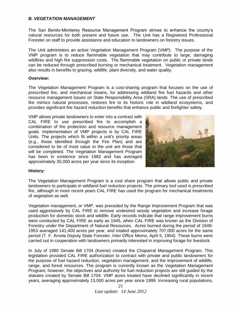
The Vegetation Management Program is a cost-sharing program that focuses on the use of prescribed fire, and mechanical means, for addressing wildland fire fuel hazards and other resource management issues on State Responsibility Area (SRA) lands. The use of prescribed fire mimics natural processes, restores fire to its historic role in wildland ecosystems, and provides significant fire hazard reduction benefits that enhance public and firefighter safety.
VMP allows private landowners to enter into a contract with CAL FIRE to use prescribed fire to accomplish a combination of fire protection and resource management goals. Implementation of VMP projects is by CAL FIRE Units. The projects which fit within a unit's priority areas (e.g., those identified through the Fire Plan) and are considered to be of most value to the unit are those that will be completed. The Vegetation Management Program has been in existence since 1982 and has averaged approximately 35,000 acres per year since its inception.
History: The Vegetation Management Program is a cost share program that allows public and private landowners to participate in wildland fuel reduction projects. The primary tool used is prescribed fire, although in more recent years CAL FIRE has used the program for mechanical treatments of vegetation as well. Vegetation management, or VMP, was preceded by the Range Improvement Program that was used aggressively by CAL FIRE to remove undesired woody vegetation and increase forage production for domestic stock and wildlife. Early records indicate that range improvement burns were conducted by CAL FIRE as early as 1945, when CAL FIRE was known as the Division of Forestry under the Department of Natural Resources. Acres burned during the period of 1949-1953 averaged 141,400 acres per year, and totaled approximately 707,000 acres for the same period (T. F. Arvola Deputy State Forester, Inter Office Memo, April 5, 1954). These burns were carried out in cooperation with landowners primarily interested in improving forage for livestock. In July of 1980 Senate Bill 1704 (Keene) created the Chaparral Management Program. This legislation provided CAL FIRE authorization to contract with private and public landowners for the purpose of fuel hazard reduction, vegetation management, and the improvement of wildlife, range, and forest resources. The program is currently known as the Vegetation Management Program; however, the objectives and authority for fuel reduction projects are still guided by the statutes created by Senate Bill 1704. VMP acres treated have declined significantly in recent years, averaging approximately 13,000 acres per year since 1999. Increasing rural populations,

22
Last update: 14 June 2012
air quality issues, and new CAL FIRE programs have reduced the use of prescribed fire in many areas of the state. However, VMP is a cost effective tool that is still used to treat vegetation where physical and social conditions are conducive to its use. The program has proven to be well suited for controlling invasive weeds and improving wildlife habitat under joint projects with organizations such as the Nature Conservancy. Its use to establish fuel breaks and eliminate heavy fuel accumulations in many areas of the state will continue. Local Program: Locally, the emphasis is on projects in the Wildland-Urban Interface (WUI) and the Wildland-Urban Intermix. The intention is to treat hazardous fuel accumulations near structures and infrastructure to reduce potential losses during wildfire. Other items of concern for VMP project selection are watershed protection, habitat enhancement (especially for threatened and endangered species), and property owner goals. The unit has multiple projects in various stages of planning that are addressed in each Battalion section of this plan.
Depending upon weather conditions and resource availability, we may be able to conduct multiple prescribed burns this year on projects with an active contract. Public notification of an impending prescribed burn shall be through a press release to local media outlets and may include road signs, as well.

23
Last update: 14 June 2012
Fuels:
Four distinct wildland fuel types dominate the San Benito-Monterey Unit.
Fuel Model 1 (annual grasses)
Although inter-mixed with fuel model 4 (brush), this fuel model dominates the foothills of the eastern portion of the Unit. Extending from the Santa Clara County line southward along the foothills east of the Salinas valley, this fuel model represents more than fifty percent of the fuel types in the Unit.
Fuel Model 2 (oak woodland)
This fuel model is typically located on the north and east facing slopes of the Unit. It is predominant in the northeast, southeast and southwest areas of both San Benito and Monterey counties and typically aligned with Fuel model 4 (brush), on the opposite facing slopes.
Fuel Model 4 (brush)
While a substantial amount of brush is located in the foothills east of the Salinas Valley, in the area of the Pinnacles National Monument, the majority of this fuel type is found in the mountains west of the Salinas Valley throughout the coastal range. Typically, it is found on south and western facing slopes in areas not used for cattle grazing. Brush can be found measuring over five feet in height, which corresponds to over 30 years of age.
Fuel Model 9 (conifers)
Conifers consisting of several species of pine and redwood are located in two distinct areas within the Unit, specifically, in the Fremont Peak area south of San Juan Bautista, and throughout the coastal mountains south of Monterey. The conifer forests extend into the Big Sur and Ventana Wilderness areas.
24
Last update: 14 June 2012
SECTION V: PRE- FIRE MANAGEMENT TACTICS
DIVISION / BATTALION / PROGRAM PLANS
Battalion 1: Carmel Battalion - Battalion 4611 The Carmel Battalion is located in the North West corner of the San Benito / Monterey Unit. Encompassing more than 300 square miles it contains a diverse amount of topography and vegetation. To the west, the Pacific Ocean beaches rise into the steep Santa Lucia coastal mountains transitioning from Coastal Chaparral to Redwood canyons bordered on the ridges by Oak and Grass Woodlands. Inland, several north to south running valleys are bounded by the Sierra de Salinas Range to the east. The valley floors are predominantly Grass and Oak woodlands rising to thick Chaparral stands on the south facing slopes and hardwood forests on the east facing slopes. Throughout most of these valleys, residential development has occurred both on the ridges and the floors creating pockets of Urban Interface. The north is comprised of an area of ancient sand dunes hosting the West Coast’s largest Maritime Chaparral community in the former Fort Ord area. Most of that land remains in a wild state and is considered State Responsibility Area (SRA). To the northwest, the Monterey Pine Forests of the Monterey Peninsula intermingle with a dense population of Urban Interface. And to the south, Battalion 1 borders the northern boundary of the vast Los Padres National Forest and Ventana Wilderness. The weather patterns in Battalion 1, during the summer, may range from cool and foggy 60s near the coast to 100s in the upper reaches of the inland valleys. The normal summer northwest air flow generally carries the cool moist marine air inland by evening, somewhat moderating the fire risk at night in the valleys. A summer inversion often keeps the upper elevations warm and dry throughout the 24 hour cycle. Fire history in Battalion 1 is varied. Many wildland fires have been started by lightning in inaccessible areas. Some of these have started on Federal lands and burned into SRA. Unattended controlled burns or campfires have historically contributed to damaging fires. Power line failures are also a common cause of fires due to the corrosive effects of the marine air on the lines. Interspersed throughout the varied topography and vegetation, one will find the Battalion 1 values at risk. They include; large cattle ranches, exclusive gated communities, federal, state and local forests, parks and recreation areas, commercial / industrial developments, vineyards, and many urban interface communities. To address the threat of fire in Battalion 1 and protect the values at risk, several approaches have been taken. Through the issuing of burning permits for campfires, agricultural and backyard burning, CAL FIRE personnel have been able to educate the public in the safe use of fire. Inspection of high voltage power lines is intended to mitigate their threats. The LE-100 Defensible Space inspection program conducted by CAL FIRE and our local government cooperators has targeted more than 1,000 homes each year and helped to educate residents to help themselves by properly clearing around their homes. The application of the Monterey County Fire Codes to new construction in Battalion 1 directs homeowners in the safest ways to build their homes. Fuel reduction programs involving mechanical means as well as controlled burns are being used to reduce fuel loads and create strategic fuel breaks to protect communities and maintain safe egress in case of fire. Preplans of hazardous areas have been prepared to facilitate the safest means to combat wildland fires.

25
Last update: 14 June 2012
Personnel in Battalion 1 work closely with the following organizations and agencies: Monterey County Fire Safe Council, Pebble Beach Company, Monterey County Regional Fire Protection District, Cachagua Fire Protection District, Cypress Fire Protection District, Carmel Highlands Fire Protection District, Pebble Beach Community Services District, Mid Coast Fire Brigade, Big Sur Fire Brigade, California Dept. of Fish and Game, California State Parks, Monterey Peninsula Regional Park District, Del Monte Forest Conservancy, United States Forest Service, Bureau of Land Management, Santa Lucia Preserve, Big Sur Land Trust, Monterey County and Hastings Preserve.

26
Last update: 14 June 2012
Battalion 2: Peninsula Battalion (Schedule A – Contract Districts) – Battalion 4612 – Pebble Beach CSD Battalion 4618 – Cypress FPD & Carmel Highlands FPD Battalion 4605 – Prevention & Planning Battalion 2 is comprised of three local government cooperative agreements or “Schedule A” contracts made up of Pebble Beach Community Services District (PBCSD), Cypress Fire Protection District and Carmel Highlands Fire Protection District. The Pebble Beach area is entirely State Responsibility Area. Also referred to as the Del Monte Forest, this area has a closed cone coniferous forest with areas of chaparral and coastal scrub, as well as small remnants of coastal prairie in the common areas. There are homes all throughout the forested areas as well as many homes along all of the golf courses in the forest. The forest has a lot of small fires within the common forested areas near homes that pose a major threat to many high dollar homes. The Morse Fire in 1987, started by an illegal campfire, burned 160 acres and destroyed 31 structures causing an estimated damage of approximately $18,000,000. Fire road signage, mapping and maintenance are a high priority in the district due to recreation and fire occurrences in the open spaces within the forest. The Cypress FPD borders the southern end of Pebble Beach and wraps around the city of Carmel-by-the-Sea on the north, east and south, stretching from the beaches to approximately two miles east from the mouth of Carmel Valley and bordering Carmel Highlands FPD to the south. The lower part of the district to the east covers Hwy 68, Josselyn Canyon and the homes surrounding the Del Monte Golf Course. Cypress FPD is in both SRA and LRA with housing developments surrounded by wooded areas. The Carmel Highlands FPD is the southern-most district in Battalion 2 with the northern border just south of the Carmel River down to Mal Paso Creek encompassing the wildland urban interface on the west facing slope. The district has many large homes under a tall canopy of closed cone coniferous forest with areas of chaparral and coastal scrub, as well as small remnants of coastal prairie in the common areas. Most of the district is rated as Very High Fire Hazard Severity Zones. The three fire districts maintain good working relationships to collaborate on fuel reductions projects with several different agencies such as; Monterey Peninsula Regional Parks District, Pebble Beach Company, Cal Trans, PG&E, Homeowner associations and private homeowners. Defensible space remains a very high priority in Battalion 2 due to the housing density within the wildland urban interface. The battalion has an aggressive LE-100 program employing Retired Annuitant Fire Captains to educate homeowners and to ensure compliance throughout the districts.

27
Last update: 14 June 2012
Battalion 3: King City Battalion - Battalion 4613 The King City Battalion starts from the Chualar area and encompasses both sides of the Salinas Valley down to San Ardo, ridge top to ridge top. This area includes the west entrance to the Pinnacles National Monument, Arroyo Seco, and many vineyards and cattle ranches, to name of few values at risk. The weather patterns in Battalion 3 during the summer months range from the 70s and into the low 100 degree mark. The valley winds ranging from 10-25 mph, usually begin early afternoon and subside around sunset when the marine layer occasionally blows in to cool the valley temperatures. The strong winds affect the early season fires pushing grass fires from a few hundred acres and into the thousands in the cattle grazing pastures of the eastern foothills. The steep terrain of the Arroyo Seco & southern end of Carmel Valley has driven some large wildland fires in the late summer/fall crossing borders into the LPF where access for firefighting equipment becomes very challenging. Fire History shows that “equipment use” is a leading cause of ignitions and has resulted in a number of the large, damaging fires in Battalion 3. With this knowledge, the Unit has made educating ranchers and homeowners on the importance of spark arresters and mowing in cooler weather conditions a high priority. Large billboards signs are posted in the battalion stating to “mow before 10 a.m.” before the heat of the day. Statistics show that these efforts have been successful and ignitions have decreased. Debris burning and powerline caused fires are also among the frequent ignitions in Battalion 3. Prevention staff has been working with the utility company to upgrade powerline equipment to reduce the number of fires in the Unit. Battalion personnel continue to educate homeowners on laws of debris burning and how to safely burn brush piles in the non-peak fire season to reduce the amount of control burn escapes in the Unit.

28
Last update: 14 June 2012
Battalion 4: Bradley Battalion – Battalion 4614 The Bradley Battalion starts south of San Ardo and continues south to the San Luis Obispo County line. This area includes Bryson-Hysperia with many homes in the wildland ranking this Battalion 4’s top value at risk. Battalion 4 also encompasses the San Antonio Reservoir, a popular recreational area, the community of Parkfield and the Ft. Hunter Liggett Army Training Facility among many vineyards and cattle and hunting ranches. Much like Battalion 3, the weather patterns in Battalion 4 during the summer months range from the 70s and into the low 100 degree mark. The valley winds in Bradley range from 10-25 mph and usually begin mid-afternoon and subside well after dark. In the Lockwood and Parkfield areas, the temperatures are very similar but get much less wind due to the topographical features. The terrain is predominately rolling hills with some areas of brush covered, steep slopes. Similar to Battalion 3, fire history shows that “equipment use” is, by far, the leading cause of ignitions and has resulted in a number of the large, damaging fires in Battalion 4. By educating ranchers and homeowners on the importance of spark arresters and mowing in cooler weather conditions along with the large billboard signs, the Unit has seen a decrease in our ignitions.
The main Values in Battalion 4 are recreational areas, vineyards and rangelands.

29
Last update: 14 June 2012
Battalion 5: Hollister Battalion – Battalion 4615 The Hollister Battalion is located at the North East corner of the Unit in San Benito County, following the county line on both the East and the West down to the end of Cienega Road and East to South of Panoche and Antelope Valley. The West side (Gabilan Mountain Range) of the battalion is comprised steep terrain and heavy fuels up in the Fremont Peak area. The east side (Diablo Mountain Range) is predominately grasslands, home to many large cattle ranches and quickly transitions into steep rugged terrain. The fuels commonly encountered in Battalion 5 are grass, oak woodland, Chemise and Gray Pine. Hollister Hills Recreational Area is near the Fremont Peak area and is frequented by off-road vehicles on California State Parks lands and is one of the values at risk. Other values include the wild land urban interface areas in San Juan Canyon, Cienega Road and Paicines as well as the infrastructure at Fremont Peak State Park and Mission San Juan Bautista. The weather patterns in Battalion 5 during the summer months range from the high 70s and into the low 100 degree mark with the occasional late night, early morning marine influence bringing in the fog. The winds in the Hollister area range from 5-15 mph. The terrain is predominately rolling hills with some areas of brush covered, steep slopes. Similar to Battalions 3 and 4, fire history shows that “equipment use” is the leading cause of ignitions and has resulted in a number of the large, damaging fires in Battalion 5. By educating ranchers and homeowners on the importance of spark arresters and mowing in cooler weather conditions along with the large billboard signs, the Unit has seen a decrease in ignitions. “Debris burning” also ranks among the highest sources of ignition of fires in Battalion 5. Fire department personnel make a concerted effort while writing burn permits and while out in the public, to educate residents on the laws of burn piles, what materials they can burn and safe ways to conduct their burn to not let it escape their control. The main Values in Battalion 5 are recreational areas, vineyards and rangelands. The main priorities in Battalion 5 are to educate the public that live in the wild land urban interface on how to be fire safe and to maintain fire roads that serve a crucial role in means of ingress and egress for both the public and fire equipment during a wildland fire. Personnel in Battalion 5 work closely with members from the following organizations or agencies; the San Benito Fire Safe Council, BLM, California State Parks, and local ranchers.

30
Last update: 14 June 2012
Battalion 6: Bear Valley Battalion – Battalion 4616 The Bear Valley Battalion is located on the east side of the Unit in San Benito County, following the county line on the west and bordering the Fresno County line to the east extending to Priest Valley in the south. Clear Creek Recreational Area is also in the southern portion of Battalion 6. The west side (east side of Gabilan Mountain Range) of the battalion is comprised steep terrain and heavy fuels up near the Pinnacles National Monument area. The east side (Diablo Mountain Range) is predominately grasslands, home to many large cattle ranches and quickly transitions into steep rugged terrain. The fuels commonly encountered in Battalion 6 are grass, oak woodland, Chemise and Gray Pine. The weather patterns in Battalion 6 during the summer months range from the high 70s and into the low 100 degree mark with little recovery overnight. The winds in the area range from 5-10 mph. The terrain varies from rolling hills transitioning into brush covered, steep slopes. Similar to other battalions, fire history shows that “equipment use” is the leading cause of ignitions in Battalion 6. By educating ranchers and homeowners on the importance of spark arresters and mowing in cooler weather conditions along with the large billboard signs, the Unit has seen a decrease in ignitions. “Debris burning” also ranks among the highest sources of ignition of fires in Battalion 6. Fire department personnel make a concerted effort while writing burn permits and while out in the public, to educate residents on the laws of burn piles, what materials they can burn and safe ways to conduct their burn to not let it escape their control. The main Values in Battalion 6 are the Pinnacles National Monument, Clear Creek Recreational Area, agriculture and large cattle ranches. Priorities are public education, hazard assessment, and fuel reduction. Battalion 6 maintains a close working relationship with The Pinnacles National Park, The Bay Area Network Fire, BLM, and the local ranchers.

31
Last update: 14 June 2012
Battalion 7: Aromas Battalion - Battalion 4617
The Aromas Battalion is located at the north end of the Unit encompassing portions of Monterey, San Benito and Santa Cruz Counties. The battalion runs from the northern unit boundary over to Fremont Peak and down the Salinas Valley to just north of Chualar. The Aromas battalion is also home to the Aromas Tri-County Fire Protection District which is 60 square miles of primarily residential structures with light commercial and agricultural occupancies and areas of wildland urban interface. In addition to the local population of approximately 6,000, the District experiences a constant increase to values at risk due to the major highways that traverse the District increasing the active population by hundreds of thousands per day. This exacerbates the issue of High and Very High Fire Hazard Severity Zones throughout most of the District and the interface threats to local residents.
The fuels and topography defined in the battalion are gentle slopes of oak woodland varied with steep terrain and heavy fuels in other areas encompassing many housing developments throughout. The north county area has some heavily wooded areas of Eucalyptus groves posing a challenge to firefighters, as one of the groves has Hwy 101 running through the middle of it. The weather patterns in Battalion 7 during the summer months range from the 60s and into the mid 80 degree mark with the marine layer moving in most evenings and burning off mid mornings. The winds in the area range from 5-10 mph. Similar to other battalions, fire history shows that “equipment use” is the leading cause of ignitions in Battalion 7. By educating homeowners on the importance of spark arresters and mowing in cooler weather conditions along with the large billboard signs, the Unit has seen a decrease in ignitions. “Debris burning” also ranks among the highest sources of ignition of fires in Battalion 7. Fire department personnel make a concerted effort while writing burn permits and while out in the public, to educate residents on the laws of burn piles, what materials they can burn and safe ways to conduct their burn to not let it escape their control. Other leading causes of fires in Battalion 7 are roadside fires caused by exhaust carbon, blown tires and vehicles due to the heavy traffic on these highways. The main Values in Battalion 7 are residential structures, agriculture, watershed and infrastructure.

32
Last update: 14 June 2012
TRAINING DIVISION: Battalion 4607
The San Benito-Monterey Unit Training Division has set several goals to improve firefighting operational efficiency and safety for the Unit. These goals are but not limited to:
1. All BEU personnel attend Department of General Service Defensive Driver safety program.
2. Upon selection and placement of fuel moisture collection sites and ovens, those
schedule B fire control personnel in each Division will be trained in collection and drying procedures of vegetation to assist the unit and region in determining potential fire behavior and wildland fire response levels.
3. All BEU personnel to attend annual Continuing Professional training to maintain
firefighting skills and appropriate certifications. The intent is for personnel to meet 4032 and 4036 training requirements.
4. All BEU fire control personnel to attend “A“ faller training
a. Selected personnel will be chosen to attend Class “B” faller training b. Selected personnel will be chosen to attend Class “C” faller training
i. With a goal of having at least one Class “C” faller in each Division and Gabilan Camp.
5. All BEU Fire control personnel assigned to Helitack or Hollister air attack base attend the
following training where applicable:
a. RT-372 Helicopter manager refresher training b. RT 378 Air Attack Group Supervisor Training c. Basic helicopter safety training d. Short haul training e. Air Base safety training
6. All BEU Fire Control personnel receive wildland firefighter safety and survival training
7. All BEU Battalion Chiefs and Fire Captains attend C -234 Intermediate Firing Operations
class.
8. BEU personnel attend applicable training and qualify in Incident Command System (ICS) positions. The intent is to meet the unit’s obligations to Minimum ICS Qualified Personnel Matrix (7700) located in the 7000 handbook.

33
Last update: 14 June 2012
GABILAN CONSERVATION CAMP – Administered by Division 4603
Gabilan Conservation Camp is centrally located in Monterey County and the only camp servicing the CALFIRE San Benito-Monterey Unit. The facility is situated in the front of Soledad State Correctional Facility and the Salinas Valley State Prison on Hwy 101 between the cities of Soledad and Gonzales. The camp houses approximately 131 low-risk inmates under the direction of the California Department of Corrections and Rehabilitation (CDCR) and CAL FIRE. CALFIRE operates 6 Fire Crews and a Mobile Kitchen Unit (MKU) that are available to respond year round to a variety of “all risk” emergencies throughout the state such as; wildland fires, floods, rescues and other disasters.
In preparation of emergency response, Gabilan Camp has hosted the Gabilan Exercises for the past few decades. The Gabilan Exercise evaluates each inmate fire crew’s performance through arduous evolutions for the upcoming fire season. In addition to emergency response, Gabilan Camp is heavily engaged in pre-fire management. Gabilan fire crews provide community service and hazard fuel reduction projects with the local, state and federal agencies within Santa Clara, Monterey, San Benito and San Luis Obispo counties. Projects during the last years include; but not limited to,
Federal Grant projects, Hollister Hills State Park, State Parks and Recreation, Monterey County Park, Laguna Seca Raceway, City of Monterey, City of Del Rey Oaks, Camp Roberts National Guard, Monterey Peninsula Regional Park District, Salinas Valley Fairgrounds, Salinas Airshow, San Benito County Park, San Benito County Historical Park, Monterey Peninsula College, Gonzales USD, Washington Union School, National Park Service and CALFIRE facilities.
Since the opening in 1986, Gabilan Conservation Camp has continued to be a valuable resource for the State of California and the citizens of San Benito and Monterey counties through conservation and the protection of life, property and natural resources.

34
Last update: 14 June 2012
AIR ATTACK PROGRAM: Hollister Air Attack - Battalion 4608 The Hollister Air Attack Base, established in 1962, is located along the central coast of California, 30 miles south of San Jose in the CDF San Benito-Monterey Unit. Hollister responds to an average of 350 calls per year. Staff at the base consists of one battalion chief, two fire captains, one fire apparatus engineer, and seven firefighters. The complement of aircraft located at Hollister includes one OV-10 Bronco and two S-2T air tankers. On average, the base pumps about 300,000 gallons of retardant a year. With the base’s pumps, three loading pits and equipment, Hollister has a possible peak output of 60,000 gallons of retardant each day. The base provides initial attack for 3.1 million acres encompassing 11 counties; an area spanning north to Mt. Diablo, south to King City, east to Interstate 5 and west to the Pacific Ocean. This area includes the Los Padres National Forest.

35
Last update: 14 June 2012
HELITACK PROGRAM: Bear Valley Helitack
The Bear Valley Helitack Base was established in 1987 and was located in the San Benito-Monterey Unit on Airline Highway in Bitter Water road area. The base was originally named Bitterwater Helitack Base and kept this name until 1992 when it was moved to the Bear Valley Fire Station in Paicines, changing the name to Bear Valley Helitack. Bear Valley responds to an average of 150 calls per year ranging from fires to rescues. In addition to responding to emergencies the helicopter conducts control burns and recon flights necessary to the state mission. On a daily basis, the crew of the Helitack Base consists of one pilot, two fire captains, five to six firefighters and an engineer. In addition to the helitack crew, there are two fire engines staffed at Bear Valley station. Bear Valley Helitack operates a UH-1H Super Huey helicopter. It is one of three ships that have a fixed tank rather than a bucket. The fixed tank can hold 325 gallons of water. The state has 11 helicopters with 9 helicopter bases, 2 helicopters are used as spares when maintenance is needed. Also operated out of Bear Valley is the helitender, which serves as a support vehicle for the copter. The helitender contains 1,000 gallons of fuel, along with foam, backup tools, out-of-county bags, Meals Ready to Eat (MRE’s) and many other items that are necessary to support the crew. Bear Valley provides coverage and protection from southwest Santa Clara to Interstate-5 in the Fresno-Kings Unit, down to Northern San Luis Obispo and all the way to the Pacific Ocean. As a state resource Bear Valley is also able to respond anywhere in the state. CAL FIRE helitack crews consist of highly trained and experienced firefighters who are assigned to and respond to wildland fires and rescues aboard CAL FIRE helicopters. Once arriving on a fire incident, the crew, typically 5 to 6 firefighters along with a fire captain, are let off with firefighting hand tools and initiate fire suppression actions as the helicopter supports the helitack crew with water drops. Helitack crews also perform other helicopter support operations when not assigned to direct fire line operations such as establishing and staffing helibases conducting necessary operations and support.

36
Last update: 14 June 2012
APPENDIX A: PRE- FIRE PROJECTS
Batt
Pla
nn
ing
are
a
Project Number
Project Name Status Estimated
Completion Year
Project Type
Net
Acres
1 1 Palo Colorado Pre-Fire Plan A 2013 Plan
1 2 Cachagua Pre-Fire Plan A 2013 Plan
1 3 Hatton Canyon Fuel Break O Annual 4
1 4 Outlook Fuel Break O Annual 4
1 5 Cachagua Rd. / Tassajara Rd. Fuel Break P 2015 10
1 6 Tularcitos Ridge Trail P 2012 HFT2 342
1 7 Robinson Cyn Rd Fuel Break O Continuous
1 8 Pt. Lobos VMP C 2011 VMP 10
1 9 East Molera VMP A 2012 VMP 40
1 10 Palo Colorado Fuel Reduction A 2013 HFT2
1 11 Williams Cyn Fuel Reduction A 2012 HFT2
1 12 White Rock Ridge Fuel Break A 2012 HFT2 85
1 13 Hastings Preserve VMP P 2014 VMP 150
1 14 Santa Lucia Preserve - Several VMPs A Continuous VMP 60
1 15 White Rock VMP A 2013 VMP 524
1 16 Cachagua / Galante VMP P 2015 VMP
1 17 Santa Lucia Preserve - Fire Access Rd P
1 18 Corona Park - Fire Access Rd P
1 19 Joshua Creek - Fire Access Rd O Continuous
1 20 Potrero Grasslands VMP P VMP 51
1 21 Paloma Fire Rd - Fire Access Rd O Continuous
2 Gentry Hill (roadside)
2 Olmstead Road
2 End of Loma Alta in Jack's Peak Park
2 Along Loma Alta (roadside)
2 Loma Alta, south of homes
2 Del Mesa Carmel (fuel break & access road)
2 Pacific Meadows (fuel break & access road)
2 Roach Canyon
2 Hatton Canyon
2 Pine Hills (roadside)
2 Ribera Road
2 Quail Meadows
2 Hwy 1 @ Carpenter
Status Guide: A = Active, P = Planning, C = Completed, O = Ongoing, M = Maintenance.

37
Last update: 14 June 2012
Batt
Pla
nn
ing
are
a
Project Number
Project Name Status Estimated
Completion Year
Project Type
Net
Acres
2 Powerlines in Cypress FPD
2 Roadsides in Cypress FPD
2 Via Mar Monte @ High Meadows
2 North Carmel Hills Drive strip w Hwy 1
2 Hwy 1 @ High Meadows Drive
2 Jacks Peak neighborhood roadsides
2 Powerline across Jacks Peak to Pine Hills Drive
2 San Jose Creek canyon ingress/egress
2 Victorine Ranch
2 Roadsides in Carmel Highlands FPD
2 Powerlines in Carmel Highlands FPD
2 North Mentone, San Remo
2 Hwy 1, both sides entire CHFPD boundary
2 Sunridge Pines common area
2 Huckleberry Hill - Haul Rd Fuel Break
2 Huckleberry Hill – Near Ocean Pines
2 Huckleberry Hill – Along Hwy 68
2 Hwy 68 along old burn above Morse gate
2 1990 Hwy 68 fire between Road 4 and Hwy 68
2 Huckleberry Hill - Fuel Break
2 Shepherd's Knoll - North Side of 17 Mile Drive
2 Shepherd's Knoll - South Side of 17 Mile Drive
2 Shepherd's Knoll - Condos
2 SFB Morse Botanical Reserve
2 Huckleberry Hill - Near SFB Morse Dr
2 PQR - Fire Road 20 East to Fire Road 21 - PBC
2 PQR - West of Fire Road 20
2 Pescadero Canyon (multiple areas)
2 Navajo Tract
2 Area B - Navajo North
2 Area C (Navajo south)
2 CAL Am land between Lopez and Forest Lake
2 Forest Lake - PBCSD
2 Indian Village
2 Indian Village Annex - Seal Rock Creek North
2 Crocker Grove and SFB Morse Memorial
2 Fire Road/Fuel Break maintenance (all)
2 Carmel Way (Pescadero Canyon west)
2 Hermann property
2 Pescadero Point and Courtland Hill Preserve

38
Last update: 14 June 2012
Batt
Pla
nn
ing
are
a
Project Number
Project Name Status Estimated
Completion Year
Project Type
Net
Acres
2 Fire Road 24
2 Area between Viscaino and Lisbon
2 Canyon between Palmero Way & Del Ciervo
2 Below Carmel Woods
2 Area Below Sunset Lane and Fire Road 23
2 Powerlines in Pebble Beach
3 1 Dillard VMP A 2012 VMP 19
3 2 La Macchia VMP A 2013 VMP 956
3 3 Reliz Cyn VMP P VMP
3 4 Santa Lucia School Program O Annual Pub Ed
3 5 Arroyo Seco Home Owners Association O Annual Pub Ed
3 6 Deer Creek Home Owners Association O Annual Pub Ed
3 7 Highland Hills Home Owners Association O Annual Pub Ed
3 8 Via Canada Home Owners Association O Annual Pub Ed
4 1 Bryson / Hesperia Wildland Fire Preplan A
4 2 CAL FIRE / Fort Hunter Liggett Fuel Break P
4 3 Bryson Hesperia CERT Group A
5 1 Limekiln VMP A 2013 VMP 2,200
5 2 Thompson Truck Trail A
5 3 Public Education O Pub Ed
5 4 Hollister Hills VMP P VMP 300
5 5 Thompson Valley VMP P VMP 1000
6 1 Rabbit VMP P VMP 843
6 2 Public Education Annual Pub Ed
6 3 Rock Springs Ranch VMP VMP 8,000
7 1 Battalion 7 Hazard Assessment A 2012
7 2 South Pasture VMP Prescribed Burn Project A 2012 VMP 1,360
7 3 Gabilan Ranch VMP Prescribed Burn Project P VMP
7 4 RIs - Silacci, Bengard, Christiansen, Ussery P Annually RI
Status Guide: A = Active, P = Planning, C = Completed, O = Ongoing, M = Maintenance.

39
Last update: 14 June 2012
Battalion 1 Projects: Project #1 Project Name: Palo Colorado Pre-Fire Plan Description: Preplan community with updated maps and tactical planning in preparation for wildland fires in their area. Community: Palo Colorado - south of Carmel Project Collaborators: Mid Coast Fire Brigade / Monterey FSC Project #2 Project Name: Cachagua Pre-Fire Plan Description: Preplan community with updated maps and tactical planning in preparation for wildland fires in their area. Community: Cachagua – east of Carmel Valley Project Collaborators: Cachagua FPD / Monterey FSC Project #3 Project Name: Hatton Canyon Fuel Break Maintenance Description: Maintain current fuel break in canyon between subdivisions Community: Carmel at the mouth of Carmel Valley Project Collaborators: State Parks / Cypress FPD Project #4 Project Name: Outlook to Outlook Fuel Break Maintenance Description: Maintain current fuel break in canyon between subdivisions Community: Carmel at the mouth of Carmel Valley Project Collaborators: Monterey County Public Works / Private / Cypress FPD Project #5 Project Name: Cachagua Rd. / Tassajara Rd. Fuel Break Description: Establish a fuel break along Cachagua and Tassajara roads around community Community: Cachagua - east of Carmel Valley Project Collaborators: Monterey County / Monterey FSC / Private Project #6 Project Name: Sky Ranch Egress & Fire Rd. Description: Establish a fire road for emergency egress Community: Sky Ranch Estates - east of Carmel Valley Project Collaborators: Cachagua FPD / Private Owners Project #7 Project Name: Robinson Cyn Rd Fuel Break Description: Establish a fuel break along Robinson Cyn Rd Community: Santa Lucia Preserve – Carmel Valley Project Collaborators: Santa Lucia Preserve / White Rock / Monterey County

40
Last update: 14 June 2012
Project #8 Project Name: Pt. Lobos VMP Description: Conduct a VMP at Pt. Lobos State Park Community: Carmel Highlands Project Collaborators: State Parks Project #9 Project Name: Big Sur - Molera VMP Description: Conduct several VMPs at Molera State Park Community: Big Sur Project Collaborators: State Parks Project #10 Project Name: Palo Colorado Fuel Reduction Description: Fuel Reduction project Community: Palo Colorado – south of Carmel Project Collaborators: Big Sur Land Trust / Glen Devin Project #11 Project Name: Williams Cyn Fuel Reduction Description: Fuel Reduction Project Community: South of Carmel Valley Project Collaborators: Big Sur Land Trust / Williams Cyn. Project #12 Project Name: White Rock Fuel Break Description: Establish a fuel break around the White Rock Club Community: White Rock – south east of Carmel Valley Project Collaborators: White Rock / Monterey FSC / Monterey County Regional FPD Project #13 Project Name: Hastings Preserve VMP Description: Conduct a VMP at the Hastings Preserve Community: Carmel Valley Project Collaborators: Hastings / Cachagua FPD Project #14 Project Name: Santa Lucia Preserve VMPs Description: Series of VMPs on the Santa Lucia Preserve Community: Santa Lucia Preserve Project Collaborators: Santa Lucia Preserve / Monterey County Regional FPD / Monterey FSC

41
Last update: 14 June 2012
Project #15 Project Name: White Rock VMP Description: Conduct a VMP at the White Rock Club Community: White Rock - south east of Carmel Valley Project Collaborators: White Rock / Monterey FSC / Monterey County Regional FPD Project #16 Project Name: Galante VMP Description: Conduct a VMP at the Galante Vineyards Community: Cachagua - east of Carmel Valley Project Collaborators: Galante / Cachagua FPD Project #17 Project Name: Santa Lucia Preserve Fire Access Rd. Description: Construct / Maintain Community: Santa Lucia Preserve - south east of Carmel Valley Project Collaborators: Santa Lucia Preserve / MPCPD / Monterey County Regional FPD Project #18 Project Name: Corona Park Fire Access Rd. Description: Construct / Maintain Community: Carmel Valley Project Collaborators: MPCPD Project #19 Project Name: Joshua Creek Fire Access Rd. Description: Maintenance Community: South of Carmel Valley Project Collaborators: DFG Project #20 Project Name: White Rock Ridge Fire Access Rd. Description: Maintenance Community: south east of Carmel Valley Project Collaborators: White Rock / DFG / Monterey County Regional FPD Project #21 Project Name: Paloma Fire Rd Fire Access Rd. Description: Maintenance Community: Cachagua Project Collaborators: Private Owners / Cachagua FPD Battalion 1 LE-100 inspection estimate for 2012 = 800 inspections (600 by local government in the SRA)

42
Last update: 14 June 2012
Battalion 2 Projects:
Community Project Name Owner / Collaborators Fuel Reduction Methods Cypress
FPD
CYP Gentry Hill (roadside) Private / Cypress FPD Masticate, lop, weedeat, remove
CYP Olmstead Road by Foothill School (pvt field) Private mowing
CYP End of Loma Alta in Jack's Peak Park Monterey Co Regional Parks / pvt cut/remove
CYP Along Loma Alta (roadside) Private / Monterey Co Regional Parks MoCo mowing, pvt owners cut/remove
CYP Loma Alta, south of homes Monterey Co Regional Parks / pvt Masticate, lop, weedeat
CYP Del Mesa Carmel (fuelbreak around complex, access road) Del Mesa Carmel, Cypress FPD Firecrew / masticator / mower
CYP Pacific Meadows (fuelbreak around complex, access road)
Pacific Meadows, Monterey Co Public Works, Cypress FPD Firecrew / masticator / mower
CYP Roach Canyon Monterey Co Public Works mowing
CYP Hatton Canyon State Parks, Firecrews mowing
CYP Pine Hills (roadside) Monterey Co Public Works mowing
CYP Ribera Road, by lagoon State Parks mowing
CYP Quail Meadows Private mowing
CYP Hwy 1 @ Carpenter State Parks, CalTrans, Firecrews,
Rancho Cielo weed eating, mowing, cut/remove
CYP Powerlines PG&E weedeating, scraping
CYP Roadsides Monterey Co Public Works mowing
CYP Via Mar Monte @ High Meadows State Parks weed eating, cut/chip, masticator
CYP North Carmel Hills Drive strip w Hwy 1 State Parks
weed eating, cut/chip branches, remove dead trees
CYP Hwy 1 @ High Meadows Dr to N end of North Carmel Hills Drive
State Parks, CalTrans, Firecrews, Ranchj Cielo
CYP Jacks Peak neighborhood roadsides Private / Cypress FPD weed eating, cut/chip, masticator
CYP Powerline across Jacks Peak to Pine Hills Drive PG&E weedeating, scraping
Carmel Highlands
CH San Jose Creek canyon ingress/egress State Parks mowing
CH Victorine Ranch Private and Carmel Lahaina Water Co. mowing
CH Roadsides
Monterey Co Public Works and Highlands Community Fire Safe Committee (HSFSC) fed grant Mowing, weed eating, cut/chip, masticator
CH Powerlines PG&E weedeating, scraping
CH North Mentone, San Remo Individual owners to center of private
roads Weed eating, cut/chip
CH Hwy 1, both sides entire CHFPD boundary CAL TRANS mowing, remove dead trees, chipping

43
Last update: 14 June 2012
Pebble Beach
PB Sunridge Pines common area Each owner of Sunridge Pines,
PBCSD Private contractor (masticator)
PB Huckleberry Hill - Haul Rd Fuel Break
Pebble Beach Co, Del Monte Forest Conservancy (DMFF), PBCSD
Gabilan crew, PB Co chipper (w/ operator, truck, porta potty
PB Huckleberry Hill - Ocean Pines, between Hwy 68 and Scenic Drive
Pebble Beach Co, Del Monte Forest Conservancy (DMFC), PBCSD
Gabilan crew, PB Co chipper (w/ operator, truck, porta potty
PB Huckleberry Hill - Along Hwy 68 from Los Altos FB to Haul Rd
Pebble Beach Co, Del Monte Forest Conservancy (DMFC), PBCSD
Masticator, Gabilan crew, PB Co chipper (w/ operator, truck, porta potty
PB Hwy 68 along old burn above Morse gate
Pebble Beach Co, Del Monte Forest Conservancy (DMFC), PBCSD
Masticator, Gabilan crew, PB Co chipper (w/ operator, truck, porta potty
PB 1990 Hwy 68 fire between Road 4 and Hwy 68
Pebble Beach Co, Del Monte Forest Conservancy (DMFC), PBCSD
Masticator, Gabilan crew, PB Co chipper (w/ operator, truck, porta potty
PB Huckleberry Hill - Los Altos/Costanilla Fuel Break
Pebble Beach Co, Del Monte Forest Conservancy (DMFC), PBCSD
Gabilan crew, weedeaters, PB Co chipper (w/ operator, truck, porta potty
PB Shepherd's Knoll - North Side of 17 Mile Drive
Pebble Beach Co, Del Monte Forest Conservancy (DMFC), PBCSD Private contractor crew
PB Shepherd's Knoll - South Side of 17 Mile Drive to Hwy 68
Pebble Beach Co, Del Monte Forest Conservancy (DMFC), PBCSD Pvt crew, lopping, weedeating, chipping
PB Shepherd's Knoll - Condos Pebble Beach Co, Del Monte Forest
Conservancy (DMFC), PBCSD Private contractor crew
PB SFB Morse Botanical Reserve Pebble Beach Co, Del Monte Forest
Conservancy (DMFC), PBCSD Private contractor crew
PB
Huckleberry Hill - East of Del Monte Park, North of SFB Morse Dr
Pebble Beach Co, Del Monte Forest Conservancy (DMFC), PBCSD Gabilan crew, goats
PB PQR - Fire Road 20 East to Fire Road 21 - PBC
Pebble Beach Co, Del Monte Forest Conservancy (DMFC), PBCSD Gabilan, goats, masticator
PB PQR - West of Fire Road 20 Pebble Beach Co, PBCSD Lopping, weedeating, chipping
PB Pescadero Canyon (multiple areas) Pebble Beach Co, Del Monte Forest
Conservancy (DMFC), PBCSD Goats, Private contractor crew
PB Navajo Pebble Beach Co, Del Monte Forest
Conservancy (DMFC), PBCSD
PB Area B - Navajo North DMFC Private contractor crew
PB Area C (Navajo south) DMFC Private contractor crew
PB CAL Am land between Lopez and Forest Lake CAL AM Private contractor crew
PB Forest Lake - PBCSD PBCSD Pvt crew, lopping, weedeating, chipping
PB Indian Village DMFC, PBCSD Firecrew, chipping, masticator
PB Indian Village Annex - Seal Rock Creek North to residences
Del Monte Forest Conservancy (DMFC), PBCSD Left natural
PB Crocker Grove and SFB Morse Memorial DMFC Pvt crew, lopping, weedeating, chipping
PB Fire Road/Fuel Break maintenance (all)
Pebble Beach Co, Del Monte Forest Conservancy (DMFC), PBCSD Masticator, mowing

44
Last update: 14 June 2012
PB Carmel Way (Pescadero Canyon west) DMFC Pvt crew, lopping, weedeating, chipping
PB Hermann property DMFC Pvt crew, lopping, weedeating, chipping
PB Pescadero Point and Courtland Hill Preserve DMFC Pvt crew, lopping, weedeating, chipping
PB Fire Road 24 Pebble Beach Co, Del Monte Forest
Conservancy (DMFC), PBCSD Private contractor crew
PB Area between Viscaino and Lisbon Pebble Beach Co, PBCSD Firecrew, chipping, hauling
PB Canyon between Palmero Way and Del Ciervo Road (and others) Pebble Beach Co, PBCSD Goats
PB Below Carmel Woods Pebble Beach Co, Del Monte Forest
Conservancy (DMFC), PBCSD Goats, Private contractor crew
PB Area Below Sunset Lane and Fire Road 23 Pebble Beach Co, PBCSD Goats
PB Powerlines PG&E weedeating, scraping
Battalion 2 LE-100 inspection estimate for 2012:
Pebble Beach CSD – 2,300 of 2,550 homes Cypress FPD – 3,300 of 5,500 homes Carmel Highlands FPD – 560 of 560 homes
45
Last update: 14 June 2012
Battalion 3 Projects: Project #1 Project Name: Dillard VMP Description: Fuel Modification with Fire Use Community: Pine Cyn (upper Cyn) King City Project Collaborators: Dillard Ranch, FHL Fire, CAL FIRE, SoMoCo, MPUAPCD Project #2 Project Name: La Macchia VMP Description: Fuel Modification with Fire Use Community: La Gloria Rd (Training site) Gonzales Project Collaborators: La Macchia Ranch, CAL FIRE, MPUAPCD Project #3 Project Name: Reliz Cyn VMP Description: Fuel Modification with Fire Use Community: Reliz Cyn (upper), Greenfield Project Collaborators: Anthony Ranch, Cotton Ranch, USFS, CAL FIRE, MPUAPCD Project #4 Project Name: Santa Lucia School Program Description: Public Education on Fire Safety Awareness to 5th grade students. Community: King City Project Collaborators: Santa Lucia Teachers, CAL FIRE Project #5 Project Name: Arroyo Seco Home Owners Association Description: Public Education on Fire Awareness and preparation for Wildland Fires in their
area. Community: Arroyo Seco Area Project Collaborators: Arroyo Seco HOA, CAL FIRE, SoMoCo, Monterey County SO Project #6 Project Name: Deer Creek Home Owners Association Description: Public Education on Fire Awareness and preparation for Wildland Fires in their
area. Community: Deer Creek Subdivision, Pine Cyn Rd (middle Cyn) King City Project Collaborators: Deer Creek HOA, CAL FIRE, SoMoCo, Monterey County SO

46
Last update: 14 June 2012
Project #7 Project Name: Highland Hills Home Owners Association Description: Public Education on Fire Awareness and preparation for Wildland Fires in their area. Community: Highland Hills Subdivision, Pine Cyn Rd (middle Cyn) King City Project Collaborators: Highland Hills HOA, CAL FIRE, SoMoCo, Monterey County SO Project #8 Project Name: Via Canada Home Owners Association Description: Public Education on Fire Awareness and preparation for Wildland Fires in their area. Community: Via Canada Subdivision, Via Canada Rd (lower Pine Cyn) King City Project Collaborators: Via Canada HOA, CAL FIRE, SoMoCo, Monterey County SO Battalion 3 LE-100 inspection estimate for 2012 = 350 inspections

47
Last update: 14 June 2012
Battalion 4 Projects: Project #1 Project Name: Bryson / Hesperia Wildland Fire Preplan Description: Identify predetermined evacuation areas, values at risk, control lines and
objectives, create preplan maps for responders Community: Bryson / Hesperia Project Collaborators: Bryson Hesperia CERT group, CAL FIRE, SoMoCo Project #2 Project Name: CAL FIRE / Fort Hunter Liggett Southern Boundary Fuel Break Description: Establish a fuel break along the entire length of the Ft. Hunter Liggett (FHL)
and CAL FIRE southern boundary in the Copper Head / Bryson Hesperia area Community: Ft. Hunter Liggett Military Base Project Collaborators: CAL FIRE, FHL Project #3 Project Name: Bryson Hesperia CERT Group Description: Form an emergency response team of community members that live in the
Bryson/Hysperia area Community: The Bryson / Hysperia (BH) community Project Collaborators: Monterey County OES, CAL FIRE Battalion 4 LE -100 inspection estimate for 2012 = approximately 450

48
Last update: 14 June 2012
Battalion 5 Projects: Project #1 Project Name: Limekiln VMP Description: A Vegetation Management burn that will consist of approximately 2,200 acres. The burn will consist of approximately 5 smaller burns to complete the project. This project has been approved and the line construction is being completed. Community: The site is located in the area of Limekiln Road and Cieniga Road South of Hollister in Battalion 5. Project Collaborators: Enz Ranch, Clements Ranch, and Barker Ranch. Project #2 Project Name: Thompson Truck Trail Improvement Description: This road stretches from Limekiln Road to the Fremont Peak area. At one time, this road was maintained annually by CAL FIRE and is a main access road to areas in that part of the county. The trail can also be used for evacuation of citizens from the San Juan Canyon area. Collaboration with the various property owners and gaining their trust and permission to allow CAL FIRE to once again maintain the road is crucial to the success of this project. Brushing of the roads utilizing crews and grading and installing water bars are some of the items that would need to be addressed. Community: Thompson Truck Trail runs from Cieniga Road to San Juan Canyon Road on the West side of San Benito County. Project Collaborators: Various land owners, San Benito Fire Safe Council (pending grant approval), Gabilan camp crews. Project #3 Project Name: Public Education Description: Increase public awareness on defensible space throughout San Benito County, with emphasis in the south county area and the Panoche Valley. Personnel will utilize public events such as the San Benito County Fair and work closely with the San Benito Fire Safe Council for high visibility and spread the fire safety message. Community: San Benito County Project Collaborators: San Benito County Fire Department, San Benito Fire Safe Council Project #4 Project Name: Hollister Hills VMP Description: Work with Sate Parks in burning small sections of land within the park boundary. Project is in the planning stages. Community: Hollister Hills SVRA, South San Benito County Project Collaborators: State Parks Project #5 Project Name: Thompson Valley VMP Description: Burn approximately 1000 acres of brush/grass. This project is in the planning stages Community: South San Benito County Project Collaborators: Wilbur Ranch, Enz Ranch

49
Last update: 14 June 2012
Battalion 6 Projects: Project #1 Project Name: Rabbit VMP Description: Approximately 843 acres - The site is the first of the three projects located on the Rock Spring Ranch. This project is in the final planning phase. Community: Private ranch located in San Benito County southeast of the Pinnacles National Park between Highway 25 and Fresno County line Project Collaborators: CAL FIRE / Private landowners Project #2 Project Name: Public Education Description: Increase public awareness on defensible space throughout the south county area
of San Benito County utilizing public events such as Neighborhood Prevention Gathering and San Benito County Fair
Community: County of San Benito Project Collaborators: CAL FIRE, San Benito Fire Safe Council Project #3 Project Name: Rock Springs Ranch VMP Description: The site will be the second of three separate burn projects located all on the Rock Springs Ranch totally approximately 8,000 acres Community: Private ranch located in San Benito County southeast of the Pinnacles National
Park between Highway 25 and Fresno County line Project Collaborators: CAL FIRE / Private landowners

50
Last update: 14 June 2012
Battalion 7 Projects: Project #1 Project Name: Battalion 7 Hazard Assessment Description: Hazard assessment data gathering for updated preplans and tactical planning Community: Aromas – northern Monterey County Project Collaborators: CAL FIRE Project #2 Project Name: South Pasture VMP Prescribed Burn Project Description: 1,360 acres of two adjacent property owners; the Church Ranch & Vierra Ranch Community: northwest of Fremont Peak near Prunedale - northern Monterey County Project Collaborators: CAL FIRE / Private landowners Project #3 Project Name: Gabilan Ranch VMP Prescribed Burn Project Description: This project is in the initial planning phase Community: Project Collaborators: CAL FIRE / Private landowners Project #4 Project Name: Range Improvement burns Description: Multiple Ranchers - Silacci RI, Bengard RI, Christiansen RI, Ussery RI Community: Eastern foothills of Salinas Valley Project Collaborators: CAL FIRE / Private landowners Battalion 7 LE -100 inspection estimate for 2012 = 750 (Zone 1 of 3 Zones)

51
Last update: 14 June 2012
APPENDIX B: UNIT GOALS AND OBJECTIVES

52
Last update: 14 June 2012
APPENDIX C
- IGNITION DATA
Fire Cause Number of fires from 2000-2010 Percentage by Cause Arson 82 4% Campfire 25 1% Debris Burning 137 7% Equipment Use 479 23% Lightning 16 0.8% Miscellaneous 303 15% Playing with Fire 81 4% Powerlines 132 6% Railroad 7 0.3% Smoking 67 3% Undetermined 280 14% Unknown 195 10% Vehicle 241 12%
Total = 2,045 Fire Cause Number of fires in 2011 Percentage by Cause Arson 5 6% Campfire 1 1% Debris Burning 9 10% Equipment Use 22 25% Lightning 0 0% Miscellaneous 26 29% Playing with Fire 9 10% Powerlines 4 4% Railroad 0 0% Smoking 0 0% Undetermined 11 12% Unknown 2 2% Vehicle 0 0%
Total = 89

53
Last update: 14 June 2012
EXHIBITS: MAPS
Figure A: Unit Map

54
Last update: 14 June 2012
Figure B: Battalion Maps

55
Last update: 14 June 2012

56
Last update: 14 June 2012

57
Last update: 14 June 2012

58
Last update: 14 June 2012

59
Last update: 14 June 2012

60
Last update: 14 June 2012

61
Last update: 14 June 2012
Figure C: Fire History Map
62
Last update: 14 June 2012
SUPPLEMENT: 2012
Annual Report of Unit Accomplishments
The San Benito-Monterey Unit Strategic Fire Plan sets forth a vision to identify and evaluate wildland fire hazards and recognize life, property and natural resources at risk, including watershed, habitat, social and other values of functioning ecosystems. In 2011, the San Benito-Monterey Unit made great strides in fostering inter-agency relations, collaboration, and abiding by the goals and objectives set forth in the Strategic Fire Plan for California. In 2011, the San Benito-Monterey Unit was successful in providing 4291 Public Resource Code inspections, fire prevention and fuel reduction education to communities. Unit personnel collectively completed 3,396 LE-100 inspections, with 90 Violations, and 0 citations issued. The engine companies completed with a total of 1,412 Prevention hours. The Gabilan Conservation Camp crews actively continued collaboration with neighboring agencies. In 2011, the Gabilan crews completed over 158,000 work project hours and over 18,000 crew training hours in the unit. Resource Management continues to make progress in fuel reduction in the San Benito-Monterey Unit, utilizing the Healthy Forest Treatment II grant funded programs. The new Department resource, Cal MAPPER, has been instrumental in collecting data, tracking, fiscal reporting, emergency response, planning, and assessment, for fuel reduction projects in the San Benito-Monterey Unit. Currently the Unit has a total of 24 projects, 12 treatments areas, 55 activities, 9 funding sources, 7 ownership records and 23 stakeholders records entered in the Cal MAPPER database. The San Benito-Monterey Unit is an active participant with the Monterey Fire Safe Council and the San Benito Fire Safe Council working together with local, state, and federal agencies to help prevent catastrophic wildfires through projects related to public safety, fuel reduction, and public education. The San Benito-Monterey Unit personnel participate in monthly meetings as well as assisting the fire safe councils to write project grants.