between knowledge of landscape production and representation
TRANSCRIPT
This article was downloaded by: [Newcastle University]On: 09 October 2014, At: 04:52Publisher: RoutledgeInforma Ltd Registered in England and Wales Registered Number: 1072954 Registered office:Mortimer House, 37-41 Mortimer Street, London W1T 3JH, UK
The Journal of ArchitecturePublication details, including instructions for authors and subscriptioninformation:http://www.tandfonline.com/loi/rjar20
Between knowledge of landscape productionand representationZiva Kolodney aa Faculty of Architecture and Town Planning , Technion, IsraelPublished online: 24 Feb 2012.
To cite this article: Ziva Kolodney (2012) Between knowledge of landscape production and representation,The Journal of Architecture, 17:1, 97-118, DOI: 10.1080/13602365.2012.659913
To link to this article: http://dx.doi.org/10.1080/13602365.2012.659913
PLEASE SCROLL DOWN FOR ARTICLE
Taylor & Francis makes every effort to ensure the accuracy of all the information (the “Content”)contained in the publications on our platform. However, Taylor & Francis, our agents, and ourlicensors make no representations or warranties whatsoever as to the accuracy, completeness, orsuitability for any purpose of the Content. Any opinions and views expressed in this publicationare the opinions and views of the authors, and are not the views of or endorsed by Taylor &Francis. The accuracy of the Content should not be relied upon and should be independentlyverified with primary sources of information. Taylor and Francis shall not be liable for anylosses, actions, claims, proceedings, demands, costs, expenses, damages, and other liabilitieswhatsoever or howsoever caused arising directly or indirectly in connection with, in relation to orarising out of the use of the Content.
This article may be used for research, teaching, and private study purposes. Any substantialor systematic reproduction, redistribution, reselling, loan, sub-licensing, systematic supply, ordistribution in any form to anyone is expressly forbidden. Terms & Conditions of access and usecan be found at http://www.tandfonline.com/page/terms-and-conditions

Between knowledge of landscapeproduction and representation
Ziva Kolodney Faculty of Architecture and Town Planning,
Technion, Israel
Introduction
This paper focuses on the interplay between
landscape production knowledge and landscape
representation knowledge in the making of the
cityscape. While the first emphasises the concept
of landscape as architectural and planning pro-
duction and examines landscape design processes
within historical, cultural and political contexts, the
second perceives the landscape itself as a final
product. Landscape representation focuses on
visual and textual imagery in cultural images in art,
poetry, literature, photography and cartography.
Based on the relationship between these divergent
perspectives of landscape, the paper presents the
potential of landscape as a trans-disciplinary dis-
course and a close investigation of landscape archi-
tecture’s theoretical and policy agendas. Such
premises concerning landscape, I argue, establish a
discourse of landscape architecture that is not only
interpretive of landscape production processes
through field work and planning material, but also
through ‘getting behind the scenery’ and negotiat-
ing political, cultural, social and economic agendas
as an ensemble. Such investigation of the cityscape
extends these dialectic approaches and offers
alternative readings of the urban landscape.
The paper stresses both the visual dimension and
the materiality of the urban landscape as stimulating
sources of knowledge. It presents how the visually
reproduced cityscape is associated with historically
and politically specific methods of seeing. This
exploration of ‘urban gaze’ construction, both as a
professional process of seeing and as explicit rep-
resentational evidence of the cityscape, conflicts
with the common perception of landscape as a
‘God-given’ natural object. Design practices frame
and screen a preferred ‘urban gaze’ and how that
gaze is projected onto the land as a vision of
authority and possession, a constructed landscape,
challenging its ‘natural’ materiality.1 This analytical
framework enables delineation of socio-political
strategies of landscape production based on political
empowerment and cultural practices. It asks ‘How
does landscape work as a cultural practice?’. The
emphasis is on its role as ‘an agent of power’,2
focusing on landscape reproduction’s changes of
the ‘urban gaze’ as both a real and a symbolic
terrain, a social construct.
I examine the landscape production mechanism
of the ‘urban gaze’ arising from political agendas
and cultural representations to become powerful
agents in construction of the city’s image and
everyday life. This draws attention to both the con-
crete and the perceived disposition of the land-
scape as a visionary medium linked to landscape
architecture practice. To elaborate on landscape
production and representation knowledge, I
examine the city of Haifa, Israel. Situated
between the Mediterranean Sea and Mount
Carmel, Haifa’s visual quality ‘as if sitting in the
palm of one’s hand’3 and the role landscape has
played and continues to play in its history, present
a unique opportunity to explore the making of
the cityscape as a political act.
97
The Journal
of Architecture
Volume 17
Number 1
# 2012 The Journal of Architecture 1360-2365 http://dx.doi.org/10.1080/13602365.2012.659913
Dow
nloa
ded
by [
New
cast
le U
nive
rsity
] at
04:
52 0
9 O
ctob
er 2
014

My concern is with the holistic view of the city,
both as professional endeavour and visual represen-
tation. I focus on the interaction between the politi-
cal and the professional, uniting to create a panoptic
view of the cityscape of British Mandate Haifa
(1918–1948) and of the nation-building era in
Haifa (the 1950s) until the present day. It fore-
grounded a top-down view of urban planning and
management and aimed to establish a visual
control of the whole city from above and a daily
recognition of the imposition of modern urban stan-
dards. The landscape’s centrality to the construction
of urban scenery has been emphasised as an act of
socio-cultural identity-building, considering it as a
dynamic process that produced and reproduced
itself during political changes. I draw on historical
views in photographs, postcards and paintings,
and on interviews with city planners to understand
archival architectural and planning materials cultu-
rally. This joint exploration of the urban landscape
as a professional practice and a cultural and social
terrain suggests an alternative reading of the citys-
cape. My premise is that landscape architecture is
not only concerned with the making of architectural
forms, or aesthetic, stylistic and iconographic analy-
sis, but is also a political field and actual practice. My
concern is to understand ideologies and cultural
backgrounds that influence the planning process
and, most importantly, to select terms and ideas
that can interpret and frame this perception and
suggest avenues for future research.
Yet, due to rapid urbanisation and the actions of
the higher political powers in the period analysed,
the study mainly focuses on the professional
production of the ‘urban gaze’. The effect of the
latter’s plans on everyday life has to be studied
to uncover the effects of planning politics on
city-dwellers’ perceptions.
Trans-disciplinary landscape knowledge
Landscape production knowledge is based in the
field of landscape architecture and its practice.
Although landscape architecture is a relatively a
new genre, it is central to research, education and
the professional skills that have been practised for
centuries, ever since ancient Persian garden-
making and including the post-war infrastructures
of hydro-electric and motorway projects of the
1960s; the ecological and eco-systems approach of
the 1970s; landscape and urbanism in the 1980s;
up to current landscape-urban production and
sustainability concerns. Planning and design are
central to landscape production knowledge. They
emphasise landscape as an ongoing man-made
process shaping our built environment and including
site-oriented architectural form-making. Plans and
design schemes are thus vehicles for transforming
ideas into visible shapes of planning and actual land-
scapes.4 From real or imagined field trips to collect
and interpret data, and from contexts and outlines
of designs, landscape ideas are transformed first
into a sketch outlining the general concept, a site
plan, elevations and sections, and then to detailed
plans for landscape construction. Throughout the
world, this is the accepted acknowledgement of
the practice of landscape production.
It is only since the 1990s, however, that a body of
landscape-architecture theories has emerged,
evolving from the desire for better understanding
of professional processes, projects and programmes
98
Between knowledge of
landscape production
and representation
Ziva Kolodney
Dow
nloa
ded
by [
New
cast
le U
nive
rsity
] at
04:
52 0
9 O
ctob
er 2
014
and inspired by cultural landscape studies mainly
based on landscape representation.5 It shares a
wider heritage with other disciplines such as geogra-
phy, anthropology, archaeology, history, cultural
studies, literature and art. Landscape representation
knowledge, as it emerges from such disciplines,
views landscape as a visual and textual represen-
tation, perceiving landscape as a final product and
interpreting its meanings. The impact of the geogra-
phers Denis Cosgrove and Stephen Daniels and
others, who emphasise landscape as a particular
‘way of seeing’,6 a visual practice involving the
relationships between the act of seeing/looking/
gazing at landscapes and the seen landscape as a
visual display, was fundamental to the study of
architectural imagery and symbol.
Their association between landscape images
(maps, paintings and photographs) and the actual
landscape, grounded the landscape as an idea or
phenomenon in the actual architectural world. The
connection between the perception of landscape
as a ‘way of seeing’ and as a socio-cultural meta-
phor paved the way for theories about landscape
as an account of ‘power’ and a form of identity,
an image in which ideological and social identities
are constructed.7 Recent discussions have shifted
from landscape as scenery to the notion of land-
scape as a source of social understanding, policy
and law, opening new horizons for architectural
and planning understanding of landscapes as politi-
cal and legal acts, and raising questions regarding
the right to and denial of landscape.8
This evolving body of landscape representation
studies and the cultural critique of postcolonial
theories have opened the field for landscape histor-
ians and for landscape architecture theory in
general.9 This new expanded field includes explora-
tions of landscape as ‘the other’, phenomenological
representation of landscapes, landscape aesthetics,
and landscape studies of race and class, among
many others. Dianne Harris’s seminal article
‘The Post-modernization of Landscape: A Critical
Historiography’ (1999)10 underlined a negotiation
between landscape’s interdisciplinarity and singular-
ity as an essential undercurrent of contemporary
landscape knowledge. Harris claims that, although
a better understanding of landscape history issues
such as race, class and gender are found in interdis-
ciplinary approaches, it is important to emphasise
the unique core of landscape design. Another
significant work, Recovering Landscape: Essays
in Contemporary Landscape Architecture, edited
by James Corner,11 paved the way for understand-
ing landscape as a medium through which political
agendas are naturalised. Inspired by W. J. T. Mitchell,
Corner looks behind the naturalising veil of land-
scape beauty and emphasises landscape’s role as
an active rather than a seen object.
More recently, Landscape theory12 emphasised the
impact of landscape as a representational system of
landscape architecture, but criticised its limited influ-
ence on landscape and garden history research.
There was also a reservation about the limited influ-
ence of the ‘spatial turn’ noted in cultural and
social studies upon the landscape architecture field.
By contrast, landscape architecture theory in
general tends to ignore the growth of trans-disciplin-
ary knowledge in architecture and urban research
fields, such as K. Michael Hays’ examination of narra-
tive as a form of understanding the object of architec-
99
The Journal
of Architecture
Volume 17
Number 1
Dow
nloa
ded
by [
New
cast
le U
nive
rsity
] at
04:
52 0
9 O
ctob
er 2
014

ture, and Mark Jarzombek’s examination of architec-
ture as a philosophical project.13
As a result of these influences, it is no longer
possible to study landscape history without a
degree of interdisciplinarity and a critical reflection
on landscape production. My study of the ‘urban
gaze’ is informed by critical writings produced
outside the field of landscape architecture. Of par-
ticular relevance here are Henri Lefebvre’s14 influ-
ential analysis of the social and cultural
dimensions affecting the politics of the city and
the role of the professional in producing the citys-
cape, and Kenneth Olwig’s15 notable study on the
politics of landscape, as well as a range of cultural
landscape studies of the city’s visual represen-
tation.16 Within the arena of landscape architec-
ture, studies of spatial garden design address
manipulative screening and framing visual tech-
niques as exercises of power, claiming that
‘vision’ and object-viewer relationships are inher-
ently practical processes of landscape
performance.17 This variety of studies emphasises
the importance of the interplay between landscape
production and representation, and the potential
of the trans-disciplinary discourse on landscapes
can lead to new research directions. It evolves
from the notion that landscape production is a
socio-cultural act and landscape is both a visual
and a material political construct.
Producing and representing an ‘Urban Gaze’
Gazing at the spectacular views of the city, the
harbour and the sea from above is endemic to Haifa
(Fig. 1). The unparalleled view from the ridge of
Mount Carmel links landscape aesthetics with the
beauty and ideal composition of Haifa’s cityscape, in
which the landscape has, until the present day,
acted as an agent of political change. Richard
Kauffman (1887–1958), one of Palestine/Israel’s dis-
tinguished architects and city planners, was constantly
aware of the link between landscape planning, its
visual impact and cultural values, while planning the
entire Haifa Bay area in 1926–7.18 Gazing at the
spectacular open view toward the Bay area from
Mount Carmel ridge, he stated that:
Rarely, and actually only for the few that can fly in
a plane, can one see a bird’s-eye view of a devel-
oping city or a region, which is most important for
the practice of the city planner. But in our case
[Haifa], one can get a bird’s eye view from Mt.
Carmel down across the entire Valley of
Zebulun, a view unparalleled in beauty and mag-
nificence. The wide sea, the curved shoreline of
Haifa Bay, and the high hills of Galilee with the
snow-covered Lebanon Mountains in the back-
ground, all signify greatness and splendor. This is
a natural order to be embedded deep in the prac-
tice of planning.19
Kauffman clearly expresses his understanding of the
landscape and its power for shaping the city
monolithically, and stresses his recognition that
professional planning and design can fulfill this
vision. He also associates landscape aesthetics and
beauty with the ideal composition of the cityscape
as an art work. This is the agenda of a landscape
planner employing that understanding to exercise
control of land and people, emphasising the
empowerment of seeing the city from above as a
picture. The bird’s-eye view from hilltops as an
aerial view of urban landscape design and planning
100
Between knowledge of
landscape production
and representation
Ziva Kolodney
Dow
nloa
ded
by [
New
cast
le U
nive
rsity
] at
04:
52 0
9 O
ctob
er 2
014

has been a construct since the post-Renaissance
era,20 associated with clear and coherent visible
urban planning that tried to link colonised and colo-
niser landscapes into a legible network of circula-
tion.21 In the twentieth century it allowed Le
Corbusier’s megalomaniac aerial vision of urban
schemes in Brazil and Algiers to be experienced as
a modernist display through the window of a
plane.22 Likewise, gazing at the city from above as
an ‘architectural landscape’, an object of contem-
plation, like those traced in Corbusier’s writings,
paintings and architectural works, also applies to
Haifa.
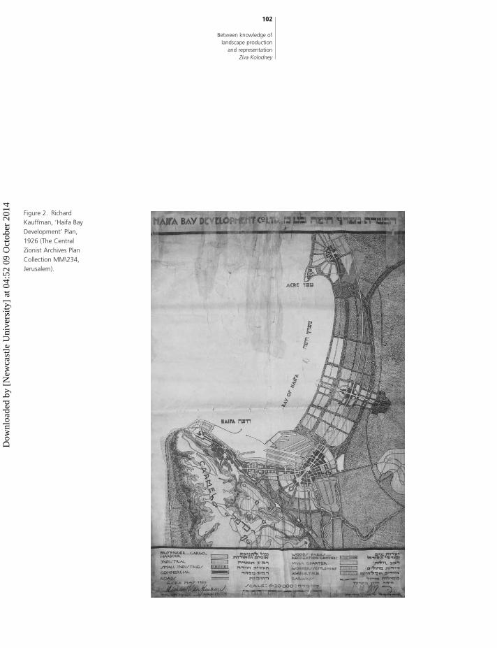
As indicated in his planning scheme, Kauffman
proposed to represent Haifa from above as a
modern object to be controlled as a whole by a par-
ticular geometry of panoramic view (Fig. 2). Kauff-
man’s ideal plan aimed to urbanise the rural land
and to define the city limits, surrounded by a pro-
posed green belt, as both distant and close visual
relationships between Mt Carmel facing north to
the Bay area and the Valley of Zebulun. Contrary
to the perception of the landscape as a passive
and final visual product, Kauffman’s landscape
production is a carefully premeditated and planned
professional process. Indeed, Haifa is an ideal locus
101
The Journal
of Architecture
Volume 17
Number 1
Figure 1. View from
Mount Carmel towards
the Bahai Gardens,
centre and Haifa Bay
area, 2010 (photograph
by Ziva Kolodney).
Dow
nloa
ded
by [
New
cast
le U
nive
rsity
] at
04:
52 0
9 O
ctob
er 2
014
102
Between knowledge of
landscape production
and representation
Ziva Kolodney
Figure 2. Richard
Kauffman, ‘Haifa Bay
Development’ Plan,
1926 (The Central
Zionist Archives Plan
Collection MM\234,
Jerusalem).
Dow
nloa
ded
by [
New
cast
le U
nive
rsity
] at
04:
52 0
9 O
ctob
er 2
014
for examining the urban scene. The city’s unique
topography makes it a showcase for a panoramic
view from above ‘as if sitting in your hand’, accord-
ing to Kauffman, and for those who planned the city
throughout the last century and until today. As indi-
cated in what follows, it also links the understanding
of urban visualisation with paradigms of modern
cityscape design and identity-building of an imperial
and later national ‘urban gaze’.
Producing an imperial ‘Urban Gaze’
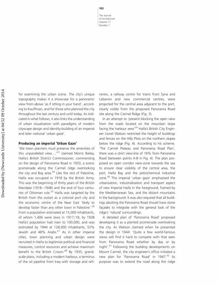
‘We town planners must preserve the amenities of
this unparalleled view. . .’23 claimed Morris Bailey,
Haifa’s British District Commissioner, commenting
on the design of Panorama Road in 1933, a scenic
promenade along the Carmel ridge overlooking
the city and Bay area.24 Like the rest of Palestine,
Haifa was occupied in 1918 by the British Army.
This was the beginning of thirty years of the British
Mandate (1918–1948) and the end of four centu-
ries of Ottoman rule.25 Haifa was targeted by the
British from the outset as a colonial port city and
the economic centre of the Near East ‘likely to
develop faster than any other town in Palestine’.26
From a population estimated at 15,000 inhabitants,
of whom 1,406 were Jews in 1917/18, by 1938
Haifa’s population had risen to 100,000, and was
estimated by 1944 at 128,000 inhabitants, 52%
Jewish and 48% Arabs.27 As in other imperial
cities, town planning and urban design were
recruited in Haifa to legitimise political and financial
measures, control resources and achieve maximum
benefit to the British Crown.28 By 1935, grand-
scale plans, including a modern harbour, a terminus
of the oil pipeline from Iraq with storage and refi-
neries, a railway centre for trains from Syria and
Lebanon and new commercial centres, were
projected for the central area adjacent to the port,
clearly visible from the proposed Panorama Road
site along the Carmel Ridge (Fig. 3).
In an attempt to ‘prevent blocking the open view
from the roads located on the mountain slope
facing the harbour area’29 Haifa’s British City Engin-
eer Lionel Watson restricted the height of buildings
and fences on the Hilly Plots on the northern slopes
below the ridge (Fig. 4). According to his scheme,
‘The Carmel Plateau and Panorama Road Plan’,
there was a strict view-line of 16% from Panorama
Road (between points A-B in Fig. 4). The plan pro-
posed an open corridor view-zone towards the sea
to ensure clear visibility of the central area, the
port, Haifa Bay and the petrochemical industrial
zone.30 This imperial ‘urban gaze’ emphasised the
urbanisation, industrialisation and transport aspect
of new Imperial Haifa in the foreground, framed by
the Mediterranean Sea, and the distant mountains
in the background. It was also required that all build-
ings abutting the Panorama Road should have stone
facades to integrate with the general look of the
ridge’s ‘natural’ surroundings.
A detailed plan of ‘Panorama Road’ proposed
developing it as a planted promenade overlooking
the city. As Watson claimed when he presented
the design in 1944: ‘Quite a few world-famous
views will find it hard to compete with that seen
from Panorama Road whether by day or by
night’.31 Following the building developments on
Mount Carmel, the city engineer’s office initiated a
new plan for ‘Panorama Road’ in 1947.32 Its
purpose was to extend the road along the ridge
103
The Journal
of Architecture
Volume 17
Number 1
Dow
nloa
ded
by [
New
cast
le U
nive
rsity
] at
04:
52 0
9 O
ctob
er 2
014
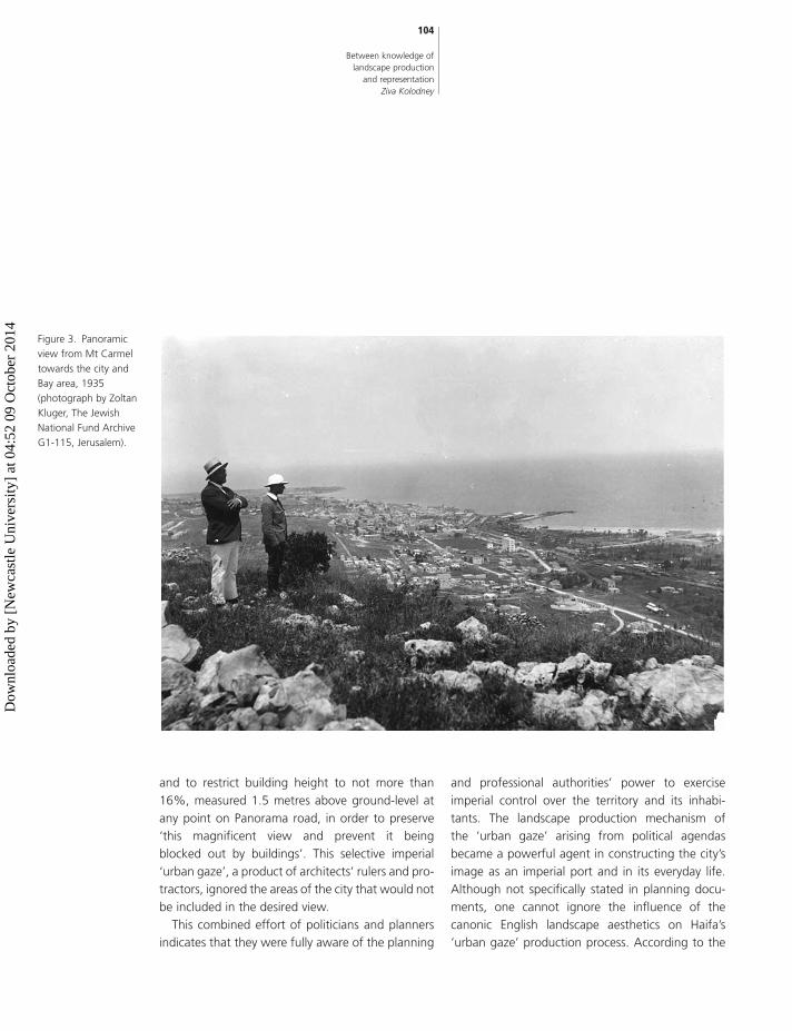
and to restrict building height to not more than
16%, measured 1.5 metres above ground-level at
any point on Panorama road, in order to preserve
‘this magnificent view and prevent it being
blocked out by buildings’. This selective imperial
‘urban gaze’, a product of architects’ rulers and pro-
tractors, ignored the areas of the city that would not
be included in the desired view.
This combined effort of politicians and planners
indicates that they were fully aware of the planning
and professional authorities’ power to exercise
imperial control over the territory and its inhabi-
tants. The landscape production mechanism of
the ‘urban gaze’ arising from political agendas
became a powerful agent in constructing the city’s
image as an imperial port and in its everyday life.
Although not specifically stated in planning docu-
ments, one cannot ignore the influence of the
canonic English landscape aesthetics on Haifa’s
‘urban gaze’ production process. According to the
104
Between knowledge of
landscape production
and representation
Ziva Kolodney
Figure 3. Panoramic
view from Mt Carmel
towards the city and
Bay area, 1935
(photograph by Zoltan
Kluger, The Jewish
National Fund Archive
G1-115, Jerusalem).
Dow
nloa
ded
by [
New
cast
le U
nive
rsity
] at
04:
52 0
9 O
ctob
er 2
014

landscape architect Gina Crandell,33 the English
school of landscape painting from the early Renais-
sance onwards assists us in characterising the visual
attributes of landscape aesthetics. It sets a ‘pictoria-
lising practice’ that defined specific compositional
techniques to represent nature in landscape
design. The understanding of this ‘stamped land-
scape’ as a collective and personal representation
narrative allows us to shed light on ‘urban gaze’
production, assisted by photographic material
found in original publications such as postcards,
posters and photographs of that era.
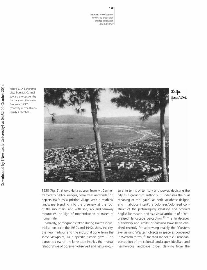
The view features in official and personal images
found in the city, national and international official
archives, private archives, newspapers, journals
and books. These photographs (Fig. 5) offer aerial
views of the cityscape from points on the Carmel
Ridge, framed by trees on either side. The trees in
the foreground thus present a natural and romantic
frame for the cityscape. Framing scenery with trees
(usually palm trees, pines or cypresses) or other
natural objects was a classic ‘European Orientalism’
of Zionist art, established at the Bezalel School of
arts and crafts.34 Ze’ev Raban’s painting of Haifa in
105
The Journal
of Architecture
Volume 17
Number 1
Figure 4. ‘The Carmel
Plateau and Panorama
Road Plan’, 1935 (Haifa
City Engineer Archive,
HP/125, Haifa).
Dow
nloa
ded
by [
New
cast
le U
nive
rsity
] at
04:
52 0
9 O
ctob
er 2
014
1930 (Fig. 6), shows Haifa as seen from Mt Carmel,
framed by biblical images, palm trees and birds.35 It
depicts Haifa as a pristine village with a mythical
landscape blending into the greenery at the foot
of the mountain, and with sea, sky and faraway
mountains: no sign of modernisation or traces of
human life.
Similarly, photographs taken during Haifa’s indus-
trialisation era in the 1930s and 1940s show the city,
the new harbour and the industrial zone from the
same viewpoint, as a specific ‘urban gaze’. This
panoptic view of the landscape implies the mutual
relationships of observer/observed and natural/cul-
tural in terms of territory and power, depicting the
city as a ground of authority. It underlines the dual
meaning of the ‘gaze’, as both ‘aesthetic delight’
and ‘malicious intent’: a coloniser/colonised con-
struct of the picturesquely idealised and ordered
English landscape, and as a visual attribute of a ‘nat-
uralised’ landscape perception.36 The landscape’s
authorship and similar discussions have been criti-
cised recently for addressing mainly the ‘Western
eye viewing Western objects in space as conceived
in Western terms’;37 for their monolithic ‘European’
perception of the colonial landscape’s idealised and
harmonious landscape order, deriving from the
106
Between knowledge of
landscape production
and representation
Ziva Kolodney
Figure 5. A panoramic
view from Mt Carmel
toward the centre, the
harbour and the Haifa
Bay area, 1930th
(courtesy of The Rimon
Family Collection).
Dow
nloa
ded
by [
New
cast
le U
nive
rsity
] at
04:
52 0
9 O
ctob
er 2
014

English aesthetic perception of the ‘picturesque
gaze’;38 for their white-male coloniser attitudes;
and for the disregard of the influence of daily activi-
ties on colonial landscapes.39
Thus, Haifa’s ‘urban gaze’ production, a replica of
the imperial ‘pride projects’ seen from every window
and balcony on the mountain ridge and slopes, is
another means of emphasising the power of the
British Empire to the city’s inhabitants. Did the iconic
image of the cityscape indeed influence the city plan-
ners who constructed that ‘urban gaze’? Did they
place trees in order to capture the ‘natural’ look estab-
lished by the numerous images? Obviously it is hard to
imagine how they could be indifferent to this collective
landscape representation knowledge.
Conversely, the other view, upwards from the
coast towards Mt Carmel, was hardly photographed
and barely mentioned in the planning discourse.
Perhaps this was because hardly any planning pro-
jects were developed, apart from residential
private enterprises. Another reason might be the
planners’ perception of the mountain as a green
space that held no attraction as an imperial-pride
project of that era. ‘Choosing what and how you
view a landscape, especially what is not viewed, is
neither accidental nor naıve’ declared Haim Maor
107
The Journal
of Architecture
Volume 17
Number 1
Figure 6. Haifa, from
the series ‘Ten Cities’,
c. 1930, watercolour on
paper (artist, Zeev
Raban, Copyrights of
“Sinai” Tel Aviv).
Dow
nloa
ded
by [
New
cast
le U
nive
rsity
] at
04:
52 0
9 O
ctob
er 2
014

the curator of the ‘Stamped landscape’ and ‘Stained
Landscape’ exhibition, ‘It is influenced by historical,
political, social, military, religion, ecological and nar-
rative-personal contexts’.40
Producing a national ‘Urban Gaze’’With the establishment of the State of Israel in
1948, Haifa’s urban fabric changed dramatically.
Hostilities before and during the 1948 war drove
some 65,000 Arab residents out of the city. At the
same time many new immigrants settled in Haifa,
where they could find housing and employment in
the port and industrial infrastructures left behind
by the British Mandate in May, 1948.41 Haifa Muni-
cipality, dominated by the Labor Party, quickly
evolved into a centre of influence and power at
the national level, becoming Israel’s ‘worker city’
(nicknamed ‘Red Haifa’). As in the British Mandate
era, national administrators relied on landscape
planning and design to create a new political,
social and economic cityscape in accordance with
their visions of statehood. In constructing a national
identity, together with modernisation and westerni-
sation, architecture was an important means of
legitimising and nationalising modern forms at the
local level.42 Aware of the power of the urban
form in constructing social identity, Haifa’s new
elected mayor, Abba Khoushy, declared that ‘the
city has spirit and style. As a living organism it con-
structs its people while being itself constructed’.43
Although Khoushy promoted independence from
British rule and strongly criticised its oppressiveness,
he nevertheless adopted the imperial ‘urban gaze’
and urged the city planners to implement the
concept.
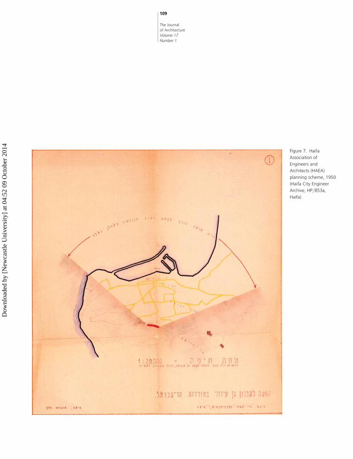
In 1950, the Haifa Association of Engineers and
Architects (HAEA) initiated a scheme for the ‘preser-
vation of Haifa’s unrivalled scenery from Mount
Carmel Ridge’.44 The scheme (Fig. 7) included a per-
spective of the city, harbour and Bay area from the
ridge downward, so that the roads that would be
below it and a park along the ridge (marked red in
the plan) would encompass this view. ‘According to
artists, authors, researchers and tourists worldwide,
this view is one of the most beautiful national heri-
tages in the world’ declared the journalist Arieh
Nesher at a press conference to present the HAEA
plan in 1951.45 The projected plan framed an
‘urban gaze’ defined by a viewing angle of specific
width, height and depth. It demarcated the exact
boundaries of the desired urban scenery, leaving
the rest outside the frame.
Official photographs appeared in books and
albums celebrating the newborn state and the
socio-political role of ‘Red Haifa’. They commemo-
rated the view of the British Imperial infrastructures
that had now become the national/local pride of
the city and its new guardians who had made their
home during the 1940s and 1950s on the mountain’s
northern slopes, facing central Haifa and the Bay. The
view of the harbour represented not just an image of
their livelihood, but of the gateway to Israel through
which thousands of immigrants entered the ‘Prom-
ised Land’. The view from the Carmel Ridge
became a patriotic nation-building narrative and
made its way into numerous city publications of the
1950s. As in the imperial era, photographs of the
1950s featured the same setting between the pine
trees along the ridge. In one representation (Fig. 8)
Mt Carmel has been juxtaposed with two elegantly
108
Between knowledge of
landscape production
and representation
Ziva Kolodney
Dow
nloa
ded
by [
New
cast
le U
nive
rsity
] at
04:
52 0
9 O
ctob
er 2
014
109
The Journal
of Architecture
Volume 17
Number 1
Figure 7. Haifa
Association of
Engineers and
Architects (HAEA)
planning scheme, 1950
(Haifa City Engineer
Archive, HP/853a,
Haifa).
Dow
nloa
ded
by [
New
cast
le U
nive
rsity
] at
04:
52 0
9 O
ctob
er 2
014

110
Between knowledge of
landscape production
and representation
Ziva Kolodney
Figure 8. View from Mt
Carmel toward the city,
1958 (image from the
book: Haifa: In Israel’s
Tenth Year, Haifa
Municipality Press).
Dow
nloa
ded
by [
New
cast
le U
nive
rsity
] at
04:
52 0
9 O
ctob
er 2
014

dressed ladies who are admiring the view of the citys-
cape merging with the sea and distant mountains:
this carefully staged image of the ladies, as if they
are pointing at something specific and thus directing
the viewer’s gaze, clearly derives from the English
landscape painting genre, a visualisation of the
relationship between landscape/culture and nature.
Abba Khoushy, the mayor, asserted that ‘due to
its geophysical structure, Haifa, unlike other cities,
must be planned architectonically, as a bird’s-eye
view from the top of Mount Carmel’.46 Accordingly,
he perceived the architectural plan as a generator
and determinant of his ideas of the city’s life. He
embraced the HAEA’s initiative of a ‘city window-
frame’ as the official plan. This plan proposed an
extensive park of 330 dunams47 on the northern
slopes of the Carmel, intended as a ‘balcony’ over-
looking the cityscape. The plan was rejected due
to the opposition of private and national land-
owners: only 5.5 dunams of the land were owned
by the municipality city. Instead, the city planner
initiated the ‘Mt. Carmel Northern Slope Plan’ that
increased the previous planning restrictions of the
1940s, demanding that no building or fences
would be higher than a view-line of 13%-21%,
measured 1.5 metres above the ground at any
point on the Panorama Road ridge. This is exempli-
fied in sketches (Fig. 9: A and B) which indicated
view possibilities from Mt Carmel with (sketch B)
and without (sketch A) building restrictions. Archi-
tectural directives were also enforced on developing
the downward area below the mountain ridge,
including sloping red roofs, stone-faced facades
and fences, and a defined height of vegetation in
order to preserve the open view. This ‘urban gaze’
mechanism, now associated with the national/
local vision of political empowerment, played a sig-
nificant role in the making of social identity. It was
the landscape production planning and design prac-
tice that enabled a process of domination, enforced
by professionals, administrators and politicians who
collaborated in transforming the cityscape into a col-
lective urban unit.
Afterword
Over the years the monolithic ‘urban gaze’ has
changed, becoming an upward view from the
coast towards Mt Carmel and vice versa. This fol-
lowed the decline of the city’s grand projects for
the harbour and heavy industry activities along the
seashore, followed in turn by private market activi-
ties that advanced economic projects scattered
throughout the city. With the beginning of the
new millennium, a ‘religious view’ constructed by
the members of the Bahai Faith has emerged as a
new and significant collective ‘urban gaze’
(Fig.10). The Bahai Gardens, stretching for a kilo-
metre along Mt Carmel, have since become the
city’s favourite photographic ‘sight’. Opened to the
public in 2001, the gardens were developed and
carefully designed according to the Bahais’ spiritual
aesthetic and Abdul-Baha’s vision that ‘A person
standing on the summit of Mount Carmel will look
upon the most sublime and majestic spectacle in
the whole world’.48
The beautifully situated garden terraces, planted
with lush vegetation intended to integrate with
the natural forests of the Carmel and the gold-
domed shrine at its centre, were declared a World
Heritage Site by UNESCO in 2008.49 Although dom-
111
The Journal
of Architecture
Volume 17
Number 1
Dow
nloa
ded
by [
New
cast
le U
nive
rsity
] at
04:
52 0
9 O
ctob
er 2
014

112
Between knowledge of
landscape production
and representation
Ziva Kolodney
Figure 9. Illustration of
Haifa Association of
Engineers and
Architects (HAEA): view
from Panorama Road
according to the
approved Town
Planning schemes,
(sketch B) and without
building restrictions
(sketch A), 1950 (Haifa
City Engineer Archive,
HP/853a, Haifa).
Dow
nloa
ded
by [
New
cast
le U
nive
rsity
] at
04:
52 0
9 O
ctob
er 2
014

inating the cityscape by day and night, the gardens
are private. Visitors can gain access only by joining
an organised tour free of charge. This has become
an iconic urban view, both for Haifa’s residents
and for the thousands of visitors who visit the
garden annually. New-millennium ‘urban gaze’ is
no longer an imperial, national or civic-patriotic con-
struct. Haifa has embraced this religious icon that
appears in every commercial or tourist pamphlet,
in books, albums, posters and postcards, and can
be found on official internet sites, personal blogs
and in private archives.
Concluding remarks
Over the last hundred years, constructing the ‘urban
gaze’ has been central to the production of Haifa’s
113
The Journal
of Architecture
Volume 17
Number 1
Figure 10: View toward
Bahai Gardens and Mt
Carmel Ridge, 2010
(photograph by Guy
Shachar, IMG_0240
file).
Dow
nloa
ded
by [
New
cast
le U
nive
rsity
] at
04:
52 0
9 O
ctob
er 2
014
cityscape. This study of the planning processes, the
accompanying discourse and the iconography of
the ‘urban gaze’, attempts to shed light on the dia-
lectic of production and representation in the
making of the urban landscape. This diversity of
knowledge is intended to ease the conventional
‘guarded’ architectural boundaries of professional
technical knowledge. Measuring angles and
frames, and designing the mountain ridge and
slopes’ form and materiality, re-conceptualise the
inherent dualism of nature/landscape and urban/
culture as a hybrid entity. Taming the mountain’s
slopes while disciplining an urban setting, juxtapos-
ing the industrialised city, sea, sky with the distant
mountains, arouse intellectual and practical percep-
tions of the landscape threefold.
The cross-field study of architectural and cultural
materials has helped to comprehend and integrate
the terms, ideas, concepts and methods of landscape
production within the field of landscape architecture.
Planning and architectural procedures concerning
‘urban gaze’ that were found in official and unofficial
planning archives, professional publications, compe-
titions and the archives of professional associations
and libraries have been examined. Visual sources
such as postcards, photographs and posters,
together with texts from literature, poetry and
popular journals published at the time of the plan-
ning process were also searched. The site itself was
examined in order to comprehend the changes it
had undergone. Unfortunately, few architects are
still able to give their insights concerning planning
in the 1950s, although those who could do so have
made a significant contribution to this study, enabling
me to amass an important body of information.
The dialectics of landscape production and rep-
resentation knowledge has assisted me in reading
the urban landscape culturally. As professionals,
we have been trained to read landscape architectu-
rally, using data collected on field trips, maps,
surveys, reports, sketches and site plans, sections,
elevations, axonometrics, detailed construction
plans in various technical media. Nonetheless, it
was the cultural and social understanding of
landscape production that helped me to interpret
the professional material and, most significantly, to
frame landscape concepts in critical theory contexts,
tying landscape production knowledge to political,
cultural and social links. A further step to this inter-
disciplinary investigation will be an ethnographical
study of city-dwellers and visitors regarding their
personal ‘urban gaze’ perspective of the city.
The ongoing discourse between urban materiality
and representation can enrich the understanding of
the urban landscape as form and reflection, pro-
fessional production and final product. The historical
modification of the ‘urban gaze’ in Haifa during the
last century exemplifies the centrality of the land-
scape in producing the modern city. It contests the
long-held belief that the urban landscape is subordi-
nate to architecture, opening new avenues of
knowledge for critical research.
Acknowledgements
I would like to thank the anonymous referees and
the editors for their valuable comments and sugges-
tions. Thanks also to Rachel Kallus, Thaisa Way and
Jeffery D. Blankenship for their constructive remarks
at the early phase of the manuscript.
114
Between knowledge of
landscape production
and representation
Ziva Kolodney
Dow
nloa
ded
by [
New
cast
le U
nive
rsity
] at
04:
52 0
9 O
ctob
er 2
014
Notes and referencesGeneral note: Haifa city plans are officially marked HP with
a serial number (eg, HP 723, etc.); HCA: Haifa City Archive,
HEA: Haifa Engineer’s Office Archive, ICA: Israel State
Archive.
1. On the ‘urban gaze’ relationship between landscape and
the visual, see: J. Wylie, Landscape (London/New York,
Routledge, 2007), pp. 55–185; B. Batuman, ‘The
Image of Urban Politics: Turkish Urban Professionals
and Urban Representation as a Site of Struggle’,
Journal of Architectural Education, 62:2 (2008),
pp. 54–65; G. H. Hermosilla, ‘Panoramic View and
National Identity: Two of Santiago de Chile’s Public
Spaces in the Second Half of the Nineteenth Century’,
Planning Perspectives, 24:3 (2009), pp. 319–347.
2. W. J. T. Mitchell, ‘Imperial Landscape’, in, W. J. T.
Mitchell, ed., Landscape and Power (Chicago, The Uni-
versity of Chicago Press, 1994), pp. 1–2. Beyond its
aesthetic role, Mitchell emphasised the landscape as
a medium through which political ideas are materia-
lised. Mitchell claimed that landscape representations
are important documents in understanding the devel-
opment of colonial, national and personal identities.
3. R. Kauffman, ‘First Planning of Haifa-Acre (1925/6)’,
in, A. Keinan, ed., Circles of Generations (Tel Aviv,
1952), p. 192.
4. See various articles in: M. Treib, ed., Representing
Landscape Architecture (London/ New York, Routle-
dge, 2008).
5. See, for example, edited volumes by: J. Corner, ed.,
Recovering Landscape: Essays in Contemporary Land-
scape Architecture (New York, Princeton Architectural
Press, 1999); A. Kahn and C. Burn, Site Matters
(London/New York, Routledge, 2005); C. Waldheim,
ed., Landscape Urbanism Reader (New York, Princeton
Architectural Press, 2006); R. Z. Delue and J. Elkins,
Landscape Theory (London/New York, Routledge,
2008).
6. The ‘way of seeing’ is a key term in the understanding
of landscape representation. It considers a particular
visual and textual imagery of the landscape and
focuses upon representations of cultural images in
art, poetry, literature, photography and cartography;
on how landscapes express both cultural, political
and economic power relationships and their spatial
attributes, emphasising landscape as a dynamic
socio-cultural participant, evidence of strategic
action, and a cultural catalyst. On the ‘way of
seeing’, see: D.E. Cosgrove and S. Daniels, Iconogra-
phy of Landscape: Essays on the Symbolic Represen-
tation, Design and Use of Past Environments
(Cambridge, Cambridge University Press, 1988);
P. Grooth and T.W. Bressi, Understanding Ordinary
Landscapes (New Haven and London, Yale University
Press, 1997); D. Harris, D. F. Ruggles, Sites Unseen:
Landscape and Vision (Pittsburgh, PA, University of
Pittsburgh Press, 2007) and J. Wylie, Landscape
(London/ New York, Routledge, 2007). Gillian Rose
argues that the landscape as ‘way of seeing’ is a par-
ticularly masculine European socio-economic elite’s
visual gaze that relates to the landscape scenery as
female body and as the beauty of nature: G. Rose,
Feminism and Geography; The Limits of Geographical
Knowledge (Cambridge: Polity Press, 1993).
7. On the landscape as a cultural catalyst, see, for
example: B. Meyer, ‘The Expanded Field of Landscape
Architecture’, in, G. George Thompson and F. Steiner,
Ecological Design and Planning (New York, Wiley &
Sons Press, 1997), pp. 45–51; J. Corner, ed., Recover-
ing Landscape: Essays in Contemporary Landscape
Architecture (New York, Princeton Architectural
Press, 1999); D. Harris, The Nature of Authority: Villa
Culture, Landscape and Representation in 18th
115
The Journal
of Architecture
Volume 17
Number 1
Dow
nloa
ded
by [
New
cast
le U
nive
rsity
] at
04:
52 0
9 O
ctob
er 2
014

Century Lombardy (University Park, PA, Pennsylvania
State University Press, 2003).
8. On perspectives of landscape and politics, see, for
example: D. Hayden, The Power of Place: Urban
Landscapes as Public History (Cambridge, MA.,
The MIT Press, 1995); D. Mitchell, ‘Cultural Land-
scapes: Just Landscapes or Landscapes of Justice?,
Progress in Human Geography, 27:6 (2003), pp.
787–796; K. Olwig, Landscape, Nature, and the
Body Politic: from Britain’s Renaissance to America’s
New World (Madison, The University of Wisconsin
Press, 2002); D. Harris, ‘Race, Space and Destabili-
zation of Practice’, Landscape Journal, 26:1
(2007), pp.1–9; Z. Kolodney, R. Kallus, ‘The Politics
of Landscape (Re)production: Haifa, a City caught
between Colonialism and Nation-Building’, Land-
scape Journal, 27:2 (2008), pp. 173–189. On the
right to landscape, see: S. Egoz, J. Makhzoumi,
G. Pungetti, The Right to Landscape: Contesting
Landscape and Human Rights (London, Ashgate
Press, 2011).
9. See, for example: D. Harris, ‘The Postmodernization of
Landscape: A Critical Historiography’, The Journal of
the Society of Architectural Historians, 58:3 (2000),
pp. 434–443; B. Meyer, ‘The Expanded Field of Land-
scape Architecture’, in, G. Thompson, F. Steiner, Eco-
logical Design and Planning (New York, Wiley & Sons
Press, 1997), pp. 45–79.
10. D. Harris, ‘The Postmodernization of Landscape’, op.
cit., pp. 434–443.
11. J. Corner, ed., Recovering Landscape: Essays in
Contemporary Landscape Architecture (New York,
Princeton Architectural Press, 1999).
12. R. Ziady DeLue and J. Elking, Landscape Theory
(London, Routledge, 2008).
13. M. Hays, ’Notes on Narrative Method in
Historical Interpretation’, Footprint (Autumn, 2007),
pp. 23–30; M. Jarzombek, ‘The Cunning of
Architecture’s Reason’, Footprint (Autumn, 2007),
pp. 31–46.
14. H. Lefebvre, The Production of Space, D. Nicholson-
Smith, trs., (Oxford, Blackwell Publishing, 1991).
15. K. Olwig, Landscape, Nature and the Body Politic, op. cit.
16. See Note 1.
17. D. Harris and D. F. Ruggles, Sites Unseen: Landscape
and Vision, op. cit.
18. While working for the Zionist Organisation, ‘Palestine
Land Development Company’, (1921–1932), Kauff-
man proposed in Haifa the neighbourhood plans for
Bat Galim (1921), Neve Sha’anan (1922) and Hadar
Hacarmel (1923), a plan for the Mount Carmel Zone
(1923) and the layout for Haifa’s Bay area (1926–7).
About Richard Kauffman’s plans in Haifa, see:
G. Herbert, S. Sosnovsky, Bauhaus on the Carmel
and the crossroads of empire (Jerusalem, Yad Izhak
Ben Zvi/Haifa: Architectural Heritage Centre, 1993),
pp. 156–210.
19. R. Kauffman, ‘First Planning of Haifa-Acre (1925/6)’,
op. cit., p. 192.
20. B. Bender, ‘Subverting the Western Gaze: Mapping
alternative Worlds’, in, P. J. Ucko, R. Layton, The
Archaeology and Anthropology of Landscape:
Shaping your Landscape (London, Routledge, 1999),
pp. 31–45.
21. F. Driver and D. Gilbert, eds., Imperial Cities: Land-
scape, Display and Identity (Manchester, Manchester
University Press, 1999).
22. A. Morshed, The Cultural Politics of Aerial Vision: Le
Corbusier in Brazil (1929), Journal of Architectural
Education, 55:4 (2002), pp. 201–210.
23. [HEA 1933], Minutes of the 27th meeting, Local Town
Planning Commission (March 30th, 1933), (HP 125).
24. [HEA 1935], The Carmel Plateau and Panorama Road
Plan (HP 125, approved in 1935).
25. Concerning Ottoman and Mandate Haifa, see:
M. Yazbak, Haifa in the Late Ottoman Period,
116
Between knowledge of
landscape production
and representation
Ziva Kolodney
Dow
nloa
ded
by [
New
cast
le U
nive
rsity
] at
04:
52 0
9 O
ctob
er 2
014
1864–1914: A Muslim Town in Transition (Leiden,
Brill Publishers, 1998); M. Seikaly, Haifa transform-
ation of an Arab society 1918–1939 (London/
New York, I.B. Tauris, 1998).
26. Palestine official census (Israel State Archive, 1918);
The Palestine Post, 14:3 (February,1943).
27. Census estimate: statistical abstract (Israel State
Archive, 1944/1945); Israeli Census (Israel State
Archive, 8.11.48).
28. In relation to British colonial plans in Haifa, see:
G. Herbert, S. Sosnovsky, Bauhaus on the Carmel
and the Crossroads of Empire, op. cit.; B. Hyman,
British Planners in Palestine, 1918–1936 (Thesis sub-
mitted for the degree of PhD, London School of Econ-
omics and Political Science, 1994).
29. J. L. A. Watson, ‘The Past Four Years in Haifa’, Building
in the Near East, 4 (1938), pp. 57–61.
30. [HEA 1935], The Carmel Plateau and Panorama Road
Plan, op. cit.
31. [HCA 1944–1945], City Engineer’s Annual Report,
1944–1945, p. 10. Professor Adolf (Peter) Rading
(1888–1957), architectural adviser to Haifa Town
Planning Department (1943–1950), was the planner
of ‘Panorama Road’ [HEA 1944], Panorama Road
Plan (HP 669, approved in 1944).
32. [HEA 1948] Panorama Road – Extension (HP 723,
approved in 1948).
33. G. Crandell, ‘Nature Pictorialized: “The View”‘, in Land-
scape History (Baltimore, Johns Hopkins University Press,
1993).
34. The Bezalel School, founded in 1903 by Boris Schatz,
established a distinctive style in which artists portrayed
both Biblical and Zionist subjects. About early art in
Israel, see: Y. Zalmona, To the East? In The East: Orient-
alism in the Arts in Israel (Jerusalem, Israel Museum,
1998; exhibition and catalogue); D. Manor, ‘Biblical
Zionism in Bezalel Art’, Israel Studies, 6:1 (2001),
pp. 55–75.
35. Ze’ev Raban (1970–1890) was a leading artist of the
Bezalel School and one of the founders of the Israeli
art world.
36. W. J. T. Mitchell, ‘Imperial Landscape’, op. cit., p. 12.
On the English landscape approach, see, for
example: G. Crandell, ‘Nature Pictorialized: “The
View”‘, op. cit.; S. Herrington, On Landscapes
(New York/London, Routledge, 2009), pp. 33–51.
37. D.F. Ruggles, ‘Making Vision Manifest: Frame, Screen,
and View in Islamic Culture’, in, D. Harris, D.F. Ruggles,
Sites Unseen: Landscape and Vision op. cit., pp. 131–
156.
38. H. V. Scott, ‘Rethinking Landscape and Colonialism in
the Context of Early Spanish Peru’, Environment and
Planning D: Society and Space, 24:4 (2006),
pp. 481– 496; M. H. Edney, Mapping an empire the
geographical construction of British India, 1765–
1843 (Chicago & London, University of Chicago
Press, 1997).
39. M. L. Pratt, Imperial Eyes: Travel Writing and Transcul-
turation (New York/London, Routledge, 1992); J. Urry,
The Tourist Gaze: Leisure and Travel in Contemporary
Societies (London, Sage Publishers, 1990); G. Rose,
Feminism and Geography: The Limits of Geographical
Knowledge (Cambridge, Polity Press, 1993).
40. H. Maor, Marked Landscapes: ‘Landscape-Place’ in
Contemporary Israeli Art (Beer Sheva, Ben Gurion Uni-
versity Gallery, 2003; exhibition and catalogue).
41. Of the 190,000 newcomers arriving in Israel between
May, 1948 and March, 1949, 24,000 remained in
Haifa. By 1948, immediately after the war, the city’s
population was estimated at 98,284, of which 96%
were Jews (Israeli Census 08.11.48, Israel State
Archive.). In 1951 it was estimated at 149,917 inhabi-
tants, 95% Jewish (Israel Bureau of Statistics 1951,
Israel State Archive).
42. On the connection between planning/architecture and
nation-building, see: S. Bozdogan Modernism and
117
The Journal
of Architecture
Volume 17
Number 1
Dow
nloa
ded
by [
New
cast
le U
nive
rsity
] at
04:
52 0
9 O
ctob
er 2
014
Nation Building: Turkish Architectural Culture in the
Early Republic (Washington, University of Washington
Press, 2001); Z. Kolodney, R. Kallus, ‘Between Colonial
and National Landscapes’, Planning Perspectives
Journal, 23:3 (2008a), pp. 323–348.
43. [HCA 1954], Haifa City Council Meeting No.122, May
17th, 1954.
44. [HCA 1950], Town Planning Committee no. 165,
September 22nd, 1950.
45. A. Nesher, ‘We must Protect the Beauty of the Carmel
City’, Haaretz newspaper (31.01. 51).
46. A. Khoushy, Thirty Months of Work: Haifa (Haifa, Haifa
Municipality, 1954), p. 19.
47. One metric dunam ¼ 1,000 m2, a measurement used
in the Ottoman Empire and still in use in Israel.
48. http://terraces.bahai.org/terraces.en.html
49. http://whc.unesco.org/en/list; http://terraces.bahai.
org/architects.en.html
118
Between knowledge of
landscape production
and representation
Ziva Kolodney
Dow
nloa
ded
by [
New
cast
le U
nive
rsity
] at
04:
52 0
9 O
ctob
er 2
014