benalla rural city council · n they form the basis of the road transport network. ... (rvmp) aims...
TRANSCRIPT

BENALLA RURAL CITY COUNCILROADSIDE VEGETATIONMANAGEMENT PLAN
November 2014

2 Benalla Rural City Council Roadside Vegetation Management Plan 2014
Background
Background
The original draft document was prepared by Benalla Rural City in 2006 with significant input from the Benalla Rural City Roadside Vegetation Management Plan Steering Committee.
The development of this 2014 update of the Roadside Vegetation Management Plan has been undertaken under the direction of the Benalla Rural City Council. The scope of this plan is the management of rural roadsides under the control of the Benalla Rural City, excluding roads controlled by VicRoads.
Acknowledgements
This plan builds on work by members of the community, representatives of organisations and a number of consultants. The work by Carol Kunert (2006), Pat Connor (2006) and Natasha Baldyga (2013) is appreciated. This plan draws on initiatives from other Councils including the Rural City of Wangaratta, and the City of Greater Shepparton. The joint project by local government and the Goulburn-Broken Catchment Management Authority developing protocols for Roadside Biodiversity Risk Management provided a solid foundation for work related to staff and contractors.
Benalla Rural City Council PO Box 227 Benalla, VIC, 3671Telephone (03) 5760 2600Email: [email protected]
ABN: 42 379 380 529
2014
This publication is intended to be of assistance to all people involved in the management of roadsides. However the Benalla Rural City Council, its employees and consultants, do not guarantee that the publication is without flaw of any kind or that it is wholly appropriate for the particular purposes of individuals, and therefore disclaim any liability for any error, loss or other consequences which may arise from reliance on any information in this publication.
Benalla Rural City Council Roadside Vegetation Management Plan 2014 3
Contents
1.0 Introduction .................................................................................................................52.0 How is this Plan organised? ..........................................................................................53.0 Principles ....................................................................................................................64.0 Relationship with other Council Plans and Strategies ....................................................6
4.1 Council Planning Provisions ............................................................................64.2 Road Management Plan .................................................................................74.3 Municipal Fire Management Plan ....................................................................7
5.0 What Area does this Plan Cover? ..................................................................................86.0 Council’s responsibility ................................................................................................87.0 Objectives of the Roadside Vegetation Management Plan ...............................................98.0 Material supporting the Roadside Vegetation Management Plan ...................................109.0 Quality of Roadside Vegetation in Rural City of Benalla ................................................11
9.1 Roadside Conservation Values Map .............................................................. 119.1.1 High Conservation Value .......................................................................... 119.1.2 Medium Conservation Value ..................................................................... 129.1.3 Low Conservation Value ........................................................................... 12
10.0 Rare and threatened species ......................................................................................1310.1 Rare and endangered species in Benalla ....................................................... 13
10.1.1 Regent Honeyeater Habitat/Lurg Ironbark Vegetation Protection Area ....... 1310.1.2 Grey-crowned Babbler Habitat Vegetation Protection Area ....................... 1410.1.3 Significant Tree Protection Area ............................................................ 1410.1.4 Lima Stringybark ................................................................................. 15
11.0 Risks to Roadside Biodiversity ....................................................................................1512.0 General Principles for Protection of Conservation Values on Roadsides ........................17
12.1 Vegetation Communities and Natural Regeneration ........................................ 1712.2 Regeneration .............................................................................................. 1712.3 Wetlands .................................................................................................... 1712.4 Wildlife habitat ........................................................................................... 1812.5 Rare, threatened or locally significant Flora and Fauna .................................. 1812.6 Pest Plants and Animal Management ........................................................... 1812.7 Roadside Marking of Special Environmental Areas ......................................... 1912.8 Unused road reserves .................................................................................. 2012.9 Road maintenance, Construction, Widening, Service Installation and Maintenance ........................................................................................ 2012.10 Fire management ........................................................................................ 20
13.0 Council department responsibilities ............................................................................2113.1 Goals ......................................................................................................... 2113.2 Vegetation Management .............................................................................. 22
13.2.1 Seed Harvesting .................................................................................. 2213.2.2 Native Vegetation removal on roadsides ................................................. 2213.2.3 Firewood Collection ............................................................................. 2413.2.4 Site rehabilitation................................................................................ 24
13.3 Pest Plants and Animals ............................................................................. 2413.3.1 State Prohibited .................................................................................. 24
CONTENTS
4 Benalla Rural City Council Roadside Vegetation Management Plan 2014
Contents
13.3.2 Regionally Prohibited Weeds ................................................................ 2513.3.3 Regionally Controlled Weeds ................................................................ 2513.3.4 Restricted Weeds ................................................................................ 2513.3.5 Weeds of National Significance ............................................................ 2513.3.6 Environmental Weeds .......................................................................... 25
13.4 Functional Issues ....................................................................................... 2613.4.1 Fire management and fire protection ..................................................... 2613.4.2 Service providers ................................................................................. 2713.4.3 Maintenance of tree Clearance by Electrical Companies and its Contractors .................................................................................... 2713.4.4 Road Maintenance, Construction and Widening ..................................... 2713.4.5 Stockpile and Dump Sites .................................................................... 2813.4.6 Stormwater Protection ......................................................................... 2813.4.7 Sand, Soil and Gravel Extraction........................................................... 28
13.5 Landholder, Farming and Associated Activities .............................................. 2913.5.1 Stock movement, droving & grazing ...................................................... 2913.5.2 Cropping ............................................................................................ 2913.5.3 Haymaking ......................................................................................... 2913.5.4 Slashing ............................................................................................. 3013.5.5 Ploughing or grading............................................................................ 3013.5.6 Maintenance of driveways .................................................................... 3013.5.7 Bee Keeping ....................................................................................... 3013.5.8 Fencing .............................................................................................. 3013.5.9 Revegetation ....................................................................................... 31
13.6 Cultural and recreational Issues ................................................................... 3113.6.1 Cultural Heritage ................................................................................. 3113.6.2 Significant Landscapes ........................................................................ 3313.6.3 State Forests, Parks, Reserves and Waterways ....................................... 33
14.0 Conclusion .................................................................................................................3415.0 Summary of recommendations ....................................................................................3516.0 References ................................................................................................................3717.0 Appendix 1: Relevant Strategies, Policies and Legislation ...........................................3918.0 Appendix 2: Roadside assessment form .......................................................................4319.0 Appendix 3: Glossary of Terms ..................................................................................4420.0 Appendix 4 List of Significant Species ........................................................................47
CONTENTS continued
Benalla Rural City Council Roadside Vegetation Management Plan 2014 5
Introduction
1.0 INTRODUCTION
Roads form a pattern across the landscape. They have a number of values: n They form the basis of the road transport network.n They are critical for the safe movement of people and goods.n They can have important remnants of native vegetation and support the refuge and movement of
fauna. n They are corridors for infrastructure, including property access, power lines, storm water
management and at times flood mitigation.n They may act as important tools in fire management and suppression.n They may be used as sources of fuel including firewood.
Road reserves can also be a source of weeds for adjacent landholders.
Roadside Vegetation Management Plans are a tool to assist the community, landholders, Council staff and contractors to manage roadside vegetation.
This Roadside Vegetation Management Plan (RVMP) aims to provide a degree of confidence about how roadside vegetation may be managed at different locations. It provides a logic about why some activities are allowed in some places and others not.
This Roadside Vegetation Management Plan has been drafted to take into account recent changes within the Benalla Rural City, legislative requirements, and community and stakeholder input. It draws on work undertaken from 2006, when the first draft Roadside Vegetation Management Plan was developed. However there have been considerable changes in both the physical and legal landscape since that work was completed. This document therefore provides a fresh approach to managing the vegetation on roadsides within the Benalla Rural City Council (BRCC).
2.0 HOW IS THIS PLAN ORGANISED
The Roadside Vegetation Management Plan consists of three documents targeted at different audiences, being:
Document 1 – The Roadside Vegetation Management Plan documents how the Council will protect biodiversity assets in the performance of its duties and provides background information.
Document 2 - The Community Roadside Management Handbook has been produced for use by the general community including land holders, Landcare groups and fire prevention agencies.
Document 3 - The Roadside Environmental Code of Practice Handbook is a document tailored to the needs of road construction and maintenance contractors and Council staff working in the field.
There are also maps which accompany the above documents.
Fact sheets are also available from the Council or on the Council website.
6 Benalla Rural City Council Roadside Vegetation Management Plan 2014
Principles
3.0 PRINCIPLES
The following principles will be applied to the implementation of the Roadside Vegetation Management Plan.
n Participation: Early and honest communication with the community around significant actions.n Working together: Development and maintenance of relationships to achieve our goals – includes
using local service providers wherever possible.n Justifiable: All actions will be subject to normal risk assessment mechanisms including social and
economic analysis where it is appropriate (i.e. for projects likely to have significant impacts or costs).
n Empowerment: Education and information will be designed to support people to take action in their own way.
n Respect: We will respect different views and ideas, try and accommodate them where possible, and provide a reasonable explanation when that is not possible.
n Accountability: We will be accountable for the actions we deliver and the immediate actions we expect to attain.
n Continuous improvement: We will monitor our progress, report to the community, and involve the community in planning for improvement.
4.0 RELATIONSHIP WITH OTHER COUNCIL PLANS AND STRATEGIES
The importance of a Roadside Vegetation Management Plan is reflected in the Council Plan 2013 – 2017, The Benalla Rural City Environment Strategy 2011 – 2015 and the Climate Action Adaptation Plan of 2013 – 2025.
The Roadside Vegetation Management Plan further develops the Council policies in relation to environmental sustainability and responsible management of natural resources.
4.1 COUNCIL PLANNING PROVISIONSThe Municipal Strategic Statement (MSS) states that in relation to native flora and fauna:
The remaining native vegetation areas are mainly restricted to river corridors, roadsides and the crown land. These areas are extremely important for the retention of fauna habitat and providing linkages between habitat areas. Council will ensure these have ongoing protection and divert development pressure to areas devoid of vegetation.
Objective 2 of the Environment section of the Municipal Strategic Statement is to “Conserve native vegetation and fauna”. Strategies identified include:
n Support the Department of Sustainability and Environment’s efforts to protect threatened species of flora and fauna.
n Support VicRoads efforts to prepare Roadside Management Plans for arterial roads and freeways.n Prevent the unjustified or illegal removal of native vegetation, including trees.n Implementation of local and regional roadside conservation strategiesn Encourage the linking and protection of remnant native vegetation to improve habitat.n Encourage landowners to fence riparian areas and other native vegetationn Develop a regional approach to planning that includes identifying areas of high biodiversity
significance.
Benalla Rural City Council Roadside Vegetation Management Plan 2014 7
Relationship with other Council Plans and Strategies
4.2 ROAD MANAGEMENT PLANThe Council’s Road Management Plan was updated in June 2013. The Road Management Plan has been established to provide Benalla Rural City with a framework to manage the road system to cater for the needs of everyone who lives and travels within the municipality.
The Road Management Plan has been developed as a response to the Road Management Act 2004 and is a mechanism to manage Benalla Rural City’s local road assets. It takes into consideration the important links provided by freeways, arterial roads and local roads within and connecting to the municipality’s local road network.
The Road Management Plan seeks to balance the community’s financial, legal, social, safety and environmental expectations, particularly those people and groups who rely on the road network for access in our rural communities.
Road asset management involves the management of the physical road infrastructure and the aspects of the use and operation of the infrastructure which may affect its condition. It applies to all road assets including pavements, signage, drainage, bridges and major culverts within the local road network.
Maintenance and construction of roads as outlined in the road management plan has considerable potential to impact roadside vegetation. Section 13 (Risks to roadside vegetation) provides some further detail. The Roadside Environmental Code of Practice (Document 3) of this Roadside Vegetation Management Plan provides detail for use of staff and contractors to reduce their impacts when working in road reserves.
Recommendation 1:The Roadside Vegetation Management Plan be included as a reference document in the Road Management Plan.
4.3 MUNICIPAL FIRE MANAGEMENT PLANA key responsibility of the Benalla Rural City Council Municipal Fire Management Planning Committee (MFMPC) is the development of a Municipal Fire Management Plan (MFMP) on behalf of the Municipal Emergency Management Planning Committee. This plan describes how regional authorities, local government, fire agencies and other relevant organisations can work together to effectively anticipate, respond to and recover from bushfire events affecting BRCC.
While the management of all types of fires is important, the MFMP has focused on bushfire in the first instance. Furthermore it is important to note that this plan recognises, but does not duplicate, the extensive work already being undertaken in fire management across the municipality. The MFMP is essentially a plan for improving integration of this existing work and developing improved methods for working together.
The Municipal Fire Management Plan identifies a series of risks. Two relate to roadside vegetation. The following is an extract:
Lima Stringybark: Department of Environment, Land, Water and Planning is currently investigating Lima Stringybark populations.Lima Stringybark/Regent Honeyeater: it is noted that The Council is re-examining its Roadside Vegetation Management Plan, reviewing the document and developing more efficient planning procedures (with respect to fire), and that roadside planting will be discussed in terms of fire safety and road safety
8 Benalla Rural City Council Roadside Vegetation Management Plan 2014
What area does this Plan Cover?
The Municipal Fire Management Plan explicitly notes the potential conflict of values:A number of the fire risk treatments adopted in Risk Management Plan pose a potential threat to some of the very values the MFMPC is seeking to safeguard. It is important that these threats are noted and that a balance be struck between protecting the community from fire and maintaining the economic, social, and environmental wellbeing of the municipality.
This Roadside Vegetation Management Plan recognises the potential for conflict and notes the conflict resolution process offered through the Municipal Fire Management Plan. The Roadside Vegetation Management Plan also offers a matrix which may assist to defuse conflicts of values on roadsides (see page 32: Fire Management and Fire Protection).
5.0 WHAT AREA DOES THIS PLAN COVER?
The Roadside Vegetation Management Plan covers all rural local roads within the Benalla Rural. Roads inside town boundaries have not been included.
The Benalla Rural City Council’s Public Road Register records the details of all public roads for which it is responsible. The municipality manages a total of 480 km of sealed rural and 756 km unsealed rural local roads.
This Plan focuses primarily on the protection and management of remnant native vegetation and biodiversity values located on the Council managed roadsides. The Plan also recognises and promotes opportunities to restore and enhance this remnant vegetation and habitats for indigenous plants and animals.
6.0 COUNCIL’S RESPONSIBILITY
Under the Road Management Act 2004, the Council is the responsible authority for all local roads within the municipality. The Council is also responsible for the management of third party activities on these roads.
It is also the Council’s responsibility under Section 43 of the CFA Act 1958 to “take all practicable steps to prevent the occurrence of fires on, and minimise the danger of the spread of fires on, any road under its care and management”.
The Council will, in consultation with other authorities, manage road reserves to: n Provide safe transport corridors. n Ensure safe property access.n Protect service assets.n Minimise fire impact. n Protect and enhance biodiversity values. n Protect cultural, amenity and heritage values.
There is an array of legislation and policy relevant to biodiversity and road management.
The following are some examples which may influence management of road reserves:n Benalla Rural City Council Planning Schemen Local Government Act 1989n Flora and Fauna Guarantee Act 1988
Benalla Rural City Council Roadside Vegetation Management Plan 2014 9
Council’s Responsibility
n Planning and Environment Act 1987n Road Management Act 2004n Aboriginal Heritage Act 2006n Environment Protection and Biodiversity Conservation Act 1999n Catchment and Land Protection Act 1994n Permitted Clearing of Native Vegetation – Biodiversity Assessment Guidelines 2013n Victoria’s Biodiversity Strategy
A more detailed outline of the most relevant acts is included in Appendix 1.
VicRoads is the responsible authority for state highways, freeways, main roads and tourist roads. The following roads are managed by VicRoads:
n Hume Freeway n Arterial roads:
Midland Highway Benalla - Tocumwal Road; Dookie - Devenish Road; Benalla - Yarrawonga Road; Benalla - Winton Road; and, Benalla - Tatong Road.
The Department of Environment, Land, Water and Planning (DELWP) and Parks Victoria are responsible for managing most roads within National Parks, State Parks and State Forest areas. HVP Plantations also manage some roads within the plantation areas.
7.0 OBJECTIVES OF THE ROADSIDE VEGETATION MANAGEMENT PLAN
Managers of road reserves, including the Council, have obligations under different State and Federal legislation. This legislation is currently changing rapidly.
This Roadside Vegetation Management Plan (RVMP) aims to: n Address the Council’s obligations for managing native vegetation on roadsides within the Benalla
Rural City as required by legislation.n Provide a degree of confidence about how roadside vegetation may be managed at different
locations. n Provide a logic about why some activities are allowed in some places and others not.n Provide tools for the use of staff, contractors and the community to manage native vegetation on
roads that are under the control of the Council.
It acknowledges that the primary function of roads is to provide safe vehicle transit. However there are a range of values for roads and their vegetation.
Roadside vegetation, particularly those of high conservation value, can act as important reservoirs of flora and fauna species. Remnant vegetation, including those on roadsides, can also be important wildlife corridors, assisting the movement of species. Species move for a range of reasons and in our current changing climate, species may move to areas where conditions suit them better.
10 Benalla Rural City Council Roadside Vegetation Management Plan 2014
Objectives of the Roadside Vegetation Management Plan
The Benalla Climate Change Adaptation Plan identifies the impacts of changing climate on biodiversity:The most susceptible species will be those with restricted or specialised habitat requirements, poor dispersal abilities or small populations.There may be increased pressure from competitors, predators, parasites, diseases and disturbances (such as bushfire or drought).Existing threats likely to be amplified, such as habitat loss and invasive species, making their impacts considerably worse.
Improving linkages and the quality of vegetation, including roadside vegetation, can increase the resilience of species. Benalla already has successful examples of this approach. For example, the programs of the Regent Honeyeater Project has led to the restoration of over 1400 hectares of habitat. The project emphasises the need for a mixed range of species with good understorey and flowering shrubs to increase vegetation and animal health. An opportunity exists to work with the outcomes of this Roadside Vegetation Management Plan, Planning Scheme offset programs and other projects to strengthen the networks of native vegetation across the Rural City of Benalla.
How does the RVMP meet it’s objectives?n All roadsides managed by the Benalla Rural City Council have been mapped to identify areas of
conservation value: high, medium and low. n Data bases held by state and federal authorities have been checked to identify species (flora and
fauna) with high protection values, usually based on rarity. n Community representatives have been involved in reviewing the approach and the maps.n CFA, and other local experts have been consulted to identify areas that must be managed
primarily for safety.n Gaps in existing Council policies (including the Benalla Rural City Council Planning Scheme)
have been identified.n Recommendations have been included to overcome gaps.n Separate documents have been developed for the community and road construction and
maintenance contractors. n The draft of the Roadside Vegetation Management Plan will be provided for public review and
consultation.n The draft will be reviewed after the community consultation to incorporate submissions where
appropriate.
8.0 MATERIAL SUPPORTING THE ROADSIDE VEGETATION MANAGEMENT PLAN
This document reflects legislation and physical conditions at a point of time. There is extensive material available that can support the community and staff in managing the roadside vegetation. This includes:
n Listings of weeds that are found in Benalla Rural City Council.n Listings of rare species in Benalla Rural City Council.n References and resources provided by other organisations.n Goulburn Broken Invasive Plant and Animal Biodiversity Strategies 2010 – 2015. These
strategies can be found under publications on the GBCMA website www.gbcma.vic.gov.aun A series of fact sheets to assist the community to better understand roadside vegetation
management and associated risks to roadsides.
These resources are available on the Benalla Rural City Council website. This will allow the supporting documentation to be regularly reviewed and updated as required.
Benalla Rural City Council Roadside Vegetation Management Plan 2014 11
Quality of Roadside Vegetation in Rural City of Benalla
9.0 QUALITY OF ROADSIDE VEGETATION IN RURAL CITY OF BENALLA
In the 2006 draft RVMP all roadside were assessed for their conservation value. Three categories were identified: High Conservation Value, Medium Conservation Value or Low Conservation Value.
Appendix 2 outlines the process used to determine conservation values of road reserves within the Benalla Rural City.
9.1 ROADSIDE CONSERVATION VALUES MAPAn assessment of all roadsides outside townships, for which the Council is the responsible authority, has been undertaken.
A conservation value of high, medium or low was generated through a vehicle-based assessment of indicating factors including:
n Roadside width n Fauna habitat (presence of trees, shrubs, grasses, leaf litter, fallen timber, rocks/crevices or wet
marshy land) n Regeneration n Wildlife corridor n Weed cover n Site disturbance n Rare or threatened species presence
A summary of the characteristics of each roadside value level is provided below.
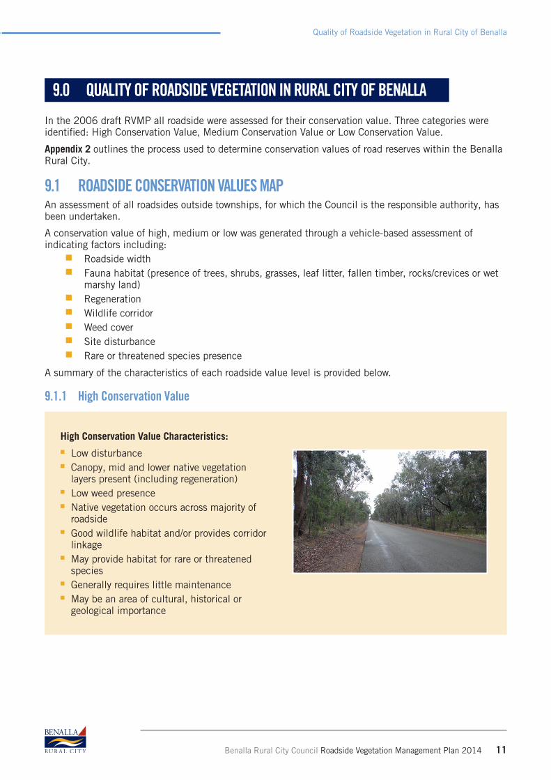
9.1.1 High Conservation Value
High Conservation Value Characteristics:n Low disturbance n Canopy, mid and lower native vegetation
layers present (including regeneration) n Low weed presence n Native vegetation occurs across majority of
roadside n Good wildlife habitat and/or provides corridor
linkagen May provide habitat for rare or threatened
species n Generally requires little maintenancen May be an area of cultural, historical or
geological importance

12 Benalla Rural City Council Roadside Vegetation Management Plan 2014
Quality of Roadside Vegetation in Rural City of Benalla
9.1.2 Medium Conservation Value
Medium Conservation Value Characteristics:n Vegetation in semi-natural conditionn Mostly native vegetationn Moderate disturbance, with moderate cover of
introduced species (20 – 30%) n Native vegetation occurs mainly in patches n Some regeneration n Few habitat features n Category may also include modified
vegetation with extensive regeneration.
9.1.3 Low Conservation Value
Low Conservation Value Characteristics:n Substantially disturbed or modified n Predominately non-native vegetation n Little to nil regeneration n Few habitat features n Potential for increased fire risk
The roadside conservation values from this assessment are currently recorded on maps held at the Benalla Rural City offices. It is recognised that conditions of roadsides change and that this material needs to be regularly updated.
An interactive mapping system that can be used by all staff and the community, in conjunction with this Roadside Vegetation Management Plan and other relevant documents, will enable informed decisions to be made on roadside management.
Recommendation 2:Assessments of Roadsides be reviewed on a five year rotation basis to reflect the changing nature of roadsides, including improvement or vegetation loss. If resources do not allow, priority is to be given to areas of high conservation value.
Recommendation 3:Roadside conservation values be recorded using GPS and be incorporated with other relevant information on the Council’s mapping system and developed into an interactive accessible format, when possible.

Benalla Rural City Council Roadside Vegetation Management Plan 2014 13
Rare and threatened species
10.0 RARE AND THREATENED SPECIES
Roadside vegetation can have a very important role in providing a reservoir of plant and animal species within the landscape. In setting priorities for action, species or ecological classes that have been identified as either rare or threatened, are of high importance.
In establishing priorities for action, it is worth noting the difference between the two categories.Rare
n occur in naturally low numbers across large areas or occur in reasonable numbers but in only a limited number of locations.
n may be locally abundant, but are classified Rare because they occur in habitat types that are naturally very restricted in distribution.
Rare species may be at serious risk and be classified into one of the threatened categories (i.e. Vulnerable, Endangered, Critically Endangered). Outside of conservation reserves, particularly on private land, rare species may be at serious risk. Their small population size and/or restricted distribution mean that rare species are predisposed to disaster from events such as fire, human disturbance or disease.Threatened
n a general term to designate species whose survival is at risk. n covers a range of categories of species including presumed extinct, endangered (in danger of
extinction, survival unlikely if threats to existence continue) and vulnerable (likely to move into the endangered category in the near future if threats continue).
Threatened species, in contrast to the Rare species, may have had relatively large populations that naturally occurred over broad areas but have suffered declines in range and or abundance. Unlike many Rare species whose populations may be small but stable, most threatened species are undergoing active population decline will move into higher extinction risk categories unless the trend can be halted or reversed1.
10.1 RARE AND ENDANGERED SPECIES IN BENALLABenalla Rural City has a number of rare and endangered species. These include: the Regent Honeyeater, the Grey-crowned Babbler, the Squirrel Glider, the Brush-tailed Phascogale (or Tuan) and the Bush Stone Curlew.
A full list of threatened species identified in the Benalla Rural City during the roadside desktop assessment can be found in Appendix 4.
The Benalla Planning Scheme recognises the importance of these species with a number of Vegetation Protection Overlays.
10.1.1 Regent Honeyeater Habitat/Lurg Ironbark Vegetation Protection Area
Located around Lurg, especially Ironbark around Lurg; White Box Woodland on Kilferra Road. Remaining vegetation is mostly now confined to least fertile soils (less nectar flow). A 1992 survey showed that 82% of the Victorian records were from Chiltern, Killawarra and Benalla areas.
1 Derived from Ryan, Paul, Threatened Flora and Fauna Species and non-threatened vertebrate fauna in the Goulburn Broken Catchment: status trends and management, pp 13 - 14

14 Benalla Rural City Council Roadside Vegetation Management Plan 2014
Rare and threatened species
This area provides one of the last remaining habitat areas for the Regent Honeyeater which is listed as an endangered species under the Fauna and Flora Guarantee Act 1988. The area also provides habitat for Squirrel gliders, Brush-tailed Phascogales (Tuan), Grey-crowned Babblers, Bush Stone Curlews and Quolls, which are listed as rare or endangered under the Fauna and Flora Guarantee Act 1988. The area maintains vegetative links between the Warby Range and the Great Dividing Range and is used as habitat and a migratory route by some indigenous fauna species.
The Benalla Planning Scheme seeks to protect and stop the removal of native vegetation in areas that support Regent honeyeater (Clause 42.02 Schedule 3).
10.1.2 Grey-crowned Babbler Habitat Vegetation Protection Area
Grey-crowned Babblers are most abundant in the region between Longwood and Benalla, the Hume Freeway and the Broken River. An estimated 150 groups (600 birds) are thought to occur in this region. The Lurg Hills population is isolated from the plains population and needs critical support to maintain viability. Elsewhere in the state there is estimated to be fewer than 50 groups, all of which appear to be under threat.
This area provides one of the last remaining habitat areas for the Grey-crowned Babbler (listed as endangered under the Fauna and Flora Guarantee Act 1988).
The Planning Scheme seeks to protect habitat areas that support Grey-crowned Babbler populations and to ensure that unnecessary removal of native vegetation in these areas does not occur. (Clause 42.02 Schedule 2).
10.1.3 Significant Tree Protection AreaSchedule 4 of the Benalla Planning Scheme contains Vegetation Protection Overlays. These controls cover trees identified as significant trees for their botanical, historic, cultural, size, growth habit or community association values.
Seven listings of trees or groups of trees are listed in this schedule. Of these, five occur on roadsides: n Eucalyptus melliodora Yellow Box, Terretts Rd, nr RMB5230 Goomalibee. Curious growth form:
abnormal outgrowths known as the “Camel Tree” due to unusual growth form.n Acacia decora Western Silver Wattle Binnie Rd 2-4 km east of Bungeet, on roadside. Rare or
localised: disjunct community; Outstanding size, Small stand - 14 trees. n Acacia decora Western Silver Wattle Stand, Thoona Devenish Rd., 2.2 km from Thoona. Rare or
localised: disjunct community. Stand of about 70 trees sparsely spread over a disused roadside.n Eucalyptus cadens Warby Swamp Gum, north side of Taminick Gap Road, 3.2 km NW of
Hume Highway. Rare or localized The only known occurrence of this species. The trees have a distinctive lean in the main trunk and have glaucous leaves
n Quercus canariensis Algerian Oak, Lima School Community Centre, Lima Rd, Lima. Contribution to landscape. Outstanding size, Impressive tree dedicated to the memory of the early settlers of the Lima district
n 1839-1979 Group planting – various Group Planting – various Road reserve Goomalibee - Baddaginnie Road, Goomalibee Avenue of Honour, Avenue of honour to Pioneer Settlers.

Benalla Rural City Council Roadside Vegetation Management Plan 2014 15
Risks to Roadside Biodiversity
10.1.4 Lima StringybarkThe Lima Stringyback Eucalyptus alligatrix subspecies limaensis is endemic to a small area near Swanpool, where fewer then 1500 plants are known to occur in approximately 140 populations.
The Lima Stringybark is listed as Endangered under the Commonwealth Environment Protection and Biodiversity Conservation Act 1999. It is also listed as Threatened under the Victorian Flora and Fauna Guarantee Act 1988.
An Action Statement has been published for the Lima Stringybark under the Flora and Fauna Guarantee Act 1988. This includes a number of recommendations for agencies, including the Benalla Rural City Council2. At this stage the Benalla Planning Scheme does not include special protection for the Lima Stringybark.
Within the roadside areas specified below, no native vegetation or understorey is to be removed, destroyed or lopped. If vegetation removal is required for road safety or maintenance, advice and approval must be sought from Council’s Planning Department and Environment Team and the Department of Environment, Land, Water and Planning.
Pearce Road, Lima Evans Road, Lima East
Swanpool Road, Swanpool Lima East Road, Lima
Jensens Lane, Lima Brennans Road, Lima South
Creamery Lane, Lima East Swanpool - Lima Road, Swanpool/Lima
Castle Hill Road, Swanpool Borschman’s Road, Lima South
Tulley Road, Lima ‘Renkin’s Corner’ (intersection of Police Track and Lima Road), Lima
Recommendation 4:The Benalla Planning Scheme be amended to incorporate an overlay protecting Lima Stringybark.
11.0 RISKS TO ROADSIDE BIODIVERSITY
The risks to roadside biodiversity is a concept that has evolved since the Road Management Act 2004 was legislated. To identify the risks to roadside biodiversity the roadsides are viewed as an asset. Asset management requires an understanding of the risks and the level of impact to the asset if the risk occurred.
In 2007 the Goulburn Broken Catchment Roadside Biodiversity Risk Management Protocols3 was a collaborative project with local government and the Goulburn-Broken Catchment Management Authority.
A sample of local government administered programs and activities that were considered to have the potential for impacts on biodiversity in road reserves were identified. These were then subjected to a quantitative biodiversity risk assessment to indicate the type, levels and significance of biodiversity risks associated with the programs and activities.
2 Department of Sustainability and Environment, Action Statement Flora and Fauna Guarantee Act 1988, No. 221. 2008. Available at http://www.dse.vic.gov.au/__data/assets/pdf_file/0007/103300/221_Lima_Stringybark_2009.pdf
3 The Goulburn Broken Catchment Roadside Biodiversity Risk Management Protocols was developed by a joint local government and Goulburn –Broken Catchment Management Authority project managed by Moira Shire Council.
16 Benalla Rural City Council Roadside Vegetation Management Plan 2014
Risks to Roadside Biodiversity
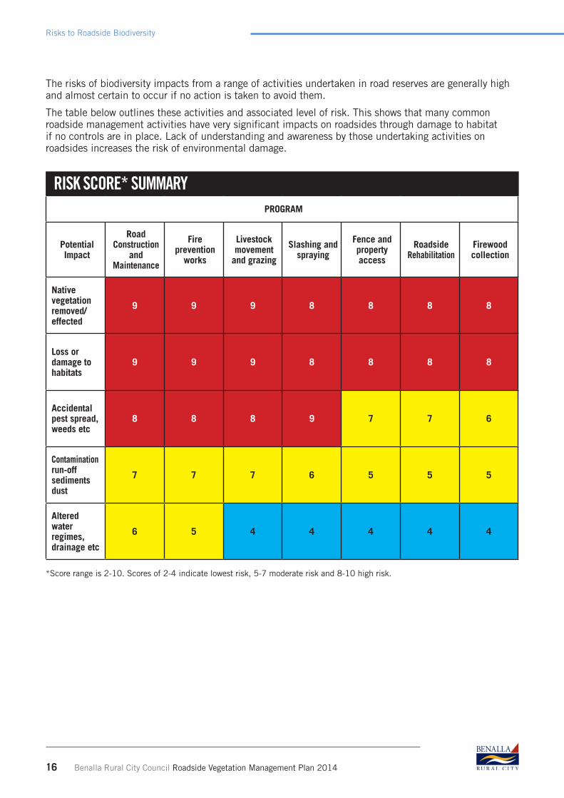
The risks of biodiversity impacts from a range of activities undertaken in road reserves are generally high and almost certain to occur if no action is taken to avoid them.
The table below outlines these activities and associated level of risk. This shows that many common roadside management activities have very significant impacts on roadsides through damage to habitat if no controls are in place. Lack of understanding and awareness by those undertaking activities on roadsides increases the risk of environmental damage.
RISK SCORE* SUMMARYPROGRAM
Potential Impact
RoadConstruction
andMaintenance
Fire prevention
works
Livestock movement
and grazing
Slashing and spraying
Fence and property access
RoadsideRehabilitation
Firewood collection
Native vegetation removed/effected
9 9 9 8 8 8 8
Loss or damage to habitats
9 9 9 8 8 8 8
Accidental pest spread, weeds etc
8 8 8 9 7 7 6
Contaminationrun-offsediments dust
7 7 7 6 5 5 5
Alteredwater regimes, drainage etc
6 5 4 4 4 4 4
*Score range is 2-10. Scores of 2-4 indicate lowest risk, 5-7 moderate risk and 8-10 high risk.
Benalla Rural City Council Roadside Vegetation Management Plan 2014 17
General Principles for Protection of Conservation Values on Roadsides
12.0 GENERAL PRINCIPLES FOR PROTECTION OF CONSERVATION VALUES ON ROADSIDES
12.1 VEGETATION COMMUNITIES AND NATURAL REGENERATIONThe principle objectives and guidelines in Victoria’s Biodiversity Strategy, Victoria’s Permitted Clearing of Native Vegetation – Biodiversity Assessment Guidelines and the Biodiversity Strategy for the Goulburn Broken Catchment will be recognised:
n The highest priority is to retain existing native vegetation by avoiding clearance where feasible, minimising disturbance to flora and fauna while installing and maintaining service assets, ensuring the safe functioning of roads and protecting community assets from fire. Where an exemption does not apply and removal is unavoidable the principle of ‘no net loss’ will be applied.
n The second priority is to prevent the decline of indigenous vegetation communities and fauna habitat by actively managing roadsides to protect remnants and to maintain visual amenity, landscape qualities and cultural and heritage values.
n The third priority is to enhance priority habitats by targeting action for designated priority ecosystems to protect endangered species.
n The fourth priority is to improve connectivity by revegetating potential wildlife corridors which form a link between isolated habitats.
n Remnant vegetation including grasslands will be identified, protected and enhanced.n Grasslands will not be restored with trees and shrubs, unless it is ecologically justified.n The importance of understorey and species composition will be recognised.
12.2 REGENERATIONn Natural regeneration of indigenous vegetation will be protected and encouraged except where:
n It imposes a safety risk (including the preservation of sight distances);n Exotic plants of historical or cultural significance are featured; n It is located within a fuel reduction corridor; n It interferes with the road, table drains, sign posting, road grading and road maintenance or
where overhead power lines exist. n Priority for natural regeneration and rehabilitation programs should be roadsides that form
strategic biological corridors: with priority to those corridors that have short connections between habitats or where it provides habitat for threatened species.
12.3 WETLANDSn Wetlands will be identified, protected and the status will be recorded. Opportunities to improve
wetland hydrology and ecology should be investigated.n Artificial wetland areas on roadsides will be retained if they are not impacting on road
maintenance, road infrastructure or existing native vegetation. n The Council, or its contractors will consult Goulburn Broken Catchment Management Authority
and Department of Environment and Primary Industries before commencing any works which may change a natural wetland, including the interruption or diversion of flows into or out of wetland areas.

18 Benalla Rural City Council Roadside Vegetation Management Plan 2014
General Principles for Protection of Conservation Values on Roadsides
12.4 WILDLIFE HABITATn Natural regeneration on roadsides will be encouraged where it forms wildlife corridors and these
are to be given first priority in restoration programs.n Fallen timber, especially hollow logs, provides valuable habitat for native animals.n In line with the current Firewood Collection Policy, dead trees or limbs containing hollows that
have fallen naturally in high conservation roadsides will be retained to provide habitat unless they are identified as a safety risk.
n All habitat components will be retained unless they pose a significant hazard as specified under the Municipal Fire Management Plan.
12.5 RARE, THREATENED OR LOCALLY SIGNIFICANT FLORA AND FAUNAn Department of Environment, Land, Water and Planning will provide updated data on the
locations of significant sites, ensuring that data bases are accurate and allow material to be incorporated into the Council’s mapping databases.
n Department of Environment, Land, Water and Planning are to be contacted to confirm, or clarify, the status and specific management actions for these sites prior to approval being given for any works.
n The Council staff, contractors, government agencies, service providers, Landcare groups, landowners and road workers will comply with management recommendations appropriate for the conservation of any identified species.
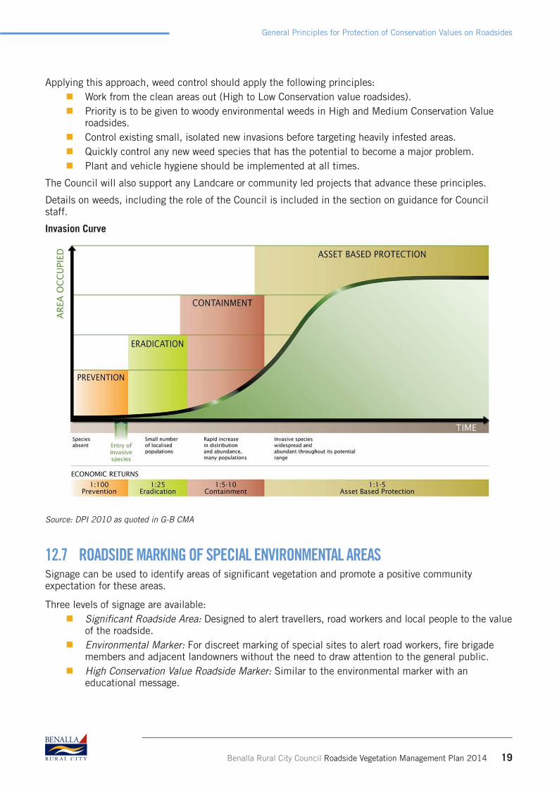
12.6 PEST PLANTS AND ANIMAL MANAGEMENTThe Biosecurity Strategy for Victoria (Government of Victoria 2009) and the Invasive Plants and Animals Policy Framework (DPI 2010) provide the approach and policy behind invasive plants and animals management in Victoria.
The Catchment and Land Protection Act 1994 (CaLP Act 1994) provides a legislative framework and defines general duties of landholders and management of noxious weeds and pest animals.
Changes made to the CaLP Act in 2013 place the responsibility on local councils for the ongoing management of regionally prohibited and regionally controlled weeds and established pest animals on Council managed roadways. The changes also require Council to develop a weed and pest management plan which must be approved by the Department of Environment, Land, Water and Planning. The Council will only treat weeds and pests in accordance with this management plan.
Weed management will also incorporate the Goulburn Broken Invasive Plants and Animals Strategy (GB IPAS) which sets the direction for invasive plants and animals investment and management in the Goulburn Broken catchment4.
The Goulburn Broken Invasive Plants and Animals Strategy is underpinned by the “biosecurity approach”. Informed by the invasive plants and animals invasion curve (Figure 1), the biosecurity approach adopts a risk-based strategy to intervention featuring four key responses; prevention, eradication, containment and asset protection.
Generally, priority will be given to programs that prevent introduction or eradicate newly establishing species, over containment and programs to reduce the impact of established species on priority assets. This approach provides the greatest public benefit for government investment.
4 Goulburn Broken Catchment Management Authority, Goulburn Broken Invasive Plants and Animals Strategy, 2010 – 2015 Executive Summary, p1
Benalla Rural City Council Roadside Vegetation Management Plan 2014 19
General Principles for Protection of Conservation Values on Roadsides
Applying this approach, weed control should apply the following principles: n Work from the clean areas out (High to Low Conservation value roadsides). n Priority is to be given to woody environmental weeds in High and Medium Conservation Value
roadsides. n Control existing small, isolated new invasions before targeting heavily infested areas. n Quickly control any new weed species that has the potential to become a major problem. n Plant and vehicle hygiene should be implemented at all times.
The Council will also support any Landcare or community led projects that advance these principles.
Details on weeds, including the role of the Council is included in the section on guidance for Council staff.
Invasion Curve
Source: DPI 2010 as quoted in G-B CMA
12.7 ROADSIDE MARKING OF SPECIAL ENVIRONMENTAL AREASSignage can be used to identify areas of significant vegetation and promote a positive community expectation for these areas.
Three levels of signage are available:n Significant Roadside Area: Designed to alert travellers, road workers and local people to the value
of the roadside.n Environmental Marker: For discreet marking of special sites to alert road workers, fire brigade
members and adjacent landowners without the need to draw attention to the general public.n High Conservation Value Roadside Marker: Similar to the environmental marker with an
educational message.

20 Benalla Rural City Council Roadside Vegetation Management Plan 2014
General Principles for Protection of Conservation Values on Roadsides
n Sites of rare, threatened or significant flora and fauna or other significant sites located on roadsides may be nominated and evaluated for the use of roadside signage.
n Information on special management approaches in these areas is to be made available.
Recommendation 5:All sites with rare, threatened or significant flora and fauna located on roadsides and nominated for signage should be on both GPS and electronic mapping systems used by Council and other key agencies.
12.8 UNUSED ROAD RESERVESn A guiding principle is that where unused road reserves are of High Conservation Value or have the
potential to be a wildlife corridor, consultation with Department of Environment, Land, Water and Planning will occur to ensure they are protected or restored and options for involving Landcare or other community organisations considered.
Recommendation 6:The identification and conservation value of all unused road reserves will be assessed as part of an ongoing program of Council.
12.9 ROAD MAINTENANCE, CONSTRUCTION, WIDENING, SERVICE INSTALLATION AND MAINTENANCE
n A Planning permit for vegetation removal on roadsides may not be required if the removal applies to road safety or road maintenance activities in accordance with the written agreement of the Secretary of the Department of Environment, Land, Water and Planning5.
n The Council staff and contractors must seek advice from the Environment Team before undertaking any work.
n Road maintenance and construction staff and contractors should refer to the accompanying handbook.
12.10 FIRE MANAGEMENTThe Council has a number of responsibilities under the Country Fire Authority Act 1958 (CFA Act 1958) and other legislation. Every four years it produces a new Fire Management Plan which is reviewed annually. This is based on a risk assessment process, and includes an Action Plan. Of the 13 items identified in the action plan, five relate to roadsides or roadside vegetation (Actions 1, 2, 5, 12, 13).
The Fire Management Plan provides an outline of key access and egress roads, suggests ways to reduce fuel loads on roads, priority access roads and fire access roads.
Electronic mapping will make the relationship clearer between the different values of roads for both fire access and vegetation and species management.
The discussion on the Municipal Fire Management Plan in the first section of this document recognises the need to manage a variety of values. Likewise the Goulburn-Broken Catchment Roadside Biodiversity
5 As constituted under Part 2 of the Conservation, Forest and Lands Act 1987. (Victorian SPP, Clause 52.17)
Benalla Rural City Council Roadside Vegetation Management Plan 2014 21
Council Department responsibilities
Risk Management Protocol identified fire prevention activities as a high risk of native vegetation being removed or affected, as well as damage being caused to habitat.
It is proposed that the Council explore combining mapping using the Benalla Road Management Plan register, the Fire Management Plan and this Roadside Vegetation Management Plan to identify potential areas of conflict, as well as areas where the fire management techniques may lead to a better habitat outcome. In particular, the critical areas from the RVMP should reflect the most accurate vegetation assessment available as well as the impact of federal legislation relating to endangered species.
Electronic mapping of roads and other information will assist overcome potential conflicts between different management plans. In addition, it is recommended that as part of the implementation of this RVMP, a matrix of roads and attributes be developed. This will assist in decision making and priority setting. Suggested elements include:
n Vegetation conservation status of roadsn Identification of roads with rare and endangered speciesn Roads adjoining existing blocks of vegetationn Roads adjoining or crossing significant wetlands, and cultural significant areasn Roads identified as priority access/egress for fires and fire access roadsn Roads with special use or need (e.g. tourism)
A review of the material developed in these three plans will lead to better understanding and management for all purposes and a clearer understanding of risks and benefits of different activities.
Recommendation 7:Develop a matrix of roads and attributes incorporating vegetation conservation values, fire access issues, road management values and potential for linkages with new and existing vegetation blocks to assist in decision making and priority setting.
13.0 COUNCIL DEPARTMENT RESPONSIBILITIES
Note: this section has been prepared to assist planning, environment, compliance and vegetation management staff. Current applicable Acts, codes and local laws are included where relevant.
This material is also available in the two accompanying documents written for the general public, and for staff and contractors working on roads.
13.1 GOALSn To utilise the Planning and Environment Act 1987, the Benalla Planning Scheme and other
planning mechanisms and tools to ensure best practice in the management of municipal roadsides.
n To protect biodiversity, cultural and recreational values while ensuring the safe functioning of the road.
n To ensure that the Council abides by the relevant Acts and Regulations.

22 Benalla Rural City Council Roadside Vegetation Management Plan 2014
Council Department responsibilities
13.2 VEGETATION MANAGEMENT13.2.1 Seed Harvesting
n A permit is required from Department of Environment, Land, Water and Planning for the harvesting of seed from any native vegetation on roadsides.
n Consent for works on a road reserve is required if undertaken by a third party – Road Management Act 2004.
n The Goulburn Broken Indigenous Seedbank has been established to provide locally native seed and information on all aspects of seed collection, extraction and storage. It also provides training to interested groups. It is located at the University of Melbourne’s Dookie College Campus.
n The Seedbank uses best practice to collect and store native seed for use in plant propagation and direct seeding activities in the Goulburn Broken. The Seedbank stores a variety of species from different provenances around the catchment.
n Anyone interested in obtaining seed are encouraged to contact the Seedbank and work through them rather than collect it themselves. The Seedbank may also be contacted where trees which have seed on them are being pruned or removed.
Guidelines for seed collection are provided by the Seedbank to ensure genetic integrity and minimal disruption to the site. Contact Seedbank coordinator on 58339279 or email [email protected]
13.2.2 Native Vegetation removal on roadsidesn There are a number of requirements for managing vegetation on roadsides. In general, a permit
to remove, destroy or lop native vegetation, including dead vegetation, is required under Clause 52.16 or 52.17 of the Victoria Planning Provisions. There are a number of exemptions.
n Council staff or private landholders need to contact the Planning Department and Environment Team to identify whether a planning permit will be required.
n The objective for permitted clearing of native vegetation in Victoria is: No net loss in the contribution made by native vegetation to Victoria’s biodiversity.
The key strategies to ensure no net loss at the permit level are:1. Avoid the removal of native vegetation that makes a significant contribution to Victoria’s
biodiversity.2. Minimise the impacts where clearing of native vegetation cannot be avoided.
3. Offset any clearing of native vegetation.
To assist in the decision making about whether a permit is required staff must refer to the Permitted Clearing of Native Vegetation Biodiversity Assessment Guidelines and the Permitted Clearing of Native Vegetation Biodiversity Assessment Handbook.
An important tool being used as part of the (permitted clearing) permits process is Native Vegetation Information Management system (NVIM). This map based system identifies native vegetation information, including Ecological vegetation classes (EVC).
Council works also need to comply with agreements under the local government public road exemption.
In emergency circumstances such as traffic accidents, trees or limbs falling and fire, landholders and agencies do not require permission to conduct works to the minimum extent necessary to ensure the threat to life or property is removed.
Recommendation 8:Information on Department of Environment, Land, Water and Planning NVIM, particularly mapping of vegetation should be reviewed and confirmed to be accurate, with corrections where needed reported to Department of Environment, Land, Water and Planning.
Benalla Rural City Council Roadside Vegetation Management Plan 2014 23
Council Department responsibilities
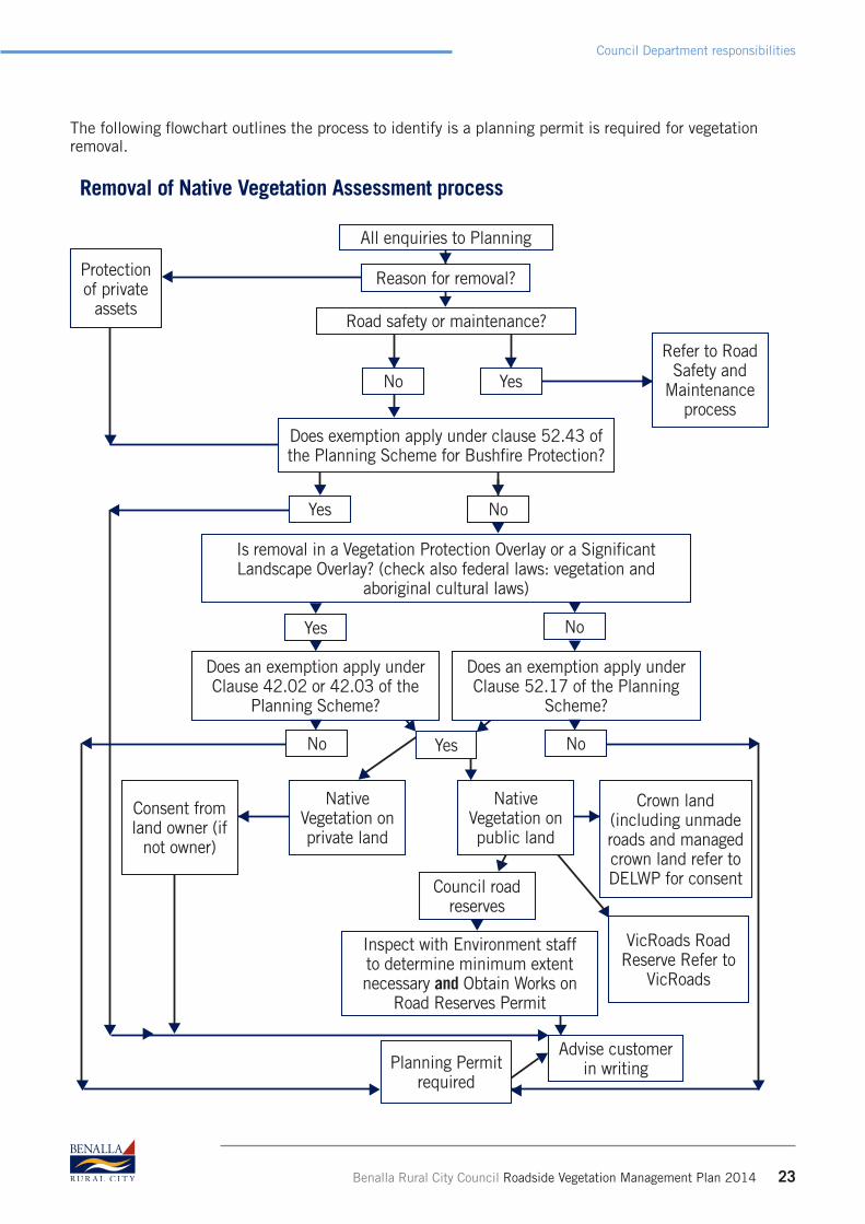
The following flowchart outlines the process to identify is a planning permit is required for vegetation removal.
Protection of private
assets
Council road reserves
Advise customer in writing
VicRoads Road Reserve Refer to
VicRoads
Inspect with Environment staff to determine minimum extent necessary and Obtain Works on
Road Reserves Permit
Does an exemption apply under Clause 42.02 or 42.03 of the
Planning Scheme?
Does an exemption apply under Clause 52.17 of the Planning
Scheme?
All enquiries to Planning
Reason for removal?
Road safety or maintenance?
Does exemption apply under clause 52.43 of the Planning Scheme for Bushfire Protection?
Is removal in a Vegetation Protection Overlay or a Significant Landscape Overlay? (check also federal laws: vegetation and
aboriginal cultural laws)
No
NoYes
Yes
Removal of Native Vegetation Assessment process
Yes
No
Consent from land owner (if
not owner)
Native Vegetation on private land
Crown land (including unmade roads and managed crown land refer to DELWP for consent
No
Planning Permit required
Native Vegetation on public land
Refer to Road Safety and
Maintenance process
Yes
No

24 Benalla Rural City Council Roadside Vegetation Management Plan 2014
Council Department responsibilities
13.2.3 Firewood Collectionn Legal requirements under federal law, particularly related to endangered species, restrict the
areas that firewood may be collected.n No firewood may be collected in roadside areas of High Conservation value, areas within the
Vegetation Protection Overlays or Lima Stringybark areas, except where the road is identified in the Municipal Fire Management Plan as a key access/egress road.
n Limited firewood collection is available on some roadsides. Only fallen timber can be collected. This information should be promoted, along with other areas where firewood should be collected. DELWP and other sources of firewood should also be promoted.
n Applications for Firewood Collection are available under Community Local Law 2009, from the Council offices and the Council website. Firewood collection is only available during periods nominated by Department of Environment, Land, Water and Planning, usually spring and autumn.
n A map of areas where firewood collection is permitted is available from the Council offices.n Firewood collection may be allowed in ‘No Firewood Collection’ areas after severe storm
damage for a short period of time. These areas will be clearly designated and advertised to the community during these times.
13.2.4 Site Rehabilitationn Permit not required for work site rehabilitation under any Act, but under this Roadside Vegetation
Management Plan, plans of the proposed works should be submitted to the Council prior to any restoration or revegetation works being undertaken. Plans will be referred to all relevant agencies to determine compliance with relevant codes of practice. If no response is received within 28 days it will be assumed that the agency has no objection to the project and plans may be approved providing proposed works comply with guidelines.
n Consent for works within a road reserve are required if rehabilitation or restoration is being undertaken by a third party – Road Management Act 2004.
n Revegetation on roadsides has the potential to create future fire management problems. Consultation at the planning stage will assist to reduce these risks.
13.3 PEST PLANTS AND ANIMALSRoadsides are a major avenue for weed and pest animals to spread, often enabling them to rapidly spread throughout a region and beyond. As the road network is utilised by a wide variety of users, the spread of weeds in an area can often be traced back to roads. Grass slashing and other road and roadside maintenance activities are regularly linked to the accidental spread of weeds through the movement of contaminated vehicles and machinery. Similarly, the carting of material such as gravel, hay and fodder is another prime vector of weed spread.
The Biosecurity Strategy for Victoria (Government of Victoria 2009) and the Invasive Plants and Animals Policy Framework (DPI 2010) provide the approach and policy behind invasive plants and animals management in Victoria.
The Catchment and Land Protection Act 1994 (CaLP Act 1994) provides a legislative framework and defines general duties of landholders and management of noxious weeds and pest animals.
Weeds are classified according to the extent and potential harm they can create.
Weeds are categorized as follows:
13.3.1 State ProhibitedThese weeds either do not occur in Victoria but pose a significant threat if they invade, or are present, pose a serious threat and can reasonably be expected to be eradicated. If present, infestations of a State Prohibited Weed are relatively small. They are to be eradicated if possible from Victoria or excluded from
Benalla Rural City Council Roadside Vegetation Management Plan 2014 25
Council Department responsibilities
the State. The Victorian Government is responsible for the treatment of all State Prohibited Weeds under Section 70(1) of the CaLP Act 1994. This work is currently being undertaken by the Department of Environment, Land, Water and Planning.
13.3.2 Regionally Prohibited WeedsRegionally Prohibited weeds are not widely distributed in a Region but are capable of spreading further. It is reasonable to expect that they can be eradicated from a region and they must be managed with that goal. Land owners, including public authorities responsible for Crown land management, must take all reasonable steps to eradicate Regionally Prohibited weeds on their land.
13.3.3 Regionally Controlled WeedsThese weeds are usually widespread and are considered important in a particular region. To prevent their spread, continuing control measures are required. Land owners have the responsibility to take all reasonable steps to prevent the growth and spread of Regionally Controlled weeds on their land.
13.3.4 Restricted WeedsRestricted Weeds includes plants that pose an unacceptable risk of spreading in this State or to other parts of Australia if they were to be sold or traded in Victoria, and are a serious threat to another State or Territory of Australia. Trade in these weeds and their propagules, either as plants, seeds or contaminants in other materials, is prohibited.
There are risks to roadside vegetation in the management of weeds and pests. While there are exemptions for planning permits (Clause 52.17, exemptions) for the removal of proclaimed noxious weeds and the removal of animal harbour (e.g. burrows) to the minimum extent of native vegetation necessary, this can lead to the removal of unnecessarily large areas of native vegetation.
13.3.5 Weeds of National SignificanceUnder the National Weeds Strategy, 32 introduced plants have been identified as Weeds of National Significance (WONS). These weeds are regarded as the worst weeds in Australia because of their invasiveness, potential for spread and economic and environmental impacts.
13.3.6 Environmental WeedsWhile there is no legislative requirement for the removal of environmental weeds, this Roadside Vegetation Management Plan alerts landholders of the significant impacts and potential spread these weeds can have.
For roadside maintenance and construction activities the Plan makes provision to incorporate their removal in works contracts.
Recommendation 9:Council distribute in advance the annual works plans for weed control on roadsides to Landcare Groups and make available to the general public.
Recommendation 10:Council develop a weed identification and information fact sheet and make available to the community
26 Benalla Rural City Council Roadside Vegetation Management Plan 2014
Council Department responsibilities
13.4 FUNCTIONAL ISSUES13.4.1 Fire management and fire protection
n Clause 52.17-7 of the Victoria Planning Provisions (fire protection) exempts road authorities from the need to obtain a planning permit to remove, destroy, or lop native vegetation to the minimum extent necessary for bushfire risk mitigation works on roadsides.
n The exemption requires an agreement between the responsible road authority and the Secretary of the Department of Environment, Land, Water and Planning (DELWP). In order for the exemption to be accessed the agreement requires the following:n A risk assessment conducted using the Interim Victorian Road Bushfire Risk Assessment
Guideline or an equivalent bushfire risk assessment methodology.n A multi-agency treatment selection process in line with the Assessment Guideline or an
equivalent selection process.n Vegetation treatments are included in a relevant plan for municipal endorsement.n Provision of a works plan to Department of Environment, Land, Water and Planning detailing
vegetation treatments6.n An exemption for planning permit exists for a number of activities in relation to fire
prevention: n To reduce fuel loads on roadsides to minimise the risk to life and property from bushfire
of an existing public road managed by the relevant responsible road authority (as defined by the Road Management Act 2004) in accordance with the written agreement of the Secretary to the Department of Environment, Land, Water and Planning (as constituted under Part 2 of the Conservation, Forest and Lands Act 1987). (SPP, Clause 52.17, Exemptions).
n For fire fighting measures, periodic fuel reduction burning, or the making of a fuel break or fire fighting access track up to 6 metres wide.
n For the making of a fuelbreak by or on behalf of a public authority in accordance with a strategic fuelbreak plan approved by the Secretary to Department of Environment, Land, Water and Planning (as constituted under Part 2 of the Conservation, Forest and Lands Act 1987). The maximum width of a fuelbreak must not exceed 40 metres. (Clause 52.17, page 6).
n Notwithstanding the number of exemptions to planning permits, the Road Management Act 2004 requires that CFA brigades apply for a Works on Road Reserve Permit and provide a traffic management plan to the Council.
n Works cannot commence on a roadside reserve until a Works on Road Reserve Permit form has been received and written approval given. The application should indicate the dates of commencement and completion of the proposed work.
n This requirement triggers a review of the proposed burning treatment and is referred to the Environment Team for review and feedback in relation to vegetation and conservation values.
6 DELWP, Roadside Vegetation Management for Bushfire Risk Mitigation Purposes Template for Work Plan Development , p1

Benalla Rural City Council Roadside Vegetation Management Plan 2014 27
Council Department responsibilities
13.4.2 Service providersn Utility companies are exempt from native vegetation removal controls under Clause 52.17 of the
Benalla Planning Scheme to maintain a minor utility installation.n They are also exempt for maintaining a utility installation, and for construction of a utility
installation as long as they comply with the appropriate code of practice approved by the Secretary of Department of Environment, Land, Water and Planning.
n Utility providers are still required to obtain consent from coordinating road authority for works impacting on roads and provide notification of the installation on infrastructure, subject to exemptions in regulations.
13.4.3 Maintenance of tree Clearance by Electrical Companies and its ContractorsSection 84 of the Electricity Safety Act 1998 specifies who is responsible for the maintenance of electric lines.
n The Council is responsible for maintaining powerline clearances in urban (declared) areas and electrical distribution companies are responsible in rural (or undeclared) areas.
n In rural areas of Benalla Rural City, Ausnet Services is the responsible authority.The Electricity Safety (Electric Line Clearance) Regulations (2010)7 is the Code of Practice for Electric Line Clearance and prescribes:
n Councils and electrical distribution companies are exempted from requiring a permit to remove native vegetation if it is in accordance with the Code of Practice prepared under Section 65 of the State Electricity Commission Act 1958. (SPP, Clause 52.17, Exemptions).
n The Code identifies Habitat trees under the Flora and Fauna Guarantee Act 1988 with particular requirements for management.
n Activities outside of the Code will require a Planning permit.
Recommendation 11:Benalla Rural City Council staff liaise with Ausnet Services on the annual vegetation management plans for Benalla Rural City produced by Ausnet Services for Energy Safe Victoria to ensure that compliance with regulations, particularly for significant roadside vegetation.
13.4.4 Road Maintenance, Construction and Wideningn Under the Road Management Act 2004, the responsible road authority has the obligations to
maintain the road.n For local road network as detailed in the Benalla Rural City Council Road Register, the Council is
both the co-ordinating road authority and the responsible road authority.n The principles and guidelines in the Roadside Environmental Code of Practice Handbook for
Roadside Construction and Maintenance Contractors and Workers will be included in tender and contract documentation. Unless exempt, the principle of No Net Loss including the requirement for offsets will apply to all works.
n Under Clause 52.17 of the Victorian Planning Provisions, no planning permit is required to remove, destroy or lop native vegetation to the minimum extent necessary to maintain the safe and efficient function of an existing public road managed by the relevant responsible
7 Administered by Energy Safe Victoria and available at http://www.legislation.vic.gov.au/Domino/Web_Notes/LDMS/ LTObject_Store/LTObjSt7.nsf/DDE300B846EED9C7CA257616000A3571/D560E565737C3EC3CA257B1E0001202 8/$FILE/10-47sra002%20authorised.pdf
road authority in accordance with the written Agreement of the Secretary of the Department of Environment, Land, Water and Planning. The Managing Native Vegetation on Roadsides; A Guideline for Implementing Agreements under the Local Government Public Road Exemption details the types of activities which are covered by the exemption, thresholds, notification requirements, data collection, reporting and auditing processes.
n The Road Management Act 2004, with a number of limited exceptions, makes it an offence to conduct works in, on, or under a road without the written consent of the coordinating road authority. The Council may impose conditions upon the approval for such works to be conducted on roads under its control.
13.4.5 Stockpile and Dump SitesThe Council has designated stockpile sites. Where it is not reasonable to use designated sites, liaise with the Environmental Team if an alternative has not been included in the projects Environmental Management Plan.
Recommendation 12:Include locations of stockpile sites on electronic maps and ensure that they minimise harm to sensitive roadside vegetation.
13.4.6 Stormwater Protectionn All elements of construction must comply with the EPA Environmental Guidelines for Major
Construction Sites (EPA, 1996).n Refer also to EPA Publication ‘Reducing Stormwater pollution from Construction Sites’ for details
of ways to reduce stormwater pollution8.
13.4.7 Sand, Soil and Gravel Extractionn The Mineral Resources (Sustainable Development) Act 1990 (MRSD Act) provides the legislative
framework for the development and regulation of extractive industries including the extraction of gravel, sand, soil, building stone and clay.
n Under the Mineral Resources (Sustainable Development) Act 1990:n Quarries greater than 5 hectares or greater than 5 metres depth or proposing blasting or
native vegetation removal must apply for a work authority and lodge a work plan with the Earth Resources Division of the Department of State Development, Business and Innovation.
n Quarries that are less than five hectares in area and less than five metres in depth, provided that no blasting or native vegetation clearance occurs, will be exempt from the requirement to work to an approved Work Plan but must instead comply with the Code of Practice for Small Quarries.
n Quarries which are less than one hectare in area and less than two metres in depth are exempt from regulation.
n An application for a planning permit to the Council must also be lodged once approvals are issued.
n There is an exemption for approval where the gravel extracted is used for an adjoining road construction.
n Individuals are not permitted to extract sand, soil or gravel from roadsides.n The provisions of the Aboriginal Heritage Act 2006 still apply, see Section 13.5.
8 EPA, Reducing Stormwater Pollution from Construction Sites, Publication 981, May 2005. Available at http://www.epa.vic.gov.au/~/media/Publications/981.pdf
28 Benalla Rural City Council Roadside Vegetation Management Plan 2014
Council Department responsibilities
13.5 LANDHOLDER, FARMING AND ASSOCIATED ACTIVITIES13.5.1 Stock movement, droving and grazingThe relevant legislation is Benalla Rural City Council Community Local Law 2009, Clause 60.
n Movement of livestock on a municipal road requires a permit. The exception is if the stock are moving to adjoining property by the most direct route. However
this must comply with a number of conditions including a traffic management plan.n Droving requires a livestock droving permit. Conditions may be applied on the permit, or
directdroving away from vegetation with rare or endangered species, or where there is a risk of weed spread.
n Grazing of road reserves requires a grazing permit from the Council. Grazing will only be permitted on low conservation value roadsides unless the Fire Management Plan or weed control plans allow for limited grazing on medium conservation value roadsides.
Some roads may be prohibited roads for grazing. The Council may specify roads or parts of a road within the municipality which cannot be utilized for droving or grazing of livestock.
Recommendation 13:Electronically map and identify by GPS all sensitive areas and overlays for efficient use by staff in determining permits, for example for droving, firewood collection and roadside vegetation removal.
13.5.2 Croppingn Cropping of the roadside involves activities relating to “planting to sow” and includes both
planting and harvesting of crops within the road reserve. n Cropping of the roadside may impact on the environmental value of roadsides by removing native
vegetation and introducing aggressive weed species.n Cropping is not permitted on roadsides.
13.5.3 Haymakingn Property owners or other parties may need access to the road reserve for the purpose of cutting
and bailing, or collecting, grass/hay to be used as stock feed. The use of the road reserve is particularly sought after in times of drought.
n This activity may only be allowed in areas of low conservation significance or in areas dominated by pasture grass. Haymaking will not be allowed in areas where it will potentially cause the spread of weeds.
n A Works Within Road Reserve Permit is required from the Council for cutting, bailing and/or collecting of cut grass for hay.
n The property owner/occupier must obtain all other relevant planning and environmental approvals from the Council and DELWP.
n A traffic management plan will be required.n Storage of baled hay is not permitted within the road reserve.
Benalla Rural City Council Roadside Vegetation Management Plan 2014 29
Council Department responsibilities

13.5.4 Slashingn Slashing or mowing of an adjoining nature strip is exempted under the Road Management Act
2004 from requiring a Works Within Road Reserve permit.n Where slashing has not previously occurred on a regular basis, Council must be consulted to
ensure native vegetation, including groundcovers, will not be impacted.n Slashing of native vegetation, including grasslands and shrubs, requires written consent from
the Council and a permit and consultation with DELWP, except by authorised Council staff or contractors to improve traffic safety i.e. traffic intersections to improve line of sight.
n Consent for works on a road reserve is required if undertaken by a third party – Road Management Act 2004.
n Ideally slashing of native grasses should not occur between October and January to allow native seed set, and blades on slashers should be set at no lower than 150 mm. above the ground. Review time of slashing annually according to the requirements of the season.
n Slashing should be designed programs to begin with clean machinery in high conservation value areas and work towards the more degraded sites. Ensure that all slashers and machinery are cleaned before and after work, especially where moving from weed infested areas to clean areas.
n Adopt the mosaic principle for slashing where possible.
13.5.5 Ploughing or gradingn Ploughing or grading for firebreaks or any other purpose is not permitted within the road reserve.
13.5.6 Maintenance of drivewaysn Maintenance of driveways is allowed providing the works are restricted to the existing driveway
and do not impact on traffic.
13.5.7 Bee Keepingn An owner or occupier of land must not keep one or more bee hives on any land unless the person
is a registered beekeeper with DELWP, in. accordance with the Livestock Disease Control Act 1994. (Community Local Law 2009, Clause 53).
n Bee hives should not be kept on road reserves.
13.5.8 Fencingn A Council Works Within Road Reserve Permit is required for fencing works being undertaken
within the road reserve (Road Management Act 2004). n A permit is not required if fencing works are being undertaken solely on the adjoining property
and no native vegetation is being removed.n An exemption from a Planning Permit for removal of vegetation for fencing works does apply
under Section 52.17 of the Victorian Planning Provisions: No Permit is required to remove, destroy or lop native vegetation to the minimum extent
necessary if any of the following apply: To enable the:
n Construction of a fence on a boundary between properties in different ownership; orn Operation or maintenance of an existing fence.
The combined maximum width of clearing permitted either side of the fence under this exemption is 4 metres.
n It should be noted that the combined maximum width of clearing permitted for a fence under this exemption is 4 metres in total.
30 Benalla Rural City Council Roadside Vegetation Management Plan 2014
Council Department responsibilities
n While a Planning Permit may not be required permission is required from the Council for any native vegetation removal occurring on the road reserve. This consent may be subject to environmental assessment and conditions if necessary.
n If vegetation removal is required, it is preferred that removal takes place on private property, rather than the road reserve.
n In emergency circumstances such as traffic accidents, trees or limbs falling and fire, landholders and agencies do not require permission to conduct works to the minimum extent necessary to ensure the threat to life or property is removed.
13.5.9 Revegetationn Landcare Groups, community groups, individuals and businesses are encouraged to become
involved in protecting and enhancing remnant vegetation on roadsides, including ‘adopting’ particular roadsides for ongoing involvement in management.
n Priorities for managing native vegetation at a State and regional level are: 1. Retain and Protect Existing Remnant. 2. Enhance Existing Remnants 3. Connect Existing Remnants by Biolinks (Wildlife Corridors.
n Projects should reflect this strategic landscape approach, including: n enhancing existing remnants by weed and pest animal control and adding habitat
components, such as logs. n supplementary plantings of shrubs and understorey and buffer plantings around existing
remnants. n establishing biolinks in appropriate locations.
n Most activities associated with revegetation on roadsides would be considered as works under the Road Management Act 2004 and thus require a Works Within Road Reserve permit from the Council.
n As roads are primarily for safe transit, revegetation works must not compromise road safety. n Revegetation on roadsides has the potential to create future fire management problems.
Recommendation 14:That CFA be consulted before any Works on Road Reserve permits that facilitate revegetation on roadsides are issued by Council.
13.6 CULTURAL AND RECREATIONAL ISSUES13.6.1 Cultural HeritageIndigenous and non-indigenous cultural heritage provides a sense of community identity. Victoria’s heritage includes archaeological sites, buildings and structures, created landscapes and community values and beliefs. As activities on roadsides have the potential to impact on heritage sites (either known or unknown), it is important to identify heritage issues to enable impacts to be avoided, minimised or mitigated.
All registered and unregistered Victorian Aboriginal archaeological sites are protected by the State Aboriginal Heritage Act 2006 and the Commonwealth Aboriginal and Torres Strait Islander Heritage Protection Act 1984. All Victorian historical sites are protected by the State Heritage Act 1995. These Acts prohibit the wilful destruction or disturbance of any cultural heritage site, place or object, whether on private or public land.
Benalla Rural City Council Roadside Vegetation Management Plan 2014 31
Council Department responsibilities

Heritage Victoria and the Office of Aboriginal Affairs Victoria are the Victorian State Government instrumentalities that administer these Acts.
The Aboriginal Heritage Act 2006 establishes cultural heritage management plans, cultural heritage permit processes and cultural heritage agreements to manage activities on land that may harm Aboriginal cultural heritage.
n If significant activities are to occur, including certain road works, the Aboriginal heritage planning tool should be used. The tool is available through the web. The tool contains a series of questions that will clarify if a cultural heritage management plan is required9.
n If a Cultural Heritage Management Plan is required under the Aboriginal Heritage Act 2006 it will be evaluated by Registered Aboriginal Parties operating under the auspices of the Aboriginal Heritage Council.
n Under the Act the discovery of Aboriginal cultural heritage places or objects on any public or private land in Victoria must be reported to the Office of Aboriginal Affairs Victoria (OAAV).
n If a Cultural Heritage Management Plan is required, other statutory authorisations can not be given before the Plan is approved.
n Cultural Heritage Permits are required for activities that may harm Aboriginal cultural heritage, but are not subject to a Cultural Heritage Management Plan.
n In consultation with the relevant Registered Aboriginal Parties, a voluntary Cultural Heritage Agreement may be prepared, which will formalise long-term cultural heritage management partnerships.
n A series of posters are available that assist in identification of cultural heritage through the Office of Aboriginal Affairs.
Areas of cultural heritage sensitivity
Under the Aboriginal Heritage Act the following may be relevant to the Benalla Municipality and are deemed to be areas of cultural heritage sensitivity unless they have been subject to significant ground disturbance:
n A registered cultural heritage place or land within 50 metres of a registered cultural heritage place
n A waterway or prior waterway, or land within 200 metres of a waterway or prior waterwayn An ancient lake or land within 200 metres of an ancient laken A declared Ramsar wetland or land within 200 metres of a declared Ramsar wetlandn A national park, State park, wilderness park, marine national park or marine sanctuaryn A greenstone outcropn A cave, rock shelter or cave entrancen Areas specified in Schedule 1 to the Aboriginal Heritage Regulations
High impact activities
Under the Aboriginal Heritage Act, an activity is deemed to be high impact if it would result in significant ground disturbance.
Significant ground disturbance is defined as disturbance of the topsoil or surface rock layer of the ground, or disturbance of a waterway, by machinery in the course of grading, excavating, digging, dredging or deep ripping, but does not include ploughing other than deep ripping. Deep ripping is deemed as meaning the ploughing of soil using a ripper or subsoil cultivation tool to a depth of 60 centimetres or more.
9 http://www.dpc.vic.gov.au/index.php/aboriginal-affairs/heritage-tools/25-aboriginal-affairs/452-aboriginal-heritage- planning-tool.
32 Benalla Rural City Council Roadside Vegetation Management Plan 2014
Council Department responsibilities
Exempt activities
The following are exempt activities relevant to Council listed under the Aboriginal Heritage Regulations:n The construction or carrying out of minor worksn Works reasonably necessary, in an emergency, to protect the health or safety of a person, to
protect property or to protect the environment. n Minor works are defined as:
Works on, over or under an existing roadway or existing rail infrastructure Maintenance or repair works, or the removal of works, associated with an existing high
impact activityn Other minor works associated with an existing high impact activity
Penalties
Large penalties apply for organisations or individuals who are found guilty of breaching the Aboriginal Heritage Act. Penalties range from 60 to 1800 penalty units for individuals and 300 to 10000 penalty units for corporations.
Recommendation 15:Prior to commencing work Project managers should refer to the VicRoads Cultural Heritage Guidelines and check the register of known cultural heritage sites and areas of cultural heritage sensitivity.
Recommendation 16:Provide roadside workers and contractors with training to increase awareness of heritage issues and to increase recognition skills of indigenous artefacts such as mounds, middens, surface scatters, tools, stone quarries, burial sites and scar trees to assist in the identification and subsequent protection of new sites.
13.6.2 Significant Landscapesn The Benalla Planning Scheme includes a Significant Landscape Overlay for the Warby Ranges
Slopes Significant Landscape Area ( Clause 42.03).n This provides a focus for the vegetation to:
n Identify and protect the visual values of the western slopes of the Warby Range, which includes a heavily dissected terrain with a diverse woodland cover.
n Recognise the importance of vegetation to landscape quality and to maintain vegetation as an important element of the landscape.
n Any works on roadsides within the Significant Landscapes Area must comply with this overlay.
13.6.3 State Forests, Parks, Reserves and Waterwaysn Responsibility for works does not rest with the Council. Where necessary refer to the Department
of Environment, Land, Water and Planning, Parks Victoria and the Goulburn Broken Catchment Management Authority for works on roadsides that abut or cut through State or National Parks, flora and fauna reserves and waterways.
Benalla Rural City Council Roadside Vegetation Management Plan 2014 33
Council Department responsibilities
14.0 CONCLUSION
Roadside vegetation management is subject to a wide range of legislation at the federal, state, regional and municipal levels. This in part reflects the important role that it has as a very important habitat for species, and a reservoir of land and animal species native to the municipality.
The management of vegetation for conservation values must also be balanced by the need to ensure that the roads are fulfilling the purpose of providing safe and efficient travel, as well as access in times of fire.
This Roadside Vegetation Management Plan acknowledges the multiple demands on roadsides, and aims to assist the Council and its staff, as well as the community and contractors, meet their legal obligations and provide consistency in approach. It provides a reference and guide for those who wish to undertake different activities on roadsides. Finally, it aims to protect and enhance the important habitat qualities of the roadsides in Benalla Rural City Council.
34 Benalla Rural City Council Roadside Vegetation Management Plan 2014
Conclusion
Benalla Rural City Council Roadside Vegetation Management Plan 2014 35
Summary of recommendations
RECOMMENDATION KEY OFFICER ACTION BY
1. The Roadside Vegetation Management Plan be included as a reference document in the Road Management Plan.
Operations Coordinator 2015/16
2. Assessments of Roadsides be reviewed over a five year rolling period to reflect the changing nature of roadsides, including improvement or vegetation loss.
Environment SustainabilityCoordinator
2015/16 and then ongoing
3. Roadside conservation values be recorded using GPS and be incorporated with other relevant information on the Council’s mapping system and developed into an interactive accessible format when possible.
Environmental SustainabilityCoordinator,
GIS Coordinator
Ongoing
4. The Benalla Planning Scheme be amended to incorporate an overlay to highlight and protect Lima Stringybark.
Planning Coordinator 2017/18
5. All sites with rare, threatened or significant flora and fauna located on roadsides and nominated for signage should be on both GPS and electronic mapping used by Council and other key agencies.
Environmental SustainabilityCoordinator,
GIS Coordinator, Operations Coordinator
2016/17
6. The identification and conservation value of all unused road reserves will be assessed as part of an ongoing council program.
Environmental SustainabilityCoordinator,
GIS Coordinator, Operations Coordinator
2015/16 and then ongoing
7. Develop a matrix of roads and attributes incorporating vegetation conservation values, fire access issues, road management values and potential for linkages with new and existing vegetation blocks, to assist in decision making and priority setting.
Environmental SustainabilityCoordinator,
Operations Coordinator, Senior Compliance
Coordinator
2015/16
8. Information on DELWP NVIM, particularly mapping of vegetation should be reviewed and confirmed to be accurate, with corrections where needed reported to DELWP.
Environmental Sustainability Coordinator
Ongoing
9. Council distribute in advance the annual works plans for weed control on roadsides to Landcare groups.
Environmental Sustainability Coordinator
Ongoing
15.0 SUMMARY OF RECOMMENDATIONS
RECOMMENDATION KEY OFFICER ACTION BY
10. Council develop a weed identification and information fact sheet and make available to the community.
Environmental SustainabilityCoordinator
Ongoing
11. Benalla Rural City Council staff liaise with AusNet Services on the annual vegetation management plans for Benalla Rural City produced by AusNet Services for Energy Safe Victoria to ensure that compliance with regulations, particularly for significant roadside vegetation.
Parks Coordinator Annual action
12. Include locations of stockpiles on electronic maps and ensure that they mimimise harm to sensitive roadside vegetation.
Environmental SustainabilityCoordinator,
Operations Coordinator
2015/16 and ongoing monitoring
13. Electronically map and identify by GPS all sensitive areas and overlays for efficient use by staff in determining permits, for example for stock moving, firewood collection and roadside vegetation removal.
Environmental SustainabilityCoordinator
Ongoing
14. CFA be consulted before any permits that facilitate revegetation on roadsides be issued by Council
Operations Coordinator, Risk Management
CoordinatorOngoing
15. Prior to commencing work Project managers check register of known cultural heritage sites or cultural heritage sensitivity areas.
Operations Coordinator, Risk Management
CoordinatorOngoing
16. Provide roadside workers and contractors with training to increase awareness of heritage issues and to increase recognition skills of indigenous artefacts such as mounds, middens, surface scatters, tools, stone quarries, burial sites and scar trees to assist in the identification and subsequent protection of new sites.
Environmental SustainabilityCoordinator,
Risk Coordinator
Ongoingprogram every
2-3 years
36 Benalla Rural City Council Roadside Vegetation Management Plan 2014
Summary of recommendations
Benalla Rural City Council Roadside Vegetation Management Plan 2014 37
References
16.0 REFERENCES
Benalla Rural City Council, Road Management Plan, July 2013. Available at http://www.benalla.vic.gov.au/Files/Road_Management_Plan_July_2013.pdf.
Benalla Rural City Council, Roadside Weed and Rabbit Control Plan.
Benalla Rural City Council, Climate Change Adaptation Action Plan 2013-2015,
Available at http://www.benalla.vic.gov.au/Files/BRCC_Climate_Change_Adapation_Plan_FINAL.pdf.
Benalla Rural City Council, Benalla Planning Scheme.
Benalla Rural City Council Community Local Law 2009. Available at http://www.benalla.vic.gov.au/Files/Community_Local_Law_2009.pdf.
Benalla Rural City Council, Application for the Occupation of a Road for Firewood Collection.
Benalla Rural City Council , Final Draft Benalla Rural City Roadside Vegetation Management Plan, 2006. (Unpublished).
Benalla Rural City Council, Municipal Fire Management Plan, 2012. Benalla Rural City Council.
Department of Environment, Land, Water and Planning, Permitted Clearing of Native Vegetation – Biodiversity Assessment Guidelines September 2013. Victoria, Department of Environment, Land, Water and Planning.
Department of Environment, Land, Water and Planning, Biodiversity Information Tools for use in Native Vegetation Decisions Explanatory Document May 2013. Victoria, Department of Environment, Land, Water and Planning. .Available at http://www.DELWP.vic.gov.au/__data/assets/pdf_file/0005/199661/Bio_info_tools_NVR.pdf.
Department of Environment, Land, Water and Planning, Reforms to Victoria’s native vegetation permitted clearing regulations Overview, May 2013.Victoria. Department of Environment, Land, Water and Planning. Available at http://www.DELWP.vic.gov.au/__data/assets/pdf_file/0007/180637/Overview_NVR.pdf.
Department of Environment and Primary Industry, Roadside Vegetation Management for Bushfire Risk Management Mitigation Purposes Template for Work Plan Development, undated. Available at http://www.DELWP.vic.gov.au/__data/assets/word_doc/0017/221318/Template-for-roadside-bushfire-risk-mitigation-work-plan.doc.
Department of Sustainability and Environment, Advisory List of Threatened Vertebrate Fauna in Victoria, 2013. Victoria, Department of Sustainability and Environment.
Department of Sustainability and Environment, Roadside Vegetation Management for Bushfire Risk Mitigation Purposes A Guideline for Road Managers, 2012. Victoria, Department of Sustainability and Environment.
Department of Sustainability and Environment, Managing native Vegetation on roadsides: A guideline for implementing agreements under the local government public road exemption. 2009. Victoria, Department of Sustainability and Environment.
Department of Sustainability and Environment, Action Statement Flora and Fauna Act 1998 No 221,

Energy Safe Victoria at http://www.esv.vic.gov.au/Legislation-Regulations/Legislation-administered-by-ESV.
EPA, Reducing Stormwater Pollution from Construction Sites, Publication 981, May 2005. Available at http://www.epa.vic.gov.au/~/media/Publications/981.pdf.
Goulburn-Broken Catchment Management Authority, Goulburn-Broken Invasive Plants and Animals Strategy 2010 – 2015 Executive Summary.
Goulburn Broken Catchment Management Authority, Goulburn Broken Invasive Plants and Animals Strategy 2010 -2015, 2010. Goulburn Broken Catchment Management Authority.
Goulburn Broken Catchment Management Authority, Biodiversity Strategy for the Goulburn Broken Catchment 2010-2015, 2010. Goulburn Broken Catchment Management Authority.
Goulburn Broken Catchment Management Authority, Goulburn Broken Catchment Roadside Biodiversity Risk Management Protocols, December 2007.
Goulburn Broken Catchment Management Authority, Weeds of the Goulburn Broken A Field Guide to Terrestrial and Aquatic Weeds, 3rd Edition, DPI and GBCMA.
Government of Victoria, Electricity Safety Electric Line Clearance Regulation 2010.
Greater Shepparton City Council, Roadside Management Strategy, Document 1, Version 2, March 2008
Greater Shepparton City Council, Community Roadside Management Handbook, Document 2, Version 2, March 2008.
Greater Shepparton City Council, Roadside Environmental Code of Practice Handbook, Road Construction and Maintenance Contractors and Workers. Document 2, Version 2, March 2008.
Rural City of Wangaratta, Roadside Conservation Management Plan, (Draft), 2010. (unpublished)
Ryan, Paul,Threatened flora and fauna species and non threatened vertebrate fauna in the Goulburn Broken Catchment: status, trends and management. Background paper to the Goulburn Broken Catchment Regional Catchment Strategy review process, 2002.Goulburn Broken Catchment Management Authority. Available at http://www.gbcma.vic.gov.au/downloads/BISforGBC/4_ThreatenedSpecies.pdf
Vicroads, A Guide to working in the road reserve Road Management Act 2004, 2009.
Vicroads, A Companion to ‘A Guide to working in the road reserve Road Management Act 2004’, 2009.
VicRoads, The Road management Act at a glance for Utility and Public Transport Providers, Factsheet.
VicRoads, VicRoads’ Roadside Management Strategy (Undated)
Victorian Government Gazette NoS269 Road Management Act 2004.Code of Practice for Management of Infrastructure in Road Reserves Monday 6 October 2008.
38 Benalla Rural City Council Roadside Vegetation Management Plan 2014
References
17.0 APPENDIX 1: RELEVANT STRATEGIES, POLICIES AND LEGISLATION
There are thirty different Strategies, Acts of Parliament and Government Policies that have an impact on roadside management. These are detailed below. Some in particular take precedence and are summarised below. A number have precedence, in particular:
n Flora and Fauna Guarantee Act 1988n State Biodiversity Strategy 1998n Planning and Environment Act 1987n Permitted Clearing of Native Vegetation – Biodiversity Assessment Guidelines 2013n Biodiversity Strategy for the Goulburn Broken Catchment 2010 - 2015n Goulburn Broken Native Vegetation Management Strategy 2000n CFA Act 1958, and n Catchment and Land Protection Act 1994.
FLORA AND FAUNA GUARANTEE ACT 1988The Flora and Fauna Guarantee Act 1988 (FFG Act) is the key piece of Victorian legislation for the conservation of threatened species and communities and for the management of potentially threatening processes.
Under the Act, species, ecological communities and potentially threatening processes can be listed. When a listing occurs an action statement must be prepared, which identifies actions that have been or will be taken to conserve the species or community or manage the potentially threatening process
Public authorities must have regard to flora and fauna conservation and management objectives which are:
n to guarantee that Victoria’s flora and fauna can survive, flourish and retain their potential for evolutionary development in the wild;
n to conserve Victoria’s flora and fauna communities; andn to manage potentially threatening processes.
Sections 17 and 18 of the Flora and Fauna Guarantee Act 1988 provide for the preparation and revision of a Flora and Fauna Guarantee Strategy. The Strategy must set out how the flora and fauna conservation and management objectives are to be achieved.
The current Flora and Fauna Guarantee Strategy was published in 1997, under the title “Victoria’s Biodiversity Strategy”10.
STATE BIODIVERSITY STRATEGY 1998The Strategy is part of the Flora and Fauna Guarantee Program and sets out how to achieve the FFG Act’s objectives. The strategy aims to:
n increase awareness of the need to conserve biodiversity;n enable continued development of partnerships between the community, industry and government
in the custodianship of our biodiversity;n indicate the existing and proposed mechanisms for achieving the objectives of flora and fauna
conservation and management in the context of ecological sustainability;
10 DELWP, at http://www.DELWP.vic.gov.au/environment-and-wildlife/threatened-species-and-communities/flora-and- fauna-guarantee-act-1988
Benalla Rural City Council Roadside Vegetation Management Plan 2014 39
Appendix 1
n detail strategic frameworks to prevent further loss of habitat and a focus for better management of existing habitats and the continuation of natural ecological processes;
n highlight the habitats and environments that require urgent attention; andn highlight major threatening processes.
PLANNING AND ENVIRONMENT ACT 1987The Planning and Environment Act 1987, provides for the Minister to prepare a set of standard provisions for planning schemes called the Victoria Planning Provisions (VPP). These provisions form a template for all planning schemes.
The VPP is best considered as a state-wide reference document or template from which planning schemes are sourced and constructed. It is not a planning scheme and does not apply to any land.
It is a statutory device to ensure that consistent provisions for various matters are maintained across Victoria. Together with the Ministerial Direction on the Form and Content of Planning Schemes, it ensures that the construction and layout of planning schemes is consistent.
The VPP is a comprehensive set of standard planning provisions and provides a standard format for all Victorian planning schemes. It provides the framework, standard provisions and State planning policy. The planning authority (usually the local council) must provide the local planning policy content, including a Municipal Strategic Statement, and select the appropriate zones and overlays from the VPP, for inclusion in their planning scheme. The VPP also has references to a number of documents which are incorporated documents common to all planning schemes.
The Vegetation Protection Overlay (VPO) (S 42) includes as its purpose:n To protect areas of significant vegetationn To ensure that development minimises loss of vegetation.n To preserve existing trees and other vegetation.n To recognise vegetation protection areas as locations of special significance, naturaln beauty, interest and importance.n To maintain and enhance habitat and habitat corridors for indigenous fauna.n To encourage the regeneration of native vegetation.
Within the VPP the State Planning Policy Framework (SPPF) sets out principles for land use and development planning including policies to protect the health of ecological systems and the biodiversity they support and conserve areas with identified environmental and landscape values.
The Objective for Biodiversity Policy is: “ to assist in the protection and conservation of Victoria’s biodiversity, including important habitat for Victoria’s flora and fauna and other strategically valuable biodiversity sites”
The Objective for Native vegetation Management is:“to ensure that permitted clearing of vegetation results in no net loss in the contribution made by native vegetation to Victoria’s biodiversity”
Prior to removing, destroying or lopping native vegetation on any roadside a permit must be issued by the responsible authority (in most cases the local council) unless exemptions apply. Exemptions apply to CFA, Councils and to Service providers to undertake particular works on roadsides.
Local planning schemes such as Benalla Planning Scheme, has specific VPOs that provide protection for native vegetation, including on roadsides. Where the local planning scheme may have vegetation clearing limits that are more stringent that those in the State Section, then the more stringent requirement applies.
Regardless of these exemptions any works carried out by third parties or private landholders must obtain permission to remove vegetation and work on roadside
40 Benalla Rural City Council Roadside Vegetation Management Plan 2014
Appendix 1

PERMITTED CLEARING OF NATIVE VEGETATION - BIODIVERSITY ASSESSMENTGUIDELINES 2013In Victoria, a permit is required to remove, destroy or lop native vegetation. These regulations are known as the native vegetation permitted clearing regulations.
The removal of native vegetation is primarily regulated by the Victoria Planning Provisions. In certain circumstances, alternate assessment and/or approvals processes are used to regulate the removal of native vegetation. This includes processes established by the Environment Effects Act 1978 and the Mineral Resources (Sustainable Development) Act 1990.
The Permitted clearing of native vegetation – Biodiversity assessment guidelines (the Guidelines) outline how impacts on Victoria’s biodiversity are assessed when an application to remove native vegetation is lodged. The Guidelines are an incorporated document in all Victorian planning schemes.
Permitted Clearing of Native Vegetation and related documents are incorporated into the Victoria Planning provisions and all planning schemes in Victoria. They were gazetted on 20 December 2013.
These Guidelines replace Victoria’s Native Vegetation Management – A Framework for action 2002.
The decision on clearing native vegetation depends on a risk assessment process using classifications of vegetation as either low risk, medium risk or high risk. Electronic tools including maps are included to assist in the assessment.
The Guidelines are applied alongside other requirements of the planning scheme when an application for a permit to remove native vegetation is considered by the responsible authority.
A permit to remove native vegetation does not replace any requirements under the Flora and Fauna Guarantee Act 1988 and the Commonwealth Environment Protection and Biodiversity Conservation Act 1999.
The primary purpose of the relevant provision of the State Planning Provision, S 52.17 is to ensure ‘Permitted clearing of native vegetation results in no net loss in the contribution made by native vegetation to Victoria’s Biodiversity. This is achieved through the following approach:
n Avoid the removal of native vegetation that makes a significant contribution to Victoria’s biodiversity
n Minimise impacts on Victoria’s biodiversity from the removal of native vegetation n Where native vegetation is permitted to be removed, ensure that an offset is provided in a manner
that makes a contribution to Victoria’s biodiversity that is equivalent to a contribution made by the native vegetation that is to be removed.
BIODIVERSITY STRATEGY FOR THE GOULBURN BROKEN CATCHMENT 2010 – 201511 This Strategy follows and builds upon the Goulburn Broken Catchment Management Authority’s Native Vegetation Management Strategy and From the Fringe to Mainstream: a Strategic Plan for Integrating Native Biodiversity.
The Strategy informs annual investment plans and the Regional Catchment Strategy update of 2011. This Strategy factors in reviews of previous strategies, a review of biodiversity targets, and a biodiversity risk assessment. It identifies priority geographic zones and strategic directions and actions for the next five years. It has been developed with extensive participation and consultation with key partners over the past two years.
11 Available at http://www.gbcma.vic.gov.au/downloads/biodiversity_strategy/gbcma_biodiversity_strategy_web.pdf
Benalla Rural City Council Roadside Vegetation Management Plan 2014 41
Appendix 1

COUNTRY FIRE AUTHORITY ACT 1958Under the Country Fire Authority Act 1958 municipalities are responsible for managing roadside vegetation to reduce the fire threat to life and property. Although some fire prevention works on roadsides are exempt from the Native Vegetation Retention Controls under the Planning and Environment Act 1987, fire prevention planners must have due regard to indigenous vegetation values. Refer to Council’s Municipal Fire Management Plan for further details.
The document Roadside Fire Management Guidelines12 provides background information for achieving the balance between fire prevention and native vegetation protection on roadsides.
CATCHMENT AND LAND PROTECTION ACT 1994The main legislation covering noxious weed and pest animal management in Victoria is the Catchment and Land Protection Act 1994 (CALP Act). Under this Act species of plants and animals can be declared as noxious weeds and pest animals.
One of the main objectives of the CaLP Act 1994 is to protect primary production, Crown land, the environment and community health from the effects of noxious weeds and pest animals. The CaLP Act 1994 defines roles and responsibilities and regulates the management of noxious weeds and pest animals. The Act prohibits the movement and sale of noxious weeds of all categories anywhere in the State, and covers weed seeds occurring as contaminants in seed lots, plant products or on vehicles, machinery or animals. The CaLP Act 1994 also regulates the importation, keeping, selling and releasing of declared pest animals.
This legislation was amended on 18 November 2013 to reflect the Roadside Weeds and Pests – Recommended Responsibilities for Action report, also known as the ‘Bailey report”.
In summary this report recommended that Local Government be responsible for the on-site management of regionally prohibited weeds, regionally controlled weeds and rabbits. The report also recommended that funding be the responsibility of State Government for regionally prohibited weeds and cost shared between State and Local Government for regionally controlled weeds and rabbits
The major implications of the amendments to the Council are:n The land owner is now defined as the municipal council if the land is a municipal road in the
municipal district of that municipal council.n Municipal councils will be responsible for the preparation and delivery of a plan for the
management of regionally prohibited weeds, regionally controlled weeds and established pest animals on rural municipal roads.
n The Council must give a notice of the proposed roadside weed and pest animal management plan and any person may make a submission. Council must allow at least 28 days after the day on which notice is given for the making of submissions.
The changes to the Act mean that the Council will be responsible for the ongoing management of regionally prohibited and regionally controlled weeds and established pest animals.
SERVICING ACTSThese Acts permit servicing authorities to locate assets on roadsides and give them rights of access for maintenance works. Refer to Telecommunications Act and Electrical Safety Act below.
12 Available at http://www.cfa.vic.gov.au/fm_files/attachments/Publications/roadside_guide.pdf
42 Benalla Rural City Council Roadside Vegetation Management Plan 2014
Appendix 1
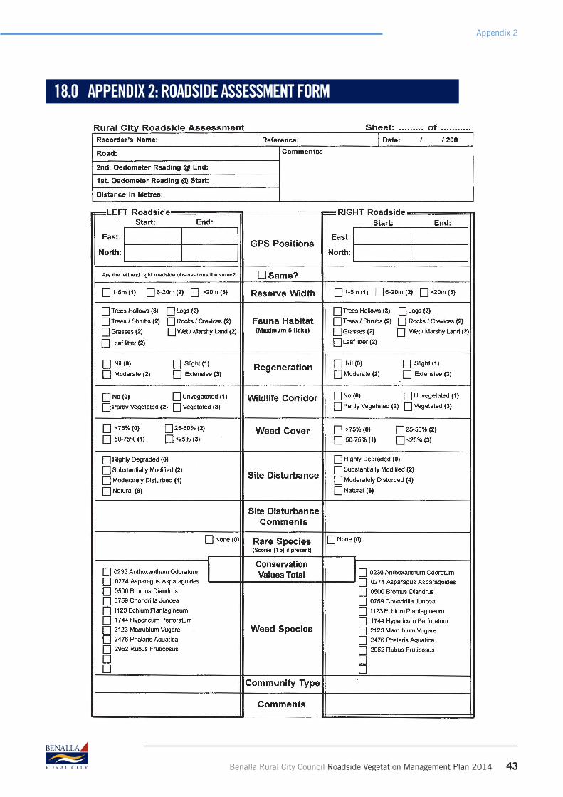
Benalla Rural City Council Roadside Vegetation Management Plan 2014 43
Appendix 2
18.0 APPENDIX 2: ROADSIDE ASSESSMENT FORM

44 Benalla Rural City Council Roadside Vegetation Management Plan 2014
Appendix 3
19.0 APPENDIX 3: GLOSSARY OF TERMS
Road Reserve
The total strip of land reserved for transportation purposes from fence line to fence line or boundary to boundary if unfenced. The road reserve usually consists a central road formation bounded by roadsides.
Road Formation
That portion of the road reserve along which vehicles travel. It includes the road pavement, shoulders and the area to the outermost side of the roadside drain, at least to where the drain batter meets the natural surface. This area includes the table drain.
Roadside
The strip of land that supports vegetation between the road formation and the boundary of the road reserve, which is usually also the boundary of the adjacent property.
Declared Road
Freeways, arterial roads (which include tourist roads, highways and forest roads) which are managed and maintained by VicRoads in accordance with VicRoads Corporate Practice and Roadside Management Plans.
Non Declared or Local Road Roads that are managed and maintained by Council.
Unused Road ReserveA road that has been gazetted under the Crown Lands Act where it is not used for public traffic. DELWP then becomes the responsible authority.
Movement of Stock
Movement of stock (during daylight hours and not less than one km per hr) as part of normal farming practices on a regular basis from one paddock to another or on an occasional basis from one paddock or property to another.
Source: RCAC Roadside Assessment Handbook
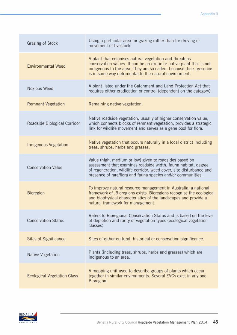
Grazing of Stock Using a particular area for grazing rather than for droving or movement of livestock.
Environmental Weed
A plant that colonises natural vegetation and threatens conservation values. It can be an exotic or native plant that is not indigenous to the area. They are so called, because their presence is in some way detrimental to the natural environment.
Noxious Weed A plant listed under the Catchment and Land Protection Act that requires either eradication or control (dependent on the category).
Remnant Vegetation Remaining native vegetation.
Roadside Biological CorridorNative roadside vegetation, usually of higher conservation value, which connects blocks of remnant vegetation, provides a strategic link for wildlife movement and serves as a gene pool for flora.
Indigenous Vegetation Native vegetation that occurs naturally in a local district including trees, shrubs, herbs and grasses.
Conservation Value
Value (high, medium or low) given to roadsides based on assessment that examines roadside width, fauna habitat, degree of regeneration, wildlife corridor, weed cover, site disturbance and presence of rare/flora and fauna species and/or communities.
BioregionTo improve natural resource management in Australia, a national framework of .Bioregions exists. Bioregions recognise the ecological and biophysical characteristics of the landscapes and provide a natural framework for management.
Conservation StatusRefers to Bioregional Conservation Status and is based on the level of depletion and rarity of vegetation types (ecological vegetation classes).
Sites of Significance Sites of either cultural, historical or conservation significance.
Native Vegetation Plants (including trees, shrubs, herbs and grasses) which are indigenous to an area.
Ecological Vegetation ClassA mapping unit used to describe groups of plants which occur together in similar environments. Several EVCs exist in any one Bioregion.
Benalla Rural City Council Roadside Vegetation Management Plan 2014 45
Appendix 3

Fuel Reduced Corridor Assist to reduce the intensity of fire, enable establishment of control lines and provide a clear traffic route.
Fuel Reduced ZoneArea of minimum fuel or vegetative hazard that is maintained in a fuel reduced condition to the extent that the passage of fire will be restricted (eg. Short green lawn, paths, driveway)
Priority Access RoadA road that is critical for an ensured transport route for travellers and provides a link between critical locations to reduce travel time for fire fighters.
46 Benalla Rural City Council Roadside Vegetation Management Plan 2014
Appendix 3

Benalla Rural City Council Roadside Vegetation Management Plan 2014 47
Appendix 4
20.0 APPENDIX 4: LIST OF SIGNIFICANT SPECIES
The following threatened species were found in the roadside desktop assessments.
Common Name Scientific Name VROTa EPBC FFG1
Deane’s Wattle Acacia deanii r
Western Silver Wattle Acacia decora v
Bent-leaf Wattle Acacia flexifolia r
Umbrella Grass Digitaria divaricatissima v
Lima Stringybark Eucalyptus alligatrix ssp.limaensis e EN L
Mugga Ironbark Eucalyptus sideroxylon s.s r
Narrow-leaf Goodenia Goodenia macbarronii v V L
Western Golden Tip Goodia mediciginea r
Flat-leaf Bush-pea Pultenaea platyphylla r
Small Leaf Bush-pea Pultenaea foliolosa r
Barking Owl Ninox connivens e L
Macquarie Perch Macquaria australasica e L
Grey-crowned Babbler Pomatostomus temporalis e L
Regent Honeyeater Anthochaera phyrgia e EN L
Bush Stone Curlew Burhinus grallarius e L
Squirrel Glider Petaurus norfolcensis e L
Brush-tailed Phascogale (Tuan) Phascogale tapoatafa v L
1 Advisory List of Threatened Vertebrate Fauna in Victoria, 2013. DELWP. Accessed 2 Jan 2014.
Key to abbreviations in above table
VROT* Victorian Rare or Threatened
X extinct in Victoria
e endangered in Victoria
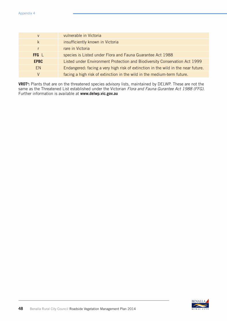
v vulnerable in Victoria
k insufficiently known in Victoria
r rare in Victoria
FFG L species is Listed under Flora and Fauna Guarantee Act 1988
EPBC Listed under Environment Protection and Biodiversity Conservation Act 1999
EN Endangered: facing a very high risk of extinction in the wild in the near future.
V facing a high risk of extinction in the wild in the medium-term future.
VROTa: Plants that are on the threatened species advisory lists, maintained by DELWP. These are not the same as the Threatened List established under the Victorian Flora and Fauna Gurantee Act 1988 (FFG). Further information is available at www.delwp.vic.gov.au
48 Benalla Rural City Council Roadside Vegetation Management Plan 2014
Appendix 4

Benalla Rural City Council Roadside Vegetation Management Plan 2014 49
