belmont res. kibby basin, nevada #lithium ni 43-101 technical report
TRANSCRIPT

Technical Report
Describing
the
Kibby Basin Property Centered on
431,624E - 4,243,747N
UTM NAD83 Z11
in
Esmeralda County, Nevada USA
Prepared for
Belmont Resources Inc.
#600-625 Howe Street
Vancouver, BC V6C 2T6
Prepared By
E.L. “Buster” Hunsaker III, CPG 8137
Hunsaker Inc
Elko, Nevada USA
Effective May 26, 2016

Belmont Resources Inc. Kibby Basin Property, Esmeralda County, Nevada
Hunsaker Inc. -ii-
Ernest L. Hunsaker III, CPG 8137
TABLE OF CONTENTS
1.0 SUMMARY .................................................................................................................. 4
26.1 Phase One Exploration Program ............................................................................. 5
2.0 INTRODUCTION ........................................................................................................ 6
2.1 Issuer ......................................................................................................................... 6
2.2 Terms of Reference and Purpose .............................................................................. 6
2.3 Sources of Information ............................................................................................. 6
2.4 Property Inspection ................................................................................................... 6
3.0 RELIANCE ON OTHER EXPERTS ........................................................................... 6 4.0 PROPERTY DESCRIPTION AND LOCATION ........................................................ 6
4.1 Location .................................................................................................................... 6
4.2 Royalties and Agreements ........................................................................................ 7
4.3 Environmental Liabilities and Permits ..................................................................... 7
4. 4 Other Significant Factors and Risks ........................................................................ 8
5.0 ACCESSIBILITY, CLIMATE, LOCAL RESOURCES, INFRASTRUCTURE, AND
PHYSIOGRAPHY ............................................................................................................ 11
5.1 Topography, Elevation, and Vegetation ................................................................. 11
5.2 Means of Access ..................................................................................................... 12
5.3 Local Resources ...................................................................................................... 12
5.4 Climate .................................................................................................................... 12
5.5 Infrastructure ........................................................................................................... 12
6.0 HISTORY ................................................................................................................... 12
7.0 GEOLOGIC SETTING AND MINERALIZATION ................................................. 14
7.1 Regional Geology ................................................................................................... 14
7.2 Local and Property Geology ................................................................................... 14
7.2.1 Stratigraphy ...................................................................................................... 17 7.2.2 Structure ........................................................................................................... 17
7.2.3 Water ................................................................................................................ 18
7.3 Mineralization ......................................................................................................... 18
8.0 DEPOSIT TYPES ....................................................................................................... 22
9.0 EXPLORATION......................................................................................................... 22 10.0 DRILLING ................................................................................................................ 22 10.0 SAMPLE PREPARATION, ANALYSIS, AND SECURITY ................................. 22
12.0 DATA VERIFICATION .......................................................................................... 22 13.0 MINERAL PROCESSING AND METALLURGICAL TESTING......................... 23
15.0 MINERAL RESERVE ESTIMATES....................................................................... 23 16.0 MINING METHODS ............................................................................................... 23 17.0 RECOVERY METHODS ......................................................................................... 23

Belmont Resources Inc. Kibby Basin Property, Esmeralda County, Nevada
Hunsaker Inc. -iii-
Ernest L. Hunsaker III, CPG 8137
18.0 PROJECT INFRASTRUCTURE ............................................................................. 23 19.0 MARKET STUDIES AND CONTRACTS .............................................................. 23 20.0 ENVIRONMENTAL STUDIES .............................................................................. 23 21.0 CAPITAL AND OPERATING COSTS ................................................................... 23
23.0 ADJACENT PROPERTIES ..................................................................................... 24 24.0 OTHER RELEVANT DATA AND INFORMATION ............................................ 24 25.0 INTERPRETATION AND CONCLUSIONS .......................................................... 24 26.0 RECOMMENDATIONS .......................................................................................... 25
6.1 Phase One Exploration Program ............................................................................. 25
26.1 Phase One Exploration Program ........................................................................... 25
26.2 Phase Two Exploration Program .......................................................................... 25
DATE AND SIGNATURE............................................................................................... 26
CERTIFICATE OF QUALIFICATIONS......................................................................... 27 27.0 REFERENCES ......................................................................................................... 29
LIST OF TABLES
Table 1: Kibby Basin Claims ............................................................................................ 11 Table 2: Phase One Exploration Program Budget ............................................................ 25
Table 3: Phase Two Exploration Program Budget ........................................................... 26
LIST OF FIGURES
Figure 1: Kibby Basin Property Location Map................................................................... 9
Figure 2: Kibby Basin Property Claim Map ..................................................................... 10 Figure 3: Kibby Basin Access Map .................................................................................. 13
Figure 4: Kibby Basin Property Regional Geology Map (Legend-Figure 5) ................... 15 Figure 5: Kibby Basin Property Geology Map-Legend .................................................... 16 Figure 6: Kibby Basin Property Geology Map (Legend-Figure 5)................................... 19
Figure 7: Kibby Basin Property Gravity Map (after Oppliger, 2003) .............................. 20 Figure 8: Kibby Basin Property Well and Geothermal Map (after Oppliger, 2003) ........ 21
Belmont Resources Inc. Kibby Basin Property, Esmeralda County, Nevada
Hunsaker Inc. -4-
Ernest L. Hunsaker III, CPG 8137
1.0 SUMMARY
Belmont Resources Inc. (the “Company” or “Belmont”) entered into a Mineral Property
Acquisition Agreement to purchase 100% right, title, and interest in the Kibby Basin
Association Placer Mining Claims (the “Property”). Belmont is listed on the TSX
Venture Exchange (TSXV: BEA) and the corporate office is located in Vancouver, B.C.
The property covers 2,560 acres located in Esmeralda County, Nevada centered on UTM
coordinates 431,624E/4,243747N. The claims are within sections 29, 30, 31, & 32,
T6N/R37.5E and sections 25 & 26, T6N/R37E. They are 35.8 direct air miles northwest
of Tonopah, Nevada. Tenure consists of 16 unpatented association placer mining claims
(160 acres each) covering 2,560 acres on United States public lands under the
management of the Bureau of Land Management. Belmont holds the claims via a
Mineral Property Acquisition Agreement made on March 29th
, 2016 with Zimtu Capital
Corp which was amended April 15, 2016.
Kibby Basin is located in the western portion of the Great Basin in Nevada. The regional
tectonic and structural setting is complex. Lithology and physiography, in particular,
reflect this complexity with a wide range of rock ages (Precambrian to recent) and a
diverse distribution of rock types (metamorphic-volcanic-igneous-sedimentary-surficial
unconsolidated sediments).
However, the visible surface of the property geology is simple. The surface rocks consist
exclusively of Quaternary Alluvium and unconsolidated playa sand, gravel, and clay. No
faults, folds, or additional structural elements occur on the surface within the claim area.
There is no mineralization known on the Property and there is no prior mineral
ownership.
Belmont has not done any exploration and there is no known previous exploration
activity or production for the Kibby Basin Property.
The Kibby Basin Property is an early stage exploration project that warrants further work.
As is typical, the data available are limited. However, due to the regional setting,
extensive information is available from academic, government, and professional public
domain sources. Using a continental-brine lithium model based on Clayton Valley, the
available data is useful and sufficient to review and discuss the Property. Regional and
property-wide geology reviewed for the Kibby Basin Property shows key features that are
similar to the known lithium mine area at Silver Peak-Clayton Valley.
1. The setting of Kibby Flat within the Monte Cristo Valley indicates a basin large
enough to develop layers that could act as aquifers.
2. Regional gravity data suggest a basin with sufficient depth to provide enough
volume of Quaternary sediments to host aquifers of sufficient extent.
3. Groundwater is present and widespread.
4. Geothermal indicators suggest an area with locally higher heat-flow.

Belmont Resources Inc. Kibby Basin Property, Esmeralda County, Nevada
Hunsaker Inc. -5-
Ernest L. Hunsaker III, CPG 8137
The data suggest two work phases will prudently and effectively test for the presence and
quality of the four key features mentioned above. Phase one results will determine how
best to execute the drilling proposed in phase two.
The phase one program consists of a regional geophysical review and a detailed gravity
program. The regional geophysical review will give guidance to design the detailed
gravity layout and orientation.
If warranted by the results from phase 1 the phase 2 drilling program would test the
optimum areas.
Activity Units Quantity Rate ($) Cost ($)
Geology/Supervision/Permitting Days 5 $650 $3,250
Travel Expenses (room/ & board) Days 1 $130 $130
Mileage Miles 700 $0.60 $420
Subtotal $3,800
Geophysical Regional Review 1 $1,500 $1,500
Gravity - Survey Stations 395 $45 $17,775
Gravity - Interpretation 1 $3,000 $3,000
Subtotal $22,275
Drilling Days 0 $4,000 $0
Drill Sample Analyses (20% of Drilling Cost) $0 $0
Drill Site Prep and Reclamation/Bond Project $0 $0
Subtotal $0
Contingency (15%) $3,911.25
Total $29,986
Activity Units Quantity Rate ($) Cost ($)
Geology/Supervision/Permitting Days 20 $650 $13,000
Travel Expenses (room/ & board) Days 13 $130 $1,690
Mileage Miles 2100 $0.60 $1,260
Subtotal $15,950
Geophysical Regional Review 0 $1,500 $0
Gravity - Survey Stations 0 $45 $0
Gravity - Interpretation
Subtotal $0
Drilling Days 12 $4,000 $48,000
Drill Sample Analyses (20% of Drilling Cost) $9,600 $9,600
Drill Site Prep and Reclamation/Bond Project $15,000 $15,000
Subtotal $72,600
Contingency (15%) $13,282.50
Total $101,833

Belmont Resources Inc. Kibby Basin Property, Esmeralda County, Nevada
Hunsaker Inc. -6-
Ernest L. Hunsaker III, CPG 8137
2.0 INTRODUCTION
2.1 Issuer
This report is prepared for Belmont Resources Inc. (the “Company” or “Belmont”).
Belmont is listed on the TSX Venture Exchange (TSXV: BEA) and the corporate office
is located in Vancouver, B.C.
2.2 Terms of Reference and Purpose
Belmont retained Hunsaker Inc. to prepare an independent technical report for the Kibby
Basin Property (“Property” or “Kibby Basin”) conforming to the requirements of
Canadian National Instrument 43-101 (“NI43-101”). Ernest L. Hunsaker III, CPG-8137
is a Senior Geologist and President of Hunsaker Inc. and is a Qualified Person (“QP”) as
defined by NI43-101.
2.3 Sources of Information
Belmont provided documentation regarding their acquisition of ownership and claim data
was determined from the property inspection, Federal public records, and Esmeralda
County public records.
Published information and data are the basis for the technical information in this report.
Item 27.0 (“References”) lists the sources of information. The text cites the references
where customary and appropriate.
All units of measurement in this report are English-system unless noted otherwise.
Survey and map date are in Universal Transverse Mercator-meter (“UTM”) coordinates,
North American Datum 83 (“NAD 83”) Zone 11. Monetary values are in US dollars
(“$”).
2.4 Property Inspection
The Author made an unaccompanied visit to the property on April 21, 2016 to review the
access, property geology, and physiographic setting.
3.0 RELIANCE ON OTHER EXPERTS
The author is responsible for the non-referenced content of this report.
4.0 PROPERTY DESCRIPTION AND LOCATION
4.1 Description and Location
The property covers 2,560 acres located in Esmeralda County, Nevada centered on UTM
coordinates 431,624E / 4,243,747N (Figure 1). The claims are within sections 29, 30, 31,

Belmont Resources Inc. Kibby Basin Property, Esmeralda County, Nevada
Hunsaker Inc. -7-
Ernest L. Hunsaker III, CPG 8137
& 32, T6N/R37.5E and sections 25 & 26, T6N/R37E. They are 35.8 direct air miles
northwest of Tonopah, Nevada.
4.2 Mineral Tenure
Tenure consists of 16 Federal unpatented association placer mining claims (160 acres
each) covering 2,560 acres (Figure 2 and Table 1). Claims are on lands managed by the
U.S. Department of Interior – Bureau of Land Management (BLM).
Belmont holds the claims via a Mineral Property Acquisition Agreement made on March
29th
, 2016 with Zimtu Capital Corp which was amended on April 15, 2016. Per the
Agreement, Zimtu Capital Corp. agrees that on the closing date of July 15, 2016 they will
sell to Belmont and transfer a 100% undivided right, title and interest to the claims. In
order to purchase the property Belmont has agreed to:
1. Pay to Zimtu Capital $25,000 as follows:
a. $5,000 on signing of the Agreement
b. $20,000 upon Exchange Approval of the Agreement
2. Issue 1,000,000 common shares of Belmont as follows:
a. 500,000common shares upon Exchange approval; and
b. 500,000 common shares at six months from Exchange approval
The agreement is subject to the approval of the Exchange and if the Approval Date has
not occurred by June 30, 2016 or the Closing Date has not occurred by July 15, 2016,
Zimtu Capital Corp. may terminate the Agreement and no further rights will accrue.
Upon commencement of production Belmont will pay a 1.5% Net Smelter Royalty
(“NSR”) to Zimtu Capital. Belmont may acquire 50% of the NSR for $1,000,000.
To maintain the validity of the claims Federal statute requires that annual maintenance
fees must be paid prior to September 1 of each year. Currently those fees are $155 for
each 20 acre portion of the claims, payable to the Bureau of Land Management. Prior to
November 1, Nevada state statute requires recording of a Notice of Intent to Hold with
Esmeralda County along with payment of $10.50 per claim and $4.00 document fee.
No royalties or other agreements are known.
4.3 Environmental Liabilities and Permits
The Mining Law of 1872 for unpatented mining claims confers non-exclusive rights to
use the surface for mining purposes. The Federal Land Policy and Management Act of
1976 (“FLPMA”) requires that notification (“Permit”) and bonding is filed and accepted
with the BLM prior to non-casual disturbance (drilling, trenching, etc.).
No notification and bonding for surface disturbance is in place and prior to initiation of
the recommended phase 2 program (Item 26.2) that needs to be completed.
Belmont Resources Inc. Kibby Basin Property, Esmeralda County, Nevada
Hunsaker Inc. -8-
Ernest L. Hunsaker III, CPG 8137
4.4 Other Significant Factors and Risks
There are no other significant factors or risks known, which would adversely affect
access, title or work on the project.

Belmont Resources Inc. Kibby Basin Property, Esmeralda County, Nevada
Hunsaker Inc. -9-
Ernest L. Hunsaker III, CPG 8137
Figure 1: Kibby Basin Property Location Map

Belmont Resources Inc. Kibby Basin Property, Esmeralda County, Nevada
Hunsaker Inc. -10-
Ernest L. Hunsaker III, CPG 8137
Figure 2: Kibby Basin Property Claim Map

Belmont Resources Inc. Kibby Basin Property, Esmeralda County, Nevada
Hunsaker Inc. -11-
Ernest L. Hunsaker III, CPG 8137
Claim Name County NMC#
Kibby 1 Esmeralda County, Nevada 1122074
Kibby 2 Esmeralda County, Nevada 1122075
Kibby 3 Esmeralda County, Nevada 1122076
Kibby 4 Esmeralda County, Nevada 1122077
Kibby 5 Esmeralda County, Nevada 1122078
Kibby 6 Esmeralda County, Nevada 1122079
Kibby 7 Esmeralda County, Nevada 1122080
Kibby 8 Esmeralda County, Nevada 1122081
Kibby 9 Esmeralda County, Nevada 1122082
Kibby 10 Esmeralda County, Nevada 1122083
Kibby 11 Esmeralda County, Nevada 1122084
Kibby 12 Esmeralda County, Nevada 1122085
Kibby 13 Esmeralda County, Nevada 1122086
Kibby 14 Esmeralda County, Nevada 1122087
Kibby 15 Esmeralda County, Nevada 1122088
Kibby 16 Esmeralda County, Nevada 1122089
Table 1: Kibby Basin Claims
5.0 ACCESSIBILITY, CLIMATE, LOCAL RESOURCES, INFRASTRUCTURE, AND
PHYSIOGRAPHY
5.1 Topography, Elevation, and Vegetation
The Kibby Property is located in Kibby Flat, which is the geographic name for the playa
in the lowest portion, of the Monte Cristo Valley. The playa is a closed basin that is
essentially flat, with an elevation of 5,268 feet. The Cedar Mountain Range to the north
and east reaches as high as 8,089 feet and the Pilot Mountains to the west have a

Belmont Resources Inc. Kibby Basin Property, Esmeralda County, Nevada
Hunsaker Inc. -12-
Ernest L. Hunsaker III, CPG 8137
maximum height of 9,187 feet. To the south, the Monte Cristo Range reaches 7,996 feet
and the pass separating the Monte Cristo and the Cedar Mountain Ranges is 5,597 feet
high.
Vegetation is typical of the high-desert portion of the Basin and Range. The playa has
very sparse vegetation consisting primarily of sagebrush and shadscale. Mean annual
precipitation is around 5 inches
5.2 Means of Access
To reach the Property, leave Tonopah, Nevada and travel 19 miles towards Reno, Nevada
on U.S. Highway 95 (Figure 3). Leave the highway and travel 15 miles northward on
the maintained dirt road to an intersection with a well-developed dirt track. Then go 6
miles northwest to the claims. Vehicle access is good to all portions of the Property
when it is dry. During periods of heavy rainfall or snowmelt from the surrounding higher
elevations (when water is standing on the playa) travel can be difficult to impossible.
5.3 Local Resources
Tonopah is the nearest population center with food, lodging, and supplies. Surface
transportation in the region is good via U.S. Highway 95 with numerous paved state
roads and well maintained dirt roads reaching into the countryside. A small local airport
is available. There is no regular commercial air service.
5.4 Climate
Climate is typical of the high-desert portion of the Basin and Range. Temperatures range
from highs of 100o
F in the summer to -15o
F in the winter. Average highs are 40o
F in
winter and 85o
F during the summer. Under typical climate conditions the operating
season is 12 months per year
5.5 Infrastructure
Surface rights are sufficient to support a mining operation, power is less than 8 miles
distant. Tonopah and the surrounding region hosts sufficient experienced mining people,
contractors, and equipment to carry out most mining and exploration activities. Reno and
Las Vegas are less than 240 miles distant if additional supplies and experience are
required.
Tonopah is the likely source of water for drilling.
6.0 HISTORY
There is no known prior ownership for the Kibby Basin Property.

Belmont Resources Inc. Kibby Basin Property, Esmeralda County, Nevada
Hunsaker Inc. -13-
Ernest L. Hunsaker III, CPG 8137
Figure 3: Kibby Basin Access Map

Belmont Resources Inc. Kibby Basin Property, Esmeralda County, Nevada
Hunsaker Inc. -14-
Ernest L. Hunsaker III, CPG 8137
There is no known previous exploration activity, mineral resource estimation, or
production for the Kibby Basin Property.
7.0 GEOLOGIC SETTING AND MINERALIZATION
Kibby Basin is located in the western portion of the Great Basin in Nevada. The regional
tectonic and structural setting is complex (Figure 4). Lithology and physiography, in
particular, reflect this complexity with a wide range of rock ages (Precambrian to recent)
and a varied distribution of rock types (metamorphic-volcanic-igneous-sedimentary-
surficial unconsolidated sediments). Of necessity, this complexity is simplified; which
still leaves a noticeably long list of specific rock units (Figure 5). The following
discussion is summarizes and consolidates the references cited.
However, the visible, surface of the property geology is simple. The surface rocks
consist exclusively of Quaternary Alluvium and unconsolidated playa sand, gravel, and
clay (Figure 4). No faults, folds, or additional structural elements occur on the surface
within the claim area.
7.1 Regional Geology
The Property is within the central Walker Lane. The Walker Lane is a distinct zone that
is 50-100 miles wide and trends over 380 miles from northwest to southeast (Figure 1).
The Walker Lane sub-parallels the southwestern border of Nevada and is a continental
scale transition zone between the Sierra Nevada massif and the north-trending regions of
the Great Basin. Oldow et al (2016) describe how this portion of the Walker Lane is a
structural stepover that links the Furnace Creek Fault System to the south with the central
Walker Lane. The complex history of extensional and transcurrent faulting from 15 Ma
to the present (Oldow, 2003) is reflected in the wide range of fault orientations; from
northeast to west-northwest. During this period, numerous half-grabens developed to
accommodate the strain. Hardyman (1990) identified a series of half-grabens in and
around Monte Cristo Valley.
North-south trending basin and range faulting is the latest structural activity to overprint
and offset the earlier faults and basins resulting in additional deepening or exhumation of
these basins. Recent colluvial sediments have accumulated in these basins to depths
which are variably well known.
7.2 Local and Property Geology
The Kibby Basin Property is located in topographic lowlands. Thus, the surficial
property geology consists of Quaternary colluvium - alluvium undifferentiated which
includes recent desert wash, playa deposits, and sand dunes (Figure 4). These units result
from erosion of the surrounding ranges and basins. No distinctly observable structures
occur.

Belmont Resources Inc. Kibby Basin Property, Esmeralda County, Nevada
Hunsaker Inc. -15-
Ernest L. Hunsaker III, CPG 8137
Figure 4: Kibby Basin Property Regional Geology Map (Legend-Figure 5)

Belmont Resources Inc . Kibby Basin Property, Esmeralda County, Nevada
Hunsaker Inc. -16-
Ernest L. Hunsaker III, CPG 8137
Figure 5: Kibby Basin Property Geology Map-Legend

Belmont Resources Inc. Kibby Basin Property, Esmeralda County, Nevada
Hunsaker Inc. -17-
Ernest L. Hunsaker III, CPG 8137
7.2.1 Stratigraphy
Geologic units mapped in the ranges surrounding Kibby Flat are on Figure 6 (map labels
in parentheses are same as noted on Figure 5):
Quaternary Alluvium-colluvium undifferentiated (Qal, Qya, QToa, Qpl, QTg,
QTs)
Quaternary- Pliocene/Pleistocene: Basalt (Tba)
Tertiary: Rhyolitic to quartz latitic welded ash flows (Tt2)
Tertiary-Early Pliocene: Gilbert Andesite (Ta3)
Tertiary: Shale, siltstone, limestone, and tuff (Ts3)
Tertiary-Late Miocene: Esmeralda Formation (Ts3)
Tertiary: Rhyolite plugs, domes, flows, and breccias (Tr2, Tr3)
Cenozoic-Mesozoic: Granite (TJfi, TRfi)
Jurassic: Dunlap Formation (JTRgor)
Triassic: Luning Formation (WLB)
Triassic: Excelsior Formation (GC
Ordovician: Palmetto Formation (DCs)
Tertiary units are the most ubiquitous. The same units also occur adjacent to basins
Clayton Valley all around the town of Silver Peak (Figure 4) The Tertiary units are
potential sources of lithium (Davis, 1979).
Albers and Stewart (1972) restricted the nomenclature of the Tertiary Esmeralda
Formation (Ts3-Figure 6) to the sedimentary units in the Weepah Hills area south of
Kibby Basin. Other authors have either included volcanic units in the Esmeralda
Formation or subdivided the Esmeralda Formation into even more distinct tectono-
stratigraphic units (Jones, 2007, Burrus, 2013). Siltstone, shale, and limestone in the
Esmeralda are fresh-water units and regionally extensive suggesting a lake (Esmeralda
Lake - Turner, 1900, Reheis et al, 2009) or numerous widespread lakes throughout the
region expanding and contracting through time.
Variable wet and dry periods continued into the Quaternary and are apparent in the
detailed stratigraphy of drill logs for Clayton Valley (Vine, 1979 and Pantea, 1981).
Continued subsidence of the basins developed aquifers in the porous and permeable units
in basin sediments. These general descriptions and more specific evaluations (Zampirro,
2003) define distinct aquifers that host groundwater which are known to contain brines
and lithium-bearing brines.
7.2.2 Structure
Distinct structural details are not mappable in the colluvial and alluvial filled basins. But,
they do project into the playa from the faults in the surrounding ranges (Figure 6). Faults
trend north-south, north-northeasterly and northwesterly. Within the broader Monte
Cristo Valley there are more easterly trending faults which bound half-grabens
(Hardyman 1990). Hardyman demonstrated thicker basin-fill close to the bounding
faults.

Belmont Resources Inc. Kibby Basin Property, Esmeralda County, Nevada
Hunsaker Inc. -18-
Ernest L. Hunsaker III, CPG 8137
It is difficult to determine basin depths by observation of the playa surface exposures.
However, regional gravity data provides relative caricatures of the depth, shape, and
extent of covered basins. Kibby basin has a gravity signature that suggests depths similar
to Clayton Valley (Figure 7).
7.2.3 Water
Kibby Flat is a dry playa and no springs or water sources occur on the Property.
Geothermal research by the Nevada Bureau of Mines and Geology (“NvBMG”)
identified three wells and springs in the region (Figure 8). All three sources indicated
near-surface water. Water from the Dunham Mill Well was geochemically analyzed
however, the NvBMG discredited the results due to their observation of obvious
contamination.
Nevada has abundant geothermal resources and NvBMG compilation has outlined areas
with potential heat flow, based on surface temperatures of springs, drill hole-water
temperatures, geothermal-related geochemical signatures, and associated geologic
settings. Figure 8 has areas highlighted with geothermal clusters. These areas suggest
zones of potential elevated heat flow.
7.3 Mineralization
The Property has no known mineralization.

Belmont Resources Inc. Kibby Basin Property, Esmeralda County, Nevada
Hunsaker Inc. -19-
Ernest L. Hunsaker III, CPG 8137
Figure 6: Kibby Basin Property Geology Map (Legend-Figure 5)

Belmont Resources Inc. Kibby Basin Property, Esmeralda County, Nevada
Hunsaker Inc. -20-
Ernest L. Hunsaker III, CPG 8137
Figure 7: Kibby Basin Property Gravity Map (after Oppliger, 2003)

Belmont Resources Inc. Kibby Basin Property, Esmeralda County, Nevada
Hunsaker Inc. -21-
Ernest L. Hunsaker III, CPG 8137
Figure 8: Kibby Basin Property Well and Geothermal Map (after Oppliger, 2003)

Belmont Resources Inc. Kibby Basin Property, Esmeralda County, Nevada
Hunsaker Inc. -22-
Ernest L. Hunsaker III, CPG 8137
8.0 DEPOSIT TYPES
Lithium-bearing continental brines is the general description of the target deposit type
and is the model-type used for this report. Various theories of formation suggest that
continental brines contain lithium due to:
Lithium leaching from surrounding lithium-bearing rock units
And/or
Lithium added to ground water from hot spring activity.
No definitive model exists that is universally accepted. Historic and recent academic and
descriptive work defines the regional and local setting of the Clayton Valley brines
(Albers and Stewart, 1972; Davis and Vine, 1979; Pantea et al, 1981; Zampirro, 2003).
The Kibby Basin Property has potential to host lithium-bearing brines in a geologic
setting similar to the continental brine model ascribed to Clayton Valley. Zampirro
(2003) described Clayton Valley as a graben feature with accumulated pluvial and
interpluvial sediments which contain lithium-bearing brines. Detailed structural
interpretation at Clayton Valley from boreholes, seismic surveys, and gravity surveys has
defined a hydrogeologic setting sufficient to host the lithium resource.
A basin with similar regional features exists at Kibby Flat. The surrounding range
contains the same and closely age-correlative lithologic units to those identified around
Clayton Valley. The faulting around Kibby Flat is also similar in orientation. The basin
appears to be large enough to allow for development of a favorable hydrogeologic setting
to host lithium-bearing brines.
9.0 EXPLORATION
Belmont has not completed any exploration on the Property.
10.0 DRILLING
Belmont has done no drilling on the Property.
11.0 SAMPLE PREPARATION, ANALSIS, AND SECURITY
Neither Belmont nor the author has collected any samples because the appropriate media
is not present on the surface.
12.0 DATA VERIFICATION
The data presented in this report is from published academic, professional, and
governmental groups. The author is familiar with the regional setting from professional
experience believes this data sufficiently describes the Geology as described in Item 8.
Belmont Resources Inc. Kibby Basin Property, Esmeralda County, Nevada
Hunsaker Inc. -23-
Ernest L. Hunsaker III, CPG 8137
There is no other data to verify.
13.0 MINERAL PROCESSING AND METALLURGICAL TESTING
There has been no mineral processing or metallurgical testing on the Property.
14.0 MINERAL RESOURCE ESTIMATES
There have been no mineral resource estimates made for the Property.
15.0 MINERAL RESERVE ESTIMATES
There have been no mineral reserve estimates calculated for the Property.
16.0 MINING METHODS
There have been no mining methods determined for the Property.
17.0 RECOVERY METHODS
There has been no recovery methods determined for the Property.
18.0 PROJECT INFRASTRUCTURE
There are no project infrastructure plans for the Property.
19.0 MARKET STUDIES AND CONTRACTS
There has been no market studies or contracts completed for the Property.
20.0 ENVIRONMENTAL STUDIES
There have been no environmental studies on the Property.
21.0 CAPITAL AND OPERATING COSTS
There has been no capital or operating cost studies for the Property.

Belmont Resources Inc. Kibby Basin Property, Esmeralda County, Nevada
Hunsaker Inc. -24-
Ernest L. Hunsaker III, CPG 8137
22.0 ECONOMIC ANALYSIS
There has been no economic analysis performed for the Property.
23.0 ADJACENT PROPERTIES
There are no significant properties adjacent to the Property.
24.0 OTHER RELEVANT DATA AND INFORMATION
There are no additional relevant data for the property.
25.0 INTERPRETATION AND CONCLUSIONS
The Kibby Basin Property is an early stage exploration project that warrants further work.
As is typical, the data available are limited. However, due to the regional setting,
extensive information is available from academic, government, and professional public
domain sources. Using a continental-brine lithium model based on Clayton Valley, the
available data is useful and sufficient to review and discuss the Property.
Regional and property-wide geology reviewed for the Kibby Basin Property shows key
features that are similar to the lithium mine area at Silver Peak-Clayton Valley.
1. The setting of Kibby Flat within the Monte Cristo Valley indicates a basin large
enough to develop layers that could act as aquifers.
2. Regional gravity data suggest a basin with sufficient depth to provide enough
volume of sediments to host aquifers of sufficient extent.
3. Groundwater is present and widespread.
4. Geothermal indicators suggest an area with locally higher heat-flow.
The surrounding Tertiary-age rocks contain lithologic units and formations which occur
in the known lithium producing region of Clayton Valley and thus may also have acted as
a source for lithium in the Kibby Flat region. The faults mapped in the surrounding
basins trend north-south, east-northeast, and northwest. These intersecting trends are
likely to occur within the basin and develop a plumbing system sufficient to circulate
fluid. This faulting could be sufficient for fluid transport to allow lithium to accumulate
in economic concentration.
The continental-brine model for lithium, as exemplified in Clayton Valley, has potential
at the Kibby Basin Property. A staged exploration program will prudently test for each
necessary element before proceeding to the next stage. Key elements to determine at the
project level are:
Belmont Resources Inc. Kibby Basin Property, Esmeralda County, Nevada
Hunsaker Inc. -25-
Ernest L. Hunsaker III, CPG 8137
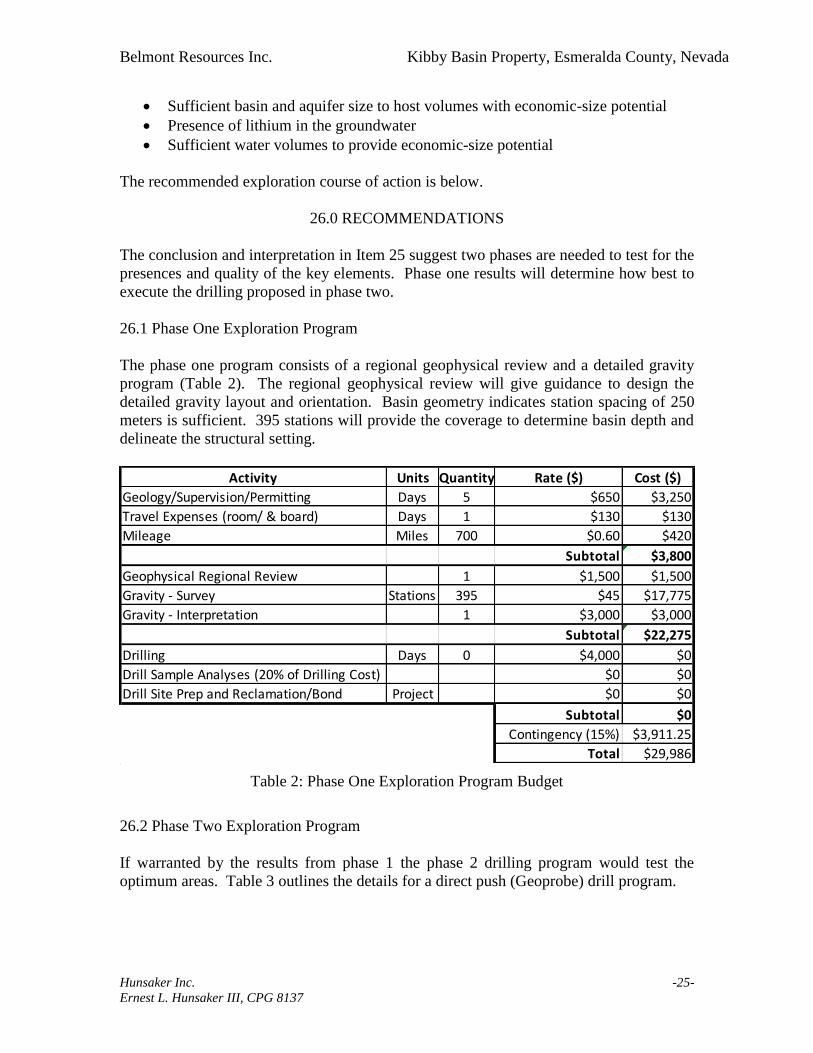
Sufficient basin and aquifer size to host volumes with economic-size potential
Presence of lithium in the groundwater
Sufficient water volumes to provide economic-size potential
The recommended exploration course of action is below.
26.0 RECOMMENDATIONS
The conclusion and interpretation in Item 25 suggest two phases are needed to test for the
presences and quality of the key elements. Phase one results will determine how best to
execute the drilling proposed in phase two.
26.1 Phase One Exploration Program
The phase one program consists of a regional geophysical review and a detailed gravity
program (Table 2). The regional geophysical review will give guidance to design the
detailed gravity layout and orientation. Basin geometry indicates station spacing of 250
meters is sufficient. 395 stations will provide the coverage to determine basin depth and
delineate the structural setting.
Table 2: Phase One Exploration Program Budget
26.2 Phase Two Exploration Program
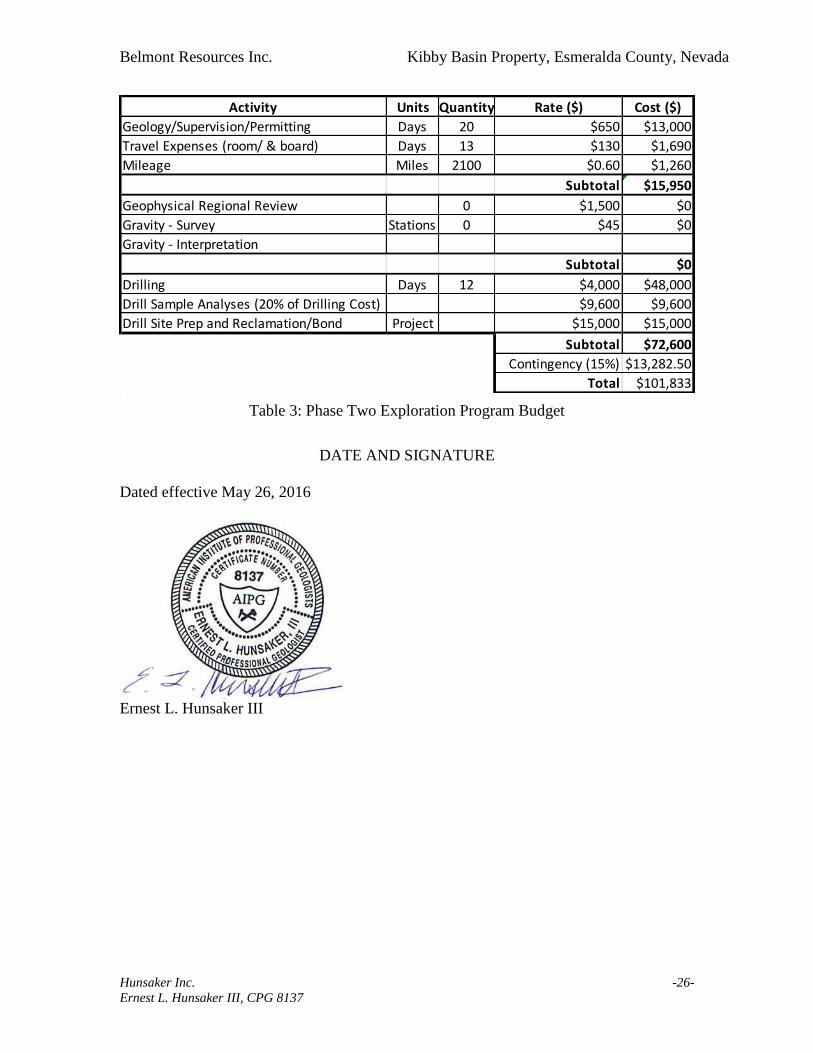
If warranted by the results from phase 1 the phase 2 drilling program would test the
optimum areas. Table 3 outlines the details for a direct push (Geoprobe) drill program.
Activity Units Quantity Rate ($) Cost ($)
Geology/Supervision/Permitting Days 5 $650 $3,250
Travel Expenses (room/ & board) Days 1 $130 $130
Mileage Miles 700 $0.60 $420
Subtotal $3,800
Geophysical Regional Review 1 $1,500 $1,500
Gravity - Survey Stations 395 $45 $17,775
Gravity - Interpretation 1 $3,000 $3,000
Subtotal $22,275
Drilling Days 0 $4,000 $0
Drill Sample Analyses (20% of Drilling Cost) $0 $0
Drill Site Prep and Reclamation/Bond Project $0 $0
Subtotal $0
Contingency (15%) $3,911.25
Total $29,986
Belmont Resources Inc. Kibby Basin Property, Esmeralda County, Nevada
Hunsaker Inc. -26-
Ernest L. Hunsaker III, CPG 8137
Table 3: Phase Two Exploration Program Budget
DATE AND SIGNATURE
Dated effective May 26, 2016
Ernest L. Hunsaker III
Activity Units Quantity Rate ($) Cost ($)
Geology/Supervision/Permitting Days 20 $650 $13,000
Travel Expenses (room/ & board) Days 13 $130 $1,690
Mileage Miles 2100 $0.60 $1,260
Subtotal $15,950
Geophysical Regional Review 0 $1,500 $0
Gravity - Survey Stations 0 $45 $0
Gravity - Interpretation
Subtotal $0
Drilling Days 12 $4,000 $48,000
Drill Sample Analyses (20% of Drilling Cost) $9,600 $9,600
Drill Site Prep and Reclamation/Bond Project $15,000 $15,000
Subtotal $72,600
Contingency (15%) $13,282.50
Total $101,833

Belmont Resources Inc. Kibby Basin Property, Esmeralda County, Nevada
Hunsaker Inc. -27-
Ernest L. Hunsaker III, CPG 8137
CERTIFICATE OF QUALIFICATIONS
I, Ernest L. Hunsaker III, do hereby certify that:
1. I am a consulting geologist employed by Hunsaker Inc P.O. Box 2021, Elko, Nevada,
USA 89803.
2. This certificate applies to “Technical Report Describing the Kibby Basin Property
Centered on 431,624E / 4,243,747N UTM NAD83 Z11 in Esmeralda County, Nevada
USA”, dated effective May 26, 2016.
3. I am a graduate of the Colorado School of Mines with a B.S degree in Geological
Engineering (1981) and Colorado State University with a M.Sc. degree in Economic
Geology (1988). I am a member of the American Institute of Professional Geologists
and certified as a Professional Geologist by that organization (CPG #8137). I have
read the definition of “qualified person” set out in NI 43-101 and certify that by
reason of my education, work experience and affiliation with a professional
association I fulfill the requirement to be a “qualified person” for the purpose of NI
43-101.
4. I have practiced my profession, as a mining and exploration geologist continuously
for 35 years since 1981. During this period I worked throughout the Great Basin as a
staff and consulting geologist for mining and exploration companies. I have more
than 25 years in Nevada, exploring for and developing gold, silver, base metal, and
industrial mineral properties.
5. I have managed the exploration and drilling program for a lithium-brine property in
Clayton Valley, Nevada and have conducted reconnaissance and exploration for
lithium-brine bearing properties throughout Nevada.
6. I visited the Kibby Basin Property on April 21, 2016.
7. I am responsible for all items of this report.
8. I am independent of Belmont Resources Inc. as described in section 1.5 of NI 43-101;
other than providing standard industry consulting services.
9. I do not have any involvement with this Property other than this assignment and a
consulting assignment to file and record claims for this Property.
10. I have read NI 43-101 and the Technical Report has been prepared in compliance
with the instrument.

Belmont Resources Inc. Kibby Basin Property, Esmeralda County, Nevada
Hunsaker Inc. -28-
Ernest L. Hunsaker III, CPG 8137
11. As of the effective date of this certificate, to the best of my knowledge, information,
and belief, the Technical Report discloses all scientific and technical information that
is required to make the Technical Report not misleading.
Dated effective the 26th day of May, 2016
Ernest L. Hunsaker III

Belmont Resources Inc. Kibby Basin Property, Esmeralda County, Nevada
Hunsaker Inc. -29-
Ernest L. Hunsaker III, CPG 8137
27.0 REFERENCES
Albers, J.P., and Stewart, J.H., 1972 Geology and Mineral Deposits of Esmeralda
County, Nevada: Nevada Bureau of Mines and Geology Bulletin 78
Burrus, J.B., 2013, Structural and stratigraphic evolution of the Weepah Hills Area, Nv-
Transition from Basin-and-Range Extension to Miocene Core Complex
Formation: Abstract – University of Texas at Austin, May 2013.
Crafford, A.E. J., 2007, Geologic Map of Nevada: U.S. Geological Survey Data Series
249
Davis, J.R., and Vine, J.D., 1979. Stratigraphic and tectonic setting of the lithium brine
field, Clayton Valley, Nevada, in RMAG-UGA 1979 Basin and Range
Symposium, pp.421-430.
Hardyman, R.F., John, D.A., and Oldow, J.S., 1990, Tectonic Framework of the Central
Walker Lane Regions; Yerington to Tonopah, Nevada in Buffa, R.H., and
Coyner, A.R., eds., Geology and Ore Deposits of the Great Basin – Field Trip
Guidebook Compendium: Great Basin Symposium, April 1990, Geological
Society of Nevada, Reno, Nevada
Oldow, John S., 2003, Late Cenozoic Displacement Partitioning in the Northwestern
Great Basin, in: Brown, H. Gassaway, ed. Regional Geology & Gold Deposits of
the Silver Peak Area, Mineralization Hosted by Metamorphic Core Complexes,
Geological Society of Nevada Special Publication 38, p. 113-152.
Oldow, J.S., Elias, E.A., Ferranti, L., McClelland, W.C., and McIntosh, W.C., 2009, Late
Miocene to Pliocene synextensional deposition in fault-bounded basins within the
upper plate of the western Silver Peak–Lone Mountain extensional complex,
west-central Nevada, in Oldow, J.S., and Cashman, P.H., eds., Late Cenozoic
Structure and Evolution of the Great Basin–Sierra Nevada Transition: Geological
Society of America Special Paper 447
Oppliger, G.L. 2003, Great Basin Free Air Anomaly, Gravity Data and Images Prepared
by Gary L. Oppliger, Great Basin Center for Geothermal Energy
Pantea, M.P., Asher-Bolinder, S., and Vince, J.O., 1981, Lithology and lithium content of
sediments in basins surrounding Clayton Valley, Esmeralda and Nye Counties,
Nevada, U.S. Geological Survey, Open-File Report 81-962
Reheis, M.C., Slate, J.L., Sarna-Wojcicki, A.M., and Meyer, C.M., 2009, A late Pliocene
to middle Pleistocene pluvial lake in Fish Lake Valley, Nevada and California,
Geological Society of America Bulletin, v. 105, p. 953-967

Belmont Resources Inc. Kibby Basin Property, Esmeralda County, Nevada
Hunsaker Inc. -30-
Ernest L. Hunsaker III, CPG 8137
Turner, H.W., 1900, The Esmeralda formation, a fresh-water lake deposit: U.S.
Geological Survey Annual Report 21, pt. 2, p. 191-208
Zampirro, D., 2003, Hydrogeology of Clayton Valley Brine Deposits, Esmeralda County,
Nevada, in: Castor, S.B., Papke, K.G., and Meeuwig, R.O., eds., Betting on
Industrial Minerals, Proceedings of the 39th
Forum on the Geology of Industrial
Minerals, Reno/Sparks Nevada May 18-24, 2003, Nevada Bureau of Mines and
Geology, Special Publication 33