bell’s travel guides logs/richardson-highway-log.pdfbell’s travel guides richardson highway road...
TRANSCRIPT
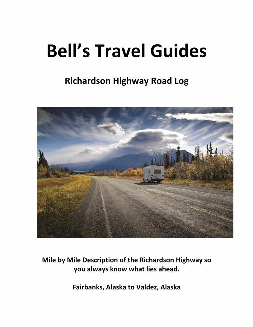
Bell’s Travel Guides
Richardson Highway Road Log
Mile by Mile Description of the Richardson Highway so
you always know what lies ahead.
Fairbanks, Alaska to Valdez, Alaska

The Richardson Highway is Alaska’s oldest highway. In 1898 a trail was pushed from Valdez to Eagle in the Interior of Alaska. Residents had requested money from Congress to improve the trail but by the time approval came through, the gold production in the Eagle area had declined. The funds were used instead to improve the Fairbanks portion because of the Felix Pedro find in Fairbanks. Stampeders left the Valdez to Eagle trail near the Gakona River and followed the river to its head waters. Here they joined the Castner trail which paralleled the Gulkana river to its source and then across the Alaska Range. They then traveled down the Delta and Tanana Rivers to Fairbanks. Major Wilds P. Richardson worked to upgrade the trail to a wagon road in 1910 after the Fairbanks gold rush. It was made suitable for vehicles in the 1920s and paved in 1957.
The Richardson connects Valdez (mile 0) and Fairbanks (mile 364). The drive will take you through the spectacular and narrow Keystone Canyon and across the Thompson Pass where you will find Worthington Glacier, one of the few glaciers in the world that you can drive to. From Valdez to Delta Junction there are many opportunities to view the Alaska pipeline, which parallels the highway. Summits along the route are high, with the Thompson Pass peaking at 2,805 ft.
Copper Center is one of the oldest white communities in Alaska’s Interior and served the prospectors on their way to the Gold Rush.
Glennallen is the center of the Copper River Basin, one of Alaska’s best outdoor recreation areas.
Delta Junction is at the junction of the Alaska and Richardson Highways. It is also home to a permanent maintenance station for the Alyeska pipeline.
North Pole is one of Alaska’s most interesting communities. It is best known as the home of Santa Claus House.
Fairbanks has a diversified economy, with the military, tourism and the University of Alaska as key components. There is also oil, gas, gold and coal in the area.
The Wrangell St. Elias National Park is the largest National Park in the U.S. It can be accessed via the Edgerton Highway at mile 83 of the Richardson. The road to McCarthy is rough and challenging. From here you can explore the National Park, a UNESCO World Heritage Site. I recommend that you fly in with Wrangell Mountain Air. They offer daily scheduled air service and day tours to McCarthy-Kennicott from Chitna and Glennallen. 800-478-1160
From Delta Junction to Valdez, the trans-Alaska pipeline parallels the route. Updates on Road Conditions and Construction: http://511.alaska.gov
mile 364 Fairbanks.
mile 360.6 Parks Highway to Denali Park, bypass Fairbanks via the Mitchell Expressway.
mile 359.7 Business Route. Leads to Cushman St. and downtown Fairbanks.
mile 357 Badger Road is a 12 mile loop which rejoins the Richardson Highway at mile 349.5 in North Pole.
mile 349.5 North Pole Alaska.
mile 349.5 Badger Road is a 12 mile loop which rejoins the Richardson Highway at mile 357.

mile 346.7 Laurance Road. Chena Lakes Recreation Area. 86 camp sites with bathrooms and dump station. Boat launch and picnic area, designated swimming area and rental of canoes, kayaks and row boats. Volleyball and basketball courts and playground. Chena Lake is stocked with salmon, rainbow trout, arctic char and grayling. 907-488-1655
mile 346 Chena Flood Channel.
mile 344.7 Moose Creek.
mile 343.5 Moose Creek Road
mile 342.5 Eielson Air Force Base Main Gate. Built in 1943. Named for Carl Ben Eielson, famous Alaskan bush pilot.
mile 327.7 Little Salcha River.
mile 325.5 Community of Salcha.
mile 324.8 Munsons Slough and parking at south end of bridge.
mile 324.5 Parking.
mile 323.6 Clear Creek.
mile 323.3 Salcha River State Recreation Site. 130 sites, boat launch, picnic area, toilets and water. Fishing for grayling and king salmon is good in the Salcha River. Fee area.
mile 322.2 Salcha River Lodge.
mile 321.5 Harding Lake State Recreation Area is a highly developed recreation area 45 miles southeast of Fairbanks (1.5-mile side road to campground on north side of Harding Lake) off the Richardson Highway. Harding Lake, is one of the few natural lakes near Fairbanks that can be reached by road, it is a favorite spot to swim, boat and fish. There are 90 camp sites for vehicles, a walk-in group camping area, toilets, water and dump station. There is also a large picnic and beach area with dressing rooms, a baseball field, volleyball court, horseshoe pits and campfire area. Resident ranger. Pike and lake trout. Harding Lake was a brief stopover for Will Rogers & Wiley Post on their ill-fated flight to Barrow, Alaska. Be sure to bring along your mosquito repellent!
mile 317.9 Parking.
mile 313 Parking with info sign on Tanana Valley.
mile 310 Parking.
mile 306 Rest area beside Birch Lake. Toilets.
mile 305.2 Birch Lake State Recreation Site is reached by turning north onto the gravel road for 1/4 mile. 17 camp sites, picnic area, toilets, swimming. Boat launch, excellent rainbow and trout fishing (boat recommended).
mile 304.3 Parking.

mile 298.2 Parking.
mile 297.6 Scenic view, parking on west side of highway. Access road to Tanana River.
mile 296.5 Parking with view of Tanana River.
mile 295.3 Banner Creek, historic placer gold stream.
mile 294 Parking.
mile 289.7 Parking loop road.
mile 288 Parking with Scenic view.
mile 286.7 Shaw Creek. Large parking area and boat launch good early spring and fall grayling fishing. Picnic table. View of Mt. Deborah (12,339 ft.) to the west, Mt. Hayes (13,832 ft.) to the southwest and Mt. Hess (11,940 ft.) between the two former peaks. All are a part of the Alaska Range which spans southcentral Alaska in a sweeping 600-mile arc.
mile 280.4 Small gravel parking area.
mile 277.8 Quartz Lake State Recreation Area, access via good 3-mile side road. 87 parking and camping sites. Large RV’s can park at the camping sites in the parking lot development. Facilities include two boat launches, a handicap accessible fishing dock, picnic sites, a picnic shelter, swimming area, beach volleyball court, water, and toilets. Stocked with rainbow, trout and cohoe. Boat recommended. Fee area.
There is a trail connecting Lost Lake and Quartz Lake. There are 12 camp sites at Lost Lake. Facilities include picnic area, water and toilets. Lost Lake is not stocked but its small picnic area is a favorite spot for those who want to enjoy the area's scenery and wildlife.
mile 275.4 Big Delta Bridge and Trans-Alaska Pipeline Bridge elevated 40 ft. above the Tanana River, this 1200-ft. bridge is the second longest on the route. (The longest crosses the Yukon River north of Fairbanks). Good view of the Alaska Range to the south. Large parking area at east end of bridge.
mile 275 Tanana Trading Post and Tesoro Gas station to South side of highway. Big Delta State Historical Park and turn off to Rika’s Roadhouse on North side of highway.
Rika’s Roadhouse at Big Delta State Historical Park. Rika’s Roadhouse Café and Gifts is open at Big Delta State Historical Park, from May 15 to September 5, 7 days a week 10 am – 4 pm. The Café serves homemade soups, sandwiches, pies and baked goods. The Smiling Moose Gift shop specializes in Alaskan-made gifts, souvenirs, and food items, and offers unique, locally made ulus, knives, fur items, books, photography, wall art and much more. 907-895-4201(during season) or 507-884-9103. [email protected]
The Valdez-to-Fairbanks trail brought travelers to the banks of the Tanana River, where they crossed by ferry. John Hajdukovich, a Yugoslavian entrepreneur, bought the land along with a fur trading post in 1909 making the Roadhouse over 100 years old. The two-story roadhouse, built of logs became a year-round oasis for hunters, trappers, prospectors and travelers as well as local Athabascans and homesteaders. However, John had many other interests, including the responsibility of US Game Commissioner. Sitting still and running a roadhouse did not appeal to him so he simply asked guests to make themselves at home and leave some money on the table. He ran it in this way until 1918, when finally a dependable, hard-working Swede named Rika Wallen was hired to take over.

Learn more of this fascinating story by visiting the Roadhouse, refresh yourself at the Restaurant and enjoy the gift shop. Open from mid May to mid September 10am - 5pm offering homemade soups, hot and cold sandwiches, salads, fruits, pie and ice cream. The gift shop specializes in local, Alaskan made items, including jewelry, knives, ulus, pens, hats and mittens, photography, historical local books and post cards, furs, food and snacks, and souvenirs and much more. Free admission to the park! 907-895-4201
mile 270.3 Alaska 7 Motel Comfort at a comfortable price; large clean rooms, private baths, satellite TV, refrigerator, courtesy coffee. 907-895-4848
mile 268.3 Clearwater State Recreation Site on Jack Warren Road, 11 miles km on good road. Campground has 17 camp sites, picnic area, tables, toilets, water and boat launch. You can continue on this road 8.5 miles to the Alaska Highway mile 1415/km 2277.
mile 268 Smith's Green Acres RV Park
mile 267 Delta State Recreation Site. 25 camp sites, water, tables, toilets, picnic shelters, Fee area.
mile 267 Delta Junction Airstrip.
mile 266.3 Delta Junction Post Office.
mile 266 Delta Junction. Junction of Richardson and Alaska Highway. Delta Junction Visitor Information is located here. Turn left if you are southbound for Tok or stay to the right for Glennallen and Valdez.
mile 265 Jarvis Creek.
mile 262.6 Scenic view, handicap accessible toilets.
mile 261 Fort Greely.
mile 258.3 Alyeska Pipeline Pump Station No. 9. No tours available.
mile 257.6 Meadows Road, entrance to U.S. Army Cold regions Test Center at Fort Greeley.
mile 252.9 Rest area.
mile 246 Donnelly Dome to the west, elevation 3,910 ft.
mile 245 Donnelly Lake.
mile 243.9 Parking, good views (on clear day) of Alaska Range, and peaks Deborah, Hess, and Hayes, to the south.
mile 243.5 Parking with view of pipeline.
mile 241.3 Scenic view; parking.
mile 238 Donnelly Creek State Recreation Site. 12 camp sites along loop road, water and toilets, firepits and hiking trail. It is one of the state's most scenic campgrounds, with views of some of the tallest peaks in the Alaska Range. The Delta bison herd can often be seen from nearby viewpoints and from the campground.

mile 234.7 Ruby Creek, parking.
mile 234.5 Parking.
mile 233.2 Bear Creek, parking
mile 231 Darling Creek, parking.
mile 230.5 Parking.
mile 229.5 Parking with great views.
mile 228.3 One Mile Creek.
mile 227.4 The Black Rapids Roadhouse. Established in 1902 on the original Valdez-Fairbanks Trail. The new lodge has a restaurant and accommodations.
mile 227 Gunny Sack Creek, parking.
mile 225.4 Parking, picnic tables on right southbound. Trail opposite historical sign leads 1/4 mile to Black Rapids Lake, it is stocked with rainbow. Historical sign describes rapid advance of Black Rapids Glacier. During the winter of 1936, this mile-wide, 300-foot-high river of ice advanced an average of 115 ft./day, or over 4 miles, to within 1/2 mile of the highway. It has been receding ever since.
mile 224.8 Upper Suzy-Q Creek, parking.
mile 224.5 Lower Suzy-Q Creek, parking.
mile 223.7 Boulder Creek, parking.
mile 223 Whistler Creek, parking.
mile 220.8 Flood Creek, parking.
mile 219.9 Michael Creek, parking at both ends of bridge. Good view of Pump Station No 10.
mile 219.1 Pipeline Pump Station No. 10.
mile 218.8 Trims Creek, parking at north end of bridge.
mile 218 Highway Maintenance Camp, no services.
mile 217.1 Castner Creek, small parking area at both ends of bridge.
mile 217 Parking.
mile 216.8 Lower Miller Creek, parking at south end of bridge. Pipeline crosses the river above ground.
mile 216 Parking area to view pipeline.

mile 215.2 Parking; pipeline crosses Miller Creek.
mile 214 Scenic view; parking.
mile 212 Parking.
mile 208.4 Parking.
mile 206.2 Scenic view; parking.
mile 203.9 Parking.
mile 202.4 McCallum Creek.
mile 202 Pipeline parallels the highway.
mile 201.4 Phelan Creek.
mile 200.5 Fielding Lake State Recreation Site. Access via 2-mile side road. A scenic campground at an elevation of 2,973 feet in the Alaska Range. The ice on the lake often remains until July. The 17 site campground is rustic but has picnic tables, toilets, and a bulletin board with information about the area. Boat launch and fishing. The boat launch provides access to some excellent fishing. The fish population is all natural and not stocked. Arctic Grayling, lake trout and burbot are all found in Fielding Lake. No fee and no water. There is a public use cabin which is available by reservation.
mile 197.6 Parking; scenic view. Monument to former Alaska road commission director, Captain Wilds P. Richardson, for whom the highway is named. Good view of Gulkana Glacier .
mile 196.8 Gunn Creek bridge. View of Gulkana Glacier to northeast.
mile 195 Summit Lake. There are several parking areas bordering Summit Lake between mile 191 and 194.
mile 190.5 Parking by Gulkana River Salmon Spawning viewpoint. View of Summit Lake and pipeline.
mile 189.5 Large parking area.
mile 188.3 Rest area; tables, firepits, water, toilets.
mile 185.5 Paxson Junction with the Denali Highway. This scenic, 133 mile/214 km route connects the Richardson Highway with Denali National Park and Preserve. The highway begins at Paxson Junction on the Richardson Highway and ends at Cantwell Junction where it merges with the Parks Highway. It is only 28 miles from this point to the Denali National Park. This highway is closed from October to mid-May. This is a mostly gravel road and most rental car companies do not allow their vehicles to be driven on this road.
mile 182.1 Parking by Paxson Lake.
mile 180 Parking.
mile 179 Huffman Creek.
mile 177 Parking.
mile 175 Paxson Lake BLM Campground. Access by 3/4-mile gravel road. Large campground (50 camp sites) near lake with some pull-through sites, dump station, fire pits, boat launch and water available. Good fishing for trout, grayling and burbot. Fee area. Watch for bear.
mile 173.2 Dick Lake to the east. Good view of pipeline. Grayling fishing.
mile 171.5 Parking.
mile 170 Meier's Lake Roadhouse.
mile 169.3 Large parking area. Middle Fork Trailhead to Meier's Lake.
mile 168.1 Gillespie Lake Trailhead and parking. Grayling fishing.
mile 166.5 June and Nita Lakes one mile trail to the west. Fishing.
mile 162.2 Parking.
mile 161 Haggard Creek.
mile 160.8 Haggard Creek Trailhead, parking area. Access to Gulkana River, grayling fishing.
mile 156 Parking.
mile 153.5 Parking.
mile 153 Parking.
mile 150.7 Parking.
mile 149 Parking.
mile 147.2 Sourdough Roadhouse.
mile 147.5 Sourdough Creek BLM Campground. 42 camp sites, toilets, boat launch. Handicap accessible. Fee area. Good fishing in Gulkana River.
mile 147 Large parking area with views of the Alaska Range.
mile 141.4 Large parking area.
mile 140.7 Parking.
mile 139.3 Parking.
mile 138.2 Poplar Grove Creek.
mile 136.9 Gulkana River Trail.
mile 136.5 Coleman Creek.

mile 135.6 Parking.
mile 132.3 Parking.
mile 132 Gulkana River Fishing and Camping Park.
mile 130 Parking.
mile 128.5 Gakona Junction. North Junction of Richardson and Glenn Highways. Here the Glenn Highway (known locally as the Tok Cut-Off) heads northeast 125 miles to Tok Alaska .
mile 128.5 Historic Gakona Lodge and Trading Post.
mile 127 Gulkana.
mile 126.8 Gulkana River Bridge, parking.
mile 126 Parking.
mile 118.5 Gulkana Airport.
mile 118 Dry Creek State Recreation Site. 50 camp sites, picnic shelters, water, toilets, trails and fishing.
mile 115 South Junction of Richardson and Glenn Highways. Here the Glenn Highway heads west 189 miles to Anchorage or 115 miles south to Valdez. If you're heading towards Anchorage see the Glenn Highway description.
Hub of Alaska at the junction of Glenn and Richardson Highways. Produce, meat, ice cream, hot sandwiches, coffee, fishing tackle and licenses. Alaskan gifts and jewelry. ATM machine at the store. 907-822-3555
The Greater Copper Valley Visitor Center at the junction of the Richardson and Glenn Highways. Stop by for up-to-date info about the area.
mile 112.5 Rest Area, Historical Marker. Commemorates Alaska Road Commission which began in 1905. Great view of the Wrangell Mountains, 4 major peaks: Mount Drum, Mount Sanford, Mount Wrangell and Mount Blackburn. mile 111.8 Copperville Road.
mile 111 Tazlina River Trading Post.
mile 110.7 Tazlina River Bridge.
mile 110.6 Rest Area. Picnic tables and toilets beside the Tazlina River.
mile 110.4 Tazlina River RV Park.
mile 107 Side road to Wrangell St-Elias Park and Preserve Visitor Info Center

mile 106.2 North Junction of Old Richardson Highway loop road leads to historic Copper Center. Copper Center is one of the oldest white communities in Alaska's Interior. Founded as a government agricultural experimental station, it later served as a transportation center for the gold rush prospectors who came over the old Richardson Trail from Valdez enroute to the Forty Mile area and Dawson.
The George I. Ashby Memorial Museum, housed in rustic log cabins, the museum offers the visitor a unique look at the varied past of the Copper River Valley area. Exhibits include early mining of gold and copper, and Russian artifacts.
Mile 102 Copper River Princess Wilderness Lodge Brenwick Craig Road.. Overlooking the Wrangell-St. Elias National Park, this lodge features a true wilderness experience. Participate in the many activities available including flight seeing, river rafting, horseback riding, fishing and excursions into the historic Kennicott mining district. Restaurant, lounge, espresso bar, gift shop and tour desk. Call 907-822-4000 or 800-426-0500 for reservations.
mile 101 Klutina River Bridge. Parking. The Klutina River has good runs of both Alaska King salmon and the world famous Copper Red salmon. The Klutina-Gulkana Rivers offer some of the state's best fishing.
mile 100.2 South Junction of Old Richardson Highway loop road leads to historic Copper Center and returns to the highway at mile 106.2.
mile 90.7 Parking by Willow Creek.
mile 88.6 Viewpoint; Pipeline parallels highway.
mile 87.7 Parking by Willow Lake. Good views of Wrangell Range, over 50 miles away. Mt. Drum (12,010 ft.) is nearest peak. Mt. Wrangell (14,163 ft.) is semi-active volcano east of Mt. Drum. Mt. Sanford (16,237 ft.) is partly hidden by these two mountains and Mt. Blackburn (16,390 ft) the tallest of the four major peaks. The Wrangell Range takes in an area of over 5,000 square miles, and has 12 peaks above 10,000 ft. Innumerable glaciers drain northward into the Tanana and Yukon river systems which flow into the Bering Sea. Glaciers also drain southward into the Copper and Chitina river systems which empty into Prince William Sound and the Pacific.
mile 83 Parking at Pippin Lake.
mile 82.6 Junction. The Edgerton Highway branches off to the small community of Chitina (33 miles) and into the Wrangell St. Elias National Park to the ghost towns of Kennicott and McCarthy (60 miles past Chitina) This takes approximately 3 hours to drive and the road can be quite rough. The first 33 miles to Chitina are paved. Liberty Falls Campground, with 6 units, grayling fishing, is located 24 miles from this junction.
Chitina (pronounced CHIT-na) has a population of around 200. Its beautiful scenery, dilapidated buildings and fishing in nearby lakes and streams are it's main attractions. 2 miles from Chitina across the Copper River is a camping and picnic area. The highway leading to the campground crosses a $4 million-dollar bridge which is part of a project designed to provide good access from Chitina to the mineral-rich area surrounding McCarthy and the Wrangell-St. Elias National Park and Preserve, the largest Park in the USA. Chitina became prominent about 1910 as a railroad and mining supply center, after completion of the Copper River and Northwestern Railway from the coastal town of Cordova to the world-famous copper mines at Kennicott. The road from Chitina to McCarthy follows the path of the old railroad. This gravel road is state maintained from May 15 - September 15 and is passable by any standard passenger vehicle. There are no vehicle services beyond Chitina and the road is narrow in places. Check at the Ranger Station at Chitina for current road conditions. There is a footbridge across the Kennicott River. The town of McCarthy is a half mile beyond the end of the first bridge. Van transportation is available to Kennicott and McCarthy from the footbridge. Call Wrangell Mountain Bus 554-4411 from the pay phone at the bridge.

Wrangell Mountain Air A real Alaska experience might be summed up in a few words; Mountains, glaciers, wild, untamed wilderness and rustic frontier towns. Wrangell Mountain Air is your ticket to the wonders of Wrangell-St. Elias National Park. Based at McCarthy near the center of the park, the company offers fly-in day trips to Kennicott National Historic Landmark with optional history tours and glacier hiking, flightseeing in what has been described as the Himalayas of North America. Fly-in backpacking, base-camping and river trips are also available. Take advantage of scheduled daily flights from Chitina and McCarthy and spend a couple of days in the area. Reservations required. 1-800-478-1160.
The "Company Town" of Kennicott and its support town of McCarthy sprang up in 1910 with the development of the massive high grade copper deposits at the Kennicott Mine and flourished until 1938 when the mine and railroad were abandoned. In 1986 the Kennicott Mine was named a National Historic Landmark. Today there are about 50 residents in Kennicott / McCarthy area.
Kennicott Glacier Lodge is a full service lodge with hotel rooms, restaurant, guided tours, hiking, and flight seeing. A unique opportunity to stay and explore the famous ghost towns of Kennicott and McCarthy. Comfortable lodging, indoor bathrooms and hot showers as well as a cozy living room with a library and fireplace. Accommodation is limited so there is lots of personal attention from the staff. Historical tours with knowledgeable guides are available 907-258-2350, or toll free 1-800-582-5128.
Mile 80.8 Parking.
mile 79.5 Squirrel Creek and Squirrel Creek State Recreation Site. 25 camp sites, water, toilets, firepits and fishing in creek. Fee area. Limited turn around space at end of road. If you are driving a large RV it is best to park near the entrance and walk to select your site. Road is fairly rough.
mile 79.1 Tonsina River Bridge. Tonsina River and Little Tonsina River which parallels the highway from mile 74 to mile 65, has good Dolly Varden, salmon & grayling fishing.
mile 74.5 Large parking area.
mile 72 Parking with view of Alaska Pipeline.
mile 65 Little Tonsina River.
mile 64.7 Pump Station No. 12. This is the last of 12 pump stations located along the Alaska pipeline. Parking and information sign on pipeline.
mile 62 Ernestine Station. Highway maintenance camp-no public facilities.
mile 60 Parking by Tiekel River.
mile 58.1 Wagon Point Creek.
mile 56.2 Parking by Tiekel River.
mile 56 Tiekel River Lodge.
mile 55.1 Parking by Tiekel River.
mile 54 Parking.
mile 50.7 Tiekel River Bridge.

mile 47.9 Large paved rest area by Tiekel River, covered picnic tables, toilets. Viewpoint and information sign for Mount Billy Mitchell.
mile 46.9 Tiekel River Bridge and parking.
mile 45.6 Stuart Creek, parking just north of bridge.
mile 43.3 Large parking area.
mile 42.2 Parking.
mile 37.3 Tsaina River Bridge and parking at south end of bridge.
mile 35 Parking
mile 30.1 Large parking area with good view of Worthington Glacier. There are several places to pull off over the next couple of miles and view this spectacular scenery.
mile 28.7 Worthington Glacier and Worthington Glacier State Recreation Site. Viewing shelter with interpretive displays, picnic shelters, trails, and toilets (no overnight camping). Public telephone.
mile 27.5 Good view of 27 Mile Glacier if you are heading towards Valdez.
mile 27 Highway Maintenance Camp, no public facilities.
mile 26 Thompson Pass. 2,678 ft. Historical sign sketches history of early-day travel on this route. Airstrip.
mile 25.7 Parking with view. Keystone Glacier can be seen on a clear day.
mile 25.5 Parking.
mile 24.4 Parking. Marshall Pass. During the winter of 1907 a 140-ft. steamboat was carried piece-by-piece on horse-drawn sleds to the Copper River, 31 miles east.
mile 24.3 Parking.
mile 24.1 Blueberry Lake State Recreation Site. Access by 1 mile side road. 25 camp sites, picnic shelter, water, toilets, and trails. Grayling and Rainbow trout in both lakes.
mile 23.4 Parking with view.
mile 23 Parking with view.
mile 21.5 Parking.
mile 18.7 Sheep Creek.
mile 18.3 Parking on both sides of highway, telephone.
mile 16.4 Lowe River and bridge.

mile 15.9 North end of Keystone Canyon.
mile 15.4 Lowe River Bridge, parking at bridge. Historical sign.
mile 14.8 Lowe River Bridge. Old Railroad Tunnel. Historical sign describes hand-cut tunnel started in 1905. This tunnel was described in Rex Beach's novel, The Iron Trail.
mile 13.9 Bridal Veil Falls, Keystone Canyon. Large parking area.
mile 13.4 Horsetail Falls. Welcome to Valdez sign and area map, large parking area.
mile 12.9 South end of Keystone Canyon.
mile 11.9 Loop road that accesses the Pack Trail of 1899. Parking is better at the north end of the loop road.
mile 11.6 Parking.
mile 4 Parking beside Lowe River.
mile 3.3 Robe Lake Road. Robe Lake Recreation Area. Floatplane base, and picnic area reached by 1/2-mile gravel road.
mile 2.8 Dayville Road. leads 5.4 miles to Port of Valdez. extends to south side of Valdez Arm, tank farm and docks for the 800 mile-long Trans-Alaska pipeline. No public access.
mile 2.6 Parking.
mile 2.4 Valdez Memorial Cemetery.
mile 1.7 City of Valdez Gold Fields Complex.
mile .9 Valdez Glacier Stream.
mile 0 Old Valdez Town site. If you are heading towards Valdez continue straight ahead (4 miles) to the new City of Valdez, which was rebuilt after the devastating earthquake of 1964.
This marks the end of the Richardson Highway. It is 3.5 miles to the new town site of Valdez, Alaska.
mile 3.4 Access road to airport (west) 1 mile. Valdez Glacier Campground (2 miles) 101 camp sites, water, toilets and fire pits. Fee area.
mile 2.2 Mineral Creek Loop Road returns to the Richardson Highway at mile 3.4. Access road to Port of Valdez and container terminal.
mile 1.9 Parking.
mile 1.2 Parking.
mile .9 Parking at Crooked Creek salmon spawning area. Observation platform. Chucagh National Forest Information Center.

mile .4 Parking with information Kiosk.
mile 0 Valdez Alaska