beach and bay access - texas gulf coast online€¦ · beach and bay access urbanized area beach...
TRANSCRIPT

N
Beach and Bay Access
Urbanized Area
Beach
Dunes
Flats
Intermittent Water
Inundation Water
Mangroves
Sea Grass
Sewage/Industrial
Water
Wetlands
0 7 Miles
1 : 355,764
0 8 Kilometers
Galveston
edited by texasgulfcoastonline.com
Beach and Bay Access

Site/Area Location(Includes nearest city/town)
FiFisishshh
g
Swi
wi
mining
eiieie
iiningng
iicicncnckckikining
Ca
ining
Wi
Winin
SSuiining
Boa
Ram
amp
mp
Boa
Dockck
PiPieierer
Res
rroroom
ShShowe
wer
ElElelecrriricic
yy/
y/igighghiining
FrFrere
aterer
Co
Con
ones
iioion
EnEnt
nn//P/P
rrgFeFee
ululflf
Bay
ay
iv//L/L
eecess
Galveston COUNTY
7 Mile Road 7 Mile Road at end of seawallGalveston
13 Mile Road Off of Highway 3005, Galveston
18th Street Fishing Pier 101 18th Street, Galveston281-339-2600
61st Street Fishing Pier61st Street & Seawall Boulevard
Galveston, 409-744-8365
April Fool Point 815 Avenue O, San Leon
Bay Street Park 25th & Bay streets, Texas City
Bayshore Park FM 646 at the Spillway, San Leon
Bayshore Public Boat Ramp Bayshore Drive & Avenue B, Bacliff
Bayside RV Park 5619 West Bayshore Drive, Bacliff
Beach Pocket Park #17 Mile Road & Highway 3005
Galveston, 409-766-2138
Beach Pocket Park #311 Mile Road & Highway 3005
Galveston, 409-737-1206
Ben BlackledgePublic Boat Ramp Under Highway 146, Kemah
Big Reef Nature Park Boddecker Drive, Galveston
Bolivar Bait Camp End of Boyt Road, Bolivar Peninsula409-684-4210
Bolivar Ferry Landing End of Highway 87, Port Bolivar
Cade Street Off of Highway 87, Bolivar Peninsula
Captain Nap’s Moses Lake Marina
Crystal Beach
4009 North 20th Street, Texas City
State Hwy. 87, Bolivar Peninsula
edited by texasgulfcoastonline.com

Site/Area Location(Includes nearest city/town)
FiFisishshh
g
Swi
wi
mining
eiieie
iiningng
iicicncnckckikining
Ca
ining
Wi
Winin
SSuiining
Boa
Ram
amp
mp
Boa
Dockck
PiPieierer
Res
rroroom
ShShowe
wer
ElElelecrriricic
yy/
y/igighghiining
FrFrere
aterer
Co
Con
ones
iioion
EnEnt
nn//P/P
rrgFeFee
ululflf
Bay
ay
iv//L/L
eecess
Galveston COUNTY
Dollar Point Marina 4220 Bay Street, Texas City409-945-4808
Dr. K. Lloyd LauderdaleBoat Ramp
End of Yacht Basin RoadBol ivar Peninsula
Eagle Point Fishing Camp 101 1st Street, San Leon281-339-1131
Emerald Beach Alma Street, Bol ivar Peninsula
Erman Pilsner Boat Ramp End of 15th & 16th streetsBolivar Peninsula
Flagship Fishing Pier 25th street & Seawall BoulevardGalveston
FM 270 Boat Ramp Egret Boulevard at Cow BayouLeague City
Fort Crockett Seawall Park 51st Street & Seawall BoulevardGalveston
Fort Travis Seashore Park End of 10th Street, Bolivar Peninsula
Frank CarmonaBeach Pocket Park
11 Mile Road & Highway 3005Galveston
Galveston Fishing Pier 90th Street & Seawall BoulevardGalveston, 409-744-2273
Galveston Island State Park14901 FM 3005, Galveston
409-737-1222
Galveston Yacht Basin 715 Holiday Drive, Galveston409-762-9689
Glades of Galveston 8227 Teichman Road, Galveston
Gulf Drive 2nd Street & Highway 3005Galveston
Haney Park Entrance to Texas CityDike on Dike Road, Texas City
Hershey Beach Access San Luis Pass Roadand 10 Mile Road
Dellanera RV Park 7 Mile Road & Highway 3005Galveston, 409-740-0390
edited by texasgulfcoastonline.com
Site/Area Location(Includes nearest city/town)
FiFisishshh
g
Swi
wi
mining
eiieie
iiningng
iicicncnckckikining
Ca
ining
Wi
Winin
SSuiining
Boa
Ram
amp
mp
Boa
Dockck
PiPieierer
Res
rroroom
ShShowe
wer
ElElelecrriricic
yy/
y/igighghiining
FrFrere
aterer
Co
Con
ones
iioion
EnEnt
nn//P/P
rrgFeFee
ululflf
Bay
ay
iv//L/L
eecess
Galveston COUNTY
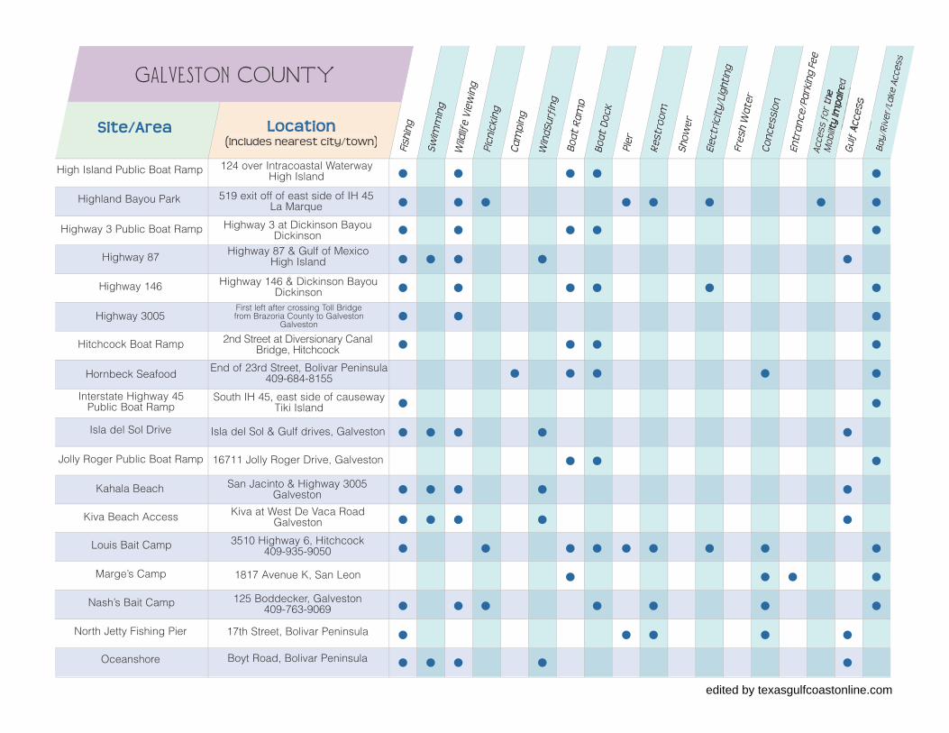
Highway 3 Public Boat Ramp Highway 3 at Dickinson BayouDickinson
Highway 87 Highway 87 & Gulf of MexicoHigh Island
Highway 146 Highway 146 & Dickinson BayouDickinson
Highway 3005First left after crossing Toll Bridgefrom Brazoria County to Galveston
Galveston
Hitchcock Boat Ramp 2nd Street at Diversionary CanalBridge, Hitchcock
Hornbeck Seafood End of 23rd Street, Bolivar Peninsula409-684-8155
Interstate Highway 45Public Boat Ramp
South IH 45, east side of causewayTiki Island
Isla del Sol Drive Isla del Sol & Gulf drives, Galveston
Jolly Roger Public Boat Ramp 16711 Jolly Roger Drive, Galveston
Kahala Beach San Jacinto & Highway 3005Galveston
Kiva Beach Access Kiva at West De Vaca RoadGalveston
Louis Bait Camp 3510 Highway 6, Hitchcock409-935-9050
Marge’s Camp 1817 Avenue K, San Leon
Nash’s Bait Camp 125 Boddecker, Galveston409-763-9069
North Jetty Fishing Pier 17th Street, Bolivar Peninsula
Oceanshore Boyt Road, Bolivar Peninsula
Highland Bayou Park 519 exit off of east side of IH 45La Marque
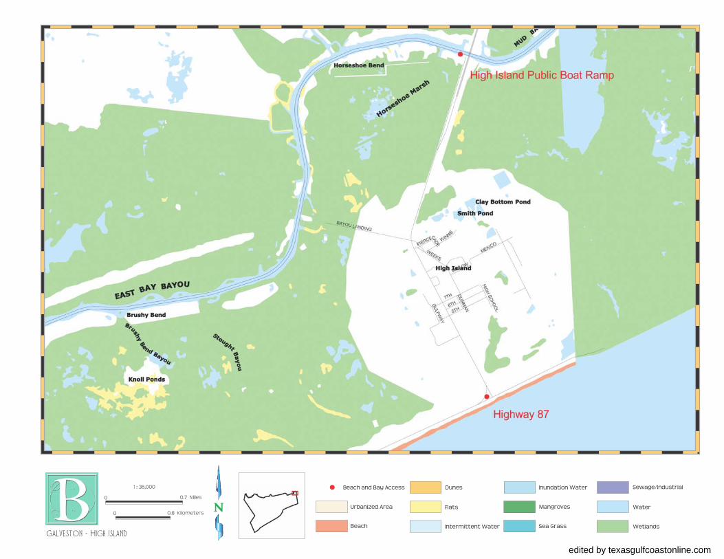
High Island Public Boat Ramp 124 over Intracoastal WaterwayHigh Island
edited by texasgulfcoastonline.com

Site/Area Location(Includes nearest city/town)
FiFisishshh
g
Swi
wi
mining
eiieie
iiningng
iicicncnckckikining
Ca
ining
Wi
Winin
SSuiining
Boa
Ram
amp
mp
Boa
Dockck
PiPieierer
Res
rroroom
ShShowe
wer
ElElelecrriricic
yy/
y/igighghiining
FrFrere
aterer
Co
Con
ones
iioion
EnEnt
nn//P/P
rrgFeFee
ululflf
Bay
ay
iv//L/L
eecess
Galveston COUNTY
Palm Beach at Moody Gardens End of 81st Street, Galveston
Payco Marina 501 Blume Drive, Galveston409-744-7428
Pelican Island Causeway Under Highway 275 & PelicanIsland Causeway, Galveston
Pirate’s Beach Marina 14302 Stewart Road, Galveston409-737-9966
R.A. Apffel Park Boddecker Drive & SeawallBoulevard Galveston, 409-762-3278
Ramada Beach Area Driftwood Road, Bolivar Peninsula
Ray’s Bait Camp 20th Street in Texas City
Rettilon Road Rettilon Road, Bolivar Peninsula
Rollover Pass Highway 87 at Rollover Pass
Bolivar Peninsula
Rosewood Boat Ramps Rosewood & East Shore drivesClear Lake Shores
Salt Cedar Drive Salt Cedar Drive & Highway 3005Galveston
San Luis Toll Bridge Under bridge between San Luis &Galveston Island, Galveston
Seawall Drive Galveston
Seawolf Park End of Seawolf Parkway
Boa
t Lau
nch
Fee
Shirley’s Bait Camp 1501 Rankin at Intracoastal Canal409-684-9251
Pirate’s Cove Bait Camp 3401 Highway 6, Hitchcock409-935-7774
Overton Avenue At end of Peninsula, Bolivar
Pabst Road Pabst Road & Highway 3005Galveston
edited by texasgulfcoastonline.com

Site/Area Location(Includes nearest city/town)
FiFisishshh
g
Swi
wi
mining
eiieie
iiningng
iicicncnckckikining
Ca
ining
Wi
Winin
SSuiining
Boa
Ram
amp
mp
Boa
Dockck
PiPieierer
Res
rroroom
ShShowe
wer
ElElelecrriricic
yy/
y/igighghiining
FrFrere
aterer
Co
Con
ones
iioion
EnEnt
nn//P/P
rrgFeFee
ululflf
Bay
ay
iv//L/L
eecess
Galveston COUNTY
Sportsman Public Boat Ramp 11628 Sportsman Drive, Galveston
Stewart Beach Broadway & Seawall BoulevardGalveston, 409-765-5023
Stingaree Marina End of Stingaree RoadBolivar Peninsula, 409-684-9530
Teakwood Marina 400 Tiki Drive, Tiki Island409-935-5552
Texas City Dike End of Palmer Highway, Texas City409-948-8172
Texas Parks & WildlifeDepartment Boat Ramp
South IH 45, Exit 4, under IH 45,Galveston
Walter Hall Park 807 North Highway 3, League City
Washington Park 61st Street before enteringGulf Freeway, Galveston
West Bay Marina 21706 Burnet, Sea Isle, Galveston409-737-3636
Skyline Park End of Palmer Highway, Texas City
Skyline Drive North end of Skyline DriveTexas City
edited by texasgulfcoastonline.com
N
Beach and Bay Access
Urbanized Area
Beach
Dunes
Flats
Intermittent Water
Inundation Water
Mangroves
Sea Grass
Sewage/Industrial
Water
Wetlands
0 0.7 Miles
1 : 36,000
0 0.8 Kilometers
Galveston - High Island
edited by texasgulfcoastonline.com

N
Beach and Bay Access
Urbanized Area
Beach
Dunes
Flats
Intermittent Water
Inundation Water
Mangroves
Sea Grass
Sewage/Industrial
Water
Wetlands
0 0.7 Miles
1 : 36,000
0 0.8 Kilometers
Galveston - Rollover Pass
edited by texasgulfcoastonline.com

N
Beach and Bay Access
Urbanized Area
Beach
Dunes
Flats
Intermittent Water
Inundation Water
Mangroves
Sea Grass
Sewage/Industrial
Water
Wetlands
0 0.7 Miles
1 : 36,000
0 0.8 Kilometers
Galveston - ramada Beach
edited by texasgulfcoastonline.com

N
Beach and Bay Access
Urbanized Area
Beach
Dunes
Flats
Intermittent Water
Inundation Water
Mangroves
Sea Grass
Sewage/Industrial
Water
Wetlands
0 0.7 Miles
1 : 36,000
0 0.8 Kilometers
Galveston - OceanShore
edited by texasgulfcoastonline.com

N
Beach and Bay Access
Urbanized Area
Beach
Dunes
Flats
Intermittent Water
Inundation Water
Mangroves
Sea Grass
Sewage/Industrial
Water
Wetlands
0 0.7 Miles
1 : 36,000
0 0.8 Kilometers
Galveston - Bolivar Ferry
edited by texasgulfcoastonline.com