basin-scale change in water availability and water quality ...645547/fulltext01.pdf · basin-scale...
TRANSCRIPT

1
Thesis title
Basin-scale change in water availability and water quality under intensified irrigated agriculture
Rebecka Törnqvist
Department of Physical Geography and Quaternary Geology Stockholm University
2013

your name
2
© Rebecka TörnqvistISSN 1653-7211ISBN 978-91-7447-724-5
Paper I, II © Springer Science+Business Media B.V.Paper III © ElsevierPaper IV, V © Rebecka Törnqvist
Cover: The shrinking Aral Sea (Centre image; © Visible Earth NASA) and irrigated agriculture in the Aral Sea Drainage Basin (Photo: Rebecka Törnqvist and Jerker Jarsjö).
Print: US-AB, Stockholm

3
Thesis title
Changes in land use and water use can greatly impact the cycling of water and water-borne substances. Increased redistribution of river water to irrigated fields can cause enhanced evapotranspiration and de-creased river discharge. Additionally, the water quality can be affected by the external input of fertilisers and pesticides, and by changed pollutant transport pathways in expansive irrigation canal systems. This thesis examines basin-scale changes in water use, river discharge, water quality and nitrogen (N) loading under conditions of intensified irrigated agriculture, using the Aral Sea drainage basin (ASDB) with its two large rivers Syr Darya and Amu Darya in Central Asia as study area. Results show that more efficient irrigation techniques could reduce outtake of river water to the cotton fields in the ASDB by about 10 km3/year, while the corresponding river water saving at the outlet would be 60% lower. The result illustrates the importance of accounting for return flows of irrigation water in basin-scale water saving assessments. Moreover, a decrease in riverine N concentrations at the outlet of the Amu Darya River Basin (ADRB) was observed during a 40-year period of increasing N fertiliser input. The decrease was identified to be primarily caused by increased recirculation of river water in the irrigation system, leading to increased flow-path lengths and enhanced N attenuation. Decreasing N loads were shown to be primarily related to reduced discharge. N export from the basin may further decrease due to projected discharge reductions related to climate change. Furthermore, nutrients and metals were occasionally found at concentrations above drinking water guideline values in sur-face waters in the ADRB. However, metal concentrations in groundwater in the lower ADRB were subject to orders of magnitude higher health hazards. Projected decrease in downstream surface water availability would thus imply decreased access to water suitable for drinking.
Key words: Irrigation, Hydrology, Land-use change, Basin-scale, Central Asia, Aral Sea, Semi-arid, Return flow, Water saving, Health risk, Water quality, Surface water, Groundwater, Nitrogen, Attenuation, Recircula-tion, Climate change
Abstract

your name
4
5
Thesis title
Förändringar i mark- och vattenanvändning kan avsevärt påverka kretsloppet av vatten och vattenburna äm-nen. Jordbrukssektorn använder globalt sett ca två tredjedelar av världens sötvattenresurser och har därmed en särskilt viktig roll för tillgången av vatten i olika hydrologiska system. Det har påvisats att ett ökat vatte-nuttag för bevattning, som resulterar i ökade vattenförluster genom avdunstning, har orsakat minskat flöde i många stora floder i arida och semi-arida områden. Dessutom kan kvaliteten på vattnet påverkas av extern tillförsel av näringsämnen och bekämpningsmedel till jordbruksområden samt ändrade transportvägar i och med utbyggnad av storskaliga system av reservoarer, bevattningskanaler och dräneringskanaler.
Denna avhandling avser att fördjupa kunskapen om förändringar i vattenanvändning, vattenkvalitet och massflöden av näringsämnen i avrinningsområden där en ökad användning av konstbevattning sker. I under-sökningen har syntesiserande datanalys och hydrologisk modellering använts för att identifiera viktiga förän-dringsprocesser som påverkar de hydrologiska grundförhållanden, vilka är viktiga att förstå för utveckling av mer hållbara strategier för att tillgodose kraven på tillgänglighet och kvalitet på begränsade vattenresurser i torra områden. Aralsjöns avrinningsområde i Centralasien med dess två stora floder Amu Darya och Syr Darya används som studieområde. Området karaktäriseras av en drastisk minskning i vattenflöde som hu-vudsakligen har orsaktas av en betydande ökning av regionens konstbevattnade jordbruksareal.
Resultaten från denna avhandling visar på betydelsen av återanvändning av vatten inom det hydrologiska systemet i Aralsjöns avrinningsområde. I studien framkom att effektivare bevattningstekniker kan minska uttaget av flodvatten till bomullsfälten i Aralsjöns avrinningsområde med ca 10 km3/år, vilket är kopplat till minskade återflöden till floden. Detta resulterar i en lägre, men betydande, effektiv flodvattenbesparing vid avrinningsområdets utlopp av ca 4 km3/år. Faktiska vattenbesparingar kan framförallt vinnas genom att minska vattenflöden som inte går att återanvända, såsom förluster till atmosfären. Till följd av detta visade sig vattenbesparande bevattningstekniker vara mest effektiva i torra delar inom avrinningsområdet där det finns stor potential att minska vattenförluster genom avdunstning.
En syntes av vattenkvalitetsdata i Amu Daryas avrinningsområde visade på ytvattenkoncentrationer av met-aller och näringsämnen som tillfälligtvis översteg WHOs hälsoriskbaserade riktvärden. Dock var metallhalter i grundvatten från den nedre delen av Amu Daryas avrinningsområde genomgående kopplade till betydligt högre hälsorisker än i ytvatten. Minskad tillgång av ytvatten i denna region kan därmed innebära en potentiell minskning i tillgång på vatten som är lämpligt som dricksvatten.
Minskade kvävekoncentrationer observerades nära utloppet av Amu Daryas avrinningsområde trots ökad tillförsel av kväve till avrinningsområdets odlingsområden. En ökad recirkulation av flodvatten i det sam-mankopplade bevattning-, dränering- och reservoarsystemet, med förlängda transportvägar och en ökad grad av nedbrytning och retention av näringsämnen, identifierades som en viktig process för de minskade koncen-trationerna. Dessutom visade sig ett minskat massflöde av näringsämnen från Amu Daryas avrinningsområde vara starkt korrelerat till dess minskade vattenflöde. En framtida förändring i klimat kan leda till ytterligare minskat vattenflöde i Aralsjöns avrinningsområde och en ökad nedbrytning av kväve, p.g.a., en ökad kvot mellan recirkulerat vatten och vattenutflöde. En sådan utveckling, som även är projicerad för många andra arida och semi-arida områden, kan därmed resultera i fortsatt minskat massflöde av kväve från avrinning-sområdet.
Sammanfattning

your name
6

7
Thesis title
List of papers
This doctoral thesis consists of a summary and five appended papers. The papers are referred to as Paper I−V in the summary text.
Basin-scale change in water availability and water quality under intensified irrigated agriculture
Rebecka Törnqvist
Department of Physical Geography and Quaternary Geology, Stockholm University, Sweden
Co-authorship
I led the writing, prepared figures and tables, was responsible for setting up the models, synthesised the data and performed the trend analysis and modelling in Papers I-IV. Bakhtiyor Karimov was responsible for the water quality data measurement campaigns in Uzbekistan in Paper III. Jerker Jarsjö was leading the develop-ment of the analytical relationship between nitrogen attenuation and recirculation ratio in Paper IV.
For Paper V, Jerker Jarsjö led the writing of the paper. I set up the hydrological model, performed the analysis of future recirculation ratios and was responsible for writing parts of the paper. Su Ye performed the hydro-climatic modelling.
All the co-authors contributed to the interpretation of results and formulation of manuscripts for Paper I-V.
I. Törnqvist, R., Jarsjö, J. (2011) Reduction of Water Losses by Use of Alternative Irrigation Techniques in the Aral Sea Drainage Basin. In: Behnassi, M., D’Silva, J., Shabbir, S.A. (eds.) Sustainable agricultural development: Recent approaches in resources management and environmentally-balanced production enhancement. Springer, Dordrecht, pp 157–168
II. Törnqvist, R., Jarsjö, J. (2012) Water savings through improved irrigation techniques: Basin-scale quantification in semi-arid environments. Water Resources Management 26: 949–962.
III. Törnqvist, R., Jarsjö, J., Karimov, B. (2011) Health risks from large-scale water pollution: Trends in Central Asia. Environment International 37: 435-442.
IV. Törnqvist, R., Jarsjö, J., Basu, N., Rao, S., Destouni, G. Mechanisms of basin-scale nitrogen load reductions under intensified irrigated agriculture. Manuscript submitted to Global Biogeochemical Cycles.
V. Jarsjö, J., Törnqvist, R., Ye, S. Climate-driven change in circulation of nitrogen and irrigation water: Multi-model projections for Central Asia. Manuscript.
your name
8
Abbreviations and variablesα – Attenuation constant
ΔP – Change in precipitation
ΔS – Basin-scale storage change
ΔT – Change in temperature
λ – Attenuation rate
λT – Attenuation product
γ -HCH – Lindane
ADRB – Amu Darya River Basin
Alt – Alternate furrow irrigation method
Alt surge – Alternate surge flow irrigation method
ASDB – Aral Sea Drainage Basin
CHF – Cumulative Hazard Factor
Cin – Concentration of upstream river runoff
Cirr – Concentration of recirculated water
Cmix – Flow-weighted average of Cin and Cirr
Cout – Concentration in outlet river runoff
Cout/Cin- Output-input concentration ratio
CRU – Climate Research Unit
DDD – Dichlorodiphenyldichloroethane
DDE – Dichlorodiphenyldichloroethylene
DDT – Dichlorodiphenyltrichloroethane
DIN – Dissolved Inorganic Nitrogen
DL – Detection Limit
Drip – Drip irrigation method
ET – Evapotranspiration
ETa – Actual evapotranspiration
ETirr – Evapotranspiration from irrigation water
ETnat – Natural evapotranspiration without irrigation
ETp – Potential evapotranspiration
FAO – Food and Agriculture Organisation
f – Fraction of irrigation water lost through ET
GCM – General Circulation Model
HF – Hazard Factor
IPCC – Intergovernmental Panel on Climate Change
NNI – Net Nitrogen Input
Pirr – Irrigation water diversions
PS – Precipitation Surplus
Qin – Upstream river discharge
Qirr – Fraction of recirculated water not lost through ETirr
Qout – Outlet river discharge
Qr – Recirculated irrigation water
Qret – Return flow
Qs-w – Total discharge in soil-water system
Quse – Water use
r – Recirculation ratio
SDRB – Syr Darya River Basin SRTM – Shuttle Radar Topography Mission
Surge – Surge flow irrigation method
T – Advective travel time
THC – Tuyamuyn Hydrological Complex
US EPA – United States Environmental Protection Agency
Vs-w – Volume of soil-water system
WHO – World Health Organisation
WS – Water Saving
WSE – Water Saving Efficiency

9
Thesis title
such as Lake Chad and the Aral Sea, may also lead to shrinking lakes with associated severe environmental consequences (Glantz, 1999; Lemoalle et al., 2012). The pressure on water resources in semi-arid and arid regions necessitates sustainable strategies to meet the requirements of water availability and water quality.
Drainage basins are the topographically based spatial unit of a hydrological system. All the precipitation that falls within this area which is not lost through ET or is stored permanently in the biota-soil-water system in the basin will eventually end up as runoff at the outlet of the basin. Consequently, all activities that occur within a drainage basin will affect the water quality and the magnitude of discharge at the outlet. Hydrological and contaminant transport processes need to be understood and quantified on the drainage basin scale in order to efficiently plan for effects of land-water use changes, such as irrigation expansion and implementation of water use efficiency strategies. Generally, the river basin-scale has increasingly been pointed out as the required unit for water resource management, for instance in the EU Water Frame-work Directive (Directive 2000/60/ec). To agree on integrated water resources management plans on the river basin-scale is of high importance in transbound-ary river basins as these are shared between different countries, but agreement can be difficulty achieved in practice (Molle et al., 2007).
Water savings and increased water productivity, i.e., to get more crop yield per applied amount of water, are needed to cope with present or approaching water scarcity in many arid and semi-arid regions (Pereira et al., 2002; Molden et al., 2007; Rosegrant et al., 2009). Quantifications of the effect of land-water use changes can greatly differ between the field plot-scale and the basin-scale (Loeve et al., 2004). For example, water savings at the field plot-scale can be achieved by increased application efficiency by decreasing deep zone percolation or excess runoff (Periera et al., 2002; Lankford, 2006). At the basin-scale, on the other hand, the return flows, i.e., the water applied minus crop water requirements, is not necessarily considered as losses as these water quantities can be reused several times further downstream (Molle et al., 2007). Water savings at the basin-scale are thus achieved through reductions in non-reusable return flows such as losses to the atmosphere and percolation to saline aquifers (Molden et al., 2001). Water accounting by use of wa-ter balances and identification of non-reusable water is a common approach to identify the potential of wa-ter savings in a river basin (e.g., Molden et al., 2001; Khan et al., 2008).
1. Introduction
1.1 Problem description
The cycling of water and water-borne substances has been heavily affected by human driven changes in land-water use (Foley et al., 2005; Piao et al., 2007; Weiskel et al., 2007; Wisser et al., 2010). About 70% of the global freshwater withdrawals are used in the agricultural sector, which therefore has an especial-ly important role in the changed water cycle (Shik-lomanov, 2000). The rerouting of water from rivers or groundwater aquifers to cropped fields in irrigated agricultural systems has been estimated to increase the global net water fluxes by 2 600 km3 per year (Gor-don et al., 2005). Irrigated areas and agricultural water consumption have almost doubled during the period 1960−2000 at a global scale, and are projected to fur-ther increase during this century (Shiklomanov, 2000; Jackson et al., 2001; Molden et al., 2007). Fresh water is hence becoming a scarce resource in many parts of the world due to these changes. Decreased fresh water availability can greatly affect the livelihood of people and the environment by leading to failures in meeting the requirements for drinking water, crop production and environmental beneficially river flows. Irrigated agriculture is not only connected to decreased wa-ter availability but also to deteriorated water quality caused by excessive fertiliser and pesticide use. The worldwide consumption of fertilisers and pesticides (herbicides, insecticides and fungicides) amounts to 200 million ton/year (Food and Agriculture Organ-isation (FAO), 2008) and 3 million ton/year (Horri-gan et al., 2002), respectively. Furthermore, irrigated agriculture with inadequate drainage is often related to water logging and salinization of soils, with associ-ated decreased soil fertility which leads to increased fertilisation requirements (Gordon et al., 2008).
Arid and semi-arid regions are characterised by low precipitation and high evapotranspiration (ET). These regions are thereby especially vulnerable to decreased water availability due to land-water use and climatic changes. It is mainly the arid and semi-arid regions of the world that are reliant on irrigated agriculture for agriculture expansion and for efficient food produc-tion (Shiklomanov, 2000). Irrigation water withdraw-als and associated ET increases have caused decreased river discharge in many arid and semi-arid regions (Falkenmark and Lannerstad, 2005). Some examples of large rivers that have been observed to dry up dur-ing parts of the year are the Yellow river, the Colorado river, and the Ganges river (Postel, 2000). However, in contrast to these exorheic river basins which discharge into the ocean, river flow reductions in endorheic riv-er basins which discharge into terminal inland water,
Basin-scale change in water availability and water quality under intensified irrigated agriculture

your name
10
Rebecka Törnqvist
Modelling of water savings related to changes in ir-rigation systems or cropping patterns at a basin-scale level involves integrating processes of rerouted flow-paths in irrigation-drainage systems, return flows, and losses of water to the atmosphere. Hydrological mod-ule based modelling is used to quantify water savings at large scales (e.g., Cai et al., 2003; Yakubov and Man-thrithilake, 2009; Nikouei et al., 2012). This modelling approach is based on availability and requirement of water use for different purposes for one specific unit, for example a country, or multiple nodes, for example, different segments of a river. Crop pattern and irri-gation efficiencies are parameters that can be altered to investigate future scenarios of water savings. To account for spatial differences in return flows can be especially challenging in this kind of modelling as it requires large amounts of information on site specific conditions of the efficiency in irrigation-drainage ca-nals. Distributed hydrological modelling is another approach to investigate land-water use changes (see, e.g., Abbott and Refsgaard, 1998). For instance, rel-atively simple distributed hydrological modelling based on water balance principles, which mainly re-quires easily available topology and climate data as input, has been shown to be successful in modelling hydrological responses of land-water use and climatic changes in different world regions (Shibuo et al., 2007; Asokan et al., 2010; Jarsjö et al., 2012). These kinds of models allow for investigating the impact on regional differences in climate and non-reusable water losses for basin-scale water saving potentials.
Leaching from agricultural fields may transport ex-cess fertiliser and pesticide input to the connected surface water-groundwater system, from which fur-ther transport of the constituents to the terminal wa-ter body can occur. For instance, global nitrogen (N) use efficiency is around 50% (Bouwman et al., 2009), i.e., only half of the applied N fertilisers are used by the crops. As a consequence, water for drinking water purposes might be severely affected by pollution re-lated to agriculture to such an extent that it is a hazard for human health (e.g., Oren et al., 2004), and lakes and oceans can be affected by eutrophication and pol-lution with negative consequences on their flora and fauna (Carpenter et al., 1998). Other anthropogenic impacts, such as mining, can additionally pollute the water by contributions of toxic heavy metals (Crosa et al., 2006). There might be many different pollutants that contribute to the overall health risk from drink-ing water at the basin-scale. Health risk assessments or ecological risk assessments can be powerful tools to identify which contaminants at which locations that are related to unacceptable pollution levels and
decide on rational target levels (Hall et al., 1998; Fryer et al., 2006). Moreover, trend analysis of spatial and temporal differences of water quality within a drain-age basin is important to perform for understanding hydrological processes behind changes in pollution levels and to mitigate pollution risks.
Increased surface water withdrawals for irrigation have caused diminishing surface water availabil-ity in many arid and semi-arid regions (Falkenmark and Lannerstad, 2005), which consequently cause groundwater to become a more important water re-source both for irrigation water and drinking water. In irrigated drainage basins accumulated salt and anthropogenic pollution can easily percolate to the shallow groundwater due to inefficient irrigation wa-ter use (Quadir et al., 2009; Ibrakhimov et al., 2011) and cause pollution levels of health risk (Jalali, 2005; Fetouani et al., 2008). When assessing the basin-scale water quality it is thus of high importance to consider the connected groundwater-surface water system.
The change in transport pathways for nutrients and contaminants is another process that can affect water quality. Generally, increased basin-scale flow-path lengths lead to longer travel times and increased attenuation-retention of nutrients and contaminants (Persson et al., 2011). The river is naturally the main transport pathway for nutrients and contaminants in a river basin. The expansion of irrigation systems with accompanying drainage canals and reservoirs can largely alter and extend nutrient and contami-nant transport pathways to the terminal water body. Return flows of excessive irrigation water to the river or groundwater allow for multiple reuse of the irriga-tion water along its way in the river basin, which fur-ther extends the flow-paths. Arid systems have been found to be characterised by higher N attenuation-re-tention compared to mesic systems (Caraco and Cole, 2001). More favourable conditions for denitrification and larger density of reservoirs in arid systems com-pared to mesic systems was pointed out as impor-tant factors (Caraco and Cole, 2001). In agreement, enhanced N attenuation-retention rates, from for instance favourable conditions for denitrification in drainage canals and irrigated top soil, has been iden-tified at different scales in agriculture systems (e.g., Seitzinger et al., 2006; Scheer et al., 2009; Lassaletta et al., 2012). Nevertheless, studies of the impact of agricultural production on N riverine concentrations or loads are predominantly focusing on the leaching processes of excessive N input on agricultural fields.Analytical relationship between irrigation water re-circulation (expressed as a recirculation ratio between
11
Thesis title
recirculated river water for irrigation and outflow from the system) and N attenuation has been devel-oped at plot scale for paddy fields in Japan (Hitomi et al., 2006; Hama, 2012). However, at larger scales such analytical relationships have not yet been established due to incomplete knowledge of underlying processes.
Furthermore, high linear correlation between dis-charge and N export has been found in many highly agricultural managed river basins (Basu et al., 2010). This implies that changes in river discharge from land-use changes is another process which further needs to be investigated for understanding the impact on N loading from irrigation development in a river basin. Additionally, arid and semi-arid regions are projected to be specifically vulnerable to the impact of climate change due to their climatic conditions (In-tergovernmental Panel on Climate Change (IPCC), 2007). Projected climate induced river flow changes may thereby be an additional processes of high im-portance for changing N export patterns.
1.2 Thesis objectives
This thesis aims to examine basin-scale change in water availability and water quality under intensified irrigated agriculture. To address this problem, connections between basin-scale changes in water use, river discharge, water quality and N loading are investigated, which allow for identification of
underlying factors for such changed conditions. The Aral Sea drainage basin (ASDB) is used as a case study site. The large-scale hydrological consequences and critical changes of the agricultural expansion within ASDB are widely recognised. Therefore, analysis of data on changing hydrology, land use and contamination in the ASDB may reveal long-term trends and underlying causal factors from irrigation development that may be masked by random fluctuations in many other river basins.
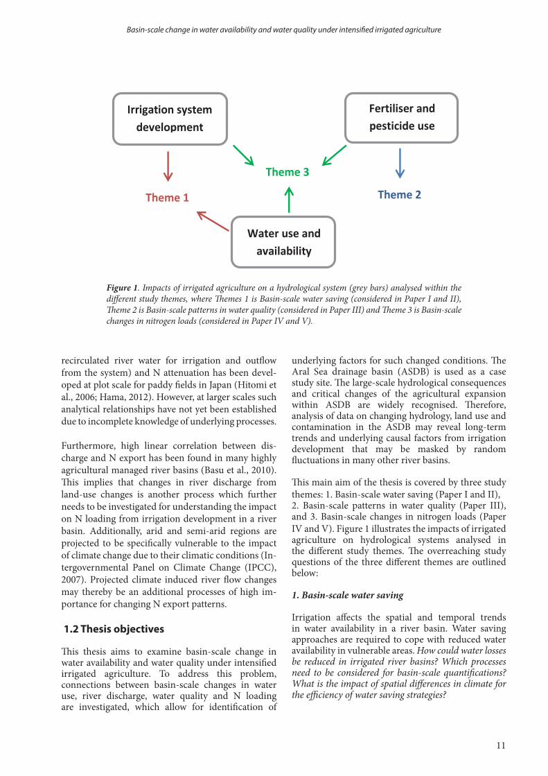
This main aim of the thesis is covered by three study themes: 1. Basin-scale water saving (Paper I and II), 2. Basin-scale patterns in water quality (Paper III), and 3. Basin-scale changes in nitrogen loads (Paper IV and V). Figure 1 illustrates the impacts of irrigated agriculture on hydrological systems analysed in the different study themes. The overreaching study questions of the three different themes are outlined below:
1. Basin-scale water saving
Irrigation affects the spatial and temporal trends in water availability in a river basin. Water saving approaches are required to cope with reduced water availability in vulnerable areas. How could water losses be reduced in irrigated river basins? Which processes need to be considered for basin-scale quantifications? What is the impact of spatial differences in climate for the efficiency of water saving strategies?
Basin-scale change in water availability and water quality under intensified irrigated agriculture
Fertiliser and pesticide use useCIDE USE
Irrigation system development
Water use and availability
Theme 2 Theme 1
Theme 3
Figure 1. Impacts of irrigated agriculture on a hydrological system (grey bars) analysed within the different study themes, where Themes 1 is Basin-scale water saving (considered in Paper I and II), Theme 2 is Basin-scale patterns in water quality (considered in Paper III) and Theme 3 is Basin-scale changes in nitrogen loads (considered in Paper IV and V).

your name
12
Rebecka Törnqvist
2. Basin-scale patterns in water quality
Excessive fertiliser and pesticide use in agricultural production systems together with other anthropogenic pollution can cause health risks related to deteriorated water quality. At the basin-scale level, which are the most hazardous contaminants from a human health perspective in the connected surface water and groundwater system? Which large-scale water quality patterns between groundwater and surface water, between upstream-downstream locations and between seasons or years can be identified?
3. Basin-scale changes in nitrogen loads
Increased N input and irrigation expansion together with climate induced discharge changes can impact the N export from irrigated agricultural river basins. How does intensified irrigated agriculture and climatic changes affect N concentration levels and N loading from a river basin? Which dominant processes behind changed N concentrations and loading can be found in irrigated river basins?
13
Thesis title
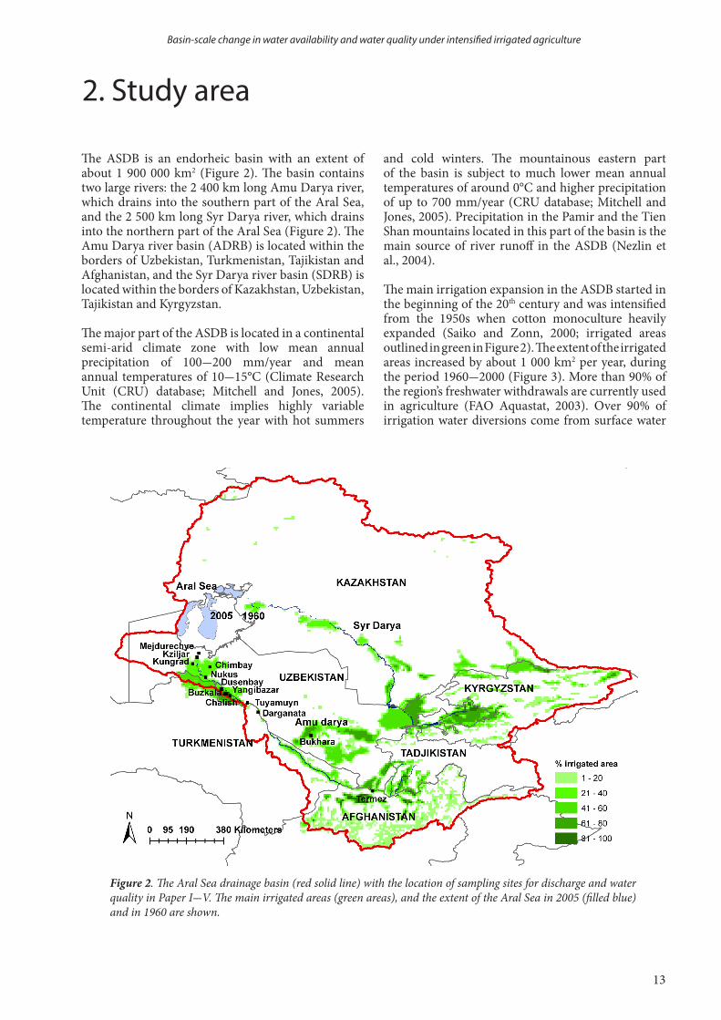
The ASDB is an endorheic basin with an extent of about 1 900 000 km2 (Figure 2). The basin contains two large rivers: the 2 400 km long Amu Darya river, which drains into the southern part of the Aral Sea, and the 2 500 km long Syr Darya river, which drains into the northern part of the Aral Sea (Figure 2). The Amu Darya river basin (ADRB) is located within the borders of Uzbekistan, Turkmenistan, Tajikistan and Afghanistan, and the Syr Darya river basin (SDRB) is located within the borders of Kazakhstan, Uzbekistan, Tajikistan and Kyrgyzstan.
The major part of the ASDB is located in a continental semi-arid climate zone with low mean annual precipitation of 100-200 mm/year and mean annual temperatures of 10-15°C (Climate Research Unit (CRU) database; Mitchell and Jones, 2005). The continental climate implies highly variable temperature throughout the year with hot summers
and cold winters. The mountainous eastern part of the basin is subject to much lower mean annual temperatures of around 0°C and higher precipitation of up to 700 mm/year (CRU database; Mitchell and Jones, 2005). Precipitation in the Pamir and the Tien Shan mountains located in this part of the basin is the main source of river runoff in the ASDB (Nezlin et al., 2004).
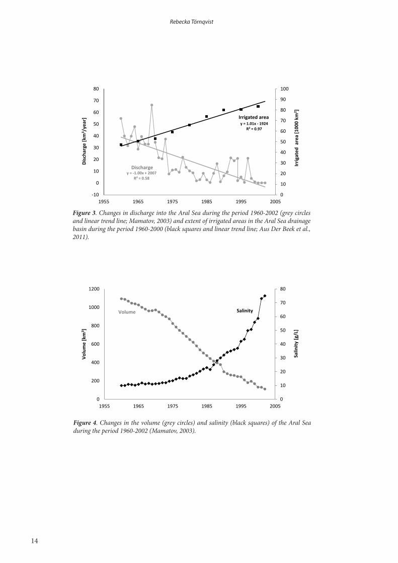
The main irrigation expansion in the ASDB started in the beginning of the 20th century and was intensified from the 1950s when cotton monoculture heavily expanded (Saiko and Zonn, 2000; irrigated areas outlined in green in Figure 2). The extent of the irrigated areas increased by about 1 000 km2 per year, during the period 1960-2000 (Figure 3). More than 90% of the region’s freshwater withdrawals are currently used in agriculture (FAO Aquastat, 2003). Over 90% of irrigation water diversions come from surface water
Figure 2. The Aral Sea drainage basin (red solid line) with the location of sampling sites for discharge and water quality in Paper I-V. The main irrigated areas (green areas), and the extent of the Aral Sea in 2005 (filled blue) and in 1960 are shown.
2. Study area
Basin-scale change in water availability and water quality under intensified irrigated agriculture
your name
14
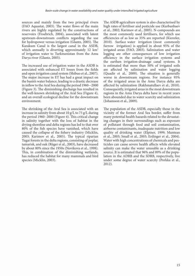
Figure 4. Changes in the volume (grey circles) and salinity (black squares) of the Aral Sea during the period 1960-2002 (Mamatov, 2003).
Rebecka Törnqvist
Figure 3. Changes in discharge into the Aral Sea during the period 1960-2002 (grey circles and linear trend line; Mamatov, 2003) and extent of irrigated areas in the Aral Sea drainage basin during the period 1960-2000 (black squares and linear trend line; Aus Der Beek et al., 2011).
y = -1.00x + 2007 R² = 0.58
y = 1.01x - 1924 R² = 0.97
0
10
20
30
40
50
60
70
80
90
100
-10
0
10
20
30
40
50
60
70
80
1955 1965 1975 1985 1995 2005
Irrig
ated
are
a [1
000
km2 ]
Disc
harg
e [k
m3 /
year
]
Discharge
Irrigated area
0
10
20
30
40
50
60
70
80
0
200
400
600
800
1000
1200
1955 1965 1975 1985 1995 2005
Salin
ity [g
/L]
Volu
me
[km
3 ]
Volume Salinity
15
Thesis title
The ASDB agriculture system is also characterised by high rates of fertiliser and pesticide use (Kurbanbaev et al., 2002; Karimov et al., 2005). N-compounds are the most commonly used fertilisers, for which use efficiencies of as low as 35% are reported (Kienzler, 2010). Surface water irrigation (most commonly furrow irrigation) is applied in about 95% of the irrigated areas (FAO, 2003). Salinization and water logging are other consequences of low irrigation efficiency in the surface irrigation systems and the earthen irrigation-drainage canal systems. It is estimated that more than 50% of irrigated soils are affected by salinization and water logging (Quadir et al., 2009). The situation is generally worse in downstream regions. For instance 95% of the irrigated areas in the Amu Darya delta are affected by salinization (Rakhmatullaev et al., 2010). Consequently, irrigated areas in the most downstream regions in the Amu Darya delta have in recent years been abounded due to water scarcity and salinization (Johansson et al., 2009).
The population of the ASDB, especially those in the vicinity of the former Aral Sea border, suffer from many potential health hazards related to the devastat-ing changes in their surroundings such as exposure of pollutant through food and soil contamination, airborne contaminants, inadequate nutrition and low quality of drinking water (Elpiner, 1999; Muntean et al., 2003; Small et al., 2003; Erdinger et al., 2004). Water with high concentrations of chemicals and pes-ticides can cause severe health affects while elevated salinity can make the water unusable as a drinking source. It is estimated that 96% and 89% of the popu-lation in the ADRB and the SDRB, respectively, live under some degree of water scarcity (Porkka et al., 2012).
sources and mainly from the two principal rivers (FAO Aquastat, 2003). The water flows of the main rivers are highly regulated by the constructions of reservoirs (Froebrich, 2004), associated with latent upstream-downstream conflicts regarding the use for hydropower versus irrigation (Glantz, 2005). The Karakum Canal is the largest canal in the ASDB, which annually is diverting approximately 12 km3
of irrigation water to Turkmenistan from the Amu Darya river (Glantz, 2005).
The increased use of irrigation water in the ASDB is associated with enhanced ET losses from the fields and open irrigation canal system (Shibuo et al., 2007). The major increase in ET has had a great impact on the basin’s water balance, leading to a drastic decrease in inflow to the Aral Sea during the period 1960-2000 (Figure 3). The diminishing discharge has resulted in the well-known shrinking of the Aral Sea (Figure 4), and an overall ecological decline for the downstream environment.
The shrinking of the Aral Sea is associated with an increase in salinity from about 10 g/L to 75 g/L during the period 1960−2000 (Figure 4). This critical change in salinity together with the loss of habitat in the drying shoreline and delta regions has led to that over 80% of the fish species have vanished, which have caused the collapse of the fishery industry (Micklin, 2003; Karimov et al., 2005). The typical riparian Tugai forests in the delta regions, consisting of poplar, tamarisk, and oak (Rüger et al., 2003), have decreased by about 80% since the 1950s (Novikova et al., 1998). This, in combination of the diminishing wetlands, has reduced the habitat for many mammals and bird species (Micklin, 2003).
Basin-scale change in water availability and water quality under intensified irrigated agriculture
your name
16
In this thesis, the combined use of synthesised data analyses and distributed hydrological modelling has enabled a comprehensive assessment for identifying basin-scale changes in hydrology, water quality and N loading processes under intensified irrigation. 3.1 Data synthesis and analysis
Studies of reported effectiveness of alternative irrigation techniques compared to furrow irrigation from the ASDB and study areas of similar climatic conditions as in the ASDB were compiled in Paper I. The synthesis comprised of study areas with different soil texture and climate and had the aim to investigate the variability in reported water use and yield changes from improved irrigation methods (Mateos et al., 1991; Kanber et al., 2001; Cetin and Bilgel, 2002; Ismail et al., 2004; Ismail, 2006; Rajak et al., 2006; Ibragimov et al., 2007; Horst et al., 2007; Ünlü et al., 2007). The impact of alternative irrigation techniques on both water use and crop yield was considered by investigating the resulting water use change if: i) the current area for cotton production was maintained or ii) the current yield of cotton was maintained by altering the area needed to produce it.
A data synthesis of reported water quality measurements from the ADRB was performed in Paper III, which comprised 24 monitoring stations and 11 contaminants (Kurbanbaev et al., 2002; Nasrulin and Zahidova, 2002; Crosa et al., 2006; Froebrich et al., 2006). Further statistical analyses were performed for river water quality data for four substances at four locations for five years. The in total 680 water quality data measurements were grouped into categories of (1) location, (2) location and year and (3) location and season. The in total 84 category pairs were tested for statistically significant differences in mean values by using Smith-Satterthwaite two sample two tail test for populations with unknown and unequal variances at a 95% confidence level.
In Paper V, temperature (T) and precipitation (P) from the CRU TS 2.1 database for 1961−1990, which was used as a reference period, were compared to projected changes in climate from 65 Global Circulation Model (GCM) projections from IPCC’s fourth assessment. The projected changes in T and P, i.e., ΔT and ΔP, for the near future (2025), the mid-century (2050) and the long distance future (2100) were extracted from two previous studies (Lioubimtseva and Henebry, 2009; Jarsjö et al., 2012). The total prediction envelope of ΔTi and ΔPj for different GCM projections were discretised to i × j
evenly spaced nodes where i and j was 1,……, 10 and 1,……., 8, respectively. The hydrological model was run i × j (i.e., 80) times yielding values of river flow resulting from different combination of ΔT and ΔP. The resulting river flow values for each node were interpolated to produce a continuous hydrological response map to visualise responses from climate changes. Ranges and ensemble average output were used to evaluate the uncertainties and trends in ΔT, ΔP and river flow from different GCM projections.
3.2 Sampling methods
Concentration measurements of 13 substances; nitrate (NO3
-), nitrite (NO2-), chromium (Cr), arsenic (As),
fluoride (F), copper (Cu), lead (Pb), cadmium (Cd), mercury (Hg), dichlorodiphenyltrichloroethane (DDT), dichlorodiphenyldichloroethane (DDD), dichlorodiphenyldichloroethylene (DDE) and lindane (γ-HCH), were conducted in the downstream Mejdurechye reservoir in the ADRB (see location in Figure 2) during four campaigns in 2007 and 2008. At each measurement occasion, two samples were taken at three different locations in the reservoir. Detailed information on the reservoir, sampling procedures, analysis methods, instruments and detection limits are provided in the Supplementary Information to Paper III. 3.3 Quantification methods and models
3.3.1 GIS based basin-scale hydrological modelling
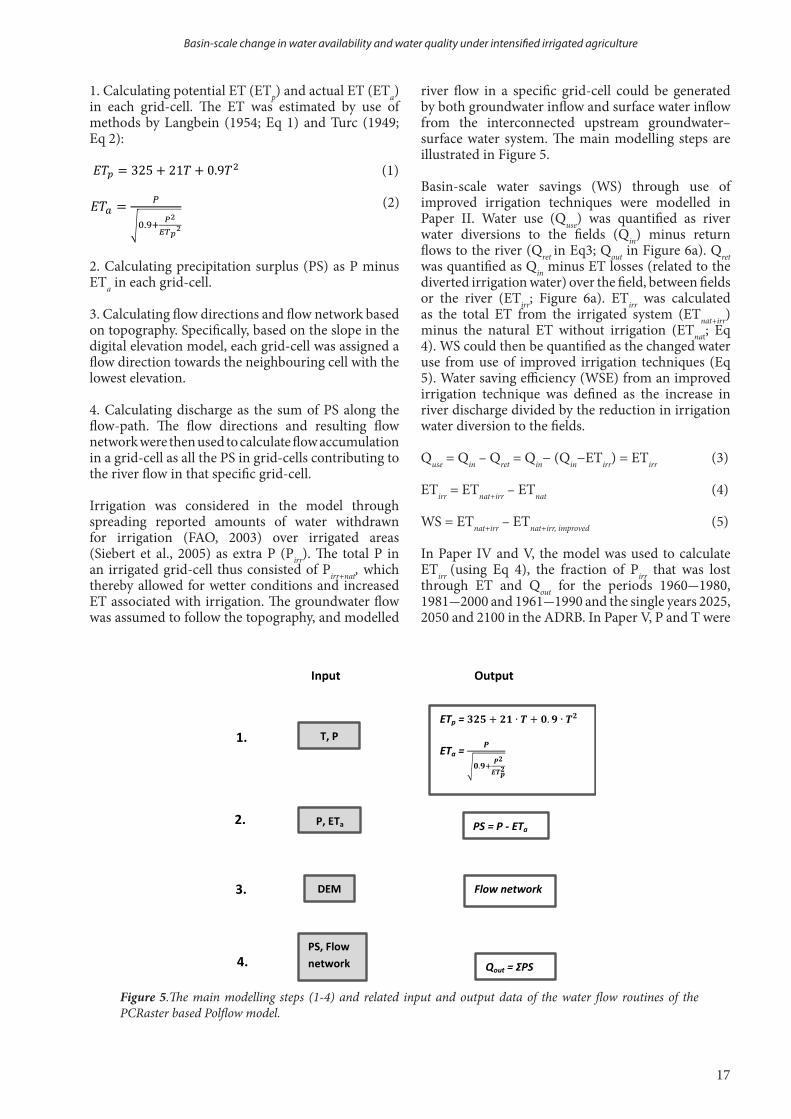
Distributed hydrological modelling was performed in Paper II, IV and V by application of the water flow routines of the PCRaster based Polflow model (De Wit, 2001) to the ASDB. The model has previously been used for hydro-climatic modelling in the ASDB (Shibuo et al., 2007; Jarsjö et al., 2012), and in other irrigated basins (Asokan et al., 2010) and non-irrigated basins (Darracq et al., 2005; Jarsjö et al., 2008). The model is based on a water balance approach for river discharge, Q = P – ET − ΔS, where ΔS is the water storage change. ΔS is assumed to be small on the considered decadal scales. The main input data to the model were P and T data (CRU TS 2.1 database; Mitchell and Jones, 2005), digital elevation data (SRTM; Farr et al., 2007), and land use data (Global map of irrigated areas; Siebert et al., 2005). The area of the ASDB region covered 3000 × 3000 grid cells and the spatial resolution of the data was 0.5°.
The basic steps of the modelling can be summarised as:
3. Materials and methods
Rebecka Törnqvist
17
Thesis title
1. Calculating potential ET (ETp) and actual ET (ETa) in each grid-cell. The ET was estimated by use of methods by Langbein (1954; Eq 1) and Turc (1949; Eq 2):
(1) (2)
2. Calculating precipitation surplus (PS) as P minus ETa in each grid-cell.
3. Calculating flow directions and flow network based on topography. Specifically, based on the slope in the digital elevation model, each grid-cell was assigned a flow direction towards the neighbouring cell with the lowest elevation.
4. Calculating discharge as the sum of PS along the flow-path. The flow directions and resulting flow network were then used to calculate flow accumulation in a grid-cell as all the PS in grid-cells contributing to the river flow in that specific grid-cell.
Irrigation was considered in the model through spreading reported amounts of water withdrawn for irrigation (FAO, 2003) over irrigated areas (Siebert et al., 2005) as extra P (Pirr). The total P in an irrigated grid-cell thus consisted of Pirr+nat, which thereby allowed for wetter conditions and increased ET associated with irrigation. The groundwater flow was assumed to follow the topography, and modelled
river flow in a specific grid-cell could be generated by both groundwater inflow and surface water inflow from the interconnected upstream groundwater–surface water system. The main modelling steps are illustrated in Figure 5.
Basin-scale water savings (WS) through use of improved irrigation techniques were modelled in Paper II. Water use (Quse) was quantified as river water diversions to the fields (Qin) minus return flows to the river (Qret in Eq3; Qout in Figure 6a). Qret was quantified as Qin minus ET losses (related to the diverted irrigation water) over the field, between fields or the river (ETirr; Figure 6a). ETirr was calculated as the total ET from the irrigated system (ETnat+irr) minus the natural ET without irrigation (ETnat; Eq 4). WS could then be quantified as the changed water use from use of improved irrigation techniques (Eq 5). Water saving efficiency (WSE) from an improved irrigation technique was defined as the increase in river discharge divided by the reduction in irrigation water diversion to the fields.
Quse = Qin – Qret = Qin− (Qin−ETirr) = ETirr (3)
ETirr = ETnat+irr – ETnat (4)
WS = ETnat+irr – ETnat+irr, improved (5)
In Paper IV and V, the model was used to calculate ETirr (using Eq 4), the fraction of Pirr that was lost through ET and Qout for the periods 1960-1980, 1981-2000 and 1961-1990 and the single years 2025, 2050 and 2100 in the ADRB. In Paper V, P and T were
Basin-scale change in water availability and water quality under intensified irrigated agriculture
Figure 5.The main modelling steps (1-4) and related input and output data of the water flow routines of the PCRaster based Polflow model.
Input Output
T, P ETp =
ETa =
√
P, ETa PS = P - ETa
DEM Flow network
PS, Flow network Qout = ΣPS
1.
2.
3.
4.
√

your name
18
altered according to the projected change between the reference period 1961-1990 and the considered future periods (see section 3.1).
3.3.2 Health risk screening
In Paper III, hazard factors (HFs) were used to express health risk and to facilitate comparisons between pollution levels of substances. HFs were calculated by dividing measured concentrations with a substance-specific drinking water guideline concentration which can be considered to be related to low risk for adverse health effects (World Health Organisation (WHO), 2006). A HF above one thus indicates a potential health risk. Cumulative health factors (CHFs) were calculated as the sum of HFs for the mixture of contaminants. CHFs can be used as an additive estimate of the aggregated toxicity of a contaminant mixture when more detailed data on synergies are absent (US EPA, 1989; WHO, 2006). Guideline values from WHO (2006) were used to calculate HFs and CHFs.
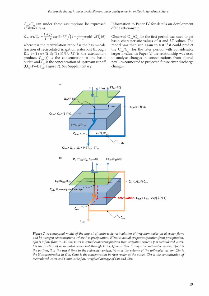
3.3.3 Nitrogen attenuation and irrigation water recirculation relationship
In Paper IV, a relationship between outflow-inflow N concentration ratio (Cout/Cin) and recirculation ratio (r) of irrigation water was developed, where r was defined as the recirculated irrigation water from the river in the basin (Qr=Pirr) divided by the outflow from the basin (Qout). A certain fraction (f) of Qr was assumed to be lost through ET over the irrigated fields, expressed as ETirr/Qr (Figure 7a). Figure 7b shows a conceptual model of how N concentrations change along the hydrological flow-paths in an irrigated river basin assuming a first order N degradation expressed as exp[-λT], where λ is the attenuation rate and T is the advective travel time. λT is denoted the attenuation product. The attenuation can be considered to occur in the connected surface water, groundwater and soil water system. The attenuation rate λ was further assumed to change as function of r where λ(r) = λ(1 + αr) and α is a constant that allows for different conditions of the significance of r on the attenuation effect.
Rebecka Törnqvist
Figure 6. a) Water use in an on-farm perspective, and a basin scale perspective, and b) basin-scale reduction in water application (outtake), and c) corresponding water savings, by changing the current cotton irrigation practice of continuous furrow irrigation to drip irrigation (Drip), alternate furrow irrigation (Alt), surge flow irrigation (Surge) and alternate surge flow irrigation (Alt surge), under a constant area scenario (1) and a constant production scenario (2).
Return flow, Qout =Qin - ETirr
ETirr ETirr
Diversion of irrigation water, Qin
b) Basin scale water use
River flow
a) On-farm water use
River flow
Diversion of irrigation water, Qin
Return flow, Qout =Qin - ETirr
ETirr ETirr
Diversion of irrigation water, Qin
b) Basin scale water use
River flow
a) On-farm water use
River flow
Diversion of irrigation water, Qin
0
2
4
6
8
10
12
14
Drip Alt Alt surge Surge
Wat
er sa
ving
s [k
m3 /
y]
Alternative irrigation techniques
Scenario 1
Scenario 2
c)
0
2
4
6
8
10
12
14
Drip Alt Alt surge Surge
Redu
ctio
n in
wat
er a
pplic
atio
n [k
m3 /
y]
Alternative irrigation techniques
Scenario 1
Scenario 2
b)
a)
19
Thesis title
Cout/Cin can under these assumptions be expressed analytically as:
(6)
where r is the recirculation ratio, f is the basin-scale fraction of recirculated irrigation water lost through ET, β=(1+αr)∙((f-1)r/(1+fr)-1)-1, λT is the attenuation product, Cout(r) is the concentration at the basin outlet, and Cin is the concentration of upstream runoff (Qin=P-ETnat; Figure 7). See Supplementary
Basin-scale change in water availability and water quality under intensified irrigated agriculture
Figure 7. A conceptual model of the impact of basin-scale recirculation of irrigation water on a) water flows and b) nitrogen concentrations, where P is precipitation, ETnat is actual evapotranspiration from precipitation, Qin is inflow from P -ETnat, ETirr is actual evapotranspiration from irrigation water, Qr is recirculated water, f is the fraction of recirculated water lost through ETirr, Qs-w is flow through the soil-water system, Qout is the outflow, T is the travel time in the soil-water system, Vs-w is the volume of the soil-water system, Cin is the N concentration in Qin, Cout is the concentration in river water at the outlet, Cirr is the concentration of recirculated water and Cmix is the flow-weighted average of Cin and Cirr.
P ETnat ETirr=f∙Qr
Qin=P-ETnat
Qs-w= Qin+(1-f)∙Qr
r= Qr/Qout
Qs-w
Qout= Qs-w- Qr = P-ETnat -ETirr
Qr
Qirr=(1-f)∙Qr
T=Vs-w/Qs-w
a)
P, ETnat (Cp, CET ≈0)
Cin=Nappl/Qin
Attenuation: Cout = Cmix exp[-λ(r) T]
Cout
Cout
Cout
Cirr=1/(1-f)∙Cout
b) ETirr (CET≈0)
Cmix: flow-weighted average
Information to Paper IV for details on development of the relationship.
Observed Cout/Cin for the first period was used to get basin characteristic values of α and λT values. The model was then run again to test if it could predict the Cout/Cin for the later period with considerable larger r-value. In Paper V, the relationship was used to analyse changes in concentrations from altered r-values connected to projected future river discharge changes.
⁄ [ ] (
[ ])⁄
your name
20
4.1 Paper I and II - Basin-scale water saving
In Paper I, potential reductions in irrigation water use on the cotton production fields in the ASDB through use of alternative irrigation techniques instead of the relatively inefficient traditional furrow irrigation were quantified. Two irrigation development scenarios were considered: (1) a constant-area scenario, where the current area for cotton production was maintained, and (2) a constant-production scenario, where the current yield of cotton was maintained by changing the area of cotton production. Results showed that alternative irrigation methods can allow for irrigation water outtake reductions of 10-40% on cotton fields in the ASDB (Figure 6b). The results from field studies conducted in the ADSB (Horst et al., 2007; Ibragimov et al., 2007) were comparable to results from study areas of similar climate.
The magnitude of reductions in irrigation water outtake to the fields depends on the irrigation method used and whether yield changes were considered or not (Scenario 1 and 2, respectively, in Figure 6b). For the constant-area scenario, surge flow on alternate furrows irrigation technique was shown to reduce water use the most, whereas for the constant-production scenario, drip irrigation was most efficient in reducing water use. This could be explained by the fact that all alternative techniques were associated with lower yields than traditional furrow irrigation in the ASDB field studies, except for drip irrigation. A lower yield per area thus requires an extended irrigated area, for which more water is needed to keep the production constant.
Paper II further explored possible basin-scale water savings from the irrigation water outtake reductions quantified in Paper I, by use of distributed hydrological modelling. The basin-scale net river water savings were between 1 and 6 km3/year depending on irrigation method and land use scenario (Figure 6c), which were about 60% lower than the reductions in water outtake to the fields (Figure 6b). This discrepancy could be explained by the presence of return flows of excessive irrigation water back to the river, which means that reduced irrigation water diversions are not directly shown as increased river flow. Return flows would also decrease along with decreasing water diversions to the fields. Therefore, the net water saving, which would result in increasing river discharge at the basin outlet is lower than the reduction in river water diversions.
The impact of regionally climatic differences on
potential water savings was further assessed. In specific, WSE investigations were performed to identify regions of the ASDB where changes in irrigation methods would lead to the largest increases in discharge. The irrigated areas in the ASDB were divided into seven different regions, which had WSE ranging between 0.2 and 0.8 (Table 1). Results showed that implementation of improved irrigation methods in cotton fields in the downstream regions (with WSE equalling 0.8; Table 1) would be four times as efficient as in the wetter and colder upstream regions (with WSE equalling 0.2; Table 1). The Amu Darya delta had the highest WSE due to its dry climate related to large non-reusable water losses through ET and small return flows.
4.2 Paper III - Basin-scale patterns in water quality
Paper III had the aim to identify the most hazardous contaminants from a human health perspective in the ADRB. Data from downstream reservoir water quality measurements were analysed together with synthesised reported upstream water quality data to investigate temporal and seasonal trends, trends along hydrological pathways and differences between main components of the hydrological systems (river water, reservoir water and groundwater). Results from the sampling campaigns in the downstream Mejdurechye reservoir showed NO2
- and Cd concentrations occasionally above health based guideline values.
Rebecka Törnqvist
Table 1. Climate characteristics and water saving efficiencies (WSE) of the seven irrigation regions considered in the spatial analysis of water saving quantifications.
RegionMean tem-
perature [°C]
Meanprecipita-
tion[mm]
WSE
ADRB1. Downstream 13 106 0.782. Middle reach 15 225 0.353. Upstream 14 400 0.27SDRB4. Downstream 10 159 - *5. Middle reach - 1 14 373 0.416. Middle reach - 2 9 413 0.227. Upstream 4 364 0.17
* No reported cotton production in the region
4. Results

21
Thesis titleBasin-scale change in water availability and water quality under intensified irrigated agriculture
Figure 8. Mean hazard factors (HFs) in a) drainage water and river water for nitrite and nitrate, b) groundwater, reservoir and river water for fluoride, arsenic, mercury and copper, and c) groundwater, reservoir and river water for cadmium, chromium, manganese, nickel and lead. Values below the horisontal solid lines indicate samples with concentrations below the detection limits (DL) and thereby of low HFs. Locations are categorised according to upstream to downstream mean surface waters and groundwater flows, i.e., from left to right in the figure. Abbreviations: Res. THC = Tuyamuyn Hydrological Complex Reservoir, Res. Mejdu. = Mejdurechye Reservoir. See Figure 2 for sample site location.
a)
0.000001
0.00001
0.0001
0.001
0.01
0.1
1
10
100
1000
Buk
hara
(200
3)
Nuk
us(1
999-
2000
)
Kun
grad
(199
9-20
00)
Term
ez(1
998-
2002
)
Dar
gana
ta(2
003)
Res
.TH
C in
(200
3)
Res
.TH
C o
ut(2
003)
Tuya
muy
n(1
998-
2002
)
Nuk
us(1
998-
2002
)
Kzi
ljar
(199
8-20
02)
Res
.Mej
du.1
(200
7-20
08)
Res
.Mej
du.2
(200
7-20
08)
Res
.Mej
du.3
(200
7-20
08)
Drainage water River water and reservoir water
HF
Nitrate
Nitrite(long)Nitrite(short)
<DL
b)
0.000001
0.00001
0.0001
0.001
0.01
0.1
1
10
100
1000
Cha
lish
(200
2-20
04)
Yan
giba
zar
(200
2-20
04)
Buz
kala
(200
2-20
04)
Dus
enba
y(2
002-
2004
)
Term
ez(1
998-
2002
)
Dar
gana
ta(2
003)
Res
.TH
C in
(200
3)
Res
.TH
C o
ut(2
003)
Tuya
muy
n(1
998-
2002
)
Nuk
us(1
998-
2002
)
Kzi
ljar
(199
8-20
02)
Res
.Mej
du.1
(200
7-20
08)
Res
.Mej
du.2
(200
7-20
08)
Res
.Mej
du.3
(200
7-20
08)
Groundwater River water and reservoir water
HF
F-AsHgCu
<DL
c)
0.00001
0.0001
0.001
0.01
0.1
1
10
100
1000
Cha
lish
(200
2-20
04)
Yan
giba
zar
(200
2-20
04)
Buz
kala
(200
2-20
04)
Dus
enba
y(2
002-
2004
)
Term
ez(1
998-
2002
)
Dar
gana
ta(2
003)
Res
.TH
C in
(200
3)
Res
.TH
C o
ut(2
003)
Tuya
muy
n(1
998-
2002
)
Nuk
us(1
998-
2002
)
Kzi
ljar
(199
8-20
02)
Res
.Mej
du.1
(200
7-20
08)
Res
.Mej
du.2
(200
7-20
08)
Res
.Mej
du.3
(200
7-20
08)
Groundwater River water and reservoir water
HF
CdCrMnNiPb
< DL

your name
22
High concentrations of Cu, NO2-, F, As and Cd
contributed to CHFs above one, i.e., indicating health risk from the contaminant mixture observed in the reservoir water, for three of the four measurement campaigns. Trend analysis of substances contributing to high CHFs in Mejdurechye were performed in four stations along Amu Darya River (Figure 2; Termez, Tuyamuyn, Nukus and Kziljar). The analysis showed primarily seasonal variability in Cu concentrations, primarily spatial variability in As concentrations, and primarily temporal variability in F. For NO2
- both seasonal and spatial variability was identified.
Figure 8 shows comparisons between mean HFs for groundwater, drainage water, river water and reservoir water in the ADRB. The measurement stations are ordered considering surface water and groundwater flow directions, from upstream stations to downstream stations. HFs exceeding one were found for Cr, Pb, Mn and Ni in Tuyamuyn reservoir water and upstream stations, with lower values downstream. Reported groundwater quality data were only available for Cu, Cr and Pb. Cu HFs were two orders of magnitude higher in groundwater than in river water, and Cr and Pb stand out with HFs up to 280 and 65, respectively. Overall, surface water was related to much lower HFs than groundwater. Adverse health effects related to contaminants found at HFs above one in surface water and groundwater have been frequently observed in the population of the region. It is therefore plausible that untreated drinking water is a source of these contaminants for the population.
4.3 Paper IV and V - Basin-scale changes innitrogen loads
In Paper IV, long-term changes in dissolved inorganic nitrogen (DIN) concentrations and loads at the outlet of the ADRB were investigated. Decreasing riverine DIN concentrations were observed near the Aral Sea outlet during the considered period 1960-2000 (linear decreasing trend; Figure 9a). The later 20-year period (1981-2000) showed half the mean concentration of the observations during the earlier 20-year period (1960-1980). The full considered period 1960−2000 was characterised by increased N fertiliser application and net N input (NNI; N fertiliser application minus N crop uptake) due to changed crop patterns and yields (Table 2), which could not explain decreased N concentrations. The reduction in concentrations could not be explained by improved fertilisation application or irrigation efficiency either. Instead, the decrease in concentrations was identified to mainly be caused by a considerable increase in the irrigation-drainage-reservoir system and recirculation of irrigation water, causing increased N attenuation-retention. An analytical relationship between increased ratio of irrigation water diversions
Figure 9. Temporal trend in a) annual mean dissolved inorganic nitrogen (DIN) concentration (linear trend) and b) annual DIN load (exponential trend), c) linear correlation between annual DIN load and annual mean discharge, near the Amu Darya River Basin outlet for the period 1960-2000, and d) five year averages of the ratio of N fertiliser application and DIN load and the recirculation ratio (r) in the Amu Darya river basin for the period 1960-2000.
R² = 0.45
0
0,5
1
1,5
2
2,5
1955 1965 1975 1985 1995 2005
DIN
con
cent
ratio
n [m
g/L]
R² = 0.50
0
20000
40000
60000
80000
100000
120000
140000
1955 1965 1975 1985 1995 2005
DIN
load
[ton
/yea
r]
R² = 0.81
0
20
40
60
80
100
120
140
0 20 40 60 80
DIN
load
[100
0 to
n/ye
ar]
Discharge [km3/year]
c)
R² = 0.90
0
20
40
60
80
100
120
0 1 2 3 4 5 6 7 8 9 10
N fe
rt a
ppl/
N lo
ad
Recirculation ratio, r
a)
b)
d)
Rebecka Törnqvist

23
Thesis title
and river discharge (r) and decreased Cout/Cin ratio was developed (see section 3.3.3), and shown to match observations for both 20-year periods with significantly different r-values (Table 2).
An observed six-fold decrease in DIN loads between the periods 1960-1980 and 1981-2000 was a combined result of drastic river flow reduction and decreased DIN concentrations at the basin outlet (exponential decreasing trend; Figure 9b). However, the high linear correlation (R2 = 0.8; Figure 9c) between DIN load and discharge suggest that changed river flow is the key factor for DIN export from the basin. High linear correlation (R2 = 0.9) was found between the ratio of N fertiliser application and DIN load, and r (Figure 9d), which is in agreement with the modelling result of a strong relationship between basin-scale r and N attenuation.
In Paper V, the findings from Paper IV were used to further explore how projected future climate change additionally could change hydrological conditions and N attenuation in the ADRB. Results showed that temperatures are projected to increase between 1 and 2°C in 2025 and between 3 and 5°C in 2100, compared to the reference period 1961−1990. However, projected precipitation changes (ΔP) were inconclusive, since individual GCM projection results showed both increased and decreased precipitation for all the considered time frames. Ensemble means of multiple GCMs future climate projections; however, showed increased ΔP for all the considered time periods, with a ΔP of 5 mm/year for the near future (year 2025; Table 3) and a ΔP of 13 mm/year for the more distant future (year 2100; Table 3). Due to the large uncertainty in future ΔP the modelled discharge based on projected future climate was consequently also uncertain. Based on the ensemble mean ΔP and ΔT; though, the discharge is expected to be reduced by 3 km3/year in the near future and is at risk of being lost entirely in the more distant future (Table 3).
The results further indicated that r-values will increase with projected decreased discharge. For instance, the projected hydrological conditions based on the ensemble mean for 2050, with a decrease in discharge with 4 km3/year (Table 3), would yield an r-value of 17, i.e., a three times as large value as for the present conditions. A larger r-value would lead to increased N attenuation. In 2050, the Cout could be expected to be one order of magnitude lower than for the period 1981−2000, assuming a constant irrigation water diversions and N fertiliser input. Consequently, the N export could be expected to decrease even more in the future due to changed climate induced hydrological conditions which would lead to increased r and N attenuation.
Table 2. Development of N fertiliser application, net N input (N fertiliser application minus N crop uptake), irrigation water withdrawal and recirculation ratio between the periods 1960 − 1980 and 1981 −2000.
1960 −1980 1981−2000N fertiliser application
[ton/year]282 500 412 000
Net N input [ton/year]* 22 500 84 000
Irrigation water withdrawal [km3/year]
41 51
Irrigation water withdrawal
[m3/ha]
18 000 16 500
Recirculation ratio (r) 1.4 5.7
* Only for the Uzbek part of the ADRB
ΔT [°C]
ΔP [mm]
ΔQ [km3/year]
2025 + 1.4 +4.9 −32050 +2.2 +4.0 −42100 +4.0 +13.3 −8
Table 3. Ensemble means of multiple GCM projections of future temperature (T) and precipitation (P) change, and modelled future discharge compared to the reference period 1961−1990 in the Amu Darya Drainage Basin.
Basin-scale change in water availability and water quality under intensified irrigated agriculture
your name
24
5.1 Impact of reuse of irrigation water on water saving potentials
Results from the hydrological modelling of basin-scale water savings in Paper II show that net river water savings from changed irrigation methods were about 60% lower than the corresponding reductions in basin-scale irrigation water outtake to the fields (Figure 6b and c). Water savings would equal the reductions in water outtake if the impact of return-flows was neglected (Figure 6a). With the presence of return flows; however, reduced irrigation water outtake are not directly shown as increased river flow, since a certain amount of water is reused. Water savings that lead to increased river flow are then achieved by decreasing water losses that cannot be reused, for example water losses to the atmosphere over the irrigated fields. How water use is defined is therefore of great importance for quantifying basin-scale water savings (Figure 6a). This also demon-strates the importance of reuse of irrigation water for the hydrology of ASDB, like in many water scare regions with inefficient and extensive irrigation-drainage systems (Quadir et al., 2007).
The modelled basin-scale increase in river discharge from water saving measures on the cotton fields in ASDB was in the order of 1 to 6 km3/year (Figure 6c). Such increased discharge could help to prevent small lakes and reservoirs (e.g., the Mejdurechye reservoir studied in detail in Paper III) in the Amu Darya delta to dry up and contribute to the recover-ing ecosystem of the northern part of the Aral Sea. For instance, fishery has once again become im-portant for local livelihood after restoration efforts of lakes and reservoirs in the northern Amu Darya delta (Schlüter et al., 2009). Diversified income opportunities from fishery in addition to irrigated agriculture can enhance the overall resilience with regard to variability in water availability (Schlüter et al., 2009).
Regional differences in WSE due to climatic factors were identified in the ASDB. Reductions in water outtake to the fields will more directly be shown in increased river flow in dry regions of the basin, which are related to large losses of water through ET that allow for a large potential for water sav-ings (expressed as high WSE; Table 1). The present results thus suggest that implementation of improved irrigation techniques in dry regions would be most efficient in terms of yielding the largest water savings from a certain degree of reduction in irrigation water diversions to the cotton fields. On the other hand, in
regions with low water availability, reuse of irriga-tion water may be an important additional water resource for parts of the population. One can thus argue that the implementation of improved irriga-tion techniques for instance in the dry Amu Darya delta would lead to decreasing water resources for the parts of the population which are dependent on drainage water for irrigation (Olsson et al., 2013). However, for performing sustainable recommenda-tions and planning for where in the basin to imple-ment water saving measures, more aspects such as water quality of return flows, the dependency or unwillingness of the local population to use return flows for irrigation, cost of measures, and other socio-economic factors need to be considered (Törn-qvist et al., 2008).
In other studies, potential water savings at large scales in different parts of the ASDB have been mod-elled (Cai et al., 2003; Yakubov and Manthrithilake, 2009). The impact on discharge from changed crop patterns and increased irrigation efficiency was stud-ied for the SDRB using a node-link network model by Cai et al. (2003). Results showed that the inflow to the Aral Sea was estimated to double if the area of cotton-forage production was decreased by one-third in favour for maize-wheat production, and that a 20% increase in irrigation efficiency would occur (Cai et al., 2003). Module based simulation model-ling of crop production, water demand and water supply in Uzbekistan showed that a future scenario of a 10% increased water use efficiency would lead to an increase in the Aral Sea inflow of 2 km3/year (Yakubov and Manthrithilake, 2009). This would correspond to a WSE of about 0.33, when consider-ing the change in basin-scale irrigation water diver-sions and increased discharge, which is in the same magnitude as the result in Paper II with a mean WSE of 0.4 in the cotton production areas of ASDB. Addi-tionally, also regional WSE estimations for the Amu Darya delta were in agreement with results from basin-scale water savings from improved irrigation methods in regions with similar dry climatic condi-tions, such as the Zayandeh-Rud basin in central Iran (Nikouei et al., 2012). The corresponding WSE in the Zayandeh-Rud basin was 0.75 which is similar to the WSE in the Amu Darya delta of 0.78 (Table 1).
The results from Paper I and II demonstrate that to choose an alternative irrigation technique that not only reduces the water use but also increases the water productivity is favourable if a certain crop production should be maintained when the pos-sibility to expand irrigated areas are limited due to
5. Discussion
Rebecka Törnqvist

25
Thesis title
salinization and water scarcity. Drip irrigation is an irrigation method which has been reported to give higher yields and increased water productiv-ity compared to traditional furrow irrigation in arid and semi-arid regions (Cetin and Bilgel, 2002; Rajak et al., 2006; Ibragimov et al., 2007). However, this irrigation technique is more expensive to implement and maintain than the instead more labour-intense traditional surface irrigation methods (Lioubimtseva and Henebry, 2009). Another promising water sav-ing approach is the use of conservation agriculture techniques which aim at conserving soil moisture and soil organic matter by low soil-disturbance and soil covering with mulch and crop residues (Stagnari et al., 2009). A synthesis of studies of conservation agriculture techniques for different agricultural production systems in ASDB showed that especially raised beds, i.e., no tillage applied, and mulching of crop residues could increase water use efficiency and yield for cotton and winter wheat in irrigated regions (Kienzler et al., 2012). Other strategies for water savings and increased water productivity could be to change from water demanding crops, such as cotton, to less water demanding crops such as wheat and maize, as demonstrated in model results above from Cai et al. (2003).
A distributed hydrological model was used to quan-tify basin-scale water savings. The model is based on a general water balance approach that allows for calibration of the difficult to measure and estimate ET when distributed climate data and discharge observations are available. In this case the mod-elled ET corresponded well (4% difference) with ET derived from the water balance closure, even though ET equations which require small amount of input information and do not consider seasonality were used. Additionally, the Langbein method employed here has previously been compared with the Thorn-thwaite method (Thorntwaite, 1948), which consid-ers seasonality, for ET computation in the ASDB (Shibuo et al., 2007; Jarsjö et al., 2012). The com-parison showed that the ET and resulting discharge from the two methods only differed with less than 5% both for historic and future conditions (Jarsjö et al., 2012). The use of global data sets such as CRU climate data (Mitchell and Jones, 2005) can be asso-ciated with additional uncertainties. For instance, er-rors in P would lead to errors in ET estimations from the water balance closure approach. From a com-prehensive water balance assessment of more than 50 Australian catchments (Australian Government National Water Commission, 2007), an average error term of 14% of the total inflows was estimated to be associated to such water balance approaches as used in this thesis (Asokan et al., 2010). For comparison, even with the use of ET methods which considers more parameters, for example the Penman-Monteith method (Monteith, 1981). ET errors of up to 50%
could be attained if no calibration to observed dis-charge is performed (Kite and Droogers, 2000).
Despite potential uncertainties in model results derived from input data or model assumptions, the results were in agreement with other water saving quantifications from ASDB (Yakubov and Man-thrithilake, 2009; Cai et al., 2003) and basins of similar climatic conditions (Nikouei et al., 2012). This implies that the distributed model used in this thesis, which mainly requires easily available topol-ogy and climate data as input, can yield results with accuracy comparable to hydrological module based models. These; however, require large amounts of site specific data, e.g., for drainage and irrigation canal efficiencies in order to account for effects of return flows. The distributed modelling approach used in this thesis is therefore promising to use for water saving quantifications, especially in regions with low availability of data.
5.2 Impact of decreased surface water availabil-ity on health risks and transport pathways
Results from the ADRB synthesis of water quality studies and water quality data sampling in Paper III, showed varying pollution levels between sea-sons, locations and water systems. In particular, the results show that surface waters in the ADRB occasionally were subject to health hazards. How-ever, groundwater was overall related to much higher HFs than surface waters (Figure 8). Consistent with these findings of overall higher pollution levels in groundwater than surface water, average groundwa-ter salinity (Johansson et al., 2009) was observed to be double the levels compared to river water salinity in the upper Amu Darya delta (Crosa et al., 2006). Additionally, many of the substances with relatively high HFs in ADRB surface waters (As, F, NO3
−, and Cd) had much higher HFs in groundwater (of up to 5) than in river water in the SDRB (below 0.6; Chiba et al., 2006; Bosch et al., 2007). Groundwater has also been observed to be highly polluted by in particular salt and N from agricultural activities in many other irrigated arid and semi-arid regions (Böhlke, 2002; Oren et al., 2004; Jalali, 2005; Fetouani et al., 2008). For instance, 75% of groundwater NO3
− concentra-tion observations were exceeding the WHO drinking water guideline values in the irrigated plain of Triffa in Morocco (Fetouani et al., 2008), and groundwater NO3
− concentrations up to eight times the WHO drinking water guideline values were observed in the irrigated Arava valley in Israel (Oren et al., 2004).
Severe droughts in the ADRB in 2000 and 2001 led to recommendations from the Uzbek government to construct 2 600 new shallow wells and to repair old malfunctioning wells for irrigation water and drink-ing water purposes (Rakhmatullaev et al., 2010).
Basin-scale change in water availability and water quality under intensified irrigated agriculture
your name
26
At the same time, it has been reported that shallow wells used for drinking water have been abandoned due to highly salinized groundwater (Rakhmatul-laev et al., 2010). The drinking water situation in the downstream ADRB is consequently extremely vulnerable in dry years. The expected intensification of the surface water scarcity, as projected in Paper V, may require a further shift from surface water to groundwater as the main drinking water source. The present results from the health risk screening imply that this could impair the quality of untreated drink-ing water even more. It is therefore recommended to perform groundwater quality assessments of more substances related to high HF contaminants identi-fied in Paper III and at more locations to get a more complete picture of the groundwater health risk.
In the downstream regions of the ADRB, irrigated areas are abandoned along with water scarcity and salinization (Johansson et al., 2009). Hydrologic distributed modelling in accordance to Persson et al. (2011) of transport pathways and mean groundwa-ter travel times to surface water under diminishing surface water availability in the Amu Darya delta was performed. The aim of the investigation was to illustrate the impact on groundwater travel time from profoundly changed surface water availability and transportation pathways from the time of a full functioning irrigation system around 1980 compared to the present state and future conditions in response to projected hydro-climatic trends. The estimates of groundwater travel times were based on mean values of hydraulic conductivity and effective porosity for the whole Amu Darya delta (Shibuo et al., 2006). Refined analysis of local heterogeneities would be needed for more exact absolute values.
The groundwater travel times to surface water were relatively short in the full functioning irrigation-reservoir system (red in Figure 10a). Large exchange between surface water and groundwater was thus present in the delta as a result of fine-branched canal systems. The current drying of small canals in the most downstream part of the delta implies that travel times from some locations within the delta have increased to a year or more (yellow and green in Figure 10b), which implies an increasing importance of groundwater contaminant transport. The expected continued drying of surface water in the near future would lead to irrigated areas mainly being present close to the river and main canals. In parts of the delta formerly supplied by water from smaller canals, groundwater would be the main transport pathway and patches of higher travel times would appear throughout the delta (Figure 10c). In accordance to projections of extreme dry future conditions, the groundwater may be the only water resource and transport pathway available. If the rest of the surface water resources dry out within the delta, the aver-
age travel times to the former Aral Sea border will increase by an order of magnitude in comparison with the situation in the 1980s (Figure 10d). Over-all, this modelling illustration shows that reduced surface water availability would mean that ground-water would be the main water system for transport-ing contaminants, and would to a larger extent be governing the total travel time in the delta.
5.3 Impact of development of irrigation systems on nitrogen attenuation and export
The results in Paper IV showed decreased DIN concentrations during a period of intensified irri-gated agriculture with increased N fertiliser input to the ARDB (Figure 9a; Table 2). This is in contrast to many observations of increased N riverine concen-trations from agricultural activity mainly due to leaching of excessive input of synthetic N fertilisers (e.g., Carpenter et al., 1998). In agreement with the findings in this thesis; however, connections between increased irrigation and N attenuation have been observed in other river basins (Oelsner et al., 2007; Brown et al., 2011; Lassaletta et al., 2012). Specifi-cally, significant correlation between irrigated agri-cultural area and decreased N delivery from land to water have been shown for the Missouri river basin (Brown et al., 2011), as well as between N attenua-tion-retention and the density of reservoirs and irri-gation channels in catchments in the Ebro river basin (Lassaletta et al., 2012). In the Middle Rio Grande, a pattern of lower DIN concentrations in agricultural return flows than in diverted river water and of lower DIN concentrations in dry years compared to wet years was observed (Oelsner et al., 2007). This was explained by high N attenuation-retention on the agricultural fields and larger relative contribution of agricultural return flows to the river in dry years (i.e., higher r-values; Oelsner et al., 2007).
In agreement with the basin-scale findings, field studies from the ADRB also show that on average 40% (and up to 70%) of applied N fertilisers to the agricultural fields are lost through volatilisation, and are much larger than N losses through leaching (Kienzler, 2010; Scheer et al., 2009). Coupled irriga-tion and fertilisation events, which promote favour-able conditions for denitrification by increased soil moisture and availability of N, were identified as one key factor behind the high volatilisation losses (Scheer et al., 2009). Four interconnected dams, the Tuyamuyn Hydrological Complex (THC), in the up-per Amu Darya delta were constructed in the early 1980s (Olsson et al., 2008). This additional irrigation related modification of the lower ADRB could cause increased basin-scale N attenuation-retention due to increased residence time in the reservoirs, which has been observed in many other regulated river basins (Caraco and Cole, 2001).
Rebecka Törnqvist
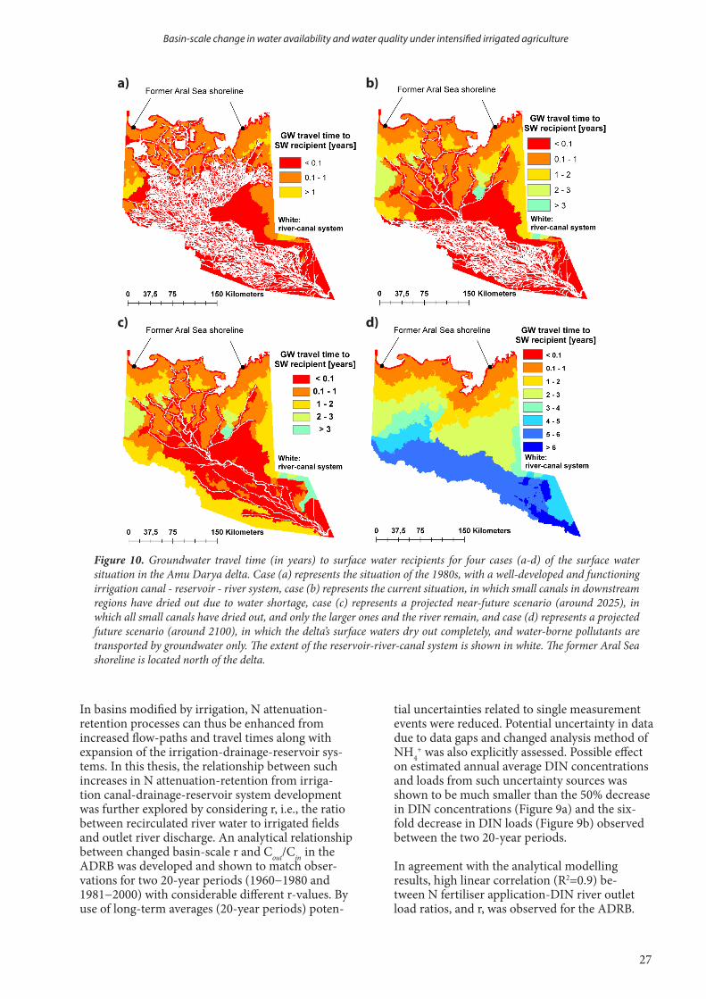
27
Thesis title
Figure 10. Groundwater travel time (in years) to surface water recipients for four cases (a-d) of the surface water situation in the Amu Darya delta. Case (a) represents the situation of the 1980s, with a well-developed and functioning irrigation canal - reservoir - river system, case (b) represents the current situation, in which small canals in downstream regions have dried out due to water shortage, case (c) represents a projected near-future scenario (around 2025), in which all small canals have dried out, and only the larger ones and the river remain, and case (d) represents a projected future scenario (around 2100), in which the delta’s surface waters dry out completely, and water-borne pollutants are transported by groundwater only. The extent of the reservoir-river-canal system is shown in white. The former Aral Sea shoreline is located north of the delta.
a)
c)
b)
d)
In basins modified by irrigation, N attenuation-retention processes can thus be enhanced from increased flow-paths and travel times along with expansion of the irrigation-drainage-reservoir sys-tems. In this thesis, the relationship between such increases in N attenuation-retention from irriga-tion canal-drainage-reservoir system development was further explored by considering r, i.e., the ratio between recirculated river water to irrigated fields and outlet river discharge. An analytical relationship between changed basin-scale r and Cout/Cin in the ADRB was developed and shown to match obser-vations for two 20-year periods (1960−1980 and 1981−2000) with considerable different r-values. By use of long-term averages (20-year periods) poten-
tial uncertainties related to single measurement events were reduced. Potential uncertainty in data due to data gaps and changed analysis method of NH4
+ was also explicitly assessed. Possible effect on estimated annual average DIN concentrations and loads from such uncertainty sources was shown to be much smaller than the 50% decrease in DIN concentrations (Figure 9a) and the six-fold decrease in DIN loads (Figure 9b) observed between the two 20-year periods.
In agreement with the analytical modelling results, high linear correlation (R2=0.9) be-tween N fertiliser application-DIN river outlet load ratios, and r, was observed for the ADRB.
Basin-scale change in water availability and water quality under intensified irrigated agriculture
your name
28
The results imply that increased development of irrigation-drainage-reservoir systems in a river basin could lead to enhanced N attenuation-retention conditions, which could outweigh N leaching from the fields, and cause decreased riverine N concen-trations. However, for substances not attributed to attenuation-retention processes an increased recircu-lation of irrigation water would evidently not lead to decreased concentrations. On the contrary, salt is for instance subject to downstream accumulation from reuse of irrigation in regions with high ET (Crosa et al., 2006; Olsson et al., 2013).
In Paper IV, a high linear correlation between dis-charge and N export from the ADRB was observed. Similar patterns have been observed in many other river basins characterised by high agricultural inten-sity (Basu et al., 2010). River discharge has decreased drastically during the considered historical 40-year period in the ADRB (Figure 3), which has caused a six-fold decrease in DIN load from the basin between the periods 1960−1980 and 1981−2000 (Figure 9b). This implies that reduced discharge is even more important for decreased N export from the river basin than decreased N concentrations. Accordingly, reduced discharge related to irriga-tion water diversions has caused reduced N export in both river basins with increasing and decreasing concentration trends (Ludwig et al., 2009; Tao et al., 2010).
N fertilisation has been maintained high throughout the period of considerable decrease in N export from the ADRB (Table 2). This implies that the decrease
in N load from the basin has led to that N accumula-tion in the soil-groundwater system and volatilisa-tion losses have become increasingly important for the N cycling in the river basin. Such accumulations of N have been observed in field studies from ADRB (Shanafield et al., 2010; Kienzler et al., 2011), which implies that N sources may be retained in the river basin for a long time after the input has ceased. The build-up of N sources can buffer concentration variations and lead to more homogenous loading pattern, which has been observed in many agricul-tural catchments (Basu et al. 2010; Basu et al., 2011; Thompson et al., 2011).
In Paper V, the impact of projected future climatic driven changes in discharge on N attenuation was further explored, while keeping the present irrigation water diversions and N input constant. The results imply that N riverine concentrations would likely de-crease in the future due to increased r-values caused by ceasing outlet river flows. Future N export from the ADRB would thus decrease even more along with projected decreased discharge and increased N attenuation. Future hydro-climatic changes (investi-gated in Paper V) or irrigation water use changes (in-vestigated in Paper IV) can thus lead to reductions in N export from irrigated river basins. Many arid and semi-arid regions around the world are projected to undergo reductions in discharge due to climate change and agricultural intensification (Jackson et al., 2001; IPCC, 2007; Yasin et al., 2010), and may therefore undergo comparable shifts in N export and internal N storage in the soil-groundwater system as shown here for the ADRB.
Rebecka Törnqvist

29
Thesis title
In this thesis, synthesised data analyses and distributed hydrological modelling were performed to investigate basin-scale changes in water use, river discharge, water quality and N loading. Connections between such changes were investigated and allowed for identification of underlying factors for changes in water availability and water quality in river basins modified by irrigated agriculture. The main findings of this thesis are:
- If traditional furrow irrigation would be replaced by more efficient irrigation techniques in the cotton fields of the ASDB, the outtake of river water to agricultural fields could be reduced by about 10 km3/year, which is on the same order as the current downstream discharge of the main rivers in ASDB.
- However, results also show that the basin has a high degree of water recirculation, which means that reduced irrigation water diversions are not directly shown as increased river flow, since a certain amount of water is reused. Return flows back to the river would also decrease if the outtake would be lowered. Therefore, the net water saving, seen as increasing river discharge at the basin outlet, is considerable lower (around 4 km3/year) than the outtake reduction. This illustrates the importance of quantifying internal return flows in basin-scale water saving assessments.
- The water saving efficiency of the considered improvements in irrigation techniques, expressed as the gain in downstream river discharge divided by the outtake reduction associated with the improved irrigation techniques, differed considerably between irrigation regions in the ASDB due to regional climatic differ-ences. The water saving efficiency was found to be up to a factor four larger in dry regions characterised by large non-reusable ET water losses and smaller return flows compared to colder and wetter regions.
- Nutrients and metals from agricultural and mining activities were occasionally found at concentrations exceeding WHO’s health risk-based guideline values in surface waters in the ADRB. However, metal con-centrations in groundwater wells distributed across the lower ADRB were subject to orders of magnitude higher health hazards than in surface waters.
- With such considerable groundwater contamination, decreased availability of surface water resources (e.g., due to water losses from irrigation expansion) implies decreased access to water suitable for drink-ing. Analogously, polluted groundwater may increasingly become the only remaining water source in many arid and semi-arid areas of the world, since surface water discharges are expected to decrease glob-ally in arid and semi-arid areas, in response to global irrigation increase and projected climate change.
- Decreasing riverine DIN concentrations during a 40-year period were observed at the outlet of the ADRB despite increasing N fertiliser input to agricultural fields of the basin. A developed analytical relationship between recirculation ratios of recirculated irrigation water and discharge, which increased considerably during the 40-year period, and DIN outflow-inflow concentration ratio was shown to match observations. High linear correlation between N fertiliser application-DIN river outlet load ratios and recirculation ratios was also observed. This suggests that the observed decrease in concentrations is primarily caused by increased irrigation canal-drainage-reservoir systems causing increased flow-path lengths and associated enhanced N attenuation-retention.
- A large decrease in DIN export from the ADRB was shown to primarily be the result of drastic river discharge reduction. Decreased N export indicates an increased internal N storage and degradation in basins where N fertiliser inputs are maintained, as in the ADRB. Projected future climate change is likely to further decrease the Amu Darya discharge, which would lead to continued decrease in N export both directly by further reducing the DIN mass loads at the basin outlet and by increasing recirculation ratios.
- Many arid and semi-arid regions around the world are projected to undergo reductions in discharge, as mentioned earlier. This thesis has shown that basic hydrological functioning can shift in such river basins, for instance in terms of decreased N export and related increased internal N accumulation.
6. Conclusions
Basin-scale change in water availability and water quality under intensified irrigated agriculture

your name
30
Rebecka Törnqvist
Methodological contributions of this thesis are the development of an analytical relationship between basin-scale recirculation ratio (r) and the outflow-inflow concentration ratio (Cout/Cin), and of a distributed hydro-logical model approach to investigate water saving potentials. The validity of the analytical relationship and the modelling approach would be interesting to assess in irrigated regions from different parts of the world. Effects from different degrees in agricultural versus urban impacts, irrigation practices and many other river basin characteristics would be interesting to investigate to expand the conclusions drawn from this thesis.
This thesis has mainly studied impacts from historic changes in land-water use from intensified irrigation. Additionally, impacts of future climatic changes were studied in Paper V. The findings in this thesis could be used to further explore the impact on the hydrology and water quality from changes in future irrigation development in the ASDB. For instance, investigations of impacts from possible shifts in spatial patterns of ir-rigated regions from downstream regions to further upstream locations, due to the abandonment of irrigated areas in water scarce and salinized downstream areas, could be an interesting aspect to study for the future water resource situation in the region.
Furthermore, additional groundwater quality assessments including substances with herein identified health risk are recommended to perform to obtain a clearer overview of the groundwater health risk situation. Such assessments could be complemented with groundwater modelling to further investigate groundwater transport of contaminants in areas of intensified irrigation, with associated elevated groundwater tables and decreasing surface water availability.
7. Future research

31
Thesis titleBasin-scale change in water availability and water quality under intensified irrigated agriculture
First of all, I want to thank my main supervisor Jerker Jarsjö. His never ending encouragement and guidance along the winding pathway of health risks, return flows and attenuation products have been essential for the accomplishment of this thesis. I would like to thank my co-supervisor and co-author Georgia Destouni for interesting discussions and helpful advice. I am also thankful for the opportunity of collaboration with the other co-authors Nandita Basu, Bakhtiyor Karimov, Suresh Rao and Su Ye, and for their generous knowledge sharing.
I would like thank everyone who has contributed to the friendly atmosphere at the department, and espe-cially within the PhD student group. A special thanks to Shilpa Asokan, Alistair Auffret, Arvid Bring, Amelie Darracq, Klas Persson, Carmen Prieto and Yoshihiro Shibuo for generous advice for settling in as a new PhD student (and nice chitchat in the corridors thereafter). I would also like to thank Susanna Blåndman and Ca-rina Henriksson for administrative support, and Peter Jansson and Helle Skånes for valuable assistance when finalising this thesis.
I would like to take the opportunity to thank my family and friends outside the department for their encour-agement and helping me not to think too much about research in my spare time. The sincerest thanks to my sister Maria and nephew Bruno for love and generosity, not least in letting me stay over in their living room whenever I needed to be two hours closer to work, and to my parents Ulla-Maria and Tommy whose love and support with everything between grammar-check and being the best baby-sitters and pig feeders, have been essential to fulfil this work.
Finally, I would like to thank Philipp and Isak for all their love and encouragement. Philipp has been the best and most supporting roommate/data support/proof-reader/barista at our home office, and Isak has by far been my greatest accomplishment during my time as a PhD student.
Financial supportWork in this thesis has been financially supported by the Swedish International Development Cooperation Agency (SIDA). Work has also been carried out within the frameworks of the Bolin Centre for Climate Re-search (supported by a Linnaeus grant from the Swedish research councils VR and Formas). The Bolin Centre for Climate Research has also financially supported me for attending conferences and performing a field trip to the study area.
8. Acknowledgements
your name
32
Rebecka Törnqvist
Abbott, M.B., Refsgaard, J.C. (1996), Distributed Hydrological Modelling. Kluwer Academic Publishers, Dordrecht.
Asokan, S.M., Jarsjö, J., Destouni, G. (2010), Vapor flux by evapotranspiration: Effects of changes in climate, land use, and water use. J. Geophys. Res. 115:D24102. doi:10.1029/2010JD014417
Aus Der Beek, T., Voß, F., Flörke, M. (2011), Modelling the impact of Global Change on the hydrological system of the Aral Sea basin, Phys. Chem. Earth 36, 684–695. doi:10.1016/j.pce.2011.03.004
Australian Government National Water Commission (2007), Australian Water Resources 2005: A baseline assessment of water resources for the National Water Initiative, Level 2 assessment, Water availability theme, National perspective, Report, Natl. Water Comm., Canberra, ACT, Australia.
Basu, N., Destouni, G., Jawitz, J., Thompson, S., Loukinova, N., Darracq, A., Zanardo, S., Yaeger, M., Sivapalan, M., Rinaldo, A., Rao, R. (2010), Nutrient loads exported from managed catchments reveal emergent biogeochemical stationarity, Geophys. Res. Lett., 37, L23404. doi:10.1029/2010GL045168.
Basu, N.B., Thompson, S.E., Rao, P.S.C. (2011), Hydrologic and biogeochemical functioning of intensively managed catchments: A synthesis of top-down analyses. Water Resour. Res. 47, W00J15. doi: 10.1029/2011WR010800
Bosch, K., Erdinger, L., Ingel, F., Khussainova, S., Utegenova, E., Bresgen, N., et al. (2007), Evaluation of the toxicological properties of ground- and surface-water samples from the Aral Sea Basin. Sci. Total Environ. 374, 43–50. doi: 10.1016/j.scitotenv.2006.11.048
Bouwman, A.F., Beusen, A. H. W., Billen, G. (2009), Human alteration of the global nitrogen and phosphorus soil balances for the period 1970–2050. Global Biogeochem. Cy. GB0A04, doi:10.1029/2009GB003576.
Brown, J. B., Sprague, L. A., Dupree, J. A. (2011), Nutrient sources and transport in the Missouri river basin, with emphasis on the effect of irrigation and reservoirs. J. Am. Water Resour. As., 47 (5), 1034-1060. doi: 10.1111/j.1752-1688.2011.00584.x
Böhlke, J.K. (2002), Groundwater recharge and agricultural contamination. Hydrogeol. J. 10, 153–179. doi: 10.1007/s10040-001-0183-3
Cai, X., McKinney, D.C., Rosegrant, M.W. (2003), Sustainability analysis for irrigation water management in the Aral Sea region. Agric. Syst. 76, 1043–1066. doi: 10.1016/S0308-521X(02)00028-8
Caraco, N.F., Cole J.J. (2001), Human influence on nitrogen export: a comparison of mesic and xeric catchments. Mar. Freshwater Res. 52, 119–25.
Carpenter, S. R., Caraco, N. F., Correll, D. L., Howarth, R. W., Sharpley A. N, Smith V.H. (1998), Nonpoint Pollution of Surface Waters with Phosphorus and Nitrogen. Ecol. Appl. 8 (3), 559-568. doi: 10.2307/2641247
Cetin, O., Bilgel, L. (2002), Effects of different irrigation methods on shedding and yield of cotton. Agric. Water. Manag. 54, 1-15. doi: 10.1016/S0378-3774(01)00138-X
Chiba, M., Shinohara, A., Sekine, M., Hiraishi, S. (2006), Drinking water quality from the aspect of element concentrations. J. Radioanal Nucl. Chem. 269(3), 519–26. doi: 10.1007/s10967-006-0259-6
Crosa, G., Stefani, F., Bianchi, C., Fumagalli, A. (2006), Water Security in Uzbekistan: implication of Return Waters on the Amu Darya Water Quality. Environ. Sci. Pollut. Res. 13 (1), 37–42. doi: 10.1065/espr2006.01.007
Darracq, A., Greffe, F., Hannerz, F., Destouni, G., Cvetkovic,V, (2005), Nutrient transport scenarios in a changing Stockholm and Malaren valley region, Sweden. Water Sci. Techol. 51(3–4), 31–38
De Wit, M. J. M. (2001), Nutrient fluxes at the river basin scale, I: The Polflow model, Hydrol. Process., 15, 743–759
Elpiner, L. (1999), Public health in the Aral Sea coastal region and the dynamics of change in the ecological situation. In: Glantz, M., editor. Creeping environmental problems and sustainable development in the Aral Sea basin. Cambridge University
Press, Cambridge, p. 128–156.Erdinger, L., Eckl, P., Ingel, F., Khussainova, S., Utegenova,
E., Mann, V., et al. (2004), The Aral Sea disaster — human biomonitoring of Hg, As, HCB, DDE, and PCBs in children living in Aralsk and Akchi, Kazakhstan. Int. J. Hyg. Environ. Health 207, 541–547. doi: 10.1078/1438-4639-00325
Falkenmark, M., Lannerstad, M (2005), Consumptive water use to feed humanity – curing a blind spot. Hydrol. Earth Syst. Sci. 9, 15–28. doi 1607-7938/hess/2005-9-15
FAO (2003), Review of world water resources by country. Water reports 23, Food and Agriculture Organization of the United Nations, Rome
FAO (2008), Current world fertilizer trends and outlook to 2011/12. Food and Agriculture Organization of the United Nations, Rome.
Farr, T. G., Rosen, P. A., Caro, E., Crippen, R., Duren, R., Hensley, S., Kobrick, M., Paller, M., Rodriguez, E., Roth, L., Seal, D., Shaffer, S., Shimada, J., Umland, J.,Werner, M., Oskin, M., Burbank, D., Alsdorf, D. E. (2007), The shuttle radar topography mission, Rev. Geophys., 45, RG2004. doi:10.1029/2005RG000183.
Fetouani, S., Sbaa, M., Vanclooster, M., Bendra, B., (2008), Assessing ground water quality in the irrigated plain of Triffa (north-east Morocco). Agric. Water. Manag. 95, 133 – 142. doi:10.1016/j.agwat.2007.09.009
Foley, J. A., DeFries, R., Asner, G. P., Barford, C., Bonan, G.,Carpenter, S. R., Chapin, F. S., Coe, M. T., Daily, G. C., Gibbs, H. K., Helkowski, J. H., Holloway, T., Howard, E. A., Kucharik, C. J., Monfreda, C., Patz, J. A., Prentice, I. C., Ramankutty, N., Snyder, P. K., (2005), Global consequences of land use, Science 309, 570–574. doi:10.1126/science.1111772
Froebrich J. (2004), Water management aspects of Amu Darya. In: Nihoul, J.C.J., Zavialov, P.O., Micklin, P.P., editors. Dying and Dead Seas. Climatic Versus Anthropic Causes. Kluwer Academic Publisher, Dordrecht, p. 49–76.
Froebrich, J., Ikramova, M., Razakov, R. (2006), Improved groundwater management strategies at the Amu Darya River. In: Baba, A., Howard, K.W.F., Gunduz, O., editors. Groundwater and ecosystems. Springer, Dordrecht, p. 153–165.
Fryer, M., Collins, C.D., Ferrier, H., Colvile, R.N., Nieuwenhuijsen, M.J. (2006), Human exposure modelling for chemical risk assessment: a review of current approaches and research and policy implications. Environ. Sci. Policy 9, 261–74. doi: 10.1016/j.envsci.2005.11.011
Glantz, M. (1999), Creeping environmental problems and sustainable development in the Aral Sea basin. Cambridge University Press, Cambridge.
Glantz, M. (2005), Water, climate, and development issues in the Amu Darya Basin, Mitig. Adapt. Strateg. Glob. Chang. 10(1), 23– 50, doi:10.1007/s11027-005-7829-8.
Gordon, L., Steffen, W., Jonsson, B., Folke, C., Falkenmark, M., Johannessen, A. (2005), Human modification of global water vapor flows from the land surface, Proceedings of the National Academy of Sciences of the United States of America 102, 7612–7617. doi: 10.1073/pnas.0500208102
Gordon, L.J., Peterson, G.D., Bennett, E.M. (2008), Agricultural modifications of hydrological flows create ecological surprises. Trends Ecol. Evol. 23(4), 211–219. doi: 10.1016/j.tree.2007.11.011
Hall, L.W., Scott, M.C., Killen, W.D. (1998), Ecological risk assessment of copper and cadmium in surface waters of Chesapeake Bay watershed. Environ. Toxicol. Chem. 17 (6), 1172 -1189. doi: 10.1897/1551-5028(1998)017<1172:ERAOCA>2.3.CO;2
Hama, T. (2012), Cyclic Irrigation for Reducing Nutrients and Suspended Solids Loadings from Paddy Fields in Japan, In Irrigation - Water Management, Pollution and Alternative Strategies, edited by Garcia-Garizabal, I., ISBN: 978-953-51-0421-6, InTech, doi: 10.5772/29958.
Hitomi, T., Yoshinaga, I., Feng, Y.W., Shiratani, E. (2006) N removal function of recycling irrigation system, Water Sci.
References
33
Thesis titleBasin-scale change in water availability and water quality under intensified irrigated agriculture
Technol., 53(2), 101-109, doi: 10.2166/wst.2006.043.Horrigan, L., Lawrence, R.S., Walker, P. (2002), How sustainable
agriculture can address the environmental and human health harms of industrial agriculture. Environ. Health Perspect. 110 (5), 445-456.
Horst, M.G., Shamutalov, S.S., Gonçalves, J.M., Pereira, L.S. (2007), Assessing impacts of surge-flow irrigation on water saving and productivity of cotton. Agric. Water Manag. 87, 115–127. doi: 10.1016/j.agwat.2006.06.014
Ibragimov, N., Evett, S.R., Esanbekov, Y., Kamilov, B.S., Mirzaev, L., Lamers, J.P.A. (2007), Water use efficiency of irrigated cotton in Uzbekistan under drip and furrow irrigation. Agric. Water Manag. 90, 112–120. doi: 10.1016/j.agwat.2007.01.016
Ibrakhimov, M., Martius, C., Lamers, J.P.A., Tischbein, B. (2011), The dynamics of groundwater table and salinity over 17 years in Khorezm. Agric. Water Manag. 101, 52– 61. doi:10.1016/j.agwat.2011.09.002
Intergovernmental Panel on Climate Change (2007) Synthesis Report, Contribution of Working Groups I, II and III to the Fourth Assessment Report of the Intergovernmental Panel on Climate Change In: Pachauri RK, Reisinger A, editors. Climate Change 2007. Geneva, Switzerland.
Ismail, S., Depeweg, H., Schultz, B. (2004), Surge flow irrigation under short field conditions in Egypt. Irrig. Drain. 53, 461–47. doi: 10.1002/ird.145
Ismail, S.H. (2006), Effect of tillage on water advance and distribution under surge and continuous furrows irrigation methods for cotton in Egypt. Irrig. Drain. 55, 191–199. doi: 10.1002/ird.227
Jackson, R.B., Carpenter, S.R., Dahm, C.N., McKnight, D.M., Naiman R.J., Postel, S.L., Running, S.W. (2001), Water in a Changing World. Ecol. Appl. 11, 1027-1045. doi: 10.2307/3061010
Jalali, M. (2005), Nitrates leaching from agricultural land in Hamadan, western Iran. Agric. Ecosyst. Environ. 110, 210–218. doi:10.1016/j.agee.2005.04.011
Jarsjö, J., Asokan, S.M., Prieto, C., Bring, A., Destouni, G. (2012), Hydrological responses to climate change conditioned by historic alterations of land-use and water-use. Hydrol. Earth Syst. Sci., 16, 1335–1347, doi:10.5194/hess-16-1335-2012.
Jarsjö, J., Shibuo, Y., Destouni, G. (2008), Spatial distribution of unmonitored inland water discharges to the sea. J. Hydrol. 348(1–2), 59–72. doi: 10.1016/j.jhydrol.2007.09.052
Johansson, O., Aimbetov, I., Jarsjö, J. (2009), Variation of groundwater salinity in the partially irrigated Amudarya River delta, Uzbekistan. J. Mar. Syst. 76(3):287–95. doi: 10.1016/j.jmarsys.2008.03.017
Kanber, R., Köksal, H., Önder, S., Kapur, S., Sahan, S. (2001), Comparison of surge and continuous furrow methods for cotton in the Harran plain. Agric. Water Manag. 47, 119–135. doi. 10.1016/S0378-3774(00)00102-5
Karimov, B., Lieth, H., Kurambaeva, H., Matsapaeva, I. (2005), The problems of fishermen in the southern Aral Sea region. Mitig. Adapt. Strateg. Glob. Chang. 10, 87-103.
Khan, S., Hafeez, M.M., Rana, T., Mushtaq, S. (2008), Enhancing water productivity at the irrigation system level: A geospatial hydrology application in the Yellow River Basin. . J. Arid Environ. 72, 1046–1063. doi:10.1016/j.jaridenv.2007.11.011
Kienzler, K.M. (2010), Improving the N use efficiency and crop quality in the Khorezm region, Uzbekistan. PhD Dissertation. Der Hohen Landwirtschaftlichen Fakultät der Rheinischen Friedrich-Wilhelms-Universität, Bonn, Germany.
Kienzler, K.M, Djanibekov, N., Lamers, J. (2011), An agronomic, economic and behavioral analysis of N application to cotton and wheat in post-Soviet Uzbekistan. Agric. Syst., 104(5), 411-418. doi:10.1016/j.agsy.2011.01.005.
Kienzler,. K.M.,. Lamers, J.P.A, McDonald, A., Mirzabaev, A., Ibragimov, Egamberdiev, N O., Ruzibaev, E., Akramkhanovd, A. (2012), Conservation agriculture in Central Asia—What do we know and where do we go from here? Field Crops Res. 132, 95–105. doi:10.1016/j.fcr.2011.12.008
Kite, G. W., Droogers, P. (2000), Comparing evapotranspiration estimates from satellites, hydrological models and field data, J. Hydrol., 229, 3–18. doi: 10.1016/S0022-1694(99)00195-X
Kurbanbaev, R.E., Matsapaeva, I.V., Konstantinova, L.G. (2002), The role of collecting drainage systems in the formation of chemical composition of lake water in the Amu Darya lower reaches. Water Resour. 29(3), 46–50.
Langbein, W.B. (1949), Annual runoff in the United States, U. S.
Geol. Surv. Circ. 52Lankford, B. (2006), Localising irrigation efficiency. Irrig. Drain.
55, 345–362. doi: 10.1002/ird.270Lassaletta, L., Romero, E., Billen, G., Garnier, J., García-Gómez,
H., Rovira1, J.V. (2012), Spatialized N budgets in a large agricultural Mediterranean watershed: high loading and low transfer. Biogeosciences 9, 57–70. doi:10.5194/bg-9-57-2012
Lemoalle, J., Bader, J.C., Leblanc, M., Sedick, A. (2012), Recent changes in Lake Chad: Observations, simulations and management options (1973–2011). Glob. Planet. Chang. 80–81, 247–254. doi:10.1016/j.gloplacha.2011.07.004
Lioubimtseva, E., Henebry, G.M. (2009), Climate and environmental change in arid Central Asia: impacts, vulnerability, and adaptations. J. Arid Environ. 73, 963–977. doi:10.1016/j.jaridenv. 2009.04.022
Loeve, R., Dong, B., Molden, D., Li, Y.H., Chen, C.D., Wang, J.Z. (2004), Issues of scale in water productivity in the Zhanghe irrigation system: implications for irrigation in the basin context. Paddy Water Environ 2, 227–236. doi: 10.1007/s10333-004-0061-4
Ludwig, W., Dumont, E., Meybeck, M., Heussner, S. (2009), Review: River discharges of water and nutrients to the Mediterranean and Black Sea: Major drivers for ecosystem changes during past and future decades? Prog. Oceanogr. 80, 199–217. doi:10.1016/j.pocean.2009.02.001.
Mamatov, S. (2003), Study of the groundwater contribution to the Aral sea region water supply and water quality: strategies for reversibility and pollution control, INTAS project 1014. EU-INTAS Aral Sea Basin Call 2000, Group CR5 status report.
Mateos, L., Berengena, J., Orgaz, F., Diz, J., Fereres, E. (1991), A comparison between drip and furrow irrigation in cotton at two levels of water supply. Agric. Water Manag. 19:313–324
Micklin, P. (2003), The Aral Sea crisis. In: Nihoul, J.C.J., Zavialov, P.O., Micklin, P.P., editors. Dying and Dead Seas. Climatic Versus Anthropic Causes. Kluwer academic Publisher, Dordrecht, p. 99-123.
Mitchell, T.D., Jones, P.D. (2005), An improved method of constructing a database of monthly climate observations and associated high resolution grids. Int. Climatol. 25, 693–712. doi: 10.1002/joc.1181
Molden, D., Sakthivadivel, R., Habib, Z. (2001), Basin-level use and productivity of water: Examples from South Asia. Research Report 49. International Water Management Institute (IWMI), Colombo, Sri Lanka:
Molden, D., Frenken, K., Barker, R. et al. (2007), Trends in water and agricultural development. In: Molden, D., editor. Water for food, water for life: a comprehensive assessment of water management in agriculture. Earthscan, London, pp 57–89
Molle, F. (2007), River basin development and management. In: Molden, D., editor. Water for food, water for life: a comprehensive assessment of water management in agriculture. Earthscan, London, pp 585-624.
Monteith, J.L. (1981), Evaporation and surface temperature. Quart. J. R. Soc. 107, 1–27.
Muntean, N., Jermini, M., Small, I., Falzon, D., Furst, P., Migliorati, G., et al. (2003), Assessment of dietary exposure to some persistent organic pollutants in the Republic of Karakalpakstan of Uzbekistan. Environ. Health Perspect. 111(10), 1306–1311. doi: 10.1289/ehp.5907
Nasrulin, A., Zahidova, M. (2002), The experience of creation of the GIS System of ecological monitoring in Aral Sea Basin. J. Prob. Mech. 4, 38–43.
Nezlin, N.P., Kostianoy, A.G., Lebedev, S.A. (2004), Interannual variations of the discharge of Amu Darya and Syr Darya estimated from global atmospheric precipitation. J. Mar. Syst. 47(1–4), 67–75. doi: 10.1016/j.jmarsys.2003.12.009
Nikouei, A., Zibaei, M., Ward, F.A. (2012), Incentives to adopt irrigation water saving measures for wetlands preservation: An integrated basin scale analysis. J. Hydrol., 464–465, 216–232. doi: 10.1016/j.jhydrol.2012.07.013
Novikova, N.M., Kust, G.S., Kouzmina, J.V., Trofimova, G.U., Dikariova, T.V., Avetian, S.A., Rozov, S.U., Deruzhinskaya, V.D., Safonicheva, L.F., Lubeznov, U.E. (1998), Contemporary plant and soil cover changes in the Amudarya and Syrdarya river deltas. In: UNESCO, Ecological Research and Monitoring of the Aral Sea Deltas. UNESCO, Paris, p. 155-188.
Oelsner, G.P., Brooks, P.D.., Hogan, J.F. (2007) Nitrogen Sources and Sinks Within the Middle Rio Grande, New Mexico. J. Am. Water Resour. As., 43(4), 850-863. doi: 10.1111 ⁄j.1752-

your name
34
Rebecka Törnqvist
1688.2007.00071.xOren, O., Yechieli, Y., Böhlke, J.K., Dody, A. (2004),
Contamination of groundwater under cultivated fields in an arid environment, central Arava Valley, Israel. J. Hydrol. 290, 312–328. doi:10.1016/j.jhydrol.2003.12.016
Olsson, O., Bauer, M., Ikramova, M., Froebrich, J. (2008), The Role Of The Amu Darya Dams And Reservoirs In Future Water Supply In The Amu Darya Basin. In: Qi, J., Evered, K.T., editors, Environmental Problems of Central Asia and their Economic, Social and Security Impacts. Springer, Dordrecht, p. 277-292. doi: 10.1007/978-1-4020-8960-2_20
Olsson, O., Gassmann, M., Manig, N., Ikramova, M., Wegerich, K. (2013) Basin efficiency approach and its effect on streamflow quality, Zerafshan River Uzbekistan. J. Hydrol. 476,128–135. doi: org/10.1016/j.jhydrol.2012.10.022
Periera, L.S., Oweis, T., Zairi, A. (2002), Review: irrigation management under water scarcity. Agric. Water Manag. 57, 175–206. doi: 10.1016/S0378-3774(02)00075-6
Persson, K., Jarsjö, J., Destouni, G. (2011), Diffuse hydrological mass transport through catchments: scenario analysis of coupled physical and biogeochemical uncertainty effects, Hydrol. Earth Syst. Sci., 15, 3195–3206, doi:10.5194/hess-15-3195-2011.
Piao, S., Friedlingstein, P., Ciais, P., De Noblet-Ducoudre´N, Labat, D., Zaehle, S. (2007), Changes in climate and land use have a larger direct impact than rising CO2 on global river runoff trends, Proceedings of the National Academy of Sciences of the United States of America 104, 15242–15247. doi:10.1073/pnas.0707213104
Porkka, M., Kummu, M., Siebert, S., Flörke, M. (2012), The Role of Virtual Water Flows in Physical Water Scarcity: The Case of Central Asia. Int. J. Water Resour. D. 28(3), 453-474. doi: 10.1080/07900627.2012.684310
Postel, S. (2000), Entering an Era of Water Scarcity: The Challenges Ahead. Ecol. Appl. 10 (4), 941-948. doi: 10.2307/2641009
Qadir, M., Noble, A.D., Qureshi, A.S., Gupta, R.K., Yuldashev, T., Karimov, S. (2009), Salt-induced land and water degradation in the Aral Sea basin: A challenge to sustainable agriculture in Central Asia. Nat. Resour. Forum 33, 134–149.
Rajak, D., Manjunatha, M.V., Rajkumar, G.R., Hebbara, M., Minhas, P.S. (2006), Comparative effects of drip and furrow irrigation on the yield and water productivity of cotton (Gossypium hirsutum L.) in a saline and waterlogged vertisol. Agric. Water Manag. 83, 30–36. doi: 10.1016/j.agwat.2005.11.005
Rakhmatullaev, S., Huneau, F., Kazbekov, J., Le Coustumer, P., Jumanov, J., El Oifi, B., et al. (2010), Groundwater resources use and management in the Amu Darya River Basin (Central Asia). Environ. Earth Sci. 59(6), 1183–93. doi: 10.1007/s12665-009-0107-4
Rosegrant, M.W., Ringler, C., Zhu, T. (2009), Water for Agriculture: Maintaining Food Security under Growing Scarcity. Annu. Rev. Environ. Resour. 34:205–22.doi: 10.1146/annurev.environ.030308.090351
Rüger, N., Schlüter M., Matthies, M. (2003), A fuzzy habitat suitability index for Populus euphratica in the Northern Amudarya delta (Uzbekistan). Ecol. Model., 184 (2-4): 313-328, doi: 10.1016/j.ecolmodel
Saiko, T.S., Zonn, I.S. (2000), Irrigation expansion and dynamics of desertification in the Circum-Aral region of Central Asia. Appl. Geogr. 20:349–367. doi: 10.1016/S0143-6228(00)00014-X
Scheer, C., Wassmann, R., Butterbach-Bahl, K., Lamers, J., Martius, C. (2009), The relationship between N2O, NO, and N2 fluxes from fertilized and irrigated dryland soils of the Aral Sea Basin, Uzbekistan, Plant Soil 314, 273–283. doi: 10.1007/s11104-008-9728-8.
Schlüter, M.,Leslie, H.,Levin, S. (2009), Managing water-use trade-offs in a semi-arid river delta to sustain multiple ecosystem services: a modeling approach. Ecol. Res., 24, 491–503. doi: 10.1007/s11284-008-0576-z
Seitzinger, S., Harrison, J. A., Bohlke, J. K., Bouwman A. F., Lowrance, R., Peterson, B., Tobias, C., Van Drecht, G. (2006), Denitrification across landscapes and waterscapes: a synthesis, Ecol. Appl., 16(6), 2064–2090. doi: 10.1890/1051-0761(2006)016[2064:DALAWA]2.0.CO;2
Shanafield, M., Rosen, M., Saito, L., Chandra, S., Lamers, J.,
Nishonov, B. (2010), Identification of N sources to four small lakes in the agricultural region of Khorezm, Uzbekistan. Biogeochemistry 101, 357–368. doi: 10.1007/s10533-010-9509-3.
Shibuo, Y., Jarsjö, J., Destouni, G. (2006), Bathymetry–topography effects on saltwater-fresh groundwater interactions around the shrinking Aral Sea. Water Resour. Res. 42:W11410. doi:10.1029/2005WR004207.
Shibuo, Y., Jarsjö, J., Destouni, G. (2007), Hydrological responses to climate change and irrigation in the Aral Sea drainage basin. Geophys. Res. Lett. 34, L21406. doi:10.1029/2007GL031465.
Shiklomanov, I.A. (2000), Appraisal and Assessment of World Water Resources, Water Int. 25 (1), 11-32. doi: 10.1080/02508060008686794
Siebert, S., Döll, P., Hoogeveen, .J, Faures, J.M., Frenken, K., Feick, S. (2005), Development and validation of the global map of irrigated areas. Hydrol. Earth Syst. Sci. 9(5), 535–47.
Small, I., Falzon, D., van der Meer, J.B.W., Ford, N. (2003), Safe water for the Aral Sea Area. Could it get any worse? Eur. J. Public Health, 13(1), 87–9. doi: 10.1093/eurpub/13.1.87
Stagnari, F., Ramazzotti, S., Pisante, M. (2009) Conservation Agriculture: A Different Approach for Crop Production Through Sustainable Soil and Water Management: A Review. E. In Lichtfouse (ed.), Organic Farming, Pest Control and Remediation of Soil Pollutants. Sustain. Agric. Reviews 1, doi: 10.1007/978-1-4020-9654-9 5.
Tao, Y., Wei, M., Ongley, E., Zicheng, L., Jingsheng, C. (2010), Long-term variations and causal factors in N and phosphorus transport in the Yellow River, China, Estuar. Coast. Shelf Sci., 86, 345–351. doi:10.1016/j.ecss.2009.05.014.
Thompson, S. E., Basu, N. B., J. Lascurain, A. Aubeneau, Rao, P. S. C. (2011), Relative dominance of hydrologic versus biogeochemical factors on solute export across impact gradients, Water Resour. Res., 47, W00J05. doi:10.1029/2010WR009605.
Thornthwaite, C. W. (1948), An approach toward a rational classification of climate, Geogr. Rev., 38, 55–94.
Turc, L. (1954), ‘The water balance of soils,’ Relation between precipitation evaporation and flow. Ann. Agron. 5, 491–569.
Törnqvist, R., Norström, A, Kärrman, E, Malmqvist, P.-A. (2008), A framework for planning of sustainable water and sanitation systems in peri-urban areas. Water Sci. Technol. 58 (3): 563-570. doi: 10.2166/wst.2008.702
Ünlü, M., Kanber, R., Onder, S., Sezen, M., Diker, K., Ozekici, B., Oylu, M. (2007), Cotton yields under different furrow irrigation management techniques in the Southeastern Anatolia Project (GAP) area, Turkey. Irrig. Sci. 26, 35–48. doi: 10.1007/s00271-007-0070-3
United States Department of Agriculture (2009), Cotton: World markets and trade. Foreign agricultural service, office of global analysis circular series FOP 04-09 April 2009. Avaliable at: http://www.fas.usda.gov/cotton_arc.asp.
United States Environmental Protection Agency (US EPA) (1989), Risk Assessment Guidance for Superfund. EPA/540/1-89/002. Office of Emergency and Remedial Response. Human Health Evaluation Manual (Part A), U.S. Environmental Protection Agency, Washington, DC.
World Health Organisation (WHO) (2006), Guidelines for drinking water Quality Vol. 1 Recommendations. 3rd ed., World Health Organisation, Geneva.
Weiskel, P. K., Vogel, R. M., Steeves, P. A., Zarriello, P. J., DeSimone, L.A. and Ries III, K. G. (2007), Water use regimes: Characterizing direct human interaction with hydrologic systems, Water Resour. Res. 43, W04402. doi:10.1029/2006WR005062
Wisser, D., Fekete, B. M., Vörösmarty, C. J. and Schumann, A. H. (2010), Reconstructing 20th century 20 global hydrography: a contribution to the Global Terrestrial Network-Hydrology (GTN-H). Hydrology and Earth System Sciences, 14, 1–24. doi:10.5194/hess-14-1-2010
Yakubov, M., Manthrithilake, H. (2009), Water for food as food for thought: case study of applying the Podiumsim model to Uzbekistan. Irrig. Drain. 58, 17–37. doi: 10.1002/ird.451
Yasin, J.A., Kroeze, C. and Mayorga, E. (2010), Nutrients export by rivers to the coastal waters of Africa: Past and future trends. Global Biogeochem. Cy. 24, GB0A07. doi:10.1029/2009GB003568.