basic ground - water data for western...
TRANSCRIPT

I I I I
I I I
WATER RESOURCES REPORT NUMBER EIGHTEEN
ARIZON A STATE LAND DEPARTMENT
OBED M. LASSEN, COMMISSIONER
BASIC GROUND - WATER DATA fOR
WESTERN PINAL COUNTY,
ARIlONA
BY W.F. HARDT, R.E.CATTANY, AND L.R.KISTER
PREPARED BY THE GEOLOGICAL SURVEY,
UNITED STATES DEPARTMENT OF THE INTERIOR
Phoenix, Arizona
December 1964
Introduction ... ,., ••..•.... " •••••••.•.••••••••••••••...• , .•
Acknowledgments .•..••••••.••••••••••••••.•••••••••••••••••
Personnel ••.••••.•.•• , ••.•.•••• , ••••••••••••.••.•••••••••••
Explanation of tables ........ ' .•....•.••.••...•....• , ••••••••
Figurc 1. .Map of Arizona showing area of report •..•..•.••.•••
2. Map of western pinal County, showing area boundaries
and location of wells .•••..••...•.••.••.•••••••••
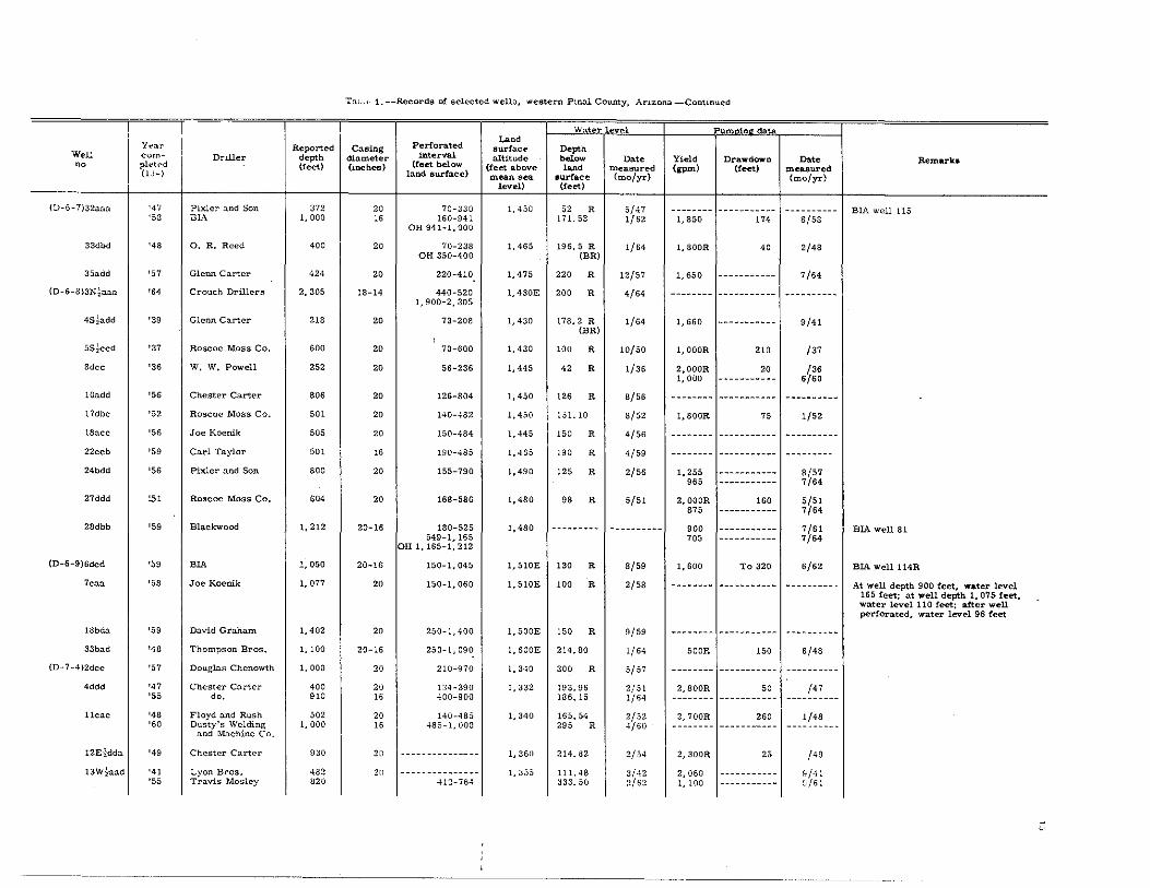
Table 1. Records of selected wells, western Pinal County,
CONTENTS
Page
Explanation of tables-Continued
Table 1 ............................................... .
Table 2 ••••••••••••••••••••••••••••••••••••••••••••••••
Tables 3 and 4 •••••••..•.•••••.•..•..•.•..•.••....•.•..
lLLUSTRA TIONS
Figure 3. Well-numberIng system in Ari:r;ona "." •. , •. , ••..••
4. Geohydrologic units of the alluvium in western Pinal
County, Arizona •.•.••..•.•• ,.".,"',., •• , ..•..
TABLES
Page
Table 3, Chemical analyses of ground water, weslern Pinal
Page
Page
Page
County, ArIzona •.• "., •• ,', •••.••••. , ••••• ,',.. 311 Arizona •.........••••• ,., ••••• , ••••.•..•••••••
2. Geohydrologic interpretations of selected drillers'
logs, western Pinal County. Arh:ona ••••• ,.,." •• 22
'Waler R~hts AdJudic~!ion Toruli eMI Div~io" Atlomsy Gonsrars Olf"",:
4. Field determinations of temperature and specific
conduct!!nce of water from selected wells made
during the summer of 1960, western PInal County.
Arizona •. , ••••••••••••••....•.••••• ,', •.•••.•.
HI

I I

BASIC GROUND·WATER DATA FOR WESTERN PINAL COUNTY, ARIZONA
By W, F, Hardt, L, R, Kister, and R, E, CaUany
Introduction
In 1958 the U, S. Geological Survey, in cooperation with the
Arizona State Land Department, began an investigation of the ground
water resonrces of western Pinal County, The study area (fig. 1) con·
slsts of valley floors of low relief surrounded by mountains. It includes
about 2, 000 square miles in the lower Santa Cruz basin and adjacent
areas along the Gila River and has been subdivided into the Eloy, Casa
Grande·Florence. Stanfield· Maricopa, and Gila River areas (fig, 2),
This detailed investigation of the second largest agricultural area in
the State consisted of evaluating and analyzing by various methods the
basic data collected mainly from 1940 to 1963.
The purpose of this report is to make available selected well
records, drillers' logs, and quality·of·water information, which will
be useful in developing the water resources of western Pinal County,
and to supplement the more comprehensive discussions in two forth
coming reports. The first of these reports will contain a description
and analysis of the geohydrologic system, including the subdivision of
the permeable deposits, a definition of the impermeable boundaries of
the basin, a discussion of the effects of ground-water withdrawal, and a
determination of the amount of ground water in storage. The second
l·eport will contain a description and analysIs of the quality· of-water
data.
Acknowledgments
The cooperation of many people in western Pinal County mate
rially aided the investigation, Farmers, ranchers, landowners. well
drillers, business people, and pubUc and private companies graciously
furnished data used in this report. Special thanks are given to the
Arizona Public ServIce Co., Casa Grande; ArIzona Water Co., Phoenix;
Electrical Power Districts 2, 4, and 5, CooUdge and Eloy; Hanson
Pump Co., Casa Grande; San Carlos Irrigation District and Project,
CooUdge-particularly Carl Anderson, h1arvin Young, Bud Hes, Cap
Hanson, and A, S. Cobb: Southwest Gas Corp., Coolidge: Western Pump
Co., Casa Grande; and SamuelF. Turner, consulting engineer, Phoenix,
Work on this report was begun under the supervision of J. W.
Harshbarger, former district geologist, and continued under the super
vision of P. EldonDennis, former district geologist, andH, M, Babcock,
present district chief of the Water Resources Division in Arhona. Most
of the basic data were collected by personnel of the Arizona district-
particularly E. K. Morse, C, S. English, J. T. Hollander, T. W,
O'Brien, R. L. T):lOmpson, and the late M. B. Booher.
Explanation of Tables
Included in this report are well records, drIllers' logs, and
quality-of-wster analyses. The records are arranged in numerical
order by township, range, and section under the well-numbering system
used in Arizona (fig. 3). For the most part, the weU data were obtained
from well-registration forms of the Arizona State Land Department and
from visits to the well a by a Geological Survey representative. The
division of the subsurface materials into five geohydrologic units and
the descriptions of the lithologic characteristics and water- bearing
properties {fig. 4)are based primarily on the interpretation of drillers'
logs.
Table 1.--The 304 wells in this table are considered represent
allvl! of the 1,500 irrigation wella in western Pinal County. The table
includes the well-location number, the date the weU was drilled or
deepened by the driller to the depth shown, the casing diameter, and
the perforated interval in the casing or the amount of open hole. The
land-surface altJtude was obtained from topographic maps or was esti
mated where adequate maps were not available, The water-level and
dIscharge data, for the mosl part, were reported by the drillers or
were measured by a representative of the Geological Survey; however,
some data also were obtsined from the Bureau of Indian Affairs and the
Bureau of Reclamation.
Table 2.--Table 2 includes 107 representative drillOi'rs' logs.
The driller's termlnoloiY has been retaIned and is reproduced as crig
inally submitted to the StateLaod Department or the Geological Survey.
The drillers' logs have been analyzed and interpreted, and the subsur
face material has been subdivided into five basic geohydrologic units
based primarHy on particle she and permeability (fig. 4).
Tables 3 and 4.--Table 3 contains 388 quaUt}-of-water analyses
from 213 wells. Most of the analyses were made in the laboratory,
Some wells were sampled more than once to determine the ohange in
chemicsl quality of the water with time, Table 4 contains field deler
minations of specIfic conductance and temperature of the water from
653 wells tested in the summer of 1960, The specU1c conductance is a
measure of the ability of the water to conduct an electric current. The
conductance varies with the concentration of the ions in solution and Is
a rough measure of the d19solved-soUds ~ontent of the water,

N
2
36·
()
." .. '-() -() \:)
o I
114· liZ·
<:..
'" &
0 C 0 N
, 1-', I '--~ FloQstaff
KlnQman I \-'", ~, •
I - -, I --I
I Y A V A __ 1 pre~cott
',,-, J ; ,~_-+ ___ I- - - - - --,- --
, ",j
Y u
IMARICOPA I
M A I
.'~er ~I
Phoenix.
Gi lO , ,....!--- I
50
I
, 1-------
P
100 MILES
I
M
110·
o UJ
N 01 « I L_
I (.}
>
Holbrook , « • «
z
FiguI'O 1. -Map of Arizona showing area of report.
36·

I I I I I I I I I
BEDROCK
®
IRRIGATION WELL
+ UNUSED IRRIGATION WELL
o
STOCK, DOMESTIC, OR INDUSTRIAL WELL
I N DIAN R E'SEF{V"AT"ION"j BOUNDARY
~ AREA BOUNDARY
T. 10 S.
-_. R.5 E R.S E.
E LOY ARE A
R. 9 E.
FIGURE 2.-~MAP OF WESTERN PINAL COUNTY, SHOWING AREA BOUNDARIES AND LOCATION OF WELLS.
R. 10 E
RIDE.
T. 9 S.
o ,.
[tg R. II E.
N
I
.
T 6
? S.
C

B A
, " GILA A~CI SALT RIVE BASE liNE
". t~ or • • . • "n , z • • § 2
• • • • • • C > 0 • / ,
~ . ,; • ~
/ / VH
o • z • ,
1// / • • a $
Wfll (O-4~~~9ta(J
" , • • • • • J:: , • • "
, "
T. ,1 " .. " .. u • S ~, ~ " " " "
" a " " " " " .. .. " " ..
The well numbers used by the Geological Survey in Arizona are in accordance with the Bureau of Land Management's system of land subdivision. The land survey in Arizona is based on the Gila and Salt River meridian and base line, which divide the State into four quadrants. These quadrants are designated counterclockwise by the capital letters A, B, C, and D. All land north and east of the point of origin is in A quadrant, that north and west in B quadrant, that south and west in C quadrant, and that south and east in D quadrant. The first digit of a well number indicates the township, the second the range, and the third the section in which the well is situated. The lowercase letters a, b, c, and d after the section number indicate the well location within the section. The first letter denotes a particular l60-acre tract, the second the 40-acre tract, and the third the lO-acre tract. These letters also are assigned in a counterclockwise direction, beginning in the northeast quarter. If the location is known within the 10-acretract, three lowercase letters are shown in the well number. In the example shown, well number (D-4-5)19caa designates the well as beingintheNEtNEtSWt sec. 19, T. 4 S., R. 5 E. Where there is more than one well within a lO-acre tract, consecutive numbers beginning with 1 are added as suffixes.
Where a section is more than a mile long in either direction, the designation St. Nt. E~, or W~ is added to indicate the part of the section in which the well is located.
Figure 3. -- Well-numbering system in Arizona.
5

·6
Geohydrologic unit
Upper sand and
gravel unit
Sill and clay unit
Lower sand and
gravel unit
Local gravel unit
Hydrologic
bedrock
Thickness (feet)
0-600
0-2,000
0-500
0-\,000
General description
Fluviatile deposits, predominantly sand and gravel
with some clay; poorly sorted; generally 300 to
400 feet thick.
Fluviatile and lacustrine deposits of fiue sand, silt,
and clay; contains thin lenses of highly permeable
sand and gravel. The thickest parts of the unit
are generally in the center of the western and
eastern parts of the Im',er Santa Cruz basin,
May contain gypsiferous and calcareous beds
locally.
Fluviatile deposits, predominantly sand and gravel
with some clay; usually more cemented than the
upper sand and gravel unit. Unit has much fine-
grained material in some areas. Where the silt
and clay unit is absent, the upper and lower sand
and gravel units may be undifferentiated.
Fan deposits of gravel with some sand, silt, and
clay. Generally more cemented and consolidated
than the sand and gravel units. Occurs only in
the Stanfield-Maricopa area. This deposit may
be a lateral equivalent of the lower sand and
gravel unit.
Cemented conglomerate, consolidated sand and
gravel, hard rock, and crystalline rock. The
upper surface of this unit defines the shape of
the basin that is filled with permeable alluvium.
North-trending ridge of hydrologic bedro.;k
5 miles west of Casa Grande is within 200 feet
of the land surface and divides the lo· ... ·er Santa
Cruz basin into two parts.
Water-bearing properties
Has the highest average permeability of the geohydrologic
units and is the most productive source of ground water.
In the 1940's wells yielded as much as 4,000 gpm; in
1962 well yields ranged from 500 to 2,000 gpm. The
water is of good chemical quality.
Generally has low permeability. Yields small to moderate
amounts of water to welis, mainly from the sand and
gravel lenses. Long-term )ield of the unit could be
appreciable if the large volume of saturated sediments
is drained. Lo.;ally contains poor-quality water from
gypsiferolls beds.
Generally has good to fair permeability; locally, poor
permeability. Where it is overlain by the silt and day
unit, the water may be under artesian pressure. This
essentially untapped aquifer probably can yield 1,000
to 2,000 gpm of fair- to good-quality water, although
the water temperature may be more than 100"1<'.
Generally has good permeability. Yields as much as
1,500 gpm of good-quality water to wells; specific
capacities are generally above average. Lo.;ally, it
yields small amounts of poor-quality water where It
is cemented or where It contains much silt and clay.
This unit and the upper sand and gravel unit form a
joint aquifer system near Stanfield.
Has e:>ctremely low permeability. Generally not water
bearing. May yield small to moderate amounts of
water to wells where the rocks are fractured.
Figure 4. --Geohydrologioc units of the alluvium in western Pinal County, Arizona.

T A B L E s

Wcll no.: Sec fig. 3 for description of well-numbering system. Driller: BlA, Bureau of Indton Affn!rs. Perforated interval: OH, open hole. Land surface altitude: E, estimated.
Table 1. --Recol"ds of selected wells. western Pinnl County, Arizona (Il'rlgntion wells except as noted)
Water level: R, l"Cported; BR, Bureau of Reclamation data. Yield: R, reported. Remarks: BlA, BUl"eau of Indian Affairs San Carlos Project.
Wa or 01 Pum in data Yellr Perforated Land-
~ou eom- Reported Casing interval surface Depth
"0. pleted Driller depth diameter (feet below altitude bol~ Dat. Yield Drawdown Dat. Remarks (!9-) (feet) <inches) land surface} (feet above land measured (gpm) (feet) measured
mean sea surface (mo/Y's:) (mofyr) lcvel) (feet)
(D-3-5)laaa '63 CroUCh Drillers 1,240 20-12 160-520 1,255 110 & 9/63 3,600R ----------- -----------560-640 680-760 780-820
OH 1,014-1,240
4aad '39 BIA 230 20 60-160 OH 180-230
1,214 128.53 1/64 2,780R 35 /39 BlA well 94
24abd '35 ROBcoe MOBS Co. 202 20 45-190 1,235 45 & 1/46 1,525R 20 /35 BlA well 69 '59 do. 648 IS 20-616 8G & 11/59 --------- ----------- -----------OH 620-648
28ebb '34 do. 164 20 50-116 1,203 136-150
27 & 1/46 1,350R 69 /34 BlA well 53
'47 do. 245 IS OH 164-246 82.32 1/64 -------.- ----------- -----------(D-3-6)6OOa '63 Crouch Drillers 1,140 20 377-1,110 1,259 --------- --------- --------- ----------- -----------
OH 1,111-1,140
(D-4-2)13bce '48 S. L. D. Drilling 275 20 60-229 Co. OH 229-275
1,170 72.47 1/63 --------- ----------- ----------- Recorder well
13cec '51 William Patterson 41S 20 200-416 1,175 101 & (BR)
1/64 --------- ----------- -----------14ead '55 Jim Gile 692 20-16 180-625 1,187 77 & 6/55 935 --------.-- 6/60 First water at 85 feet, second water at
OH 628-692 200-220 feet, thil"d water at 646-659 foci
15ddb '58 Wininger Drilling 520 20 207-490 Co. OH 497-520
1,210 207 & 1/58 --------- ----------- -----------27add '55 Clyde OrUUng Co. 611 16-12 200-580
OR 580-611 1,195 210 & 9/55 --------- ----------- -----------
33ddc '61 Maricopa Drilllng 697 22 250-690 1,260 265 & 5/61 --------- ----------- ----------- Driller reports "salty water at 65 feet, Co. seoled orr"
35bcd '51 R. J. Johnson 570 20 85-555 1,210 67.50 3/51 2,600R 180 3/51 890 -------~--- 6/60
(D-4-3)4add '58 Weber Drilling Co. 500 12-10 90-495 1,125 130 2/61 70& 103 10/58 Pump set at 230 reet
l4ndd '51 R. M. Holmes 219 12 --------------- 1,165 154 & 5/51 ----~-~-- -----~~-~-- -------~~--'54 Aubrey Lyon 400 20 65-385 57 & 6/54 2,800R 160 6/54
1,280 ----------- 8/61
20ddb '44 W. J. Crouch 300 20 --------------- 1,160 !l5 & 1/64 (BR)
2,500R 50-60 /44
22ddd '47 Carl Ballard 735 20 --------------- 1,175 139.96 1/64 2,800R 135 147 1,230 ----------- 7164
25ddd '56 Carl Taylor 1,005 16 550-958 1,195 137 & 12/56 7" ---~------- 7/62 OH 967-1,005 2,210 ----------~ 7/64
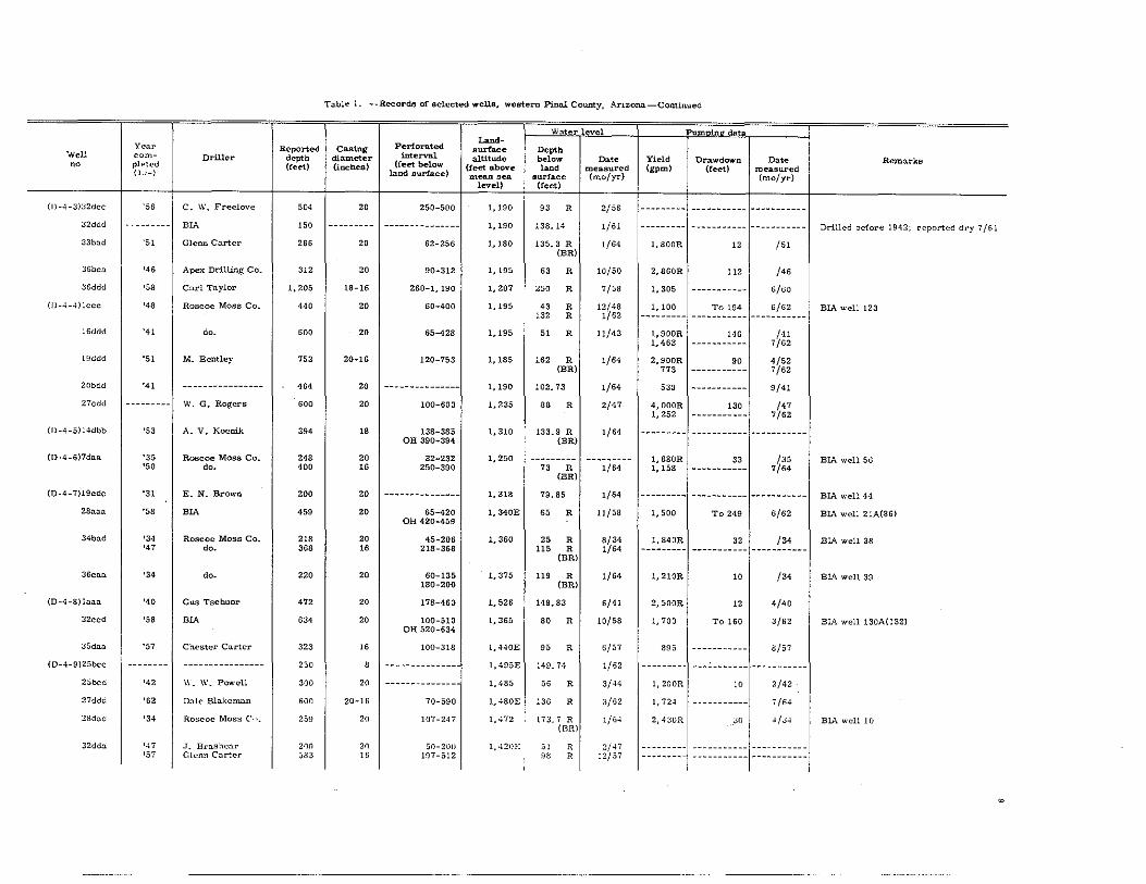
Table 1. --R.ecord6 of selected weUs, western Pinnl County, Arizona-Continued
W t r vel Pumuinll'da
Perforated Land-
Year Reported Casing aurface Depth Well com- Driller depth dia.meter interval altitude below 0.,. Yield Drawdown Date Remarks no pl.-ted (feet) (incnea) (feet below (feet above l=d measured (gpm) (rect) measured (1 J-) land aurface) mean sea. surface (mofyr) (mo/yr) level) (feet)
(1)-4-3):;2dcc '56 C. W. Freelove 504 20 250-500 1,190 93 R 2/56 --~-~---- ---~------~ --~~-------
32ddd --------- BIA 150 --------- --------------- 1,190 138.14 1/61 --------- ----------- ----------- Drilled before 1942; reported dry 7/61
33bad '51 Glenn Carter 266 20 62-256 1,180 135.3 R (BR)
1/64 1, BOOR 12 /51
36bca '46 Apex Drilling Co. 312 20 90-312 1,195 63 R 10/50 2,860R 112 /46
36ddcl '58 Carl Taylor 1.205 18-16 260-1.190 1,207 250 R 7/58 1.305 -----~----- 5/60
(1J-4-4)lccc '48 Roscoe Moss Co. 440 20 60-400 1,195 43 R 12/48 1,100 To 194 5/62 BIA well 123 132 R 1/62 --------- ----------- -----------
lSddd '41 do. 600 20 65-428 1,195 51 R 11/43 1,900R 146 /41 1.463 ----------- 7/62
l!)ddd '51 M. Bentley 753 20-16 120-753 1,185 162 R 1/64 2,900R 90 4/52 (BR) 773 ----------- 7/62
20bdd '41 ---------------- 464 20 --------------- 1,190 102.73 1/64 530 ----------- 9/41
27cdcl -----.--- W. G. Rogers 600 20 100-600 1,235 88 R 2/47 4,000R 130 /47 1.252 ----------- 7/62
(D-4-5)14dbb '53 A. V. Kocnik 394 18 138-385 1,310 133.9 R 1/64 -----._-- ----------- -------~---OH 390-394 (BR)
{D-4-6)7daa '35 Roscoe Moss Co. 248 20 32-232 1,250 --------- 1.880R 33 /35 BIA well 56 '50 do. 400 16 250-390 73 R 1/64 1,158 ----------- 7/64
(BR)
(D-4-7)19cdc '31 E. N. Brown 200 20 --------------- 1,318 79.85 1/64 --------- ----------- ----------- BIA well 44
28aaa '58 BIA 459 20 65-420 1,340E OH 420-459
65 R 11/58 1.500 To 249 6/62 BIA well 21A(86)
34bad '34 Roscoe Moss Co. 218 20 45-206 1,360 25 R 8/34 1.840R 32 /34 BIA well 38 '47 do. 368 16 218-368 115 R 1/64 --------- ----------- -----------
(BR)
36cna '34 do. 220 20 60-135 1,375 180-200
119 R (BR)
1/64 1.210R 10 /34 BIA well 39
(O-4-8)I<1aa '40 Gus Tsehuor 472 20 178-460 1,526 149.83 6/41 2.500R 12 4/40
32ccd '58 BIA 634 20 100-510 1,365 OH 520-634
80 R 10/58 1.700 To 160 3/62 BIA well 130A(I32)
35daa '57 Chester Carter 323 16 100-318 I,HOE 95 R 6/57 895 ----------- a/57
{D-4-9)25bcc -------- ---------------- 2~0 , --------------- 1,495E 149.74 1/62 -------- - ---------~- -----------25bcd '42 W. W. Poy{cll 300 20 --~---------- -- 1,485 56 R 3/44 1,200R 10 2/42
27ddd '62 Dale Blakeman 600 20-16 70-590 1,4S0E 136 R 3/62 1,724 ----------- j /64
2!ldad '34 Ro~coc Moss COl. 259 2n 107-24j 1,472 173.7 R (ER)
1/64 2.4:;I)R :;0 .. /34 BtA well 10
32dda '47 ,T. Brashear 200 20 50-200 1,42nE .,1 R 2/4j --------- ----~------ -----------'57 Glenn Corter 583 16 187-512 >.18 R 12/57 --------- ----------- ---------~-
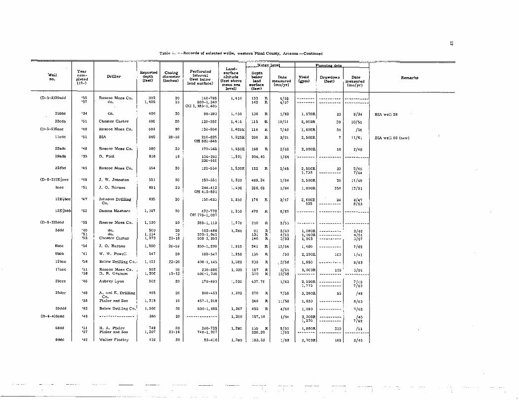
w

~
Tuble 1. --Recordll of selected wallll, western Pinal County, Adzooa-Corrtinued
Water evel- -----Pu '" ••
Perfora.ted Land-
Year Reported CaBing Burface Deptn Woll com- Driller depth diameter interval o.lUtude below Da« Yield Drll.wdown Dato RemlU'kli 00. pletcd (feet) (inches) (feet below (feet above l .. d measured (gpm) (feet) menllured (lu-) land surface) mean lIell surface (molYr) (molYr)
level) (feet)
(D-4-10)1:lddd '35 Roscoe Moss Co. 309 20 24-80 1,554 OH 165-309
32 R 1/62 2,020R 25 9/35 BIA well 7 A
130.0.a '60 Glenn Carter 110 16-12 20-100 1, SODE 11. 5 R 7/60 ------.-- ---.--.-_.- -----------28bdc '52 Roscoe Moss Co. 402 20 140-380 1.575E 150 R 1/52 2,400R 30 1/52
1,323 ------.---- 13/62
29do.." '62 RlA 622 20-16 170-524 1,5SDE 535-61<1
168 R 1/62 --.------ ----._----- --.-------- BLA well 2 (new); first water nt 180 feet
31nbb 'J< Roscoe Moas Co. 350 20 90-334 1.495 131 R 1/62 l,800R 15 4/34 BlA well 5
(D-5-2)211dd '46 W. R. Wiley 407 20 90-407 1,230 329;28 1/62 2,500R 25 1/46 932 ----------- 7/62
llddd '58 Mnrieopl1 Drilling 720 20 490-710 Co.
1,280 300 R 1/58 I, S10 ----------- 7/62
13dee '51 Al Godfrey 702 16 250-702 1,285 429.45 1/64 3,OOOR 16 4/51 1,320 ----------- 7/S2
21bbb '45 Roscoe Moss Co.' 400 20 --------------- 1,339 220 8/45 2,OOOR 40 8/45 '51 W. G. Rogers 505 16 200-495 333.00 1/63 735 ----------- 7/62
21bdd '47 Roscoe Moss Co. ---------- --------- ----- ---------- 1,330 334.45 1/63 --------- ----------- -----------25ccc '49 J. W. Johnston 602 20 15-S02 1,328 425.40 1/63 3,800R 16 3/49
1,375 ----------- 7/62
26cec '50 W. G. Rogers BOO 20 250-536 1,350 207.33 ·3/51 1, ODOR 110 1/50
(D- 5-3) 12cdd '52 Carl Tnylor 374 20 110-365 1.220 199.8 R (BR)
I/S4 3, DOOR 30 12/52
13b= '25 Thorn 587 20 --------------- 1,220 S6.40 3/42 1,840 32 9/41
17ecc '48 J. O. Barnes 586 20 140-586 1,247 105 R 2/48 3, DOOR 40 2/48
23add '56 Belew Drilling Co. 1,185 22-18 300-1,180 1,230 165 R 4/56 --------- ----------- -----------25ndd '46 Roscoe MOBS Co. 550 20 115-535 1,238 241. 05 1/S3 765 ----------- 7/64
28bee '51 Thompson Bros. 600 20 200-600 1,240 200 3/51 --------- ----------- -----------'62 Cecil Noel 1,005 16-14 400-1,005 191.58 1/63 --------- ----------- -----------
28cce '48 Thompson Bros. 600 20 169-589 1.250 95 R 6/48 2.200R 40 S/48 OR 589-600 1,360 ----------- 8/S3
30ncc '57 Punk Young 704 20 475-704 1,280 432 R (BR)
1/64 1,530 ----------- 7/S2
34ddd '55 Belew Drilling Co. 1,250 20 250-1,240 1,245 260 R 10/55 730 ----------- 8/S1
36cdd '45 C. W. Freelove 534 20 126-520 1,260 110 R 3/45 1,100 '0 3/45 '51 Roscoe Moss Co, 1.212 16 580-1,190 280 R 1/64 --------- ----------- -----------
(BR)
(D-5-4)4cdd '50 -- -------------- 1,100 20-16 -------------- 1,225 ---------- ----------- 1,500H To 420 161 8dcc '62 Pixler and Son 1.305 20 400-710 1,230 2<1 R 4/S2 1.380 ----------- 7/62
OH 721-1,305

[awl ... __ Records of »dected well», "'euten! i'mal County, Artzona -Contl.nlled
Water evel Pumoinll data
Perforated Land~
Y":'lr Reported Casing 8urfo.ce Depth. Well curn- DrlUer depth. diameter interval altitude below Dat. Yield Drawdown Dat. Remarks 00 pl .. tt·d (feet) (inches) (feet below (feet above ,=, measured (gpm) (feet) measured
(l ,-) land surface) mean sea surface (mo/yr) (mo/yr) level) (feet)
(IJ-.~-4)11IddrJ '44 8,11 C l'llLlC:1 450 20 150-260 1.27.1 I :)3.05 7/44 2,900R 45 7/44 OH 268-450
',,:; Carl Ta;.-·lur 650 18 -------------- ---------- ----------- 755 ----------- 8/61
21bdd '.">7 dr). 505 20 175-590 1,245 3()'. ,.0 1/63 --------- ----------- -----------2::1aan '50 \\. J. Crouch 520 20 200-500 1,305 402 R 1/64 2.300R 60 4/50
(BR)
Z8ddd '56 Pixler nnd Son 1,050 20-16 400-1,040 1,260 210 R 12/56 1,560 ----------- 8/63
2~.'lcd '52 \\. J. Crouch !:iS8 20 250-675 1,24;) 160 R /52 2,OOOR 100 /52
:;5ccb '41 C. W. Freelove 300 20 100-300 1,275 95 R 8/46 1,760 To 98 9/41 '55 DuSty'8 'Welding 920 16 300-900 180 R 2/55 2,200R 260 2/55
and Machine Co,
(IJ-.;-·)):Jlaad '52 M. Bentley 505 20-18 120-505 1,325 398 R 1/64 2,100R 72 1/52 (BR) 1,090 .-.-------- 4/52
:Jlacc '56 Gordon Cameron 1,000 18 200-597 1,305 240 R 12/56 410 ---.------- 7/62 .' OH 597-1,000
(D-5-1:i)28ddc '57 M. Wininger 350 12 150-350 1,450 115 R 11/57 --------- --_.------- -----------(D-5-7)8:::Ldb '56 A. V. Koenik 415 20 125-400 1,390 -115.50 11/56 I,OOOR 225 11/56 BlA well 41R
12E~'ddd -------- ----- -- -- ---- --- 357 20 --- -- --------- 1,385 ---------- ---.------- -----.--. ----------- -----------'57 Pixler and Son 1,005 16 385-1,005 126 R 10/57 --------- ----------- -----------
22add '35 Roscoc Moss Co, 210 20 62-180 1,385 59 R 1/46 2,060R 21 --.-------- BIA well 70 '60 --- ------------- 745 20-16 35-730 158.36 1/63 --------- ----------- --.---.----
OH 743-745
22bdc '34 Roscoe Moss Co. 230 20 91-93 1,385 24 R 5/34 3, 740R 21 5/34 BlA well 98 139-192
'58 BIA 903 16 230-890 134 R 9/58 2,000 To 172 3/62 OH 898-903 146 R 1/62
25W1-ad '40 Roscoe Moss Co. 228 20 146-214 1,400 182.74 1/62 1,800R 40 /40
25E~add '57 Clyde 1,940 20-12 - --------- ---- 1,400 167.00 9/57 --------- ----------- ----------- Salty water; reported temperature 130°F; well to be abandoned
28dcc '58 M. E. Henery 389 16 200-377 1,410 175 R 8/58 --------- ----------- -----------Well Drillinp; Co.
:;"ncd '63 John N. Lard 1.205 20-16 1.050-1,185 1,4411 270 R 8/63 l,270R ----------- 8/63 First wo.ter.at 1,100 fect, rose to 270 fect; temperature 107°F; water level higher tlmn in nearby wells
36Ekdan '57 A. V. Koenik 535 20-16 238-532 1,410 164 R 11/57 --------- ----------- -----------(D-5-8l11cdc '52 Roscoe Moss Co. 650 20 85-635 1,425 75 R 7/52 1, SOOR 90 7/52
13bca '51 Pixler and Son 418 20 107-400 1,450 107 R 7/51 1, SOOR 140 7/0.1
14cad '56 A. V. Koenik 730 20 140-696 1,44.,) 133.08 1/58 --------- ----------- ----------- BlA well 21 OH 704-730 148.82 1/64 600 ----------- 7/64
16dda '34 Roscoe Moss Co. 200 20 65-135 1,425 l~(] •• 11 1/62 2,110R 28 6/34 EIA well 29; recorder well
17baa ':;4 do. 421 20 60-230 1,-110 1511.72 1/64 1,210R 30 6/34 BlA well 31 OH 404-421
~
~
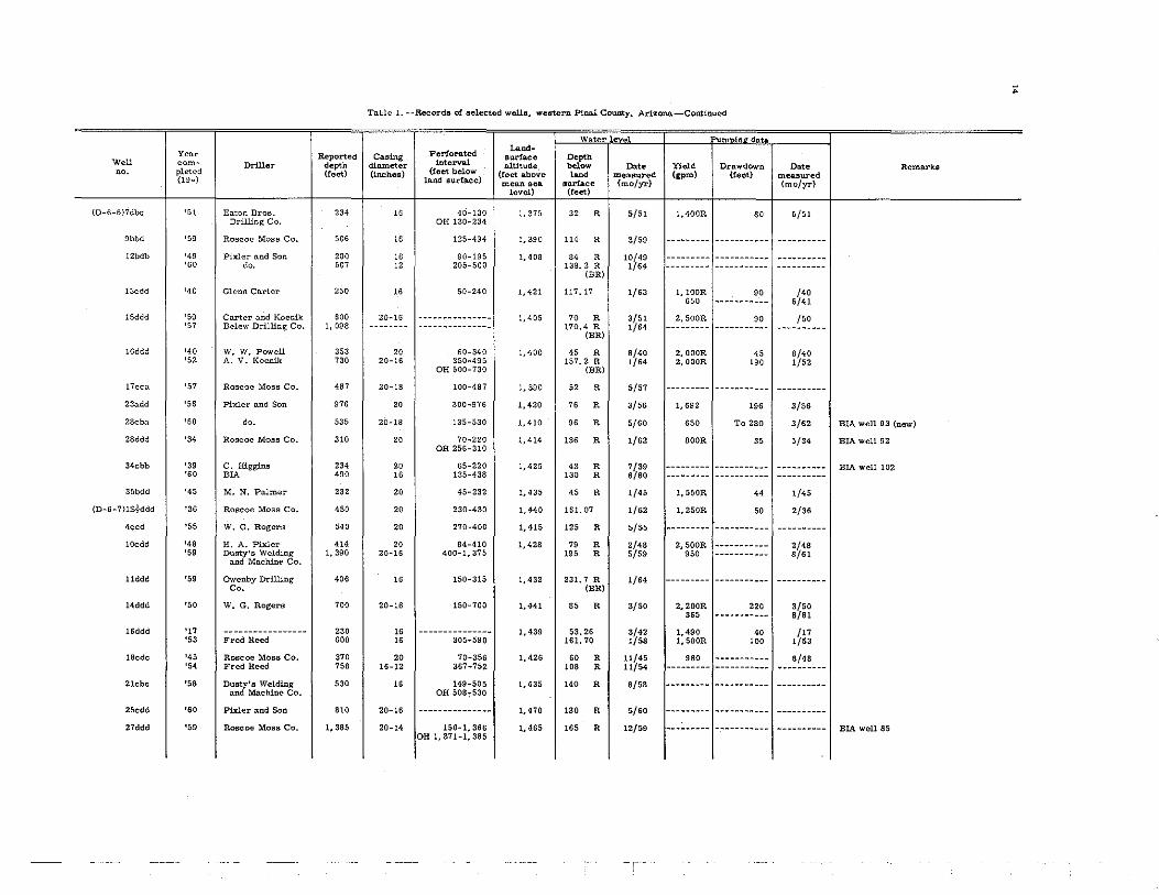
Ta.bl., 1. --Rccords or 6cleetcd wclll'l, western Pinal County, Arioz;on&-CoBtinued
Water ev • Perforated
Land-Year Reported Cl'Hling aurlllce Depth Woll eom_ Driller depth diameter lntervnl altitude bol~ Da,. Yield Drawdown Do'. Remarks no. pleted (reet) (inches) (teet below (feet above lond measured (gpm) (leet) measured (19-) land surface) mean Bell surface (mo/yr) (mo/yr)
level) (feet)
{D-;'-8)ZOadd '55 Roscoe Moss Co. 802 20 140-785 1.410 133 R 4/55 -._----- -------._- -----------'57 do. 1,405 16 800-1,340 142 R 4/57 -------- .--._----- -.--------. OH 1,385-1,405
25bbc '34 do. 406 20 98-392 1,450 136 R 1/62 1,570R 23 6/34 BIA well 26
32cdn '51 Cheater Carter 400 20 120-380 1.415 115 R la/51 2, DOOR 20 la/51
(O-5-9l6an., '40 Roscoe Moss Co. 504 20 120-504 1,425E 118 R 7/40 1,600R 34 /50
lledc '61 BlA 845 20-16 210-625 1,52SE OH 831-845
206 R 3/61 2, SOaR 7 11/61 BIA well 80 (new)
22adc '48 Roscoe Moss Co. SSO 20 170-568 1,550E 168 R 2/48 2,000R 10 2/48
29ada '35 D. Paul 616 16 134-266 336-440
1,521 204.45 1/64 -------- ---------- -----------32dbd '45 Roscoe Moss Co. 554 20 122-554 1,530E 122 R 2/45 2,500R 32 2/45
1,753 ---------- 7/64
(D-6-211Ekccc '49 J. W. Johnston 551 20 150-551 1,333 489.24 1/64 3,500R 20 11/49
3000 '51 J. O. Bn.:t'nes 891 20 244-412 OH 412-891
1,406 296.05 1/64 1,000R 350 12/51
12EJbcc '47 Johmlon Drilling 635 20 150-635 1.350 176 R 3/47 2,600R 24 3/47 Co. 525 ---------- 8/63
13E}bbb '62 Damon Mashorc 1,007 20 470-778 OH 778-1,007
1,350 470 R 6/62 -------- ---------- -----------
(D-6-3)2ddd '55 Roscoe Moss Co. 1,130 20 285-1.115 1,270 210 R 2/55 -------- ---------- -----------3ddd '40 do. 500 20 102-486 1.265 91 R 2/40 1,000R ---------- 2/40
'51 do. 1.114 16 390-1,041 131 R 4/51 1, ODOR ---------- 4/51 '53 Chester Carter 1,270 20-16 500-1,250 140 R 3/53 1,505 ---------- 5/57
'bo, '54 J. O. Barnes 1,200 20-18 350-1,200 1,310 241 R 12/54 1.480 ---------- 7/62
9bbb '41 W. W. Powell 547 20 15"0-547 1,259 155 R /50 2.200R 100 1/41
15bcc '56 Belew Drilling Co. 1,151 22-20 400-1,145 1.305 205 R .. 3/56 1,950 ---------- 8/63
17acc '51 Roscoe Moss Co. 592 20 200-580 1.335 187 R 3/51 3.000R 125 3/5'1 'SS D. B. Grnh:l.m 1.200 16-12 600-1.200 370 R 12/58 -------- ---------- -----------
23ccc '46 Aubrey Lyon 502 20 170-490 1,330 437.76 1/63 2.500R ---------- 7/46 1.775 ---------- 7/62
25dcc '48 A. and E. Drilling 465 20 200-450 Co.
1.325 270 R 7/58 3,200R 55 /48
'SS Pixler and Son 1.215 16 457-1.210 340 R 11/58 1.630 ---------- 8/63
35ddd '52 Belew Drilling Co. 1.500 20 500-1,485 1,367 455 R 4/62 1,990 ---------- 7/62
{D-6-4)3cdd '45 ---------------- 360 20 -------------- 1,290 157.10 1/64 3.200R ---------- i45 1,270 ---------- 7/62
6ddd '51 H. A. Pixler 740 20 200-725 1,280 155 R 9/51 1,800R 230 /51 '57 Pixler and Son 1.207 20-16 740-1,207 226.26 1/63 -------- ---------- -----------
9ddd '42 Walter Findley 410 20 85-410 1,290 183.53 1/63 2,700R 165 2/42

Table 1. - -Recorda of selected wells, wester, f'tnal Courrty, Arizona-Continued
Watel;' v., Pumoina datil.
Perforated Land-
Year Reported Casing surface Depth Well com- Dri11c:- depth diameter interval altitude below Dat. Yield Drawdown Date Remarks no pl<:'tcd (feet) (inches) (feet below (feet above l=d measured (gpm) (feet) measured (l )-) land surface) mean sea surface (mo/yr) (mo/yr) level) (feet)
(J)-n->-I)l::1.:ldd '42 V. alter Findley 320 20 100-320 1.320 1,''-'.85 1/62 2,500R 25 /42 1,220 ----------- 7/62
17ded '51 Roscoe Moss Co. 1,294 20 175-450 OH 470-1,294
1.295 165 R 10/51 1.805 ----------- 8/63
19cdd '45 Chester C.:lrter 446 20 134-430 1,305 129 R 11/45 2,200R ----------- /45 1,420 --------~-- 8/63
22dd.:l '45 W. J. Schnaufer 606 20 90-520 1,315 141 'R 5/45 2,200R 55 5/45
25.:ldd '51 C. R. Clyde 396 18 204-396 1.340 168 R 4/51 --------- ----------- -----------'55 Belew Drilling Co. 1,003 18-16 250-750 226 R 1/55 1.460 ----------- 7/62 OH 756-1,003
27ddd '52 R. and C. Drilling 570 18 186-570 1.325 165 R 2/51 --------- ----------- -----------Co.
'57 Pixler and Son 1,035 18-14 560-1,030 280.50 1/58 1,055 ----------- 7/60
31ccc '60 Dusty's Welding 1,400 20-16 400-1,400 1,339 445.04 1/64 2,320 ----------- 7/62 and Machine Co.
::l::Jauu '44 Chester Carter 400 20 150-400 1,320 135 R 1/44 2.000R ----------- 1/44 '56 Belew Drilling Co. 1,000 16 380-995 392.6 R 1/64 --------- ----------- -----------
(BR)
3>-1ddd '46 Chester Carter 406 20 112-385 1,335 279.5 1/58 2,200R 40 2/46 1,865 7/62
36ddd '41 W. J. Schnaufer 650 20 106-630 1,350 102 R 1/41 2,400R 23 /41 '56 Pixler and Son 1,240 OH 630-1.240 236 R 1/56 3,000R ----------- 4/56
-,
1,235 ----------- 7/62
(O-6-5)I4bcc '51 W. G. Rogers 240 18 60-240 1,355 43 R 10/51 1,000R 90 10/51
16add '40 ----------------- 200 20 65-161 1,345 63.86 1/64 --------- ----------- -----------18ddd '53 V. Owens 900 20-18-16 270-880 1,328 250 R 6/58 360 ----------- 8/61
21add '51 James Johnston 400 20 120-365 1.355 --------- --------- 365 ----------- 8/63
22dbb '60 Pixler and Son 200 20 75-155 OH 157-200
1.360 63 R 6/60 --------- ----------- -----------25ccc '36 Roscoe Moss Co. 102 20 33-102 1,384 55.25 1/63 1,210R 14 5/36 BlA well 87; recorder well
27cdd '51 J. W. Johnston 198 20 70-198 1,365 64.50 10/51 300R ----------- 9/51 Abandoned
2!I.:ldd '48 G. Van Horn 500 26 0-500 1,350 202.14 1/63 1,10OR 20 2/48
30ddd '51 - --------- ------- 278 20 135-278 1,3>-19 --------- --------- --------- ----------- -----------'54 v., ... G. Rogers 1,010 16 278-1,010 369.9 R 1/64 1,600R ----------- 4/54
(BR) 768 ----------- 1/62
33cdd '51 Pixler .:lnd Son 412 20-16 170-400 1.370 155 R 9/51 800R 259 9/51
36aaa '39 C. Hi~~ns 114 20 32-111 1.31Hl 41. 10 3/41 --------- ----------- ----------- BlA well 105
(0-6-6)4.:la;). '50 R. McCartncy 385 16 100~3S0 1,426 116.71 1/56 1,SOOR 25 3/50 OH 380-385 550 ----------- 7/64
7=b '26 Art Young 150 16 - ------ --- ---- 1,391 136. :30 1/63 90DR 70 /26
~'
" Tnldc 1. --Recorda of aelected wella, western Pin.lll. County. AI:'i:l:ono.-Contlnued
W tel' • in at
Yelll' PerlOro.ted La""-Reported Casing surface Depth.
W.ll com- D1"111er depth diameter interval nlUtude b"~ I».t. Yield Drllwdown Date Remarks nn. pletcd (feet) Unch.ea) (teet below (feet above l~d measured (gpm) (teet) measured {Hlw} land surflLCe) menn scn !Jurfaco (moJyr) (mo/yro} level) (feet)
(D-6-6)7dbc '51 Ea.ton BroB. 234 16 40-130 1,375 32 R 5/51 1.400R 80 5/51 Drilling Co. OH 130-234
9bbd '59 Roscoe MOBS Co, 506 16 125-494 1,390 114 R 3/59 --------- -----.--.-- ----.-----12bdb '49 Pixl cr nnd Son 200 16 90-195 1.408 84 R 10/49 --------- ------.---. ----------
'60 do. 507 12 205-500 138.2 R 1/64 --------- ------.---- ----------(BR)
13cdd '<0 Glenn COoMer 250 16 50-240 1,421 117.17 1/63 I, IOOR 90 /40 650 --------.-- 6/41
15ddd '50 Curter nnd Koenik 600 20-16 ---- --- -------- 1,405 70 R 3/51 2,500R 90 /50 '57 Belew Drilling Co, 1,098 -------- ------ ---- ----- 170.4 R 1/64 --------- ----------- ----------
(BR)
16ddd '40 W. W. Powell 353 20 60-340 1,400 45 R 8/40 2,OOOR 45 8/40 '52 A. V. Koenik 730 20-16 350-495 157.2 R 1/64 2,000R 100 1/52
OH 500-730 (BR)
17cca '57 Roscoe Moss Co. m 20-18 100-487 1,390 52 R 5/57 --------- ----------- ----------23add '56 Pixler and Son 976 20 300-976 1,420 76 R 3/56 1.692 196 3/56
28cba '60 do. 535 20-18 135-530 1,410 96 R 5/60 650 To 280 3/62 BIA well 93 (new)
28ddd '34 Roscoe MOBS Co. 310 20 70-220 1,414 OB 256-310
136 R 1/62 800R 35 5/34 BIA well 92
34cbb '39 C. Higgins 234 20 65-220 1,425 43 R 7/39 --------- ----------- ---------- BIA well 102 '60 BlA 490 16 135-438 130 R 6/60 --------- ----------- ----------
35bdd '45 M. N. Palmer 232 20 45-232 1,435 45 R 1/45 1,550R 44 1/45
(D-6-7)lSkddd '36 Roscoe Moss Co. 450 20 230-430 1,440 161. 07 1/62 1,250R 50 2/36
4ccd '55 W. G. Rogers 540 20 270-400 1,415 125 R 5/55 --------- ----------- ----------10cdd '48 H. A. Pixler 414 20 84-410 1,428 79 R 2/48 2.500R ----------- 2/48
'59 Dusty's Welding 1,390 20-16 400-1,375 105 R 5/59 950 ----------- 8/61 and Mnchlne Co.
11ddd '59 Owenby Drilling 406 16 150-315 1,432 231. 7 R 1/64 --------- ----------- ----------Co. (;BR)
14ddd '50 W. G. Rogers 700 20-16 150-700 1,441 85 R 3/50 2,200R 220 3/50 365 ----------- 8/61
16ddd '17 ----------------- 230 16 --------------- 1,439 53.26 3/42 1,490 40 /17 '53 Fred Reed 600 16 305-590 161.70 1/58 1,500R 100 1/53
18cdc '45 Roscoe Moss Co. 370 20 70-356 1,426 60 R 11/45 980 ----------- 8/48 '54 Fred Reed 758 16-12 367-752 108 R 11/54 --------- ----------- ----------
21cbc '58 Dusty's Welding 530 16 149-505 1,435 140 R 8/58 --------- ----------- ----------and Machine Co. OH 508~530
25cdd '60 Pixler nnd Son 810 20-16 --------------- 1,470 180 R 5/60 --------- ----------- ----------27ddd '59 Rol:lcoe Moss Co. 1,385 20-14 150-1,366 1.465
OB 1.371-1,385 165 R 12/59 --------- ----------- ------.--- BIA well 85
Wei:. no
(D-6-7)32aaa
33dbd
35add
(D-6-8)3N}aaa
4S~add
5S~CCd
3dcc
10add
17dbc
18acc
22ccb
24bdd
27ddd
28dbb
(D-6-9)6dcd
7caa
lBbda
33bad
(D-7 -4 )2dcc
4ddd
Ileac
12E}dda
13W~·aad
Yt'ur complt'ted (lJ-)
'47 '58
'48
'57
'64
'39
'37
'36
'56
'52
'56
'59
'56
!51
'59
'59
'58
'59
'48
'57
'47 '55
'48 '60
'49
'41 '55
Dnller
Pixler and Son ElA
O. R. Reed
Glenn Carter
Crouch Drillers
Glenn Carter
Roscoe Moss Co.
W, W. Powell
Chester Carter
Roscoe Moss Co.
Joe Koenik
Carl Taylor
Pixler and Son
Roscoe Moss Co.
Blackwood
ElA
Joe Koenik
David Graham
Thompson Bros.
Douglas Chenowth
Chester Carter do,
Floyd and Rush Dusty's Welding
and Machine Co.
Chester Carter
Lyon Bros. Travis Mosley
Reported depth (feet)
372 1,000
400
424
2,305
218
600
252
806
501
505
501
800
604
1,212
1,050
1,077
1,402
1.100
1,000
400 910
502 1,000
9::10
482 "'0
Tal,.'·1.--Records of selected wello, western Pinal County, Arlzona-Continued
Casing diameter (inches)
20 16
20
20
18-14
20
20
20
20
20
20
16
20
20
Perforated interval
(feet below land surface)
70-330 160-941
OH 941-1, 000
70-238 OH 350-400
220-410
440-520 1,900-2,305
73-203
70-600
56-236
126-804
140-482
150-484
180-485
155-790
168-586
20-16 180-525
20-16
20
20
20-16
20
20 16
20 16
549-1,165 OH 1. 165-1, 212
150-1,045
150-1,060
250-1,400
250-1, 09~
210-870
1:,4-390 400-900
140-435 485-1,000
'0 1---------------211 -------~~;=;6;-
Land surface altitude
(feet above mean sea
level)
1,450
1, 465
1.475
1,430E
1,430
1,430
1.445
1,450
1,450
1,445
1,455
1,490
1,480
1,480
I, SlOE
I, SlOE
1,500E
1,600E
1,340
1,332
1,340
1.360
1,355
WAter level
Depth below l~d
surface (feet)
52 R 171.53
196.5 R (BR)
220 R
200 R
17S.2 R (BR)
100 R
42 R
126 R
161.10
150 R
190 R
125 R
98 R
130 R
100 R
150
214. SO
300
193.96 186.15
165.54
R
R
295 R
214.~2
111. 43 :.l33.50
Date measured (mo/yr)
5/47 1/62
1/64
12/57
4/54
1/64
10/50
1/36
S/56
8/52
4/56
4/59
2/56
5/51
8/59
2/53
9/59
1/64
5/57
2/51 1/64
2/52 4/60
2/54
:.l/42 2/6".'..
Yield (gpm)
m))inQ: data
Drawdown Date (feet) measured
(mo/yd
--------1-----------1----------1,850 174 S/58
1, SOOR 40 2/43
1,650 ,-------~--- 7/64
-----------1 ----------
1,650 9/41
I, DOOR I 210 I /37
2, DOOR 20 /36 1,000 ----------- 6/60
1, SOOR
1,255 965
2,OOOR 875
900 705
75
160
1/52
8/57 7/64
5/51 7/64
7/51 7/54
Remark..-
BIA well 115
BlA well 31
1,600 To 320 I 6/62 I BlA well 114R
--------,-----------, ----------, At well depth 900 feet, w..ter level 165 feet; at well depth 1,075 feet, water level 110 feet; after well perforated, water level 96 feet
-----------1----------500R 150 6/4S
-----------1 ----------2, SOOR I 50 /47
2,700R
2,300R
2,060 1, 100
260 1 1/48 ----------- --~----~--
25
1::::::::---
/40
8/41 !j /61
0'

~
Table 1. --Records of selected W611B, wemeJ;'n P1nAl County. Arizona-Continue(!
W r ~e Pum In dn lAnd-
Year' Reported Cnsing Perfora.ted Burfllce Depth Well com- Driller depth dituneter interval altitude bel~ 0. .. Yield DrawdQWD Oat. Remarks 00. ph-ted (feet) (inches) {reet below (teet above 1M" mealJUred (gpm) ~..t) measured (19-) land Burface) meaD Ilea surface (molYr) {mo/yr}
level) (feet)
(D-7-4117cdd '62 Belew Drilling Co. 1.490 20 500-1,155 OR 1,205-1,490
1,410 468 R 3/62 -------- ----------- ----------
22ddd 'S> C. E. Williams 808 20 180-400 OH 400-808
1,360 300.70 1/64 1.400R 202 6/51
24W}ddd . '41 Roscoe MOBS Co. 505 20 .- --- ---------- 1.370 277.96 1/61 3,160R 30-40 /41 2,180 -------._-- 9/61
25Eludd '51 W. G. Rogers SOO 20 180-570 1,380 217.99 1/55 2,300R 33 2/51
(D-7-5)5ddd '41 Roscoe Mosa Co. 450 20 _________ v ___ w_
1.374 --------- -~~~~--~-- -------- ----------- ----------'54 Chester Curter 695 OH 366-695 338,86 1/64 2.200R 100 5/54
geed '51 Pixler and Son 524 20 200-512 1.380 1>4 R 12/51 . 2.200R 90 12/51
18dee '58 Belew Drilling Co. 1,397 20 400-830 OR 838-1. 397
1,380 2" R 2/58 -------- ----------- ----------21ded '51 L. G. Adru:ns "5 18 175-383 1,400 --------- -----_.-_. -------- ----------- ----------
'52 M. Rayburn 510 15 OH 383-610 150 R 4/52 1.400R 220 4/52
(D-7-611ddb '58 BJA 893 20-15 170-893 1,450 135 R 5/58 1,780 190 8/58 BlA well 91
5ded '55 ----------------. 505 20-15 70-220 OH 220-505
1,410 65,84 10/56 -------- ----------- ---------- Measured well depth, 275 feet (1955)
6ddd '50 W. Findley 273 20 55-81 OH 90-273
1,415 69 R 9/50 540R 34 4/50
12ecd '37 Roscoe Moss Co, 42. 20 68-411 1,465 61.15 8/41 1.000R 70 2/37
20dcd '52 R. and C. Dri1l1ng 554 20-15 344-554 Co.
1,450 105 R 10/52 1,250R 150 10/52
20ddd '55 W. E. Dunigan 400 20 165-400 1,451 ._-._---- ---------- -------- ----------- ----------27dda --------- ----------------- 210 15 --------------- 1,480 153 R
(BR) 1/64 -------- ----------- ----------
28ddd '48 !som and Howk 458 20 150-468 1,465 135.32 1/64 5,600R 25 /48 2,240 ----------- 6/57
29udd '57 Cecil Noel 535 20 115-265 OR 283-535
1,455 110 R 2/57 490 ----------- 6/59
31aad '49 W. G. Rogers 522 20 90-200 1.450 90 R 8/49 700R 90 8/49 OH 200-522
31ccc '55 Cecil Noel 840 20 125-288 1,453 102 R 5/55 -------- ----------- ---------- Water encountered llt 120 feet. rose to OH 296-640 102 reet; water temperature 104·F at
400-405 feet
36ddd '52 0, and R. Drilling 1,020 20 875-930 1.505 --------- ---------- 1.395 ----------- 7/64 Co. OH 940-1,020
(D-7-7)lbcd '18 ----------------- 200 20 --------------- 1,485 --------- ---------- 2, ODOR 100 /18 '53 Fred Reed 600 16 200-590 160 R 3/53 800R 200 3/53
Idee '54 C. T. Henderson 1.791 20-16 700-1,791 1,493 --------- ---------- -------- ----------- ----------3ddd '44 Roscoe Moss Co. 420 20 90-405 1.485 238 R 1/64 1,500R 100 9/44
(BR)

fabl" 1 •. Records uJ ",d",ct.;:d wd1", W"'Btern } .. ..i.l County, Arizona-Continued
t ~~ter eve! Pum inlt data
I Land-Y", ... r Reported Casing Perforated surface Depth W,ll com- I Driller depth diameter interval altitude below Date Yield Drawdown Date Remarks 00 pl ... t".:! (feet) (inches) (feet below (feet above lan<:l measured (gpm) (feet) measured (l 1-) land surface) m<:'an sea I surfac .... (mo/yr) (mo/yr:
levt'U (fe~t)
I (fl-, -; ),"Iddd '46 Aubre,\' 1.:\.'011 6110 20 100-590 1,-+'.'\1 21', iH 1/63 1. -+uOR 100 4/46
llcdd '4) ----------------- 600 20 --------------- 1, 4~'5 ::! 14 R 1/64 1,870 ----------- 9/41 (BR) 820 ----------- 6/57
22ddd '57 Owenby Drilling: 800 16 200-800 1,520 236.69 1/63 245 ----------- 7/62 Co.
~2cdd '48 Roscoe Moss Co. 1,432 20 340-1,000 1,516 216. ~I) 1/63 1,330 ----------- 7/64
:33o.dd '," \\. Findl",y 612 20 135-600 1,525 217, 2~ 1/63 1, SOOR 216 5/48
35dcc 15/:1 John MeMnhon 550 16 247-545 1,540 245 R 4/58 ----------- ----------(D-7-S)lded '52 D, D. Paul 400 20 90-380 I, SLOE 122.94 1/56 1,800R 90 4/52 Reported destroyed (1957)
:;adn '61 Chester Carter 628 20 180-626 1,500 160 R S/61 ----------- ----------"dec '36 Roscoe Moss Co. 408 20 120-395 1,503 238 R 1/64 2,200R 26 /38
(BR) 1,440 ----------- 9/41
"ddd '45 do. 500 20 100-485 1,521 243 R lBR)
1/64 2,OOOR 150 3/45
16ddd '62 Dale Blakeman 1,260 20 250-1,150 1,535 230 R 5/62 990 ----------- 7/64 Driller rcports "salt showing from 1,145 to 1,260"
19cdd '57 Owenby Drilling 602 20 220-595 1,530 208 R 12/57 ----------- ----------Co.
19dad '51 Fred Reed 600 20 170-590 1,530 174 R S/51 2,200R 100 S/51
23ced '46 ----------------- 550 20 ----- ---- -- ---- 1,540E 256.70 1/62 2,l00R ----------- /46 715 ----------- 9/61
2Scdd '46 N. T. Olson 674 20 146-640 1,555 298 R 1/64 2,OOOR 245 7/46 (BR) 2,480 --------~-- S/48
32cdc '5S Owenby Drilling 1,000 20 310-990 1,560 323 R 9/58 ----------- ----------Co.
34edd '46 Roscoe Moss Co. 540 20 160-520 1,570 132 R 10/46 2,260 ----~------ S/4S '55 D. B. Graham 1,025 16 515-1,016 228 R 3/55 1,320 ----------- 7/62
36ddd '47 C. Lindsey 500 20 134-486 1,5S0E 235. uS 1/57 3,OOOR 8 /47 1, 170 ----------- 9/61
(lJ-8-(,)3add '46 Thompson Bros. 800 18 200-800 1 ... 3" 188. 1/53 3, ZOOR 15 /46 2,45u -~--------- 7/4'cl
5ddd '53 Roscoe Moss Co. 430 20 --------------- 1,475 IS7, l·" 1/63 1,600R 126 0/53 Chuieilu weil 9
Ilddc '62 Pixler and Son I, 100 20-1S 400-1,Oflll 1,510 325 R 5/62 ---~------- ----------26ddd '58 Hillis and Crouch 1,5Q5 16 700-780
OH 780-1,505 1,539 182. S() I/Oj8 ---~------- .---------
27ddd '47 Aubrt':"· J yon 533 2(] HJ,,-526 1,530 16S •. ~7 1/ ,i/:l 2, "OOR 40 7/47 1,:;lEilJ ----------- 7/:tfj
29ddd '41 Roscoe Mu!>s Cu, :;,'58 20 78-:;26 I, 51i~1 66 K 1/~ 1 1, lJ211 ----~-----~ 8/41 '56 J)Ugty',,; \\eldin~ ,Z,O 14 31111-lilill 227,li:, 1/ (j:; 112 ----------- 7/61
and Machine (,rJ. O!! 6:;6-7511
:;

~
Table 1. --Recorda of selected wells, western Pinal County, Arizona_Continued
, , , W e" e m " d.
Perforated Land~ Year Reported Cusing surface Deptb Well com- Driller depth diameter interval altitude bcl~ Date Yield Drnwdown Datc Remarks M. plet(>d (reet) (incites) (reet below (feet above l~d mea6Ured (gpm) (feet) measured (1:.1-) land 8urfll.CC) mean nea 8urface (mo/yr) (mo/yr) level) (feet)
(D-8-6)31ccb '51 -- -.-- --- .-- --.-- 500 20 130-300 1,523 156.00 1/58 --------- ----------- ----------OH 312-600
33dbb '55 Duaty's Weldin!! 500 20-16 ·180-495 1.520 231. 18 1/63 --------- ----------- ----------and Machine Co,
35ddd '46 Aubrey Lyon 770 20 170-650 1,545 166.45 1/64 --------- ----------- ----------(D-S-7)laad '45 Roscoe Moss Co. 620 20 160-600 1,555 150 R 3/46 1,200R 300 3/46
30dd '49 Pixler nnd Son 5>2 20 200-490 1,545 258 R 1/64 1,800R 53 3/49 (BR) '" ----------- 7/63
5cdd '50 J. W. Johnston 725 20 180-726 1,525 llS R 3/50 1,970R 122 3/50
9:ldd1 '39 W. W. Powell 418 20 110-418 1,544 284.52 1/64 970 ----------- 9/41
9ndd2 '58 Owenby Drilling Co. 1,507 15 1,000-1,495 1,544 305 R 11/58 250 ----------- 3/59
llddc 'SO 0, :lnd R. Drillin/j; 1,217 20-16 690-1,215 Co.
1.570 320 R 8/60 --------- ----------- ----------15dnd '37 Roscoe Mosa Co, 350 20 ---- --- --- ----- 1.565 --------- ---------- --------- ----------- ------.---
'50 W. G. Rogers 552 20-16-14 --- ---- --- ----- --------- ---------- 1.400R 280 6/50
20dd:l '51 Roecoe Moss Co. 1.094 20 400-1,070 OH 1.082-1.094
1,560 195 R 4/51 1.200R 125 4/51
21ddd '48 Robinson :lnd 1,697 20-14-12 143-1.697 1,570 250.95 1/62 2, ;lOOR 65 /48 Muson 510 ----------- 7/64
26ddd '62 0, and R, Drilling 1.000 20 270-995 Co.
1,605 270 R 4/62 495 ----------- 8/62
30acc 'SO do. 1,200 16 500-960 1.552 205 R 7/60 --------- ----------- ----------OH 965-1,200
3bdd '45 Roscoe Moss Co. 992 20 250-980 1,595 117 R 5/41)' 2.500R 300 5/46 1,600 ----------- 7/52
35d:ld '62 O. :lnd R. Drilling 1.215 16-12 250-1.210 1,610 250 R 4/62 --------- ----------- ----------Co.
(D-8-8)4cd:l '52 D. D. P:lul 550 20 100-545 1,570 102 R 3/52 1,900R 79 3/52
8bbb '61 O. :lnd R. Drilling 1.200 15 370-1,195 Co.
1.570 370 R 8/61 800R 20-30 9/61
9bdd '62 Pixler and Son 1,278 20-16 425-1,278 1.585 270 R 2/62 --------- ----------- ----------12dcc '48 Thompson Bros. 1,010 20-16 193-1,010 1,615 265.57 1/57 2.500R 20 2/48
2.120 ----------- 8/48
20ddd '58 Owenby Drilling Co. 2,508 16 400-2,500 1,612 2.0 R 10/58 2,755 ----------- 7/63
22cdd '51 C. F. Walters 1,002 16 230-982 1,625 214 R 11/51 2,200R 227 11/51
27ddd '60 O. and R, Drilling 1.000 20 475-995 Co.
1,640 320 R 12/60 1.630 ----------- 7/63
29bccl '36 W. W. Powell 350 20 150-350 1.615 170 R 3/45 ;l.OOOR 15 ;l/;l6 '52 Roscoe Moss Co. 410 15 345-404 230 R 12/52 2.500R 100 12/52

Table 1 •. Records of selected wells, western Pinal County. Arizona-Contmued
Water evel ~mnin data
Perforated Land~ Y/;,flr Reported Casing Burface Depth Well com~ Driller depth diameter interval altitude below """ Yield Drawdown Date Remarks 00 ph>h'u (feet) (inches) (feet below (feet nbove lMd measured (gpm) (feet) measured (l ,~) land surface) mean sea lIurface (mo/yr) (mo/yr} level) (feet)
(D-B~a)2:Jbcc2 '47 Chester Carter 1,386 20 1, 100~l, 386 1,615 112 R 7/47 2,000R 92 7/47 '51 Roscoe Moss Co. 1,685 12 I, 385~1, 675 160 R 1/51 ~-~----~- -~--------- ----------
:nadd '40 do. 660 20 120-660 1,630 350 R 1/64 360 ----------- 7/64 (BR)
33add '51 D. Graham 1,296 20 250-1,296 1,640 344 R 1/64 2,600R 100 2/51 (BR) 2,300 ----------- 7/52
(D-s-nJlBcdc '58 A. V. Koenik 1,160 20 300-1,140 1,645 305 R 3/58 --------- ---------~- ----------OH 1.152-1,160
(1)-8- G )l3I:: ;'add '50 Roscoe Moss Co. 930 20 125-912 1,570 244 R 1/64 1,090 ----------- 7/64 (BR)
24E~ddd '47 Thompson Bros. 1,200 20 110-1,100 1,580 99.30 2/49 2,800R 90 4/47 OR 1,100-1,200 1,7BO ----------- 6/59
(D-.!.I-7)2cdd '40 Aubrey Lyon 562 20 146-562 1,615 120 R 3/40 1,900R 16 /40 1,530 ----------- 7/52
13daa '61 O. and R. Drilling I, 130 16 485-1,080 1,645 355· R 11/61 --------- ----------- ~---------Co. OH 1,085-1.130
15ddd '40 Aubrey Lyon 600 20 165-420 1,622 244 R 1/64 2,500R 40 7/40 (BR) 1,540 ----------- 7/48
18ndd '52 D. Graham 1,200 20 400-1,180 1,580 265.79 1/63 2,100R 272 12/52 1,370 ----------- 6/60
23ddd '42 Roscoe Moss Co. 570 20 135-520 1,643 256 R 1/64 1,200 ----------- 8/44 (BR)
25ddd '61 Thomas Wheat 1, 125 16-10 580-1,100 1,660 --------- --------- --------- ----------- ____ w _____
OH 1,100-1,125
27add '41 Roscoe Moss Co. 670 20 w _____________
1,630 235,75 1/63 2,OOOR 14 8/46 1,540 ----------- 7/48
29ddd '51 do. 1,242 20 400-1,226 1,602 182.69 1/63 3.150R 50 4/51
36add '40 do. 550 20 150-530 1,660 129 R 2/40 2,800R 40 /40 (D-9-8)3aao. '59 A. V. Koenik 600 10 300-600 1,655 300 R 6/59 --------- ----------- ----------
5dcc '59 Owenhy Drilling 1,200 16 270-1,150 Co.
1,645 280 R 4/59 --------- ----------- ----------Gcdd '40 Roscoe Moss Co. 710 20 156-698 1,664 104 R 2/40 2,500 ------~---- 9/41
'60 David Graham UlO 16 700-900 315 R 12/60 --------- ___ w _______
----------Sddd '52 \o\'altcr Bros. 803 20 210-803 1,670 220 R 5/52 2,700R 80 5/52
1.615 ----------- 7/63
17cdd '37 y.". Snoffn(.'r 600 20 -- ---- ---- ---- 1,665 ::143.92 1/64 1,220 ----------- 7/48
19ddd '51 Ro~coe MOBS Co. 1,450 20 400-1,364 1,67::! ZOO R 6/51 3,05()R 50 H/:>! OH 1,364-1.450 I, 175 ---------.- 7/v3
21dba '51 David Grah::tm I, sou 20 222-1.243 1,685 triO R :3/51 -------~- -.--------- _____ w ____
Wnter rose from 206 to 190 feet at Of{ 1,26;'-1. ;jOn depth of 1,198-1,209 feet
~

Year Reported W,ll com- Driller depth no. pletC'd (feet) (lU-)
(D- 9 -8) 22ddd '40 .- ----------- ---- 600
25ddd '58 Forrest Aikins 890
32do.d 'SO O. and R. Drilling 925 Co.
35bao. '62 Roscoe Mosa Co. 850
35ddd '41 Aubrey Lyon 620
(D-9-9)24dde '51 W. Aldridge 566
34ddd '40 ---- --- ----- ----- 600
{D-9-10)17ndd '62 O. nnd R. Drilling 1,365 Co.
1Sa.dd '53 E. Dottor 865
20dnn '62 O. nnd R. Drilling 1,365 Co.
29~ '52 Western Drilling 660 Co.
'60 O. o.od R. Drilling 1,410 Co.
(D-I0-6)11ndn '61 do. 600
(D-I0-8)10= 's< Wa.ltcr Bros. 490
103Jld '58 Owenby Drilling 715 Co.
12bdd '48 Thompson Bros. 505
12da.d '38 W. S. Young 404
(D-10-9)5ccb '4' Thompson Bros. SOO
6ndd '40 ----------------- 570
."'" '62 0, nnd R. Drilling 480 Co.
13dna '62 Pixler nnd Son 542
13cidd '50 M. Brashear 401
16a.ab '52 A. A. McDaniel 299
25ddn '60 do. 500
Table 1. --Record8 ot selected weila, welJterll Pinal County, Arizona-Continued
W ter , , PumlinlT dnt
Perforated Land_
Casing "urlnce Depth dilUnetcr interval altitude below Pat, Yield Dro.wdown (inches) (feet below (teet above IMd measured (gpm) (feet) land lIurlnce) menn sco. surface (mo/yr)
level} (feet)
20 ------ -----.-. 1,697 335 R 1/64 2, OOOR 240 (ER) 1,450 -----------
20 255-890 1,730 260 R 2/58 --------- -----.------------.- 300-845 1,695 . 300 R 12/60 --------. -----------OH 852_925
20-18 600_700 1,705 226.24 1/63 1,840R -.---------20
fifi ___ fifi _______
1,730 333.10 1/63 1,860 _ _____ fi ____
1,950 -----------20 170-550 1,805 150 R 10/51 l,900R 235
1,005 _____ H ___ fi_
20 111_527 1,787 184.48 2/53 2,400R 10 OH 527-600 950 -----------
20 420-1,275 1,880 227 R 2/62 --------- -----------OR 1,281-1,365
20-6 250-810 1,835 197 R 4/53 1,650R 385 OR 822-865 905 -----------
20 420-1,275 1,875 227 R 2/62 1,445 -----------oa 1, 281-I, 365
20 250-6S0 1,870 203 R 7/52 2,500R 75
lS-12 640-1,405 240 R 8/60 1, S35 -----------16 315_545 1,575 315 R 11/61 --------- _________ HH
OR 553-S00
18 195-485 1,720 219 R 4/51 2,140R 52
16 350-525 1,725 350 R 10/58 '45 -----------OR 535_715
20 160-482 1,740 347.45 I/S4 --------- -----------OR 482-505
20 ----------.--- 1,749 306.81 2/S2 1,800R 30 1,690
__ fi_fi _____ H
20 175_550 1,755 247,70 1/57 2,220 -----------OR 550-600 2,440 ___ H _______
20 154_570 1,750 197.60 8/48 2,370R To 191 1,720 -----------
16 315-415 1,770 315 R 7/62 --------- ...-----------OH 420-480
20 250-535 1,835 190 R 4/62 1,680 -----------20 164-400 1,835 165 R 12/50 2,300R 20
18 165-295 1,783 238.25 1/62 1,500R 220
20 200-497 1,850 199 R 10/60 --------- -----------
Oat, measured (mo/yr}
/40 7/48
---.------
----------/62
8/41 7/48
10/51 9/61
S/51 6/59
----------4/53 7/63
7/63
7/52
9/61
----------4/51
7/63
----------138
7/48
8/48 5/52
9/42 7/51
----------7/63
'12/50
5/52
----------
RemnrkB
Pump sct o.t 540 fcct
" o

Tuble 1. --Recorda of ;;clected wells, western Pinal County, Arizona-COlltinued
------- -- - - - -- --- ------ - - - - - - .- - - - - ..
Vvllt r ~ l Fum in dllta
Perforllted La""· Yell!" Reported Casing surface Depth
Wel! com- Driller depth dillmeter intervlll altitude below ""t< Yield Drllwdown """ Remllrks no ph·t.,,j (feet> (inches) (feet below ((eet Ilbove '~d measured (gpm) (teet) mellsured
(l'H mnd surface) mean sea surface (mo/yr) (molyr) level) (feet)
(D -10-fl)36ddd '58 A. A. McDaniel 600 20 180-570 1. 860 175 R 3/58 --------- ----------- ----------OH 572_600
(D-I0-10)5ddu '48 Pixler and Son 480 20 ---- --- -------- 1,858 212.30 1/64 --------- ----------- ----------15add '52 Roscoe Moss Co_ 2,509 l4 400-680 1,920 255.02 1/58 Test I-well pcrforutL'd 1,757-1, 763
1,540-1,640 feet, OH 1,788-1,950 feet; yield 365 1,650-1,590 gpm, drawdown 184 feet, 11/1/52 1,757-1,763 Test 2-well perforated 1,540-1,640,
OH 1,788-1,950 1,650-1,690, L 757-1, 763 feet, OH 1,788-1.950 feet; yield 1140 /Wm,
No data drawdown 215 feet, 11/14/52 1,950-2.509 Teat 3-well perforated 400-680.
1,540-1,640,1.650-1,690,1,757-1,763 feet. OH 1,788-1,950 feet; yield 1,675 /Wm. drawdown 126 feet, Il/20/52
35ccd '62 O. and R. Drilling 500 16 200-495 1.900 200 R 1/62 --------- ----------- ----------Co.
'"

22 Table 2. --Geohydroloilc interpret.UODI oflelected ckWera' lOll, ... tarn Pinal County. Arl.t:ona
Well location, altitude of land sunace, and
description of material
ThIck-nUll Depth (reet) (feet)
Geobydrolo(lc: unit Welliocatlon. altitude of land surrace, and
deecription ot material
4. (D-4.-3)3Zdcc-Contl.nued O. {D-2-Z}8ada 1,035 feet
Red sticky clay ••••••••••••• Fine sand, few streaks of clay Sand, gravel and boulders •••
(poor water quality), •••.••. J _J3"6,0_f--,36~0!.-+~U~PP""''-'''''nd'''''"'''~J-", "".ov,'~I--l Sticky clay ••••••••••••••••• Sand. sandy clay. clay (Httle r Sand and gravel ••••••••••••
waler at 467 feetl.......... 190 550 Sticky clay ••••••••••.•••••• Fine Band (quicksand) •.••••. 2 552 SUt and clay Sand, gravel and boulders ••• Clay....................... 348 900 Sticky clay ••••••••••••••••• Coarse granite, gravel. some Clay with hard ribs •••••••••
S~{iJ~~~k:::::::::::::::::: _\i3_f--",,~92~'~+{HL~,O,,~W,,~:0~'l(~~~:~"~~~~ O'M~n~~,~oc "g<k~"'V!"~ ~;;:A:i::;;:::::::::::: TOTAL DEPTH •••••••••••••
1. {O-3-6)31aba 1,240 feet
Soil ..•.••.••••••.••••••.•• Fine sand ••....•••.••.••••. Sand, gravel and boulders to
8 inches ••••.••..•••.•.••. Sand, gravel and boulders
with aome hard clay ••••••• Sand, gravel, clay •...•••••• Sand, gravel and boulders to
6 inches, tight ........... . Sand, gravel., .••.•.•..•.••. Clay and gravel •.••••••..••• Sand and gravel .•.••••.•..•. Clay •• ", ..•.••.••••. , ., •. ,
9 3
74
34 •
925
9 12
86
120 12'
20 144 14 158 2 160
38 198 4 202
23 225 1 226 '/ 233
20 253 11 264
Upper sand and gravel
5. (O-4-3)36dab 1,200 Ceet
Soil ••••••••••••••••••••••• Sand gravel ••••••••••• , •• , • Sandy clay ••••••••••••••••• Clay ..................... . Sand gravel •••••••••• , ••••• Sandy clay ••••••••••••••••• Caliche with gravel ••••••••• Sand gravel •••••••••••••• , • Sandy clay ••••••••••••••••• Clay ••••••••.••••••••••••• Sandy clay ••••••••••••••••• Clay •••••••••••••••••••••• Sandy clay with gravel ••• , •• Conglomerate ••••••••••••••
TOTAL DEPTH ••••••••••••
6. {D-4-4l1ccc I, 195 teet
Sand and gravel" .••. ,., •••• Sand and gravel, tight ••• , •.• Cemented gravel, •••• , ••••• , Cemented conglomerate ••••• Sand gravel to 3 inches •.••.• Sand and gravel with streaks
of clay., .••.•••••••••.••. 114 3'/8 Caliche ........ " ........ .. Cemented boulders to 6 inches Sand and gravel with streaks
23 401 Sand and boulders •• " •••••• Hard caliche and clay •••••••
of clay ..... , ............ . 19 420 Soft clay ••••••••••••••••••• Boulders to 5 inches ••. " ••• Sand and gravel, •••.••. , .•••
26 446 Cemented sand •••••••••••••
Malpais,., •••.•.•••••••.•.• Hard rock ••••••.••••.••••••
1_-i5~9'--f--~50~.~+ _________ -jj Tight sand, ••••••••••••••••
.1i - ~~ Hydrologic bedrock ~:~e~:~c~::dn.d. ~~~~::::::: Caliche clay with cemented
T~OT~A~L~D~E~PT~IC'.C.C.C.C.C.C .• C.C.~.C.:.4-__ -1_6_0C5~i-_-----------jl streaks •••••••••••••••••• _ Decomposed granite •••••••• 2. (D-4-2)l4cad
1, 18'/ feet TOTAL DEPTH ••••••••••••
Top soil................ • .• 10 10 Clay....................... 45 55 Clay and gravel ••••.•..• ,... 15 70 Sand and gravel, very soft,
not loose................. 26 96 Upper sand and gravel Gravel and clay. . • • . • . • • • . . • 46 142 Clay, .' . • . • • . • •• . •• . •• • • . • . 52 194 Sand and gravel, very soft,
not loose •..•.••.•.•.••.•. 1=~2~6~E~2~2!0=t~~~~~§=§~~ Hard clay. • • • . • • • • • • . • • . •• • an c a Gravel and sand, hard packed. ower san an rave Mountain rock.............. ~ 040 Gravel and sand, very soft-
water shows up in this strata ••.••.•.•.••••..•.••
Hard packed sand and gravel.
TOTAL DEPTH ............ .
3. {D-4-3)4add 1, 125 feet
13 659 33 692
692
Top soil.................. • 10 10 Layers of sand, gravel with
clay binder............... 20 30
Hydrologic bedrock
7. (D-4-4)17bdd 1,182 feet
Top soil ••••••••••••••••••• Caliche •••.••••.••••••••••• Sand ••••.••••••••••••••••• Caliche •••.•••••••••••••••• Sand and gravel •••• " •••••• Sandy clay and gravel ••••••• Sand and sandy clay •••••••• Sandy clay ••••••••••••••••• Clay ••••.••••••••••••••••• Sandy clay .•• , •••••••••• -> •• Cemented sand and grav-el ••• Clay with sUty streaks •••••• Decomposed granite •.•••• " Tight sand and gravel ••••••. Decomposed granite •••••••• Decomposed conglomerate ••• Granite ••••••••••••••••••••
TOTAL DEPTH ••••••••••••
8. {D-4-4)27cda 1,230 feet
Hard sand and gravel and clay Upper sand and gravel binder.................... 10 40 Top soil, clay and grsvel,
Clay and hardpan........... 30 70 water at 115 feet ........ .. Sand and boulders........... 5 75 Water sand and clay •••••••• Gravel and clay •.•.••••••.•• ,_-,'~5c-t--.... S~0_t--_--____ ---l Clay and gravel •••••••••••• Clay •••.•.••••.••••.••••••. I" ~ Sand and gravel •••••••••••• Sticky clay................. 30 165 Gravel •••••.•••••••••••••• Clay •• ,. .• .••••.••••••.•••• 85 250 Gravel and clay •••••••••••• Sticky clay................. 160 410 SUt and clay Clay and sand ............. . Sandy clay................. 5 415 Clay, sand and gravel, SOMe Hard etay.. •.••••••.•••• .•• 20 435 granite wash •••••••••••••• Sticky etay • . • . . • • • • • • • • . • • • 65 500 Granite wash and gravel •••••
Some clay and gravel granite TOTAL DEPTH,............ 500 wash .................... .
Gravel traveling water •••••• 4. {D-4-3)32dcc Granite rock, broken, with
1, 190 feet hard ledges .•••••••••.••••
Top soil and silt ...••...•..• Sand .•.....•..••.•.••.•.••. Sandy clay ..•.•.•.•.• , •••.• Sand. gravel and clay •.••••• Sand, gravel and boulders •.• Sandy clay .•••.•.••.••••.•.
30 10 25 15 80 70
30 40 65 Upper sand and gravel 90
160 230
Conglomerate, hard •.••.•••
TOTAL DEPTH .•••••••••••
Tblck~ ne •• (teet)
30 20
" 10
" 10
" " 15 33 20 40
110 15
~ 25
305
40 40 40 18
" 15 70 15
125
"
2 8
10 15 15 25 50
115 85 25 40 25 35 35
50 190
235 25
40 105
Depth (teet)
260 280 305 315 360 370
450 504
50'
26
" 82 115 135 115 285 300
lrr 460 765
Geohydrolollc unit
Silt Ind cllY
Upper sand and gravel
Silt and clay .
wer sa an rave : 330 I ny'JrO.og.c uearoc
1,335
40 80
120 l3S 160 Upper sand and gravel 116 245 260
395 140 i nyurOloglc e rOCII:
440
2 10 20 35 50
" 125
~~g 455 .60 675
115 200 225 265 290
Upper sand and gravel
sm and clay
Lower sand and ravel
Hydrologic bedrock
325 Upper sand. and gravel 360 410 600
835 .60
900 Hydrologic bedrock I, 005
1, 005

Tauk ·~Geoh)'droloilc interpretations of selected drlllfra' loge, western I'Jn!li County, Arh;on""C-_CCo:o:t~tnC"C'Cd=-_______ _
Thick. -.-- r-------~,'ell1~aHo~, altitudt:: Th;~~ WelllocaHon, altitude of land surface, and
descdpUon of matedal nUl Depth Geohydrologlc unit of land surface, and ness Pepth Geohydrolo,lc unit (Ceet) (teet) description of material (teell (feet)
9. (D-4-5)3ccc 1,235 feet
Soil •.......• , ........... . Coarse sand .•.••........•. Clay and caliche .•.•.....•. Clay. coarse sand. gravel •. flard clay and sharp gravel. Brown rock •.•..•......... Sand and gravel ..•..•...... Sand and gravel with hard
streaks of sandatone ..... .
4 4
45 174 45 15 9
4 8
" 227 272 287 288
Upper sand and gravel
12. (D-4-8)laaa-Contlnued
Clay .•••..•......•••..•.•. Conglomerate •....• , ...... . Gravel ...•.........•...... Tough clay •......... "" ..... Gravel .••........•••.•.... Conglomerate, sheils, gravel Gravel ...•.......••..•.... Clay .....•.......•.. " ..... Gravel and aand ....••.••.•. Conglomerate, dl'Y and hard.
24 28 t 1 4
37 32 22
3 43
280 308 319 323 360 392 414 417 460 'J I~ Hydrolog cbedrock
Brown rock .•............. Sandy red clay ............ . Red rock ...• , ...•....•..•. Brown rock ......•...•.•..
18 34
8 11 21
8 t2 54
314 348 354 385 386 394 406 460
TOTAL DEPTH ....• _. ~,,_."_._._. -+ ___ +-_4_7_2_+-________ _
13. (D-4-8)32ccd Clay and sandstone ........ . Brown rock •.•.•.......... Clay and rock .••....••.... Sandstone and brown rock Sandstone and decomposed
granite" ..........•.•.... Decomposed gl"anite and
broken quartz ••.•.•••.... Decomposed granite and
quartz ..........•••••.•..
100
30
30
"
,," 590
620
705
Hydrologic bedrock
1,365 feel
Silt •.....••••...•....•.... Sand .....••••••...•••..... Gravel ......•..•....••.... Boulders ..•..•••...••..... Sandy clay ••....•......••.. Sand and gravel •.....•.••.. Sandy clay and gravel ••.••.. Red clay ...••......•.••.... liard gray clay and gravel ...
":r:o~r~A:I~,~D:E=:P~T~I:I.~.~.~.~.~.:.:.:.:.: .. ~+_---~~7~0:5_+_---------_i1 Red clay ..•.•......•.•••..• _ Red clay and gravel. •.•.•... 10. (D-4-5)14dbb Tough and hard red clay ••••.
1,310 feet Broken qual"tz with traces of decomposed granite .•••...
Clay and sandy clay, soft •.. Decomposed granite, hard .. Hard sand ....•••.••.••••.• Decomposed granite, hard .. Hard cemented sand ..•.•... Decomposed granite, hard .. Decompoaed granite, hard
(water) ••...•.•.....•.•.. Hard decomposed granite •.. Hard decomposed granite •.. Hard decomposed granite,
fiue ......• , •.•...••.•... Ilal'd decomposcd granite,
coal'se .....•.......•.•.. Hard decomposed granite,
fine ...•......•. " ...... ". Hard decomposed granite.
coarse. " ..........••.•.. Hard decomposed granite,
fine .... " ....•..•.•.••.. " liard decomposed granite,
coarse •••...•.....••••.. Hard decomposed granite,
fine ....•...•.•.... " .. " . " Bxtremely hard granite." ...
60 18 2 6
18 39
7 14 10
20
23
18
11
28
48
62 14
so 76 78 84
100 139
146 160 170
190
213
231
242
270
318
380
Upper aand and gravel
.HI'j I nyurologlc oeoroc!':
394
Cemented sand •...........• Gravel ••...••........•••.• Conglomerate •.....•..•••.. Hard sandy shale with
streaks of qual"tz ....•. ; ..• Broken quartz and conglom-
e,"ate .•..........•..•.•.. Hard quartz .. " ........•....
TOTAL DEPTH .......... ..
14. (D-4-fJ)J8ada 1,505 feet
Soil ..•....•.•.........••.• Caliche ....•.•.•..•......•. Clay ...•..•.•............. Gravel. bearing water 170
feet .•......•...... " ..... . Sandy clay with IP'avel .....• Cemented granite boulders ..
TOTAL DEPTH ••........••
15. (D-4-9)31bua 1,450 feet, estimated
TOTAL DEPTH .•...•..•... ----:-:-;::--:c=:-------1I----I----j-----------~ Clay .•••................•.
11. (D-4-7)26aaa Sand and gravel .•.......••• 1.340 feet. eatimated Clay .••••...•.•.•.......••
Sand and gravel, 4 Inches ••• Silt ••..•.••••••••••••••••• Sand ...•.••.•.••••.•.•.... Gravel. •...•••........••.. Gravel and boulders ...•.•.. Gravel. •....••......••.... Gravel. " ............•..... Conglomerate •.•.•••••••.. Boulders and sandy clay .... Sandy clay and large gravel. Broken quartz •............ Shale with hard and soft
streaks. also traces of granite and brown clay ... .
Solid granite ......... " ... .
TOTAL DEPTH ........... .
12" (0-4-8)laaa 1,526 leet
Soil ... " ...•......•....... Caliche" ................. .
10 15 45 40 75 23
142 30 t2
27 24
10 25 70
110 185 208 350 380 392
435 459
459
Upper Band and gravel
Hydrologic bedrock
Cemented aand ..•.......••• Clay, streaks of sand •..•.•• Conglomerate ••...•......•• Conglomerate •••.•.......•• 1I1alpais •....•..•.•...•..•• Granite •.••..•..•......•.••
TOT A L DEPTH ..........••
16. (D-4-9)35aaa. 1,460 feet, flstinlated
Soil •.••••••••••••••••••••. Boulrlers, sand, gravel .... . COflrse gravel, sand." ..... . Sand. clay ....•.•........•• Sand, fine gravel •...•.•...• Sand, large gravel. .......•• Sand, clay ................• Sand •••..•..•••........•.• Sand, clay (soft) .•.........• Hard conglomerate .......••
15 32 40
15 17
8 45 43 42 19
85 Upper aand and gravel 128 170 188
:~ ~~~ 40 30 45
260 Silt and clay 290 335
400 65 75 15 28
475 Lower sand and gravel
40
50 26
490 518
558
608 634
634
4 SO
Hydrologic bedrock
4 76 00 169 Upper sand and gravel
16 200
185 385 ., ~2!j- r·HYdr61oglC-----oearoCk
425
9 9 126 135 77 212 Upper sand and gravel 10 222
2 224 ~t-_2~8~4~ ________________ __
15 ~~~ Hydrologic bedrock 23 368 14 382
4 64 46 17 S
13
I' 29 15
382
4 6B
114 131 139 Upper sand and gravel 152 165 194 209 :t\lU Hydrologic bedrock
Sandy clay ............... . Caliche ... " .............. . Sandy clay. " ....•.........
2 24
6 12 63
7 14
S 27
4 9
2 26 32 46
109 116 130 138 165 169 178
TOTAL DBPTH ; ••.... '.C'_'C'. _. + __ -j1-_2_'_0-j'--_________ _
Coarse sand. show of gravel Clay and sand .•.•.••..•.•• Sand and show of gravel •.•• Clay and sand (flrat water) •• Show of gravel. •....•.••••• Clay ..........••.•.••...•• Ol'avel, heavy water pres-
sure .. " ....•.•...••••... Clay" ... " . " ......•........ Coarse gravel ... " ...... " " " Clay ....•••... " •.......... Coarse sand ..••....•...•..
18 11 26
8 t5
196 207 233 241 256
Upper sand and gravel
17. (O-4-1O)21adc 1,550 feet, estimated
Sandy formation .. " ...•...•• Gravel .....•. " •.........•• Bouldet"s ...... " .........•• Boulders •. " ....... " .....• Sandstone shell ....•.•..•.•• Sandy clay. first show of
water at 135 feet .........• Hard )'ock formation ....... . Sand ••......... " ......... .
20 5 5
25 5
75 70
5
20 25 30 55 60 Upper aand and gravel
135 205 210
23

24 Table 2. --Geohydroloalc interpretaUon' of .elected drUlen' 101', wellern Pin,l County, Araona-Continued
• Welliocatii'ln. altitude of land surface, and
description of material
17. (D~4-10}21adc-Continued
Boulders ...•••••....•••••• Gravel ..•••..•..•••••....• Shale •.•..••••••....•••••. Hard abrasive rock .•....•• Shale •••.•.••••••.•.•••••. Rock ...•••••..•.••••.••.. Decomposed granite ..••••••
Thlck-ne.. Depth (reet) (teet)
5 215
Oeohyr:!roloi1c unit Welliocatlon. altitude
of land surface, and description of material
22. (D-5·4)6cdd 1,220 feet
I----';B~0-l1--'2~9~5~~~~~~~~~~__l Soil .............. " ...... . ~~ ;~g ~:~~Y.~~~~::::::::::::::::: 10 400 HydrologIc bedrock Sandy clay •••••••••••.••••• 35 435 Sand gravel •••...•.•••••••. 15 450 Sandy clay •..•••••••••..•••
Clay. red •••••••••••••••••• TCO:::cT:A~L~D:::cE~PT-,-,H:,",C'C' C"C'"'"'C' C' C' -f~~~+---.:':5:0-f~~~~~~~~~-l Sandy clay ••••••••••••••••• ~ Clay ••••••••••••••••••••••
18. {D-5-2)2ddd Sandy clay ••••••••••••••••• 1,240 feet Clay. red ••••••••••••••••••
Sandy loam soil •••.•••••••• Gravel and sand ..••••••••• Caliche and rock ••••••••••• Sand and gravel, struck
water at 127 feet Sandy clay ••••••••.••••••• Sand and graveL .•..••••.•. Sandy clay with gravel ••••.• Sand gravel ••...•• , ••.•.•• Cemented gravel with granite
shells., •.•••••..•.••••..
Surface soil .••• , •..•.••••• CaUche gravel. ..•• , ••••... Gravel, bouldera •....•••• , Sandy clay. , .•..•.••• , •... Sand gravel .•••••••...•••• Clay, sand, streaks coarse
sand .................. ,. Sand, gravel streaks ••••••. Sandy clay ••••..•••••...•• Sand. very coarse ..•••• , •• Sand gravel ••...•.••••••.. Sand, boulders •••••..••.•• Boulders. solid formation •.
12 73
5
125 30
" 35 192
"
, 32 50 85 45
" 60 60 30 80 60
12 85 90
215 245 300 335 527
8 40 90
175 220
270 330 390 420
Upper sand and gravel, lower sand and gravel, undifferentiated
Hydrologic bedrock
Upper sand and gravel
Sandy clay ••••••••••••••••• Clay, gray •••••••••.••••••• Sandy clay, red •••••••••••• Clay •••••••••••••••••••••• Sandy clay, red •••••••••••• Sandy clay, gray •••••••••••
TOTAL DEPTH ••••••••••••
24. (D-5-4)26ccd 1, 270 feet
500 Top soil .••• , •••••••• , ••••• 560 Sandy clay ••••••• , , ••..•••• bb\ yarolog c rock Clay •• , •••.•••••••••••••••
Sand gravel, dry ••••••••.••
~T_O~T_ACLCD'---E_P_T_H~,~,~,_,_, ~"~'C'C'~'~' --1~~~+~6_6_0--1_~~~~~~~~-l g~~e'n't~d' ~~~d::::::::::::: 20. (D-5-3)l7dcc Sandy clsy ................ .
1.230 feet Sand and gravel, dry •• , •.•••
TOp soil ••••••..••••••.•.• Caliche ••••.•.•••••••..••• Sand and gravel •••••...•••• Gravel ••••. , ..•••••• , .•••• Clay with some gravel .••••• Clay, boulders •.•.•••••• ,. Clay ....••••..•.••••••..•. Clay with trace of sand ..••• Clay ••.•..•••••......•••.. Gravel ..•••••...• , •••• , •.. Gravel and clay .•• , ...••••• Gravel and sandy clay .•... , Gravel, boulders .•.•.....•
TOTAL DEPTH ..•..•.•. , •.
21. {D-5-3)34ccc 1,245 feet
Surface •• ' .••...• , •....••• Clay .................... , • Clay and gravel. .•••. , ....• Sand and gravel, .....••••.. Caliche .••••.••..••••...•. Sand and gravel. ••...... , •• Hard ciay ...•.•....•••••.. Sandy clay ............... . Clay .•.•.....•••.....•.•• ' Clay and gravel. •.•••••.••• Clay ....... , ............. . Sand with water •..•.•....•• Clay and sand .•••.. , •.•••• Clay, sticky ...••••.•••••.. Clay and sand •••....•••... Clay, sticky .••••..••••••.• Clay ..................... . Clay. sticky •..•..••••...•• Clay .••..•••..•..••••...•• Clay. sticky •...••••••..••• Clay and graveL •••.•..•••. Clay, sticky •••••...••• , •.. Sand and clay, ..•.••...•••• Clay ...••......••••...••••
TOTAL DEPTH .....••..•..
Clay ••..•••••••••••••••••• 10 10 Cemented sand ••••••••••••• 10 20 Sand and gravel, dry •.•••••• 60 80 Upper sand and gravel Sandy clay ............... .. 86 166 Sand, dry •.•••••.•••••••.••
1---;89~+--12~5~5-1~~~~~~_~~-I Sandy clay .••••.•••••.•••••
~~ ~~~ Silt and clay ~~~t;.,,~·t~~:::::::::::::::: 85 410 Clay ... " .... " ......... ..
150 560 Sandy clay ••••..•••• , •••••• "'0 ~7"35 Clay •.•••••..•••••.•••••••
Lower sand and gravel Sandy clay .•••••..••••••.•• 115 850 Clay ..................... . 54 904 Cemented sand ••..••••••.••
Conglomerate ••.•••••••••••
25 15 10 5
20 , 27
6 9
" lB 10
183
~~ 67
251 B
lB' 102 31
317
904 Clay .••••••..•••••••••••••
25 40
" 55 75 83
ao 116 "5 137 155 165 348
!;g 517 768 776 960
1,062 1,093 1,410
1,524
Upper sand and gravel
SUt and clay
Lower sand and gravel
Sand and gravel •••••••••••• Cemented sand •••••.••••••• Sand and gravel .•••••••.••• Decomposed granite •••••••• Sand •••••••••••••••••••••• Hard shells-streaks ofssnd. Rock •••••.••••••.••••••.••
TOTAL DEPTH •••.•••••..•
25. {D-5-5)31daa 1,320 feet
SUrface •••••.•••••.••••••.• Sand and gravel •.•••••.•••• Clay and gravel •••••••••••• Sand and gravel {having trouble
keeping hole atraight) •••••• Cemented sand and gravel ••• Gravel •.•••••••••••••••••• Cemented Band and gravel ••• Hard rock ••.•••••••••••.•• Hard rock ..••••••••••••••• Sand and gravel •••••.•••••• Cemented sand and gravel ••• Clay and gravel ••.••••••.•• Cemented sand and gravel ••• Sand .•.••••••••••••••••••• Cemented aand and gravel ••• Sand •.•••••••••••••.•••••• Clay and sand ••••..•••••.•• Sand ••.•••••••.••••••••••• Cemented :land and gravel ••• Sand., •..•••••• , .•••• , ••••
ThlcknUl (feet)
9 21 20 35
" 45 15
115 ,~
'" " 100 85 B2
" 65
10 150
15 41 14 70 90
35
3 7
15 15 , 12 10
8 6
12 7
32 , 76 12 11
2: 2!
9 31 19
;~ 8 B
23 109 32 35
'"
10 SO 51
19 52 13 34 16 31 93
"; 160 a 64 27 16 15 40 10
Depth (feet)
9 30
" 85 140 185 200 315
400 675 700 SOO "5 967
1,035 1,100
1,100
10 160 175 216 230 300 390
720
720
3 10 25 40 48 60 70 78
" 96 103 135 14' 220 232 243
2~0 291 300 331 350
465 473 481 5" 613 "5 680 m
790
10 90
141
160 212 225 259 275 306 399
72~ 882 893 957 9"
1,000 1,015 1.055 1,065
Oeohydro!o,le unll
Upper sand and gravel
Silt and clay
Upper sand and gravel
ca rave
Hydrologic bedrock
Upper sand and gravel
Silt and clay
Local gravel
n) ro og c bedrock
Upper sand and gravel
Local gravel

WelllocaHon, altitude of land surface, and
descriptlon of material
25. (D·5~5)31dlQ-Continued
Clay •••••••••••••••••••••• Clay and sand •••••••••• , •• Sand and gravel •••••••••••• Hard sand ••••••••••••••••• Cemented sand and gravel •• Hard aand ••••••••••••••••• Sand and clay •••••••••••••• Cemented sand and gravel ••
Thlck-ne.. Dapth (teet) (taet)
13 27
" " 8 5
17 51
1,078 1,105 1,183 1,182 1,190 1,195 1,.212 1,263
Oeohydrolactc .wt Well location. altitude
of land surface, and description of material
30. {D·5-8)n.dd 1,·416 teet
Clay and ealiche •••••••••••• Sand and gravel to 1 inch •••• Sand and graye! to " inchu •• eilY and gravel to .. inches •• Gravel to 8 inches •••••••••• Cement gravel to 6 inches ••• Gravel to 8 inches •••••.•.•• Cement rrave1 to 8 inches •••
TOTAL DEPTH.,.......... 1,263 Clay. sand and gravel to It -=-::..:::.::.::=.:=::..:::..::.:.:..::::..::.-+---1..::.::.=-+----------1 inches •••••••••••• ~ •••••• 26. (D-5-7)lddd Yellow clay ••••••••••••••••
1,315 feet Sand and gravel to 2 inches ••
Silt ...................... . Hard packed sand •••••••••• Sand and boulders •••••••••• Boulders •••••••••••••••••• Sandy clay and aandstone
aireaka ••••••••••• , •••••• Boulders •••••••••••••••••• Stick)' red clay •••••••••••• Hard aireaka. aandy clay ••• Red clay •••••••••••••••••• Packed silt •••••••••••••••• Hard rock •••••••••••••••••
TOTAL DEPTH ••••••••••••
27. {D·5·7)9adb 1,390 feet ,
Surface ••••••••••••••••••• Sand and gravel, 10 inches ••• Clay and boulders,12 inches. Sand and gravel, 6 inches ••• Clay •••••••••••••••••••••• Sand •••••••••••••••••••••• Clay •••••••••••••••••••••• Sand and gravel, 5 inches ••• Clay and boulders, 8 inches. Sand and gravel, 4 inches ••• Clay and boulders, 6 inches. Granite •••••..•••••••...•.
TOTAL DEPTH •••••.••••••
28. (D-5~?)22bdc 1,385 feet
Hard clay •••.•....•..•..•. Sand and gravel to t inch ••• Sandy clay ..•••••••••••••• Sand and gravel to 2 inches. Sandy clsy •••••••••••••••• Sand and gravel to 2 inches. Clay ••••••••••••••••••.••• Sand and gravel to 6 inches. Clay •••.•..•.••••••••••••• Sandstone •••••••••••.•••.. Clay ..................... . Blue clay ••••••••••••••••• Red clay •••••••••••••••••• Blue clay •...••••••••••••• Red clay with hard streaks
of clay •....••••••••••••• Sticky red clay ••••• , •••••• Clay .••.•..•.••..••••••••• Soft sandy clay •.•••.•••••• Sand, gravel and clay .•. ' •. Granite •••••••••••••••..••
Yellow clay •• ; ••••••••••••• 12 12 Sand and gravel to 2 inches •• Hi 27 Yellow elly •• ~ ••••••••••••• 18 46 Red clay •••••••••••••••••••
135 180 Upper sand and gravel Blue clay •••••••••••••••••• Red clay. sticky ••••••••••••
35 215 Red clay, tough ........... . I --i15r+-i'~3~0'-l----------l Blue clay •••••••••••••••••• r .-~~ Sandy clay. tine ••••••••••••
38 320 Blue clay •••••••••••••••••• 150 470 Silt and clay Sandy clay •••••••••••••••••
60 530 Red clay. sticky •••••••••••• :no I n~rologlc De<>roo Sandy clay •••••••••••••••••
I Red clay, sUck)' •••••••••••• Sandy red clay. hard •••••••• Red ciay. hard streaks •••••• Sandy clay. Hght brown ••••• Sandy clay and silt ••••••••••
40 40
" 55 10 10
14 11 63 , 47
5 , 44
i: 15
9 181
36
23 180 39 89
800
40 80
125 180 190 200
355 390 '12
,15
14 25 as 92
139 14' 148 192
241 255 255 452 .88
5Il 691 730 819
Upper sand and gravel
an c a
Lower sand and gravel
I HydrOlogiC bedrock
Upper sand and gravel
Silt and clay
wer Ban a rave I HyclrOiog c bedrOCk
Sandy clay with some small gravel •••••••••••••••••••
Broken quartz and granite, hard •••••••••••••••••••••
TOTAL DEPTH ••••••••••••
31. (D-5-8)20abd 1,410 feet
Soil •••.••••••••••••••••••• Caliche and clay •••••••••••• Gravel and boulders, 6 inches Clay and gravel •••••••••••• Gravel and boulders, 4 Inches Clay and little gravel, t inch Clay and caliche •••••••••••• Boulders •••••••••••••••••• Clay and Ultle sand ••••••••• Tight aand, little gravel, t inch ••••••••••••••• , ••••
Clay and caliche •••••••••••• Tight aand and little gravel, i inch .•••••••••••••••••••
Tough clay ••••••••••••••••• Hard blue clay ••••••••••••• Tough brown clay ••••••••••• Silt and clay ••••••••••••••• Tough aUCk)' clay ••••••••••• Hard blue clay .•••••••••••• Hard brown clay •••••••••••• Hard clay, little streaks of
silt •••••••••••••••••••••• Cemented sand and clay ••••• Clay, cemented sand and
little gravel, t inch ••••••• Cemented sand and little
gravel and clay ••••••••••• Cemented clay and gravel,
2 inches •••••••••••••••••• Tight sand, gravel and Uttle
_T_O_T_A~LCD_E-=P_TCHC·C·C··c·c·c·c·c·c··c· __ t_----_t--C9COC'_t-------------------I clay ••••••••••••••••••••• Cemented clay and gravel, 29. {D-5-8)l4cad 4 inches ••••••••••••••••••
1,445 feet
Surface ••••••••••••••••••• Sand .•..•. , ...•••••••••••• Boulders .•••••••••.••..•.. Clay ..•. , ••••••••••••••••• Gravel, dry •.•.•.....••••. Sand, water ••••••••••••••• Clay ...•....••.••••••••••• Clay with hard rock streaks. Hard sand .••.••••••••••••• Sandy clay •..••.••.•.•...• Clay •••.•••••••••••••••••• Bentonite .•..•..•..•.•••.• Cl!iy ••••••••• , •••••••••••• Hard rock shell •••••••••••• Clay ••••••....•.••••••••.• Decomposed granite •••••••• Granite •••••••••••••••••••
30 30 5 35
80 115
TOTAL DEPTH ••••••••••••
32. (D-5-9)6aaa 1,440 feet, estimated
10 125 Upper sand and gravel 5 130 Soil ..................... .. r--ol,'-1"I,,',,',--Ir----------II Gravel, boulders •••••••••••
125 ~~5 Gii~;l~\:t~t:~.~~~.~i.I~.:~~~ 10 375 Gravel, boulders, waler •••• 20 395 Sandy clay ••••••••••••••••• 85 460 Silt and clay Yellow clay ••••• , •••••••••• 20 500 Yellow clay •••••••••••••••• 10 510 Gravel. broken rock, water.
6 516 Sand, clay ••••••••••••••••• 184 700 Cemented gravel •••••••••• , 2~ -----r2~ Clay, sand, gravel •••••••••
5 730 Hydrologic bedrock Water sand, gravel ••••••••• Yellow clay •••••••••••••••• Sandy clay ••••••••••••••••• Yellow clay ••••••••••••••••
"T"'O'-T"A~L~D'-E,PT'_''_H'_.O.C .. C.C.".O •. C .. c.c._L __ i_~73~O~L ________ ---1 Yellow clay ••••••••••••••••
Thick· nell Dapth (teet) (ta.t)
• 23 I' 11
" 17 13 8
12 .. • 15
• 13
"g 25 .. ,
5 8
11 I' 5 5
24 20
188 54
20
140
2 23 37
8
" 19 29 15 20
5 24
8 11'
5 186 I'
257
100 50
70
45
" 85
10
42 18
• 44 5
30 37
" 28 I. 15 13
8 31
" " .. 115 128 138
148 232 238 '53 25' 270
::g 520 818 820 825 8S! 84. . .. 881 .88 880 710 ". 950
970
1,110
1,110
2 25
" 70 145 155 194 '10 230
235 260
265
318 435 440 ". 543 900
1,000 1.060
1,130
1,175
1,230
1,3.15
1,325
1,325
42 80
84 108 113 143 180 225 253 285 280 .93
25
o.oh)"clrolOfie unit
Upper sand and gravel
SUt and clay
Lower sand and IIravel
Hydrologic bedrock
Upper sand and graval
Silt and clay
Lower sand and gravel
Upper sand and gravel
SUt and clay

26 Table 2, --Geohydrolo,lc interpretatloru ol •• lectM dr-Weu l lot-, ...... tun P1n.a1 COWlt1. Al'lIona-Contintied
Well location, altitude of land Burface, and
description of material
32. (D~5-9)8aaa2-ConUnued
Cemente(i gTaveI, no water. Cemented gravel •••••••• , •• Sand, gravel •••••••••.•••• Clay ••••••••••••••••••.••• Decomposed granite, no water
Thlck-nell Dlptb (feet) (teet)
35 500
Well location, altitude of land surface, and
deacTiption of material
ST. (D-6-3)3du 1,260 teet
35 535 Cia,. •••••••••••••••••••••• 25 560 Lower sand and ,ravel Sand and gravel, to 6 inches.
I ~~2i'-I-~'~'~''-h.'''''''"'''''''''''''",..--t Tta;ht sand. end Iravel ...... . r -,,1) '\)u nyurolo,lCl DeOrOCl Clay, ,oft sand streaks ••••• - - Hlrd cit.,. ••••••••••••••••••
_T~O:T.:::A:L~D=E:P~T:H~.:.:.:. ~"~.~.:.:. :"'-+ __ --+_:':':�--+ _________ -1 g:~ ~;.;~. ;'ith ~'e~~~i~' .. 33, (D-5-9)22abb crave1 •••••••••••••••••••
t, 500 feet, estimated Grav,llbovt tl.neh ••••••••• Shale ••••••••••••••••••••••
Soil...................... 10 10 Clay mb:ed with gravel •••.•• ~..................... n ~ __ -~-Sandy clay and gravel. •• • • • 42 125 gravel mixed with it ••••••• Boulders, first water 140 Hard brown aule ••••••••••• feet........... ... ....... 49 174 Clay mixed with very HUla
Gravelly clay.............. 26 200 gravel ••••••••••••••••••• Gravel. • • • • • • • • • •• • •• • • • • • 8 208 Upper sand and gravel Clay •••••••••••••••••••••• Clay. ...•.. ... ...•...•..•. 12 220 Gravel ••••• , •••••••••••••• Sandy clay................ 6;1 285 Clay •••••••••••••••••••••• Gravelly clay... ••••••••••• 3 288 Clay with small streaks of Gravel.... .••..•...•..••.• 17 305 clay ••••••••••••••••••••• Sandy clay and gravel...... ,~-i';;'-j1---~3~'~0-jI---________ --I Clay •••••••••••••••••••••• Sand and boulders........ •• r 6~ ~~~ Clay and gravel mixed •••••• SUcky clay.............. •. 4 432 Cemented gravel ••••••••••• Gravel with thin strata of LoweT Band and gravel Clay mixed with very Htlle
clay. ...•••••• ••••••••••• 166 598 gravel ••••••••••••••••••• Clay...................... 2 600
TOTAL DEPTH ••••••••••••• TOTAL DEPTH............ 600
38. (D~6-3)25dce
1.325 feet 34. (D~5~9)31add 1.500 feet
Caliche ••.••.••••••••••••• Red sand ..•.•••.•..••..•.. Clay •••••••••••••••••••••• Clay •••••.••.••••••••••.•. Sand .•..••....•..•...•..•. Caliche and clay ••••••••••• Caliche and clay ••••••••••• Sand ..•••.••.••.•.••.•••.. Caliche and clay •••••.••.•• Clay •••.•••...•.•••••...•• Gravel and boulders •••••••• Clay •••••••••••••••••••••• Tight gravel ••••••••••••••• Clay and caliche •••••••••.• Clay and gravel, 1 inch ••..• Hard clay .•..••••••••.•••. Clay and caliche ••••••••••• Clay and gravel, 1 inch ••••• Sticky clay ........ : ..... .. Tough clay ..••.••.•.•.•.•• Tough clay, and silty streaks
Sandy top soU and clay •••••• 8 8 Sand •••••••••••••••••••••• 4 12 Clay and gravel ••••••••••••
18 30 Sandy clay ••••••••••••••••• 7 37 Clay .................... .. 4 41 Gravel, 1 inch •••••••••••••
24 65 Upper sand and gravel Clay •••••••••••••••••••••• 6 71 Gravel, 1 inch ••••••••••••• 3 74 Clay ••••••••••••••••••••••
21 95 Gravel, 1 inch ••..••••••••• 17 112 Clay and gravel (firm) ••••••
1---'i'*'_1-~2~1~0~1-________ -1I Packed gravel, l1inChea .•••
i~ ~~~ TOTAL DEPTH .......... .. 8S 328
6 334 39. (D-6~3)34dcc 21 355 1,400 feet 77 432 Silt and clay
3 435 Top aoil ••••••.••.•..•..•.• 55 490 Sand and gravel •••••••••••• 30 520 36 556
Clay .•..•..••••••••••••••• Clay with sand and boulders,
dry .•.•.•••••.••••••••••• TOTAL DEPTH............ 556 Clay with sand and gravel, ~=c~CC:c~~~~~~'-+-____ -+ __ ~~+-________________ __1 water ••••••••• , ••••••••..
35. (D-6·2)lE!cdb Rock ................ ; .... . 1.320 feet
Top soil .•.••••.•••••••••• Sand gravel •.•..•.....•... Sand gravel and clay ••••••• Gravel and clay ..•...•..•.• Clay gravel and boulders ••• Gravel sand,' sandy clay,
and boulders •.•..•..•....
4 160 32
126 283
213
4 16. 196 Upper sand and gravel, 322 lower sand and gravel, 605 undifferentiated
8IB
TOTAL DEPTH ••••••••••••
40. (D~6~4)6ddd
1,280 feet
Surface soil and sand ..•.••• Clay •••••••••••••••••••••• Gravel, 2 inches .•••••••••• Clay •••••••••••••••.••••.•
TOTAL DEPTH............ 818 Sandstone ..•.•••••••••••••• ..:.~=CC~~=~==~'-+-----+-~~+--c---------1I Gravel, 6 inches •.•••••••••
36. (D-6~3)2ddd Clay •••••••••••••••••••.•• 1,270 feet Gravel, t inch •••••••••••••
Silt ••••••••••••••••••••••• Caliche ••••••••••••••••••• Ssndy and gravel. ••••••••.• Sandy clay .•.••.•..•.•••.• Sand and gravel. ..••.•••••. Sandy clay and gravel •.•••• Running sand •••••••••••••• Sticky clay •••••••••••••••• Caliche and clay •.••..•..•. Cemented gravel. ..•..••••• Hard caliche and clay •••••• Sandy clay •••••••••••.•..• Sticky clay .•..•.••.••.•.•• Sandy clay •••••••••••••••• Caliche and clay .••..•..... Sandy clay and gravel •••.•• Tight gravel and clay ••••.•. Caliche and clay ...•..•....
Clay •••••••••••••••••••.•• 8 8 Sandy clay and grave~ •••••••
12 20 Hard clay with layer of pack 55 75 sand .•••••••••••••••••••• 15 90 Upper sand and gravel Soft aandy clay and gravel ••• 30 120 Hard clay and pack sand •••••
150 270 Fine packed gravel ••••••••• 1--i1~2,1--4'2B~2\-1-_________ --11 Coarse packed gravel •••••••
l~~ ~~~ TOTAL DEPTH .......... .. 10 535 55 590 41. (D-6-4)l7dcd 80 670 1.295 feet 40 710 Silt and clay 30 740 Top soil .................. .
200 940 Clay •••••••••••••• , ••••••• 25 965 Sand, gravel ............. .. 50 1. 015 Sand, gravel ••••••••••••••.
115 1,130 Clay ....•...•.•..•.••••••• Sand, gravel •••••••••••••••
_TCOCT:A~LCDCE:cP~T:H~.:.:.:"~.~.:.~.:. C"'-+-___ --+~I~.~':30~+-_________ __1 g~~\.~i:::::::::::::::::::: Cemented gravel ••• , ••••••• Clay •••••••.•..••.•....••• Cemented gravel •••••••••.•
Thick-nil. Dlpth Geo~rolOfie unit (feet) Ulet)
" 37 7
126
70 , 17
" 250
15
70 .. 2
20
10 10 30
lOB
12 3
150 15 B2
7 61
• 58 , " '"
3 17
.' 39'
95
'""
10 50 20
" 10 20 25 15 20 30
, 15 30 45 15 10 10 70 10 20 40
" " 99 224
'IB 523 ,<0 5B5
~5 850
920 '88 970 990
1,000 1,010 1,040
1,203
1,203
12 15
IB' IBO 242
Upper eand and gravel
Sut and clay
Lower sand and gravel
249 Upper sand and gravel 310 31. m 3B7 4B5
Il, JHII ~ S gravel
1.215
3 20 25
420
51'
UppeT sand and gravel
bIt) I Local gravel
51'
10 60 80
13' 14' 16' 190 205 225 255
550 67' 740
I ~; ~~~ 1,207
5 20 50 95
110 120 130 200 210 230 270
Upper sand and gravel
Sut and clay
Local gravel
Upper sand and gravel

Table 2. -:'Qeobydrolollc interpretationa 01 aeleclM drWUI' lOll, we.tern Pinal County, Arillona-Contmued
Well location, altitude of land surface, and
description of material
41. (D-6-4)17dcd-Continued
Clay with streaks cemented gravel •••••••••••••••••••
Cemented gravel. •.•••••••• Hard shale •••••••••••••••• Gravel ••.••••••••••••••••• Clay •..••••• , ••••.•••.•••• Hard shale •••••••••••••••• Cemented gravel. ••..•.•••• Clay wIth hard cemented
gravel streaks ••••••••••• GraveL .................. . Clay •••••••••••••••••••••• Cemented gravel ••••••••••• Hard streaks of rock shale •• Conglomerate ••••••••.•••• Conglomerate with streaks
of shale ••••••••••••••••• Hard conglomerate ••••••••• Conglomerste with streaks
of gravel ..••••.••••••••• Sand rock •.•••••.•••••••••
Thick-ne.. Dlptb (teet) (telll)
Oeohydrolo,lc unlt Well location, altitude
of land aurface, and deacrlption of matedal
45. (D-B-5)I8ddd-Conllnued
Thlck-nUl Depth (teet) (fut)
Sand and gravel, water...... 10 148 35 30:; Clay.. • • • • • • •• ••• ••• ••• • • • 7 155 15 320 Sand...................... 10 185 20 340 Sandy clay with atreaks ot
6 345 aUcky clay............... 70 23:; 5 350 Cemented gravel........... ~? ~~~
15 365 Sandy clay................. 15 280 5 370 Sand and gravel............ 5 285
Cemented gravel... •••••••• 12 297 25 39:; Gravelly clay with granite
3 398 bouldera ................. 13 310 1--ri'~2_I-C4~'"0<-1-________ -j1 Cemented gravel.. • •• • •• • •• 85 395
"~7 "5~~3~2 Sandy clay................. 10 405 Cemented gravel........... 75 480
343 875 Gravelly clay.............. 5 485 Cemented gravel with granite
50 925 Local gravel ledgea ................... 195 680 15 940 Sandy clay. • • • • • • • • • • •• • • • • 15 695
Cemented gravel.. ••• ••• • • • 30 725 95 1,035 Sticky gravelly clay •• , •••• ,. 175 900
Geollydrolorfc units
Local gravel
Conglomerate almostgranUe Conglomerate mosUygranite Sand rock, hard ••••••••.••
~~11~2~~I~.~'4fu7~r-~ ____________ ~ '~8 ~," ~2~~~0~8 I-_T_O_TA_L:-;-D_E;:PT:-:H-:.,,' :-:".,-._. __ "_._" __ .-+ ____ -+ __ '_0_0 -+ ______________ __ Hydrologic bedrock 86 1: 294 46. (O-6-5)25bcc
1,376 teet
~T~O:T:A=L~D:E::.PT=HC·:· :":·~·C·:· :":.:. ___ -!-__ -t~IC· :2:"=--!-________ --1 Soil ••••••••••••••••••••••• 42. (0-6-4}2Saaa CaUche ••••••••••••••••••••
1,324 feet Sand and gravel ........... . Clay and gravel ••••••••••••
Soil • • • • • • • • • • • • • • • • • • • • • • 5 5 Clay ••••••••••••••••••••••
~;~~:::::::,::::::::::::::: ~g 16g ~~~~i~~~.~~~~~I.~~.6.~~~~~~:: Clay. ••• ••. ••• ••. ••....... 105 205 Sandy clay ••••••••••••• , • • 5 210 Upper sand snd gravel TOTAL DEPTH •••••••••••• GraveL................... 5 215 Water and gravel........ .. 15 230 Sandy clay... ••••••••••••• 55 285
41. (D-6-5l27cdd 1,365 feet
Gravel.................... I _.J'~5-.jf-~3~0~0'--lf-________ --1 Gravel clay. •••••••••••••• I" l~,O~ ~50~~5 Surface aoil •••••••••••••••• Sandy gravel. . •• ••••••••••• Sand and gravel •••••••••••• Sandyciay................ 5 510 Caliche •••••••••••••••••••• Gravel.................... 95 805 Sand and gravel •••••••••••• Sandy clay................ 100 705 Clay. packed sand, streaks •• Cement gravel..... •••••••• 10 715 Solid rock ••••••••••••••••• Sandy clay................ 90 805 Local gravel
TOTAL DEPTH •••••••••••• Hard formation............ 20 825 Sandy clay....... ••••••••• 30 855 Gravel.................... 55 910 48. (D-6-5}31ddc
1,360 feet Sandyclay................ 5 915 Qravel.. •••••••••••••••••• 1--ri2{5_h_'~4~0<-h===~===_---H Malpaia rock ••••••••••• ,.. 135 1,07b I Hydrologic bedrock Ssnd and csliche •••.••••••••
Sand and gravel •••••••••••• T.~O~TOA::LCD~E~PCTCH~.C.C.: •• :.".".".c.: .. '-+-____ -tC'".~O~7~5-t __________________ -IGraVel ••••••••••••••••••••
- Sand snd clay •••••••••••••• 43. (0-6-4)31ccc Gravel .................. ..
1,339 feet BOUlders, 3 to 6 inches •••••
Gravel and clay •••••••••••• Cemented gravel with streaks
of clay •••••••••••••••••• Gravel and clay ...•.••••••• Sandy clay ••••••••.••.••.. Cemented gravel. •••••••••• Sand and graveL .....•••••• Hard gravelly clay .•....... Gravel •••••••••••••••••.•• Cemented gravel ••••••••••• Cemented gravel ••••.•..... Porous breaks and gravel,
rock at 1.400 feet ....... .
TOTAL DEPTH ........... .
44. (0-6-5)12cca 1,360 feet
Top soil •••••••••••••••••• Caliche .....•.••.••••••••• Sand ..................... . Sand and graveL ••••••..•.• Quick sand •••••••••••••••• Red rock •.•••••••••••••••• Brown rock .•••.•••••••••• Sandstone ....••••.•••••••• Granite ...•.......••....••
TOTAL DEPTH ••••••••••••
45. (0- 6-:;) 18ddd 1,328 feet
Top soil •••.••..••.•...... Caliche .••••••••••••••••••
Sand •••••••••••••••••••••• SO 60 Sand, clsy and gravel •••••••
Psck aand and gravel ••••••• 120 180 Sand snd gravel •••••••••••• 60 240 Pack gravel •.•••••••••••••• 45 285 Upper sand and gravel Cemented gravel •••••••..•. 25 310 Pack gravel .............. .. 20 330 Packed gravel. •••••••••••••
1---'7~0_I-C4~0~0<-f-________ ---H Cemented boulders ...•.....
18g ~~~. Local gravel p~;~~~~;:~~~td~%e~~.~f •••• 1-:!7~0~0_f-"'c' 2~'"5'--1--________ --1 Granite ••••••••••••••......
115 1,400 Hydrologic bedrock
1,400
TOTAL DEPTH ••••••••••••
49. (D-6-6l6ub 1,415 feet
Topsoil •••.••.•••••••••••• Sand •••••••••••••••••.••••
20 20 Caliche •••••••••••••••••••• 10 30 Sandy clay •..•••••••••••••• 10 40 Upper sand and gravel Sand, first water ••••••••••• 30 70 Jointed clay ••••••••••••••••
f-_i,I,~27-if--~'~"4~22;-1-----------IID~~~~~:e~. ~~~~~t~. ~~~~ .~~~ Decomposed granite sand and
5 141 Hydrologic bedrock gravel with streaks of 3 150 cemented sand ••••••••••••
150
5 17 38 75 Upper sand and gravel 97
Hard cemented sand with hard quartz ahells. All sand of the decomposed granite varlety, very sharp, abrasive, and heavy •••••••••••••••.
4 18 20
5 7
" ,
5 25 30 25 75
12 23 11 18 14 ,
5 110
, 60
1
3 12 31 34 , 20
77
131
132
4 20 40 45
" 110
'" 115
5 30 60 95
160 w. 199
12 35
" 92 78 85 90
200
~~~ 525 600 6,0
1,278
.'" 1,345 1,346
1,346
3 15
" 60 98
108
193
314
Upper sand snd gravel
Hyaro OglC I)erlrock
Upper aand and gravel
I Hyarologlc l)earoCk
Upper sand and ,ravel
Local grsvel
Hydrologic bedrock
Upper sand and gravel
Hydrologic bedrock
Gravel and boulders •••••••• Gravel and clay •.•......•.• Hard ledges •••••••••••...• Clay wIth gravel streaks ••••
5 12 21 37 12 51 13' LT"or""A"L~D"E"PCTOH~'"'~'C'C"C'"'~'~'C"C-"-____ -1~4~4"',-"-________________ ___
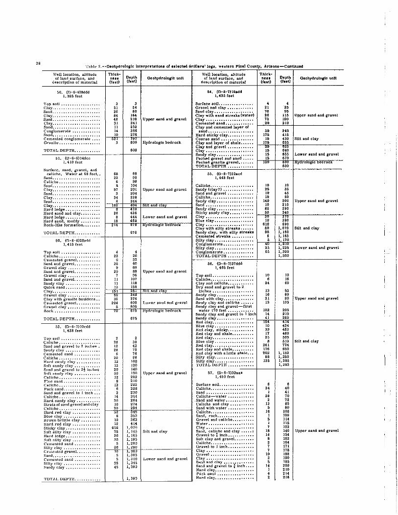
'28 Tabl .. 2 --Geohydrololle interpretationa of ulecttd drUllln' la,s, wulern Pinal Count)'. Ar~on.-Conllnued
WelllocaUon, altitude of land surface, and
description of malerial
50. (D-6-6)8ddd 1,385 feet
Top Boil •••••••••••••••••• Clay .•.. ", .....•...•..•.. Sand •••••••••••••••••••••• Clay" •••••••••••••••.•••• Sand •••••••••••••••••••••• Clay ....•...........••.•.. Sand ••••••••••••••• , ••• , •• Conglomerate ••••••••..•.• Sand ••••••••••••••• , •••••• Cemented conglomerate •••• Granite .••••••.•••••.••.•.
TOTAL DEPTH ••••••••••••
51. (O-6-6114dcc 1,410 feet
Surface. sand. gravel. and caliche. WaleI' at 68 feet, •
Sand •••••••••••••••••••••• Caliche •••• , •••••••••.•••• Sand •••••••.••••..•••.••.• Clay ...•.•.••..••.•...•... Sand ...•.••.••••..•••••••• Clay •...•••••••••••••••••• Sand ••••• , •••••••••••• , ••• Clay •••••••••••••••••••••• Hard ledge ••....•.•.•.•..• Hard sand and clay ••••• , ••• Hard ledge, ••••••••.•• , ••• Hard sand, muddy •.•••• , •. Rock-like formation ••••••••
TOTAL DEPTH ••••.•••••••
52. (D-6-6)28add 1.415 feet
Top soil ••.••.•••••••••••• Caliche., ••••••••••••••••. Cemented graveL ••.•.••••. Sand and gravel •••••••••••. Gravel clay, •.•..•...•..•. Sand and gravel. ••.•••••••• Gravel clay ••••••••••••••• Sand and gravel. •...•...... Sandy clay .....•..•.••.••• Quick sand •••••••••••••••• Clay .••••••••••••••••••••• Gravel clay ••••••.••..•..• Clay with granite boulders •• Cemented graveL •••••••••• Gravel clay .•••••••••••••• Rock .................... .
Thick-ne.. Depth (reet) (reet)
3 51 26 84 4' 31 11 14 10
68 22 ,
3 54 BO
164 210 241 252 266 276
8~~ BOO
68 90 96
104
OeohydrolOIIi:: unit
Upper Band and gravel
HydrologIc bedrock
B 97
3 34 ,
201 Upper sand and gravel 204 238 244
t an c a
Weli location, altitude of land surface, and
description of material
54. (D-6-7)19add 1.435 feet
Surlace sol1 •••••••••••••••• Gravel and clay •••••••••••• Sand clay •••••••••••••••••• Clay with sand streaks (water) Clay ..................... . Cemented sllnd ••••••••••••• Clay and cemented layer ol
sand ••••••••••••••••••••• Hard sticky clay •••••••••••• Coarse sllnd ••••••••••••••• Clay and layer of shale •••••• Clay and gravel •••••••••••• Clay •••••••••••••••••••••• Sandy clay ••••••••••••••••• Packed gravel and sand ••••• Packed granite gravel ••••••• TOTAL DEPTH ••••••••••••
55. (D-6-7)22acd 1,4451eet
Caliche •••••••••••••••••••• Sandy (clay?) ............ .. Sand and gravel ••••.••••••• Caliche ................... . Sandy clay ••••••••••••••••• Sand ••••••••••••••••••••••
"2~' ~4~;!3~6 Sandy clay •••• , •••••••••••• Sticky sandy clay •••••••••••
8 444 Lower sand and gravel Clay ••••••••••••••••••••••
f~,'nBr-t--i4'i"i-h.· """"""""",,,,,,,,,--1 Blue clay ••••••••••••••••• , <:l'l; 0, ny 1'0 OglC oeorOCK Clay ..................... .
Clay wlth sUty streaks •••••• 676 Sandy clay, wllh silty streake
Cemented atreaks •••••••••• Silty clay •••••••••••••••••• Conglomerate •••••••••••••• S11ly clay ••••••••••••••••••
4 4 Conglomerate •••••••••••••• 22 26 TOTAL DEPTH ••••••••••••
6 32 28 60 56, {D-S-7)27ddd
9 69 1. 465 leet 20 89 Upper sand and gravel
Thickne •• (teet)
4 21 70 20 75 20
30 175
15 175
~: 15 15
""
10 25 10 15
140 10 80 50
;~ 610
80 80
6 6
:: "
7 96 Top soil.. ................. 10 11 107 Caliche.................... 6 II U8 Clay and caliche............ 24
~=~1~2~~=t'3~0~rc"I'"'!:;;§=====l Dry sand and gravel to 2 1 t an c a inches................... 13
3:,: Sandy clay................. 16
376 Sand with clay.............. 21 224 600 Lower sand and gravel Sandy clay and caliche. • •• • • 13
Depth (tull
4 25 95
Geohydrolo,te unit
115 Upper lland and gravel 190 210
240 416 430 Silt and clay 605 :~g 655 Lower sand and gravel 670
10 35 45 60
200 210 290 340
~~g 990
1,070 1,160 1,165 1,170
~' ~~~ 1: 300 1,300
10
" 40
53 69 90
lOS
Upper sand and gravel
Silt and clay
Lower sand and gravel
Upper sand and gravel
5 605 Sandy clay and gravel-f1rat 70 675 Hydrologic bedrock water 170 feet............ 102 205
Sandy clay and gravel to 1 Inch 14 219 TOTAL DEPTH.. •••••••••• 675 Sandy clay ••••••••••••••••• e--ri4~'_e---,;2~60:-l-________ _ ---C~~CCCC7CCCC---+----+---+-----------1 Red clay................... 1~,~0 442'44
53. {D-6-7)lOcdd Blue clay •••••••••••••••••• 1,428 feel Red clay, stIcky............ 39 463
Topsoil •• , ••••••..••.•... Caliche •..••....•.•••••••• Sand and gravel to 2 inches. Sandy clay •.... , •...•.•... Cemented sand ..•.•.•.•••• Caliche .•• , ••••••••.•••... Hard sandy clay ..•••...•.. Soft sandy clay •••••••••••• Sand and gravel 10 2! Inches Soft sandy clay ..•..•••.••• Caliche ••• , ••.•••••••..•.• Fine sand .......••..••.••• Caliche ••••.••••••..••••.. Pack sand ....•...•.••..•.• Sand and gravel to 1 inch ••• Caliche ......•......•.•..• Hard sandy clay ••••••••••• Strata of sand grave} and clay Caliche ...•.....•.•••••••• Hard red clay •••••••••••.• Blue clay ••••.....•...•..• Brown brittle clay ••••••••• Hard red clay ••••••••••••. Slicky clay ••••••••••..•... Soft silty clay ••....•...•..• Hard ledge ••••....•..••.•• Soft silty clay .....•...•.• , Cement€d sand .••••••••••• Silty clay ••••••••••••••... Cemented graveL ..•......• Sand ••••••..•..•........•. Cemented sand .••.•.•••••• Silty clay .•••• , ••••.•.•... Sandy clay ••••.......•..••
TOTAL DEPTH .•..•..•....
2 28 12 28
6 20 12 12 20 50 12 B
12 , 2
14 20 10 20
" 10 52
6S6 75 20 30
5 90
2 30 42 70 76 B6
lOB 120 140 190 Upper sand and gravel 202 210 222 228 230 244 264 274 294
352 362 .1.
1,070 1, 145 Silt and clay 1,16" 1,19" 1,200 1.290
~' ~~~ 1: 310 Lower sand and gravel 1,345 1,390
1,390
Red clay and shale.......... 17 480 Red clay................... 25 505 Blue clay.. •••••••••••••••• 8 513 Red clay................... 261 774 Red clay and shale.......... 176 950 Red clay with a little shale... 202 1,152 Silty clay.................. 98 1,250 Silty clay.................. 135 1,385 TOTAL DEPTH............ 1,385
57. {D- 6-7)32aaa 1,450 feet
Surface soil •••••••••••••••• Caliche •••••••••••••••••••• Sand ••••••.••••••••••••••• Caliche-water ••••••••••••
,Sand and water ••••••••••••• Caliche and clay ••••••••••• Sand with water •••••••••••• Caliche •••••••••••••••••••• Sand. rock ••••••••••••••••• Gravel and caliche •••••••••• ·Water ••••••••••••••••••••• Clay •••••••••••••••••••••• Sand. caliche and clay ••••• ; Gravel to finch •••••••••••• Soft clay and gravel ••••••••• Caliche •••••••••••.•••••••• Gravel to 1 inch •••••••••••• Clay •••••••••••••••••••••• Gravel •••••••••••••••••••• Clay •••••••••••••••••••••• Sand and clay •••••••••••••• Sand and gravel to t inch •••• Hard clay •••••••••••••••••• Pack sand ••.•••••••••••••• Hard clay ••••••••••••••••••
6 34
1 29
2 13
5 I,
1 5 1 7
1B
" B 2 7 7
10 2 5
14 1
• 2
B 40 41 70 72 85 90
lOB lOB 11' 115 122 140 154 162 164 171 17B 188 190 195 209 210 214 216
Silt and clay
Upper sand and gravel

Table 2.--Geobydrolorlc lnterprataUOIUI rAnllcUd drWln'lOJa, wlltel'n P1nt.1 County, Arir.ona-Conttnuld
Well location, altitude of land surface, and
descrJption of materIal
57. {D-8-7)32aaa-Continued
Dlpth (teed
Well location, altitude of land stu"face, and
description of materIal
80. (D-8-8)11adc-Contlnued
Water gravel •••••••••• ".. 14 230 Clay .................... .. Clay...................... 8 238 Soft clay ••••••••••••••••••• Gravel ••••••••••••••• , • • •• 4 242 Clay and ahale ••••••••••••• Clay...................... 4 248 Clay •••••••••••••••••••••• GraveL................... 5 251 Pack aand ••••••••••••••••• Clay................... ••• 11 262 son clay and sand •••••••••• Sand and gravel............ 6 268 Clay •••••••••••••••••••••• Fine sand................. 2 270 Pack aand ••••••••••••••••• Sand and gravel to t Inch • 1---i'~'-II-~'~8~':-I _________ -I Clay •••• ' •••••••••••••••••• Hard clay •• ,.............. ~,~' ~,3,,~ Pack alnd ••••••••••••••••• Blue hard clay, •••••.••• ,.. Solt olay and sind •••••••••• SUcky yellow clay •• ,.,..... 8 350 Clay •••••••••••••••••••••• Hard red clay." ••.••• , •• , 22 372 Pack fiand ••••••••••••••••• Clay with hard atreaks .•..• 48 418 Sut and clay Clay and ahale ••• ; •••••••••
_~_"""""" W ,. __ ----Sandy clay.... ••••••••.••• 18 578 Clay and shale ••••••••••••• Sticky clay ••••••• " • • • • • •• 15 593 Tough clay................ 177 770 TOTAL DEPTH ........... .
~~r;!' ~~~dy' ~lay' ~/lth 's'~~il' ----zr .f91I 61. (D-6-8)28dbb gravel................... 44 840 1,480 fest
HaNi sandy clay with small Low.er sand and gravel atreaks of rock........... 35 875 Top soU •••••••••••••••••••
~~v~~n~~~l~~~:l~~e~:~: ~!~y 1----""'_1---'-",''-1-________ --1 g:~~~e:::::::::: :'::::::::: hard granite............. 98 1,000 Hydrologic bedrock Sandy clay •••••••••••••••••
Sand-first water at 1&Oleet.
_T~O:T.:::A:L~D:E:::P~T~H:,~,:,:, ~"~'~':':':"'-+_--_+~I~.:O:O:O_+---------_i ~~~%IC~~~::::::::::::::::: 58. (D-6-8)3bdd Sandy clay •••••••••••••••••
1,435 feet Sand, tight •••••••••••••••••
Soil •••••••••••••••••••••• Tight gravel •••• , ••••••••.• Clay and caliche ••••••••••• Sand and Uttle gravel. ., •••• Tight gravel •• , ••••••••••• Sand and clay ••••••••••• _ •• Coarse gravel ••••••••••••• Clay and gravel, 3 inches ••• Hard clay ••••••••••••••••• Coarse gravel, 3 inchea •••• Clay and gravel •••••••••••• Gravel and boulders, 6 inches Clay ..................... . Gravel and boulders, 6 Inchea Caliche and clay ••••••••••• Cemented gravel, 2 Inches •. CaHche and clay ••••••••••• Cemented sand and gravel, l! Inches _ •••••••••••••••
Sticky clay •••••••••••••••• Clay and caliche ••••••••••• Cemented gravel, t Inch ••.• Tough clay •••••••••• _ ••••• Cemented sand •.•••••••••• Tough sticky clay, brown ••• Blue clay, tough ••••••••••• Tough aticky clay, brown ••• Tough clay and little snt •••• Silt and clay, IUUe gravel
(pea) ••••••••••.••••••••. HaNi clay and little sUt
atreaks .••••••••• _ •••••••
Clay, tough •••••••••••••••• 7 7 Streaks of hard clay and sand 8 15 Hard tough clay, red ••••••••
50 65 Tough clay, blue ......... .. 20 85 Red clay •••••••••••••••• _ ••
7 92 Red clay, tough •••••••••••• 6 98 Blue clay ••••••••••••••••••
10 108 Red clay with hard and tough 28 136 atreaks ••••••••••••••••••
5 141 Blue clay. tough •••••••••••• 7 148 Blue clay with tough streaks.
17 165 Red clay with tough streaks •• 32 197 Sticky red clay ••••••••••••• 11 208 Upper sand and gravel Red clay .................. . 9 217 Red clay. sticky, with a
18 235 little water crystal •••••••• 6 241 Red clay, sticky. _ ••••••••••
23 264 TOTAL DEPTH ••••••••••••
5 269 11 280 62. (D-6-9)6dcd 27 307 1,510 feet, estimated
6 313 15 328 Fill-decomposed granite •••
1--;1~0:-i__433~8~i__--------__l Top soU ••••••••••••••••••• r ',!, ~~O'~'O Caliche, sand, some clay •••
Sand, some gravel, clay •••• 690 1,090 Sandy clay. some gravel •••• 180 1,270 Sandy clay, sandstone, hard
230
250
SUt and clay streaks-atatlc water level 1,500 130 feet ••••••••••••••••••
Decomposed granite quartz •• 1,750 Sandy clay •••••••••••••••••
Dark, line sand., •• , •••••••
_T~O=T.:::A=L~D::.::E=P~T:H~,~,C,=' :"~'~'C':':'~' -l ___ +_'~,C'=SO:-+_--------_I S~~~~ec~~~e~~t~. ~:~~ • ~~~~~ •• 59. (D-6-8)6adc Red clay, some sand ••••••••
1,420 feet Sandy clay, fine •••••••••••• Red clay, gravel ••••••• _ •••
SoU •••••..•••••••• _...... 5 5 Broken quartz, caliche-hard. Caliche and little gravel.... 65 70 Red clay, some sand •••••••• Clay and caliche........... 10 80 Red shale, hard ••••••.••••• Clay and gravel............ 35 115 Red clay ••••••••••••••••••• Sandy clay and little gravel. 43 159 Red shale ••••••••••••••••.• Gravel and boulders........ 64 222 Red clay ••.•••••••••••••••• Clay...................... 8 230 Upper sand and gravel Red shale. sandstone •.••••• Hard cemented gravel, 2 Red clay, hard streaks of
inches .•••••. _........... 6 236 clay shale •.•••••••. _ ••••• Clay and little gravel, 1 inch 19 255 Red clay shale, aome aand-Clay and caliche........... 35 290 stone ••••.•••••••• _ •••••• Cemented gravel, 2 inches.. 10 300 Red clay ••••••••••••••••••• Clay and gravel. • • • • . •• . • • • I --ri'*'-i__-i'~'~':-I_--------__l Red clay shale, sandstone ••• Tough clay..... ...••••••.• I !,~~,,~ ~~ Silty clay •••••• _ ••••••••••• Hard cemented clay........ 915 SUt and clsy Silty clay, sandstone •••••••• Hard cemented clay...... .. 285 1,200 Silty clay ••••••••••••••• - ••
Brown clay shale ••.••••••••
T·CO_T_A.c::L_D_E_PCT_HC'_' C"C'C'C'C' C' ="~'_1-__ -+_'C' _2_00_1-________ -1 Silty clay •••••••••••••••••• _ SUt, fine sand, clay •••••••• 60. (D-6-8)Iladc Fine aand clay aandstone,
1,470 feet broken quartz •••.•••••••.•
Sand and clay mix ••.••.•••• GraveL •••••..••••••••.••• Quick sand, bearing water •• Clay •..•..•••••.•..•••.•.. Quick sand ..••••.•..•••••• Cement gravel ••••••..•••••
II' , 9
22 10 ,
II' 115 124 146 15' 158
Upper sand and gravel
Clay •••••••• _ ••••• _ ••••••• Sandy clay, hard streaks,
some gravel, sandstone __ ••
TOTAL DEPTH ••••••••••••
Th1ckDU. (teet)
22 , 18
" 10 5
12 8 ,
13 , 8
10
'~~ 248
10 20 15
110 5
20 25
ISO 15 25 85
;g 130 75
8
135 14 8
130 , 60
10 82
10 10 50 20 30
15 5
10 , 32 16 19 33 , 33 2~ , 27 , 75
55 28 57
145 , 52 18 78
34 51
55
Depth (teet)
180
'84 200
'" 28' '00 31' 320 322 '35 ,<0 348 '58 ~~g
1,216
1,216
!O 30
" 155 160 180 20' '55 370 395 'SO ~~~ '85 'SO '68
90' 91' '25
1,055 1,060 1,120
1,130 1,212
1,212
!O 20 70 90
120
135 140 150 155
187 20' 222 255 '59 292
j~: '29 '56 ,60
'" ,go 518 57' 720 726 '78 '96 8" 910
'44 995
1,050
1,050
Geoh)'drolorto unU
Silt and clay
Upper sand and gravel
sut and clay
Upper sand and gravel
Silt and clay
Lower sand and gravel
29

30 Table 2 .• ·Geohydroloilc interpretAtlon. of .elected drWlra' lOll, we.tern P1nal c.-.ty. Arllona-CoaUnu.d
Well location, altitude of land surface, and
description of material
63. (D-6-9)18bda 1, 500 feet, estimated
Sandy clay ••.•••••.••••••. Coarse sand •••..•••.•••••• Sandy clay •.• , •••.••••.••• Coarse sand ••..••••.. , •••• Sandy clay with small strata
of sand ••••..••••..•••••. Gravel and boulders ••••..•• Cemented shell and jointed
clay ••.••••••.••••••••••• Clay .•••••••.•••..••••.••• Sand and gravel. .••...••••. Silty clay ••..••••.• , ••••.• Conglomerate of clay sand
Th.Jckne •• (teet)
47 16 42 10
" 11
Dlpth (tut)
47 63
105 116
Otoh,ydrolo,lc "unit Well looation, altitude
of land surface, and descriptIon of material
Sand, gravel ••..••.••.••••• Cemented land. '" ••••••••• Sand. gravel ••••••••••••••• Cemented Jl'lvel ••••••••••• Gravelly clay ••. '" •••••••• Clay, gravel. hard .••.•••.••
133 Upper sand and gravel Gravel •••••••••••••••••••• 144 Clay, bouldera •••••••••••••
Gravel, sand, clay ••••••••• 26 170 Clay. gravel, boulders ••••• 85 255 Gravel ••••••••••••••••••••
"=:E~'=p~'~6~3C~!!!::;;;;!:E§c::===:i Conglomerate •••••••••••••• /- an c a Sand. 'ravel •.•••••..••••.. Cemented sand •••••••••••••
307 1,402 Sand gravel •••..•••••.••••• Lower sand and gravel Hard gravelly elay .•••••.•••
TOTAL DEPTH............ 1,402 Sand, gravel ••••••••••••••• --------'--'--'---'-+----+--'--+-----------iI Gravelly clay ••••••••••••••
64. (D-7-4)2dcc Sand, gravel, hard •••••••••
and gravel •.••••••.•••••.
1, 340 feet Sand, gravel with clay ••••••
Top soU .. , ••••.•••••.•••• Clay conglomerate ••••• , ••• Dry sand and streaks of
conglomerate ••••..•••••• Clay ••.•••••..••••. , ••••.. Dry sand, first water at 276
leet ••..••••..•••••.••••• Sandy gray clay conglomerate Heavy sand. Water .•••.•.• Hard gray conglomerate ..• , Soft red clay, , .•••••..•••. Fine sand, Water •..• " .•• Hard conglomerate.,., •. ,., Hard rock, •.. ,., •• , .• ", .. Brown rock", .•• " •..•• ,' Hard red rock., •..• ,", •.•
6 , '04 "
6 , 212 230 Upper sand and gravel
Sand, gravel ••••••••••••••• Cemented sand, gravel •••••• Sand, gravel ••••••••••••••• Clay, gravel ••••••••••••••• Sand, gravelly clay ••••••••• Gravelly clay •••••••••••••• Sand, graveL ••••••••••••••
46 276 Sand, !raVellY clay ••••••••• 184 460 Gravel y clay ••••••••••••••
,--,-,i'-j~~'~6;;'H~--------__lI Sand, gravel ••••••••••••••• r ::Il~ !~~ Cemented sand, gravel ••••••
6 786 Gravelly clay •••••••••••••• 14 800 Local gravel Sand, gravel •••••••••••••••
~2'~6~0_lf-~9~6~0:--lf---------__l Gravelly clay •••••••••••••• '" -""'0 Gravelly clay •••••••••••••• 4 Hydrologic bedrOCk Cemented gravel •••••••••••
10 I, 000 Gravelly clay •••••••••.•••• Sand and gravel with cemented
TOTAL DEPTH............ 1,000 streaks ................. . ------------+---i---'--+-----------iI Sand and gravel ••••••••••••
65. (D-7-4) 16ccc Clay and gravel •••••••••••• 1,392 feet Cemented aand and gravel •••
Soil .• " •..• " •..• " •••• , • Clay.", .••• " ••• " .•••• , , Granite? shell, rock., •••.. Decomposed granite and Clay Sand, gravel •••.••••.• " •• Granite shell, rock •.• " ••. Clay sand ••..••• , •.•• , •••. Sand, gravel, clay .•••.•.•• Clay. gravel., ••••• , •••••• Granite shell, rock" ••.. ,. Gravel, sand and clay •..• " Granite shell, rOck ••.••••. Sand, gravel, clay .••••••.• Rock ••• , •.•••••..••••...• Sand, gravel •....•••••..•• Rock •••...••••.•••••..••• Sandy clay •••.•••••...•••. Hard shell •.•. , •••.••••.•• Cemented gravel., ..•••.•.. Caliche .••••.••••..•••••.. Sharp sand ••••.•••••..•••. Hard shell •••.•••••.•••.•• Sand and clay •••...••••..••
, , 52 60 22 82
173 255 5 260
23 283 37 320 14 334 46 380
~~ !g~ 31 456 28 484
Upper sand and gravel
Clay •••••••••••••••••••••• Conglomerate •• , ••••••••••• Hard cemented sand and
gravel ••••••••••••••••••• Hard clay and gravel ••••••• ". Hard cemented aand and
gravel ••••••••••••••••••• Hard clay •••••••••••••••••• Clay and aand •• '" ••••••••• Clay •••••••••••••••••••••• Sand and gravel •••••••••••• Hard red sticky clay •••••••• Granite ••••••••••••••••••••
4 488 TOTAL DEPTH •••••••••••• 37 525
7 532 67. (D-7-4)36W!bbd 41573 1,315feet
5 578 27 605 Local gravel Sol1. ..................... . 29 634 Cla.y •••.••••••••••• , ••••.• 12 646 Sand •. '" •..••••••••• , .••• 4 650 Cemented gravel •••••••••.•
110 760 Clay and caUche •••••••• , ••• 6 766 Light water sand •••••••••••
41 807 Clay and caliche •••••••••••• 5 812 Water sand ••••••• , •••.••••
1_-J;6~B~f-~B~B~0:-,f-________ __l Clay and caliche •••••••••••• "Tr -B~r! Water sand .............. ..
Hard shell ••.•.•••.•.•••.. Sandy clay ..• , •.•.•••..••• Hard shell •••..••••..••••• Sand. gravel •••..•••••..•• Hard shale., •... , •••.••••. Boulders ••• , ..•••..•.•••.. 14 905 Hydrologic bedrock Clay ••••.••••• '" ••.••••••
Cemented gravel, •••••••••• TOTAL DEPTH............ 905 Conglomerate, sand, gravel, ------------4----i---4------------~ boulders (decomposed gran-
66, (D-7-4)18dcc ite, mountain wash \,440 feet formation) ••••••••••••••••
Sandy clay •••••.•••••...•• Sandy gravel .•..••..••••.. Caliche •••..••• , •..••••..• Clay .•••••..••••..••••..•• Sand, gravel •••••••••...•• Clay, sandy •••...• , .....•• Cemented sand, gravel .•••• Sandy clay •••.•••••..••.•. Cemented sand, gravel ••... Sand, gravel .•• , •...•••... Cemented sand •••.••••...• Clay .•••••..•••.••••••..•• Sand, gravel •••.••••...••• Cemented sand. gravel •••.• Sandy clay •.•.••• , ..•••.•• Cemented sand, gravel .. , •• Coarse gravel •.•••••...••. Gravelly clay ...••.•.•••..• GraveL., ...••••..••.....• Gravelly clay, hard ..•••...
30 , 11
" 13
" 3 33
4 12
6 12
" , 20 16 ,
1 1 ,
30 34
" 60 73
" 93 126 130 142 148 160
'" 190 210 226 230 231 232 240
Upper sand and gravel
TOTAL DEPTH ••••••••••••
68. (D-7-5)21bdc 1,395 feet
Sou ••••••••••••••••••••••• Sand •••••••••••••••••••••• Caliche .•••••• , ••.••••••••• Sand •. , ••••••••••••••••••• Clay •••••••••••••••••••••• Sand •••••••••••••••••••••• Cemented sand ••••••••••••• Sand •.••••••••••••••.••••• Clay .•••.••••.•••••••••••• Sand ••.• , ••.•••••••••••••• Sandy clay ••••••••••••••••• Sandy clay, hard ••••••.•••• Cemented sand ••••••••••••• Sandy clay ••••••••••••••••• Hard clay •.•••••..•••••••••
Thicknl •• (tilt)
• , as , '0
6 • • • , 3
" 6 4 ,
18 , 4 , , : , ,
11 12 , 6
11 2 3
19 14 , " 6 16 ,
126
" 20 111
14
4B
" 38 31 10 14 ,
2 , " " 6B , 24
7 53
7 40 ,
664
15 , , 10 , , , SO 30 35
135 40
" 120 43
Depth UuO
'" 'SO 278
'" 30' 30, 312 320 328 330 333 369 383 3'7
'" 388 "0 394 396 ,00
:~~ 407 415 426 438 "0 '46 457 459 462 481
'" "0 '" '" 540
54' 670 695 716 '28 "0 886 941
979 1,010 1,020 1,034 1,038
1,067
, 10 28 4'
110 11' 138 14' 198 205 '45 'SO
914
914
15 20
" 35 40
" " 130 180 195 330 370 395
'" '"
Local gravel
Hydrologic bedrock
Upper sand and gravel
Local gravel
Upper sand .nd gravel

Table? --Geohy1irolog1e interpretation, 01 .elected drUlen ' 10"',' "'ulern Pinal County. Aruona-Continued
Well location, altitude of land surface, and
description of material
68. (D-7-5)2Ibdc-Continued
Sandy clay .....••••••••... Clay and sand .•.•..•..••••• Hard cemented conglomerate Clay ••••••.••.•..••••••••• Broken etay and conglomerate Broken aand clay and con-
glomerate •••••••••..•••• Conglomerate •.•••••••.•.. Conglomerate sand •••••••••
Thick-ness Depth Geohydrololic unU-
WelllocaHon, altitude of land surface, and
descdptlon of material (feet) (reet)
17 5
;-20
45 10 85
71, (D-7-6)l2aed-Continued
575 Clay •••••••••••••••••••••• 580 Cemented sand ••••••••••••• ~~~ Pack sand ••••••••••••••••• 535 Clay and gravel •••••••••••• 605 Cement saoo •••••••••••••••
Clay •••••••••••••••••••••• Hydrologic bedrock 650 Pack sand ••••••••••••••••• 660 Cement sand ••••••••••••••• 745 Granite-bottom of 20-inch
hole •••••••••••••••••••••
_TC°:::.rCA"LCo::oECP"T,"C"""""O" C" c" """'"0"0" C" -+ ___ +---",',5-+ _________ -1 G~~f!t~:-:-~.r.u:.~. ~~~~~ ~.~~. 69. (D-7-6)1ddb
1,450 feet
Soil •••••..•.••••••••••••• Sandy clay ••.•.• , ••••••.•. Sandy clay and gravel, ••••• Sandy clay •••••••••••••••• Sandy clay and gravel ...••• Sandy clay .••••••••••••••• Sand and gravel (water level
170 feel) ••••••••••••••••• Clay, hard •••••••••••••••• Fine sand •••••••••.••••••• Clay. tough ••••••••• , .•••• Sand •••••.•.•••••••••.••.. Clay, hard ....•.••••••••.. Clay, gummy •.•.•••••••••• Rock. hard ............... . Clay, hard •.•••••••••....• Sandy clay and gravel •••••• Clay. hard .•••.•••..••.••• Cemented conglomerate ..•. Quartz rock, hard ..••••••• Quartz with streaks of
bentonite ••••••.••••••••• Quartz with streaks of clay. Broken quartz ..•••••••••.• Sand and gravel •••.•••••••• Quartz, hard ••••••••••...•
TOTAL DEPTH .......... ..
70. (D-7-6)6dcd 1,410 feet
Surface soil •.•..•..••••••. Gravel •..•.••••••••.•••••• Caliche •• , ••••••••••.•..•• Gravel •••.•.•••••••••••.•. Clay-first water 53. 5 feet. Boulders, water .•••••••••. Gravel and clay •••••••••••• Cemented conglomerate •••• Clay balls and gravel ••••••• Boulders .••••••••••.•••••• Conglomerate •••••••••.••• Gravel •••..•••••••••••..•• Clay •••••••.•••••••••••..• Hard clay •••••..•••••••••• Loose boulders •••••.•.•••• Red conglomerate •••••...•. Blue shale ••.•...••••••••• Sharp gravel, \ inch ••••••• Blue shale .••••••••••..••• Cemented conglomerate .••. Hard red sandstone rock •...
TOTAL DEPTH .••••••.•...
71. {D+7-6}12acd 1,465 feet
Dirt ...•.••••••..••••••••. Sand and boulders •.•..••••• Cemented gravel, ••••••..•• Clay, ................... .. Sand and graveL •••.•.••••• Caliche clay •..••••••••.••• Cemented sand •••••••••••. Sand and gravel •.•••••••••• Clay and sand ••••••••••••• Water sand and boulders •••• Cement sand •••.•••••••••• Clay •.••••••••• , •••••••••• Cement sand •••••.•••••••• Clay •••••.••••••••.••.•••• Cement sand ••••••••••.••• Clay ••••••••••••••••••..•• Pack sand •••.••••••••.•.•• Clay ••..•••••...•••••••••• Cement sand ••••••.••••••• Clay •••..•.•••••••••.••••• Water sand and gravel ••..•. Clay •...•••••...•.•••••••• Cement sand •••••..••.•••• Water gravel ....•••••..•.•
TOTAL DEPTH ••••••••••••
10 10 72. {D-7-6)2Sddd 15 25 1,485 feet 35 60 20 80 Top soil ••••••••••••••••••• 30 110 Caliche .. " .............. .. 55 165 Sand .................... ..
Upper sand and gravel Caliche and clay •••••••••••• 25 190 Sand and clay ••••••••••••••
S 198 Sand and gravel •••••••••••• 27 225 Sand and clay ••••••••••••••
9 234 Caliche and clay •••••••••••• 20 254 Clay and gravel, 1 inch .••••
"I "55' ~3:~5 Clay •••••••••••••••••••••• Clay Band and gravel, 1 inch.
9 444 Silt and clay Hard caliche .............. . 26 470 Clay and gravel, I inch •••••
Hard clay •••••••••.•••••••• 1--'5"0r-t--{54~2~tL"'= ..... "'-.!.'""'d'-" •• nd~l..,, g",,,,.~I'-1 Tight gravel •••••••••••••••
,~80 '6:3~0 Tough sticky clay, t inch •••• Sand and gravel and clay •••• Caliche and clay ••••••••••••
80 710 Clay and little gravel ••••••• 75 785 Hydrologic bedrock Tough clay ••••••••••••••••• 83 868 Sand and gravel ••••••••••••
7 875 Tough clay ••••••••••••••••• 18 893 Sticky clay and soft streaks,.
28 , 8
10 , 8
l' 2
893
28 32 40 50 54 62 78 80 88 8
9 13
2 II
1 8
28 14
8 36
97 Upper sand and gravel 110 112 123 124 132 160
'" 182 218 ~o~ Hydrologic bedrock
505
12 12 22 34 16 50 , 54 24 78 22 100
8 108 32 140
6 146 Upper aand and gravel 24 170
Clay and ailt .' ••••••••••••••
TOTAL DEPTH ••••••••••••
73. (D-7-8)29add 1,455 feet
Top soil ••••••••••••••.•••• Clay •••••••••••••••••••••• Sandy etay snd gravel ••••••• Clay •••••••••••••••••••••• Sandy clay ••••••••••••••••• Sand and gravel, firat water. Clay ..................... . Sandy clay ............... .. Clay •••••••••••••••••••••• Sandy clay ••••••••••••••••• Sand and gravel •••••••••••• Sandy etay and gravel •• , •••• Sand and gravel •••••••••••• Rock and decomposed granite Gravelly clay •••••••••••••• Hard rock •••••.•••••••••••
TOTAL DEPTH ••••••••••••
74. (D-7-6)30acd 1,440 feet
Sandy clay •••.•••••••••••.• Clay ••.•••••••••••.••••••• Sand, hard. First water,
level 60 feet, bails to80iee! Clay ••.••••••••••••••••••• Hard red formation ••••••••• Hard brown formation ••••••• Hard red formation, abrasive
TOTAL DEPTH ••••••••••••
75. (D-7-S)33dda 1,475 feet
4 174 Top soil; caUche; ahella ••••• 28 202 Gravel •••••••••••••••••••• 21 223 Clay •••••••••••••••••••••• 22 245 Sand and sandy clay; fJrst 10 255 water, level 135 feet •••••• 8 263 Clay ••••••••••••••••••••••
1 --ri',+--{26~'~t---------'-I Sand •••••••••••••••••••••• ", ~!~ Clay ................ " ... . 314 Silt and clay Very hard and abrasive de-
69 383 compoaed granite and aome ~ 388 clay streaks ............. .
5 393 3 396
Lower sand and gravel TOTAL DEPTH .•..••••••••
Thicknell ((eet)
59 3 , , , 5 5 ,
43
135
5
• 6 55 15 10 35 40 15 10 20 10 15 20
6 52 12
if 58 , SO 90
144
5 5
85 20 10 25 20 10 10 10 10 70 20
60 35
25 40
45 10 55
" " 30 40
205
Depth ((eet)
m 458 460
'" 471
'" 481 ." 530
685
685
5 9
15 70 85 95
130 170
Geoh)'drologic unit
Hydrologic bedrock
185 Upper aand and gravel 195 215 225 240 260 26' 319 330
430
'" 490 Silt and clay 570 660 80'
90'
5 10 75 95
105 130 150 Upper Band and gravel 160 170 190 190 260 280
480 Hydrologic bedrock 535
535
60 95
120 160
~~~. 257
",
45 55
110
160 190 220
'" '" 465
Upper sand and gravel
Hydrologic bedrock
Upper sand and gravel
Hydrologic bedrock
31
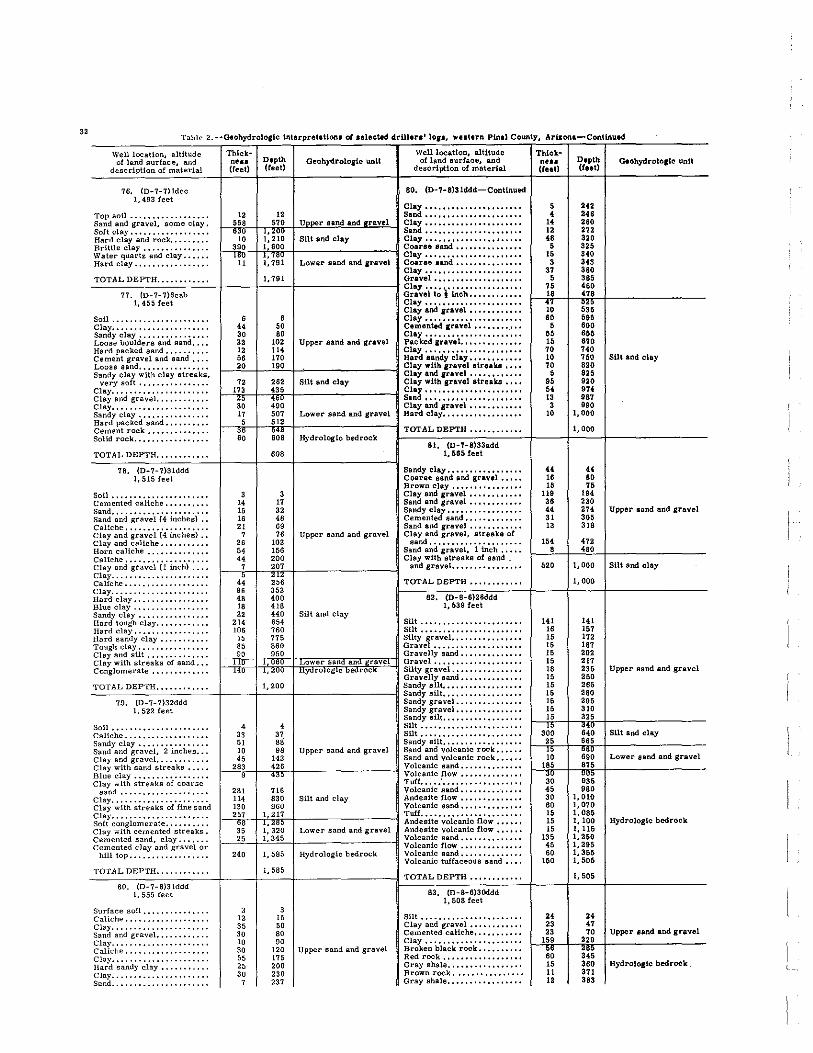
32 Table 2 ··aeohydrologlc interpretlUonJ; 01 .elected drUlera' 10,1, wntern Plnal County. Arizona-Continued
Well location, altitude of land surface, and
description of material
76. (O-7-7)ldcc 1,493 feet
ThickmIle (feet)
Depth (feet)
Qeohydrolo,lc unit Well location, altitude ot land surface, and
description of material
80. {D-7-8)31ddd-ConUnued
TMcknUl (rut)
Depth (feet)
Clay...................... 5 242 Top soil.................. 12 12.. Sand...................... (( 248 Sand and gravel, some clay. I _"'j'~'-I,~'~'Il0--l_U~lo .. ~ ••• ,-,-.. ,n,d!..!"''>'!.I'" .. n,v~."'~ Clay 14 260 SaHelay .................. r-63
'00 -1, ... 20,,°0 Sand:::::::::::::::::::::: 12 272
Hard clay and rock......... SUt and clay Clay •••••••••••••••• ,..... 48 3aO Brittle clay............... -,'.900-+'".,',,°,°---1----------11 Coarse sand............... 5 325 Water quart~ and clay...... ' l~,?, ~, ••• '!~'~, Clay...................... 15 340 Hard clay................. Lower sand. and gravel Coarse Band............... 3 343
Clay...................... 37 380 _TCO:T:A=LCD:..:E:PCTCHC'C':":' C":"c.C.:":"'--+ __ --+:'".C':':I--+ _________ -I Gravel.................... 5 385
77. (D-7-1)6cab ~~~;~li~r~~h:::::::::::: 1: :~~ 1, 45S feet Clay...................... ~,~O ~'''"
Clay and fl'avel •••••••••••• So11 •• • • • • . . • • • • • • . • • • • • • • 6 6 Clay.. • •• • •• • •• • •• • •• • •• • • 80 595 Clay...... •••••••••• •• •.•• 44 50 Cemented grayel •••••••• _... 5 800 Sandy clay. . • • • • • • • . .• • •• . 30 80 Clay •• " ••••••••••••••• , , • 55 855 Loose boulders and sand,... 22 102 Upper sand and gravel Packed 'ravel •••••••• ,.".. 16 870 Hard packed sand.......... 12 114 Clay...................... 70 740 Cement gravel and sand.... 56 170 Hard sandy clay •• "........ 10 750 Loose sand... .•• •••••.•••• L--""O_f--_'"',o'-'f--________ __l Clay with gravel streaka ••• , 70 820 Sandy clay with clay streaks, I Clay and gravel ••••••• ,.... 5 825
very aoft •••••••••••••••• 72 282 SUt and clay Clay with gravel atreaka •••• 95 920
g~:~'~~d gr·a'.;s'l:::::::::::: f--"1i'lc3--1f__c·H'~'f__If__----------l ~~:::::::::::::::::::::: ~: :~~ Clay. • • • • • . • • •• • • . • • • • • • • • ~g 490 Clay and gravel. • •• • •• • ••• • 3 990 Sandy clay................ 17 507 Lower sand and gravel Hard clay.................. 10 1,000
GeohydroloJlc unit
sUt and clay
Hard packed sand.......... f--,*'-If__-150'~'--II_--------__l ~Oel~e~~:~.c.~:::::::::::::: ~r ~~: Hydrologic bedrock rT_OT_A_L;::-D_E-;:PT,-:H-:;,,:·:·_·O·C"_·_·_·_·-t ___ t-':·_0_00_t-____ --__ _
81. (D-7-8)33add TOTAL DEPTH ••••••••••••
78. (D-7-7)Slddd 1.515 Ieet
Soil •••••••••••••••••••••• Cemented caliche •••••••••• Sand •••.••••••••••••••.••• Sand and gravel (4 inches) •. Caliche •••••••••••••••••.. Clay and gravel (4 inches) •• Clay and caliche ••••.•••••. Horn caliche •..••••..••••• Caliche •••..••••..•••••... Clay and gtavel (1 inch) .••• Clay ...••••...•••••.••••.. Caliche ••..••••.••••••••.• Clay ..••••••...•••••..•••• Hard clay ..•••••..••••••.• Blue clay •••.•..•••...•••• Sandy clay ..•••••.•••••••. Hard tough clay ....••••.••• Hard clay •••...••••••..••• Hard sandy Clay •••.•••••.• Tough clay ••••..•••••••.•• Clay and sUt .••••••.•••••• Clay with streaks of sand ••. Conglomerate ••.•••••••.••
608 1.665 leet
Sandy clay ••••••••••••••••• Coarae BInd and gravel ••••• Brown clay ••••••••••••••••
3 3 Clay and gravel •••••••••••• 14 17 Sand and gravel ••••••••••••
~~ :~ ~~':!~n~!:r~~~d::::::::::::: 21 69 Sand and. gravel ••••••••••••
7 76 Upper sand and gravel Clay and gravel, streaks of 26 102 sand ••••••••••••••••••••• 54 156 Sand and gravel, 1 inch ••••• 44 200 Clay with streaka of aand .
1--{'-f---;2~0~':--f------------I and gravel ••••••• , ••••••••
4~ 256 96 352 48 400 18 418
TOTAL DEPTH ••••••••••••
82. (D-8-6)26ddd 1,5391eet
22 440 Silt and clay 214 654 SUt ••••••••••••••••••••••• lOS 760 Silt •••••••••••••••••••••••
15 775 Silty gravel •••••••••••••••• 85 860 Gravel ••••••••••••••••••••
~=~'~O~q~'~50~q;gj~~@~~g,j",q Gravelly sand •••••••••••••• wer san an rave Grsvel •••••••••••••••••••• .4U IJIYi:frOIOg1c bedrOCK Silty gravel ••••••••••••••••
Gravelly sand ••••••••••••••
_TC0:..:.T_ACLCD-,E:PCTCHC·C·C·C·:· C"C'C'C':' c" -I ___ +'C·_'_o_0-l _________ -I Sandy silt ••••••••• " •• , •••• Sandy silt •••••••••••••••••• 79. (D-7-7)32ddd Sandy gravel •••••••••••••••
1,522 feet Sandy gravel ••••••••••••••• Sandy silt ••••••••••••••••••
Soil ••..•••••.•••••.•.•••• Caliche •.•••••••••••.••••• Sandy clay •••••••••.•••••. Sand and gravel, 2 inches ••• Clay and gravel ••.•••••.••• Clay with sand streaks .•••• Blue clay ••••••.••••..•••• Clay with streaks of coarse
sand ................... . Clay .•••..••••••..••••.••• Clay with streaks of fine sand Clay •.••••.••••..•••••••.• Soft conglomerate ••••..•••• Clay with cemented streaks. Cemented sand, clay ••••.•• Cemented clay and gravel or
hill top •.•.••••.•.••••...
TOTAL DEPTH ........... .
80. {D-7-8)Slddd 1.555 feet
Surface soil ..••••..••••..• Caliche •...•••...•••....•• Clay ....•••••..•••...••••• Sand and gravel •••..•••••.. Clay •••.•.•••••..••••.•••• Caliche ••••••...•••••..••• Clay •...•••.•••••.•..••••. Hard sandy clay •••••• '" •. Clay •.••••.•..••••..••••.. Sand ..••••.•••••.•••••••..
4 4 Silt ••••••••••••••••••••••• 3S 37 Silt ••••••••• , •••••••• , •••• 51 8S Sandy silt •••••••••••••••••• 10 98 Upper sand and gravel Sand and volcsnic rock •••••• 45 143 Sand and volcanic rock ••••••
1_~2"8q .-',l---1i352.5~l------------I ~~~~:~~~ ~~r::::::::::::::: Tuff •••• : ••••••••••••••••••
281 716 Volcanic sand ••••••••• -••••• 114 8S0 Silt and clay Andesite How •••••••••••••• ISO 960 Volcanic sand ••••••••••••••
1-~''''5B'~'5'~-i ,',L •• :. 29 2~32',,'05rl------------I I:f;~it~'~~l'c'a'n'i~'£i~;"::::::
Lower sand and gravel Andeaite volcanic fiow ••••••
1_--,2C"_f-"L' 3,."''--f--________ --I ~~~~:~~~ ~la;: : :: : : : ::: ::: : : 240 1.585 Hydrologic bedrock Volcanic sand ••••••••.•••••
Volcanic tuffaceous sand ••••
3
" 35 30 10 30 55 25 30 ,
1,585
, 15 50 90 SO
120 Upper sand and gravel 125 200 230 232
TOTAL DEPTH ••••••••••••
83. {D-8-6)3Oddd 1,508 Ieet
Silt ••••••••••••••••••••••• Clay and gravel •••••••••••• Cemented caliche ••••••••••• Clay •••••••••••••••••••••• Broken black rock •••••••••• Red rock •••••••••••••••••• Gray shale ••••••••••••••••• Brown rock •••••••••••••••• Gray shale •••••••••••••••••
" 16 15
119 38
" 31 13
164 , 520
141 15 15 15 15 15 18 15 15 15 15 15 15
~g 45 30 60 15 15 15
135 45 60 150
24 23 23
169
:: 15 11 12
.. 60
" ". 230 274 '05 '18
'" 480
1.000
1,000
141 15' l22 182
'" 212 23' 250 26' 260 29' 310 32'
-:~ ,eo
1,010 1,070 1,085 1.100 1.115 1,250 1,295 1.355 1,506
1,505
24
"
Upper aand and gravel
SUt and clay
Upper sand and gravel
Silt and clay
Lower aand and gravel
Hydrologic bedrock
70 Upper land and gravel ", 3:; 380 HydrologIc bedrock 321 383

Table 2,··Geohydro!oglc Interpretations oJ selected drUlera' lOis, western Pind County. Arlzonl-Conllnued
Well location, altitude of land surface, and
description of material
83. (D-8-6)30ddd-Continued
Red rock •••••••••.•••.•••• Black rock ••••••••••••••••
ThIck-ness Depth (leet) (feet)
425
Geohydroloiic unit Welllocatlon, altitude
of land surface, and description of material
87. (D-8-7)308CO 1,552 feet
42 15 440 Top Boil •••••••••••••••••••
CaUche •••••••••••••••••••• _T~O::T~A::::L~D:E:::.PT~H".O. O. O""'C'O'O' 0"".'-+_---+-,44~0'--+_--------_II Caliche streaks of aand •• " • Sandy clay •••••••••••••••••
84. (D-B-6)31ccb Sandy gravel, fiTst water 230 1,515 Ieet feet •••.••..•••••.••.• - .••
Sand and clay •••••••••• , • •• 160 160 Sand gravel and clay •••••••• Clay •... _................. 20 180 Clay •••••••••••••••••••••• Clay............ •.••.••••• 25 205 Sand and gravel •••••••••••• Sandy clay .. "............ 10 215 Clay and gravel" ......... . Clay and gravel............ 5 220 Coarae sand .......... " ... Sandy clay and gravel...... 28 248 Upper sand and gravel Clay and gravel •••••••••••• Cemented gravel......... .. 7 255 Clay shale ••••••••••••••••• Clay.... ••• ••••••••••••.•• 5 260 Clay and cemented Band Clay and gravel............ 16 276 layers ••••••••••••••••••• Sand...................... 4 280 Clay and fine Band ••••••••••
~~~\' ;~d' ;~d b'e'd' : : :: : : :: : : f--,~'--i~~2~'~'--i---------_l Conglomerate ••••••••••••••
Rock shells and red bed.... 6 318 TOTAL DEPTH •••••••••••• Sand and 3-inch gravel... .. 4 322
88. (D-8-7)35bdd 1,605 feet
Rock shells and red bed.... 13 335 Shale and black rock sheIla. 13 348 Cemented gravel........... 5 353
Top soU ••••••••••••••••••• Clay ••••••••••••••••••••••
Shale, sheils.............. 2 355 Hard red clay. .• •••••• ••• • 7 362 Red rock........ ••••.•••.. 6 368 Sand and gravel ••••••••••••
Sand and clay •••••••• , ••••• Clay and gravel ••••••••••••
Clay...................... 3 371 Rock..................... 2 373 Hard clay........ ••••••. •• 2 375 HydrologIc bedrock Gravel ••••••••••••••••••••
Sandy clay ••••••••••••••••• Sand and gravel •••••••••••• Sandy clay •••••••••••••••.• Gravel •••••••••••••••••••• Sandy clay •••••••••••••••••
Rock... •••••••••••••••••• 12 387 Sand and red gravel. • •• • • • • 4 391 Hard clay. . • • • •• . • • • • • • • • • 2 393 Brown rock..... ..•...•.•• 5 398 Broken rock and clay....... 7 405
Clay and streaks of sand •••• Clay...... •••••••••••••••• 3 408 Rock..................... 3 411 Sandy clay ~ •••••••••••••••• Clay and rock........... •• 4 415 Rock and red bed and mal-
Clay shale and fine sand ••••• Sandy clay •••••••••••••••••
pais... •.. ..••.•••••••• •• 185 600 Streaks of fine pack sand and clay •••••••••••••••••••••
_TC0:,:TCA:LOD:..::E:P"T:H=·,·O· O"O'"'C"'O' 0"'-+-__ -+_"':0:0-+ _________ -11 Cltln~~dd~!~:~ar ~~ ~.r.a~~~ .t.o.
Sf). (D-B-6)35ddd Hard shell and strata of clay. 1.545 feet Cemented sand •••••••••••••
Clay shale •••••••.••••••••• Clay ..................... . Sand •••••••••••••••••••••• Clay ....•..•.••••••••••••• Sand and graveL ••••••••••• Clay ..•.•••••••••••••••••• Sand and gravel. .••.•..•..• Clay .••••••••••••••••••••• Sand ...•..•..•...••.•••••• Clay •••••••••••••••••••••• Gravel ........•.••..•.•••• Clay •••••••••••••••••••.•• Sandy clay .••••••••••••••• Clay .••••..•..•••••..••••. Gravel •••••••••••••••••••• Sandy clay ..•.•.•••••••••• Clay and gravel. ••••••.•..• Clay ••••••••••••••••••••••
30 30 Clay and gravel •••••••••••. 15 45 Fine pack sand ••••••••••••• 25 70 Sandy clay ••••••••••••••••• W 90 ~ •••••••••••••••••••••• 20 110 Clay shale ••••••••••••••••• 15 125 Upper sand and gravel 35 160 TOTAL DEPTH ........... . 10 170 41 211 89. (D-8-8)6bbb
i="cl ,3~~90=~= ~2~,,;0~0~'r::~IT!:'.nii!""".'L====~ Caliche •• ~~ ~~~ .f~.e.t •••.••••• Sand and gravel ••••••••••••
4 504 Sandy clay ••••••••.•••••••• 39 543 Lower sand and gravel Sand and gravel •••••••.•••• 57 600 Clay and gravel ........... .
1-.i2;'-j1-~6;:2;;'Hh,""==C0===--l Gravel •••••••••••••••••••• Conglomerate ••••.•••••••• 14:J "(U I Hytiro og c e rock: Sandy clay and gravel •••••••
Sand and gravel •••••••••••• TOTAL DEPTH............ 770 Pea gravel ••••••••••••••••• -""-'c::'---':-':c::-'c'~~-'c'~+--_j---+--------_I Clay and gravel ••••••••••••
B6. (D-B-7)21ddd Sandy clay and gravel ••••••• 1,570 feet Sandatone ••••••••••••••••••
Sticky clay ••••••••••••••••• Surface soil ••••••••••••••. Fine sand ••••••••••••••••• Quick Band and some water. Fine sand to a good looking
water sand •••••••••.•.... Sand and streaks of clay •••• Fine water sand ••••••••••• Cemented sand .••.•..•..•• Sand and clay •••••••••••••• Clay ..•••••.•••••••••••••• Sand and boulders •••••••••• Heavy water sand, good •••• Sand and clay ••••••.•.••••• Clay •••••••••••••••••••••• Sand and clay .....•...•..•. Clay •••••••••••••••••••••• Sand streaks. mostly clay •. Clay .••••••••••••••••••••• Clay streaks of sand .•.•••• Clay ...................... . Red to brown shale •••••.•.• Clay and shale ••••••••••••• Clay of strata of gravel
carrying water ••••••••.••
20 70 60
20 Cemented sand and gravel ••• 90 Sticky clay •••••••••••••••••
150 Sandy clay and gravel ••••••• Gravel ••••••••••••••••••••
40 190 Clay and gravel ........... . 6 196 Sticky clay .••••••••••••••••
24 220 Clay and gravel •••••••••••• 45 265 Upper sand and gravel Sticky clay ••••••••••••••••• 85 350 Joint clay •••••••••••••••••• 10 360 Sand and gravel ••••••••••••
6 366 Clay and gravel •••••••••••• 44 410 Sandy clay and gravel •••••••
5 415 Sand and gravel •••••••••••• 15 430 Sandy clay and grsvel •••••••
I _.:6~0--i-C4~9~OH---------_l Sand •••••••••••••••••••••• I"" Hard packed clay •••••••••••
175 765 115 880 TOTAL DEPTH ••••••••••••
65 945 Silt and clay 90 1,035 90. (D-B-B)2Oddd
349 1,384 1,612 feet 241 1,625
72 1,697 Lower sand and gravel Top soil ••••••••••••••••••• Clay •.•.•••••••••••••••••• Caliche •••••••••••••••••••• Clay •••••••••••••••••••••• Sand ••••••••••••••••••••••
_T~O~T-'A~L~D,E"PCT"H,.".".".,.'''".C.".,.,.-' ___ .L,'.C609,,-' _________ J Clay and gravel ••••••••••••
Thlck-nesa Depth Geohydrologtc unit {(eeU (teet)
4 17
129
" 45 87 22 10 I. 31 83
"" 292
.,"
12 II 62 10 , 63 91 79 12 25 2;; 40 20
132
28
40 " , " 86 17 20 82
291
10 41 69 42 26
108 12 13 34 37 13 18 32
" ';; 102 48 38 23
" 22 19 38 87 11 49 , 92
4 8 4
" 19 71
4 21
150 203 248 335 35' 367 386 417 480 ,w 902
Upper sand and gravel
SUt and clay
wer san an rave , ;:uu I HYUrOIOglC oearocK
1,200
12 23 85 85
102 165 Upper sand and gravel 25' '35 34' 372
~;~ 670 690 822
'50 890 Silt and clay '40 945
1,030 1,096 1,113 I, "I33 1,215 1,506
1,506
10
" 120 162 188 296 308 321 Upper sand and gravel 355 392 405 423 455 478
605 70'
'" 793 81' 873 895 sut and clay 914 850
1,037 1,054 1,103 1,108 1,200
1,200
4 12 16 74 Upper sand and gravel 93
164
33

34 Table 2. --Geohydrologic interpretation. of ullcted. drUlen' 10", Weltern Plnd County. Ari.zonl-Continued.
Well location. altitude of land surface, and
description of material
90. {D-S-8)20ddd-Continued
Sand and gravel •••••••••.•• Clay and gravel ••••••.•.•.. Gravel and sand ••..••...•• Clay •••••••.•••.•...•••••• Gravel and sand ..••••••••• Clay •••••.•..••••••••••••• Sand, ..•..•••••••••••••••• Clay ...•••••••••••• ' •..•.. Gravel ••••••••.•••.•...••• Clay •••••••..•..•••••••••• Gravel and sand ••••••••••. Clay •..••••••••••••....•.. Cemented gravel. •••••••••• Clay •..•.•••••••••••••••.• Cemented gravel. .......•.• Clay and gravel. .•••••••••• Clay ••...••••••••••••..•.. Cemented sand ..•..••.•••• Clay and gravel. •••••...•.. Cemented gravel. •..••..••• Clay .•....••••••••••••••.. Cemented graveL •......••• Clay •.....•.•••••••••••••• Conglomerate ••••••....•.. Clay ••••.. ' •..••.•••••••••• Clay and graveL •••.•••.... Clay ••••••••.•.••..•.•••.• Clay and graveL ••••••••••• Clay ...•..••••••••••••.••. Clay and gravel ••..•...•... Clay ••••.•..•..••••••••••• Hard shell .••••••••••••••• Clay ..•.•.•••••••••••••.•. Hard shell •••••••••••.•.•• Clay •••••••••••••.•.•••••• Hard shell •.•..••••••••••• Clay ••••••••••.••••••••••• Hard shell ••.••••••••••••• Clay ••...•.••••••••••••.•. Hard shell •••••••••••.•... Clay •••••••••••••.•...•••• Hard shell ••••.••.•.•••••• Clay ••••....•••••••••••••. Hard shell ••••••••••...•.• Clay ••.•••••••..•.••..•••• Hard shell ......•.•••••••• Clay ••.•....•••••••••••••. Hard shell •••••••.••..•... Clay ••••••......••.••••••• Clay shale ••••••••.••••... Clay ••••• , •.•.. , ••.•••••• , Clay with mica ••••••••••.• Clay •..••••• , •. , •..•.....• Clay shale ..... , ••••••••• , Clay .... , ...••• , ••••..•... Clay and fine sand Clay .. , .•••••• ,' ••••. , •...
TOTAL DEPTH ••••••• , •• ,.
91. {D-8-8)29bcc 1,615 feet
Topfill .••..•..••••• , ••• ,. Gravel and clay, , • , .•.•••.• Sand and gravel. •.••...•••• Sandy clay •••..••••••••••• Sand and gravel ••••••• , • , •• Clay ............. , ...... .. Gravel. .•.• ,."., •••.••••• Clay ....••••• , •• , ........ . Caliche, gravel to ?, boul-
ders •• , ., ••••..••• , ••••• Clay., •••.....•.••••••• , •• Boulders, 4 inches, ., .•..•. Clay.,., .•••• ,' ., •• , .•...• Clay and gravel. ..•..•••.•• Gravel, 1 inch, •.••••••• , •• Clay., .... , •• , •••••.•..•.. Gravel, light.,., ••.••....• Sand lime.,., •.. , ••••• , ••. Clay, •. , ..••••. , •• " •..•.• Sand, light, ..•..••.•••••.. Clay .•.•. , ...••••• ,' ..•... Sand, light, ••••.•. , •...••• Clay .•••. , •. , ..••••••••.. , Gravel, 1 inch •.....•..•••• Clay, •••..•. , ..••• , ••.•..• Light sand ••••••......•. ,. Clay ••••••..•....••••••... Pack sand •.••• , •• , •. , •..•• Clay ..•• , ...•. , ..•••••• , •• Pack sand ...••••••• " .•... Cement layer .... , •.••••••• Clay., ..•.•..•••• ,., .••... Pack sand., •• , •. , •..•..••• Clay ..•• , ., •.... , •••• , •••• Soft clay-sand .• , ••• , ..... Clay ...... ,' .•••••• , .•. , ..
Thlck-nesa Depth (feet) (teet)
Oeohydrolo,lc unit WelllocaUon, altitude
of land surface, and descrJption of malerial
91. (D-8-8)29bcc-Continued
9 173 Gravel, free. 6/8 inch •••••• 97 270 Clay ••••••••••••••••••••••
6 276 Sand. fine ••••••••••••••••• 88 364 Clay ••••••••••••••••••••••
8 372 Sand, &/a inch ••••••••••••• 71 443 Clay ••••••••••••••••••••••
6 449 Sand. fine ••••••••••••••••• " 510 ~ ••••••••••••••••••••••
4 514 Sand, fine ••••••••••••••••• 6 620 Clay ••••••••••••••••••••••
I _-"~2--j1-~5~'n2--j1-________ -l Sand, tine ••••••••••••••••• C 2 ~', "5",!, Clay •••••••••••••••••••••• Sand, fine •••••••••••••••••
121 688 Clay .................... .. 6 694 Sandy fill-light, fine •••••••
1~ ~!g ~~~tr~ch::::::::::::::: 5 715 Clay ••••••••••••••••••••••
27 742 Decomposed granite ••••• '," 4 746 Clay •••••••••••••••••••••• 9 755 Sand and gravel ••••••••••••
15 770 SUcky clay ••••••••••••••••• 5,00
820 Caliche.1 ................ ..
830 Gravel, 2 inch ••••••••••••• 82 912 Clay •••••••••••••••.•••••• 73 985 Gravel, 1 inch ••••••••••••• 13 998 Clay •••••••••••••••••••••• 17 1,015 Gravel ................... . 92 1,107 Clay ••••••••.••••••••••••• 25 1,132 Tough clay, (ray with sand ••
5 1,137 Clay, red •••••••••••••••••• 2 1,139 Hard clay ••••••••••••••••••
59 1,198 Clay •••••••••••••••••••••• 4 1,202 Gravel •••••••••••••••••••• 6 1,208 Silt and clay Clay •••••••••••••••••••••• 2 1,210 Sand, fine ............... ..
15 1,225 Clay •••••••••••••••••••••• 3 1,228 Sand, fine •••••••••••••••••
12 1,240 Sand, tine ••••••••••••••••• 3 1,243 Clay, soft •••••••••••••••••
13 1,256 Sand, fine ••••••••••.•••••• 4 1,260 Clay ..................... .
21 1,261 Sand, fine ................ . 4 1,285 Clay •••••••••••••••••••••• 1 1,286 Soft clay ••••••••••••••••• ' •• 3 1,289 Clay ••••••••••••••••••••••
59 1,348 Sand, line ••••••••••••••••• 3 1,351 Clay ..................... .
326 1,677 Sand, line ••••••••••••••••• 120 1,797 Clay ••••••••••••••••••••••
53 1,850 Sand, fine ••••••••••••••••• 90 1,940 Clay ••••••••••••••••••••••
267 2, 207 Sand, fine ••••••••••••••••• 13 2,220 Clay ••••••••••••••••••••••
130 2,350 Clay, silt •••••••••••••••••• 60 2,410 SUi ••••••••••••••••••••••• 98 2,508 Clay ••••••••••••••••••••••
B 6
11
" 10 34 13 13
22
" 34 14 , 12 12 ,
5 11
2 18
2 110
5
": ., , 5
• 1 5 , , 2
16
Silt ...................... . 2,508 Clay •••.••••••••••••••••••
Hard clay ••••••••••••••••••
• 14 25 48 58 92
105 118
140 216 250 264 Upper sand and gravel 210 282 35' 360
'" 382 38' 402 .04 514 519
~~~ 122 '29 13' m 739 Silt and clay
14' ", 154 15'
'"
Hard clay and little sand •••• Hard clay •••••••• I •••••••••
TOTAL DEPTH ••••••••••••
92. (D-8-9)18cdc 1,645
Clay •••••••••••••••••••••• Cemented sand ••••••••••••• Clay •••••••••••••••••••••• Sand and boulders •••••••••• Sandy clay, lirst show of
water at 285 feet •••••••.•• Cemented sand ••••••••••••• Clay ..................... . Cemented sand; sand; sand
and gravel •••••••••••••••• Clay •••••••••••••••••••••• Sand •••••••••••••••••••••• Clay ••.••••••••••••••••••• Sand ..................... . Clay ••••••••••••••••.••••• Sand ..................... . Clay •.•••••••••••••••••••• Hard sand ••••••••••••••••• Clay •••••••••••••••.••.••• Sand •••••••••••••••••••••• Clay ..................... . Sand •••••••.•••••••••••••• Clay .••••••••••••••••••••• Clay with streaks of sand ••••
TOTAL DEPTH •••.••••••••
Thicknell (teeU
, • , • 2
20 2 " , 11
1 , 2
26 16 22
5 19
5 31
• • 10
• 10 , , 2 2 1
24 , 18 15 13 2
32 , • , ,
10 2
• • 2 2 , • 18 • , 2
53 15 • , • 39
101 80
120
15 5
20 95
145 20
" " 15 25 15 25 10
135 15 20 20
165 20 25
130
Depth (teeU
776 '84 '81
'" '" 81' 81' '" 859 810 811 "0 '82 90. 82. 84' 951 970 975
1,006 1,014 1,018 1,028 1,032 1,042 1,045 1,051 1,053 1,055 1,056 1,080 1,086 1,104 1,119 1,132 1,134 1,166 I, 1'12 1, 180 1,183 1,190 1,200 1,202 1,210 1,216 1,218 1,220 1,227 1.231 1,249 1,253 1,260 1,262 1,315 1,330 1,334 1,341 1,345 1,384 1,485 1,565 1,685
1,685
15 80
100 195
3"40 360 415
490
555 580 595 620 830
'" 180 800 820 985
1,005 1,030 1,160
I, 160
Geohydrolo,lc unit
Upper sand and gravel
SUt and clay
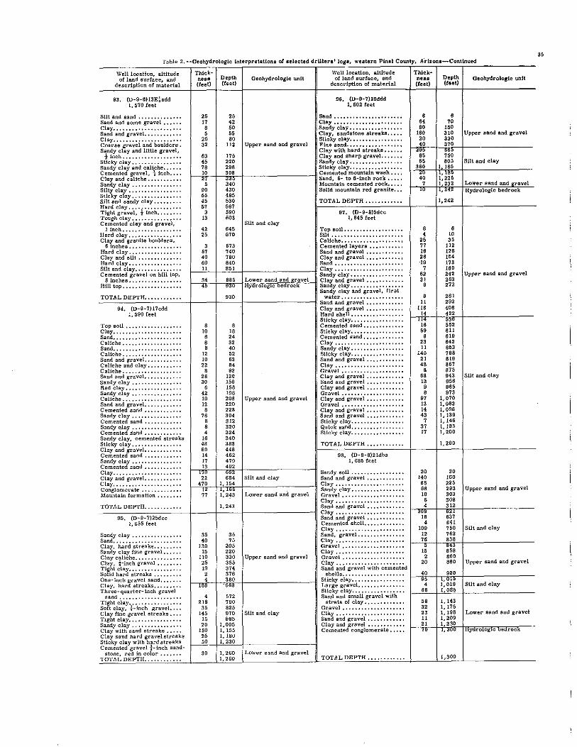
Table 2 --Oeohydrologlc interpretations of selacted drUlera' logs, westerll Pinal Count)', A"rl.zonl-Continui"-'d
Well location, altitude of land surface, and
description of material
93. (D-9-6)13E!sdd 1,570 feet
Thick-ness Depth (teet) (reet)
Oeohydrologic unit Welliocatlon, altitude of land surface, and
description of material
96. (D-9-7)29ddd 1,602 feet
Silt and sand. • • • •• • • •• • • •• 25 25 Sand •••• , •••••••••• , , ••••• Sand and some gravel...... 17 42 Clay •••••••••••••••••••••• Clay...................... 8 50 Sandy clay ••••••••••••••••• Sand and gravel,........... 5 55 Clay, aandstone streaks ••••• Clay.... •••••••••••••••••• 25 80 Sticky clay ••••.•••••••••••• Coarae gravel and boulders. 32 112 Upper sand and gravel Fine sand •••••••••••••••••• Sandy clay and little gravel, Clay with hard stresks ••••••
i inch................... 63 175 Clay and. sharp gravel ...... . Sticky clay.. . . . . • . . . • • • • • • 45 220 Sandy clay •••••••••• , •••.•. Sandy clay and caliche...... 78 298 Sticky clay •••••••.••••••••• Cemented gravel, ~ inch.... 1-~1O;-+--l'~O~'-1~~~~~~~~~-lCemented mountain wash •.••
i~~aya~~a~a.l~~~~::::::::::: 2~ ~~g ~:~:~t:~ ~oe~:~f~r:~k::::: Silty clay................. 90 430 SaUd mountain red granite ••• Sticky clay •..•••••••••• , • • 55 485 Silt snd sandy clay. • • • . . . . . 45 530 Hard clay. . . . . . • • • • • •• • • •• 57 587 Tight gravel, ! inch. • • . • • .. 3 590 Tough clay. • • • . • • •• • • • • • • • 13 603 Cemented clay and gravel, Silt and clay
TOTAL DEPTH ••••••••.••.
97. (D-9-8)5dcc 1,645 feet
1 inch................... 42 645 Top soil ••••••••••••••••••• Hard clay............... •• 25 670 Silt ••••••••••••••••••••••• Clay and granite boulders, . CaUche ••••••••••••••••.•••
6 inches. •••••••••••••... 3 673 Cemented layers ••••••••••• Hard clay................. 67 740 Sand and gravel ••.••.•••••• Clay and silt.............. 40 780 Clay and gravel •••••••••••• Hard clay. •• • • •• • •• • • .. • . • 60 840 Sand •••••••••••••••••••••• Silt and clay •••••••••••• , • • ~_'!c''--+-'''~'~'-1~~~~ ____ ~-l Clay •••••••••.••.••••••••• Cemented gravel on hill top, Sandy clay ••••••••.••••••••
8 inches................. 1-_'~'<-+,';'~'-1,L"o:;w"-'~'~'~'~n~di'~n~d~ "''i'ev,'c'-I Clay and gravel •••••••.••.. Hill top. ••• • ••• • • • • • .• • • •• 4~ ~;su tlyorologlc e rock Sandy clay ...••••••••••••••
Sandy clay snd gravel. first
CTCOCTCA:c::LCDCE:::.PT-=--HC·C·C· 'C'C'C'C'C' ·c·C·_+-__ -+_C93C°'--+-___ ~ __ ~~__IS!~t~~d·g;~;~i:::::::::::: 94. (D-9-7)17cdd Clay and gravel ••••••••••••
1,590 feet Hard shell •••••••.••.•••••• Sticky clsy •••••••••••••••••
Top soil ••••••.•..••••• , • • 8 8 Cemented sand ••••••••••••• Clay.... ••••••••••••••.••• 10 18 Sticky clay ••••••••••••••••• Sand •••••••• , • • • • • ••• • . . • • 6 24 Cemented sand ••••••••••••• Caliche. . • • • • • • • • • • •• • • •• • 8 32 Clay •••••••••••••••••••••• Sand...................... II 40 Sandy clay •••••••••.••.•••. Caliche................... 12 52 Sticky clay ••••••••••••••••• Sand and gravel.... •••••••• 10 62 Sand and gravel ..•••••••••• Caliche and clay........... 22 84 Clay •••••••••••••••••••••• Caliche............ ••••••• 8 92 Gravel ••..••..•••••••••••• Sand and gravel.......... .. 28 120 Clay and gravel ••••••••.•.• Sandy clay.. . .. . . .• • . . • • •• 30 150 Sand and gravel •••••••••••• Red clay.................. 6 156 Clay and gravel ••••••..••.• Sandy clay .......•.•••• , • • 42 198 Gravel ..•.•••••••••••••••• Csliche. .• • .• • • •• • • •• • • • • • 10 20B Upper sand and gravel Clay and gravel •..•••••.••• Sand and gravel............ 12 220 Gravel •••••••••••••••••••• Cemented sand............ 8 228 Clay and gravel •.•••••••••• Sandy clay.. ••••.•..•.•••• 76 304 Sand and gravel ••••••••••.• Cemented sand............ B 312 Sticky clay .....•.•••••••••• Sandy clay................ 8 320 Quick sand •••••••••••.••.•. Cemented sand............ 4 324 Sticky clay .•••••••••••••••• Sandy clay, cemented streaks 16 340 SUcky clay................ 48 388 TOTAL OEPTH ••••••..••.. Clay and gravel............ 60 448 Cemented sand............ 14 462 98. (D-9-8)21dba Sandy clay................ 17 479 1,685 feet Cemented sand............ 13 492
Thick-nUll Depth (leet) (feet)
• " 80 160 20
" <I:~
" 360
40 7
• , " 77 18 28 19
7 62 21
9
9 11
116
" 16
" , 23 11
'" 21
" , 68 13 , , 97 12
" 43 7
37 17
6 70
150 310 330 370
;~~ ,06
1,165
1: 225 I 232
1,242
6 10 35
'" 12' ,64 173 180 '42 26' 272
28' 29' 40' 422
~5~ 611 61' 64'
'" 798 ,19 867
'" 94' 96' '66 973
1,070 1,082 1,096 1,139 1,146 1,183 1,200
1,200
Clay...................... 1,!~, "6'" Sandy soil......... •••••••• 20 20 Clay and gravel............ Silt and clay Sand and gravel............ 140 160 Clay...................... 1--!47~0}-+'~,~'~'j'--!,~~~~~~~~-1 Clay................ •.•.•• 85 225 Conglomerate... .•.......• !: 1, ~~ Lo"" o,nd 0nd· gr'V" Sandy clay................. 6,'0 3"0" Mountain formation........ 77 1,213 ,,~ ~ ~ Gravel .••.••.•••••••••••••
Clay.............. ••••.•.• 5 308 TOTAL DEPTH............ 1.243 Sand and gravel............ 4 312 ~~:.=.:=:...::~~~~~+--+~::-.+--------1 Clay...................... "~'~6 ~'~'~7
95. {O-9-7)25dcc Sand and gravel ••••••••.••. 1,655 feet Cemented shell. •••••••••••• 4 641
Sandy clay ..•••••••••••••• Sand •••.••.••...••..•••••• Clay, hard streaks ••••••.•• Sandy clay fine gravel ..•••• Clay caliche ••••••••••.•... Clay, i-inch gravel ....••••
Clay.... .....••••••••••••• 109 750 35 35 Sand, gravel............... 12 762 40 75 Clay...................... 76 838
1~~ ig~ gr:;~l.:::::::::::::::::::: 1~ ~;~ 110 330 Upper sand and gravel Gravel............ ........ 2 860 25 355 Clay...... •••••••••••••••• 20 880
Oeohydrolo,ie unit
Upper sand and gravel
SUt and clay
Lower Band and gravel Hydrologic bedrock
Upper sand and gravel
Silt and clay
Upper sand and gravel
Silt and clay
Upper sand and gravel Tight clay •••••••••••••.•.. Solid hard streaks .......•• One-inch gravel sand •.•.... Clay, hard streaks ••••••••• Tbree-quarter-incb gravel
19 374 Sand and gravel witb cemented 2 376 shells.................... f.-.;'5'0~hc9~'n0:-l-~~~~~~-~-
I-"",~'l-+".~ ,,'~'~,0-l~~~~_~~~~-I tt;~~~ ~~iv'ei::::::::::::::: .. ~ ~: 019 sand .................. ..
Tight clay •••.•••.••....... Soft clay, i-inch gravel •••• Clay fine gravel streaks ..•. Tight clay ••••••••••••••••• Sandy clay ..•.•••••••.• , •• Clay with sand streaks ....• Clay sand hard gravel streaks Sticky clay with hard streaks Cemented gravel i-inch sand-
atone. red in color .•••••• TOTAL DEPTH ........... .
, 21'
" '" 15 20 ," 25
" 30
67' 790
'" 970
'86 1,005 1.155 1,180 1,230
Silt and clay
1,260 Lower sand and gravel 1,260
Silt and clay Sticky clay................. 66 1,085 San,d and small gravel with
strata of clay............. 5B 1,143 Gravel ••••• ,.............. 32 1,115 Clay...................... 23 1.198 Sand and gravel •••• , • .• • .. • 11 1,209 Clay and gravel............ 21 1,230 Cemented conglomerate..... 11.1 l, <11.1.
Lower aand and gravel
• tlyarOlog c eorock
TOT A L DEPTH ...• ' ...... . 1,300

36 Table 2 ·-Oeohyttl'ologlc interpretationa of .elected drUlen' 10i6, wealern Pinal County. Arbona-Contlnued
"'ell location, altitude of land surface. and
description of material
99. (D*9*8)34dcd 1.710 feet
Top soU •••••••••••••••••• Fine sand ••••••••••••••••• Coarse gravel ••••••••••••• Coarse sand ••••••••••••••• Hard sand •••.••••••••••••• Clay •••••.•••••••••••••••• Sand and clay •••••••••••••• Clay with sand streaks ••••. Cemented conglomerate •.•• Sand and gravel with some
clay ••••••••••••••••••••• Quartz, rock*hard •••••••••
Thick-ness Depth (teet) (reet)
GeohyclrolOilc unit We111ocation, altitude
of land surface, IlIId description of material
102. (0-10-9)5ccb-Continued
Clay gravel •••••••••••••••• 30 30 Sand and gravel. water •••••• 15 45 Clay gravel ••••••••••••••••
115 160 Upper sand and gravel Sand •••••••••••••••••••••• 70 230 Rock ................... ".
_~17.0;-+-->4,0,0-t _________ -lIClay gravel •••••••••••••••• ~~ ~~~ Cemented gravel •••• '" •••• 80 510 Sand gravel ••••••••••••••••
140 650 Silt and clay Brown shale ••••••••••••••• __ 3~0~+--.!'~'~0--l _________ -lGravel clay ........•.......
Rock •••••••••••••••••••••• L--;7iiO_f--,7.5"0f--hL"o;;wii,,,<,*,.,,,"~d',;;.nadi;~~"~'"'"I-jjClay gravel ...........•.... I 5B 806 Hydralog c OeUrOCK Sand and gravel ••••••••••••
Hard brown clay ••••••••••••
_TC°,--T_ACLCD:..:ECPCTC"C·C·C·C· C"C'C'C'C' C' C· -I---+--='CoC'-I----------l Granite rock •••••••• " •••••
100. (D*9*9)34ddd TOTAL DEPTH •••••••••••• 1,787 feet
Dry gravel •.•••••••••••••• Clay gravel •..•••••••••••• Clay gravel ••••••••••••••• Clay •.•••••••••••••••••••• \Vater gravel ••••••••.••••• Sandy clay •••••.•••••••••• \Vater gravel •••••••••.•.•• Sticky clay •••••••.•••••••• Some gravel atrata. very
thin •••..•••••••••••••••• Clay •••••••••••••••••••••• Gravel •••••••••••••••••••• Gravel. •• , ••••••• " ••••••• Clay", •.••••••••••••••••• GraveL ••••••••••••••••••• Clay .••••••••••••••••••••• Gravel ••••.••••••••••••••• Very hard clay •••••••••••• Conglomerate ••••...•••••• Rock •.•••••••••••••••••••
103. (0* 10*9)l6ccc 77 77 1.784 leet 35 112 37 149 SUt ••••••••••••••••••••••• 16 165 Upper sand and gravel Gravel •••••••••••••••••••• 25 190 Gravel and bouldera •••••••• 38 228 Coarse gravel, 4 inches •••••
f=:i'~'=1==2~'~0'=~!'l:§!::£§'=====l Clay and caliche •••••••••••• an c a Sand and gravel. 3 inches ••• Clay •••••••••••••••••••••• Hard sandstone ••••••••••••• " , ,
13 85
4 , 21
7
83
373 377 382
'" 461
'" 470 491 498
GOO
Lower sand and gravel
Hydrologic bedrOCk
Clay and gravel •••••••••••• Hill top and decomposed
granite ••••••••••••••.••••
TOTAL DEPTH ••••••••••••
104. (D-I0-9)23add 1.830 feet
TOTAL DEPTH •••••••.••••
Top soil ••••••••••••••••••• Sandy clay •••••••••.••••••• Sand and gravel ••••••••••••
---ccC--C---,-.,.c-----+----+---+-----~-----1 Sand and gravel. first water. 101. (D-9-10)29aaa Sandy clay ............... ..
1,870 leet Sand ..................... . Clay ••.•••••••••••••••••••
Top soil.................. 10 10 Sand •••••••••••••••••••••• Red clay..... •.•••••••.••• 60 70 Cemented sand ••••••••••••• Sand and gravel......... ••• 15 85 Clay •••••••••••••••••••••• Red clay........ •••••••.•• 40 125 Hard cemented sand •••••••• Sandy shale............... 96 221 Clay •••••••••••••••••••••• Sand. some water.......... 3 224 Sand •••••••••••••••••••••• Sandy red clay........... •• 31 255 Cemented sand ••••••••••••• Sand.. . • . . •• • • • . • • • • • • • • • • 2 257 Jointed clay •••••.•••••••••• Sand clay................. 43 300 Clay •••••••.•••••••••.•••• Sand...................... 11 311 Jointed clay •••••••••••••••• Sand and gravel.. •••.•••••• 15 326 Sand ••••••.••••••••••••••• Gray clay................. 18 344 Clay •..••••••••••••••••••• Sand....... •••••••••.••••• 5 349 Hard cemented decomposed Sticky gray clay........... 22 371 granite .................. . Sand................ •..••• 4 375 Very sticky yellow clay..... 10 385 TOTAL DEPTH •••••••••••• Very sticky red clay....... 29 414 Sand...................... 5 419 105. (D-IO-9)36ddd Red clay.................. S 428 Upper sand and gravel 1,860 feet Sand clay............... •• 42 470 Sand clay and gravel....... 10 480 SoU ••••••••••••••••••••••• Clay and gravel............ 10 490 Gravel •••••••••••••••••••• Sand and graveL........... 5 495 Clay •••••••••••••••••••••• Sticky white clay........... 15 510' Gravel ••••.••••••••••••••• Sand and graveL........... 2 512 Clay ••••.••••••••••••••••• White large gravel......... 18 530 Gravel •••••••••••••••••••• Sticky clay................ 15 545 Dirty gravel ••••••••••••••• Sand and clay streaks...... 5 550 Sandy clay ••••••••••••••••• Clay and sharp gravel...... 5 555 Clean graVel and water •••••• Clay...................... 35 590 Clay ..................... . Clay and small red gravel.. 15 605 Gravelly clay •••••••••••••• Sticky clay................ 5 610 Gravel and water ••••••••••• Sand...................... 15 625 Gravel and clay ••••••••.••• Clay...................... 5 630 Gravel and water •••.••••••• Sand............ •..•••••.. 5 635 Gravel and clay •••••••••••• Sand and gravel. ••••••••••• 1-~~1~3~f--~'~'~':-f----------__jJ Gravel and water ••••••••••• Clay........ •••••••••••.•• ~3~6~0 ~~~ Gravel and clay •••••••••••• Joint clay......... •.•••••• f---'J::r-+{I,. nl4~0i--~5'i""'-"'"~d'-"ol"''Ly----~ ~~~~:t~n~a~:~~;::::::::::: ~~~~.~~ 'g'r'a'v'ei:::::::::::: I __ ~ '7~'~_~i 11'c" ~~'5B*'i--~L~OW'(H;"~'~.~nd~.~nd~£; g,<~ .. ,'~I~ SG'.",~"IOI,·nyd·w· , .. t'·;·.·.·.·.·.·.·.·.·.·.·. Conglomerate............. r 168- ---f,-4ro- -Hyaro og c oearOCK • • •
Sand and water ••••••••••••• TOTAL DEPTH............ 1,410 Sandy clay •••••••••••••••••
---:c:::---c::-::cc:cC-,..---+---j--'--+---------I1 GraveUy clay •••••••••••••• 102. (D-I0-9)5ccb Sticky clay ................ .
1,755 feet Sand and water .•••••.••••••
Top soil •.••• , .••••••••••• Boulders and gravel sand.
dry •••..••••.••••••••••• Gravel and sand .••••.•.••• Rock ................... .. Quicksand and boulders •...•
40
30 20 20 20
40
70 90
110 130
Upper sand and gravel
Clay •••••••••••••••••••••• Clay with layers of gravel
and water •••••••••••••••• Sticky clay ••••••••••••••••• Sand and water ••••••••••••• Clay •••••••••••••••••••••• Sandy clay •••••••••••••••••
30 70 70 20 10 20 15 60 20 20 20 10 30 40
28 12
122 22 80 15 44 , " 20
3 27
144 42
" 5
" 5 29 13 7 , 5
" 44 18 38 , , 12
20 20 13 12 5
II
" 83 22 34 31
5 15 , 15 , 20 15 12 20 , " 20 16 II
3 18
42 9 , , 6
Depth (teet)
160 230 300
'" 340
'" 380 440
'" 490 510 520 SOO 590
600
28 40
162 184 '64 280 324 328 380 400
400
3 30
174 216 20' '58 326 331 360 373 380 38' 392
'" '" 476 512 520 522
534
534
20 40 53 55 70 81
lOS 186 210 '44 275 260 '96 300 315 320 340 355 357 392 395 425 445 461 472 475 493
535 04' 04' 552 55'
Geohydrolo,le unit
nyc ro og c OettroCk
Upper sand and gravel
Hydrologic bedrock
Upper sand and gravel
HydrologiC bedrock
Upper sand and gravel
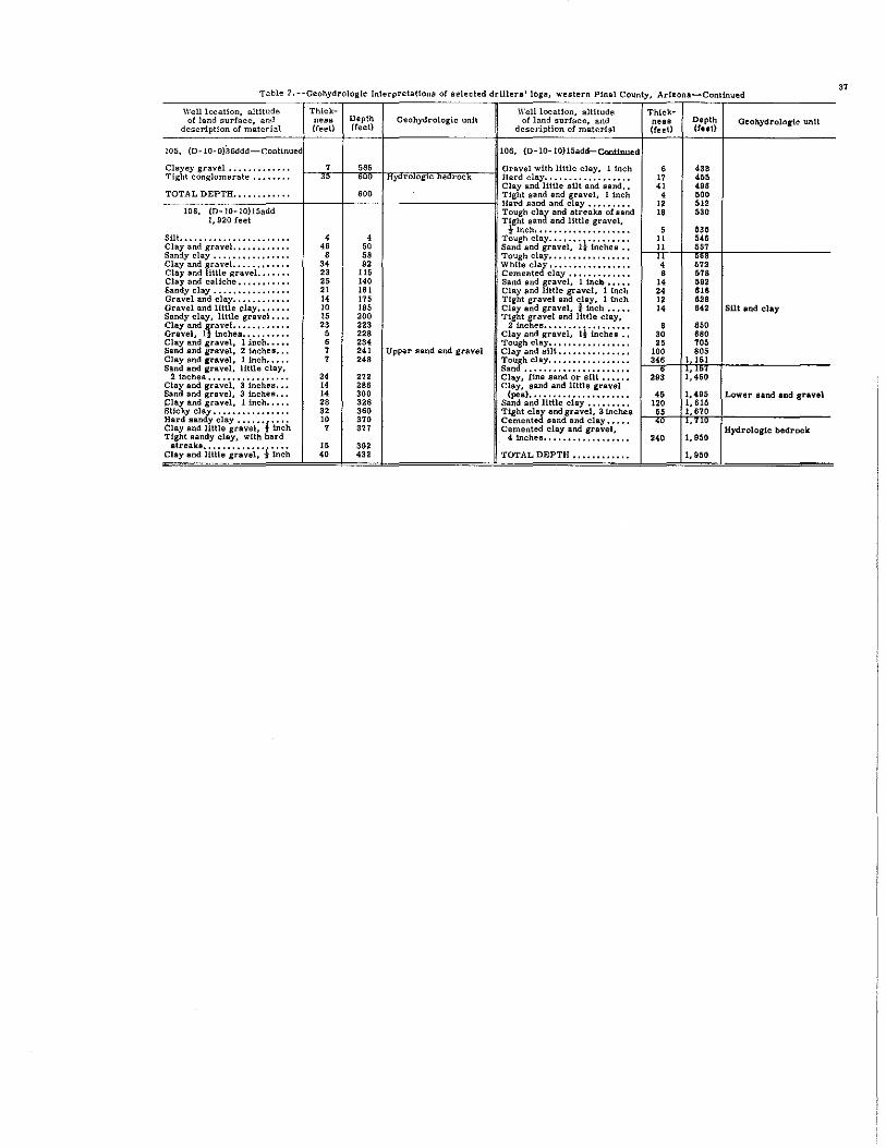
Table 2. --Geohydrologlc Interpretations of selected drillers' logs western Pinal County Arbona-Continued 37
Well location, altitude Thick- Well location, altitude Thlck-of land surface, and nesa Depth Geohydrologic unit of land surface, and ness Depth Gcohydroln,lc unit
descrfptlon of material (feet) (teet) description of material (teet) (feet)
LOS. (D-10- 9)36ddd-continued 106. (D-10-IO)15add-Coniinued
Clayey gravel ••••••••••••• 7 '" Gravel with little clay, linch 6 '" Tight conglomerate •••••••• " ,eo Hyarol0g1c DeQrOCk Hard clay .................. 17 '" Clay and little silt and sand •• 41 498 TOTAL DEPTH •••••••••••• 600 Tight sand and gravel, 1 inch , 500
Hard sand and clay ••••••••• 12 51' 106. (D-10-IO)15add Tough clay and streaks of sand 18 530
1,920 feet Tighl sand and little gravel, t Inch •••••••••••••••••••• ,
'" Silt ••••••••••••••••••••••• 4 4 Tough clay ••••••••••••••••• 11 '" Clay and gravel •••••••••••• " " Sand and gravel, It inchea •• 11 5S7 Sandy clay ••.••••••••••••• 8 58 Tough clay ••••••••••••••••• '~ ~;i Clay and gravel •••••••••••• 34 " \Vhite clay ••••••••••••••••• Clay and liltle gravel. •••••• 23 11& Cemented clay ••••••••••••• 8 578 Clay and caliche ••••••••••• 25 140 Sand and gravel, 1 inelt ..... 14 5" Sandy clay •••••••••••••••• 21 161 Clay and little gravel, I inch 24 816 Gravel and clay •••••••••••• 14 175 Tight gravel and clay. 1 inch 12 628 Gravel and little clay ••••••• 10 185 Cla~ and gravel, i inch ••••• 14 ." SUt and clay Sandy clay, little gravel •••• 15 200 Tig t gravel and little clay, Clay and ~ravel ••••••• " ••• 23 223 2 inches •••••••••••••••••• 8 850 Gravel, 1 inchel •••••••••• 5 '28 Clay and gravel, Ii inches •• 30 680 Clay and gravel, 1 lnch ••••• • 234 Tough clay ••••••••••••••••• " 705 Sand and gravel, 2 inches ••• 7 241 Upper sand and gravel Clay and slit ••••••••••••••• 100 "5 Clay and gravel, 1 inch ••••• 7 248 Tough clay ••••••••••••••••• ". 1,151 Sand and gravel, little clay, Sand •••••••••••••••••••••• 29: 1; ~:6 2 inches ••••••••••••••.•• 24 27' Clay, fine sand or sUt •••••• Clay and gravel, 3 inches ••• 14 '86 Clay, sand and little gravel Sand and gravel, 3 inchea ••• 14 300 (pea) ••••••••••••••••••••• " 1,495 Lower sand and gravel Clay and gravel, 1 inch ••••• 28 328 Sand and llttle clay ••••••••• 120 1,615 Sticky clay •••••••••••••••• " 360 Tight clay and gravel, 3 inches " 1,670 Hard aandy clay ••••••
i .... 10 370 Cemented sand and clay ••••• '" .' '" Cla~ and little gravel, inch 7 377 Cemented clay and gravel, Hydrologic bedrock
Tlg I aandy clay, with hard 4 inches •••••••••••••••••• 240 1,950 streaks •••••••••••••••••• 15 392
Clay and little gravel, 1- inch 40 '" TOTAL DEPTH •••••••••••• 1,950

~I Tom w.n Date of Depth pera- Silica Calcium Magna-slum location eolledio (feet) , turc (SlOt (Ca) (Mg)
CF)
(0-3-4)
25dcb 9/25/41 156 " - 104 29
(0_3_5)
28cbb 9/25/41 164 70 - 146 38·
29bcb 9/25/41 174 70 - 129 33
31ubc 9/25/41 186 " - - -
34bbb 9/25/41 158 " - 136 35
6/21/49 72 " 169 31
8/23/50 72 - - -
(0-3-6)
31aba 9/25/41 226 73 - 64 19
1/ /59 605 - - - -(0_4_2)
13ccc 4/14/59 416 71 52 9>1 390
3/30/61 74 4B 677 307
3/30/61 " 54 655 290
(D-4-3)
22caa. 9/13/49 - B2 - - -
34ddd 9/17/41 300 76 - - -
36bcd 9/13/49 280 78 44 76 17
8/23/50 77 - - -
(0_4_4)
16cdd 9/17/41 600 83 - 56 12
16ddd 9/13/49 600 B4 30 35 6.0
17cdd 9/17/41 600 79 - 60 12
20bdd 9/17/41 464 78 - 260 60
28daa 9/17/41 600 81 - 30 6.3
33bdd 9/13/49 600 as - - -33ddd 9/17/41 305 80 - 40 10
Table 3. -·Chernical..na.lYlIeli or ground water, welJtern P1nal. County, Arizona
(Analytical re.w.ts in parta per mJ.lllon except as indicatc<t)
Pl.lilolved Bardne ... solids &8 CaCOS Per-
Sodium Pota.- '1'"';1, C,,- Swrat~ I CMond, Fluo Ni-olum bonate bonate ride trate !cent
(Na) (K) (HCOS)1 (COSI (504)' (el) (F) (N°i Parta TOIlB Calcium Non- 110-per per magne- car- (\1=
million acre- alum bonate root
189 274 a '" 278 1.4 3. a 900 1. 22 379 154 52
206 272 a 238 348 1.3 5. a 1,120 1. 52 521 I)lB 46
216 337 a 222 290 1:6 9.7 1,070 1. 46 45S 182 51
- 292 a - 352 - - - - - - -182 251 a 199 325 - - 1,010 1. 37 "" 269 45
247 309 a "9 400 1.0 9. a 1,300 1.77 549 296 49
- 309 a - <06 - - - - - - -
143 201 a 112 185 1.5 3. a 626 .85 238 73 57
- 186 a - 74 - - - - 50 a -
3,930 3<7 a 3,330 6,160 4.2 - 15,000 20.4 3,900 3,620 69
3,1f/0 337 a 3,510 4,130 5.1 58 12,200 16.6 2,950 2,670 70
3,240 341 a 3,530 4,130 5.3 146 12,200 16.6 2,860 2,580 71
- 180 a - 33 - - - - - - -- 179 6.9 - 60 - - - - - - -
117 221 a '" 93 • 7 18 652 .89 260 79 49
- '" a - 102 - 21 - - - - -
160 109 a 201 160 3.3 5. a 651 .89 189 100 65
134 151 a 144 B4 3.1 3.5 514 .70 112 0 72
121 123 9.8 121 149 2.6 2.5 538 .73 199 99 57
326 230 a 669 510 - - 1,940 2.64 896 707 44
117 150 a 113 74 3.4 2.5 420 .57 101 a 72
- '" a - 4B - - - - - - -124 144 a 155 85 1.5 9.8 496 .67 141 23 66
Sodium_ ~peeiC1c ad.orp- fO:!U~-t1~ ~micro-rao ~~.t (SA&) 2S.C)
4.2 1,530
3.9 1,870
4.4 1,740
- 1.840
3.6 1,720
4.6 2,120
- 2,200
4.0 1,070
- 653
27 21,000
26 17,500
26 17,100
- 549
- 721
3.2 1,010
- 1,150
5.1 1. 110
5.3 807
3.7 922
4.7 2,970
5.1 715
- 584
4.5 832
pH
-
--
-
---
-
7.6
7.1
6. B
7.2
----
---
----
RemarkB
Sampled at 125 feet
Sa.mpled a.t 400 feet
~ 00

T.').ble 3. --Chemico.l analyses or grOUIld water, western Pinal County, Ari:ona-Contlnued
-
Dissolved Hnr<iness Sodium- Speei!ic
Tem- solids as CaC03 per_ oDduet-W.U Date or De". pera- Silica Cnlcium Magne- Sodium Potas- Biear- Car- Sulrate Chloride Fl," Nl- •• m adsorp-
slum .1= bonate bonate rid. rate tion ~ .. pH Remarkll location colleetio (feet) ture (81°2) (Ca) (Mg)
(No.) (K) (HC03) (C03)
(504) (Cl) (F) (N03) Parts Tons Calcium. Non- .. - ratio (micro_ (OF) dium mhOS at per per m .... - car- (SAR)
million acre- "om bonate 25OC) fool
(0_4_5)
3ece 1/ /59 705 - - - - - 155 0 - 195 - - - - 655 528 - - 1,830 7.4
6bec 3/10/61 385 75 - - - - 148 0 264 322 - - - - 348 226 - - 1,810 7.6 Sampled at 125 feet
3/10/61 76 - - - - 186 0 167 266 - - - - 280 128 - - 1,500 7.4 Sumpled at 250 feet
12a.').a 9/25/41 250 72 - 104 27 182 248 0 148 290 - - 873 l.19 371 168 55 4.l 1. 520 -(0-4-6)
3b= 1/10/57 153 71 42 208 56 404 7.4 305 0 323 720 1.8 7.2 1,920 2,61 750 500 54 6.4 3,200 7.6 Sampled at 129 fect
16adc 9/25/41 21< 74 - 120 29 209 271 0 214 302 .7 - 1,010 1. 37 419 197 52 4.4 1,730 -6/21/49 460 79 42 33 7.1 51 179 0 48 29 l.l 3.6 313 .43 U2 0 54 2.5 480 -8/23/50 - - - - - 178 0 - 30 - - - - - - - - 481 -
(0-4-7)
28=a 12/9/58 459 - - - - - 75 0 - 225 - - - - 33 0 - - 1,120 8.0
~ 32ccd 12/ /58 534 - - - - - 261 0 - 302 - - - - 174 0 - - 1,560 6.9
(0-4-9)
5=" 7/7/55 403 74 - - - - 201 0 - 186 - - - - - - - - 1,070 7.0 Fell sampled llIIllUally
7/18/56 74 - - - - 199 0 - 194 - - - - 248 85 - - 1,060 9.0
7/12/57 75 - - - - 157 22 - 186 - - - - 212 47 - - 1,050 9.7
7/17/58 74 - - - - 189 6 - 181 - - - - 220 55 - - 1,060 9.4
8/11/59 75 - - - - 192 0 - 191 - - - - 236 79 - - 1,090 7.3
9/1 /60 76 - - - - 189 0 - 197 - -, - - 250 95 - - 1, 140 7.5
6.')..')..'). 1/2 /51 453 76 33 " 14 U8 '" 0 68 174 1.2 6.8 574 .78 214 56 54 3.5 1,000 7.5
25bcd 6/16/53 300 70 37 93 24 148 221 12 130 218 .9 7_8 779 1. 06 330 130 49 3.5 1,310 7.8
28cca 6/21/49 254 70 39 102 26 145 213 0 U2 266 1.0 9.2 802 1. 09 362 187 47 3.5 1,400 -6/ /60 - - - - - - - - - - - - - - - - - 1,600 -
(D-4-10)
32b.').d 9/24/41 212 70 - 92 23 160 236 0 139 228 1.0 17 773 1. 05 324 130 52 3.9 1,350 - Well sampled annually
5/26/58 392 70 39 164 32 167 235 0 152 311 1. , 138 1,120 1. 52 540 348 40 3.1 1,860 7.7
8/26/59 70 - - - - 226 0 - 222 - - - - 358 l73 - - 1,420 7.4
7/21/60 69 - - - - 385 0 - 222 - - - - 380 187 - - 1,480 7.3
~ 22bbc 9/16/41 505 84 - 51 10 221 149 0 200 212 3.0 14 784 1. 07 168 48 74 7.2 1,360 -
~
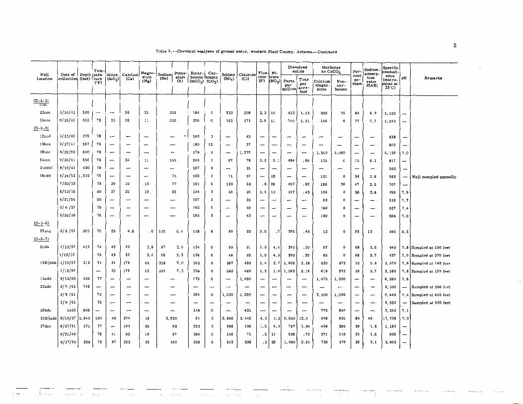
--,-Tem- Magna-w,n Date of Depth perll- Silica Calcium sium location collectio (reet) tura (Si02) (Co.)
(Mg) (CF)
{O-5-2) ---con:-
23ccc 9/16/41 505 - - 56 21
25ccc 9/1'5/49 602 78 32 38 11
(D-5-3)
12aad 9/13/49 375 78 - - -13ban 9/17/41 567 76 - - -28bec 6/29/60 600 78 - - -34ccc S/20/41 550 76 - 24 " 34dddl 9/16/41 400 78 - - -
36cdd 8/14/52 1,212 79 - - -7/20/53 78 39 55 12
8/10/55 80 37 25 10
5/21/56 '0 - - -
5/9 /57 79 - - -5/26/58 79 - - -
{D-5-61
27adn 2/6 /57 500 79 25 4.8 .0
(D_5_7)
Sudb 1/12/57 '15 74 43 22 2.9
1/12/57 78 43 22 2.4
12E}bbb 1/10/57 212 71 31 176 44
1/10/57 - 29 176 43
14add 6/12/60 "6 77 - - -22add 3/9/61 745 - - - -
3/9/61 79 - - -
3/9/61 79 - - -22bdc 1958 903 - - - -25Etudd 8/10/57 1,940 130 40 374 " 27dee 8/27/41 175 77 - 144 26
6/21/49 78 41 82 16
8/17/50 250 76 67 253 26
Table 3. --Chemical analyses or groucd water, western Pinal County, Arizona_Continued
Dissolved Ho.rdness
Potns- Biear_ Car-F1udt
Bolids ns CaeOa Sodium slum
Sulfate Chloride ride rate (Na) bonate bOIlll.tc (504) (ell Parts Tons (K' (BeOs) (COS) (F) (NOa) Calcium. Non-per per ma.gne- cnr-
million acre- sium bonate foo<
216 '" 0 223 208 2.3 " 833 1.13 226 75
210 208 0 162 ,71 2.9 11 7<0 1. 01 1<0 0
- 190 0 - 49 - - - - - -- 180 12 - 37 - - - - - -- 179 0 - 1.370 - - - - 1,240 1; 090
1<5 240 0 97 76 3.2 9. , 484 .66 105 0
- 187 0 - 31 - - - - - -" "8 0 71 37 - " - - 121 0
77 181 0 103 62 .6 29 457 .62 "6 38
65 154 0 60 30 1.4 13 317 ." 104 0
- 157 0 - 32 - - - - 93 0
- '" 0 - 40 - - - - 160 8
- 180 0 - 42 - - - - 130 0
102 0.4 128 6 63 22 9.0 .7 296 .40 12 0
67 2.4 134 0 50 31 1.0 4.4 290 .39 67 0
68 2.2 136 0 48 32 '.0 4.3 290 .39 65 0
318 7.0 302 0 387 480 1.4 2.7 1,600 2.18 620 372
324 7.2 298 0 382 480 1.2 1.9 1,590 2.16 616 ,,, - ," 0 - 1,480 - - - - 1,470 1,330
- - - - - - - - - - -- 204 0 1,630 1,290 - - - - 2,100 1,930
- - - - - - - - - - -- 148 0 - 425 - - - - 770 649
2,920 " 0 3,660 2,440 4.3 1.3 9,500 12.9 999 934
82 220 0 298 108 1.5 9.2 767 1. 04 466 286
67 186 0 148 71 .3 11 528 .72 271 118
193 320 0 515 238 .3 29 1,480 2.01 738 476
Sodium-Per- adsorp_ cent tion '0- ratio diuO!. (SAR)
" 6.2
77 7.7
- -- -
- -
75 6.1
- -
" 2.8
47 2.5
58 2.'
- -- -
- -
95 13
68 3.6
68 3.7
52 5.6
53 5.7
- -- -- -- -- -86 40
28 '.6
35 '-' 36 3.1
Specific ~~ndu<:t-
nnea {micro_ F~OS at 25~C)
1.420
1,240
638
602
5, ISO
817
502
562
707
498
51'0
627
596
496
440
437
2,570
2,580
6,260
6,500
6,440
6,520
2,240
17,700
1,180
80'
2,060
,.
--
--
7.9
--
--7.9
7.7
7.4
7.9
8.5
7.8
7.9
7.6
7.6
7.6
-7.4
-7. ,
7.0
-
--
Remarks
• o
Well sampled rumually
Sampled at 150 feet
Sampled nt 370 feet
Sampled at 140 feet
Sampled at ISO feet
Sampled at 200 feet
Sampled at 400 feet
Sampled at 525 feet

Table 3. ~~ChemJcal analy8e8 or ground water, wefrtern Pi.IUIJ. County, Arizona-Continued
Di8aolved Hal;'dneaa Sodlum~
Specltic Tem~
Magne~ Potas. Blcar· Car· Fluo N'· solids as CaC03 Per_
ndsorp~ onduct.
Wcll Date 01. Depth pera- SUica Calcium alum Sodium ,,= bono.te bQllD.te Sulfate Chlor1de rid. rate cent tion ance
pH Remarkll location collectio (teet) ture (Si02) (Cn) (Mg) (Nn)
(K) (BC03) (COS) (S04) (Cl)
(F) (NOS) Parts Tona Calcium. Non- .0· ratio (micro. (OF)
per per magne- car- dium (SAR) mhos nt million acre_ .,= bonate 25"C)
foot
(0.5-8)
2uua 9/24/41 230 73 - 68 25 204 194 0 151 278 0.7 7.7. '" 1.13 272 113 62 5. , 1,430 -7baa 10/20/59 545 - - - - - '" 0 - 4!5 - - - - 320 232 - - 1. 820 7.' IOcca 3/10/61 796 72 - - - - - - - - - - - - - - - - 1,890 - Sampled at 175 feet
3/10/61 73 - - - - - - - - - - - - - - - - 1,890 - Sampled at 600 feet
3/10/61 73 - - - - - - - - - - - - - - - - 1,610 .- Snmpled at 775 feet
!4ead! 9/25/41 216 73 - 140 " 305 324 0 28) 445 - - 1,370 1.86 522 266 56 5. , 2,330 -!4ead2 2/6 /57 730 - " lOS 24 240 30S 0 184 305 1.6 15 1,070 1. 46 368 116 " 5.4 1,760 7.5
3/10/61 72 - - - - 30J 0 192 324 - - - - 400 I" - - 1, 860 7.4 Snmpled at 200 feet
3/10/61 72 - - - - 266 0 - 268 - - - - 318 100 - - 1, 600 7.9 Sampled at 350 feet
3/10/61 73 - - - - - - - - - - - - - - - - 1,570 - Sampled at 496 feet
17bao. 9/24/41 421 74 - - - - 181 0 - 30S - - - - - - - - 1,620 -19add 9/2/41 320 77 - 46 9.2 149 160 0 97 168 1.4 4.0 553 .75 153 22 " 5.2 964 -1geec 9/1 /41 250 76 - 176 41 303 122 0 360 550 ., 18 1,510 2.' 05 60s 50s 52 5.3 2.530 -ZOuddl 9/4/41 160 76 - 489 100 455 241 0 980 970 1.4 39 3, 150 4.28 1,630 1. 430 38 4.9 4.660 -20bdd 9/4/41 240 76 - '" 154 "6 !l9 0 1,330 1.730 2.4 55 4.750 6.46 2.390 2.270 40 6.5 7.040 -25bbe 9/24/41 406 B2 - !I 2.2 116 147 '.9 56 53 5.3 '.6 333 .45 36 0 87 8.4 564 -26bbc 9/24/41 256 76 - 324 68 259 193 0 "I 555 ' .5 - 1.980 2.69 1,090 932 34 3.4 3,050 -
6/ /60 77 - - - - - - - - - - - - - - - - 1,700 -28edd 7/6/60 200 8) - - - - 160 0 - 1,160 - - - - 710 579 - - 5.040 7.9
30edd 9/3/41 200 77 - 171 3! 159 211 0 269 292 I. , 39 1.070 1. 46 554 381 38 2.9 1.750 -31bdd 6/21/49 - 78 43 196 32 190 216 0 279 384 1.5 24 1,260 1.71 620 444 40 3.3 2,050 -
6/ /60 - - - - - - - - - - - - - - - - - 1,380 -31dec 7/8/60 568 77 - - - - 123 0 - 550 - - - - 860 759 - - 2,850 7.' 35add 9/25/41 218 76 - 107 27 167 215 0 255 202 1.7 12 '" 1.19 378 202 49 3.7 1,410 -
6/ /60 502 81 - - - - - - - - - - - - - - - - '50 -(D·S_9)
6cdd 9/17/41 320 70 - 136 31 205 297 0 180 342 - - 1,040 1.4'1 467 223 49 4.1 1.810 -11ede 3/28/51 845 72 - - - - 218 0 179 156 - - - - 302 124 - - 1,180 7.0 Sampled at 250 feet
3/28/61 7J - - - - 216 0 180 154 - - - - 304 127 - - 1,180 7.0 Sampled at 400 feet
3/28/61 71 - - - - 154 0 167 I" - - - - 252 126 - - 1,080 7.6 Sampled at 800 feet
19ddd 3/9 /61 300 73 33 345 82 222 240 0 599 502 .9 59 2,050 2.80 1,200 1,000 29 2.' 3,090 7. , Sampled at 200 feet
e
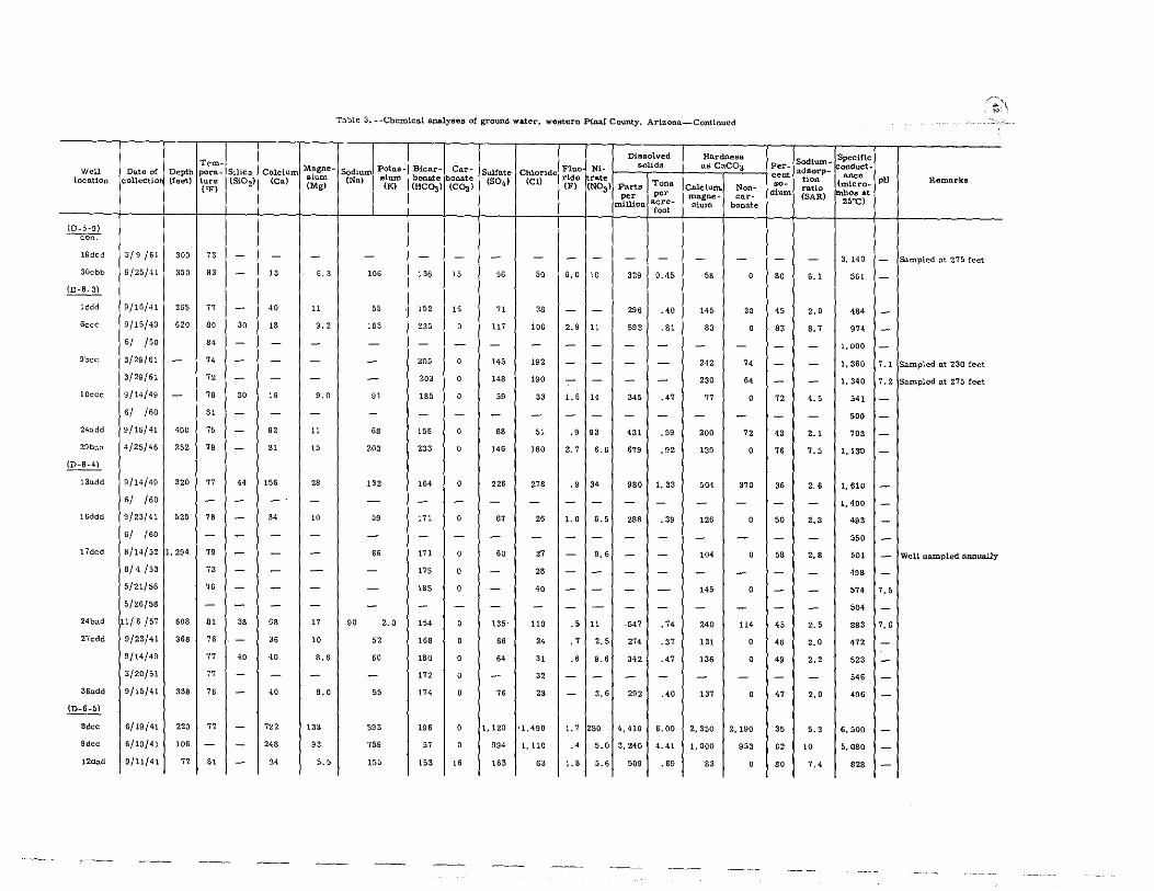
Tern_ Mo.gne_ W.ll Date of Depth perll- Silica Calc:ium alum location collectio (feet) tul'a (51°2) {Cal (Mg) (eF)
(0-5-9) ~
19ddd 3/9/61 300 73 - - -30cbb 9/25/41 350 83 - 13 6.3
(0-6.3)
Iddd 9/16/41 265 77 - 40 11
Gcce 9/15/49 620 80 30 18 9.2
6/ ISO 84 - - -9bec 3/29/61 - 74 - - -
3(29/61 " - - -IOcce 9/14/49 - 78 30 16 9.0
6/ /60 Bl - - -24add 9/15/41 400 75 - 62 11
29baa 4/25/45 252 79 - 31 15
(D-5-4)
13add 9/14/49 320 77 44 156 2B
6/ /60 - - - -15ddd 9/23/41 525 78 - 34 10
6/ /60 - - - -17dcd 8/14/52 1,294 79 - - -
8/4/53 73 - - -5/21/56 76 - - -5/26/58 - - - -
24bad 11/6/57 608 81 3B 68 17
27cdd 9/23/41 368 76 - 36 10
9/14/49 77 40 40 8.6
3/20/51 77 - - -36add 9/15/41 338 7S - 40 9.0
~ 8dcc 6/19/41 220 77 - '22 133
9dcc 6/19/41 lOS - - 248 93
12dad 9/11/41 77 Bl - 24 5.5
.---
Table 3. --Chemical analyses or ground water. western Pm.aJ. County. Arizona_Continued
DiIllBOlved Hnrdnes8
Sod~~rr Potas. Bienr- Car- Fluo Nl. solida as CaeOS sturn bonate bonate
Sulfate Chloride ride r.te (No.)
(K) (HCOJ) (C0;l1 (504) (el) (F) {NOSI Part. Tons Calc:iurn. Non-
po. poo rnll.gne- car-Il1illion acre- aium bonate
foot
- - - - - - - - - - -106 136 " " 50 6.0 10 329 0.45 58 0
55 152 16 71 2B - - 296 .40 145 20
183 235 0 117 106 2.9 11 593 .81 83 0
- - - - - - - - - - -
- 205 0 145 192 - - - - 242 74
- 203 0 148 190 - - - - 230 64
91 185 0 59 33 1.6 14 345 .47 77 0
- - - - - - - - - - -68 156 0 68 51 .9 93 431 .59 200 72
203 233 0 146 160 2.7 6.6 6'9 .92 139 0
132 164 0 226 278 .9 " 980 1,33 504 370
- - - - - - - - - - -59 171 0 67 26 1.0 6.5 288 .39 126 0
- - - - - - - - - - -66 171 0 SO 27 - 9.6 - - 104 0
- 175 0 - 2B - - - - - -- 185 0 - 40 - - - - 145 0
- - - - - - - - - - -90 2.0 154 0 135 110 .5 11 ,547 ." 240 114
62 168 0 66 24 .7 2.5 27, .37 131 0
60 180 0 64 31 .6 9.6 342 .47 136 0
- 172 0 - 32 - - - - - -55 174 0 OS 23 - 3.6 292 .40 137 0
593 196 0 1,120 '1.490 1.7 250 4,410 6.00 2,350 2,190
759 57 0 994 1,110 .4 5.0 3,240 4.41 1,000 953
155 153 16 163 63 1.' 5.6 509 .69 83 0
Sodl\ll'1'l-Per_ ado.orp_ .0" tion .0· ratio diUm
(SAR)
- -
80 6.1
45 2.0
83 8.7
- -- -- -72 4.5
- -43 2.1
76 7.5
36 2.6
- -50 2.3
- -58 2.8
- -- -- -45 2.5
4S 2.0
49 2.2
- -47 2.0
35 5.3
62 10
SO 7.4
Specific onduct. a~o
(micro_ Im~oa at
25"C)
3, 140
5"
484
974
1,000
1.360
1.340
541
500
703
l,l3U
1,610
1,400
493
550
501
498
574
504
883
472
523
546
496
6,500
5,080
828
pH
--
---7.1
7.2
----
------'.5
-7.6
----
---
Remarks
Sampled at 275 feet
Sampled at 230 feet
Sampled at 275 feet
· ~
Well sampled l1/lIIually

- -
Tem- Magne-W.ll Date of Depth pera- Silica Calcium locu.t1on collectio (feet) ture (Si02) (Ca) sium
(Mg) (OF)
(0-6-5) --con:--
16cdd 6/20/41 - 76 - 538 >03
I 71l.dd 6/20/41 150 76 - ,,8 lOS
6/21/49 75 57 422 95
8/23/50 75 - - -4/9/51 75 62 307 62
21o.ddl 6/20/41 123 76 - 382 84
6/21/49 75 42 376 84
8/23/50 75 - - -
6/8 /51 75 - - -21add2 8/14/52 400 76 - - -
7/20/53 75 - - -8/ /" 92 61 - -8/9/55 73 64 264 65
5/21/56 74 - - -5/9 /57 75 - - -5/26/58 74 - - -
8/25/59 75 - - -
6/21/60 74 - - -23ada 3/30/61 118 ., - - -23cda 4/' /60 - - - - -25bbb 6/19/41 100 74 - 304 96
6/21/49 75 67 263 51
8/23/50 74 - - -7/16/51 74 - - -
36a= 9/25/41 114 74 - 360 107
(D-6-6)
7ddd 6/6 /60 "8 75 - - -13cdd 6/18/41 250 76 - 49 20
16ddd 6/16/41 353 77 - 28 8.3
17ddd 8/27/41 266 75 - 246 62
Table a. __ Chemleal analytles ot ground water, western Pinal COWIty. Amana-ContInued
Dissolved Hardnestl
Potas- BiclU'_ Car- Fluo Nl- solidB as CaCOa Sodium SulCate Chloride (Na) ,,= bonate bolllltc (SOd (Cl) rid. r.te
Parts Tona CR) (HCOa ) (COal CF) (NOa' Cnlc:iurn. NoD-per per ...... - car-
m.illion acre- ,1= bollllte root
811 295 0 1,360 1,260 1.8 111 4,330 5.89 1.770 1,530
m 253 0 1,270 1,290 .9 175 4,280 5,82 1,810 1,600
896 293 0 1,580 1,030 .. 65 4.300 5,85 1,440 1,200
- 295 0 - 1,000 - - - - - -814 355 0 1,200 830 1.2 45 3,480 4,73 980 689
719 254 0 1,210 940 1.8 S4 3.540 4.81 1, aoo 92
781 352 0 1,310 910 .8 65 3,730 5,07 1.280 995
- 330 0 - 895 - - - - - -- 367 0 - 835 - - - - - -892 351 0 1, 180 750 - 39 - - 862 575
- 365 0 - 765 - - - - - -- 349 0 - 775 1.4 45 - - - -701 368 0 1.070 710 1.0 39 a,lOO 4.22 92' 624
- 376 0 - 715 - - - - 8SS 677
- 382 0 - '35 - - - - 750 437
- 366 0 - '<0 - - - - 720 420
- 364 0 - 600 - - - - 620 322
- 382 0 - 640 - - - - 290 0
- 324 0 241 176 - - - - 124 0
- 196 0 - 420 - - - - 4SS 324
511 81 6.9 1,130 700 1.3 23 2,810 3,82 1,150 1,080
587 363 0 970 600 I.. 33 2,760 3.75 907 '10
- 411 0 - 4SS - 30 - - - -- 397 0 - 476 - - - - - -945 368 0 1. 660 960 4.9 25 4,250 5.78 1. 360 1,060
- 174 0 - 670 - - - - 1,210 1.070
70 95 11 159 64 .8 2.0 422 .67 204 126
62 125 13 72 24 .8 4.4 274 .37 10' 1
128 152 0 '" 342 1.1 7.7 1.340 1. 82 S2S 793
Sodium.-Per- adBOl"p-cent ,0_ tion ratio dium (SAR)
50 8.4
" 7.9
67 10
- -
64 11
65 8.7
67 9.5
- -- -57 12
- -- -
62 10
- -- -
- -- -- -- -- -49 '.5
58 8.5
- -- -
60 11
- -43 2.1
66 2 ••
25 1.9
Specmc onduct-.~.
(m.icro-mhos at
25"C)
6,190
6,190
6,040
5,860
5,000
5, 150
5,310
5,320
5,030
4,800
4.710
4.71<1
4,400
4,4ao
4,120
4,040
3.900
a.740
1,570
2,770
4,120
3,990
3,400
3,230
5,830
3,400
712
448
2,070
p.
-------
----
-7.2
7.3
7.3
7.8
7.2
7.4
7.4
------
7.8
-
--
RemarkB
Well sampled rumunlly
WeU sampled o..nnu.ally
Well sampled annually
~
w
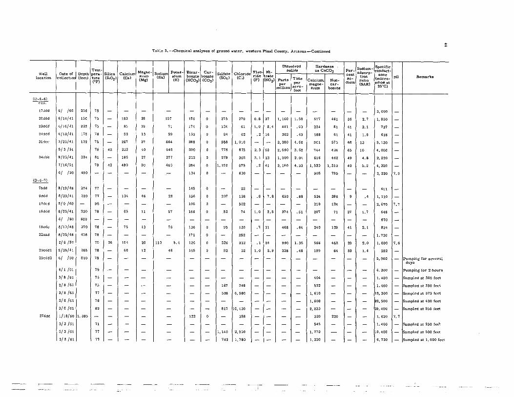
Tern" Magno-Woll Dnte of Depth pera- Silica Calcium slum location collectio (feet) turc (51°2) (On) (Mg) (eF)
(D.G_G) -con:-
17ddd ,/ /60 256 75 - - -20ddd 6/16/41 150 75 - 183 39
23ddd 6/16/41 302 75 - 65 16
24ddd 6/18/41 176 76 - 53 13
31dcc 9/25/41 102 75 - 267 67
5/3 1':>1 75 42 232 40
34cbb 9/25/41 234 81 - 186 37
7/16/51 78 42 480 80
6/ Iso 490 - - - -(0_6_7)
7bdd 8/19/48 274 77 - - -9ddd 8/29/41 230 77 - 134 46
10ded 9/9/60 - 96 - - -
16ddd 8/26/41 230 78 - 65 11
6/ Iso SOO - - - -
18ede 8/19/48 370 78 - 75 13
22a:ld 8/25/48 488 78 - - -
2/6/57 79 36 194 20
25edd1 9/25/41 268 78 - SO 12
25cdd2 6/ Iso 810 79 - - -6/1/61 79 - - -
3/8/61 75 - - -
3/8/61 75 - - -3/8 /61 77 - - -3/8/61 76 - - -3/8/61 80 - - -
27ddd 1/18/60 1. 385 - - - -
3/3/61 71 - - -
3/3/61 77 - - -
3/3/61 77 - - -
To.blc 3. ·.Chemical analyBes of ground water, western Pinal County, Arizona-Continued
Dissolved HIlrdnes8
Potus- Bienr_ Ca.r. Flue Ni- solids as CaeOa Sodium
,i= bonate bonate Sulfate Chloride ride rate (Na)
(K) (HeOa) (COs) (504) (Cl)
(F) (NOs) Parts Tons Calcium. Non. per per magne- car_
million acre· sium bonate f='
- - - - - - - - - - -157 190 0 375 270 0.8 37 1, 160 1. 58 617 461
71 174 0 134 61 1.0 8.4 441 .60 224 81
69 153 0 84 62 .2 16 363 .40 186 61
864 398 0 988 1,010 - - 3,380 4.60 901 676
640 390 0 776 676 2.3 SO 2,660 3.62 7H 424
277 212 0 679 302 2.1 12 1,500 2.04 616 442
465 384 0 1,190 675 .2 41 3,160 4.30 1,530 1,210
- 134 0 - SOO - - - - 905 795
- 146 0 - 22 - - - - - -23 156 0 207 168 .8 7.8 653 .89 524 396
- 106 0 - 602 - - - - 210 124
67 165 0 82 74 1.0 2.5 374 .51 207 71
- - - - - - - - - - -76 136 0 96 130 .7 11 468 .64 2" 129
- 171 0 - 262 - - - - - -
110 6.4 126 0 226 312 .1 24 990 1. 35 566 462
46 165 0 82 52 1.0 3.9 338 .46 199 64
- - - - - - - - - - -
- - - - - - - - - - -- - - - - - - - - 404 -- - - 187 248 - - - - 622 -- - - 628 6,580 - - - - 1,610 -
- - - - - - - - - 1,600 -- - - 817 10,400 - - - - 2.230 -
- 122 0 - 368 - - - - 320 220
- - - - - - - - - 546 -
- - - 1,140 2,950 - - - - 1,770 -
- - - 742 1,780 - - - - 1,230 -
Sodium-Per- adsorp-cent Hon ,,- rutio dium (SAR)
- -
36 2.7
41 2.1
41 1.9
68 13
65 10
49 4.8
40 6.2
- -
- -
9 .4
- -
37 1.7
- -41 2.1
- -29 2.0
33 1.4
- -
- -- -- -- -- -
- -- -- -- -- -
Specific: ooduct-Iloee
(micro_ mhos at
2S"C)
3,000
1,850
727
618
5,130
4,000
2,220
4,320
3,220
411
1, 110
2.670
646
670
824
1. 730
1, 600
682
5,960
4,300
1,480
1,460
19,300
0,500
9,400
1,630
1. 460
10,400
6,730
pH
-
--
--
---7.9
--
7. ,
---
-
7.6
---
-
-
-
--
7.7
-
-
-
RemllrkB
Pumping for sever:ll d:lya
Pumping for 2·hours
S:l.mpled at 300 feet
Sampled at 350 feet
S:l.mpled at 375 feet
Sampled nt 400 feet
S:lmpled at 550 feet
Sampled at 250 feet
S:l.mpled at 500 feet
. .
S:l.mpled nt 1, 000 feet

Table 3. --Cbemical an&lyse8 oC ground water. western PiDal County. Arizona_Continued
Dissolved Hlirdness Sodium_ Speclric Tem- Magoe- PotafJ- Biear- Car- Fluo Nl_ fJolidfJ as CaC03 Per- adsorp_ oDduct_
W.ll Date of Depth pora- Silica Calc::1um sium Sodiun\. .1= booate bonate SuUate Chloride ride rate oem tiOD ~. pH Remarka locatioD collectio (Ceet) ture (S102) <Cal (Mgl
(Na) (K) (RCOa> (COal
(S04) (Cl) (F) (NOa> Parts Tons Calcium, Noo- '0- ratio (micro-
(CF) pel' per car- dium (SARI F~OS at magne-
25<c) millioo acre_ Slum bonate root (D_6_7) ---con:-
3lana. 8/19/48 '20 76 - <00 61 163 189 0 576 585 0.1 29 1,910 2.60 1,250 1.090 22 2.0 2,950 -32naa. 6/1 /61 1,000 7B - - - - - - - - - - - - - - - - 856 - fa.mple from discharge
pipe
3/9/61 76 - - - - - - - - - - - - - - - - 1.450 - jSnmpled a.t 200 feet
3/9/61 76 - - - - - - - - - - - - - - - - 1,020 - ampled nt 350 feet
3/9/61 77 - - - - - - 81 194 - - - - 274 - - - 1,010 - ampled nt 500 feet
3/9/61 7B - - - - - - - - - - - - - - - - 1. 030 - f$amplecl at 940 feet (0-6-8)
2bbu 8/25/48 365 79 " 183 33 319 201 0 565 345 2.3 51 1,640 2.23 592 '28 54 5.7 2,470 -2dda 9/17/41 250 7B - - - - 106 0 - 388 - - - - - - - - 2,00(1 -
6/ /60 84 - - - - - - - - - - - - - - - - 2.300 -3uuu 8/25/48 .00 79 - - - - 210 0 - 350 - - - - - - - - 2,270 -3ddu 8/25/48 460 82 - - - - 133 0 - 47 - - - - - - - - 50s -
6/ /60 a1 - - - - - - - - - - - - - - - - 710 -4adc 8/24/48 375 7B 45 loa 20 167 172 0 213 23. 1.9 20 89. 1, 22 352 210 51 3.9 1.430 -8dcc 9/5/41 252 77 - 64 13 44 171 0 57 73 •• 6.0 342 .47 213 73 31 1.3 612 - Well 8II..Dlpled rmnually
6/21/49 80 33 39 6.3 70 160 0 53 58 1.6 '.7 34' .47 124 0 55 2.7 55' -8/17/50 79 - - - - 164 0 56 - - - - - - - - - 547 -5/26/58 80 34 37 '.0 75 166 0 60 47 1.6 5.0 346 .47 109 0 60 3.1 547 7.1
9/3/59 82 - - - - 154 0 - 42 - - - - 66 0 - - 481 7.4
6/23/60 82 - - - - 135 24 - 44 - - - - 44 0 - - 536 a.a
18ddd 8/23/48 39' 7B - - - - 170 0 - 156 - - - - - - - - 1.040 -9/16/49 79 34 160 28 69 170 0 163 228 .3 31 801 1, 09 51. "a 22 1.3 1,350 -
25aa11 8/26/48 500 76 70 160 80 .74 175 0 955 950 2.2 30 3, 110 4.23 1,480 1,330 " 5.' 4,580 -28adc 8/18/48 210 77 52 10. 23 74 162 0 97 194 .a a.l 633 .86 354 222 31 1.7 1,060 -28cdc 8/18/48 200 78 - - - - 172 0 - 69 - - - - - - - - 579 -
6/ /60 81 - - - - - - - - - - - - - - - - 550 -32cl1d 8/17/48 320 - 35 34 5.5 44 177 0 33 13 .6 5.0 257 .35 lOS 0 47 1.a 385 -34acc 8/27/48 500 79 - - - - 146 0 - 216 - - - - - - - - 1,140 -
~ 6dcd 6/ /60 1,050 - - - - - 79 0 - 210 - - - - 58 0 - - 1.230 7.7
*

Tem- Magna_ Well Date of Depth pera- Silica Calcium slum loeation collectio (feet) ture (SI02 ) (ea) (Mgl (OF)
(D-6-9) ----con:-
7bbc 7/14/41 249 - - 24 '.4
7cdd 8/27/48 500 81 - - -19bbd 8/26/48 500 79 60 52 7.0
(D-7 _4)
25W}o.dd 9/15/41 400 " - 32 7.2
26bb 9/15/41 900 79 - 23 16
(O-7-5)
Sddd 9/12/41 .50 " - 44 12
7/16/51 79 - - -18ddd 9/12/41 500 " - - -
(0-7-6)
Iddb 8/1 /58 893 - - - -2m 3/S0/S1 - 75 - - -
3/S0/S1 75 - - -
3/30/S1 76 - - -6ded 1/18/57 505 76 34 2<6 2<
1/18/57 80 " 223 16
11ued 8/16/48 297 82 - - -20edd 8/11/48 - 80 - - -28ddd 9/15/48 <6, 86 39 25 5.5
29ddd 8/11/48 260 76 - 39 6.9
313de 8/11/48 iSS - - 130 22
31ddd 9/15/48 280 'I 3i i7 6 ,
33ddd 8/13/48 600 87 30 9.3 2.2
6/ /60 65 - - -34ddd 8/13/48 607 " - - -
6/ /60 " - - -353dd 8/13/48 480 93 - - -
6/ /60 98 - - -36ddd 8/6 /41 480 80 - - -
Table 3. ·-Chem1cnl ana.lyscs of ground water, western Finnl Coumy. Arizona-Continued
Dissolved Hardness Potas- Bica>:'- Car- Fl,o NI- solida as Cae03
Sodium Sulfate Chloride (Nil) .1= bonate bonate ride rate
(K) (HCOs> (COal (504) eel)
(F) (NOa) Parts Tons Cu.lcium. Non-per per magne_ car-
million acre- .,= bonate '00<
'" '" 9. , 72 84 5.3 n 4i5 0,56 " 0
- '" 0 - 22< - - - - - -137 159 0 107 "6 3. , 1.5 592 .81 15' 28
80 176 0 72 39 1.7 5.3 324 .44 '09 0
286 3U 12 i72 190 3.4 i7 872 1.19 123 0
" '" 0 84 26 - 3.7 309 .42 159 i3
- 173 0 - 36 - - - - - -- 17' 0 - 25 - - - - - -
- '58 0 - 43 - - - - U7 0
- 260 0 426 258 - - - - 7<0 527
- 302 0 435 260 - - - - 780 532
- '" 0 426 258 - - - - 650 5"
163 2.8 '" 0 '" 21' 1.5 21 1,350 1.84 7i2 564
U5 L8 16' 0 '" 140 , 7 9 0 1,130 1. 54 622 465
- i77 0 - 67 - - - - - -
- 165 0 - 35 - - - - - -" ISO 0 70 42 1.0 3.' 341 .<6 65 0
63 '" 0 72 22 1.0 4.7 299 .41 '26 0
123 170 0 'OS 230 .9 17 802 1. 09 4i5 276
80 162 0 63 29 1.0 4.6 3i2 .42 70 0
88 '" 0 " 28 1.0 5. , 29' .40 32 0
- - - - - - - - - - -- 100 0 - 51 - - - - - -- - - - - - - - - - -- i57 0 - 23 - - - - - -- - - - - - - - - - -- '" 0 - 21 - - - - - -
Sodium-Per_ ll(ilJorp-oeo,
tion '0- ratio dium (~AR)
" 6.3
- -65 4.7
61 3.3
" U
41 I.,
- -- -
- -- -- -- -33 2.7
29 2.0
- -- -67 3. ,
" 2 .•
39 2.6
7i 4.2
86 6. ,
- -- -- -- -- -- -
Specific onduc;:t. .~.
(micro-F"hoS at
25"<:)
72i
1,200
"5
543
1,470
"5
57i
473
530
1.930
2,010
1. 840
1.920
1.590
873
553
51'
504
1,370
482
H' 480
519
750
455
400
449
pH
-
-
-
-
-
--
-
7. ,
7.5
6.9
7.5
7.'
7.5
-
-
-
-
-
-
-
-
---
-
-
R",maJ;'ka
Sampled nt 200 feet
Sampled a.t 325 feet
Sampled a.t 525 feet
Sampled 3t 110 feet
S3mpled at 260 feet
· ~

Tnblc 3. --Chemical analyaoa or groUDd ... .tor, _atom P1Dal County, Arizona-Cozrt!nuod
DiIlBOlvod IIP.rdnoll8 Sodium- Spoc1fic Tem_ Mllgne_ Potal;l_ Biear- C=· Fl~{t'. aol1dll all CaCOs Per- adaorp-ouduct_
Woll Date or Dept, pera- SWca Calcium Sodium Solfoi. Chloride eon< .... location eolloctio (teet) ture (51°2) (ea) • 1= (Na) .1= bonate bonate (SO,) (cn ride rate Parts ToD.II ... tion (miero- pH Remarkll
('F) (Mg) (K) (HC03' (C~) (F) (N03) Cakl_ Non-d1=
ratio F~oll at per per magne_ car_ (SAR) 25"C) million aere- .1= bonate 'ant
(D-7-6) ----con:-
36ddd 6/ /60 480 87 - - - - - - - - - - - - - - - - 410 -(D_7_7)
Idee 6/ /60 1,791 8< - - - - - - - - - - - - - - - - 1,180 -Iddd S/12/48 m 80 - - - - 179 0 - 22 - - - - - - - - 449 -
6/ /60 82 - - - - - - - - - - - - - - - - 430 -"dd 9/27/41 500 79 - - - - 176 0 - 17 - - - - - - - - 424 -
6/ /60 82 - - - - - - - - - - - - - - - - 700 -3ddd 8/13/48 420 82 - - - - 171 0 - 28 - - - - - - - - 481 -
6/ /60 86 - - - - - - - - - - - - - - - - '" -5dcd S/17/48 ZOO 77 - - - - 190 0 - 11< - - - - - - - - 1,020 -
6/ /60 78 - - - - - - - - - - - - - - - - 1,100 -6ddd S/17/4S 340 77 - - - - 161 0 - 18 - - - - - - - - .2<; -12eed 9/9/41 450 78 - 45 9.8 39 18< 0 53 19 0.8 2.0 258 0.35 153 2 36 1.4 '36 -
S/12/48 82 - 40 6.0 48 168 0 62 24 .. 3.9 257 .35 124 0 46 1.9 450 -19ded 7/28/41 ZOO 78 - 64 10 47 155 16 7. 31 .2 4.5 313 .43 176 49 37 1.5 528 -22dddl 8/5 /4S 800 79 - - - - 184 0 - 17 - - - - - - - - .56 -22ddd2 6/ /60 800 85 - - - - - - - - - - - - - - - - 430 -26ddd S/5 /48 800 80 - - - - 168 0 - 25 - - - - - - - - '" -
6/ /60 85 - - - - - - - - - - - - - - - - 400 -32edd 9/17/48 1,432 8< 34 26 4.7 90 147 0 88 45 1.2 3.4 365 .50 84 0 70 4.3 493 - Well sampled nnnually
8/14/52 85 c- - - 77 142 0 79 28 - 3.8 - - 73 0 70 3.9 '98 -S/6 /53 - - - - - 133 0 - 25 - - - - - - - - .96 -8/ /64 81 42 25 7.' 63 170 0 50 24 .8 2.3 298 .41 93 0 69 2.8 '52 -9/6/55 79 - - - - 169 0 - 22 - - - - - - - - 437 7.1
6/17/57 80 - - - - 158 0 - 23 - - - - 81 0 - - 447 7.6
5/27/5S 84 - - - - 148 0 - 26 - - - - 70 0 - - 463 7.5
6/ /60 85 - - - - - - - - - - - - - - - - 430 -33:l.dd 8/1S/4S 612 79 - - - - 168 0 - 22 - - - - - - - - 445 -
6/ /60 79 - - - - - - - - - - - - - - - - m -35add 8/3/48 93. 82 - - - - 160 0 - 19 - - - - - - - - 416 -
~

Tem-Magna-Woll Date of Depth ~ra- Silica Calcium
location collect!o (feat) ture (51°2) (Ca) ,1= (Mg) (~F)
(0_7.7) ~
35add 6/ /60 93·1 86 - - -(0-7-8)
Idcld 8/27/48 320 " - - -4-dde 9/9/41 444 78 - - -
6/ /60 83 - - -Sddd
, 8/12/48 <50 80 - - -
6/ /60 60 - - -
IOddd 8/16/48 600 79 - - -
6/ /50 81 - - -
16cdd 8/5/48 570 79 - - -6/ /60 85 - - -
17ddd S/4 /48 - 80 - - -
6/ /60 86 - - -
27cdd 8/3/48 540 78 - - -61 /60 86 - - -
28ddd 8/3/48 600 78 - - -6/ /60 86 - - -
34cdd 8/3/48 540 . 78 - - -
6/ /50 1,025 83 - - -(D-8-4)
23cdd 9/27/56 196 SO 28 14 6.4
(0-8-6)
2add 8/6 /48 600 87 - 15 1.5
3add 7/29/48 SOO 88 29 10 0
Ilkldd 8/6/48 690 82 - - -
12add 8/5/48 800 82 - - -6/ /60 81 - - -
14ddd 8/5 /48 750 83 - - -6/ /60 84 - - -
17dcb 2/13/50 104 - - - -
Table 3 •• -Chem1c1ll a.naJy'ea ot grouDd water, wostCl'D Pinal County. Arizona-Continued
Dissolved Hnrdne88
Potaa- Blear- Car- Fl,o Nl. solida as CaeOa Sodium Sulfate Chloride (Na) .1= bonate bonate (S04~ (el) rid. rate
(K) (BCOS) (COS) (F) (NOS) Part, TOM Calcium. Non_ por per magee- car_
million acre- ,1= bOnate <0,"
- - - - - - - - - - -
- 220 0 - 1,040 - - - - - -
- 159 8.9 - 13 - - - - - -- - - - - - - - - - -- 169 0 - 15 - - - - - -- - - - - - - - - - -- 173 0 - 24 - - - - - -- - - - - - - - - - -
- 175 0 - "' - - - - - -- - - - - - - - - - -- 185 0 - 18 - - - - - -- - - - - - - - - - -- 18' 0 - " - - - - - -- - - - - - - - - - -
- 185 0 - 10 - - - - - -- - - - - - - - - - -
- 185 0 - 10 - - - - - -- - - - - - - - - - -
222 263 0 109 140 4.0 9.7 663 0,90 62 0
72 123 11 35 24 2.2 4.1 225 .31 44 0
92 138 0 56 " 1.2 19 229 .41 25 0
- 156 0 - 24 - - - - - -- 155 0 - 23 - - - - - -
- - - - - - - - - - -- 149 0 - 22 - - - - - -
- - - - - - - - - - -
- 193 0 - 31 - - - - - -
Sodium-PeT- adsoX"j)_ ,oot tiOD
.0· X'1).tio dium (SAR)
- -
- -
- -- -- -
- -- -- -- -- -
- -
- -- -- -
- -
- -- -- -
89 12
78 4.7
89 8.0
- -
- -- -- -
- -- -
Speeific onduct_ ~oe
(miero-mhos at
25"C)
340
4.440
"'0
380
391
470
425
450
509
450
422
470
436
630
379
750
3"
4<0
1, 110
446
416
446
442
410
424
425
SSO
pH
-
--
---
--
--
-
-
--
-
--
-
7.7
-
-
-
-----
Remarks
Test well
• ~
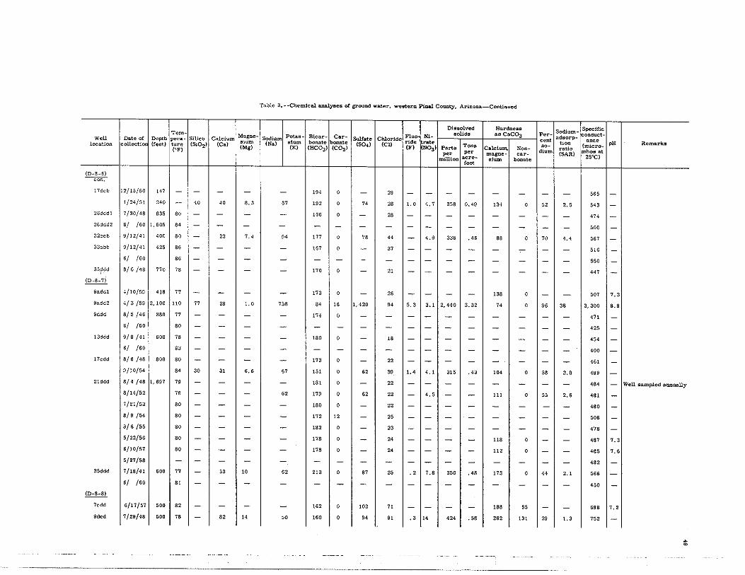
Table 3.··Ch.cm1co.l o.na.lYEles or ground wate>:" weEltetrn Pinal County, Arizono._Continued
DiEiBOlved Ha>:'dness Sodium. Specific Tem~ Magne. Petaa. Bicar· Car- Fluo Nl- solids as CaC03 Per· adsorp. onduct·
W.ll Date of Depth. petra- Silica Cnlcium sium Sodium ,1= bonate bonate
Sulfate Chloride rid, >:'ate cent tiOD ance pH Remarka location collectio (feet) ture (Si02) (Ca) (Mg) (Na)
(K) (HCOS) (COS) (S04) (Cl)
(F) (NOS) Parts Tona Calcium. Non- '0- ratio (micro-(~F) po. dium (SAR) mh.os at po. magne_ ca>:'-
million acre- Slum bonate 25"C) root
(D~B·6)
---con:--17dcb 12/1S/S0 1" - - - - - 19' 0 - 29 - - - - - - - - 565 -
1/24/S1 '<0 - 40 <0 8.3 " 192 0 " 28 1.0 4.7 358 0.49 134 0 52 '.5 543 -26dddl 7/30/48 835 so - - - - 166 0 - 28 - - - - - - - - 4H -26ddd2 6/ /50 I, "OS 84 - - - - - - - - - - - - - - - - 500 -32ccb 9/12/41 400 so - 23 7.4 94 177 0 78 44 - 4.9 338 .45 88 0 70 4.4 5" -33o.bb 9/12/41 435 86 - - - - 167 0 - 37 - - - - - - - - 516 -
6/ /50 86 - - - - - - - - - - - - - - - - 550 -3Sddd 8/5/48 770 7B - - - - no 0 - 21 - - - - - - - - 447 -
iD.8.7)
9uddl 4/10/,,9 '" 77 - - - - 173 0 - " - - - - 138 0 - - 507 7.3
9add2 4/3 /59 2,100 110 77 28 1.0 758 84 16 1,420 94 5.3 3.1 2,440 3.32 74 0 96 38 S,300 8.9
9ddd 8/5/46 3SO 77 - - - - 174 0 - - - - - - - - - - 471 -6/ /50 so - - - - - - - - - - - - - - - - 425 -
13ddd 9/8/41 500 78 - - - - 180 0 - 18 - - - - - - - - 454 -6/ /50 83 - - - - - - - - - - - - - - - - 400 -
17cdd 8/6 /48 SOO so - - - - '" 0 - 22 - - - - - - - - 461 -9/10/54 84 30 31 6.6 " '" 0 62 39 1.4 4.1 3" .43 104 0 58 '.8 499 -
21ddd 8/4/48 1,697 79 - - - - 181 0 - 22 - - - - - - - - 484 - Well sampled a.nIluo.lly
8/14/52 79 - - - 62 179 0 62 22 - 4.5 - - 111 0 55 2.6 481 -7/21/53 SO - - - - 180 0 - " - - - - - - - - 4SO -8/9 /54 SO - - - - 172 12 - 25 - - - - - - - - 506 -S/6/55 SO - - - - 182 0 - 23 - - - - - - - - 478 -5/22/56 SO - - - - 178 0 - 24 - - - - 118 0 - - 487 '-' 6/10/57 80 - - - - 178 0 - 24 - - - - 112 0 - - 485 7.6
5/27/58 - - - - - - - - - - - - - - - - - 482 -35ddd 7/18/41 600 77 - 53 10 62 213 0 87 25 .2 7.8 350 .48 173 0 44 2.1 566 -
6/ /60 81 - - - - - - - - - - - - - - - - <SO -(D·8.8)
7cdd 6/17/57 SOO 82 - - - - 162 0 10' 71 - - - - 188 55 - - 698 7. ,
Sdcd 7/29/48 500 78 - 82 14 50 160 0 9. 91 .3 14 424 .58 262 131 29 1.3 752 -
~

Tem- Mngna-Woll Date of Depth perll- Silica Cnlcium location collectio (feet) turc (SiOZ) (Ca) slum
(Mg) (,-F)
(D-S-S) --con;--
SIded 5/ /60 500 82 - - -lOcdd 7/28/48 500 79 - - -
6/ /50 81 - - -14bbb 7/2g/48 - 7S - 37 5.2
6/ /50 81 - - -15cdd 8/3/48 - 7S 35 36 4.7
17cdd 8/14/52 1,328 B5 - - -S/S/53 B5 - - -S/9 /55 77 36 82 lS
5/22/56 70 - - -6/11/58 - - - -
laddd 7/28/48 - 79 - - -
./ /'0 B5 - - -29bccl 9/10/48 350 79 - " 10
29bcc2 9/10/48 1,386 90 - S.5 2.5
(D-8_10)
4bbb 7/12/48 - - 23 15 9. ·1
10/13/52 - - - -
7/29/53 - - - -
9/14/54 - - - -7/3 /56 78 - - -
5/10/57 77 - - -5/27/58 - - - -
(D-9-6)
24E¥ddd 7/29/48 1,200 81 - 10 2.1
8/14/52 80 - - -
8/6 /53 79 - - -
8/19/54 - - - -
9/6/55 80 40 25 8.1
5/22/56 81 - - -
Tllble 3. --Chemical analy6ea or ground water, western Pinal County. Arizona-Continued
Dissolved Hardness
Potll.l3- Bicar- Car- Flue Nl- soUds Ilil CO;C03 Sodium Sulfate Chloride
(Na) ,1= bonate bonate (504) (el) ride rate Parts TOD" (K) (HC03l (C03l (F) (NOS) Calcium, NOD_ per per magna- car-
million acre- ,1= bonate root
- - - - - - - - - - -- 179 0 - 10 - - - - - -
- - - - - - - - - - -" 176 0 32 0.0 0.4 2.2 208 0.28 118 0
- - - - - - - - - - -39 lH 0 30 14 .5 2.3 245 .33 110 0
"' 148 0 52 35 - 3.7 - - B5 0
- 153 8 - 38 - - - - - -54 192 0 117 75 .2 12 488 .65 278 121
- lSI 0 - 34 - - - - 178 30
- - - - - - - - - - -
- 175 0 - 34 - - - - - -- - - - - - - - - - -47 198 0 67 26 .8 8.8 311 .42 176 14
54 104 8 0 35 19 2.0 2.7 194 .25 26 0
153 18< 0 " 142 .8 7.1 489 .67 76 0
- 173 0 - 131 - - - - - -- 175 0 - 131 - - - - - -
- 172 0 - 140 - - - - - -
- 158 0 - 104 - - - - 65 0
- 174 0 - 126 - - - - 70 0
- - - - - - - - - - -
72 130 0 '7 20 1.2 3.5 220 .30 34 0
78 127 0 52 28 - 5.0 - - 33 0
- 123 0 - 33 - - - - - -
- 110 5 - 27 - - - - - -80 139 0 76 48 1.0 11 358 .49 98 0
- 128 0 - 42 - - - - 58 0
Sodium. Per- adsorp_ " ... ,,- tiM mUo dlum (SAR)
- -- -- -
39 I.'
- -44 I.'
53 3.1
- -30 I.'
- -- -- -- -37 1.5
82 5.5
81 7.5
- -
- -
- -
- -
- -- -
82 5.4
84 5.9
- -- -
54 3.5
- -
Specific QUduet-nnee
(micro-mhos at
25"C)
<70
367
375
364
365
357
469
501
770
555
435
504
550
'" 342
854
812
819
817
807
808
817
372
421
432
456
554
SOO
pH
-
------
-7.2
7.4
-
-
---
-----
7.5
-
-
--
-7. ,
7.4
Remarks
~ o
Well sampled annually
Well sat/lpled l).llIlunlly
Well sampled nnnunlly

Table 3. -·Chenw::81~ .. of groUDd w.ter. westonl P1na1 County. Amon&-Cont1nued
- - - r--Diuolved HD.rdae88
Sodium~ Specific Tem- Magne- P .... - &=- Car-
;;dU: N1- aolldll au CaC03 Per- aQsOrp- onduct-
Woll Da.te of Dopth .. ~. Sil1ea. Calcium sium sr:~rr M= ....... ....... """"'. Chlorid. B'. '0" tiM ~o pH Remaru location eolloct;iQ (teet) tUre (51°2) (Ca) (Mi) (10 (HCC>;,) (C~)
(SO.) (eu fF) {N°3' Parts ToD.lil Calcium, Non-.0_
ratio (micro-("F) dl= m~o. at PCIr per ma&ne - car- (SAR) 25"C) mill10n acre- .1= bona'. root
·(D-9_6) ~
24E}ddd 5/20/57 1,200 80 - - - - 123 0 - 42 - - - - " 0 - - 491 7.1 Wen Bampled IlllDWlll.y
5/11/58 - - - - - - - - - - - - - - - - - 527 -~
Iddd 9/5/41 634 78 - - - - 213 0 - 23 - - - - - - - - 575 -6/ /60 " - - - - - - - - - - - - - - - - 5GO -
7ddd 7/27/48 1,000 78 - - - - 138 0 - 19 - - - - - - - - 384 -1o/add 9/5/41 GOO 78 - - - - 206 0 - 22 - - - - - - - - 542 -
6/ /GO so - - - - - - - - - - - - - - - - 500 -19ddd 7/17/41 GOO 76 - 15 4.8 58 10' " 47 15 1.0 2.0 208 0.28 57 0 69 3.3 369 - Wen sampled fUlnua.lly
8/14/52 " - - - 69 121 0 43 19 - 3.3 - - 24 0 86 6.1 358 -7/21/53 " - - - - 122 0 - 20 - - - - - - - - 360 -8/9 /54 - - 12 3.1 71 130 0 " 24 1.0 6.1 256 .35 42 0 78 4.7 39' -9/5/55 - - - - - 120 0 - 26 - - - - - - - - 380 7.3
5/22/55 78 - - - - "' 0 - 27 - - - - 39 0 - - 394 7.5
5/20/57 77 - - - - 101 0 - 30 - - - - 49 0 - - 421 7.'
5/11/58 78 - - - - 120 0 - 32 - - - - 44 0 - - 421 7.'
27add 7/17/41 670 78 - 40 8.3 52 164 11 55 23 .5 '.0 271 .37 13. 0 46 2.0 455 -6/ /GO 82 - - - - - - - - - - - - - - - - 450 -
28ddd 7/20/48 GOO 82 31 26 3.8 67 167 0 55 20 .8 2.5 288 .38 so 0 64 3.3 435 -6/ /GO 82 - - - - - - - - - - - - - - - - 400 -
~ 20ndd 7/29/41 5DO 77 - 56 10 61 220 0 90 24 .9 3S 35' .48 181 1 42 2.0 498 -
7/21/48 81 - - - - 201 0 - 23 - - - - - - - - '22 -8/21/50 so - - - - 195 0 - 27 - - - - - - - - 550 -
21dbn 8/14/52 1,300 82 - - - 87 17' 0 73 28 - 12 - - 83 0 69 4.1 540 - Well aunpled DJmUally
7/21/53 82 31 35 4.7 63 170 0 63 22 .8 6.3 310 .42 107 0 " 2.6 479 -8/10/54 82 - - - - 190 0 - 28 - 8.3 - - - - - - 526 -8/9 /55 81 - - - - 182 0 - 27 - - - - - - - - S3S -5/9 /57 80 - - - - 190 0 - 27 - - - - 122 0 - - 52, -5/27/58 - - - - - - - - - - - - - - - - - 47' -
~

~
Table 3.--Chemlcnl analyses or grolll'ld water, weHtern Pinal County, Ar1~ona-CoDt1nued
DiaBolved Hardnea8 Sodium- Specific Tem- Magne- PotnB_ B1cur- ear- Fl •• NI- aolldo 0.8 CaCOa Per- adaorp_ ot1duct-
Well Date o( Depth pera- Silica Calcium .Ilium
Sodium ,1= bonate bonate Sulfate Chloride ,!d. rate .00' tion ~.
pH Remark. loclltion collectio (feet) tUra (51°2) (Ca) (Mgl
(Nil) (K) (HeOal (COal
(5°4) (el) (F) (NOal Parts Tons Calc:lum. Noo- ~- ratio ~fcro-(OF) per pelr ~,- '''m (SAR) boa at """"'.- 26"C) miWon acro- .1= _to
toot
(D_10_9) .
6,dd 7/3/41 '" 79 - 34 10 53 133 14 89 24 0.3 3. , 303 0.41 126 17 52 2.4 461 -(0-10-10)
15ucc 8/12/52 '" 80 18 34 3.9 40 153 0 31 14 .6 1.2 223 .30 101 0 46 1.7 361 -11/14/52 1,950 106 31 7. , 1.6 81 128 7 48 16 4.0 2.3 261 .36 26 0 as 7.0 392 -

Table 4. --Field determinations of temperature and specific conductance of water from aelected wells made during the 5ummer of 1960, 53 western Pinal County Arizona
Well location TemMrature
OF) Field apecUic cooductaAce
(mlcrombo. at U"(:) Well location TemMrature
7) Field apecUlc conductanee
(mtcromlloa a' 25"(:)
(0-3-4)25dcb 72 1. 600 (0-4-8)36aad 76 750
(0-3-5)24aca 80 1,450 (D-4-9)26cbb 70 1,400
31abc 72 1, S50 27deb 70 1,650
34bbb 72 1, sao 28ccb 70 1,600
(D-3-6)31abb 75 800 28ddd 70 1,600
(D-4-2)14cda " 1,200 29cbc 73 1,300
Z6bbb 85 1. 650 32eda 70 2, SOD
34dde " 2,200 (D-4-10)14aaa 83 960
35dcd " 1,200 21aab 72 1,850
(D-4-3)13ddd " 580 31baa 69 1.650
15dcc 81 830 32baa 70 2, 000
I7add 80 520 (D-4-11)7add " I, 000
ZOdcd 75 2. OSO (D-5-2)Icdc 8B 550
22ddd 79 1,000 2add 87 1.200
23aaa 79 1,200 2cdc 87 1,300
24ddd 83 L 300 2ddd " 1,180
25dda 81 1,030 tIded " 1,225
27dad 79 640 12ccc 92 1,100
32edd 80 510 13edd 89 1,025
33ada " 800 14dcd 91 1,375
34ddd " 770 24ccc 93 1,200
36ddd 80 1,030 2Sccc 92 1,250
(D-4-4)lbbc 76 1, 100 26edd 90 1,200
Ieee 77 l,20d (D-5-3)ldaa " 1,425
16ddd 85 850 3M' 77 1,280
17ddd 83 2,300 Ilcdd 77 620
19ddd 84 900 I1ddd 77 600
20ddd 83 2.300 12ada " 700
28ddd 87 1,100 12ddd " 900
29ddd 87 850 13add 79 700
31ddd 79 880 13ded " 510
32ddd 84 750 laccc 77 1,500
33ddd 81 2, 000 17ccc 85 560 ,-34dcb 87 1,000 20cbc 83 500
(D-4-5)3cdc 80 1,200 22add 77 580
3ddd 77 1,200 22bdd 77 600
Sbcc 76 1,400 23ada " 550
7bbb 77 1,550 24ddd 78 550
10bbb 80 1.900 25add 79 510
22bce 81 1,100 27ddd 76 560
(D-4-S)3ddd 74 1,500 28bee " 5,000
Sbce 72 1.900 30cbe 87 1,0SO
8ead 75 1, 180 31ecc 90 1,200
Oddd 74 1,100 32eee 82 600
lSada 75 1,200 34ecc 81 725
{D-4-7)18beb 76 1,550 34ddd 77 700
18eea 79 1,700 35aaa 77 520
34baa 82 1,700 35ddd 79 550
35baa 89 1,450 36aad 79 520
36dee 71 1,900 36ddd 79 550
(D-4-8)35add 76 1.025 (0-5-4)3ddd " 880

54 Table 4. --Field determinations of temperature and spe-ciflc conductance of water from selected wells made during the summer uf 1060, western Pinal County. Arl~ona Continued
WttlloeaUOfI remM"ature Field apecllic c:ODduclance Well locaUon TemMrlture Field apecltlc conductance .. ) (microDlbo. at U"C) "F) (micrombOI at 25"C)
(D-!i-4)4ddd " 1. 050 (D-5-7)23dad 79 3,600
"'dd 80 680 24acd 77 4, 100
Seda " 900 24bdc 90 2,400
7add 79 1. 080 24cdd 77 3, BOO
7dcd 84 630 24ddd 80 2,500
Badd 90 700 25ccc 90 1.225
8ddd 90 700 25dcc 76 2,400
lOadd " 850 25ddd 76 2,600
lOcdd B6 600 26cdc 79 700
lOddd 87 800 26dcd 90 1, 100
14add 63 810 2iaad 79 810
14bba 85 1,500 27r.:dd 79 870
14dbb 85 700 28ccc 80 610
l5ada. " 720 28cdd 80 560
15add 89 800 34acc 81 600
15dda 93 760 34dcc 63 500
21bdd 79 810 34ddd 81 600
21cdd 81 1, 000 3Bate 77 2,600
22ccc " 460 36cdd 81 880
23aaa 85 810 36dac 79 2,4S0
23bdd 85 700 (D-5-8l2ada " 1.800
23dba 63 760 5add " 1,500
23ddd 81 700 l1cdc 80 1,180
25baa 80 870 12ada 77 1,370
25bdd 80 820 12daa 83 940
26add 80 1,050 13bee 82 1,000
27ddd 82 1. 400 14aee 75 1,500
28ddd 82 1,600 16eea 76 1,300
32ddd 85 480 17bab 73 1,550
33add 80 980 17bbb 75 1,300
34baa 83 1,100 19add 78 2,900
35ddd 83 825 20abb 98 1,100
(D-5-5)30aee 83 910 20aee 75 5, 000
30edd 83 1,700 20bdd 99 1,170
31aad 91 1,480 23bee 75 1; 750
3ladd 84 950 25bbb 78 1,150
(D-5-6)11dbb 76 4,100 26bbe 77 1,700
27add 78 510 28edd 81 4,500
28aae 77 600 29ddd 77 5,800
28add 78 710 30eed 91 1,350
28ddd 80 710 30cdd 85 1,425
(D 5-7}1aae 72 2,900 31add 80 1,800
9aad 80 1,150 31bdd 81 1,380
J2aaa 74 1,950 3ledd 77 2,500
12ddd 95 850 32bde 83 650
13bde 79 2,300 33edd 81 1,150
13ccd 78 3,600 33dcc 78 2,900
13cda 81 1,525 34add 79 1,550
14add 77 5,400 34ccc 83 1,400
15bcd 86 1,050 34ddd 80 1,800
23aad 79 3,000 35add 78 1,600
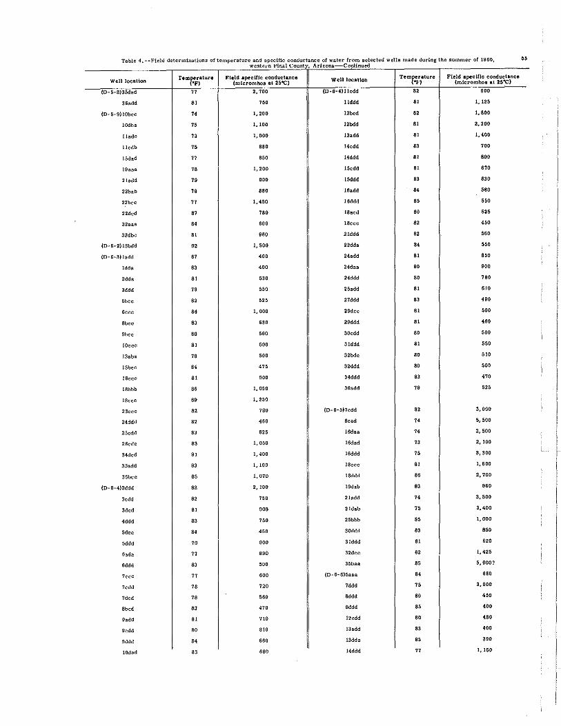
Table 4.·· Field determinations of temperature and specific conductance of water from selected wells made during the summer of 1960, 55 western Pinal County, Arh;ona Continued
WelllOCBlion remr.:ratW'e 'F)
Field apecilic conductance (micromhos at 25"C)
WelilocaUon TemMrature 'F)
Field lpecllic conductance (mieromhoa at 25"C)
{D-5·8)35dad 77 2,100 (D-6-4)Ilcdd .. 900
36add 'I 700 Ilddd 'I 1,125
(D-5-9)lObee 74 1,200 12bcd .. 1,800
IOdba 75 1,100 J2bdd 'I 2,200
lladc 73 1,000 13add 'I 1,400
llcdb 70 '80 14edd 83 700
15dad 77 850 14ddd 'I 800
19aaa 7B 1,200 15cdd 'I 870
21add 79 900 15ddd 83 ." 22bab 78 880 16add " '80
22bec 77 1,450 16ddd 85 '50
22dcd 87 780 18aed 80 '" 32aaa .. 600 18ccc 82 '" 32dbc 81 '50 21ddd " 860
(O-6-2)13bdd 92 1,500 22dda " '" (0-6-3)1add 87 400 24add 'I '50
Idda 83 400 24das 80 900
2dda 'I 530 24ddd 80 780
3ddd 79 '" 25add 'I .10
5bec " '" 27ddd 83 .eo
6ccc " 1,000 29dcc 81 800
8bcc 83 680 29ddd 'I 480
9bcc 80 860 30cdd 80 800
lOecc 'I 800 31ddd 'I '" 13aba 78 800 32bdc 80 '10
15bce .. '" 32ddd 80 800
16ccc 'I 900 34ddd 83 470
18bbb as 1,050 36add 78 '" 18eee 89 1,250
23ece 82 780 (0-6-S)1edd .. 3,000
24ddd 82 460 8cad 74 5,500
2Scdd 83 ." IWaa 74 2,500
26cde 83 1,050 16dad 73 2,100
34dcd 91 1,400 16ddd 75 3,300
3Sadd 83 1,100 18cce 'I 1,600
35bee 85 1,070 18ddd as 2,700
(0-6-4)2ddd 82 2,100 19dab 83 980
lcdd 82 780 21add 74 3,500
3ded 81 eoo 21dab 70 3,400
4ddd 83 780 2Sbbb 85 1,000
Sd" " '" 30ddd 83 850
Sddd 79 eoo 31ddd 81 .20
6ada 77 890 32dec 82 1,426
6ddd 83 500 3Sbas 85 5, O~~?
7ece 77 600 (0-6-6)5aaa .. .80
1cdd 78 720 7ddd 75 3,000
7dcd 78 860 Bddd 80 450
Sbed 83 470 9ddd 85 400
9add 81 710 12cdd 80 480
gedd 80 810 13add 83 400
9ddd .. 660 13dda 85 390
lOdad 83 680 14ddd 77 I, 150

" Table 4. --Field determinations of temperature and specific conductance of water from selected wells made during the summer of 1960, weatern Pinal Count ArIzona-Continued
WellloeaUon TemMratura 'F)
Field .pecittc CODductanCI (mlcrolllbo, at 25"C) WeU locaUoa T,mMrature
'F) Field apeclfic conductance
(micromho. It 2$"C)
(D-6-6)15cdc " 525 (D-6-7)36a.dd 83 550
16cdd 77 1,650 36dbd " 125
17ddd 15 3,000 {D-S-SHead 18 2,800
16bbc " 1,800 1bbe SO 2,300
21ddd SO 740 2dda 84 2,300
22ddd 81 850 2ddd 83 830
23ddd " 400 3aaa SO 2, 000
24add 85 400 3ada 18 2,400
24dad 77 1,050 3add 79 1.550
25add SO 640 3ccc 79 1.500
25baa 77 SOO 3dda 81 710
28add 76 2,200 4ddd SO 1. 000
35aad 85 510 5bbd 18 2,050
35ace 84 SOO 5cbc 81 SOO
36aaa 76 1,200 Seed 83 1,200
36ddd 77 850 ""d 81 650
(D-6-7)laad 80 1,225 5ddd 81 700
ladd 81 1,400 6aba 77 1.650
1cdd " 600 6cdd 83 SOO
Iddd 83 I, 000 6ddc 83 550
2add 81 790 7cdd 81 600
3cdd 81 600 7dda " 490
4ccc 85 480 lOadd 18 1.700
4cdd 85 450 lOdda 81 1,250
4ddd 83 520 lOddc 81 1,800
5bad 83 410 llcdd 82 460
7adc 84 550 12cdc 81 790
8ddc 80 440 12dcc 84 480
lla.dd 80 630 13add 84 600
llcdd 82 520 15dcc 75 2,500
12aad 82 800 17dac 82 420
13cdd 83 590 laced 81 710
14add 82 810 19add 80 700
14cdd 82 600 22cdd 75 1,700
16cdd 80 560 23aaa 76 1,650
lSddd 80 646 23a.dd 80 550
17ddd 79 430 23ddd 79 880
18add 79 450 24acc 80 800
19add 85 500 24dcc 82 1,200
20add 80 450 25aaa SO 540
20dda 79 440 27acc 78 1,000
21bcd 78 700 27bad 75 1,350
21dda 79 580 27dcc 79 790
22acc 88 625 28cdc 81 560
26cbc " 960 3ledd 80 1,050
32aaa 87 525 32cdd 81 440
32d cd " 810 33ccc 83 420
33cad 83 510 33cdd 83 420
33dba 79 490 34cdd 82 690
34bdd 80 450 34ddd 76 1,250
35add 83 560 35cdd 78 875

Table 4. --Field determinations of temperature and specific conductance of water from selected wells made during the summer Of-I,96t~-- c~fl western Pinal County. ArIzona Continued
Well location remperature Field specUic conductance Well location TemMrature FIeld apecUlc conductance
("F) (mieromho. at 25"C) '» (mieromh08 at 25"C)
(0-6-9)6aaa 83 850 (0-7-7)lObcc 81 450
1acc 93 1,000 IOddd 85 480 ,
1cde 81 800 !ledd " 460
29aad 79 1,100 22ddd 85 430
(0-1-4)2ddd 79 500 23ddd 82 4"
4ddd 61 590 24edd 80 550
5eee 63 1,150 25edd 61 500
6bee 85 1,000 2&ddd 83 470
gede " 1,200 26ddd 65 <00
t1dda 80 5<0 27daa " <60
12ddd 80 '" 27ddd 61 500
13bad 61 480 30edd 61 <00
14ddd 82 960 31ddd 93 500
15bdd 67 1,250 32cdd 65 '" 16eee 65 1,000 32ddd 91 900
17eee 93 1, 100 33edd 79 <IO
18ded 90 1, 100 33ddd 80 <00
23ddd 82 1,300 34edd 61 <00
24bad 82 500 34ddd 61 360
24edd 82 700 35add " '<0 25aad 79 550 35edd 82 400
26eee " 950 35ddd 91 <00
2Sddd 61 1,200 36ddd 83 550
(0-7-5)5ddd 67 900 (0-7-a)3edd 83 1,400
6ddd 80 530 3ddd 80 1,000
7ddd 80 480 4dde 83 360
geed 83 530 5d" 80 1,700
16add 80 560 7cdd 82 '" 24ded 76 2,000 7ddd 83 <00
(D-7-6)lcde 90 610 8edd " 670
Sddd 76 3,000 6dd, 80 470
13edd 63 <00 6ddd 65 550
20ded 63 2,200 gedd 65 430
29add 83 2,000 10ddd 61 450
29ddd 79 1, SOO 15ede " 460
3lada 80 1,200 15dO<l " <00
32ddd " 480 lSedd 65 450
33ddd 65 480 17edd " <00
34add 91 600 17ddd " 470
34ddd 95 750 18edd " 450
35add 96 440 18ddd 66 '" 3Sddd 67 410 19cdd 83 700
19ddd 65 420
{D-1-7)ldec " 1,180 20edd 66 <00
Iddd 82 430 20ddd " 450
2ddd 82 700 2lcdd 85 <00
3edd " <00 21ddd 83 450
3ddd 66 570 22add 85 500
5bdd 77 1,450 22edd 83 410
5d,d 76 1,100 22dde 66 <00
Sece 76 475 23eee 67 950
9ddd 63 425 26edd " 400

" Table 4, --FIeld determinations of temperature and specific conductance of water from selected wells made durIng the summer of 1960, western Pinal County, Arizona Continued
Well location remr.rature "F)
Field lpeCitlC cOJ:ldvctance {mlcromboa at 26"C} Well loeation Temf.'itlture
'F) Field apeeU'le conductance
(mlcromhos at 26-<:)
(D-7-8)27cdd 86 630 (D-8-1)27ddd 80 450
27ddd 87 1,400 28cdd 81 410
2:8cdd 88 1.800 29cdd 81 410
28ddd 86 750 29ddd 84 '" 29cdd 82 750 33edd " 500
29ddd 82 560 33ddd 79 475
30cdd 81 1,600 34add 81 440
30ded 82 500 35add 80 500
3ledd 78 870 3Mdd 81 450
31ddd 80 610 (D-B-8)lcdd 82 500
32ccd 84 460 Iddd 85 400
32:cdd 81 600 4ddd B1 400
3Udd 80 950 Sddd 80 750
33edd 81 600 ",d 82 470
33ddd 84 370 IDcdd B1 375
34cdd 83 440 14bbb 81 365
34ddd 82 400 15ccc 76 600
(D-8-6)2dcd 90 400 16cdd 76 575
3ddd 90 450 17dcd 80 460
5add 82 460 18ddd , 85 550
Ba.dd 83 450 19ddd 76 800
12add 81 410 27cdd 80 400
13add 85 410 28cdd 81 '" 14ddd 84 '" 31add 80 550
23ddd 85 420 32cdd 81 510
28ddd " 500 32ddd 81 450
32acd 82 650 (D-8-9)1ddd 82 380
:J3a.bb 86 550 16a.dd 82 410
(D-6-7)2ddd 81 390 16;ddd 80 430
3add 81 400 (D-9-6)13add 82 400
4ddd 81 390 24ddd 80 480
6ddd 80 440 (D-9-7)lddd 79 560
9ddd 80 425 2ddd 80 575
10add 84 370 3add 79 450
l1cdd " 370 4add 78 500
Ilddd " 390 lOadd 80 440
12add " 350 Ilddd 80 490
12cdd 83 400 13dad 80 560
13add 79 500 14add 80 500
13ddd 83 400 14ddd 78 575
14ddd 80 425 lSddd 77 475
lSddd 80 425 16add .. 450
16ddd 80 450 21ddd 80 450
17ddd 78 425 22add 80 450
16add 80 400 26add 82 450
19add 80 425 26ddd 80 450
19ddd 79 440 27add 82 450
21ddd 80 470 27ddd 83 420 -
23add 80 600 28ddd " 400
26add 79 600 30ddd 77 450
27cdd 80 450 32ddd 79 370

Table 4, --Field determinations of temperature and specific conductance of water from selected wells made during the summer of 1960, oJ I western Pin Count Ar zona-Continued "
WelllGCIUon TemMrltW'e "V)
Field apeellic eOOcNcwee (mlel'omhoa at J6"C) Well IGCaUoo Tem~l'ature Field lpeeltie eonduC!tanee
"F) (micl'omhOIl .t 25"C)
{0-9-8)6ddc " 560 (D-9-8)34add " 510
8add 83 420 35edd " 470
8ddd 80 520 35daa 85 480
9ddd 83 400 35dee 85 480
lOddd 80 420 36ddd 82 530
ISccd 83 '" (D-9-9)31ded 84 '" 15ddd 84 400 (D-IO-6)llddd 84 1,000
17ddd " 440 (0-10-7)6aaa " ,70
lSadd " 760 CO-IO-8)ldaa " 470
19ddd " 440 3add 87 470
21dcd 82 400 CD-IO-9}5cec 84 000
22ddd 60 000 6add 84 000
23ddd 80 470 10add 78 '" 25dda 81 420 10dbb 79 700
25ddd " 470 13cee 77 960
27aad 83 470 13ddd 77 400
2gedd 83 m Hen 91 000
30ddd " 400 15cdd 80 630
31ddd " 460 23ddd 80 850
32aaa " 480 24add 78 700
32ddd 99 460 24dda 79 '" 33ddd 84 460

I ,