baseline inventory report standard july 9, 2018
TRANSCRIPT

Baseline Inventory Report Standard July 9, 2018
Introduction The following document is intended as a guide for those preparing baseline inventory reports on properties owned and covenanted by the Islands Trust Conservancy. Baseline inventory reports are used by the Islands Trust Conservancy to provide information for management of nature reserves and covenants. Information may also be extracted to document the state of land being placed under a conservation covenant.
What is a “baseline inventory report” and why is it important? A baseline inventory report is a record of the condition of the land and typically includes information on flora and fauna, other natural features. It also includes any human features such as buildings and trails. Information from a baseline inventory report can act as a legal tool in conservation covenant enforcement to demonstrate the natural values on a property when it was protected. Baseline inventory reports can also provide information to land managers for management planning.
How detailed does the baseline inventory report need to be? Baseline inventory reports should be detailed enough to be able to get a site level understanding of the land. Information should be presented in simple language and should be understandable to the average person. Where technical language is necessary, resource materials to assist interpretation should be referenced. As a guide, baseline inventory reports for the Islands Trust Conservancy should be approximately 6-8 pages in length (excluding maps and photographs) with an additional 1-2 pages to describe each mapped ecological community. Use the format provided in the Contents of the Baseline Inventory Report (below).
Before Beginning a Baseline Inventory Report You Must: 1. Have an understanding of its intended use – is it to establish natural values present in a
covenant area, to assist with land management, or to do both? 2. Have a final completed survey of the land or covenant area done by a registered British
Columbia Land Surveyor if available or another reference for the site boundaries. 3. Be an environmental professional approved by the Islands Trust Conservancy.

ITC Baseline Inventory Report Standard
Page 2 of 14
Recommended Baseline Inventory Report Procedures Who Should Collect Information? To ensure that the contractor hired to complete the baseline inventory report is a qualified individual, it is important that they be approved by the Islands Trust Conservancy prior to any data collection. In some instances, the Islands Trust Conservancy may recommend or require that professional biologists, foresters, land use planners, or other professionals be consulted. Some baseline inventory reports may require input from biologists with expertise in species at risk. If archaeological sites are present, information from registered archaeologists may be required.
Information Gathering The following information is available from the Islands Trust Conservancy and should be reviewed by the contractor prior to conducting field work:
□ Acquisition or covenant history. □ All easements registered on title. □ Survey of the land and/or covenant area(s) done by a British Columbia Land Surveyor or
other available boundary information. □ Relevant digital mapping data:
o Orthophotography; o Sensitive Ecosystem Mapping; o Terrestrial Ecosystem Mapping (TEM); o Cadastral; o Contours; o Zoning and Land Use Designations; o Water features including streams, watercourses and other water bodies; o Shoreline, eelgrass and forage fish mapping; o Agricultural Land Reserve locations; o Building footprint mapping; o Critical Habitat mapping (Government of Canada); and o Occurrence data for rare species and ecological communities (BC Conservation
Data Centre). □ Information about the protected area history. □ Registered archaeological sites. □ Information from First Nations from prior information sharing. □ Agricultural Land Reserve and Private Managed Forest Land designation. □ Existing research and field studies and information about recorded sightings of rare
species and ecological communities. □ Islands Trust Conservancy visual identity.
Other sources of information to be gathered if available:
□ First Nations offices may be able to help with historical use of the land. Contractors should be aware that there are overlapping First Nations’ territories in the Islands Trust

ITC Baseline Inventory Report Standard
Page 3 of 14
Area and the protected area may be in more than one First Nation’s territory. Please discuss with the Islands Trust Conservancy before reaching out to First Nations.
□ Landholders or previous landholders are often rich source of information. Questionnaires, discussions and property tours can be helpful. Some landholders also keep species observation lists and information.
□ Local conservancies, historical societies, naturalist clubs, and neighbours may also be able to contribute valuable information. Personal meetings, questionnaires, discussions and property tours are recommended.
□ The Agricultural Land Commission or the Managed Forest Council may be able to provide information on lands in the Agricultural Land Reserve or Private Managed Forest.
□ The local Official Community Plan and Land Use Bylaw will provide zoning and land use designation information including Development Permit Areas.
Field Work Site visit(s) are an integral component of a baseline inventory report and will provide information to identify and describe the natural features of the property (i.e. vegetation, wildlife, geography, geology, soils and hydrology). It is a snapshot of the current state of the protected area on the date of collection. Depending on the size and complexity of the land, field work may require several days. Field work for baseline inventory reports should be conducted when the ecological features of interest are best observed. As a rule of thumb, springtime generally provides the best opportunity for species identification, but this may vary. Special attention should be taken not to disturb rare species during sensitive times (e.g. Peregrine Falcons during nesting). Other considerations when deciding the time to collect baseline data include the availability of covenant holder(s), land holder(s), community members (for Nature Reserves) and First Nations as they may need to provide information or wish to be present during site visits. Presence of other interested parties may also be helpful in identifying locations for photopoints, property boundaries and special features.
Final Baseline Inventory Report Deliverables Contractors completing baseline inventory reports must deliver the following products to the Islands Trust Conservancy:
□ Final baseline inventory report in a format that follows the Contents of the Baseline Inventory Report below with the Calibri font and colours used for headings and text. The report must be provided as both a word document (e.g. .doc) and as a .pdf. Terminology used throughout the baseline inventory report should be respectful of First Nations. The words “provincially-managed land or federally managed land” should be used in place of “Crown”. “Privately managed” should be used in place of “private” and “land holder” instead of “land owner”.

ITC Baseline Inventory Report Standard
Page 4 of 14
□ Digital photos as .jpg files with file names according to the following standard: ITC_YYYY-MM-DD_[island code]_[property name]_[concise description]_[Photo number]_(dpivalue).jpg Where “YYYY-MM-DD” is the date the photo was taken. The island code and property name are provided by the Islands Trust Conservancy. Photo number references the identification number of the photo used in the baseline inventory report.
□ Maps as .jpg files with file names following the following standard: ITC_YYYY-MM-DD_[island code]_[property name]_[concise description]_MAP.jpg Where “YYYY-MM-DD” is the date the baseline inventory report was finalized. The island code and property name are provided by the Islands Trust Conservancy.
□ Data collected as follows in a format compatible for use in ESRI ArcGIS software, with an accuracy approved by the Islands Trust GIS Department and the Islands Trust Conservancy prior to data collection:
o Ecological Communities (polygons) o Trails and Other Anthropological Features (e.g. buildings, wells, septic fields, etc.) o Other Natural Features (e.g. water features such as streams and springs, notable
glacial erratics, notable trees) o Photopoints
Note that once photos, images (e.g. maps) and data are submitted as part of an Islands Trust Conservancy Management Plan, they become the property of the Islands Trust Conservancy and may be used at the discretion of the Islands Trust Conservancy in items like communications materials, the Islands Trust Conservancy website and in other Islands Trust Conservancy work as required.

ITC Baseline Inventory Report Standard
Page 5 of 14
Contents of the Baseline Inventory Report The following is a list of elements that must be included in a baseline inventory report.
1. Acknowledgements Indicate the primary author of the report and their affiliations and professional qualifications (if appropriate). Acknowledge other contributors and their contributions (e.g. landowners, neighbours, species at risk experts, other professionals or subject experts). Please use the table below.
Name Position/Affiliation Professional Accreditation or subject expertise
Contribution
E.g. Marisa Gardengnome
Biologist, Gardengnome Environmental Services
R.P. Bio. Primary Author
Quan Littleplant Species at Risk Biologist, subcontractor, Gardengnome Environmental Services
R.P. Bio. Identification and inventory of Lomatium grayi
Evelyn Archae Archaeologist, Archae and Associates Consulting
Professional Archaeologist
Archaeological site information
Jon Avian Landholder Amateur birder for over 30 years and resident on the land between 2001 to the present
Bird list: birds observed 2001-2018
2. Property Information 2.1 Legal description as provided by the Islands Trust Conservancy.
2.2 Property and covenant size (if appropriate) as noted on surveys.
2.3 Property access information including:
Location of property and location of the covenant area (if applicable);
Directions from closest BC ferry dock or access point; and,
Information about legal access. Most legal access will be via a public road, but some properties may require access via easement, statutory right of way or water.
3. Significance of the Land and Natural Amenities
3.1 In a one paragraph, easy to read narrative, provide a general description of the land with an emphasis on the feature(s) of interest. If the area is a covenant area granted through the:
Natural Area Protection Tax Exemption Program (NAPTEP), include information on the features detailed in the Natural Area Protection Tax Exemption Program Regulation; and/or
Ecological Gifts Program, include available information about the Ecological Gift.

ITC Baseline Inventory Report Standard
Page 6 of 14
General notes on topography, aspect, geology and soils should be in this description with more specific information in the descriptions of each ecological community (section 9 below).
3.2 Note rare species or ecological communities in the tables below. The B.C. Conservation
Data Centre Species and Ecosystems Explorer is helpful for determining these.
Species Name Status
English Scientific Provincial BC List COSEWIC SARA Global
e.g. Peregrine Falcon
Falco peregrinus anatum
S2?B (2010)
Red NAR (2017)
1-SC (2012)
G4T4
Ecological Community Name Status
English Scientific Provincial BC List Global
e.g. Douglas-fir arbutus
Pseudotsuga menziesii – Arbutus menziesii
S2 (2004) Red GNR
3.3 Note any hydrological features on the land (e.g. lakes, ponds, streams, springs, ditches, etc.). Note if there is observed or known use of the features by fish, amphibians, mammals, birds, insects or other species. Include hydrological features on a map (section 10, below).
4. Conditions at Time of Data Collection Indicate dates when data was collected. E.g. Surveys of the land took place between March 31 and April 13, 2018 as indicated in the table below.
Date Activity Conditions Data Collector
March 31, 2018 Ecosystem data collection and mapping
14o, overcast Marisa Gardengnome
April 1, 2018 Ecosystem data collection and plant inventory
15o, overcast Marisa Gardengnome & Quan Littleplant
April 13, 2018 Bird inventory 17o, sunny Jon Avian
5. Report Methodology
5.1 Equipment
All surveys conducted were completed using the equipment listed below:
Camera:
Lens: (if applicable)
GPS:
Compass:
Clinometer:
Other: e.g. tape for measuring tree diameter, measuring tape used for distances, etc.

ITC Baseline Inventory Report Standard
Page 7 of 14
5.2 Methodology
Describe methodology used to collect and process data. Describe pre-field work, field inspection (e.g. ecological data collection, photo point information collection, etc.) and data processing (e.g. GPS data post processing, GIS analysis, etc.)
6. Landscape Context
6.1 A description of the protected area in the context of the region and island, including a
description of adjacent land uses at each boundary line. Include maps as appropriate and provide a description and representative photographs of the boundaries.
6.2 A description of the ecological classifications for the land including its BC Ecoregion Classification and its biogeoclimatic zone(s), subzone(s) and variant(s) (as appropriate). If the land contains multiple biogeoclimatic zone(s), subzone(s) or variant(s), include a map.
6.3 Climate: Description of climate for the site and projections for climate change if known.
7. Site History
7.1 Provide information about First Nations1 traditional use of the land from observations, archaeological site records and information from First Nations. Include both past and present uses as appropriate.
7.2 Provide information about the land post-colonization, including, as appropriate and available, settlement history, history of buildings and other improvements, logging activity, agricultural use, resource extraction, past contamination, etc.
8. Anthropogenic Features
Include a map indicating the location of all human attributes on the land. 8.1 List any buildings or structures in the table below and reference photopoints (e.g.
houses, cottages, studios, workshops, sheds, outhouses, chicken coups, etc.). For covenants, buildings and services outside the covenant area should be noted, but will not need a detailed description.
1 When first referencing First Nations traditional use a footnote should be included which states: “The Islands Trust
Conservancy recognizes that the language commonly used to refer to land may be disrespectful to First Nations. For
example, notions of ‘private’ and ‘Crown’ land do not appropriately recognize aboriginal title, and imply a belief in
the concept of terra nullius, the idea that land was not owned prior to the assertion of European sovereignty. The
Islands Trust Conservancy acknowledges that terra nullius is a concept that doesn’t apply to the Islands Trust Area.
The words “provincially-managed land” or “federally managed land” will be used in place of “Crown”. “Privately
managed” will be used in place of “private” and “land holder” instead of “land owner.”

ITC Baseline Inventory Report Standard
Page 8 of 14
Anthropogenic Feature Description Condition Photopoint Location
e.g. Pump house 3 m x 4 m stick frame construction, houses well head and water purification system
Recent build (less than approximately 10 yrs old). In good repair
P2, Map 3
8.2 List any land modifications in the table below and reference photopoints (e.g. roads, wells, utility lines, septic fields, buried water or utility lines, fences, gates, signs, trails, etc.). Anthropogenic Feature Description Condition Photopoint
Location e.g. Trails Walking trails for
personal use throughout property as mapped
10 cm average cleared width
P3, Map 3
Water line 1.5 inch buried waterline as mapped, from pump house to residence (outside of covenant area)
Connections appear to be in good condition, condition of the buried line is unknown
N/A
8.3 Indicate the location of known archaeological sites and areas of archaeological site
potential (if known). If archaeological sites are registered, indicate their registration number. Summarize the content of the record or archaeological report. Note, archaeological sites are considered confidential information and the specific location and information regarding the site must not be shared publicly.
9. Inventory by Ecological Community2 The date that data was collected should be included at the beginning of this section and each ecological community is described in 2-3 sentences and includes a table indicating representative species observed and a mapped polygon reference. A typical mapped polygon will only include one ecological community; however, a mapped polygon may have multiple ecological communities if many are found in close proximity to one another and separation is impractical. If a mapped polygon is determined to have multiple ecological communities, the percent coverage of each community within the polygon should be noted and the distribution of the ecological communities should be described. Each ecological community must have at least one representative photograph (see information on photographs, below). Forested ecosystems should include a site series reference as described in “A Field Guide for Site Identification and Interpretation for the Vancouver Forest Region” (Green and Klinka,
2 Ecological communities are used by the B.C. Conservation Data Centre and NatureServe to describe both forested and non-forested natural
areas. More information about ecological communities, including descriptions of ecological communities in the Islands Trust Area, can be found
on the B.C. Conservation Data Centre website.

ITC Baseline Inventory Report Standard
Page 9 of 14
1994) and a structural stage as defined in “Standards for Terrestrial Ecosystems Mapping in British Columbia” (RIC 1998) Wetland ecosystems should be classified according to “Wetlands of British Columbia: A Guide to Identification” (MacKenzie and Moran, 2004) Garry oak ecosystems should be classified according to “Garry Oak (Quercus garryana) Plant Communities and Ecosystems in Southwestern British Columbia” (Erickson, 1996). All publications are available through the Ministry of Forests, Lands, Natural Resource Operations and Rural Development. Tables used to describe ecological communities must follow the template below. Species in this section should be noted using both their scientific and common names. Rare species and ecosystems as well as invasive species should be noted.
Sample Polygon Table Templates
Polygon ID: 1
Ecological Community:
Douglas-fir – arbutus
Classification3: CDFmm/02
Structural Stage: 5 – Young Forest
Status (BC List): Red listed
Photopoint(s): P5
Ecological Community Description:
Mixed age (30 – 50 years old) Douglas-fir / Arbutus forest with scattered mature (80+ years old) Douglas-fir and a few scattered bigleaf maple (Acer macrophyllum) and western redcedar (Thuja plicata). Some bedrock outcrops and scattered boulder talus is present throughout the polygon, making up approximately 10-20% of the polygon area. The understorey is dominated by dull Oregon-grape (Mahonia nervosa) and Oregon beaked moss (Kindbergia oregana) with patches of salal (Gaultheria shallon).
Disturbance Notes: The polygon includes some historical disturbance from an old skid road through the east side. This old road is used as a trail.
Anticipated Change/Succession:
Deer grazing may restrict recruitment of arbutus trees and understorey species. Dominant vegetation is likely to be Douglas-fir trees, except in rocky outcrop areas where moss and lichen will continue to dominate.
Wildlife observations:
Pileated woodpecker (Dryocopus pileatus) cavities observed on large snags, Black tailed deer (Odocoileus hemionus) browse observed on shrubs, Bald Eagle (Haliaeetus leucocephalus) observed overhead during surveys.
3 Classification should be to site series (forested ecosystems), to Garry oak plant community/ecosystem or by wetland type.
ITC Baseline Inventory Report Standard
Page 10 of 14
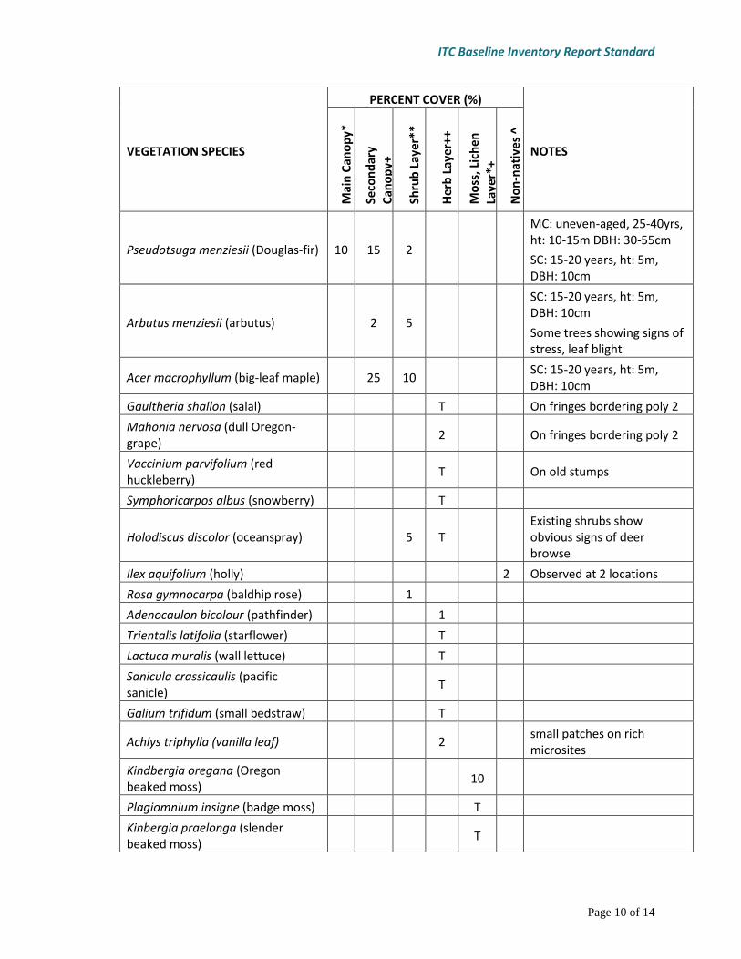
VEGETATION SPECIES
PERCENT COVER (%)
NOTES
Mai
n C
ano
py*
Seco
nd
ary
Can
op
y+
Shru
b L
ayer
**
Her
b L
ayer
++
Mo
ss, L
ich
en
Laye
r*+
No
n-n
ativ
es ^
Pseudotsuga menziesii (Douglas-fir) 10 15 2
MC: uneven-aged, 25-40yrs, ht: 10-15m DBH: 30-55cm
SC: 15-20 years, ht: 5m, DBH: 10cm
Arbutus menziesii (arbutus) 2 5
SC: 15-20 years, ht: 5m, DBH: 10cm
Some trees showing signs of stress, leaf blight
Acer macrophyllum (big-leaf maple) 25 10
SC: 15-20 years, ht: 5m,
DBH: 10cm
Gaultheria shallon (salal) T
On fringes bordering poly 2
Mahonia nervosa (dull Oregon-grape)
2
On fringes bordering poly 2
Vaccinium parvifolium (red huckleberry)
T
On old stumps
Symphoricarpos albus (snowberry) T
Holodiscus discolor (oceanspray) 5 T Existing shrubs show
obvious signs of deer browse
Ilex aquifolium (holly)
2 Observed at 2 locations
Rosa gymnocarpa (baldhip rose) 1
Adenocaulon bicolour (pathfinder) 1
Trientalis latifolia (starflower) T
Lactuca muralis (wall lettuce) T
Sanicula crassicaulis (pacific sanicle)
T
Galium trifidum (small bedstraw) T
Achlys triphylla (vanilla leaf) 2 small patches on rich
microsites
Kindbergia oregana (Oregon beaked moss)
10
Plagiomnium insigne (badge moss) T
Kinbergia praelonga (slender beaked moss)
T
ITC Baseline Inventory Report Standard
Page 11 of 14
Rhytideadelphus triquetrus (electrified cat’s tail moss)
2
Neckera douglasii (Douglas’ neckera)
T
On tree stems
Homalothecium fulgescens (yellow moss)
T
On maple tree
Porella navicularis (tree ruffle liverwort)
T
On woody debris
Cover by Layer (%) 10 42 23 5+ 12+ 2 Total Canopy Cover: 40-50%
*Codominant trees, main layer of tree cover. Make note of any dominant trees. +Trees greater than 10m that do not reach the main canopy. **All woody plants less than 10m tall. ++All herbaceous species, regardless of height and some low woody plants less than 15cm tall. *+ All bryophytes, terrestrial lichens and liverworts. T stands for Trace or less than 1%
10. Maps
Maps may be located in related sections or at the end of the report, but there should also be a list of maps and relevant page numbers (if they aren’t all in one section). Each map should include a:
Title;
North arrow;
Scale bar;
Scale (eg. 1:500); and,
Date produced. Maps may be produced in colour, but if the report may be used for covenant purposes, maps should be legible in greyscale for black and white printing. Typical maps for a baseline inventory report include:
Location map (e.g. a map showing the location of the site on its island);
Landscape context (e.g. a map indicating nearby protected areas and surrounding land uses), the location map can be an inset of the landscape context map;
Anthropogenic features (e.g. buildings, trails, archaeological sites, etc. as referenced in section 8); and,
Natural features (e.g. ecological communities as in section 9, significant natural features as in section 3, hydrological features identified in section 3)
Maps of anthropogenic and natural features should also include photopoints. For simpler sites, anthropogenic and natural features may be combined on a single map. Please see below for an example map.

ITC Baseline Inventory Report Standard
Page 12 of 14
11. Photos Photographs are used to establish the general state of each ecological community and to record any significant features of the covenant area. Provide a list of photos in a table as shown below. Photos may not be provided in the text of the baseline inventory report. They must be labelled and attached as an appendix and provided as individual .jpg files labelled as described in the “Final Baseline Inventory Report Deliverables” section, above. The number of photographs will vary according to the complexity of the site. Typical photos will include images of:
Significant values, e.g. natural, cultural and geological features;
Representative areas of each ecological community;

ITC Baseline Inventory Report Standard
Page 13 of 14
Anthropological features;
Significant patches of invasive species or areas of disturbance; and
Areas considered at risk, e.g. a property line adjacent to a parking lot or an area where erosion is occurring.
PHOTO POINT
LOCATION (UTM
Coordinates)
DIRECTION PHOTO-GRAPHER
DATE YYYY-
MM-DD
DESCRIPTION
Anthropogenic Features as noted on Map 3
P1 (from GPS) 110o MG* 2018-03-10
Western boundary line showing pin and adjacent farm use
P2 43o MG 2018-03-10
Pump house exterior with door and protruding waterline
P3 75o MG 2018-03-10
Trail from house to viewpoint indicating representation of maintained width
Natural Features as noted on Map 4
P4
185o MG 2018-03-11
Significant rock fall at base of cliff, including uprooted trees.
P5
300o MG 2018-03-12
Representative of Ecological Community 1. Mixed Douglas-fir – arbutus with patchy oceanspray in the understorey
* MG = Marisa Gardengnome

ITC Baseline Inventory Report Standard
Page 14 of 14
12. Appendices An appendix with photographs is required. Other optional appendices include:
Species lists from other biologists or naturalists who have visited the site (e.g. comprehensive bird lists);
Anthropological records or historically relevant documents; and
Additional reports completed prior to the baseline inventory report.