baseline assessment of ngemai conservation area · baseline assessment of ngemai conservation area...
TRANSCRIPT

Baseline Assessment of Ngemai Conservation Area
Marine Gouezo, Lincoln Rehm, Evelyn I. Otto, Randa Jonathan, Dawnette Olsudong,
Geory Mereb
Palau International Coral Reef Center
PICRC Technical Report No 15-12
June 2015

PICRC Technical Report No 15-12
1
Abstract
Marine Protected Areas (MPAs) have been used worldwide to protect biodiversity and increase
marine resources’ yields. In 2003, the Republic of Palau established the Protected Areas Network
(PAN) to help improve the management and effectiveness of Palau’s MPA. In 2006, Palau made a
commitment to effectively conserve 30% of its near shore habitat through the Micronesia Challenge.
Yet, very few data on the baseline status of MPAs that are part of this network have been collected.
This present study was conducted to collect baseline ecological data within the different habitats of
Ngemai Conservation Area (CA) located in Ngiwal State of Palau, to assess the effectiveness of the
MPA over time. Findings demonstrated that despite its small size and early protections status (7
years old MPA), Ngemai CA had high abundance of commercially-important fish and invertebrates. In
addition, due to its position, the MPA seemed to have been protected from the two past typhoons,
with live coral cover approaching 25% on the fore reef habitat. Ngemai CA is a good example of
ecosystem-based management as it includes most of the marine habitats in one location. These
characteristics make the MPA resilient and an essential component of the PAN, especially on the
east coast of Palau.

PICRC Technical Report No 15-12
2
Introduction Marine Protected Areas have been widely used as an effective conservation tool against
anthropogenic threats such as overfishing (Halpern et al. 2009; Lester et al. 2009; Edgar et al. 2014).
MPAs have demonstrated to increase fish biomass, abundance, mean size and species biodiversity
(Friedlander and DeMartini 2002; Abesamis et al. 2006; Hamilton et al. 2011). In addition, it has been
shown that they also benefit adjacent non-protected areas (McClanahan and Mangi 2000; Agardy et
al. 2003).
The Republic of Palau, located in western Micronesia, has made great advances in its marine
protective management. In 1994, the marine protection act implemented fishing restrictions on
several commercially-important species, and in 2003 the Palauan government established the
Protected Areas Network (PAN). This network aims to effectively protect both terrestrial and marine
habitats of Palau. In 2006, an international initiative called the Micronesia Challenge (MC), required
Micronesian nations (The Federated States of Micronesia, The Republic of Marshall Islands, Guam,
The Commonwealth of the Northern Marianas Islands, and The Republic of Palau) to commit to
effectively protect at least 20% of their terrestrial habitats and 30% of their marine habitats by 2020
(Micronesia Challenge Steering Committee 2011). This initiative far exceeds the current request for
countries to protect 10% of their marine and terrestrial habitats through international conventions and
treaties (United Nations 1992). The Palauan government is using its PAN to meet the goals of the MC
and to effectively expand its protected areas.
Despite these great advances since 2006, very little information has been gathered on the baseline
status of MPAs. As an organization that is committed to guide efforts supporting coral reef
stewardship through research and its applications for the people of Palau, Palau International Coral
Reef Center (PICRC) collects baseline ecological data at MPAs sites. Oselkesol Ngemai
Conservation Area (CA) is located in Ngiwal State at 7°31.882 N, 134°37.55 E. The conservation
area includes both terrestrial and marine habitats, starting from the fore reef, to the lagoon, to the
mangroves and to the Tayo river and land; the total area is 3.25km2 (Fig. 1). Ngemai CA (marine
habitats) was closed to fishing in June 1997 until 2001, when it was re-opened to fishing until 2008. In
March 2010, Ngemai was consolidated with the terrestrial area, Oselkesol, when it became part of the
PAN. As PICRC focuses on marine habitats, only the reef and the lagoon was surveyed; an area of
2km2 (Fig. 2).

PICRC Technical Report No 15-12
3
Figure 1: Satellite image showing Oselkesol Ngemai Conservation Area, including both marine and terrestrial habitats. In order to meet the goals of the MC, the Palauan government has to show that their MPAs network is
effective at protecting biodiversity and increasing marine resources. A previous survey was
conducted at Ngemai in 2011-2012 sampling three stations on the fore reef habitat and comparing
the data with a reference site close-by (Koshiba et al. 2013). The sampling design only focused on
one habitat (the fore reef) and therefore do not represent the MPA as a whole. In addition, it is difficult
to find a reference site that shows similar environmental characteristics than the MPA itself.
Therefore, the main objective of this survey was to collect baseline ecological data within the different
habitats of Ngemai CA. Over the coming years, subsequent sampling at the same sites will allow us
to assess the effectiveness of the MPA at protecting biodiversity and increasing commercially-
important species’ biomass over time.
PICRC Technical Report No 15-12
4
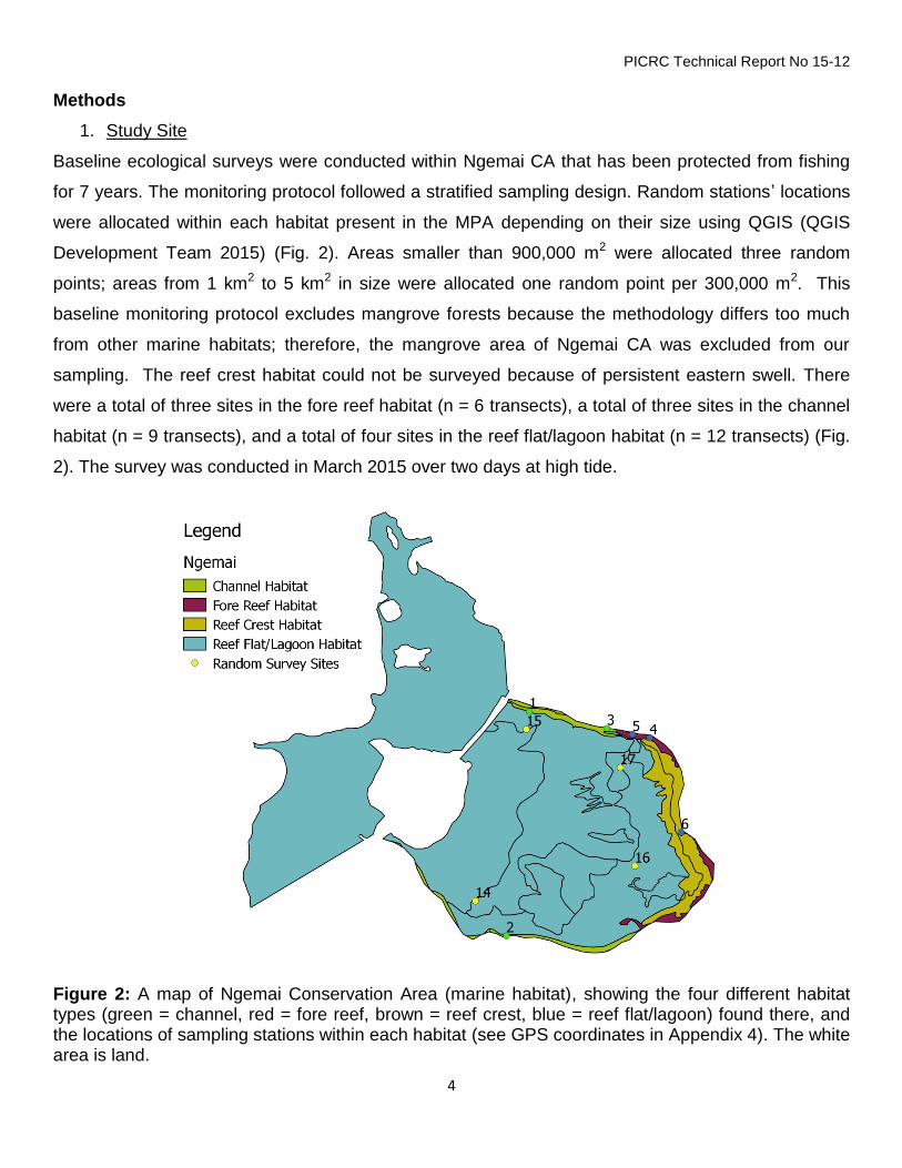
Methods
1. Study Site
Baseline ecological surveys were conducted within Ngemai CA that has been protected from fishing
for 7 years. The monitoring protocol followed a stratified sampling design. Random stations’ locations
were allocated within each habitat present in the MPA depending on their size using QGIS (QGIS
Development Team 2015) (Fig. 2). Areas smaller than 900,000 m2 were allocated three random
points; areas from 1 km2 to 5 km2 in size were allocated one random point per 300,000 m2. This
baseline monitoring protocol excludes mangrove forests because the methodology differs too much
from other marine habitats; therefore, the mangrove area of Ngemai CA was excluded from our
sampling. The reef crest habitat could not be surveyed because of persistent eastern swell. There
were a total of three sites in the fore reef habitat (n = 6 transects), a total of three sites in the channel
habitat (n = 9 transects), and a total of four sites in the reef flat/lagoon habitat (n = 12 transects) (Fig.
2). The survey was conducted in March 2015 over two days at high tide.
Figure 2: A map of Ngemai Conservation Area (marine habitat), showing the four different habitat types (green = channel, red = fore reef, brown = reef crest, blue = reef flat/lagoon) found there, and the locations of sampling stations within each habitat (see GPS coordinates in Appendix 4). The white area is land.

PICRC Technical Report No 15-12
5
2. Measurements of ecological variables At each site, three 30-m transects were laid at a maximum depth of 5-m, following the same direction
as the current, and consecutively with a few meters separating each transect. Along each 30-m
transect, four surveyors recorded data on fish, invertebrates, benthic cover and coral recruitment. The
first surveyor recorded the abundance and size estimates of the most common commercially
important and protected fish species within a 5-m wide belt (see fish list in Appendix 1). The second
surveyor recorded the abundance of invertebrates targeted by local fisheries within a 2-m wide belt
(see invertebrates list in Appendix 2). For the estimation of benthic cover, the third surveyor took a
photo every meter along the 30-m transect using an underwater camera mounted on a 1-m x 1-m
photo-quadrat PVC frame, for a total of 30 photos per transect. The fourth surveyor recorded the
abundance of coral recruits smaller than 5-cm diameter (to genera) within a 30-cm wide belt of the
first 10-m of each transect.
3. Data extraction and analysis To estimate benthic cover, photo-quadrats were analyzed using CPCe software (Kohler and Gill
2006). Five random points were allocated to each photo and the substrate below each point was
classified into benthic categories (see the benthic categories list in Appendix 3). The mean
percentage benthic cover of each category was calculated for each transect (n = 30 photos per
transect, n = 3 transects per site).
The biomass of fish was calculated using the total length-based equation: , where W is the
weight of the fish in grams, TL the total length of the fish in centimeters (cm), and a and b are
constant values from published biomass-length relationships (Kulbicki et al. 2005) and from Fishbase
(http://fishbase.org).
The data collected at Ngemai CA were baseline data, therefore neither comparison through time nor
with a reference site were possible for this study. Mean values with standard errors of each of the
measured ecological variables were calculated and plotted into bar charts using excel.

PICRC Technical Report No 15-12
6
Results Fish abundance and biomass The biomass of commercially-important species (see list in Appendix 1) was the highest in the fore
reef habitat with 5,749.1g (± 2,347 SE) per 150 m2 (Fig. 3). The lowest biomass within the MPA was
found in the reef flat (Fig. 3). The highest mean abundance of fish was found in the fore reef habitat
with 33.1 (± 6 SE) individuals per 150 m2 (Fig. 3). The lowest abundance was found in the reef flat
with 3.25 (± 1.4 SE) individuals per 150 m2 (Fig. 3).
Figure 3: Mean fish biomass (left) and abundance (right) of commercially-important species within the three main habitats of Ngemai MPA The fore reef habitat was dominated by three fish families: Siganidae, Scaridae and Lutjanidae while
the channel hosted a high abundance of Siganidae species with a mean of 12.3 (± 4.7 SE) individuals
per 150 m2 (Fig. 4). The reef flat had a low abundance of the five dominant fish families (Fig. 4).
0
1000
2000
3000
4000
5000
6000
7000
8000
9000
Channel Fore reef Reef flat
Me
an
Fis
h B
iom
as
s (
+-S
E)
per
15
0 m
2
MPA Habitat
0
5
10
15
20
25
30
35
40
45
Channel Fore reef Reef flat
Me
an
Fis
h A
bu
nd
an
ce
(±S
E)
per
15
0 m
2
MPA Habitat

PICRC Technical Report No 15-12
7
Figure 4: Mean abundance of fish belonging to the five dominant fish families encountered in the three habitats of Ngemai MPA. Protected fish species were sighted within the surveyed area. There was a total of four Siganus
fuscescens (Meyas), two Bolometopon muricatum (Kemedulk) and one Cheilinus undulatus (Maml).
Benthic cover The benthic cover among the three habitats differed greatly. The channel was dominated by sand
(40% ±10% SE), followed by macroalgae and turf algae (31% ± 15% SE, 14% ± 5.7% SE,
respectively) (Fig. 5). The fore reef habitat was dominated by turf algae (49% ± 13.2% SE) and live
corals (24% ± 3.9% SE) (Fig. 5). The reef flat habitat had the greatest cover of seagrass (39% ±
13.1% SE) and sand (33% ± 6.1% SE) (Fig. 5). This habitat also had the lowest coral cover.
-5
0
5
10
15
20
Fore reef Channel Reef flatMe
an
Ab
un
da
nce
of
fis
h f
am
ily
(±S
E)
per
15
0m
2
MPA Habitat
Siganidae
Scaridae
Lutjanidae
Lethrinidae
Carangaidae

PICRC Technical Report No 15-12
8
Figure 5: Mean percentage cover of main benthic cover present in the three habitats of Ngemai CA
The fore reef habitat had a total of 26 coral genera and was dominated by species from the genus
Porites (Fig. 6). The channel habitat had a total of 16 coral general – all of them in low abundance
(less than 2 % cover) (Fig. 6). The reef flat was dominated by seagrass and soft sediments. The most
abundant seagrass species found in this habitat was Enhalus acoroides (21% ± 10.7% SE) and
Thalassia hemprichii (10.3 % ± 4.9 SE).
8%
24%
1%
31%
11%
2%
39%
14%
49%
11%
10%
3%
2%
40%
1%
33%
2%
10%
2% 3%
0%
10%
20%
30%
40%
50%
60%
70%
80%
90%
100%
Channel Fore Reef Reef Flat
Pe
rce
nta
ge c
ove
r o
f b
en
thic
ca
teg
ori
es
(%
)
MPA Habitats
Carbonate
Rubble
Sand
Soft Coral
CCA
Turf
Seagrass
Macroalgae
Coral

PICRC Technical Report No 15-12
9
Figure 6: Mean percentage cover (±SE) of different coral genera present in the channel (a) and fore reef (b) habitats of Ngemai CA
0
0.5
1
1.5
2
2.5
3
3.5
4P
erc
en
etg
ae
co
ral c
ove
r (%
) a) Channel Habitat
-2
0
2
4
6
8
10
12
14
Pe
rce
nta
ge
Co
ral C
ove
r (%
)
Coral Genera
b) Fore Reef Habitat

PICRC Technical Report No 15-12
10
Coral recruitment Coral recruitment was higher in the fore reef and reef flat habitat with mean of 2.1 (± 0.7) and 1.1 (±
0.5) recruits per 3m2 respectively (Fig. 7). The fore reef and reef flat habitats were dominated by
Porites species (including Porites rus) and Montipora species of coral recruits. Recruits of
Psammocora species were also present in the reef flat habitat.
Figure 7: Mean coral recruits density in the three habitat of Ngemai CA
Invertebrates’ density The abundance of commercially-targeted invertebrates’ species (see list in Appendix 2) was high in
the reef flat habitat with 31 (± 22 SE) individuals per 60 m2 (Fig. 8). The reef flat hosted high densities
of sea cucumber species; the most abundant was Stichopus vastus (Ngimes), followed by Holothuria
impatiens (Sekesaker) and Actinopyga species (Cheremrum).
0
0.5
1
1.5
2
2.5
3
Fore reef Reef flat Channel
Me
an
Co
ral
Re
cru
its
den
sit
y (±S
E)
per
3m
2
MPA Habitat

PICRC Technical Report No 15-12
11
Figure 8: Mean abundance of commercially-targeted invertebrates’ species in the three habitats of Ngemai CA.
0
10
20
30
40
50
60
Reef flat Channel Fore reef
Me
an
In
ve
rteb
rate
s a
bu
nd
an
ce
(±
SE
) p
er
60
m2
MPA Habitat

PICRC Technical Report No 15-12
12
Discussion The overall goal of this study was to collect baseline ecological information within the Ngemai marine
protected area. This site has been closed to fishing since 2008 and is part of the PAN since 2010.
Although no comparison through time and/or with a reference site was possible for this site, our study
highlights interesting results for a 7-years old MPA.
The fish abundance of commercially-targeted species was relatively high in the channel and fore reef
habitats with more than 20 individuals per 150m2. The fore reef habitat had more fish, 33 individuals
per 150m2 than in the previous survey done in 2011 on the fore reef (11.4 individuals per 150 m2)
(Koshiba et al. 2013) which shows that protection from fishing is working. Both the fore reef and
channel habitats had high abundance of five important fish families. Herbivorous fishes, Siganidae
and Scaridae, which are not only a targeted species but also important groups that play key
ecological role in promoting reef resilience to increasing disturbance (Nyström et al. 2008; Mumby et
al. 2013). Carnivorous fish from the family Lutjanidae, were also abundant in both habitats. Other
carnivorous fish from the Lethrinidae and Carangaidae families appeared in lower abundance than
other families but their presence shows that the MPA hosts predatory fish and might be an indication
that fishing pressure has decreased. The lowest abundance and biomass of fish was in the reef flat
which is due to the environmental characteristics of the habitat: shallow exposed lagoon with
sediments and seagrass beds. The reef flat had smaller fish from four of the five main fish families.
This shows that this area is acting as a nursery for juvenile fish and is an essential habitat of the
MPA. Finally, the sighting of three protected fish species (Maml, Kemedukl and Meyas) within the
surveyed area is very encouraging. This shows that even a small MPA like Ngemai CA, due to
presence of different habitat types, is home to a diverse fish communities, including protected species
in Palau.
Live coral cover was the highest in the fore reef habitat (24%) which has similar values than in 2011
(Koshiba et al. 2013). Despite the occurrence of the two typhoons in 2012 and 2013, live coral cover
was not damaged like sites nearby (Melekeok and Ngaraard PICRC monitoring sites), where now live
coral cover is lower than 5% (unpublished data, PICRC). The Ngemai fore reef positioned backwards
from the adjacent fore reefs North and South (Fig. 1) must have protected it from big swells and reef
destruction. The presence of live mature coral colonies inside the MPA is very encouraging for the
future recovery of damaged reefs surrounding the MPAs. Depending on how well the reefs are

PICRC Technical Report No 15-12
13
connected, the MPA might help repopulating damaged reefs nearby (Golbuu et al. 2012). The
channel habitat had very high levels of sediments because of the river nearby. Despite the high-
sediment conditions, live corals were present in this habitat and relatively diverse with 16 recorded
different coral genera. The adjacent consolidated terrestrial protected areas Oselkesol will be
beneficial to coral reefs in the channel and fore reef helping prevent high sedimentation levels which
are harmful to corals. Previous studies in Palau showed that sediments yield was significantly lower
where land activities were reduced (e.g. clearing) and mangroves were present (Golbuu et al. 2003,
2011; Victor et al. 2004). Finally, the reef flat habitat was dominated by soft sediments with seagrass
beds cover approaching 40% and hosted juveniles fish and high number of invertebrates (discussed
below).
Coral recruitment was the highest on the fore reef habitat but was lower than in the previous surveys
(2.1 recruits in 2015 against 4.2 recruits in 2011 per 3 m2) (Koshiba et al. 2013). This decrease is
possibly due to the loss of mature coral colonies nearby caused by the two subsequent typhoons in
2012 and 2013. The outer reef on the east coast has lost about 20% of coral cover (unpublished data,
PICRC) and will affect recruitment rate in the following years (Doropoulos et al. 2014). Coral
recruitment was low on the reef flat and channel habitat with less than 1 recruit per 3m2. This is due
to substrate type: fine sediments and sand. The two channels had the lowest recruitment rate (less
than 0.5 recruits per 3m2) also caused by the substrate type (sand and mud) and the sedimentation
occasioned by the river close-by.
The reef flat hosted most of the commercially-important invertebrates. Sea cucumber species,
especially Stichopus vastus (Ngimes) and Holothuria impatiens (Sekesaker) appeared in high
abundances in the seagrass beds. This indicates that harvesting pressure have ceased as these two
species are harvested by locals for their own consumption. The presence of Actinopyga species
(Cheremrum) was encouraging as it used to be harvested for export to Asian markets.
Ngemai CA is a very good example of the application of protective management including ecosystem
-connectivity in Palau. Despite its small size of 2 km2, Ngemai CA include mangrove forests, reef flat
with seagrass beds, coral reefs living in high sedimentation conditions and coral reefs on the fore
reefs. All these different ecosystems connect with each other due to the larvae stages of most of
marine organisms as well as their physical characteristics (e.g. nurseries for segrass beds) (Palumbi
PICRC Technical Report No 15-12
14
2003; Cowen 2006; Mumby and Hastings 2008). In addition, the sheltered location of Ngemai CA,
saved the reefs from the destruction caused by the two typhoons that damaged most of the exposed
East coast of Palau. All of these characteristics make Ngemai CA very resilient and a key component
of the PAN that will hopefully help with the recovery of surrounded damaged reef in the next years.
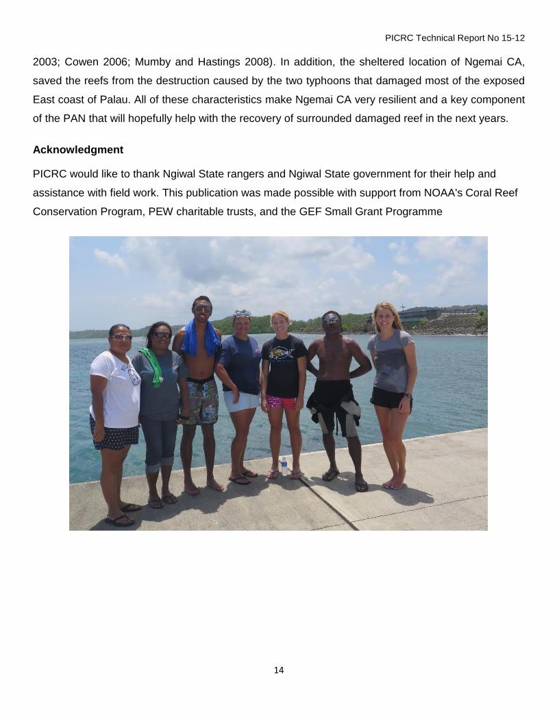
Acknowledgment
PICRC would like to thank Ngiwal State rangers and Ngiwal State government for their help and
assistance with field work. This publication was made possible with support from NOAA's Coral Reef
Conservation Program, PEW charitable trusts, and the GEF Small Grant Programme

PICRC Technical Report No 15-12
15
References Abesamis RA, Russ GR, Alcala AC (2006) Gradients of abundance of fish across no-take marine
reserve boundaries: evidence from Philippine coral reefs. Aquat. Conserv. Mar. Freshw. Ecosyst. 16:349–371
Agardy T, Bridgewater P, Crosby MP, Day J, Dayton PK, Kenchington R, Laffoley D, McConney P, Murray PA, Parks JE, others (2003) Dangerous targets? Unresolved issues and ideological clashes around marine protected areas. Aquat. Conserv. Mar. Freshw. Ecosyst. 13:353–367
Cowen RK (2006) Scaling of Connectivity in Marine Populations. Science 311:522–527
Doropoulos C, Roff G, Zupan M, Nestor V, Isechal AL, Mumby PJ (2014) Reef-scale failure of coral settlement following typhoon disturbance and macroalgal bloom in Palau, Western Pacific. Coral Reefs 33:613–623
Edgar GJ, Stuart-Smith RD, Willis TJ, Kininmonth S, Baker SC, Banks S, Barrett NS, Becerro MA, Bernard ATF, Berkhout J, Buxton CD, Campbell SJ, Cooper AT, Davey M, Edgar SC, Försterra G, Galván DE, Irigoyen AJ, Kushner DJ, Moura R, Parnell PE, Shears NT, Soler G, Strain EMA, Thomson RJ (2014) Global conservation outcomes depend on marine protected areas with five key features. Nature 506:216–220
Friedlander AM, DeMartini EE (2002) Contrasts in density, size, and biomass of reef fishes between the northwestern and the main Hawaiian islands: the effects of fishing down apex predators. Mar. Ecol. Prog. Ser. 230:e264
Golbuu Y, Wolanski E, Idechong JW, Victor S, Isechal AL, Oldiais NW, Idip D, Richmond RH, van Woesik R (2012) Predicting Coral Recruitment in Palau’s Complex Reef Archipelago. PLoS ONE 7:e50998
Halpern BS, Lester SE, Kellner JB (2009) Spillover from marine reserves and the replenishment of fished stocks. Environ. Conserv. 36:268–276
Hamilton RJ, Potuku T, Montambault JR (2011) Community-based conservation results in the recovery of reef fish spawning aggregations in the Coral Triangle. Biol. Conserv. 144:1850–1858
Kohler KE, Gill SM (2006) Coral Point Count with Excel extensions (CPCe): A Visual Basic program for the determination of coral and substrate coverage using random point count methodology. Comput. Geosci. 32:1259–1269
Koshiba S, Idechong J, Isechal A, Nakaya S, Merep A, Mereb G, Oldiais N, Olsudong D, Nestor V (2013) A Biological Survey of Ngemai Marine Protected Area. 1–15
Kulbicki M, Guillemot N, Amand M (2005) A general approach to length-weight relationships for New Caledonian lagoon fishes. Cybium 29:235–252

PICRC Technical Report No 15-12
16
Lester S, Halpern B, Grorud-Colvert K, Lubchenco J, Ruttenberg B, Gaines S, Airamé S, Warner R (2009) Biological effects within no-take marine reserves: a global synthesis. Mar. Ecol. Prog. Ser. 384:33–46
McClanahan TR, Mangi S (2000) Spillover of exploitable fishes from a marine park and its effect on the adjacent fishery. Ecol. Appl. 10:1792–1805
Micronesia Challenge Steering Committee (2011) A Report on Progress to Implement the Micronesia Challenge 2006-2011. 1–33
Mumby PJ, Bejarano S, Golbuu Y, Steneck RS, Arnold SN, van Woesik R, Friedlander AM (2013) Empirical relationships among resilience indicators on Micronesian reefs. Coral Reefs 32:213–226
Mumby PJ, Hastings A (2008) The impact of ecosystem connectivity on coral reef resilience. J. Appl. Ecol. 45:854–862
Nyström M, Graham NAJ, Lokrantz J, Norström AV (2008) Capturing the cornerstones of coral reef resilience: linking theory to practice. Coral Reefs 27:795–809
Palumbi SR (2003) Population genetics, demographic connectivity, and the design of marine reserves. Ecol. Appl. 13:146–158
QGIS Development Team (2015) QGIS Geographic Information System. Open Source Geospatial Foundation Project,
United Nations (1992) Convention Biological Diversity. 1–30

PICRC Technical Report No 15-12
17
Appendix 1:
Commercially important fish species in Palau
Common name Palauan name Scientific name
1 Lined rabbitfish Kelsebuul Siganus lineatus
2 Forketail rabbitfish Beduut Siganus argenteus
3 Bluespine unicornfish Chum Naso unicornis
4 Orangespine unicornfish Cherangel Naso lituratus
5 Longface emperor Melangmud Lethrinus olivaceus
6 Orangestripe emperor Udech Lethrinus obsoletus
7 Yellowlip emperor Mechur Lethrinus xanthochilis
8 Red snapper Kedesau Lutjanus bohar
9 Humpback snapper Keremlal Lutjanus gibbus
10 Bluefin trevally Oruidel Caranx ignobilis
11 Giant trevally Erobk Caranx melampygus
12 Parrotfish species Melemau Cetoscarus/Scarus spp
13 Pacific longnose parrotfish Ngeaoch Hipposcarus longiceps
14 Bluespot mullet Kelat Valamugil seheli
15 Squaretail mullet Uluu Liza vaigiensis
16 Rudderfish (lowfin) Komud, Teboteb Kyphosus spp (vaigiensis)
17 Giant sweetlips Melim ralm, Kosond/Bikl Plectorhinchus albovittatus
18 Yellowstripe sweetlips Merar Plectorhinchus crysotaenia
19 River snapper Kedesau’l iengel Lutjanus argentimaculatus
20 Yellow cheek tuskfish Budech Choerodon anchorago
21 Masked rabbitfish Reked Siganus puellus
22 Goldspotted rabbitfish Bebael Siganus punctatus
23 Bicolor parrotfish Beyadel/Ngesngis Cetoscarus bicolor
24 Indian Ocean Longnose parrotfish Bekism Hiposcarus harid
25 Red gill emperor Rekruk Lethrinus rubrioperculatus
26 Pacific steephead parrotfish Otord Scarus micorhinos
Protected Fish Species (yearly and seasonal fishing closure)
27 Dusky rabbitfish Meyas Siganus fuscescens
28 Bumpead parrotfish Kemedukl Bolbometopon muricatum
29 Humphead parrotfish Maml Cheilinus undulatus
30 Squaretail grouper Tiau Plectropomus areolatus
31 Leopard grouper Tiau Plectropomus leopardus
32 Saddleback grouper Tiau, Katuu’tiau, Mokas Plectropomus laevis
33 Brown-marbled grouper Meteungerel’temekai) Epinephelus fuscoguttatus
34 Marbled grouper Ksau’temekai Epinephelus polyphekadion

PICRC Technical Report No 15-12
18
Appendix 2: Macro-invertebrates list
Common names Palauan name Scientific name
Black teatfish Bakelungal-chedelkelek Holothuria nobilis
White teatfish, Bakelungal-cherou Holothuria fuscogilva
Golden sandfish Delalamolech Holothuria lessoni
Hairy blackfish Eremrum, cheremrum edelekelk
Actinopyga miliaris
Hairy greyfish Eremrum, cheremrum Actinopyga sp.
Deepwater red fish Eremrum, cheremrum Actinopyga echinites
Deepwater blackfish Eremrum, cheremrum Actinopyga palauensis
Stonefish Ngelau Actinopyga lecanora
Dragonfish Irimd Stichopus horrens
Brown sandfish Meremarech Bohadschia vitiensis
Chalk fish Meremarech Bohadschia similis
Leopardfish /tigerfish Meremarech, esobel Bohadschia argus
Sandfish Molech Holothuria scabra
Curryfish Delal a ngimes/ngimes ra tmolech
Stichopus hermanni
Brown curryfish Ngimes Stichopus vastus
Greenfish Cheuas Stichopus chloronotus
Slender sea cucumber Sekesaker Holothuria impatiens
Prickly redfish Temetamel Thelenota ananas
Amberfish Belaol Thelenota anax
Elephant trunkfish Delal a molech Holothuria fuscopunctata
Flowerfish Meremarech Pearsonothuria graeffei
Lolly fish Cheuas Holothuria atra
Pinkfish Cheuas Holothuria edulis
White snakefish Cheuas Holothuria leucospilota
Snakefish Cheuas Holothuria coluber
Red snakefish Cheuas Holothuris falvomaculata
Surf red fish Badelchelid Actinopyga mauritiana
Crocus giant clam / Oruer Tridacna crocea
Elongate giant clam Melibes Tridacna maxima
Smooth giant clam Kism Tridacna derasa
Fluted giant clam Ribkungel Tridacna squamosa
Bear paw giant clam Duadeb Hippopus hippopus
True giant clam Otkang Tridacna gigas
Sea urchin Ibuchel Tripneustes gratilla
Trochus Semum Trochus niloticus

PICRC Technical Report No 15-12
19
Appendix 3: Benthic categories
CPCe Code Benthic Categories
"C" "Coral"
"SC" "Soft Coral"
"OI" "Other Invertebrates"
"MA" "Macroalgae"
"SG" "Seagrass"
"BCA" "Branching Coralline Algae"
"CCA" "Crustose Coralline Algae"
"CAR" "Carbonate"
"S" "Sand"
"R" "Rubble"
"FCA" "Fleshy Coralline algae"
"CHRYS" "Chrysophyte"
"T" "Turf Algae"
"TWS" "Tape
"G" "Gorgonians"
"SP" "Sponges"
"ANEM" "Anenome"
"DISCO" "Discosoma"
"DYS" "Dysidea Sponge"
"OLV" "Olive Sponge"
"CUPS" "Cup Sponge"
"TERPS" "Terpios Sponge"
"Z" "Zoanthids"
"NoIDINV" "Not Identified Invertebrate"
"AMP" "Amphiroa"
"ASC" "Ascidian"
"TURB" "Turbinaria"
"DICT" "Dictyota"
"LIAG" "Liagora"
"LOBO" "Lobophora"
"SCHIZ" "Schizothrix"
"HALI" "Halimeda"
"SARG" "Sargassum"
"BG" "Bluegreen"
"Bood" "Boodlea"
"GLXU" "Galaxura"
"CHLDES" "Chlorodesmis"
"JAN" "Jania"
"CLP" "Caulerpa"
"MICDTY" "Microdictyton"
"BRYP" "Bryopsis"
"NEOM" "Neomeris"
"TYDM" "Tydemania"

PICRC Technical Report No 15-12
20
"ASP" "Asparagopsis"
"MAST" "Mastophora"
"DYCTY" "Dictosphyrea"
"PAD" "Padina"
"NOIDMAC" "Not ID Macroalgae"
"CR" "C.rotundata"
"CS" "C.serrulata"
"EA" "E. acroides"
"HP" "H. pinifolia"
"HU" "H. univervis"
"HM" "H. minor"
"HO" "H. ovalis"
"SI" "S. isoetifolium"
"TH" "T.hemprichii"
"TC" "T. ciliatum"
"SG" "Seagrass"
"ACAN" "Acanthastrea"
"ACROP" "Acropora"
"ANAC" "Anacropora"
"ALVEO" "Alveopora"
"ASTRP" "Astreopora"
"CAUL" "Caulastrea"
"CRUNK" "Coral Unknown"
"COSC" "Coscinaraea"
"CYPH" "Cyphastrea"
"CTEN" "Ctenactis"
"DIPLO" "Diploastrea"
"ECHPHY" "Echinophyllia"
"ECHPO" "Echinopora"
"EUPH" "Euphyllia"
"FAV" "Favia"
"FAVT" "Favites"
"FAVD" "Faviid"
"FUNG" "Fungia"
"GAL" "Galaxea"
"GARD" "Gardininoseris"
"GON" "Goniastrea"
"GONIO" "Goniopora"
"HELIO" "Heliopora"
"HERP" "Herpolitha"
"HYD" "Hydnophora"
"ISOP" "Isopora"
"LEPT" "Leptastrea"
"LEPTOR" "Leptoria"
"LEPTOS" "Leptoseris"
"LOBOPH" "Lobophyllia"
PICRC Technical Report No 15-12
21
"MILL" "Millepora"
"MONT" "Montastrea"
"MONTI" "Montipora"
"MERU" "Merulina"
"MYCED" "Mycedium"
"OULO" "Oulophyllia"
"OXYP" "Oxypora"
"PACHY" "Pachyseris"
"PAV" "Pavona"
"PLAT" "Platygyra"
"PLERO" "Plerogyra"
"PLSIA" "Plesiastrea"
"PECT" "Pectinia"
"PHYSO" "Physogyra"
"POC" "Pocillopora"
"POR" "Porites"
"PORRUS" "Porites-rus"
"PORMAS" "Porites-massive"
"PSAM" "Psammocora"
"SANDO" "Sandalolitha"
"SCAP" "Scapophyllia"
"SERIA" "Seriatopora"
"STYLC" "Stylocoeniella"
"STYLO" "Stylophora"
"SYMP" "Symphyllia"
"TURBIN" "Turbinaria"
"CCA" "Crustose Coralline"
"CAR" "Carbonate"
"SC" "Soft Coral"
"Sand" "Sand"
"Rubble" "Rubble"
"Tape" "Tape"
"Wand" "Wand"
"Shadow" "Shadow"
"FCA" "Fleshy-Coralline"
"CHRYOBRN" "Brown Chysophyte"
"TURF" "Turf"
"BCA" "Branching Coralline general"
"BC" "Bleached Coral"

PICRC Technical Report No 15-12
22
Appendix 4: GPS coordinates of survey sites (UTM)