bakersfiel d field office - bureau of land management copies of the document on cd may be obtained...
TRANSCRIPT

Proposed Caliente Resource Management Plan (RMP) Amendment
and Environmental Assessment (EA) Regarding Management of Lands Recently
Transferred to the Bureau of Land Management (BLM)
Known as the Naval Petroleum Reserve Number 2 (NPR-2)
Ba
ke
rsfield
Fie
ld O
ffice
Public Lands USA; Use Share, Appreciate
BLM

United States Department of the Interior BUREAU OF LAND MANAGEMENT
Bakersfield Field Office 3801 Pegasus Drive
Bakersfield, California 93308-6837 www.ca.blm.gov/bakersfield
March 6, 2006 3100 (P) NPR-2
(CA-160.95)
Dear Reader:
Enclosed for your review is the Proposed Caliente Resource Management Plan (RMP) Amendment/Final Environmental Assessment (EA) regarding management of lands recently transferred to the Bureau of Land Management (BLM) known as the Naval Petroleum Reserve Numbered 2 (NPR-2). This Proposed RMP Amendment/EA discusses the oil and gas related and realty program management guidance and decisions from the Caliente RMP that will apply to lands within NPR-2. These lands, formerly managed by the Department of Energy, are located within the Bakersfield Field Office Area (formerly Caliente Resource Area). Management responsibility for these lands was transferred to BLM from the Department of Energy in the Energy Policy Act of 2005. As stated in the Act, “the principal purpose of the lands subject to transfer ... is the production of hydrocarbon resources, and the Secretary of the Interior shall manage the lands in a fashion consistent with this purpose.”
The Proposed RMP amendment/EA is online at http://www.ca.blm.gov/bakersfield/DivofMinerals.html Additional copies of the document on CD may be obtained from the BLM Bakersfield Field Office, 3801 Pegasus Dr., Bakersfield, CA 93308, or requested by telephone (661) 391-6000, facsimile message (661) 391-6156, or email [email protected]
We originally determined that an EA level NEPA document was appropriate because we were tiering off of an EIS (Caliente RMP and EIS, dated 12-3-96) that was thoroughly reviewed by USFWS, EPA, the oil and gas industry, environmental groups, and the general public. The affected area is similar to the surrounding area, and the proposed actions are virtually identical to those analyzed in the original EIS. The draft RMP Amendment/EA was published January 12, 2006, followed by a 30-day public comment period. No comments were received that would alter that determination.
During the comment period, 12 comments were received from the public. Ten of those comments were in favor of leasing/development as described in the document, one contained a question that has been addressed, and one contained concerns about issues that have been addressed and incorporated into this document. The primary concerns were in regard to air quality and biological issues, and changes were made to those sections in both Chapter 4 – Affected Environment, and Chapter 5 – Environmental Effects. We have determined that those and other minor changes that were made were not significant enough to warrant resubmitting the Draft document for comments.
"Visit us on the Internet at www.ca.blm.gov/bakersfield"

The Proposed RMP Amendment/Final EA portrays the proposed action in its entirety, and the Final EA also portrays the associated impacts of the proposed action. The effective date is March 6, 2006.
PROTEST RIGHTS
Any person who participated in the planning process and has an interest which is or may be adversely affected by the approval or amendment of a resource management plan may protest such approval or amendment. A protest may raise only those issues which were submitted for the record during the planning process.
(1) The protest shall be in writing and shall be filed with the Director at the following address:
Director (attention: Protest Coordinator) Box 66538 Washington, DC 20035 (for regular mail) or Director (attention: Protest Coordinator) 1620 L Street, N.W., Suite 1075 Washington, DC 20036 (for overnight mail.)
For an amendment not requiring the preparation of an environmental impact statement, such asthis, the protest shall be filed within 30 days of the publication of the notice of its effective date.
(2) The protest shall contain: (i) The name, mailing address, telephone number and interest of the person filing the protest; (ii) A statement of the issue or issues being protested; (iii) A statement of the part or parts of the plan or amendment being protested; (iv) A copy of all documents addressing the issue or issues that were submitted during the
planning process by the protesting party or an indication of the date the issue or issues were discussed for the record; and
(v) A concise statement explaining why the State Director's decision is believed to be wrong.
At the end of the 30-day protest period, the proposed Plan Amendment, excluding any portion under protest, will become final. A Record of Decision will be issued for the non-protested portions of the Plan Amendment. Approval will be withheld on any portion of the Plan Amendment under protest until final action has been completed on such protest.
For additional information contact Jeff Prude in the BLM Bakersfield Field Office at (661) 391-6140.
Sincerely,
(original signed by) Ronald Huntsinger Bakersfield Field Manager
"Visit us on the Internet at www.ca.blm.gov/bakersfield"
Proposed Caliente Plan Amendment and Environmental Assessment Regarding Management of Lands Recently Transferred to BLM known as
Naval Petroleum Reserve Number 2 (NPR-2)
Table of Contents Page
Chapter 1 – Purpose and Need ................................................................................................................. 5 Background ...... ......................................................................................................................... 5
Legal Description of NPR-2 Lands ............................................................................................ 6
Chapter 2 – Proposed Action and Alternatives ........................................................................................ 11 Preferred Alternative .................................................................................................................. 11
Management Area General Objectives and Allocations ............................................................ 11 Objectives ..................................................................................................................... 11 Allocations .................................................................................................................... 11 Oil and Gas ..................................................................................................... 11 Lands and Realty Management ....................................................................... 12 Allocations common to both Oil and Gas and Lands ..................................... 14
No Action Alternative ................................................................................................................ 15
Chapter 3 - Standard Processes ................................................................................................................ 16
Chapter 4 – Affected Environment .......................................................................................................... 17 Location and Physical Description ............................................................................................. 17
Weather ......................................................................................................................... 17 Air, Soil, and Water ................................................................................................................... 17
Air ................................................................................................................................. 17 Soils .............................................................................................................................. 18 Water ............................................................................................................................ 18
Biological Resources .................................................................................................................. 18 Cultural Resources ..................................................................................................................... 24
Geology ...................................................................................................................................... 24 Lands .. ....................................................................................................................................... 24 Range . ....................................................................................................................................... 28
Recreation .................................................................................................................................. 28 Socio-Economic ......................................................................................................................... 28 Visual Resources ........................................................................................................................ 28 Wilderness .................................................................................................................................. 28
Chapter 5 – Environmental Effects .......................................................................................................... 29 Reasonably Foreseeable Development Scenario ........................................................................ 29
Alternative 1 – Preferred Alternative ........................................................................... 29 Alternative 2 - No Action Alternative .......................................................................... 30
Projected levels of Oil and Gas Activity under the Preferred Alternative .................................. 31 Proposed Action Alternative – Effects on Critical Elements ..................................................... 32
Description of Types of Oil and Gas Related Activities Occurring under the Proposed Action ......................................................................................................... 32
Air, Soil, and Water ...................................................................................................... 33 Biological Resources .................................................................................................... 35 Cultural Resources ........................................................................................................ 45
Lands ............................................................................................................................ 46 Range ............................................................................................................................ 46
1

Recreation ..................................................................................................................... 46 Socio-Economic ........................................................................................................... 46 Visual Resources .......................................................................................................... 47 Wilderness .................................................................................................................... 47 Cumulative Impacts ...................................................................................................... 47
No Action Alternative ................................................................................................................ 48 Environmental Consequences of No Action ................................................................. 48
Chapter 6 – Mitigation ............................................................................................................................. 50 Air, Soil, and Water ................................................................................................................... 50
Biological Resources .................................................................................................................. 50 Cultural Resources ..................................................................................................................... 50
Lands .. ....................................................................................................................................... 50 Range . ....................................................................................................................................... 50
Recreation .................................................................................................................................. 50 Visual Resources ........................................................................................................................ 50
Wilderness .................................................................................................................................. 50
Chapter 7 – Consultation and Coordination ............................................................................................. 51 Issue Identification/Public Scoping ............................................................................................ 51
Public Involvement, Contacts & Date of Contact ..................................................................... 51 Native American Contacts ............................................................................................ 51
Others ........................................................................................................................... 51 Mailing List ................................................................................................................................ 51
Chapter 8 – References ... ......................................................................................................................... 52
Appendix A – Oil and Gas Management Guidelines ............................................................................... 55 Oil and Gas Leasing Availability Categories ............................................................................. 55
Lands Closed to Oil and Gas Leasing............................................................................ 55 Lands Open to Oil and Gas Leasing ............................................................................. 55
Leasing with Standard Lease Stipulation ........................................................ 56 No Surface Use Stipulation ............................................................................. 56
Leasing with the Limited Surface Use Stipulation ......................................... 56 Standard Engineering Practices .................................................................................... 63 Drilling a New Well ........................................................................................ 63
Temp. Abandonment of a Producing Well ..................................................... 64 Plugging and Abandonment of a Well ............................................................ 65
Appendix B – Lands and Realty Management Guidelines ...................................................................... 67 Land Use Authorizations ............................................................................................................ 67 Land Tenure Management Guidelines ....................................................................................... 68
Other Lands Actions .................................................................................................................. 70
Appendix C – Biological Resource Management Guidelines .................................................................. 71 Introduction ................................................................................................................................ 71 Conservation Strategy ................................................................................................................ 71
Appendix D – Air Quality/Affected Environment ................................................................................... 74
Finding of No Significant Impact ............................................................................................................. 78
2
Figures and Tables Table 1-1 Legal Description of NPR-2 Lands and Location of Oil and Gas Leases .................. 6 Figure 1-2 DOE Township Letters and Section codes ............................................................... 9 Figure 1-3 Map showing lands transferred to BLM from DOE ................................................. 10 Figure 2-1 NPR-2 Potential Land Disposals .............................................................................. 13
Figure 4-1 San Joaquin kit fox pupping dens found in 1981 on Naval Petroleum Reserve No. 2 .................................................................................................. 20
Figure 4-2 Giant kangaroo rat locations on Naval Petroleum Reserve No. 2 , 1981 to 1987 .... 21 Figure 4-3 Locations of blunt-nosed leopard lizard sightings made during a 1981 survey of Naval Petroleum Reserve No. 2 ............................................................................................... 22 Table 4-4 BLM sensitive species with potential to occur on NPR-2 lands ................................ 22 Table 4-5 Executive Orders, Public Land Orders, Surveys, and Public Laws affecting
NPR-2 ....................................................................................................................................... 25 Table 4-6 Parcel Access ............................................................................................................. 25 Table 5-1 Projected habitat disturbance associated with existing and new oil and gas leases
(Preferred Alternative) .................................................................................... 29 Table 5-2 Projected habitat disturbance associated with existing oil and gas leases
(No Action alternative) ................................................................................... 30 Table 5-3 Impacts of Absorbing NPR-2 Lands into BLM’s Existing Oil and Gas Program ..... 31 Table 5-4 Habitat disturbance and Habitat Zone on Leased and Unleased parcels at NPR-2 .... 36 Table 5-5. RMP Components that implement Recovery Plan Goals ......................................... 43 Table B-1 Parcels with Unclear Surface Access ........................................................................ 70 Table D-1 Federal and State Attainment Status for Western Kern County ................................ 75
3

LIST OF PREPARERS:
POSITION SIGNATURE
1. WILDLIFE ________Amy Kuritsubo___
2. BOTANY ________Denis Kearns_____
3. CULTURAL RESOURCES ________Kim Cuevas______
4. RANGE ________Karen Doran______
5. MINERALS ________Jeff Prude_ ____
6. RECREATION ________N/A_____________ (Wilderness, Visual Resources)
7. LANDS ________Dan Vaughn______ (Use Authorizations, Land
Tenure Adjustment)
8. AIR, SOIL, & WATER ________Glenn Harris______
9. CARRIZO ________N/A_____________
10. FIRE ________N/A_____________
Project Coordinator: _____Jeff Prude____________________________March 2, 2006___ Signature Date
NEPA Coordinator: ________________________________________________________ Signature Date
4

Chapter 1 Purpose and Need
The Bureau of Land Management (BLM) is proposing this Amendment the Caliente Resource Management Plan (CRMP) and Environmental Assessment to cover newly transferred lands at Naval Petroleum Reserve No. 2 (NPR-2). This Proposed Amendment/EA discusses the oil and gas related and realty program Management Guidance and Decisions from the Caliente RMP (CRMP) that will apply to NPR-2 lands. These lands, formerly managed by the Department of Energy, are located within the Bakersfield Field Office Area (formerly Caliente Resource Area). Management responsibility for these lands was transferred to BLM in the Energy Policy Act of 2005.
The CRMP covers 3 regional management areas, and the NPR-2 lands fall under one of those, the Valley Management Area. Although the NPR-2 lands fall within the area covered by the CRMP, that Plan did not specifically address NPR lands and did not mention that lands acquired in the future by the BLM would be managed identical to existing lands. Therefore, the BLM must amend the CRMP to include NPR-2 lands.
This amendment covers oil and gas operations, including new leasing, along with realty program actions. All other activities (e.g., grazing, recreation, etc.) will be covered in a revision to the CRMP that is expected to be begun within the next couple of years. The two-phase approach was selected as BLM has made a commitment to begin leasing NPR-2 lands as soon as possible after the lands transfer to BLM. To meet this commitment, BLM wanted to focus on the oil and gas and realty program activities first.
The proposed action identifies the suitability of the newly transferred lands for leasing for oil and gas exploration and development and any constraints thereon, in addition to addressing both ongoing and new oil and gas related activities on lands that are already leased. The amendment will also identify guidance for specific realty program actions, including the process for potentially repositioning small parcels through exchange, sale or acquisition.
Background
The lands addressed by this amendment were formerly under the jurisdiction of the Department of Energy. However, the Energy Policy Act of 2005 (hereinafter referred to as the Act) transferred management responsibility from the DOE to the BLM effective August 8, 2005. As directed in the Act, “the principal purpose of the lands subject to transfer ... is the production of hydrocarbon resources, and the Secretary of the Interior shall manage the lands in a fashion consistent with this purpose.” Accordingly, this plan amendment will specify management prescriptions at NPR-2 for all oil and gas related activities and specific realty actions covered under 43 CFR 2000 by extending existing management prescriptions from the current CRMP.
The proposed action identifies the suitability of the newly transferred lands for leasing for oil and gas exploration and development and any constraints thereon, in addition to addressing both ongoing and new oil and gas related activities on lands that are already leased. The amendment will also identify guidance for specific realty program actions, including the process for potentially repositioning small parcels through exchange, sale or acquisition. The land affected comprises only the federal portion of NPR-2. Total federal acreage is approximately 10,451 acres, located in Townships 31 South, Ranges 23-24 East; and 32 South, Ranges 23-25 East, MDBM. Approximately 7,919 acres, 76% of the transferred land, already contain ongoing oil and gas operations and little change is expected in those areas. Approximately 2,532 acres, or 24% of the transferred land, is unleased. There are more than 19,000 acres of private minerals within NPR-2, and those lands are not covered under this Plan Amendment.
The subject lands have been in production for more than 70 years. Peak production of 1430 BOPD occurred in 1935, and many wells have already been plugged and abandoned. Current total production is 1050 BOPD from 200-300 wells. Ongoing activities consist primarily of routine workovers, plugging and abandonment, and general maintenance. New drilling activity (on existing federal leases) has been very low, with no new
5

wells in more than 9 years. However, with the recent and sustained rise in oil and gas prices, permits to drill a number of wells have been submitted.
Although nearly all of the land is leased, there is interest in leasing the unleased parcels now that the lands are under BLM jurisdiction. We expect approximately half of the new drilling to be on the new leases, and approximately half on existing leases. In total, we expect that there will be between 50 and 200 new wells. These wells, along with the associated well pads, facilities, and roads, are expected to temporarily or permanently disturb between 44 and 137 acres of habitat. Additionally, seismic projects that are projected in the project area are expected to disturb between 18 and 36 acres, most of which will be temporary. Overall new disturbance is projected to be between 62 and 173 acres. Details are provided in Chapter 5.
This amendment will also identify guidance for specific lands (realty) program actions. This is needed for several reasons: 1) The Energy Policy Act of 2005, Public Law 109-58, which transferred jurisdiction of the NPR-2 lands to BLM, provided that the primary use of these lands would be for oil and gas production. However, this Act also allows BLM to make disposals of NPR-2 land or allow commercial or non-profit surface use of NPR-2 lands, not to exceed 10 acres each, so long as the disposals or surface uses do not materially interfere with the ultimate economic recovery of the hydrocarbon resources of NPR-2 lands. Oil and gas exploration and development usually require some BLM realty authorizations beyond the typical oil and gas lease authorizations. This is because oil and gas lease authorizations only authorize the holder of the lease to explore and develop the leased area. Federal oil and gas leases do not give the lessee total control over the lands in the lease. Ancillary facilities are commonly needed for lease exploration and development, such as electrical power lines, phone lines, water lines, etc. These ancillary facilities are typically not owned by the lessee (third-party owned) and, therefore, are not authorized by the lease. BLM can authorize such facilities by a right-of-way, land use permit, or some other type of realty authorization. In addition, oil and gas shipping lines and certain other facilities (if they do not exclusively benefit the lease) are typically authorized by BLM through a right-of-way, even if they cross a portion of a leased area. Administration of existing leases, and new leases, will likely require the processing of some rights-of-way or other realty authorization. 2) Executive Order 13212 of May 18, 2001 directed Federal agencies to "take appropriate actions, to the extent with applicable law, to expedite projects that will increase the production, transmission, or conservation of energy.” The administration of oil and gas leases on NPR-2 is a project that will increase the production of energy resources. The processing of realty authorizations needed for lease administration helps meet the intent of this Executive Order. 3) Routine requests for new realty authorizations on NPR-2 lands are anticipated, beyond those associated with oil and gas leases. The “checkerboard” pattern of the NPR-2 lands and its location along a major transportation corridor (State Hwy. 119) result in the need for utility rights-of-way. 4) Due to considerable urban interface near the City of Taft, some realty actions and authorizations are anticipated. 5) A significant number of unauthorized facilities (pipelines, power lines, phone lines, etc.) are believed to exist on the NPR-2 lands. Dealing with such situations is typically a realty function.
Legal Description of NPR-2 Lands and Location of Oil and Gas Leases
The following chart shows the legal description of the lands at NPR-2 covered by this plan. Also shown are the locations of current federal oil and gas leases at NPR-2.
Table 1-1 Legal Description of NPR-2 Lands and Location of Oil and Gas Leases
LEGAL DESCRIPTION LEASE NUMBER
ACRES SURFACE &
ALL MINERALS
OIL & GAS ONLY
ALL MINERALS
ONLY Township 31 South, Range 23 East, MDBM Sec. 8 S1/2 Unleased 320 Sec. 18 Lots 1 and 2 of NW1/4, Lots 1 and 2 of SW1/4, E1/2 Unleased 642.78 Sec. 20 N1/2N1/2, S1/2S1/2 SAC 019571 320 S1/2N1/2, N1/2S1/2 SAC 019594 320 Sec. 22 S1/2N1/2, N1/2S1/2 SAC 019577 320 N1/2N1/2 SAC 019571a 160
6

S1/2S1/2 SAC 019571 160 Sec. 26 N1/2N1/2,S1/2SE1/4 SAC 019571 240 S1/2N1/2, N1/2SE1/4 SAC 019577 240 Sec. 28 N1/2NW1/4 SAC 019577 80 S1/2NW1/4, N1/2SW1/4, S1/2NE1/4, S1/2N1/2NE1/4 SAC 019383c 280 N1/2N1/2NE1/4 SAC 019386c 40 S1/2SW1/4 SAC 019384c 80 E1/2SE1/4 SAC 019385b 80 W1/2SE1/4 SAC 019396b 80 Sec. 34 N1/2N1/2, S1/2S1/2 SAC 019571 320 S1/2N1/2, N1/2S1/2 SAC 019352b 320 Township 31 South, Range 24 East, MDBM Sec. 30 E1/2 Unleased 320 Lots 1 and 2 of NW1/4, Lots 1 and 2 of SW1/4 Unleased 349.63 Sec. 32 N1/2 SAC 019396b 320 S1/2S1/2 SAC 019336 160 N1/2SW1/4 SAC 022065b 80 E1/2N1/2SE1/4 SAC 019424b 40 W1/2N1/2SE1/4 SAC 019424a 40 Township 32 South, Range 23 East, MDBM Sec. 12 NE1/4, NE1/4NW1/4 SAC 019577 200 Sec. 12 N1/2NW1/4NW1/4 excepting: Lot 118½ per DOE deed dated 3-17-86 Lot 825 per DOE deed dated 12-7-88 Lot 823 per DOE deed dated 7-2-85 Lot 817 per DOE deed dated 7-22-86 Lot 819 per DOE deed dated 4-29-88 Lot 820 per DOE deed dated 12-7-88 Lot 815 per DOE deed dated 11-21-88 Lot 816 per DOE deed dated 12-31-85 Lot 110 per DOE deed dated 12-7-88 Lot 900 per DOE deed dated 4-14-87
This land is to be described as Lots 1 through 7 in a forthcoming BLM dependent resurvey of this area.
SAC 019577
9.05 5.63 0.75 0.23 0.10 0.45 0.71
Sec. 12 All mineral rights (but without surface entry rights) in those portions of the N1/2NW1/4NW1/4 described as:
Lot 118½ per DOE deed dated 3-17-86 Lot 825 per DOE deed dated 12-7-88 Lot 823 per DOE deed dated 7-2-85 Lot 817 per DOE deed dated 7-22-86 Lot 819 per DOE deed dated 4-29-88 Lot 820 per DOE deed dated 12-7-88 Lot 815 per DOE deed dated 11-21-88 Lot 816 per DOE deed dated 12-31-85 Lot 110 per DOE deed dated 12-7-88 Lot 900 per DOE deed dated 4-14-87
SAC 019577
0.337 0.411 0.349 0.297 0.200 0.580 0.110 0.032 0.407 0.373
No U.S. surface entry
rights Sec. 12 Lots 8 and 9, N1/2NE1/4SE1/4
Unleased 1.65 1.65 20
Sec. 12 All mineral rights (including surface entry rights) in the south 552.12 feet of the NE1/4SE1/4 as described in the deed from the Housing and Home Finance Agency, Public Housing Administration, recorded 6-30-58 at Book 2972, Page 330, official records of Kern County, CA
Unleased 16.75
Includes U. S. surface entry rights
Sec. 12 Drill Site 12 Lot 21 of Ford Townsite (portion of Drill Site 13) Lot 31 of Ford Townsite (portion of Drill Site 28)
Unleased 2.07 0.98 0.97
Sec. 12 Oil & Gas rights in Ford Townsite (including surface entry rights) excepting Drill Sites 9, 10, 17, and 18 (see below) and Drill Sites Unleased
355.21 Includes U.S.
7

3A, 4, 6, 9A, 20, 22, 25, and 26 (which remain under DOE jurisdiction) surface entry rights
Sec. 12 All mineral rights (including surface entry rights) in Drill Sites 9, 10, 17, and 18 of Ford Townsite (reserved to U.S. in R&PP patent 987560 to Kern County dated 10-16-1926)
Unleased
2.07 2.07 2.07 2.07
Includes U. S. surface entry rights
Sec 12 Oil & Gas rights in Ford Townsite Drill Sites 3A, 4, 6, 9A, 20, 22, 25, and 26 (surface remains under DOE jurisdiction, oil and gas rights transferred to BLM)
Unleased 12.7
Includes U.S. surface entry
rights, but these rights will probably
be relinquished
upon disposal of the surface)
Township 32 South, Range 24 East, MDBM Sec. 2 SE1/4 SAC 019343 160 Lots 1 and 2 of NE1/4, Lots 1 and 2 of NW1/4 SAC 019396b 316 Sec. 4 Lots 1 and 2 of NE1/4, Lots 1 and 2 of NW1/4, S1/2 SAC 019343 636.22 Sec. 6 Lots 1 and 2 of NE1/4, Lots 1 and 2 of NW1/4, Lots 1 and 2 of SW1/4, SE1/4
SAC 019343 661.05
Sec. 8 All SAC 019343 640 Sec. 12 W1/2 SAC 019343 320
E1/2 SAC 019396b 320 Sec. 14 All SAC 019343 640 Sec. 18 Lots 3 and 4, S1/2SE1/4NW1/4
SAC 019577 40.43 40.35
20 Sec. 18 All mineral rights in NE1/4, N1/2 of Lot 1 of NW1/4, N1/2S1/2 of Lot 1 of NW1/4 (surface rights conveyed to City of Taft, no surface entry rights retained)
SAC 019577 220
No surface entry rights
Township 32 South, Range 25 East, MDBM Sec. 18 E1/2, E1/2W1/2 Unleased 480
TOTALS 9,830.69 355.21 260.826
To simplify references to specific sections, DOE adopted a convention of assigning letters to the various townships: B (T31S, R23E), C (T32S, R23E), D (T32S, R24E), G (T31S, R24E) and H (T32S, R25E). Sections were then referred to as a combination of section number and township letter. For example, section 8 in T 31S, R 23E is referred to as Section 8B. A map providing a key to this nomenclature as well as a map of NPR-2 lands is shown on the following pages.
8

Figure 1-2 DOE Township Letters and Section codes
9
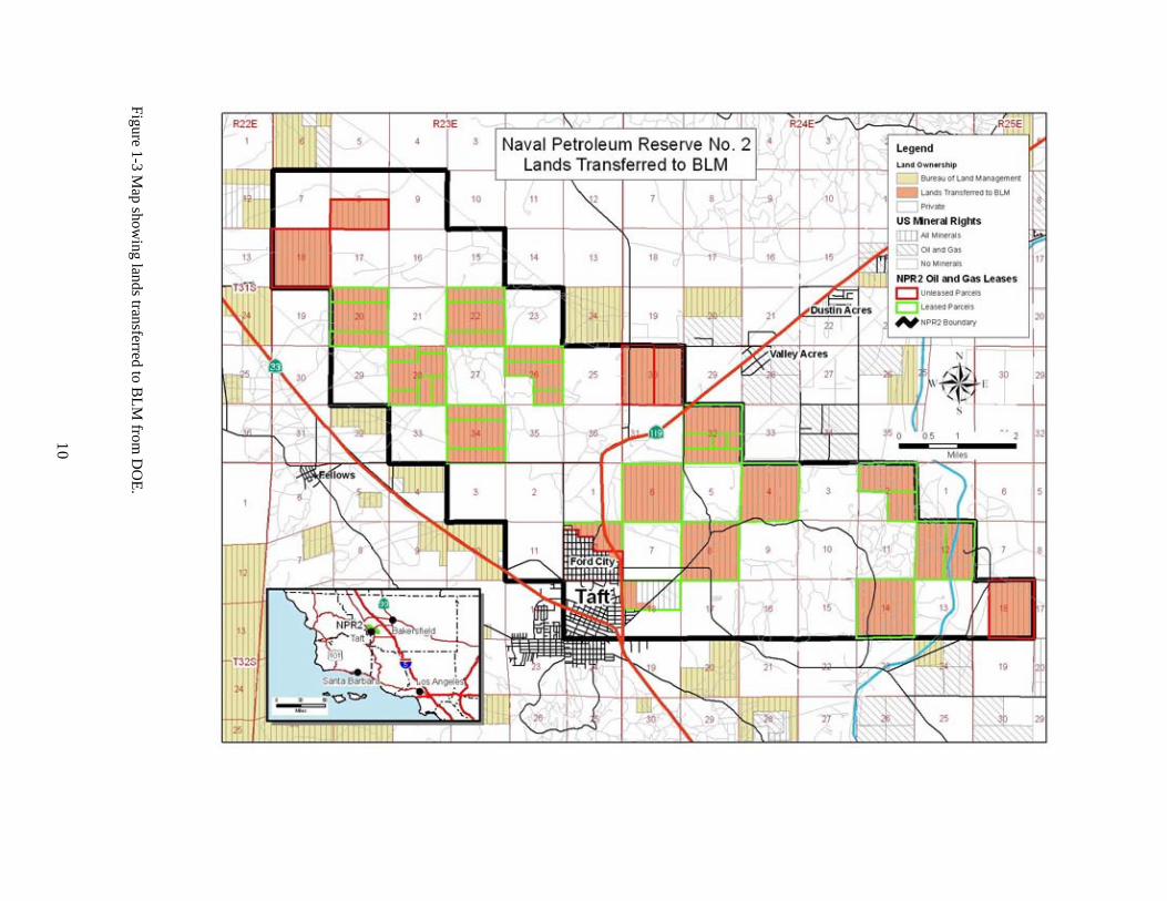
Figure 1-3 Map show
ing lands transferred to BLM
from D
OE.
10

Chapter 2 Proposed Action and Alternatives
Preferred Alternative
All lands at NPR-2 will be open to leasing for oil and gas with Special Stipulations Consistent with the existing Caliente RMP. Under this alternative, existing management prescriptions in the current Caliente RMP for all oil and gas related activities and specific realty actions covered under 43 CFR will be extended to NPR2. These are described as follows.
Management Area General Objectives and Allocations
Objectives
As directed in the Act, “the principal purpose of the lands subject to transfer ... is the production of hydrocarbon resources, and the Secretary of the Interior shall manage the lands in a fashion consistent with this purpose.” With that directive in mind, the following objectives from the Caliente RMP will apply to all oil and gas, lands and realty related activities within the NPR-2 boundaries:
• manage public lands to provide healthy, sustainable, biologically diverse ecosystems contributing goods, services and other social and cultural needs for local communities, the region and nation,
• manage public lands to meet the following minimum Standards of Ecosystem Health (see Chapter 6 of the Caliente RMP for further explanation and indicators used to determine whether or not these standards are being met): • Soils exhibit functional biological and physical characteristics that are appropriate to soil type,
climate, and land form. • Healthy, productive and diverse populations of native species, including special status species
(Federal T&E, Federal proposed, BLM sensitive, or Calif. State T&E) are maintained or enhanced where appropriate.
• Riparian/wetland vegetation, structure and diversity and stream channels and floodplains are functioning properly and achieving advanced ecological status.
• Surface and groundwater quality complies with California or other appropriate water quality standards.
• provide a leadership role in developing and implementing regional conservation strategies, • dedicate public lands to meet San Joaquin Valley conservation goals, • integrate management objectives with and assist local county governments, private organizations, and
state agencies in the development and implementation of local management plans (e.g. Habitat Conservation Plans, mitigation banks, county general plans, air and water quality plans), and
• collaborate with the oil and gas industry in meeting mutually beneficial management objectives.
Allocations
Oil and Gas
NPR-2 contains 10,451 acres of federal mineral estate of which a total of 7,919 acres are currently leased. The remaining 2,532 acres are unleased. Public acreage that is currently leased will not be subject to additional stipulations; however, if leases expire, and new leasing occurs, special stipulations will be applied.
All 10,451 acres are in areas that would be open to oil and gas leasing with Limited Surface Use (LSU) stipulations. However, approximately 7,919 acres of that total are currently under lease, so those lands would not be subject to any new stipulations unless the current leases expire and the lands are released.
11

Special categories of the LSU stipulations include:
All 2,532 acres of unleased land acres would be subject to the LSU-Protected Species stipulation. If any current leases expire, and new leasing occurs, it would also be subject to the LSU-Protected Species stipulation.
No acres would be subject to the LSU-Critical Habitat stipulation unless the USFWS designates or proposes Critical Habitat within NPR-2. If the USFWS designates or proposes Critical Habitat within NPR-2, any new leases within that area would be subject to the LSU-Critical Habitat stipulation (see LSU-Critical Habitat stipulation, Appendix A).
All 2,532 acres of unleased land would be subject to the LSU-Sensitive Species stipulation. If any current leases expire, and new leasing occurs, it would also be subject to the LSU-Protected Species stipulation.
No acres would be open to oil and gas leasing under standard terms and conditions, or a No Surface Use Stipulation (NSU). However, there will be significant limitations on the surface area that can be developed within the 420 acre unleased portion of Sec 12, T. 32S, R. 23E, MDB&M, because of pre-existing residential development (the “Ford City townsite area”).
Lands and Realty Management A limited number of parcels near the communities of Taft and Ford City will be considered for potential disposal. Figure 2-1 shows these parcels. Any such disposals shall require site-specific evaluation(s) under the applicable regulations, prior to any final decision on such action. Individual disposals will be limited to 10 acres each, and may be disposed of through public sale, lease and/or sale under the R&PP Act, exchange, legislative transfer, or some other type of disposal action. The areas of potential disposal are:
T32S, R23E, MDB&M Sec. 12 NE1/4NW1/4,
Lots 1-7, inclusive (a portion of N1/2NW1/4NW1/4), that portion of the SW1/4NE1/4 lying west of State Hwy. 119, that portion of the SE1/4NE1/4 lying west of State Hwy. 119,
NW1/4NE1/4SE1/4*, that portion of the NE1/4NE1/4SE1/4 lying west of State Hwy. 119*, Drill Site 12 in Ford Townsite, a portion of Drill Site 13 in Ford Townsite (Lot 21), a portion of Drill Site 28 in Ford Townsite (Lot 31),
* Note: The surface of the unleased lands in the NE1/4SE1/4 of T32S, R23E, MDB&M Sec. 12, is the primary access point for any oil and gas operations that may occur in the future on the currently unleased minerals underneath the Ford City townsite. Any disposal of this surface would have to take that fact into account.
These parcels aggregate approximately 161 acres. Oil and gas rights will be retained on the above parcels, but without the right of surface entry (in order to avoid conflicts between surface uses and Federal oil/gas extraction operations). Other mineral rights, such as saleable and locatable minerals, would likely be disposed of (in order to avoid conflicts between surface uses and Federal mineral rights).
12

Figure 2-1 NPR-2 Potential Land Disposals
13

All existing or occupied utility corridors delineated in the Western Regional Utility Corridor Study of 1993 are designated as utility corridors. These right-of-way corridors are one mile wide and follow existing routes. Uses of these corridors include routes for: larger electric transmission facilities, major pipelines, communication sites and associated pathways, and communication lines for interstate use. The mineral estate lands of patents issued pursuant to the Recreation and Public Purposes Act and the Small Tract Act would be managed consistent with county zoning requirements.
BLM lands that are newly-recognized due to a land survey error or hiatus, mapping or records errors would be managed consistent with adjacent public lands, if any.
Due to low productivity and/or conflicts with endangered species habitat, all BLM lands within the Resource Area are considered unsuitable for entry under the Desert Land Entry Act of March 3, 1877 (43 USC 321) and Indian Allotment Act of February 8, 1887 (25 USC 334).
Allocations common to both Oil and Gas, and Lands and Realty Management
Oil and gas, and lands and realty related motorized and mechanized travel on public land would be "limited" to existing mapped or maintained roads and trails or designated routes of travel, or as allowed on an approved permit. Designated routes of travel would be posted and include roads and trails shown on surface management maps. Existing roads and designated routes may be closed to protect resources following public notification; however, use of closed roads may be allowed by the authorized officer.
For oil and gas, and lands and realty related travel, the speed limit on unpaved roads not maintained by the county shall be a maximum of 25 MPH (unless otherwise posted).
With respect to oil and gas, and lands and realty related activities, public lands identified by the USFWS and CDF&G as important for the recovery of Federally listed species would be managed as conserved lands (see “A Conservation Strategy for Threatened and Endangered Species in the San Joaquin Valley” in Appendix C. These areas would be managed in a manner consistent with the direction established by the USFWS and CDF&G through the Kern Valley Floor HCP and any pertinent recovery plans, and would complement local conservation plans.
With respect to oil and gas, and lands and realty related activities, lands acquired through Compensation activities would be managed to benefit the species identified in the applicable U.S. Fish and Wildlife Service or California Department of Fish and Game biological opinion, agreement or other document. Acquisition of lands with compensation funds will target areas approved by the USF&WS and CDF&G. Management of these areas would be to promote recovery of the target species. Special management terms and conditions for these areas include:
These lands may only be repositioned or transferred to a party with concurrence from the USF&WS and CDF&G.
ROW authorizations, land use permits, geophysical explorations, recreational permits and public uses and livestock grazing will be managed to be compatible with objectives for the area.
These lands would be proposed for withdrawal from entry under the mining laws if surface lands are acquired over federal mineral estate.
The area would be open to leasing of oil, gas, and geothermal resources with the Limited Surface Use – Protected Species stipulation.
14

Management Guidelines
Detailed management guidelines for Oil and Gas, Lands and Realty Management, Biological Resources, and Air Quality are provided in Appendices A, B, C, and D, respectively.
No Action
Under this Alternative, BLM would continue to manage the lands as they were managed by the Department of Energy prior to being transferred to the BLM. The primary difference would be that there would be no new leasing, and any leases that expired/terminated would not be re-leased. It is estimated that only 34-92 acres would be temporarily or permanently disturbed in this case, because there would be no disturbance on land that is currently unleased. Although there is less impact to the environment under this alternative, this alternative would not meet the primary objective for which the land was transferred to the BLM, i.e., to manage all the lands primarily for the production of oil and gas, which would include leasing the currently unleased lands. Rights-of-way would be adjudicated on a case-by-case basis. No right-of-way corridors would be designated. No public sales would occur. R&PP applications, permits, etc. would be adjudicated on a case-by-case basis. Land acquisitions (land or access easements) would not be performed.
Other alternatives that were briefly evaluated and dismissed include:
Issue new leases with Standard Terms and Conditions – dismissed because it does not conform to the guidelines promulgated in the Caliente RMP and the Programmatic Biological Opinion under which operations are currently conducted.
15
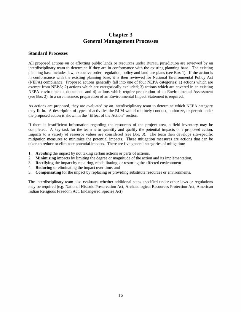
Chapter 3 General Management Processes
Standard Processes
All proposed actions on or affecting public lands or resources under Bureau jurisdiction are reviewed by an interdisciplinary team to determine if they are in conformance with the existing planning base. The existing planning base includes law, executive order, regulation, policy and land use plans (see Box 1). If the action is in conformance with the existing planning base, it is then reviewed for National Environmental Policy Act (NEPA) compliance. Proposed actions generally fall into one of four NEPA categories: 1) actions which are exempt from NEPA; 2) actions which are categorically excluded; 3) actions which are covered in an existing NEPA environmental document, and 4) actions which require preparation of an Environmental Assessment (see Box 2). In a rare instance, preparation of an Environmental Impact Statement is required.
As actions are proposed, they are evaluated by an interdisciplinary team to determine which NEPA category they fit in. A description of types of activities the BLM would routinely conduct, authorize, or permit under the proposed action is shown in the “Effect of the Action” section.
If there is insufficient information regarding the resources of the project area, a field inventory may be completed. A key task for the team is to quantify and qualify the potential impacts of a proposed action. Impacts to a variety of resource values are considered (see Box 3). The team then develops site-specific mitigation measures to minimize the potential impacts. These mitigation measures are actions that can be taken to reduce or eliminate potential impacts. There are five general categories of mitigation:
1. Avoiding the impact by not taking certain actions or parts of actions, 2. Minimizing impacts by limiting the degree or magnitude of the action and its implementation, 3. Rectifying the impact by repairing, rehabilitating, or restoring the affected environment 4. Reducing or eliminating the impact over time, and 5. Compensating for the impact by replacing or providing substitute resources or environments.
The interdisciplinary team also evaluates whether additional steps specified under other laws or regulations may be required (e.g. National Historic Preservation Act, Archaeological Resources Protection Act, American Indian Religious Freedom Act, Endangered Species Act).
16

Chapter 4 Affected Environment
Location and Physical Description
NPR-2 is located in the southwestern portion of Kern County, California, approximately 48.3 km (30 mi) southwest of Bakersfield and adjacent to Taft (Figure 1). The federal government owns 18 parcels of land with a combined area of 10,451 acres within NPR-2 (Figure 2). These properties are arranged in a “checkerboard” pattern.
The major topographic feature of NPR-2 is the Buena Vista Hills, a low-lying but distinctive northwest-southeast anticlinal ridge. The Buena Vista Hills are roughly parallel to the larger Elk Hills ridge to the north. Together, these two sets of hills form a region of hilly terrain rising from the valley floor at the southwestern edge of the San Joaquin Valley just east of, but disjunct from, the steeper Temblor range. NPR-2 also includes some flatter land along the edges of Buena Vista and Midway Valleys. Elevations range from 310 to 1,288 feet.
Weather
Annual weather patterns consist of hot, dry summers and cool, damp winters. Temperatures in the summer are often above 100ΒF and temperatures in the winter are seldom below 35ΒF. Average annual precipitation recorded at Taft is 4.8 inches. Approximately 89% of the precipitation occurs from November to April. Fogoccurs on more than 10% of the days during the winter months.
Air, Soil, and Water
Air Quality
The following text is a summary of the Air Quality information. An extended write up is located in Appendix “D”. The project area is located in the San Joaquin Valley (SJV) Air Basin in western Kern County, California crossing into the southern boundary of the Western Kern County Oil Fields Air Quality area. Regulatory oversight authority for air quality matters rests at the local level with the San Joaquin Valley Air Pollution Control District (SJVAPCD), at the state level with the California Air Resources Board (CARB) and at the federal level with the U.S. Environmental Protection Agency (EPA), Region IX. The Bureau of Land Management has air program responsibilities through its permitting programs and Clean Air Act requirements to analyze all actions for conformity to air quality plans.
The San Joaquin Valley Air Pollution Control District has prepared air quality plans for both PM10 and ozone for inclusion in the State Implementation Plan (“Best Available Control Measures/Technology and Reasonable Available Control Measures/Technology Demonstration for Sources of PM10 and PM10 precursors in the San Joaquin Valley Air Basin and “Extreme Ozone Attainment Demonstration Plan, San Joaquin Valley Air Basin Plan Demonstrating Attainment of Federal 1-hour Ozone Standards”). These plans include sections on emissions inventory, control strategies and emission budgets. These sections include discussions on oil and gas development. The USEPA designated the basin as a nonattainment area for the new 8-hour ozone standard in April 2004 and the new PM2.5 standard in 2005. The air plans for these new designations have not been prepared yet. Due to the nature of these two pollutants, many of the provisions from the existing plans would be in the new plans. The Oil and Gas industry is highly regulated by the SJVAPCD. The air plans are implemented through rule making which include a number of categories including permitting, equipment requirements and performance standards, dust and precursor emissions (NOx and SOx) and others. Any oil and gas and lands activities authorized through by BLM, including leasing and Rights of Ways would also have to comply with all of the SJVAPCD rules and permitting requirements.
17

Currently there are a number of emission sources in the air basin which affect pollution levels. The SJVAPCD has documented these in their air plan inventories. They show the baseline (1990) emissions for NOx at 787 tons per day in the summer time. Of that total, 165.1 tons (21%) were from oil and gas production. Kern County oil and gas activities accounted for approximately 15% of the NOx emissions (117.3 tons per day). Kern County has 1000-2000+ new oil and gas wells drilled every year plus tens of thousands of existing producing wells. In addition, emissions from hundreds of thousands of automobiles and trucks and significant other industrial and agricultural sources accounted for another 147 tons of NOx per day in Kern County in 1990. Additional information is located in Appendix D
Soils
Soils on NPR-2 are typical of those developed from relatively fine-grained residual or alluvial materials under semi-arid to arid conditions. A characteristic soil tends to be very deep, well-drained, light colored, and loamy in texture with some rock fragments. NPR-2 soils contain an abundance of alkaline salts and carbonates. These soils are also characterized by moderately slow permeability, slow surface runoff and slight erosion hazards on slopes. In areas of slightly greater slope (9-15%), runoff and slight erosion is moderate. Where slopes are greater that 30%, surface runoff is rapid and erosion hazard is moderate to severe. In some areas or NPR-2, especially where Torriorthents soils occur, plant growth may be naturally reduced because the potential rooting depth of plants is restricted by excess salts that have not leached from the soil.
Water
NPR-2 contains no naturally occurring streams, lakes or ponds containing fresh water. Water tables are deeply placed and are of poor quality on the Westside of the San Joaquin Valley.
Biological Resources
Three vegetation communities are present on NPR-2. Most of the property is a mosaic of non-native grassland and valley saltbush scrub (Holland 1986), also referred to as California annual grassland series and allscale series (Sawyer and Keeler-Wolf 1995). In the alkaline soils of sections 12D and 18H adjacent to Buena Vista Lake, the vegetation is characterized as valley sink scrub (bush seepweed series of Sawyer and Keeler-Wolf). Both the valley saltbush scrub and the valley sink scrub are considered to be sensitive plant communities. Historically, these two communities extended over much of the western half of the San Joaquin Valley, but are now much reduced in acreage due to agricultural conversion, flood control, groundwater pumping, and other development (Holland 1986, California Energy Commission 1991).
The non-native grassland is composed primarily by introduced weedy annual grasses and forbs. Dominated by red brome (Bromus madritensis ssp. rubens) and red-stemmed filaree (Erodium cicutarium), the grassland also supports other introduced grasses such as zorro fescue (Festuca megalura), slender oats (Avena barbata), foxtail (Hordeum glaucum), and Mediterranean grass (Schismus barbatus). Growing along roads and other disturbed sites are introduced weedy herbs including Russian thistle (Salsola kali), tocolote (Centaurea melitensis), horehound (Marrubium vulgare) and various mustards. Native forbs include fiddleneck (Amsinkia intermedia), pepperweed (Lepidium dictyotum), crassula (Crassula erecta), tansy phacelia (Phacelia tanacetifolia), Jimson weed (Datura wrightii), turkey mullein (Eremocarpus setigerus), and wild buckwheat (Eriogonum ordii).
The valley saltbush scrub vegetation on NPR-2 ranges from dense thickets along drainages to scattered individuals within the non-native grassland. Dominated by common saltbush (Atriplex polycarpa), other shrubs encountered include bladderpod (Isomeris arborea), cheesebush (Ambrosia (Hymenoclea) salsola), alkali goldenbush (Isocoma acradenia var bracteosa), valley saltbush (Atriplex lentiformes), and winter fat
18

(Krascheninnikovia lanata). Historically, saltbush scrub vegetation extended over much of the western half of the San Joaquin Valley. Saltbush acreage is now much reduced in the San Joaquin Valley due to agriculture, other development, and wildfires fueled by introduced annual grasses.
Good representations of valley sink scrub can be found on the NPR-2 lands adjacent to Buena Vista Lake. Here, the fine-textured alkali soils support healthy stands of the low, succulent shrub, bush seepweed (Sueda moquinii), with only a limited presence of introduced grassland species. Tipton kangaroo rat (Dipodomys nitratoides nitratoides) makes its home in this habitat. Low-lying areas within the valley sink scrub are commonly flooded during rainy winters and may support vernal pool species. In the surrounding, less alkaline soils, seepweed tends to be replaced by saltbush.
Animals documented on NPR-2 include 20 species of mammals, 45 species of birds, and 8 species of reptiles (O’Farrell and Sauls 1987, O’Farrell et al. 1987b). The most common mammal species are rodents and lagomorphs including short-nosed kangaroo rat (Dipodomys nitratoides brevinasus), Heerman’s kangaroo rat (D. heermanii), San Joaquin pocket mouse (Perognathus inornatus), deer mouse (Peromyscus maniculatus), San Joaquin antelope squirrel (Ammospermophilus nelsoni), desert cottontail (Sylvilagus audubonii), and black-tailed jackrabbit (Lepus californicus) (O’Farrell et al 1987b). The San Joaquin kit fox (Vulpes macrotis mutica) and coyotes (Canis latrans) are the most commonly observed carnivores. Other less frequently observed carnivores are the badger (Taxidea taxus), bobcat (Lynx rufus), striped skunk (Mephitis mephitis), and long-tailed weasel (Mustela frenata) (O’Farrel and Sauls 1987).
Commonly observed birds include western meadow lark (Sturnella neglecta), mourning dove (Zenaida macroura), sage sparrow (Amphispiza belli), horned lark (Eremophila alpestris), brewer’s blackbird (Euphagus cyanocephalus), and California quail (Lophortyx californicus). Commonly seen raptors include the northern harrier (Circus cyaneus), red-tailed hawk (Buteo jamaicensis), American kestrel (Falco sparverius), great-horned owl (Bubo virginianus), and burrowing owl (Athene cunicularia).
Commonly observed reptiles include side-blotched lizard (Uta sansburiana), western whiptail (Cnemidophorus tigris), blunt-nosed leopard lizard (Gambelia sila), gopher snake (Pituophis melanoleucus), Pacific rattlesnake (Crotalus viridus), glossy snake (Arizona elegans) and San Joaquin coachwhip (Masticophis flagellum) (O’Farrell and Sauls 1987). No fish occur on NPR-2 lands and invertebrate populations have not been inventoried.
Federally Listed, Proposed and Candidate Species
Federally listed species known to occur on NPR-2 lands include Kern mallow (Eremalche parryi ssp. kernensis FE), San Joaquin kit fox (Vulpes macrotic mutica, FE), giant kangaroo rat (Dipodomys ingens, FE), Tipton kangaroo rat (Dipodomys nitratoides nitratoides, FE), and blunt-nosed leopard lizard (Gambelia sila, FE). Hoover’s woolly-star (Eriastrum hooveri, FR), a previously federally listed species, also occurs on NPR2 lands. Although not encountered during surveys in 1988 and 1993, San Joaquin wooly-threads (Monolopia congdonii) could possibly occur on NPR-2.
Critical habitat has not been proposed or designated at NPR-2.
General species accounts are included in the April 19, 2001 BA prepared by DOE, the December 20, 2001 BO issued to DOE (1-1-01-F-0130), the March 31, 1997 BO issued to BLM for the Caliente RMP (1-1-97-F-64) and Recovery Plan for Upland Species of the San Joaquin Valley (Recovery Plan) (U.S. Fish and Wildlife Service 1998) and are not repeated in this document. Rather, species information pertinent to NPR-2 lands is presented.
Kern mallow. Kern mallow habitat includes valley sink scrub and valley saltbush scrub. The species has been documented from sections 18H, 18B, 20B, 28B, 8D, and 32G and could be expected elsewhere on NPR2.
19

San Joaquin woollythreads. Habitat for San Joaquin woollythreads includes valley grassland and valley saltbush scrub. Seemingly appropriate habitat occurs along the northern flank of Elk Hills and in the Buena Vista Valley.
Hoover’s woolly-star. Hoover’s woolly-star occurs at numerous locations throughout NPR-2. Distribution appears to depend more on site-specific conditions than on topography or elevation, and to correspond with soil disturbance. The USFWS published a final rule de-listing Hoover’s woolly-star on October 7, 2003. As part of the post-delisting monitoring plan, BLM has agreed to monitor populations of Hoover’s woolly-star on BLM lands in each of the four metapopulations. BLM will also treat Hoover’s woolly-star as a special status species after delisting.
San Joaquin kit fox. On NPR-2, San Joaquin kit foxes occur primarily in the low relief terrain, and less commonly in the moderate to high relief terrain along the Buena Vista Hills ridge. Low relief lands on NPR-2 are included in the western Kern county core population. The western Kern county core population includes Elk Hills, Buena Vista Hills, Buena Vista Valley, and Lokern Natural Area. The western Kern county core population is one of three core populations that must be conserved for species recovery. BLM also controls a significant amount of habitat in the other two core populations, Carrizo Plain and Ciervo-Panoche area. Typical and atypical dens have been found on NPR-2. Figure 4-1 shows pupping dens that were found in 1981.
Figure 4-1 San Joaquin kit fox pupping dens found in 1981on Naval Petroleum Reserve No. 2 (solid dots = typical ; open dots = atypical). Adapted from O’Farrell and Sauls, 1987.
Giant kangaroo rat. On NPR-2, giant kangaroo rats occur primarily in low relief terrain at lower elevations, and occasionally on gentle slopes at higher elevations (Figure 4-2). During a 1981 field survey, most precincts
20

were found in ten sections containing flat terrain in and around upper Buena Vista Valley (O’Farrell and Sauls 1987, O’Farrell et al.1987a). A second concentration was found on a gentle alluvial fan in Section 2D near the dry bed of Buena Vista Lake. Scattered locations were also observed.
NPR-2 lands are part of the western Kern county geographic unit. Six major giant kangaroo rat geographic units are identified by the Recovery Plan. The Recovery Plan identifies proper land use and management of publicly owned lands, including NPR-2, as highest priority. A secondary priority is to maintain in a natural state 80 percent of the natural land in NPR-2.
Figure 4-2 Giant kangaroo rat locations on Naval Petroleum Reserve No. 2, 1981 to 1987. Adapted from O’Farrell, et. al., 1987a.
Tipton kangaroo rat. On NPR-2, Tipton kangaroo rats only occur in the portion of Section 18H that extends east of the Aqueduct. This parcel includes 480 acres and is currently unleased.
Blunt-nosed leopard lizard. On NPR-2, blunt-nosed leopard lizards are found in flat terrain, gentle ridges near the flats, or in broad sandy washes (Figure 4-3)(O’Farrell and Sauls 1987). During a 1981 survey of NPR-2 lands (private and DOE lands) 19 blunt-nosed leopard lizards were observed (O’Farrell and Sauls
21

1987). Most of the lizards were seen in the southeastern half of the Buena Vista Hills primarily in the six sections located in the gentle foothills near Buena Vista Lake. Only two lizards were seen in upper Buena Vista Valley; none were observed in Midway Valley.
Figure 4-3 Locations of blunt-nosed leopard lizard sightings made during a 1981 survey of Naval Petroleum Reserve No. 2. Adapted from O’Farrell and Sauls, 1987.
Buena Vista Lake Shrew. A survey for Buena Vista Lake shrews was conducted in section 18H of NPR-2 where the only potential habitat occurs (EG&G 1988). Pitfall traps were placed at 15-yard intervals along five transect lines. No Buena Vista Lake shrews were captured.
Special Status Species
BLM Sensitive Plant Species. A number of BLM sensitive species (CNPS list 1b) have potential habitat on NPR-2 lands. Most in the following list have been documented from NPR-2 itself or on nearby sites such as Elk Hills.
Table 4-4 BLM sensitive species with potential to occur on NPR-2 lands
Family Species Lasthenia glabrata ssp.
Common Name Note
Asteraceae coulteri Coulter’s goldfields known from alkali sink, 6 miles E of NPR-2 known from alkali grasslands in Lost Hills,
Asteraceae Layia munzii Munz' tidy tips CPNM, etc.
known from saltbush grassland in southern Asteraceae Layia leucopappa Comanche Point layia San Joaquin Valley
common on cryptogamic crusts in saltbush Asteraceae Stylocline citroleum oil neststraw scrub in Elk Hills Asteraceae Stylocline masonii Mason neststraw Known from saltbush scrub in Taft, Elk Hills
22

known from alkali sink, between Taft and Chenopodiaceae Atriplex cordulata heartscale Maricopa, NPR1, and Buena Vista
known from Lost Hills in vegetation similar Chenopodiaceae Atriplex depressa brittlescale to NPR-2
on and adj to NPR1, also in Lost Hills and Chenopodiaceae Atriplex vallicola Lost Hills saltbush CPNM
Liliaceae Calochortus striatus alkali mariposa lily known from alkali sink, 5 miles E of NPR-2
Eschscholzia lemmonii ssp. known from atriplex grassland, Taft quad Papaveraceae kernensis Tejon poppy and Elk Hills Polemoniaceae Eriastrum hooveri Hoover's wooly star common on NPR-2 and elsewhere
known from alkaline areas, Elk Hills and Ranunculaceae Delphinium recurvatum valley larkspur elsewhere
Cordylanthus mollis ssp. Scrophulariaceae hispidus hispid bird’s-beak known from alkali sink, 20 miles E of NPR-2
San Joaquin Antelope Squirrel. During a 1981 survey of NPR-2 lands (private and DOE lands), 761 were counted in 45 sections (O’Farrell and Sauls 1987). They were the second most commonly observed vertebrate. Estimate relative density did not appear to be related to intensity of development. The only area where San Joaquin antelope ground squirrels were not observed was adjacent to housing developments in the north end of Taft in section 12 (O’Farrell and Sauls 1987). In such areas, California ground squirrels appear to displace them.
Short-nosed Kangaroo Rat. Short-nosed kangaroo rats are numerous and widely distributed on NPR-2. The distribution and relative abundance of short-nosed kangaroo rats on NPR-2 was determined by live-trapping along transect lines between July 1983 and August 1984 (O’Farrell et al 1987b). Short-nosed kangaroo rats comprised 26.2% of all individual small mammals captured.
Mountain Plover. Mountain plover may occur on NPR-2 as winter visitors. Suitable habitat is limited to the flatter, sparsely vegetated areas of NPR-2.
LeConte’s Thrasher. Between 20 April and 26 June, 1981, six LeConte’s thrashers were observed during a survey of NPR-2 (O’Farrell and Sauls 1987). Areas with mature saltbush lining the drainage banks, such as section 34B, may provide suitable habitat for LeConte’s thrashers.
High Economic or Recreation Value Species
During the 1981 survey of NPR-2, 395 mourning doves and 104 California quail were observed (O’Farrell and Sauls 1987). Deer, elk and pronghorn do not normally occur on NPR-2.
Aquatic Wetland or Riparian Habitat
There are no jurisdictional wetlands on NPR-2 (U.S. Army Corp of Engineers 1995). There are no natural perennial water sources (springs or streams) on NPR-2. Intermittent drainages, such as Sandy Creek and Buena Vista Creek, flow only in response to local rain events. Occasionally, oilfield workers will use produced water to create small impoundments or artificial watercourses to provide water for quail and other wildlife. Such human-created riparian habitat may exist at NPR-2.
Significant Populations
23

Raptors. Commonly seen raptors include the northern harrier, red-tailed hawk, American kestrel, great-horned owl, and burrowing owl. Other raptors know from NPR-2 include turkey vulture (Cathartes aura), golden eagle (Aquila chrysaetos), prairie falcon (Falco mexicanus), black shouldered kite (Elanus caeruleus), ferruginous hawk (Buteo regalis), Swainson’s hawk (Buteo swainsoni).
Neotropical Migrants. NPR-2 provides habitat for the following neotropical migrants: sage sparrow, horned lark, Brewer’s blackbird, cliff swallow, loggerhead shrike, burrowing owl, lesser goldfinch, brown-headed cowbird, Say’s phoebe, western kingbird, lark sparrow, long-billed curlew, barn swallow, ash-throated flycatcher, and white crowned sparrow.
Sensitive Plant Communities
As mentioned above, valley saltbush scrub and valley sink scrub are sensitive plant communities now much reduced in extent relative to historical distributions; some estimate that less than 5% intact habitat remains (California Energy Commission 1991). These valley scrub communities provide core habitat for a number of federally listed species (both animals and plants) and have been identified as rare and worthy of conservation by the California Native Plant Society (Holland 1986). Both communities have been targeted for conservation under the Kern County Valley Floor Habitat Conservation Plan. On NPR-2, valley sink scrub occurs only in section 18H and 12D, while saltbush scrub is relatively common throughout the Reserve.
Cultural Resources - In prehistoric times, the project area would have been occupied by Yokuts. Yokuts territory extends from the northern end of the San Joaquin Valley near Sacramento to the Southern portion of the San Joaquin Valley, where it terminated south of Wheeler Ridge near the Grapevine at the western end of the valley, and within the Kern River Canyon at the southeast end of the valley. The project area falls within the prehistoric territory of the Tulumne Yokuts (Latta 1977:228). The Tulumne were concentrated around Buena Vista Lake, but their range extended northwest to McKittrick, west to Bitter Water Creek near Taft, and south to San Emigdio.
Class 3 cultural resource inventories have been conducted throughout NPR-2 in response to development proposals. Similar surveys will continue as project locations are selected, to fulfill our obligations under Section 106 of the National Historic Preservation Act and identify national register eligible properties.
The most common prehistoric cultural resources encountered in the oilfields are sites associated with habitation, lithic production, and food processing. There is generally a low to moderate potential for prehistoric sites in this area. Prehistoric sites in the oilfields are generally associated with water sources; such as Buena Vista Lake, rivers, or sloughs. Examples of typical prehistoric sites include CA-KER-2963, a rock ring, and CA-KER-3161, a lithic scatter, both determined not eligible by the Department of Energy. NPR-2 lands adjacent to the shoreline of Buena Vista Lake are more likely to contain cultural resources, and those sites are more likely to be eligible for the National Register. One site, CA-KER-116 excavated by W.R. Wedel in 19331934, and Dave Frederickson in 1964-1965, is located along the southwestern edge of Buena Vista Lake. This site contains several distinct cultural strata, the earliest of which may have represented the Western Pluvial Lakes Tradition dating to approximately 8000 years ago (Moratto 1984:99). Although most of CA-KER-116 is located on private lands, a small portion of the site is located on NPR-2 lands. The federal lands within NPR-2 that contain a portion of CA-KER-116 are already leased for oil and gas. However, any new actions would still be reviewed prior to new surface disturbing activities.
From historic to modern times, the project area has been part of large-scale oil drilling operations, as well as livestock and agricultural operations. Typical historic period cultural resources include trash dumps, abandoned oilfield camps or communities, and sites of early oil exploration. Approximately 81 sites, located in Sections 6, 8, 12, 18, 28, 30, and 32, were determined not eligible by the Department of Energy.
Geology – A general discussion of area wide geology is provided in the Caliente RMP.
24

Lands - The subject NPR-2 lands consist of approx. 9,830 acres of Federal surface/mineral ownership and 520 acres of Federal mineral estate ownership only. The land pattern is a typical "checkerboard" pattern derived from the past grant, by Congress, of alternate sections to railroad companies in 1894 through 1896. Various Executive Orders (EO), Public Land Orders (PLO), surveys, and public laws established or affected NPR-2 as shown below:
Table 4-5 Executive Orders, Public Land Orders, Surveys, Public Laws affecting NPR-2 ACTION DATE COMMENTS EO establishing NPR-2 7-2-1920 Withdrew NPR-2 lands from settlement, location, sale, and entry;
reserved NPR-2 lands for classification. EO modifying NPR-2 12-13-1912 Modified and extended EO of 7-2-1910 as to specific lands. EO 3862 6-11-1923 Modified EO of 12-13-1912 by eliminating Ford Townsite from
NPR-2; provided for the establishment and survey of Ford Townsite; reserved oil & gas deposits to U.S. and withdrew them as part of NPR-2.
GLO Survey 4-3-1924 Established lots and streets in Ford Townsite. Also established drill sites within the Townsite.
EO4225 5-16-1925 Modified EO of 12-13-1912 by eliminating Ford Townsite addition from NPR-2; provided for the establishment and survey of Ford Townsite Addition; reserved oil & gas deposits to U.S. and withdrew them as part of NPR-2.
GLO Survey 5-16-1926 Established lots and streets in Ford Townsite Addition. Also established drill sites within the Townsite Addition.
EO 6444 11-25-1933 Revoked EO 3862 and EO 4225. Restored all drill sites in Ford Townsite to NPR-2 status under the jurisdiction of the Navy, except for surface estate on drill sites 9, 10, 17, and 18 which had been conveyed to County of Kern for park purposes.
EO 10075 8-18-1949 Eliminated certain drill sites in Ford Townsite from NPR-2 status, in order for them to be sold for homesites; reserved oil & gas deposits on these drill sites to the U.S. as part of NPR-2.
PLO 5112 9-10-1971 Revoked the original EO of 7-2-1910; EO of 12-13-1912 remains in effect.
Energy Policy Act of 2005 Public Law 109-58
8-10-2005 Eliminated NPR-2 withdrawal; transferred jurisdiction from DOE to DOI-BLM, except for certain drill sites in Ford Townsite.
One drill site and portions of two other drill sites in Ford Townsite were under BLM jurisdiction (12, 13, and 28) even prior to the passage of Public Law 109-58. These were released from NPR-2 by EO 10075 in 1949. Portions of drill sites 13 and 28 were then sold by BLM for homesites, with portions remaining unsold and under BLM jurisdiction. No portion of drill site 12 was sold.
Access: Some portions of the NPR-2 lands are crossed by public roads or highways. Other portions of NPR-2 do not appear to have any access except via dirt roads. The following table shows the known access status for the NPR-2 lands. A parcel with physical access is one with a physical road leading to the parcel from a known public road or highway. There may be no legal easement for such road. A parcel with legal administrative access is one with a legal easement leading to the parcel, giving BLM employees and/or lessees the right to use the easement to access the parcel. A parcel with legal public access is one with a legal easement leading to the parcel, or one that is crossed by a public road or highway, giving the general public the right to use the easement to access the parcel. It is possible that many of the public roads crossing NPR-2 are authorized under (Federal) Revised Statute 2477; however, no formal determination of this status has yet been made. Legal administrative access to some parcels in NPR-2 is not yet clear, but may be revealed in certain access agreements or easements secured by DOE or DOD. The records for these agreements or easements will be analyzed by BLM in the near future. Physical access to all of the NPR-2 lands is apparent due to the existence of a network of dirt roads that cover the general area.
Table 4-6 Parcel Access
LEGAL DESCRIPTION ACCESS
PHYSICAL LEGAL ADMINISTRATIVE
LEGAL PUBLIC
Township 31 South, Range 23 East, MDBM
25
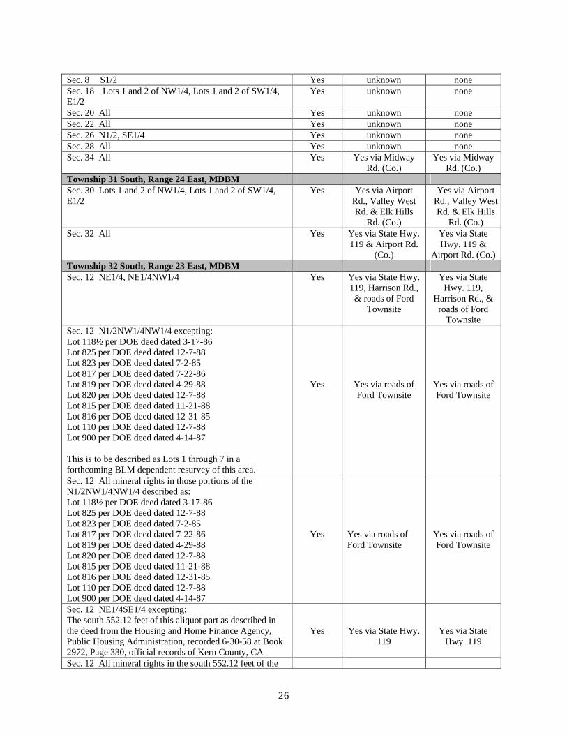
Sec. 8 S1/2 Yes unknown none Sec. 18 Lots 1 and 2 of NW1/4, Lots 1 and 2 of SW1/4, E1/2
Yes unknown none
Sec. 20 All Yes unknown none Sec. 22 All Yes unknown none Sec. 26 N1/2, SE1/4 Yes unknown none Sec. 28 All Yes unknown none Sec. 34 All Yes Yes via Midway
Rd. (Co.) Yes via Midway
Rd. (Co.) Township 31 South, Range 24 East, MDBM Sec. 30 Lots 1 and 2 of NW1/4, Lots 1 and 2 of SW1/4, E1/2
Yes Yes via Airport Rd., Valley West Rd. & Elk Hills
Rd. (Co.)
Yes via Airport Rd., Valley West Rd. & Elk Hills
Rd. (Co.) Sec. 32 All Yes Yes via State Hwy.
119 & Airport Rd. (Co.)
Yes via State Hwy. 119 &
Airport Rd. (Co.) Township 32 South, Range 23 East, MDBM Sec. 12 NE1/4, NE1/4NW1/4 Yes Yes via State Hwy.
119, Harrison Rd., & roads of Ford
Townsite
Yes via State Hwy. 119,
Harrison Rd., & roads of Ford
Townsite Sec. 12 N1/2NW1/4NW1/4 excepting: Lot 118½ per DOE deed dated 3-17-86 Lot 825 per DOE deed dated 12-7-88 Lot 823 per DOE deed dated 7-2-85 Lot 817 per DOE deed dated 7-22-86 Lot 819 per DOE deed dated 4-29-88 Lot 820 per DOE deed dated 12-7-88 Lot 815 per DOE deed dated 11-21-88 Lot 816 per DOE deed dated 12-31-85 Lot 110 per DOE deed dated 12-7-88 Lot 900 per DOE deed dated 4-14-87
This is to be described as Lots 1 through 7 in a forthcoming BLM dependent resurvey of this area.
Yes Yes via roads of Ford Townsite
Yes via roads of Ford Townsite
Sec. 12 All mineral rights in those portions of the N1/2NW1/4NW1/4 described as: Lot 118½ per DOE deed dated 3-17-86 Lot 825 per DOE deed dated 12-7-88 Lot 823 per DOE deed dated 7-2-85 Lot 817 per DOE deed dated 7-22-86 Lot 819 per DOE deed dated 4-29-88 Lot 820 per DOE deed dated 12-7-88 Lot 815 per DOE deed dated 11-21-88 Lot 816 per DOE deed dated 12-31-85 Lot 110 per DOE deed dated 12-7-88 Lot 900 per DOE deed dated 4-14-87
Yes Yes via roads of Ford Townsite
Yes via roads of Ford Townsite
Sec. 12 NE1/4SE1/4 excepting: The south 552.12 feet of this aliquot part as described in the deed from the Housing and Home Finance Agency, Public Housing Administration, recorded 6-30-58 at Book 2972, Page 330, official records of Kern County, CA
Yes Yes via State Hwy. 119
Yes via State Hwy. 119
Sec. 12 All mineral rights in the south 552.12 feet of the
26

NE1/4SE1/4 as described in the deed from the Housing and Home Finance Agency, Public Housing Yes Administration, recorded 6-30-58 at Book 2972, Page 330, official records of Kern County, CA
Yes Yes via State Hwy. 119
Yes via State Hwy. 119
Sec. 12 Drill Site 12 Lot 21 of Ford Townsite (portion of Drill Site 13) Lot 31 of Ford Townsite (portion of Drill Site 28)
Yes Yes via roads of Ford Townsite
Yes via roads of Ford Townsite
Sec. 12 Oil & Gas rights in Ford Townsite (including surface entry rights) excepting Drill Sites 9, 10, 17, and 18 (see below) and Drill Sites 3A, 4, 6, 9A, 20, 22, 25, and 26 (which remain under DOE jurisdiction)
Yes Yes via roads of Ford Townsite
Yes via roads of Ford Townsite
Sec. 12 All mineral rights in Drill Sites 9, 10, 17, and 18 of Ford Townsite (reserved to U.S. in R&PP patent 987560 dated 10-16-1926 to Kern County)
Yes Yes via roads of Ford Townsite
Yes via roads of Ford Townsite
Township 32 South, Range 24 East, MDBM Sec. 2 Lots 1 and 2 of NE1/4, Lots 1 and 2 of NW1/4, SE1/4
Yes unknown none
Sec. 4 Lots 1 and 2 of NE1/4, Lots 1 and 2 of NW1/4, S1/2
Yes Yes via Honolulu Rd. (Co.)
Yes via Honolulu Rd.
(Co.) Sec. 6 Lots 1 and 2 of NE1/4, Lots 1 and 2 of NW1/4, Lots 1 and 2 of SW1/4, SE1/4
Yes Yes via Airport Rd. (Co.)
Yes via Airport Rd. (Co.)
Sec. 8 All Yes Yes via Airport Rd. (Co.)
Yes via Airport Rd. (Co.)
Sec. 12 All Yes Yes via Lake Sta. Rd. (Co.)
Yes via Lake Sta. Rd. (Co.)
Sec. 14 All Yes Yes via Honolulu Rd. (Co.)
Yes via Honolulu Rd.
(Co.) Sec. 18 Lot 2 of NW1/4, S1/2S1/2 of Lot 1 of NW1/4 Yes Yes via State Hwy.
119 & Airport Rd. (Co.)
Yes via State Hwy. 119 &
Airport Rd. (Co.) Sec. 18 All mineral rights in NE1/4, N1/2 of Lot 1 of NW1/4, N1/2S1/2 of Lot 1 of NW1/4 (surface rights conveyed to City of Taft, no surface entry rights retained)
Yes Yes via Airport Rd. (Co.)
Yes via Airport Rd. (Co.)
Township 32 South, Range 25 East, MDBM Sec. 18 E1/2, E1/2W1/2 Yes Yes via Lake Sta.
Rd. (Co.) Yes via Lake Sta. Rd. (Co.)
Survey Status: The survey status of the NPR-2 lands is unknown at this time, but is expected to be fairly complete and accurate, based on the survey status of other oil and gas areas in the region. Because oil/gas wells need to be precisely located, the original government survey monuments in the area have been generally well preserved or perpetuated by private surveyors in areas of oil and gas activity.
Existing Authorizations: The BLM official records show the following actions or authorizations on NPR-2 lands:
• S 080109 Right-of-way for Phone line within Drill Site #12 in Ford Townsite • Federal Power Commission Order of 11/14/1963; withdrawal for Power Proj.2426 in NE1/4NW1/4 Sec.
18, T32S, R25E, MDM and in NE1/4, W1/2SE1/4 Sec. 12, T32S, R24E, MDM. These are for the California Aqueduct Project.
• S 033318 Right-of-way for buried oil or gas pipeline in N1/2 Sec. 18, T32S, R24E, MDM.
27

In addition to the above, DOE records that have been transferred to BLM show approximately 40 facilities being authorized by a DOE permit. These are the types of facilities that are typically authorized via a right-ofway by BLM (power lines, pipelines, phone lines, roads, etc.).
Unauthorized Uses: Although a systematic inventory has not yet been done by BLM, it appears that there are several dozen unauthorized facilities crossing or situated on the NPR-2 lands. These facilities consist of pipelines, power lines, phone lines, communication sites, etc.
Withdrawals and Classifications: With the revocation of the withdrawal for NPR-2 by Public Law 109-58, the following withdrawals or classifications remain on the NPR-2 lands:
• Federal Power Commission Order of 11/14/1963; withdrawal for Power Proj.2426 in NE1/4NW1/4 Sec. 18, T32S, R25E, MDM and in NE1/4, W1/2SE1/4 Sec. 12, T32S, R24E, MDM. These are for the California Aqueduct Project.
• Executive Order 10075, withdrawal for Ford Townsite. This withdrawal eliminated certain drill sites in Ford Townsite from NPR-2 status, in order for them to be sold for homesites. It also reserved oil & gas deposits on these drill sites to the U.S. as part of NPR-2.
Range- No livestock grazing activities are currently authorized on NPR-2. Livestock grazing will be addressed in the CRMP Revision mentioned earlier.
Recreation- No recreational activities are currently authorized. Recreation will be addressed in the CRMP Revision mentioned earlier.
Socio-Economic – The current oil and gas leases on NPR-2 produce approximately 1050 barrels of oil per day and 4,500 mcf of gas per day. The market value of these products is approximately $3 million per month. These leases also provide approximately 50-100 jobs for the local economy.
Visual Resources- Exceptional scenic quality found in pristine situations will not be found anywhere on NPR2. The area is generally oilfield in nature, with more than 10,000 oil wells within a few miles of the NPR-2 boundary.
Wilderness- There are no wilderness experiences on any portion of NPR-2, nor are there any wilderness study areas or wilderness areas located on any portion of NPR-2.
28

Chapter 5 Environmental Effects
Analysis Assumptions
Reasonably Foreseeable Development Scenarios – The following tables show the levels of reasonableforeseeable development that would occur under each of the alternatives that were evaluated for this PlanAmendment.
Alternative 1- Preferred Alternative - All lands at NPR-2 will be open to leasing for oil and gas with Special Stipulations Consistent with the existing Caliente RMP.
Table 5-1. Projected habitat disturbance associated with existing and new oil and gas leases (Preferred Alternative)
Projected Habitat Disturbance Associated with Existing and New Oil and Gas Leases 5
Description Permanent 2 Temporary 3 Transient 4
Minimum Maximum Minimum Maximum Minimum Maximum
Wells
Number of wells
50 200 50 200 50 200
Acres/well pad 0.344 0.344 0 0.1 0 0.1 Other facilities 1, acres/well
0.221 0.221 0 0.1 0 0.1
Total acres per well
0.565 0.565 0 0.2 0 0.2
Total Acres 28.2 113 0 40 0 40 % habitat disturbed 6
50 50 50 50 50 50
Habitat disturbed, acres
14.1 56.5 0 20 0 20
Other Projects, excluding Seismic
Projects/year 2 4 2 4 2 4 Number of projects over life of plan
30 60 30 60 30 60
Acres/project 0.5 0.5 0.5 0.5 0.5 0.5 Total acres 15 30 15 30 15 30 % habitat disturbed 6
100 100 100 100 100 100
Habitat disturbed, acres
15 30 15 30 15 30
Seismic
Projects/year 0 3 0 3 0 3 Acres/project 1 1 5 5 10 10 Number of projects over life of plan
3 6 3 6 3 6
Total acres 3 6 15 30 30 60 % habitat disturbed
100 100 100 100 100 100
Habitat disturbed, acres
3 6 15 30 30 60
29

Total Habitat Disturbed, acres 32.1 92.5 30 80 45 110 1 Infrastructure such as roads, pipelines, sumps, tank settings, etc. For the most part, it will be possible to use existing infrastructure for new wells. In some cases, however, new infrastructure will be needed. 2 Includes digging, scraping, and plans for long term use. 3 Defined as digging and scraping, but use limited to construction phase only, after which artificial or natural revegetation will occur. 4 Defined as mashing down of vegetation by vehicles or other equipment without digging or scraping and during the construction phase only. 5 Note that foot traffic on habitat, such as that which occurs during inspections, surveys, monitoring, and the like, is not considered to be a disturbance.6 A general guideline is to site new development in areas that have already been disturbed, to the extent practical and economical. It has been assumed this will be possible 50 percent of the time for new well projects. For other projects, it has been assumed that this will not be possible.
Alternative 2 – No Action Alternative (No new leasing) - BLM would continue to manage the lands as they were managed by the Department of Energy prior to being transferred to the BLM. The primary difference would be that there would be no new leasing, and any leases that expired/terminated would not be re-leased.
Table 5-2. Projected habitat disturbance associated with existing oil and gas leases (No Action Alternative)
Projected Habitat Disturbance Associated with Existing Oil and Gas Leases 5
Description Permanent 2 Temporary 3 Transient 4
Minimum Maximum Minimum Maximum Minimum Maximum
Wells
Number of wells
25 100 25 100 25 100
Acres/well pad 0.344 0.344 0 0.1 0 0.1 Other facilities 1, acres/well
0.221 0.221 0 0.1 0 0.1
Total acres per well
0.565 0.565 0 0.2 0 0.2
Total Acres 14.1 56.5 0 20 0 20 % habitat disturbed 6
50 50 50 50 50 50
Habitat disturbed, acres
7.1 28.3 0 10 0 10
Other Projects, excluding Seismic
Projects/year 1 2 1 2 1 2 Number of projects over life of plan
15 30 15 30 15 30
Acres/project 0.5 0.5 0.5 0.5 0.5 0.5 Total acres 7.5 15 7.5 15 7.5 15 % habitat disturbed 6
100 100 100 100 100 100
Habitat disturbed, acres
7.5 15 7.5 15 7.5 15
Seismic Projects/year 0 2 0 2 0 2 Acres/project 1 1 5 5 10 10
30

Number of projects over life of plan
2 4 2 4 2 4
Total acres 2 4 10 20 20 40 % habitat disturbed
100 100 100 100 100 100
Habitat disturbed, acres
2 4 10 20 20 40
Total Habitat Disturbed, acres 16.6 47.3 17.5 45 27.5 65 1 Infrastructure such as roads, pipelines, sumps, tank settings, etc. For the most part, it will be possible to use existing infrastructure for new wells. In some cases, however, new infrastructure will be needed. 2 Includes digging, scraping, and plans for long term use. 3 Defined as digging and scraping, but use limited to construction phase only, after which artificial or natural revegetation will occur. 4 Defined as mashing down of vegetation by vehicles or other equipment without digging or scraping and during the construction phase only. 5 Note that foot traffic on habitat, such as that which occurs during inspections, surveys, monitoring, and the like, is not considered to be a disturbance.6 A general guideline is to site new development in areas that have already been disturbed, to the extent practical and economical. It has been assumed this will be possible 50 percent of the time for new well projects. For other projects, it has been assumed that this will not be possible.
A. Projected Levels of Oil and Gas Activity under the Preferred Alternative
The BLM will manage the lands transferred from DOE to BLM jurisdiction identical to existing lands covered under the Caliente RMP and Caliente RMP BO (1-1-97-F-64). Based on historic levels of activity and current levels of interest in the area, we have projected the following impacts of NPR-2 being absorbed into and managed under BLM’s existing oil and gas program:
Table 5-3 Impacts of Absorbing NPR-2 Lands into BLM’s Existing Oil and Gas Program CRMP NPR-2
Total “Active” Leases 250 Approx 15 Total Unleased Minerals 825,000 acres est 2532 acres Total Federal Wells in CRMP area 7500 est 430 (315 active) Total New Wells Projected to be Drilled in past 5 yrs 800-1300 N/A Total Actual Wells Drilled in past 5 years 800* est 0 Total Projected New Wells (average per year) 150-260 3-15 New Surface Disturbance** Proj. in CRMP – last 5 yrs 500-1075 acres N/A Actual New Surface Disturbance – last 5 yrs 324 acres*** N/A New Surface Disturbance Projected in next 5 yrs, acres/year (The CRMP is expected to be amended within the next few years.)
100-215 acres 2-6 permanent 2-5 temporary
Total Fed Production Rate 35-40,000 BOPD 1050 BOPD (rough est)
* Nearly two-thirds of these wells were drilled in the last two years, as opposed to only one-third in the first three years. Drilling activity is expected to remain in the high range, on average, for the next 5 years.
31

** New surface disturbance is defined as disturbance of previously undisturbed surface.
*** Source of 324 acres of disturbance - Annual Report to USFWS from BLM
In the Caliente Resource Area EIS, it was projected that 150-260 federal wells would be drilled per year, plus seismic, roads, etc., with new surface disturbance of up to 215 acres per year on average. In actuality, during the past 5 years, total disturbance has been only a fraction of that amount, or 65 acres per year. Including NPR-2, the total amount would still be well within the range of projected disturbance that was analyzed in the CRMP and EIS. Overall, the additional impacts of including NPR-2 are expected to be relatively minor.
It should be noted that the existing BO for NPR-2 (1-1-01-F-0130) projected significantly higher levels of activity than those shown above. The higher levels were based on projections that have not proven to be true. Upon review of actual activity and analysis of current trends, we believe that the above numbers represent a more reasonable projection of activity during the Plan Amendment life.
Proposed Action Alternative – Effects on Critical Elements
Resources in addition to those discussed below were considered as a part of the scoping process. Those resources were dropped from further consideration once it was determined that there was minimal potential for them to sustain significant impacts. The following elements of the human environment are subject to requirements specified in statute, regulation, or executive order, and must be considered in all environmental assessments. Those elements that are affected are discussed below in greater detail.
Critical Element Affected Critical Element Affected
YES NO YES NO Air Quality X Wastes, Hazard/ Solid X ACEC's Cultural Resources Floodplains Native Amer. Concerns T & E Species Environmental Justice
Description of Types of Oil and Gas Related Activities Occurring under Proposed Action
The BLM routinely conducts, authorizes, or permits the following:
1. Leasing of unleased lands through competitive auction after appropriate NEPA documentation is prepared, or noncompetitively during the two-year period following a competitive auction at which no bids were received.
2. Inspection and enforcement activities to ensure compliance with appropriate laws and regulations.
3. Drilling, installing, and testing of new exploratory, infill, and offset oil and gas production wells, wastewater and waterflood injection wells, and gas injection wells.
4. Redrilling, deepening, recompleting, remediating, working-over, and otherwise maintaining wells. These include new wells, active existing wells, and inactive existing wells that could be returned to service.
5. Withdrawing oil, gas, gas liquids, and water from production wells, and injecting gas and water into
X Water Quality X X Wetlands/Riparian X X Wild & Scenic Rivers X X Wilderness X
X Weeds X X
32

injection/disposal wells, and conducting other activities related to well operations and maintenance.
6. Construction, maintenance, and removal of surface impoundments (drilling and produced water sumps).
7. Transporting, processing, separating, extracting, refining, and distributing produced oil, gas, gas liquids, and water for sale/custody transfer, injection, and other activities typical of oilfield operations and maintenance.
8. Constructing new infrastructure typically needed for oilfield development and operations and maintenance.
9. Operating and maintaining existing and new infrastructure.
10. Operating a variety of automobiles, trucks, and heavy mobile machinery.
11. Shutting-in, mothballing, and formally abandoning wells as they exhaust their economic usefulness.
12. Geophysical, seismic, or other survey to identify subsurface geologic structures that may contain petroleum.
13. Field monitoring, inspection, and other maintenance and operation activities.
14. Surface maintenance activities, such as weed control and erosion control.
15. Conducting regulatory compliance activities such as surveys or environmental cleanup.
16. Using, disposing, and storing of chemicals used in operations and maintenance.
17. Permits for pest control activities.
18. Rights of way for construction, operation, and maintenance of water infrastructure, electrical power lines and related facilities, natural gas pipelines, telephone lines and related facilities, radio systems and related facilities, and public roads and related facilities.
Third-party actions authorized by BLM may include some of the above actions.
Any surface disturbing activity requires prior approval of the BLM. Such approval would include a site-specific evaluation and compliance with NEPA requirements. Routine activities, including but not limited to cleaning out wells, well tests, monitoring activities, repairing and maintenance of equipment, and routine workovers do not require BLM approval, but would require adherence to all applicable laws and regulations.
Air, Soil, and Water
Impacts to Air Quality
Introduction - Impacts would be in the form of gaseous and particulate matter that is emitted into the air as a result of the activities being analyzed. All of the pollutants subject to analysis are addressed in federal, state and local laws, statutes, regulations and rules. The federal and state ambient air quality standards define the criteria pollutants that are part of the emissions that are typically analyzed. In addition to the criteria pollutants, there are criteria for air toxics, hazardous air pollutants (HAPs), Prevention of Significant Deterioration (PSD), fugitive dust and regional haze.
33

The analysis is based upon various activities’ potential to emit. The analysis is further limited by the need to look at changes in emissions that would occur as a result of the proposed action. Many similar regional activities that produce emissions would not be impacted by the proposed action and would not be addressed in this analysis. The activities associated with the proposed action that would have an impact on air quality include Construction activities at the well pad, establishing vehicle routes, vehicle access, drilling operations, development, production, Rights of Ways and distribution. Changes in these activities would result in changes in disturbance rates to soil surfaces and would result in changes in PM10 and PM2.5 emissions. In addition, combustion emissions and other gaseous emissions including ozone precursors such as nitrous oxides and reactive organic gases would be produced. Based upon the potential to emit and emissions that are likely to be affected by the proposed action, this analysis addresses the particulate emission PM10 and the ozone precursor emissions. In addition, these two pollutants are important because the affected area is classified as a federal nonattainment area for PM10, PM2.5 and ozone (both 1-hour and 8-hour).
Planning Assumptions for Air Quality: State Implementation Plans (SIPs) are prepared for most of the federal nonattainment areas. These SIPs are designed to result in compliance with the NAAQS by federal deadlines. The SIPs are implemented through a series of rules. In addition, air quality is highly regulated by a number of additional federal, state and regional regulations and rules. These regulations and rules apply to many of the activities in the proposed action. It is assumed that the activities would be conducted in compliance with the regulations and rules. As the new air plans are developed, activities would be conducted in compliance with those plans also.
Expected Impacts - The proposed action includes a number of actions which would generate emissions. Project emissions include direct emissions of NOx, SOx and VOC (which are precursor emissions for ozone and PM2.5), CO, PM10 and PM2.5. These emissions are associated with combustion sources such as diesel drill rig engines, drill pad construction equipment (i.e., dozers, backhoe, grader, etc.), temporary production flare, remedial well work, equipment trucks, hauling of liquids, drill rig crew trucks/vehicles, portable lift equipment, portable testing equipment and temporary production facilities. In addition, PM10 will be released during the drill pad construction phase and from the daily ingress and egress of vehicles on the unpaved access roads. The primary emission sources during any new construction at he drill sites and on Rights of Ways would be from heavy equipment exhaust and fugitive dust. Other emission sources will occur during the operation and maintenance of these leases and Rights of Ways. These sources include oil facilities, gas facilities, operator vehicle traffic, and gas powered oil well pumping units.
The expected emissions from the proposed action would be low both in relation to the overall activity in the region, and by itself. Emissions from sumps and pits include only VOCs and are estimated at around 1 pound per day of VOC. As each well is typically drilled over a period of only a few days to a couple of weeks, the emissions would be around 100-200 pounds per year from this source. The proposed action is projected to result in disturbance to up to 11 acres (4 to 11) per year and the development of up to 15 new wells (3 to 15) per year. The use of low sulfur diesel and newer low emission equipment would greatly reduce emissions. The newer technology diesel engines built after 1997 reduced emissions 90%. Based upon existing estimates for oil and gas development, the proposed action to drill 5 new wells per year would generate an estimated 720 pounds of PM10 emissions and under 450 pounds of NOx per year. The SOx emissions come from the sulfur in the diesel fuel and the use of low sulfur diesel would nearly eliminate the emissions. These emissions are well below deminimus emission levels defined by the USEPA for these pollutants (10 tons per year for VOC or NOx and 70 tons per year for PM10). The emissions are insignificant in light of the other regional and local activity. This is illustrated in the SIP inventory which shows daily NOx totals for the nonattainment area at 787 tons per day which is nearly 1.3 million times as much as the proposed activity or even the Kern County Oil and Gas NOx daily emission level of 117.3 tons which is nearly 200,000 times as much.
BLM requires that the lessee/operator has the responsibility for ensuring that all operations are properly permitted with the appropriate agencies, and that the operations are in compliance with all mobile and stationary source guidelines. Required control measures include such items as dust control using application of water or pre-soaking and limiting traffic speed on unpaved roads. They also include such items as use of low
34
emission construction equipment, use of low sulfur fuel, and/or use of the existing power transmission facilities, where available, rather than temporary power generators.
Conformity: The USEPA rules require federal agencies to determine whether a proposal conforms to the existing SIPs. USEPA rules state that an analysis is not necessary when the total emissions do not exceed deminimus levels, comply with the SIP and do not exceed 10% of the regional emissions. As the emissions are well below deminimus levels, comply with the SIP and are well below 10% of regional emissions, no further conformity analysis is necessary.
Cumulative Impacts:
As opposed to other environmental impacts, emissions into the air are very short term. The air is constantly moving, causing dilution and dispersal. For this reason, single small short term releases of pollutants have very little to do with overall regional pollution levels. The cumulative impacts of all of the sources in a region and the pollutants transported into the region show up in the regional monitoring as concentration levels of the various pollutants. In the case of the San Joaquin Valley, the USEPA has classified the region as a nonattainment area for ozone (1 and 8 hour) and particulates (PM10 and PM2.5) due to past multiple days of exceedance of the National Ambient Air Quality Standards. According to Air Resource Board data, ARB 2006b, the valley exceeded the national 1 hour ozone standard 8 days in 2005, the 8 hour ozone standard 72 days and the PM10 standard 0 days in 2005. All of these levels are nearly half or less of what they were four year ago. The cumulative effect area for air resources for the proposed action is the San Joaquin Valley Air Basin. The expected emission levels are within the levels in the attainment demonstrations in the SIPs and are not likely to result in or contribute to exceedances of the National Ambient Air Quality Standards.
Impacts to soil
Approximately 62-173 acres of previously undisturbed soil will be affected by oil and gas related activities projected under this plan. The impacts due to this disturbance will be reduced because most or all surface disturbing activities will be subject to rehabilitation and mitigation measures that are included in sundry notices and applications for permit to drill. Impacts from spills/contamination are expected to be very localized because all activities will be subject to spill prevention and control plans, and any contamination will be removed/mitigated as required in those plans.
Impacts to water
NPR-2 contains no naturally occurring streams, lakes or ponds containing fresh water. Water tables are deeplyplaced and are of poor quality on the Westside of the San Joaquin Valley.
Biological Resources
Impacts to Habitat from Oil and Gas Activities
A likely effect of ongoing and new oil and gas activities would be the loss or alteration of habitat. DOE estimated that construction of proposed facilities and some third party projects would result in the long term loss of 53-148 acres of habitat, temporary loss of 135-368 acres of habitat, and transient effects on 590-1,436 acres of habitat. BLM however, expects the level of disturbance to be much less. This is based on the low level of current activity, with no new wells in more than seven years.
Over the next 15 years, BLM expects permanent habitat loss to be from 17 and 47 acres, temporary habitat loss to be from 18 and 45 acres, and transient effects to be from 28 and 65 acres on presently leased lands (see Table 5-2).
Habitat impacts associated with the issuing and development of new leases is estimated to result in between 16
35
and 45 acres of permanent habitat loss, 13 and 35 acres of temporary habitat loss and 18 and 45 acres of transient effects (Table 5-1 less Table 5-2).
At the landscape scale for NPR-2 habitat, it is estimated that between 62 and 173 acres would be disturbed on leased and unleased lands under the proposed action. This amounts to less than 2% of the 10,451 acre NPR-2 area, 2% of the undisturbed BLM land in NPR-2 and 0.74% of all undisturbed land in NPR-2. This amount of disturbance is not expected to significantly decrease the utility of NPR-2 lands for species conservation and recovery.
With the exception of Ford City (Section12C) and Section 18D, NPR-2 lands are treated as reserve (red zone) or corridor (green zone) lands under the Oil and Gas Programmatic Biological Opinion and the Conservation Strategy described in Chapter 6. Red and green zone lands are subject to the highest mitigation and compensation requirements. In addition, cumulative surface disturbance is limited to 10 percent of any parcel in red zone, and 25 percent of any parcel in green zone. Ford City (Section 12C) and Section 18D would be managed as urban lands (white zone). In 1981, O’Farrell and Sauls (1987) estimated the amount of habitat disturbance 1:10,000 scale aerial photographs and a dot grid. Using the same technique, BLM estimated the current surface disturbance on these 5 parcels using 2003 aerial photographs. Table 5-4 shows the 1981 and 2003 disturbance estimates for the NPR-2 parcels.
Oil and Gas Leasing. Currently 2,532 acres, in 5 parcels, are unleased. Table 5-4 lists the 1981 and 2003 disturbance estimates for the 5 unleased parcels. Although leasing has no direct effect on habitat, eventual development of the leases could result in habitat impacts.
Section 12C. Approximately 420 acres of the unleased mineral estate underlies the town of Ford City or is immediately adjacent to Ford City. Of these 420 acres, 380 acres is private surface that has been developed with houses and streets. DOE retains surface ownership of 13 acres, in eight separate parcels (Drill Sites 3A, 4, 6, 9A, 20, 22, 26). BLM has surface ownership of the remaining 27 acres, in six separate parcels. Three of the BLM surface parcels (Drill Sites 12, 13, 28) and all eight of the DOE parcels are lots within Ford City and range in size from 0.97 to 2.07 acres. These drill sites are not likely to provide important habitat for biological resources due to adjacent human activity and past disturbance on the parcels. Leasing of the 380 acres with private surface and the three surface parcels in Ford City will not result in habitat loss as these areas do not provide any sensitive species habitat.
The remaining three unleased BLM-owned surface parcels in Section 12C form a 23.3 acre area adjacent to Ford City that is bisected by Highway 119. Of the 23.3 acre parcel, approximately 32% is currently disturbed, 25% appears to have been disturbed in the past, and 43% supports undisturbed saltbush scrub. Leasing of this 23.3 acres parcel could result in some habitat loss. The amount of habitat loss, however, is expected to be minimal, as existing disturbed areas could be used for oil related activities. If the area is developed to the same degree as the adjacent leased area (39%), an additional 7% more may become disturbed.
Sections 8B, 18B, 30G and 18H. These sections include 2,112 acres of unleased federal surface and mineral estate. These sections are relatively undisturbed, with disturbance estimates ranging from 2% to 16% (see Table 5-4). These sections would be managed as reserve (red zone) or corridor (green zone) lands and would be subject to highest mitigation and compensation requirements. In addition, cumulative new surface disturbance is limited to 10% of any parcel in red zone, and 25 % of any parcel in green zone. Leasing of these sections may result in some habitat loss, but the total amount of disturbance would not exceed 10% for Section 8B and 18B, or 25% for Section 30G and 18H. Table 5-4 shows the estimated maximum amount of habitat loss that would be allowed by section. It is unlikely that the maximum amount of habitat loss would actually occur, as BLM predicts that actual development of these areas would not exceed 80 acres of temporary and permanent disturbance. Habitat loss would also be offset by compensation with habitat or equal or greater value as described in Appendix C – Biological Resources Management Guidelines.
Table 5-4. Habitat disturbance and Habitat Zone on Leased and Unleased parcels at NPR-2.
36

Parcel Number
Legal Description Approximate acres
Proportion of habitat disturbed, 2003 aerial photography
Proportion of habitat disturbed, 1981 (O’Farrell and Sauls 1987)
Habitat Management Zone
Maximum additional acres disturbed
LEASED LANDS 20B 31S/23E, section
20 640 11% 16.8% Reserve
(Red) At limit
22B 31S/23E, section 22
640 10% 10.9% Reserve (Red)
At limit
26B 31S/23E, section 26
480 15% 21.3% Reserve (Red)
At limit
28B 31S/23E, section 28
640 10% 16.5% Reserve (Red)
At limit
34B 31S/23E, section 34
640 10% 18.4% (settling ponds)
Reserve (Red)
At limit
12C 32S/23E, section 12, NE1/4, NE1/4NW1/4, N1/2NW1/4NW1/4
220 (217 acres BLM surface, 3 acres private surface)
39% (excludes 20 acres in Lots 1-7, 1181/2, 825, 823, 817, 819, 820, 815, 816, 110,& 900)
Not available
Urban (White)
NA
32G 31S/24E, section 32
640 16% 8% Corridor (Green)
9% = 58 acres
2D 32S/24E, section 2 480 14% 7.9% Corridor (Green)
11% = 53 acres
4D 32S/24E, section 4 636 16% 12.8% Corridor (Green)
9% = 57 acres
6D 32S/24E, section 6 661 30% 33% (settling ponds)
Corridor (Green)
At limit
8D 32S/24E, section 8 640 30% 29% Corridor (Green)
At limit
12D 32S/24E, section 12
640 30% (20% from California Aqueduct)
36.6% Corridor (Green)
At limit
14D 32S/24E, section 14
640 15% 16.1% Corridor (Green)
10% = 64 acres
18D 32S/24E, section 18, lots 3 and 4, se1/2se1/4nw1/4
100 16% 19.3% (includes all of 18D, private S1/2 and BLM N1/2)
Urban (White)
NA
18D 32S/24E, section 18, All mineral rights in NE1/4, N1/2 of Lot 1 of NW1/4, N1/2S1/2 of Lot 1 of NW1/4 (surface rights conveyed to City
220 73% Urban (White)
NA
37

of Taft, no surface entry rights retained)
UNLEASED LANDS 8B 31S/23E, section 8,
s1/2 320 (surface & minerals)
2% 4.6% Reserve (Red)
8% = 26 acres
18B 31S/23E, section 18, all
640 (surface and minerals)
3% 15.5% (large settling ponds)
Reserve (Red)
7% = 45 acres
30G 31S/24E, section 30, all
669 (surface and minerals)
16% 11.7% Corridor (Green)
9% = 60 acres
12C 32S/23E, section 12, s1/2, s1/2nw1/4, s1/2nw1/4nw1/4
420 (27 acres BLM surface, 13 acres DOE surface, 380 acres private surface)
Ford City residential area (57% disturbed Lots 8 & 9, N1/2NE1/4SE1/4)
Ford City residential area
Urban (White)
NA
18H 32S/25E, section 18, e1/2, e1/2w1/2
480 (surface and minerals)
2% 7.1% Corridor (Green)
23% = 110 acres
Impacts to Species from Oil and Gas Activities (Ongoing and New Oil and Gas Activities, Oil and Gas Leasing)
Potential impacts to plants include direct mortality from earth excavation or crushing by vehicles. Adverse impacts could also result from soil erosion resulting in loss of the supporting substrate for plants, or from soil compaction resulting in reduced germination rates. Impacts to plants occurring after seed germination but prior to seed set could be particularly harmful as both current and future generations would be adversely affected. Weeds which are introduced and/or promoted by soil disturbing activities compete against and displace native vegetation.
Development associated with oil and gas activities have the potential to affect the rare plants mentioned above. Soil disturbing activities directly affect species by destroying habitat, churning soils, impacting biological crusts, disrupting seedbanks, burying individual plants, and generating sites for undesirable weedy species. Weeds may be introduced during construction and operation of the lease. Road generate weedy habitat along their edges, as well as avenues for weed invasion into unoccupied territory. Dust generated by construction activities and travel along dirt roads can affect nearby plants by depressing photosynthesis, disrupting pollination, and reducing reproductive success. Oil or other chemical spills will contaminate soils as to render them unsuitable for plant growth.
Potential impacts to animals, including listed species, include direct mortality or injury, loss of dens or burrows, displacement, and human disturbance. Direct mortality or injury could result from vehicle strikes, or from collapsed dens and burrows resulting in animals being crushed or entombed. Burrows and dens could be destroyed or damaged by vehicle traffic, particularly heavy equipment. Animals could be displaced during project activities. Such displacement of animals into unfamiliar areas could increase the risk of predation and increase the difficulty of finding required resources such as food and shelter. Human disturbance could result in displacement of animals, even though dens and burrows may not be directly impacted. Human disturbance also might alter the behavior of animals (e.g., activity periods, space use) resulting in increased predation risk, reduced access to resources, and reduced breeding success. Project activities during the spring breeding season could increase the potential for adverse impacts. Animals could also become entrapped in oil spills, leaks, sumps or improperly maintained well cellars or other facilities.
38
Roads and large areas of disturbance can be a barrier to movement for some animal species. Animals in the San Joaquin Valley suite of sensitive animal species, however, generally do not have difficulty crossing roads or disturbed areas. It is not unusual to observe kangaroo rats, kit foxes, antelope squirrels or blunt-nosed leopard lizards crossing roads. This tendency does expose these animals to vehicle strikes, especially on paved roads with higher speeds.
Structures such as polelines, buildings, and pumper units may provide perches for predators. The types of structures typically found in oilfields, however, do not tend to provide nesting structures for raptors, including ravens.
Individual projects would be subject to NEPA and ESA review. If a project is determined to adversely affect listed species, the project would be subject to compliance with the Oil and Gas Programmatic Biological Opinion or a project level consultation. Under the Oil and Gas Programmatic Biological Opinion, listed species and habitat surveys are required prior to BLM authorizations and surface disturbing activities. Habitat features used by listed plants and animals, special status plant populations, and important habitats are avoided as required in the BO. Direct incidental take is avoided for San Joaquin kit fox and blunt-nosed leopard lizards, and direct take is avoided to the greatest extent practicable for the other listed animals species (rarely resulting in direct take). Impacts to the habitats supporting these species are mitigated through the Biological Opinion’s requirement that “compensation habitat” be acquired and managed as habitat in perpetuity in an agency-approved off-site location. The BO requires that three acres be acquired for each acre subject to permanent disturbance and 1.1 acres be acquired for each acre of temporary disturbance. The BO also requires that each acre of BLM listed species habitat on federally owned surface be “replaced”, acre for acre, since the BLM lands are considered conserved lands by the Recovery Plan and Draft Kern Valley Floor Habitat Conservation Plan.
In addition to NEPA and ESA review, all new oil and gas leases would be subject to the Limited Surface Use – Protected Species Stipulation and the Limited Surface Use – Sensitive Species Stipulation. Should critical habitat become proposed or designated by the U.S. Fish and Wildlife Service, new oil and gas leases issued in such areas would be subject to the Limited Surface Use – Critical Habitat Stipulation. Leasing of lands under these constraints will provide strong protection for protected species, special status species, and any critical habitat that may be designated in the future.
Kern mallow. Kern mallow has been documented from sections 18H, 18B, 20B, 28B, 8D, and 32G and since its preferred habitat (valley sink scrub and valley saltbush scrub) is common on NPR-2, populations can be expected elsewhere on the Reserve. Kern mallow could be adversely impacted by activities associated with oil and gas activities. Impacts include loss of habitat, destruction of plants and seedbanks, introduction and spread of weeds and reduced vigor and reproduction due to dust. Survey and avoidance measures will be implemented for Kern mallow to minimize impacts to this species.
San Joaquin woollythreads. San Joaquin woolythreads has not been documented from NPR-2, but may occur in grasslands and valley saltbush scrub communities. San Joaquin woolythreads could be adversely impacted by activities associated with oil and gas activities. Impacts include loss of habitat, destruction of plants and seedbanks, introduction and spread of weeds and reduced vigour and reproduction due to dust. Focused surveys for San Joaquin woolythreads will help determine if populations of this species occur on NPR-2 .
Hoover’s Wooly-star. Hoover’s woolly-star is abundant on NPR-2, particularly in gentle terrain, but also occurs in rugged terrain (Anderson and Holmstead 1995). Hoover’s woolly-star could be adversely impacted by earth excavation, off-road vehicle traffic, erosion and spills. Development on NPR-2 tends to occur in rugged terrain rather than the flats. This should reduce the likelihood that Hoover’s woolly-star will be impacted by most projects. Many activities will result in temporary or transient habitat disturbance. Hoover’s wooly-star can quickly colonize disturbed areas and is expected to re-colonize temporary or transient disturbance areas. Survey and avoidance measures will also be implemented for Hoover’s wooly-star to
39

further minimize impacts to this species.
San Joaquin kit fox. Potential impacts to San Joaquin kit fox include direct mortality, loss of dens, loss or alteration of habitat, human disturbance, and exposure to oil field chemicals. Construction of well pads, access roads, and associated oil field facilities may trap or bury foxes, particularly if the construction occurs on or near a den site. Dens are ecologically important to kit foxes. Since kit fox use multiple dens, the occasional loss of a den is not expected to be significant. Activities near or impacts to natal dens could have more impact, particularly if such impacts occur while young pups are present. Disturbance to dens, especially natal dens, should be minimized due to survey and avoidance measures required by BLM for all actions.
NPR-2 is part of the western Kern county core population, one of three core populations identified by the U.S. Fish and Wildlife Service as important for species recovery. One goal for the Western Kern county core population is to protect natural lands with appropriate land use and management. Project activities will result in some habitat loss. This habitat loss is not expected to conflict with recovery plan goals as individual projects are expected to be relatively small (less that 3 acres on average) compared to the home range of a kit fox (average 1144 acres; Zoellick et al. 1987) and widely dispersed over space and time. In addition, standard kit fox mitigation measures will be applied as appropriate to all BLM authorizations and projects.
Kit fox have been entrapped in well cellars that are not properly covered. In 1981 two kit fox pups were rescued from a concrete well cellar on NPR-2 (O’Farrell and Sauls 1987). In 1990, the remains of two kit fox pups were recovered from an abandoned well cellar. Following this incident, DOE requested action plans and implementation schedules from lessees to correct this problem.
The production, transportation, processing and storage of crude oil may result in some spills. The washes and drainages in which spilled oil collects are also primary travel routes and foraging areas for kit fox and other wildlife. Kit foxes could also drown in pooled oil, or become mired in tarry substances. In 1982, 2 kit fox pups were found dead in spilled oil on NPR-2 as a result of activities by a lessee. BLM has strict requirements for prompt containment and clean-up of such spills. This should help to reduce the impacts of oil spills on kit foxes.
Vehicle strikes are likely to occur as a result of project related traffic. Between 1983 and 1986, vehicles were the cause of about 6% of known kit fox deaths (O’Farrell et al. 1987b). As a comparison, during the same time period, coyotes were responsible for most (45%) of the known kit fox deaths (O’Farrell et al. 1987b).
Kit foxes are frequently observed near facilities on NPR-2 and commonly use developed areas. They do not seem to be particularly sensitive to human disturbance.
Giant kangaroo rat. Potential impacts to giant kangaroo rats include direct mortality, loss of burrow systems, loss or alteration of habitat, and harassment. The construction and maintenance of wells pads, access roads, pipelines, and other oil field structures may trap or bury kangaroo rats in their burrows. Kangaroo rats can also drown or become entrapped in spilled oil or tarry substances. Kangaroo rats may also be killed by vehicles. Burrows can also be damaged or destroyed by project activities. Some habitat may also be lost or altered.
Pre-construction surveys and implementation of mitigation measures that are part of the Oil and Gas Programmatic Biological Opinion will reduce the potential for many of these impacts. Traditionally, well development on NPR-2 has been in the hilly terrain, away from the flats where giant kangaroo rats tend to occur. Giant kangaroo rats are mostly active at night and most vehicle traffic is expected during daylight hours. This combination will reduce the chances for a vehicle strike.
Tipton kangaroo rat. Impacts to the Tipton kangaroo rat would be similar to those described for the giant kangaroo rat. Tipton kangaroo rats only occur in Section 18H on NPR-2. Currently this section is not leased. DOE drilled an exploratory well in Section 18H in 1995. The well was abandoned and DOE had no further exploration or development plans for Section 18H. BLM proposes to offer this parcel for lease, but with the
40
special lease stipulations described above. The special lease stipulations will ensure that BLM can implement the pre-construction and mitigation measures that are part of the Oil and Gas Programmatic Biological Opinion.
Blunt-nosed leopard lizard. Potential impacts to blunt-nosed leopard lizards include direct mortality, loss or alteration of habitat, and harassment. Blunt-nosed leopard lizards are active during the day, which enhances the threat of some impacts, such as vehicle strikes. Blunt-nosed leopard lizards have been killed by vehicles on both NPR-2 and nearby Elk Hills. Project activities could destroy burrows used by blunt-nosed leopard lizards. Lizards can become entrapped or buried inside destroyed burrows as well. Discharge of waste water could drown lizards using drainages. Lizards can become entrapped or drown in oil or tarry substances. Improperly covered well cellars, buried valve boxes, buckets and vertical pipe sections can act as pitfall traps and entrap lizards. Pre-construction surveys and implementation of mitigation measures that are part of the Oil and Gas Programmatic Biological Opinion will reduce the potential for these impacts. BLM lease operating standards (e.g. waste water discharge policies, proper maintenance of equipment and facilities, etc) will also reduce the potential for these impacts.
Buena Vista Lake Shrew. The Buena Vista Lake shrew is not thought to occur on NPR-2, and will not be impacted by the proposed action.
BLM Sensitive Plant Species. Impacts to sensitive plants are generally those mentioned under rare plants above. Impacts to specific species would be dependent on the location of the disturbance relative to populations of the plant in question. Overall, impacts to the less common valley sink scrub habitat would tend to affect more species than similar impacts to the more widespread valley saltbush habitat. Five of the 13 sensitive species listed as occurring or potentially occurring on NPR-2 are restricted to valley sink scrub habitat.
San Joaquin Antelope Squirrel. Impacts to the San Joaquin antelope squirrel would be similar to those described for the giant kangaroo rat. Antelope squirrels are, however, more widely distributed on NPR-2 and are more likely to occur on or near a project site than giant kangaroo rats. Pre-construction surveys and implementation of mitigation measures that are part of the Oil and Gas Programmatic Biological Opinion will reduce the potential for many of these impacts. To comply with the California Endangered Species Act, BLM has developed “take avoidance” measures that will be incorporated into the Oil and Gas Programmatic Biological Opinion. Compliance with these take avoidance measures will significantly minimize impacts to antelope squirrel.
Short-nosed kangaroo rat. Impacts to short-nosed kangaroo rats would be similar to those described for the giant kangaroo rat. Short-nosed kangaroo rats are also widely distributed on NPR-2, and like the antelope squirrel, are more likely to occur on or near a project site than giant kangaroo rats.
Mountain Plover. Depending on the pattern of development, some areas may become unsuitable for plover use due to human activity. It is unlikely that all areas suitable for plover use will become available.
LeConte’s Thrasher. Light and moderate oilfield development that maintains saltbush between wells and facilities, and tall saltbushes along drainages provides suitable habitat for LeConte’s thrasher. The areas likely to currently support thrashers on NPR-2 are either corridor (green zone) or reserve (red zone) and would have a limit of 25% and 10% development. The Oil and Gas Programmatic also contains measures to retain saltbush stringers and minimize the removal of saltbush. The combination of the development limits and the saltbush conservation measures in the Oil and Gas Programmatic are expected to maintain LeConte’s thrasher habitat on NPR-2 lands.
High Economic or Recreation Value Species, Raptors and Neotropical Migrants. Impacts to these species would be as described under Impacts to Habitat and Impacts to Species. These species are expected to persist on NPR-2.
41
Aquatic, Wetland or Riparian Habitat. There will be no impact to no jurisdictional wetlands or no natural perennial water sources (springs or streams) since nome occur on NPR-2. The Oil and Gas Programmatic Biological Opinion contains measures to minimize impacts to large drainages or draws. These measures should adequately conserve intermittent drainages, such as Sandy Creek and Buena Vista Creek.
Sensitive Plant Communities. Potential impacts to sensitive plant communities include loss of key species, loss of species diversity, invasion by weeds, alteration and loss of soil health and fertility. In addition, roads and other development tend to fragment habitat, disrupt pollinators, remove sites for seed germination, and degrade habitat along edges.
Impacts to Habitat and Species from Lands and Realty Activities
Impacts from new land use authorizations. It is expected that the majority of new land use authorizations would be related to oilfield activities and cover the same types of facilities and activities as in the oilfields. Some authorizations are likely to be related to urban expansion, but for facilities or activities (roads, powerlines, pipelines, buried cables, water tanks, etc) that are similar to those within the oilfields. Other authorizations, such as R&PP permits and apiary sites, have no oilfield counterpart, but still have similar effects to species and habitat. Impacts to biological resources from all these types of authorization would be similar to the effects described above for oil and gas activities.
As described for oil and gas activities, individual land use authorizations would be subject to NEPA and ESA review, and the development limits associated with reserves (red zone) and corridors (green zone) would apply.
Impacts associated with land disposals. There are no direct effects to biological resources from land disposals, as transfer of ownership will have no immediate effect. It is, however, likely that the federal disposal will result in future development of the parcel. Development will result in impacts similar to those described above for oilfield activities. Unlike oilfield activities and land authorizations which are likely to be dispersed over a parcel, development resulting from disposal is likely to be more concentrated and cover a parcel more completely.
All disposals will be limited to 10 acres or less in size and are likely to be in areas currently impacted by urban activities. These lands in themselves are not likely to support significant biological resources. They do, however serve as a buffer between urban activities and habitat that is less impacted by human use. As these “buffer” lands become developed, the adjacent habitat may become degraded.
Each proposal for disposal will be subject to additional NEPA and ESA review. This will allow for an opportunity to minimize the effects of individual disposals to biological resources.
Positive Effects
The proposed action will benefit listed species by maintaining federal control over oil and gas activities at NPR-2. BLM control will allow new oil and gas related projects to be managed under the Oil and Gas Programmatic Biological Opinion. The mitigation measures, compensation requirements, development limits will ensure that oil and gas activities on NPR-2 are consistent with the SJV Recovery Plan.
Relationship to the SJV Recovery Plan
The proposed action contains objectives and allocations that implement the conservation strategy and actions outlined by the Recovery Plan for Upland Species of the San Joaquin Valley. Table 5-5 lists the recovery plan goals and the RMP components that implement the recovery plan protection goal.
42
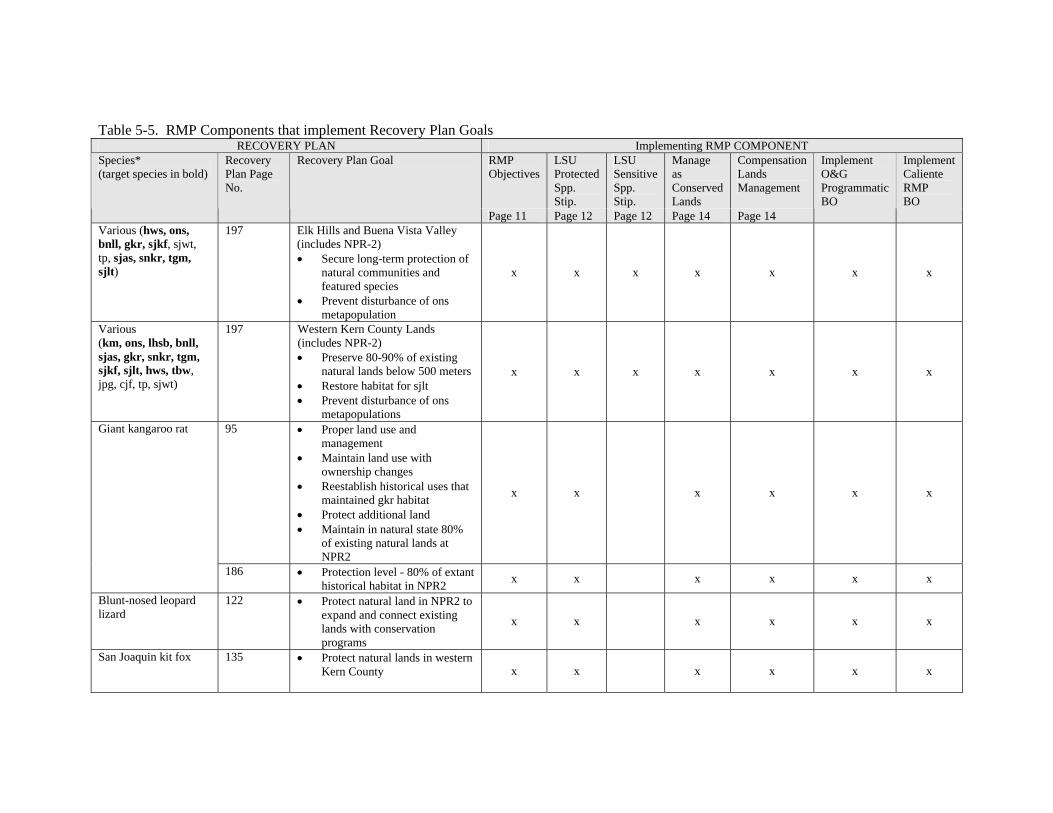
Table 5-5. RMP Components that implement Recovery Plan Goals RECOVERY PLAN Implementing RMP COMPONENT
Species* (target species in bold)
Recovery Plan Page No.
Recovery Plan Goal RMP Objectives
Page 11
LSU Protected Spp. Stip. Page 12
LSU Sensitive Spp. Stip. Page 12
Manage as Conserved Lands Page 14
Compensation Lands Management
Page 14
Implement O&G Programmatic BO
Implement Caliente RMP BO
Various (hws, ons, bnll, gkr, sjkf, sjwt, tp, sjas, snkr, tgm, sjlt)
197 Elk Hills and Buena Vista Valley (includes NPR-2) • Secure long-term protection of
natural communities and featured species
• Prevent disturbance of ons metapopulation
x x x x x x x
Various (km, ons, lhsb, bnll, sjas, gkr, snkr, tgm, sjkf, sjlt, hws, tbw, jpg, cjf, tp, sjwt)
197 Western Kern County Lands (includes NPR-2) • Preserve 80-90% of existing
natural lands below 500 meters • Restore habitat for sjlt • Prevent disturbance of ons
metapopulations
x x x x x x x
Giant kangaroo rat 95 • Proper land use and management
• Maintain land use with ownership changes
• Reestablish historical uses that maintained gkr habitat
• Protect additional land • Maintain in natural state 80%
of existing natural lands at NPR2
x x x x x x
186 • Protection level - 80% of extant historical habitat in NPR2 x x x x x x
Blunt-nosed leopard lizard
122 • Protect natural land in NPR2 to expand and connect existing lands with conservation programs
x x x x x x
San Joaquin kit fox 135 • Protect natural lands in western Kern County x x x x x x
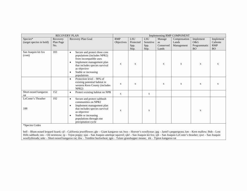
RECOVERY PLAN Implementing RMP COMPONENT Species* (target species in bold)
Recovery Plan Page No.
Recovery Plan Goal RMP Objectives
LSU Protected Spp. Stip.
LSU Sensitive Spp. Stip.
Manage as Conserved Lands
Compensation Lands Management
Implement O&G Programmatic BO
Implement Caliente RMP BO
San Joaquin kit fox (cont)
183 • Secure and protect three core populations (includes NPR2) from incompatible uses
• Implement management plan that includes species survival as objective
• Stable or increasing populations
x x x x x x
188
• Protection level – 90% of existing potential habitat in western Kern County (includes NPR2)
x x x x x x
Short-nosed kangaroo rat
152 • Protect existing habitat on NPR x x
LeConte’s Thrasher 192 • Secure and protect saltbush communities on NPR2
• Implement management plan that includes species survival as objective
• Stable or increasing populations through one precipitation cycle
x x x
*Species Codes
bnll – Blunt-nosed leopard lizard; cjf – California jewelflower; gkr – Giant kangaroo rat; hws – Hoover’s woollystar; jpg – Jared’s peppergrass; km – Kern mallow; lhsb – Lost Hills saltbush; ons – Oil neststraw; tp – Tejon poppy; sjas – San Joaquin antelope squirrel; sjkf – San Joaquin kit fox; sjlt – San Joaquin LeConte’s thrasher; sjwt – San Joaquin woollythreads; snkr – Short-nosed kangaroo rat; tbw – Temblor buckwheat; tgm – Tulare grasshopper mouse; trk – Tipton kangaroo rat

Cultural Resources - Approval of the proposed action will not significantly impact cultural resources.. As stated in the Caliente Resource Management Plan, “When an undertaking is proposed by either BLM or the public a comprehensive process is initiated to identify cultural resources that may be affected by the proposed project.” Typically, this process includes a review of known records, and a class 3 cultural inventory. In rare cases, data recovery may also be required. The proposed action will allow cultural resources to be managed on NPR-2 as they are on nearby public lands under the Caliente RMP. Based on past experience within the Bakersfield Field Office, we estimate that sites that are found can be avoided more than 75% of the time. The few remaining sites that cannot be avoided will be evaluated for listing on the National Register and mitigation measures will be instituted if the site is found to be eligible. Additionally, consultation with local Native American groups was conducted in order to identify traditional cultural properties and issues associated with implementation of the proposed action. At this time, BLM has not received comments from the Native American community.
Oil and Gas Leasing Upon issuing an oil and gas lease, BLM is obligated to allow the lessee to develop the parcel unless a stipulation specifically stating otherwise is attached to the lease when it is issued.. Actual impacts may occur only as the lease is developed. This process is described below under oil and gas development, and would only be a factor if the lessee actually chose to develop the lease. The projected amount of disturbance from oil and gas development (under 300 acres spread over 10,451 acres) on newly leased lands is less than 3% of NPR-2. It is therefore projected that less than 3% of the cultural sites will have the potential to be impacted by leasing. Of these, past experience indicates that 75% can be avoided, meaning that impacts from leasing will affect less than 1% of the cultural sites in NPR-2. It should be noted that only 480 acres of the total 2,532 acres of unleased lands in NPR-2 are adjacent to the prehistoric shoreline of Buena Vista Lake. Considering the type and density of both historic and prehistoric sites, as well as established protective procedures, the overall effect of oil and gas leasing and subsequent development is expected to be minimal.
Oil and Gas Development. As projects are proposed, the areas of potential effect (APE) are defined and assessments of the impacts upon cultural resources are undertaken. NEPA and Sec. 106 compliance will be completed on all undertakings within the 2,532 acres of unleased lands in NPR-2, as well as on currently leased NPR-2 lands in the event new actions are proposed. In the event that cultural resources are identified within a project area, an evaluation of significance will occur and steps will be taken to mitigate impacts to that resource. Mitigation most frequently involves site avoidance, but may rarely include data recovery or compensation. It should be noted that BLM has discretional control over mitigation stipulations and/ or avoidance measures imposed on a project. Although a lessee has a right to develop a lease, BLM may require development activities to be moved up to 200 meters in any direction. This should allow nearly all sites to be avoided. Sites that cannot be avoided will be evaluated for listing on the National Register and mitigation measures will be instituted if the site is found eligible. Should development uncover subsurface sites, the lessee is required to halt all work until the site can be evaluated and proper mitigation and avoidance measures identified. When considering the projected amount of disturbance from oil and gas development (under 300 acres spread over 10, 451 acres), the type and density of both historic and prehistoric sites, and established protective procedures, the overall effect of oil and gas development is expected to be minimal.
Land Use Authorizations. Land use authorizations, which may include rights-of-way for roads, powerlines, and pipelines, as well as permits, generally result in surface disturbance. Even authorizations for existing uses usually allow for maintenance, which can result in new surface disturbance. Impacts from land use authorizations would generally be similar to those from oil and gas development. However, because land use authorizations are entirely discretionary and the Bureau may require a proposed action to be relocated as far as necessary to avoid or minimize impacts, the effect of land use authorizations on cultural resources is expected to be insignificant.
Land Disposals. Land Disposals may result in the removal of cultural resources from BLM ownership. However, disposals are entirely discretionary and require the preparation of a NEPA document, which would address impacts to cultural resources. A land disposal would not occur until an inventory, record search, site
45

determination, mitigation, and Native American consultation had been completed. This process allows the Bureau to identify and retain significant cultural sites.
Lands - Land Use Authorizations - In general, environmental consequences (direct, indirect, and cumulative) due to land use authorizations area as described in BLM’s Caliente RMP EIS Chapter 4, and are not considered to be significant. Most, if not all, impacts to the environment due to new or existing authorizations can be mitigated or compensated for, to the point where they are insignificant. In addition, these impacts are often short-term impacts, such as for a buried right-of-way facility that revegetates over time. Implementation of the proposed right-of-way process would promote the orderly administration of NPR-2 lands by BLM, would allow for expeditious extraction of oil/gas resources on NPR-2 lands, and would discourage unauthorized uses of the land. The proposed action will allow existing DOE permits to be managed in a timely and proper manner. The designation of the proposed right-of-way corridors would provide the public with preferred routes that may help in the planning of linear utilities, and would also reduce BLM processing costs.
Range- None
Recreation- None
Socio-Economic - The proposed action will allow the existing leases at NPR-2 to continue oil and gas production at or above their current levels. This benefits the local economy, as well as the national supply of oil and gas. The proposed action will most likely result in more oil and gas production because of the authorization of several new lease areas. The proposed action would also designate right-of-way corridors on NPR-2 lands, which would assist both utility companies and BLM in the authorizing of several new rights-ofway per year, not associated with oil and gas production. The proposed action may make some lands available for community expansion near Taft, which would be an economic benefit to that community.
Most oilfield operations in Kern County are performed by local contractors, with Bakersfield being the largest city in the area. The next largest town in the area, and the nearest significant population center to NPR-2, is Taft, with a population of 6,500. More than 10,000 residents of Bakersfield and Taft work in areas directly or indirectly dependent on oil and gas activity.
According to a local drilling company (Western Drilling), a drilling a typical well at NPR-2 would employ the equivalent of 25 fulltime employees for one week. Based on an average wage of $22/hr, this is a net of $22,000 per week, plus the additional impacts of “trickle down,” added to the local economy for each well drilled. Although this is not a significant amount in comparison to the entire local economy, it is a positive impact.
In general, environmental consequences (direct, indirect, and cumulative) due to land tenure adjustments area as described in BLM’s Caliente RMP EIS Chapter 4, and are not considered to be significant. The preferred alternative in the Caliente RMP identified 55,000 acres of BLM for potential disposal in central California. The small amount of lands identified for potential disposal (approx. 161 acres) from NPR-2 is considered to be an insignificant increase in this figure. Lands disposed of could be developed into urban or suburban areas. The specific analysis of impacts due to such development is beyond the scope of this plan, partly because the specifics of the development are unknown at this time and also because such analysis is more appropriately analyzed by local governments under the California Environmental Quality Act (CEQA) after the land is in private ownership. Disposal of BLM surface estate and non-oil and gas minerals near Taft could simplify the BLM land pattern in the area and potentially decrease BLM’s management costs in the area. Any non-oil and gas mineral rights disposed of in such transactions would still be available for future exploitation by the private sector, although this is not expected to occur because the most likely use of these lands would be for community expansion. Disposal of surface entry rights (associated with the retained oil and gas rights) on the disposal parcels would avoid conflicts between surface uses and the potential use of these areas for oil/gas extraction. Restrictions on use and surface entry issues (for mineral development) could be resolved in the private sector through appropriate zoning, surface waivers, etc. The acquisition of any needed access
46

easements would allow for legal administrative access for up to seven parcels of NPR-2 lands, helping BLM to adequately manage those parcels. The acquisition of any fee parcels would, in general, help preserve biological habitat.
Identifying and resolving unauthorized uses of NPR-2 lands would promote proper land uses by the public, would ensure that BLM receives a fair return for such uses, and would also discourage future parties that might consider installing facilities on NPR-2 lands without authorization.
Visual Resources- Approximately 50-200 wells will be added within the project area within the next 15 years. The wells and associated equipment will generally be painted to blend into the background, as practical, so there will not be any significant impairment of visual resources.
Wilderness- None
Cumulative Impacts
In the Caliente Resource Management Plan and EIS, published December 1996, BLM analyzed the overall effects of oil and gas activities in the area. The analyses and conclusions contained in those documents are still valid, and current cumulative impacts are still significantly under the level of cumulative impacts that were projected/analyzed in those documents. There have not been and are not expected to be any additional impacts in the area around NPR-2 that would change those conclusions.
Air Quality
There could be a slight increase in emissions from the proposed action. This increase would be expected to be less than 0.75 % of new emissions from other new wells that are being drilled in the area..
Federal Conformity:
A federal conformity analysis is required for any federal action within any federal nonattainment or maintenance area. The NPR-2 area is within four federal nonattainment areas. The clean air act and its implementing rules (40 CFR part 93) state that federal agencies must make a determination that proposed actions in federal nonattainment/ maintenance areas conform to the applicable implementation plan before the action is taken. In addition, the action cannot cause or contribute to any new violation of the National Ambient Air Quality Standards, cannot increase the frequency or severity of any existing violation of any NAAQS or delay timely attainment of any standard or any required interim emission reduction or other milestones.
The BLM has developed a ten-step process to comply with the federal conformity requirements. These ten steps are: (1) Determine spatial and jurisdiction applicability, (2) Describe SIP status and content, (3) Develop any necessary background information, (4) Develop air quality impact analysis, (5) Compare activity to applicable SIP provisions and rules, (6) Develop conclusion statement, (7) Prepare a formal determination, (8) Conduct an agency/public review, (9) Submit the determination to appropriate regulatory agencies and (10) Archive the results. Steps 7-10 must be completed only if the project has total emissions of criteria pollutants exceeding deminimus levels established in the regulations (40 CFR 93.153 (b)(1&2)). Most of these steps are carried out in the environmental document.
Conformity Analysis and Conclusion: The expected emissions from the proposed action are well below deminimus levels and less than 10% of the emissions in the planning area. All of the SIP requirements for the federal nonattainment areas are met by the proposed action as the actions are all regulated and permitted by the SJVAPCD. All emission levels are below deminimus levels, so no further conformity analysis is necessary and a formal conformity determination is not required.
47

Biological Resources
Table 5-1 shows the projected amount of habitat disturbance resulting from oil and gas actions on NPR-2. It is estimated that between 32 and 92 acres may be permanently disturbed, and between 30 and 80 acres may be temporarily disturbed over the life of the plan. This is a total of between 62 and 173 acres, which amounts to less than 2% of the 10,451 acre NPR-2 area, 2% of the undisturbed BLM land in NPR-2 and 0.74% of all undisturbed land in NPR-2. Should all 173 acres of disturbance occur within corridor lands (green zone), the total disturbance on green zone lands within NPR-2 (BLM and private) would remain below the 25% disturbance limit. If, however, all 173 acres of disturbance were to occur within reserves (red zone), the total disturbance on red zone lands within NPR-2 (BLM and private) would exceed the 10% limit. This potential impact to reserves could be minimized by working with operators to accelerate restoration in red zone lands. It is also expected that disturbance would be distributed within red, green and white zones, reducing the likelihood that the 10% limit would be exceeded on NPR-2 reserve lands.
The location of oilfield developments will be widely scattered and in many instances among existing oil pads, roads and facilities. The spacing and low relative percentage of new disturbance is not expected to perceptively reduce the quality of habitat on NPR-2. Impacts to special status species will also be minimized by implementing measures from the Oil and Gas Programmatic Biological Opinion. While there are several sections in NPR-2 where the current level of disturbance exceeds the 25% disturbance objective for corridors (green zone) and the 10% disturbance for reserves (red zone), the anticipated impacts from new oilfield and realty actions are not expected to decrease the utility of NPR-2 in special status species conservation and recovery.
Cumulative effects also include the effects of future state, tribal, local, or private actions that are reasonable certain to occur in the action area. BLM is not aware of any specific non-federal activity that is reasonable certain to occur, that would affect biological resources. It is likely that activities similar to those described for the federal lands would occur on the non-federal lands adjacent to federal NPR-2 lands.
Cultural Resources – The cumulative impacts on cultural resources are not expected to be significant (see previous discussions).
Visual Resources - The area is generally oilfield in character. There are more than 10,000 oil wells within a 5 mile radius of NPR-2, the proposed action fits into the general landscape, and there will be no significant new intrusion into the view shed.
No Action Alternative
Following is a description of the environmental consequences of the No Action Alternative:
Air, Soil, and Water - The No Action Alternative would not affect air, soil, and water since new oil, gas, and realty actions would not occur other than on existing leases.
Biological Resources- Impacts to Biological Resources from the No Action alternative would be the same as for the Proposed Action, except that impacts associated with new oil and gas leases and land disposals would not occur. Over time, if leases expire, they would not be renewed, and disturbed areas on these expired leases may become naturally restored.
Cultural Resources – The impacts to cultural resources from the No Action Alternative would be the same as the proposed action, with the exception that new oil and gas leases and land disposals would not occur
Lands - Land Use Authorizations – The No Action Alternative may encourage disorderly development of oilfield facilities and encourage unauthorized uses of the land. The No Action Alternative will not allow
48

existing DOE permits to be managed in a timely manner.
Other Lands Actions – none
Range- None
Recreation- None
Socio-Economic - The No Action Alternative may delay or prohibit the extraction of needed oil and gas resources at an important time for the U.S.
The No Action Alternative would not allow for the disposal of any BLM parcels within NPR-2, and would not allow for the acquisition on any private lands in the NPR-2 area, including access easements. This could result in an opportunity to improve the BLM land pattern being forgone, as well as an opportunity being foregone to allow for community expansion near the community of Taft. Opportunities to acquire legal access to some of the NPR-2 lands could also be foregone.
Visual Resources- None
Wilderness- None
49

Chapter 6 Mitigation
Air, Soil, and Water- No new mitigation measures will be implemented for air, soil, and water. All applicable laws and regulations will be set forth by the SJAPCD, CARB, and the Regional Water Quality Control Board (RWQCB).
Biological Resources- BLM will work with oilfield operators to accelerate restoration of disturbed lands in areas that are approaching or at the disturbance limits for conserved lands (red and green zone lands).
Other measures to prevent impacts to biological resources have been built into the proposed action. In addition, the Oil and Gas Programmatic Biological Opinion contains measures designed to minimize impacts to federally listed species. No additional mitigation measures are proposed.
Cultural Resources – Measures to prevent impacts to cultural resources have been built into the proposed action and the cultural resource sections previously discussed. Cultural resources management guidelines are provided in the BLM/SHPO State Protocol.
Lands - Land Use Authorizations – Mitigation measures will be site-specific for each land use authorization, but will be similar to APD and Sundry Notice mitigation.
Land Tenure Management - Loss of biological habitat due to land disposals could be considered to be pre-compensated through BLM’s prior purchases of large areas of habitat lands in the Carrizo Plain National Monument, several miles west of NPR-2. BLM has purchased approximately 90,000 acres of habitat lands over the last 17 years in this area.
Range- None
Recreation- None
Visual Resources- None
Wilderness- None
50

Chapter 7 Consultation and Coordination
Issue Identification/Public Scoping
A “Notice of Intent to Prepare an Amendment to the Caliente Resource Management Plan Regarding Bureau of Land Management Administration of Newly Transferred Lands at Naval Petroleum Reserve 2 (NPR-2) in Kern County, CA,” was published in the Federal Register on September 26, 2005. A 30 day comment period followed. During that time, no comments were received.
Mailing List
The “Draft Resource Management Plan Amendment and EA for NPR-2” was published January 12, 2006, both on the BLM website and in hardcopy format. A press release was issued, and hardcopies and/or copies on CD were sent to a number of interested parties. A total of 12 comments were received, 10 of which were general comments in support of leasing and development, 1 of which was a question requiring clarification, and one of which raised a number of concerns. This final EA addresses the issues that were raised.
Public Involvement, Contacts & Date of Contact Press releases, publication on the web.
Native American Contacts Ms. Dee Dominguez Tinoqui-Chalola Council of Kitanemuk and Yowlumne Tejon Indians
Mr. Gene Albitre, President Native American Heritage Preservation Council of Kern County
Mr. Neil Peyron, Chairperson Tule River Reservation
Mr. Clarence Atwell, Chairperson Santa Rosa Rancheria
Mr. Catarino and Mrs. Juanita Montes
Hector Lalo Franco Wukchumni Tribal Council
Others USFWS
Isaac George, Planning Dept., City of Taft Nov. 2005 Joe Hippolito, Crimson Resources Nov. 2005
51
Chapter 8 References
Anderson, D.C., and G.L. Holmstead. 1995. Characterization of Eriastrum hooveri (Hoover’s wooly-star) habitat on the Naval Petroleum Reserves in California. U.S. Department of Energy Topical Report No. EGG 11265-1167. 39 pp.
California Energy Commission. 1991. Southern San Joaquin Valley Ecosystems Protection Program, Natural Lands Inventory and Maps. Sacramento, CA. 41 pp. plus maps.
EG&G Energy Measurements, Inc. 1988. The Occurrence and Status of Candidate Species Listed by the U.S. Fish and Wildlife Service on Naval Petroleum Reserve #1, Kern County, California, EG&G Energy Measurements Report EGG 10617-2015, Santa Barbara Operations, Goleta, California.
Holland, R.F. 1986. Preliminary Descriptions of the Terrestrial Natural Communities of California. Nongame-Heritage Program. California Department of Fish and Game, Sacramento, CA. 156 pp.
Latta, Frank F. 1977. Handbook of Yokuts Indians. Bear State Books, Santa Cruz, CA. 765pp.
Moratto, Michael J. 1984. California Archaeology. Academic Press, Inc. San Diego, CA. 758pp.
O’Farrell, T.P., and M.L. Sauls. 1987. Biological survey of Naval Petroleum Reserve #2 (Buena Vista) Kern County, California. U.S. Department of Energy Topical Report No. EGG 10282-2166. 30 pp.
O’Farrell, T.P., N.E. Mathews, T.T. Kato, P.M. McCue, J.S. McManus, and M.L. Sauls. 1987a. Distribution of the endangered giant kangaroo rat, Dipodomys ingens, on the Naval Petroleum Reserves, Kern County, California. U.S. Department of Energy Topical Report No. EGG 10282-2173. 30 pp.
O’Farrell, T.P., G.D. Warrick, N.E. Mathews, and T.T. Kato. 1987b. Report of endangered species studies on Naval Petroleum Reserve #2, Kern County, California. U.S. Department of Energy Topical Report No. EGG 10282-2189. 76 pp.
Sawyer, J.O., and T. Keeler-Wolf. 1995. A manual of California vegetation. California Native Plant Society, Sacramento, CA. 471 pp.
U.S. Army Corps of Engineers. 1995. February 27, 1995 Letter from Tom Coe, Chief Central Valley Office, to Mark Hawley, Bechtel Petroleum Operations, Inc.
U.S. Fish and Wildlife Service. 1998. Recovery plan for upland species of the San Joaquin Valley, California. U.S. Department of the Interior, Fish and Wildlife Service, Portland, OR. 319 pp.
Zoellick, B.W., T.P. O’Farrell and T.T. Kato. 1987. Movements and home range of San Joaquin kit foxes on the Naval Petroleum Reserves in California. U.S. Department of Energy Topical Report No. EGG 102822184. 38pp.
52

Air Quality References:
ARB. 1991. Prospects for Attaining the State Ambient Air Quality Standards for Suspended Particulate Matter (PM10), Visibility Reducing Particulates, Lead, and Hydrogen Sulfide. California Environmental Protection Agency, Air Resources Board. Sacramento, CA
ARB. 1992. California’s Air Pollution Control and Air Quality Management Districts. California Environmental Protection Agency, Air Resources Board. Sacramento, CA
ARB. 1993a. California Air Pollution Control Laws. California Environmental Protection Agency, Air Resources Board. Sacramento, CA
ARB. 1993b. Area Designations for State and National Ambient Air Quality Standards. California Environmental Protection Agency, Air Resources Board. Sacramento, CA
ARB. 1996. Proposed Amendments to Area Designations for State Ambient Air Quality Standards, Including Amendments Due to Changes in Air Basin Boundaries, and Proposed Maps of Area Designations for the State and National Ambient Air Quality Standards. California Environmental Protection Agency, Air Resources Board. Sacramento, CA
ARB. 2000. Recommended Area Designations for the Eight-Hour Ozone Standard. California Environmental Protection Agency, Air Resources Board. Sacramento, CA
ARB. 2001a. California’s State Implementation Plan. At http://www.arb.ca.gov/sip/siprev1.htm. California Environmental Protection Agency, Air Resources Board. Sacramento, CA
ARB. 2001b. Fine Particulate Matter-PM2.5 Particulate Pollution-Charting a Course for Clean Air. At http://www.arb.ca.gov/pm25/pm25.htm. California Environmental Protection Agency, Air Resources Board. Sacramento, CA
ARB. 2003a. Air Pollution- Particulate Matter Brochure. At http://www.arb.ca.gov/html/brochure/pm10.htm. California Environmental Protection Agency, Air Resources Board. Sacramento, CA
ARB. 2003b. Final Regulation Order for the Rulemaking To Consider Amendments to Regulations for the State Ambient Air Quality Standards for Suspended Particulate Matter and Sulfates. California Environmental Protection Agency, Air Resources Board. Sacramento, CA
ARB. 2003d. Air Quality Emissions and Modeling. At Http://www.arb.ca.gov/html/aqe&m.htm. California Environmental Protection Agency, Air Resources Board Sacramento, CA
ARB. 2003e. California Air Quality Data. At http://www.arb.ca.gov/aqd/aqdpagealt.htm. California Environmental Protection Agency, Air Resources Board Sacramento, CA
ARB. 2006a. Area designations For State Ambient Air Quality Standards PM2.5. at http://www.arb.ca.gov/design/adm/s4_pm25.pdf. California Environmental Protection Agency, Air Resources Board Sacramento, CA
ARB. 2006b. Air Quality Trend Data. at http://www.arb.ca.gov/adam/cgi-bin/db2www/polltrendsb.d2w/start. California Environmental Protection Agency, Air Resources Board Sacramento, CA
Gladstein, Cliff. 2003. Heavy Duty Fleet Modernization: From Retiring Gross Polluters to Alternate Fuels. Presentation at California Desert Air Working Group Fall Conference, Death Valley, California. Gladstine & Associates LLC. Santa Monica, CA
SCAQMD, 1993b. CEQA Air Quality Handbook. South Coast Air Quality Management District. Diamond Bar, CA
53

SJVAPCD, 2003, Best Available Control Measures/Technology and Reasonable Available Control Measures/Technology Demonstration for Sources of PM10 and PM10 precursors in the San Joaquin Valley Air Basin, San Joaquin Valley Air Pollution Control District
SJVAQMD, 2004, Extreme Ozone Attainment Demonstration Plan, San Joaquin Valley Air Basin Plan Demonstrating Attainment of Federal 1-hour Ozone Standards. San Joaquin Valley Air Pollution Control District
U.S. Bureau of Land Management. 1999. Air Quality Conformity Analysis and Determination Process. Course Number 7000-06. NTC, Phoenix, AZ
U.S. Bureau of Land Management. 2000. Conformity Determination Soledad Canyon Sand and Gravel Mining Project. Appendix to Final EIS Soledad Canyon Sand and Gravel Mining Project. California Desert District, Palm Springs – South Coast Field Office. Palm Springs, CA
U.S. Bureau of Land Management. 2001. Air Quality Conformity for Managers – Satellite Broadcast Course Number 7000-06BC. At http://www.blm.gov/nstc/air/index.html . National Science & Technology Center, Denver, CO
U.S. Bureau of Land Management. 2003. Draft Air Quality Handbook. California Desert District, Ridgecrest Field Office, Ridgecrest, CA
USEPA. 1993. Federal Register Notice #5863213. Vol. 58, Number 228, P63213-63259. November 30, 1993. At http://www.epa.gov/oar/oaqps/greenbk/5863213.html. Washington D.C.
USEPA. 1997. PM-2.5 Composition and Sources. Prepared for FACA National and Regional Strategies Workgroup. Office of Air Quality Planning and Standards. At http://www.epa.gov/ttn/oarpg/naaqsfin/ . Washington, DC
USEPA. 1999. Handbook for Criteria Pollutant Inventory Development, A beginner’s Guide for Point and Area Sources. At http://epa.gov/ttn/chief. Washington, DC
USEPA. 2003d. Compilation of Air Pollution Emission Factors, AP-42, Fifth Edition, Volume I: Stationary Point and Area Sources. At http://epa.gov/ttn/chief/ap42/index.html Washington, DC
USEPA. 2003e. Federal Register Notices Related to Particulate Matter Designations and Classifications. August 27, 2003. At http://www.epa.gov/oar/oaqps/greenbk/pfrnrpt.html. Washington D.C.
USEPA. 2003f. EPA’s Decision on New Air Quality Standards. Office of Air & Radiation. AT http://www.epa.gov/ttn/oarpg/naaqsfin/. Washington, DC
USEPA. 2003g. PM-2.5 NAAQS Implementation. At http://www.epa.gov/ttnnaaqs/pm/pm25_index.html. Washington, DC
USEPA. 2003h. Designations for the Fine Particle National Ambient Air Quality Standards. Office of Air and Radiation. Memorandum from Jeffrey R. Holmstead, Assistant Administrator to Regional Administrators, Regions I-X. Washington, DC
USEPA. 2003i. Air Trends, Lead. At http://epa.gov/airtrends/lead.html. Washington, DC
USEPA. 2003j. Air Trends, More Details on Lead – Based on Data Through 2000 (More Recent Data Will Be Available Soon). At http://epa.gov/airtrends/lead2.html. Washington, DC
USEPA. 2006. Region 9 State designations for PM2.5 Standard. At http://epa.gov/pmdesignations/regions/region9desig.htm. Washington, DC
54

Appendix A Oil and Gas Management Guidelines
Oil and Gas Leasing Availability Categories
The Amendment describes the various categories of land availability for leasing for oil and gas. A determination has been made that the lands covered by this Amendment are open to leasing for oil and gas. In addition, the plan identifies proposed stipulations to be associated with each new lease.
Public lands that are closed to leasing separate into two groups. Tracts that have been closed by previous legislation or secretarial policy form one group of lands and are known as non-discretionary closures. The second group of closed lands, consisting of those that would possibly be proposed for closure under this plan, is called proposed discretionary closures.
Lands open to oil and gas leasing separate into the following groups: open to leasing under a standard lease stipulation; open to leasing under a no surface use stipulation; and open to leasing under a limited surface use stipulation. The standard oil and gas lease form includes those preprinted lease terms and conditions that apply to all leases. Other stipulations developed in this plan are applied in lease areas with special resource concerns, and supersede any inconsistent provisions of the standard lease form. The special stipulations proposed in this plan address limited surface use for areas with resource protection needs slightly different from the standard lease stipulation. The Limited Surface Use (LSU) stipulation provides additional protection for Federally Proposed and Listed Species; Proposed and Designated Critical Threatened and Endangered Species Habitat; and Federal Candidate, State Listed and Bureau Sensitive Species. Three additional special stipulations were contained in the Caliente RMP that are not applicable to any of the land in the NPR-2 area. Those special stipulations are: No surface use for areas where very unique resources exist, LSU – Department of Defense lands, and LSU – Coast (for management of Coast Area ACEC’s/SMA’s.
Lands Closed to Oil and Gas Leasing
There are no areas covered by non-discretionary closures or proposed for discretionary closure within the subject lands.
Lands Open to Oil and Gas Leasing
Because no lands are closed to leasing by discretionary or non-discretionary closure, all public land and Federally reserved mineral estate within the NPR-2 Area are open for oil and gas leasing activities.
The process of nominating a federal parcel for a lease sale is initiated when a letter of interest in oil and gas leasing is submitted to the Sacramento Office of the Bureau of Land Management. Lease sales would be scheduled a maximum of four times a year, depending on oil industry interest, for the life of the Plan. The RMP will be used to determine the applicability of lease stipulations attached to parcels nominated for lease interest at the time of the lease sale. Three categories of lease stipulations, described in detail below, would include:
1. Offered for lease with a Standard Lease stipulation 2. Offered for lease with a No Surface Use stipulation 3. Offered for lease with a Limited Surface Use stipulation
All new leases at NPR-2 would be offered with Limited Surface Use Stipulation(s) (LSU). If existing leases expire or terminate and the lands are re-leased, they will also be leased with Limited Surface Use Stipulation(s).
55

Leasing with Standard Lease Stipulation
The Standard Lease stipulation includes the terms and conditions that are the national standards printed on Bureau of Land Management lease forms (form 3100-11, February 2003).
Under standard terms, a proposed exploration and development operation can be modified by the operator and Bureau to minimize impacts of the project's operation design. Modifications are limited to moving the proposed operation less than 200 meters and delaying the project less than 60 days in one lease year.
No lands within NPR-2 are proposed to have this stipulation.
No Surface Use Stipulation
This lease is within an area that contains unique or significant natural or cultural values, or other uses preclude surface development over the entire leased area. To prevent or reduce disturbance to unique or significant natural or cultural values or other pre-existing uses that preclude surface development, No Surface Use is allowed on the lease.
Additional Information
Application. The No Surface Use stipulation is intended for use when adequate protection of surface resources cannot be provided through mitigation, and there are no suitable sites for development anywhere on the entire lease. Mineral development of the lease from an off-site location is recommended. There are no lands within NPR-2 that are proposed to have this stipulation.
Review Process. If conditions change so that the NSU stipulation becomes necessary for lands to be leased at a future date, the No Surface Use stipulation would be applied at the time of a lease sale. An exception or modification to the stipulation may be approved if it can be demonstrated that operations can be conducted without causing unacceptable impacts to the critical cultural or natural values or to the other pre-existing use. Any decision to grant an exception or modification would be based on field inspection and inventory and the NEPA review process. The lessee should be aware that the timing of the surveys is critical, in that some species can only be surveyed during a brief period each year. The stipulation may be waived if a determination is made by the Bureau that the resource or other use no longer exists on the leased lands.
Although there are specific discrete areas within NPR-2 where No Surface Use is allowed due to pre-existing conditions (e.g., residential development), there are no leases where the entire surface is precluded from development. Consequently, there are no lands within NPR-2 that are proposed to have this stipulation.
Leasing with the Limited Surface Use Stipulation
Special stipulations may be proposed for use to protect unique resources or values where it may be necessary to modify surface activities beyond authorities contained under the standard lease terms (43 CFR 3103.1-3). The Limited Surface Use Stipulation allows BLM, in consultation with the applicant, to extend modification of development proposals beyond the standard 200 meters and 60-day conditions. By reserving the additional leeway in siting facilities, the BLM and applicant can generally use the combination of increased siting and timing flexibility to modify development proposals to entirely avoid or significantly minimize surface-disturbing effects associated with lease development. The Limited Surface Use stipulation thus allows BLM to offer for lease parcels known to or suspected to contain unique resources or values and resolve any potential conflicts at the time when the lessee is prepared to design development proposals.
This stipulation also advises prospective lessees that they are considering the purchase of a lease in areas known or suspected to contain unique resources or values and advises them of potential constraints and development options available. Historically, the BLM in cooperation with the lessee has been able to find sufficient flexibility in designing lease development proposals, even in the most sensitive of locations, to facilitate development without adversely affecting either the resource values of concern or the oil and gas lease.
56

Special conditions that may be attached to new leases issued in the area managed by the Bakersfield Field Office are collectively referred to as the Limited Surface Use stipulation (LSU) and supersede any inconsistent provisions of the standard lease form. The wording of the Limited Surface Use stipulation has been adjusted to address two differing resource concerns (there were six in the Caliente RMP, but four are not currently applicable because the resource values or other pertinent criteria do not exist in the subject NPR-2 area). The Limited Surface Use Stipulation would be applied at the lease sale, to parcels located as shown on the RMP map and as described below.
This stipulation has been developed to be utilized over the life of the plan without the need for further plan amendments. The LSU stipulation has been worded to allow for adjusting the geographic locations where they would be applied based on the resource condition at the time of the lease sale offering. The locations identified in this plan address 2005 resource conditions that will be updated and modified on an annual basis. Information on those updates will be available to those interested in potential lease sales.
Limited Surface Use Stipulations
a. Federally Proposed and Listed Species (LSU - Protected Species) b. Federal Candidate, State Listed and Bureau Sensitive Species (LSU - Sensitive Species)
The following LSU categories from the Caliente RMP are shown for informational purposes only – there are currently no lands in the NPR-2 area subject to these stipulations. However, if a determination is made in the future that one or more of the following stipulations would be appropriate, then the stipulation(s) would be applied according to the criteria in the Caliente RMP.
c. Proposed Critical Habitat and Designated Critical Habitat (LSU - Critical Habitat) d. Raptor (LSU - Raptor) N/A for NPR-2 e. Department of Defense lands (LSU – Defense) – N/A for NPR-2 f. Coast Management Area (LSU – Coast, for management of Coast Area ACEC’s/SMA’s) – N/A for
NPR-2
Waivers, Modification, Exceptions and Deferral to Other Plans
The Authorized Officer may grant a waiver, modification, or exception to the Limited Surface Use stipulation if the factors leading to the stipulation's inclusion in the lease have changed or if new information has been made available. If the protection provided by the stipulation is no longer necessary or can be adequately mitigated and the proposed operation on a lease would not cause unacceptable impacts, a waiver would be evaluated (see 43 CFR 3101.1-4).
The Authorized Officer may also defer the addition of the Limited Surface Use stipulation referred to under b, c, and d above to requiring compliance with other existing approved plans. Those plans may include Habitat Conservation Plans, Programmatic Consultations, Conservation Agreements or others that provide for adequate protection and conservation of resources and compliance with all Federal and State laws.
As an example, once completed, the Kern County Valley Floor Habitat Conservation Plan and associated BLM Programmatic Section 7 Consultation on oil and gas development activities will provide adequate protection for resources identified in b, c, and d above for lands within CDOG administrative boundaries and for all federally reserved mineral estate in Kern County. Future lease sales covering parcels in those areas would defer the addition of a Limited Use Stipulation to notation that compliance with the above approved programs or plans is required.
a. Limited Surface Use Stipulation - Federally Proposed and Listed Species (LSU - ProtectedSpecies)
All or a portion of this lease is within the range of one or more plant or animal species (a list of species would
57

be included with the stipulation for each lease) that are either listed as threatened or endangered, or are proposed for such listing by the U.S. Fish and Wildlife Service.
The lessee is notified that time frames for processing applications may be delayed beyond established standards to allow for species surveys, and consultation or conferencing with the U.S. Fish and Wildlife Service. Notice is also given that surface-disturbing activities may be moved or modified, and that some activities may be prohibited during seasonal time periods. Surface disturbing activities will be prohibited on the lease only where:
1. the proposed action is likely to jeopardize the continued existence of a listed or proposed species, or 2. the proposed action is inconsistent with the recovery needs of a listed species as identified in an approved
U.S. Fish and Wildlife Service Recovery Plan.
Prior to the authorization of any surface disturbing activities, a preliminary environmental review will be conducted to identify the potential presence of habitat for these species. Authorizations may be delayed until completion of the necessary surveys during the appropriate time period for these species. The lessee should be aware that the timing of the surveys is critical, in that some species can only be surveyed during a brief period each year.
The BLM may need to initiate consultation or conference with the U.S. Fish and Wildlife Service if the site inspection concludes that a listed or proposed species may be affected by the proposed activity. The lessee should be aware that the U.S. Fish and Wildlife Service has up to 135 days to render their biological opinion, and that there are provisions for an additional 60 day extension. Offsite habitat protection or enhancement for wildlife or vegetation (compensation) may be required by the U.S. Fish and Wildlife Service when habitat is disturbed. The consultation may also result in some restrictions to the lessee's plan of development, including movement or modification of activities, and seasonal restrictions. Surface disturbing activities will be prohibited on the lease if the consultation or conference concludes that either of the conditions identified in 1. or 2. above exists.
Additional Information
Application. The Limited Surface Use - Federally Proposed and Listed Species (LSU - Protected Species) stipulation would be attached, at the time of lease sale, to leases within the range of certain federally listed or proposed species, or to leases containing, or adjacent to, documented locations of certain federally listed or proposed species. (A list of species would be included with the stipulation for each lease.)
The combined range of the following currently listed species will be used to determine current applicability of the LSU - Protected Species stipulation for listed species: San Joaquin kit fox, blunt-nosed leopard lizard, giant kangaroo rat, Tipton kangaroo rat, California jewelflower, Kern mallow, San Joaquin woolly-threads and Bakersfield Cactus. Hoover’s woolystar (Eriastrum hooveri) was removed from the Federal List of Endangered and Threatened Species on October 7, 2003 (68 FR 57829) and is now treated as a sensitive species by BLM. The range of the listed species is shown on the map packet. If additional species become listed, existing species become delisted, or if new range information becomes available, the area on the map packet will be modified accordingly and all subsequent lease sales will be evaluated against the modified map area. The recent historic range of the California condor was excluded from consideration due to the extensive amount of unoccupied range.
Documented locations for currently proposed species will be used to determine current applicability of the LSU - Protected Species stipulation for proposed species. If additional species become proposed, or new location information becomes available, the species and parcel lists will be modified and all subsequent lease sales will be evaluated against the modified parcel list.
Review Process. Generally, the following process will be used to approve surface disturbing activities on leases with the LSU - Protected Species stipulation. The proposed activity would be reviewed to determine if
58

listed or proposed species would be affected. This review may involve site-specific surveys for plant and animal species, conducted according to established methodologies that may specify certain seasons or other conditions. In some cases, this may mean that a survey cannot be completed until the next growing season for some plant species or after seasonal appearance for some animal species.
If the review determines that listed or proposed species will not be affected, approval of the application will normally be granted within 30 days of the review.
If the review determines that listed or proposed species may be affected, but in a beneficial, insignificant or benign manner, and written concurrence is received from the U.S. Fish and Wildlife Service, approval of the application will normally be granted within 30 days of receiving U.S. Fish and Wildlife Service concurrence.
If it is determined that a listed or proposed species may be adversely affected, the BLM will work with the applicant to modify the proposal to minimize impacts. Modifications may include movement of activities, seasonal restrictions, mitigation and/or compensation. Modified proposals will be developed cooperatively with the applicant to ensure that the modified project still meets the applicant's objective. If the modified project may still adversely affect a listed or proposed species, BLM will initiate formal consultation or conference with the U.S. Fish and Wildlife Service.
Coordination with the U.S. Fish and Wildlife Service on Listed Species. Currently there are two options for meeting the formal consultation requirement. A new consultation may be initiated or a previously completed formal consultation may be utilized.
If a new consultation is initiated, the U.S. Fish and Wildlife Service will issue a document, called the Biological Opinion. The U.S. Fish and Wildlife Service has up to 135 days to complete a Biological Opinion and they may request an additional 60-day extension. Extensions beyond 195 days require the consent of any applicant.
A previously completed formal consultation may also be used to meet the formal consultation requirement. Examples of previously completed consultations that may be used include the San Joaquin Valley Oil and Gas Programmatic and the Programmatic Opinion for Naval Petroleum Reserve No. 1.
Upon completion of a new consultation or determination that a previously completed consultation can be used, approval of the application will normally be granted within 30 days. If the new consultation concludes that a listed species may be jeopardized, then surface disturbance will be prohibited on the lease. Surface disturbance will also be prohibited if the consultation concludes that the proposed action is inconsistent with the recovery needs of the listed species as identified in an approved U.S. Fish and Wildlife Service Recovery Plan.
Coordination with the U.S. Fish and Wildlife Service on Proposed Species. Bureau policy requires a conferencing with the U.S. Fish and Wildlife Service on any action that may adversely affect proposed species. Depending on the complexity of the situation, a conference may be completed in a single telephone conversation or may require the time frames of a consultation. Generally, upon completion of the conference, approval of the application will be granted within 30 days. If the conference concludes that a proposed species may be jeopardized, surface-disturbing activities will be prohibited on the lease.
Final Approval. Final approval of applications that will have no effect on listed or proposed species willnormally be granted within 30 days of the review.
Final approval for projects that may affect listed or proposed species in a beneficial, insignificant or benign manner will normally be granted within 30 days of receiving U.S. Fish and Wildlife Service written concurrence. The U.S. Fish and Wildlife Service generally responds to requests for concurrence in 30 days.
For projects that require consultation or conference with the U.S. Fish and Wildlife Service, final approval will
59

normally be granted within 30 days of consultation or conference completion. Conditions of approval will include any conditions specified by the BLM or U.S. Fish and Wildlife Service for minimizing impacts.
b. Limited Surface Use - Federal Candidate, State Listed and Bureau Sensitive Species (LSU -Sensitive Species)
All or a portion of this lease is within the range of one or more plant or animal species (see attached list) that are either Federal candidates for listing as threatened or endangered (Federal Candidate), are listed by the State of California as threatened or endangered (State Listed), or are designated by the Bureau of Land Management as Sensitive (Bureau Sensitive).
The lessee is notified that time frames for processing applications may be delayed beyond established standards to allow for species surveys and coordination with the U.S. Fish and Wildlife Service and California Department of Fish and Game. Notice is also given that surface-disturbing activities may be relocated beyond the standard 200 meters but not more than 1/4 mile and that surface disturbing activities may be prohibited during seasonal time periods.
Prior to the authorization of any surface disturbing activities, a preliminary environmental review will be conducted to identify the potential presence of habitat for these species. Authorizations may be delayed until completion of the necessary surveys during the appropriate time period for these species. The lessee should be aware that the timing of the surveys is critical, in that some species can only be surveyed during a brief period each year.
The Bureau of Land Management may need to coordinate with the U.S. Fish and Wildlife Service or the California Department of Fish and Game if the site inspection concludes that a Federal Candidate, State Listed or Bureau Sensitive species may be affected by the proposed activity. Coordination may delay application processing beyond established time frames.
To prevent or reduce disturbance to Federal Candidate, State Listed or Bureau Sensitive species, surface operations may be moved up to 1/4 mile and surface disturbing activities may be prohibited during seasonal time periods.
Additional Information
The Limited Use - Federal Candidate, State Listed and Bureau Sensitive Species (LSU - Sensitive Species) stipulation would be attached to leases that are either within the range of certain species, or that contain or are adjacent to a documented location of a certain species. A list of species would be included with the stipulation for each lease.
Ranges or documented locations for the following species will be used to determine the current applicability of the LSU - Sensitive Species stipulation: Tehachapi slender salamander, mountain plover, San Joaquin antelope squirrel, Asteraceae: Lasthenia glabrata ssp. coulteri (Coulter’s goldfields), Layia munzii (Munz' tidy tips), Layia leucopappa (Comanche Point layia), Stylocline citroleum (oil neststraw), Stylocline masonii (Mason neststraw); Chenopodiaceae: Atriplex cordulata (heartscale), Atriplex depressa (brittlescale), Atriplex vallicola (Lost Hills saltbush); Liliaceae: Calochortus striatus (alkali mariposa lily); Papaveraceae: Eschscholzia lemmonii ssp. kernensis (Tejon poppy); Polemoniaceae: Eriastrum hooveri (Hoover's wooly star); Ranunculaceae: Delphinium recurvatum (valley larkspur); Scrophulariaceae: Cordylanthus mollis ssp. hispidus (hispid bird’s-beak).
The current list of parcels or potential geographic area for each species will be maintained in the Bakersfield Field Office. As species are added or removed from special designation, or new location information becomes available, the species list, parcel lists and geographic area lists will be modified. All subsequent lease sales will be evaluated against the modified species list, parcel list or geographic area list.
60

Generally the following process will be used to approve surface disturbing activities on leases with the LSU Sensitive Species stipulation. The proposed activity would be reviewed to determine if special status species would be affected. This review may involve site-specific surveys for plant and animal species, conducted according to established methodologies that may specify certain seasons or other conditions. In some cases this may mean that a survey cannot be completed until the next growing season for some plants or after seasonal appearance for some animal species.
If the review determines that a special status species may be adversely affected, then surface disturbing activities may be relocated up to 1/4 mile and certain surface disturbing activities may be prohibited during seasonal periods. Bureau policy may also require coordination with the U.S. Fish and Wildlife Service or California Department of Fish and Game.
c. Limited Surface Use Stipulation - Proposed Critical Habitat and Designated Critical Habitat (LSU - Critical Habitat) – Although there is not currently any Proposed or Designated Critical Habitat within the boundaries of NPR-2, should Proposed or Critical Habitat be designated within NPR2 the following stipulation would apply:
All or a portion of this lease lies within an area that is designated as critical habitat, or is proposed for designation as critical habitat (see attached species and parcel list) by the U.S. Fish and Wildlife Service.
The lessee is notified that time frames for processing applications may be delayed beyond established standards to allow for species surveys, and consultation or conferencing with the U.S. Fish and Wildlife Service. Notice is also given that surface disturbing activities may be moved or modified and that some activities may be prohibited during seasonal time periods. Surface disturbing activities will be prohibited on the lease only where:
1. the proposed action is likely to destroy or adversely modify critical habitat or proposed critical habitat, or
2. the proposed action is inconsistent with the recovery needs of a listed species as identified in an approved U.S. Fish and Wildlife Service Recovery Plan.
Prior to the authorization of any surface disturbing activities, a preliminary environmental review will be conducted to identify the potential presence of habitat for these species. Authorizations may be delayed until completion of the necessary surveys during the appropriate time period for these species. The lessee should be aware that the timing of the surveys is critical, in that some species can only be surveyed during a brief period each year.
The Bureau of Land Management may need to initiate consultation or conference with the U.S. Fish and Wildlife Service if the site inspection concludes that designated or proposed critical habitat may be affected by the proposed activity. The lessee should be aware that the U.S. Fish and Wildlife Service has up to 135 days to render their biological opinion, and that there are provisions for an additional 60 day extension. Offsite habitat protection or enhancement for wildlife or vegetation (compensation) may be required by the U.S. Fish and Wildlife Service when designated or proposed critical habitat is disturbed. The consultation may also result in some restrictions to the lessee's plan of development, including movement or modification of activities, and seasonal restrictions. Surface disturbing activities will be prohibited on the lease only if the consultation or conference concludes that either of the conditions identified in 1. or 2. above exist.
Additional Information
Application. The Limited Surface Use - Designated and Proposed Critical Habitat (LSU - Critical Habitat) stipulation would be attached to leases within areas that are designated as critical habitat, or proposed for designation as critical habitat for certain species. A list of species and parcels would be included with the stipulation for each lease. Critical habitat is designated or proposed by the U.S. Fish and Wildlife Service according to the regulations found in 50 CFR 424. Critical habitat means (1) the specific areas within
61

geographical area currently occupied by a species, at the time it is listed in accordance with the Endangered Species Act, on which are found those physical or biological features (i) essential to the conservation of the species and (ii) that may require special management considerations or protection, and (2) specific areas outside the geographical area occupied by a species at the time it is listed upon a determination by the Secretary that such areas are essential for conservation of the species (50 CFR 424.02).
There is currently no designated or critical habitat or proposed critical habitat within the boundaries of NPR-2. If additional areas are designated within NPR-2, the species and parcel lists will be modified and all subsequent lease sales will be evaluated against the modified species and parcel list.
Review Process. Generally, the following process will be used to approve surface disturbing activities on leases with the LSU - Critical Habitat stipulation. The proposed activity would be reviewed to determine if designated or proposed critical habitat would be affected. This review may involve site specific surveys for plant and animal species, conducted according to established methodologies which may specify certain seasons or other conditions. In some cases this may mean that a survey cannot be completed until the next growing season for some plant species or after seasonal appearance for some animal species.
If the review determines that listed or proposed critical habitat will not be affected, approval of the application will normally be granted within 30 days of the review.
If the review determines that listed or proposed critical habitat may be affected, but in a beneficial, insignificant or benign manner, and written concurrence is received from the U.S. Fish and Wildlife Service, approval of the application will normally be granted within 30 days of receiving U.S. Fish and Wildlife Service concurrence.
If it is determined that a listed or proposed critical habitat may be adversely affected, the BLM will work with the applicant to modify the proposal to minimize impacts. Modifications may include movement of activities, seasonal restrictions, mitigation and compensation. Modified proposals will be developed cooperatively with the applicant to ensure that the modified project still meets the applicant's objective. If the modified project may still adversely affect designated or proposed critical habitat, BLM will initiate formal consultation or conference with the U.S. Fish and Wildlife Service.
Coordination with the U.S. Fish and Wildlife Service on Designated Critical Habitat. The BLM is required to initiate formal consultation with the U.S. Fish and Wildlife Service for any action that may adversely affect designated critical habitat. As a result of the consultation, the U.S. Fish and Wildlife Service issues a document, called the Biological Opinion. The U.S. Fish and Wildlife Service has up to 135 days to complete a Biological Opinion and they may request an additional 60 day extension. Extensions beyond 195 days require the consent of any applicant.
As part of the Biological Opinion, the U.S. Fish and Wildlife Service will determine if the proposed action is likely to destroy or adversely modify critical habitat. Destruction or adverse modification of critical habitat means a direct or indirect alteration that appreciably diminishes the value of critical habitat for both the survival and recovery of a listed species. Such alterations include, but are not limited to, alterations adversely modifying any of those physical or biological features that were the basis for determining the habitat to be critical (50 CFR 402.02).
If consultation concludes that critical habitat will be destroyed or adversely modified, then surface disturbance will be prohibited on the affected portion of the lease. Surface disturbance will also be prohibited if the consultation concludes that the proposed action is inconsistent with the recovery needs of the listed species as identified in an approved U.S. Fish and Wildlife Service Recovery Plan.
Coordination with the U.S. Fish and Wildlife Service on Proposed Critical Habitat. Bureau policy requires conferencing with the U.S. Fish and Wildlife Service on any action that may adversely affect proposed critical habitat. Depending on the complexity of the situation, a conference may be completed in a single telephone conversation or may require the time frames of a consultation. Generally, upon completion of
62

the conference, approval of the application will be granted within 30 days. If the conference concludes that proposed critical habitat will be destroyed or adversely modified, then surface disturbance will be prohibited on the affected portion of the lease.
Final Approval. Final approval of applications that will have no effect on designated or proposed critical habitat will normally be granted within 30 days of the review.
Final approval for projects that may affect designated or proposed critical habitat in a beneficial, insignificant or benign manner will normally be granted within 30 days of receiving U.S. Fish and Wildlife Service written concurrence. The U.S. Fish and Wildlife Service generally responds to requests for concurrence in 30 days.
For projects that require consultation or conference with the U.S. Fish and Wildlife Service, final approval will normally be granted within 30 days of consultation or conference completion. Conditions of approval will include any conditions specified by the BLM or U.S. Fish and Wildlife Service for minimizing impacts.
d. Limited Surface Use - Raptor (LSU - Raptor) – N/A
e. Department of Defense lands (LSU – Defense) – N/A
f. Coast Management Area (LSU – Coast, for management of Coast Area ACEC’s/SMA’s) – N/A
Standard Engineering Practices
Recognized engineering practices for the routine operation of oil and gas exploration and development areknown as Conditions of Approval or COAs. These standard procedures are described in the Federal OnshoreOrders and further clarified in the Code of Federal Regulations (CFR 43, October, 2005).
Standard regulations may be supplemented with additional COAs. The additional COAs address sensitive issues within the Area managed by the Bakersfield Field Office. Critical issues underlying the federal regulations and supplemental COAs are the protection of usable aquifers, mineral zones includinghydrocarbons, surface environmental issues, site safety and well control, and site reclamation.
Bureau inspection and monitoring of oil field activity on public lands is discussed within the phases of oil andgas development:
a. Drilling a New Well b. Temporary Abandonment of a Producing Well (Idle Well) c. Plugging and Abandonment of a Well d. Surface Reclamation
No special COAs are normally added for routine producing operations.
Drilling a New Well
After an Application for Permit to Drill (APD) has been received by the Bakersfield Office of the Bureau of Land Management, a review of engineering design as well as potential effects to sensitive resources is undertaken. Special conditions would be noted on the application at this review stage of an oil and gas projectby either the operator or the Bureau of Land Management. Modified proposals would be developed cooperatively with the applicant to ensure that the modified project still meets the applicant's objective. Anyspecial conditions would be attached to the APD by the Bureau and the applicant would be informed within seven days of receipt of the APD. In addition to Bureau-wide regulations, the Bakersfield Field Office has developed procedures - these may include but are not limited to:
Steam Injectors. All steam injection wells within a 300' radius of a new location must be shut-in a minimumof 3 days prior to the spudding of a new well.
63

Conductor Pipe. A minimum of 50' of conductor pipe is to be set and cemented to surface. The conductorpipe must be equivalent to or exceed the properties of A-25 grade line pipe.
Diverter. Prior to spud, a diverter system will be installed on the conductor pipe and function tested. The test will be recorded in the drilling log. The diverter system, at a minimum, will consist of an annular typepreventer (minimum working pressure 1000 psi), 2" (minimum ID) kill line, and 6" (minimum ID) diverterline with no internal restrictions or turns. A full opening hydraulically-controlled valve will be installed in thediverter line which will automatically open when the annular preventer is closed. The accumulator system willhave sufficient capacity to close the annular preventer and open the hydraulically-controlled valve.
Remote controls for the diverter system will be located on the rig floor and readily accessible to the driller. Remote controls will be capable of closing the annular preventer and opening the hydraulically-controlledvalve. Master controls will be located at the accumulator and will be capable of closing and opening the annular preventer and opening the hydraulically-controlled valve. The diverter system will be function-tested daily and the test recorded in the drilling log.
General Casing and Cementing. A Subsequent Report (Form 3160-5) detailing the size, weight, and gradeof the casing; the amount and type of cement, including additives; and a copy of the service company's materials ticket and job log will be submitted to the BLM within five (5) business days following the cementing of the casing string. Each casing string (except conductor pipe) will be pressure tested, prior to drilling out the casing shoe, to 0.22 psi/ft of casing string length or 1000 psi, whichever is greater, but not toexceed 70% of the internal yield pressure of the casing. The casing pressure test will be recorded in the drilling log. The wait-on-cement (WOC) time for each casing string will be adequate to achieve a minimum of500 psi compressive strength at the casing shoe prior to drilling out.
Drilling Fluids. Sufficient quantities of drilling fluid (mud and water) will be maintained at the well site, atall times, for the purpose of controlling steam kicks.
Temporary Abandonment of a Producing Well (Idle Well)
Economic conditions often depress the California market for the typical heavy oil produced in the area managed by the Bakersfield Field Office. When the producing market is depressed, an operator may decide toshut-in his uneconomic, producing wells and wait for conditions to improve. The highly viscous nature ofmost Kern County crude oil, typical low well head pressures, and the relatively low corrosive properties of thefluids (low sulfur crude) make the known dangers of shutting in a well for long periods and then bringing itback on-line less of a mechanical problem here in this Field Office Area than in other producing regions of the country. As a result, by 1990, a large number of wells were remaining idle for longer and longer periods. Monitoring and correction of the problem have been successfully undertaken by the California Division of Oil,Gas, and Geothermal Resources and the local BLM Field Office. The following additional conditions may be required as applicable prior to the temporary abandonment (TA) of a producing oil/gas well, service well, or aninjection well.
Zone Isolation. The requirement to isolate the producing interval (General Requirement #4) is waived. This waiver is based on the information submitted with the application and the geologic data in Volume # 1 California Oil and Gas Fields, Central California, (Buena Vista Oil field) which indicates the absence of usablewater aquifers above the producing horizon in (section in which well is located).
Mechanical Integrity of Casing. The mechanical integrity of the casing may be determined using the ADA pressure test method.
Fluid Surveys. A fluid level survey will be performed at 2-5 year intervals during the period the well is temporarily abandoned. A copy of the survey will be submitted to the BLM with the TA well request (sundry notice form 3160-5).
Monitoring of Wellhead Pressures and Temperatures. Wellhead pressure and temperature will becontinuously monitored throughout the period the well is temporarily abandoned. Any pressure/temperature change will be promptly reported to the BLM.
64

Isolation of the Producing Interval. The producing interval will be isolated by setting a plug in the casingwithin 100' above the producing interval if a rising fluid level, an increasing wellhead pressure, or anincreasing wellhead temperature is detected. The plug can be either a retrievable or drillable-type bridge plug or a cement plug of at least 100' in length.
Plugging and Abandonment of a Well
No additional conditions are typically attached to the abandonment of a well in California. Onshore Orders describe the plugging procedure. While final abandonment will normally be witnessed by the BLM, no finalsite marker is currently required by the Bakersfield field office.
Surface Reclamation
Conditions for the recovery of an oil well site are unique to each area's ecosystem and habitat. The following examples of Conditions of Approval have been developed for use within the Area managed by the BakersfieldField Office. The applicability of any or all of these COAs will be determined based on site-specific conditions.
General. The operator (or holder) will prepare a seedbed by: a) scarifying the disturbed area, (b) distributingtopsoil uniformly, or c) disking the topsoil, as directed by the BLM Authorized Officer (use one as appropriate).
The operator will recontour the disturbed area and obliterate all earthwork by removing embankments, backfilling excavations, and grading to re-establish the approximate original contours of the land in the area of operation.
The operator will uniformly spread topsoil over all unoccupied disturbed area (outside the ditch line, fence line, work area). Spreading will not be done when the ground or topsoil is frozen or wet.
The operator will seed all disturbed area, using an agreed upon method suitable for the location. Seeding willbe repeated if a satisfactory stand is not obtained as determined by the BLM Authorized Officer uponevaluation after the first growing season.
The operator will arrange to have a biologist available to assist the construction workers in the identificationand avoidance of endangered species.
Producing Wells. Site reclamation for producing wells will be accomplished for portions of the site notrequired for continued operation of the well. The following measures are typical reclamation requirements, and any or all of these may be required on a site by site basis:
Reclamation of drilling fluid pit (mud pit).Polluting substances, contaminated materials moved offsite or buried.
Site fencing.Berm removal and site grading. Cut and fill slope vegetation.
Non-producing Wells. Rehabilitation on the entire site will be required and will commence as soon as practical, dependent upon prevailing weather conditions. Cut and fill slopes will be reduced and graded to blend to the adjacent terrain.
Drilling fluids held within pits may be allowed to dry. Fluids that will not dry must be removed. All polluting substances or contaminated materials such as oil, oil-saturated soils, and gravels will be buried with aminimum of 2 feet of clean soil as cover, or be removed to an approved site.
Drainages will be re-established and temporary measures will be required to prevent erosion to the site until vegetation is established.
65

After final grading and before replacement of topsoil, the entire surface of the site will be scarified to eliminateslippage surfaces and to promote root penetration. Topsoil will then be spread over the site to achieve anapproximate uniform, stable thickness consistent with the established contours.
Permanent Well Abandonment. The surface management agency is responsible for establishing and approving methods for surface rehabilitation and determining when this rehabilitation has been satisfactorilyaccomplished. At this point, a Subsequent (Final) Report of Abandonment will be approved.
66

Appendix B Lands and Realty Management Guidelines
Lands
In general, lands actions are proposed to be handled the same as in the Caliente RMP, Chapter 2 (Area-Wide Management Allocations), Chapter 3 (General Management Processes), and Chapter 3 (Land Tenure Management Guidelines), with a few changes and clarifications as shown below.
1. Land Use Authorizations:
Right-of-Way Issuance Procedures: The issuance of a BLM right-of-way is a discretionary action on the part of BLM, based on the submission of a proper application. Since a right-of-way is a surface action not involving the mineral estate, the issuance of BLM rights-of-way only applies to BLM surface ownership, and does not apply to those NPR-2 lands where BLM has only mineral rights. The Caliente RMP did not really address how right-of-way applications would be handled by BLM, other than to designate right-of-way corridors per the 1986 Western Regional Corridor Study. New right-of-way applications on NPR-2 lands will be considered and adjudicated by BLM on a case-by-case basis, mainly because rights-of-way are very site-specific. New right-of-way applications will be processed under the regulations at 43 CFR 2800. Facilities requiring a right-of-way typically consist of roads, power lines, pipelines, phone lines, and communication sites. Government oil and gas leases typically authorize the lessee to construct facilities to explore and extract such resources. These leases do not authorize other parties (third parties) to construct facilities on the government lands (even if the facilities partially serve the lease), nor do they authorize the lessee to construct facilities that benefit lands other than the leased area (unless there is a communitization or unit agreement in effect). Therefore, the following guidelines will be followed by BLM:
Facilities that require a BLM right-of-way - all third-party-owned facilities. - all facilities owned or constructed by an oil/gas lessee that are outside of a lease or unit area. - all facilities owned or constructed by an oil/gas lessee that are within a lease or unit area, that serve more than just the lease or unit area (ROW may be needed on a case by case basis, depending
on circumstances) - all oil/gas shipping lines from the point of metering.
Facilities that do not require a BLM right-of-way - all facilities owned or constructed by an oil/gas lessee that are within a leased or unit area, and that serve only the lease or unit area. - all facilities that are specifically authorized under the terms of the lease.
BLM may require that right-of-way applications involving NPR-2 lands include surveys for flora, fauna, cultural, property boundaries, or other features on the lands involved. Such surveys must by performed by qualified parties acceptable to BLM, and will be paid for by the applicant. Applications will not be considered complete until such surveys, if required by BLM, are submitted to BLM. Applicants are encouraged to arrange for a pre-application meeting with a BLM realty specialist. The processing of right-of-way applications may include a consultation with other agencies by BLM, such as the U.S. Fish & Wildlife Service, the State Historic Preservation Officer, and/or various State and County agencies.
Terms & Conditions for New Rights-of-Way: New rights-of-way will contain terms and conditions to recover processing costs for BLM, to return fair-market rental value to BLM, and to protect public safety and the environment. New rights-of-way will also be adjudicated in light of the statutory restrictions on such surface uses of NPR-2 lands, i.e., so that the rights-of-way do not materially interfere with the ultimate
67

economic recovery of the hydrocarbon resources of NPR-2 lands. Specific terms and conditions include, but are not limited to, those shown in 43 CFR 2801.2. In particular for the NPR-2 lands, terms and conditions to protect wildlife habitat and endangered species habitat may be imposed. For impacts to endangered species habitat that cannot be mitigated, compensation by the applicant in the form of land or dollars may be required. Terms and conditions to protect cultural (historic or prehistoric) features may also be imposed. Terms and conditions may address the size, placement, and structure of the planned facility, and the timing, methods, extent, and monitoring of facility construction. BLM may require new rights-of-way to be located in the designated right-of-way corridors in the area, as defined in the Western Regional Utility Corridor Study of 1993.
Continuation of Existing Permits Issued by DOE: Permits issued by DOE for existing facilities such as roads, pipelines, power lines, etc. will be honored by BLM for the duration of their term. Such permits will be incorporated into BLM’s official records. BLM will assume the role of administrator of these permits, including the enforcement of permit terms and conditions. Rental rates will remain as stated in the existing permits. If, upon expiration of the permit, the holder desires to continue the operation of the facility, the holder must submit an application to BLM for a new BLM authorization for the facility. BLM will determine if the public interest will be served by the continuation of the facility. Failure to submit an application to BLM upon expiration of the existing permit will place the facility in an unauthorized status, and it will be treated as in "Unauthorized Realty Uses" below.
Right-of-Way Corridors: Utility corridors were addressed in Chapter 2 of the Caliente RMP, where all existing or occupied corridors delineated in the Western Regional Utility Corridor Study of 1986 were designated as utility corridors on BLM lands. This amendment proposes to follow this same approach, except that those corridors shown on the 1993 update of the Corridor Study are hereby designated as utility corridors on BLM NPR-2 lands. Since a right-of-way is a surface action not involving the mineral estate, this designation of right-of-way corridors does not apply to those NPR-2 lands where BLM has only mineral rights.
Right-of-Way Avoidance/Exclusion Areas: There are no proposed right-of-way avoidance/exclusion areas on the NPR-2 lands. Since a right-of-way is a surface action not involving the mineral estate, the issuance of BLM rights-of-way only applies to BLM surface ownership, and does not apply to those NPR-2 lands where BLM has only mineral rights.
Other Authorizations for Use/Occupancy/Development: These consist of State Selections (2620), Recreation & Public Purposes Act leases/patents (2912, 2740), miscellaneous leases, permits, and easements for various uses (2920), airport leases (2911). These will be considered and adjudicated by BLM on a case-bycase basis, as long as they do not interfere with the main purposes of Public Law 109-58, namely oil and gas production, and do not exceed the statutory 10-acre limit of Public Law 109-58.
2. Land Tenure Management Guidelines: This is addressed in Chapter 4 of the Caliente RMP.
Retention Areas: All lands will be retained in U.S. ownership, with the exception of a limited number of small parcels, less than 10 acres in size each, where there is a legitimate community need for the land and the BLM has determined that disposal of these lands does not interfere with the law that transferred the property to BLM jurisdiction (Energy Policy Act of 2005; Public Law 109-58). The primary use of these lands, as set forth in that law, will be oil and gas production.
Disposal Areas:
A limited amount of the NPR-2 lands will be considered for potential disposal to the private sector because the primary purpose of NPR-2 lands, as directed by Federal law, is oil and gas production. The following parcels appear to be difficult/uneconomic to manage due to their urban interface. Disposal of these parcels would also allow for some community expansion in the Taft area. These lands will be considered for potential disposal
68
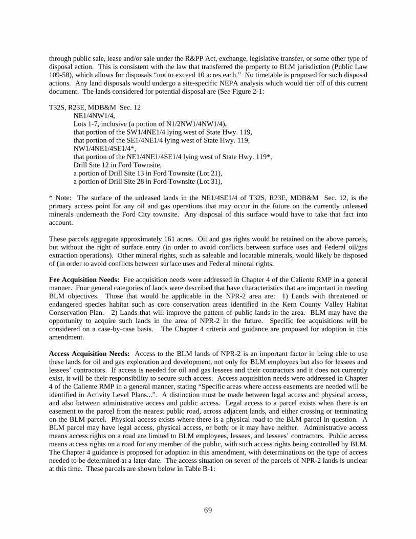
through public sale, lease and/or sale under the R&PP Act, exchange, legislative transfer, or some other type of disposal action. This is consistent with the law that transferred the property to BLM jurisdiction (Public Law 109-58), which allows for disposals “not to exceed 10 acres each.” No timetable is proposed for such disposal actions. Any land disposals would undergo a site-specific NEPA analysis which would tier off of this current document. The lands considered for potential disposal are (See Figure 2-1:
T32S, R23E, MDB&M Sec. 12 NE1/4NW1/4,
Lots 1-7, inclusive (a portion of N1/2NW1/4NW1/4), that portion of the SW1/4NE1/4 lying west of State Hwy. 119, that portion of the SE1/4NE1/4 lying west of State Hwy. 119,
NW1/4NE1/4SE1/4*, that portion of the NE1/4NE1/4SE1/4 lying west of State Hwy. 119*, Drill Site 12 in Ford Townsite, a portion of Drill Site 13 in Ford Townsite (Lot 21), a portion of Drill Site 28 in Ford Townsite (Lot 31),
* Note: The surface of the unleased lands in the NE1/4SE1/4 of T32S, R23E, MDB&M Sec. 12, is the primary access point for any oil and gas operations that may occur in the future on the currently unleased minerals underneath the Ford City townsite. Any disposal of this surface would have to take that fact into account.
These parcels aggregate approximately 161 acres. Oil and gas rights would be retained on the above parcels, but without the right of surface entry (in order to avoid conflicts between surface uses and Federal oil/gas extraction operations). Other mineral rights, such as saleable and locatable minerals, would likely be disposed of (in order to avoid conflicts between surface uses and Federal mineral rights.
Fee Acquisition Needs: Fee acquisition needs were addressed in Chapter 4 of the Caliente RMP in a general manner. Four general categories of lands were described that have characteristics that are important in meeting BLM objectives. Those that would be applicable in the NPR-2 area are: 1) Lands with threatened or endangered species habitat such as core conservation areas identified in the Kern County Valley Habitat Conservation Plan. 2) Lands that will improve the pattern of public lands in the area. BLM may have the opportunity to acquire such lands in the area of NPR-2 in the future. Specific fee acquisitions will be considered on a case-by-case basis. The Chapter 4 criteria and guidance are proposed for adoption in this amendment.
Access Acquisition Needs: Access to the BLM lands of NPR-2 is an important factor in being able to use these lands for oil and gas exploration and development, not only for BLM employees but also for lessees and lessees’ contractors. If access is needed for oil and gas lessees and their contractors and it does not currently exist, it will be their responsibility to secure such access. Access acquisition needs were addressed in Chapter 4 of the Caliente RMP in a general manner, stating “Specific areas where access easements are needed will be identified in Activity Level Plans...”. A distinction must be made between legal access and physical access, and also between administrative access and public access. Legal access to a parcel exists when there is an easement to the parcel from the nearest public road, across adjacent lands, and either crossing or terminating on the BLM parcel. Physical access exists where there is a physical road to the BLM parcel in question. A BLM parcel may have legal access, physical access, or both; or it may have neither. Administrative access means access rights on a road are limited to BLM employees, lessees, and lessees’ contractors. Public access means access rights on a road for any member of the public, with such access rights being controlled by BLM. The Chapter 4 guidance is proposed for adoption in this amendment, with determinations on the type of access needed to be determined at a later date. The access situation on seven of the parcels of NPR-2 lands is unclear at this time. These parcels are shown below in Table B-1:
69

Table B-1 Parcels with Unclear Surface Access
Township 31 South, Range 23 East, MDBM Sec. 8 S1/2 Sec. 18 Lots 1 and 2 of NW1/4, Lots 1 and 2 of SW1/4, E1/2 Sec. 20 All Sec. 22 All Sec. 26 N1/2, SE1/4 Sec. 28 All Township 32 South, Range 24 East, MDBM Sec. 2 Lots 1 and 2 of NE1/4, Lots 1 and 2 of NW1/4, SE1/4
The proposed action is to secure at least administrative access to these seven parcels if needed, unless analysis of DOE records shows administrative access to already exist.
3. Other Lands Actions:
Unauthorized Land (Realty) Uses: As unauthorized realty uses on these BLM lands are identified, BLM will notify the suspected owner(s) of the facility that their facility is suspected of being unauthorized, and the owner(s) will be given an opportunity to produce any documentation showing that the facility is authorized by the United States. BLM will make an analysis of whether it would be in the public interest to allow the facility to continue to exist. If authorization documentation is submitted to BLM, the documentation will be analyzed by BLM for authentication and adequacy. If the authorization is authentic and accurate, BLM will incorporate the authorization into its records system. If no documentation is submitted to BLM, or if inadequate documentation is submitted, BLM may require the owner(s) to submit to BLM an application for authorization of the facility, or BLM may require the owner(s) to remove the facility. Payment of processing costs, back rental, and penalty fees may be imposed by BLM. If the suspected owner(s) of the facility are unresponsive or unwilling to participate in BLM’s authorization process, BLM may issue citations for appearance by the suspected owner in the local Federal court.
New Withdrawal Areas: none proposed. The Caliente RMP states that if compensation lands are acquired over existing federal mineral estate, these lands would be proposed for withdrawal from entry under the mining laws. Federal mineral estate (all minerals) is limited to 40 acres in section 12 and 220 acres in section 18. Surface lands overlaying this mineral estate is not likely to be acquired as compensation lands as they do not have the habitat qualities necessary for acceptance as compensation lands. Thus, we do not expect any withdrawal areas to be proposed.
Withdrawal modification/revocation areas: none proposed.
Agricultural Entry Areas: Due to low productivity and/or conflicts with endangered species habitat, all BLM lands within the Resource Area are considered unsuitable for entry under the Desert Land Entry Act of March 3, 1877 (43 USC 321) and Indian Allotment Act of February 8, 1887 (25 USC 334).
Cadastral Survey Needs: Cadastral survey and monumentation of the Public Land Survey System is one of the basic prerequisites for proper land management. It will take some time to evaluate the survey status of each BLM NPR-2 parcel. If needed, dependent resurveys will be initiated by BLM. No timetable for such dependent resurveys is proposed at this time. BLM lands that are newly-recognized due to a land survey error or hiatus, mapping or records errors would be managed consistent with adjacent public lands, if any. In some cases, the newly-recognized lands may be suitable for sale or repositioning, based on site-specific circumstances.
70
Appendix C Biological Resource Management Guidelines
Introduction
The management objectives and allocations chapter of this RMP Amendment provides direction for the management of biological resources within the NPR-2 lands as they pertain to oil and gas, realty and lands related activities. Guidelines for the management of other activities such as oil and gas development have been developed so that these activities will be carried out consistent with the direction established for biological resources. Although special areas with significant biological resources were recognized in the Caliente RMP as ACEC's or SMA's, there are no such lands at NPR-2.
This section contains the specific biological resource information that will be used in conjunction with the guidelines found in other parts of this RMP. In addition, this section includes a strategy for how public lands will be managed to contribute to the conservation of San Joaquin Valley endemic species.
Conservation Strategy
A Conservation Strategy for Threatened and Endangered Species in the San Joaquin Valley
Background
Public land in the Valley Management Area, including the land at NPR-2, constitutes a high percentage of the remaining natural land in the Southern San Joaquin Valley. These natural lands provide important habitat for several federal and state listed plant and animal species, as well as many other species that are endemic to the region.
The Endangered Species Act of 1973 mandates that federal agencies, including the Bureau, carry out programs for the conservation of threatened and endangered species. Bureau policy, as stated in Bureau Manual Section 6840 and policy statements such as Fish and Wildlife 2000, further guides how Bureau lands will be managed to meet the mandate for conservation programs.
The Endangered Species Act also directs the U.S. Fish and Wildlife Service to develop Recovery Plans for threatened and endangered species. These Recovery Plans provide the strategy that all agencies and organizations can implement to ensure a coordinated and comprehensive approach to species conservation and recovery. Currently, the U.S. Fish and Wildlife Service is working on the final draft of the San Joaquin Valley Multispecies Recovery Plan.
The Multispecies Recovery Plan will provide a framework for recovery efforts within the San Joaquin Valley region. Local governments, industry, private landowners and local offices of state and federal agencies will determine how the regional framework will be implemented for their local area. Part of the concept is to develop local plans that can be applied consistently by local, state and federal governments within the local planning area. To assist with the local plan development, the U.S. Fish and Wildlife Service is cooperating with local governments to develop Habitat Conservation Plans that integrate recovery objectives with the planning activities of local, state and federal governments.
Public land in the San Joaquin Valley plays a key role in many of these local plans. This section will address how the Bureau will integrate with these emerging local plans.
71
Regional Conservation Strategy
The foundation of the regional conservation strategy is a system of reserves and connecting corridors. Through assessments of remaining natural land habitats, a reserve system concept was developed to conserve the best remaining habitats of the San Joaquin Valley natural communities. Several large keystone reserves, several small specialty reserves, and connecting corridors linking many of the reserves have been proposed. The large reserves are intended to maintain and conserve multiple plant and animal listed species as a natural community, while the small reserves are designed to conserve a particular species or unique natural feature. These reserves would be managed for long-term conservation of the listed plants and animals, and the natural communities on which they depend, but would allow for a variety of land uses managed in a compatible manner. Both large and small reserves are necessary to conserve the Valley's biological resources.
A generalized reserve system map has been developed that identifies the keystone reserves, small specialty reserves, and connecting corridors. The specific boundaries of reserves and connecting corridors will be developed during local planning efforts, such as the Valley Floor Habitat Conservation Planning project. Currently the Valley Floor Habitat Conservation Planning project identifies eight separate reserves: Interstate 5 East, Allensworth Extension, Semitropic, Goose Lake, Buttonwillow, Lokern, Buena Vista Valley and Kern Lake. There are two additional reserves located outside the Valley Floor Habitat Conservation Planning project: Cuyama Valley and Carrizo Plain.
Reserves include both large, multi-species reserves and small specialty reserves. These areas would be managed primarily for listed plants and animals. While other compatible resource uses could occur, they would be designed to maintain habitat quality and species' populations. Management of the reserves would be assured by fee acquisition, by Federal, State, or local agencies, chartered conservation organizations, conservation easements, or long-term cooperative agreements with existing landowners. Emphasis is to maintain a certain percentage of the native lands as high quality habitat and rehabilitate non-native lands as they become available for purchase, easement, or agreement. A threshold for habitat disturbance from energy mineral development, roads and existing facilities would be established. Reserves and connecting corridors would have different thresholds for habitat disturbance. Compensation of new habitat disturbance within the threshold would be at a standard rate for uses that are considered permanent habitat loss and at another standard rate for temporary habitat loss.
Connecting corridors are comprised of native lands and agricultural lands to be managed for maintaining interchange and gene flow between the primary reserves and for maintaining supplemental populations between reserves. Emphasis is to maintain a certain percentage of native lands as moderate to high quality habitat, and maintain a certain percentage of the agricultural lands in agricultural production or fallow. A certain percentage of these lands would be available for urban, industrial or other land uses that are considered permanent habitat loss. Land would be designed to maintain corridor integrity as extant habitat and for movements. Corridors would not be severed by permanent habitat loss from urban-industrial uses. All habitat loss would be compensated at a standard rate and compensation would be directed to the reserve areas. Currently the compensation rate is 3:1 for permanent habitat loss and 1.1:1 for temporary loss,. Compensation could also be directed back to the corridor on a limited basis. Corridors would not normally be acquired by purchase, but would be subject to conservation easements and agreements. However, some parcels essential to maintain corridors or buffers may need to be purchased.
On native lands outside the reserve and corridor system, there will not be an emphasis on management for the retention of habitat values. Most of these lands have some habitat value and many of these areas may be valuable sources of plant and animal populations in the short-term. Most of these values will continue to exist unless there are dramatic changes in current land uses.
72

Bureau Conservation Program
At the present time, the U.S. Fish and Wildlife Service is working on the final draft of the San Joaquin Valley Multispecies Recovery Plan. Several local Habitat Conservation Plans are also being developed. As these plans are finalized, the specific nomenclature and boundaries of the Bureau conservation program will be refined to match the final Multispecies Recovery Plan and local Habitat Conservation Plans. The Bureau will continue to be actively involved in the Multispecies Recovery Plan effort and local Habitat Conservation Plan efforts. Management at NPR-2 would be consistent with the surrounding areas.
The foundation of the regional conservation strategy is a system of reserves and corridors. Five of the reserve areas identified in the regional conservation strategy contain public lands addressed in this Resource Management Plan (Carrizo, Goose Lake, Lokern, Cuyama Valley and Buena Vista Valley). Public lands in three of these areas are proposed for designation as Areas of Critical Environmental Concern (Carrizo, Goose Lake, Lokern). The public lands in these five areas will be managed for the long-term conservation of the listed plants and animals and the natural communities on which they depend, while still allowing for a variety of land uses managed in a compatible manner.
A majority of the remaining public lands within the Valley Management Area has been identified in the regional conservation strategy as connecting corridors. Public lands in these areas would be managed to maintain linkages between reserve areas. Management at NPR-2 would be fully consistent with these goals.
Public lands within the Valley Management Area specifically excluded from the reserve and corridor system include lands near Freeborn Mountain, San Emigdio, Ventucopa, the upper elevations of the Caliente Range, Taylor Canyon, and the oil production areas from Lost Hills and McKittrick south through Taft and Maricopa. Some of these areas will be addressed in local Habitat Conservation Plans that are currently being developed.
Meeting the Public Need
One goal of the Bureau conservation strategy is to dedicate or reposition public holdings to meet San Joaquin Valley conservation needs so that private lands will have fewer restrictions placed on them. Not only can the Bureau dedicate management of existing holdings to promote recovery and conservation, but also the Bureau can reposition some land holdings to better suit private development and better serve public conservation efforts. For example, within the Kern Valley Floor Habitat Conservation Plan Area, the Bureau will manage all public lands within reserves and corridors as conserved lands. These conserved lands will be managed consistent with other conserved lands to promote conservation and recovery. By managing the public lands as conserved lands, it minimizes the amount of private lands that would otherwise need to be identified to meet the goals of the Kern Valley Floor Habitat Conservation Plan.
The Bureau also intends to maintain options for efficient application processing, such as preapproved permitting with the U.S. Fish and Wildlife Service (programmatic biological opinions) and the use of local Habitat Conservation Plans. Several programmatic biological opinions have been completed, including one for oil and gas activities in Kern and Kings Counties that would likely be used extensively for activities occurring at NPR-2.
73

Appendix D Air Quality/Affected Environment
The project area is located in the San Joaquin Valley (SJV) Air Basin in western Kern County, California crossing into the southern boundary of the Western Kern County Oil Fields Air Quality area. Regulatory oversight authority for air quality matters rests at the local level with the San Joaquin Valley Air Pollution Control District (SJVAPCD), at the state level with the California Air Resources Board (CARB) and at the federal level with the U.S. Environmental Protection Agency (EPA), Region IX.
The federal CAA (Clean Air Act) and the state California Clean Air Act contain the primary provisions relating to air quality. Among the most important provisions are the sections relating to the establishment of the National and State Ambient Air Quality Standards, nonattainment areas, the development of SIPs (state implementation plans), Prevention of Significant deterioration (PSD), Air Toxics and federal conformity. Rules have been issued by the EPA (40 CFR) to implement the CAA. The main parts of 40 CFR are part 50 which deals with the National Ambient Air Quality Standards (NAAQS), part 51 which deals with implementation (State Implementation Plans (SIPs) part 58 which deals with monitoring and part 93 which covers federal conformity.
Air pollution generally refers to additional chemical compounds, gases and particulates that may have been added to the air. The source of these pollutants can be from Vegetation sources (biogenic), geological (geogenic), or man caused (anthropogenic). Pollution can also be classified as to the category of the source of the emissions. The two major categories of emissions are mobile sources and stationary sources. Mobile sources include on-road automobiles and trucks, off highway vehicles, aircraft, trains, construction equipment and recreational vehicles. Stationary sources include point sources such as large stack emissions from industrial sources and power generation and area sources which represent an accumulation of many small point sources spread over a larger area.
The federal and state Clean Air Acts regulate certain forms of pollution under three main categories. These are criteria pollutants, air toxics and global warming and ozone-depleting gases. There is also regulation of a more general category of emissions that reduce visibility. These come under the titles of regional haze, prevention of significant deterioration (PSD) and visibility reducing particulates (VRP).
The definitions used in determining whether or not an area meets air quality standards are found in the federal and state Clean Air Acts and their associated ambient air quality standards. Criteria pollutants are defined as those pollutants for which the federal and state government have established ambient air quality standards, or criteria, for concentrations in order to protect public health. The federal National Ambient Air Quality Standards (NAAQS) include both primary and secondary standards for several “criteria pollutants.” The primary standards are designed to protect human health with an adequate margin of safety. The secondary standards are designed to protect property and ecosystems from effects of air pollution. Ambient air is that air that is accessible to the general public. It may not include areas inside fenced industrial areas, or buildings (like factories). Under the federal Clean Air Act, (NAAQS) are established by the Environmental Protection Administration (EPA). National Ambient Air Quality Standards have been developed for seven criteria pollutants (ozone, respirable particulate matter (PM10), fine particulate matter (PM2.5), carbon monoxide, nitrogen dioxide, lead and sulfur dioxide). These standards are used to classify all areas as to whether they are in attainment, in nonattainment or are unclassified for any of the NAAQS. California has established California Ambient Air Quality Standards for the same federal criteria pollutants plus an additional 3 pollutants (visibility reducing particulates, sulfates and hydrogen sulfide). The Ambient Air Quality Standards for California are stricter than the federal standards.
Areas that are classified as nonattainment areas by the EPA are required to prepare and implement a State Implementation Plan (SIP) that identifies and quantifies sources of emissions and presents a comprehensive strategy to control and reduce locally generated emissions. The SIP also includes an attainment demonstration
74

which shows (generally through modeling) that the proposed combination of existing sources and the proposed actions will result in meeting attainment by the prescribed deadline. SIPs for areas that have been designated as "moderate" must contain "reasonably available control measures" (RACM) or "reasonably available control technology" (RACT) to be implemented, unless their effect on a source is insignificant. In addition, the EPA mandates the application of RACMs to existing sources. The SIP must justify the non-inclusion of RACMs not selected. Serious nonattainment areas are required to apply best available control measures (BACM) or best available control technology (BACT).
Federal ambient air quality standards have been established for particulate matter less than 10 microns in diameter (PM10), particulate matter less than 2.5 microns in diameter (PM 2.5) nitrogen dioxide (NO2), sulfur dioxide (SO2), lead (Pb), carbon monoxide (CO), and ozone (O3). The CARB has established state AAQS, which in some cases are more stringent than the federal AAQS. The EPA and CARB determine the air quality attainment status of designated areas by comparing local ambient air quality measurements from the state or local ambient air monitoring stations with the federal and state AAQS. These attainment designations are determined on a pollutant-by-pollutant basis. The western portions of Kern County have been designated as a federal and state non-attainment area for O3, PM10 and PM2.5 and are unclassifiable or have no designation for all other criteria pollutants. Consistent with federal requirements, an unclassifiable designation is treated the same as an attainment designation. Therefore, both CARB and EPA consider the western portion of Kern County as in attainment for CO, NO2, SO2 and Pb. Table D-1 presents the federal and state attainment status for the western portion of Kern County.
The San Joaquin Valley currently has an “extreme” non-attainment air quality designation for the one hour ozone standard, serious non-attainment for the eight hour ozone standard, serious non-attainment for PM10 and nonattainment for PM2.5. The regulations and designations for PM2.5 and the 8-hour ozone standard are new with the PM2.5 designation occurring in 2005. Attainment defines the status of a given air shed with regard to NAAQS requirements. Air sheds not meeting these standards are classified as “nonattainment.” The year in which the attainment is projected to be reached determines the nonattainment classification (i.e., serious, severe, and extreme). Each specific classification has defined time periods for reaching attainment and various sanctions for failure to make progress.
Table D-1 Federal and State Attainment Status for Western Kern County
Pollutant Federal Attainment Status State Attainment Status Ozone – 1 hour Nonattainment/Extreme Nonattainment/Severe Ozone – 8 hour Nonattainment/Serious None
CO Unclassifiable (Attainment) Attainment NO2 Unclassifiable (Attainment) Attainment SO2 Unclassifiable (Attainment) Attainment
24 hour PM10 Nonattainment/Serious Nonattainment 24 hour PM2.5 Nonattainment Nonattainment
Lead No Designation Attainment
Respirable particulate matter, PM10, emissions are comprised of particulate material below 10μ in diameter. PM10 is a mixture of substances including elemental carbon, lead and nickel; compounds such as nitrates, organics and sulfates; and complex mixtures such as diesel exhaust and soil. Ambient PM10 in the air is from two sources. It is considered direct emissions when particles are emitted directly from the source. PM10 precursor emissions are emitted as gases and form into particles in the atmosphere down wind from the source. PM10 in the atmosphere can be caused by both environmental factors and human activities. Human activities that contribute to the PM10 emissions include combustion sources such as stack emissions, diesel exhaust and smoke from prescribed fire and wild fire, fugitive dust sources such as construction and demolition activities, off highway vehicle (OHV) travel, unpaved public roads and parking lots and industrial activities,. The combustion sources tend to produce smaller particulates (less than 5 μ ) while fugitive sources tend to produce
75

larger particulates (larger than 5μ )
One of the reasons for the concern with PM10 emissions is their adverse effect on human health. All of the PM10 particles are considered Respirable Particulate because they can be inhaled into the nose, throat and/or lungs. The fine PM10 particles are the largest threat to health because they tend to deposit in the air sacks. In addition, many of the fine particles are from precursor emissions many of which are toxic or carcinogenic. Fugitive dust is primarily coarse particulate that is not as likely to contain toxic materials. The newest studies report that a 100 μ gm/m3 increase in daily PM10 concentrations would increase mortality by 10%. The state PM10 standards are considered public health goals.
The USEPA has established new NAAQS standards for PM2.5 emissions. These standards are for particles at or below 2.5 μ. These fine particles have been implicated as an increased health risk and consist of chemical compounds that mostly result from combustion processes. PM2.5 is a regional rather than a hotspot type of pollutant. The primary source of PM2.5 in the atmosphere is combustion products and is likely be found in the same areas as ozone. It forms from both direct sources and secondarily from the chemical transform of precursor emissions in the atmosphere. Many of the precursor emissions are also from combustion sources. Some of these precursor emissions include SO2 and NOx. The USEPA estimates that secondary PM2.5 accounts for 50% of the ambient PM2.5 in many areas. Characterization work by the USEPA and others have developed an understanding of the sources of PM2.5 for a number of areas. Work done by Heloemmen and others (in USEPA 1997) in Phoenix, Arizona found that 57% of the PM2.5 was from direct combustion sources. They also found that unpaved road travel accounted for 1% of the emissions. Work by the Desert Research Institute in the San Joaquin Valley found that unpaved roads accounted for <1% of the PM2.5 and that soil accounted for around 7% of the PM2.5. They found that most of the soil PM2.5 came from construction and agricultural fields. Major sources for PM2.5 are diesel engines, power plants, boilers and such (USEAP 1997). Control strategies for PM2.5 have targeted diesel engines which are now being regulated and which are targeted in new South Coast Air Quality Management District proposals (Gladstein 2003). PM2.5 emissions from BLM lands are likely to be very small and have very little impact on any possible attainment/nonattainment designations. The projections from air regulators indicate a reduction in PM2.5 levels as the regulations take effect and the required technology advances are implemented. Any areas that are classified as non attainment areas by the USEPA would have to reduce the ambient PM2.5 levels.
Ozone (O3) is one of a number of substances called photochemical oxidants. It is formed in the atmosphere as a result of the action of ultraviolet sunlight on certain chemicals in the atmosphere. These chemicals are referred to as precursor emissions and include nitrogen oxides (NOx), and reactive organic gas (ROG)(sometimes called volatile organic compounds (VOC)). The ozone forms down wind from the precursor source during the daylight hours. The reaction is accelerated by increased sunlight intensity and temperature. As a result, the maximum Ozone levels are generally reached in the late afternoon during the warmer times of the year. Ozone occurs in two layers in the atmosphere. The layer immediately surrounding the earth’s surface is called the troposphere. The troposphere extends up about 10 miles and it is here that ground level ozone (“bad ozone”) is a pollutant that damages human health, vegetation and many common materials. The stratosphere extends up from about 10 to 30 miles and ozone here is considered “good” because it protects life from harmful ultraviolet rays.
The classification of an area as a federal nonattainment area brings an additional requirement for federal agencies. Section 176(c) of the Clean Air Act (CAA), as amended (42 U.S.C. 7401 et seq.) and regulations under 40 CFR, part 93,subpart W, state that "no department, agency or instrumentality of the Federal Government shall engage in, support in any way or provide financial assistance for, license or permit, or approve any activity which does not conform to an applicable implementation plan." This means that under the CAA 176(c) and 40 CFR, part 93, subpart W, (conformity rules), federal agencies must make a determination that proposed actions in federal nonattainment areas conform to the applicable implementation plan (SIP) before the action is taken.
Significance thresholds have been established for air quality issues. These can be summarized as follows:
76

1.Generates total emissions (direct and indirect) that exceed deminimus thresholds, 2.Generates a violation of any ambient air quality standard when added to the local background; and/or, 3.Does not conform with the applicable attainment or maintenance plan(s); and/or, 4.Exposes sensitive receptors to substantial pollutant concentrations, including those resulting in a cancer risk greater than or equal to 1 in a million and/or a Hazard Index (HI) (non-cancerous) greater than or equal to 0.1.
77

__
______________________________ ____________________________
______________________________ ____________________________
Finding of No Significant Impact
EA NO.: CA-160-06-067
STATE: California OFFICE: Bakersfield Field Office PROJECT: Amendment to Caliente RMP to Provide for management of lands by BLM on newly transferred lands at the Naval Petroleum Reserve Number 2 (NPR-2)
1. ENVIRONMENTAL COMPLIANCE
We have reviewed the environmental document, which analyzes the environmental effects of the proposed action, and have determined that the proposed action and recommended mitigation measures result in a finding of no significant impact on the human environment. We find that proper consideration has been given to all resource values and that this assessment is technically adequate. Therefore, an environmental impact statement is not required to further analyze the environmental effects of the proposed action.
Reviewed By:
Project Lead, Bakersfield F.O. Date
AFM-Resources, Bakersfield F.O. Date
AFM-Minerals, Bakersfield F.O. Date
Bakersfield F.O. Manager Date
2. DECISION
I have reviewed the recommendations on the proposed action addressed in this environmental assessment. I find this action to be in conformance with applicable land use plans, that it effectively serves the public, and that it will not cause unnecessary or undue degradation. It is therefore my decision to approve the proposed action, subject to the mitigation measures identified for the proposed action in the Environmental Assessment. The Decision Record incorporates the mitigation measures and recommendations into the proposed action as the decision of the Bureau on this matter.
Approved By:
California State Director Date
78

PROTEST RIGHTS
Any person who participated in the planning process and has an interest which is or may be adversely affected by the approval or amendment of a resource management plan may protest such approval or amendment. A protest may raise only those issues which were submitted for the record during the planning process.
(1) The protest shall be in writing and shall be filed with the Director at the following address:
Director (attention: Protest Coordinator) Box 66538 Washington, DC 20035 (for regular mail) or Director (attention: Protest Coordinator) 1620 L Street, N.W., Suite 1075 Washington, DC 20036 (for overnight mail.)
For an amendment not requiring the preparation of an environmental impact statement, such as this, the protest shall be filed within 30 days of the publication of the notice of its effective date.
(2) The protest shall contain: (i) The name, mailing address, telephone number and interest of the person filing the protest; (ii) A statement of the issue or issues being protested;
(iii) A statement of the part or parts of the plan or amendment being protested; (iv) A copy of all documents addressing the issue or issues that were submitted during the planning process
by the protesting party or an indication of the date the issue or issues were discussed for the record; and (v) A concise statement explaining why the State Director's decision is believed to be wrong.
79