bahamas first national communication - climate …unfccc.int/resource/docs/natc/bahnc1.pdfforeword 3...
TRANSCRIPT
First National Communication on Climate Change
Submitted to the Secretariat of the United Nations Framework Convention on Climate Change
for Presentation to the Conference of Parties
COMMONWEALTH OF THE BAHAMAS
The Bahamas Environment, Science and Technology Commission
Nassau, New Providence, The Bahamas
April 2001

Foreword 3
Preface 4
Map of The Commonwealth of The Bahamas 5
Chapter 1NATIONAL CIRCUMSTANCES AND BACKGROUND 6
1.1 Geography, Geology and Population 61.1.1 Location 61.1.2 Geology 71.1.3 Hydrogeology 81.1.4 Population 9
1.2 Climate 101.2.1 Weather conditions 101.2.2 Tropical storms and hurricanes 12
1.3 History and Government 151.3.1 History 151.3.2 National government 161.3.3 Local government 17
1.4 Economy 171.4.1 Introduction 171.4.2 Tourism 181.4.3 Banking and Finance 191.4.4 Ship Registry 191.4.5 Fisheries 201.4.6 Agriculture 211.4.7 Industry 22
1.5 Energy production and transport 221.6 The Environment 23
1.6.1 Introduction 231.6.2 The BEST Commission 241.6.3 Biodiversity 26
1.7 Land use, land use changesand forestry 28
1.8 National circumstances and summary tables 30
Chapter 2NATIONAL INVENTORY OF GREENHOUSE GASES 33
2.1 Introduction 332.2 Inventory process 332.3 Emissions of greenhouse gases 37
2.3.1 Energy sector 372.3.2 Fugutive emissions 382.3.3 Emissions from International
bunkering 392.3.4 Agriculture 392.3.5 Liquid and solid waste 402.3.6 Land use changes and forestry 41
Chapter 3VULNERABILITY AND ADAPTATION: AN INITIAL ASSESSMENT 43
3.1 Introduction 433.2 Climate and sea level scenarios 43
3.3 Vulnerable sectors 443.3.1 Introduction 443.3.2 Tourism 463.3.3 Water resources 473.3.4 Coral reefs 473.3.5 Agriculture 48
3.4 Assessment of expected impacts 493.4.1 Introduction 493.4.2 Hurricanes 493.4.3 Non-tropical processes 50
3.5 Moving towards adaptation in The Bahamas 523.6 Gaps in research and information needs 55
3.6.1 Introduction 553.6.2 Research and information needs 56
Chapter 4SYSTEMATIC OBSERVATIONS AND CAPACITY BUILDING 58
4.1 Systematic Observations and Research 584.1.1 Introduction 584.1.2 Systematic observations 584.1.3 Research activities 60
4.1.3.1 Regional research 614.1.3.2 El Nino 614.1.3.3 Climate change investigations 614.1.3.4 Vulnerability 62
4.2 Capacity Building 634.2.1 Introduction 634.2.2 CPAAC capacity building 644.2.3 Climate change awareness 66
4.3 Conclusions 67
Chapter 5POLICIES AND MEASURES 68
5.1 Introduction 685.2 Policies and measures 685.3 Sustainable development 705.4 Measure to respond to climate change 75
5.4.1 Introduction 755.4.2 Policies and measures for reduction
of GHG emissions 765.4.2.1 Energy and local transport 765.4.2.2 International transport 80
5.4.3 Carbon sequestration 805.4.3.1 Marine sequestration 805.4.3.2 Forestry 82
5.4.4 Financial implications 84
Chapter 6RECOMMENDATIONS 85
Definitions and abbreviations 89
Annex 1NATIONAL CLIMATE CHANGE COMMITTEE 90
Annex 2ACKNOWLEDGEMENTS 91
Annex 3LIST OF SCIENTIFIC NAMES 92
References 96
CONTENTS Page

THE BAHAMAS ENVIRONMENT ,SCIENCE ANDTECHNOLOGY COMMISSION
Ministry of Agriculture and Fisheries
3
April, 2001
FOREWORD
The Commonwealth of The Bahamas has a long history of environmental concern. This concern is reflected in the application of the "Precautionary Principal" to environment matters. In the early 1950s, legislation was enactedto protect wild birds and animals, and in 1959 The Bahamas National Trust Act (BNT) was passed. This Act, among other things, established the Bahamas National Trust, a land and sea park in the Exuma Cays, and laid thegroundwork for the present national park system in the country. There are now twelve recognized national parksadministered by The Bahamas National Trust. The Inagua National Park was established in 1965, under the BNTAct and this proved instrumental in saving the West Indian flamingo from the almost certain extinction predicted byCharles Cory in 1880. These were small beginnings, but in the 1950s no one could have predicted the environmen-tal concerns that now face mankind.
The Government of the Bahamas, in undertaking a legislative strengthening programme to protect, conserve andpreserve the natural resources of The Bahamas. In this regard the following Acts and supporting regulations are indraft form:
• A new Fisheries Act,• A Marine Mammal Act and Regulations,• Legislation to control the use of Pesticides,• An Environmental Impact Assessment (EIA) Act and related Regulations, and,• A Pollution Control and Waste Management Regulations.
Further, Government has implemented the requirement, that large-scale developments in the Bahamas undergo arigorous Environmental Impact Assessment (EIA) process and has implemented measures to protect the physicallandscape and certain indigenous trees of The Bahamas through legislative action.
The Bahamas, like many other small island states, is particularly vulnerable to climate change and the myriad problems associated with it. The natural resource base of The Bahamas is limited, the economy relying on tourismand services. In addition to potential damage to a fragile economy, climate change, increased climate variabilityand the sea level rise will also impact on the amount of land available for human habitation and agriculture, ground-water resources, supplies and the quality of groundwater resources, and vegetation. Because climate change is aglobal problem,it must be addressed globally.
Government accepts that marine reserves hold significant potential for protecting diverse and integrated ecosys-tems, keystone species, research and monitoring sites, for the protection of spawning stocks, and for providing abasis for recruitment of species to wider areas. In this regard the government has embarked on establishing anetwork of marine protected areas. The goal is to establish some 20% of marine areas of The Bahamas as "no
take" reserves. The first five of such areas a have been approved in principal and efforts are under way to defineand inventory the areas and to develop and implement the appropriate management plans. Efforts are also underway to expand the national park system. These initiatives also will benefit the worlds’ climate system and improvethe ability of The Bahamas and the Bahamian natural ecosystems to adapt to climate change, increased climatevariability and rising sea levels.
Government is equally convinced that action already taken within its borders represent only the first of many stepsthat all Parties to the United Nations Framework Convention on Climate Change (UNFCCC) must undertake toaddress this global problem. Technical and financial resources have been committed nationally and The Bahamaslooks forward to a similar commitment by the international community to assist itin this process.
I am pleased to present the First National Communication on Climate Change of the Commonwealth of TheBahamas to the United Nations Framework Convention on Climate Change Secretariat for submission to theConference of Parties.
James F. Knowles, M.P., Minister of Agriculture and Fisheries.

in most of the Family Islands, where many of the inhabitants are
either fishermen, or farmers, or both. Any significant change in
climate patterns and mean sea level would cause a drastic
change in their life styles. The fact that The Bahamas is not rich
in natural resources will accentuate the problems faced by these
people, because there is no other means of employment, other
than agriculture and fishing, in these islands. Tourism is the
main economic activity in The Bahamas but is concentrated on
New Providence and Paradise Island, in Grand Bahama, Abaco
and a few other islands in the northern part of the archipelago.
Climate change would have a devastating effect on tourism in
the short-term in the form of damaged beaches and resorts.
The Government of The Bahamas recognizes that future
development of the Bahamian people will depend on the
responsible economic exploitation of the natural and man-made
resources available in the country. This recognition, however, is
tempered by the government’s effort to eliminate poverty, the
ever-increasing demands for employment from the overwhelm-
ingly youthful population, and pressure for more and better
government services. The Government of The Bahamas is
faced with the dilemma, as perhaps are many other govern-
ments, of how to divert scarce economic and human resources
from immediately pressing needs, to the more long-term impacts
of climate change.
4
The Bahamas has a long history of scientific observation and
study. Christopher Columbus wrote about the plants and
animals as he sailed through the islands in 1492. Various
travelers have written of their sojourns in The Bahamas, but the
most significant early account is that of Mark Catesby, a British
naturalist who spent nine months in The Bahamas in 1725. His
work, The Natural History of Carolina, Florida and The Bahama
Islands, provides a relatively comprehensive account of the
natural resources of the islands. Sadly, several species
described by Catesby are now either extinct (the West Indian
Monk Seal) or no longer occur in The Bahamas (the American
crocodile, the Scarlet Ibis and the West Indian Manatee).
There have also been several studies of the geology of the
islands and scientists continue to be attracted by the bird life,
the mangrove swamps, the iguanas, and the blue holes.
Climate Change has been called the "most pervasive and truly
global of all issues affecting humanity." The world is now
concerned, with increasing belief and apprehension, that the
pattern of the global climate is being altered by man’s own
actions. The most crucial environmental issues of the next
few decades will be those relating to the earth’s atmosphere.
During the 1980’s, the accumulation of scientific evidence led to
increasing concern with the potential consequences of climate
change. By 1990, a series of international conferences had
issued urgent calls for a global treaty to address the problem of
climate change. The Commonwealth of The Bahamas signed
the United Nations Framework Convention on Climate Change
(UNFCCC) on June 12 1992, and ratified it on September 2
1994.
When considering climate change as it relates to The Bahamas
it is important to note that the country is an archipelago of small
islands, most of them uninhabited, and that more than 80% of
the land surface is only a meter or less above mean sea level.
The natural resources of the country are very limited. The
economy is built on tourism and services . Bahamians, like
other island peoples, have historically had a close personal
relationship with the land and the sea. Until the advent of mod-
ern tourism and banking industries, most Bahamians relied on
the resources of both land and sea for survival. This is still true
Photography: courtesy of Devin Weech
PREFACE

5
Map: coutresy of The Department of Lands and Surveys

FOREWORD 3
PREFACE 4
CHAPTER 1NATIONAL CIRCUMSTANCES AND BACKGROUND 5
Location and population 5Climate and weather 5History and government 5Constitution 5Local Government. 5Economy 6Environment 6Land use and forestry 6
CHAPTER 2NATIONAL INVENTORY OF GREENHOUSE GASES 8
Introduction 8Inventory process 8Emissions of greenhouse gases 8Agriculture, forestry and land use 9
CHAPTER 3INITIAL VULNERABILITY AND ADAPTATION ASSESSMENT 10
Vulnerability 10Vulnerability and adaptation assessment 10Tourism 10Health 10Water resources 10Agriculture 10Fisheries and biodiversity 10Natural disasters: hurricanes 10Natural disasters: non-tropical 11Adaptations options 11Initial V&A 11Gaps in research and information needs 11
CONTENTS EXECUTIVE SUMMARY
CHAPTER 4SYSTEMATIC OBSERVATIONS AND CAPACITY BUILDING 12
Weather Observations 12Marine and oceanographic observations 12Research on climate change 12Storm surges 12CPACC components 13Climate change awareness 13
CHAPTER 5POLICIES AND MEASURES 14
Mitigation 14Capacity building 14Policy and measures 14Sustainable development 14Marine Protection 14Preservation of the physicallandscape 14The BEST Commission 14 Measures to respond to climate change 15Policies and measures forGHG reductions 15Carbon sequestration 15Financial implications 15
CHAPTER 6RECOMMENDATIONS 16
DEFINITIONS AND ABBEVIATIONS 17
Annex 1NATIONAL CLIMATE CHANGE COMMITTEE 18
Annex 2ACKNOWLEDGEMENTS 19
Annex 3LIST OF SCIENTIFIC NAMESREFERRED TO IN THE TEXT 20
REFERENCES 21

The Executive Summary of The Bahamas First National Communications (FNC) to the United Nations Framework Convention on Climate Change (UNFCCC) is contained herein.
Note to readers:
Photos provided as a courtesy by various individuals. Their use, without permission, isnot permitted.
Annex 3 (List of Scientific Names Referred to in the Text) and References areprovided in English only.

FOREWORD
THE BAHAMAS ENVIRONMENT, SCIENCE ANDTECHNOLOGY COMMISSION
Ministry of Agriculture and Fisheries
April, 2001
The Commonwealth of The Bahamas has a long history of environmental concern. This concern is reflected in the applicationof the "Precautionary Principal" to environment matters. In the early 1950s, legislation was enacted to protect wild birds andanimals, and in 1959 The Bahamas National Trust Act (BNT) was passed. This Act, among other things, established theBahamas National Trust, a land and sea park in the Exuma Cays, and laid the groundwork for the present national park system in the country. There are now twelve recognized national parks administered by The Bahamas National Trust. TheInagua National Park was established in 1965, under the BNT Act and this proved instrumental in saving the West Indianflamingo from the almost certain extinction predicted by Charles Cory in 1880. These were small beginnings, but in the1950s no one could have predicted the environmental concerns that now face mankind.
The Government of the Bahamas, in undertaking a legislative strengthening programme to protect, conserve and preserve thenatural resources of The Bahamas. In this regard the following Acts and supporting regulations are in draft form:
• A new Fisheries Act,• A Marine Mammal Act and Regulations,• Legislation to control the use of Pesticides,• An Environmental Impact Assessment (EIA) Act and related Regulations, and,• A Pollution Control and Waste Management Regulations.
Further, Government has implemented the requirement, that large-scale developments in The Bahamas undergo a rigorousEnvironmental Impact Assessment (EIA) process and has implemented measures to protect the physical landscape and certainindigenous trees of The Bahamas through legislative action.
The Bahamas, like many other small island states, is particularly vulnerable to climate change and the myriad problems associated with it. The natural resource base of The Bahamas is limited, the economy relying on tourism and services. Inaddition to potential damage to a fragile economy, climate change, increased climate variability and the sea level rise will also impact on the amount of land available for human habitation and agriculture, groundwater resources, supplies and thequality of groundwater resources, and vegetation. Because climate change is a global problem, it must be addressed globally.
Government accepts that marine reserves hold significant potential for protecting diverse and integrated ecosystems, keystonespecies, research and monitoring sites, for the protection of spawning stocks, and for providing a basis for recruitment of species to wider areas. In this regard the government has embarked on establishing a network of marine protected areas. The goal is to establish some 20% of marine areas of The Bahamas as "no take" reserves. The first five of such areas a havebeen approved in principal and efforts are under way to define and inventory the areas and to develop and implement theappropriate management plans. Efforts are also under way to expand the national park system. These initiatives also willbenefit the worlds’ climate system and improve the ability of The Bahamas and the Bahamian natural ecosystems to adapt toclimate change, increased climate variability and rising sea levels.
Government is equally convinced that action already taken within its borders represent only the first of many steps that allParties to the United Nations Framework Convention on Climate Change (UNFCCC) must undertake to address this globalproblem. Technical and financial resources have been committed nationally and The Bahamas looks forward to a similarcommitment by the international community to assist it in this process.
I am pleased to present the First National Communication on Climate Change of the Commonwealth of The Bahamas to theUnited Nations Framework Convention on Climate Change Secretariat for submission to the Conference of Parties.
James F. Knowles, M.P., Minister of Agriculture and Fisheries.

The Bahamas has a long history of scientific observationand study. Christopher Columbus wrote about the plantsand animals as he sailed through the islands in 1492.Various travelers have written of their sojourns in TheBahamas, but the most significant early account is that ofMark Catesby, a British naturalist who spent nine monthsin The Bahamas in 1725. His work, The Natural Historyof Carolina, Florida and the Bahama Islands, provides a relatively comprehensive account of the natural resourcesof the islands. Sadly, several species described by Catesbyare now either extinct (the West Indian Monk Seal) or nolonger occur in The Bahamas (the American crocodile, theScarlet Ibis and the West Indian Manatee). There have also been several studies of the geology of the islands and scientists continue to be attracted by the bird life, the mangrove swamps, the iguanas, and the blue holes.
Climate Change has been called the "most pervasive andtruly global of all issues affecting humanity." The world is now concerned, with increasing belief and apprehension,that the pattern of the global climate is being altered byman’s own actions. The most crucial environmental issuesof the next few decades will be those relating to the earth’satmosphere. During the 1980’s, the accumulation of scientific evidence led to increasing concern with the potential consequences of climate change. By 1990, aseries of international conferences had issued urgent calls for a global treaty to address the problem of climatechange. The Commonwealth of The Bahamas signed the United Nations Framework Convention on ClimateChange (UNFCCC) on June 12 1992, and ratified it onSeptember 2 1994.
When considering climate change as it relates to TheBahamas it is important to note that the country is anarchipelago of small islands, most of them uninhabited,and that more than 80% of the land surface is only ameter or less above mean sea level. The natural resourcesof the country are very limited. The economy is built ontourism and services.Bahamians, like other island peoples,have historically had a close personal relationship with theland and the sea. Until the advent of modern tourism andbanking industries, most Bahamians relied on the resourcesof both land and sea for survival. This is still true in most of the Family Islands, where many of the inhabitants areeither fishermen, or farmers, or both. Any significantchange in climate patterns and mean sea level would cause a drastic change in their life styles. The fact that TheBahamas is not rich in natural resources will accentuate theproblems faced by these people, because there is no othermeans of employment, other than agriculture and fishing,in these islands. Tourism is the main economic activity inThe Bahamas but is concentrated on New Providence andParadise Island, in Grand Bahama, Abaco and a few otherislands in the northern part of the archipelago. Climate
change would have a devastating effect on tourism in theshort-term in the form of damaged beaches and resorts.
The Government of The Bahamas recognizes that futuredevelopment of the Bahamian people will depend on theresponsible economic exploitation of the natural and man-made resources available in the country. This recognition, however, is tempered by the government’seffort to eliminate poverty, the ever-increasing demands for employment from the overwhelmingly youthful population,and pressure for more and better government services. TheGovernment of The Bahamas is faced with the dilemma, as perhaps are many other governments, of how to divertscarce economic and human resources from immediatelypressing needs to the more long-term impacts of climatechange.
Photography: courtesy of Philip Weech
PREFACE

CHAPTER 1
NATIONAL CIRCUMSTANCES AND BACKGROUND
Location and populationThe Commonwealth of The Bahamas comprises an archipelago of over 700 islands plus more than 200 cays,islets and rocks, spread over approximately 100,000 mi2
(260,000 km2) of the Atlantic Ocean. The Bahamas lieseast of Florida (U.S.A.), and extends about 750 mi (1,200km) southeastwards to within 50 mi (81 km) of Cuba andHaiti. Total land area is approximately 5,380 mi2 (13,934km2). The islands have low relief and the highest point isonly 206 ft (63 m) above mean sea level, in Cat Island.The potable freshwater resources of The Bahamas occur as three-dimensional lenses in the rock, overlying brackishand saline waters and most within five feet of the land sur-face. The 1990 census gave a total of 254,685 persons,with a growth rate of 1.9% per annum since 1980. Theprojection for 1997 was 288,862, and for 2000, 303,069.Some 60% of the population was under thirty years of age.Over 80% of the population resides on two islands: NewProvidence (where the capital, Nassau is located), andGrand Bahama.
Climate and weatherThe climate of The Bahamas is sub-tropical with fairlyhigh mean temperatures and moderate rainfall. Meanannual rainfall varies from about 58 in (1470 mm) toabout 34 in (865 mm). Mean daily temperatures fluctuatebetween 63°F and 90F (17°C and 32°C) with May toOctober considered the summer months. These are alsothe wetter months. Hurricanes are regular occurrences inThe Bahamas during the Atlantic hurricane season (June 1to November 30). Hurricane Andrew damaged severalislands in 1992, and Floyd struck The Bahamas in
September 1999, leaving major damage on a number ofislands. Tropical storms and hurricanes occur most frequently in September, October, August and November,in that order. Storm surges may cause serious flooding.
History and governmentThe island of San Salvador is generally accepted as the sitewhere Columbus landed in 1492. The islands remaineduninhabited until the 1640’s, when Englishmen fromBermuda settled some of the islands with their Africanslaves. American Loyalists formed a second wave of set-tlers. There was prosperity during the American Civil Warand during that time the first hotel in the Bahama Islandswas opened.
Constitution A new constitution, adopted in 1964, led to internal self-government, after centuries of British rule. Majorityrule came in 1967, and independence on July 10 1973.The House of Assembly is the fourth oldest parliament inthe English-speaking world. The Head of State is H.M.Queen Elizabeth II who is represented by a Governor-General. The legislature is a two-chambered system basedon the Westminster model, with members of the Houseelected and representing a constituency. The two majorpolitical parties are the ruling Free National Movement(FNM) and the Progressive Liberal Party (PLP). ThePrime Minister is the leader of the party winning the mostseats. Cabinet is composed of Ministers appointed by thePrime Minister.
Local GovernmentLocal government was established in 1996 and electionsfirst held in the 23 Family Island Districts in July 1996.Implementation of local government acknowledges thatcentral government, distant from so many communities,cannot respond adequately to the short-term needs of thosecommunities. New Providence, the centre of government,is not included in the system of local government.

EconomyThe economy is dominated by the tourism sector which isthe principal contributor to gross domestic product (GDP) and accounts for 50% of GDP. The financial services sectoris the second largest contributor to GDP. The banking andfinance sector accounts for approximately 15% of GDP,and the majority of banks and trust companies are engagedin the management of assets of wealthy clients. TheBahamas is one of the world’s fastest growing of the largership registry centres, with nearly 1,600 vessels. A numberof the major cruise lines have their ships registered in The Bahamas.
The shallow water banks of The Bahamas are rich in fish.The agriculture and fisheries sectors combined account for3 to 5 % of GDP. The fisheries sector contributes 2-3% of GDP. No-take zones are being established and long-linefishing is prohibited. Agriculture's contribution to theeconomy of The Bahamas is relatively small (1-2% ofGDP). The sector produces substantial quantities of broilers and eggs, but some 85% of the food consumed in The Bahamas is imported.
There is a small but growing industrial sector, and GrandBahama is home to several industries and crude oil storagefor transhipment. New Providence is home to brewing,distilling and light manufacturing. There are a number of companies producing paper products, furniture and bedding, and a small food processing industry.
Electrical energy is produced mainly through the combustion of fossil fuel products such as gas/diesel oiland residual fuel oil (bunker "C"). Liquefied petroleumgas is used for cooking, while diesel oil and gasoline
(petrol) are used for transportation. There is no use of biomass for electricity generation, little use of solar energyfor water heating, and no use of solar energy for the generation of electricity.
EnvironmentThe Bahamas is recognized as a leader in environmentallegislation in the Wider Caribbean Region. Twelve nationalparks have been established, and it is intended to expandthe system. The Bahamas Environment, Science andTechnology (BEST) Commission was established in 1994,based in the Office of the Prime Minister, to advise on policies to ensure sustainable development and the conservation of biodiversity. Although more than 96% of the total area of The Bahamas is in marine and deep-water ecosystems, much of the biodiversity of these ecosystems has yet to be described.
Land use and forestryBahamian soils are thin, coarse-textured and fragile, andquickly become exhausted. Various attempts at commercialagriculture have been tried, and some have had some success. Land use has changed dramatically on NewProvidence over the past thirty years with the building ofseveral large resort hotels, and large tracts of land havebeen cleared for housing, business complexes and roads.On Grand Bahama also a great deal of land clearing andconstruction has taken place. The forest resources of The Bahamas comprise pine forest, coppice forests andmangrove forests, with approximately 80% of forestresources on state lands (Crown land). Pine forests areconsidered the most productive of the three forest types,and pine is now a protected species. Coppice (hardwood)forests are found in the central and southern Bahamas.
Photography: courtesy of Philip Weech

Note: Parties may also report on the rate of change of the above indicators to the extent possible; data in this tableshould be as disaggregated as possible and include information on individual sectors.
Table 1 National Circumstance: The Bahamas
CRITERIA 1990 1994
Population 254,685 274,600
(Estimate)
Relevant area Total: 260,000 km2 Total: 260,000 km2
Land: 13,940 km2 Land: 13,940 km2
GDP at current market price Not available Not available
GDP per capita at current market price Not available Not available
Estimated share of the informal
sector in the economy in GDP (%) Not available Not available
Share of industry in GDP (%) Not available Not available
Share of services in GDP (%) Not available Not available
Share of agriculture in GDP (%) *3-5% *3-5%
Land area used for agriculture 24,323 ha 20,344 ha
(Estimated) (Census)
Urban population as % of total population 70 70
Livestock population Not available Cattle (non-dairy): 796
Sheep: 6,292
Goats: 13,580
Pigs: 4,777
Poultry: 750,000
Forest area (kha) Pine forest 227.8 Pine forest 227.8
Coppice forest 701.8 Coppice forest 701.8
Mangrove forest 690.4 Mangrove forest 690.4
Population in absolute poverty
Life expectancy at birth Male Male 70.7
Female Female 77.4
Literacy rate 98%
* Agriculture and Fisheries

CHAPTER 2
NATIONAL INVENTORYOF GREENHOUSE GASES
IntroductionIn accordance with Article 4.1(a) of the United NationsFramework Convention on Climate Change (UNFCCC),all Parties are required to update and report on theirnational inventory of greenhouse gases (GHG). ANational Climate Change Committee (NCCC), comprisinggovernment and non-governmental representatives, wasformed and first convened in March 1996, to undertakepreparation of this First National Greenhouse GasInventory for The Bahamas. GHG emissions, and theirremoval by sinks, have been calculated for 1990 and 1994for The Bahamas. Electricity generation and the trans-portation sector are the two most significant sources ofGHG emissions in The Bahamas. There is no primary fuelproduction in the Bahamas and all fossil fuels are import-ed. International marine and air bunkering fuels, and thestorage and transmission of fossil fuel, represents fuelexported through The Bahamas.
Inventory processThe NCCC held a series of workshops, and compiled a listof potential greenhouse gases sources organized into fourbroad categories: energy activities, agriculture, land use,land use changes and forestry, and waste (solid and liquid).The NCCC also identified data sources and agreed on aprocedure for the conduct of the national inventory. Datafor sectors other than energy were provided by the CentralBank and directly by the Department of Statistics, andother government ministries and departments. Oilimports were approximately 4.5 million barrels of energyin 1990, and 4.4 million barrels in 1994. Gas/diesel oilaccounted for just over a third of the total, and gasolineand residual fuel oil each account for just under 30% each.
Emissions of greenhouse gasesElectrical power in The Bahamas is generated through the combustion of imported liquid fossil fuels. The storageof fuel and international bunkering represents a smallerfraction of fuels in the sector, and is reported separately.Data on carbon dioxide emissions from fossil fuels for1990 and 1994, by type of fuel, are presented in Table 2.1.Carbon dioxide emissions produced by the consumption ofgas/diesel oil and residual fuel oil for electricity generation,account for some 65% of total CO2 emissions in TheBahamas.
The local transport, agriculture, forestry and fisheries sectors make insignificant contributions to total CO2
emissions and were not covered in this exercise. Theindustrial sector was not a significant source of emissions.However, some three (3) million long tons of fuel arestored each year for transshipment outside The Bahamas at the oil storage facility in Grand Bahama. This is the primary source of fugitive emissions, estimated at three (3) Gg of non-methane volatile organic carbon (NMVOC)compounds in both 1990 and 1994 (Table 2.2). Carbondioxide (CO2) emissions from bunkering aviation andmarine fuels are shown in Table 2.3.
Table 2.1 Carbon dioxide emissions from fossil fuel energy sources in The Bahamas for 1990 and 1994(Gigagrams of CO2)
Fuel type 1990 1994 % Total
Gasoline 470.7 476.5 25.2
Jet Kerosene 55.0 43.6 2.6
Gas/diesel oil 802.4 593.5 37.1
Residual fuel oil 424.8 696.9 29.8
LPG 39.7 40.8 2.1
Other oils 101.5 14.9 3.1
Total (Gg Co2) 1894.1 1866.2
1. 1 A Gigagram (abbreviated to Gg) is
1,000,000,000 (109) grams, or 1,000 metric tones.
Table 2.2 Estimated emissions of other greenhouse gases in The Bahamas for the years 1990 and 1994 (Gg).
Year Methane Nitrous oxide Carbon NMVOC’s(CH4) (N2O) Monoxide
(CO)1990 2 0 4 31994 1 1 4 3
Table 2.3 Carbon dioxide emissions from internationalbunkering in The Bahamas (Gg CO2).
1990 1994 % TotalAviation 492 341 54Marine 404 305 46Total all Bunkers 896 645Photography: courtesy of Philip Weech

Agriculture, forestry and land use The Bahamas depends almost entirely on imports to feedBahamians and tourists. Livestock numbers are small andthere is no cultivation of rice or prescribed burning ofsavannas or crop residues. There is some slash-and-burnfarming but the acreage is very small. Insignificantamounts of fuel wood and charcoal are used for cooking.Enteric fermentation by livestock, manure management,and agricultural soils all produce emissions on a very smallscale. No estimate is made for feral animals (dogs, cats,pigs, donkeys and horses), and domestic animals (pets)have been excluded. Estimates of carbon dioxide,methane and nitrous oxide emissions from the agriculturalsector for 1990 and 1994 are estimated to total less than 1 Gg.
Liquid waste disposal is mainly by septic tanks. The largetourism sector, and a high standard of living, is responsiblefor the estimated 1 Gg of methane (CH4) emissions. Solidwaste is disposed of into unlined public dumps across theBahamas. The estimated per capita waste stream from allsources was estimated at 2.6 kg per day but it is estimatedthat only 70% of this is disposed of in a public facility.
Forests are critical components of the climate system asthey have potential for sequestering greenhouse gases. The Bahamas has three types of forest: pine, coppice hardwood, and mangrove. Agriculture accounts for50,250 ac (20,344 ha) or 78.5 mi2 (203.4 km2) of land, according to the 1994 Agricultural Census, which is only about 1.5% of total land.
Photography: courtesy of Philip Weech
Photography: courtesy of Philip Weech
HealthImpacts on human health, and on the spread of diseasevectors as a result of increasing temperatures and humidity,have not yet been quantified, due in part to the inability ofglobal models to predict changes on the scale of a smallisland state. Changes in the incidence of malaria, dengueand other tropical diseases can be expected.
Water resourcesPotable water in The Bahamas is produced primarily byextraction from shallow freshwater lenses. Rise in sea levelwill put this already threatened natural resource at higherrisk, because it will bring the fresh water lens closer to thesurface of the land. Inundation of land containing fresh-water resources by storm surges will cause further damage.These freshwater lenses are also threatened by pollution.
AgricultureMany of the short-term subsistence crops grown in theFamily Islands crops are seasonal, and any significant shiftsin climatic conditions will affect crop production. Rises insea level and inundation by storm surges, will result in theloss of agricultural land due to saltwater intrusion andsalinization of the soil. On the other hand, increased CO2
concentrations may have a positive effect on the yield ofcertain crops.
Fisheries and biodiversityDamage to reefs and coastal wetlands may impair the"nursery" role of these habitats for commercial fishspecies, changes in ocean temperatures may impact themigration of fish and other marine life forms. Theseimpacts will affect the biodiversity of Bahamian waters.Terrestrial biodiversity will also be impacted by expectedincreases in the incidence of flooding, the area of wetlands,and the area of saline soils.
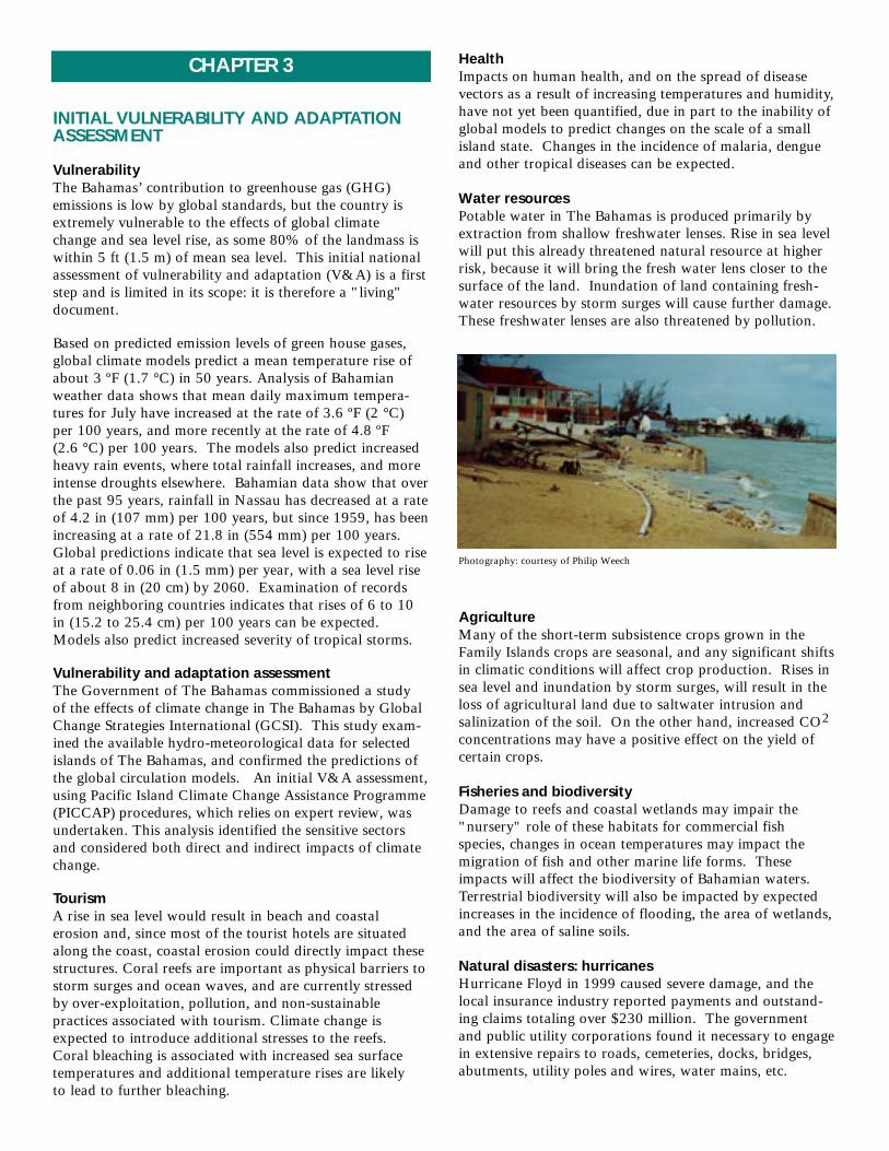
Natural disasters: hurricanesHurricane Floyd in 1999 caused severe damage, and thelocal insurance industry reported payments and outstand-ing claims totaling over $230 million. The governmentand public utility corporations found it necessary to engagein extensive repairs to roads, cemeteries, docks, bridges,abutments, utility poles and wires, water mains, etc.
CHAPTER 3
INITIAL VULNERABILITY AND ADAPTATIONASSESSMENT
Vulnerability The Bahamas’ contribution to greenhouse gas (GHG) emissions is low by global standards, but the country isextremely vulnerable to the effects of global climate change and sea level rise, as some 80% of the landmass iswithin 5 ft (1.5 m) of mean sea level. This initial nationalassessment of vulnerability and adaptation (V&A) is a firststep and is limited in its scope: it is therefore a "living" document.
Based on predicted emission levels of green house gases,global climate models predict a mean temperature rise ofabout 3 ºF (1.7 °C) in 50 years. Analysis of Bahamianweather data shows that mean daily maximum tempera-tures for July have increased at the rate of 3.6 ºF (2 °C) per 100 years, and more recently at the rate of 4.8 ºF (2.6 °C) per 100 years. The models also predict increasedheavy rain events, where total rainfall increases, and moreintense droughts elsewhere. Bahamian data show that overthe past 95 years, rainfall in Nassau has decreased at a rateof 4.2 in (107 mm) per 100 years, but since 1959, has beenincreasing at a rate of 21.8 in (554 mm) per 100 years.Global predictions indicate that sea level is expected to riseat a rate of 0.06 in (1.5 mm) per year, with a sea level riseof about 8 in (20 cm) by 2060. Examination of recordsfrom neighboring countries indicates that rises of 6 to 10in (15.2 to 25.4 cm) per 100 years can be expected.Models also predict increased severity of tropical storms.
Vulnerability and adaptation assessmentThe Government of The Bahamas commissioned a study of the effects of climate change in The Bahamas by GlobalChange Strategies International (GCSI). This study exam-ined the available hydro-meteorological data for selectedislands of The Bahamas, and confirmed the predictions ofthe global circulation models. An initial V&A assessment,using Pacific Island Climate Change Assistance Programme(PICCAP) procedures, which relies on expert review, wasundertaken. This analysis identified the sensitive sectorsand considered both direct and indirect impacts of climatechange.
TourismA rise in sea level would result in beach and coastal erosion and, since most of the tourist hotels are situatedalong the coast, coastal erosion could directly impact thesestructures. Coral reefs are important as physical barriers tostorm surges and ocean waves, and are currently stressedby over-exploitation, pollution, and non-sustainable practices associated with tourism. Climate change isexpected to introduce additional stresses to the reefs.Coral bleaching is associated with increased sea surfacetemperatures and additional temperature rises are likely to lead to further bleaching.
Photography: courtesy of Philip Weech

Natural disasters: non-tropicalStorms of non-tropical origin, while of shorter durationand generally localized, can also disrupt operations andendanger life and property. In addition to the above, out-of-season tropical cyclones, though very rare in theAtlantic, can occur. Experience suggests that severeweather phenomena can occur at any time of year in the Bahamian archipelago.
Adaptations optionsClimate change presents new challenges due to the speed of the anticipated changes and the magnitude of the investments needed to adapt to predicted changes. In thecase of some small islands the only option may be retreatand abandonment of property. The do nothing option orstrategy is the one against which all other options may becompared. All too often, however, it is the default optionbecause other options are either not available or are notknown. Across The Bahamas no one option alone is likely toachieve the desired results of reducing vulnerability to climate change. Zoning practices based on vulnerabilityassessments, restricting types of development, prohibitingactivities that exacerbate the impacts, and replacement and provision of increased security for settlements andinfrastructure, are options that need to be considered.Costs associated with planned adaptation will be high but the cost of not acting will be measured directly in loss of life, loss of competitiveness in the tourism sectorand often at the expense of the environment.
Changes in global weather patterns could reduce demandfrom the eastern United States and Canada for winter holidays in The Bahamas. Further, the possible introduc-tion of diseases and their spread due to increases in temperature and humidity, are causes for concern. Threatsfrom health-based impacts will probably be manifestedmainly in the poorer countries of the region, and migrationof persons to and through The Bahamas has potential forintroducing diseases.
Initial V&AV&A assessment generally assumes that climate changewill be steady and linear in nature. Catastrophic changeshave not been factored into this initial assessment. It alsoassumes that impacts, both positive and negative, will bemeasurable and that the resources and knowledge of mitigation and adaptation measures are within the nation’scapacity. The cost of adaptation and of acquiring theneeded capacity of human resources was not assessed orquantified. There is clearly a need for further studies.
Gaps in research and information needsThere are many gaps in existing data and information, anda lack of tools to assess the physical, social and economicimpacts on the most vulnerable sectors of the economy. Alisting of research and information needs recognizes tencategories (economic sectors or subject areas) where gapsare considered to exist, and where more information isneeded. These categories are Agriculture, Fisheries,Forestry, Geographic information systems, Health,Meteorology and oceanic observations, Physical planning,Public works, Tourism, insurance and commercial, andWater resources and supply. No attempt has yet been madeto place topics in any order of priority either between orwithin categories
Photography, this page: courtesy of Philip Weech

tained and operated by the National Oceanographic andAtmospheric Administration of the United States (NOAA)as part of the Global Sea Level Observing System (GLOSS)network, at Settlement Point Grand Bahama, since 1978.
Under the Caribbean: Planning for Adaptation to ClimateChange (CPACC) Project three long-term sea level gaugeswere provided to The Bahamas, to complement existingnational and regional efforts. There are no wave recordersin the Bahamas, even though tropical and non-tropicalprocesses generate significant swells that have causedextensive damage in coastal areas in recent time. An ultraviolet meter was installed at Nassau InternationalAirport in 1999 to measure UVB radiation, but there is a need to install at least two more such recorders, in thecentral and southeast Bahamas.
Research on climate changeThe most notable research activity on global climatechange in which The Bahamas is participating, is theCPACC Project managed by the Organization of AmericanStates (OAS) and funded by the Global EnvironmentFacility (GEF). Twelve CARICOM states are involved inthe CPACC Project, and its principal objective is to build a regional and national capacity in climate change. Thereis a parallel "Feasibility Study on the Prediction andAmelioration of Socio-Economic Impacts of the El NinoSouthern Oscillation (ENSO) in Latin America and theCaribbean".
The El Nino episodes of 1995 and 1998 were, in part,responsible for the feasibility study refer red to above. It was during these events that Bahamian coral reefs experienced significant bleaching. Coral reefs are believedto be excellent indicators of climate change, since theyrespond to changes in temperature, turbidity, and solarradiation. The general objective is to design feasible regional early warning systems to ameliorate the impacts of the El Nino Southern Oscillation (ENSO). GlobalChange Strategies International (GCSI) of Canada, werecontracted in 1999 to undertake a study of climate changein The Bahamas, and this led to a preliminary assessmentof the vulnerability and adaptation of The Bahamas to climate change. The study identified data gaps in thehydro-meteorological monitoring system, suggested climatechange scenarios that might be used to predict futurechanges, and commented on assessment of the vulnerabilityand possible adaptation strategies. This study will formthe basis for a national workshop on vulnerability andadaptation.
Storm surgesObservations in The Bahamas suggest that storm surgesproduces most of the flood damage and drowning associated with tropical storms that make landfall, or that closely approach a coastline. Recognizing this factgovernment, in association with the World MeteorologicalOrganization (WMO) and the United States Government,applied the Sea Lake and Overland Surges from Hurricane(SLOSH) computer model to The Bahamas. An atlas was
CHAPTER 4
SYSTEMATIC OBSERVATIONS AND CAPACITY BUILDING
Weather ObservationsThe Bahamas has a long history of weather observations,recorded and reported by individuals who were usuallyuntrained and at widely dispersed locations throughout
the islands. Records are oftenincomplete and the instrumentsused were of varying type, quality, and accuracy. Of particular interest are reports ontropical cyclones: the LucayanIndians named those affectingThe Bahamas, "hurricanes".
In 1935, a network of observingstations was organized by theBahamas TelecommunicationsDepartment, in conjunction with the United States WeatherBureau. Formation of the BritishCaribbean MeteorologicalService in 1951 resulted in amore systematic manner of making observations. TheCaribbean Meteorological
Service was reconstituted in1962, and prompted the
Government of The Bahamas to establish its ownMeteorological Office. This existed from 1963 to 1972.The Bahamas Meteorological Service was created as a separate Department of Meteorology in 1973, under theMinistry of Tourism, and a cooperative upper air observingstation with the United States has been maintained since1978. In 1982, the governments of the United States andThe Bahamas agreed to cooperate in the operation andmaintenance of a network of meteorological surface observation and reporting stations in The Bahamas. Duringthis time, the number of observing stations was increasedto 14, all providing hydro-meteorological information.This coverage is now considered insufficient to adequatelymonitor the climate of The Bahamas: analysis suggests thatat least 60 rainfall stations should be installed throughoutthe archipelago.
Marine and oceanographic observationsVarious marine and oceanographic observations have beenmade on an ad-hoc basis over the past century. The mostnotable systematic observations are those of the CaribbeanMarine Research Centre (CMRC) (now known as thePerry Institute for Marine Sciences), at Lee Stocking Islandin the Exuma Cays. Observations include records ofwater temperature, water level, and circulation. Sea levelrecordings have been made by various entities over the pastcentury, but no long-term records exist for any individualsite across the Bahamas. A tidal gauge has been main-
Photography: courtesy G. BurnsideDepartment of Meteorology

produced to provide maps of SLOSH-modeled heights of storm surge and extent of flooding, for various combinations of hurricane strength and direction of storm motion. The model has so far been applied only tothe northern and central Bahamas and now needs to beexpanded to include the remaining islands of the Bahamas.The findings should be integrated into the BahamasNational Geographic Information System (BNGIS) and be used to guide development in those areas vulnerable to severe flooding.
CPACC componentsThe CPACC Project started in 1997, and a RegionalProject Implementing Unit (RPIU) has been established atthe Barbados campus of the University of the West Indies.Specific objectives are to strengthen regional capability formonitoring and analyzing climate and sea-level dynamicsand trends, and to seek to determine potential impacts of climate change. There are nine components: design and establishment of a sea level and climate monitoringnetwork, establishment of a database and information systems, an inventory of coastal resources and uses, formulation of a policy framework for integrated coastalzone and marine (ICZM) management, coral reef monitoring, coastal vulnerability and risk assessment, economic valuation of coastal and marine resources, greenhouse gases (GHG) inventory and agriculture andwater resource vulnerability assessment.
Climate change awarenessThe CPACC project has provided a means for training andawareness building and further support for the nationaleffort at public awareness and advocacy on climate changeissues in The Bahamas. Focused training in a regional
context was facilitated by the project in the execution of its various regional and pilot components.
The lack of a national evaluation of the observed climatechange signals in the Bahamas constrained the nationalawareness, training and public education efforts. The available scientific reports, largely prepared by theIntergovernmental Panel on Climate Change (IPCC), served as the basis of national discussions within the public sector but the scientific material often lacked therequired specificity necessary for public dissemination.Consequently, public officers were primarily targeted initially. But persons trained at the national level for execution of the pilot component on coral reef monitoringinvolved both non-governmental organizations and privatesector persons. Public awareness was heightened as a resultof the national consultation that preceded the implementa-tion of the CPACC project at a national consultation, heldin 1996.
Public addresses by senior government officials havefocused on the impacts of climate change and government’sefforts to build capacity, to report on involvement in theUNFCCC process, on the status of national efforts underthe CPACC project, and on progress in executing the"Enabling Project", funded by the Global EnvironmentFacility (GEF). This project has provided training andassistance directly with the preparation of the FirstNational Communication, with the initial V&A assess-ment, and with the review of the systematic observationnetwork. Experiences with hurricanes have fostered publicdebates and increased national and international attentionto climate change.
Extent and Sources of Coral ReefDegradation through long termmonitoring
Pilot AreasIllustrating patch reefs, Fringingreefs, Channel reefs and windwardreefs
• Man Jack Cay, Abaco Low impact
• New Providence High impact
COMPONENT 5Coral Reef Monitoring PilotSitesTHE BAHAMAS
• Exuma Medium impact
Pilot areas were strategically selected to show high, medium and low impact and how marine near shore communities have changed over time with changes in population and land use.

and formalizing the requirements for environmental impactassessments.
Marine ProtectionGovernment recognizes that marine parks can provide protection for diverse and integrated ecosystems and forthe protection of spawning stocks, so as to provide a basisfor recruitment of species to wider areas. Government hasagreed, as policy, that as much as 20% of the shallowwater habitats of Bahamian marine resources will be protected as no-take zones and that a network of marineprotected areas will be established.
Preservation of the physical landscapeGovernment enacted the "Conservation and Protection of the Physical Landscape of The Bahamas Act in 1997"and regulations that protect twelve species of tree, and provided for improved regulation of the cutting or excavation of hills for fill, and for the indiscriminate landclearing of virgin vegetation for development.
The BEST Commission The Bahamas Environment, Science and Technology(BEST) Commission is the primary government agency forcreating framework strategies for sustainable development,for implementing the environmental impact assessmentprocess, and for developing databases of environmentalinformation. BEST has received significant assistance fromthe United Nations Environment Programme (UNEP)through grants from the Global Environmental Facility(GEF), for CPACC (Caribbean Planning for Adaptation to Climate Change), for the preparation of a NationalBiodiversity Strategy and Action Plan and for a NationalBiodiversity Data Management Project. BEST alsoreceived technical assistance through an Organization ofAmerican States (OAS) consultancy, with the legislativebasis for environmental impact assessment (EIA).
Measures to respond to climate changePolicy options available to The Bahamas to respond to climate change are limited. The future for most smallisland states is uncertain because they often lack fossil fuelresources, indigenous science and technology capability,and they must depend on imports of technology. They alsolack any real adaptation options other than abandonment,retreat, or accommodation to climate change. Initialassessment of the vulnerability to climate change in TheBahamas is rather bleak. It is expected that fuel importsand GHG emissions will to rise as the population growsand the demand for energy, in response to climate change,increases. There will be increased dependence on importedtechnologies for water production, health impacts fromheat stress will increase, and there is the possibility of ahigher incidence of tropical diseases. More frequent disruptions and damage to infrastructure and human settlements from hurricanes and storm surges will occur,and this will be reflected in increased insurance andrebuilding costs. Land degradation and increases in theareas subject to flooding, will occur, and there will be aloss of freshwater resources.
CHAPTER 5
POLICIES AND MEASURES
MitigationThe Bahamas recognizes that efforts to mitigate theimpacts of climate change require multidisciplinary andcross-sectoral approaches, and must take account of thearchipelagic nature of The Bahamas and its natural vulnerability. Efforts at sustainable development, capacitybuilding, and use of appropriate policies and measures can reduce the impacts of climate change. International assistance, adequate financial resources, and the availabili-ty of scientific and technological solutions, can reduce vulnerability and provide the means for developing adaptation strategies.
Capacity buildingRecent experiences with several major hurricanes haveheightened awareness of the country’s vulnerability to climate change, and the need for policies and measures toreduce vulnerability. Among the capacity building needsare: development of international negotiating skills, development of vulnerability and adaptation (V&A) assessment skills, and development of the skills needed to translate recommendations into policy options.Government policy at the national level is defined throughthe work of the BEST Commission, and government realizes the need to preserve the country’s natural heritageand to provide for the sustainable use of resources.
Policy and measuresThe policy and measures proposed, and currently beingemployed in The Bahamas, include actions to provide forsustainable development and the sustainable use of naturalresources. These measures should include an examinationof possible climate change specific measures that canrespond to changing conditions, and that would be beneficial to a small island developing state even if climatechange does not occur in the manner, or on the time scales,predicted. The latter type of measure is expected todevelop as a better understanding and appreciation of thevulnerability of The Bahamas is gained.
Sustainable developmentSustainable development as a concept, has become fashion-able only in recent times. A critical element is recognitionand acceptance of "the precautionary principle".Government’s policy on sustainable development has yet to be fully defined in a single policy document but elementsof policy exist in, for instance, the National BiodiversityStrategy and Action Plan. The Prime Minister has made anumber of statements on environmental issues, includingsustainable development, in a series of national addresses.Elements of policy include measures to reduce the vulnera-bility of human settlements by, inter alia, providing for theadoption of a land-use plan for New Providence, facilitat-ing public participation in planning and land-use matters,

Policies and measures for GHG reductionsThe Bahamas is not a significant source of GHG emissionsso that efforts to reduce GHG emissions will have only avery minor impact globally. However, there is a need to reduce the drain of foreign reserves used to acquireimported fossil fuels and there would be health benefitsfrom reduced emissions. Importation of fuels for electricitygeneration is expected to increase over time, driving upemissions, if measures are not taken to reverse or slow thistrend. Options include:
• use of insulation to lower cooling needs, • solar tinting of windows to reduce heat build up, • encouragement of off-peak consumption by price
adjustment, • use of solar heating and power generation. • reduction or elimination of duty on "energy friendly"
consumer products, • use of ocean thermal energy conversion (OTEC), wind
farms and ocean turbines to generate power,• use of cleaner fuels in local transport vehicles,• replacement of gasoline powered vehicles with electric
vehicles, and • improvements to the mass transit system.
In addition The Bahamas should review ways of achievingGHG reductions in the international bunkering and shipping sectors, which would have global benefits, andexplore the feasibility of importing electricity from Floridavia submarine cables.
Carbon sequestration The extensive shallow marine areas sequester carbon diox-ide through chemical, mechanical and biological processes.An estimated 370 to 739 kg CO2 per year is sequesteredover a 277 km2 area of shallow marine banks aroundAbaco. This equates to a carbon sequestration of some121,968 to 243,930 Gigagrams (Gg) of CO2 over theentire shallow water banks of The Bahamas. Unfortunately,the scientific basis to enhance these processes is not wellunderstood, and there is uncertainty as to the potentialbenefits globally. It is clear however, that efforts to protectcoral reefs will have the benefit of reducing stresses on themarine systems, and on the process that work to sequestercarbon in marine systems.
Forests also sequester CO2 by photosynthesis, andBahamian forests include pine, coppice (or hardwood), and mangrove forests. A Forestry Act has been draftedwhich would provide, inter alia, for the scientific management of pine and coppice forests which shouldenhance their effectiveness in carbon sequestration.Actions of the National Creeks and Wetlands RestorationInitiative (NCWRI) will serve to enhance the carbonsequestering functions of the mangrove forests. TheBahamas has also drafted new legislation to provide formodern management of the water sector through a newWater and Sewerage Corporation Act. The Act wouldwork cooperatively with the Forestry Act and the NCWRIto protect the well fields and ecosystems provide services inwater resources conservation.
Financial implications There is a need to provide adequate financial resourcesdirected at public awareness, education, training and development, that is critical to the successful implementa-tion of any policy and measures in the energy, forest,water, transport sectors. Several of the measures proposedwill initially impact negatively on government revenuesfrom the energy sector, and on tax revenues from conces-sions in customs duty. External financial resources will berequired in order to undertake the cost: benefit analyses,and the pre-feasibility and socio-economic impact analyses.
Photography: courtesy Philip Weech

RECOMMENDATIONS
The following recommendations are considered necessaryfor The Bahamas to adequately meet the challenges of climate changes and sea level rise. No attempt at prioritization has been made.
Capacity buildingTraining is required at the tertiary level in fisheries, hydrology, information technology, marine ecology,meteorology, natural resource economics, oceanography,policy formulation and terrestrial ecology. An inventoryand economic valuation of coastal resources needs to be undertaken. Training in the preparation of greenhousegases (GHG) inventories and in the conduct of vulnerabili-ty and adaptation assessment is required. Institutional recommendations include strengthening of the BahamasEnvironment, Science & Technology (BEST)Commission’sinformation technology capacity, and of the BahamasNational Geographic Information System Centre(BNGISC).
Data collection and monitoringRecommendations include formulation of guidelines toensure compatibility of national data with the reportingrequirements of international organizations, incorporationof additional data requirements into data collection instruments, where necessary, to meet reporting deadlinesset by international organizations, a national repository forthe storage, archiving and retrieval, of census and surveydata, and introduction of a system to monitor changes inland use.
Meteorology and oceanic observationsAdditional recording stations are considered necessary inThe Bahamas to adequately monitor climate change. Thesesea level monitoring stations, wave recorders at selectedsites, a system of UV-B bio-meters to assess the likelyimpacts of UV radiation on human health, application ofthe Sea Lake and Overland Surges from Hurricanes(SLOSH) computer model to all islands of The Bahamas,to provide maps for various scenarios.
Scientific research, monitoring and data collectionScientific research and reviews of literature, establishmentof baselines, and monitoring, is required for several areas.These include
Coral reefsMonitoring of coral reefs for the impacts of climate changeis already underway (under the CPACC Project) but needsto be expanded. Studies of the role of coral reefs and calcareous algae in sequestering carbon dioxide, and studies on the role of carbonate deposition in sequesteringcarbon dioxide.
FisheriesThe impact of increasing sea surface temperatures onimportant fish species, and of the impact of changes in the Gulf Stream on migratory species needs to be assessed.
ForestsAssessment of the effects of salinization of the soil, and rising water tables, on the growth and biodiversity of pineand coppice forests, and on coastal and inland mangrovecommunities.
AgricultureThe vulnerability of the sector to soil salinization, loss oflands to inundation and to periodic salt-water flooding,needs to be assessed. Agricultural production systemsadapted to saline soil, to atmospheric CO2 enrichment and increased temperatures, needs to be evaluated.
Geographic information systems The Bahamas National Geographic Information SystemCentre should be the repository for all digitized data sets of spatial information.
HealthEpidemiological monitoring of human diseases that mayincrease as a result of climate change will be needed, andassessment of the likely effects of heat and humidity stress.
Public works Public facilities (docks, piers, coastal roads, and buildings)at risk of damage from storm surges, inundation andinland flooding should be identified, and strategies developed to minimize vulnerability.
Water resources and supplyA programme of water quality monitoring for fresh, salineand hyper-saline waters is needed in order to assess theirvulnerability to sea level rise.
Economics Economic evaluations of the impact of various climatechange scenarios on the tourism, commercial and propertyinsurance sectors are needed, and economic analyses of the options for the generation of electrical power, andalternative power sources for motor vehicles.
Climate change awarenessPublic awareness of the reality and consequences of climate change, given the vulnerability of The Bahamas, isessential, among all sectors of the community, using townmeetings and the print, radio and television media.
CollaborationThe Bahamas is presently participating in the CPACCProject, in the "Feasibility Study on the Prediction andAmelioration of Socio-Economic Impacts of the El NinoSouthern Oscillation (ENSO) in Latin America and theCaribbean". It is recommended that such regional collaboration continue.
CHAPTER 6

CARICOM: Caribbean Community. CARICOM is essentially two organizations in one. The Community deals with functional matters of regional cooperation while the Common Market is the economic branch. The members areAntigua and Barbuda, The Bahamas, Barbados, Belize, Dominica, Grenada, Guyana, Jamaica, Montserrat, St Lucia, St Kitts and Nevis, St Vincent and the Grenadines, Suriname, Trinidad and Tobago The Bahamas is not a member of the Common Market. Haiti is expected to become a member in July 2001. Anguilla, the British Virgin Islands, andTurks and Caicos, are associate members.
Commonage land: Land held in common by the inhabitants of the Family Islands who were born there. These landswere originally granted to commoners of the islands for services rendered the Crown. Until recently, such lands wereused exclusively for farming but are now used for residential purposes.
CPACC: Caribbean Planning for Adaptation to Climate Change.
El Nino: A warm current that periodically flows along the western coast of South America, usually forming aroundDecember or January. It results in temporary reversals of airflows and surface ocean currents in the equatorial Pacificocean, abnormal warming of surface waters of the coast of Peru, leading to disturbances of global weather patterns.
GHGs: Greenhouse gases: those gases capable of absorbing terrestrial radiation and therefore responsible for the greenhouse effect. The main greenhouse gases are water vapour, carbon dioxide (CO2), methane (CH4), nitrous oxide(N2O) and the wholly anthropogenic chlorofluorocarbons (CFCs).
Family Islands: The major populated islands other than New Providence and Grand Bahama. These are Abaco, Acklins,the Berry Islands, the Bimini Islands, Cat Island, Crooked Island, Eleuthera, the Exuma Islands and Cays, Great Inagua,Long Island, Mayaguana, Rum Cay and San Salvador
Ghyben-Hertzberg Lenses: Freshwater lenses in oceanic islands that are made up of three layers: an upper layer of drinkable (potable) water, a transition layer, in which salinity increases downward, and a saline layer in which salinityincreases rapidly downwards. Water is ideally abstracted only from the upper layer, but over-pumping can to the intru-sion of saline water. Freshwater moves outwards from the centre of the lenses towards the ocean and this flow carriesaway salt water that might otherwise enter and spoil the lens.
IPCC: Intergovernmental Panel on Climate Change.
New Providence/Nassau/Paradise Island: Nassau is often used synonymously with New Providence. Nassau is the capital city of The Bahamas, and New Providence is the island on which Nassau is located. Paradise Island, formallyHog Island, is located a few hundred yards north of New Providence and is separate from, but linked by two bridges to,New Providence. Paradise Island is a major tourist area. The sea between New Providence and Paradise Island formsNassau Harbour.
OAS: Organization of American States. Comprises thirty-four member states in the Americas and the Caribbean.
Saffir-Simpson Scale: Based on wind speeds, the scale is designed to show the level of damage that can be expected fromhurricanes. There are five categories which range from category 1 (wind speed 74 to 95 mph, damage minimal) to category 5 (winds in excess of 156 mph and damage catastrophic.
SIDS: Small Island Developing State(s).
Units of measurement: Units of length used in this communication are inches (in), feet (ft) and miles (mi), along with themetric equivalents of metre (m) and kilometer (km). Units of area used are square miles (mi2) and square kilometers(km2). Wind speeds are in knots (kt), which are nautical miles per hour. Conversion factors used are: 1 in = 25.4 mm; 1 ft = 0.348 m; 1 mi = 1.61 km; 1 mi2 = 2.59 km2. Temperatures are given in degrees Fahrenheit (˚F) and in degreesCentigrade (˚C).
DEFINITIONS AND ABBREVIATIONS
NATIONAL CLIMATE CHANGE COMMITTEE
In order to coordinate The Bahamas’ national response tothe issue of climate change at the local, national, regionaland international levels, and to provide a mechanism forresponding to its obligations under Articles 4 and 12 of the UNFCCC, the National Climate Change Committee(NCCC) was established as a sub-committee of TheBahamas Environment, Science and Technology (BEST)Commission, Office of the Prime Minister.
The Ambassador for the Environment serves as an ex-officio member of the NCCC. Other members of the committee are appointed by the BEST Commission, andcomprise senior public servants, public and private sectorpolicy advisors, and representatives of non-governmentalorganizations. The NCCC Chairman is on the Board ofDirectors of the BEST Commission, to ensure coordinationof the committee’s work with national governmental policies.
The first meeting of the NCCC was convened on March 61996. The committee has met frequently since its incep-tion and organized a national workshop in 1998 toincrease public awareness of climate change. Committeemembership has remained consistent during the four yearsof operation. The following is a list of CommitteeMembers:
• Mr. Philip S. Weech, Senior Hydrologist, Water and Sewerage Corporation (Chairperson).
• Mr. Arthur W. Rolle, Deputy Director,Department of Meteorology
(Deputy Chairperson).• Mr. David L. Cates, Deputy Permanent
Secretary, Ministry of Foreign Affairs (Secretary).
• Mr. Michael Braynen, Director of Fisheries, Ministry of Agriculture and Fisheries (1997-present).
• H.E. Earl Deveaux, M.P., Ambassador for the Environment and Chairperson of the BEST Commission (2000-2001).
• Dr. John Hammerton, BEST Commission (1998-2000).
• Mr. Patrick Hanna, Bahamas Electricity Corporation.
• Mr. Colin Higgs, Director of Fisheries, Ministryof Agriculture and Fisheries (1996-1997).
• H. E. Lynn Holowesko, Ambassador for the Environment, and Chairperson of the BEST Commission (1996-1999).
• Mr. Lambert Knowles, Bahamas Association of Professional Engineers and George V. Cox and Associates.
• Mr. Reginald Lobosky, President, Bahamas Chamber of Commerce (1995-1997).
• Mr. Neil McKinney, President, Bahamas Chamber of Commerce (1997-1999).
• Mr. Dwight King, Ministry of Public Works.• Ms. Melanie Roach, Director, Department of
Public Works.• Mr Bismark Coakley, President, Bahamas
Chamber of Commerce (1999-present).
At the first meeting Mr. Philip Weech was electedChairperson, Mr. Arthur Rolle was elected Vice-chairperson, and Mr. David Cates was elected Secretary.These office holders have not changed since the inceptionof the NCCC. Mr. Michael Braynen succeeded Mr. ColinHiggs as Director of Fisheries; Mr. Neil McKinney succeeded Mr. Reginald Lobosky as President of TheBahamas Chamber of Commerce; and AmbassadorDeveaux succeeded Ambassador Holowesko asAmbassador for the Environment in January 2000, and in February 2001, the BEST Commission portfolio was transferred to the Ministry of Agriculture and Fisheries.The Minister is the Hon. James F. Knowles, M.P. ThePermanent Secretary, Mr. Colin Higgs, is the Ambassadorfor the Environment.
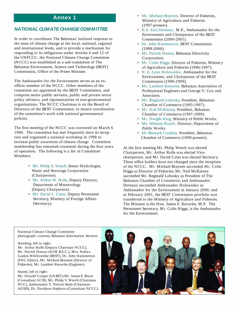
National Climate Change Committeephotograph: courtesy Bahamas Information Services
Standing, left to right:Mr. Arthur Rolle (Deputy Chairman NCCC),Mr. Patrick Hanna (AGM B.E.C.), Mrs. NakiraGaskin-Wilchcombe (BEST), Dr. John Hammerton(FNC Editor), Mr. Michael Braynen (Director ofFisheries), Mr. Lambert Knowles (Engineer).
Seated, left to right:Mr. Donald Cooper (US BET),Mr. James P. Bruce(Consultant GCSI), Mr. Philip S. Weech (ChairmanNCC), Ambassador T. Neroni Slade (ChairmanAOSIS), Dr. Davidson Hepburn (Consultant NCCC).
Annex 1
Special thanks go to:
Mr. Errol Bethel (Parliamentary Registrar) for informationon the electoral process, Mr. Timothy Bethel (Bahamas National Trust) for information on the National Parks System, Mrs. Barbara Burrows (Acting Permanent Secretary in theCabinet Office) for information on hurricane damage, andfacilitating the work of the NCCC,Dr. Richard Cant (Acting General Manager, Family IslandWater Environment, Water and Sewerage Corporation) forproviding information and support,Mr. Clarence Cleare (Ministry of Local Government) forinformation on the local government system.Mr. David Cates (Deputy Permanent Secretary in theMinistry of Foreign Affairs, and Secretary to the NCCC)for diligently compiling the first draft if this FirstCommunication. Dr. John L. Hammerton (now retired but formerly a member of staff of the BEST Commission and one-timemember of the NCCC) for undertaking the revision andediting of this First Communication.Mr. Oris Russell (retired Permanent Secretary) for information on the Bahamian flora. Mr. Carl Smith (Director of Agriculture) for informationon the Bahamian flora.Ms Patrice Williams and Ms Grace Turner (Department ofArchives) for information on the history of The Bahamas.Comptroller of Bahamas Customs, for data on imports.Governor of the Central Bank of The Bahamas, for data on oil imports.Director of Meteorology and staff, for provision of meteorological data and general support.Director and staff of the Department of Statistics, for census data and data on imports,Esso Standard Oil SA Ltd for information on oil imports.General Manager and staff of the Bahamas ElectricityCorporation for information on generating capacity anddemand.
General Manager and staff of the Water and Sewerage
Corporation, for facilitating the work of the NCCC in
many ways.
Ministry of Foreign Affairs, for general support and for
facilitating the work of the NCCC.
Shell Bahamas Ltd for information on oil imports.
Texaco Bahamas Ltd for information on oil imports.
Preparation of the Report has truly been a team effort and
a capacity building activity.
ACKNOWLEDGEMENTS
The National Climate Change Committee (NCCC) gratefully acknowledges the work of committee membersin compiling this report, all of whom served on a voluntarybasis. These persons have substantive posts in either thepublic service or the private sector, and preparation of thisreport was, therefore, outside the scope of their regularwork. Their determination is indicative of the importanceaccorded to environmental issues in The Bahamas.
The Committee would be remiss if it did not acknowledgethe work of the late Mrs. Catherine Benjamin. Althoughill for a number of years, and at times confined to home,Mrs. Benjamin worked untiringly in the BEST Commissionas its first coordinator. Holding the rank of DeputyPermanent Secretary, she was, in the early years of theCommission, also responsible for the relief efforts follow-ing the passage of hurricane Andrew. Mrs. Benjamin didnot serve on the NCCC, but she was largely responsible for setting up the BEST Commission and its subsidiarycommittees.
The Committee thanks Senator, formally Ambassador,Lynn Holowesko, for her support and encouragementwhile Chairperson of the BEST Commission from 1994 to 2000. Senator Holowesko has a lifelong interest inenvironmental issues, and was twice President of TheBahamas National Trust, from 1976 to 1982 and from1984 to 1991.
Ambassador Earl Deveaux, M.P., Chairman of the BESTCommission from January 2000 to February 2001, and aformer Minister of Agriculture and Fisheries, was also verysupportive of the Committee’s work since his appointment.
The Hon. James F. Knowles, M.P., assumed responsibilityfor the BEST Commission effective February 2001, and hasbeen, and continues to be, understanding and supportive ofthe work of the NCCC.
Ms. Teresa Butler, Permanent Secretary in the Office of thePrime Minister, is thanked for her constant understandingand guidance during the work of the NCCC. The staff ofthe BEST Commission, especially Ms. Lorca Bowe and Ms.Maria Heild, is acknowledged, especially in arranging committee meetings and circulating documents.
Thanks go to Mrs. Eleanor Philips (Department ofFisheries) and Mr. Jeffrey Simmons (Department ofMeteorology) for undertaking the initial vulnerability and adaptation assessment, reported in Chapter 3.Many other persons contributed to the preparation of thisdocument, some unknowingly.
Annex 2

LIST OF SCIENTIFIC NAMES OF MARINE AND TERRESTRIAL ANIMALS AND PLANTS REFERRED TO IN THE TEXT
BirdsBahama parrot Amazona leucocephala bahamensis Bobwhite Colinus virginianusChukar Margarops fuscatusCuban grass-quit Tiaris olivaceaKirtland’s Warbler Dendroica kirtlandii Northern mockingbird Mimus polyglottosRing-necked pheasant Phasianus colchicusWest Indian flamingo Phoenicopterus ruberWhistling duck Dendrocygna aboreaWhite crown pigeon Columba leucocephala
Terrestrial mammalsBahama hutia Geocapromys ingrahamiiRaccoon Procyon lotor
IguanasIguana Cyclura spp. (including C. baelopha, C. carinata, C. cychlura, C. rileyi)
Scale fish of commercial importanceAmberjack Seriola dumeriliBonefish Albula vulpesBlue marlin Makaira nigricansDolphin Coryphaena hippurusJacks Caranx spp.Lane snapper Lutjanus syngarisNassau grouper Epinephelus striatusSail fish Istiophorus platypterusSwordfish Xiphias gladiusTuna Thunnus thynnusWahoo Acanthocybium solanderiWhite marlin Tetrapturus albidus
Other marine species of commercial importance Spiny lobster Panuluris argusQueen conch Strombus gigas
TurtlesCat Island freshwater turtle Trachemys terrapenInagua Green turtle Chelonia midasHawksbill turtle Eretmochelys imbricata), andInagua freshwater turtle Trachemys stejnegeri Leatherback turtle Dermochelys coriaceaLoggerhead turtle Caretta caretta
DolphinsBottlenose dolphin Tursiops truncatus Atlantic spotted dolphin Stenella longirostris Spinner dolphin Stenella plagiodon
Whales (migratory) Beaked shortfin whale Globicephala macrohynchusHumpback whale Megaptera novaeangliaeMinke whale Balaenoptera acutorostrataSperm whale Pyseter caodon
Sharks Hammerhead shark Sphyrna mokarranTiger shark Galeocerdo cuvieriNurse shark Ginglymostoma cirratumMako shark Isurus oxyrinchusLemon shark Negaprion brevirostris
Native and naturalized plants Black mangrove Avicennia germinansBrazilian pepper tree Schinus terebinthifoliusButton wood Conocarpus erectusCaribbean pine Pinus caribeaCasuarina Casuarina equisetifoliaHorseflesh Lysiloma sabicuLignum vitae Guaicum sanctumMahogany Swietenia mahagoniPaper bark tree Melaleuca quinquenerviaPoison wood Metopium toxiferumRed mangrove Rhizophora mangleTurtle grass Thalassia sp. White mangrove Laguncularia racemosaWild fig Ficus spp.Wild tamarind Lysiloma latisiliquum
Introduced crop speciesAvocado Persea americanaBeans Phaseolus spp.Breadfruit Artocarpus communisCassava Manihot esculentaCorn Zea maisGuava Psidium guajavaGooseberry Phyllanthus acidusGuinep Melicocca bijugaHog plums Spondias mombinHot pepper Capsicum spp.Mamey Mammea americanaMango Mangifera indicaMelon Cucumis meloPigeon pea Cajanus cajanPineapple Ananas comosusSapodilla Manilkara zapotaScarlet plum Spondias purpurea Soursop Annona muricataSweet potato Ipomoea batatasSugar apple Annona squamosaWater melon Citrullus vulgaris
The West Indian Monk Seal (Monachus tropicalis) is now extinct,while the American crocodile (Crocodylus acutus), Scarlet Ibis(Guara rubra) and West Indian Manatee (Trichechus manatus)are no longer recorded in The Bahamas. Freshwater fish of thegenus Gambusia have been introduced and are found in pondsand potholes on most islands.
Reference: BEST (1995).
Annex 3

Albury, P. 1978. The story of The Bahamas. London, Macmillan.
BEST. 1995. Bahamas Biodiversity Country Study Report. Bahamas Environment, Science and Technology Commission,Office of the Prime Minister. Nassau, Bahamas.
BEST. 1998. National biodiversity strategy and action plan. Bahamas Environment, Science and Technology Commission,Office of the Prime Minister. Nassau, Bahamas.
Bohlke, J.E. and C. Chaplin. 1993. Fishes of The Bahamas and adjacent tropical waters (2nd ed.). Austin: University ofTexas Press.
Britton, N. L. and C.F. Millspaugh. 1920. The Bahamas flora. New York: published by the authors.
Brown, L. and J.F. Downhower. 1993. The eyes of Andros. Bahamas Naturalist: 7, (1), 5-10.
Brudenell-Bruce, P.G.C. 1975. The birds of New Providence and the Bahama islands. London: Collins.
Bryant, D., L. Burke, J.W. McManus and M. Spalding. 1998. Reefs at risk: A map-based indicator of threats to the world’scoral reefs. Washington, DC: World Resources Institute.
Campbell, D. 1978. The ephemeral islands. London: Macmillan.
Cant, R.V. 1996. Water supply and sewerage in a small island environment: The Bahamian experience. Small IslandsMarine Science and Sustainable Development Coastal and Estuarine Studies, 51, 329.
Cant, R. 1997. Developing water supply strategies for The Bahamas. Bahamas Journal of Science: 4, (2), 5-7.
Cant, R.V. and P.S Weech. 1986. A review of the factors affecting the development of Ghyben-Hertzberg lenses in TheBahamas. Journal of Hydrology: 84: 333-343.
Cant, R.V., P.S. Weech, and E.E. Hall. 1989. Saltwater intrusion in The Bahamas: a case study of the Great Lucayan water -way, Grand Bahama, The Commonwealth of The Bahamas. Nassau, Bahamas: unpublished report. 9 pages.
Carter, T.R. 1994. IPCC Technical guidelines for assessing climate change impacts and adaptations. Working Group II ofthe Intergovernmental Panel on Climate Change (IPCC). 59 pages.
Carew, J.L. 1997 Rapid sea-level changes at the close of the last interglacial (substage 5e). Recorded in Bahamian IslandGeology: Comment and Reply. Geology: 25, 527.
Cates, D.L. 1998. Alligators, Seals and Iguanas. In: The Bahamas Handbook and Businessman’s Annual. Nassau,Bahamas: Dupuch Publications. Pages 111-121.
Cates, D.L. 1997. Mark Catesby and The natural history of Carolina, Florida and the Bahama Islands. Journal of TheBahamas Historical Society: 18, 2-10.
Catesby, M. undated. Natural history of Carolina, Florida and the Bahama Islands. Two volumes. London: Published bythe Author, 1729-1747.
Central Bank. 2000a. Central Bank of The Bahamas 1999 Annual Report. Nassau, Bahamas: Central Bank of TheBahamas.
Central Bank. 1997. Quarterly Statistical Digest. 6, (2). Nassau, Bahamas: Central Bank of The Bahamas.
Cleare, C.B. 2000. Local government profile. Ministry of Local Government, Nassau, Bahamas: unpublished paper.Coenen, C. 1995. Observations on the Bahamian rock iguanas of the Exumas. Bahamas Journal of Science: 2, (2), 8-14.
Correll. D. and H. Correll. 1982. Flora of The Bahamas archipelago. Germany: Gantner Verlag K-G.
Department of Agriculture and Department of Statistics. 1996. Second census of agriculture 1994. Final Results. Nassau,Bahamas: Department of Agriculture and Department of Statistics.
Department of Meteorology. 1977. Rainfall of New Providence. Nassau, Bahamas: Department of Meteorology. 57 pages.
Department of Statistics. 1998. The Bahamas in Figures 1997. Nassau, Bahamas: Department of Statistics.
Deveaux, E. 1999. Sustainable use of The Bahamas’ marine environment. Address to the 3rd US Coral Reef Task ForceMeeting, St. Croix, USVI, November 2-3. Unpublished.
REFERENCES

Dupuch Publications. 2000b. Bahamas handbook and businessman’s annual 2000. Nassau, Bahamas: DupuchPublications.
Eneas, G. 1998. Agriculture in The Bahamas. Its historical development 1492-1992. Nassau, Bahamas: Media Publishing.
Fairbridge, R.W., R.N. Young, C.G.A. Harrison and M.M. Ball. 1961. Geology of The Bahamas. In: The Encyclopedia of World Regional Geology Part I: Western Hemisphere. Stoudesburg, Pennsylvania: Dowden Hutchinson and Ross: 109-114.
Foos, A. 1994. Water Budget for Cockburn Town, San Salvador. Bahamas Journal of Science: 2, (1), 31-35.
Gamble, D.W., M.E. Brown, D. Parnell, D. Brommer and P.G. Dixon. 2000. Lessons learned from Hurricane Floyd damage on San Salvador. Bahamas Journal of Science: 8, (1), 24-31.
Hearty, P.J. 1998. Enigmatic boulders of Eleuthera: geological evidence tells of catastrophic waves in The Bahama. In: The Bahamas Handbook and Businessman’s Annual 1998. Nassau, Bahamas: Dupuch Publications. Pages 122-132.
Hearty, P.J. and P. Kindler. 1995. Sea-Level highstand chronology from stable carbonate platforms (Bermuda and TheBahamas). Journal of Coastal Research: 11, (3), 675.
Higgs, L. 1978. Bush medicine in The Bahamas. Nassau, Bahamas: published by the author.
Ingraham, H.1999a. Environmental enhancement. Broadcast address by the Prime Minister of The Bahamas, May 2.Nassau, Bahamas.
Ingraham, H. 1999b. Reconstruction effort following hurricane Floyd. Communication to Parliament by the Prime Minister of The Bahamas. October 13. Nassau, Bahamas.
Ingraham, H. 2000a. Hurricane Floyd recovery efforts and hurricane Floyd tree replacement and beautification programme. Communication to Parliament by the Prime Minister. February 23. Nassau, Bahamas.
Ingraham, H. 2000b. Contribution on a resolution to return to Nassoak Limited 208.41 acres of land acquired by theGovernment in 1989 for development of a freight terminal at Clifton, New Providence. Communication to Parliament bythe Prime Minister. May 17. Nassau, Bahamas.
IPCC. 1996. Revised IPCC guidelines for national greenhouse gas inventories. Intergovernmental Panel on ClimateChange.
Jelesnianski, C.P. 1967. Numerical computation storm surges with bottom stress. Monthly Weather Review, 95, 740-756.
Kindler, P. and P. Hearty. 1996. Carbonate petrography as an indicator of climate and sea-level changes: new data fromBahamian quaternary units. Sedimentology: 42, 381.
Little, B.G, et. al. 1971- 1976. Land Resources of the Commonwealth of The Bahamas. Volume 1 Abaco; Volume 2Eleuthera; Volume 3 Cat Island; Volume 4 Andros; Volume 5 Grand Bahama; Volume 6 Great Exuma, Little Exuma and Long Island; Volume 7 Crooked Island and Acklins; Volume 8 Mayaguana and Inagua. Nassau, Bahamas.
Martin, H. and J.P. Bruce. 1999. Effects of climate change: hydrometeorological and land-based effects in The Bahamas.Ottawa, Canada: Global Change Strategies International, Inc.
Martin, H. and J.P. Bruce. 2000. Effects of climate change: hydrometeorological and land-Based effects in The Bahamas:Final report. Ottawa, Canada: Global Change Strategies International, Inc.
Ministry of Foreign Affairs. 1992. Report of The Commonwealth of The Bahamas to the United Nations Conference onEnvironment and Development. Nassau, Bahamas: Ministry of Foreign Affairs.
Ministry of Health and Ministry of Commerce, Agriculture and Industry. 2000. National Food and Nutrition Policy and Agenda for Action. Nassau, Bahamas: Ministry of Health and Ministry of Commerce, Agriculture and Industry.Unpublished Draft.
National Research Council. 1990. Saline agriculture. Salt-tolerant plants for developing countries. Washington, DC:National Academy Press.
Neumann, A.C. and P.J. Hearty. 1996. Rapid sea-level changes at the close of the last inter-glacial (substage 5e) recorded in Bahamian island geology. Geology: 24, (9), 775.

Neumann, AC. and Land, L.S. 1975. Lime mud deposition and calcareous algae in the bight of Abaco, Bahamas. Abudget. Journal of Sedimentary Petrology, 45, (4), 763-786.
Patterson, J. 19977. Native Trees of The Bahamas. Nassau, Bahamas: published by the author.
Rappaport, E.N. and F.C. Sheets. 1993. Hurricane Andrew. Bahamas Journal of Science: 1, (1), 2-9.
Rolle, A. W. 1990. A storm surge atlas for the northern and central Bahamas New Providence and vicinity). Nassau: theNational Weather Service of The Bahamas. 21 pages plus Appendix.
Russell, C. 1998. The future of forestry in The Bahamas. Bahamas Journal of Science: 5, (3 ), 2-11.
Russell, C. 2000. Bahamas country report: forestry outlook study for the Caribbean. Nassau, Bahamas: Department ofLands and Survey. Mimeographed.
Sealey, N.E. 1994a. Bahamian Landscapes. Nassau, Bahamas: Media Publishing.
Sealey, N.E. 1994b. Rainfall distribution in New Providence for 1993. Bahamas Journal of Science: 1, (3), 33-35.
Sealey, N.E. 1995. Rainfall distribution in New Providence for 1994. Bahamas Journal of Science: 2, (2), 32-34.
Sealey, N. E. 1996. Rainfall distribution in New Providence for 1995. Bahamas Journal of Science: 4, (1), 35-36.
Sealey, N. E. 1997. Distribution of rainfall in New Providence for 1996. Bahamas Journal of Science: 5, (1), 36.
Sealey, N. E. 1998. Distribution of rainfall in New Providence for 1997. Bahamas Journal of Science: 5, (2), 34-36.
Sealey, N. E., P. Balfe and N. Wardle. 1999. Rainfall distribution on New Providence for 1997-1998. Bahamas Journal ofScience: 6, (2), 55-57.
Shaklee, R.V. 1997. Historical hurricane impacts on The Bahamas: Part I: 1500-1749.Bahamas Journal of Science: 5, (1),7-9.
Shaklee, R.V. 1998. Historical hurricane impacts on The Bahamas: Part II: 1750-1799. Bahamas Journal of Science: 5, (2),16-20.
Shaklee, R.V. 1998. Historic weather at Nassau. Bahamas Journal of Science: 6, (1), 23-30.
Shaklee, R.V. 2000. Historical hurricane impacts on The Bahamas: 1800-1850. Bahamas Journal of Science, 8, (1), 16-24.
Shattuck, G. (ed.). 1905. The Bahama Islands. Baltimore, Maryland: Baltimore Geographical Society.
Smith, D., L. Miller and J. Miller. 1994. The Butterflies of the West Indies and South Florida. Oxford and New York:Oxford University Press.
Suplee, C. 1999. El Nino la Nina nature’s vicious cycle. National Geographic 195, (3), 72-95.
United Nations. 1994. Earth Summit. Programme of action for small island developing states. Global conference on thesustainable development of small island developing states, Bridgetown, Barbados, April 26 to May 6 1994. New York.United Nations.
United Nations. 1992. Agenda 21: programme of action for sustainable development. Rio Declaration on Environment andDevelopment. Statement of Forest Principles. United Nations Conference on Environment and Development, Rio deJaneiro, Brazil, June 3-14., 1992. New York. United Nations.
UNFCC. 1999. Compendium of decision tools to evaluate strategies for adaptation to climate change. Bonn: UNFCCSecretariat.
Watson, R.T., M.C. Zinyowera and R.H. Moss (Eds). 1998. The Regional Impacts of Climate Change. An assessment ofvulnerability. A special report of IPCC working group II. Published for the Intergovernmental Panel on Climate Change.Cambridge University Press, United Kingdom.
Weech, P.S. 1999. Situational analysis of water resources: country report for The Bahamas. Nassau: Report for the WaterSector in The Bahamas. Unpublished: 15 pages.
White, A. 1998. A birder’s guide to the Bahama islands and Turks and Caicos. American Birding Association.
Williams, P.M. 1999. Chronological highlights in the history of The Bahamas 600 to 1900. Nassau, Bahamas: publishedby the author and The Bahamas Historical Society.
Woods, C.A, (ed.). 1989. Biogeography of the West Indies past, present and future. Gainesville, Florida: Sandhill CranePress, Inc.

NATIONAL CIRCUMSTANCES AND BACKGROUND
1.1 GEOGRAPHY, GEOLOGY AND POPULATION
“Though all the others [islands] we have seen werebeautiful, green and fertile, this [probably CrookedIsland] was even more so. It has large and very greentrees, and great lagoons, around which these treesstand in marvelous groves. Here and throughout theisland, the trees and plants are as green as inAndalusia in April. The singing of small birds is sosweet that no one could ever wish to leave this place.Flocks of parrots darken the sun and there is a marvelous variety of large and small birds.” Christopher Columbus, 1492. (1)
1.1.1 Location The Commonwealth of The Bahamas consists of an archipelago of islands atop the Bahama platform, which extends more that 840 miles (mi)/ 1,335 kilometers (km) from the coast of Florida tothe island of Hispaniola. The platform comprises a series of thick, shallow carbonate banks, knownas the Little and Great Bahamas Banks, horizontally aligned, that have built up along the subsidingcontinental margin of North America. The archipelago comprises over 700 islands plus more than200 cays, islets and rocks, spread over approximately 100,000 square miles ( mi2) / 260,000 squarekilometers (km2) of the Atlantic Ocean. The Bahamas lies between latitudes 21˚ and 27˚ north andlongitudes 72˚ and 79˚ west, about 50 mi (81 km) east of Florida (U.S.A.), and extending about 750mi (1,200 km) southeastwards to within 50 mi (81 km) of Cuba and Haiti. Insulated from the NorthAmerican continent by the Straits of Florida, and cooled in the summer months by the northeasttrade winds, The Bahamas suffers neither extreme heat nor cold. The climate is greatly influencedby the Gulf Stream as it flows north through the Straits of Florida.
Geographically and geologically the archipelago includes The Bahamas and the Turks and CaicosIslands. The Turks and Caicos Islands were administered from Nassau until 1848, when they wereplaced under colonial administration from Jamaica. The Bahamas and the Turks and Caicos Islandshave common features and many plant and animal species, mostly birds and fishes, in common.
6
Photography: courtesy of Philip Weech
CHAPTER 1
(1) Christopher Columbus (1492) “discovered” The Bahamas and wrote about the plants and animals as he sailedthrough the islands in 1492. He also described the many islands and tieir attributes in his journal

The total land area of The Bahamas is approximately 5,382 mi2 (13,940 km2). The largest of theislands is Andros, with an area of 2,300 mi2 (5,957 km2), some 80% of which is less than 3.3 feet (ft) (1.0 m) above mean sea level. Harbour Island, with an area of 1.5 mi2 (3.9 km2) and Spanish Wells,with an area of 0.5 mi2 (1.3 km2), are the two smallest permanently inhabited islands. Thirty islandsand cays are inhabited, among which there are great disparities in terms of the economies, standards of living and size of population. All populated islands have basic infrastructure such asschools, roads, electricity and running water.
1.1.2 Geology
“The Bahama Islands may not only be said to be rocky, but are in reality entire rocks, having their surface in some places thinly covered with a light mold, which in a series of time has been reduced to that consistence from rotten trees and other vegetables. …It is amazing to see trees of a very large size grown out of rock where no soil is visibleand the rock solid and compact before the roots found way to separate them…the fibres of the trees insinuate, and as they swell and grow bigger, widen the crevasses, which with the assistance of wind and rain, admit the roots penetration.”Mark Catesby, 1725. (2)
There is evidence that in the Pleistocene Epoch the sea levelaround the Bahamas stood about 300 ft (91 m) lower than it doesat present. Subsequently, the sea level rose to a level at least 15 ft (4.6 m) above present mean sea level. In more recent times(Holocene Epoch) the sea reached its present level. Fairbridge et al. (1961) provide a useful general account of the geology of The Bahamas.
All the islands of The Bahamas have generally low relief. The highest point is 206 ft (63 m) in Cat Island. The highest point inAbaco is about 120 ft (37 m) above mean sea level, and in GrandBahama it is only 68 ft (21 m). The highest point in Andros 71 ft(21.6 m) above mean sea level and the greater part of that island,the largest in the archipelago, is less than 20 ft (6 m) above sealevel. New Providence has ridges rising to about 100 ft (31 m) witha summit height of 127 ft (39 m) above mean sea level. This low
relief reflects variations in sea level during the Pleistocene Epoch. During the time that the sea levelwas falling, there was dune formation and the building of recessional beach ridge systems. The lowplatform of marine limestone is thus partially covered by lithified Aeolian dune ridges, by beachridges, and by small areas of unconsolidated or partially consolidated calcareous sands. Hearty andKindler (1995) and Kindler and Hearty (1996) have researched the petrography of the carbonatesand reported on the sea level changes.
7
Photography: courtesy of Philip Weech
(2) Mark Catesby (1725) was a British Naturalist who spent nine months in The Bahamas in 1725. His published workprovides a relatively comprehensive account of the natural resources of The Bahamas circa 1725.

Geophysical data indicate that the shallow marine carbonates of the Little and Great Bahama banksare between 3.2 mi (5.4 km) and 6 mi (10km) thick, depending on the location. These banks areseparated by a series of deep-water channels. It is usually upon the margins of these banks thatthe islands of The Bahamas occur unevenly. The islands are usually long and narrow, oriented fromnorthwest to southeast with central ridges extending to up to about 100 ft (31 m), but see above.The upper portions of the islands have been exposed several times in the geological past as a resultof sea level fluctuations in the Pleistocene Epoch. Radiocarbon dating of the carbonate rocks hasshown them to be between 5,000 and 1,000,000 years old. Carew (1997) and Neumann and Hearty(1996) have made valuable contributions to knowledge of sea level changes in The Bahamas in thelast interglacial.
In the early 1970s, the larger islands of The Bahamas were studied in detail by the Land ResourcesDivision of the (then) Ministry of Overseas Development of the United Kingdom, under the auspicesof the Ministry of Agriculture. The reports (Little et al., 1971 to 1976) include detailed surveys of thegeology, landforms, soils, water resources, vegetation and land use.
1.1.3 Hydrogeology The rock in which the sustainable and exploitable groundwater resources of The Bahamas occur,extend down to 110 ft (40 m) in the zones of the Pleistocene and Holocene limestone and limesands. These rocks were formed as a result of wave action, the chemical precipitation of calciumcarbonate and the deposition of oolitic and skeletal sands of marine origin. The surface geology isdominated by Pleistocene limestone and features include shallow marine deposits, and littoral andwind blown deposits that have been cemented by the solution of calcium carbonate in fresh rainwa-ter during periods of low sea level, followed by re-precipitation within the inter-granular pores at thetime of lower sea levels.
The groundwater resources of The Bahamas comprises the freshwater, brackish, saline and hypersaline waters found in the near and deep subsurface, and in the lakes and ponds that occur on the surface. The freshwater resources occur as three-dimensional lens-shaped bodies, whichoverlies brackish and saline waters. It is incorrect to conceive of these Ghyben-Hertzberg lenses(see Definitions and Abbreviations for a fuller description of these lenses) as occurring in subter-ranean lakes, rivers or ponds. Groundwater saturates the rock and all its pores, fissures and interconnected cavities. The shape, size and thickness of the freshwater bodies are controlled bythe size, shape, orientation and subsurface geology, and the amount of rainfall. More than 90% of freshwater lenses are within 5 ft (1.5 m) of the land surface.
Saltwater intrusions periodically occur from storm surge events, but also from canalization fordevelopment of residential lots (Cant et al., 1989). The supply of fresh water continues to pose a
problem as development occurs and demand increases, and as a result of the proliferation of septictanks (Cant, 1996, 1997). Weech (1999) also discusses water resources in The Bahamas, andFoos (1994) has proposed a water budget for Cockburn Town in San Salvador.
8

1.1.4 PopulationThe 1990 census indicated a population of 254,685 and anannual growth rate from 1980, of 1.9%. The projected population for 1997 was 288,862, and for 2000, 303,069. The population is youthful, with some 60% under 30 years of age. The population is concentrated on just two islands:New Providence, where the capital city of Nassau is located,had 67% and Grand Bahama, home to the second largest cityof Freeport, had 16% of the population. The remaining islandsare sparsely populated. The estimated population in 1997 was288,862, and is projected to be 303,069 in 2000. Some thirtyislands and cays are inhabited. Table 1.1.1 lists the islandsand their population as determined by the 1990 census.
Table 1.1.1 Land Area, population and population density of the principal islands of The Bahamas.
Area Population Population densityIsland (mi2) (1990 census) (per mi2)
New Providence 80 171,542 2144
Grand Bahama 530 41,035 77
Abaco 649 10,061 16
Acklins 192 428 2
Andros 2300 8,155 4
Berry Islands 12 634 53
Bimini Islands 9 1,638 182
Cat Island 150 1,678 11
Crooked Island 93 423 5
Eleuthera 187 8,017 43
Exuma & Cays 112 3,539 32
Harbour Island 3 1,216 405
Inagua 599 985 2
Long Island 230 3,107 14
Mayaguana 110 308 3
Ragged Island 14 89 6
Rum Cay 30 53 2
San Salvador 63 486 8
Spanish Wells 10 1,291 129
Other Islands / Cays 9 --- ---
All Bahamas 5,382 254,685 47
Source: Department of Statistics.
9
Photography: courtesy of Philip Weech

New Providence, which is about 80 mi2 (207 km2) in area, had a population density of 2,144 per mi2
(827 per km2) in 1990, compared with a national average of 47 per mi2 (18 per km2). GrandBahama with an area of 530 mi 2 (1373 km2) had a population density of 77 per mi2 (30 per km2).The remaining islands, called the Family Islands (formerly known as the Out Islands), are moresparsely populated (Table 1.1.1) and economic activity in many of them is limited. Many lackresources of fresh water and soil, and agricultural initiatives have failed. At present, fishing provides a good income and there is growth in the ecotourism sector.
Many of the Family Islands have suffered population depletion as a result of the dramatic successof the tourism sector that began in the 1950s in New Providence, and in the 1960s in GrandBahama. Subsequently the banking and financial services sectors developed in New Providencefrom the 1960s onward, and the industrial sector in Freeport in the late-1960s. These have servedas major employment magnets attracting large numbers of people from the Family Islands. Thelong-term result has been stunted development in most of the Family Islands and a disparity ofincomes and standards of living between the two urban centres on the one hand, and Family Islandsettlements on the other. The rapid population growth and infrastructure development in NewProvidence has stretched its natural resource base to its limits in critical areas such as waterresources and the availability of land for human habitation and for recreation.
1.2 CLIMATE
“The Bahama Islands are blessed with a most serene air,and are more healthy than most other countries in thesame latitude.” Mark Catesby, 1725.
1.2.1 Weather conditionsThe climate of The Bahamas is sub-tropical with fairly hightemperatures but only moderate rainfall. Throughout theislands, the average annual rainfall varies from about 34inches (in) / 865 millimetres (mm) to about 58 in (1470mm). There is a distinct northwest to southeast gradient ofdecreasing rainfall. Rainfall seasonality is marked, with adry season generally extending from November to April,with the period December to March particularly dry. Sealey
(1994) et seq., Sealey et al. (1999), and Department of Meteorology (1977) have described the rain-fall distribution patterns for New Providence. During the wet season rain generally falls on 10 to 20days during each month, while during the rest of the year, when rainfall is generally less than 2 in(50 mm), rain falls on fewer than 10 days each month. In the more southerly islands, July is drierthan May, June, August, September and October, giving an almost bimodal rainfall distribution.Parts of these islands are distinctly arid with xerophytic vegetation and little agricultural potential.
10

11
Mean daily temperatures fluctuate between 60˚F and 90˚F (17˚C and 32˚C) although maximum andminimum temperatures fluctuate over a much wider range from 41˚F to 96˚F (5˚C to 36˚C). May toOctober are considered the summer months in The Bahamas, when mean daily temperatures exceed77˚F (25˚C). These months are also the wetter months. In general the more southerly islands aresignificantly warmer in the winter months than the more northerly islands.
The winter months of December to March are much cooler and drier, but a feature during this time is periodic cold fronts. These systems pass through the islands on an average of one every week,bringing a mass of cool dry arctic air, giving periods of cool, dry and windy weather. November andApril can be considered transitional months between the two main seasons. These months arealmost identical in temperature and rainfall, but the minimum temperature in April is lower, and therainfall in November, is higher. The reason for these slight differences is that during an active winter, a few cold fronts can still affect the islands in April, and hurricanes can still affect TheBahamas in November, the last month of the hurricane season. The predominant wind direction is northeasterly from October to April and southeasterly from June to August.
Detailed weather data for New Providence is given in Table 1.2.1. This gives means and extreme val-ues of weather elements at Nassau International Airport, for the 30-year period 1961 to 1990. SinceNew Providence is located almost in the middle of the archipelago, the data in Table 1.2.1 can beregarded a reasonable “average” of weather conditions in The Bahamas
Table 1.2.1 Means and extreme values of weather elements, 1961–1990, for Nassau InternationalAirport, New Providence.
Jan. Feb. Mar. Apr. May Jun. Jul. Aug. Sep. Oct. Nov. Dec.
Mean daily max. temperature (˚F) 77.3 77.5 79.7 81.8 84.6 87.3 89.1 89.3 88.4 85.4 81.8 78.7
Mean daily min. temperature (˚F) 62.1 62.5 63.8 66.2 69.8 73.3 74.7 74.8 74.4 71.9 68.0 63.8
Highest max. temperature (˚F) 86.4 88.7 87.8 91.2 92.3 93.2 93.4 95.0 93.2 91.8 90.0 86.7
Lowest min. temperature (˚F) 41.4 45.8 44.6 48.6 55.5 59.0 64.2 64.4 59.5 59.9 52.0 41.5
Mean relative humidity (%) 78 78 76 74 77 79 77 79 81 80 78 78
Mean dew point (˚F) 62.6 62.6 63.5 64.9 69.6 73.5 74.6 75.0 74.7 71.8 67.6 64.0
Monthly rainfall (in) 1.86 1.59 1.57 2.12 4.58 9.17 6.21 8.50 6.75 6.91 2.23 2.04
Maximum rainfall in a day (in) 4.62 3.47 3.48 11.23 3.48 6.55 4.08 6.23 5.31 8.07 2.68 4.64
Number of rain days 8 6 6 5 10 15 17 18 17 16 9 8
Mean wind speed (kt) 8.0 8.6 8.9 8.3 7.9 7.2 7.1 6.9 6.2 7.4 8.1 7.8
Sunshine mean daily hours. 7.1 7.6 8.3 9.2 8.7 7.7 8.8 8.6 7.1 7.2 7.4 6.9
Source: Department of Meteorology.

From Table 1.2.1, it can be noted that there is a correlation between dew point and relative humidityon the one hand, and mean maximum and minimum temperatures and mean temperatures on theother. The duration of daylight, the interval between sunrise and sunset, varies from 10 hours 35minutes in late-December to 13 hours 41 minutes in late-June. The average hours per day of brightsunshine are shown in the Table 1.2.1: on average there are at least seven (7) hours of bright sunshine per day year round, although it is not uncommon to get a spell of cloudy weather for two or three consecutive days at any time of the year.
1.2.2 Tropical storms and hurricanes
“I have never heard that any of the BahamaIslands are subject to earthquakes…The windsblow three-quarters of the year east, andbetween south and east…August andSeptember are blowing months, and areattended with hurricanes, at which time thewinds are very changeable, shifting suddenlyto all points of the compass.“Mark Catesby, 1725.
Hurricanes are frequent occurrencesin the weather systems affecting The Bahamas during the periodJune 1 to November 30, which is the Atlantic Hurricane Season.Nearly every year several storms or hurricanes come close enough to the islands to require the posting of warnings and alerts. Theoccurrence of hurricanes has beendocumented in Bahamian history from the early settlement of the islands (Shaklee, 1997, 1998a,1998b). Severe damage was reported from many islands, especially during the 1920s.
Based on the historic record, it is thought that at the beginning of the twentieth century there werefewer hurricanes than later in the century, but it is impossible to be sure about this because at thebeginning of the century, sophisticated detection, tracking and communications systems did notexist. At that time, hurricanes were reported only when they were observed from ships, or whenthey made landfall. It is unlikely that all hurricanes that made landfall in The Bahamas, especially
12
Photography: courtesy of Philip Weech
Photography: courtesy of Philip Weech

13
those affecting the more remote and uninhabited Family Islands, were reported. During the hurricane months experienced inhabitants would watch changing weather patterns and their barometers, for falling barometric pressure, as indicators of approaching storm systems. Often they had only a few hours to prepare, and often damage to buildings, boats and crops was severe. During the period 1900 to 1999, forty-three hurricanes hit the Bahamas, a mean of 4.3 per decade.Only during the 1900s, 1920s, 1930s and the 1940s did the numbers of hurricanes exceed thismean. The strongest hurricane was recorded in 1947 and measured 5 on the Saffir-Simpson Scale(sustained winds in excess of 155 miles per hour (mph) / 245 knots per hour (kph). This was theonly category 5 hurricane to affect The Bahamas for the century, and it moved across northernAbaco and Grand Bahama before striking Florida. The year 1933 was the most active year, withfour hurricanes recorded as moving through The Bahamas. Of the forty-three hurricanes during the1900 to 1999 period, fifteen have been termed “major” (category 3 or higher on the Saffir-SimpsonScale), which is a little more than a third of the total. Eight of these occurred in the last fifty years,during which period only four other “minor” hurricanes struck The Bahamas.
During the 1990s, two major hurricanes, Andrew in 1992 and Floyd in 1999, struck The Bahamas.Andrew was a relatively small but powerful hurricane that did considerable damage to NorthEleuthera, Harbour Island, Spanish Wells, Current Island and the Berry Islands, before moving overSouth Florida, where it devastated Homestead and the surrounding areas (Rappaport and Sheets,1993). Hurricane Floyd struck the Bahamas in September 1999, leaving major damage on CatIsland, Eleuthera, Abaco and Grand Bahama. A number of other islands were damaged to a lesserextent, including Long Island, San Salvador, Exuma, South Andros and the Berry Islands. Also during 1999 Dennis caused some damage on Abaco and Hurricane Irene, while passing over SouthFlorida, caused minor damage to Abaco. Recovery efforts made necessary by the 1999 season willbe ongoing in the foreseeable future (Ingraham, 1999b, 2000).
Paths of all hurricanes and tropical storms in the North Atlantic area from 1871 to the present, aregiven in United States Weather Bureau Technical Papers (Tropical Cyclones of the North AtlanticOcean), which is updated every five years. Data on the numbers of tropical storms and hurricaneswhose centre has passed within 100 mi (160 km) of The Bahamas from 1871 to 1999 (129 seasons)are summarized in Table 1.2.2. The data indicate that tropical storms and hurricanes most frequently occur in the months of September, October, August and November, in decreasing order.Probability is calculated as the number recorded for any one month divided by the number ofAtlantic hurricane seasons.
Table 1.2.2 Number of hurricanes and tropical storms over the period 1871-1999 (129 hurricaneseasons) by months.
Hurricanes & Tropical Storms May June July Aug. Sept. Oct. Nov. Total
No. per month 3 5 11 43 52 50 22 186
Probability per month 0.02 0.04 0.09 0.33 0.40 0.39 0.17

14
Table 1.2.3 Number of hurricanes over the period 1886-1999 (114 hurricane seasons) by months.
Hurricanes May June July Aug. Sept. Oct. Nov. Total
No. per month 1 0 3 21 28 19 6 78
Probability per month 0.01 0.0 0 .0 0.18 0.25 0.17 0.05
Table1.2.4 Number of tropical storms over the period 1986-1999 (114 hurricane seasons) bymonths.
Tropical Storms May June July Aug. Sept. Oct. Nov. Total
No. per month 2 4 7 14 19 28 12 86
Probability per month 0.02 0.04 0.06 0.13 0.17 0.25 0.10
From 1886 onward hurricanes were distinguished from tropical storms, and data on the numbers ofhurricanes and the number of tropical storms, are summarized in Tables 1.2.3 and 1.2.4 respective-ly. The data indicate that, in August and September, more than half of all tropical cyclones (stormsplus hurricanes) affecting the Bahamas become hurricanes, whereas in other months the proportionis about one-third. The number of storms and hurricanes affecting any one part of The Bahamas is,of course, very much stated above, and the number of cases of hurricane force winds affecting anyone locality is much less still. For example, hurricane conditions might be expected at Nassau, NewProvidence, once in nine years.
Storm surges are often associated with the movement of hurricanes across land, where the centrallow-pressure core of the storm pushes a wall of water ahead of it. Non-tropical processes also generate storm surges, with waves traveling long distances over the open ocean, and interactingwith the ocean-facing side of the islands. The surge of water often lasts for several days, with theheight of the waves being a factor of the interacting site, the strength of the non-tropical process,and the ocean wind dynamics at the site. Typical non-tropical processes create the “rages” of Abacoand North Eleuthera, as they face the open Atlantic Ocean. These rages occur often in the wintermonths as intense low-pressure systems move eastward into the North Atlantic Ocean. Rolle (1990) has produced an atlas of storm surge scenarios for the central and northern Bahamas.
Geological evidence suggests that storm surges in the past have changed the coastline in certainareas of The Bahamas. On North Eleuthera, for example, huge boulders up to 1,000 cubic meters(m3) in volume are thought to have been moved onshore by storms approximately one hundredthousand years ago (Hearty, 1998). The presence of chevron-shaped coastlines, and evidence ofinland flood levels, supports this theory. More recently, in 1991, the “Halloween storm”, struck at theGlass Window in North Eleuthera, and a newly constructed reinforced bridge deck, weighing severalhundred tons, was moved off its abutments by an Atlantic Ocean surge that also caused coastalflooding across the entire northern Bahamian archipelago.

1.3 HISTORY AND GOVERNMENT OF THE BAHAMAS1.3.1 HistoryThe island of San Salvador is generally accepted as the site where Christopher Columbus landed onOctober 12 1492. The Lucayans, a branch of the Taino Amerindians living in parts of the Caribbean,inhabited the Bahama Islands at that time. They had migrated to The Bahamas from Cuba andHispaniola during the period 600-800 A.D. These aboriginal people were captured by the Europeansand transported into slavery on the island of Hispaniola, and to pearl fisheries off the coast ofVenezuela. They died out as a result of enslavement and lack of immunity to European diseases.Albury (1978) and Williams (1999) have written useful historical accounts of The Bahamas.
Following the demise of the Lucayans theBahama Islands remained uninhabited until the late 1640’s. The early settlers wereEnglishmen from Bermuda seeking religiousfreedom and accompanied by their Africanslaves. By the early 1700’s New Providencehad developed sufficiently to become a piratehaven. The British government appointed aformer privateer, Woodes Rogers, as the firstRoyal Governor whose mandate included eliminating piracy.
The Colony remained sparsely populated, the inhabitants making a meagre living fromsubsistence farming and fishing. AmericanLoyalists formed a new wave of settlers,
arriving in the islands after the American Revolutionary War. The Loyalists attempted to establishcotton plantations on several islands, but these ventures soon failed, due in part to the poor soil andto insect pests.
Bahamian history is characterized by periods of booms and busts. Prosperity was experienced during the American Civil War, when Nassau was used as a trans-shipment point for cotton from theConfederacy being exported to Europe, and for firearms and other supplies going the other way intothe Confederacy. During this era the first hotel in the Bahama Islands, the Royal Victoria, wasopened in Nassau. Clandestine smuggling activities resumed during prohibition in the 1920’s, andagain in the 1980s and 1990s when The Bahamas was used as a transhipment point for the illegaldrug trade. After prohibition was repealed in 1932, Bahamians began to create the superb tourismindustry of today. Since the mid-1990s the country has experienced an unprecedented economicboom.
There were major changes in the country beginning in 1953 with the development of party politics,and the extension of voting rights to non-property owners and, later, to women. A new constitutionwas adopted in 1964 leading to internal self-government. Majority rule came in 1967, when theProgressive Liberal Party (PLP) defeated the United Bahamian Party (UBP). The PLP was toremain in power until 1992. The Bahamas became an independent country on July 10, 1973.
15

The Commonwealth of the Bahamas is a small island state within the Commonwealth of Nations,formerly the British Empire. The Bahamas was a British Colony for over three hundred years andmany British traditions are still retained, especially in the judicial, legal and government sectors. TheBahamas has a stable, democratic government. The Bahamas House of Assembly, first convenedin 1729, is the fourth oldest parliament in the English-speaking world.
In addition to membership of the Commonwealth of Nations, the country is a member of the UnitedNations and of a number of the agencies of the United Nations system; the Organization ofAmerican States (OAS); the Caribbean Community (CARICOM); and the Association of CaribbeanStates (ACS).
1.3.2 National GovernmentHM Queen Elizabeth II is Head of State and is represented by the Governor-General. The Bahamaslegislature is a two-chamber system based on the Westminster model, with a House of Assemblyand a Senate. Members of the House of Assembly are elected and represent a constituency, ofwhich there were 40 at the last election held in March 1997. Elections are held every five years withuniversal adult suffrage for citizens of The Bahamas who are over eighteen years old and resident inThe Bahamas. The major political parties are the ruling Free National Movement (FNM) and theProgressive Liberal Party (PLP). The party winning the majority of seats in the election forms thegovernment. The Prime Minister is the leader of the winning party and he/she must be a member ofthe House of Assembly.
The Cabinet is composed of Ministers and Ministers of State, appointed by the Prime Minister, andare responsible for running their government ministries. Each ministry has a Permanent Secretary,a career public servant, who is responsible for the day-to-day operation of the ministry. Members ofthe Senate are appointed by the Governor-General, on the advice of the Prime Minister and Leaderof the Opposition. There are currently sixteen Senators.
16

1.3.3 Local GovernmentThe Local Government Act of 1996 established a system of local government, and elections werefirst held in the twenty-three Family Island Districts on July 26 1996. The elected officials assumedresponsibility for the administration of the day-to-day affairs of their communities during August1996. Local Government is intended to deepen the democratic traditions of the country by transfer-ring decision-making authority to communities, and by making government more accountable.Implementation is an acknowledgement that a central government, distant from communities in theFamily Islands, cannot respond adequately to their daily needs. Cleare (2000) has provided anaccount of local government, and the Parliamentary Registrar (the official responsible for theconduct of all elections) provided additional information (Bethel 1999: personal communication).
The effect of local government has been to widen the base of power in Family Island communitiesby empowering the people through implementation of the Act. In order to broaden and diversify thegroup eligible for election, the government allowed certain categories of public servants to seekelection for local government office without jeopardizing their jobs, tenure of employment and opportunity for promotion in the public service. Local government elections are held every threeyears. The island of New Providence is not included in the system of local government.
1.4 THE ECONOMY1.4.1 Introduction
The Bahamian economy is driven by thetourism sector. Banking and the financial services sector is the second largest contributor to gross domestic product (GDP).The agricultural, fisheries and industrial sectorsare comparatively small, and there is a growingindustrial sector.
Government is the largest single employer.When totaled, the public service plus the government (utility) corporations (the Bahamas Electricity Corporation, the BahamasTelecommunications Corporation, the BahamasHotel Corporation, the BroadcastingCorporation of The Bahamas, BahamasairHoldings (the national airline), and the Water and Sewerage Corporation) employapproximately 25,000 persons. Governmenthas announced plans to divest itself of the corporations and to invite private investment.
17
Photography: courtesy of Devin Weech

1.4.2 Tourism
“[The] healthiness of the air induces many of the sickly inhabitants of Carolina to retire to them [Bahama Islands] for the recovery of their health.” Mark Catesby, 1725
Tourism dominates the economy of The Bahamas: it generates approximately 50% of gross domestic product (GDP) and provides employment, directly and indirectly, for about 50% of theworking population. The latter is expected to increase to approximately 60% by the year 2010. It is estimated that the tourism industry contributed $1.5 billion US dollars to the economy in 1998,when 3.5 million tourists visited the country. About 1.6 million of these were “stop-over” visitors,staying in a hotel. A similar number were cruise ship visitors. Stopover visitors represent a population equivalence (based on year-round residence) of 23,800 persons, using a duration-of-stay of 5.8 days per visitor.
It is expected that the tourism sector will continue to grow in the future. However, growth will bedetermined by how well the sector, and the country, adjusts its tourism offerings to the changingpreferences of consumers. It is recognized that tourism is a high impact industry, as constructionof large resorts can damage both the land and the marine environments, and there are associatedproblems, such as sewerage and garbage disposal, generation of electricity, and the provision of
potable water for the tourist population as well as for theresident population.
The majority of tourists visit Nassau, and in recent years there have been major developments at the cruise ship port, and at the international airport. Therecently opened Atlantis Hotel on Paradise Island, andrenovations of facilities there and at Cable Beach, havemade The Bahamas the largest tourist destination in theCaribbean in terms of hotel rooms. Freeport is also an important tourist destination, with recent major construction projects and a cruise ship facility.
18
Photography: courtesy of Devin Weech
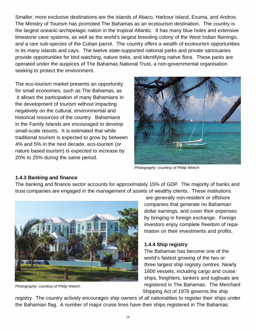
Smaller, more exclusive destinations are the islands of Abaco, Harbour Island, Exuma, and Andros.The Ministry of Tourism has promoted The Bahamas as an ecotourism destination. The country isthe largest oceanic-archipelagic nation in the tropical Atlantic. It has many blue holes and extensivelimestone cave systems, as well as the world’s largest breeding colony of the West Indian flamingo,and a rare sub-species of the Cuban parrot. The country offers a wealth of ecotourism opportunitiesin its many islands and cays. The twelve state-supported national parks and private sanctuariesprovide opportunities for bird watching, nature treks, and identifying native flora. These parks areoperated under the auspices of The Bahamas National Trust, a non-governmental organisationseeking to protect the environment.
The eco-tourism market presents an opportunityfor small economies, such as The Bahamas, asit allows the participation of many Bahamians in
the development of tourism without impacting negatively on the cultural, environmental and historical resources of the country. Bahamiansin the Family Islands are encouraged to developsmall-scale resorts. It is estimated that while traditional tourism is expected to grow by between4% and 5% in the next decade, eco-tourism (ornature based tourism) is expected to increase by20% to 25% during the same period.
1.4.3 Banking and finance The banking and finance sector accounts for approximately 15% of GDP. The majority of banks andtrust companies are engaged in the management of assets of wealthy clients. These institutions
are generally non-resident or offshorecompanies that generate no Bahamiandollar earnings, and cover their expensesby bringing in foreign exchange. Foreigninvestors enjoy complete freedom of repa-triation on their investments and profits.
1.4.4 Ship registryThe Bahamas has become one of theworld’s fastest growing of the two or three largest ship registry centres. Nearly 1600 vessels, including cargo and cruiseships, freighters, tankers and tugboats are registered in The Bahamas. The Merchant
Shipping Act of 1976 governs the ship registry. The country actively encourages ship owners of all nationalities to register their ships underthe Bahamian flag. A number of major cruise lines have their ships registered in The Bahamas.
19
Photography: courtesy of Philip Weech
Photography: courtesy of Philip Weech

In an effort to register more small cruise ships, luxury yachts and charter boats government hasreduced tariffs and fees for these vessels. Ships engaging in foreign trade that are under twelveyears old and weigh over 1,600 net tons are eligible for Bahamian registration. Under certain circumstances special permission may be obtained from the Minister of Transport for registration of ships under 1,600 net tons, or over twelve years old.
1.4.5 Fisheries
“The water is so exceeding clear, that at the depth of twenty fathom, the rocky bottom is plainly seen, and in calm weather I have distinctly and with much pleasure beheld variety of fish sporting amidst groves of corallines and numerous other submarine shrubs, growing from the rocky bottom, amongst infinite variety of beautiful shells, fungus, and astroites, etc.” Mark Catesby, 1725
In The Bahamas, the important commercial species of fish and other marine fauna, and a largenumber of species with little or no commercial value, live on the extensive shallow water banks.Particularly important commercially is the spiny lobster. Other commercially important species
include the queen conch, theNassau grouper, the lanesnapper, jacks and bonefish.There are also a number ofimportant offshore pelagicgame fish including blue marlin, tuna, wahoo, sailfish,swordfish, amberjack, dolphinand white marlin.
The waters surrounding TheBahamas are home to fourspecies of sea turtles: the loggerhead, the green turtle,
the hawksbill turtle and the leatherback turtle. Three species of dolphin occur, the bottlenose, theAtlantic spotted and the spinner, and four species of migratory whales, minke, sperm, beaked shortfin and humpback, are occasionally seen. There are several species of sharks including hammerheads, tiger sharks, nurse sharks, makos and lemon sharks. These marine species are of great importance to the biodiversity of the country and have significant potential for eco-tourism.Annex 3 lists the scientific names. On the island of Abaco efforts are underway to develop a whale-watching programme.
The Fisheries Resources (Jurisdiction and Conservation) Act of 1977 established an exclusive fishery zone of 200 miles from the baseline from which the territorial sea is measured. The purposeof the Act is to conserve the fisheries resources of the country and to regulate the exploration andexploitation of those resources. Marine mammals, sea turtles and spiny lobster are protected by law.
20
Photography: Conch Shells (Strombus gigas) courtesy of Philip Weech

Fisheries regulations set limits for game fishing and long-line fishing is prohibited. Fisheries management is complex as it requires local, regional and international cooperation, and must alsoaddress concerns about endangered species, marine mammals, international shortages, and conflicts with agriculture, coastal development, and tourism.
The exclusive fishery zone is not to be confused with the exclusive economic zone established bythe Archipelagic Waters and Maritime Jurisdiction Act of 1993. This Act establishes the archipelagic,territorial and internal waters of the country and the right of innocent passage of ships and aircraft.The Act also establishes the two hundred mile exclusive economic zone of the country and the typesof activities that may be conducted therein.
Important components of the Bahamas "sun, sand and sea" tourist package are the numerousbeaches throughout the islands. The health of these beaches is directly related to the near shorebarrier and fringing reefs that act as natural breakwaters, thereby limiting their erosion by waveaction. It is also related to the numerous stony and soft corals that make a significant contribution tothe production of sand to replenish the beaches. Corals are increasingly recognized as sources ofbiomedical chemicals and are the sources of new chemicals currently being tested for anticancer,anti-microbial and anticoagulant properties. Bryant et al. (1998) have produced a world atlas ofcoral reefs at risk. Commercial fishing is reserved exclusively for Bahamians. However, several foreign investors are involved in aquaculture projects.
1.4.6 Agriculture Agriculture’s contribution to GDP is relatively small and historically of the order of 1% to 2%. Despite this, there ispotential for the sector to make a greater contribution, focusingparticularly on certain of the minor fruits. Subsistence farmingis still important in the Family Islands, growing typically corn,cassava, sweet potatoes, beans and pigeon peas, but the number of farmers has declined in the past two decades andthe average age of farmers has increased. The land area under agriculture according to the 1994 Agricultural Censuswas 50,250 acres (ac) / 20,344 hectares (ha) (Department ofAgriculture and Department of Statistics, 1996). The sectorproduces substantial quantities of broilers and eggs, thoughall the inputs are imported. There is little red meat produced,though significant amounts of goat and sheep mutton are produced. Essentially all the dairy products consumed are
imported, though there is some local manufacture using imported ingredients.
Some 90% of the food consumed in The Bahamas is imported, and food imports account for about25% of all non-petroleum imports. This includes most of the carbohydrate foods and all the sugar.There is scope for greater local production of fresh fruits and vegetables, but production is seasonaland imports are necessary for much of the year to meet the demands of hotels and restaurants.There are a number of nurseries and landscaping companies.
21

1.4.7 IndustryThere is a growing industrial sector, and several industrial parks in New Providence for light industryand the manufacture of consumer products. Grand Bahama is home to several industries includingthe manufacture of pharmaceuticals and other chemicals. There is an oil refinery that is no longer inoperation, and a crude oil storage facility at Riding Point.
New Providence is home to the industries of brewing anddistilling, and light manufacturing including furniture andbedding. There are a few companies producing a range ofpaper products, a company producing shoes, and severalsmall operations producing garments of various types.There are a few sizeable food processors and several cottage industry food processors, making mainly preserves and pepper sauces. A significant cottageindustry is straw work with the products sold locally in
a number of crafts markets and in hotels.
1.5 ENERGY PRODUCTION AND TRANSPORTEnergy is produced mainly through the combustion of fossil fuel products such as gas/diesel oil and residual fuel oil (bunker “C”). Liquefied petroleum gas (LPG) isused for cooking while gasoline (petrol) and diesel oil are used for transportation. These account for 90% of the total carbon dioxide emission. Local transportation,manufacturing industries, commercial andresidential buildings, are other users of fossil fuels, but along with agriculture and forestry, contribute insignificant amounts of carbon dioxide. The fishing industry and the mail boat (inter-island shipping) services contribute some carbon dioxide emission, but this is small compared to thatof the major users of fossil fuel.
There is no use of biomass for electricity generation, and an insignificant amount is used for cooking, either as fuel wood or as charcoal.
22
Photography: courtesy of Devin Weech

1.6 THE ENVIRONMENT
“This beautiful species [flamingo] was at one time very abundant throughout The Bahama Islands; but of late years they have been so persecuted by the inhabitants that at the present time they are to be found in any numbers only upon the inland ponds and marshes of Inagua and Abaco. They are gradually dying off, or seeking some more inaccessible locality as yet undisturbed by the presence of mankind andin all probability with the next century the Flamingo will be unknown in The Bahamas.
During the month of July they [Bahama parrots] repair in large numbers to the cornfields near Matthewstown [Inagua] and cause great destruction to the crops. At this season they are quite tame, and quantities of them are killed.” Charles Corey, 1880.
1.6.1 IntroductionThe natural beauty of the Bahamas is complemented by itsrich cultural heritage, the warm hospitality of its people, anda vibrant economy. The Government is cognizant of theurgent need to protect the fragile environment and ecosys-tems of the country. This is reflected in the report tothe United Nations Conference on Environment and
Development (UNCED) (Ministry of Foreign Affairs, 1992).
The Bahamas is been recognized as a leader in environ-mental legislation in the Wider Caribbean Region. The WildBirds Protection Act of 1952, the Bahamas National TrustAct of 1959, the Fisheries Resources (Jurisdiction andConservation Act, Amendment No. 2 of 1993), and theConservation and Protection of the Physical Landscape Actof 1997, were each milestone achievements. Shortly aftercoming to power in 1992, the present government began toannounce a programme aimed at protecting the physicalenvironment and the natural resources of the country.
23

1.6.2 The BEST CommissionAs a part of this programme the Bahamas Environment Science and Technology (BEST)Commission was established in 1994. The Commission is housed in the Office of the PrimeMinister, with an Ambassador for the Environment having direct responsibility for its operations.The mandate of the BEST Commission includes:
• coordination of policies and programmes for environmental protection.• development of science and technology in The Bahamas.• development of a national conservation strategy and action plan. • proposing legislation to support the national conservation strategy and plan.• advising government on the environmental impact of development proposals.• preparation of a national inventory of natural resources, including species, habitats and
ecosystems.• development of a national system of parks, protected areas and reserves, to provide for
in situ conservation.• coordinating responses to the international environmental conventions to which The
Bahamas is party.
Even before signing the Convention on Biological Diversity, The Bahamas reaffirmed that biodiversi-ty and sustainability are fundamental to the success of the development process. It is the role of theBEST Commission to advise the Government on policies and activities that will ensure that develop-ment takes place in harmony with sustainable use and the conservation of biodiversity. Two primarystated goals of the Government of The Bahamas are sustainability and the elimination of poverty:both are linked to the conservation and wise use of natural resources.
The Government of The Bahamas has recognised that the environment is critically important to theeconomy and well being of all generations of Bahamians (Ingraham, 1999a). As a consequencegovernment has begun to incorporate the protection and enhancement of the environment and ofbiodiversity into the national planning process. Government is committed to the development andimplementation of a review and approval process for development, through environmental impactassessment processes. This will include regular monitoring, quality control and enforcement of lawsfor the protection of natural, including freshwater, marine resources, agricultural lands and general environmental quality.
The Bahamas is signatory to most of the major international environment conventions (see Box1.6.2.1.) and has national legislation protecting endangered plants and animals and the physicallandscape.
24

INTERNATIONAL LEGAL INSTRUMENTS ON THE ENVIRONMENT TO WHICH THE BAHAMAS IS A CONTRACTING PARTY OR SIGNATORY
• Vienna Convention for the Protection of the Ozone Layer Concluded at Vienna on 22 March 1985 (Ratified on 1 April, 1993)
• Montreal Protocol on Substances that Deplete the Ozone Layer Concluded at Montreal on 16 September 1987 (Ratifiedon 4 May 1993)
• Amendment to the Montreal Protocol on Substances that Deplete the Ozone Layer (Ratified on 4 May 1993)
• Amendment to the Montreal Protocol on Substances that Deplete the Ozone Layer (Ratified 4 May 1993)
• Basel Convention on the Control of transboundary Movements of Hazardous Wastes and Their Disposal. Concluded at Basel on 22 March 1989 (Ratified 12 August 1992)
• United Nations Framework Convention on Climate Change Concluded at New York on 9 May 1992 (Signed 12 June 1992; ratified 2 September 1994)
• Convention on Biological Diversity (Signed 12 June 1992; ratified 2 September 1994)
• Washington Convention or Convention on the International Trade in Endangered Species of Wild Fauna and Flora (CITES)
• Law of the Sea Convention (1982)
• International Convention for the Prevention of Pollution from Ships (MARPOL 1973 and 1978) (Effective application: 16 February, 1979 and 2 October 1978 respectively)
• International Coral Reef Initiative
• Agenda 21
• The Barbados SIDS Action Plan
• Wider Caribbean Initiative on Generated Waste (MARPOL)
• UNEP Programme of Action
• Action Plan of the Summit of the Americas
• Programme of Action of the UN Commission on Sustainable Development
• Programme of Action of COP II
• International Convention for the Prevention of Pollution of the Sea by Oil (Ratified 22 October 1976)
• Amendments to the International convention for the Prevention of Pollution of the Sea by Oil, 1954, Concerning Tank Arrangements and Limitation of tank Size (Ratified 16 February, 1979)
• Amendments to the International Convention for the Prevention of Pollution of the Sea by Oil, Concerning the Protection of the Great Barrier Reef (Ratified 16 February,1979)
• Treaty Banning Nuclear Weapon Tests in the Atmosphere, in Outer Space and Use of Outer Space and Under Water (Ratified 11 August, 1976)
• Treaty on Principles Governing the Activities of States in The Exploration and Use of Outer Space Including the Moon and Other Celestial Bodies (Ratified 11 August, 1976)
• International Convention on Civil Liability for Oil Pollution Damage (20 January, 1976)
• International Convention relating to Intervention on the High Seas in Cases of Oil Pollution Casualties (Ratified 30 March, 1983)
• Protocol relating to Intervention on the High Seas in Cases of Marine Pollution by Substances Other than Oil (Ratified 30 March, 1983)
• International Convention on the Establishment of an International Fund for Compensating Oil Pollution Damage as Amended (Ratified 16 October, 1978)
• Convention on the Prohibition of the Development, Productionand Stockpiling of Bacteriological (Biological) and Toxic Weapons, on their Destruction (Ratified 26 November, 1986)
• United Nations Convention on the Law of the Sea of 10thDecember, 1982 relating to the Conservation and Management of Straddling Fish Stocks and Highly Migratory Fish Stocks (Ratified 16 January, 1997)
• Convention for the Protection and Development of the Marine Environment in the Wider Caribbean Region
• Cartagena Convention to Negotiate Final Protocol ConcerningPollution from Land-Based Sources and Activities
• Protocol Concerning Specially Protected Areas and Wildlife in the Wider Caribbean (SPAW)
• Convention on Wetlands of International Importance Especially as Waterfowl Habitat (Ramsar Convention)
25

1.6.3 Biodiversity
“Alligators were sometimes brought in for the table; but it required considerable address and some courage to destroy them. The flesh of an alligator which I tasted was hard, white, and very much resembled the sturgeon’s.” Daniel McKinnen, 1804
Mark Catesby was among the first to comment on the biodiversity of The Bahamas (Cates, 1997), and his volumesprovide a useful insight into the early history of biodiversityin The Bahamas. Campbell (1978) has written a usefulaccount of the islands, and Shattuck (1905) provides a historical perspective. Woods (1989) provides a usefulguide to the biogeography of the West Indies. Most of theislands of the Bahamas remain uninhabited to this day, andare visited only infrequently by yachtsmen and boaters.Their environment is relatively undisturbed. However, thedisposal of garbage on beaches, in harbours and inlets, andin open water, is a matter of concern. It is not only unsightlybut can be harmful and life threatening to animal-life. Insmall island states maintaining ecosystem characteristics isa challenge as small islands are more prone to loss andextinction of species than larger landmasses. Removal andalteration of one or more components leads to ecosystemchange and loss of biodiversity. The poaching of iguanasand snakes for the pet trade is also a matter of concern.These and other concerns are discussed in the NationalBiodiversity Strategy and Action Plan prepared by the BESTCommission (BEST, 1998).
A full account of the biodiversity of The Bahamasis presented in the Biodiversity Country Study(BEST, 1995), and a summary of some of the marine biodiversity has been given in 1.4.5.Fishweries, above. Approximately 300 species ofbirds are known to occur in The Bahamas but themajority (169) of these are passage migrants. Some forty species are resident, of which three areendemic and there are twenty-one endemic sub-species. Bahamian birds are part of the West Indianavifauna rather than that of North America. Allspecies of wild birds are protected by the Wild Birds Protection Act of 1952, which establishes hunting regulations on game birds and penalties for violations.
Mark Catesby: The Alligator and Red Mangrove
Mark Catesby: The Ilathera Duck

Several species of birds, including the northern mockingbird, ring-necked pheasant, chukar,bobwhite, and Cuban grass-quit have been introduced. Annex 3 contains a list of the scientificnames of the species referred to in this chapter. The Bahamas National Trust is promoting birdwatching for both Bahamians and tourists. Useful guides to the birds of The Bahamas areBrudenell-Bruce (1975) and White (1998).
The flora of The Bahamas is varied. Ecosystems range fromhigh coppice (comprising wild figs, mahogany, lignum vitae,poison wood, horse flesh, wild tamarind and other species),to seaside coppice (low growing scrub-brush). Large areas in Abaco, Andros, Grand Bahama and New Providence arecovered with pine forests (or “barrens”), with an under storeyof shrubs and vines. Mangroves forests occur on the coastand inland in wetlands and salinas: the species include red,black and white mangroves and buttonwood. Britton andMillspaugh (1920) provide an early description of the flora ofThe Bahamas and a more recent account is that of Correll and Correll (1982). More than 1350 species of floweringplants and fern, representing approximately 660 genera and 144 families, have been described,including 27 genera of orchids and five bromeliad genera (Correll and Correll, 1982). It is thoughtthat only fifteen endemic species of plants are found in the islands. The Bahamian flora has beenderived from the Caribbean basin, and particularly from Cuba.
Most Bahamians have traditionally considered Bahamian plants to be “bush” a local term used todenote land and vegetation of little or no commercial value. There was little use of local species in landscaping, therefore. A large number of exotic species of plants have been imported over theyear, many of which are now naturalized and several of which have become invasive. Invasivesinclude casuarina (or beefwood), Brazilian pepper tree, and paper bark tree. In 1997, theGovernment passed The Conservation and Protection of the Physical Landscape Act that protectstwelve species of trees considered to be rare or of historic importance. Bahamian trees and shrubsare now being used in greater quantities in landscaping projects. “Bush” is also used to refer to various medicinal plants and Higgs (1978) has documented these and their uses.
Associated with the native flora are many cultivated crop plants including mango, avocado, sapodilla, scarlet and hog plums, guinep, breadfruit, sugar apple, guavas, sapodilla, soursop, gooseberries, mamey, sweet potato, pigeon peas, hot pepper, corn, beans, cassava, melons, andpineapple. These are not native to The Bahamas, but have been cultivated for generations and insome cases have become naturalized.Only one endemic mammal, the Bahama hutia occurs in TheBahamas, but cave bats are also found. Feral dogs, cats, and rats are found on most islands anddonkeys, horses, and hogs are found on Abaco and Inagua. Raccoons, introduced in the late1700s, are found on New Providence and are common in some neighbourhoods where they may bepests.
27
Photography: courtesy of Philip Weech

Other animals found in The Bahamas include several endemic species of iguanas, lizards, butter-flies, moths and other insects, land crabs and snakes. Interestingly, in a country where surfacefreshwater is very rare, freshwater turtles are found on Cat Island and Inagua. The Bahamas, andparticularly Andros, abounds in blue holes. Although some research has been done, these arethought to contain many species not yet described and named (Brown and Downhower, 1993).
The majority of The Bahamas’ space (more that 96%) is in coastal, marine and deep-water habitats.This vast majority of these remain unexplored and their biodiversity unknown. In marine ecosys-tems, destruction of coral reefs and sea-grass beds removes food and shelter for many life forms.Similarly, the destruction of mangrove forests removes nurseries for a large number of organismsand for many fish of commercial importance. These forests also provide nesting sites for variousbird species.
1.7 LAND USE, LAND USE CHANGES AND FORESTRY
“…there is Gumme Benjamin of the best and the worst sort, Guacom and Sasparilla and Sasafras, and some of them red wood…”George Gardyner of Peckham, 1651
Historically large expanses of land on all of the major inhabited islands were used for subsistencefarming. This activity virtually eliminated the primeval forests, which existed when Columbus landedin 1492. Traditionally the slash-and-burn method of land clearing has been used. The soils of TheBahamas are very thin, calcareous, fragile and inherently of low fertility and droughty. Once landhad been farmed for a few years it became exhausted, and farmers cleared new acreage for plant-
ing. Various attempts at commercial agriculturehave been tried, including the establishment of cotton plantations in the late 1700s, pineapple productionin the late 1800s, sisal in the late 1800sand early 1900s, tomatoes from the 1940s to theearly 1980s, sugar cane in the 1950s, and citrus inthe 1980s and 1990s. Some of these projects weresuccessful for a number of years but eventually succumbed because of soil depletion. The citrusgroves of Abaco are probably the largest successfulongoing agricultural project in The Bahamas.
Land use has changed on New Providence over thepast thirty years. Virtually all of Paradise Island has been cleared of native vegetation for large-scale hotel developments, along with luxury houses, apartments, condominiums and a golf course.Large areas of water front and lake front land around the island of New Providence have beencleared for hotels, luxury housing complexes, and private houses. Nassau has gone from havingthree or four small hotels in the 1950s, with only a few hundred rooms, to having dozens of resortsoffering a combined total of thousands of rooms. Large tracks of land on the interior of the islandhave been cleared to make room for housing, business complexes and roads.
Photography: courtesy of Philip Weech

29
On Grand Bahama a great deal of develop-ment has also taken place. Most recent isthe container transshipment port and cruiseship facilities. In the Family Islands, Abaco isprobably the most developed with the moreremote islands such a Mayaguana, Acklins,Ragged Island and Crooked Island remainingsparsely populated and largely unchanged.
During the early twentieth century a sawmilloperated on Abaco. By 1943, all the virginforests of Abaco had been cut, leaving only afew isolated pockets of old growth in the north. Today, although the pine forests of Abaco are extensive and impressive for The Bahamas, the forests are, for the most part, secondary. Oncethe forests were depleted, the sawmill was moved to Grand Bahama where it operated until the1970s. Smaller operations were located on New Providence and Andros.
Government recognizes the importance of the Caribbean pine and has made it a protected species.The rejuvenation of the pine forest is of great importance to the many under-storey broadleaf plants,orchids, bromeliads, bracken fern, and vines. Further, pine forests provide important habitat for butterflies, snakes, crabs, and birds, and for the endangered Kirtland’s Warbler and, on Abaco, theBahama Parrot. Many well fields for fresh water are under pine forest. Feral animals such asdogs, cats, rats, raccoons, hogs, horses and donkeys also live in the forests.
The forest resources of The Bahamas have been classified into three distinct types namely pine forest, coppice forests and mangrove forests. Approximately 80% of the forest resources are on state lands (Crown Land) with the remaining 20% in private holdings. The pine forests are considered the most productive and commercially viable forest resource, comprising an estimated880 mi2 (2,278 km2). Russell (1998, 2000) has discussed the future of forestry in The Bahamas andin the Caribbean. Patterson and Stevenson (1977) provide a useful guide to identifying the trees ofThe Bahamas.
The coppice hardwood forests are found predominantly in the central and southern Bahamas andhave been described and inventoried by Little et al. (1971-1976): they comprise various hardwoodspecies harvested in the past for saw logs. The estimated area of coppice forest is 2,709 mi2
(7,108 km2). The mangrove forests occur predominantly on the lee shores of most Bahamianislands, and the total area of mangrove forest in The Bahamas is estimated to be some 2,666 mi2
(6,904 km2). Significant areas of wetlands, which include mangrove forests, are the north coast ofGrand Bahama, the west coast of Andros, the Marls of Abaco, much of Cat Island, and Lake Rosa,Inagua. The latter is protected under the Ramsar Convention.
Photography: courtesy of Philip Weech

30
1.8 NATIONAL CIRCUMSTANCES AND SUMMARY TABLES
Table 1.8.1 National circumstances: The Bahamas.
Criteria 1990 1994
Population 254,685 274,600(Estimate)
Relevant area Total: 260,000 km2 Total: 260,000 km2Land: 13,940 km2 Land: 13,940 km2
GDP at current market price Not available Not available
GDP per capita at current market price Not available Not available
Estimated share of the informal sector in the economy in GDP (%) Not available Not available
Share of industry in GDP (%) Not available Not available
Share of services in GDP (%) Not available Not available
Share of agriculture in GDP (%) * 3 - 5% * 3 - 5%
Land area used for agriculture 24,323 ha 20,344 ha(Estimated) (Census)
Urban population as % of total population 70 70
Livestock population Not available Cattle (non-dairy): 796Sheep: 6,292Goats: 13,580Pigs: 4,777Poultry: 750,000
Forest area (kha) Pine forest 227.8 Pine forest 227.8Coppice forest 701.8 Coppice forest 701.8Mangrove forest 690.4 Mangrove forest 690.4
Population in absolute poverty Not available Not available
Life expectancy at birth Male Male 70.7Female Female 77.4
Literacy rate 98%
Table 1.8.1 summaries the national circumstances, as required by the UNFCC Guidelines for First National Communications of Non-Annex 1 Parties. Note that estimates, usually based on interpolation, or calculations based on growth rates, are applied where appropriate. In some instances, data are not available. Tables 1.8.2 and 1.8.3 present the summaries of the initial national greenhouse gas inventories of anthropogenic emissions and removals by sinks for 1990 and 1994.
*Agriculture and Fisheries

31
Table 1.8.2 Initial national greenhouse gas inventories of anthropogenic emissions by sources andremovals by sinks of all greenhouse gases not controlled by the Montreal Protocol: 1990 (Gg).
CO2 CO2 CH4 N2O NOx CO NMVOC SO2Emissions Removals
Total National Emissions and Removals 1,894 - 2 0 0 4 4 0
3,600
1 Energy
Reference Approach(1) 1,894
Sectoral Approach(1) 0 0 0 0 0 4 0
A Fuel Combustion 0 0 0 0 0 0
B Fugitive Emissions from Fuels 0 0 0 0 4 0
2 Industrial Processes 0 0 0 0 0 0 0
3 Solvent and Other Product Use 0 0 0
4 Agriculture 0 0 0 0
5 Land-Use Change 0 (2) - 1 0 0 4& Forestry 3,600
6 Waste 1 0
7 Other (please specify) 0 0 0 0 0 0 0 0
Memo Items:
International Bunkers 0 0 0 0 0 0
Aviation 0 0 0 0 0 0 0
Marine 0 0 0 0 0 0
CO2 Emissions from Biomass 0
P = Potential emissions based on Tier 1 Approach. A = Actual emissions based on Tier 2 Approach.
(1) For verification purposes, countries are asked to report the results of their calculations using the Reference Approach
and explain any differences with the Sectoral Approach. Do not include the results of both the Reference Approach and the
Sectoral Approach in national totals.
(2) The formula does not provide a total estimate of both CO2 emissions and CO2 removals.
It estimates “net” emissions of CO2 and places a single number in either the CO2 emissions
or CO2 removals column, as appropriate. Please note that for the purposes of reporting, the signs
for uptake are always (-) and for emissions (+).

Table 1.8.3 Initial national greenhouse gas inventories of anthropogenic emissions by sources andremovals by sinks for all greenhouse gases not controlled by the Montreal Protocol: 1994 (Gg).
CO2 CO2 CH4 N2O NOx CO NMVO SO2
Emissions Removals C
Total National Emissions and Removals 1,866 0 0 1 0 0 3 0
1 Energy Reference Approach(1) 1,866
SectoralApproach(1) 0 0 0 0 0 3 0
A Fuel Combustion 0 0 0 0 0 0
B Fugitive Emissionsfrom Fuels 0 0 0 0 3 0
2 Industrial Processes 0 0 0 0 0 0 0
3 Solvent and Other Product Use 0 0 0
4 Agriculture 0 1 0 0
5 Land-Use Change & Forestry (2) 0 (2) 0 0 0 0 0
6 Waste 0 0
7 Other (please specify) 0 0 0 0 0 0 0 0
Memo Items:
International Bunkers 645 0 0 0 0 0 0
Aviation 341 0 0 0 0 0 0
Marine 305 0 0 0 0 0 0
CO2 Emissions from Biomass 0
P = Potential emissions based on Tier 1 Approach. A = Actual emissions based on Tier 2 Approach.
(1) For verification purposes, countries are asked to report the results of their calculations using the Reference Approach and
explain any differences with the Sectoral Approach. Do not include the results of both the Reference Approach and the
Sectoral Approach in national totals.
(2) The formula does not provide a total estimate of both CO2 emissions and CO2 removals. It estimates “net” emissions of
CO2 and places a single number in either the CO2 emissions or CO2 removals column, as appropriate. Please note that for
the purposes of reporting, the signs for uptake are always (-) and for emissions (+).
Note 1: X - Data to be presented to the extent that the Party's capacities permit (Article 12.1(a)).
Note 2: Non-Annex I National Communications will include the information in this table, and a description of assumptions
and methods used, and the values of emission coefficients, where these differ from IPCC assumptions, methods and values.
Note 3: Efforts should be made to report the estimated range of uncertainty, where appropriate.
32

NATIONAL INVENTORY OF GREENHOUSE GASES
2.1 INTRODUCTIONIn accordance with Article 4.1(a) of the United Nations Framework Convention on Climate Change(UNFCCC), all parties to the Convention are required to update and report periodically on theirnational inventory of anthropogenic greenhouse gas emissions and the removal by sinks. A National
Climate Change Committee (NCCC) (see Annex1 for composition), was formed and first con-vened in March 1996. The NCCC undertook thepreparation of this First National GreenhouseGas Inventory for The Bahamas. The committeeused the IPCC greenhouse gas inventory soft-ware, the spreadsheet workbook, and followedthe revised 1996 IPCC Guidelines for nationalgreenhouse gas inventories Revised 1996, IPCC Guidelines for National Greenhouse GasInventories (IPCC, 1996)).
Greenhouse gas (GHG) emissions and theirremoval by sinks have been calculated for The Bahamas for 1990 and 1994. Electricity
generation and the transportation sector are the two most significant sources of greenhouse gasemissions in The Bahamas. There is no primary fuel production in the Bahamas and all fossil fuelsare imported. International marine and air bunkering fuels, and the storage and transmission of fossil fuel, represents fuel exported through The Bahamas.
2.2 INVENTORY PROCESSThe National Climate Change Committee organized the First Greenhouse Gas Inventory Workshopin July 1998, at which time potential greenhouse gas sources were identified, and these sourcesorganized into four broad categories. The workshop identified data sources and agreed on a procedure for the conduct of the national inventory.
Subsequent workshops organized by the NCCC provided for the review of data categories andanalysis of fuel sources for imports into The Bahamas. The workshops also identified problems in the compilation, gathering and access to data held in the public domain. A key issue was one pertaining to the rules and procedures governing the access to data collected for statistical purposesin The Bahamas. Data can only be provided in an aggregate form according to the statistical guide-lines. In most cases data held in statistical databases could not be made available for the inventorywithout violating existing rules and regulations. This issue was of particular concern in the industrialsector. Additionally, it was determined that the detailed data required to verify the top-down reference approach using the revised IPCC guidelines were not available in the form required forinput into the IPCC tables. A statistical survey was required to collate and verify existing data.
33
CHAPTER 2
Photography: courtesy of Philip Weech

34
Unfortunately, preparations by the relevant government agency for the 2000 Census of thePopulation of The Bahamas frustrated this process.
Further discussions provided a means for indirectly obtaining information from the Central Bank of The Bahamas and from the Customs Department database, needed to conduct an initial green-house gas inventory for The Bahamas. It was determined that public data contained in the CentralBank's Quarterly Statistical Digest (Central Bank, 1997, for example),and, and the BahamasCustoms database and reports, the local oil companies' reports, and data from other fuel sources,contained data that could be were used in the inventory process especially in the fuel analysisimportant to the Energy sector.
Data for other sectors wastaken from the Central Bank of the Bahamas QuarterlyStatistical Reports, as well as directly provided by theDepartment of Statistics, theDepartment of Agriculture, the Department of Fisheries,the Department of Lands andSurveys and the Water andSewerage Corporation. Thedata in the Central Bank’s
Quarterly Statistical Reports on oil trading is supplied directly, to the Central Bank, by the local oil companies and is disaggregated into oil imported for domestic consumption, and that for thebunkering of foreign ships and aircraft. Oil that is imported for transshipment, or for refining andsubsequent re-export, has been excluded from the trade account, since no change of ownershipoccurred according to the procedures used by the Central Bank of The Bahamas. In some cases,the data available were not immediately suitable for input into the IPCC spreadsheets.
In such cases, assumptionswere made to allow theincorporation of these data.Box 2.2 lists some of theproblems and constraintsexperienced in undertakingthe inventory, and Table 2.2.1 indicates the Categories and subcategories reviewed in thenational inventory processfor The Bahamas.
Photography: courtesy of Philip Weech
Photography: courtesy of Philip Weech

35
Box 2.2 Problems and constraints to the greenhouse gas inventory process and proposals toimprove the process.
The Revised 1996 Intergovernmental Panel on Climate Change (IPCC) Guidelines for NationalGreenhouse Gas Inventories (IPCC, 1996) was used to produce the national inventory of green-house gases for the Bahamas. Some of the difficulties encountered in following the guidelines are summarized below.
The IPCC Reference or Tier 1 Approach had to be modified in order to accommodate the type, format and accuracy of the data collected by national authorities.
In some instances national regulations governing the use of statistical data also impacted thisprocess.
• A "top-down" approach was applied using the aggregate statistical data compiled by the Central Bank of the Bahamas on fossil fuels, but no "bottom-up" comparison was attempted,as the essential statistical data were unavailable in the disaggregated format required for input into the IPCC spreadsheet.
• In many cases a new data collection exercise would have had to be conducted to obtain data in the format needed.
• The Department of Statistics was fully engaged in preparatory work for the 2000 Population Census of The Bahamas, and was unable to cooperate as fully as they would have liked with the exercise.
• In some instances the types of national data were simply not available: in the transport sector for example, data on fuel usage and numbers, types and sizes of vessels in the marine transport, commercial, and recreational fishing sub-sectors, were not available.
Given these constraints, the Central Bank’s Aggregated Statistical Summary of fuel imports provided the highest quality verifiable data source available for immediate use in a format that allowed for the initial national inventory of greenhouse gases in a modified Tier 1 Approach. Central Bank's Statistical Survey of 1994, that focused on disaggregating the fuel used in international bunkering, allowed for some refinement of the inventory process. Verification of the data was undertaken in discussion with the fuel suppliers in The Bahamas, and through consultation with the Customs Department. Additionally,work by other government agencies, notably by the Ministry of Agriculture in the 1994 Agricultural Census, also provided reliable data for the agricultural sector.
In order to improve the reproducibility and accuracy of future national inventories, the following steps are proposed.
• Steps must be taken to allow for verification of data, using multiple sources, so as to permit the use of a "top-down" and "bottom-up" comparison.
• The compilation of statistical data, and the nature of the reporting process, need to be addressed.
• A detailed examination of the transport sector, focusing on fuel usage in private and public vehicles, in marine transport, in domestic aircrafts, and in agriculture, is required.
• A national system for data collection, storage, archiving and retrieval, also needs to be developed, and persons trained in its use.
• Land use, land use changes and forestry, will require special attention, as this initial national inventory relies heavily on data collected by a Land Resources Survey (Little et al., 1971-1976) completed some 25 years ago.
• A system for updating and reporting on changes in land use needs to be developed so as to provide reliable data for future national inventories.
• The issue of carbon sequestration in the shallow waters of the Bahamas requires scientific study in order to verify the initial assessment, and to determine strategies for enhancing the capacity of the system to sequester carbon.

Table 2.2.1 Organization of the greenhouse gas (GHG) inventory.
Category Sub category
Energy activities Fuel combustion
Energy Industries
Transport
Fugitive emissions
Memo items: international bunkers
Agriculture Enteric fermentation
Manure management
Agricultural soils
Land use, land use changes and forestry Conversion to other uses
Clearing of forests
Managed areas
Waste solid and liquid Solid waste disposal on land
Wastewater handling practices
The IPCC guidelines were followed as data sources permitted and default values, where provided,were used. The IPCC reference approach was used for the energy sector. A top downtop downapproach was used as data was not available or not in the required format that would enable a bottom-up verification of emission in the energy sector.
36

The industrial profile of The Bahamas did not change over the 1990 to 1994 period and consisted ofbrewing and distilling, some chemical plant output and from the pharmaceutical industry, the produc-tion and export of solar evaporated salt, and the re-export of crude oil. Essential industrial outputdata needed to calculate emissions in the sector was not available. However it was determined,based on an examination of the industrial sector make-up, that the sector was considered too smallor were not accessible through indirect examination making use of the statistics maintained by theCentral Bank.
The Bahamas National Green House Gas Inventory was organized into four main categories andsub-categories, as indicated in Table 2.2.1 above, and as described in the Revised IPPC 1996Guidelines. GHG emissions were mainly from imported liquid fossil fuels consisting of gasoline, jet(aviation) and other kerosene, gas and diesel oil, liquefied petroleum products (principally liquefiedpropane gas (LPG)), and lubricants. Table 2.3.1 summarizes the quantities of fuel imported for thefive years 1990 to 1994. These data were verified through discussions with the local oil companiesand by reference to the Bahamas Customs database.
Table 2.3.1 Fuel imports into The Bahamas in thousands of barrels of energy (BOE) for the fiveyears 1990 to 1994.
Fuel type 1990 1991 1992 1993 1994 % Total
Gasoline 1287 1327 1347 1345 1303 30.5
Jet Kerosene 187 141 120 126 148 3.3
Gas/diesel oil 1759 1595 1382 1083 1301 32.9
Residual fuel oil (Bunker C) 879 787 974 1537 1442 25.9
LPG 156 201 217 164 160 4.1
Other oils 225 381 34 24 33 3.2
2.3 EMISSIONS OF GREENHOUSE GASES2.3.1 Energy sectorElectrical power in The Bahamas is generated through the combustion of imported liquid fossil fuels.In addition, residual fuel oil, diesel and fuel oils account for the total amount. The data for energyproduction and consumption are based on the latest information, as contained in Central Bankreports on petroleum usage in The Bahamas. Discussions among informed parties determined themost viable and reliable information. Data for a particular type of fuel, or for a particular supplier,were obtained from at least two sources. The import of fossil fuels for use in power generation andin transport represents the total use of fuel in the energy sector in The Bahamas. The storage offuel and international bunkering represents a smaller fraction of fuels in the sector and is reportedseparately. Data on carbon dioxide emissions from fossil fuels for 1990 and 1994, by type of fuel,are presented in table 2.3.2.
37
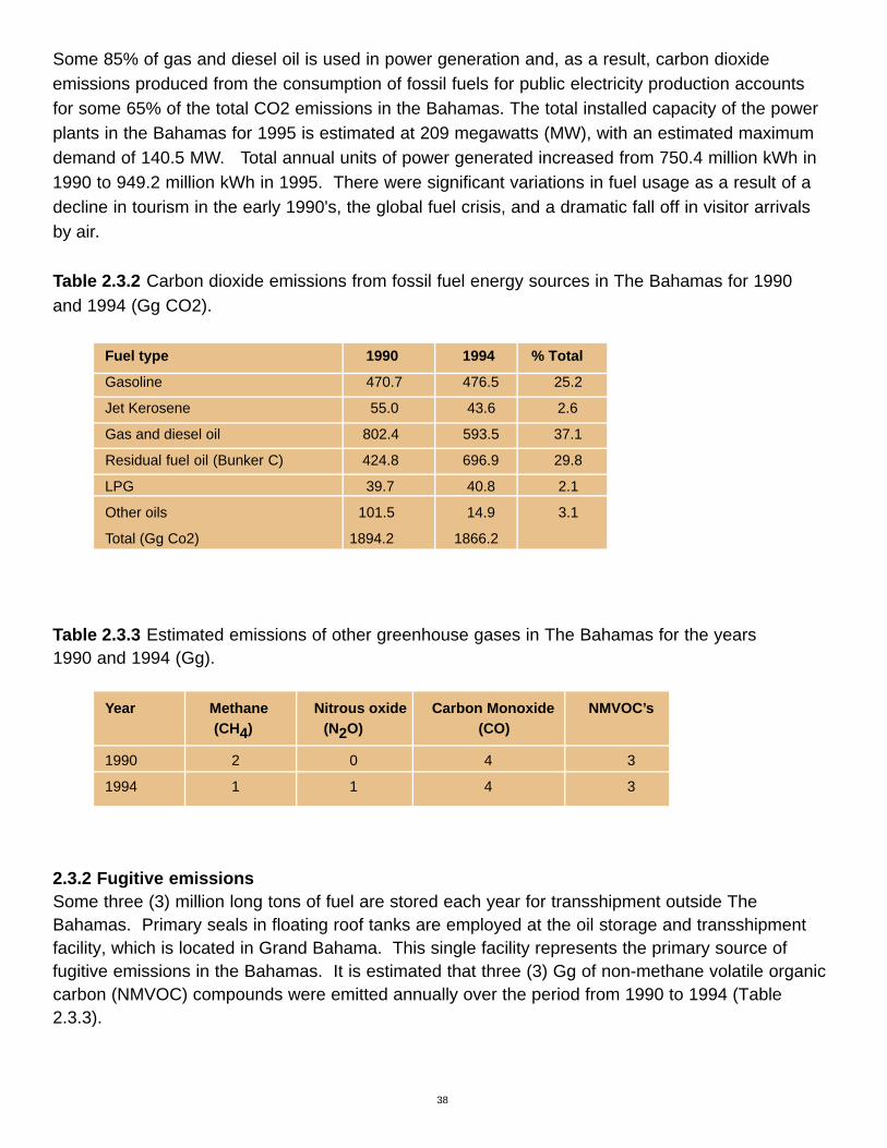
Some 85% of gas and diesel oil is used in power generation and, as a result, carbon dioxide emissions produced from the consumption of fossil fuels for public electricity production accounts for some 65% of the total CO2 emissions in the Bahamas. The total installed capacity of the powerplants in the Bahamas for 1995 is estimated at 209 megawatts (MW), with an estimated maximumdemand of 140.5 MW. Total annual units of power generated increased from 750.4 million kWh in1990 to 949.2 million kWh in 1995. There were significant variations in fuel usage as a result of adecline in tourism in the early 1990's, the global fuel crisis, and a dramatic fall off in visitor arrivalsby air.
Table 2.3.2 Carbon dioxide emissions from fossil fuel energy sources in The Bahamas for 1990 and 1994 (Gg CO2).
Fuel type 1990 1994 % Total
Gasoline 470.7 476.5 25.2
Jet Kerosene 55.0 43.6 2.6
Gas and diesel oil 802.4 593.5 37.1
Residual fuel oil (Bunker C) 424.8 696.9 29.8
LPG 39.7 40.8 2.1
Other oils 101.5 14.9 3.1
Total (Gg Co2) 1894.2 1866.2
Table 2.3.3 Estimated emissions of other greenhouse gases in The Bahamas for the years 1990 and 1994 (Gg).
Year Methane Nitrous oxide Carbon Monoxide NMVOC’s(CH4) (N2O) (CO)
1990 2 0 4 3
1994 1 1 4 3
2.3.2 Fugitive emissions Some three (3) million long tons of fuel are stored each year for transshipment outside TheBahamas. Primary seals in floating roof tanks are employed at the oil storage and transshipmentfacility, which is located in Grand Bahama. This single facility represents the primary source of fugitive emissions in the Bahamas. It is estimated that three (3) Gg of non-methane volatile organiccarbon (NMVOC) compounds were emitted annually over the period from 1990 to 1994 (Table2.3.3).
38

2.3.3 Emissions from international bunkering The Central Bank Quarterly Statistical Report aggregated the oil sold in international bunkeringactivities, based on oil reports from the Customs Department, and oil companies reports. TheCentral bank conducted statistical exercise in 1994 to disaggregate the data. The survey revealedthat three types of fuels were involved in international bunkering activities in The Bahamas: gasolinefor and boats, jet fuel for aircraft, and gas oil for larger marine transport vessels transiting theBahamas. Carbon dioxide (CO2) emissions from the two categories of bunkering aviation andmarine fuels accounted, respectively, for 54 and 46 % of the total (Table 2.3.4). The data reflectsthe significant variations in international air and marine transport of tourist into and from theBahamas over the 1990 to 1994 period.
Table 2.3.4 Carbon dioxide emissions from international bunkering in The Bahamas (Gg CO2).
1990 1994 % Total
Aviation 492 341 54
Marine 404 305 46
Total all Bunkers 896 645
2.3.4 AgricultureThe Bahamas depends almost entirely on imports of basic foodstuffs to feed Bahamians andtourists. It has a very small livestock population (see Table 2.3.5),; there is no cultivation of rice, and no prescribed burning of savannas or field burning of agricultural residues. There is someslash-and-burn agriculture practiced in the Family Islands but the total acreage involved is verysmall. There is an insignificant amount of fuel wood or charcoal used for cooking. Enteric fermentation by livestock, manure management, and agricultural soils all produce emissions on a verysmall scale. Emissions from animal production and from animal waste management systems aretherefore considered negligible. Nitrous oxide can be produced from agricultural soils through various activities such as application of synthetic fertilizer, animal waste, nitrogen-fixing crops, decay of crop residues, and through indirect sources such as the atmospheric deposition nitrousoxide as a result of nitrogen fixation in the atmosphere.
Data from the 1994 Census of Agriculture (Department of Agriculture and Department of Statistics,1996) were used to estimate livestock numbers (Table 2.3.5). The IPCC reference approach forwarm developing countries default values were employed, as the sector, in relative terms, is verysmall, and significant data gaps were evident. Agricultural soils were addressed under Land Use,Land Use Changes and Forestry. No reliable data were available on the total imports of fertilizersnor of the types of fertilizers used. Consequently, an estimate of 2.65 short tons or 5300 lb (2403 kg) was assumed and has been applied to the 1994 data. The area of agricultural landsis considered under land use.
39

No estimate is made for feral animalpopulations (dogs, cats, pigs, donkeysand horses) and domestic animals havebeen excluded. Estimates of carbondioxide, methane and nitrous oxideemissions from the agricultural sectorfor 1990 and 1994 are insignificant, with a combined total of less than 1 Gg.
Table 2.3.5 Livestock numbers in The Bahamas based on the Agricultural Census of 1994.
Type of Animals Numbers of animals
Cattle (non-dairy) 796
Sheep 6292
Goats 13580
Pigs 4777
Poultry 750,000
Source: Department of Agriculture and Department of Statistics (1996).
2.3.5 Liquid and solid waste Liquid waste disposal is mainly by use of septic tanks as less than 20% of homes are linked to anypublic sewerage drainage and collection, treatment and disposal facilities. The large tourism sector,and a high standard of living, is responsible for the estimated 1 Gg of methane (CH4) emissions.
The per capita protein consumption was estimated at 25.8 kg per annum, based on asurvey conducted in 1990 (Ministry of Healthand Ministry of Commerce, Agriculture andIndustry, 2000)
Solid waste is disposed of into unlined publicdumps across the Bahamas. The estimatedper capita waste stream from all sourceswas estimated at 2.6 kg per day, based onthe Bahamas Solid Waste Study of 1998. Itis estimated that only 70% of this total is disposed of in a public facility.
40
Photography: courtesy of Philip Weech
Photography: courtesy of Philip Weech

2.3.6 Land use, land use change and forestryForests are critical components of the climate system. Their potential for sequestering greenhousegases is enormous, and they act as an additional reservoir to trap carbon dioxide (C02) emissions.The entire Bahamas was, at one time, entirely covered with forests of tall tropical hardwood andslow-growing trees in the drier south-centralsouth central and southern Bahamas, and with forests of pine in the north and north-central Bahamas. Mangrove forests occupy many shallow lakes andlarge area of coastal flats between the dry land and the sea. Managed areas of forests are evidentwith management practices while far from ideal having impacted the entire Bahamas over the lastfifty years. At one end of the continuum of managed lands are the Pine Forests of the Bahamas,these forests are found in the northern and central Bahamas and comprises some 227.8 kha. Slashand burn agricultural practices inhabit the central point in the continuum of managed forests involv-ing the tropical slow growing hardwood coppice area across the entire expanse of the Bahamas.Mangrove areas were also exploited less intensively than the dry land areas but were a valuablesource of wood in the early part of the century and were used to preserve meats. The types of forestin The Bahamas and their estimated areas are shown in table 2.3.6.
Large areas of the tropical hard wood forests were cut down by the early settlers to make room forfarms and plantations, for timber for housing, for firewood and for their economic value as exports.As the farms and plantations failed, the settlers went to a rotating "slash and burn" agriculture.Today, because of the migration of people from the Family Islands to the main economic centres ofNew Providence and Grand Bahama, some areas of tropical hard woods are regenerating. In thepine islands, forests were cut for timber to build boats and houses, for fuel wood and particularly toclear land for cane cultivation. No commercial logging activity is currently being practiced on the pineislands and, consequently, these islands are also in a younger phase of re-growth.
Table 2.3.6 Forest cover in The Bahamas by type and area (kha).
Type Area (kha) Type
Pine forest 227.8 Tropical moist
Pine under-storey 227.8 Tropical moist
Tropical hardwood coppice 701.8 Tropical dry
Mangrove forest 690.4
A variety of carbon and nitrogen trace gases are either emitted or absorbed in the biosphere.Changes in the biosphere, through land use changes and forestry activities will modify the naturalbalance of these trace gases both in emission and uptake. On the global scale, the human activity,which most affects the biosphere is deforestation, especially in the tropics. In this section, the calculation of emissions focused on four activities which acted either as sources or sinks namely:abandoning of managed lands, forest conversion (to other land uses), managed fields and clearingforests for "slash and burn" agriculture, or for citrus groves.
41

The approach used in the initial inventory of greenhouse gases was to attempt to quantify thesequestration potential of all forested areas of The Bahamas. No national definition of managedforested areas exist and without undertaking a detailed surveys to determine the areas under management over the 1990 –1994 period or by updating the 1970 Land resources survey it was notpossible to estimate areas under active management across The Bahamas. Consequently, for thepurposes of this inventory the entire landmass of The Bahamas, its mangroves, tropical hardwoodforests and pine islands including the under-storey is accounted for as significant areas are undersome sort of native vegetation and management regime. The related issues of data uncertainty,areal coverage, growth rates, tree types and percent dry mass of wood is very high using thisprocess. 50,250 ac (20,344 ha) or 78.5 mi2 (203.4 km2) of land, according to the 1994 AgriculturalCensus, which is only about 1.5% of total land.
According to the 1994 Agricultural Census, the area of agricultural land was 50,250 ac. (20,344 ha)or 78.5 mi2 (203.4 km2). This represents only about 1.5% of the total land area of The Bahamas.The soils of The Bahamas are poor and derived from the mechanical breakdown of limestone. Windblown sand of marine origin accumulates along active beaches forming dunes, and the naturaldecomposition of vegetation in depressions, and Karst features, along with dust from the Saharablown by the trade winds, form the only organic soils found throughout the Bahamas. These areclassified as Class 1 lands (lands that can be easily tilled) along with the deeper red and brownsoils, and together account for 5.5% of total agricultural lands (Little et al., 1971-1976)
42

INITIAL NATIONAL VULNERABILITY & ADAPTATION STATEMENT FOR THE BAHAMAS
3.1 INTRODUCTIONThe Bahamas is a Party to the United Nations Framework Convention on Climate Change (UNFCCC) and, as such has obligations in relation to mitigation and adaptation to climate changeand sea level rise. One of the commitments is to submit national communications in accordance withDecision 10 CP/2. At the UNFCCC Fourth Conference of the Parties (COP4), it was stressed thatParties to the Convention should recognize the need for the implementation of adaptation measuresto climate change and sea level rise.
The Bahamas contribution to the GHG emissions is low by global standards. However, TheBahamas is extremely vulnerable to the effects of global climate change and sea level rise, as some eighty percent (80%) of the landmass of The Bahamas is within 5 ft (1.5 m) of mean sea level. This initial national assessment of vulnerability and adaptation (V&A) is only a first step, and it is limited in its scope due to a dearth of information. This document should therefore be seen as anevolving or living document that must be updated periodically, and as relevant information becomesavailable. This initial V&A was compiled by Mrs. E. Philips (Department of Fisheries) and Mr. J.Simms (Department of Meteorology), based on available information on climate change in TheBahamas, and using the Pacific Island Climate Change Assistance Programme (PICCAP) of theUnited Nations Institute for Training and Research (UNITAR) (PICCAP/CC: TRAIN) as a model. In large part this work relies on the expert judgment of professionals in various disciplines drawnfrom the public service in The Bahamas. The substantive part of this work was prepared as part of a regional training workshop organized by the National Communications Support Programme(NCSP), held in Port-of-Spain, Trinidad and Tobago in July 1999, and entitled “Thematic Workshopon Vulnerability and Adaptation Assessment”.
3.2 CLIMATE AND SEA LEVEL SCENARIOSThe initial assessment of the vulnerability of the Bahamas to climate change began with an evaluation of projected climate and sea level scenarios for the Caribbean region. No sector specificanalysis was available that addressed the national perspective and the downscaling of the results ofthe Global Circulation Models was not considered adequate for national purposes. This is becausemany islands are too small and “disappear” on GCM maps and the degree of resolution of the models is only regional.
In order to evaluate the observed recent changes in the meteorological record, and the impacts thathave already occurred, the Government of The Bahamas commissioned a study of climate changein The Bahamas by Global Change Strategies International (GCSI). The report, entitled “Effects ofclimate change: hydro-meteorological and land based effects in The Bahamas” (Martin and Bruce,1999, 2000), analysed the hydro-meteorological data and discussed land-based and human healthissues, and draws comparisons with nearby countries where information in available. The report
43
CHAPTER 3

had as one of its many objectives “to contribute to the assessment of the vulnerability and adapta-tion of The Bahamas to the future impacts of climate change.”
Reliable climatic data for the past half-century are available for all major islands of The Bahamas. In New Providence rainfall data is available from 1870 and all other elements from 1905 to the present. Analyses of these data have shown that there was a slight increase in temperature, moreparticularly during the 1990’s. It was also shown that during the passage of tropical cyclones, whichhave become more frequent during the past decade, there were noticeable increases in rainfall.
3.3 VULNERABLE SECTORS3.3.1 Introduction Areas identified as most likely to be directly and measurably affected by climate change and sealevel rise based on the examination of the climate change scenarios from the regional and nationalanalyses (as summarized in Box 3.2.1) include, but are not limited to the following: tourism, coralreef resources, water resources and agriculture. Indirect effects are expected in human health andwell being, in human settlement and infrastructure, and in the socio-economic sector and the environment sector. In addition, some of the response measures are anticipated to result inincreased greenhouse gas (GHG) emissions. An example is the expected extra demand for air-conditioning with the consequent increase in energy demand and consumption. Air conditioningwould reduce stress but at the cost of increased emissions.
The entire Bahamas is considered a coastalzone likely to be impacted directly andindirectly by climate change processes. TheBahamas has a very extensive coastal zonedue to the multiple island structure of thecountry. Because of the size of the islands,one is rarely more than ten miles from thecoast and in most cases it is difficult to definewhere the coastal zone ends and anotherbegins.
The Bahamas has extensive mangrove coverage on both the coast and in inlandbrackish water lakes. The mangrove coverage on islands such as Andros is extensive, providing valuable breeding andnursery grounds for many species of fish,reptiles, crustacean, mollusks, birds andother fauna and flora.
44
Photography: courtesy of Philip Weech

Box 3.2.1 Predicted global and regional changes, and observed national changes in temperatures,precipitation, sea level, and occurrence of extreme events.
TemperatureGlobal: Based on current and predicted emission levels of greenhouse gases, global climate models predict a global mean temperature rise of about 3º F in 50 years. National: The results of analyses of changes in Bahamian weather data over the last 100 years indicates the following observed changes: since 1905, the mean daily maximum temperature for July has increased at a rate of 3.6 ºF per 100 years, and more recently at a rate of 4.8 ºF per 100 years, and extreme high temperatures are increasing more quickly, for example, in January at a rate of 6.8˚F per 100 years.
PrecipitationGlobal: Changes in precipitation patterns with increasingly heavy rain events where total rain increases, and with more intense droughts elsewhere, and more precipitation in the northern Bahamas and less in the south (Hadley Centre projection to 2050s).National: Over the past 95 years the annual rainfall in New Providence has decreased at a rate of 4.2 inches per 100 years. However, since 1959 annualrainfall has been increasing a rate of 21.8 inches per 100 years. Since 1959, the rainfall in Long Island and Inagua has been decreasing at rates of 10.2 and 16.8 inches per 100 years, respectively.
Sea level changesGlobal: Based on IPCC predictions, sea level is expected to rise at a rate of 0.06 in (1.5 mm) per year, a sea-level rise of about 8 in (20 cm) by 2060.National: No analysis of Bahamian sea level changes exists, so an examination was made of the rise in sea level recorded at long-term sea level sites in neighboring countries. Results indicate that the sea level is rising at 6 to10 in (15.2 to 25.4 cm) per 100 years.
Extreme eventsGlobal: Increased severity of the most intense tropical storms, and a possible change in geographic distribution.National: The Bahamas usually has a very active hurricane season averaging three passing within 100 miles of the country. Over the past decade, there seems to have been a slight increase in the number. Also there seemed to have been an increase in the intensity of storms and hurricanes An analysis of Bahamian hydro-meteorological data over the last 100 years indicates an increase in the number of North Atlantic Basin tropical storms per year from seven to about ten since 1905.
OtherNational: Overall wind speeds are decreasing, particularly in summer, with windy or calm summers occurring in the same year as windy or calm winters. Since 1945, spring and fall months have been getting sunnier.
Based on Martin and Bruce (2000).
45

The Bahamas is noted internationally for the quality of its beaches. The pink, white and brown sandsand calm, clear and warm waters attract thousands of tourists and residents alike. Coastal develop-ment has had an impact on beach formation and erosion, however. Proper reviews of likely impactsare necessary to ensure minimal damage to the beaches.
The Bahamas has one of the most diverse and extensive coral reef systems of the region, with over900 mi2 (2300 km2) of healthy coral reefs, supporting a diverse and economically viable fishingindustry. Reefs provide effective barriers and coastal protection to low lying areas on most of theislands exposed to storm surge and ocean waves. These reefs are also important aesthetically for Bahamians as well as tourists. The physical characteristics of the Bahamas, many of which
predispose it to the negative effects of climatechange, were presented earlier (see 1.1.1,1.1.2, 1.1.3 and 1.2.2). In particular the lowelevation with more than 80% of the landmasswithin 5 ft (1.5 m) of mean sea level, theporous nature of the young limestone formations and the location of the Bahamas inthe Atlantic hurricane belt, render the countryextremely vulnerable. Socio-economic issuesare also relevant but no comprehensiveattempt to evaluate these has yet been made,due to a lack of tools and methods to conductan assessment.
3.3.2 TourismThe tourism sector of The Bahamian economy generates about 50% of total direct Gross DomesticProduct (GDP) and employs directly and indirectly about 50% of the labour force. Because of its dominant position in the economy, tourism tends to influence other commercial and economicactivities such as government revenue and expenditure; wages and prices in the labour market;construction, and to a lesser extent, money, credit and interest rates. The tourism sector is therefore
the dominant sector within the Bahamian economy (see Section 1.4.2).
An increase in sea level rise would result in beach and coastal (shoreline) erosion. This could resultin loss of beaches, which is one of the major reasons tourists flock to The Bahamas. Most of thehotels and tourist resorts are situated along the coastline, so that any significant coastal erosioncaused by sea level changes or as a result of tropical cyclones, could be disastrous for these structures and for the tourism industry in general.
Disruptions to the industry from hurricanes are expected. However, damage from frequent hurri-canes, or from more intense hurricanes, as a result of global processes, could make investments inthe sector too expensive, and the cost of business would increase rendering the sector less compet-itive when compared to other destinations globally. The possible impact on human health, and thepossible spread of disease vectors, due to increasing temperatures and humidity has not beenquantified. This is largely due to the inability of global models to predict the changes on the scale of
46

a small island state like the Bahamas. Changes in disease vectors, malaria, dengue and other tropi-cal diseases within the region are anticipated to impact the regional tourism product. The movementof peoples within the region, both legally and illegally, is also expected to indirectly impact the localsituation.
3.3.3 Water resourcesThe demand for water in The Bahamas is met primarily by the extraction of freshwater from shallowfreshwater lenses (see Section 1.1.3). The extraction of freshwater on some islands as a result ofthe demands of local population and the demands of the tourism industry, is extremely high, espe-cially on New Providence, such that the freshwater resources on that island are unable to meet thedemand, and as a result fresh water is shipped from Andros to augment the local supply. Water isalso processed from seawater by reverse osmosis to meet the demand for freshwater.
An increase in sea level rise along with indiscriminate extraction of freshwater from the well fields,will put this already threatened resource at even higher risk. As noted in 1.1.3, the fresh water lensrests on top of the seawater within the porous rocks. Rising sea levels will bring the fresh waterlens closer to the surface of the land, which is expected to expose the freshwater resources toincreased evapo-transpiration, with the added risk of salinization from the increased natural with-drawal.
Inundation of land containing freshwater resources by storm surges associated with hurricanes andwith non-tropical events, will impact water quality and lead to the further damage and loss of fresh-water resources and lands used for freshwater extraction purposes.
It is also anticipated that a slow, gradual, rise in sea level will result in an increase in the area ofwetlands. This, in turn, is expected to lead to the gradual evolution of pine forests and coppice forestto perennial wetlands, with consequent changes in the fauna and flora. Wetlands are also expectedto evolve fresh to brackish to saline and, in extreme cases, to hyper-saline marshes, especially inthe drier extreme southeastern islands of the Bahamas. The structure and natural productivity ofthese areas will therefore change over time. At the extreme projection of a sea level rise of 5 ft (1.5 m), above present sea level, some 80 % of the land mass of the Bahamas will be reclaimed bythe sea for most, if not all, the year.
The freshwater resources are also threatened by human activity such as contamination from sewer-age, agricultural runoffs such as fertilizer and insecticides, and pollution from vehicles such as oiland fuel runoffs and disposal. The resources of the heavily populated islands of new Providenceand Grand Bahama are especially at risk by these activities.
3.3.4 Coral reefs The coral reefs of The Bahamas have been described as the third most extensive coral reef systemin the world. The reefs support a variety of commercially important marine resources, as describedin Section 1.4.5. Reefs are also important as physical barriers to storm surge and ocean waves.Problems associated with reefs include over-exploitation, pollution from run off and sewage, andnon-sustainable practices associated with diving and tourist related industries.
47

Climate change is expected to introduce additional stresses associated with higher temperaturesand erosion of the shoreline and the resultant increase in silting. The greater inundation of the reefand shoreline from extreme events, such as hurricanes and surges, are also anticipated to stresscoral reefs.
Coral bleaching events have been noted across The Bahamas and in the Caribbean region, and areassociated with elevated sea surface temperatures, though this may not be the only factor involved.Additional temperature rises are likely to further stress and weaken coral and damage the ability ofthe coral reef system to withstand the impact of hurricanes, which will lead to further beach erosion.
Algal blooms, sometimes called “red tides”, can cause serious food poisoning. The causative bio-toxins accumulate in the food chain, and persons consuming scale fish and shellfish containingaccumulated bio-toxins, can experience serious illness. The relationship between elevated sealevel temperatures and the occurrence of these algal blooms, and with the content of the bio-toxins,is largely unknown at present, but is a matter of concern to fisheries and health authorities alike.The principle causal agents are dinoflagellates, a group of organisms that are classified as algae,but are sometimes regarded as protozoa. They are typically unicellular, and may be photosyntheticor heterotrophic, or both. One of these bio-toxins, known as ciguatera, is certainly a cause of poisoning in the Caribbean. There is a need for more information on red tides and the occurrence ofciguatera and other toxins in The Bahamas. Increased instances of red tides would almost certainlylead to an increase in incidences of food poisoning.
3.3.5 AgricultureAlthough the agricultural sector is not a major contributor to GDP in The Bahamas, some agriculturalproduction, both of crops and livestock, is undertaken to a greater or lesser degree, on severalislands (see Section 1.4.6). Many of the population on the less developed islands depend on subsistence agriculture for at least a part of their livelihood. Many of the short-term crops (corn,pigeon peas, sweet potatoes and vegetables) are seasonal, and any significant shifts in climaticconditions such as increased temperatures, more frequent or more intense droughts, and anychanges in mean rainfall, could have adverse effects on production and food supply.
Inundation by storm surges and rises in mean sea level, will result in the loss of agricultural land due to saltwater intrusion and salinization. Recent experiences with Hurricane Floyd in 1999 demonstrate the vulnerability of the agricultural sector to such events. Plant breeding, includinggenetic engineering, may increase the salt tolerance of some crops, and systems of crop productionmay need to be modified to adjust to increased salinization of the soil, or to saline irrigation water.The National Research Council (1990) has produced a useful account of salt-tolerant plants thatcould be useful, but many of them are unfamiliar.
On the other hand, increased atmospheric CO2 concentrations may positively enhance the growthand yield of certain crops. Increased CO2 concentrations however, may favour certain weedspecies over crop species, so shifting the balance of competition and leading to changes in theweed flora. “New” pests and diseases of crops and animal may enter the country as a result of climate change, and quarantine authorities will need to be vigilant.
48

3.4 ASSESSMENT OF EXPECTED IMPACTS3.4.1 IntroductionThis section considers the impacts of recent tropical and non-tropical processes as they serve to highlight the vulnerability to climatic events, processes and the types of damage that tropical systems can cause. An analysis of the impact of Hurricane Floyd in September 1999 demonstratesthe impact that tropical processes can have on the economy, and quantifies the damage.
The non-tropical processes are considered separately as they fall out of the traditional hurricaneseason and include events that impact the Bahamas but are described as extreme events in otherregions. In many ways this serves to emphazise the fact that the global climate system is indeedglobal, with effects across national borders and over great distances from the actual event.
3.4.2 HurricanesHurricanes are frequent occurrences in the weather systems affecting The Bahamas, as has beenpointed out in Section 1.3.1. In the past, during the hurricane months, experienced inhabitantswatched changing weather patterns and watched their barometers for falling barometric pressure as indicators of approaching storm systems. Often they had only a few hours to prepare and oftendamage to buildings, boats and crops was severe. In most years one or more hurricanes comeclose enough to the islands to cause concern and the posting of warnings.
The landfall of Hurricane Andrew in North Eleuthera, inSeptember 1992, ended an almost thirty-year period dur-ing which hurricane damage in the Bahamas was relatively minor, compared with that in other Caribbeancountries and along the eastern seaboard of the UnitedStates. Having been largely spared the ravages of suchhurricanes as David, Gilbert and Hugo, the last majorhurricane prior to Andrew was Betsy in 1965. HurricaneFloyd in September 1999 (see Section 1.2.2) causedsevere damage, and during the same season, HurricaneDennis caused minor damage on Abaco, and HurricaneIrene dumped some rain but, along with HurricaneHarvey, skirted the islands.
It is important to note that, whereas considerable damage was caused in some Family Islands, neither Andrew nor Floyd seriously affected New Providence. A 30-mile shift to the south in the pathof hurricane Andrew, and a 30-mile shift to the west in the case of Floyd, would have brought thesesystems much closer to New Providence, where Nassau is located, and nearly 70% of the popula-tion. One can only speculate on the amount of damage that might have occurred.
The Prime Minister outlined the damage caused by hurricane Floyd in two addresses to Parliamenton October 13, 1999 and again on February 23, 2000 (Ingraham 1999b, 2000a). In the latteraddress, the Prime Minister noted that the local insurance industry reported payments totaling$167.8 million in settlement of hurricane insurance claims, and that $69.6 million in claims remained
49
Photography: courtesy of Philip Weech

(at that time) outstanding. These figures did not include settlements made by foreign insurancecompanies. The Inter-American Development Bank (IDB) estimated the damage caused by hurricane Floyd at $153 million, excluding damage to housing and personal property.
The Prime Minister also noted that there were a largenumber of properties, especially in the Family Islands,that did not have insurance coverage. Their losseswere not therefore included in the above figures. Thegovernment and public utility corporations found it necessary to engage in extensive repairs to roads,cemeteries, docks, bridges, abutments, utility polesand wires, water distribution systems and electric generators. Government purchased several million dollars worth of building supplies for distribution in theislands for the most needy inhabitants who lost theirhomes to Floyd.
Based on data available, it is estimated that thenumber of storms (and hurricanes) is increasing ata rate of between 3 and 4.5 per one hundred years.There were fourteen named systems during the 1998
season, with nine becoming hurricanes and three of these becoming intense hurricanes. During the1999 season there were twelve named tropical storm systems, with eight becoming hurricanes.
In addition to the high winds and rain associated with hurricanes, storm surges are also of greatconcern in The Bahamas, because major hotels, exclusive residential properties and Family Islandsettlements are located in close proximity to the sea. Low-lying areas, usually residential, are easilyflooded. There is also concern with the management and storage of pesticides and fertilizers, otherhazardous chemicals, and petroleum products during hurricanes. Spillage can contaminate soil andgroundwater. The storage and use of these chemicals is largely unregulated.
3.4.3 Non-tropical processesThe meteorological definition for “sub-tropical,” is the region between the tropical and temperateregions, particularly an area between 35 and 40 degrees north and south of the equator. The term“extra-tropical” applies to tropical cyclones moving pole-ward from about 40˚ to 45˚N, where theweather system generally encounters relatively cold ocean waters (less than 26˚C). Finally,“non-tropical” events are those not specifically confined to the tropics, (i.e., gales, thunderstorms,tornadoes). Experience suggests that severe weather phenomena can occur at any time of year in the Bahamian archipelago. Such weather phenomena may endanger life, destroy property, andrequire expenditure of funds for repair. Box 3.4.1 provides a summary of the types of damage to be expected in The Bahamas resulting from climate change.
50
Photography: courtesy of Philip Weech

Box 3.4.1 Analysis and summary assessment of the types of damage likely to result from climatechange processes.
Degradation of coral reefsSome species of corals will respond well to sea level rise. However, stress due to temperature increase will have a devastating effect on most species, and coral bleaching events and the incidence of coral diseases will increase. Increased storm activity and physical damage to reefs during the passage of storms will result in significant loss of the resource.
Salt water intrusion and loss of freshwater resources Freshwater lens are expected to shrink from losses, and water quality to deteriorate, as a result of salinity changes resulting from inundation and salinization. Sewerage systems will be apt to flood and contaminate both the land and sea. Water borne diseases are likely to occur.
Loss of agricultural landsSalt-water intrusions and arising water table will render some agriculture lands unfit for agriculture. Occasional inundation with also render lands unsuitable for agriculture at least for a period of time.
Environmental and socio-economic changesIncreased demands on limited natural resources. Shifts in traditionalagriculture and fisheries practices will be necessary.
Human health and well-beingVector borne diseases are expected to increase. Prolonged periods of high temperatures and humidity will lead to stress, particularly among the very young and the very old.
Coastal/Beach ErosionThe Bahamas is extremely vulnerable to sea level rise as some 80% of the country is within 5 ft (1.5 m) of mean sea level, with a resulting loss of land from erosion of the coastline. Low lying areas that border Nassau Harbour and much of downtown Nassau are expected to flood more frequently.
Settlement and infrastructureDamage to coastal roads bridges, jetties and piers, is expected to occur asa result of storms, hurricanes and surges. Telecommunications and power
lines are likely to be damaged by winds and sea, with loss of services. Airports will be subject to flooding.
51

Analysis of meteorological and oceanographic data for the Bahamas indicates that the most serious threat of storm damage comes from tropical cyclones in which winds of destructive forceare sustained for long periods of time. Nevertheless, storms of non-tropical origin, while of shorter
duration and generally localized in nature, can also disrupt operations and endanger life andproperty. In addition to the above-mentioned events out-of-season tropical cyclones, though veryrare in the Atlantic, can occur. Their region of formation is to the northeast of Puerto Rico and southeast of Bermuda, between December and May. These systems may move west to east, incontrast to the movement of systems developing during the hurricane season.
Some systems forming in this general vicinity during the off-season months include:• A hurricane in March 1908 struck the Leeward Islands• Hurricane Able, in May 1951, brushed the northern Bahamas and east coast of Florida.• An unnamed tropical storm developed during December 1953.• Hurricane Alice, in December 1954 to January 1955, struck the Leeward Islands.• A subtropical storm formed in January 1978.• Hurricane Lili, in December 1984, briefly threatened the Leeward Islands.• A subtropical storm formed in April 1992.• The Christmas Weekend or Santa Storm of December 1994.
The northern Bahamas experienced severe weather conditions on January 19,1977 when a lowpressure system off Cape Hatteras deepened rapidly, causing gale force winds and large northeast-erly swells to bombard the eastern shorelines of the islands over the next few days. There wereunconfirmed reports of snow flurries on Grand Bahama and Abaco. This system caused a majorfreeze in South Florida and severely damaged the citrus crop.
In 1991, The Bahamas felt the affects of the “Halloween Storm" of October 30 to November 1.Although this did not produce much "weather", the sea swells (waves which break away from thewind systems that produce them) caused extensive coastal damage along the eastern coastline of islands in the northwest and central Bahamas. A rare combination of meteorological factors,including a weakening Hurricane Grace in the Atlantic, an unusually strong Canadian high-pressure ridge, and developing low pressure in the North Atlantic, combined to generate this system. It is worth noteworthy that these waves traveled approximately 1100 miles to affect TheBahamas.
3.5 MOVING TOWARDS ADAPTATION IN THE BAHAMASConventional literature on the subject of adaptation, and in particular the recent outputs of theIntergovernmental Panel on Climate Change (IPCC), presents several strategies for adaptation to climate change. Adaptation to change occurs naturally whenever humans are faced with otherchoice but to change. At various times in Bahamian history the stages of adaptation have been exercised largely in an unplanned manner in response to change processes that have impacted the Bahamas. An example is the growing of sisal, a crop well-adapted to the drier islands of TheBahamas, in the early 1940s, in response to the need for ropes and twines and the impossibility ifimporting these commodities during World War II. The sisal was retted (soaked) in old salt-pans that were no longer used for salt production.
52

Climate change however presents new challenges due to the speed of the anticipated changes, andthe magnitude of the investments need to effect adequate change. Additionally, in the case of somesmall islands the only option may be to retreat, a practice of abandonment that in the minds of mostresidents of small islands is difficult to visualize. One should perhaps distinguish between “retreat”which implies a withdrawal, in this instance to higher and drier ground, and abandonment ofdwellings and other buildings, and “relocate” which implies transferring to another island (or anothercountry). In small island states, such as The Bahamas, “retreat” may not be an option becausethere is no place to retreat to. In low-lying small island states, also like The Bahamas,relocation may be a necessary option from small islands with no high ground.
The adaptation process is summarized in Box 3.5.1.
Box 3.5.1 The options available in the adaptation process.
Bear lossesThis is the “do nothing” strategy or response, against which all options may be compared. All too often, however, this is the “default strategy” because other options are not available or not know.
Share lossesThis response involves sharing the losses with a wider community, eitherthrough informal arrangements (e.g. extended families and cooperatives)
or through institutional ones, such as the insurance industry.
Modify or eliminate the threatIt is sometimes possible to exercise a measure of control over the environmental threat. In the case of climate change, the reduction of green house gas emissions is the major modification that is a possibility. This is also known as mitigation.
Reduce or prevent effectsThis option or measure involves taking steps to prevent the effect. In agriculture, for example, it could involve using irrigation when the climate gets drier, or changing to drought-resistant crops.
Avoid the effectsThis measure could involve the relocation of an economic activity, such asthe development of inland resort facilities because of rising sea levels and
increasingly frequent storms, which would threaten the viability of seaside operations.
The third type of adaptation strategy, modifying or eliminating the threat (by reducing emissions ofGHG), is not discussed here, but is discussed in Chapter 5 “Policies and Measures”.

Some of the possible adaptation strategies or options for The Bahamas are summarized in Box3.5.2. This is organized around the major sectors likely to be impacted by climate change. Noattempt has been made in this initial assessment to cost, assess the technical feasibility, or considerpracticality of any particular option or options. It is clear, however, that across the Bahamas no oneoption will alone achieve the desired results of reducing the vulnerability of the Bahamas to climatechange. It is also clear that in the adaptation process hard choices will have to be made to abandonsome settlements, or not replace them when damaged. Improvements to human settlements byzoning practices based on vulnerability risk assessments, restrictions on class or type of develop-ment, prohibition of all activities likely to exacerbate impacts, and the costs associated withreplacement of buildings, and providing for increased security of settlements and infrastructures, are options that need to be considered. It is also clear that the costs associated with planned adaptation will be high, but the cost of not acting at all will be measured directly in loss of life, loss of competitiveness in the tourism sector, and often at the expense of the environment.
Box 3.5.2 Some adaptation options that may be applicable to The Bahamas.
TourismThe Bahamas has in excess of 3.5 million visitors a year. More emphasis on the development of eco-tourism programmes, especially on the FamilyIslands, will provide a means of ensuring sustainable development while preserving the natural environment. Smaller, less dense and more dispersed facilities are suggested.
Improved InfrastructureIn light of recent increases in numbers, and greater intensity tropical stormsystems, affecting The Bahamas, improved coastal infrastructure, andimproved designs of sea walls, cause ways and bridges, is needed. Coastal zoning, setbacks, hazard mapping and enforcement are recommended. Building control enforcement is also strongly recommended. Insurance schemes to provide funds for “adaptative” rebuilding are needed.
Water Sector and ResourcesA water sector policy is needed as the sector and its resources need further protection. Monitoring of competing uses of the resource, such as non-registered private wells, is needed. Efforts need to be directed at educating the public in water conservation. The use of reverse osmosis and other forms of desalination needs to be further expanded and actively considered for themore remote family islands and in New Providence. Sewerage schemes and their infrastructure will requires upgrading in the face of rising sea levels.
Redistribution of populationThe Government of the Bahamas has almost completed the electrificationprocess for most of the country. The far southern islands have experienced depopulation as a result of persons seeking economic opportunity elsewhere in The Bahamas. Recent electrification and general improvements of infra-structure in these islands will positively encourage the movement of population back to these islands, providing that economic activities are available.
54

3.6 GAPS AND RESEARCH AND INFORMATION NEEDS3.6.1 IntroductionThis Chapter represents an initial assessment of the Vulnerability and Adaptation (V&A) options toglobal climate change for The Bahamas. The report draws on data from known sources and noattempt, except for the commissioned study by Martin and Bruce (2000), has been made to examinethe impacts of climate change to a service-based economy from outside its borders. This issue isimportant because one of the global effects of climate change will be seasonally higher mean temperatures across the higher latitudes. Tourism is the major economic base in The Bahamas and any changes in global weather patterns could potentially lead to reduced demand from theeastern United States and Canada, the main tourist market, for winter holidays in The Bahamas.
Additionally, any significant change in the price, use and availability of energy in the transport sector,has the potential for raising costs and reducing competitiveness in the tourism sector.
Further, the possible introduction of exotic diseases and disease vectors, and their spread as aresult of increases in mean temperature and humidity, are causes for concern. Malaria and denguefever are two examples of diseases with potential for impacting both the Bahamian population andthe tourism sector. Health-based impacts are likely to be manifested mainly in the poorer countriesof the region, and the migration of persons from these countries to and through The Bahamas, hasthe potential to introduce diseases and vectors.
There is as yet little hard data on climate change and its potential impacts on biodiversity, humanhealth and well-being, and on marine ecosystems that can be used to develop a socio-economicmodel for The Bahamas. Consequently an assessment of the economic impact of the negative orpositive impacts of climate change has not yet been attempted.
V&A assessment general assumes that climate change will be steady and linear in nature, and catastrophic change has not been factored into the assessment. It also assumes that impacts, bothpositive and negative, will be measurable, and that the resources and knowledge of mitigation andadaptation will be within the national capacity. The cost of adaptation, and of acquiring the neededcapacity, has not yet been quantified.
The issue of natural disaster management and response to the multiple stresses experienced as aconsequence of hurricanes impacting The Bahamas also requires examination. Experiences of pastextreme events and the impacts of El Nino and La Nina episodes, provide valuable lessons and abasis for costing impacts and adaptation responses to climate change.
55

3.6.2 Research and information needs Arising from the initial V&A assessment for The Bahamas, it became clear that there were manygaps in existing data and information, and a lack of tools to assess the physical and economicimpacts on the most vulnerable sectors of the economy. The following listing is grouping by categories, which are either economic sectors or subject area, and is not in any order of priorityeither between or within categories.
Agriculture • Assess the vulnerability of the sector to soil salinization, to loss of agricultural lands due to
year-round and seasonally high water tables, and to salt-water flooding, using Geographic Information Systems (GIS) and other information sources.
• Develop and evaluate agricultural production systems adapted to various levels of soil salinization, and to atmospheric CO2 enrichment and increased temperatures.
• Develop production systems to use low quality (saline) water for irrigation.• Assess likely impact of increased temperatures on pest and disease incidence and on
weeds, and monitor for changes in pests, diseases and weeds.
Fisheries • Assess the impact of increased sea surface temperatures on the economically important
fish species, and on sea-grass beds.• Assess the impact, for various scenarios of shifts in the strength and direction of the gulf
stream, on migratory deep-water fish and marine mammals.• Assess the impact of increased water temperatures on the breeding behaviour and
performance of economically important fishes.
Forestry • Assess the effects of salinization of the soil, and rising water tables, on pine forests, and
monitor the changes in the biodiversity of these forests. • Assess the effects of salinization of the soil, and rising water tables on hardwood coppice
forests, and monitor changes in the biodiversity of these forests.• Assess the effects of salinization of the soil, of inundation and rising sea levels, on coastal
and inland mangrove communities, and monitor changes in the biodiversity of thesecommunities.
• Review the suitability of alien (exotic) saline-adapted species of timber trees for The Bahamas.
Geographic information systems• From additional runs of the Sea Lake and Overland Surges from Hurricanes (SLOSH)
model and Digital Elevation Models (DEM), develop digitized data sets to be maintained and managed by the Bahamas National Geographic Information System Centre (BNGISC).
• Produce digitized bathymetric and land contour maps for the entire Bahamas indicating all features of land use, to facilitate the more accurate modeling of storm waves and surges.
• Digitize changes in the movement of sand bodies and silting rates in shallow marine waters.
56

Health • Establish a system of UV-B bio-meters to assess the likely impacts of UV radiation on
human health. • Conduct epidemiological monitoring of human diseases, especially dengue, yellow fever
and malaria, and of insect vectors of human diseases, in The Bahamas.• Assess the likely effects of heat and humidity stress on the human population.
Meteorology and oceanic observations• Establish additional sea level monitoring stations at selected sites.• Establish wave recorders at selected sites to monitor, inter alia, the impacts of non-tropical
processes that generate strong ocean swells. • Expand and upgrade the meteorological and hydrological monitoring system in The
Bahamas, and provide access to data to key sectors.
Physical planning• Using GIS data, develop a national of zoning and a series of maps covering the entire
Bahamas, based on risk assessment, for various projected scenarios though to the year 2100.
• Develop draft legislation to enforce the system of zoning, and to enforce the use of risk assessment and impact analysis in project planning and environment impact assessment.
Public works• Using GIS and physical planning data and maps, produce a catalogue of public facilities
(docks, jetties, and public buildings, etc.) at risk of damage from storm surges, andinundation and inland flooding by heavy rainstorms.
• For the above, develop strategies to minimize vulnerability, and prioritize the worknecessary.
• Develop and revise at regular intervals, the cost of the above.
Tourism, insurance and commercial • For the tourism sector, carry out an economic impact assessment for various scenarios of
climate change and sea level rise.• For the tourism sector, prepare plans with costs, for infrastructure needs to protect
properties against extreme events.• For the insurance sector, conduct a study to of the insurance implications of climate change
and sea level rise in The Bahamas.• For the commercial sector, conduct a study of the commercial implication of climate change
and sea level rise, with particular reference to the location of commercial properties, the storage of dangerous materials, local transportation and inter-island traffic, etc.
Water resources and supply• Institute a systematic programme of water quality monitoring for fresh, saline and
hyper-saline waters, so as to assess their vulnerability to contamination by sea level rise and anthropogenic pollution.
• Develop appropriate mitigation measures, especially for fresh (potable) water supplies. • Develop long-term national water resources plans for the entire Bahamas.• Identify water resources at risk from inundation, sea level rise and flooding from extreme
events.
SYSTEMATIC OBSERVATIONS AND CAPACITY BUILDING
4.1 SYSTEMATIC OBSERVATIONS AND RESEARCH4.1.1 IntroductionWeather observations in The Bahamas have been made since the arrival of Christopher Columbusin 1492, and have continued to the present day. Historically, these observations were reported bynumerous private individuals, usually untrained, on both land and at sea, and at widely dispersedlocations across the Bahamas. These records are often incomplete with numerous gaps.Additionally, the instruments used to collect data were of varying type, quality, and accuracy.
Of particular interest are the observations and reports on tropical cyclones, the dominant seasonalfeature of Bahamian weather. Tropical cyclones that affected The Bahamas were named “hurricanes” by the Lucayan Indians. Shaklee (1997, 1998) examined the records of hurricanes inhistorical accounts and observed that, prior to 1871, the data was “sadly deficient.” He considersthis primarily due to the lack of permanent settlers to record the passage of hurricanes through theislands. Shaklee (1997) also points out that the records for the period 1492-1750 (258 years) suggest that only seventeen hurricanes passed through The Bahamas during that period. Thiscompares with reports for the period 1750 to 1799 (49 years) of thirty-six possible hurricanes
reported as having passed through The Bahamas (Shaklee, 1998).
4.1.2 Systematic observationsIn 1935, a network of observing stations was organized by the Bahamas TelecommunicationsDepartment, in conjunction with the United States Weather Bureau. The Bureau provided theinstrumentation and forms for recording the information, along with the necessary instructions.
Annual tours were arranged to inspect and maintain the instruments. The information collected was disseminated in accordance with the international standards and practices of the times. The formation of the British Caribbean Meteorological Service in 1951 resulted in the formulation of amore systematic manner of making observations. The Caribbean Meteorological Service wasreconstituted in 1962, and this prompted the Government of The Bahamas to establish its own
Meteorological Office as an autonomous section of the Department of Civil Aviation. This Office was in existence from 1963 to 1972 (A.W. Rolle, personal communication).
The Bahamas Meteorological Service was created as a separate Department (the Department ofMeteorology) in 1973, under the Ministry of Tourism. A cooperative upper air observing station withthe United States has been maintained since 1978. On July 2 1982, the governments of the UnitedStates and the Commonwealth of The Bahamas concluded an agreement regarding cooperation inthe operation and maintenance of a network of meteorological surface observation and reportingstations in the Bahamas. During this time, the number of observing stations increased to 14, all providing hydro-meteorological information. Upon examination, this coverage was considered to beinsufficient to adequately monitor the climate of The Bahamas, as analysis suggested that at least60 rainfall stations should be installed, throughout the archipelago, to provide adequate coverage.
58
CHAPTER 4

Systematic hydrological observations date back to the early 1970s, and formed part of the compre-hensive Land Resources Survey (Little et al. (1971-1976)). All of the major islands were monitoredover a period of five years for the purposes of this survey.
Various marine and oceanographic observations have been made on an ad-hoc basis over the pastcentury. Systematic observations however are more recent, the more notable being those of theCaribbean Marine Research Centre (CMRC), now known as the Perry Institute for Marine Sciences,at Lee Stocking Island in the Exuma Cays. These observations include records of the physicalprocesses controlling water temperature, water level, and circulation. Some of the observations arein-situ, and are made in the shelf waters of Exuma Sound, the adjacent shallow waters of the GreatBahama Bank to the west, and in the connecting tidal channels.
Sea level recordings have been made by various entities over the past century, but no long-termrecords exist for any individual site across the Bahamas. A tidal gauge has been maintained and
59
Automated Weather Stationand Tidal Gauge
Photography: courtesy of G. Burnside
Department of Meteorology

operated by the National Oceanographic andAtmospheric Administration (of the United States) aspart of the GLOSS (Global Sea Level ObservingSystem) network, at Settlement Point, Grand Bahama,since 1978. Under the Caribbean: Planning forAdaptation to Climate Change (CPACC) Project of theOrganization of American States (OAS), the Departmentof Meteorology (of The Bahamas) was provided withthree long-term sea level and hydro-meteorological monitoring stations, to augment and complement theexisting national and regional efforts. The new sites areexpected to provide comprehensive measurements oflong-term sea level trends in The Bahamas. The monitoring efforts at Lee Stocking Island and GreatInagua (though the latter site was completely destroyedby Hurricane Floyd in 1999) are important regionalmeasuring stations, while the site in Nassau Harbouris important because Nassau is the main populationcenter, and has economic and historical significance asthe main port of entry for much of the past 500 years.
There are no wave recorders in the Bahamas, eventhough tropical and non-tropical processes generatesignificant swells that have caused extensive damage in
coastal areas in recent time. Ultra-violet radiation (UVB) that is harmful to health is being measuredby an ultraviolet bio-meter installed at Nassau International Airport in 1999. For comparative purpos-es, there is a need to install at least two more such recorders, one in the central and the other in thesoutheast Bahamas.
4.1.3 Research activitiesThese range widely and encompass regional and international initiatives, and include not only meteorological but socio-economic elements.
60
Photography: courtesy of G. Burnside

4.1.3.1 Regional research The most notable research activity on global climate change in which The Bahamas is participating,is the CPACC Project (see above). There is a parallel Feasibility Study on the Prediction andAmelioration of Socio-Economic Impacts of the El Nino Southern Oscillation (ENSO) in LatinAmerica and the Caribbean. Twelve CARICOM states are involved in the CPACC Project fundedby the Global Environmental Facility (GEF). The objective of the project is to build a regional andnational capacity in climate change. The CPACC Project is further discussed under 4.2 (CapacityBuilding).
4.1.3.2 El Nino.The El Nino episodes of 1995 and 1998 were, in part, responsible for the Feasibility Study referredto in 4.1.3.1 above. It was during these events that Bahamian coral reefs experienced significantbleaching. Coral reefs are regarded as excellent indicators of climate change, since they respond tochanges in the temperature and turbidity of the water, and to solar radiation. The general objectiveof the Project is to design feasible regional early warning systems to ameliorate the impacts of the El Nino Southern Oscillation (ENSO). The Study will include some case studies on ENSO in theCaribbean.
4.1.3.3.Climate change investigations In June 1999, the Government of The Bahamas, through the National Climate Change Committee(NCCC) of the BEST Commission, contracted with Global Change Strategies International (GCSI) ofCanada, to undertake a study of climate change in The Bahamas. The study (Martin and Bruce,1999, 2000) formed part of the effort of the Government of The Bahamas to develop a NationalAction Plan on Climate Change, and a First National Communication to the United NationsFramework Convention on Climate Change (UNFCCC). The study follows earlier GCSI contributionsto a workshop, and the provision of consultancy services to The Bahamas. The scope and objectives of the study of climate change impacts in The Bahamas are summarized in Box 4.1.2.
61

4.1.3.4 VulnerabilityThe degree of resolution of Global Circulation Models (GCM) is generally inadequate to depict the regional climates in areas consisting of small and narrow landmass, such as The Bahamas.Examination of these models nevertheless indicate that the Geophysical Fluid Dynamics Laboratory(GFDL) Model, the Canadian Climate Centre (CCC) Model, and the United Kingdom MeteorologicalOffice (UKMO) Model all predict an increase in mean air temperature of about 2˚ degreesCentigrade in the Caribbean region. All the models simulated the future climate in an atmospherewith a doubled carbon dioxide concentration within 75 years. No signals could be had for rainfallfrom the simulation exercises. However, for research purposes it was decided that a 1˚ to 2˚ degreeCentigrade temperature increase should be used, along with a 10 to 20% variation in rainfall.
Box 4.1.2 Scope and summary of the principal findings of the report “Effects of climate change:hydro-meteorological and land-based effects in The Bahamas”.
ScopeThe study examined human health, hydro-meteorological and land-based issues. The overriding question addressed was: what changes have occurred in the Bahamian climate to date, and what impacts have been identified? Using data provided by the Bahamian government, the study examined, analyzed and reported on, the following:
• Hydro-meteorological data for The Bahamas.• Historical review of tropical storms, storm processes and storm surge inundations.• The occurrences of drought periods and heavy rains, focusing on the increase in
intensity of rainfall events.• Changes in vegetation and sedimentary processes throughout The Bahamas.• Mean air temperature changes. • Changes in mean groundwater levels in freshwater lenses in The Bahamas.• Possible health impacts, to date, as indicated by hospital admissions data and
incidences of malaria, respiratory disease and heat stress, for example.
A comparison with nearby countries and with comparable regions, will be attempted if data are available. In general, the availability of appropriate databases will influence the level of detail produced in the final report. The study will not produce new databases nor undertake supplementary measurements.
Principal findingsThe study contributed to a subsequent assessment of the vulnerability and adaptation of The Bahamas to the future impacts of climate change by:
• Identifying data gaps in the hydro-meteorological monitoring system, and proposing method(s) of filling these gaps.
• Proposing climate change scenarios that might be used to predict future change.• Providing a relative assessment of the vulnerability of The Bahamas to the effects of
climate change. • Commenting on possible adaptation strategies for The Bahamas.
The study report will form a background paper on the hydro-meteorological and land-based effects of climate change in The Bahamas. It is intended to be the basis for a national workshop on vulnerability and adaptation, to be held at the completion of the study. To this end, the report will make specific reference to questions posed, and to discussion points that may be raised by workshop participants.
Source: Martin and Bruce (2000)
62

These models projected sea level rises of 1.6 in (4 cm), 12 in (30 cm) and 20 in (50 cm) over thenext 25, 50 and 100 years respectively.
Observations in The Bahamas reveal that storm surge produces most of the flood damage anddrowning associated with tropical storms that make landfall, or that closely approach a coastline.Recognizing this fact, and the vulnerability of the Bahamian archipelago to storm surges, theGovernment of the Commonwealth of the Bahamas, the World Meteorological Organization (WMO)and the United States Government, applied the Sea Lake and Overland Surges from Hurricanes(SLOSH) computer model developed by Jelesnianski (1967), to the Bahamas. On the basis ofobservations by forecasters of the Department of Meteorology of The Bahamas and of the NationalHurricane Center in Miami, Florida, thirteen storm-track headings were selected as representative ofstorm behavior in this region. Rolle (1990) has produced an atlas that provides maps of SLOSH-modeled heights of storm surge and extent of flood inundation, for various combinations of hurricanestrength and direction of storm motion. This project, an example of bilateral assistance, was donewith the assistance of the Storm Surge Group of the National Hurricane Center, National Oceanicand Atmospheric Administration.
The model has so far been applied only to the northern and central Bahamas (i.e., to the islands ofNew Providence, Eleuthera, Cat Island, San Salvador, Rum Cay, Long Island, Exuma and the Cays,southern Abaco and the Berry Islands). “Ground-truthing” of the model came in 1992 with the passage of Hurricane Andrew over the island of Eleuthera. Consultants recommended that for further assessments the SLOSH model be run with a 20 cm sea level rise, and the use ofGeographic Information Systems (GIS) data generated by this model. The work now needs to be expanded to include the remaining islands of the Bahamas, which are also frequently threatenedby hurricanes. The findings should undoubtedly guide development in those areas vulnerable tosevere flooding.
4.2 CAPACITY BUILDING4.2.1 IntroductionThe intergovernmental negotiation process that led ultimately to the Earth Summit in 1992, servedas a mechanism for highlighting global concerns for the environment, including climate change, andto achieve heightened awareness of these issues in The Bahamas and throughout the Caribbeanregion. The process in the Bahamas, of coordinating the national effort to prepare a national reportfor UNCED (Ministry of Foreign Affairs, 1992), led to the formation of a National Inter-MinisterialCommittee on Science and Technology (NIMCOST). This Committee had the approval of theCabinet of The Bahamas and was charged with coordinating the national effort to prepare the country report to UNCED under the aegis of the Ministry of Foreign Affairs. The UNCED countryreport represented the first national statement on climate change and served, within the public service, as an initial assessment of the potential impacts of climate change on The Bahamas.Awareness within the public sector was also heightened, and the stage was set for efforts to developthe technical capacity, and the advocacy needed to develop a national strategy responsive to theglobal problem of climate change.
63

The members of the Caribbean Community (CARICOM) are primarily low-lying coastal states andislands with fragile coastal ecosystems. Tourism and agriculture are the principal sources of employment and of foreign exchange earnings. Coastal areas, holding the vast majority of the population and economic activity, are vital to the prosperity and well being of these countries. They are also the most productive areas, supporting a wealth of living marine resources and highbiological diversity. In recent years these resources have come under increasing stress. This problem may well be compounded by the anticipated global warming, which will result in rises in sealevel, increases in sea surface temperatures, and changes in wind and ocean currents. The vulnera-bility of coastal resources, of human settlements, and of infrastructure to sea level rise, underscoresthe urgent need for an integrated framework to address these issues. The scarcity of reliable dataand lack of suitable information systems and coordinated institutional structures to manage coastalresources, aggravate the difficulties.
National governments in the Caribbean came to the realization that the coastal environments in theregion were under stress because of increasing human activities, tourism-related infrastructure, environmentally inadequate disposal of liquid and solid waste, decaying drainage infrastructure,uncontrolled development schemes, severe weather events, mismanagement of coastal ecosys-tems, and increased sedimentation due to poor watershed management. Further, there was the realization that the potential impacts of sea-level rise in the small island developing states of theCaribbean, included but were not limited to, salt water intrusion, increased coastal erosion, permanent flooding or inundation, and increased vulnerability to the impacts of tropical storms.
4.2.2 CPACC capacity building The active participation of The Bahamas in the 1994 Global Conference on SustainableDevelopment of Small Island Developing States, held in Barbados (United Nations, 1994), resultedin the CARICOM countries approaching the OAS for technical assistance to assess the potentialimpacts of climate change in the Caribbean region. Thus originated the CPACC Project. The OASand Global Environment Facility (GEF) Project Development Faculty supported the preparation of aproject proposal. It became effective in April 1997, when the Board of Directors of the World Bank,one of the Global Environment Facility (GEF) implementing agencies, approved a US$6.5 milliongrant, and designated the OAS as the executing agency. A Regional Project Implementing Unit(RPIU) has been established at the Barbados campus of the University of the West Indies. CPACCconstitutes an enabling activity of the United Nations Framework Convention on Climate Change.
The overall purpose of the CPACC project is to support Caribbean countries in preparing to copewith the adverse effects of global climate change, particularly sea-level rise, on coastal areasthrough vulnerability assessment, adaptation planning, and capacity building. The project follows a regional approach, being executed through the cooperative efforts of all twelve participating countries, the University of the West Indies Centre for Environment and Development (UWICED),and several regional institutions, through a combination of national projects, pilot and demonstrationactivities, and regional training and technology transfer workshops. This approach seeks tostrengthen regional cooperation and institutions and provides cost-effective means for adaptationplanning, data collection, and sharing of information, skills, and project benefits.
64

Box 4.2.1: Regional components of the Caribbean Planning for Adaptation to Climate Change(CPACC) Project.
• Component 1: Design and establishment of a sea level and climate-monitoringnetwork. All countries. Spare parts for the sensor, were purchased and shipped to
Barbados to start stockpiling replacement parts at CIMH. The second continuously operating GPS station was installed in Jamaica. The Institute of Marine Affairs (IMA) of Trinidad and Tobago has launched a web site to present data from the monitoring stations (http://www.ima-cpacc.gov.tt/index.htm).
• Component 2: Establish database and information systems. All countries. A series of workshops sponsored by the United Nations SIDSNet programme were mounted by
CPACC and successfully completed.
• Component 3: Inventory of coastal resources and uses. All countries. The metadata protocol for coastal resources inventories was prepared and participating countries were trained in completing the data forms.
• Component 4: Formulation of a policy framework for integrated coastal zone and marine (ICZM) management. All countries. A first evaluation of how climate change adaptation is being incorporated into the existing policies of selected countries has been completed.
• Component 5 (Pilot Component): Coral reef monitoring for climate change. The Bahamas, Belize and Jamaica. The coral reef monitoring activities have begun in allparticipating countries.
• Component 6 (Pilot Component): Coastal vulnerability and risk assessment. Barbados, Grenada. and Guyana. Phase I has been successfully completed, producing national screening assessment implementation plans and data requirements.
• Components 7 and 8: Economic valuation of coastal and marine resources(Dominica, St Lucia and Trinidad and Tobago) and formulation of economic and regulatory proposals (Antigua and Barbuda and St. Kitts and Nevis). A draft methodology for Component 7 has been agreed, and country visits were conducted to the two countries participating in Component 8. A work plan for sharing experiences between the two components has been developed.
• Component 9: Greenhouse gases (GHG) inventory and agriculture and water resource vulnerability assessment. St. Vincent and the Grenadines. The national communication for St. Vincent and the Grenadines has been completed and is awaiting endorsement by the government.
65

The project’s specific objectives are to strengthen regional capability for monitoring and analyzingclimate and sea-level dynamics and trends, and to seek to determine potential impacts of climatechange. Other objectives include identifying socioeconomic, environmental and geographic areasparticularly vulnerable to the adverse effects of climate change, to develop an integrated manage-ment and planning framework for cost-effective responses and adaptation to the impacts of climatechange on coastal and marine areas, to enhance regional and national capabilities for preparing forthe advent of climate change through institutional strengthening and human resource development,to identify and assess policy options and instruments that will initiate and guide the implementationof long-term programmes of adaptation to climate change in vulnerable coastal areas. The ninecomponents of the CPACC Project are specifically designed to address Caribbean issues and aresummarized in Box 4.2.1.
4.2.3 Climate change awarenessThe CPACC project has provided a means for training and awareness building and further supportfor the national effort at public awareness and advocacy on climate change issues in The Bahamas.Focused training in a regional context is facilitated by the project in the execution of its variousregional and pilot components.
The lack of a national evaluation of the observed climate change signals in The Bahamas constrained the national awareness, training and public education efforts. The available scientific reports largely prepared by the IPCC served as the basis of national discussions within the publicsector but the scientific material often lacked the required specificity required for public dissemina-tion. Consequently, mainly public officers were targeted in the initial efforts. Persons trained at the national level for execution of the pilot component on coral reef monitoring involved both non-governmental organizations and private sector participation in the establishment, selection and monitoring of the selected sites across The Bahamas. Public awareness was heightened as a resultof the national consultation that preceded the implementation of the CPACC project at a nationalconsultation held on the 1996.
Under Component 1 (see Box 4.2.1), Department of Meteorology staff were responsible for theinstallation, and are now responsible for the repair and upkeep, of three sea level monitoring devicesacross The Bahamas. This necessitated consultations with the private sector and the research community to build support and cooperation. A national workshop under Component 2 (establish-ment of a database and information system), supported by the United Nations SIDSNet Programme,and executed by CPACC, was successfully completed.
Public addresses by senior government officials have focused on the impacts of climate change andgovernment’s efforts to build capacity, to report on the national involvement in the UNFCCC process,advise on the status of national efforts under the CPACC project and its various components andprogress in executing the “Enabling Project”. Additionally, experiences with tropical cyclones, publicdebates and the increased national and international media attention to climate change has also ledto, and been used to increase, awareness on the subject.
66

4.3 CONCLUSIONSThe existing systematic observations, and the historical records of weather in the Bahamas, are sufficiently detailed to meet the reporting needs of the country. Deficiencies however exist, andthere is a need to further examine the historical records in order to fill data gaps in the long-termweather records for some islands. There is also a need to develop new systems to monitor theanticipated changes in Bahamian weather, to provide a basis for fine-tuning regional climate models,and to build capacity in areas where it does not presently exist.
A research agenda, covering most of the major sectors, and embracing many disciplines, is presented at 3. 6.2.
67

POLICIES AND MEASURES
5.1 INTRODUCTION
“The small island states are extremely vulnerable to global climate change and globalsea-level rise. A range of adaptation strategies is theoretically possible. On some small low-lying island states and atolls, however, retreat away from the coasts is not an option. In some extreme cases, migration and resettlement outside of national boundaries might have to be considered.” Watson et al. (1998)
As a small island developing state with a services-based economy, dependent on imported fossilfuels, and lacking the scientific capacity to develop the technologies in the energy, transport andtechnological sectors needed to address issues of mitigation and adaptation to climate change, TheBahamas, and indeed, many other small island states, are caught between the proverbial “rock anda hard place”. This assessment is reflected in the above quote from the IPCC in its assessment ofthe regional impacts of climate change and the vulnerability of small island states.
The Bahamas recognizes that efforts to mitigate the impacts of climate change, as expressed in climatic variability, rising sea levels, and an increase in the intensity and frequency of tropicalprocesses, requires approaches that are multidisciplinary and cross-sectoral. These efforts musttake account of the archipelagic nature of The Bahamas, its natural vulnerability, and its locationwithin the tropical convergence zone. National sustainable development efforts and practices,capacity development, and the use of appropriate policies and measures, can serve to reduce theimpact, but will not prevent climate change. International assistance, adequate financial resourcesand the availability of scientific and technological solutions, can reduce vulnerability and provide themeans for developing adaptation strategies. However, efforts within any one country, will be defeat-ed if the global trend of increasing GHG emissions is not reduced.
5.2 POLICIES AND MEASURESThe Bahamas has taken the first steps in adapting to global climate change through both regionalefforts and at the national level. At the regional level, the Organization of American StatesCaribbean Planning for Adaptation to Climate Change Project (OAS: CPACC) is the initiative thatgrew out of the Small Islands Developing States (SIDS) Conference in 1994. The Bahamas involve-ment in this regional initiative focuses on capacity building and efforts directed at incorporating climate change in national planning.
At the national level, recent experiences with several major hurricanes and tropical and non-tropicalprocesses have heightened awareness of the nation’s vulnerability, and the public’s awareness ofthe potential impacts of climate change. In this regard, there is a need to develop strategies toimplement policies and measures to reduce The Bahamas’ vulnerability to the impacts of climatechange.
68
CHAPTER 5

Box 5.2.1 Capacity building needs in the area of climate change.
Component Capacity building needs
Strengthen coordination and support mechanisms at the national and regional levels in climate change by:
Developing further international negotiating skills At the national level establish a negotiating unit.
Developing regional systems based on existing At the regional level establish a region alclimate change initiatives. climate change centre.
Regional climate scenarios for vulnerability and Creation of skills needed to assess adaptation (V and A) assessment. V and A options at the sector levels in
water resources, socio-economic including tourism, energy and
Education training and awareness transport sector policy considerations
Public advocacy Production of national assessments of V and A
Research and systematic observation Develop regional climate models scaled for Bahamian level examination
of sector level impacts.
Policy formulation and implementation Skills to translate climate change sector recommendations into policy implementation.
Green house gases inventory SIDS-friendly national database creation and monitoring systems to
track national policy objectives.Sector based studies to determinepolicy options.
Government policy, at the national level, is being defined through the work of the BESTCommission. This is partially in response to the country’s commitments to its international obligations and, more importantly, because government realizes the need to preserve the country’snatural heritage and to provide for the sustainable use of resources for future generations ofBahamians.
Capacity development efforts have focused largely on project-based activities in response to theregional CPACC project and to the “Enabling Activity”. Global Environment Facility (GEF) is funding both projects, the former in the amount of US$6.5 million, and the latter in the amount ofUS$187,000. The “enabling activity” is intended, inter alia, to produce The Bahamas’ First NationalCommunication to the UNFCCC. The transition from a project-based approach to a process-basedapproach, with the objective of providing for sustainable development, has started.
69

There is however much work still needed in capacity building and Box 5.2.1 is a summary list ofareas where capacity building is required, in the area of climate change, that have been partiallyrealized from the “enabling activity” project.
The policy and measures proposed, and currently being employed in The Bahamas, fall into twobroad categories:
• Actions taken to provide for sustainable development and the sustainable use of natural resources; and
• An examination of possible measures, that are climate change specific, that can respond tochanging conditions, and that would be beneficial to a small island developing state even if climate change does not occur in the manner, or on the time scales, predicted by scientists.
The former type of action is fairly well developed as a result of ongoing national efforts in the area of biodiversity and the movement in the tourism sector to develop eco-tourism as a major economicactivity. The latter is in the early consideration phase, but is expected to develop as a better under-standing and appreciation of the vulnerability of The Bahamas, and the need for adaptation optionson an island-by-island basis for national planning, is realized.
5.3. SUSTAINABLE DEVELOPMENTSome of the more often used definitions of sustainable development in the modern context include:
“…meets the needs and aspirations of the present generation without compromising the ability of future generations to meet their own needs.”
“…a process, which enables all people to realize their potential and to improve their quality of life in ways which protect and enhance the Earth’s life support systems.”
“………improves the quality of human life while living within the carrying capacity ofsupporting ecosystems.”
Sustainable development, as a concept of national development, has only become fashionable inrecent times. The practice of providing for the sustainable use of natural resources however, isnot foreign to Bahamians. Living close to sea level, at the mercy of nature and dependent on itsabundant resources for survival, led our immediate ancestors, and the Amerindians that precededthem, to make use of the natural resources for basic survival. The stockpiling of “hurricane ham”, as it was locally called, and dried conch (Strombus gigas), as food reserves at the start of the hurricane season, was a traditional survival tool. Scattered across hundreds of islands of the archipelago over the past centuries, the inhabitants also learned to depend on each other in times of need.
Two critical elements of sustainable development are already enshrined in national legislation, andin actions taken in the absence of a firm scientific basis, thus employing nationally “the precaution-ary principle”, a key feature of the UNFCCC. These elements involved the creation of a nationalmarine park in 1958 (the Exuma Land and Sea Park) along with the creation of the Bahamas
70

National Trust. The trust is a non-governmental organization, established by Act of Parliament.Since that time, eleven other national parks have been established, but the system is as yet far fromcompletely representative of the ecosystems of The Bahamas. These The Bahamas commitment toenvironmental conservation and preservation.
Recent developments, and further refinement of the government’s national policy on sustainabledevelopment, have yet to be fully defined in a single national policy document. Elements of policy,as it relates to a national biodiversity strategy and action plan, exist in response to the reportingrequirements under the Convention on Biological Diversity. More recently, the Governor-General,senior officials and public servants, have enunciated elements of government policy direction in various speeches and presentations. For example, at the beginning of the each new session of parliament, the Governor-General delivers the "Speech from the Throne", written by the governmentto outline its achievements over the previous parliamentary session, and to detail its legislative programme for the coming session. Further, the Prime Minister has made a number of statementsrelating to environmental issues, including sustainable development, in a series of national address-es made on matters on which members of the public have expressed concern (Ingraham, 2000a, b).
Additionally, in a speech to the Third US Coral Reef Task Force Meeting held in St. Croix in the USVirgin Islands in November 1999, the Ambassador for the Environment noted that natural resourcesand environmental protection are inextricable linked in The Bahamas (Deveaux, 1999). The contentof a large portion of these speeches and public addresses are not within the purview of this report,but new elements of a national sustainable development policy can be identified and cover theele-ments presented in Box 5.3.1 on the following page.
71
Photography: courtesy Philip Weech

Box 5.3.1 Elements of a national policy towards sustainable development.
Box 5.3.1(a)
MEASURES TO PRESERVE THE MARINE ENVIRONMENT.
“The Bahamas has long recognized the need of conservation and preservation”
“Natural resources and environmental protection are inextricable linked in The Bahamas and that the Government recognizes that future social and economic development of the country depends on responsible economic exploitation of natural and manmade resources.”
“The Bahamas has taken significant steps to protect its marine environment. The country is the first to prohibit fishing for the Nassau grouper (spp name) the spawning aggregation and will expand the prohibition to other aggregations. Amanagement plan for the queen conch (Strombus gigas) fishery is being developed based on a recently concluded three-year study. A national creek and wetlands restoration programme has been launched to ensure that the creek and wetlands make the critically vital contribution to replenishing the oceans and reefs”
Speech given at the Third US Coral Reef Task Force Meeting in St. Croix, USVirgin Islands in November 1999 by Ambassador for the Environment, Dr. Earl Deveaux (Deveaux 1999)
During the past decade there has been a growing interest in marine fishery reserves as an alternative management approach for protecting the marine environment. Government accepts that marine parks hold significant potential for protecting diverse and integrated ecosystems, keystone species, research and monitoring sites, for the protection of spawning stocks, and for providing a basis for recruitment of species to wider areas. Further, government accepts that the marine environment provides the most significant potential for improving the well-being of the Bahamian people, including tourism development and fisheries, as well be the development of pharmaceuticals from marine resources. As a consequence, government has agreed as national policy objectives:
• That as much as 20% of the shallow water habitats of Bahamian marine resources will be included as no-take zones. In 1999, Government created the first of five "no-take" fishing zones throughout the country to serve as buffers to over fishing in The Bahamas.
• Government, in advanced discussions with the Bahamas National Trust, plans to develop a Marine Park at Clifton Bay, New Providence. This park will include a no-take replenishment zone, but would not interfere with traditional use of the area by boaters, snorkellers, and line-fishermen.
• Government has agreed to establish a network of marine protected areas throughout the country based on research conducted by The Bahamas National Trust.
• Government proposes to establish other parks in the country including:• several Cays near Andros and New Providence would be purchased
and included in the parks system,• A marine park at Walker’s Cay, Abaco,• The expansion of the Exuma Land and Sea Park, and • Several community parks on New Providence and Grand Bahama.

73
MEASURES TO REDUCE THE VULNERABILITY OF HUMAN SETTLEMENTS AND INFRASTRUCTURE.
Proposal to introduce a new Town Planning Act to:• Provide for the preparation and adoption of a land-use plan for New Providence,• Facilitate public participation in planning and land-use matters,• Formalize the types of projects requiring Environmental Impact Studies,• Extend the boundary of the Historic Nassau District, and• Designate Historic Districts in the Family Islands.
The Act will also include stronger provisions for prosecutions and increased fines forthose guilty of illegal land-use and unauthorized building activities. Town Planning Regulations under the Act will set standards for land use, building heights, setbacks, density and parking among other things for New Providence and the Family Islands.

74
Box 5.3.1(b)
MEASURES TO PRESERVE THE PHYSICAL LANDSCAPE.Government recently enacted the “Conservation and Protection of the Physical Landscape of The Bahamas Act (1997)” and regulations that created a list of protectedtrees and provided for improved regulation of the cutting or excavation of hills for fill, and for the indiscriminate land clearing of virgin vegetation for development
MEASURES TO BUILD CAPACITY“a significant response by the Government towards meeting the stated goal and objective to protect and conserve the environment was the establishment of the BEST Commission in 1994 and the appointment of an Ambassador for the Environment in 1995.”Prime Minister Hubert A. Ingraham
The BEST Commission serves as:• The primary Government agency for creating framework strategies for
sustainable development,• The implementing agency for the environmental impact assessment
process, (a requirement for all major development proposals)• The coordination of international assistance for developing model policies
on conservation and preservation, and• The development of data banks of information on the environment.
The Bahamas has received significant assistance from international organizations as follows:
In Climate ChangeUNEP for the Caribbean Planning for Adaptation to Climate Change (CPACC) project, designed to improve the data available on the likely impacts of Climate Change. The project was also substantially supported by the Organization of American States (OAS)and will contribute information critically important to the protection of The Bahamas coastlines. The Bahamas is also involved in coral reef monitoring, another component of CPACC activities.
In Environmental Impact Assessment (EIA)The BEST Commission received technical advice under an OAS consultancy on the development of a legislative basis for Environmental Impact Assessment (EIA) studies.
In BiodiversityThe Bahamas National Biodiversity Strategy combines two of three major projects funded by the United Nations over the past four years through a grant from the Global Environmental Facility. The Biodiversity Strategy recognizes that The Bahamas comprises several distinct ecological regions and recommends integrated bioregional planning and management through the development of partnerships among central and local government and the people of each region. The Bahamas was selected to participate in several international programmes including a National Biodiversity Data Management project.

75
5.4 MEASURES TO RESPOND TO CLIMATE CHANGE5.4.1 IntroductionThe options available to the Bahamas in the formulation of policy and measures to respond to climate change are very limited. These limits are not unique to The Bahamas but mirror concernsraised by many small island developing states. It is clear however that the future for small islandstates will be made more uncertain because of:
• Small size and economies,• The natural resource base, while possessing a high biodiversity, is often poor in fossil fuel
resources,• The lack of indigenous capacity, science and technology, and dependence on imports of
virtually all goods and services,• High dependence on technology importation in the key sectors of the economy, such as
transport, water production, etc.,• Susceptibility to free market forces with the risk of marginalization due to small size, and• Lack of any real adaptation options, other than abandonment, retreat, or accommodation to
climate change.
What is certain is that The Bahamas will suffer frequent disruptions in its main economic activities asa result of climate change, climatic variability and the projected increase in the numbers, frequencyand intensity of tropical and non-tropical processes. Multiple stresses will become the order of theday, as the impact of natural disasters will be felt throughout the economy and the society as health,human settlement and well-being are impacted. In essence, the vulnerability of the Bahamas to theadverse effects of global climate change processes will increase.The initial assessment of the vulnerability of The Bahamas to climate change and the future of theBahamas in the global marketplace presents a rather bleak future. It is anticipated that:
• Fuel imports and GHG emissions will continue to increase as population grows and the demand for basic services as a result of, and in response to, climate change.
• There will be increased dependence on imported technologies for water production (by reverse osmosis and desalination), which are energy intensive.
• There will be increased flows of foreign reserves to pay for the fossil fuels and the technology needed to provide the essential services of water and power.
• Growth in the demand for electricity in order to cope with heat stress will continue. • Health impacts from heat related stresses will increase, and there will be the possibility of
negative effects from tropical diseases, such as dengue, and the threat of other tropical diseases spawned or encouraged by poverty and a low standard of health in neighboring states.
• More frequent disruptions and damage to infrastructure and human settlements fromhurricanes and storm surges will occur.
• Costs of providing insurance and costs for rebuilding damaged property and facilities will increase.
• Land degradation (including salinization), loss of coastal zones, and increase in the area subjected to frequent flooding, will occur. In addition there will be a loss of freshwater resources, increase in the areas subject to inundation by storm surges, and greater climaticvariability.

76
5.4.2 Policies and measures for reductions of GHG emissionsThe Bahamas does not represent a significant source of GHG emissions and, as such any effort toreduce or mitigate GHG emissions will have only a minor impact globally. However, in the context ofThe Bahamas’s competitiveness in its service-based economy and in the tourism sector, and theneed to reduce the drain of foreign reserves used to import fossil fuels for the energy and trans-portation sectors, policies and measures can have a meaningful impact. Additionally, the possiblehealth benefits of reducing emissions that impact human health and well-being are beneficial sideeffects of actions being taken to reduce emissions.
5.4.2.1 Energy and local transport An increasing population, and the archipelagic nature of the Bahamas, will make it increasingly difficult to meet the energy needs of the country. The importation of fuel for electricity generation and for local transportation, are expected to increase over time, driving up emissions if measuresare not taken to reverse or slow this trend. Currently, the bunker “C” and other heavy fuel oils usedfor power generation in The Bahamas are responsible for large quantities of greenhouse gas emissions. The available policy options considered at this initial stage focus on the primary source of GHG emissions identified in the inventory analysis in Chapter 2. The possible options include,but are not limited to, the measures summarized in Box 5.4.1. These options represent an initialassessment and no attempt has been made to prioritize or to cost measures presented.

Box 5.4.2.1 Possible options for reductions in greenhouse gas emissions in the energy generationand local transport sectors.
Box 5.4.2.1(a)
Sector: Power consumption and use
Possible measuresIncreasing power plant efficiency
CommentsAn option is not to generate electricity locally at all but to explore the feasibility of importing electricity from Florida via submarine cables. Combining this approach with the use of electric vehicles would greatly reduce greenhouse gas emissions in the country.BEC should explore the viability of using solar energy to meet its internal electricity consumption needs. The Big Pond Administration Complex, for example, can be transformed into a state-of-the-art “green” compound with solar heating and solar electricity generation, “Petlier Effect” cooling systems, “smart” lighting systems, etc.
The implementation of tariffs for commercial users needs to be explored. Large consumers should be encouraged to improve their power factor by the offer of discounted rates.
Possible measures Change type(s) of lighting
CommentsReduce or eliminate the duty on energy friendly consumer products, such as fluorescent lightning and low wattage cooling systems, so that the demand for energy is reduced.
Possible measures Use of cleaner fuel(s) that are less carbon intensive.
CommentsThe Bahamas Electricity Corporation generates electricity from the burning of heavy fuel oil and diesel fuel. By moving to a cleaner fuel, such as compressed natural gas (CNG), the Corporation could greatly reduce its greenhouse gas emissions.
Possible measures Investigate the use of alternate technologies for power generation
CommentsOcean thermal energy conversion (OTEC), wind farms, solar cells, ocean turbines, etc. need to be considered.
77

78
Box 5.4.2.1(b)
Sector: Power generation
Possible measuresDemand-side power management
CommentsBahamas has endorsed the Caribbean Renewable Energy Programme.
Possible measuresEncourage use of insulation to lower cooling needs and solar tinting of windows to reduce heat build upPossible measuresReduce consumers demand for power, or encourage off peak consumption
CommentsUse of solar heating and power generation
Possible measuresTarget growth in solar systems for heating solar hot water systems, and
CommentsMost homes in the country use electric water heaters. However The Bahamas is blessed with an average of over seven hours of sunshine perday, year round. This energy can be used to generate power for street lighting as well as for water heating purposes in both homes and businesses.
Possible measures Power generation in rural areasNational “Energy Star” system to reduce standby power requirements of electrical systems.
Box 5.4.2.1(c)
Sector: Local transport
Possible measures Investigate use of cleaner fuels e.g. compressed natural gas (CNG)
CommentsGasoline powered vehicles currently in use could be replaced with electric vehicles. The larger diesel powered vehicles could be replaced with vehicles that operate on CNG, and that use ultra-capacitors or flywheel technology
Possible measuresEncourage phase out of low mpg vehicles
CommentsTarget older less efficient vehicles; encourage car-pooling.
Possible measuresEncourage early adoption of hybrid vehicles
CommentsElectric automobiles (EVs) and hybrid vehicles (HVs): hybrid and electric vehicles currently cost between US$ 25,000-$40.000 and current custom duty on these vehicles is in excess of 70% of the vehicle’s cost. Toencourage the use of these vehicles in the Bahamas, this duty should be eliminated.
Possible measures Improvements to mass transit to discourage the use of private passenger vehicles.

Government has a responsibility to its citizens to ensure sustainable development and the sustain-able use of its resources while preserving the economic base and international competitiveness. Inthe energy sector, the strategic use of punitive measures, usually in the form of taxation (in TheBahamas in the form of custom duties) can help to achieve this objective. By making environmen-tally friendly products exempt from customs duty, and by increasing the duty on environmentally hostile products, government can encourage the introduction and adoption of sustainable productsand practices. In the energy sector several options are available namely:
• National Energy Standards Commission. Government can encourage sustainable development by enacting legislation to ensure that standards in the energy sector areimplemented and enforced. Standardization helps to eliminate the waste of energy,improve efficiency and reduce costs. The funding and expertise required to start this standardization process, should be sought from the developed world.
• The Power Generation Sector. There are a number of steps that The Bahamas can take to assist in minimizing the increasing demand for energy in the country and reduce the negative effects associated with generating electricity in the Bahamas. The use of alternate fuels, improved sector efficiency, the use of “renewable” energy and the review of other power generation options represent possible approaches.
• National Energy Policy. The use of fossil fuels is a major drain on the foreign exchange reserves of the Bahamas. The formulation of a National Energy Policy, with the objectives of reducing the loss of foreign exchange earnings, reducing GHG emissions, improving efficiency, the adoption of renewable technologies and the reducing energy costs, should be considered.
79

5.4.2.2 International transportThe Bahamas as the third largest international ship register also requires review. An improvement in GHG reduction in the international bunkering and shipping sectors would have global benefits.Programmes to effect measures that will at least contribute to addressing climate change and itsadverse impacts, including the abatement of increase in greenhouse gas emissions and enhance-ment of removals by sinks, should be considered.
5.4.3 Carbon sequestration The word “sequestration” has many meanings, including those of separation, putting away in a placeof concealment or confinement. “Carbon sequestration” has come to mean the act of putting awaycarbon in “places of confinement”, in the form of plant tissues by photosynthesis, or by chemicalprocesses such as conversion to carbonates. The term “carbon sinks” is often used to refer to these“places of confinement”. The processes are also referred to as “carbon fixation.”
5.4.3.1 Marine sequestrationBoth globally and in The Bahamas, carbon sequestration occurs naturally through several well-documented processes. In The Bahamas only two of these processes have the possibility ofenhancement by the actions of man. Firstly, there are the natural marine processes that have functioned from distant geological time and involve both chemical and biochemical reactions.Secondly, there is the fixing CO2 by photosynthesis, primarily of forests. The scientific basis forquantifying the benefits of the latter is fairly well documented, but that for quantifying marineprocesses is less well documented.
80
Photography: courtesy Philip Weech

As pointed out in Chapter 1, The Bahamas is an archipelago of some 700 islands, covering 100,000square miles (260,000 km2) of ocean. Extensive shallow water banks dominate these waters. Theland area of The Bahamas totals approximately 5,382 square miles (13,778 km2). Of this area,mangroves forests account for an estimated 690 km2. The national inventory identified sources andsinks of GHGs, utilizing the IPCC 1996 guidelines. This exercise, by design, did not consider carbonsinks that have moderated climate over geological time frames and in the context of a small islandstates make them unique features of the biosphere.
The growth and expansion of coral reefs, the natural precipitation of carbon dioxide to produceoolitic sands, the growth of calcareous algae producing lime and aragonite mud and sand, and other biological and chemical processes have, in geological time kept pace with sea level rise. The oolitic sands and aragonite are almost pure calcium carbonate. Data are not readily available on the magnitude of these processes. There is uncertainty as to the rates and importance on aglobal scale, but it is clear that these processes play, and will continue to play, an important rolein adaptation strategies in the context of a small island state. An attempt was made however to quantify one element of these processes where scientific data exist. The growth of calcareous algae,and the production of carbonate sands and muds, has been considered, along with an estimate ofthe total carbon sink potential in the Bahamas. The uncertainty of this estimate is high, and allcarbon sources are assumed to be atmospheric. The results have been extrapolated across theshallow banks of The Bahamas. Geologists have described these as a “vast carbonate bucket” thathas operated over geological time undisturbed by the accelerated rates of CO2 emissions attributedto the activities of mankind. Rates of sediment production have kept pace with changes in sea level,and the geological evidence indicates that the “bucket”, operating undisturbed, has seen sedimentlevels constantly rising and overflowing into the deep-water canyons and oceans surrounding theBahamas. Far more sediment is produced in the “bucket” or within the area of the banks (estimatedat 100 times) than along the coastal margins or coral reef zones.
These extensive shallow marine areas sequester carbon dioxide through chemical, mechanical andbiological processes. The marine flora, comprising communities of turtle grass and other calcareousgreen algae have in geological time resulted in the upward growth of the Bahamian platforms.Studies have demonstrated that the shallow marine flora of calcareous algae in the Bight of Abacohave contributed to a two-meter thick sediment carpet of calcareous muddy sands, accumulating ata rate of some 120mm per 1000 years. Calcareous green algae have produced some 1.5 to 3 timesthe mass of carbonate sands and muds in a year according to studies (Neumann and Land, 1975).An estimated 370 to 739 kg CO2 per year is or sequestered over a 2,770 km2 area of the shallowmarine banks around Abaco. This equates to a carbon sequestration of some 121,968 to 243,930Gigagrams (Gg) CO2 over the shallow water banks of The Bahamas. Not considered are the otherchemical, mechanical and biological processes that are at work.
Unfortunately, the scientific basis to enhance the functions of the marine processes is not wellunderstood, and the uncertainty of the potential benefits globally is high. It is clear however thatefforts to protect coral reefs, while at the same time reducing GHG emissions, will have the addedbenefit of reducing stresses on the marine systems and on the process that work to sequester carbon in marine systems.
81

5.4.3.2 Forestry The pine forests of The Bahamas have been studied and their environmental benefits documented in work that formed part of the Bahamas Land Resources Survey (Little et al. date). Chapter 2includes, as part of the national GHG inventory of The Bahamas, an estimate of the carbon removalby the forests of the Bahamas. Protection of Bahamian forests by activities that reduces stressesfrom fires, and legislation providing for the setting aside of forests as conservation, managed andpreservation areas, have the potential for enhancing the service that forests provide as sinks for carbon dioxide.
The need to develop a modern management regime for all forests in The Bahamas has been documented and a Forestry Act developed by the Department of Lands and Surveys, the agencyresponsible for the management of forests in The Bahamas. Box 4.5.1 below presents some ofmore important features of the proposed Forestry Act. The broader definition of forest includes pine,coppice (or hardwood), and mangrove areas. These have all been considered in the draft Act, aswell as the need to provide means for fire management in forested areas both government ownedand on private land holdings. Additionally, government policy to set aside 20 % of coastal andmarine areas including pine forests, mangroves and coppice forests, and the establishment of aNational Creeks and Wetlands Restoration Initiative, will serve to enhance the carbon sequesteringfunctions of forests in The Bahamas.
82

Box 5.4.1 The intent and major provisions of the proposed Forestry Act.
IntentThe object is to provide a legal framework for the long-term management of forestsin The Bahamas, through the establishment of a governmental forestry agency, and a permanent forest estate subject to scientific management and the licensing of timber-cutting activities.
Categories of forestProvision is made for three categories of forest on Crown lands: forest reserves, protected forests and conservation forests.
• Forests reserves are areas of Crown land designated for permanent inclusion in the forest estate. They make up the majority of the land to be designated under the legislation. In order to protect the integrity forest reserve they may only be declared, modified or abolished by Act of Parliament.
• Protected forests are, similarly, areas of Crown land managed under the same regime as forest reserves but which may at some later time be subject to other land uses (e.g., agriculture, tourism, industrial or residential). Protected forests may be declared or their boundaries modified by Ministerial Order.
• Conservation forests are areas set aside for the conservation of bird, animal and plant communities. Designation as a conservation forest would not prohibit all activities but would prohibit certain activities at certain times. Conservation forests may only be declared, modified or abolished by Act of Parliament.
InstitutionsThe Chief Forest Officer, subject to the directions of the Minister responsible for forestry, has overall responsibility for:
• The administration of the legislation, and for the management and development of forests.
• The taking of forest inventories, conducting research, and collecting information on forest resources.
• The preparation and submission to the Minister of a national forest plan every ten years, which will serve as a basis for the national forestry activities during that period.
• A forest management plan for each area designated under the legislation, describing the area and the objectives of the management plan.
83

LicensingLegislation would authorize the issue of leases, licenses and permits authorizing types of activity within forest reserves, protected forests and conservation forests. The Chief Forest Officer would assist owners of private forest lands in planting, cutting, forest management and valuation, charging them a reasonable sum for these services. In addition, private forest owners who intend to utilize their forests commercially would be required to submit a forest management plan for scrutiny by the Chief Forest Officer. The legislation would enable authorized officers to inspect and seize goods and to prosecute offenders. It would be an offence for a person to cut trees, clear land,set fire or hunt in any forest reserve, protected forest or conservation forest without a lease, license or permit issued under the legislation. Repeat offenders would be subject to double penalties and any person taking or destroying trees or other forest products would be required to pay compensation in addition to any fine imposed.
The Bahamas has also drafted new legislation intended to provide for modern management of thewater sector through a new Water and Sewerage Corporation Act. The proposed Act will workco-operatively with the Forestry Act and the National Creeks and Wetlands Restoration Initiative to protect ecosystems that provide services in forestry, wetlands and water resources conservation.Regulations restricting activities such as dredging (and the resulting destruction of freshwaterlenses), the creation of marinas in areas of freshwater lens, all impact negatively on forests,
wetlands and water resources are proposed.
5.4.4 Financial implications There is a need to provide adequate financial resources directed at public awareness, education,training and development, that is critical to the successful implementation of any policy and measures in the energy, forest, water, transport sectors.
Several of the measures proposed will initially impact negatively on government sources of revenuefrom the energy sector, or on the tax revenue from these sectors through concessions in customsduty, for example on vehicle conversions. Additionally, many of the technologies proposed for consideration have yet to prove their environmental benefits. High capital cost, research and development needs, and the economies of scale all need to be studied and tested in the context of a small island developing state.
External financial resources will be required in order to undertake the required cost:benefit analyses,and the pre-feasibility and socio-economic impact analyses. Conservative estimates indicate that, ifthe proposed enhancement of sinks by the adoption of modern forestry and water resource manage-ment practices were implemented nationally, some US$5 to 10 million would be required initially, andsome US$2 to 3 million annually a five to ten year period. No estimates have yet been made to costthe conversions required in the energy and transport sectors.
84

85
RECOMMENDATIONS
This final chapter presents recommendations for future actions that are considered necessary forThe Bahamas to adequately meet the challenges of climate changes and sea level rise. A list ofresearch and information needs has already been given at Section 3.6, and Box. 2.1 in Chapter 2lists a number of the constraints encountered in the inventory process. The recommendations thatfollow inevitably overlap: capacity building, for example, is not an end in itself but must relate to particular disciplines and topics.
6.1 CAPACITY BUILDINGBuilding of national capacity in all the areas and disciplines relevant to climate change is essentialif The Bahamas is to adequately manage the challenge of climate change. Box 5.2.1 in Chapter 5partially addresses this topic. Training at the tertiary level in a number of relevant disciplines will be necessary and the disciplines needed include, meteorology, oceanography, hydrology, fisheries,marine and terrestrial ecology, database management, natural resource economics, and policy formulation. Recommendations include:
• A national system for the management of environmental and climate change databasesand information systems be established, including strengthening of the Bahamas National Geographic Information System Centre (BNGISC).
• The undertaking of an inventory and economic valuation of coastal resources, including riskassessments of all coastal zones, including settlements.
• Formulation of policy and legislation for integrated coastal zone and marine (ICZM)management.
• Training in methodologies for the preparation of greenhouse gases (GHG) inventories. • Training in the conduct of vulnerability and adaptation assessment. • The coordination of international assistance in the area of management of climate change.
6.2 DATA COLLECTION AND MONITORINGAs pointed out in Box 2.1, much of the available data were not in the format required for input intothe IPCC Spreadsheet. Recommendations include:
• Formulation of guidelines, in consultation with government’s data collection agencies, to ensure the compatibility of data with the reporting requirements of all international organizations, including the UNFCCC.
• That, where necessary, additional data requirements be incorporated into survey and data collection instruments on a periodic basis, to meet reporting deadlines set by international organizations.
• That a national repository and system for the collection, storage, archiving and retrieval, of census and survey data, be established.
• That a system be established for the monitoring on changes in land use, in order to providereliable data for future national inventories.
CHAPTER 6

6.3 METEOROLOGY AND OCEANIC OBSERVATIONSIt has been pointed out that additional recording stations are considered necessary in The Bahamasto adequately monitor climate change. Recommendations include:
• Establishment of additional sea level monitoring stations at selected sites.• Establishment of wave recorders at selected sites. • Establishment of a system of UV-B bio-meters to assess the likely impacts of UV radiation
on human health. • Expansion and upgrading of the meteorological and hydrological monitoring system in The
Bahamas to provide fuller coverage. • Application of the Sea Lake and Overland Surges from Hurricanes (SLOSH) computer
model to all islands of The Bahamas, to provide maps for various scenarios.
6.4 SCIENTIFIC RESEARCH, MONITORING AND DATA COLLECTIONScientific research and reviews of literature, establishment of baselines, and monitoring, is requiredfor several areas. The following identifies eight areas, but the list is not necessarily comprehensive.Recommendations include:
6.4.1 Coral reefs • Monitoring of coral reef monitoring for the impacts of climate change (this is underway
under the CPACC Project) but needs to be expanded.• Expansion of marine fishery reserves as an approach for protecting the marine
environment, and as a means of conserving fish stocks. • Studies of the role of coral reefs and calcareous algae in sequestering carbon dioxide. • Studies of the role of carbonate deposition in sequestering carbon dioxide.
6.4.2 Fisheries• Assessment of the impact of increasing sea surface temperatures on important fish
species. • Assessment of the impact of changes in flow and direction of the Gulf Stream, on migratory
species of fish and marine mammals.
6.4.3 Forests • Assessment of the effects of salinization of the soil, and rising water tables, the growth and
biodiversity of pine and coppice forests. • Assess the effects of salinization of the soil, of inundation and rising sea levels, on coastal
and inland mangrove communities, and monitor changes in the biodiversity of these communities.
6.4.4 Agriculture• Assessment the vulnerability of the sector to soil salinization, loss of agricultural lands to
inundation, and to periodic salt-water flooding. • Development and economic evaluation of agricultural production systems adapted to soil
salinization, to atmospheric CO2 enrichment and increased temperatures.
86

6.4.5 Geographic information systems • Utilization of the BNGISC as the repository for all digitized data sets for spatial data in The
Bahamas, including bathymetric and land contour data, to facilitate the modeling of storm waves and surges and movement of sand bodies in shallow marine waters.
6.4.6 Health • Epidemiological monitoring of human diseases that may increase in frequency in The
Bahamas as a result of climate change.• Assessment of the likely effects of heat and humidity stress on the human population.
6.4.7 Public works• Identification, based on GIS data and maps, those public facilities (docks, piers, coastal
roads, and buildings) at risk of damage from storm surges, inundation and inland flooding, and develop strategies to minimize vulnerability.
6.4.8 Water resources and supply• A systematic programme of water quality monitoring for fresh, saline and hyper-saline
waters, in order to assess their vulnerability to sea level rise. • Development of long-term national water resources plans for the entire Bahamas.• Identification of water resources at risk from inundation, sea level rise and flooding from
extreme events.
6.5 ECONOMICSEconomic evaluations and impact assessments, cost: benefit studies, sensitivity analysis, and economic modeling of options, will be of great importance in guiding decision making.
Recommendations include:
• An economic impact assessment of the tourism sector for various scenarios of climate change and sea level rise in The Bahamas.An economic impact assessment of the property insurance implications of climate change and sea level rise in The Bahamas.
• An economic impact assessment of the implications for the commercial sector of climate change and sea level rise in The Bahamas.
• An economic analysis of the options for generation of electrical power including, but notlimited to, solar cells, ocean thermal energy conversion, wind farms and ocean turbines. .
• An economic analysis of the cost implications of switching to “cleaner” fossil fuels for generation of electricity. See also Box 5.4.1.
• An economic analysis of the options for alternative power sources for motor vehicles, including those used for public transport and the revenue implications.
87

88
6.6 LEGISLATION Legislation is critical to the management of climate change and all its implications.
Recommendations include:
• Enactment of the proposed Forestry Act to provide for effective management of the nationalforest, the conservation of natural resources, and the possible enhancement of the forests carbon sequestering function.
• Enactment of the revised Water and Sewerage Corporation Act, which would provide protection for freshwater resources, and for forests and wetlands.
• Enactment of a new Town Planning Act to, inter alia, provide for the adoption of a land-use plan for New Providence, facilitate public participation in land-use matters, and formalize the types of projects requiring environmental impact studies.
• Enact legislation, comparable to the above, to control development in the Family Islands.
6.7 CLIMATE CHANGE AWARENESSPublic awareness of the reality and consequences of climate change, and particularly, given the vulnerability of The Bahamas, is essential. The CPACC and “Enabling Project” have raised theawareness of the many in the public service and in the public (business) sector. Awareness is needed among the public at large.
Recommendations include:
• The holding of town meetings and other public fora throughout The Bahamas to educate the public as to the vulnerability, time scale, and options for adaptation.
• To use the print, radio and television media to increase public awareness, and ensurepublic input into the decision making process.
6.8 COLLABORATIONThe Bahamas is presently participating in the CPACC Project, and in the Feasibility Study on thePrediction and Amelioration of Socio-Economic Impacts of the El Nino Southern Oscillation (ENSO)in Latin America and the Caribbean. There is also the GEF-funded “Enabling Project”. It isrecommended that such regional collaboration continue.

DEFINITIONS AND ABBREVIATIONS
CARICOM: Caribbean Community. CARICOM is essentially two organizations in one. The Community deals with functional matters of regional cooperation while the Common Market is the economic branch. The members are Antiguaand Barbuda, The Bahamas, Barbados, Belize, Dominica, Grenada, Guyana, Jamaica, Montserrat, St Lucia, St Kitts andNevis, St Vincent and the Grenadines, Suriname, Trinidad and Tobago The Bahamas is not a member of the CommonMarket. Haiti is expected to become a member in July 2001. Anguilla, the British Virgin Islands, and Turks and Caicos,are associate members.
Commonage land: Land held in common by the inhabitants of the Family Islands who were born there. These landswere originally granted to commoners of the islands for services rendered the Crown. Until recently, such lands wereused exclusively for farming but are now used for residential purposes.
CPACC: Caribbean Planning for Adaptation to Climate Change.
El Nino: A warm current that periodically flows along the western coast of South America, usually forming aroundDecember or January. It results in temporary reversals of airflows and surface ocean currents in the equatorial Pacificocean, abnormal warming of surface waters of the coast of Peru, leading to disturbances of global weather patterns.
GHGs: Greenhouse gases: those gases capable of absorbing terrestrial radiation and therefore responsible for thegreenhouse effect. The main greenhouse gases are water vapour, carbon dioxide (CO2), methane (CH4), nitrous oxide(N2O) and the wholly anthropogenic chlorofluorocarbons (CFCs).
Family Islands: The major populated islands other than New Providence and Grand Bahama. These are Abaco,Acklins, the Berry Islands, the Bimini Islands, Cat Island, Crooked Island, Eleuthera, the Exuma Islands and Cays, GreatInagua, Long Island, Mayaguana, Rum Cay and San Salvador
Ghyben-Hertzberg Lenses: Freshwater lenses in oceanic islands that are made up of three layers: an upper layer ofdrinkable (potable) water, a transition layer, in which salinity increases downward, and a saline layer in which salinityincreases rapidly downwards. Water is ideally abstracted only from the upper layer, but over-pumping can to theintrusion of saline water. Freshwater moves outwards from the centre of the lenses towards the ocean and this flow
carries away salt water that might otherwise enter and spoil the lens.
IPCC: Intergovernmental Panel on Climate Change.
New Providence/Nassau/Paradise Island: Nassau is often used synonymously with New Providence. Nassau is thecapital city of The Bahamas, and New Providence is the island on which Nassau is located. Paradise Island, formallyHog Island, is located a few hundred yards north of New Providence and is separate from, but linked by two bridges to,New Providence. Paradise Island is a major tourist area. The sea between New Providence and Paradise Island formsNassau Harbour.
OAS: Organization of American States. Comprises thirty-four member states in the Americas and the Caribbean.
Saffir-Simpson Scale: Based on wind speeds, the scale is designed to show the level of damage that can be expectedfrom hurricanes. There are five categories which range from category 1 (wind speed 74 to 95 mph, damage minimal) tocategory 5 (winds in excess of 156 mph and damage catastrophic.
SIDS: Small Island Developing State(s).
Units of measurement: Units of length used in this communication are inches (in), feet (ft) and miles (mi), along with the metric equivalents of metre (m) and kilometer (km). Units of area used are square miles (mi2) and square kilometers (km2). Wind speeds are in knots (kt), which are nautical miles per hour.Conversion factors used are: 1 in = 25.4 mm; 1 ft = 0.348 m; 1 mi = 1.61 km; 1 mi2 = 2.59 km2.Temperatures are given in degrees Fahrenheit (oF) and in degrees Centigrade (oC).
89

• Mr. Michael Braynen, Director of Fisheries, Ministry of Agriculture and Fisheries (1997-present).
• H.E. Earl Deveaux, M.P., Ambassador for the Environment and Chairperson of the BESTCommission (2000-2001).
• Dr. John Hammerton, BEST Commission (1998-2000).
• Mr. Patrick Hanna, Bahamas Electricity Corporation.
• Mr. Colin Higgs, Director of Fisheries, Ministry of Agriculture and Fisheries
(1996-1997).• H. E. Lynn Holowesko, Ambassador for the
Environment, and Chairperson of the BESTCommission (1996-1999).
• Mr. Lambert Knowles, Bahamas Association of Professional Engineers and George V. Coxand Associates.
• Mr. Reginald Lobosky, President, Bahamas Chamber of Commerce (1995-1997).
• Mr. Neil McKinney, President, Bahamas Chamber of Commerce (1997-1999).
• Mr. Dwight King, Ministry of Public Works.• Ms. Melanie Roach, Director, Department of
Public Works.• Mr. Bismark Coakley, President, Bahamas
Chamber of Commerce (1999-present).
At the first meeting Mr. Philip Weech was electedChairperson, Mr. Arthur Rolle was elected Vice-chairperson, and Mr. David Cates was electedSecretary. These office holders have not changedsince the inception of the NCCC. Mr. Michael Braynensucceeded Mr. Colin Higgs as Director of Fisheries; Mr.Neil McKinney succeeded Mr. Reginald Lobosky asPresident of The Bahamas Chamber of Commerce; and Ambassador Deveaux succeeded AmbassadorHolowesko as Ambassador for the Environment inJanuary 2000, and in February 2001, the BESTCommission portfolio was transferred to the Ministry of Agriculture and Fisheries. The Minister is the Hon.James F. Knowles, M.P. The Permanent Secretary, Mr.Colin Higgs, is the Ambassador for the Environment.
90
ANNEX 1
NATIONAL CLIMATE CHANGE COMMITTEE
In order to coordinate The Bahamas’ national responseto the issue of climate change at the local, national,regional and international levels, and to provide a mech-anism for responding to its obligations under Articles 4and 12 of the UNFCCC, the National Climate ChangeCommittee (NCCC) was established as a sub-commit-tee of The Bahamas Environment, Science andTechnology (BEST) Commission, Office of the PrimeMinister.
The Ambassador for the Environment serves as an ex-officio member of the NCCC. Other members of thecommittee are appointed by the BEST Commission, andcomprise senior public servants, public and private sector policy advisors, and representatives of non-governmental organizations. The NCCC Chairman is on the Board of Directors of the BEST Commission, to ensure coordination of the committee’s work withnational governmental policies.
The first meeting of the NCCC was convened on March6, 1996. The committee has met frequently since itsinception and organized a national workshop in 1998 to increase public awareness of climate change.Committee membership has remained consistent duringthe four years of operation. The following is a list ofCommittee Members:
• Mr. Philip S. Weech, Senior Hydrologist, Water and Sewerage Corporation (Chairperson).
• Mr. Arthur W. Rolle, Deputy Director,Department of Meteorology (Deputy Chairperson).
• Mr. David L. Cates, Deputy Permanent Secretary, Ministry of Foreign Affairs (Secretary).
National Climate Change Committeephotograph: courtesy Bahamas Information Services
Standing, left to right:Mr. Arthur Rolle (Deputy Chairman NCCC),Mr. Patrick Hanna (AGM B.E.C.), Mrs. Nakira Gaskin-Wilchcombe (BEST), Dr. John Hammerton (FNC Editor),Mr. Michael Braynen (Director of Fisheries), Mr. LambertKnowles (Engineer).
Seated, left to right:Mr. Donald Cooper (US BET),Mr. James P. Bruce(Consultant GCSI), Mr. Philip S. Weech (Chairman NCC),Ambassador T. Neroni Slade (Chairman AOSIS), Dr.Davidson Hepburn (Consultant NCCC).

ANNEX 2
ACKNOWLEDGEMENTS
The National Climate Change Committee (NCCC) grate-fully acknowledges the work of committee members incompiling this report, all of whom served on a voluntarybasis. These persons have substantive posts in eitherthe public service or the private sector, and preparation ofthis report was, therefore, outside the scope of their regu-lar work. Their determination is indicative of the impor-tance accorded to environmental issues in The Bahamas.
The Committee would be remiss if it did not acknowledgethe work of the late Mrs. Catherine Benjamin. Although ill for a number of years, and at times confined to home,Mrs. Benjamin worked untiringly in the BEST Commissionas its first coordinator. Holding the rank of DeputyPermanent Secretary, she was, in the early years of theCommission, also responsible for the relief efforts following the passage of hurricane Andrew. Mrs.Benjamin did not serve on the NCCC, but she was largely responsible for setting up the BEST Commissionand its subsidiary committees.
The Committee thanks Senator, formally Ambassador,Lynn Holowesko, for her support and encouragementwhile Chairperson of the BEST Commission from 1994 to 2000. Senator Holowesko has a lifelong interest inenvironmental issues, and was twice President of TheBahamas National Trust, from 1976 to 1982 and from1984 to 1991.
Ambassador Earl Deveaux, M.P., Chairman of the BESTCommission from January 2000 to February 2001, and a former Minister of Agriculture and Fisheries, was alsovery supportive of the Committee’s work since hisappointment.
The Hon. James F. Knowles, M.P., assumed responsibili-ty for the BEST Commission effective February 2001, andhas been, and continues to be, understanding and sup-portive of the work of the NCCC.
Ms. Teresa Butler, Permanent Secretary in the Office of the Prime Minister, is thanked for her constant understanding and guidance during the work of theNCCC. The staff of the BEST Commission, especiallyMs. Lorca Bowe and Ms. Maria Heild, is acknowledged,especially in arranging committee meetings and circulating documents.
Thanks go to Mrs. Eleanor Philips (Department ofFisheries) and Mr. Jeff Simmons (Department of Meteorology) for undertaking the initial vulnerabilityand adaptation assessment, reported in Chapter 3.
91
Many other persons contributed to the preparation of this document, some unknowingly.
Special thanks go to:
Mr. Errol Bethel (Parliamentary Registrar) for informationon the electoral process, Mr. Timothy Bethel (Bahamas National Trust) for informa-tion on the National Parks System, Mrs. Barbara Burrows (Acting Permanent Secretary in theCabinet Office) for information onhurricane damage, and facilitating the work of the NCCC,Dr. Richard Cant (Acting General Manager, Family IslandWater Environment, Water and Sewerage Corporation) forproviding information and support,Mr. Clarence Cleare (Ministry of Local Government) forinformation on the local government system.Mr. David Cates (Deputy Permanent Secretary in theMinistry of Foreign Affairs, and Secretary to the NCCC)for diligently compiling the first draft of this FirstCommunication. Dr. John L. Hammerton (now retired but formerly a mem-ber of staff of the BEST Commission and one-time mem-ber of the NCCC) for undertaking the revision and editingof this First Communication.Mr. Oris Russell (retired Permanent Secretary) for information on the Bahamian flora. Mr. Carl Smith (Director of Agriculture) for information onthe Bahamian flora.Ms Patrice Williams and Ms Grace Turner (Department ofArchives) for information on the history of The Bahamas.Comptroller of Bahamas Customs, for data on imports.Governor of the Central Bank of The Bahamas, for dataon oil imports.Director of Meteorology and staff, for provision of meteorological data and general support.Director and staff of the Department of Statistics, for census data and data on imports,Esso Standard Oil SA Ltd for information on oil imports.General Manager and staff of the Bahamas ElectricityCorporation for information on generating capacity anddemand.General Manager and staff of the Water and SewerageCorporation, for facilitating the work of the NCCC in manyways.Ministry of Foreign Affairs, for general support and forfacilitating the work of the NCCC.Shell Bahamas Ltd for information on oil imports.
Texaco Bahamas Ltd for information on oil imports.Preparation of the Report has truly been a team effort anda capacity building activity.

ANNEX 3
LIST OF SCIENTIFIC NAMES OF MARINE AND TERRESTRIAL ANIMALS AND PLANTS REFERRED TO IN THE TEXT
BirdsBahama parrot Amazona leucocephala bahamensis Bobwhite Colinus virginianusChukar Margarops fuscatusCuban grass-quit Tiaris olivaceaKirtland’s Warbler Dendroica kirtlandii Northern mockingbird Mimus polyglottos Ring-necked pheasant Phasianus colchicusWest Indian flamingo Phoenicopterus ruberWhistling duck Dendrocygna aboreaWhite crown pigeon Columba leucocephala
Terrestrial mammalsBahama hutia Geocapromys ingrahamii Raccoon Procyon lotor
92
Mark Catesby: Bahama hutia

93
IguanasIguana Cyclura spp. (including C. baelopha, C. carinata, C. cychlura, C. rileyi)
Scale fish of commercial importanceAmberjack Seriola dumerili Bonefish Albula vulpes Blue marlin Makaira nigricansDolphin Coryphaena hippurusJacks Caranx spp. Lane snapper Lutjanus syngarisNassau grouper Epinephelus striatus Sail fish Istiophorus platypterus Swordfish Xiphias gladiusTuna Thunnus thynnusWahoo Acanthocybium solanderi White marlin Tetrapturus albidus
Other marine species of commercial importance Spiny lobster Panuluris argus Queen conch Strombus gigas
TurtlesCat Island freshwater turtle Trachemys terrapenInagua Green turtle Chelonia midasHawksbill turtle Eretmochelys imbricata), andInagua freshwater turtle Trachemys stejnegeri Leatherback turtle Dermochelys coriaceaLoggerhead turtle Caretta caretta
DolphinsBottlenose dolphin Tursiops truncatus Atlantic spotted dolphin Stenella longirostris Spinner dolphin Stenella plagiodon
Whales (migratory) Beaked shortfin whale Globicephala macrohynchusHumpback whale Megaptera novaeangliaeMinke whale Balaenoptera acutorostrataSperm whale Pyseter caodon

94
Sharks Hammerhead shark Sphyrna mokarranTiger shark Galeocerdo cuvieri Nurse shark Ginglymostoma cirratumMako shark Isurus oxyrinchus Lemon shark Negaprion brevirostris
Native and naturalized plants Black mangrove Avicennia germinansBrazilian pepper tree Schinus terebinthifoliusButton wood Conocarpus erectusCaribbean pine Pinus caribea Casuarina Casuarina equisetifoliaHorseflesh Lysiloma sabicu Lignum vitae Guaicum sanctumMahogany Swietenia mahagoniPaper bark tree Melaleuca quinquenerviaPoison wood Metopium toxiferumRed mangrove Rhizophora mangleTurtle grass Thalassia sp. White mangrove Laguncularia racemosaWild fig Ficus spp.Wild tamarind Lysiloma latisiliquum
Introduced crop speciesAvocado Persea americanaBeans Phaseolus spp. Breadfruit Artocarpus communis Cassava Manihot esculentaCorn Zea mais
Photography: courtesy of Philip Weech
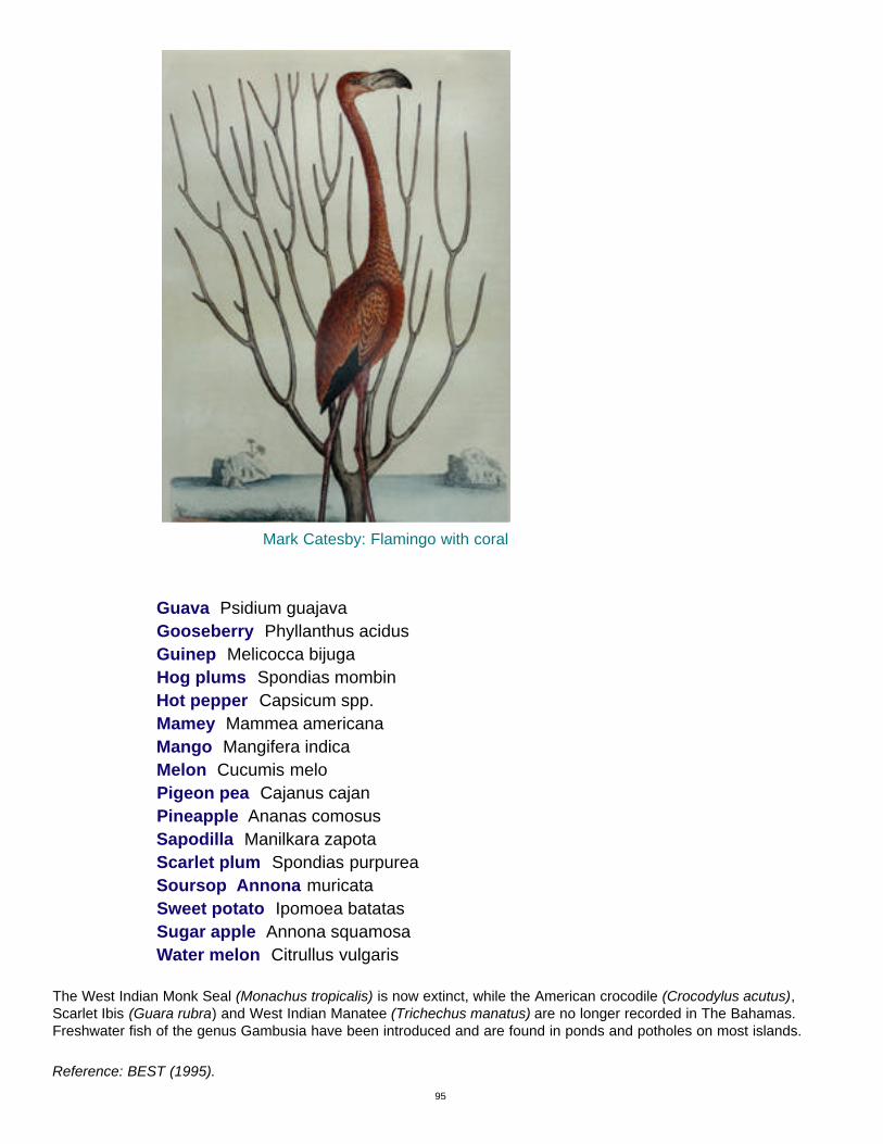
95
Guava Psidium guajavaGooseberry Phyllanthus acidusGuinep Melicocca bijugaHog plums Spondias mombin Hot pepper Capsicum spp.Mamey Mammea americanaMango Mangifera indica Melon Cucumis melo Pigeon pea Cajanus cajanPineapple Ananas comosusSapodilla Manilkara zapotaScarlet plum Spondias purpurea Soursop Annona muricataSweet potato Ipomoea batatasSugar apple Annona squamosaWater melon Citrullus vulgaris
The West Indian Monk Seal (Monachus tropicalis) is now extinct, while the American crocodile (Crocodylus acutus),Scarlet Ibis (Guara rubra) and West Indian Manatee (Trichechus manatus) are no longer recorded in The Bahamas.Freshwater fish of the genus Gambusia have been introduced and are found in ponds and potholes on most islands.
Reference: BEST (1995).
Mark Catesby: Flamingo with coral

REFERENCES
Albury, P. 1978. The story of The Bahamas. London, Macmillan.
BEST. 1995. Bahamas Biodiversity Country Study Report. Bahamas Environment, Science and TechnologyCommission, Office of the Prime Minister. Nassau, Bahamas.
BEST. 1998. National biodiversity strategy and action plan. Bahamas Environment, Science and TechnologyCommission, Office of the Prime Minister. Nassau, Bahamas.
Bohlke, J.E. and C. Chaplin. 1993. Fishes of The Bahamas and adjacent tropical waters (2nd ed.). Austin: University ofTexas Press.
Britton, N. L. and C.F. Millspaugh. 1920. The Bahamas flora. New York: published by the authors.
Brown, L. and J.F. Downhower. 1993. The eyes of Andros. Bahamas Naturalist: 7, (1), 5-10.
Brudenell-Bruce, P.G.C. 1975. The birds of New Providence and the Bahama islands. London: Collins.
Bryant, D., L. Burke, J.W. McManus and M. Spalding. 1998. Reefs at risk: A map-based indicator of threats to theworld’s coral reefs. Washington, DC: World Resources Institute.
Campbell, D. 1978. The ephemeral islands. London: Macmillan.
Cant, R.V. 1996. Water supply and sewerage in a small island environment: The Bahamian experience. Small IslandsMarine Science and Sustainable Development Coastal and Estuarine Studies, 51, 329.
Cant, R. 1997. Developing water supply strategies for The Bahamas. Bahamas Journal of Science: 4, (2), 5-7.
Cant, R.V. and P.S Weech. 1986. A review of the factors affecting the development of Ghyben-Hertzberg lenses in TheBahamas. Journal of Hydrology: 84: 333-343.
Cant, R.V., P.S. Weech, and E.E. Hall. 1989. Saltwater intrusion in The Bahamas: a case study of the Great Lucayanwaterway, Grand Bahama, The Commonwealth of The Bahamas. Nassau, Bahamas: unpublished report. 9 pages.
Carter, T.R. 1994. IPCC Technical guidelines for assessing climate change impacts and adaptations. Working Group IIof the Intergovernmental Panel on Climate Change (IPCC). 59 pages.
Carew, J.L. 1997 Rapid sea-level changes at the close of the last interglacial (substage 5e). Recorded in BahamianIsland Geology: Comment and Reply. Geology: 25, 527. Cates, D.L. 1998. Alligators, Seals and Iguanas. In: The Bahamas Handbook and Businessman’s Annual. Nassau,Bahamas: Dupuch Publications. Pages 111-121.
Cates, D.L. 1997. Mark Catesby and The Natural History of Carolina, Florida and the Bahama Islands. Journal of TheBahamas Historical Society: 18, 2-10.
Catesby, M. undated. Natural history of Carolina, Florida and the Bahama Islands. Two volumes. London: Published bythe Author, 1729-1747.
Central Bank. 2000a. Central Bank of The Bahamas 1999 Annual Report. Nassau, Bahamas: Central Bank of TheBahamas.
Central Bank. 1997. Quarterly Statistical Digest. 6, (2). Nassau, Bahamas: Central Bank of The Bahamas.
Cleare, C.B. 2000. Local government profile. Ministry of Local Government, Nassau, Bahamas: unpublished paper.
Coenen, C. 1995. Observations on the Bahamian rock iguanas of the Exumas. Bahamas Journal of Science: 2, (2), 8-14.
Correll. D. and H. Correll. 1982. Flora of The Bahamas archipelago. Germany: Gantner Verlag K-G.
Department of Agriculture and Department of Statistics. 1996. Second census of agriculture 1994. Final Results.Nassau, Bahamas: Department of Agriculture and Department of Statistics.
Department of Meteorology. 1977. Rainfall of New Providence. Nassau, Bahamas: Department of Meteorology.57 pages.
Department of Statistics. 1998. The Bahamas in Figures 1997. Nassau, Bahamas: Department of Statistics.
Deveaux, E. 1999. Sustainable use of The Bahamas’ marine environment. Address to the 3rd US Coral Reef Task ForceMeeting, St. Croix, USVI, November 2-3. Unpublished.
Dupuch Publications. 2000b. Bahamas handbook and businessman’s annual 2000. Nassau, Bahamas: DupuchPublications.
96

Eneas, G. 1998. Agriculture in The Bahamas. Its historical development 1492-1992. Nassau, Bahamas: MediaPublishing.
Fairbridge, R.W., R.N. Young, C.G.A. Harrison and M.M. Ball. 1961. Geology of The Bahamas. In: The Encyclopedia of World Regional Geology Part I: Western Hemisphere. Stoudesburg, Pennsylvania: Dowden Hutchinson and Ross:109-114.
Foos, A. 1994. Water Budget for Cockburn Town, San Salvador. Bahamas Journal of Science: 2, (1), 31-35.
Gamble, D.W., M.E. Brown, D. Parnell, D. Brommer and P.G. Dixon. 2000. Lessons learned from Hurricane Floyd damage on San Salvador. Bahamas Journal of Science: 8, (1), 24-31.
Hearty, P.J. 1998. Enigmatic boulders of Eleuthera: geological evidence tells of catastrophic waves in The Bahama. In:The Bahamas Handbook and Businessman’s Annual 1998. Nassau, Bahamas: Dupuch Publications. Pages 122-132.
Hearty, P.J. and P. Kindler. 1995. Sea-Level highstand chronology from stable carbonate platforms (Bermuda and TheBahamas). Journal of Coastal Research: 11, (3), 675.
Higgs, L. 1978. Bush medicine in The Bahamas. Nassau, Bahamas: published by the author.
Ingraham, H.1999a. Environmental enhancement. Broadcast address by the Prime Minister of The Bahamas, May 2.Nassau, Bahamas.
Ingraham, H. 1999b. Reconstruction effort following hurricane Floyd. Communication to Parliament by the Prime Minister of The Bahamas. October 13. Nassau, Bahamas.
Ingraham, H. 2000a. Hurricane Floyd recovery efforts and hurricane Floyd tree replacement and beautification programme. Communication to Parliament by the Prime Minister. February 23. Nassau, Bahamas.
Ingraham, H. 2000b. Contribution on a resolution to return to Nassoak Limited 208.41 acres of land acquired by theGovernment in 1989 for development of a freight terminal at Clifton, New Providence. Communication to Parliament bythe Prime Minister. May 17. Nassau, Bahamas.
IPCC. 1996. Revised IPCC guidelines for national greenhouse gas inventories. Intergovernmental Panel on ClimateChange.
Jelesnianski, C.P. 1967. Numerical computation storm surges with bottom stress. Monthly Weather Review, 95, 740-756.
Kindler, P. and P. Hearty. 1996. Carbonate petrography as an indicator of climate and sea-level changes: new datafrom Bahamian quaternary units. Sedimentology: 42, 381.
Little, B.G, et. al. 1971- 1976. Land Resources of the Commonwealth of The Bahamas. Volume 1 Abaco; Volume 2Eleuthera; Volume 3 Cat Island; Volume 4 Andros; Volume 5 Grand Bahama; Volume 6 Great Exuma, Little Exuma andLong Island; Volume 7 Crooked Island and Acklins; Volume 8 Mayaguana and Inagua. Nassau, Bahamas.
Martin, H. and J.P. Bruce. 1999. Effects of climate change: hydrometeorological and land-based effects in TheBahamas. Ottawa, Canada: Global Change Strategies International, Inc.
Martin, H. and J.P. Bruce. 2000. Effects of climate change: hydrometeorological and land-Based effects in TheBahamas: Final report. Ottawa, Canada: Global Change Strategies International, Inc.
Ministry of Foreign Affairs. 1992. Report of The Commonwealth of The Bahamas to the United Nations Conference onEnvironment and Development. Nassau, Bahamas: Ministry of Foreign Affairs.
Ministry of Health and Ministry of Commerce, Agriculture and Industry. 2000. National Food and Nutrition Policyand Agenda for Action. Nassau, Bahamas: Ministry of Health and Ministry of Commerce, Agriculture and Industry.Unpublished Draft.
National Research Council. 1990. Saline agriculture. Salt-tolerant plants for developing countries. Washington, DC:National Academy Press.
Neumann, A.C. and P.J. Hearty. 1996. Rapid sea-level changes at the close of the last inter-glacial (substage 5e) recorded in Bahamian island geology. Geology: 24, (9), 775.
Neumann, AC. and Land, L.S. 1975. Lime mud deposition and calcareous algae in the bight of Abaco, Bahamas. Abudget. Journal of Sedimentary Petrology, 45, (4), 763-786.
Neumann, C.J., G.W. Cry, E. L. Caso and B.R. Jarvinen 1981. Tropical cyclones of the North Atlantic Ocean, 1871-1980. National Climatic Center, Ashwville NC, in cooperation with the National Hurricane Center and National HurricaneResearch Laboratory, Coral Gables, Fla.
97

Patterson, J. 19977. Native Trees of The Bahamas. Nassau, Bahamas: published by the author.
Rappaport, E.N. and F.C. Sheets. 1993. Hurricane Andrew. Bahamas Journal of Science: 1, (1), 2-9.
Rolle, A. W. 1990. A storm surge atlas for the northern and central Bahamas New Providence and vicinity. Nassau: theNational Weather Service of The Bahamas. 21 pages plus Appendix.
Russell, C. 1998. The future of forestry in The Bahamas. Bahamas Journal of Science: 5, (3 ), 2-11.
Russell, C. 2000. Bahamas country report: forestry outlook study for the Caribbean. Nassau, Bahamas: Department ofLands and Survey. Mimeographed.
Sealey, N.E. 1994a. Bahamian Landscapes. Nassau, Bahamas: Media Publishing.
Sealey, N.E. 1994b. Rainfall distribution in New Providence for 1993. Bahamas Journal of Science: 1, (3), 33-35.
Sealey, N.E. 1995. Rainfall distribution in New Providence for 1994. Bahamas Journal of Science: 2, (2), 32-34.
Sealey, N. E. 1996. Rainfall distribution in New Providence for 1995. Bahamas Journal of Science: 4, (1), 35-36.
Sealey, N. E. 1997. Distribution of rainfall in New Providence for 1996. Bahamas Journal of Science: 5, (1), 36.
Sealey, N. E. 1998. Distribution of rainfall in New Providence for 1997. Bahamas Journal of Science: 5, (2), 34-36.
Sealey, N. E., P. Balfe and N. Wardle. 1999. Rainfall distribution on New Providence for 1997-1998. Bahamas Journalof Science: 6, (2), 55-57.
Shaklee, R.V. 1997. Historical hurricane impacts on The Bahamas: Part I: 1500-1749.Bahamas Journal of Science: 5,(1), 7-9.
Shaklee, R.V. 1998. Historical hurricane impacts on The Bahamas: Part II: 1750-1799. Bahamas Journal of Science: 5, (2), 16-20.
Shaklee, R.V. 1998. Historic weather at Nassau. Bahamas Journal of Science: 6, (1), 23-30.
Shaklee, R.V. 2000. Historical hurricane impacts on The Bahamas: 1800-1850. Bahamas Journal of Science, 8, (1), 16-24.
Shattuck, G. (ed.). 1905. The Bahama Islands. Baltimore, Maryland: Baltimore Geographical Society.
Smith, D., L. Miller and J. Miller. 1994. The Butterflies of the West Indies and South Florida. Oxford and New York:Oxford University Press.
Suplee, C. 1999. El Nino la Nina nature’s vicious cycle. National Geographic 195, (3), 72-95.
United Nations. 1994. Earth Summit. Programme of action for small island developing states. Global conference on thesustainable development of small island developing states, Bridgetown, Barbados, April 26 to May 6 1994. New York.United Nations.
United Nations. 1992. Agenda 21: programme of action for sustainable development. Rio Declaration on Environmentand Development. Statement of Forest Principles. United Nations Conference on Environment and Development, Riode Janeiro, Brazil, June 3-14., 1992. New York. United Nations.
UNFCC. 1999. Compendium of decision tools to evaluate strategies for adaptation to climate change. Bonn: UNFCCSecretariat.
Watson, R.T., M.C. Zinyowera and R.H. Moss (Eds). 1998. The Regional Impacts of Climate Change. An assessmentof vulnerability. A special report of IPCC working group II. Published for the Intergovernmental Panel on Climate Change.Cambridge University Press, United Kingdom.
Weech, P.S. 1999. Situational analysis of water resources: country report for The Bahamas. Nassau: Report for theWater Sector in The Bahamas. Unpublished: 15 pages.
White, A. 1998. A birder’s guide to the Bahama islands and Turks and Caicos. American Birding Association.
Williams, P.M. 1999. Chronological highlights in the history of The Bahamas 600 to 1900. Nassau, Bahamas: published by the author and The Bahamas Historical Society.
Woods, C.A, (ed.). 1989. Biogeography of the West Indies past, present and future. Gainesville, Florida: Sandhill CranePress, Inc.
98