bad pass archaeology - the american...
TRANSCRIPT
>> By Laura L. Scheiber, Judson Byrd Finley, and Maureen P. Boyle
he Bad Pass Trail runs for miles along the western side of rugged Bighorn Canyon in southern Montana and northern Wyoming. Today it consists of
numerous rock piles or cairns, which once helped guide travelers along the treacherous canyon country. People also left behind rocks that once held down the bottoms of lodges at campsites along the trail, which remind us of where tipis once stood. Archaeologists call these circular arrangements of rocks that cover much of the North American Plains tipi rings
or stone circles. These sites provide essential information about the past lives of Plains inhabitants. Of the many indigenous groups who followed the Bad Pass Trail, the Crow still live closest to Bighorn Canyon. According to Crow Studies scholar Timothy McCleary, the word for prehistory in the Crow language is translated as “when we used stones to weigh down our lodges.” Research at stone circle sites in Bighorn Canyon is a highly effective way to combine anthropological inquiry, interpretive and innovative public outreach, and Native American participation.
Bad Pass Archaeology
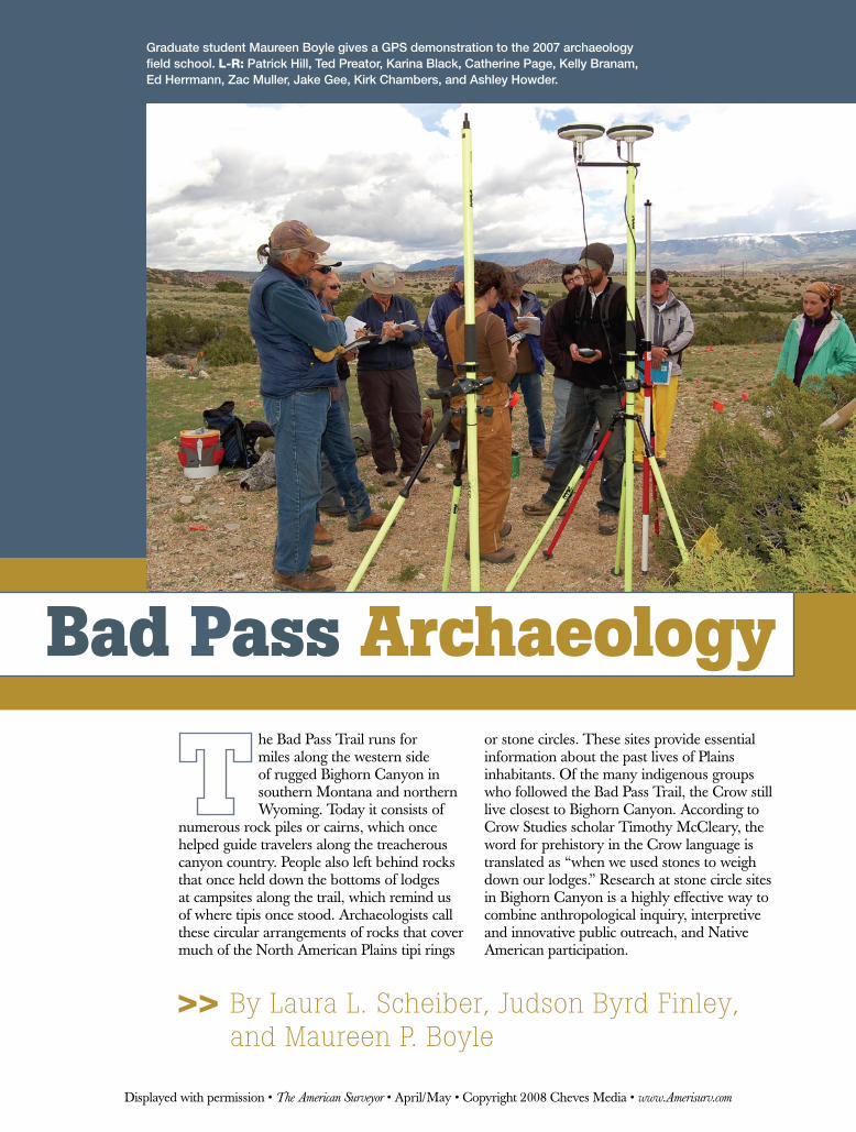
Graduate student Maureen Boyle gives a GPS demonstration to the 2007 archaeology field school. L-R: Patrick Hill, Ted Preator, Karina Black, Catherine Page, Kelly Branam, Ed Herrmann, Zac Muller, Jake Gee, Kirk Chambers, and Ashley Howder.
Displayed with permission • The American Surveyor • April/May • Copyright 2008 Cheves Media • www.Amerisurv.com
For the last three summers, we have directed archaeological field schools at Bighorn Canyon National Recreation Area (NRA) in Carbon County, Montana. Students assist with document-ing stone circle sites using 21st century technology. This work is part of a larger research project, Exploring Historical and Social Landscapes of the Greater Yellowstone Ecosystem, which involves researchers and students from Indiana
University (Bloomington, Indiana), Northwest College (Powell, Wyoming), and Little Big Horn College (Crow Agency, Montana).
By combining traditional mapping tech-niques with digital technology, we provide a comprehensive package for understand-ing domestic space and everyday lives. Bighorn Canyon NRA provides a unique setting to address questions about stone circles as a record of domestic life. First,
the canyon country served as a natural travel corridor between the Bighorn Basin and High Plains to the south and the unglaciated Missouri Plateau to the north for thousands of years. Domestic activity was a strong component of travel, evi-denced by numerous stone circles located within the park boundaries. Second, Bighorn Canyon lies at the heart of Crow territory. The Crows immigrated to the area as recently as the late 16th century.
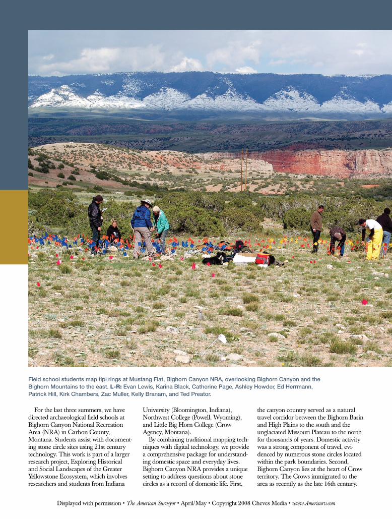
Field school students map tipi rings at Mustang Flat, Bighorn Canyon NRA, overlooking Bighorn Canyon and the Bighorn Mountains to the east. L-R: Evan Lewis, Karina Black, Catherine Page, Ashley Howder, Ed Herrmann, Patrick Hill, Kirk Chambers, Zac Muller, Kelly Branam, and Ted Preator.
Displayed with permission • The American Surveyor • April/May • Copyright 2008 Cheves Media • www.Amerisurv.com
During this time, they were in transition from a semi-sedentary horticultural life to one as nomadic bison hunters. These changes brought about transformations in social and ritual life. Soon afterward, Crow Indians made contact with the first Euroamerican explorers. Impacts of 19th century culture contact and colonialism reverberated with extant transformational trends in Crow life as they changed from a nomadic hunting culture with horti-cultural roots to a sedentary ranching and reservation-based lifeway. Domestic campsites in Bighorn Canyon bear witness to these transitions.
Stone Circle StudiesStone circles are recognized as one of the few forms of preserved indigenous domestic architecture on the North American Plains, dating at least to 5,000 years ago. Prior to the historic use of wooden stakes as tent pegs, Plains Indians used stones as tipi weights. Once moved, stones often stayed in place, preserving the superstructure characteristics of the lodge. Stone circles at Bighorn Canyon supply abundant archaeological data while also linking contemporary Crow Indians to their own history through vast oral traditions. Between 1968 and 1974, nearly 120 stone circle sites were documented at Bighorn Canyon NRA and the surrounding area, as described by Larry Loendorf and Lori Weston in a 1983 Plains Anthropologist article. We estimate that as many as 1,000 stone circles within the park boundaries require reinvestigation under the current National Park Service condition assess-ment mandate. Loendorf and Weston attributed sparse or absent artifacts at sites along travel corridors like the Bad Pass Trail to brief occupational durations.
We propose instead that the variation is a product of a hundred years of recre-ational artifact collection. We believe our current fieldwork paints a positive picture for stone circle research, and the sites at Bighorn Canyon are a perfect test-case for this approach.
We developed a four-stage data collection methodology that allows us to conduct analysis at distinct complemen-tary levels. First, we teach our students how to hand-draw accurate planview maps of each stone circle using graph paper, measuring tapes, protractors, and compasses. Planviews capture the singularity of individual rocks that make up the stone circles.
Second, we record information on each rock, feature, and artifact using Dell Axim X51v Personal Data Assistants (PDAs) and Magellan ProMark 3 survey-grade GPS receivers. PDA data recording is an efficient, high-speed process that reduces human transcription error and provides immediate program compatibility with Microsoft Access. The Windows Mobile version of Access called Data on the Run allows researchers
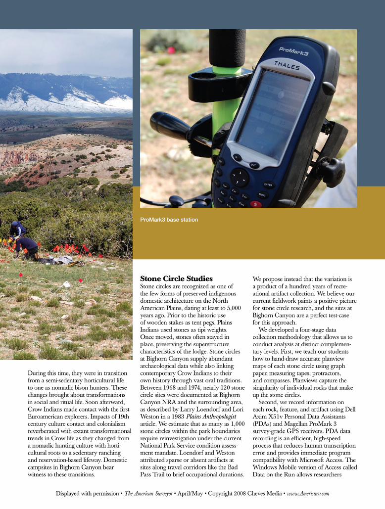
ProMark3 base station
Displayed with permission • The American Surveyor • April/May • Copyright 2008 Cheves Media • www.Amerisurv.com
to create drop-down menus to record qualitative data such as artifact material type, which again reduces typing errors. PDA attribute collection covers a wide range of descriptive and quantitative data for each stone circle, including diameters, orientations, and presence or absence of doorway openings and associated features such as cooking hearths.
The ProMark 3 equipment provides fine-grained, sub-centimeter location data on individual stones, features, and artifacts. The use of the ProMarks also allows us to fine-tune our methodolo-gies in the field, particularly to choose appropriate duration of shots depending on satellite coverage and feature type. Thus, all stones in a circle can be shot at a consistent 15-second interval that streamlines our data across circles, sites, and field seasons. Locational data from the receivers are uploaded to ArcMap 9.1 GIS software on a Dell D610 laptop computer. We daily plot the GPS data, which is joined to attribute information for each item in an Access data table.
Geophysical survey is the third ana-lytical level that provides an important
window into subsurface deposits. David Maki from Archaeo-Physics conducted gradiometry surveys using a Geoscan Research FM256 fluxgate gradiometer. [Editor’s Note: A previous Archaeo-Physics article, “Imaging the Buried Past,” appeared in The American Surveyor in July 2005 and is available in our online archives.] Data is collected in transects spaced at 0.50 meters, with 8 samples collected per linear meter for an overall data sample density of 16 samples per square meter. This step is particularly informative for guiding excavation decisions as it measures the differential magnetic properties of cultural features (stone circles and fire hearths) buried within unmodified geological matrices.
Small targeted excavations provide the final analytical level, which allows us to collect essential datable charcoal
samples from domestic hearths. Taken together, this archaeological data provides a baseline for understanding occupational chronologies of stone circle sites and American Indian domestic life.
Using Survey-Grade GPSWe use three GPS receivers to record spatial information from stone circle sites. The first receiver is set up as a base,
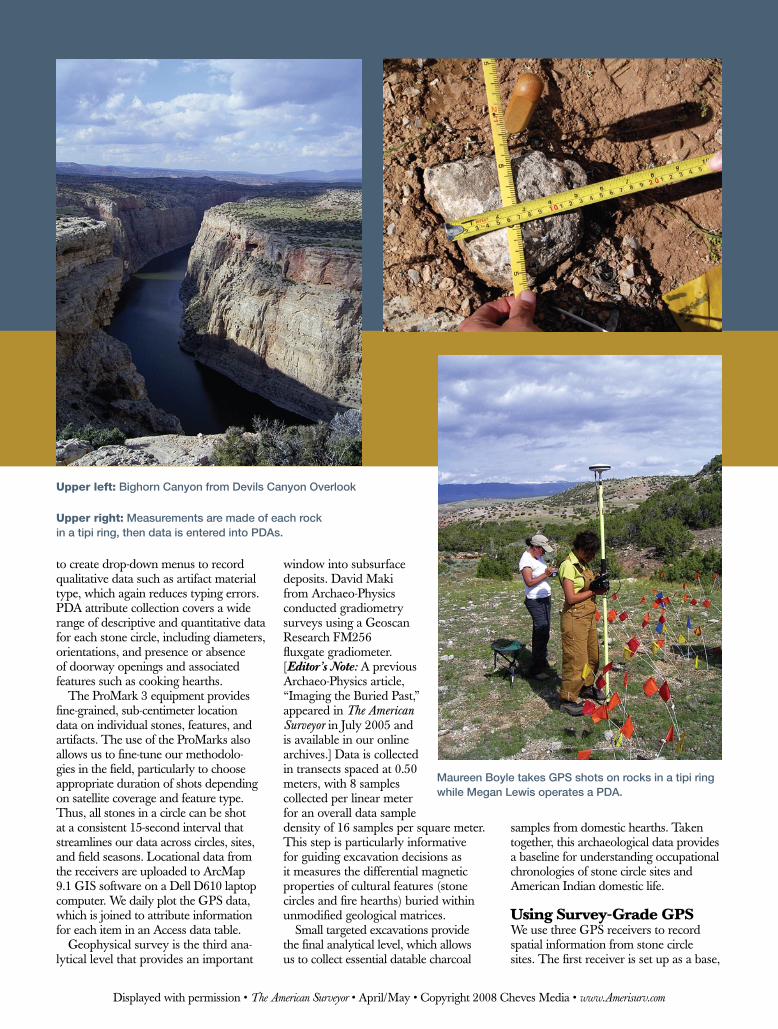
Upper left: Bighorn Canyon from Devils Canyon Overlook
Upper right: Measurements are made of each rock in a tipi ring, then data is entered into PDAs.
Maureen Boyle takes GPS shots on rocks in a tipi ring while Megan Lewis operates a PDA.
Displayed with permission • The American Surveyor • April/May • Copyright 2008 Cheves Media • www.Amerisurv.com

collecting static data in a stable location throughout the day. Base location is fixed at each archaeological site in order to increase accuracy among rover data collection events (e.g., between filenames and collection days) and to ease post-field data correction with permanent regional base stations, or continuously operating reference stations (CORS). The two additional receivers act as rovers, collecting stop-and-go survey data at individual points. The stop-and-go survey mode allows the GPS operator to move quickly and efficiently from point to point at a consistent recording interval. This mode also facilitates in-field data collection by allowing the GPS operator to alter recording intervals when appropriate, to stop between collection shots for any length of time, and presents a user-friendly educational mode for field school students. We average 6 mm accuracy vertically and horizontally with this data recovery system.
Both advantages and disadvantages exist for the use of this equipment and should be considered by anyone who is considering using survey grade GPS for archaeological research.
Commendations:The system is ideal in flat or rolling 1. topography and sparsely vegetated environments (e.g., high-altitude desert and open plains) with excellent satellite coverage.The equipment is fairly easy to use, 2. and students benefit from training in GPS technology.The ProMark 3s provide phenom-3. enal confidence intervals in spatial coordinates.These coordinates are tied into the 4. UTM system, not arbitrary grids, which is usually the case when using a total station.The Global Satellite Navigation 5. Systems (GNSS) Solutions software offered by Magellan in concert with the ProMarks is relatively user friendly.
Cautions:Poor satellite coverage in topographic 1. basins with tree cover means that single frequency GPS systems such as the one we are using are not as consistently useful in remote wilder-ness areas where we are also working,
although mission planning alleviates some of these problems.The set-up from site to site and day to 2. day is a trial-and-error process. Using a fixed base point is necessary to facilitate later post-processing.The base tripod set-up is highly critical. 3. High winds can knock over the base station. Although attribute data can be 4. recorded directly onto the GPS receivers using the mobile mapping program, we chose to use the GNSS Solutions survey software for post-processing because the confidence levels are a few millimeters as opposed to about 20cm. This means that the attribute and coordinate data for each object need to be merged later, and that keeping the log points consistent is absolutely critical.Data must be post-processed every 5. evening to ensure that all of the receivers collected data for the day and to ensure that the assigned GPS log points correspond with associated PDA attribute log points. The fixed base station coordinate data 6. must be post-post-processed against
Tipi rings at Mustang Flat (2007)
Displayed with permission • The American Surveyor • April/May • Copyright 2008 Cheves Media • www.Amerisurv.com

the CORS stations, available online through the National Geodetic Survey. Because we stay in remote locations and do not have access to the Internet during our fieldwork, we cannot perform this task until after we leave the field, often months later.
Results of the StudyTwo years ago we implemented our staged approach to stone circle analysis along documented travel segments of the Bad Pass Trail with funding from the Western National Parks Association, Indiana University Office of the Vice President for Research, Bighorn Canyon NRA, and Northwest College. Students have recorded 3,782 rocks from 72 stone circles and 65 features at five archaeo-logical landscapes. We also documented attribute data on 2,109 stone tools and debitage [the sharp-edged flakes or mate-rial left over from the making of stone
tools]. David Maki has surveyed 22,700 square meters with subsurface remote sensing equipment. We performed limited excavations within several stone circles, revealing occupations that span between 2,500 and 300 years ago. We have laid the foundation for a successful multi-year program that will assist Bighorn Canyon NRA in meeting its programmatic needs while advancing our research program.
Archaeology along the Bad Pass Trail is a combination of academic research, education, heritage, and resource management. We recommend that archaeologists consider adopting similar protocols if they are working in open country, are interested in household-level archaeological analysis, want to maximize and standardize archaeological site recording across landscapes, and wish to incorporate educational science programs that provide GPS/GIS skill
sets useful across disciplines. Our meth-odologies allow for increased accuracy in spatial analysis and for increased coverage of archaeological landscapes at fine-grained scales that aid in site conservation for future generations. We also bring the accessibility of geographic knowledge in digital spatial models such as GIS to diverse audiences. Finally, our work is primarily a non-invasive surface mapping technique, which only minimally impacts the archaeological sites we hope to protect.
Laura Scheiber is an Assistant Professor of Anthropology at Indiana University. Judson Byrd Finley is an Adjunct Faculty at Northwest College and consultant for Western Geoarchaeological Research. Maureen Boyle is an Archaeology in Social Context Graduate Student at Indiana University.
Custom orders your way … when you need them.
When your name is on it, our name is behind it.
Berntsen delivers.
Your deadlines deadlines
The professional’s choice in survey products • www.berntsen.com • 877.868.9176
areour
Displayed with permission • The American Surveyor • April/May • Copyright 2008 Cheves Media • www.Amerisurv.com