‘azzun town profile (including ‘isla & ‘izbat at tabib...
TRANSCRIPT

‘Azzun Town Profile (including ‘Isla & ‘Izbat
at Tabib Localities)
Prepared by
The Applied Research Institute – Jerusalem
Funded by
Spanish Cooperation
2013

Palestinian Localities Study Qalqiliya Governorate
1
Acknowledgments
ARIJ hereby expresses its deep gratitude to the Spanish Agency for International Cooperation for
Development (AECID) for their funding of this project.
ARIJ is grateful to the Palestinian officials in the ministries, municipalities, joint services councils,
village committees and councils, and the Palestinian Central Bureau of Statistics (PCBS) for their
assistance and cooperation with the project team members during the data collection process.
ARIJ also thanks all the staff who worked throughout the past couple of years towards the
accomplishment of this work.

Palestinian Localities Study Qalqiliya Governorate
2
Background
This report is part of a series of booklets, which contain compiled information about each city, town,
and village in the Qalqiliya Governorate. These booklets came as a result of a comprehensive study
of all localities in Qalqiliya Governorate, which aims to depict the overall living conditions in the
governorate and presenting developmental plans to assist in improving the livelihood of the
population in the area. It was accomplished through the "Village Profiles and Needs Assessment;"
the project funded by the Spanish Agency for International Cooperation for Development (AECID).
The "Village Profiles and Needs Assessment" was designed to study, investigate, analyze and
document the socio-economic conditions and the needed programs and activities to mitigate the
impact of the current unsecure political, economic and social conditions in Qalqiliya Governorate.
The project's objectives are to survey, analyze and document the available natural, human,
socioeconomic and environmental resources, and the existing limitations and needs assessment for
the development of the rural and marginalized areas in Qalqiliya Governorate. In addition, the
project aims to prepare strategic developmental programs and activities to mitigate the impact of the
current political, social, and economic instability with the focus on the agricultural sector.
All locality profiles in Arabic and English are available online at http://vprofile.arij.org.

Palestinian Localities Study Qalqiliya Governorate
3
Table of Contents
Location and Physical Characteristics _________________________ 4
History ___________________________________________________________ 5
Religious and Archaeological Sites _____________________________ 6
Population _______________________________________________________ 8
Education ________________________________________________________ 8
Health Status ____________________________________________________ 9
Economic Activities ____________________________________________ 10
Agricultural Sector _____________________________________________ 12
Institutions and Services _______________________________________ 14
Infrastructure and Natural Resources ________________________ 15
Environmental Conditions _____________________________________ 17
Impact of the Israeli Occupation ______________________________ 18
Development Plans and Projects ______________________________ 30
Implemented Projects __________________________________________ 30
Proposed Projects ______________________________________________ 31
Locality Development Priorities and Needs ___________________ 33
References ______________________________________________________ 34

Palestinian Localities Study Qalqiliya Governorate
4
‘Azzun Town Profile1
Location and physical characteristics
‘Azzun (including ‘Isla & ‘Izbat at Tabib localities) is a Palestinian town in Qalqiliya Governorate,
located 7-9km west of Qalqiliya City. It is bordered by Kafr Laqif village and Wadi Qana to the east, Kafr Thulth town to the south, An Nabi Elyas village to the west, and Jayyus and Khirbet Sir to the
north (ARIJ-GIS, 2013) (see map 1).
Map 1: ‘Azzun location and borders
Source: ARIJ - GIS Unit, 2013
‘Azzun is located at an altitude of 226-244m above sea level with a mean annual rainfall of 587-589
mm. The average annual temperature is 19oC whilst the average annual humidity is approximately
62% (ARIJ-GIS, 2013).
Until 2012, ‘Isla & ‘Izbat at Tabib localities had been governed by a Projects Committee. However,
in 2012, upon a decision by the Palestinian Ministry of Councils and the Ministry of Local
1 The information listed in this profile includes the information of each of ‘Azzun town and ‘Isla & ‘Izbat at Tabib
localities; based on the Local Government's decision in 2012 to merge the three localities under one local council.
Palestinian Localities Study Qalqiliya Governorate
5
Government, ‘Isla & ‘Izbat at Tabib localities were merged with the bigger locality of ‘Azzun town
under ‘Azzun Municipal Council.
The classification of the residential areas borders has been adopted in this profile based on the
administrative division of Palestinian communities, according to the Palestinian National
Authority(PNA). This administrative division system has been developed by the Palestinian Ministry
of Planning, the Ministry of Local Government, the Palestinian Central Bureau of Statistics(PCBS),
and the Central Election Commission (CEC).
Since 1996, ‘Azzun has been governed by a Municipal Council which is currently administrated by
11 members appointed by the Palestinian National Authority (PNA). There are also 37 employees
working in the council, whose permanent headquarters is included within the ‘Middle Joint Services
Council.’ The Council possesses two vehicles for the collection of solid waste, a pick-up car and a
small hammer truck (‘Azzun Municipal Council, 2012).
It is the responsibility of the Municipal Council to provide a number of services to the residents of
‘Azzun, including:
The establishment and maintenance of the drinking water and electricity networks.
Waste collection and street cleaning.
Road rehabilitation, construction and paving.
Implementation of projects and studies for the town.
Organization of license processes.
Protection of historical and archeological sites.
Protection of governmental properties.
Provision of educational kindergartens.
Provision of offices for governmental services.
Provision of transportation.
Provision of an ambulance service.
Provision of part of the sewerage network.
Provision of a firefighting service. (‘Azzun Municipal Council, 2012)
History
‘Azzun town used to be called “’Ein al ‘Ezz” meaning the spring of welfare, due to the large number
of fruit trees located there. However it was later changed to ‘Azzun. ‘Isla locality (from the word
‘asal’ meaning honey, in indication to sweetness), was named due to the village being famous for the
production of molasses which is produced from grapes. As for ‘Izbat at Tabib village; the word
‘‘izbat’ means estate while the word at ‘tabib’ (literally meaning the doctor) was taken in relation to
the grandfather of the At Tabib family. It should be noted that ‘Izbat at Tabib village includes the
locality of Mahattat Tahseen Mansur.
The town was established in 1187 A.D., with its residents descending from the Qaysar (lands of
1948) and Al Hijazz areas (‘Azzun Municipal Council, 2012).
Palestinian Localities Study Qalqiliya Governorate
6
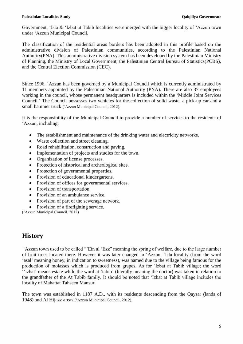
Photo of ‘Azzun
Religious and archaeological sites
There are nine mosques in the town (‘Azzun Grand, the Old, Huthaifa ben al Yaman, Salah ad Din,
Omar ben al Khattab, Al Mansoor, As Sahaba, ‘Isla Old and ‘Izbat at Tabib Mosques). The town has
several sites of archaeological interest including As Salah House, the martyrs’ graves and Barshona
archeological area. All of these sites are in need of restoration in order to be deemed tourist sites, as
determined by the Ministry of Tourism and Antiquities (‘Azzun Municipal Council, 2012) (see map 2).

Palestinian Localities Study Qalqiliya Governorate
7
Map 2: Main locations in ‘Azzun Town
Source: ARIJ - GIS Unit, 2013
Palestinian Localities Study Qalqiliya Governorate
8
Population
According to the Palestinian Central Bureau of Statistics (PCBS), the total population of ‘Azzun in
2007 was 8,650, of whom 4,469 were male and 4,181 female. There were 1,486 households
registered as living in 1,621 housing units.
Age groups and gender
The General Census of Population and Housing carried out by the PCBS in 2007 showed that the
distribution of age groups in ‘Azzun was as follows: 43.1% were less than 15 years of age, 52.8%
were between 15 and 64 years of age, and 3.4% were 65 years of age or older. Data also showed that
the gender ratio of males to females in the town was 106.9:100, meaning that males and females
constituted 51.7% and 48.3% of the population respectively.
Families
‘Azzun residents are from several families, including ‘Adwan, Radwan, Salim, Hussein, Sweidan,
Abu Hanniya, Odah, Hawashah, Tabib, Suleiman, Radi, Mas’ood and Abu Dayyah (‘Azzun Municipal
Council, 2012).
Immigration
The field survey conducted by ARIJ staff showed that approximately 25 people from different
families have left the town since Al Aqsa Intifada in 2000 (‘Azzun Municipal Council, 2012).
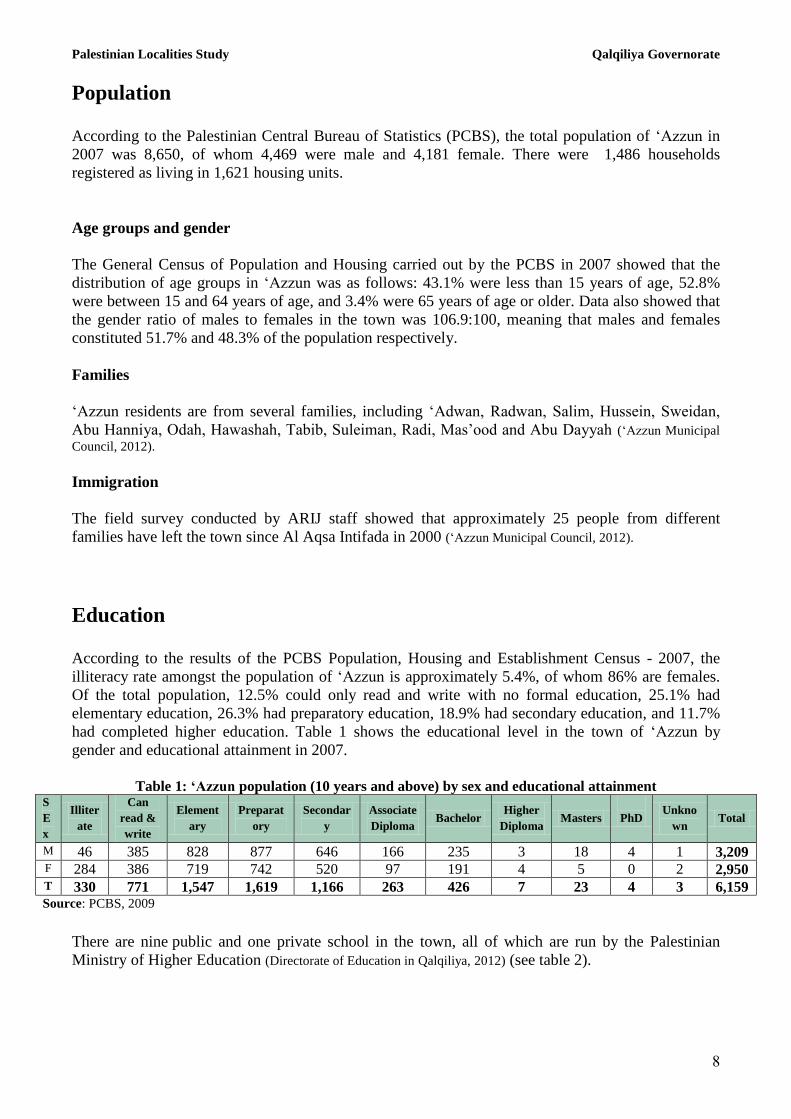
Education
According to the results of the PCBS Population, Housing and Establishment Census - 2007, the
illiteracy rate amongst the population of ‘Azzun is approximately 5.4%, of whom 86% are females.
Of the total population, 12.5% could only read and write with no formal education, 25.1% had
elementary education, 26.3% had preparatory education, 18.9% had secondary education, and 11.7%
had completed higher education. Table 1 shows the educational level in the town of ‘Azzun by
gender and educational attainment in 2007.
Table 1: ‘Azzun population (10 years and above) by sex and educational attainment
S
E
x
Illiter
ate
Can
read &
write
Element
ary
Preparat
ory
Secondar
y
Associate
Diploma Bachelor
Higher
Diploma Masters
PhD Unkno
wn Total
M 46 385 828 877 646 166 235 3 18 4 1 3,209 F 284 386 719 742 520 97 191 4 5 0 2 2,950 T 330 771 1,547 1,619 1,166 263 426 7 23 4 3 6,159 Source: PCBS, 2009
There are nine public and one private school in the town, all of which are run by the Palestinian
Ministry of Higher Education (Directorate of Education in Qalqiliya, 2012) (see table 2).

Palestinian Localities Study Qalqiliya Governorate
9
Table 2: Schools in ‘Azzun by name, stage, sex, and supervising authority (2011/2012)
School name Supervising authority Gender
‘Azzun Boys’ Secondary School Government Male
Fatima Sroor Girls’ Secondary School Government Female
‘Azzun Boys’ Elementary School Government Male
‘Azzun Girls’ Elementary School Government Female
Fatima Ghazal Girls’ Elementary School Government Female
The Martyr Yasir Arafat Boys’ Elementary
School
Government Male
‘Azzun Boys’ Middle School Government Male
Al Eyman Private Elementary School Private Mixed
‘Isla Co-educated Elementary School Government Mixed
‘Izbat at Tabib Co-educatedional Elementary
School
Government Mixed
Source: Directorate of Education in Qalqiliya, 2012
There are 2,968 students, 173 teachers, and 107 classes in thw town. The average number of students
per teacher in the school is nearly 17, whilst the average number of students per class is
approximately 28 (Directorate of Education in Qalqiliya, 2012).
There are also 5 kindergartens in ‘Azzun town which are run by different private organizations
(Directorate of Education in Qalqiliya, 2012) (see table 3 below).
Table 3: Kindergartens in ‘Azzun town by name and supervising authority
Name of kindergarten No. of classes No. of teachers Supervising authority
An Nahda Kindergarten 3 4 Private
Al Berr wal Islah Charitable Society Kindergarten 3 3 Private
Bara’em al Eyman Kindergarten 4 5 Private
Ar Rashid Kindergarten 2 3 Private
‘Isla Kindergarten 2 3 Private
Source: Directorate of Education in Qalqiliya, 2012
The education sector in ‘Azzun town faces a number of obstacles, mainly:
The lack of classrooms in the elementary schools.
The small size of yards and playgrounds at the schools.
The lack of educational equipment and tools.
The lack of extracurricular activities to improve student’s experiences.
The inadequacy of some of the curriculums for students.
The lack of a bus to transport students from ‘Isla to ‘Azzun town schools.
The harassment inflicted on the schools and students by the Israeli occupation forces and settlers,
represented by the existence of permanent and partial checkpoints which hinder the access of
students to their schools, in particular Martyr Yasir Arafat elementary school and ‘Azzun boys’
secondary school.(‘Azzun Municipal Council, 2012)

Palestinian Localities Study Qalqiliya Governorate
11
Health status
‘Azzun has several health facilities; the Martyr Omar al Qasem Specialized Center, a governmental
general physician clinic, a governmental medical lab, a governmental mother and child care center
and a governmental pharmacy, in addition to an ambulance owned by the Red Crescent Society. In
the absence of required health services or in emergencies, patients are transferred to Darweesh
Nazzal Hospital, Qalqiliya Health Directorate or the UNRWA Hospital in Qalqiliya city (11km
away) (‘Azzun Municipal Council, 2012).
The health sector in the town faces a number of obstacles and problems, principally (‘Azzun Municipal
Council, 2012):
The lack of specialized clinics.
The lack of specialized governmental clinics, such as diabetics, nutritional or other clinics.
The lack of necessary medicines at the pharmacy.
The poor infrastructure of the health clinic building and its small size
The lack of a radiology center
Economic activities
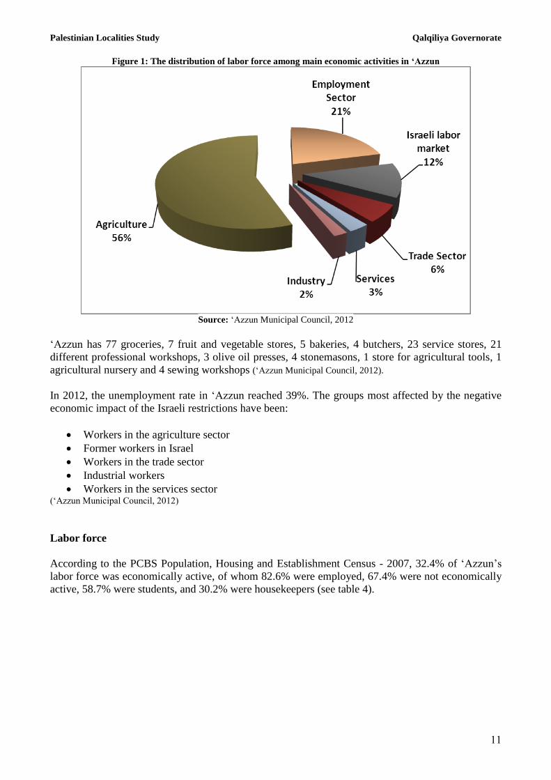
The economy in ‘Azzun is dependent mainly on the agricultural sector, which absorbs 56% of the
town’s workforce (‘Azzun Municipal Council, 2012) (see figure 1).
The results of a field survey conducted by the ARIJ team in 2012 for the distribution of labor by
economic activity in ‘Azzun are as follows:
Agriculture sector (56%)
Government or other employees sector (21%)
Israeli labor market (12%)
Trade sector (6%)
Services sector (3%)
Industry (2%)
Palestinian Localities Study Qalqiliya Governorate
11
Figure 1: The distribution of labor force among main economic activities in ‘Azzun
Source: ‘Azzun Municipal Council, 2012
‘Azzun has 77 groceries, 7 fruit and vegetable stores, 5 bakeries, 4 butchers, 23 service stores, 21
different professional workshops, 3 olive oil presses, 4 stonemasons, 1 store for agricultural tools, 1
agricultural nursery and 4 sewing workshops (‘Azzun Municipal Council, 2012).
In 2012, the unemployment rate in ‘Azzun reached 39%. The groups most affected by the negative
economic impact of the Israeli restrictions have been:
Workers in the agriculture sector
Former workers in Israel
Workers in the trade sector
Industrial workers
Workers in the services sector (‘Azzun Municipal Council, 2012)
Labor force
According to the PCBS Population, Housing and Establishment Census - 2007, 32.4% of ‘Azzun’s
labor force was economically active, of whom 82.6% were employed, 67.4% were not economically
active, 58.7% were students, and 30.2% were housekeepers (see table 4).

Palestinian Localities Study Qalqiliya Governorate
12
Table 4: ‘Azzun population (10 years of age and above) by sex and employment status
S
e
x
Economically active Non-economically active
Not
stated Total Employe
d
Currently
unemploy
ed
Unemplo
yed
(never
worked)
Total Stude
nt
Housek
eeping
Unable
to work
Not
working
& not
looking
for work
Others Total
M 1,387 129 176 1,692 1,246 2 154 37 71 1,510 7 3,209
F 262 11 29 302 1,192 1,251 169 10 20 2,642 6 2,950
T 1,649 140 205 1,994 2,438 1,253 323 47 91 4,152 13 6,159
M: Male; F: Female; T: Total.
Source: PCBS, 2009
Agricultural sector
‘Azzun has a total area of approximately 14,902 dunums of which 10,871 are arable land and 1,028
dunums are registered as residential land (see table 5 and map 3).
Table 5: Land use and land cover in ‘Azzun town (area in dunums)
Total
area
Built
up
area
Agricultural area
(10,871)
Inland
water
Forests Open
spaces
Area of
industrial,
commercial &
transport unit
Area of
settlements,
military
bases &
Wall zone
Cemete
ries Permanent
crops
Green-
houses
Range-
lands
Arable
lands
14,902 1,028 8,491 70 710 1,600 0 582 1,841 90
485 7
Source: ARIJ – GIS Unit, 2013

Palestinian Localities Study Qalqiliya Governorate
13
Map 3: Land use/land cover and Segregation Wall in ‘Azzun Town
Source: ARIJ - GIS Unit, 2013
Table 6 shows the different types of rain-fed and irrigated open-cultivated vegetables in ‘Azzun. The
most commonly cultivated crops within this area are white cabbages, green beans and snake
cucumber, there are a total area of 192 dunums of greenhouses in the town and the most commonly
cultivated crops within this cucumber
Table 6: Total area of rain-fed and irrigated open cultivated vegetables in ‘Azzun (area in dunums)
Fruity
vegetables
Leafy
vegetables Green legumes Bulbs
Other
vegetables Total area
Rf. Irr. Rf. Irr. Rf. Irr. Rf. Irr. Rf. Irr. Rf. Irr.
17 8 0 27 19 9 7 0 0 15 43 59 Rf.: Rain-fed; Irr.: Irrigated.
Source: Ministry of Agriculture - Qalqiliya, 2010
Table 7 shows the different types of fruit trees planted in the area. ‘Azzun is famous for olive
cultivation and there are approximately 10,593 dunums of land planted with olive trees in the town.
Table 7: Total area of horticulture and olive trees in ‘Azzun (area in dunums)
Olives Citrus Stone fruits Pome fruits Nuts Other fruits Total area
Rf. Irr. Rf. Irr. Rf. Irr. Rf. Irr. Rf. Irr. Rf. Irr. Rf. Irr.
10,593 0 0 76 17 2 0 0 12 0 24 5 10,646 83 Rf.: Rain-fed; Irr.: Irrigated.
Source: Ministry of Agriculture - Qalqiliya, 2010
In terms of field crops and forage in ‘Azzun, cereals (particularly wheat) are the most cultivated,
covering an area of approximately 215 dunums (see table 8).

Palestinian Localities Study Qalqiliya Governorate
14
Table 8: Total area of forage and field crops in ‘Azzun (area in dunums)
Cereals Bulbs Dry
legumes Oil crops
Forage
crops
Stimulatin
g crops
Other
crops Total area
Rf. Irr. Rf. Irr. Rf. Irr. Rf. Irr. Rf. Irr. Rf. Irr. Rf. Irr. Rf. Irr.
215 0 6 20 13 0 2 0 80 0 0 0 15 25 331 45 Rf.: Rain-fed; Irr.: Irrigated.
Source: Ministry of Agriculture - Qalqiliya, 2010
The field survey conducted by ARIJ team shows that 12% of the residents in ‘Azzun rear and keep
domestic animals such as sheep and goats (see table 9).
Table 9: Livestock in ‘Azzun
Cows* Sheep Goats Camels Horses Donkeys Mules Broilers Layers Bee
hives
77 2,207 348 0 0 0 0 168,000 4,000 42 *Including cows, bull calves, heifer calves and bulls
Source: Palestinian Ministry of Agriculture - Qalqiliya, 2010
There are approximately 33km of agricultural roads in the town, divided as follows:
Table 10: Agricultural roads in ‘Azzun town and their lengths
Suitability of agricultural roads Length (km)
For vehicles 10
For tractors and agricultural machinery only 13
For animals only 6
Unsuitable 4 Source: ‘Azzun Municipal Council, 2012
The agricultural sector in the town faces some problems, including:
The confiscation of lands by the Israeli government.
The lack of economic feasibility for agricultural investment.
The lack of capital for agricultural projects.
The lack of water resources.
The lack of pastures and green areas.
The high prices of feed and pesticides.
The inability to reclaim the agricultural lands.
The existence of the Segregation Wall which divides the land. (‘Azzun Municipal Council, 2012)
Institutions and services
‘Azzun town has a post office, an office for the Ministry of Social Affairs, a fire brigade center and a
National Security Center, in addition to a number of local institutions and associations that provide
services to various sectors of society. These include:
‘Azzun Municipal Council: Founded in 1996 by the Ministry of Local Government, with the
aim of addressing different issues concerning the town and providing various services and
infrastructure to its residents.
Al Berr wal Islah Charitable Society: Founded in 1987 by the town’s residents, it provides
social, cultural and development services.

Palestinian Localities Study Qalqiliya Governorate
15
The Development & Creativity Society: Founded in 2010 by the town’s younger
generation, providing the youth with cultural and social services.
The Livestock Society: Founded in 1995 by the Ministry of the Interior. The society is
concerned with providing guidance and awareness services related to livestock.
The Organic Oil Society: Founded in 2010 by the Ministry of the Interior with the aim to
provide services to improve the quality of olive oil
The General Union Society for Farmers: Founded in 2001 by the Ministry of the Interior,
the service provides agricultural advice and guidance.
‘Azzun Youth Sports Club: Founded in 1978 by the town’s young people with the aim of
providing sports and educational activities.
The Rural Saving & Credit Society: Founded in 2005 by the Ministry of the Interior, with
the aim of proving loans.
The Animal & Plant Development Society: Founded in 2011 by the Ministry of the
Interior, with the aim of providing guidance and awareness services in the fields of animals
and plants.
The Palestinian Guidance Center: Founded in 2000 by a foreign donor, aiming to provide
health and guidance services as well as rehabilitation services for the disabled.
‘Azzun Zakat Committee: Founded in 1993 by the town residents and concerned with
providing assistance to poor families and orphans.
The Refugees Committee: Founded in 2002 by the Refugees Department and concerned
with the town’s refugee issues.
The Popular Resistance Committee: Founded in 2003 by the residents of the locality,
concerned with fighting the Wall and the Israeli plans.
Rubu’ al Khair Charitable Society: Founded in 2010 by the Ministry of Social Affairs and
interested in providing women with development projects, in addition to training and
education in different fields.
The Women's Anti-Poverty Society: Founded in 2010 by women from ‘Izbat at Tabib with
the aim of providing women with manual labor tasks.
‘Izbat at Tabib Cooperative Society: Founded in 2009 by the Ministry of Labor. (‘Azzun Municipal Council, 2012)
Infrastructure and natural resources
Electricity and telecommunication services:
‘Azzun, ‘Isla and ‘Izbat at Tabib have each been connected to public electricity networks since 1983,
1986 and 1985 respectively. All are served by the Israeli Qatariya Electricity Company, which is the
main source of electricity in the localities. 100% of the housing units in the localities are connected
to the network. However, the town does suffer some obstacles in the electricity sector, namely:
Exposed wires
The need for new adapters
Aged network in need of renewal
High price of electricity
Lack of capital for the establishment of new infrastructure projects
The need to expand the network to cover all new areas (‘Azzun Municipal Council, 2012)

Palestinian Localities Study Qalqiliya Governorate
16
‘Azzun, ‘Isla and ‘Izbat at Tabib are also connected to telecommunication networks and
approximately 90%, 30% and 20% of the housing units within the localities’ boundaries are
connected to phone lines, respectively (‘Azzun Municipal Council, 2012).
Transportation services:
There are 40 taxis in ‘Azzun, which are considered insufficient, thus, the residents use their own
private cars, travel on foot or on animals. The lack of vehicles in the town in addition to the existence
of earth mounds and military checkpoints and the poor infrastructure of roads are considered the
main obstacles faced by the town’s residents (‘Azzun Municipal Council, 2012).
There are 34.5km of main roads and 17.65km of secondary roads in ‘Azzun (‘Azzun Municipal Council,
2012) (see table 10).
Table 10: Roads in ‘Azzun town
Status of internal roads
Road length (km)
Main Secondary
1. Paved and in good condition 13 6.65
2. Paved and in poor condition 6.3 1.5
3. Unpaved 15 9.5 Source: ‘Azzun Municipal Council, 2012
Water resources:
‘Azzun is provided with water by the West Bank Water Department and ‘Azzun Municipality
through the ‘Azzun northern well, which supplies the residents with water through the public water
network established in 1981. All housing units are connected to the network (‘Azzun Municipal Council,
2012).
The quantity of water supplied to ‘Azzun town in 2012 was recorded as approximately 488,000 cubic
meters per year (‘Azzun Municipal Council, 2012). Therefore the estimated rate of water supply per capita
is approximately 133 liters per day. However, no ‘Azzun citizen consumes this amount of water due
to water losses, which are estimated at 20% (‘Azzun Municipal Council, 2012). These losses happen at the
main source, along major transport lines, in the distribution network and at the household level.
Therefore the rate of water consumption per capita in ‘Azzun is more likely to be 107 liters per day
(‘Azzun Municipal Council, 2012). The average water consumption of ‘Azzun residents is considered
good compared with the minimum quantity of 100 liters per capita per day proposed by the World
Health Organization. Each cubic meter of water from the public network costs 4 NIS (‘Azzun Municipal
Council, 2012).
In addition, the town has 320 individual household rainwater harvesting cisterns, as well as 3 water
reservoirs; two with a 500m3 and one with a 200m
3 capacity. There is also an artesian well located in
the town called the ‘Azzun northern well, which supplies the town with water through the public
network. This is in addition to Aal Adwan southern well which is privately owned and has a
pumping rate of 300m3 per day. This well is used for agricultural purposes (‘Azzun Municipal Council,
2012).

Palestinian Localities Study Qalqiliya Governorate
17
Sanitation:
‘Azzun and ‘Isla localities lack a public sewerage network and most of the population use cesspits
and septic tanks as the main means of wastewater disposal. ‘Izbat at Tabib has had a sewerage
network since 2003 connected to approximately 45% of the housing units, but the rest of housing
units use cesspits as the main means of wastewater disposal (‘Azzun Municipal Council, 2012).
Based on the estimated daily per capita water consumption, the approximate quantity of wastewater
generated per day is 856m3, or 312,000m
3 annually. At the individual level, it is estimated that the
per capita wastewater generation is approximately 85 liters per day. Part of the wastewater amount is
collected through the sewerage network while the rest of wastewater is collected by cesspits and
septic tanks and discharged by wastewater tankers directly in to open areas or nearby valleys with
little regard for the environment. It is noted that there is no wastewater treatment either at the source
or at the disposal sites and this poses a serious threat to the environment as well as to public health (ARIJ - WERU, 2013).
Solid waste management:
The Joint Services Council for Solid Waste, in cooperation with ‘Azzun Municipality, is responsible
for the collection and disposal of solid waste generated by citizens and establishments in the town.
As the process of solid waste management is costly, a monthly fee of 17 NISper household is
charged to the population and facilities served by domestic solid waste collection and transportation
services. Approximately 70% of these fees are collected from the citizens (‘Azzun Municipal Council,
2012).
Most of the population in ‘Azzun benefits from the solid waste services, whereby waste is collected
from households, institutions, shops and public squares in plastic bags and placed in 129 containers
(of 1m³ capacity), located at various places in the town. The Joint Council and ‘Azzun Municipality
collect the solid waste three times a week and transport it using a waste vehicle to Zahret al Finjan
dumping site in Jenin Governorate, 50-70km from the town, where it is subsequently buried in an
environmentally friendly way (‘Azzun Municipal Council, 2012).
The daily per capita rate of solid waste production in ‘Azzun is 1.05kg. Thus the estimated amount
of solid waste produced per day from the ‘Azzun residents is nearly 10.5 tons, or 3,841 tons per year (ARIJ-WERU, 2013).
Environmental conditions
Like other towns and villages in the Governorate, ‘Azzun experiences several environmental
problems which must be addressed and solved. These problems can be identified as follows:
Water crisis
Water is cut off by the West Bank Water Department for long periods of time due to the Israeli
control over Palestinian water resources, which causes problems in the organization of water
pumping and its distribution amongst the population. The West Bank Water Department distributes
water to various areas on an interval basis because the quantity of water available is not sufficient to
simultaneously meet everyone’s needs. The West Bank Water Department also purchases water from
Palestinian Localities Study Qalqiliya Governorate
18
Israeli companies in order to meet the citizens’ water needs and mitigate the high percentage of water
losses due to the aged network which is in need of restoration.
Wastewater management
The absence of a public sewage network to cover all areas in the town means that ‘Azzun residents
are forced to use unhygienic cesspits for the disposal of wastewater and/or to discharge wastewater
into the streets, as citizens cannot afford the high cost of sewage tankers. This is particularly
common in winter. These methods facilitate environmental damage, health problems and the spread
of epidemics and diseases in the town. This wastewater also contaminates the ground water because
most cesspits are built without lining to avoid the need to use sewage tankers and allow wastewater
to enter into the ground. The untreated wastewater collected from cesspits by sewage tankers is then
disposed of in open areas without concern for the damage it causes to the environment and to
residents' health.
Solid Waste Management
‘Azzun town does not suffer any problems concerning the management of solid waste. This is due to
the adequate organization and management of waste disposal services by ‘Azzun Municipality and
the Joint Council for the Management of Solid Waste. Waste is disposed of in Zahret al Finjan
landfill in Jenin Governorate which is the main environmentally sound landfill serving the town, in
addition to most of the localities in Qalqiliya Governorate.
Impact of the Israeli Occupation
Geopolitical status in 'Azzun
According to the Oslo II Interim Agreement signed on 28th
September 1995, between the Palestinian
Liberation Organization (PLO) and Israel, 'Azzun town was divided into areas “B” and “C”.
Approximately 2,342 dunums (24.7% of the towns total area) was assigned as area B, where the
Palestinian National Authority (PNA) has complete control over civil matters but Israel continues to
have overriding responsibility for security. As area B constitutes most of the inhabited Palestinian
areas including municipalities, villages and some refugee camps. It is worth mentioning that The
majority of the population of 'Azzun town reside in area B. While, the rest of the village’s area,
constituting 7,130 dunums (75.3 % of the total), is classified as area C, where Israel retains full
control over security and administration related to the territory. In area C, Palestinian building and
land management is prohibited without the prior consent or authorization of the Israeli Civil
Administration. Most of the lands lying within area C are agricultural areas, open spaces and
confiscated land which was taken for the purpose of building Israeli settlements on the village’s
territory (see table 11).

Palestinian Localities Study Qalqiliya Governorate
19
Table 11: The geopolitical divisions of 'Azzun according to the Oslo II Interim Agreement in 1995
Percentage of total town area Area in dunums Area
0 0 Area A
24.7 2342 Area B
75.3 7130 Area C
0 0 Nature reserve
100 9472 Total
Source: ARIJ-GIS, 2013
Israeli occupation practices on 'Azzun Town
'Azzun has been subjected to numerous Israeli confiscations for the benefit of the various Israeli
objectives, demonstrated by the construction of Israeli settlements and Israeli bypass roads on the
village territory. This is in addition to the segregation plan developed through the segregation wall
which aims to the isolate thousands of dunums of agricultural land and open areas in the town. The
following is a breakdown of the Israeli confiscations on 'Azzun town:
Israel confiscated approximately 268 dunums (2.8%) of 'Azzun land, to establish Ma'ale Shomron
settlement. This settlement is considered part of the larger Shomron settlement bloc. It is important
to note that only part of this settlement was established on the town lands of 'Azzun, while the
remaining settlement area was established on the lands of other villages such as Kafr Thulth, and
Deir Istiya. Moreover, the settlement of Karne Shomron forms a key component of the larger
'Kedumim settlement bloc, which Israel is seeking to include within its borders by constructing the
Separation Wall in the area.
The Israeli Segregation Wall plan in 'Azzun Town
Implementation of the Israeli segregation Wall plan on the ground has been ongoing since 2002. This
began after the Israeli Authorities decided to implement the separation policy between Israel and the
occupied Palestinian territories by establishing an isolation zone in the western part of the West
Bank. This isolation zone stretches from the north to the south of the West Bank confiscating the
most fertile agricultural lands and isolating Palestinian societies and communities from one another.
By connecting most of the Israeli settlements in an attempt to legitimize the route of the Separation
Wall inside the West Bank, the isolation area also undermines the regional interaction between
Palestinian towns and villages, and controls the natural resources. The construction of the wall has
ignored the ruling of the International Court of Justice (ICJ) made on July 9th 2004, in which they
recommended that the route of the Wall should be changed and Palestinians affected by the Wall in
should be offered compensation. However, on April, 30th 2007, rather than changing the wall route
to reduce the negative impact on these villages, Israel disregarded the human rights of these
Palestinians by implementing more changes to the route, intending instead to connect the Israeli
settlements to one another. These changes worsened the situation for the affected villages as they
became more isolated from one another. According to the latest amendments of the Wall route, 2.1
km of the Wall were built on the village lands of 'Azzun from the south-western side. Israel Plans to
build 1.6 km from the Separation Wall, on the town lands of 'Azzun from the south-western side. In
general, the Wall will isolate 1,321 dunums approximately (14% of the town’s total area). Israel is
trying to control the largest area possible of Palestinian lands through the Separation Wall, in order to

Palestinian Localities Study Qalqiliya Governorate
21
guarantee the expansion of Israeli settlements even after including them to their new illegal borders.
(See table 12).
Table 12: Land classification of the isolated area behind the Segregation Wall in 'Azzun town
No. Land classification Area (dunums)
1 Isreali Settlments 268
2 Forests 52
3 Open spaces 111
4 Agricultural Areas 807
5 Shrubs 90 6 Palestinian Built up Area 2
7 Total 1,302
Source: ARIJ-GIS, 2013
The Israeli occupation claims that the goal behind the construction of the Separation Wall in the
occupied Palestinian territories is due to security reasons under the pretext of protecting Israeli
citizens, but on the ground, some 733 square kilometers of Palestinian territories, 13% of the West
Bank will be isolated between the Separation Wall and the Armistice Line of 1949 (Green Line).
There will also be an annexation of 107 Israeli settlements constituting more than 85% of the Israeli
settlers’ living in the occupied territories of the West Bank. It seems that Israel has begun the second
phase of what it is seeking to achieve by building the Segregation Wall, after the isolation of the
Palestinian territories from the main communities in the West Bank, Israel is taking advantage of the
uninhabited spaces to build roads linking settlements with Israel, following the same segregation
pattern followed in the settlement construction process. Israel is seeking to link the Israeli
settlements in the West Bank with the cities and Israeli communities which are adjacent to the Green
Line (the armistice line of 1949) in an effort to undermine the development of the Green Line and
redraw their eastern border as part of a greater scheme to take more land and resources from the
West Bank.
The Israeli bypass roads on the Lands of 'Azzun Town
The concept of “Bypass roads” began to appear during the time of the Oslo Agreement in
Septemper-1993 (signed between the PLO and Israel) and refers to the roads built by the Israelis in
the occupied Palestinian territories in an attempt to link Israeli settlements in the West Bank with
each other and Israel. Since then, Israel have doubled their efforts to increase the size of bypass roads
in the occupied Palestinian territories which will affect the peace negotiations with the Palestinians,
and the establishment of a Palestinian state. During the last 46 years of occupation, Israel has built
810 kilometers of bypass roads, facilitating the connection of the illegal Israeli settlements in the
occupied West Bank. According to the Oslo Agreement that was signed between the Palestinians and
the Israelis, the Palestinians were allowed to use these roads, but after the start of the second Intifada
on 30th
September 2000, the Israeli occupation authorities prevented Palestinians from using these
roads under the pretext of 'security concerns'. It is worth mentioning that the establishment of the
Israeli bypass roads in the occupied Palestinian territories has contributed to the weak development
of Palestinian communities in the West Bank through making real obstacles in the areas that is
marked for Palestinian development. In 2004, Israel proposed a network of bypass roads that
transformed the path way of the Palestinians and prevented them from using Israeli roads forcing
them to relocate their path way to another road network entirely separated from Israeli bypass roads,
ensuring Israeli use of these roads, helping Israel tighten its control on Palestinian movements and

Palestinian Localities Study Qalqiliya Governorate
21
restricting their rights. The Palestinian town of 'Azzun is in a similar position to other Palestinian
villages in the occupied Palestinian territories having had land confiscation because of the
establishment of the Israeli bypass road No. 55 which cuts the town through the middle. Following
the outbreak of the second Palestinian intifada in late September 2000, the Israeli occupation
authorities increased their control over bypass road No. 55 and prevented Palestinians from 'Azzun
and neighboring Palestinian villages from using the bypass road through settler violence towards
Palestinians such as stone throwing.
Previous Israeli Violations Against 'Azzun Land and property
On January,17
th, 2010 the Regulation and Building Committee of the Israeli Civil Administration
issued several military order notifications to several families from 'Azzun town which included
warnings to stop construction of industrial and residential buildings, under the pretext of illegal
construction since the targeted constructions lie in areas classified as area C. The facilities that have
been notified belongs to the citizen Mohammad Abed Al Latif Suwaidan, and the citizen Ibrahim
Hussain Ghannam.
On July,18th
2012 Israeli occupation authorities handed over two warning notifications from the
Inspection Subcommittee of the Israeli Civil Administration, to two families from 'Azzun town.
These military notifications order them to stop construction of their residential buildings, under the
pretext of illegal construction since the targeted constructions lies in areas classified as area C. That,
according to the interim Oslo II Agreement, is under full Israeli control. The facilities that had been
notified belonged to the citizen Hani Salah Shbeta and the citizen Salah Farouq Shbeta.
The Israeli occupation authorities, accompanied by a large number of military vehicles and
bulldozers raided the western entrance to the town of Azzun and the part that was demolished belong
to the citizen Ibrahim Hussein Ghannam, under the pretext of an unauthorized building, the building
is location areas is classified as "c ", which, according to the Oslo II Agreement , It is under full
Israeli control. The target building that have been notified to stop the construction work under the
pretext of building without permission was demolished, and the Israeli occupation authorities did not
give a chance to the owners to proceed with obtaining the necessary licenses, and as a result the
house have been demolished.
Moreover, the village of ‘Azzun suffered from several Israeli settler attacks from Ma'ale Shomron
settlement, located to the east of ‘Azzun town. One of these attacks occurred on October, 31st, 2013,
when the settlers destroyed 300 olive trees owned by residents Saleh and Ahmed Mohammed
Radwan.
The Israeli Checkpoints on 'Azzun Town
Following the outbreak of the second Palestinian Intifada on September, 2000, the Israeli authorities
tightened Israeli closures against Palestinian towns and villages, Israel closed the entrance roads of
Palestinian villages which connected them to main streets (especially the roads that are used by
Israeli settlers as well), forcing villagers to walk long distances in an attempt to find an alternative to
exit, or to access their villages. The Israeli occupation authorities to found alternative routes to
Palestinian villages in order to communicate with each other by digging tunnels beneath the Israeli
bypass roads. This process was part of the Israeli policy to ensure the uniqueness of Israeli use of
these roads, announced as a policy in October 2004. Israel proposed a network of bypass roads that

Palestinian Localities Study Qalqiliya Governorate
22
transformed the existing path way of Palestinians and prevented them from using Israeli roads,
moving their path way to another road network is entirely separated from the Israeli bypass roads.
This meant Israel could tighten their hold over Palestinian movements and deny them access to
freedom of movement rights. The Palestinian town of 'Azzun was targeted by the Israeli occupation
authorities. Following the outbreak of the second Palestinian intifada in late September 2000, the
Israeli occupation authorities increased control over the bypass road number 55 preventing
Palestinians from 'Azzun and neighboring Palestinian villages from using the bypass road, those who
did were subjected to settler violence such as stone throwing.
According to the Oslo Agreement that was signed between the Palestinians and the Israelis, the
Palestinians were allowed to use these roads, but after the start of the second Intifada on 30
September 2000, the Israeli occupation authorities prevented Palestinians from using these roads
under the pretext of 'security concerns'. It is worth mentioning that the establishment of Israeli
bypass roads in the occupied Palestinian territories has contributed to poor development of the
Palestinian communities in the West Bank by making real obstacles in the areas that is marked for
Palestinian development.
Military orders for ‘Azzun Town
• Israeli Military Order No. 6/15 / T : issued on February 6th 2007, confiscated an area of 24.6
dunums the town lands of ‘Azzun and Kafr Laqif for the purpose of building the Segregation Wall in
the area.
• Israeli Military Order No. 07/09 / T : issued on February 6th
2007, to confiscate an area of 79.6
dunums from the town lands of ‘Azzun and Jayyus for the purpose of building the Segregation Wall
in the area.
.
• Israeli Military Order No. 15/ 06 / T : issued on December 25th
. 2006, and confiscated an area of
279 dunums of the town lands of ‘Azzun, Kafr Laqif and Hajja for the purpose of building the
Segregation Wall in the area.
• Israeli Military Order No. 15/ 06 / t (Amendment to Border No. 2) issued on February,15th
, 2007,
and confiscated an area of 42.2 dunums of the lands of ‘Azzun and Kafr Laqif for the purpose of
building the Segregation Wall in the area. This change came up to amend a section of the Separation
Wall which is intended to be established on the territory of these two villages .
• Israeli Military Order No. 32 / 02 / T : issued on September,26th
, 2002, and confiscated an area of
449 dunums of the town lands of ‘Azzun, Habla and Ras 'Atiya for the purpose of building the
Segregation Wall in the area.
• Israeli Military Order No. 37 / 02 / T : issued on the February, 5th
, 2002, and confiscated an area of
560 dunums of the town lands of ‘Azzun ,Jayyus and Qalqiliya for the purpose of building the
Segregation Wall in the area.
• Israeli Military Order No. 43/ 02 / T : issued on November,8th
.2002, and confiscated an area of
239.5 dunums from the villages of ‘Azzun , Qalqiliya and Habla for the purpose of building the
Segregation Wall in the area.

Palestinian Localities Study Qalqiliya Governorate
23
• Israeli Military Order No. 65 / 05 / T : issued on October ,6th
, 2005 and confiscated an area of 224
dunums from the villages of Kafr Thulth, ‘Azzun for the purpose of building the Segregation Wall in
the area.
• Israeli Military Order No. 40 / 02 / T (Amendment to border No. 2 ) issued on September,26th
,2002,
and confiscated an area of 894.5 dunums of the village lands of ‘Azzun, Habla and Kafr Thulth.
This was a military order to modify sections of the Segregation Wall on the land villages of the
previous lands.
• Israeli Military Order No. 95/20 / T : issued on February, 1st, 1995, and confiscated an area of 17.4
dunums of the land of ‘Azzun and Qalqiliya for military purposes , in order to establish an Israeli
camp.
Geopolitical status in 'Isla
According to the Oslo II Interim Agreement signed on 28th
September 1995, between the Palestinian
Liberation Organization (PLO) and Israel, 'Isla was divided into areas “B” and “C”. Approximately
217dunums (7.5% of the village’s total area) were assigned as area B, where the Palestinian National
Authority (PNA) has complete control over civil matters but Israel retains overriding responsibility
for security, area B constitutes most of the inhabited Palestinian areas including municipalities,
villages and some refugee camps, which means that most of the population of 'Isla reside in area B.
The remaining village’ area, constituting 2,669 dunums (92.5 % of the total), is classified as area C,
in which Israel retains full control over security and administration relating to the territory. In area C,
Palestinian building and land management is prohibited without prior consent or authorization from
the Israeli Civil Administration. Most of the lands lying within area C are agricultural areas and open
spaces, land which was confiscated were taken for the purpose of constructing an Israeli settlements
on the village’s territory (see table 13).
Table 13: The geopolitical divisions of 'Isla according to the Oslo II Interim Agreement in 1995
Percentage of total village area Area in dunums Area
0 0 Area A
7.5 217 Area B
2,669 92.5 Area C
0 0 Nature reserve
100 2,886 Total Source: ARIJ-GIS, 2013
Israeli occupation practices on 'Isla village
'Isla has been subjected to numerous Israeli confiscations for the benefit of various Israeli objectives,
demonstrated by the construction of Israeli settlements and the Segregation Wall on the village
territories. The following is a breakdown of the Israeli confiscations on 'Isla village:
Israel confiscated 131 dunums of land in 'Isla village (4.5% of the village lands), to establish the
‘Alfei Menashe’ settlement. Only part of this settlement was established on the village lands of 'Isla,
while the remaining settlement area was established on the lands of other villages such as Ras at
Tira, Arab ar Ramadin al Janubi, 'Arab Abu Farda, An Nabi Elyas, 'Izbat al Ashqar, and Wadi ar

Palestinian Localities Study Qalqiliya Governorate
24
Rasha. The settlement of ‘Alfei Menashe’ is considered to be one of the most important settlements
for Israel. This is due to its strategic geographical location, as well as the large area which it
occupies, it is the largest Israeli settlement in Qalqiliya Governorate in terms of area size and
population. The settlement of 'Alfei Menashe' also forms a key component of the large 'Ariel
Kedumim' settlement bloc, which Israel is seeking to include within its borders by constructing the
Separation Wall on West Bank lands effectively including all settlements within the wall as part of
greater Jerusalem
Israeli settlements with “National Priority”
On December 12, 2009, the Israeli cabinet approved a new map on national priority areas in Israel
that was presented by the Israeli Prime Minister, Benjamin Netanyahu, and it was decided to give
funding to dozens of Israeli settlements in the occupied Palestinian territory. The total budget of this
plan is about 2 billion shekels, of which 110 million shekels were designated for Israeli settlers living
in Israeli settlements in the occupied Palestinian territory. The map included 90 Israeli settlements in
the West bank, of which, Alfe Menashe settlement was included. Whilst the Israeli government is
promoting settlement construction in Israeli settlements in the occupied Palestinian territory,
especially in settlements in the eastern segregating zone where focus is being placed on changing
areas into areas “suitable for tourist investment”. This will be achieved by providing them with the
primary needs to attract more Jewish immigrants to live and work in the area that is, in addition to
settlements in the western segregation zone and those located in the corridor area “as defined by
Israel”. Such behavior displaces Palestinians in the area from their homes and land, and imposes
obstacles which stand in the face of Palestinian societal growth, development and construction,
especially in the eastern segregation zone. It also ignores the Right of Return of Palestinian
refugees’ who were displaced from their home towns by Israel in 1967, and manipulates the
demographics of area for the benefit of its colonial ambitions.
The Israeli Segregation Wall plan in 'Isla village
Implementation of the Israeli Segregation Wall plan on the ground has been ongoing since 2002.
This began after the decision of the Israeli Authorities to implement the separation policy between
Israel and the occupied Palestinian territories by establishing an isolation zone in the western part of
the West Bank. This isolation zone stretches from the north to the south of the West Bank, thereby
confiscating the most fertile agricultural lands, isolating Palestinian communities and separating
them from one another. By connecting most of the Israeli settlements in an attempt to legitimize the
route of the Separation Wall inside the West Bank, the isolation area also undermines the regional
interaction between Palestinian towns and villages, and controls the natural resources. The
construction of the wall has ignored the ruling of the International Court of Justice (ICJ) made on
July 9th 2004, in which they recommended that the route of the Wall should be changed and
Palestinians affected by the Wall in affected areas should be offered compensation. However, in
2007, rather than changing the wall route to reduce the negative impact on these villages, Israel
disregarded the human rights of these Palestinians by implementing more changes to the route,
intending instead to connect the Israeli settlements to one another. These changes worsened the
situation for the affected villages causing them to become increasingly isolated from one another.

Palestinian Localities Study Qalqiliya Governorate
25
According to the latest amendments of the Wall route, 4.8km from the Wall were built on the village
lands of 'Isla from the eastern side. Moreover, if the Isolation Plan is enforced on the village lands of
'Isla, then the Wall will isolate approximately 1722 dunums (59.6% of the village’s total area). These
lands include agricultural areas and open spaces, which are necessary for the villagers to build and
expand upon in the future. Israel’s goal through the establishment of the wall is to try and control the
largest area size possible of Palestinian lands through the Separation Wall plan in order to guarantee
the expansion of Israeli settlements even after including them within their new illegal borders. (See
table 14).
Table 14: Land classification of the isolated area behind the Segregation Wall in 'Isla village
No. Land classification Area (dunums)
1 Forests 241
2 Open spaces 523
3 Agricultural Areas 751
4 Isreali Settlments 131
5 Segregation Wall 75
6 Palestinian Built up Area 1
7 Total 1,722
Source: ARIJ-GIS, 2013
The Israeli Checkpoints on 'Isla village
The Israeli military checkpoints are considered a uniform procedure for the Israeli army in the
occupied Palestinian territories. Such measures did not exist prior to the outbreak of the Palestinian
uprising Intifada in September 2000. During this period the Israeli army began to implement a
number of checkpoints with only increased the already limited restrictions on movement when
Palestinians attempt to cross the barriers. Moreover these checkpoints witness many examples of
abuse and severe violations practiced by the Israeli soldiers against Palestinian civilians from all
segments of society, students, teachers, patients, medical staff and employees are all submitted to
lengthy security checks. These checks can involve beatings, humiliation, the stripping of clothes and
forcing them to wait for long hours under the burning sun or in cold weather before allowing them to
cross the checkpoints. These damaging practices have further affected Palestinian society, families
fear for the safety of their loved ones and often avoid needing to cross any checkpoints or barriers
out of self-protection, this can cause families to be separated from one another resulting in social
fragmentation, economic inactivity especially with regards to trade, this in turn affects
unemployment rates and internal migration. When attacks are made against medical teams and
patients the damages to society are unprecedented.
The suffering of 'Isla village is not different from the suffering of other Palestinian villages in the
governorate of Qalqiliya. After the completion of the Wall on the lands of 'Isla village, the Israeli
occupation authorities established an agricultural gate, to the western side of the village and on the
Wall route. The Israeli army controls the entrance of the Palestinian farmers from the village of 'Isla
Palestinian Localities Study Qalqiliya Governorate
26
to their agricultural lands to plant and cultivate them which have been isolated by the Wall. The
access is limited to a specific number of Palestinian farmers, those who were able to obtain a permit
from season to season (olive picking season) from the Israeli civil administration (ICA). Permits are
usually issued for those who are able to prove their ownership of the land to the relevant Israeli
department (such as the Israeli civil administration ICA), and the permits for the ownership of the
land. Many land owners in this village suffered because of a punishment regime in which villagers
are prevented from reaching their land. The most recent example of this was in 2013 when the
agricultural gate was closed causing severe economic losses and a wasted harvest period. Leaving
the land in this manner and not cultivating it is also very detrimental for the soil quality and can then
have a negative impact on future yields.
Israeli military orders which targeted 'Isla village
Israel have been systematically avoiding their responsibilities as an occupying power of the
Palestinian territories through repeated attempts to justify their existence as an administrator body in
the occupied Palestinian territories. Israeli use military orders to legitimize violations under the
pretext of "security concerns", the orders themselves violate international and humanitarian laws and
the repeated statements and decisions issued by the UN Security Council. Throughout the Israeli
occupation, the village of 'Isla has been a target for many military orders which have affected land
and properties. The following are Israeli military orders for which information is available:
• Israeli military order no.32/02/T: issued on 26th September 2002 to confiscate an area of 449
dunums of lands from the villages of Azzun, ‘'Isla, Habla, and Ras 'Atiya for the purpose of building
the Segregation Wall.
• Israeli military order no.40/02/T: issued on 26th September 2002 to confiscate an area of 894.5
dunums of lands from the villages of ‘Azzun, 'Isla ,Habla, and Kafr Thulth for the purpose of
building the Segregation Wall.
• Israeli military order no.65/05/T: issued on 6th
August 2005 to confiscate an area of 224 dunums of
lands from the villages of ‘Azzun, 'Isla and Kafr Thulth for the purpose of building the Segregation
Wall.
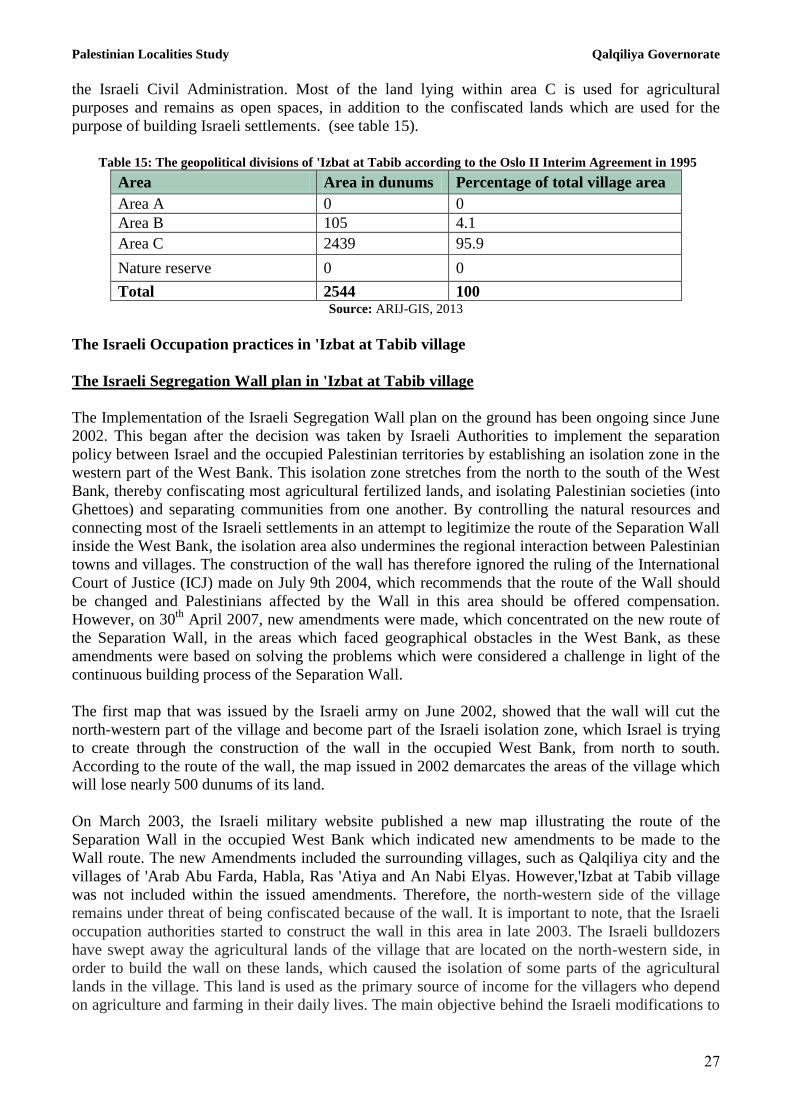
Geopolitical status in 'Izbat at Tabib
According to the Oslo II Interim Agreement signed by the Palestinian Liberation Organization (PLO)
and Israel on 28th
September 1995, 'Izbat at Tabib was divided into areas “B” and “C”.
Approximately 105 dunums (4.1% of the village’s total area) were assigned as area B, where the
Palestinian National Authority (PNA) retains complete control over civil matters but Israel retains
responsibility for security. Area B constitutes most of the inhabited Palestinian areas, including the
municipalities, villages and some refugee camps. The majority of the population of 'Izbat at Tabib
resides in area B. While the remaining village area, constituting 2439 dunums (95.9% of the total), is
classified as area C, where Israel retains full control over security and administration. In area C,
Palestinian building and land management is prohibited without the prior consent or authorization of
Palestinian Localities Study Qalqiliya Governorate
27
the Israeli Civil Administration. Most of the land lying within area C is used for agricultural
purposes and remains as open spaces, in addition to the confiscated lands which are used for the
purpose of building Israeli settlements. (see table 15).
Table 15: The geopolitical divisions of 'Izbat at Tabib according to the Oslo II Interim Agreement in 1995
Percentage of total village area Area in dunums Area
0 0 Area A
4.1 105 Area B
95.9 2439 Area C
0 0 Nature reserve
100 2544 Total Source: ARIJ-GIS, 2013
The Israeli Occupation practices in 'Izbat at Tabib village
The Israeli Segregation Wall plan in 'Izbat at Tabib village
The Implementation of the Israeli Segregation Wall plan on the ground has been ongoing since June
2002. This began after the decision was taken by Israeli Authorities to implement the separation
policy between Israel and the occupied Palestinian territories by establishing an isolation zone in the
western part of the West Bank. This isolation zone stretches from the north to the south of the West
Bank, thereby confiscating most agricultural fertilized lands, and isolating Palestinian societies (into
Ghettoes) and separating communities from one another. By controlling the natural resources and
connecting most of the Israeli settlements in an attempt to legitimize the route of the Separation Wall
inside the West Bank, the isolation area also undermines the regional interaction between Palestinian
towns and villages. The construction of the wall has therefore ignored the ruling of the International
Court of Justice (ICJ) made on July 9th 2004, which recommends that the route of the Wall should
be changed and Palestinians affected by the Wall in this area should be offered compensation.
However, on 30th
April 2007, new amendments were made, which concentrated on the new route of
the Separation Wall, in the areas which faced geographical obstacles in the West Bank, as these
amendments were based on solving the problems which were considered a challenge in light of the
continuous building process of the Separation Wall.
The first map that was issued by the Israeli army on June 2002, showed that the wall will cut the
north-western part of the village and become part of the Israeli isolation zone, which Israel is trying
to create through the construction of the wall in the occupied West Bank, from north to south.
According to the route of the wall, the map issued in 2002 demarcates the areas of the village which
will lose nearly 500 dunums of its land.
On March 2003, the Israeli military website published a new map illustrating the route of the
Separation Wall in the occupied West Bank which indicated new amendments to be made to the
Wall route. The new Amendments included the surrounding villages, such as Qalqiliya city and the
villages of 'Arab Abu Farda, Habla, Ras 'Atiya and An Nabi Elyas. However,'Izbat at Tabib village
was not included within the issued amendments. Therefore, the north-western side of the village
remains under threat of being confiscated because of the wall. It is important to note, that the Israeli
occupation authorities started to construct the wall in this area in late 2003. The Israeli bulldozers
have swept away the agricultural lands of the village that are located on the north-western side, in
order to build the wall on these lands, which caused the isolation of some parts of the agricultural
lands in the village. This land is used as the primary source of income for the villagers who depend
on agriculture and farming in their daily lives. The main objective behind the Israeli modifications to

Palestinian Localities Study Qalqiliya Governorate
28
the wall route that were issued in 2003, was to connect Israeli settlements to each other without
concern for what may result from these adjustments and the negative effects and disastrous outcomes
it may have on the Palestinian communities and residents. According to the Israeli charts in 2003, it
was to be built 2km away from the wall on the territory of the village of 'Izbat at Tabib. This resulted
in the isolation of an area of approximately 500 dunums of village land (19.6 % of the total area of
the village).
Subsequently, in 2005 and 2006 the Israeli army issued several amendments to the path of the wall in
the occupied West Bank, however, none of these amendments included the village. This continued in
spite of the protests by the people of the village and the neighboring villages and their objection to
the difficult situation arising because of the wall. These amendments also came to serve the interests
of Israeli settlements and ensured the inclusion of the new boundaries drawn by Israel through its
construction of the wall.
In March 2007 ( the month before issuing another amendment to the wall in April 2007), the Israeli
army issued the Israeli Military Order No. 07.09 / T, which provides an amendment to the section of
the wall which exists in the villages of Jayyus, 'Izbat at Tabib, and An Nabi Elyas. The amendment
aimed to move the wall toward the Israeli settlement Zufin where, according to this order, the Israeli
military will reclaim the village lands and all its agricultural lands that have been isolated by the
Wall, amounting to nearly 500 dunums. In February 2009, according to Israeli Military Order 07.09 /
T, the Israeli bulldozers resumed working on the territory of the village and the neighboring villages
and razed more lands of the village and the neighboring villages so as to alter the course of the wall.
The map shows that all the land of the village is situated outside the Israeli isolation scheme.
The Israeli bypass roads on the Lands of 'Izbat at Tabib village
The concept of “Bypass roads” began appearing during the time of the Oslo Agreement in September
1993 (which was signed between the PLO and Israel) to refer to the roads built by the Israelis in the
occupied Palestinian territories. This was done in order to link Israeli settlements in the West Bank to
one another as well as to the settlements inside Israel. Since then, Israel started to raise their efforts
in increasing the size of bypass roads in the occupied Palestinian territories as part of its strategy to
impose these policies on the ground, which will affect the Peace negotiations with Palestinians, and
the establishment of a Palestinian state that is geographically connected and alive. During the last 46
years of occupation since the year 1967, Israel has been able to make and pitch 810 kilometers of
bypass roads to facilitate the connection of the illegal Israeli settlements in the occupied West Bank.
According to the Oslo Agreement that was signed between Palestine and Israel, the Palestinians were
allowed to use these roads, but after the start of the second Intifada on 30 September 2000, the Israeli
authorities prevented Palestinians from using these roads citing 'security concerns' as their primary
reason. It is worth mentioning that the establishment of Israeli bypass roads in the occupied
Palestinian territories has contributed to weakening the development of the Palestinian communities
in the West Bank through the creation of obstacles in the areas that is reserved for Palestinian
development. In 2004, Israel proposed a network of bypass roads that will alter the pathway of
Palestinians and prevent them from using Israeli roads. Palestinians will be forced to use another
road network that is entirely separated from the Israeli bypass roads to ensure the exclusive use of
these roads by Israeli citizens. In doing so, Israel will be able to tighten its grip on and ensure control
of Israeli bypass roads, while at the same time, depriving the Palestinians from their right to
“freedom of movement” within the occupied Palestinian territory, as guaranteed by international
humanitarian law. The Palestinian village of 'Izbat at Tabib is similar to other Palestinian villages in
the occupied Palestinian territories which faced land confiscation because of the establishment of

Palestinian Localities Study Qalqiliya Governorate
29
Israeli bypass road No. 55 which cuts the village through the middle. Following the outbreak of the
second Palestinian intifada in late September 2000, the Israeli occupation authorities increased their
control over bypass road No. 55 and started to prevent Palestinians from 'Izbat at Tabib and
neighboring Palestinian villages from using the bypass road so as to control the levels of violence.
Claims were made that Palestinians throw stones at Israeli settlers who use this street as an entry and
exit point to and from Israel.
Previous Israeli attacks on the territory and property
On January 3rd, 2007, the Israeli authorities issued order number 531 and MAP No. ( 2/927 ) to
construct a new street to reach Alfei Menashe settlement which passes through the urban area of the
village. It also issued the village manor (in addition to the Israeli military order), a formal letter of "
Israeli Civil Administration" in the settlement of Kedumim indicating that the existing homes in the
village are illegal and that its residents are required to move to the neighboring village of ‘Azzun.
The Formal letter also refers to the rejection of the Israeli Civil Administration to issue a master plan
for the village on the pretext that “the urban area of the village is illegal and had been erected
illegally and are contrary to the laws and regulations of Israel." It is worth mentioning that the people
of the village manor had submitted an application for a master plan for the village at the beginning of
the nineties. This was done in an attempt to protect their homes from the threat of demolition that
affected them in the mid-eighties, but it was rejected under the pretext of non-completion of the
required paperwork and that "the proposed scheme is unprofessional." It should be noted, that today
the villagers cannot renovate or expand their homes due to the Israeli practices against them and their
houses are threatened by demolition.
On February 2nd 2008, the Israeli civil administration notified four Palestinian families in the village
with orders to stop work and construction of homes and facilities in the village under the pretext of
unauthorized building and homes in the area that are classified as Area "C", according to the Oslo II
Interim 1995 Agreement. The notified buildings belong to Harba Sho'or and Mustafa Hassan Tabib,
Mussa Adnan Tabib and Radi Yousef Tabib. The homeowners were notified of the demolition
procedures and went on to complete the licensing procedures required, however, it was rejected by
the Israeli occupation authorities and their homes remained under threat.
On March 14th 2008, the Israeli bulldozers of the Israeli Civil Administration demolished barracks
of the agricultural area that is 100 square meters which belongs to Harba Tiaaha.
On May 2011, the Israeli occupation army handed the village council a notification that includes the
extension of the validity of Israeli Military Order No. (10/05/T) , which would confiscate about 1
acres of land in the village, in order to build a fence the 400 m long to surround the village from the
north side. This fence is adjacent to the bypass road number 55 . The occupation authorities
confiscated claims that the reason behind land confiscation in the village, is to protect the Israeli
bypass road number 55 from the Palestinians since Israel claim that they throw stones at settlers' cars
who uses this street to enter to Israel and return back to Israeli settlements inside the West Bank .
Also on the same day that the village received confiscation orders, the Israeli civil administration
also handed over a notification letter to the citizen Zidane Yasser Al Tabib, in order to stop the
construction of his house under the pretext of an unauthorized building in the area that is classified as
area " C" which is under full Israeli control, for security and administrative issues, and this is
according to the agreement Oslo II Interim ,1995.

Palestinian Localities Study Qalqiliya Governorate
31
On May 2nd
2012, Israeli bulldozers, supported by the Israeli army, proceeded to destroy a house (
owned by Zidane Yasser Mohammed Tabib) that was still under construction, under the pretext of
an unauthorized building in the area that is classified as area "C”, where according to Oslo II
Agreement of1995, Israel retains full control over security and administration in this area. The
demolition was conducted after less than six months from the time of being notified which informed
them to stop the construction of the house. Despite proceeding with the correct licensing procedures
required by the Israeli civil administration, the owner’s house was demolished because of the
procrastination of the Israeli authorities and intransigence to issue the necessary licensing for the
house. This intransigence, deliberately intended by the Israeli authorities, transpired in order to
complicate the licensing process, which resulted in the complete demolition of the house.
On August,7th
,2012, the Israeli Civil Administration, notified the village council and handed over a
military order under the heading " give an additional opportunity to challenge the demolition order
"which has the number ( 308 610 ) , and issued in 2005 , by virtue of this order the Board Services
building of the village will be demolished under the pretext of unlicensed construction since this
Council services building is located in the area classified as " c" . The Board Services building was
set up in 2004 with an area of 280 m ² , which is a two-floors village school where nearly 60 students
are being taught there, and also includes a health clinic affiliated to the Ministry of Health . It should
be noted that the Israeli civil administration has already notified the Board Services to stop the
construction work twice in the years 2006 and 2007, but the village council of the village was able to
adopt a resolution of precaution, from the Israeli Supreme Court to stop the demolition of the village
council services . In spite of the court's decision , but that the Israeli Civil Administration insists on
moving ahead with the demolition of the Council services.
Israeli military checkpoints
After the construction of the segregation wall on the village territory and before the announcement
of the Israeli military order which includes an amendment to the route of the wall which was given
for the benefit of the neighboring village 'Jayyus,'Izbat at Tabib and An Nabi Elyas. The Israeli army
imposed stricter control on the people of the village in an attempt to displace the citizens of the
village and make things more difficult for them. In some instances, the Israeli authorities rejected the
issuing of permits of entry into the isolated lands which are located to the west of the wall. Only a
small number of people from this village, only those who are able to prove their ownership of the
land to the Israeli administration (ICA), may enter. Usually they issue permits only for land owners
(generally the elderly). The Israeli Civil Administration issue permits only from one season to
another, making it difficult for land owners to cultivate their agricultural lands by themselves without
the necessary equipment or laborers, especially since these permits do not include or allow access for
their laborers and equipment that are needed for the cultivation of the land.
Development plans and projects
Implemented projects
‘Azzun Municipal Council has implemented several development projects in ‘Azzun during the past
five years (see table 16).
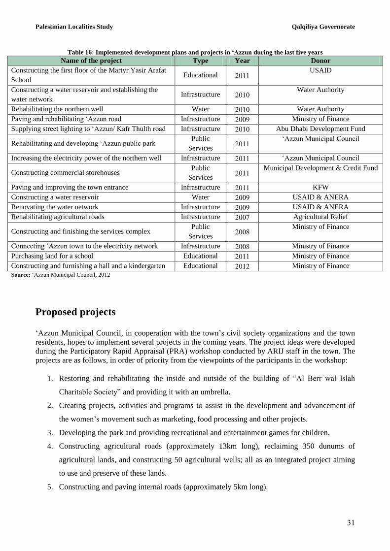
Palestinian Localities Study Qalqiliya Governorate
31
Table 16: Implemented development plans and projects in ‘Azzun during the last five years
Name of the project Type Year Donor
Constructing the first floor of the Martyr Yasir Arafat
School Educational 2111
USAID
Constructing a water reservoir and establishing the
water network Infrastructure 2111
Water Authority
Rehabilitating the northern well Water 2111 Water Authority
Paving and rehabilitating ‘Azzun road Infrastructure 2119 Ministry of Finance
Supplying street lighting to ‘Azzun/ Kafr Thulth road Infrastructure 2111 Abu Dhabi Development Fund
Rehabilitating and developing ‘Azzun public park Public
Services 2111
‘Azzun Municipal Council
Increasing the electricity power of the northern well Infrastructure 2111 ‘Azzun Municipal Council
Constructing commercial storehouses Public
Services 2111
Municipal Development & Credit Fund
Paving and improving the town entrance Infrastructure 2111 KFW
Constructing a water reservoir Water 2119 USAID & ANERA
Renovating the water network Infrastructure 2119 USAID & ANERA
Rehabilitating agricultural roads Infrastructure 2117 Agricultural Relief
Constructing and finishing the services complex Public
Services 2118
Ministry of Finance
Connecting ‘Azzun town to the electricity network Infrastructure 2118 Ministry of Finance
Purchasing land for a school Educational 2111 Ministry of Finance
Constructing and furnishing a hall and a kindergarten Educational 2112 Ministry of Finance
Source: ‘Azzun Municipal Council, 2012
Proposed projects
‘Azzun Municipal Council, in cooperation with the town’s civil society organizations and the town
residents, hopes to implement several projects in the coming years. The project ideas were developed
during the Participatory Rapid Appraisal (PRA) workshop conducted by ARIJ staff in the town. The
projects are as follows, in order of priority from the viewpoints of the participants in the workshop:
1. Restoring and rehabilitating the inside and outside of the building of “Al Berr wal Islah
Charitable Society” and providing it with an umbrella.
2. Creating projects, activities and programs to assist in the development and advancement of
the women’s movement such as marketing, food processing and other projects.
3. Developing the park and providing recreational and entertainment games for children.
4. Constructing agricultural roads (approximately 13km long), reclaiming 350 dunums of
agricultural lands, and constructing 50 agricultural wells; all as an integrated project aiming
to use and preserve of these lands.
5. Constructing and paving internal roads (approximately 5km long).

Palestinian Localities Study Qalqiliya Governorate
32
6. Establishing a retaining wall along the valley passing through the town territory
(approximately 5km long).
7. Rehabilitating the southern artesian well so that it can be used to its full potential.
8. Establishing a sewerage network (approximately 9km long) and a treatment unit.
9. Building a public services center.
10. Developing the existing civil defense center.
11. Expanding the ‘Azzun health clinic.
12. Restoring and completing ‘Azzun Secondary School’s yards.
13. Establishing a new school for girls.
14. Providing a bus for students.
15. Constructing a building for ‘Izbat at Tabib Co-educational Elementary School.
16. Establishing a gym to include a number of playgrounds (land is available for this purpose).
17. Rehabilitating 170 dunums of greenhouses, and connecting irrigation networks
(approximately 100 dunums).
18. Completing the public water network and changing the plastic pipes for metal ones
(approximately 2km long).
19. Extending the agricultural irrigation networks and providing farmers with plastic tanks of
5m3 capacity.
20. Installing solar panels in remote areas.
21. Constructing a compost factory for the production of organic fertilizers.
22. Creating small development projects such as the establishment of home gardens, and
collective sheep or poultry farms, to employ labor.
23. Establishing a dairy factory along with a cattle farm.
24. Expanding the town’s structural plan.

Palestinian Localities Study Qalqiliya Governorate
33
Locality development priorities and needs
‘Azzun suffers from a significant shortage of infrastructure and services. Table 17 shows the
development priorities and needs in the town, according to the Municipal Council’s perspective:
Table 17: Development priorities and needs in ‘Azzun
No. Sector Strongly
needed
Needed Not a
priority
Notes
Infrastructural needs 1 Construction and paving of roads * 35.8km^
2 Rehabilitation of old water networks * 4km
3 Extending the water network to cover new built up
areas *
4.4km
4 Construction of new water networks * 1.4km
5 Rehabilitation/construction of new wells or springs *
Aal Adwan southern
well
6 Construction of water reservoirs * 250m3
7 Construction of a sewage disposal network * 32km
8 Construction of a new electricity network * 10km
9 Providing containers for solid waste collection * 100 containers
10 Providing vehicles for collecting solid waste *
11 Providing a sanitary landfill *
Health needs 1 Building new clinics or health care centres * 1 health center
2 Rehabilitation of old clinics or health care centres * 1 health center
3 Purchasing medical equipment and tools *
Educational needs 1 Building new schools
*
2 elementary schools
for boys, 1 school for
girls and 1 co-
educational elementary
school
2 Rehabilitation of old schools
*
The boys’ secondary
and the girls
elementary schools
3 Purchasing new school equipment *
Computer and science
labs
Agriculture needs
1 Rehabilitation of agricultural lands * 375 dunums
2 Building rainwater harvesting cisterns * 70 cisterns
3 Construction of livestock barracks * 25 barracks
4 Provision of Veterinary Services *
5 Provision of seeds and hay for animals * 450 tons per year
6 Construction of new greenhouses *
100 dunums and 10
greenhouses
7 Rehabilitation of greenhouses *
50 dunums and 4
greenhouses
8 Provision of field crops seeds *
9 Provision of plants and agricultural supplies *
^ 18.3km main roads, 9.5km secondary roads and 8km agricultural roads Source: ‘Azzun Municipal Council, 2012
Palestinian Localities Study Qalqiliya Governorate
34
References:
Applied Research Institute - Jerusalem (ARIJ), 2013. Geographic Information Systems and
Remote Sensing Unit Database. Bethlehem - Palestine.
Applied Research Institute - Jerusalem (ARIJ), 2013. Geographic Information Systems and
Remote Sensing Unit; Land Use Analysis (2012) – Half Meter High Accuracy. Bethlehem -
Palestine.
Applied Research Institute - Jerusalem (ARIJ), 2013. Water & Environment Research Unit
Database (WERU). Bethlehem - Palestine.
‘Azzun Municipal Council, 2012.
Ministry of Education & Higher Education (MOHE) - Qalqiliya, 2012. Directorate of
Education; A database of schools (2011/2012). Qalqiliya – Palestine.
Palestinian Central Bureau of Statistics. 2009. Ramallah, Palestine: General Census of
Population and Housing Censuses, 2007.
Palestinian Ministry of Agriculture (MOA), 2010. Directorate of Agriculture data (2009/2010).
Qalqiliya – Palestine.