ayetteville future and use map
TRANSCRIPT
ayetteville FUTURE LANDUSE MAP
City Council Meeting5/11/2020

ayetteville FUTURE LAND USE MAP
Create a new Future Land Use Plan and Policy RecommendationsUpdate 2010 Land Use
Plan (joint City/County Plan)Bring together previous
small area plans (12 adopted plans)Reinforce ideas in these
plans and update based on new trendsGuide rezonings,
infrastructure and design
Project Purpose
Strategic Plan • Goal III: Strategic land use
policy• Objective A – Manage
growth and support strategic land use policy by supporting quality development.

ayetteville FUTURE LAND USE MAP
Previous PlansPrevious Plans 1983-2017

ayetteville FUTURE LAND USE MAP
Planning Process1- Project Initiation 2- Strategic Planning
3- Plan Development 4- Implementation / Adoption

ayetteville FUTURE LAND USE MAP
Public Meeting Results
Lifestyle Centers
Mixed Use Development
Visual Preference: Commercial
Infill / Reuse
Office and Technology
Only in the right places• Strip
Commercial• Manufacturing
and Industry

ayetteville FUTURE LAND USE MAP
Public Meeting Results
Low Density Residential
Medium Density Residential
Visual Preference: Residential
Walkable Mixed Use
Conservation Subdivisions
Conservation subdivisions preferred over conventional subdivisions over 2 to 1.

ayetteville FUTURE LAND USE MAP
Survey ResultsWhich types of development are most important to encourage?1. Redevelopment of existing vacant properties2. Walkable developments3. Mixed use developments4. Industrial businesses5. Parks and Recreation facilities6. Commercial businesses7. Residential
65 Ideas for areas ripe for redevelopment
• Murchison Road• Downtown + Edges• Massey Hill• Bragg Blvd• North Fayetteville • Ramsey Street• Shaw Heights

ayetteville FUTURE LAND USE MAP
Land Use TrendsUnderutilized commercial corridors • 3,400 acres of commercial
zoning• 36% of properties are
underutilized• 1/3 of total commercial
properties are <2 acresNew development standards improving some areas

ayetteville FUTURE LAND USE MAP
Commercial Strip Redevelopment Potential
116 Parcels are zoned commercial and are <2 acres between Shaw Rd and FTCC along Bragg Blvd

ayetteville FUTURE LAND USE MAP
Land Use TrendsResidential growth in the form of single-family homes and apartments on north and west side of the City• Market trends -> small lots• Limited open space
Aging neighborhoods• Older neighborhoods in
need of reinvestment• Military reassignments may
accelerate neighborhood aging due to increase in sales and rentals

ayetteville FUTURE LAND USE MAP
Land Use Plan GoalsGoal #1: Focus growth around established municipalities, infrastructure, and strategic nodes
Goal #2: Promote economic and commercial development in key areas
Goal #3: Foster safe, stable, and attractive neighborhoods
Goal #4: Preserve and enhance environmental features
Goal #5: Recognize the strategic importance of military installations and educational institutions and ensure development is compatible and complimentary
Goal #6: Encourage redevelopment of strip commercial areas

ayetteville FUTURE LAND USE MAP
Future Land Use Map
ayetteville FUTURE LAND USE MAP
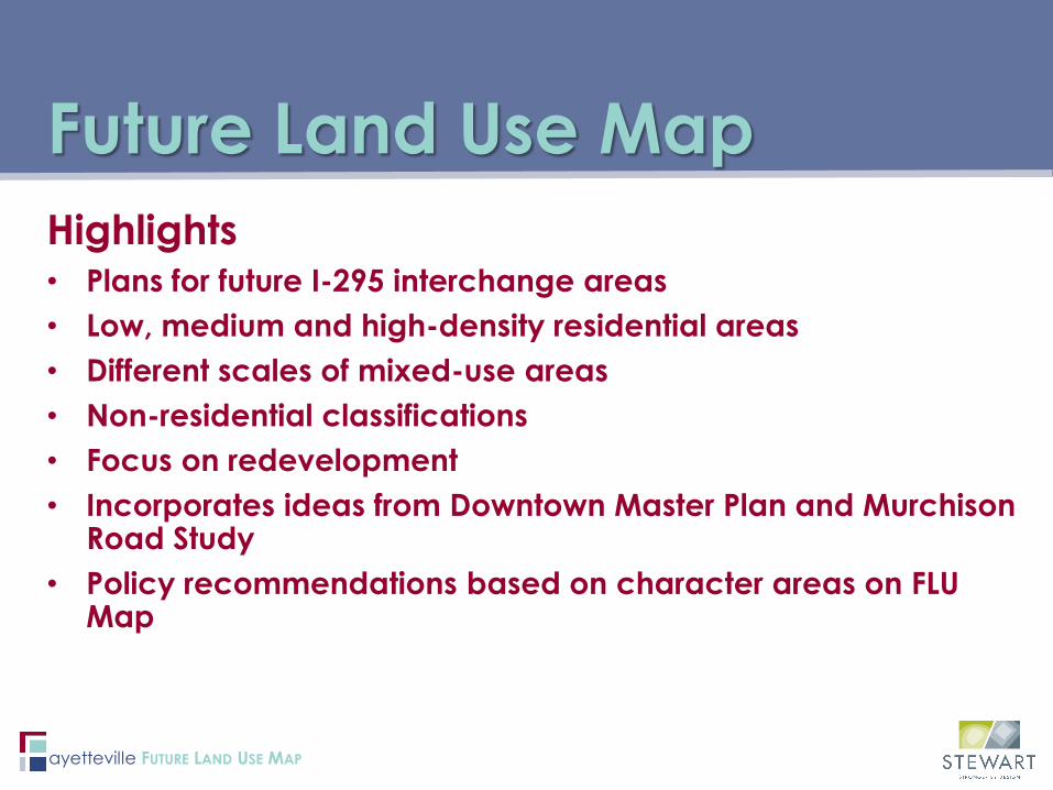
Highlights• Plans for future I-295 interchange areas• Low, medium and high-density residential areas• Different scales of mixed-use areas• Non-residential classifications• Focus on redevelopment• Incorporates ideas from Downtown Master Plan and Murchison
Road Study• Policy recommendations based on character areas on FLU
Map
Future Land Use Map

ayetteville FUTURE LAND USE MAP
Recent Updates• Edits in the following areas:
• North Ramsey Corridor• South Ramsey Corridor• Stoney Point Area• Raeford Road Area• Legion Road Area
• Most changes were from residential to commercial or mixed use (NMU or CC)
Future Land Use Map

ayetteville FUTURE LAND USE MAP
Commercial / Mixed Use:Character Areas
Downtown:• Cultural, entertainment, and
social heart of the city• Large proportion of high-rise
buildings (>5 stories), especially in core
• Intense commercial, retail, service sectors
• Dense residential uses
Regional Center:• Commercial centers with
regional draw• >400,000 sq ft nonresidential
leasable space• Vertically mixed uses, mostly
nonresidential

ayetteville FUTURE LAND USE MAP
Commercial / Mixed Use:Character Areas
Community Center:• 150,000-400,000 sq ft
nonresidential leasable space• Vertically mixed uses• Mostly nonresidential on ground
floors, with offices and potentially residential on upper stories
• Standalone, multi-family, high density attached residential as integrated uses
Neighborhood Mixed Use:• Neighborhood serving
commercial uses • Mostly a horizontal mix of uses,
vertical mix in key locations• Low-rise buildings (<3 stories)• Standalone, smaller-scale multi-
family, attached and small-lot single family residential
ayetteville FUTURE LAND USE MAP
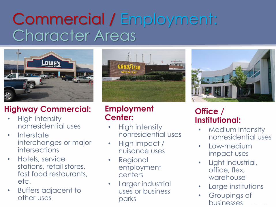
Commercial / Employment:Character Areas
Highway Commercial:• High intensity
nonresidential uses• Interstate
interchanges or major intersections
• Hotels, service stations, retail stores, fast food restaurants, etc.
• Buffers adjacent to other uses
Employment Center:• High intensity
nonresidential uses• High impact /
nuisance uses• Regional
employment centers
• Larger industrial uses or business parks
Office / Institutional:• Medium intensity
nonresidential uses• Low-medium
impact uses• Light industrial,
office, flex, warehouse
• Large institutions• Groupings of
businesses
ayetteville FUTURE LAND USE MAP
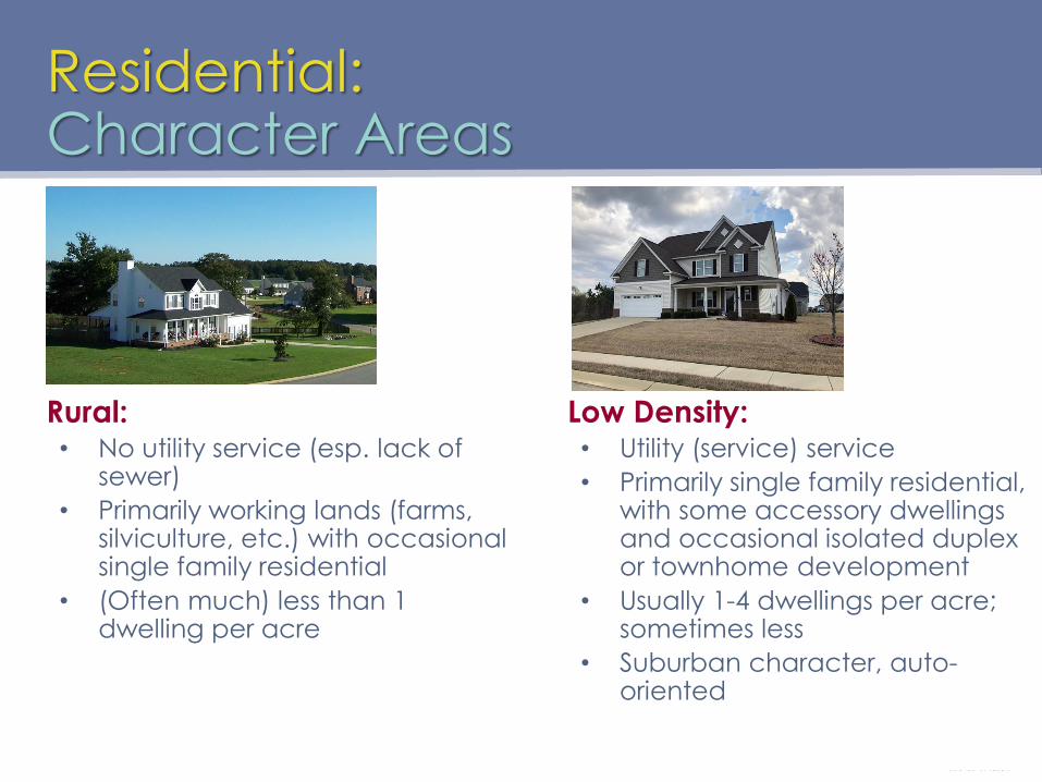
Residential:Character Areas
Rural:• No utility service (esp. lack of
sewer)• Primarily working lands (farms,
silviculture, etc.) with occasional single family residential
• (Often much) less than 1 dwelling per acre
Low Density:• Utility (service) service• Primarily single family residential,
with some accessory dwellings and occasional isolated duplex or townhome development
• Usually 1-4 dwellings per acre; sometimes less
• Suburban character, auto-oriented
ayetteville FUTURE LAND USE MAP
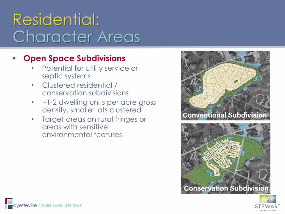
• Open Space Subdivisions• Potential for utility service or
septic systems• Clustered residential /
conservation subdivisions• ~1-2 dwelling units per acre gross
density, smaller lots clustered• Target areas on rural fringes or
areas with sensitive environmental features
Residential:Character Areas
Conservation Subdivision
Conventional Subdivision

ayetteville FUTURE LAND USE MAP
Residential:Character Areas
Medium Density Residential:• Primarily single family residential • Mix of duplex or townhome
interspersed; low-impact, low rise apartments possible
• Usually 3-6 dwellings per acre; • Small-lot neighborhoods
High Density Residential:• Townhomes and apartments in
low- to mid-rise buildings (3-5 stories); some single family
• Usually 5-16 dwellings per acre• Walkable to
retail/services/activity areas• Often serves as a step-down
(and supportive use) to adjacent commercial

ayetteville FUTURE LAND USE MAP
• Context:• Groupings of residential properties that are
very underutilized or have numerous vacant parcels
• Often older housing stock or neighborhoods• Objective/Recommendations:
• Increase private investment and revitalize neighborhoods
• Allow increased mix of “missing middle” homes with higher standards
• Example areas:• North downtown – Hillsboro St neighborhood• Southwest downtown – Commerce St /
Turnpike Rd neighborhood• Aging mobile home parks
Neighborhood Infill/Redevelopment

ayetteville FUTURE LAND USE MAP
• Context:• Groupings of commercial strip development
properties that are very underutilized or failing• Often older buildings on older corridors
• Objective/Recommendations:• Increase private investment and redevelop
failing commercial strips• Encourage higher density residential
redevelopment to support commercial FLU areas
• Example areas:• Yadkin Road strip malls
Commercial Strip Redevelopment

ayetteville FUTURE LAND USE MAP
Implementation Recommendations
#1: Use the Future Land Use Map to guide land use decisions
#2: Update the City’s comprehensive plan
#3: Remove barriers for reinvestment and redevelopment
#4: Coordinate efforts among departments to create opportunities for reinvestment in distressed areas
#5: Increase public engagement efforts in support of the goals and action steps in this document