awos in iowa awos locations in iowa a airport awos vhf...
TRANSCRIPT
AWOS in Iowa
Automated Weather Observing Systems (AWOS) collect and disseminate weather data to various sources for the primary
purpose of enhancing the safety of aircraft opera-tions in Iowa’s air transportation system.
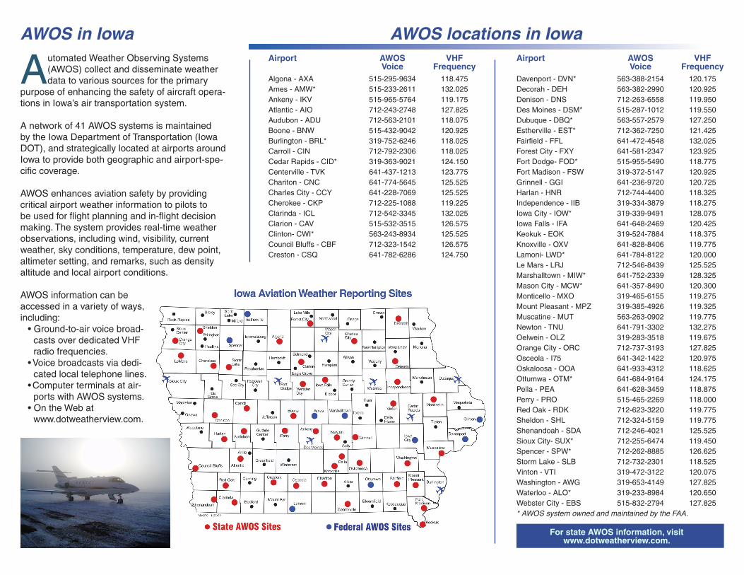
A network of 41 AWOS systems is maintained by the Iowa Department of Transportation (Iowa DOT), and strategically located at airports around Iowa to provide both geographic and airport-spe-cific coverage.
AWOS enhances aviation safety by providing critical airport weather information to pilots to be used for flight planning and in-flight decision making. The system provides real-time weather observations, including wind, visibility, current weather, sky conditions, temperature, dew point, altimeter setting, and remarks, such as density altitude and local airport conditions.
AWOS information can be accessed in a variety of ways, including: • Ground-to-air voice broad-
casts over dedicated VHF radio frequencies.
• Voice broadcasts via dedi-cated local telephone lines.
• Computer terminals at air-ports with AWOS systems.
• On the Web at www.dotweatherview.com.
Algona - AXA 515-295-9634 118.475Ames - AMW* 515-233-2611 132.025Ankeny - IKV 515-965-5764 119.175Atlantic - AIO 712-243-2748 127.825Audubon - ADU 712-563-2101 118.075Boone - BNW 515-432-9042 120.925Burlington - BRL* 319-752-6246 118.025Carroll - CIN 712-792-2306 118.025Cedar Rapids - CID* 319-363-9021 124.150Centerville - TVK 641-437-1213 123.775Chariton - CNC 641-774-5645 125.525Charles City - CCY 641-228-7069 125.525Cherokee - CKP 712-225-1088 119.225Clarinda - ICL 712-542-3345 132.025Clarion - CAV 515-532-3515 126.575Clinton- CWI* 563-243-8934 125.525Council Bluffs - CBF 712-323-1542 126.575Creston - CSQ 641-782-6286 124.750
Davenport - DVN* 563-388-2154 120.175Decorah - DEH 563-382-2990 120.925Denison - DNS 712-263-6558 119.950Des Moines - DSM* 515-287-1012 119.550Dubuque - DBQ* 563-557-2579 127.250Estherville - EST* 712-362-7250 121.425Fairfield - FFL 641-472-4548 132.025Forest City - FXY 641-581-2347 123.925Fort Dodge- FOD* 515-955-5490 118.775Fort Madison - FSW 319-372-5147 120.925Grinnell - GGI 641-236-9720 120.725Harlan - HNR 712-744-4400 118.325Independence - IIB 319-334-3879 118.275Iowa City - IOW* 319-339-9491 128.075Iowa Falls - IFA 641-648-2469 120.425Keokuk - EOK 319-524-7884 118.375Knoxville - OXV 641-828-8406 119.775Lamoni- LWD* 641-784-8122 120.000Le Mars - LRJ 712-546-8439 125.525Marshalltown - MIW* 641-752-2339 128.325Mason City - MCW* 641-357-8490 120.300Monticello - MXO 319-465-6155 119.275Mount Pleasant - MPZ 319-385-4926 119.325Muscatine - MUT 563-263-0902 119.775Newton - TNU 641-791-3302 132.275Oelwein - OLZ 319-283-3518 119.675Orange City - ORC 712-737-3193 127.825Osceola - I75 641-342-1422 120.975Oskaloosa - OOA 641-933-4312 118.625Ottumwa - OTM* 641-684-9164 124.175Pella - PEA 641-628-3459 118.875Perry - PRO 515-465-2269 118.000Red Oak - RDK 712-623-3220 119.775Sheldon - SHL 712-324-5159 119.775Shenandoah - SDA 712-246-4021 125.525Sioux City- SUX* 712-255-6474 119.450Spencer - SPW* 712-262-8885 126.625Storm Lake - SLB 712-732-2301 118.525Vinton - VTI 319-472-3122 120.075Washington - AWG 319-653-4149 127.825Waterloo - ALO* 319-233-8984 120.650Webster City - EBS 515-832-2794 127.825* AWOS system owned and maintained by the FAA.
Airport AWOS VHF Voice Frequency
AWOS locations in IowaAirport AWOS VHF Voice Frequency
ForstateAWOSinformation,visitwww.dotweatherview.com.
Forinformationorcommentscontact:
Iowa Department of TransportationOffice of Aviation800 Lincoln WayAmes, IA 50010515-239-1468FAX: 515-233-7983www.iawings.com
AWOS information is also disseminated na-tionwide through a system called the National Airspace Data Interchange Network (NADIN), making it available to air traffic control, flight ser-vice stations, the National Weather Service, and other weather reporting services.
The AWOS network maintained by the Iowa DOT is complemented by 17 additional systems around Iowa that are owned and maintained by the Federal Aviation Administration (FAA). Infor-mation from those systems is available via radio or phone, or on the Internet at http://weather.noaa.gov/weather/IA_cc_us.html.
What every pilot should know about AWOS
Wind • Readings are taken every second and a run-
ning 2-minute average is updated every 5 seconds.
• Wind speeds of less that 3 knots are reported as calm.
• If the difference between the highest 5-second average and 2-minute average exceeds 5 knots, gusts are reported.
• Wind direction is reported from the nearest degree magnetic heading.
Visibility • Readings are taken every 15 seconds and
averaged over a 10-minute period.
Presentweather • A precipitation sensor samples every 15 sec-
onds. • Temperature and visibility measurements are
used to determine precipitation type.
Skycondition • Readings are taken every 30 seconds and
averaged over a 30-minute period. • Ceiling measurements (above ground level or
AGL) are rounded as follows. Nearest 100’ up to 5,000’ AGL Nearest 500’ from 5,000’ to 10,000’ AGL Nearest 1,000’ above 10,000’ AGL
Temperatureanddewpoint • Four, 1-minute averages are used to deter-
mine the temperature.
Altimeter(barometricpressure) • Pressure sensors take readings every 10 sec-
onds; and a 1-minute average is calculated.
Remarks • A calculated density altitude report is provided,
if density altitude is greater than 1,000’ above the airport’s field elevation.
• Occasionally, airport managers will provide recorded remarks regarding Notice to Airmen (NOTAM) or local airport conditions.
Reporting stations are calibrated on a regular basis to ensure reliability and accuracy. As with any electronic device, care must be used when interpreting data. By knowing how AWOS data is collected, a pilot can better understand the infor-mation they are receiving.
Any questions regarding AWOS systems in Iowa may be directed to the Iowa DOT’s Office of Aviation at 515-239-1468.
PM 604 5-21-09
EnhancingSafetyinIowa’sAirTransportationSystem