avon hang gliding and paragliding club - skytribe - the ... · powered hang gliding. ... top...
TRANSCRIPT

Avon Hang Gliding and Paragliding Club
Sites Guide 2014

General rules to follow when visiting Avon sites
All pilots are asked to carry their BHPA membership cards whilst on Avon flying sites. BHPA rules and procedures should be followed at all times (helmets worn, gliders airworthy, etc).
In addition to the legal procedures for serious accidents, please report all accidents to the club’s safety officers, [email protected], [email protected] or [email protected]. Accidents that could result in legal action MUST be sent to the BHPA within 48 Hrs.
Please report any damage to crops, property or animals to the sites officer immediately via telephone or [email protected].
Vehicle access and parking are often a key point in site negotiations. Please use only the agreed access routes and parking areas.
No Avon site agreements include permission for the use of powered paragliding or powered hang gliding.
When flying XC try not to land in fields containing livestock and never land in fields containing horses.
Good PR helps us enormously in site negotiations (and is obviously a good thing in its own right!). Please always make an effort to be considerate and courteous to the public and landowners when driving to or at a site. Likewise, please follow the country code: take litter home with you; don’t climb over fences/walls; and always shut gates behind you.
Visiting PilotsAvon HGPG operates an open sites policy. The exceptions are Draycott, Spencer’s Bowl and Morgan’s Ridge at Mere, and usage of the Cowdown and Upton triangles at Westbury. These are due to specific landowner requirements. We have reciprocal access agreements with Thames Valley, Wessex, North Devon and Devon & Somerset Condors, with the exception of the above mentioned.
Midweek Flying Notification Procedure
Please use this link to go through how to notify the military if you fly midweek.
RAF Wittering is the phone number to call 0800 515544
http://www.bhpa.co.uk/documents/safety/canp/

Introduction
Welcome to the 2014 edition of the Avon Sites Guide. Please remember that this printed version of the sites guide is potentially out of date as soon as it is printed! Please check the online sites guide at http://www.avonhgpg.co.uk/sites/sitesmap.php regularly for any updates or important site news. As always, please ask on-site if you are unsure about anything or by contacting the local sites officer listed with each site, or the overall sites officer at [email protected]. To keep in touch with other members and informed on general club points of interest, join the Avon HG & PG Club forum This forum is private.
The Avon club does not own any flying sites and the sites presented in this guide are on both public and private land. In all cases, the use of the sites has been secured through lengthy negotiations with the landowners and in some cases our presence is only begrudgingly accepted. These negotiations have resulted in the rules set out in this guide, so if we all follow the rules then the landowners will hopefully continue to allow us to use their land. This system only works by operating as a club and requires ongoing liaison between our sites officers and the landowners. With any of the sites there is nothing to stop a rogue individual turning up and flying with no regard for the site rules. However, this would jeopardise the site agreements and has been the cause of many “lost” sites throughout the country. Please can all pilots flying in this area respect the site rules in this guide.
Useful Information
The British Hang Gliding and Paragliding Association Ltd 8 Merus Court, Meridian Business Park, Leicester, LE19 1RJ,
Telephone: 0116 289 4316Fax: 0116 281 4949Email:[email protected]
Avon HGPG Website http://www.avonhgpg.co.uk/
Avon PG results are to be found on the XC League website
http://www.xcleague.co.uk/
Yahoo Group (private chat group) http://groups.yahoo.com/neo/groups/avonhgpg/info
Club Radio Frequency 143.75 MHzTelegram chat groups(you need to download the App)
Avon LAT /Avon Air Space/Avon Site reports/Avon XC Group
WeatherCurrent UK airfields weather (METAR) http://www.xcweather.co.uk/
A large selection of weather links available at
http://www.hgpg.co.uk/weather.htm
RASP Loads of hi tech predictions here, even some that actually happen!
http://rasp.inn.leedsmet.ac.uk/RASPtableGM/RASPtableGM.html
AirspaceBristol Airport (ask for ATC) 01275 473714Temporary airspace restrictions. 0500 354802XC planner has airspace, and maps, and it is a very useful tool.
http://xcplanner.appspot.com/
NOTAMS (always check before flying XC). Notaminfo requires registration.
http://notaminfo.comhttp://www.bhpa.co.uk/documents/safety/canp/notam.php

Emergency Procedures
In the event of an accident, please be ready to assist if needed. There are very often medically experienced people on most sites.
In the event of a serious accident that needs immediate hospitalisation
• Call 112 or 999, and ask for POLICE
• Describe the incident as FALL FROM HEIGHT
• If the location is remote, give coordinates in any format. The helicopter pilots will be able to use these.
• If there is a need for a winch, eg if the victim is a long way from a landable area, make sure the police know this.
• Stop other pilots flying in the area. A pair of crossed gliders indicates ‘do not fly’. Use radios, shout, wave your hands, or whatever method works to get pilots clear. The helicopter will not land if there are gliders flying.
• Be prepared to help carry the victim’s stretcher if needed.
If you are qualified and assess that the victim is not seriously injured, then you can call an ambulance, but they will need a post code or a road name. They may not be able to use GPS coordinates.

Main Sites Key Information
Cam Long Down NW-N Rarely flown but has recently had scrub cleared.
Crook Peak WSW-S Experienced pilots only. No bottom landing.Rarely flown.
Draycott SSW-SW Full Avon members onlyExperienced pilots only. Rarely flown.
Frocester W-NW Experienced pilots only. Recommended 100Hrs plus, and Pilot rated. Excellent XC site. No top landing. Landing on the slope is permitted. There is no permission to land in the picnic area. There is congested and restricted airspace downwind and a busy gliding club behind take off.
Selsley Common WNW-NNW Modellers also use this site. The site is a popular venue for the N Bristol area. Good XC potential now airspace to the south is open.
Long Knoll SSW-SSE
Maes Knoll ESE Rarely flown and is under Bristol Airspace.
Mere: Cowards Bowl SSW-WSW A poor site that is rarely flown.
Mere: Rifle Range SSW-ESE Excellent site with good XC potential.
Mere:Spencer’s Bowl SSW-WSW (AKA White Sheet Hill). Now in use as an XC site on
weekdays. Members only, with helmet sticker, and the site is only intended for XC flights. Heavily used by modellers. See http://www.avonhgpg.co.uk/sites/spencers.php
Mere: Morgan’s Ridge WNW-NNW Similar to Spencer’s Bowl. See
http://www.avonhgpg.co.uk/sites/morgans.php
Westbury WNW-N No landing in farmer’s fields on the top or side of the hill. Stay 300’ ato when overflying the riding stables at the west end of the main ridge. Modellers also use this site. Danger area immediately behind take off from surface to 50,000ft
Bratton Camp NNW-NNE Now presented as a separate site.

Cam Long Down: W-N; 700' asl; 250' ttb; (ST 773 995 - sheet 162), site code 2.093
The southern side of the site is no longer available, as it has become completely overgrown.
Sites Officer: Wayne Buckland 07977 543746.
Rating: Any rated pilot. No training.
Permission: This is an Open Site. Please abide by Avon Club Rules and if you are not a club member read the section for Non-Members.
Parking: Park in the car park on the north side at the south end, inside the gate. Do not park on the grass.
Rigging: Walk up to the saddle and follow the path going north.
Take Offs: Any clear spot.
Local Flying: The ridge is small and so is the lift band so take care. Pilots should be aware of the bushes and the possibility of being blown back as it is a spine-back ridge.
XC Flying: Small site and not often used but may offer potential for paragliders.
Top Landing: It is a spine-back ridge so top landing on a hang-glider is not recommended. Depending on the vegetation, it is possible to land a paraglider near the top of the hill.
Bottom Landing:
Cam Long Down parking is in the public parking at the foot of Cam Peak. You should be able to see this on the map or Google maps.
Landing is on the land near the parking area, although there are a few open fields to the north of the car park that would be ok provided they are not in crop. In strong conditions use these for safety.
Telephones: On the road to the north of the car park.
Hospitals: Stroud or Gloucester.
Directions: From Dursley, take Long Street out of town.


Crook Peak: WSW-S; 550' asl, 500' ttb; (ST 388 558 - sheet 182), site code 2.069
Sites Officer: Rich Harding (07966 491138). Rating: Experienced Pilots Only. No training. Permission: This is an Open Site. Please abide by Avon Club Rules and if
you are not a club member read the section for Non-Members. The site is jointly controlled by ourselves and the Devon & Somerset Condors.
Parking: Park in one of the two lay-bys below Crook Peak, overlooking the Levels.
Rigging: Carry up to the top of the hill via the paths that lead from the lay-by. Hang glider pilots may find the longer but shallower bridle path an easier walk.
Take Offs: Not at the very top for hang gliders but lower down where the gradient is steeper. Paraglider pilots can go higher up if they wish. Be aware that this is a spineback ridge - don't get dragged over the back. The western corner of the ridge above the Webbington Hotel can be very tricky, as there is often rotor from the cliff and there are few fields uninterrupted by power lines at the bottom. It is possible to fly the north-western face, but there is no official landing field. Don't go down on this side.
Local Flying: Do not fly over any horses or let your shadow go near them. Only fly east to Wavering Down if you are certain that you can get back, as there are no bottom landing fields in that direction (the local farmers are very anti hang gliding/paragliding). Be aware that modellers use this area as well. Liaise before launching, for your own safety.
XC Flying: The site is directly under Bristol CTA 1500’. Ridge runs can be made to Weston and to Wells. If the run to Wells is possible XC's can be undertaken on the same track as from Draycott. There are better possibilities if you can get up from the north-western face.
Top Landing: Very tricky on hang gliders. Easier on paragliders as long as you use the middle portion of the ridge.
Bottom Landing: THERE IS CURRENTLY NO BOTTOM LANDINGHospitals: Weston or Bristol. Directions: Turn west off the A38 at Cross, towards Loxton. Crook Peak is
the long ridge after two miles, just before the Webbington Hotel (which can be seen from the M5).


Draycott: SSW-SW; 850' asl; 600' ttb; (ST 497 508 - sheet 183). Site code 2.022
Sites Officer: Geoff Rogers 01761 232096. Mob 07740427617
Rating: Experienced Pilots only. Soaring only, no top-to-bottoms.
Permission: Full Avon members only.
Parking: Park by the corrugated tin hut.
Rigging: Anywhere in the field over the other side of the wall. Do not climb over the stone walls, use the stile.
Take Offs: Located above the stone wall on the front of the hill just before the corner where it turns downhill, about 200 yards to the west of the hut. This is a shallow incline and requires a committed run on a hang glider.
Local Flying: This site is very sensitive to wind direction. As a general rule do not fly if the wind is coming from a direction to the east of Glastonbury Tor. Look out for the sea breeze which can switch the wind off the hill. The ridge is shared with the gliding club which operates from a field about half a mile north-west of take-off, so keep a look out for them. When good, the whole area provides plenty of lift but on other days you can find yourself at take-off height scratching just above the trees. Weak wave has been encountered several times at this site. The area to the south is part of Yeovilton AIAA so, when flying out in front, keep a look out for military aircraft. Height here is limited by Bristol CTA so please check restrictions before flying. Be aware of the Halesland block A. (See http://www.avonhgpg.co.uk/files/bath_gap_v6.pdf)
XC Flying: Two miles down wind there is a small firing range, so watch out for red flags. The downwind route is of no use for XC as you'll run into Bristol Airport CTA. To fly any distance you must track east before turning down wind. Check out an airspace map as the CTA extends east to Bath.
Top Landing: the cars park. Beware of the power line which runs along the northern edge of the uncultivated field.
Bottom Landing:
There is no official bottom landing field, but there is a field just below take-off which can be used to avoid going all the way to the bottom, although a landing in it requires great skill and judgement. The field generally used is in front of the woods to the west. This field slopes away from the hill and landings are usually made towards the hill as there is little or no wind. Ask an experienced pilot before flying. Keep out of all fields containing livestock, especially horses.
Hospitals: Bristol or Weston.
Directions: Heading west along the B3135 towards Cheddar turn left towards Westbury sub-Mendip about half a mile after passing the danger area flag on your left. The entrance gate to the site is just under a mile down this road on the right, opposite a water storage mound in the field on the left. There is a barn in the NW corner of the field. If you reach the quarry you have gone too far. (Alternatively approach is up the hill from Westbury-Sub-Mendip.) Close the gate and drive slowly across the field by following the track into the next field. Follow the track through a gate into an uncultivated field closing the gate behind you. Follow the track as far as it goes.


Frocester: W-NW; 720' asl; 250' ttb; (SO 794 012 - sheet 162). Site code 2.079
Sites Officer: Wayne Buckland 07977 543746
Rating: Experienced pilots only due to technical take-off and narrow lift band. Novice pilots may only fly under the supervision of an experienced club member who knows the site and conditions well. Recommended 100Hrs and Pilot rating.
Permission: Open site
Parking: Park in the car park behind take-off unless the area is full, in which case park in the northern car park. Do not drive on the grass.
Rigging: Over the stile from the picnic area. Take care not to damage the wall beneath the stile.
Take Offs: The centre of the west facing bowl. The true wind direction should be checked at the trig point to the south of launch before flying. Paraglider pilots should be especially careful on take-off as it is often turbulent. Beware of the barbed wire fence and bush behind launch and do not launch directly in front of rigging hang gliders.
Local Flying: If the wind is from the WSW or NW it can be turbulent in the air. This area is shared with the Bristol and Gloucestershire Gliding Club so please, when flying locally do not fly more than 100 yds north of take-off unless you are at least 600' ato. or below the ridge and going to land, as this is the glider tug flight path. Paragliders need a little more height than hang gliders before heading into the main bowl to the south of take-off. Always get briefed by a local pilot before flying.
XC Flying: This is a very popular site for XC flying and has produced several 100km plus flights, although care in planning now needs to be taken to avoid Kemble and Brize Norton Class D Airspace. Temporary airspace restrictions are also common at Fairford, which can severely limit the downwind XC route.
Top Landing: There is no top landing.On no account should you land in any field on the east side of the main road, no matter how tempting they may look as there is severe rotor there. The farmer there is also very ‘anti’. We do not have permission to land in the picnic area. Paragliders can land on the slope to the north of take-off, easier now it has been cleared, but it is never easy. It is possible for very experienced hang glider pilots to land on the slope.
Bottom Landing: There have not been problems in landing in any of the fields below in an emergency, provided you pick one that has no animals or crops in. If you are challenged then be apologetic and leave.
Hospitals: Stroud or Gloucester.
Directions: The site can be found about five miles SW of Stroud on the B4066 Dursley Road just before the turn-off down the hill to Frocester Village. It is located at the south-west end of the Coaley Peak Picnic Area.


Long Knoll: SSW-SSE; 850' asl, 200' ttb; (ST 796 377 - sheet 183). Site code 2.060
Sites Officer: Nick Somerville 01749 880579 Mob 07891 921651
Rating: Any rated pilot. No training.
Permission: Open site
Parking: There is no parking close to the hill. Hang glider pilots should drop their gliders off by the hill, being careful not to obstruct traffic as there is very little room to pull in. Then drive south past the hill and park in the garage on the SE side of the road after 400 yds. Paraglider pilots should park in the garage. Permission must be sought from the owner to park.
Rigging: Walk to the top of the hill using the stiles and following the paths.
Take Offs: Anywhere on the east end of the ridge.
Local Flying: The site can be very rough at times, so take care - at least one paraglider pilot has been blown back into the fence that runs along the spine of the hill.
XC Flying: Has good potential for paraglider XC flying. It can be difficult to get away from as you have to commit to leaving at a lower height than is usual. Beware of the wild-life park at Longleat, 2 miles to the N.
Top Landing: It is a spine backed ridge, so top landing is virtually impossible on a hang glider but paragliders can land on the side of the hill.
Bottom Landing: In the fields below the hill if they are not in crop - beware that they slope gently away from the hill. Look out for barbed wire fences. Paragliders can land on the side of, or at the foot of the hill in the same field as take-off.
Hospitals: Frome or Bath.
Directions: Leave Frome going south on the B3092. About one mile after Maiden Bradley, you will see the hill on the west side of the road.


Maes Knoll: ESE; 600' asl, 200' ttb; (ST 600 660 - sheet 172). Site code 2.061
Sites Officer: Rich Harding (07966 491138).
Rating: Any rated pilot. No training.
Permission: This is an Open Site. Please abide by Avon Club Rules and if you are not a club member read the section for Non-Members.
Parking: Off the side of the road.
Rigging: Walk to the top of the hill taking care not to disturb the farmer's cattle.
Take Offs: At the north east end of the knoll. There is a hedge, which includes several large trees just below take off.
Local Flying: Watch out for the numerous trees mentioned above.
XC Flying: None.
Top Landing: Do not land in any crops.
Bottom Landing:
Below take-off, but watch out for the barbed wire fences.
Hospitals: Bristol.
Directions: Leave Whitchurch on the A37 going south. Take the first right toward Norton Malreward. Maes Knoll is about one mile on the right after crossing the bridge over the disused railway.


White Sheet Downs: Spencer's Bowl: SSW-WSW; 755' asl; 215' ttb; ST 802 350 sheet 103; Site code: TBC
At the request of the landowner, this site is only open to full Avon Club Members only and is subject to the restrictions detailed below. Make sure you have read and understood the Site License Agreement that can be found here. Remember that you must have a dated White Sheet Hill Authorised Flyer sticker from the NT and only issued to full Avon members rated Pilot and above.
Sites Officer: Nick Somerville 01749 880579 Mob 07891 921651National Trust Warden:
Kim Portnell, Stourhead Office, 01747 842005
Rating: Pilot and Advance Pilot Rated onlyPermission: MID WEEK ONLY! We have no permission to fly at
weekends when the site is busy with model flyers. Pilot rated and above pilots with a current Avon helmet sticker and a National Trust Helmet Sticker may fly for the purpose of launching for XC flights. CP rated pilots may not use this site. Please have your BHPA card and helmet sticker in place to show the warden if asked. If non Avon pilots arrive to use the site, please ask them not to fly.
Directions / Parking:
Leave Frome going south on the B3092. Two miles after Maiden Bradley, turn left, immediately after the Red Lion pub, into Long Lane. Follow the track carefully for about 1 mile. There are a few parking spaces directly at the top of the hill and plenty more after the right turn along the top. Please do not block any gates. Access to the site is through the kissing gate on the right of the track. Remember to secure the rope on the kissing gate.
Rigging: Paragliders can lay out anywhere to the left of the 'hump'. Hang gliders can rig just inside the field by the track and carry the rigged glider forward to take-off, or rig just behind take-off in front of the fence.
Take Offs: Anywhere in the bowl but away from model fliers, if present. Make contact with any model fliers before launching and agree on how the airspace is to be shared. Although we have priority during weekdays, it is in our best interest to share when safety of conditions permit.
Local Flying / Hazards:
If the wind direction is to the right of Alfred's Tower, it is better to fly the NW ridge as the north spur creates turbulence. Remember that this is a new site so treat it with respect and share your experience of flying it with other pilots and the club committee.
XC Flying: Although there are various bits of airspace to avoid, there is the potential for 100km+ flights. First be sure to go North of the Longleat Lion Park and then again North of the Salisbury Plain Danger Area.
Top Landing: The top landing area is very large and clear of any obstructions. Model fliers usually land to the right of the 'hump' so it is best to land to its left.
Bottom Landing:
The bowl is fairly steep but experienced pilots will have no difficulty in slope landing if going down. The middle area at the bottom of the bowl has sufficient space for the safe landing of

paragliders but not hang gliders. There is no permission to land in the large fields beyond the hedge.
Hospitals: Frome or Bath.Emergency Access:
If required for emergency access, a key to the locked gate adjacent to the kissing gate can be obtained by contacting Kim Portnell, Stourhead Office, 01747 842005.

White Sheet Downs: Morgan's Ridge: WNW-NNW; 755' asl; 185' ttb; ST 803 354 sheet 103; Site code: TBC
At the request of the landowner, this site is only open to full Avon Club Members only and is subject to the restrictions detailed below. Make sure you have read and understood the Site License Agreement that can be found here. Remember that you must have a dated White Sheet Hill Authorised Flyer sticker from the NT and only issued to full Avon members rated Pilot and above.
Sites Officer: Nick Somerville 01749 880579 Mob 07891 921651National Trust Warden:
Kim Portnell, Stourhead Office, 01747 842005
Rating: Pilot and Advance Pilot Rated onlyPermission: MID WEEK ONLY! We have no permission to fly at
weekends when the site is busy with model flyers. Pilot and above rated pilots with a current Avon helmet sticker and a National Trust Helmet Sticker may fly for the purpose of launching for XC flights. CP rated pilots may not use this site. Please have your BHPA card and helmet sticker in place to show the warden if asked. If non Avon pilots arrive to use the site, please ask them not to fly.
Directions / Parking:
Leave Frome going south on the B3092. Two miles after Maiden Bradley, turn left, immediately after the Red Lion pub, into Long Lane. Follow the track carefully for about 1 mile. There are a few parking spaces directly at the top of the hill and plenty more after the right turn along the top. Please do not block any gates. Access to the site is through the kissing gate adjacent the field gate at the top of the hill. Remember to secure the rope on the kissing gate.
Rigging: Paragliders can lay out in front of the hill fort ramp or at the far end where the ramp peters out. Hang Gliders can be dropped off at the kissing gate at the top of the hill before parking further along the track. Rigging should be done on the other side of the kissing gate.
Take Offs: Anywhere along the ridge. The far end is best when the wind is WNW. The site is shared with model fliers so establish a 'shared airspace' agreement before taking off.
Local Flying / Hazards:
If the wind direction is to the left of Alfred's Tower it is better to fly the Spencer's Bowl (SW bowl). Remember that this is a new site, so treat it with respect and share your experience of flying it with other pilots and the club committee.
XC Flying: Be aware of gliders flying from the Kingston Deverill Glider Field behind the ridge to the SE (shown on airmaps as "The Park"). After that there is no significant airspace downwind until you reach the Solent block. 65km+ should be possible to Swanage.
Top Landing: The top landing area is huge and clear of any obstructions.Bottom Landing:
There is no agreed bottom landing. The ridge is steep but slope side landing should present no difficulties for paragliders provided the decision is made early. Avoid getting to low due to the abundance of bushes and small trees.
Telephones: Red Lion pub at the entrance to Long Lane.Hospitals: Frome or Bath.
Emergency Access:
If required for emergency access, a key to the locked gate adjacent to the kissing gate can be obtained by contacting Kim Portnell, Stourhead Office, 01747 842005.

Mere:
Coward's Bowl: S-WSW; 720' asl; 200' ttb; (ST 806 345 - sheet 183) Site code 2.037
Sites Officer: Nick Somerville 01749 880579 Mob 07891 921651
Rating: Any rated pilot. No training.
Permission: Open Site
Parking: Park on the main track, without blocking it or the gates into the surrounding fields. Do not drive into any of the fields.
Rigging: Rig in the bowl behind take-off and in front of the fence.
Take Offs: Anywhere in the bowl that faces into the prevailing wind. Paragliders should not launch directly in front of rigging hang glider pilots. Be aware that in stronger winds it may not be possible to penetrate out from the bowl.
Local Flying: A little used site. If the wind direction is not SW the bowl can be turbulent, due to rotor caused by the spurs on either side. These conditions can lead to rapid height losses and canopy deflations, so you should always be aware of the true wind direction before flying. The bowl effect can make it look like the wind is smack on when it is coming more from the west or east. Spencer’s Bowl is a much better site on weekdays. On the weekend we can use the south of Spencer’s, to the south of the fence which is better than the shallow bowl. (see map).
XC Flying: Be aware of the Salisbury Plain ranges which are 7 miles to the NE. Also the wildlife park at Longleat is just 4 miles to the N.
Top Landing: Can be difficult on a hang glider as the space is restricted. Land on the spur to the west in a SW-WSW wind or just behind the bowl in a S wind. Do not disturb any farm animals that may be in the field. Paragliders can land in the bowl area. Be aware of the barbed wire fence and the numerous thorny bushes in the bowl. Do not land in any other top field. We now have an agreement to use Spencer’s Bowl as an XC site midweek.
Bottom Landing: Bottom landing is only possible if the field below take-off is not in crop. If a disaster happens and you do land in the crops walk out causing the minimum amount of damage and apologise to the farmer at Wood Farm. On a paraglider there is plenty of space to land within the bowl area, but take care to avoid the small tree plantation at the very bottom.
Hospitals: Frome or Bath.
Directions: Leave Frome going south on the B3092. Two miles after Maiden Bradley, turn left, immediately after the Red Lion pub, into Long Lane. Follow the main track along and up the hill till you reach a water works site with a large aerial in a field to the right. Park here. Access to the site is along the small track to the works and then through a gate to the left. Close all gates.


Mere:
Rifle Range: S-ESE; 750' asl; 300' ttb; (ST 811 344 - sheet 183). Site code 2.037
Sites Officer: Nick Somerville 01749 880579 Mob 07891 921651
Rating: Any rated pilot. No training.
Permission: Open Site
Parking: Park on the main track, without blocking it or the gates into the surrounding fields. Do not drive into any of the fields.
Rigging: Hang gliders can rig just inside the field by the track and carry the rigged glider forward to take-off, or rig just behind take-off in front of the fence.
Take Offs: Anywhere in the bowl. Some local hang glider pilots will be seen taking off from behind the fence; this is not recommended for the beginner. In a light ESE take-offs can be made from the eastern spur. Paragliders should not launch directly in front of hang glider pilots who may be about to take off from the field behind the fence.
Local Flying: If the wind direction is not S-SE the bowl can be turbulent due to rotor caused by the spurs on either side. These conditions can lead to rapid height losses and canopy deflations, so you should always be aware of the true wind direction before flying. The bowl effect can make it look like the wind is smack on when it is coming more from the west or east. Don't hog the area in front of take-off making it difficult for others to launch.
XC Flying: This has proved to be a very potent XC site. If you lose the lift, you can fly to Long Knoll (2.5km)) and try to get up there. Beware of the wild-life park at Longleat, 4 miles to the N.
Top Landing: In the field that you walked through to get to take-off. Beware of rotor from the mounds. Beware of landing too far to the south and overshooting into the fence. Do not fly back as far north as the track as it may be difficult to penetrate forward again into the landing area. Beware of the cable that runs along the north end of the field. Do not leave your glider in a place where it becomes an obstruction to others trying to land. Do not disturb any farm animals that may be in the field. Paragliders can land in the bowl area but should be aware that they may get dragged back into the barbed wire fence. Do not land in any other top field.
Bottom Land: With the closure of the rifle range there may not always be a bottom landing area available. If the fields to the east and west of the track are in crop, any forced bottom landing should be made on the track itself. To collect a hang glider, go back to themain road and turn left. When you reach Mere, turn left by the Lloyd's Bank and look for the gated track on the right, just after the bridge over the A303. There is a path back up to take-off for paraglider pilots, who have plenty of room to side land but should be careful of the numerous bushes and small trees.
Hospitals: Frome or Bath.

Directions: On the B3095 between Kingston Deverill and Mere, look for the lay-by near a radio mast and follow the metalled track. The track across the top of the hill towards Spencers is being renewed.


Selsley Common: WNW-NNW; 690' asl, 300' ttb; (SO 827 032 - sheet 162) Site code 2.080
Sites Officer: Wayne Buckland 07977 543746
Rating: Any rated pilot.
Permission: Open site. Selsley is common land.
Parking: Park on the edge of the common no more than 50' from the road.
Rigging: Anywhere on the common.
Take Offs: About 400 yds from the road anywhere on the ridge. If any modellers are flying, do not take-off directly in front of them.
Local Flying: Beware of the wind gradient and sudden turbulence in winds of 16 mph or more, especially if the wind goes east of north. Keep a look out for the modellers that use the ridge, study their circuit patterns and stay to their east of the stone monument if possible unless you have loads of height.
Always get briefed by a local pilot before flying. This site is fairly friendly on a paraglider if the conditions are gentle. If you are going down, side land early to avoid turbulence from the trees lower down the slope. The shoulder to the NE of take-off is also a good place to side land. This area is also shared with the Bristol and Gloucestershire Gliding Club so please aware that sailplanes frequent this area in abundance.
XC Flying: If there is any west in it you are better off going to Frocester. The site has excellent XC possibilities, but can be difficult to get away from.
Top Landing: Land anywhere on the common, with the exception of any area being used by modellers. The area behind the take-off and the quarry can be turbulent in strong conditions, therefore land further back.
Bottom Landing: The field directly below take-off on the north side of the road, but note that it dips in the middle. No bottom landing if the grass in this field is long. Beware the electricity pylons below and to the left of take-off. Do not land in any other fields as this has caused friction with the farmer in the past.
If in doubt, ask before flying.
Hospitals: Stroud or Gloucester.
Directions: The site can be found about two miles SW of Stroud on the B4066 Dursley Road and is at the NW end of the common.


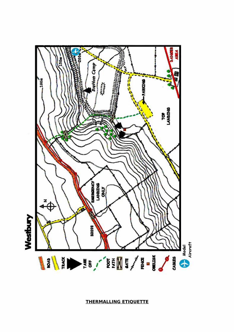
Westbury: (Please also see Bratton Camp below)
WNW-NNW; 750' asl, 300' ttb; (ST 900 518 - sheet 184).Site code 1.004
Sites Officers: Tony Moore 07775 692309, (and Nick Somerville 01749 880579 Mob 07891 921651)
Rating: Any rated pilot.
Permission: Open site.
Parking: Park in the westernmost car park. Try to leave a gap for gliders to be carried forward to take-off.
Rigging: Do not rig on any of the paths as you'll block the route to take-off. Do not rig hang-gliders on the front of the hill, stay far enough back to give paraglider pilots room to take off and land. Ensure all paths are kept clear. This is a public place and frequently used, occasionally by elderly folk walking to the view at the front, and parents with children in buggys.
Take Offs: Either side of the obelisk on the north westerly take-off. When conditions permit, paragliders should launch from well to the east of the obelisk. Never inflate a paraglider in front of a hang glider - blow back accidents have happened.
Local Flying: Make sure you can stay up before you take-off. No top to bottom flights! When flying locally do not fly south of the fence forming the southern boundary of the common area. If you do you will be violating the danger area. There are riding stables just beyond the trees at the western end of the main ridge. Stay at least 300’ ato when we are overflying this area. (See Google map) This site has great potential for flying out in front of the ridge. It is common for pilots to fly out over the cement works, over a kilometre out from the ridge and on good days triangles of 100 kms or more have been flown.
XC Flying: If you intend to fly XC make sure you have a map and know the position of the danger area. It is impossible to fly directly down wind from this site due to the danger area, you must first track west for 5 Kms. Airspace has been negotiated for XC around to the West. You can find details on http://www.avonhgpg.co.uk/sites/info_salisbury_plain.php
Tracking east, the danger area extends further north in that direction and must be avoided. There is a new (2014) agreement that means the restrictions on Keevil may be lifted on a day to day basis, allowing scoring flights to be made. The status of this can be accessed by the Telegram group.
Model Flyers: Please allow them space to fly.
Top Landing: Do not land on the side of the hill, especially on the White Horse as it is a national monument. Land anywhere on the common area behind the parked cars. Beware of members of the public, especially those flying kites. This area can be very turbulent in fresh winds, especially if the winds are northerly. In these conditions, land back in the rough grass. It is also possible to land in front of the posts on both paragliders and hang gliders. Whenever possible use this area only mid-week when the site is

not crowded with members of the public. It is also possible for experienced paraglider pilots to land on the spur to the north of the horse’s nose. Watch out for rabbit holes and carry back to take off via the public footpath which comes up from the road.
Do not land on the flat area behind the White Horse. (Turbulence)
Do not land in any of the farmer's fields on the top or side of the hill.
Bottom Landing: Bottom landings are a last resort. No deliberate top to bottom flights allowed. Be wary of livestock, especially when there are calves around. Try to land away from livestock. The field that is available for emergency landings only is the large grass field south of the road with the wire gate in the north western corner. If it is full of livestock then use another field. If you do bottom land, clear the area asap as there may be other pilots needing to land as well. De-rig by the gate at best, or at the edge of the field if you can’t. Do not walk back up the face of the hill. Go out of the gate, then along the road to the east and walk up the footpath on the spur. Do not drive your car into this field to retrieve your glider – carry it out. If you end up in another field, you will have to find your way out via the gates.
Hospitals: Frome or Bath.
Directions: Just after leaving Westbury on the B3098 to Bratton turn right up Newton Road. At the crossroads at the top of the hill, turn left and drive until the road reaches the large grass common area.
Bratton Camp. This is the slope just to the east of Westbury. NNW to NNE
Sites Officer: Tony Moore 07775 692309, (and Nick Somerville 01749 880579 Mob 07891 921651)
Rating: Any rated pilot.
Permission: Open site.
Parking: Park in the westernmost car park. Walk to the flattish take off area.
Rigging: Carry your glider over onto the hill fort and rig just in front of or to the west of the long barrow.
Take Offs: Just in front of the barrow on the northerly. Never inflate a paraglider in front of a hang glider - blow back accidents have happened.
Paragliders, be sure to be flying properly before you leave the flattish take off. Otherwise you may bang your backside hard on the earthworks. No take offs from the slope of the hill below the ditch for safety reasons, as you would not be seen by other gliders taking off
Local Flying: When flying locally do not fly south of the fence forming the southern boundary of the area. If you do you will be violating the

danger area. This site has great potential for flying out in front of the ridge. It is common for pilots to fly out over the cement works, over a kilometre out from the ridge and on good days triangles of 100 kms or more have been flown. There are riding stables just beyond the trees at the western end of the NW ridge. Stay at least 300’ ato when overflying this area. (See Google map).
XC Flying: If you intend to fly XC make sure you have a map and know the position of the danger area. It is impossible to fly directly downwind from this site due to the danger area, you must first track west for three miles. Alternatively you can track east, but this is a much more difficult track as the danger area extends further north in that direction. There is a new (2014) agreement that means the restrictions on Keevil may be lifted on a day to day basis, allowing scoring flights to be made.
Airspace has been negotiated for XC around to the West. You can find details on http://www.avonhgpg.co.uk/sites/info_salisbury_plain.php
Model Flyers: Please allow them room to fly at the east end of the Bratton site.
Top Landing: Top landings should be made to the east of the long barrow on a hang glider, but note that they can be difficult in lighter winds due to the slope. Paragliders can land anywhere on top. Be especially careful if this area contains sheep.
DO NOT LAND BEHIND THE BARROW (TURBULENCE)
Bottom Landing: The site has been cleared of trees recently and side landing is the best option for paragliders. The higher up the slope and further to the west the better. Watch out for rabbit holes and tree stumps. Walk up the spur at the western end of the slope, using the footpath that rises up the spur from the road at the bottom. The spur at the west is also now easily landable. Wehave not been given permission to land in either the cropped field or the set-aside strip at the bottom of the slope. Absolutely no landing in crop. Hang gliders need to make an early decision to fly to the emergency landing fields used for the NW take off.
Do not land in any of the farmer's fields to the east of the hill, as they may contain horses.
Hospitals: Frome or Bath.
Directions: Just after leaving Westbury on the B3098 to Bratton turn right up Newton Road. At the crossroads at the top of the hill, turn left and drive until the road reaches the large grass common area.
THERMALLING ETIQUETTE

How not to get shouted at! By Chris Jones
We've all shouted at someone, or been shouted at whilst thermalling, haven't we? This article is intended as a short guide for those new to the wonders of flying in circles. Hopefully it will help them to avoid being shouted at - there are a number of unwritten commandments that should be obeyed when thermal flying if we are all to fly happily together and here are a few of them:
Thou shalt all circle in the same direction!
Everyone knows this one, but it is surprising how often it is ignored. This is a big problem for pilots who like to turn in one direction only. All pilots should be as adept in turning to the left as to the right. Turn the same direction as the first pilot who entered the thermal. If you have to enter a thermal by turning in the wrong direction (for what ever reason), change direction as soon as you have established your climb.
Once in a thermal with other pilots, thou shalt continue to circle!
This one is aimed at those pilots that like to wander about a bit. This is fine on your own, but you've got to be aware of the other pilots in the thermal with you. Don't suddenly straighten up and slow down if you have another glider on your tail - out climb them first! This is a big problem for hang glider pilots when thermalling with paragliders. Paraglider pilots should resist the temptation to straighten up and pull on the brakes if they know that there is a hang-glider close behind then. If you don't, you'll probably get loads of verbal abuse from the hang-glider pilot, who will have to perform a violent turn to avoid you.
(Note from the alternative perspective: If it's strong, and to not straighten up into wind is going to push a paraglider pilot too far back over the hill with insufficient altitude / make him fall out of the back of the thermal, please expect him to straighten up. Ed.)
Thou shalt not fly directly at a glider in a thermal - the thermalling pilot shalt have right of way!
There is nothing worse than finding some plonker directly behind you, stopping you from 360'ing, when you've just entered a thermal. This can be especially annoying when searching for thermals in ridge lift! If you see a pilot in front of you going up in a thermal, anticipate the way they are likely to turn and angle your approach so that you can join them after they start to turn. Don't get in their way by flying straight at them. If they are not turning as you approach, be prepared to turn to get in behind (or possibly ahead of) them as soon as they start to turn. Remember to give way to the glider on your right - first turn right and then back left to get in behind them or slow down and let them through before turning in behind them. Don't get in their way.
The same thing applies when you are entering an established group of thermalling gliders. Don't dive in towards the centre - angle your path to join the outside of the circle.
Give way to pilots who are thermalling. If you don't want to join them, let them pass.
Thou shalt not follow another glider around the sky!
For some reason, the odd pilot will always follow others around the sky. It is annoying for the same reason as stated previously. If you are a follower because you think the other pilot will find lift, then just keep an eye on them and be prepared to join them if they find it - don't follow. Two gliders spread out stand a better chance of finding lift than two gliders in line astern.
This kind of thing is prevalent amongst pilots when they first start to ridge soar. It is just as annoying to have another glider close behind you on a ridge, as it is when thermalling. Give others space to fly.
Thou shalt not fly straight through thermalling gliders!
This sounds obvious, but the number of pilots who fly straight through the middle of thermals when they are ridge soaring and others are thermalling are legion. If you see pilots obviously thermalling in your path, either join them or avoid them.
The lower pilot shall have right of way!
If somebody is out thermalling you, move over by widening your turns to let them by, and then resume your circling. Don't get in their way.
Pilots not following the unwritten laws shall be castigated!
Give your vocal chords a workout if you come across a pilot flying in an unsafe manner, it's the only way they are going to find out they are behaving out of line. Be nice, be kind, be fair - most importantly fly safe. Don't make a point of having a near miss because another pilot is flying like a plonker. If you have to, change direction and circle the same way as them, even if you were in the thermal first. Store it up for a telling-off later. Write an article for Nova about it.
There shall always be shouters!
Some pilots like to shout a lot, maybe because they think they own the sky or maybe because they are nervous of flying close to others. These are rare, but you are bound to encounter them sooner or later. If you do get shouted at, check to see if you are being a plonker. If you are, stop it at once! If you are not, let the shouter go by. If you get the chance, discuss it with other pilots later. In this way you'll get to know who the shouters are. But don't discount the possibility that you may be the plonker!
There shall always be plonkers!
Yep, sad as it is, no matter how many people read this article, no matter how many pilots have things explained to them on the hill, there will always be plonkers. Learn to fly defensively - the other guy/gal will always do something stupid. Watch yourself and fly safely.

RIDGE SOARING
Questions you didn't think to ask, but wished you knew the answers to! By Chris Jones
Ridge soaring is what the majority of us in the UK spend most of our flying hours doing, yet it is surprising how little information is written down about it. This article seeks to answer some of the unasked questions.
When should I take off?
I don't want to go down when the winds are light.
The easy answer to this is, take off when other pilots are easily soaring. If you haven't got any other pilots to watch, then look for birds or other signs.
What other signs?
Let’s assume that the winds are light and you are not sure whether you will be able to stay up. Feel the glider on take-off, pick/pull it up and see if it wants to fly. If it doesn't, are you on the best lift producing bit of the hill? On some sites the take-off area produces less usable ridge lift than the main ridge, so holding your glider on take-off will tell you very little. Nevertheless, notice how it feels on good soaring days, then you'll know how to judge it when things are not so good.
In the winter the air is cold and more dense. Less wind is needed to soar in the winter than in the summer, although you'll probably not get as high. The summer brings other advantages in the form of thermals. If you've spent some time watching experienced pilots on light thermic days, you'll probably notice that often they seem to take-off just as a thermal is coming through. Now a lot of this is luck, but there are signs to watch for.
On a good thermic day with light winds the approach of a thermal can be observed in many ways:
• Movement of foliage. Watch what's happening out in front of the hill - you can often see a thermal approaching as it rattles the trees and blows the grass and crops about. • Birds. The best sign. Look for thermalling birds and for swifts chasing insects. Thermals suck up clouds of insects invisible to us, but they attract swifts like a magnet. Watch how the birds are climbing. If they are climbing well, time your take-off so that you can fly in amongst them. If the birds are just above or below the ridge be less eager, they could just be using ridge lift too weak to keep themselves up, or catching the insects ejected from a thermal into the sink! • Wind or lack of it. If the winds suddenly drop to nothing it is a good sign that there is a thermal brewing close at hand. The theory is that the thermal forms a block, sucking air into it and reducing or even reversing the background wind. As the thermal approaches, the wind will increase again slightly and you may be able to feel a slight increase in temperature. This is a good time to launch as the thermal is probably just out in front of the hill. As the thermal passes by, the winds may increase even further and it will probably feel very soarable. Don't be fooled - the wind will probably feel cool. Chances are the thermal has passed you by. The air is just rushing in to fill the gap it left behind. In the worst case you'll be launching into sink, the descending air

surrounding the thermal. Most likely you'll soar for a few beats before visiting the bottom landing. Timing here is everything, and it's not easy. • Clouds and sunshine. On a day with well spaced, nicely developed or developing cumulous clouds, time your take-off so that you can catch any thermals that may still be producing lift under a passing cloud. If the clouds are not obviously working, wait until the sun has been shining on the ground in front of the ridge for a while. It may have heated things up enough to produce a good thermal.
When should I launch if the winds are gusty?
It could be that you should not be launching at all. Variations in wind speed can cause more problems than absolute wind speeds. It is much safer to fly a hang-glider in a steady 27 mph wind, than in winds of 12 mph gusting 20 mph. If you are caught unaware, gusts may cause you to stall and dive at the ground. In gusty conditions it is important to maintain airspeed as your ground speed may be varying with the gusts. Gusts can affect you greatly on landing, when they may cause your angle of attack to alter, resulting in a climb followed by a dive at the ground. With excess airspeed you can control this. If you fly close to the stall, the dive could be a full stall dive, with no airspeed available for recovery!
As a general rule if you don't want to land in it, don't fly in it! If it is gusty, land with lots of speed on!
Gusts are usually caused by thermals and rotor. To avoid thermal gusts fly early in the morning or late in the afternoon when the thermals are weakest.
Avoiding rotor should be obvious! The NW take-off at Westbury is very rotory when the wind is off to the north, as it curls over the white-horse spur. If you can, move to a take-off where the airflow is clean and devoid of rotors! If you want to experience the full horrors of flying in rotor, try the Rifle Range in a moderate ESE - E (Wonderful as that day was, anyone who saw my full frontal 80ft off the deck at the '98 Mere Bash will testify to that! - Rich).
Sometimes the air is just plain rough and horrible. This is often the case when "wave" is at work. Check the sky for signs of wave clouds. On days when out of phase wave (i.e. the descending air) affects a site, the flying is usually horrible. Even if it is very windy, there will be little ridge lift as the rising air is smashed about by the descending air from the wave. If you are lucky the rising wave-air may be nearby.
How strong a wind should I fly in?
This depends on lots of things: the performance of your glider; the smoothness of the wind; the site; the landing area etc. If you don't think you're going to enjoy it, don't fly. Gale dangling isn't fun. Ask a knowledgeable pilot to assess the conditions for you if you are unsure. If in doubt, don't fly. As is often said - You fly, you die! and There are old pilots and bold pilots, but no old bold, pilots.
What about other pilots in the air?
The last thing you should do before you launch is look to see if there are any gliders or other craft in the way. Don't cause another pilot to take avoiding action by launching when they are close by.
If other pilots appear to be struggling, then don't launch, just wait for a better time. This is especially pertinent to paraglider pilots when hang-glider pilots are also flying.

Be aware that hang-gliders probably need a lot more height to be able to land back on top than you do - they can't just land on the side. When you see hang-gliders struggling to stay up, don't take off if you are going to be using the same bit of ridge. Wait until they are high enough to land, or have landed. What may be a fun bit of low soaring on a paraglider, may be a desperate struggle to get up on a hang-glider.
Similarly on light thermic days don't hog the ridge by flying up and down it for ages - give other pilots a chance, especially those wishing to catch a thermal and be away. Be considerate and know your limitations. Land often and give others a fair crack at it.
How far off can the winds be for me to still be able to stay up?
Again, it depends on the site. Many sites have irregular ridges; Westbury for example can be flown in anything from 270 to 360 degrees on the main NW ridge and bowl (if you're desperate!). The best way to find out if it's soarable is to ask a pilot who has flown a site many times before. Be aware that the wind may feel more on the hill than it really is. The wind tends to straighten up when it is forced up a large ridge and may give a false direction at take-off. This wind will provide little lift.
If you are flying a bowl, such as Cowards, always check the wind direction from a point outside the bowl. If the wind is off, it may be producing rotor at one side of the bowl, even though the wind direction at take-off appears smack on. This is because the bowl funnels the wind so that it appears straighter than it is.
As a rule of thumb, on a perfectly straight ridge, of good height and gradient, with winds of 10 - 15 mph, it is probably soarable if the wind is 30 degrees off. You should bear in mind that one leg of your soaring beat will be much faster than the other, as you will be flying with either a tail wind or a head wind. Take care!
In this kind of situation there is no substitute for experience: on one day it may be soarable with the wind 30 degrees off; on another it may not. Only fly if you have a safe bail-out, should you not stay up. It is not fun to go scratching a tree covered hill when the wind is off - ask anybody who has flown Ubley when the winds are from the east!