aviation weather routing tool: a decision aid for manned ... aviation weather routing tool: a...
TRANSCRIPT

2 Approved For Public Release; Distribution Unlimited
Approved For Public Release; Distribution Unlimited
Aviation Weather Routing Tool:A Decision Aid for
Manned/Unmanned Aircraft Routing
Dr. Richard ShirkeyMr. Terry JamesonBattlefield Environment DivisionArmy Research Laboratory, WSMR

Report Documentation Page Form ApprovedOMB No. 0704-0188
Public reporting burden for the collection of information is estimated to average 1 hour per response, including the time for reviewing instructions, searching existing data sources, gathering andmaintaining the data needed, and completing and reviewing the collection of information. Send comments regarding this burden estimate or any other aspect of this collection of information,including suggestions for reducing this burden, to Washington Headquarters Services, Directorate for Information Operations and Reports, 1215 Jefferson Davis Highway, Suite 1204, ArlingtonVA 22202-4302. Respondents should be aware that notwithstanding any other provision of law, no person shall be subject to a penalty for failing to comply with a collection of information if itdoes not display a currently valid OMB control number.
1. REPORT DATE 01 JUN 2008
2. REPORT TYPE N/A
3. DATES COVERED -
4. TITLE AND SUBTITLE Aviation Weather Routing Tool: A Decision Aid for Manned/UnmannedAircraft Routing
5a. CONTRACT NUMBER
5b. GRANT NUMBER
5c. PROGRAM ELEMENT NUMBER
6. AUTHOR(S) 5d. PROJECT NUMBER
5e. TASK NUMBER
5f. WORK UNIT NUMBER
7. PERFORMING ORGANIZATION NAME(S) AND ADDRESS(ES) Battlefield Environment Division Army Research Laboratory, WSMR
8. PERFORMING ORGANIZATIONREPORT NUMBER
9. SPONSORING/MONITORING AGENCY NAME(S) AND ADDRESS(ES) 10. SPONSOR/MONITOR’S ACRONYM(S)
11. SPONSOR/MONITOR’S REPORT NUMBER(S)
12. DISTRIBUTION/AVAILABILITY STATEMENT Approved for public release, distribution unlimited
13. SUPPLEMENTARY NOTES See also ADM202527. Military Operations Research Society Symposium (76th) Held in New London,Connecticut on June 10-12, 2008, The original document contains color images.
14. ABSTRACT
15. SUBJECT TERMS
16. SECURITY CLASSIFICATION OF: 17. LIMITATION OF ABSTRACT
UU
18. NUMBEROF PAGES
23
19a. NAME OFRESPONSIBLE PERSON
a. REPORT unclassified
b. ABSTRACT unclassified
c. THIS PAGE unclassified
Standard Form 298 (Rev. 8-98) Prescribed by ANSI Std Z39-18
3 Approved For Public Release; Distribution Unlimited
Approved For Public Release; Distribution Unlimited
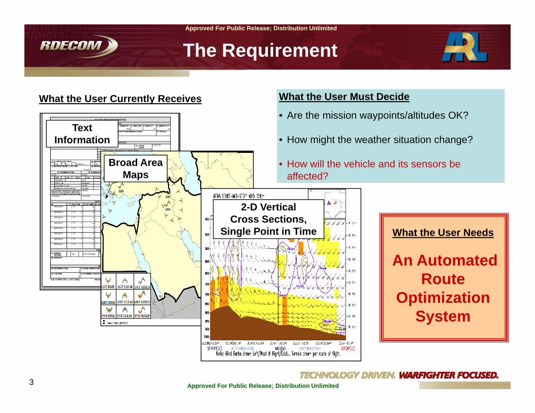
Text Information
What the User Currently Receives
Broad Area Maps
2-D Vertical Cross Sections,
Single Point in Time
What the User Must Decide
• Are the mission waypoints/altitudes OK?
• How might the weather situation change?
• How will the vehicle and its sensors be affected?
What the User Needs
An Automated Route
Optimization System
The Requirement

4 Approved For Public Release; Distribution Unlimited
Approved For Public Release; Distribution Unlimited
Theater-scale forecast model database…“Weather Data Cube”
4-D gridded fields of weather parameters
LOCAL SENSORSSurface Data SensorsUpper-Air SensorsAircraft MET Sensors
GENERAL SUPPORT CONCEPT
Weather Decision Aid Products for manual and
automated applications.
Nesting Nowcast 0-3hr Database.Automated refresh of forecast 4-D cube for pre-mission & enroute updates.

5 Approved For Public Release; Distribution Unlimited
Approved For Public Release; Distribution Unlimited
5
New 4-D Weather Forecast Grid
4-D Weather Impacts Grid
Aircraft-SpecificWeather Impacts Threshold Rules
(from Tri-Service Integrated Weather
Effects Decision Aid (T-IWEDA) database)
+ =
+Initial/Current
Flight Path
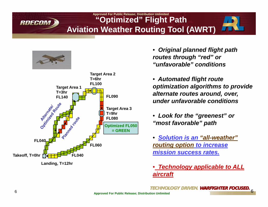
“Optimized” Flight PathAviation Weather Routing Tool (AWRT)
New Flt Path Options;Avoiding Enrte Hazards =
Altered Flt Path (if needed)
PATH OPTIMIZATION
6 Approved For Public Release; Distribution Unlimited
Approved For Public Release; Distribution Unlimited
6
“Optimized” Flight PathAviation Weather Routing Tool (AWRT)
• Original planned flight path routes through “red” or “unfavorable” conditions
• Automated flight route optimization algorithms to provide alternate routes around, over, under unfavorable conditions
• Look for the “greenest” or “most favorable” path
• Solution is an “all-weather” routing option to increase mission success rates.
• Technology applicable to ALL aircraft
Takeoff, T=0hr
FL040
Target Area 1T=3hrFL140
Target Area 2T=6hrFL100
Target Area 3T=9hrFL080
FL090
FL060
FL040
Landing, T=12hr
Optimized FL050= GREEN

7 Approved For Public Release; Distribution Unlimited
Approved For Public Release; Distribution Unlimited
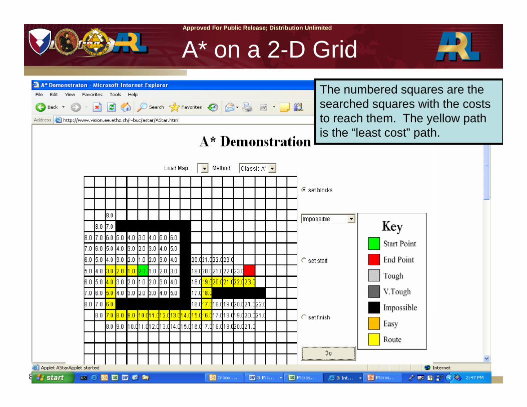
AWRT Development: Adapting the A* Routing Algorithm
• Computes the “Lowest Cost” path between points.
• Cost function can represent fuel consumption, hazard to the aircraft, mission constraints, etc.
• Searches out from a starting point, storing partial paths after each step.
• The partial paths are stored in a prioritized list.
• A Cost Function then determines the “Lowest Cost” of the paths in the priority list.
• A* is guaranteed to find a lowest cost path and is usually computationally cheaper than an exhaustive (or breadth first) search.
8 Approved For Public Release; Distribution Unlimited
Approved For Public Release; Distribution Unlimited
A* on a 2-D GridThe numbered squares are the searched squares with the costs to reach them. The yellow path is the “least cost” path.
9 Approved For Public Release; Distribution Unlimited
Approved For Public Release; Distribution Unlimited
9
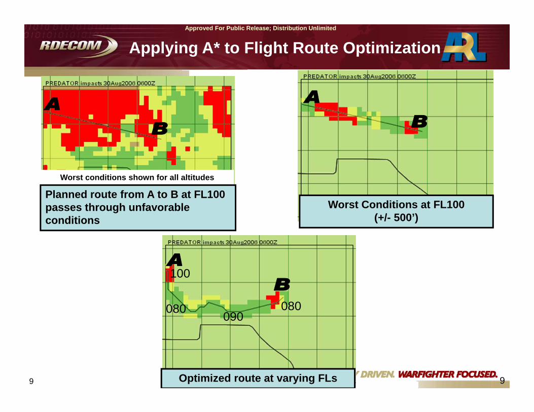
Applying A* to Flight Route Optimization
Worst Conditions at FL100 (+/- 500’)
Worst conditions shown for all altitudes
Planned route from A to B at FL100 passes through unfavorableconditions
Optimized route at varying FLs
100
080 090080

10 Approved For Public Release; Distribution Unlimited
Approved For Public Release; Distribution Unlimited
Optimized Vertical Slice
11 Approved For Public Release; Distribution Unlimited
Approved For Public Release; Distribution Unlimited
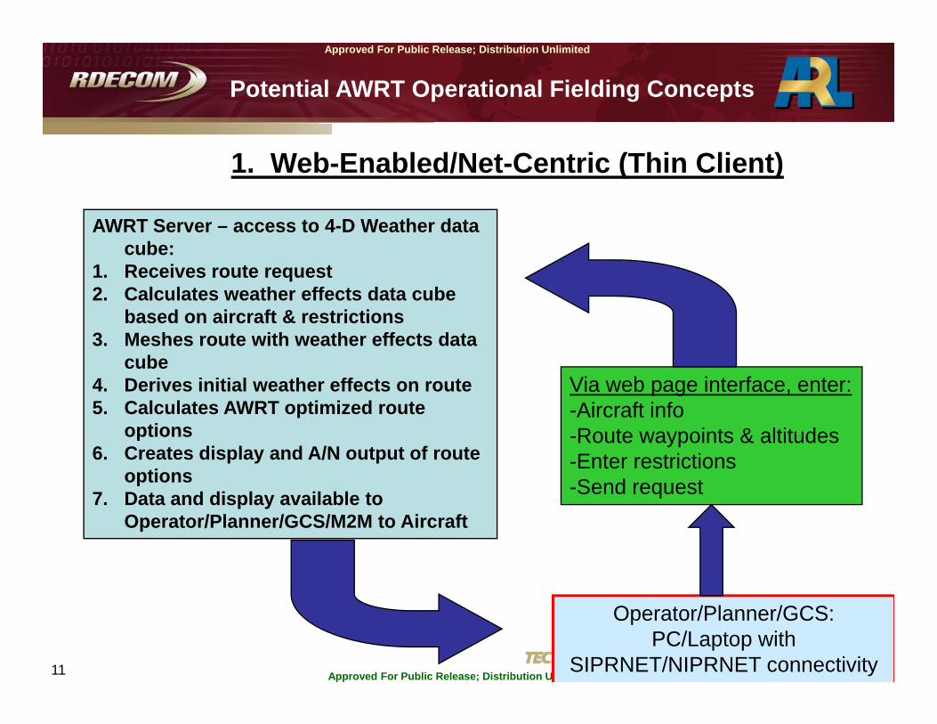
Potential AWRT Operational Fielding Concepts
1. Web-Enabled/Net-Centric (Thin Client)
Operator/Planner/GCS: PC/Laptop with
SIPRNET/NIPRNET connectivity
Via web page interface, enter:-Aircraft info-Route waypoints & altitudes-Enter restrictions-Send request
AWRT Server – access to 4-D Weather data cube:
1. Receives route request2. Calculates weather effects data cube
based on aircraft & restrictions3. Meshes route with weather effects data
cube4. Derives initial weather effects on route5. Calculates AWRT optimized route
options6. Creates display and A/N output of route
options7. Data and display available to
Operator/Planner/GCS/M2M to Aircraft

12 Approved For Public Release; Distribution Unlimited
Approved For Public Release; Distribution Unlimited
2. Autonomous (Local) Capability (Thick Client)
Operator/Planner/JMPS/GCS/??: Server/PC/Laptop hosts
1. Comm. connectivity to ingest 4-D Weather Grids
2. Weather Effects Grid Creator3. AWRT Route Optimization
capability4. A/N & graphics output of route
options
• Calculates weather effects data cube based on aircraft & restrictions• Meshes route with weather effects data cube• Derives initial weather effects on route• Calculates AWRT optimized route options• Creates local display and A/N output of route options/M2M to Aircraft
4-D Weather Forecast Data Cube:DCGS-A WeatherRegional/Theater Forecast CenterAF Weather Agency
Potential AWRT Operational Fielding Concepts
13 Approved For Public Release; Distribution Unlimited
Approved For Public Release; Distribution Unlimited
AWRT DEMO

14 Approved For Public Release; Distribution Unlimited
Approved For Public Release; Distribution Unlimited
Select Asset(s) from List:
Available Forecast Times (all selected)
Available Asset List
User Selected Asset List(ScanEagle UAS)

15 Approved For Public Release; Distribution Unlimited
Approved For Public Release; Distribution Unlimited
Compute Weather Effects Matrix:
ScanEagle color coded WEM over forecast times(red=unfavorable, amber=marginal impacts)
Geospatial Area of Interest (AOI):
Compute Weather Effects Matrix (WEM) button
16 Approved For Public Release; Distribution Unlimited
Approved For Public Release; Distribution Unlimited
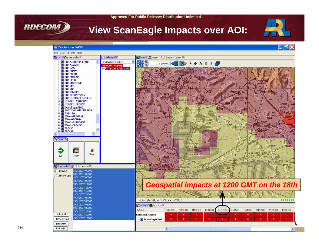
View ScanEagle Impacts over AOI:
Geospatial impacts at 1200 GMT on the 18th
17 Approved For Public Release; Distribution Unlimited
Approved For Public Release; Distribution Unlimited
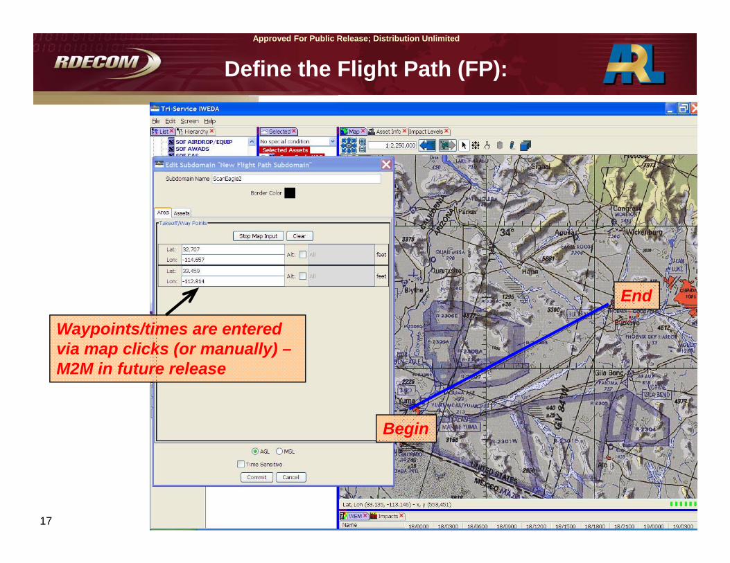
Define the Flight Path (FP):
Begin
End
Waypoints/times are entered via map clicks (or manually) –M2M in future release

18 Approved For Public Release; Distribution Unlimited
Approved For Public Release; Distribution Unlimited
Compute & View Impacts over FP:
Numerous adverse impacts along FP:
Impacts include turbulence & high winds aloft

19 Approved For Public Release; Distribution Unlimited
Approved For Public Release; Distribution Unlimited
Flight Slice along Path:
Flight slice shows impacts at manylevels – need to run the Route Optimizer!
20 Approved For Public Release; Distribution Unlimited
Approved For Public Release; Distribution Unlimited
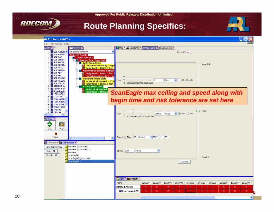
Route Planning Specifics:
ScanEagle max ceiling and speed along with begin time and risk tolerance are set here

21 Approved For Public Release; Distribution Unlimited
Approved For Public Release; Distribution Unlimited
Optimized FP Results:
Optimized route avoids all adverse weather!
Optimized flight path waypoints & times are viewable:
22 Approved For Public Release; Distribution Unlimited
Approved For Public Release; Distribution Unlimited
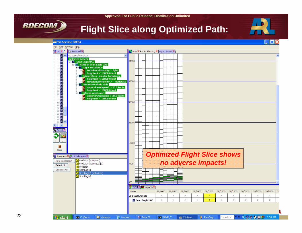
Flight Slice along Optimized Path:
Optimized Flight Slice showsno adverse impacts!
23 Approved For Public Release; Distribution Unlimited
Approved For Public Release; Distribution Unlimited
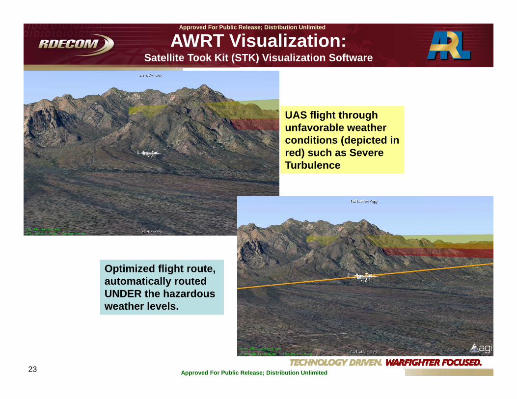
UAS flight through unfavorable weather conditions (depicted in red) such as Severe Turbulence
Optimized flight route, automatically routed UNDER the hazardous weather levels.
AWRT Visualization:Satellite Took Kit (STK) Visualization Software

24 Approved For Public Release; Distribution Unlimited
Approved For Public Release; Distribution Unlimited
CAPABILITIES: Current and Future
CURRENT:
• PC-based & IMETS/DCGS-A Hosted• Hard-wired to T-IWEDA• Map GUI = Open Map• User input of route and flight levels• Routing rules (cost functions) include:
• Weather hazards• Air speed• Head wind component• Forecast periods corresponding to flight times
FUTURE:
• Browser version• Platform independent• JAAWIN-hosted (Experimental use)• No-fly zones/restricted airspace considered in routing calculations• Multiple route options (associated with varied risk levels) displayed or toggled• Multiple missions displayed at once or toggled• Automated weather data/flight plan ingest• Machine-to-Machine capabilities• Live enroute updates as often as weather data cube updates• Visualizations: Satellite Tool Kit (STK), FalconView, Google Earth, others?
• USER INPUT FOR OTHER IDEAS???