author's personal copy - archeologický ústav · author's personal copy ... oped...
TRANSCRIPT
This article appeared in a journal published by Elsevier. The attachedcopy is furnished to the author for internal non-commercial researchand education use, including for instruction at the authors institution
and sharing with colleagues.
Other uses, including reproduction and distribution, or selling orlicensing copies, or posting to personal, institutional or third party
websites are prohibited.
In most cases authors are permitted to post their version of thearticle (e.g. in Word or Tex form) to their personal website orinstitutional repository. Authors requiring further information
regarding Elsevier’s archiving and manuscript policies areencouraged to visit:
http://www.elsevier.com/copyright
Author's personal copy
Cropmarks in main field crops enable the identification of a widespectrum of buried features on archaeological sites in Central Europe
Martin Gojda a,b, Michal Hejcman c,d,*
aDepartment of Archaeology, University of West Bohemia, Sedlá�ckova 15, 306 14 Plze�n, Czech Republicb Institute of Archaeology, Czech Academy of Sciences, Letenská 4, 118 01 Prague 1, Czech RepubliccDepartment of Ecology, Faculty of Environmental Sciences, Czech University of Life Sciences, Kamýcká 129, CZ-165 21 Prague 6, Suchdol, Czech Republicd Institute of Prehistory and Early History, Faculty of Arts, Charles University, Nám�estí Jana Palacha 2, CZ-116 38 Prague 1, Czech Republic
a r t i c l e i n f o
Article history:Received 5 March 2011Received in revised form17 January 2012Accepted 19 January 2012
Keywords:Aerial prospectionBarley and wheatCropmarksPlant nutritionRapeRemote sensing
a b s t r a c t
Buried (syn. sunken, sub-surface and sub-soil) archaeological features on arable land can frequently bediscovered due to visually detectable changes in crop growth termed cropmarks. The aim of this paperwas to demonstrate the range of features identified through cropmarks on aerial photographs in standsof main field crops in the Czech Republic.
Low-altitude oblique aerial photographs of cropmarks were collected from an aircraft from a height of300e500 m above ground during approximately 800 flight hours from 1992 to 2010. Some featuresdiscovered via cropmarks were excavated by standard archaeological methods.
Around one thousand cropmarked sites were discovered. The highest density of archaeological siteswas on sandy soils in dry lowland regions, and a substantially lower number on loess or clay soils or inregions above 350 m a.s.l. Cropmarks were best developed in barley (Hordeum vulgare), followed bywheat (Triticum aestivum), winter rape (Brassica napus) and lucerne (Medicago sativa). The most commonarchaeological sites discovered via positive cropmarks were ancient funeral and settlement areas, withmany related features such as waste pits, sunken dwellings, post holes, ditches and graves. Abandonedroads were the most commonly negatively cropmarked features. Positive cropmarks represented 98%and negative only 2% of all recorded cropmarks.
Archaeological features present beneath the modern arable horizon can irreversibly change sub-soilproperties and growth of crops. Arable fields in Czech lowlands represent a unique archive of buriedarchaeological features, recording human activities in the landscape over the last 7500 years.
� 2012 Elsevier Ltd. All rights reserved.
1. Introduction
In the agricultural landscape of many countries, archaeologicalfeatures are most frequently buried under a modern arable layerand can be identified through different sub-soil chemical andphysical properties. Chemical analysis of the modern arable layercannot be used for their identification as decades of deep ploughinghas levelled the small scale variability in arable layer propertiesinduced by ancient human activities. Plants are able to take upscarce water and nutrients from sub-soil layers, therefore buried(syn. sunken, sub-surface and sub-soil) archaeological features canfrequently be discovered due to visually detectable changes in crop
growth, termed cropmarks, which are well detectable on aerialphotographs (Evans and Jones, 1977; Stanjek and Fassbinder, 1995;Bewley and Raczkowski, 2002; Gojda, 2006; Trier et al., 2009;Cowley et al., 2010).
Field crops can distinctly indicate sub-soil archaeologicalfeatures, because their rooting depth frequently exceeds thethickness of the arable layer. In winter wheat (Triticum aestivum L.)for example, the majority of their roots are located in the arablelayer up to the upper 30 cm, but their maximal rooting depth canexceed 2 m (Canadell et al., 1996; Kirkegaard and Lilley, 2007).Penetration of roots into deep sub-soil layers is highly affected bysoil porosity (White and Kirkegaard, 2010), by the mechanicalresistance of soil to root penetration (Kirkegaard et al., 2007) and bywater and nutrient availability at particular soil depths (Haberleet al., 2006).
Positive cropmarks with extraordinary high biomass productionof crops can be recorded above buriedwaste pits, sunken dwellings,graves and ditches filled by nutrient rich sediments with high
* Corresponding author. Department of Ecology, Faculty of EnvironmentalSciences, Czech University of Life Sciences, Kamýcká 129, CZ-165 21 Prague 6,Suchdol, Czech Republic.
E-mail address: [email protected] (M. Hejcman).
Contents lists available at SciVerse ScienceDirect
Journal of Archaeological Science
journal homepage: http : / /www.elsevier .com/locate/ jas
0305-4403/$ e see front matter � 2012 Elsevier Ltd. All rights reserved.doi:10.1016/j.jas.2012.01.023
Journal of Archaeological Science 39 (2012) 1655e1664
Author's personal copy
porosity and lowmechanical resistance, enabling plants to producedeep roots and improving their water and nutrients supply(Hejcman and Smr�z, 2010). In addition to the increase in biomassproduction, positive cropmarks can be identified according todelays in crop ripening, higher concentrations of growth limitingnutrients in the plant biomass (nitrogen (N), phosphorus (P),potassium (K), calcium (Ca) and magnesium (Mg) in particular) andtherefore resulting in different colours of stands, an increase inplant height, crop density, more frequent lodging and differentshapes and size of crop plants growing above buried archaeologicalfeatures compared to plants growing in control areas with undis-turbed sub-soil (Majer, 1996; Hejcman et al., 2011). Negativecropmarks with markedly reduced crop growth and early cropripening can be recorded above ancient roads with highly com-pacted sub-soil layers, and above wall foundations that negativeaffecting the water and nutrient supply of the crop (Doneus, 2001;Hanson and Oltean, 2003; Lasaponara and Masini, 2007).
The contrast between cropmarks and control surrounding standsare most pronounced in cereals (Evans and Jones, 1977; Gallo et al.,2009), but can also occur in stands of lucerne (Medicago sativa L.),maize (Zea mays L.), pea (Pisum sativum L.), sun-flower (Helianthusannuus L.), winter rape (Brassica napus L.) and sometimes in standsof root crops (Gojda, 2005; Hejcman and Smr�z, 2010). In addition tothe different effect of crop species, cropmark formation is to someextent dependent on geological substratum, soil quality, depth ofthe buried features beneath the arable layer as well as on weatherconditions. Thebest developed cropmarks are generally recordedonshallow sandy soils with low nutrient availability and during dryyears (Evans and Jones, 1977; Challis et al., 2009).
Although cropmarks and their use for the detection of archae-ological features by means of archaeological remote sensing (ARS)have been used in the UK since the 1920s (Crawford, 1924), it wasnot until the fall of the Iron Curtain in 1989 that their use began toevoke more widespread interest across the whole of Europe (Ha�sekand Kovárník, 1999). Therefore little is known about the densityand spectrum of archaeological features detected via cropmarks inthe post-communist countries of Central Europe. The aim of thispaper was therefore to demonstrate: (1) the range and density ofburied archaeological features that were identified via cropmarks,and (2) to demonstrate the value of different field crops for ARS inBohemia, in the western part of the Czech Republic, where ARSstarted in 1992.
2. Materials and methods
2.1. Study area
Bohemia belongs to just a few European regions in which ARS(most extensively by means of low altitude aerial reconnaissance)has been extensively and continuously applied for a long period. Inthis study we examine the results obtained by the Institute ofArchaeology of the Czech Academy of Sciences between the years1992 and 2010. Since its inception in 1992, the survey hasconcentrated on lowland areas of broad valleys of the middle andlower streams of major Bohemian watercourses with well devel-oped Pleistocene terraces: the Moldau (Vltava in Czech), Elbe(Labe), Eger (Oh�re) and Isara (Jizera) rivers and their tributaries, theCidlina and Mrlina rivers, including local valley streams (see Fig. 1,polygon 1). Due to favourable environmental conditions, this area isknown as the most fertile part of Bohemia and has always formedthe core of Czech territory that has been continuously occupied byprehistoric, medieval and post-medieval populations (Gojda,2004). This area is characterised by low mean annual precipita-tion (450e550 mm) and high mean annual temperature (8e9 �C),in the context of Central Europe.
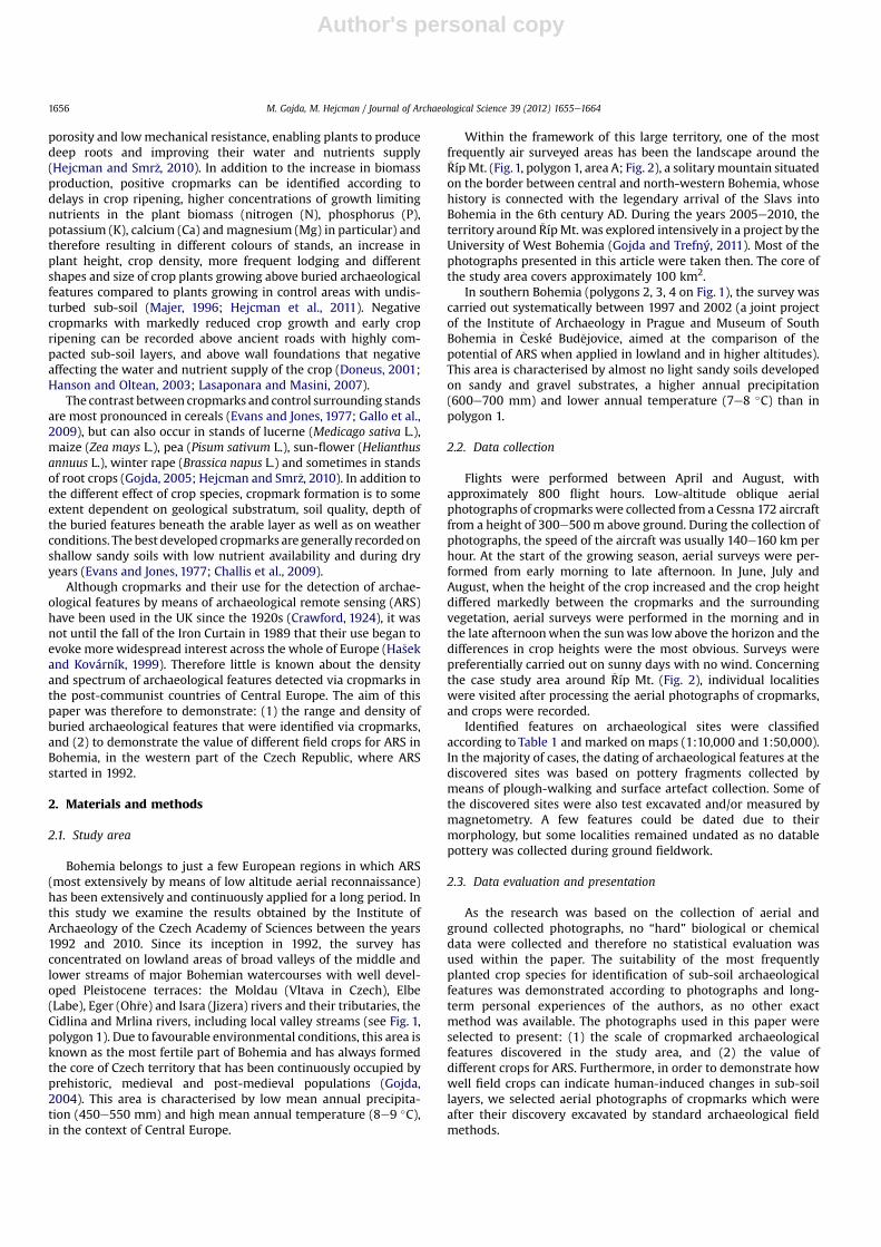
Within the framework of this large territory, one of the mostfrequently air surveyed areas has been the landscape around the�RípMt. (Fig.1, polygon 1, area A; Fig. 2), a solitarymountain situatedon the border between central and north-western Bohemia, whosehistory is connected with the legendary arrival of the Slavs intoBohemia in the 6th century AD. During the years 2005e2010, theterritory around �RípMt. was explored intensively in a project by theUniversity of West Bohemia (Gojda and Trefný, 2011). Most of thephotographs presented in this article were taken then. The core ofthe study area covers approximately 100 km2.
In southern Bohemia (polygons 2, 3, 4 on Fig. 1), the survey wascarried out systematically between 1997 and 2002 (a joint projectof the Institute of Archaeology in Prague and Museum of SouthBohemia in �Ceské Bud�ejovice, aimed at the comparison of thepotential of ARS when applied in lowland and in higher altitudes).This area is characterised by almost no light sandy soils developedon sandy and gravel substrates, a higher annual precipitation(600e700 mm) and lower annual temperature (7e8 �C) than inpolygon 1.
2.2. Data collection
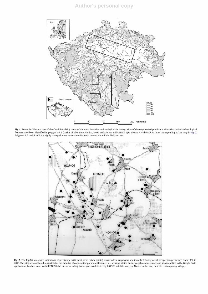
Flights were performed between April and August, withapproximately 800 flight hours. Low-altitude oblique aerialphotographs of cropmarks were collected from a Cessna 172 aircraftfrom a height of 300e500m above ground. During the collection ofphotographs, the speed of the aircraft was usually 140e160 km perhour. At the start of the growing season, aerial surveys were per-formed from early morning to late afternoon. In June, July andAugust, when the height of the crop increased and the crop heightdiffered markedly between the cropmarks and the surroundingvegetation, aerial surveys were performed in the morning and inthe late afternoonwhen the sunwas low above the horizon and thedifferences in crop heights were the most obvious. Surveys werepreferentially carried out on sunny days with no wind. Concerningthe case study area around �Ríp Mt. (Fig. 2), individual localitieswere visited after processing the aerial photographs of cropmarks,and crops were recorded.
Identified features on archaeological sites were classifiedaccording to Table 1 and marked on maps (1:10,000 and 1:50,000).In the majority of cases, the dating of archaeological features at thediscovered sites was based on pottery fragments collected bymeans of plough-walking and surface artefact collection. Some ofthe discovered sites were also test excavated and/or measured bymagnetometry. A few features could be dated due to theirmorphology, but some localities remained undated as no datablepottery was collected during ground fieldwork.
2.3. Data evaluation and presentation
As the research was based on the collection of aerial andground collected photographs, no “hard” biological or chemicaldata were collected and therefore no statistical evaluation wasused within the paper. The suitability of the most frequentlyplanted crop species for identification of sub-soil archaeologicalfeatures was demonstrated according to photographs and long-term personal experiences of the authors, as no other exactmethod was available. The photographs used in this paper wereselected to present: (1) the scale of cropmarked archaeologicalfeatures discovered in the study area, and (2) the value ofdifferent crops for ARS. Furthermore, in order to demonstrate howwell field crops can indicate human-induced changes in sub-soillayers, we selected aerial photographs of cropmarks which wereafter their discovery excavated by standard archaeological fieldmethods.
M. Gojda, M. Hejcman / Journal of Archaeological Science 39 (2012) 1655e16641656
Author's personal copy
Fig. 1. Bohemia (Western part of the Czech Republic): areas of the most intensive archaeological air survey. Most of the cropmarked prehistoric sites with buried archaeologicalfeatures have been identified in polygon No. 1 (basins of Elbe, Isara, Cidlina, lower Moldau and mid-central Eger rivers). A e the �Ríp Mt. area corresponding to the map in Fig. 2.Polygons 2, 3 and 4 indicate highly surveyed areas in southern Bohemia around the middle Moldau river.
Fig. 2. The �Ríp Mt. area with indications of prehistoric settlement areas (black points) visualised via cropmarks and identified during aerial prospection performed from 1992 to2010. The sites are numbered separately for the cadastre of each contemporary settlements; x e areas identified during aerial reconnaissance and also identified in the Google Earthapplication; hatched areas with IKONOS label: areas including linear systems detected by IKONOS satellite imagery. Names in the map indicate contemporary villages.
Author's personal copy
3. Results
3.1. Summary of main results
Since the beginning of the aerial prospection in 1992 up until2010, aerial survey campaigns over selected parts of Bohemiarevealed around one thousand of cropmarked archaeological sites.The highest density of archaeological sites (approximately onesite per 3 km2) was recorded on sandy soils in dry lowlandregions, and a substantially lower density was recorded on loessor clay soils or in regions with altitudes above 350 m a.s.l.(approximately one site per 7 km2). Approximately 90% of allcropmarked localities have been identified in the northern half ofBohemia (polygon 1 on Fig. 1) and the remaining 10% in southernBohemia (polygons 2, 3, 4 on Fig. 1). A high density of cropmarkedarchaeological sites with many features was discovered, especiallyin the Mt. �Ríp area (one site per 2.5 km2, Fig. 2). Ninety-eightpercent of discovered archaeological features were indicated bypositive cropmarks, and only two percent were indicated bynegative cropmarks.
3.2. Archaeological sites and features indicated by positivecropmarks
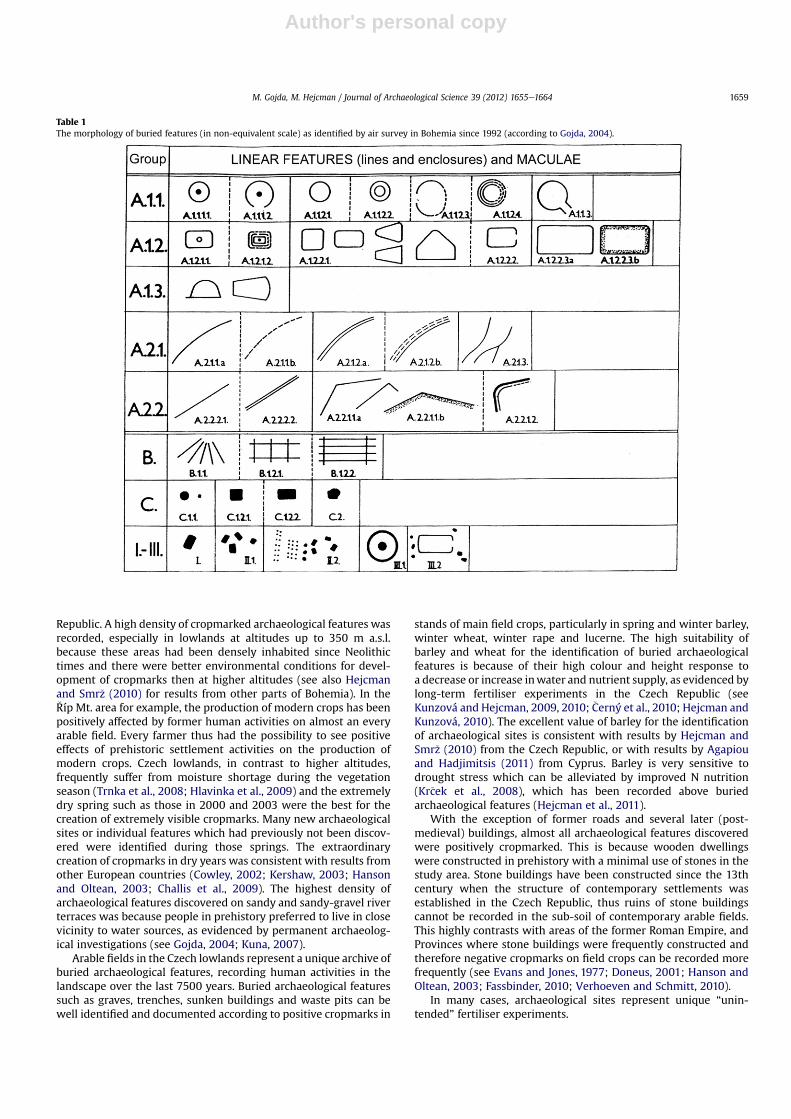
The most common archaeological sites discovered via positivecropmarkswere ancient settlementareas fromNeolithic (5500e3500BC) up to early Middle Ages (600e1200 AD, Fig. 3) withmany relatedindividual archaeological features, such as settlement or waste pits,sunken dwellings or post holes. The number of small archaeologicalfeatures in individual settlement areas ranged from several up tohundreds in the case of large settlements.
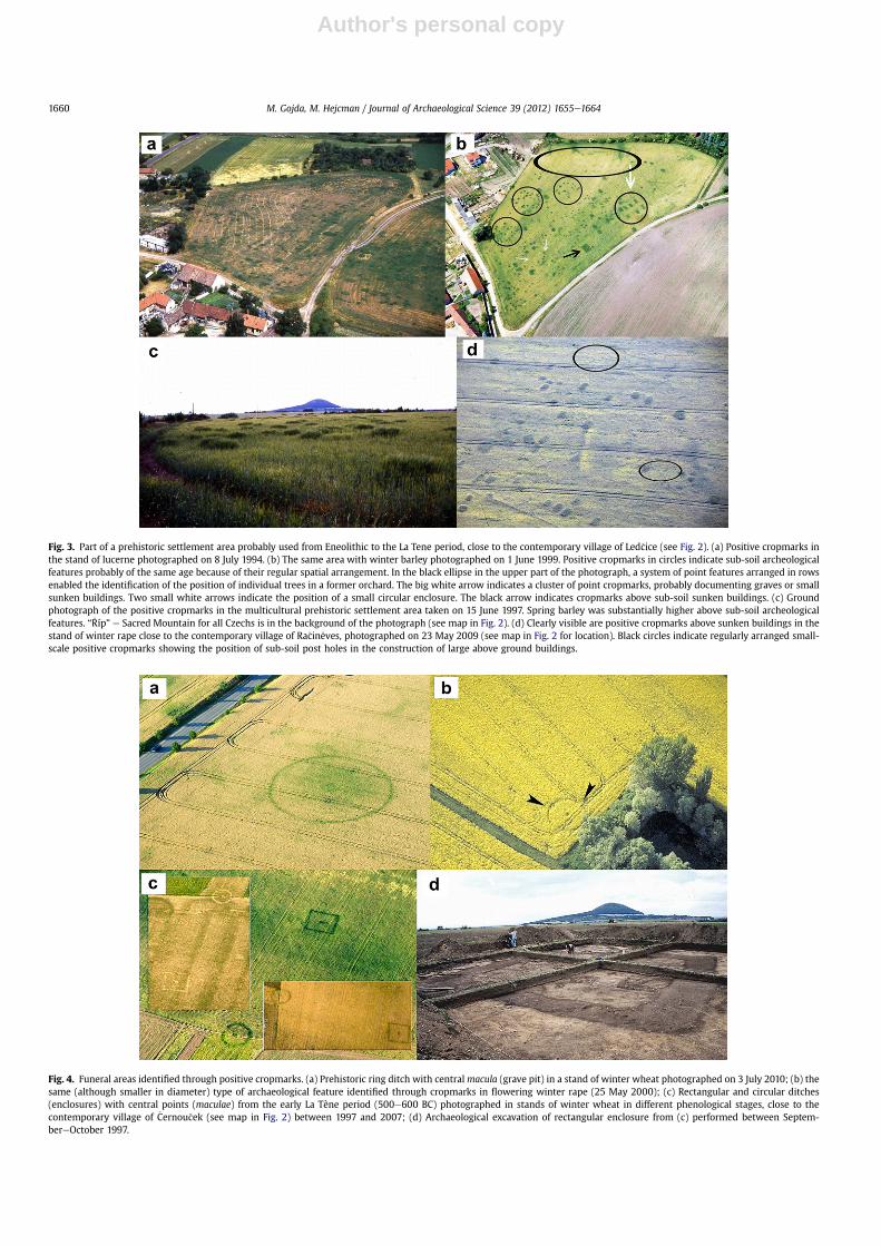
Funerary areas with burials enclosed by circular ditches filled byhumus rich sediment, which are dated to the period between lateEneolithic (2800e2200 BC) through to the end of the early Iron Age(600e500 BC) were the second most common category of archae-ological localities indicated by positive cropmarks (Figs. 4, 5, 7c,dand 8). Rectangular ditches had been most frequently used in thetransition period between the early and late Iron Ages. The thirdgroup of discovered archaeological features represented defensiveor ritual enclosures protecting settlements or ritual areas (Figs. 6and 7a,b).
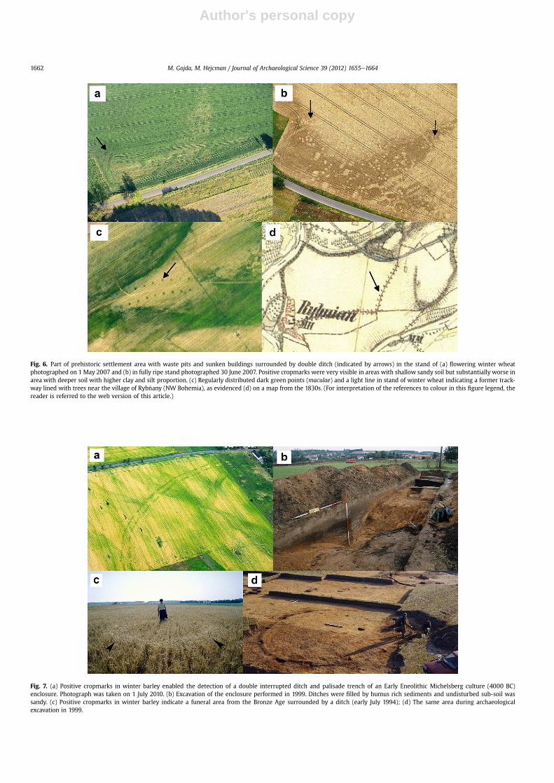
The effect of soil substratum on the creation of cropmarks isvisible in Fig. 6a and b. Double ditches, sunken dwellings andsettlement pits were clearly indicated by well developed posi-tive cropmarks in the stand of winter wheat in a moderatelyelevated area with a higher proportion of sand in the soil andlower depth of humus horizon because of erosion, than in thelower elevated neighbourhood with soil accumulation andtherefore deeper humus layer with higher proportion of clay. Inlower elevated area, there were no, or only negligible, cropmarksabove archaeological features covered by a deep humus richlayer.
3.3. Archaeological sites and features indicated by negativecropmarks
Abandoned roads were the most commonly negatively crop-marked archaeological features recorded in the study area. In a fewcases, the position of individual trees around ancient roads wereidentified, such as in the case of a site documented by an obliqueaerial photograph in Fig. 6c. Positions of former trees were indi-cated by positive point cropmarks in winter wheat stand, andverified according to historical military maps from the 1830s(Fig. 6d). Negative cropmarks indicating stone walls or funda-mentals of buildings were discovered only rarely.
3.4. Effect of crop species on the development of cropmarks
Cropmarks were the best developed in the stands of cereals, inparticular in winter or summer barley (Hordeum vulgare L.). Thehigh suitability of winter barley for the identification of archaeo-logical features is obvious from Fig. 3b. Delay in ripening of barleyabove buried archaeological features was well detectable accordingto the dark green colour of the crop on aerial photographs. Vari-ability in colours of barley thus enabled precise mapping of theprehistoric settlement area. In the same area, many archaeologicalfeatures were recorded as well as in the stand of lucerne in differentyears (Fig. 3a), but the resolution of cropmarkswas not as good as inthe case of barley. Cropmarks in lucerne stands were the bestdeveloped during the dry summer months when other crops wereharvested.
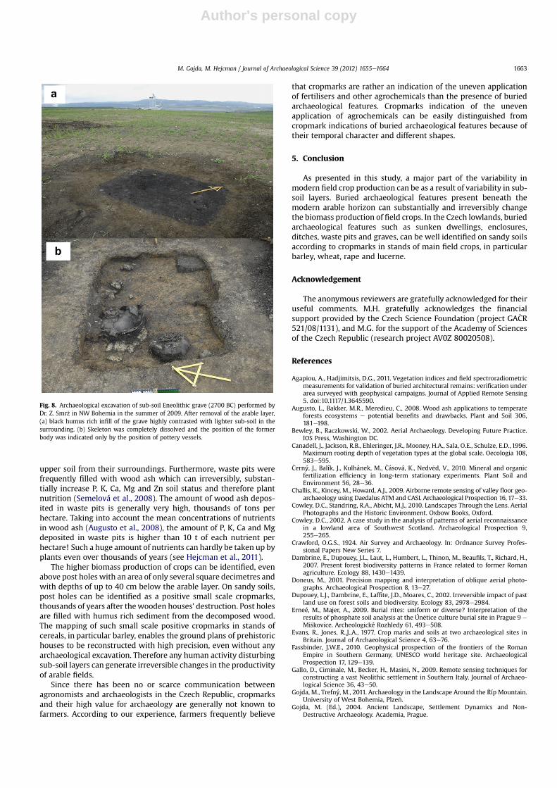
Positive cropmarks in stands of winter barley enabled theidentification and precise mapping of a unique Eneolithic enclosureon the sandy terrace of the Elbe River. In this enclosure, the darkgreen colour of barley above ancient ditches filled with humus richsoil (see Fig. 7b) well contrasted with the yellow barley in theirneighbourhood. Similarly the green colour of barley enabled theidentification of a palisade trench parallel to the ditches on theinner side of the enclosure.
In addition to colour changes, barley responded to the presenceof sub-soil archaeological features by conspicuous changes in cropheight. For example, spring barley was from 10 to 20 cm higherabove buried archaeological features in ancient residential areasthan in the neighbourhood with undisturbed sub-soil horizons (seeFig. 3c). Higher spike density and spike size of winter barley(Fig. 7c) above a shallow trench filled with humus rich soil (Fig. 7d)enabled the identification and mapping of middle Bronze Age toearly Iron Age (1500e500 BC) funerary areas.
Winter wheat was the second most suitable crop for the iden-tification of buried archaeological features in the study area.Cropmarks in stands of winter wheat enabled the identification ofsmall scale as well as large-scale archaeological features (seeFigs. 4a,c, 5a, 6a,b and c), although cropmarks were not asconspicuous as in the case of winter barley.
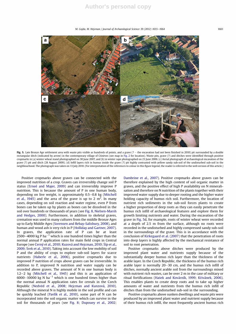
Cropmarks inwinter rape were well developed, especially in thedevelopmental stage of flowering. The most conspicuous was thelogging and delay of rape flowering above buried archaeologicalfeatures which improved plant nutrition (Fig. 4b). In other casesafter flowering, buried features such as waste pits, graves or ditcheswere well indicated by the higher standing biomass of rape than inthe neighbourhood (Fig. 5b), or by the dark green colour of thestands (Fig. 3d).
3.5. Effect of ancient human activities on content of sub-soil organicmatter
As evidenced by the dark colour of sediments in buried featuresin comparison with the control undisturbed sub-soil layers (seearchaeological excavations in Figs. 4d, 5d, 7b,d, 8a and b), manyancient human activities increased the content of soil organicmatter in the sub-soil, and this increase was irreversible.
4. Discussion
Although modern agronomy and ARS seem to be absolutelyunrelated scientific disciplines, they are highly connected throughthe investigation of human-induced variability in field cropsproduction termed cropmarks. This variability, very visible onoblique aerial photographs, enabled the discovery and documen-tation of thousands of archaeological features buried under themodern arable layer in the agricultural landscape of the Czech
M. Gojda, M. Hejcman / Journal of Archaeological Science 39 (2012) 1655e16641658
Author's personal copy
Republic. A high density of cropmarked archaeological features wasrecorded, especially in lowlands at altitudes up to 350 m a.s.l.because these areas had been densely inhabited since Neolithictimes and there were better environmental conditions for devel-opment of cropmarks then at higher altitudes (see also Hejcmanand Smr�z (2010) for results from other parts of Bohemia). In the�Ríp Mt. area for example, the production of modern crops has beenpositively affected by former human activities on almost an everyarable field. Every farmer thus had the possibility to see positiveeffects of prehistoric settlement activities on the production ofmodern crops. Czech lowlands, in contrast to higher altitudes,frequently suffer from moisture shortage during the vegetationseason (Trnka et al., 2008; Hlavinka et al., 2009) and the extremelydry spring such as those in 2000 and 2003 were the best for thecreation of extremely visible cropmarks. Many new archaeologicalsites or individual features which had previously not been discov-ered were identified during those springs. The extraordinarycreation of cropmarks in dry years was consistent with results fromother European countries (Cowley, 2002; Kershaw, 2003; Hansonand Oltean, 2003; Challis et al., 2009). The highest density ofarchaeological features discovered on sandy and sandy-gravel riverterraces was because people in prehistory preferred to live in closevicinity to water sources, as evidenced by permanent archaeolog-ical investigations (see Gojda, 2004; Kuna, 2007).
Arable fields in the Czech lowlands represent a unique archive ofburied archaeological features, recording human activities in thelandscape over the last 7500 years. Buried archaeological featuressuch as graves, trenches, sunken buildings and waste pits can bewell identified and documented according to positive cropmarks in
stands of main field crops, particularly in spring and winter barley,winter wheat, winter rape and lucerne. The high suitability ofbarley and wheat for the identification of buried archaeologicalfeatures is because of their high colour and height response toa decrease or increase inwater and nutrient supply, as evidenced bylong-term fertiliser experiments in the Czech Republic (seeKunzová and Hejcman, 2009, 2010; �Cerný et al., 2010; Hejcman andKunzová, 2010). The excellent value of barley for the identificationof archaeological sites is consistent with results by Hejcman andSmr�z (2010) from the Czech Republic, or with results by Agapiouand Hadjimitsis (2011) from Cyprus. Barley is very sensitive todrought stress which can be alleviated by improved N nutrition(Kr�cek et al., 2008), which has been recorded above buriedarchaeological features (Hejcman et al., 2011).
With the exception of former roads and several later (post-medieval) buildings, almost all archaeological features discoveredwere positively cropmarked. This is because wooden dwellingswere constructed in prehistory with a minimal use of stones in thestudy area. Stone buildings have been constructed since the 13thcentury when the structure of contemporary settlements wasestablished in the Czech Republic, thus ruins of stone buildingscannot be recorded in the sub-soil of contemporary arable fields.This highly contrasts with areas of the former Roman Empire, andProvinces where stone buildings were frequently constructed andtherefore negative cropmarks on field crops can be recorded morefrequently (see Evans and Jones, 1977; Doneus, 2001; Hanson andOltean, 2003; Fassbinder, 2010; Verhoeven and Schmitt, 2010).
In many cases, archaeological sites represent unique “unin-tended” fertiliser experiments.
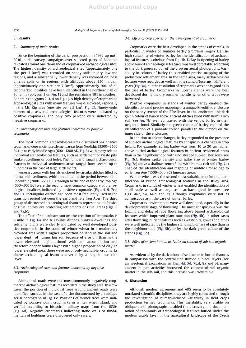
Table 1The morphology of buried features (in non-equivalent scale) as identified by air survey in Bohemia since 1992 (according to Gojda, 2004).
M. Gojda, M. Hejcman / Journal of Archaeological Science 39 (2012) 1655e1664 1659
Author's personal copy
Fig. 4. Funeral areas identified through positive cropmarks. (a) Prehistoric ring ditch with centralmacula (grave pit) in a stand of winter wheat photographed on 3 July 2010; (b) thesame (although smaller in diameter) type of archaeological feature identified through cropmarks in flowering winter rape (25 May 2000); (c) Rectangular and circular ditches(enclosures) with central points (maculae) from the early La Tène period (500e600 BC) photographed in stands of winter wheat in different phenological stages, close to thecontemporary village of �Cernou�cek (see map in Fig. 2) between 1997 and 2007; (d) Archaeological excavation of rectangular enclosure from (c) performed between Septem-bereOctober 1997.
Fig. 3. Part of a prehistoric settlement area probably used from Eneolithic to the La Tene period, close to the contemporary village of Led�cice (see Fig. 2). (a) Positive cropmarks inthe stand of lucerne photographed on 8 July 1994. (b) The same area with winter barley photographed on 1 June 1999. Positive cropmarks in circles indicate sub-soil archeologicalfeatures probably of the same age because of their regular spatial arrangement. In the black ellipse in the upper part of the photograph, a system of point features arranged in rowsenabled the identification of the position of individual trees in a former orchard. The big white arrow indicates a cluster of point cropmarks, probably documenting graves or smallsunken buildings. Two small white arrows indicate the position of a small circular enclosure. The black arrow indicates cropmarks above sub-soil sunken buildings. (c) Groundphotograph of the positive cropmarks in the multicultural prehistoric settlement area taken on 15 June 1997. Spring barley was substantially higher above sub-soil archeologicalfeatures. “�Ríp” e Sacred Mountain for all Czechs is in the background of the photograph (see map in Fig. 2). (d) Clearly visible are positive cropmarks above sunken buildings in thestand of winter rape close to the contemporary village of Ra�cin�eves, photographed on 23 May 2009 (see map in Fig. 2 for location). Black circles indicate regularly arranged small-scale positive cropmarks showing the position of sub-soil post holes in the construction of large above ground buildings.
M. Gojda, M. Hejcman / Journal of Archaeological Science 39 (2012) 1655e16641660
Author's personal copy
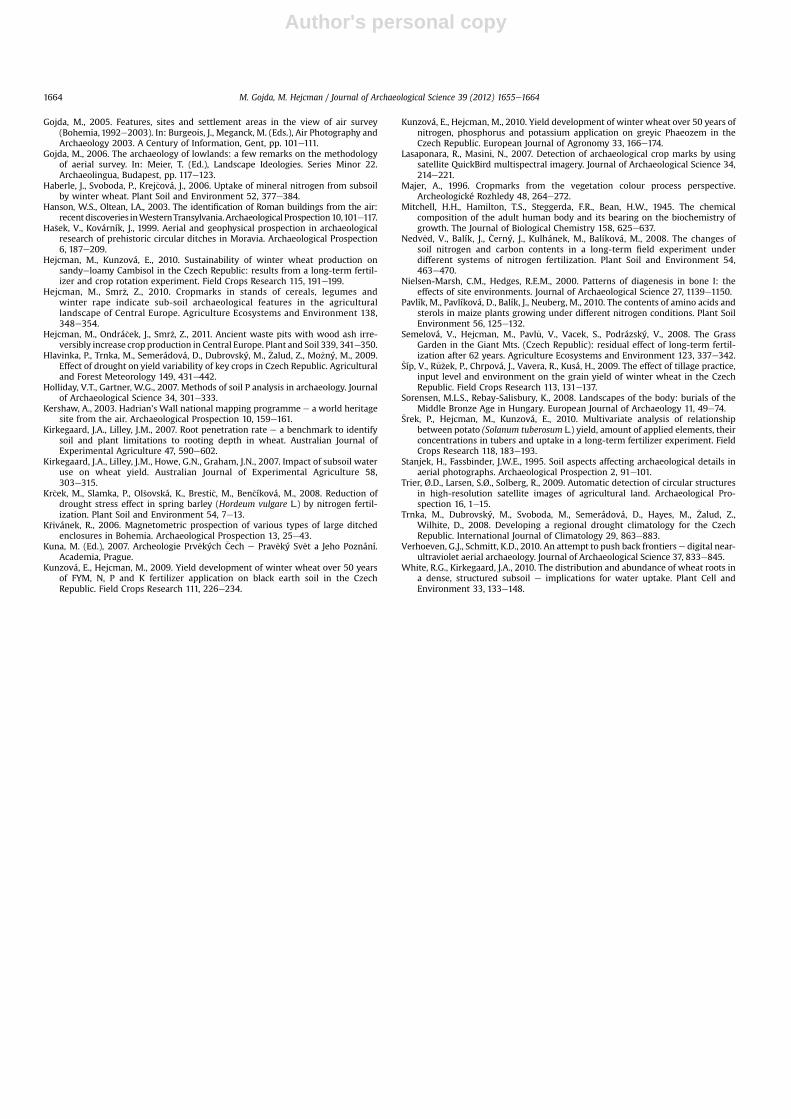
Positive cropmarks above graves can be connected with theimproved nutrition of a crop. Graves can irreversibly change soil Pstatus (Erneé and Majer, 2009) and can irreversibly improve Pnutrition. This is because the amount of P in one human body,depending on live weight, is approximately 0.5e0.8 kg (Mitchellet al., 1945) and the area of the grave is up to 2 m2. In manycases, depending on soil reaction and water regime, even P frombones can be taken up by plants as bones can be dissolved in thesoil over hundreds or thousands of years (see Fig. 8, Nielsen-Marshand Hedges, 2000). Furthermore, in addition to skeletal graves,cremation was used in many cultures from the middle Bronze Agesup to Early Middle Ages (Sorensen and Rebay-Salisbury, 2008), andhuman and wood ash is very rich in P (Holliday and Gartner, 2007).In graves, the application rate of P can be at least2500e4000 kg P ha�1 which is one hundred times higher than thenormal annual P application rates for main field crops in CentralEurope (see �Cerný et al., 2010; Kuzová and Hejcman, 2010; �Síp et al.,2009; �Srek et al., 2010). Taking into account the lowmobility of soilP and the ability of crops to explore sub-soil layers for scarcenutrients (Haberle et al., 2006), positive cropmarks due toimproved P nutrition of crops above graves can be irreversible. Inaddition to P, improved N nutrition and water supply can berecorded above graves. The amount of N in one human body is1.2e2 kg (Mitchell et al., 1945) and this is an application of6000e10000 kg N ha�1 which is one hundred times higher thanthe normal annual N application rates for cereals in the CzechRepublic (Nedv�ed et al., 2008; Hejcman and Kunzová, 2010).Although the mineral N is highly mobile in the soil profile and canbe quickly leached (Pavlík et al., 2010), some part of N can beincorporated into the soil organic matter which can survive in thesoil for thousands of years (see Fig. 8; Dupouey et al., 2002;
Dambrine et al., 2007). Positive cropmarks above graves can betherefore explained by the high content of soil organic matter ingraves, and the positive effect of high P availability on N minerali-sation and therefore on N nutrition of the plants together with theirimproved water supply due to deeper rooting and the higher waterholding capacity of humus rich soil. Furthermore, the location ofnutrient rich sediments in the sub-soil forces plants to createa higher proportion of deep roots as they can easily penetrate thehumus rich infill of archaeological features and explore them forgrowth limiting nutrients and water. During the excavation of thegrave in Fig. 5d, for example, roots of winter wheat were recordedat a depth of 2.5 m from the surface, although no roots wererecorded in the undisturbed and highly compressed sandy sub-soilin the surroundings of the grave. This is in accordance with theconclusion of Kirkegaard et al. (2007) that the penetration of rootsinto deep layers is highly affected by the mechanical resistance ofsoil to root penetration.
Positive cropmarks above ditches were produced by theimproved plant water and nutrients supply because of thesubstantially deeper humus rich layer than the thickness of thearable layer. In the Czech Republic, the thickness of the humus richarable layer is normally 20e30 cm, and the humus rich infill ofditches, normally ancient arable soil from the surroundings mixedwith nutrient rich wastes, can be over 2 m in the case of military orritual fortifications (Ha�sek and Kovárník, 1999; K�rivánek, 2006).This enables plants to create deep roots and to take up higheramounts of water and nutrients from the humus rich infill ofditches than from the undisturbed sub-soil in the surrounding.
Positive cropmarks above sunken dwellings and waste pits wereproduced by an improved plant water and nutrient supply becauseof their humus rich infill, the most frequently ancient humus rich
Fig. 5. Late Bronze Age settlement area with waste pits visible as hundreds of points, and a grave (? e the excavation had not been finished in 2010) pit surrounded by a doublerectangular ditch (indicated by arrow) in the contemporary village of Ctin�eves (see map in Fig. 2 for location). Waste pits, grave (?) and ditches were identified through positivecropmarks in (a) winter wheat stand photographed on 30 June 2007, and (b) in winter rape photographed on 23 June 2006. (c) Aerial photograph of archaeological excavation of thegrave (?) pit and ditch (28 August 2009); (d) Infill layers rich in humus inside the grave (?) pit highly contrasted with yellow sandy sub-soil of the undisturbed sub-soil in theneighbourhood. The photographwas taken on 13 July 2010. (For interpretation of the references to colour in this figure legend, the reader is referred to the web version of this article.)
M. Gojda, M. Hejcman / Journal of Archaeological Science 39 (2012) 1655e1664 1661
Author's personal copy
Fig. 7. (a) Positive cropmarks in winter barley enabled the detection of a double interrupted ditch and palisade trench of an Early Eneolithic Michelsberg culture (4000 BC)enclosure. Photograph was taken on 1 July 2010. (b) Excavation of the enclosure performed in 1999. Ditches were filled by humus rich sediments and undisturbed sub-soil wassandy. (c) Positive cropmarks in winter barley indicate a funeral area from the Bronze Age surrounded by a ditch (early July 1994); (d) The same area during archaeologicalexcavation in 1999.
Fig. 6. Part of prehistoric settlement area with waste pits and sunken buildings surrounded by double ditch (indicated by arrows) in the stand of (a) flowering winter wheatphotographed on 1 May 2007 and (b) in fully ripe stand photographed 30 June 2007. Positive cropmarks were very visible in areas with shallow sandy soil but substantially worse inarea with deeper soil with higher clay and silt proportion. (c) Regularly distributed dark green points (maculae) and a light line in stand of winter wheat indicating a former track-way lined with trees near the village of Ryb�nany (NW Bohemia), as evidenced (d) on a map from the 1830s. (For interpretation of the references to colour in this figure legend, thereader is referred to the web version of this article.)
M. Gojda, M. Hejcman / Journal of Archaeological Science 39 (2012) 1655e16641662
Author's personal copy
upper soil from their surroundings. Furthermore, waste pits werefrequently filled with wood ash which can irreversibly, substan-tially increase P, K, Ca, Mg and Zn soil status and therefore plantnutrition (Semelová et al., 2008). The amount of wood ash depos-ited in waste pits is generally very high, thousands of tons perhectare. Taking into account the mean concentrations of nutrientsin wood ash (Augusto et al., 2008), the amount of P, K, Ca and Mgdeposited in waste pits is higher than 10 t of each nutrient perhectare! Such a huge amount of nutrients can hardly be taken up byplants even over thousands of years (see Hejcman et al., 2011).
The higher biomass production of crops can be identified, evenabove post holes with an area of only several square decimetres andwith depths of up to 40 cm below the arable layer. On sandy soils,post holes can be identified as a positive small scale cropmarks,thousands of years after thewooden houses’ destruction. Post holesare filled with humus rich sediment from the decomposed wood.The mapping of such small scale positive cropmarks in stands ofcereals, in particular barley, enables the ground plans of prehistorichouses to be reconstructed with high precision, even without anyarchaeological excavation. Therefore any human activity disturbingsub-soil layers can generate irreversible changes in the productivityof arable fields.
Since there has been no or scarce communication betweenagronomists and archaeologists in the Czech Republic, cropmarksand their high value for archaeology are generally not known tofarmers. According to our experience, farmers frequently believe
that cropmarks are rather an indication of the uneven applicationof fertilisers and other agrochemicals than the presence of buriedarchaeological features. Cropmarks indication of the unevenapplication of agrochemicals can be easily distinguished fromcropmark indications of buried archaeological features because oftheir temporal character and different shapes.
5. Conclusion
As presented in this study, a major part of the variability inmodern field crop production can be as a result of variability in sub-soil layers. Buried archaeological features present beneath themodern arable horizon can substantially and irreversibly changethe biomass production of field crops. In the Czech lowlands, buriedarchaeological features such as sunken dwellings, enclosures,ditches, waste pits and graves, can be well identified on sandy soilsaccording to cropmarks in stands of main field crops, in particularbarley, wheat, rape and lucerne.
Acknowledgement
The anonymous reviewers are gratefully acknowledged for theiruseful comments. M.H. gratefully acknowledges the financialsupport provided by the Czech Science Foundation (project GA�CR521/08/1131), and M.G. for the support of the Academy of Sciencesof the Czech Republic (research project AV0Z 80020508).
References
Agapiou, A., Hadjimitsis, D.G., 2011. Vegetation indices and field spectroradiometricmeasurements for validation of buried architectural remains: verification underarea surveyed with geophysical campaigns. Journal of Applied Remote Sensing5. doi:10.1117/1.3645590.
Augusto, L., Bakker, M.R., Meredieu, C., 2008. Wood ash applications to temperateforests ecosystems e potential benefits and drawbacks. Plant and Soil 306,181e198.
Bewley, B., Raczkowski, W., 2002. Aerial Archaeology. Developing Future Practice.IOS Press, Washington DC.
Canadell, J., Jackson, R.B., Ehleringer, J.R., Mooney, H.A., Sala, O.E., Schulze, E.D., 1996.Maximum rooting depth of vegetation types at the global scale. Oecologia 108,583e595.
�Cerný, J., Balík, J., Kulhánek, M., �Cásová, K., Nedv�ed, V., 2010. Mineral and organicfertilization efficiency in long-term stationary experiments. Plant Soil andEnvironment 56, 28e36.
Challis, K., Kincey, M., Howard, A.J., 2009. Airborne remote sensing of valley floor geo-archaeology using Daedalus ATM and CASI. Archaeological Prospection 16, 17e33.
Cowley, D.C., Standring, R.A., Abicht, M.J., 2010. Landscapes Through the Lens. AerialPhotographs and the Historic Environment. Oxbow Books, Oxford.
Cowley, D.C., 2002. A case study in the analysis of patterns of aerial reconnaissancein a lowland area of Southwest Scotland. Archaeological Prospection 9,255e265.
Crawford, O.G.S., 1924. Air Survey and Archaeology. In: Ordnance Survey Profes-sional Papers New Series 7.
Dambrine, E., Dupouey, J.L., Laut, L., Humbert, L., Thinon, M., Beaufils, T., Richard, H.,2007. Present forest biodiversity patterns in France related to former Romanagriculture. Ecology 88, 1430e1439.
Doneus, M., 2001. Precision mapping and interpretation of oblique aerial photo-graphs. Archaeological Prospection 8, 13e27.
Dupouey, L.J., Dambrine, E., Laffite, J.D., Moares, C., 2002. Irreversible impact of pastland use on forest soils and biodiversity. Ecology 83, 2978e2984.
Erneé, M., Majer, A., 2009. Burial rites: uniform or diverse? Interpretation of theresults of phosphate soil analysis at the Ún�etice culture burial site in Prague 9 e
Mi�skovice. Archeologické Rozhledy 61, 493e508.Evans, R., Jones, R.,J.,A., 1977. Crop marks and soils at two archaeological sites in
Britain. Journal of Archaeological Science 4, 63e76.Fassbinder, J.W.E., 2010. Geophysical prospection of the frontiers of the Roman
Empire in Southern Germany, UNESCO world heritage site. ArchaeologicalProspection 17, 129e139.
Gallo, D., Ciminale, M., Becker, H., Masini, N., 2009. Remote sensing techniques forconstructing a vast Neolithic settlement in Southern Italy. Journal of Archaeo-logical Science 36, 43e50.
Gojda, M., Trefný, M., 2011. Archaeology in the Landscape Around the �Ríp Mountain.University of West Bohemia, Plze�n.
Gojda, M. (Ed.), 2004. Ancient Landscape, Settlement Dynamics and Non-Destructive Archaeology. Academia, Prague.
Fig. 8. Archaeological excavation of sub-soil Eneolithic grave (2700 BC) performed byDr. Z. Smr�z in NW Bohemia in the summer of 2009. After removal of the arable layer,(a) black humus rich infill of the grave highly contrasted with lighter sub-soil in thesurrounding. (b) Skeleton was completely dissolved and the position of the formerbody was indicated only by the position of pottery vessels.
M. Gojda, M. Hejcman / Journal of Archaeological Science 39 (2012) 1655e1664 1663
Author's personal copy
Gojda, M., 2005. Features, sites and settlement areas in the view of air survey(Bohemia, 1992e2003). In: Burgeois, J., Meganck, M. (Eds.), Air Photography andArchaeology 2003. A Century of Information, Gent, pp. 101e111.
Gojda, M., 2006. The archaeology of lowlands: a few remarks on the methodologyof aerial survey. In: Meier, T. (Ed.), Landscape Ideologies. Series Minor 22.Archaeolingua, Budapest, pp. 117e123.
Haberle, J., Svoboda, P., Krej�cová, J., 2006. Uptake of mineral nitrogen from subsoilby winter wheat. Plant Soil and Environment 52, 377e384.
Hanson, W.S., Oltean, I.A., 2003. The identification of Roman buildings from the air:recentdiscoveries inWesternTransylvania.Archaeological Prospection10,101e117.
Ha�sek, V., Kovárník, J., 1999. Aerial and geophysical prospection in archaeologicalresearch of prehistoric circular ditches in Moravia. Archaeological Prospection6, 187e209.
Hejcman, M., Kunzová, E., 2010. Sustainability of winter wheat production onsandyeloamy Cambisol in the Czech Republic: results from a long-term fertil-izer and crop rotation experiment. Field Crops Research 115, 191e199.
Hejcman, M., Smr�z, Z., 2010. Cropmarks in stands of cereals, legumes andwinter rape indicate sub-soil archaeological features in the agriculturallandscape of Central Europe. Agriculture Ecosystems and Environment 138,348e354.
Hejcman, M., Ondrá�cek, J., Smr�z, Z., 2011. Ancient waste pits with wood ash irre-versibly increase crop production in Central Europe. Plant and Soil 339, 341e350.
Hlavinka, P., Trnka, M., Semerádová, D., Dubrovský, M., �Zalud, Z., Mo�zný, M., 2009.Effect of drought on yield variability of key crops in Czech Republic. Agriculturaland Forest Meteorology 149, 431e442.
Holliday, V.T., Gartner, W.G., 2007. Methods of soil P analysis in archaeology. Journalof Archaeological Science 34, 301e333.
Kershaw, A., 2003. Hadrian’s Wall national mapping programme e a world heritagesite from the air. Archaeological Prospection 10, 159e161.
Kirkegaard, J.A., Lilley, J.M., 2007. Root penetration rate e a benchmark to identifysoil and plant limitations to rooting depth in wheat. Australian Journal ofExperimental Agriculture 47, 590e602.
Kirkegaard, J.A., Lilley, J.M., Howe, G.N., Graham, J.N., 2007. Impact of subsoil wateruse on wheat yield. Australian Journal of Experimental Agriculture 58,303e315.
Kr�cek, M., Slamka, P., Ol�sovská, K., Bresti�c, M., Ben�cíková, M., 2008. Reduction ofdrought stress effect in spring barley (Hordeum vulgare L.) by nitrogen fertil-ization. Plant Soil and Environment 54, 7e13.
K�rivánek, R., 2006. Magnetometric prospection of various types of large ditchedenclosures in Bohemia. Archaeological Prospection 13, 25e43.
Kuna, M. (Ed.), 2007. Archeologie Prv�ekých �Cech e Prav�eký Sv�et a Jeho Poznání.Academia, Prague.
Kunzová, E., Hejcman, M., 2009. Yield development of winter wheat over 50 yearsof FYM, N, P and K fertilizer application on black earth soil in the CzechRepublic. Field Crops Research 111, 226e234.
Kunzová, E., Hejcman, M., 2010. Yield development of winter wheat over 50 years ofnitrogen, phosphorus and potassium application on greyic Phaeozem in theCzech Republic. European Journal of Agronomy 33, 166e174.
Lasaponara, R., Masini, N., 2007. Detection of archaeological crop marks by usingsatellite QuickBird multispectral imagery. Journal of Archaeological Science 34,214e221.
Majer, A., 1996. Cropmarks from the vegetation colour process perspective.Archeologické Rozhledy 48, 264e272.
Mitchell, H.H., Hamilton, T.S., Steggerda, F.R., Bean, H.W., 1945. The chemicalcomposition of the adult human body and its bearing on the biochemistry ofgrowth. The Journal of Biological Chemistry 158, 625e637.
Nedv�ed, V., Balík, J., �Cerný, J., Kulhánek, M., Balíková, M., 2008. The changes ofsoil nitrogen and carbon contents in a long-term field experiment underdifferent systems of nitrogen fertilization. Plant Soil and Environment 54,463e470.
Nielsen-Marsh, C.M., Hedges, R.E.M., 2000. Patterns of diagenesis in bone I: theeffects of site environments. Journal of Archaeological Science 27, 1139e1150.
Pavlík, M., Pavlíková, D., Balík, J., Neuberg, M., 2010. The contents of amino acids andsterols in maize plants growing under different nitrogen conditions. Plant SoilEnvironment 56, 125e132.
Semelová, V., Hejcman, M., Pavl�u, V., Vacek, S., Podrázský, V., 2008. The GrassGarden in the Giant Mts. (Czech Republic): residual effect of long-term fertil-ization after 62 years. Agriculture Ecosystems and Environment 123, 337e342.
�Síp, V., R�u�zek, P., Chrpová, J., Vavera, R., Kusá, H., 2009. The effect of tillage practice,input level and environment on the grain yield of winter wheat in the CzechRepublic. Field Crops Research 113, 131e137.
Sorensen, M.L.S., Rebay-Salisbury, K., 2008. Landscapes of the body: burials of theMiddle Bronze Age in Hungary. European Journal of Archaeology 11, 49e74.
�Srek, P., Hejcman, M., Kunzová, E., 2010. Multivariate analysis of relationshipbetween potato (Solanum tuberosum L.) yield, amount of applied elements, theirconcentrations in tubers and uptake in a long-term fertilizer experiment. FieldCrops Research 118, 183e193.
Stanjek, H., Fassbinder, J.W.E., 1995. Soil aspects affecting archaeological details inaerial photographs. Archaeological Prospection 2, 91e101.
Trier, Ø.D., Larsen, S.Ø., Solberg, R., 2009. Automatic detection of circular structuresin high-resolution satellite images of agricultural land. Archaeological Pro-spection 16, 1e15.
Trnka, M., Dubrovský, M., Svoboda, M., Semerádová, D., Hayes, M., �Zalud, Z.,Wilhite, D., 2008. Developing a regional drought climatology for the CzechRepublic. International Journal of Climatology 29, 863e883.
Verhoeven, G.J., Schmitt, K.D., 2010. An attempt to push back frontierse digital near-ultraviolet aerial archaeology. Journal of Archaeological Science 37, 833e845.
White, R.G., Kirkegaard, J.A., 2010. The distribution and abundance of wheat roots ina dense, structured subsoil e implications for water uptake. Plant Cell andEnvironment 33, 133e148.
M. Gojda, M. Hejcman / Journal of Archaeological Science 39 (2012) 1655e16641664