australian primary mathematics classroom vol. 19 no. 4
TRANSCRIPT

AAMT—supporting and enhancing the work of teachers The Australian Association of Mathematics Teachers Inc. ABN 76 515 756 909 POST GPO Box 1729, Adelaide SA 5001 PHONE 08 8363 0288 FAX 08 8362 9288 EMAIL [email protected] INTERNET www.aamt.edu.au
Document extract Title of chapter/article Geocaching: Finding mathematics in a global treasure
hunt
Author(s) Leicha Bragg
Copyright owner The Australian Association of Mathematics Teachers Inc.
Published in Australian Primary Mathematics Classroom vol. 19 no. 4
Year of publication 2014
Page range 9–14
ISBN/ISSN 1326-0286
This document is protected by copyright and is reproduced in this format with permission of the copyright owner(s); it may be copied and communicated for non-commercial educational purposes provided all acknowledgements associated with the material are retained.

1APMC 19 (4) 2014
Australian Primary Mathematics Classroom
Volume 19 Number 4 2014
EditorCatherine Attard <[email protected]>
Review panelKim Beswick, Leicha Bragg, Fiona Budgen, Lorraine Day, Julie Clark, Shelley Dole, Noleine Fitzallen, Tricia Forrester, Peter Grootenboer, Derek Hurrell, Chris Hurst, Kevin Larkin, Paula Mildenhall, Donna Miller, Tracey Muir, Maria Northcote, Chris Ormond, Kevin Petrie, Anne Roche, Marie Skillen, Karen Skilling, Tracey Smith, Steve Thornton, Allan White, Monica Wong.
The journalAustralian Primary Mathematics Classroom is published four times each year and can be ordered by members of the AAMT through their affiliated association; non-members can subscribe by contacting AAMT directly. Other business communications (e.g., advertising, supply of journals etc.) should be sent to the AAMT Office.
Contributing articlesContributions from readers are invited for all sections of the journal, and should be sent to the editors via the AAMT Office. The focus of the journal is on innovative practice in primary mathematics educa-tion. Articles should be relevant to practising teachers and be less than 2000 words; shorter articles are preferred.
All articles should be prepared using a suitable word processing application (e.g., Microsoft Word) and emailed to the AAMT Office). All diagrams should be prepared using a suitable drawing application. Hand-drawn diagrams and photographs can be scanned at the AAMT Office and returned upon request. Any electronic images or diagrams should be of no less resolution than 300 dpi and saved as tiff or eps files and submitted electronically with the manuscript.
All authors are required to send a completed Author’s Warranty form to the AAMT Office. These are available from the Office upon request, or can be downloaded from the AAMT website.
Any queries about preparing or submitting papers should be directed to the AAMT Office. Information is also available on the AAMT website.
All submitted papers are to be accompanied by a covering letter clearly stating the name(s) and institution(s) of the author(s), the title of the paper, as well as contact telephone, email and postal addresses. Authors are also requested to submit a high resolution portrait photograph with articles.
Referee processArticles submitted for APMC undergo a blind refereeing procedure where they are read by at least two expert peer reviewers. The Editors advise authors of any changes which are required before the paper may be considered for publication in APMC.
ReviewsPublishers wishing to send materials for review should send them to the Editors care of the AAMT Office.
AAMT OfficeGPO Box 1729 Adelaide SA 5001 Australia
Phone (08) 8363 0288
Fax (08) 8362 9288
Email [email protected]
Internet http://www.aamt.edu.au
DisclaimerThe opinions expressed in this journal do not necessarily reflect the position, opinions, policy or endorsement of The Australian Associa-tion of Mathematics Teachers Inc. Publication of advertising in this journal does not imply endorsement of the product by AAMT Inc.
This journal is an official publication of The Australian Association of Mathematics Teachers Inc.
ISSN 1326-0286
2 Editorial Catherine Attard
3 Teachers holding back from telling: A key to student persistence on
challenging tasks Anne Roche and Doug Clarke
9 Geocaching: Finding mathematics
in a global treasure hunt Leicha Bragg
15 Divide and conquer: A hands-on exploration of divisibility John West
20 Australian Curriculum linked lessons: Statistics Lorraine Day
24 Learning to like algebra through looking: Developing upper primary students’ functional thinking with visualisations of growing patterns
Karina Wilke
34 A Canadian effort to address fractions teaching and learning challenges
Shelley Yearley and Catherine Bruce

9APMC 19 (4) 2014
Teachers are encouraged to create or source authentic tasks that motivate, engage, and devel-op students’ mathematical conceptual under-standing. Meeting these criteria is a tall order for teachers with limited time and resources (Leong & Chick, 2011). Geocaching is an outdoor adventure that encapsulates what many educators teachers aspire to in a mathematics task: engage-ment, educational value, and fun. Geocaching is a global treasure hunt that invites students out of the classroom into a world of discovery. This paper unveils the ‘secret world’ of geocaching and describes a geocaching educational program that was purposely designed for primary students to increase their conceptual understanding of mathematics, particularly location, and instill a sense of wonder of mathematics in the environ-ment. It is argued that geocaching offers teachers an authentic approach to develop mathematical understandings through the students’ quest to explore their surroundings in search of ‘riches’. To get started, all that is required is a global positioning system (GPS) enabled device, Inter-net access, and a sense of adventure.
The basics of geocaching
Geocaching (pronounced geo-cashing) is a global treasure hunt with approximately 2.3 million geocaches hidden around the world and over six
million geocachers — those who seek geocaches — searching all corners of the earth for them. The word geocache is derived from the terms geo (earth) and cache (hidden supply or treasure) (Christie, 2007). The basic geocache (see Figure 1) is a small watertight container that holds a pencil and a log book to record when the geocache is found. Small treasures are often placed inside the geocache so those who discover its location may have a physical reward for their find. The treasures inside the geocache are typically trinkets or inexpensive toys.
Figure 1. Basic geocache filled with ‘treasures’.
To get started, a member of the geocaching community hides their geocache, determines its location using GPS technology and posts a
Geocaching: Finding mathematics in
a global treasure huntIf you love taking mathematics lessons outdoors, then you will love this article. Leicha Bragg describes geocaching, which combines technology, treasure hunting and mathematics, and results in purposeful, authentic and engaging mathematics.
Leicha A. BraggDeakin [email protected]
APMC 19 (4) 201410
Bragg
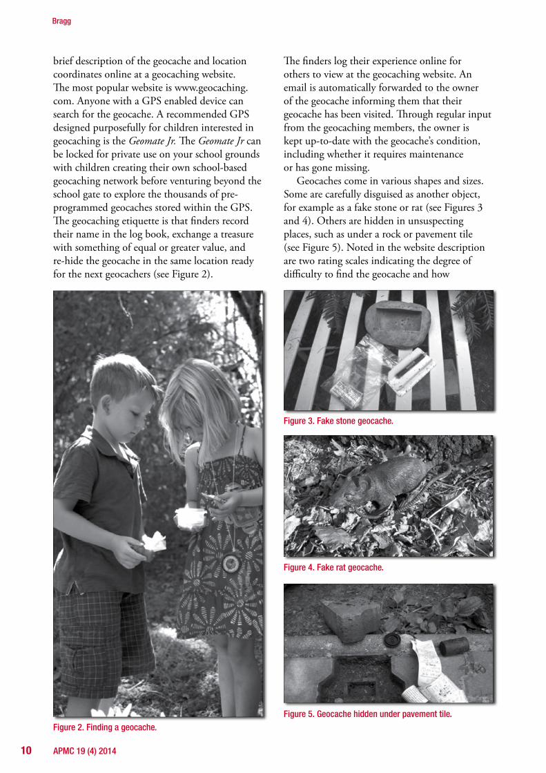
brief description of the geocache and location coordinates online at a geocaching website. The most popular website is www.geocaching.com. Anyone with a GPS enabled device can search for the geocache. A recommended GPS designed purposefully for children interested in geocaching is the Geomate Jr. The Geomate Jr can be locked for private use on your school grounds with children creating their own school-based geocaching network before venturing beyond the school gate to explore the thousands of pre-programmed geocaches stored within the GPS. The geocaching etiquette is that finders record their name in the log book, exchange a treasure with something of equal or greater value, and re-hide the geocache in the same location ready for the next geocachers (see Figure 2).
Figure 2. Finding a geocache.
The finders log their experience online for others to view at the geocaching website. An email is automatically forwarded to the owner of the geocache informing them that their geocache has been visited. Through regular input from the geocaching members, the owner is kept up-to-date with the geocache’s condition, including whether it requires maintenance or has gone missing.
Geocaches come in various shapes and sizes. Some are carefully disguised as another object, for example as a fake stone or rat (see Figures 3 and 4). Others are hidden in unsuspectingplaces, such as under a rock or pavement tile (see Figure 5). Noted in the website description are two rating scales indicating the degree of difficulty to find the geocache and how
Figure 3. Fake stone geocache.
Figure 4. Fake rat geocache.
Figure 5. Geocache hidden under pavement tile.

11APMC 19 (4) 2014
challenging the terrain is to negotiate. A loca-tion such as in the middle of Port Phillip Bay in Melbourne understandably earns a high rating for terrain difficulty due to underwater diving required to obtain it. When commencing geocaching with students, it is prudent to opt for low ratings, especially for the terrain. It is also advisable to visit the geocache ahead of time to determine the suitability of the location for your class.
Geocaching’s place in education
Geocaching offers students access to a place-based approach to education through a connection with the environment and the community of local and global geocachers. Sobel (2008) describes place-based education as,
“Emphasizing hands-on, real-world learning experiences. This approach to education increases academic achievement, helps students develop stronger ties to their com-munity, enhances students’ appreciation for the natural world, and creates a heightened commitment to serving as active, contribut-ing citizens” (p. 6).
Geocaching has strong links with members of the community as it is reliant on fellow treasure hunters creating and maintaining geocaches and sharing their experiences. Geocachers hide their geocache in a place that is of importance to them, e.g., overlooking a favourite pond. The seeker is given an insight into a space that may only be known to locals, thereby witnessing the world through other people’s eyes. This is the locals’ hidden treasure. The geocaching community has a strong emphasis on care and protection of the environment. A geocaching motto is “Cache in, trash out” to urge ongoing protection of flora and fauna as geocachers are encouraged to remove any rubbish on their treasure hunting travels.
Geocaching offers “real and relevant math-ematics” (Sparrow, 2008, p. 4) through a need to develop spatial and location skills to engage successfully in treasure hunting. The geocacher requires an understanding and awareness of compass points, distance, longitude and latitude, the functions of a GPS device, reading and following maps, trip planning, drawing and using scale, interpreting data, along with literacy and
ICT skills, and undertakes physical exercise (Bragg, Pullen & Skinner, 2010). To encourage teachers to gain the most out of the geocaching experience, a geocaching educational program (Bragg & Skinner, 2011) was created to offer primary classes experience with location skills before searching for geocaches.
Developing a geocaching program
The geocaching educational program was devel-oped for students across all levels of the primary school. The description below is a summarised account of the trialling and further development of the program with 65 Victorian primary-school children in their first year and final two years of primary school.
Pre-assessment
Two pre-assessment tasks (a mind map and map drawing) were conducted to provide insights into students’ understandings and reveal misconcep-tions related to location. First, students com-pleted a mind map task: Tell me everything you know about maps (see Bragg & Skinner, 2011, pp.2–3).Earlyyearschildrenundertookthetaskorally with a teacher recording their responses.
While students demonstrated some under-standing of mapping, most responses were lim-ited to the purpose of a map rather than specific features of maps. The second pre-assessment task focused on the students’ mapping skills and the functionality of a map. Hide, map and seek (Bragg, 2013) required the students to hide an item in the classroom, draw a map indicating the location of the item, exchange their map with a partner, locate their partner’s item, exchange feedback about the strengths and weaknesses of the two maps, and then engage in a whole-class discussion about the experience. The weaknesses raised were a lack of indicators of orientation, drawings not to scale, and a misunderstanding and inaccuracy of symbolic representations. The task was then repeated so that students could demonstrate any newly acquired knowledge of mapping. This latter task provided students with the authentic dual roles of cartographer and map user, and offered the students insights into their mapping needs in situ.
Geocaching: Finding mathematics in a global treasure hunt

APMC 19 (4) 201412
Bragg
Based on the information gained from the two pre-assessment tasks and whole-class discussions, it was apparent that the students demonstrated a limited knowledge of compass directions, key components of a map, scale, and more complex mapping structures such as longitude and latitude. A series of tasks were developed to focus on particular skills necessary to engage successfully in geocaching. These tasks were underpinned by the selected Location and transformation sub-strand content descriptors for the Measurement and geometry content strand of the Australian Curriculum: Mathematics (Australian Curriculum, Assessment and Reporting Authority [ACARA], 2012), as well as location skills more broadly. For example:
Year 5: Use a grid reference system to describe locations. Describe routes using landmarks and directional language (ACMMG113).
Year 4: Use simple scales, legends and directions to interpret information contained in basic maps (ACMMG090).
Orientation and compass use
Initially, tasks that expanded the students’ understanding of orientation were implemented. I am North was developed to assist grade 5 and 6 students “to see at first-hand the connection between geometry (orientation and angles), measurement and number” (Bragg, 2012, p. 8). Students were given a card that had either the cardinal or inter-cardinal compass points depicted as initials (such as SW), a bearing (90o) or picture of a compass. The students stood in a circle to make a giant compass rose. The student with the N (north) card revealed that card. The rest of the students moved to their card’s designated position within the compass rose then shared their strate-gies for finding their position. Once the founda-tions for the compass points had been established, children moved on to using a hand-held compass to explore location as it related to their school environment. For example, students drew a chalk compass rose in the playground (see Figure 6) and identified what they could see in particular direc-tions and the direction of the classroom, school gate, office, etc. from their position.
The next stage included pairs of students designing a scaled map of the school with
Figure 6. Students creating a chalk compass rose in the playground.

13APMC 19 (4) 2014
Geocaching: Finding mathematics in a global treasure hunt
standing of the significance of the longitude and latitude in pinpointing with accuracy locations on the globe. On a large world map, students noted the longitude and latitude of major cities throughout Australia and the world. Students shared their families’ backgrounds and selected major cities from these countries. The students started to build a picture of where a particular longitude and latitude may be located in the world and thus developed a stronger understand-ing of northern and southern, eastern and western hemispheres as well as the measurement of latitude and longitude.
In summary, these pre-geocaching lessons were designed to build on prior knowledge of location through exploratory, hands-on tasks with a strong mathematical focus. The pre-geocaching knowledge and skills included experiences with distance, direction, compass points, co-ordinates, angles, map reading and creating, scale, and longitude and latitude. The students worked collaboratively both inside and outside the classroom environment. Once this foundation knowledge was established, the geocaching adventure began.
Geocaching
The students were introduced to the geocaching website and they read about geocaches they could find in the local area. Students were surprised to discover many treasures were within walking distance of their school. The logistics of the treasure hunt was planned, parental permissions sought, and a group of 14 students set off geo-caching with two teachers and two parent helpers. The students were armed with their GPS device, a description of the geocache, and their treasure to exchange. The excitement was palpable.
Geocaching enabled students to engage imme-diately in the mathematics required to find the hidden treasure. The students handled the GPS device in a confident manner, referred regularly to it as they walked (or ran), and interpreted the co-ordinate information it provided effectively. The students directed each other using compass points and offered regular updates on distances to be covered to the geocache. Once the geocache was discovered, the students logged their find, exchanged a treasure and explored the local area.
pathways leading to a hidden treasure. The pairs would exchange maps with classmates and employ a compass to navigate the designed course. Students soon realised that indicating steps towards a location was insufficient for accuracy and a consistency in the units of meas-urement was required.
Latitude, longitude and GPS use
Once the understanding of compass points and basic mapping had been consolidated, older stu-dents learned to input data into the GPS track-ing device and read the display, which required an understanding of longitude and latitude. Sticky Balloon (see Bragg & Skinner, 2011, p. 27) was a useful activity here. It has two students sitting back-to-back, each holding an inflated balloon. Student A places a sticker on the bal-loon and proceeds to describe the location of the sticker to Student B who places their sticker on the same location on their balloon. Students soon realise that without a point of reference, the ability to locate the sticker is almost impossible. Then the students are instructed to draw a dotted line around the centre of their balloon—the equator. The balloon now has two hemispheres, north and south, and locating the sticker has become a little easier. The students are instructed to draw lines down the balloon to indicate the prime meridian and the 180th meridian. Each pair of students continues to insert a number of lines of longitude and latitude until Student B can successfully locate the sticker on their bal-loon. The whole class discussed the strengths and weaknesses of the task before repeating it. Sticky Balloon was successful in highlighting the need for lines of longitude and latitude in pinpointing with accuracy any place on a globe.
The next step was introducing students to the wonders of the global positioning system (GPS) and the GPS tracking navigation devices that utilise this technology. The students examined a GPS device and recorded its features and func-tionality, such as marking waypoints and tracks. The students located each corner of the school property and marked the waypoints by recording the longitude and latitude of each point, then discussed the differences they discovered in the numbers produced by the GPS. This discussion was promoted to develop the students’ under-

APMC 19 (4) 201414
Bragg
Concluding remarks
Although it was expected that the students would be engaged in the Geocaching Educational Program, the level of excitement, motivation, and fascination was remarkable. The students actively participated in mathematical thinking that was challenging and, at times, beyond the prescribed level for their grade in order to engage in geocaching.
This rich experience of geocaching in a primary school supports the argument that geocaching is an authentic, innovative and imaginative way to develop mathematical understandings.
ReferencesAustralian Curriculum, Assessment and Reporting Authority
[ACARA]. (2012). The shape of the Australian Curriculum, Version 3. Retrieved from www.acara.edu.au/verve/_resources/The_Shape_of_the_Australian_Curriculum_V3.pdf
Bragg, L. A. (2012). I am north: Understanding location through exploring compass points.PrimeNumber,27(4),7–9.
Bragg, L. A. (2013). Hide, map and seek: Assessing students’ understanding of location and direction. Australian Primary Mathematics Classroom, 18(4),3–7.
Bragg, L. A. & Skinner, M. (2011). Geocaching: A mathematical treasure hunt. Middle and upper primary. Bayswater, Vic.: Teachers First Choice.
Bragg, L. A., Pullen, Y. & Skinner, M. (2010), Geocaching: A worldwide treasure hunt enhancing the mathematics class-room. In R. Lesh, P. Galbraith, C. Haines & A. Hurford (Eds), Proceedings of the 47th Annual Conference of the Mathematical Association of Victoria (pp.54–62).Brunswick,Vic:Math-ematical Association of Victoria.
Christie, A. (2007). Using GPS and geocaching engages, empowers and enlightens middle school teachers and students. Meridian Middle School Computer Technologies Journal, 10(1),1–15.
Leong, Y. H., & Chick, H. L. (2011). Time pressure and instructional choices when teaching mathematics. Mathematics Education Research Journal, 23(3),347–362.
Sobel, D. (2008). Childhood and nature: Design principles for educators. Portland, ME: Stenhouse Publishers.
Sparrow, L. (2008). Real and relevant mathematics: Is It realistic in the classroom? Australian Primary Mathematics Classroom, 13(2),4–8.
The teachers and students also used this activity to develop open-ended mathematical questions about their environment. For example: a painted steel sculpture of a bird and worm measuring 13 metres high and 19 metres long was a source for many questions, such as “How much paint was used?”, “How much would the bird eat in a day if it was real?”, or “How big is the bird and how long is the worm?”.
Sharing the students’ experiences
The students’ mathematical learning throughout the geocaching educational program was assessed through a range of formative and summative assessment tasks, such as student work samples, reflective journals, video diaries, student inter-views, teacher observations, and anecdotal notes. Journal entries pleasingly highlighted many of the new skills experienced through geocaching as noted by the following extracts:
“I never knew how to use it [a compass] properly but now I know how to use it and all of the different directions”
“I didn’t know co-ordinates that well, so I am pretty good at it now”
“With scale I learned more about m, cm, km. I was really proud of myself because I didn’t really know that much about it.”
It was encouraging to observe the students’ skills developing in geocaching transfer to other situations,
“I hope that I will be able to help people with the skills I have learnt through geocaching.”
Overwhelmingly, the students enjoyed the experience and many continued to geocache outside school hours with their families. When asked, “What do you see your children learning through geocaching?” a parent shared the following: “Caring for the environment, botany, satellites, wildlife, maps and GPS; these are conversations that we have had during our twenty finds so far. I can’t wait to see what questions will be next.”