aurora northeast area transportation study · pdf filethe aurora northeast area transportation...
TRANSCRIPT

NEA
TS
Aur
ora
Nor
thea
st A
rea
Tran
spor
tati
on S
tudy
Aurora Northeast Area Transportation Study2007 UPDATE
A
U R O R
A
FrontRange
Airport
FrontRange
Airport
DenverInternational
Airport
Peña Blvd.
Jewell Ave.Gu
n C
lub
Rd
.
Wa
tkins R
d.
E-470
Pica
dilly R
d.
Pow
ha
ton
Rd
.
Haye
smo
un
t Rd
.
Hu
dso
n R
d.
Imb
od
en
Rd
.
Ma
nilla
Rd
.
Colfax Ave.
38th Ave.
56th Ave.
Smith Rd.
26th Ave.
E-470
6th Pkwy.
30
36
Mississippi Ave.
Gu
n C
lub
Rd
.
Du
nkirk S
t.
48th Ave.
Mo
na
gh
an
Rd
.
Ha
rvest R
d.
Sch
um
ake
r Rd
.
64th Ave.
Watkins
70 70
Second
Creek
Box
Elder
Creek
Gulch
Bear
West
SandC
reek
First
Creek
Creek
Coal
UPRR
TollPlaza
ADAMS COUNTY
ARAPAHOE COUNTY
ADOPTION DRAFT
AURORA NORTHEAST AREA
TRANSPORTATION STUDY
Prepared for:
City of Aurora Planning Department
15151 E. Alameda Parkway Aurora, CO 80012
Prepared by:
Felsburg Holt & Ullevig 6300 South Syracuse Way, Suite 600
Centennial, CO 80111 (303) 721-1440
Project Manager: Christopher J. Fasching, PE
July 2007 FHU Reference No. 05-271

Northeast Area Transportation Study
ACKNOWLEDGMENTS City Council Ed Tauer, Mayor Deborah Wallace, Ward I Renie Peterson, Ward II Larry Beer, Ward III Molly Markert, Ward IV Sue Sandstrom, Ward V Bob Broom, Ward VI Bob FitzGerald, At Large Ryan Frazier, At Large Steve Hogan, At Large Brad Pierce, At Large City Management Ronald S. Miller, City Manager Nancy Freed, Deputy City Manager for Operations
Planning Department Staff Robert Watkins, Director John Fernandez, Manager, Comprehensive Planning Mac Callison, Transportation Planning Supervisor Huiliang Liu, Principal Transportation Planner Jay Pierce, Principal Planner Dan Bartholomew, Data Services Supervisor Donna Vicars-Benjamin, Senior Planner Linda Clohessy, GIS Specialist Public Works Department Staff Dave Chambers, Director Dick Havercamp, Manager, Traffic Services Rick Hunter, Project Engineer Parks and Open Space Staff Curtis Bish, Principal Planner Consultant Team – Felsburg Holt & Ullevig Chris Fasching Elliot Sulsky Debbie Scott

Northeast Area Transportation Study
TABLE OF CONTENTS Page
I. INTRODUCTION -------------------------------------------------------------------------------------------- 1 A. Study Purpose ------------------------------------------------------------------------------------- 1 B. Plan Application/Use ----------------------------------------------------------------------------- 1 C. Report Organization ------------------------------------------------------------------------------ 2
II. EXISTING CONDITIONS --------------------------------------------------------------------------------- 3 A. Location---------------------------------------------------------------------------------------------- 3 B. Constraints ------------------------------------------------------------------------------------------ 3 C. Developed Areas ---------------------------------------------------------------------------------- 5 D. Transportation Facilities ------------------------------------------------------------------------- 5
III. FUTURE CONDITIONS ----------------------------------------------------------------------------------- 8 A. Land Use -------------------------------------------------------------------------------------------- 8 B. Roadway Network--------------------------------------------------------------------------------- 9 C. Travel Demands ----------------------------------------------------------------------------------10
IV. RECOMMENDED 2030 TRANSPORTATION SYSTEM PLAN -------------------------------12 A. Roadway Network--------------------------------------------------------------------------------12 B. Transit and Trails ---------------------------------------------------------------------------------16 C. Plan Improvement Costs -----------------------------------------------------------------------19 D. Priorities and Funding ---------------------------------------------------------------------------20
APPENDIX APPROVAL STATUS OF MASTER PLANNED AREAS & FUTURE RESIDENTIAL GROWTH AREAS, APRIL 2007 TRANSPORTATION ANALYSIS ZONE MAP 2030 LAND USE DATA 2030 MODEL ROADWAY NETWORK 2030 LANE-MILES GUN CLUB ROAD PLAN & PROFILE HARVEST ROAD PLAN & PROFILE IMBODEN ROAD PLAN & PROFILE PICADILLY ROAD PLAN & PROFILE

Northeast Area Transportation Study
LIST OF FIGURES
Page Figure 1. NEATS Study Area ------------------------------------------------------------------------------- 4 Figure 2. Existing NEATS Roadway Conditions ------------------------------------------------------- 7 Figure 3. NEATS 2030 Daily Traffic Projections ------------------------------------------------------11 Figure 4. NEATS Roadway Network Plan --------------------------------------------------------------14 Figure 5. I-70/E-470 Interchange Preferred Alternative ---------------------------------------------15 Figure 6. NEATS Trails and Transit Components ----------------------------------------------------17

Northeast Area Transportation Study
Page 1
I. INTRODUCTION A. Study Purpose The Aurora Northeast Area Transportation Study (NEATS) 2007 Update is intended to support Aurora’s Comprehensive Plan relative to transportation planning and provide more insight to the planning and construction of future facilities. The study covers an area north of Jewell Avenue and east of Picadilly Road, and it serves as an update to the original NEATS document prepared in December 1999 by Felsburg Holt & Ullevig. This study was conducted in close coordination with the 2007 update for the Aurora Southeast Transportation Study (SEATS). The following are addressed in this document:
► Existing and Future Land Use Projections. Since 1999, development potential throughout the study area has changed. Data from the Denver Regional Council of Governments (DRCOG) and estimates of future land use developed by City staff have been considered here for the 2030 time-frame.
► Travel Demand Levels for the 2030 Time-Frame. Long-term forecasts have been developed using the DRCOG regional travel demand model. This model is a version of DRCOG’s model with embellishments to better represent certain elements within the NEATS and SEATS sub-area. A single common model was used in preparation of both the NEATS and SEATS effort.
► Develop a Multi-Modal Transportation System to Address Roadways, Transit Service, and Trails. The plan identifies corridors, alignments and interconnections to serve multi-modal needs over the long term.
► Define the Physical Arterial Roadway Network to Adequately Serve Year 2030 Travel Demands. This roadway network identifies the appropriate laneage and classifications for the major roads within the NEATS area. As appropriate, priority road improvements are identified.
B. Plan Application/Use When adopted by the City of Aurora, the transportation system plan becomes an integral part of the City’s Comprehensive Plan. The transportation plan will be used to:
► Serve as the basis for the City to request amendments to the Denver Regional Council of Governments (DRCOG) Regional Transportation Plan.
► Support requests for project prioritization and funding through the DRCOG Transportation Improvement Program (TIP).
► Define general public right-of-way needs prior to development. Actual roadway alignments will be subject to City approval in conjunction with site specific development projects through the City’s Framework Development Plan process.
Northeast Area Transportation Study
Page 2
► Support required cross-section dimensions for street, bikeway, sidewalk, and landscape elements.
Over time, the City will likely need to continue updating various elements of the transportation system plan. This may occur as major land use changes take place or as the result of changing travel behavior. In any event, plan updates should not be required more frequently than every five years. C. Report Organization This report depicts a summary of the recommended transportation plan and the steps that led to it. Subsequent sections of the report include:
► Existing Conditions – This section sets the foundation relative to identifying constraints, where development has occurred to-date, and major transportation facilities that are already in place.
► Future Conditions – This section presents the future travel demand estimates and land use information that led to the travel estimates.
► Recommended 2030 Transportation System Plan – This section depicts the NEATS plan with respect to roadways, interchanges, grade-separated crossings, transits elements, trail corridors, and associated grade-separated crossings.
Northeast Area Transportation Study
Page 3
II. EXISTING CONDITIONS A. Location The study area encompasses the northeast part of Aurora including nearly 100 square miles of land. Figure 1 shows the study area which is bounded by 72nd Avenue on the north, Schumaker Road on the east, Jewell Avenue on the south, and Picadilly Road (and Dunkirk Street for the northern reaches) on the west. B. Constraints In general, the study area consists of relatively flat plains with moderate topography. However, the development of an interconnected transportation network is significantly affected by several natural and man-made features. Most prominent of the natural barriers are the numerous drainageways crossing the study area primarily in a south to north direction. The major drainages, also shown in Figure 1, generally occur at intervals ranging from approximately 1 to 3 miles. While acting as a constraint to roadway network development, these drainageways serve as excellent locations for trail system development and related amenities. While regional freeway continuity exists via I-70 and E-470, regional arterial continuity and connectivity is limited. In an east-west direction, only the 56th Avenue corridor has any appreciable continuity between DIA and Front Range Airport. South of the Front Range Airport, 26th Avenue, Sixth Avenue, and Jewell Avenue (4 miles south of I-70) provide some east-west regional continuity within the study area. In the 12 miles between E-470 and Schumaker Road, there is only one north-south arterial corridor with total continuity through the study area. This corridor is generally located “between” DIA and Front Range Airport along the Imboden Road and the Watkins Road corridors. The significance of these limited “through” corridors can be an issue in a built-up area when other parallel facilities are not available to serve traffic demands. Facilities with continuity, where no parallel facilities exist, can experience a heavy concentration of traffic and potential congestion. The Union Pacific Railroad (UPRR) has a track immediately adjacent to Smith Road and generally paralleling, and located between, the 26th Avenue and I-70 corridors. This facility has historically carried approximately 10 trains per day. In addition, the long-range forecast for this rail facility is uncertain. Therefore, the construction of roadways across the UPRR corridor could require significant costs for grade separations if rail activity increases. If rail activity decreases, or is relocated, then simple at-grade crossings with the appropriate signal and gate protection might be the most that would be required. From discussions with Union Pacific, it is anticipated that the level of activity for this rail line will likely increase in the future.
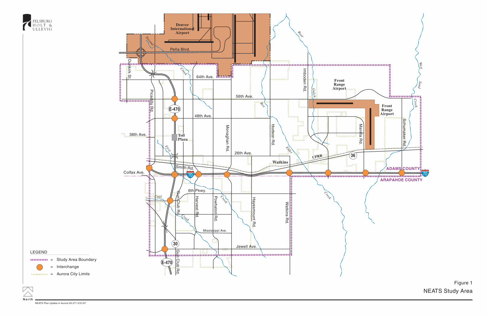
N o r t h
NEATS Study Area
FELSBURGH O L T &U L L E V I G
NEATS Plan Update in Aurora 05-271 5/31/07
Figure 1
FrontRange
Airport
FrontRange
Airport
DenverInternational
Airport
Peña Blvd.
Jewell Ave.Gu
n C
lub
Rd
.
Wa
tkins R
d.
E-470
Pica
dilly R
d.
Pow
ha
ton
Rd
.
Haye
smo
un
t Rd
.
Hu
dso
n R
d.
Imb
od
en
Rd
.
Ma
nilla
Rd
.
Colfax Ave.
38th Ave.
56th Ave.
Smith Rd.
26th Ave.
E-470
6th Pkwy.
30
36
Mississippi Ave.
Gu
n C
lub
Rd
.
Du
nkirk S
t.
48th Ave.
Mo
na
gh
an
Rd
.
Ha
rvest R
d.
Sch
um
ake
r Rd
.64th Ave.
Watkins
70 70
Second
Creek
Box
Elder
Creek
Gulch
Bear
West
SandC
reek
First
Creek
Creek
Coal
UPRR
TollPlaza
ADAMS COUNTY
ARAPAHOE COUNTY
LEGEND
= Study Area Boundary
= Interchange
= Aurora City Limits

Northeast Area Transportation Study
Page 5
While freeways and other access-controlled facilities can increase mobility, freeways can also constrain continuity of perpendicular corridors. Their nature requires grade-separations at all locations where arterial and collector streets either interchange or cross. Thus, I-70 and E-470 also represent significant constraints to the development of an integrated and continuous arterial and collector roadway system. C. Developed Areas A substantial amount of development has taken place within the NEATS study area since the last NEATS report in 1999. Specifically the following has taken place:
1. Murphy Creek. A golf course and residential uses have occurred within this development located east of Gun Club along both sides of Jewell Avenue.
2. Cross Creek. Homes have been built east of Gun Club Road at Sixth Parkway. This
development has also included the extension of Sixth Parkway to the east.
3. Traditions and Adonea. These residential developments are located next to each other southeast of Sixth Parkway and Harvest Road. Both continue to develop.
Other areas within the NEATS study area are anticipated to develop in the near term (see Future Conditions for more information). D. Transportation Facilities The major roadway facilities currently in the study area are described as follows:
► I-70 – This is the major east-west freeway that passes through the Denver Metropolitan area. Through the NEATS study area, I-70 contains four through lanes with an interchange at E-470 (which also incorporates a connection to Gun Club Road and Colfax Avenue. Other interchanges are located further east at Aurora Airpark (approximately Monaghan Road), Watkins Road, and Manila Road.
► E-470 Tollway – This is the beltway facility around the eastern half of the Denver Metropolitan area. Within the NEATS Study Area, E-470 aligns north-south in close proximity to Gun Club Road. The beltway is a toll facility with four through lanes and interchanges at 64th Avenue, 56th Avenue, I-70 (which also incorporated a connection to Gun Club Road and Colfax Avenue), Sixth Parkway, and Jewell Avenue. A future interchange is planned at 48th Avenue. SH 30 and 26th Avenue currently cross-over E-470.
► 56th Avenue – This is a two-lane arterial road running east-west and serving as a southern employee access to DIA.

Northeast Area Transportation Study
Page 6
► Gun Club Road – As Sixth Avenue extends east from Airport Boulevard, it turns south and becomes Gun Club Road at approximately Mississippi Avenue. Currently, this is a two-lane roadway, but ultimately planned to be a four to six lane facility. There is also a three-mile stretch of Gun Club Road north of Mississippi Avenue to Colfax Avenue.
► Jewell Avenue – This facility provides a significant level of continuity to the west extending to Tower Road and becoming Iliff Avenue through Aurora and eventually Evans Avenue through Denver. Within NEATS, Jewell Avenue is unimproved east of Murphy Creek, and it extends as an unimproved roadway to Watkins Road.
► Watkins Road – This roadway provides two paved lanes for traffic south from the Watkins area as far south as Quincy Avenue (within the SEATS study area). With the connection via US 36 near the Town of Watkins, Watkins Road and Imboden Road provide the greatest level of north-south continuity within the NEATS study area.
Figure 2 shows the existing conditions for NEATS roadways. Currently, most roadways within the study area are two-lane roads other than I-70 and E-470 which are both four-lane facilities. Figure 2 also shows daily traffic volumes for roadways where the data are readily available. I-70 and E-470 carry 30,000 to 40,000 vehicles per day and are by far the heaviest traveled roadways in the study area. Gun Club Road, also SH 30, serves over 16,000 vehicles per day near Jewell Avenue, and Jewell Avenue itself carries around 8,000 vehicles per day. All other roadways in the study area carry far less traffic based on available data. Transit service is scarce within the NEATS study area. The Regional Transportation District (RTD) currently provides the Gateway Call-n-Ride which runs as far east as Picadilly Road. The RTD service area extends as far east as Box Elder Creek (approximately Hudson Road). However, south of I-70, the RTD district boundary is approximately located in the vicinity of Picadilly Road. Much of the NEATS study area south of I-70 lies outside the current RTD district. There are no known existing trails within the NEATS study area.

N o r t h
Existing NEATS Roadway Conditions
FELSBURGH O L T &U L L E V I G
NEATS Plan Update in Aurora 05-271 5/31/07
Figure 2
DenverInternational
Airport
Peña Blvd.
= Number of Through Lanes
= Average Daily Traffic
= Interchange
= Tollway
= Freeway
= Aurora City Limits
LEGEND
X
XXXX
70 70
Jewell Ave.
Yale Ave.
Gu
n C
lub
Rd
.
Wa
tkins R
d.
E-470
Pica
dilly R
d.
Pow
ha
ton
Rd
.
Mo
na
gh
an
Rd
.
Haye
smo
un
t Rd
.
Hu
dso
n R
d.
Imb
od
en
Rd
.
Ma
nilla
Rd
.
Colfax Ave.
38th Ave.
56th Ave.
Smith Rd.
26th Ave.
E-470
Mississippi Ave.
64th Ave.
Watkins
Second
Creek
Box
Elder
Creek
Gulch
Bear
West
SandC
reek
First
Creek
Creek
Coal
UPRR
FrontRange
Airport
TollPlaza
FrontRange
Airport
ADAMS COUNTY
ARAPAHOE COUNTY
4
2
2
2
2
4 4
4
2
2
2
2
4
2
2
2
2
38,300 23,200
20001500
16,200
1000
3000
4000
30,000
300
3000
1000
6000
8000
21,000

Northeast Area Transportation Study
Page 8
III. FUTURE CONDITIONS A. Land Use One of the key input considerations for the travel demand model includes the magnitude and nature of households and employment by Transportation Analysis Zone (TAZ). Several sources were considered in developing the 2030 land use data to develop travel demand forecasts including:
► Development proposals and known development planning efforts
► Forecasted land use data developed by DRCOG for the regional travel demand model
► Forecasted land use data developed by City staff All three sources were considered on a TAZ by TAZ basis in developing the NEATS model land use. Most of the data used in this analysis were the DRCOG forecasts with several exceptions including:
► Transport Area (south of Front Range Airport) – DRCOG employment numbers were reallocated between TAZ’s in this area, but totals for the area were in-line with anticipated development levels. At build out (which is anticipated to be post 2030). Transport could generate as much as 140,000 vehicle-trips per day when built out.
► Various changes to land use were made to areas within the SEATS study area to reflect actual approved development and master plans such as Sorrel Ranch, Pomeroy, High Plains and Southshore.
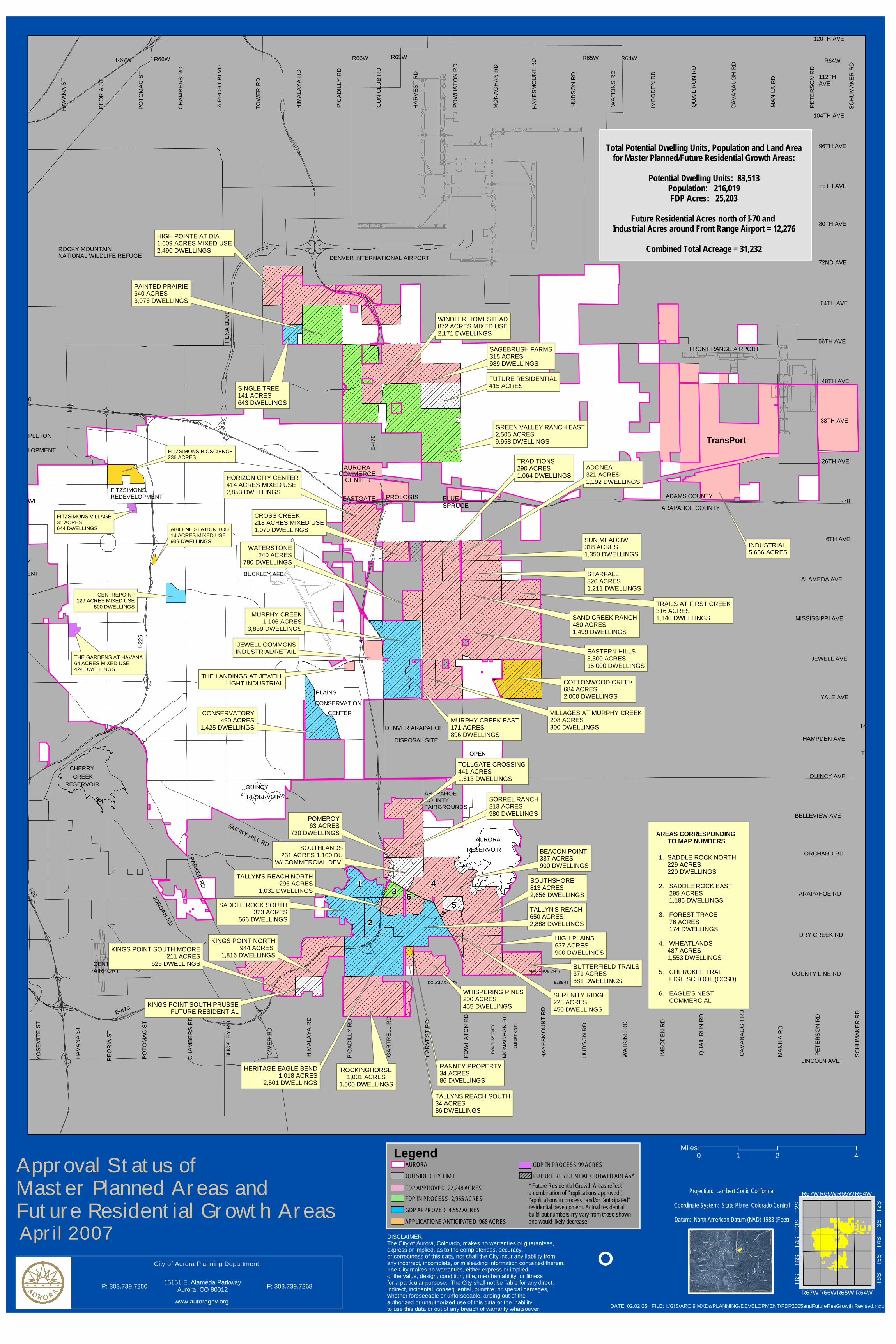
The Appendix shows the most recent City-approved master development plan areas. The larger master plan areas within the NEATS study area include:
► Eastern Hills – 15,000 homes
► Green Valley Ranch East – 9960 homes
► Murphy Creek – 3840 homes
► High Pointe at DIA – 1610 acres of mixed use including 2490 homes
► Horizon City Center – 503 acres of mixed use including 3730 homes
Other developments are also in the process of being approved. Of note is Transport near the Front Range Airport which is planning for 5400 acres of business-related uses. Current plans suggest approximately 7.8 million square feet of office space, 1.6 million square feet of retail space, and 4,500 acres dedicated to various industrial uses. Clearly, the level of development anticipated for the NEATS study area is significant.

Northeast Area Transportation Study
Page 9
The TAZ map and the associated land use numbers used in this analysis are presented in the Appendix. B. Roadway Network A base roadway network was coded into the model, and this is also shown in the Appendix. Embellishments beyond DRCOG’s regional 2030 model include:
► The addition of a north-south four-lane arterial one-half mile east of Picadilly Road between 26th and 64th Avenues.
► Establishing Gun Club Road as a four-lane facility (north of Jewell) and extending the roadway north to 64th Avenue.
► Establishing Powhaton Road as a north-south six-lane arterial road from Jewell Avenue up to 64th Avenue.
► Establishing Colfax Avenue as a four-lane minor arterial between Picadilly Road and Powhaton Road.
► Establishing four-lane east-west collectors extending from Picadilly Road to Powhaton Road (grade-separated with E-470) between: • 64th and 56th Avenues, • 56th and 48th Avenues, • 48th and 38th Avenues, and • 38th and 26th Avenues.
► Adding an additional through lane in each direction along 56th Avenue from E-470 to
Monaghan Road to establish a six-lane arterial facility extending throughout the study area.
► Extending Alameda Avenue and Mississippi Avenue east of Gun Club Road to Monaghan Road as four-lane minor arterials.
I-70 is represented in the model as a four-lane freeway and the E-470 Tollway is represented as a six-lane freeway with tolls that influence driver decisions on when and where to use the tollway. Major arterial roads represented in the model include Picadilly Road with six lanes, Sixth Parkway with six lanes, 56th Avenue with six lanes, Powhaton Road with six lanes, and Monaghan Road with six lanes.

Northeast Area Transportation Study
Page 10
C. Travel Demands Applying the model with the modifications indicated in the previous sections have produced a set of 2030 daily traffic projections that are presented in Figure 3. The model used in support of the I-70/E-470 Interchange Feasibility Study, with embellishments previously described was used in support of this effort. City planning staff administered the application of the model. Many of the NEATS study area arterial roadways are projected to carry a significant level of traffic. Roadway segments that are anticipated to see a strong concentration of traffic in 2030 include:
► Picadilly Road at I-70. Ultimately, Picadilly Road will interchange with I-70, displacing the current Colfax Avenue interchange with I-70. As the first interchange west of I-70/E-470 complex and given the relatively dense development planned nearby (southwest of I-70/E-470), this roadway will serve a significant amount of traffic.
► Harvest Road at I-70. With an interchange at this location (first one east of the I-70/E-470 complex), Harvest Road will be an attraction for access to the freeway system. 75,000 vehicles per day are projected onto Harvest Road south of I-70.
► Monaghan Road at I-70. Like Harvest Road, Monaghan Road has the potential to attract a significant amount of traffic due to its potential interchange with I-70. South of I-70, 46,000 vehicles per day are projected.
Beyond these high concentration areas, most of the arterial roads are projected to experience traffic levels in-line with urban environments. Between 20,000 vehicles per day and 50,000 vehicles per day are anticipated along most of the arterial network. Beyond the 2030 time frame, traffic volumes have the potential to increase further as the NEATS area reaches build out.

N o r t h
NEATS 2030 Daily Traffic Projections
FELSBURGH O L T &U L L E V I G
NEATS Plan Update in Aurora 05-271 6/15/07
Figure 3
DenverInternational
Airport
Peña Blvd.
Note: This plan does not necessarilyshow all needed 4-lane collector roads.Aurora will generally require majorcollectors at the mid-section lines.
70 70
Jewell Ave.
Gu
n C
lub
Rd
.
Wa
tkins R
d.
E-470
Pica
dilly R
d.
Ha
rvest R
d.
Pow
ha
ton
Rd
.
Mo
na
gh
an
Rd
.
Haye
smo
un
t Rd
.
Hu
dso
n R
d.
Imb
od
en
Rd
.
Ma
nilla
Rd
.
Colfax Ave.
38th Ave.
56th Ave.
Smith Rd.
26th Ave.
E-470
6th Ave.
Mississippi Ave.
AlamedaAve.
Du
nkirk S
t.
Qu
ail R
un
64th Ave.
SH 30
Gu
n C
lub
Rd
.
Sch
um
ake
r Rd
.48th Ave.
Watkins
Second
Creek
Box
Elder
Creek
Gulch
Bear
West
SandC
reek
First
Creek
Creek
Coal
UPRR
FrontRange
Airport
TollPlaza
FrontRange
Airport
Grade-Separated Crossingsof E-470 via Collector Roadway
Grade-Separated Crossingof I-70 via Collector Roadway
ADAMS COUNTY
ARAPAHOE COUNTY
= Daily Traffic in Thousands
= Tollways
= Freeways
= 8-Lane Arterials
= 6-Lane Arterials
= 4-Lane Minor Arterial
= 4-Lane Minor Arterial with Auxiliary Lanes
= 4-Lane Major Collector
= Other Roads
= Grade-Separated Crossing
= Roadway Interchange
= Aurora City Limits
LEGEND
XX
20
1520
15
12
28323845
40 45
25
30
35
25 30 25 15
32183015
18
45
20 20 15 12 1030
60
1050
70 2518
48
45
40
35
35
6035 30 15
25
25
23
81012
20 18 10
50
55
10
2520
30
35
6025
25
1212
2018
2025
15
281535
5
8
15
45
10
10
10 15
50
71
109
105
94
94 85 75 58
15
7357
69
Northeast Area Transportation Study
Page 12
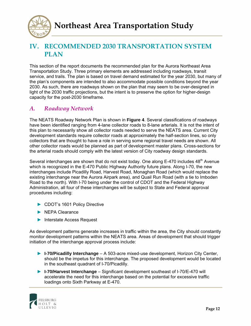
IV. RECOMMENDED 2030 TRANSPORTATION SYSTEM PLAN
This section of the report documents the recommended plan for the Aurora Northeast Area Transportation Study. Three primary elements are addressed including roadways, transit service, and trails. The plan is based on travel demand estimated for the year 2030, but many of the plan’s components are intended to also accommodate possible conditions beyond the year 2030. As such, there are roadways shown on the plan that may seem to be over-designed in light of the 2030 traffic projections, but the intent is to preserve the option for higher-design capacity for the post-2030 timeframe. A. Roadway Network The NEATS Roadway Network Plan is shown in Figure 4. Several classifications of roadways have been identified ranging from 4-lane collector roads to 8-lane arterials. It is not the intent of this plan to necessarily show all collector roads needed to serve the NEATS area. Current City development standards require collector roads at approximately the half-section lines, so only collectors that are thought to have a role in serving some regional travel needs are shown. All other collector roads would be planned as part of development master plans. Cross-sections for the arterial roads should comply with the latest version of City roadway design standards. Several interchanges are shown that do not exist today. One along E-470 includes 48th Avenue which is recognized in the E-470 Public Highway Authority future plans. Along I-70, the new interchanges include Picadilly Road, Harvest Road, Monaghan Road (which would replace the existing interchange near the Aurora Airpark area), and Quail Run Road (with a tie to Imboden Road to the north). With I-70 being under the control of CDOT and the Federal Highway Administration, all four of these interchanges will be subject to State and Federal approval procedures including:
► CDOT’s 1601 Policy Directive
► NEPA Clearance
► Interstate Access Request As development patterns generate increases in traffic within the area, the City should constantly monitor development patterns within the NEATS area. Areas of development that should trigger initiation of the interchange approval process include:
► I-70/Picadilly Interchange – A 503-acre mixed-use development, Horizon City Center, should be the impetus for this interchange. The proposed development would be located in the southeast quadrant of I-70/Picadilly.
► I-70/Harvest Interchange – Significant development southeast of I-70/E-470 will accelerate the need for this interchange based on the potential for excessive traffic loadings onto Sixth Parkway at E-470.

Northeast Area Transportation Study
Page 13
► I-70/Monaghan Interchange – Significant development south of I-70 will accelerate the need for this interchange based on the potential for excessive traffic loadings onto Sixth Parkway at E-470.
► I-70/Quail Run Interchange – The need for this interchange will be driven by the level of growth that takes place with the Transport development project at Front Range Airport.
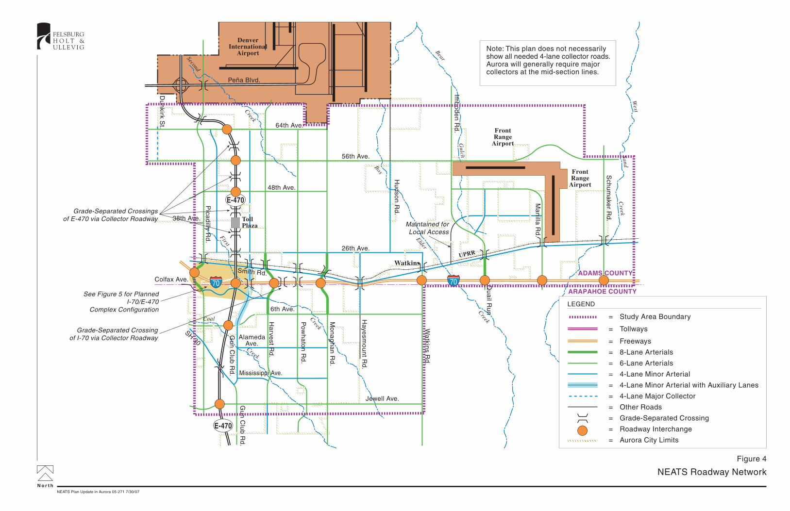
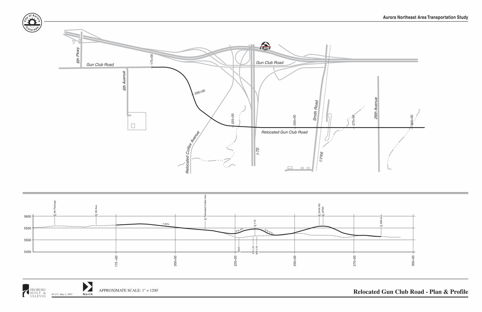
Planning for the I-70/E-470 interchange has recently taken place via CDOT’s 1601 Policy Directive and the NEPA process as represented by the I-70/E-470 Interchange Environmental Assessment (November 2006). The resulting preferred alternative from this process is characterized by the following:
► E-470 Mainline crossing over I-70 west of Gun Club Road.
► Direct ramp connections between all four directions of I-70 and E-470.
► The relocation of Gun Club Road to the east and Colfax Avenue to the south, with both being continuous through the interchange complex.
► Recognition of future interchanges at I-70/Picadilly Road and I-70/Harvest Road. Figure 5 shows the preferred alternative for the I-70/E-470 interchange. Roadway facilities within the NEATS study area are planned to predominantly be six-lane arterials on the section lines. Near the I-70 interchanges, Picadilly Road, Harvest Road, Monaghan Road, and Quail Run Road are proposed to be eight-lane sections given the high forecasted traffic volumes. Quail Run Road is shown to be an eight-lane arterial at I-70 not because of the 2030 traffic loading, but because it is recognized that Transport will not likely be built out by 2030; post-2030 traffic loadings will likely require the eight-lane section. Figure 4 also shows where grade-separated crossings will be needed. These include all facilities that will cross I-70 and E-470. Also recognized in the plan is the need to grade-separate the heavier traveled roads with the Union Pacific Railroad. Current railroad/roadway guidelines strongly encourage this, especially for new roadway construction. Potentially, an at-grade crossing may be acceptable if it can be clearly demonstrated as to why a grade-separation is impractical. However, this may be a challenge to demonstrate given the traffic increases and the potential greater rail activity in the future. The NEATS plan is showing 11 grade-separated crossings of the railroad line; these improvements represent significant costs, especially in light of the fact that they are located immediately adjacent to a cross-street (Smith Road/US 36). The additional challenge that this poses is the cross-street also needs to be raised or realigned to allow its continued intersection with the north-south roadway. This impacts the roadway/rail crossing’s construction cost and the ability of adjacent property to obtain access.
N o r t h
NEATS Roadway Network
FELSBURGH O L T &U L L E V I G
NEATS Plan Update in Aurora 05-271 7/30/07
Figure 4
DenverInternational
Airport
Peña Blvd.
Note: This plan does not necessarilyshow all needed 4-lane collector roads.Aurora will generally require majorcollectors at the mid-section lines.
70 70
Jewell Ave.
Gu
n C
lub
Rd
.
Wa
tkins R
d.
E-470
Pica
dilly R
d.
Ha
rvest R
d.
Pow
ha
ton
Rd
.
Mo
na
gh
an
Rd
.
Haye
smo
un
t Rd
.
Hu
dso
n R
d.
Imb
od
en
Rd
.
Ma
nilla
Rd
.
Colfax Ave.
38th Ave.
48th Ave.
56th Ave.
Smith Rd.
26th Ave.
E-470
6th Ave.
Mississippi Ave.
AlamedaAve.
Du
nkirk S
t.
Qu
ail R
un
64th Ave.
SH 30
Gu
n C
lub
Rd
.
Sch
um
ake
r Rd
.
Watkins
= Study Area Boundary
= Tollways
= Freeways
= 8-Lane Arterials
= 6-Lane Arterials
= 4-Lane Minor Arterial
= 4-Lane Minor Arterial with Auxiliary Lanes
= 4-Lane Major Collector
= Other Roads
= Grade-Separated Crossing
= Roadway Interchange
= Aurora City Limits
LEGEND
Second
Creek
Box
Elder
Creek
Gulch
Bear
West
SandC
reek
First
Creek
Creek
Coal
UPRR
FrontRange
Airport
TollPlaza
FrontRange
Airport
Grade-Separated Crossingsof E-470 via Collector Roadway
Grade-Separated Crossingof I-70 via Collector Roadway
See Figure 5 for Planned I-70/E-470
Complex Configuration
Maintained forLocal Access
ADAMS COUNTY
ARAPAHOE COUNTY
N o r t h
I-70/E-470 Interchange Preferred Alternative
FELSBURGH O L T &U L L E V I G
NEATS Plan Update in Aurora 05-271 7/30/07
Figure 5

Northeast Area Transportation Study
Page 16
City street cross-section standards are shown in the City’s Roadway Design and Construction Specifications. The City has also recently adopted a set of Urban Street Standards for urban centers and Transit-Oriented Development (TOD) areas. These are not specifically shown in this report, so the reader is referred to the above document. General characteristics of study area cross-sections include:
► Six-Lane Arterial – Three through lanes in each direction, a center median area capable of accommodating two lanes (possibly dual left turn lanes), and 10-foot detached sidewalks along both sides of the roadway. The landscape width between the curb and sidewalk is of adequate width that it could accommodate an additional lane (possibly a right turn lane). An eight-lane arterial would be identical with an additional 24 feet of pavement and right-of-way.
► Four-Lane Arterial – Two through lanes in each direction, a center median area capable of accommodating one lane (possibly a left turn lane), bike lanes along both sides of the street, and 8-foot detached sidewalks along both sides of the roadway. The landscape width between the curb and sidewalk is of adequate width that it could accommodate an additional lane (possibly a right turn lane).
► Four-Lane Collector - Two through lanes in each direction, bike lanes along both sides of the street, and 5-foot detached sidewalks along both sides of the roadway.
► Two-Lane Collector - One through lane in each direction, bike lanes along both sides of the street, parking lanes along both sides of the street, and 5-foot detached sidewalks along both sides of the roadway.
► Local – There are several versions of Local Streets, but they generally include one moving lane in each direction, parking lanes along both sides of the street, and 5-foot detached sidewalks along both sides of the roadway.
B. Transit and Trails Transit Service Both the Transit and Trails elements are shown in Figure 6. The transit component defines areas where new transit service should be considered as well as the potential for major transit corridors. Basic bus service provided by RTD should be expanded east as development occurs and conditions warrant. Two levels of expansion have been developed, one which entails regular fixed route service extended from current routes today. This fixed-rate “shading” also covers those areas where development levels might be substantial enough to warrant such service. The other level reflects development being on the fringes of the urbanized area and would entail a less-frequent service such as call-n-ride fixed route peak period service. Potentially, service could also be tied to possible express routes or Sky Ride routes that could utilize E-470. The feasibility of expanding transit service to newly developed areas will need to be determined by RTD on a continuous basis as development occurs.
N o r t h
NEATS Trails & Transit Components
FELSBURGH O L T &U L L E V I G
NEATS Plan Update in Aurora 05-271 6/18/07
Figure 6
FrontRange
Airport
FrontRange
Airport
DenverInternational
Airport
Peña Blvd.
Optional Alignment
70 70
Jewell Ave.Gu
n C
lub
Rd
.
Wa
tkins R
d.
E-470
Pica
dilly R
d.
Pow
ha
ton
Rd
.
Haye
smo
un
t Rd
.
Hu
dso
n R
d.
Imb
od
en
Rd
.
Ma
nilla
Rd
.
Colfax Ave.
38th Ave.
56th Ave.
Smith Rd.
26th Ave.
E-470
6th Pkwy.
30
36
Mississippi Ave.
Gu
n C
lub
Rd
.
Du
nkirk S
t.
48th Ave.
Mo
na
gh
an
Rd
.
Ha
rvest R
d.
Sch
um
ake
r Rd
.
64th Ave.
Watkins
Second
Creek
Box
Elder
Creek
Gulch
Bear
West
SandC
reek
First
Creek
Creek
Coal
UPRR
TollPlaza
ADAMS COUNTY
ARAPAHOE COUNTY
LEGEND
= Future Rapid Transit
= Park-n-Ride; Precise Location to be Determined
= Trail Corridor (Alignments not Exact)
= Grade Separated Trail Crossing
= Current RTD Service Area
= Fixed Route Suburban Transit Service
= Limited/Non-Fixed Route Transit Service(Call-n-Ride)
= Roadway Interchange
= Study Area Boundary
= Aurora City Limits

Northeast Area Transportation Study
Page 18
RTD service to the NEATS Study area south of I-70 will require an expansion of the RTD service area boundary. Currently, a significant amount of Aurora land areas, including a dozen approved Framework Development Plans, is outside the Regional Transportation District (RTD) boundary. By current state statute, these land areas must go through a petition and election process in order to be annexed into RTD. In addition, only registered electors who reside within the geographic boundaries of the land areas are considered to be “eligible electors” for such an election. Property owners are not eligible to sign the petition or to vote. The Aurora City Council has supported on-going coordination with developers and property owners to explore the potential of annexing their lands into RTD. Currently, the 2007 State Legislature has approved a bill that amends the state statute regarding the RTD annexation process. House Bill 07-1186 will allow property owners to submit annexation petitions to the RTD Board for joining the RTD and obtaining necessary transit services. This will significantly simplify the process for bringing areas into the RTD service area. This bill was recently signed by the governor. Park-n-Ride facilities are shown on the plan at strategic cross-street locations including E-470/56th Avenue, E-470/I-70 (which is already planned to be part of the Horizon City Center development), E-470/Jewell, and possibly at Jewell/Monaghan. Exact locations will need to be further assessed by RTD. Longer-term transit service (post 2030) could potentially include rapid transit. The median within E-470 has been identified for a future rapid transit facility, exact nature unknown at this time. Jewell Avenue and the Smith Road corridor have also been identified for possible rapid transit service extending into the NEATS area from the west. RTD is currently in the early stages of identifying a “Fastracks Two” program for consideration that includes these elements. At this time, the City should ensure that these corridors are preserved for the potential of rapid transit service in the future. Trails Planning for the trails element was coordinated with the Parks and Open Space Department’s preliminary concept for long-term development of a trail system within the study area. Trail facilities are planned along E-470 and along major drainageways. Other facilities are also planned that connect those planned along drainageways. On-street bike lanes and sidewalks are currently incorporated in the City’s roadway standards as presented in the previous section. Collector and local roads planned as part of the development will further supplement the trails shown in Figure 6 via their sidewalk and bike lane components. Updates to the transportation system plan may be warranted as long-range planning for trails in the city continues and the Parks and Open Space Department refines its vision. Readers should consult with the department for the latest plans. The trails component also shows locations where grade-separated crossings should be provided. These were generally determined through assessing the nature of the trail (regional or local) and of the roadway it crosses. With many of the trails following drainage-ways, another

Northeast Area Transportation Study
Page 19
consideration in making a determination for a crossing is the nature of the drainageway’s crossing of the road. Since the drainage will always cross below the street, a final assessment can be made at the time of design to determine if the marginal cost to also accommodate a trail grade-separation is prudent for a particular location. C. Plan Improvement Costs The NEATS Transportation Plan lays out the transportation requirements needed to serve future demands based on forecasted 2030 land uses and beyond. The more significant element of this plan includes the roadway system. Approximated gross unit costs were used and applied to the improvements as a means to develop conceptual-level cost estimates to see the roadway component come to fruition. The following gross unit costs have been used:
► New/widened Arterial Roadways - $1.5 million per lane-mile.
► New/widened Freeway - $3.5 million per lane mile.
► New Interchange - $15 million each.
► New Rail Road Grade-separated crossing (and Smith Road elevation) - $7 million each. Freeway and arterial lane-miles were extracted from the travel demand model for 2005 and for the 2030 time-frames. From this and from the plan shown on Figure 4, the following gross quantities have been estimated:
► 21 new freeway lane-miles (all E-470, see text)
► 520 new arterial lane-miles.
► 8 interchanges (includes I-70/Watkins Road assuming that this would need to be re-built to accommodate increased demands).
► 10 Grade-separated railroad crossings From these estimates, the roadway element of the NEATS plan is estimated to cost approximately $1.0 billion in 2006 dollars. The I-70/E-470 interchange complex alone is estimated to cost $150 million (but this does include new interchanges at Picadilly and at Harvest) resulting in a total estimated cost of approximately $1.1 billion. Some of these costs would be invested along E-470 (one interchange and all 21 lane-miles of freeway) which would likely be funded by the E-470 Public Highway Authority. However, there would still be $1.0 billion that would need to funded by other entities. This estimate range does not account for additional collector and local roadways that will also need to be constructed as part of individual developments. East-west collector roads extending between Picadilly Road and Powhaton Road, with accompanying grade-separated crossing of E-470, would add an additional $60 to $70 million to the total NEATS costs.

Northeast Area Transportation Study
Page 20
D. Priorities and Funding The NEATS Plan elements identified in Figures 4 and 6 are intended to provide a “target” in terms of the direction the City should take in serving long-term travel demands extended out to the year 2030 and beyond. Seeing the plan come to fruition will take time and a variety of funding sources. Priorities will be governed largely by the pattern of development that takes place within the NEATS study area. The development community should take on a portion of the improvements as development occurs, but the City should also look to acquire funding through the DRCOG Transportation Improvement Program (TIP) process for improvement projects that have a strong potential to qualify for federal funding. One of the critical “categories” of improvements will be the addition of interchanges and overpasses of I-70 and E-470 as development occurs. The need for I-70 interchanges will be driven largely by growth in the NEATS area, particularly adjacent to I-70. In considering an interchange for Harvest Road and Monaghan Road, the ability to construct the same road(s) across the Union Pacific Railroad should be a factor toward weighing the need for the interchange. If a grade-separated crossing of the railroad becomes problematic and the interchange is not critical, then it may not be a priority. Given that there is significant development planned around the I-70/E-470 interchange, provision for an additional freeway access and roadway continuity across the freeways needs to be a priority. Toward this end, establishing continuity along Harvest Road and constructing an interchange with I-70 will be a priority. Additionally, the construction of the Sixth Avenue Parkway across Coal Creek takes on more significance as the areas around I-70 and E-470 develop. As the Transport area continues to grow, providing for functional access to I-70 will become critical. Provision for a new interchange at Quail Run Road and its alignment into Imboden Road north of I-70 needs to be a priority development within the Transport area. Development plans are also occurring further north near 56th Avenue and 48th Avenue east of E-470. As the development of this area continues, the widening of 56th Avenue becomes more critical and the establishment of 48th Avenue and its interchange with E-470 becomes key depending on the exact nature of development growth. These too will likely be priorities if this area develops quickly. As part of assessing needs, traffic impact studies for individual developments should assess a broader study area than typically analyzed in the past. Typically, these types of studies assess roadways and intersections immediately adjacent to a development. In the interest of gaining understanding of a development’s traffic impact to a particular interchange or grade-separated crossing, a traffic study’s analysis area should be expanded at the discretion of City staff. For those developments that are taking place in areas where adequate roadway infrastructure is still lacking, the City may want to adopt a policy requiring “off-site” improvements up-front to ensure adequate transportation facilities are in place.

Northeast Area Transportation Study
Page 21
As development proceeds, reimbursement for off-site improvements could be offered to the initial developer. The added role of a traffic study for the more remote development proposals would be to identify these up-front off-site improvement needs and begin to set the stage for a phased sub-area transportation plan and identify appropriate funding and phasing. Improvements like interchanges and grade-separated crossings need to be among the off-site improvements considered as part of this process. In addition, the City has commissioned the Development Cost Study which will focus in part on identifying development related infrastructure needs and associated funding alternatives. This too could be a part of the solution relative to identifying funding sources for needed transportation projects.

Northeast Area Transportation Study
Appendix
APPENDIX APPROVAL STATUS OF MASTER PLANNED AREAS & FUTURE RESIDENTIAL
GROWTH AREAS, APRIL 2007 TRANSPORTATION ANALYSIS ZONE MAP
2030 LAND USE DATA 2030 MODEL ROADWAY NETWORK 2030 LANE-MILES GUN CLUB ROAD PLAN & PROFILE HARVEST ROAD PLAN & PROFILE IMBODEN ROAD PLAN & PROFILE PICADILLY ROAD PLAN & PROFILE
April 2007
Approval Status of Master Planned Areas and Future Residential Growth Areas
DATE: 02.02.05 FILE: I:/GIS/ARC 9 MXDs/PLANNING/DEVELOPMENT/FDP2005andFutureResGrowth Revised.mxd
0 2 41Miles
Projection: Lambert Conic ConformalCoordinate System: State Plane, Colorado CentralDatum: North American Datum (NAD) 1983 (Feet)
Ellipsoid: Clark 1866
City of Aurora Planning Department
15151 E. Alameda ParkwayAurora, CO 80012P: 303.739.7250 F: 303.739.7268
www.auroragov.org
ADAMS COUNTY
E-47
0E-
470
38TH AVE
56TH AVE
64TH AVE
96TH AVE
I-70
PENA
BLVD
COLFAX AVE
SMOKY HILL RD
CAVA
NAUG
H RD
PARKER RD
E-470
I-25
I-225
YOSE
MITE
ST
CHERRY
STAPLETON
FITZSIMONSREDEVELOPMENT
ROCKY MOUNTAINNATIONAL WILDLIFE REFUGE
REDEVELOPMENT
BUCKLEY AFBREDEVELOPMENTLOWRY
RESERVOIR
CREEKRESERVOIR
DENVER INTERNATIONAL AIRPORT
FRONT RANGE AIRPORT
HAVA
NA ST
PEOR
IA ST
CHAM
BERS
RD
BUCK
LEY R
D
TOW
ER R
D
HIMA
LAYA
RD
PICAD
ILLY
RD
JORDAN RD
POTO
MAC
ST
GART
RELL
RD
HARV
EST R
D
POWH
ATON
RD
MONA
GHAN
RD
HAYE
SMOU
NT R
D
WATK
INS
RD
HUDS
ON R
D
IMBO
DEN
RD
QUAIL
RUN
RD
CAVA
NAUG
H RD
MANI
LA R
D
PETE
RSON
RD
LINCOLN AVE SCHU
MAKE
R RD
HAMPDEN AVE
QUINCY AVE
BELLEVIEW AVE
ORCHARD RD
ARAPAHOE RD
DRY CREEK RD
COUNTY LINE RDT6S
T5S
T4S
T5S
YALE AVE
JEWELL AVE
MISSISSIPPI AVE
ALAMEDA AVE
I-70
6TH AVE
26TH AVE
48TH AVE
72ND AVET2S
T3S
80TH AVE
88TH AVE
SCHU
MAKE
R RD
PETE
RSON
RD
MANI
LA R
D
QUAIL
RUN
RD
IMBO
DEN
RD
WATK
INS
RD
HUDS
ON R
D
R64WR65W R64W
112THAVE
120TH AVE
104TH AVE
HAYE
SMOU
NT R
D
MONA
GHAN
RD
POWH
ATON
RD
HARV
EST R
D
GUN
CLUB
RD
PICAD
ILLY
RD
HIMA
LAYA
RD
TOW
ER R
D
AIRPO
RT B
LVD
CHAM
BERS
RD
POTO
MAC
ST
PEOR
IA ST
HAVA
NA ST
R66W R65WR66WR67W
DOUG
LAS
CNTY
DOUGLAS CNTY ELBERT CNTY
ELBE
RT C
NTY
ARAPAHOE CNTY
ARAPAHOE COUNTY
RESERVOIRAURORA
CENTENNIALAIRPORT
ARAPAHOECOUNTYFAIRGROUNDS
OPEN SPACE
DISPOSAL SITEDENVER ARAPAHOE
CENTERCONSERVATIONPLAINS
QUINCYT6
ST2
ST3
ST4
ST6
S
T2S
T3S
T4S
T5S
T6S
R66W
R64WR65WR66WR67W
R64WR65WR67W
HIGH POINTE AT DIA1.609 ACRES MIXED USE2,490 DWELLINGS
SINGLE TREE 141 ACRES643 DWELLINGS
WINDLER HOMESTEAD872 ACRES MIXED USE2,171 DWELLINGS
FUTURE RESIDENTIAL415 ACRES
GREEN VALLEY RANCH EAST2,505 ACRES9,958 DWELLINGS TransPort
INDUSTRIAL5,656 ACRES
BLUE SPRUCE
PROLOGIS
AURORA COMMERCE
CENTER
EASTGATE
CROSS CREEK218 ACRES MIXED USE1,070 DWELLINGS
STARFALL320 ACRES1,211 DWELLINGS
ADONEA321 ACRES1,192 DWELLINGS
TRADITIONS290 ACRES1,064 DWELLINGS
TRAILS AT FIRST CREEK316 ACRES1,140 DWELLINGSSAND CREEK RANCH
480 ACRES1,499 DWELLINGS
EASTERN HILLS3,300 ACRES15,000 DWELLINGS
MURPHY CREEK EAST171 ACRES896 DWELLINGS
MURPHY CREEK1,106 ACRES
3,839 DWELLINGS
JEWELL COMMONSINDUSTRIAL/RETAIL
CONSERVATORY490 ACRES
1,425 DWELLINGS
TOLLGATE CROSSING441 ACRES1,613 DWELLINGS
SORREL RANCH213 ACRES980 DWELLINGSPOMEROY
63 ACRES730 DWELLINGS
TALLYN'S REACH NORTH296 ACRES
1,031 DWELLINGSSADDLE ROCK SOUTH
323 ACRES566 DWELLINGS
KINGS POINT NORTH944 ACRES
1,816 DWELLINGSKINGS POINT SOUTH MOORE211 ACRES
625 DWELLINGS
KINGS POINT SOUTH PRUSSEFUTURE RESIDENTIAL
HERITAGE EAGLE BEND1,018 ACRES
2,501 DWELLINGSROCKINGHORSE
1,031 ACRES1,500 DWELLINGS
TALLYN'S REACH650 ACRES2,888 DWELLINGS
WHISPERING PINES200 ACRES455 DWELLINGS
SOUTHLANDS231 ACRES 1,100 DU
W/ COMMERCIAL DEV.
SERENITY RIDGE225 ACRES450 DWELLINGS
BUTTERFIELD TRAILS371 ACRES881 DWELLINGS
HIGH PLAINS637 ACRES900 DWELLINGS
SOUTHSHORE813 ACRES2,656 DWELLINGS
BEACON POINT337 ACRES900 DWELLINGS
1
2
34
5
AREAS CORRESPONDING TO MAP NUMBERS
1. SADDLE ROCK NORTH 229 ACRES 220 DWELLINGS2. SADDLE ROCK EAST 295 ACRES 1,185 DWELLINGS3. FOREST TRACE 76 ACRES 174 DWELLINGS4. WHEATLANDS 487 ACRES 1,553 DWELLINGS5. CHEROKEE TRAIL HIGH SCHOOL (CCSD)6. EAGLE'S NEST COMMERCIAL
WATERSTONE240 ACRES
780 DWELLINGS
PAINTED PRAIRIE640 ACRES3,076 DWELLINGS
HORIZON CITY CENTER414 ACRES MIXED USE2,853 DWELLINGS
VILLAGES AT MURPHY CREEK208 ACRES800 DWELLINGS
SUN MEADOW318 ACRES1,350 DWELLINGS
Total Potential Dwelling Units, Population and Land Areafor Master Planned/Future Residential Growth Areas:Potential Dwelling Units: 83,513Population: 216,019FDP Acres: 25,203
Future Residential Acres north of I-70 and Industrial Acres around Front Range Airport = 12,276Combined Total Acreage = 31,232
°
SAGEBRUSH FARMS315 ACRES989 DWELLINGS
THE LANDINGS AT JEWELLLIGHT INDUSTRIAL
6
TALLYNS REACH SOUTH34 ACRES86 DWELLINGS
RANNEY PROPERTY34 ACRES86 DWELLINGS
FITZSIMONS BIOSCIENCE236 ACRES
FITZSIMONS VILLAGE35 ACRES644 DWELLINGS ABILENE STATION TOD
14 ACRES MIXED USE939 DWELLINGS
CENTREPOINT129 ACRES MIXED USE
500 DWELLINGS
THE GARDENS AT HAVANA64 ACRES MIXED USE424 DWELLINGS
COTTONWOOD CREEK684 ACRES2,000 DWELLINGS
DISCLAIMER: The City of Aurora, Colorado, makes no warranties or guarantees,express or implied, as to the completeness, accuracy,or correctness of this data, nor shall the City incur any liability from any incorrect, incomplete, or misleading information contained therein. The City makes no warranties, either express or implied, of the value, design, condition, title, merchantability, or fitness for a particular purpose. The City shall not be liable for any direct, indirect, incidental, consequential, punitive, or special damages,whether foreseeable or unforseeable, arising out of the authorized or unauthorized use of this data or the inability to use this data or out of any breach of warranty whatsoever.
Legend
FDP APPROVED 22,248 ACRES
AURORAOUTSIDE CITY LIMIT
FDP IN PROCESS 2,955 ACRESGDP APPROVED 4,552 ACRESAPPLICATIONS ANTICIPATED 968 ACRES
* Future Residential Growth Areas reflect a combination of "applications approved", "applications in process" and/or "anticipated"residential development. Actual residential build-out numbers my vary from those shown and would likely decrease.
FUTURE RESIDENTIAL GROWTH AREAS*GDP IN PROCESS 99 ACRES
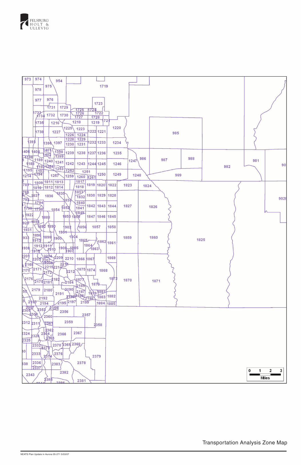
Transportation Analysis Zone Map
NEATS Plan Update in Aurora 05-271 5/03/07
FELSBURGH O L T &U L L E V I G

2030 Land Use DataNEATS/SEATS UPDATELand Use Comparison
NEATS/SEATS Modelling EffortTAZ ID EMP HH EMP HH Comments EMP HH
979 30501 300 417 300 417980 30502 82 197 82 197981 30505 101 108 101 108982 30506 1604 4875 Bennett - County capacity 1604 4875985 30509 416 603 416 603987 30511 1690 2 4614.4 0 Front Range Airport 1690 2988 30512 2657 0 1271 0 Front Range Airport 2657 0989 30513 2315 124 1022.4 13.4 Front Range Airport 2315 124
1218 31303 577 0 518.8 168.2 Too Close to DIA for HH's? 577 01220 31305 478 0 478 01221 31306 31 0 19.7 0 31 01222 31307 708 0 144.7 0 708 01223 31308 1565 88 951.3 308.5 High Pointe at DIA 1565 3001224 31309 792 548 993.5 318.9 792 5481229 31314 2052 741 1469.9 492 Windler Homestead 2052 7411231 31316 831 760 908.1 392.8 Windler Homestead 831 7601232 31317 3297 1248 251.6 72.1 Sagebrush 3297 12481233 31318 77 26 5.7 1.5 77 261234 31319 279 3 279 31235 31320 40 544 40 5441236 31321 19 59 1.4 3.4 19 591237 31322 361 2868 26.6 165.7 361 28681238 31323 52 1427 723 1328.5 Green Valley Ranch East 700 14271243 31328 58 765 78.1 485.6 58 7651244 31329 322 2631 24.3 152.2 Green Valley Ranch East 322 26311245 31330 74 48 2.7 2.8 74 481246 31331 7 0 0 0 7 01249 31334 152 547 49.7 145.3 152 5471250 31335 151 0 44.7 0 151 01251 31336 2738 143 3069.1 13 2738 1431260 31345 1380 225 766.6 0 Prologis 1380 2251261 31346 189 3 5.2 0 Blue Spruce 189 31721 41304 276 0 276 01722 41305 6673 0 6673 01726 41309 1040 0 1040 01727 41310 0 1 0 11728 41311 53 1 53 11730 41313 0 0 0 01817 50409 1150 482 1150 4821818 50410 2244 1388 1675.5 941.9 2244 13881819 50411 116 1749 13.3 463.5 116 17491820 50412 85 1219 1.8 194.1 Sky Ranch 85 12191821 50413 0 2 0 0.2 Sky Ranch 0 21822 50414 0 302 0 75.1 Sky Ranch 0 3021823 50415 2 23 0 5.8 2 231824 50416 35 55 35 551825 50417 393 2467 Big TAZ; Centroids. 393 24671826 50422 31 73 31 731827 50423 32 189 3.9 16.7 32 1891828 50424 29 524 19.5 84.1 29 5241829 50425 83 1772 69.2 297.6 Starfall 83 17721830 50426 74 1679 66.8 288.1 Traditions and Adonea 74 16491831 50427 1480 740 938.3 418.3 Cross Creek 1480 7401832 50428 71 221 30.9 80.1 71 2211833 50429 662 238 296.5 179.9 662 2381839 50435 19 1 7.6 0 19 11840 50436 8 31 8 311841 50437 9 66 0.1 20.3 9 661842 50438 77 1736 79.6 1465.3 77 17361843 50439 79 1790 82.2 1511.6 Eastern Hills, Sand Creek Ranch 79 17901844 50440 398 3278 81.4 1497.6 Eastern Hills, Trails at 1st Cr. 398 32781845 50441 380 3130 77.7 1429.2 Eastern Hills 380 31301846 50442 74 1679 77 1416.7 Eastern Hills 74 16791847 50443 95 1870 80.2 1477.8 Eastern Hills 95 18701848 50444 87 1191 63.3 417 Murphy Creek 87 11911849 50445 1 1075 0.6 130.5 Murphy Creek 1 10751850 50446 486 597 216.8 286.5 Murphy Creek 486 5971851 50447 1141 620 497.6 432.9 Jewell Commons 1141 6201855 50451 670 157 484.6 123.9 670 1571856 50452 32 1262 24.6 953.8 32 12621857 50453 151 3033 106.5 2315.6 151 30331858 50454 79 279 79 2791859 50455 103 1566 State Land Board 103 15661860 50456 76 123 76 1231861 50457 123 333 State Land Board 2378 128001862 50459 987 291 987 2911864 50460 55 146 55 1461865 50461 60 0 0.1 0 60 01866 50462 14 192 14 11501867 50463 14 216 14 2161868 50464 99 1531 Aurora Reservoir 99 15311869 50465 56 148 North of Aurora Reservoir 56 1481870 50466 0 2 0 21871 50467 5 0 5 01872 50468 81 225 State Land? 81 2251873 50469 154 1520 478.2 2051.1 Beacon Point, Southshore 154 15201874 50470 30 148 11.9 72.1 30 1481875 50471 146 860 457.7 907.8 Sorrel Ranch, Pomeroy 458 17001876 50472 76 262 208.7 256.2 Sorrel Ranch, Pomeroy 208 2621878 50473 381 1004 3419.7 1502.4 Wheatlands 381 12001879 50474 13 137 1403.4 1295.2 Southshore 95 12951880 50476 133 212 411.7 279.1 Southshore 412 2801881 50477 39 250 126.6 344.6 Southshore 127 3451882 50478 56 153 State Land? 56 1531883 50479 51 767 144.7 990.8 Southshore, High Plains 51 9911884 50480 64 466 156.2 523.6 High Plains 64 4661885 50481 0 2 0.5 1.6 Butterfield Trails 0 14431901 50516 21 462 12.6 172.2 Plains Conservation 21 4621903 50518 2309 670 789.9 410.7 2309 6702185 51421 112 987 125 981.1 Tallyns Reach North 112 9872186 51422 208 1403 346.9 752 Tallyns Reach 208 14032187 51423 50 1352 116.6 855.7 Tallyns Reach 50 13522188 51424 51 315 128.7 154.3 51 3152198 51434 9 55 0.5 40.3 9 552199 51435 39 910 38.6 109.1 Whisper Pines and Eagle Bend 39 9102209 23 1110 Copperleaf 23 11102210 355 1729 Copperleaf 355 17292356 170 964 90 861 From Douglas Co 170 9642357 278 1084 44 1397 From Douglas Co 278 13972358 289 419 52 1005 From Douglas Co 289 10052359 260 687 90 471 From Douglas Co 260 687
3/15/2006
* From City's land use estimation efforts, unless otherwise indicated.
DRCOG LU 2000-2030 Growth*

2030 Model Roadway Network
NEATS Plan Update in Aurora 05-271 5/03/07
FELSBURGH O L T &U L L E V I G
NEATS and SEATS Raw Model Network Lane-Miles
2005 2030 2005 2030Facility Type Lane-Miles Lane-Miles Lane-Miles Lane-MilesHighway 99.66 120.3 43.44 64.83Major Regional Arterial 4.18 0 15.72 15.72Principal Arterial 0 479.86 5.62 228.04Minor Arterial 67.52 111.7 40.84 35.58Collector 108.44 83.6 82.58 74.02Ramp 5.3 13.33 1.89 1.91Centroid Connector 112.64 119.76 90.7 88.226/21/2007
NEATS SEATS
05-271 May 3, 2007
Aurora Northeast Area Transportation Study
N o r t h
FELSBURGH O L T &U L L E V I G
Relocated Gun Club Road - Plan & Profile
Cit
y of Aurora
C
o l o r a d o
APPROXIMATE SCALE: 1" = 1200'
Rel
ocat
edC
olfa
xAv
enue
175
+00
225+
00
5500
5550
5450
5600
175+
00
200+00
225+
00
200+
00
275+
00
250+
00
300+
00
250+
00
275+
00
300+
0026th
Ave
nue
Gun Club Road
Sm
ith R
oad
UP
RRI-70
6th
Ave
nue
6th
Pkw
y.
Gun Club Road
Relocated Gun Club Road
WB
I-70
C LI-
70E
B I-
70
Ditc
h
C L6t
h A
ve.
C L6t
h P
arkw
ay
C LR
eloc
ated
Col
fax
Ave
.
C L26
th A
ve.C L
UP
RR
C LS
mith
Rd.
-1.00%
3 to 4% -3 to 4-%
E-470
05-271, NEATS, 1/11/07
Aurora Northeast Area Transportation Study
N o r t h
FELSBURGH O L T &U L L E V I G
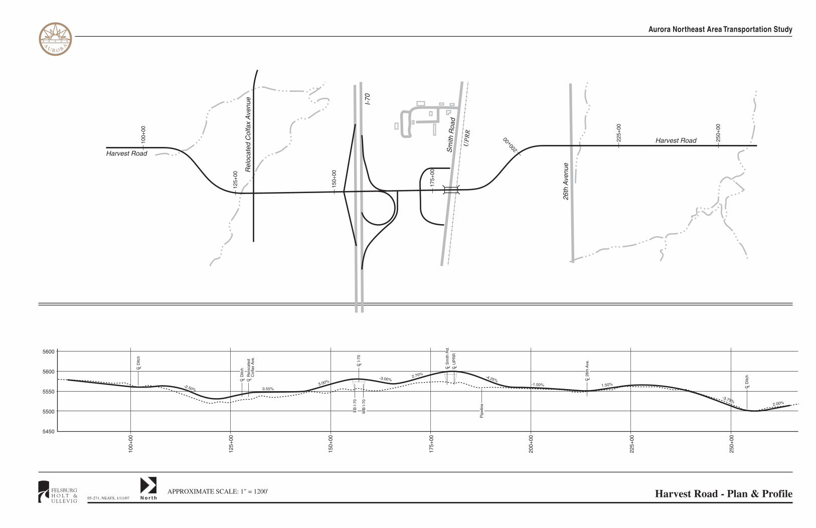
Harvest Road - Plan & ProfileAPPROXIMATE SCALE: 1" = 1200'
A
U R O R
A
Rel
ocat
ed C
olfa
x A
venu
e
Harvest Road100+
00
150+
00
200+
00 225+
00
250+
00
125+
00
175+
00
125+
00
175+
00
225+
00
5500
5550
5450
5600
100+
00
150+
00
200+
00
250+
00
5600
26th
Ave
nue
Sm
ith R
oad
UP
RR
I-70
Harvest Road
WB
I-70
C LD
itch
C LD
itch
C LI-
70E
B I-
70
C LS
mith
Rd.
C LU
PR
R
Pip
elin
e
C L26
th A
ve.
C LD
itch
2.00%-3.75%
1.50%-1.00%
-3.00%
0.55%-2.50%
-4.25%3.00%
2.70%
C LR
eloc
ated
Col
fax
Ave
.

05-271, NEATS, 1/11/07 N o r t h
FELSBURGH O L T &U L L E V I G
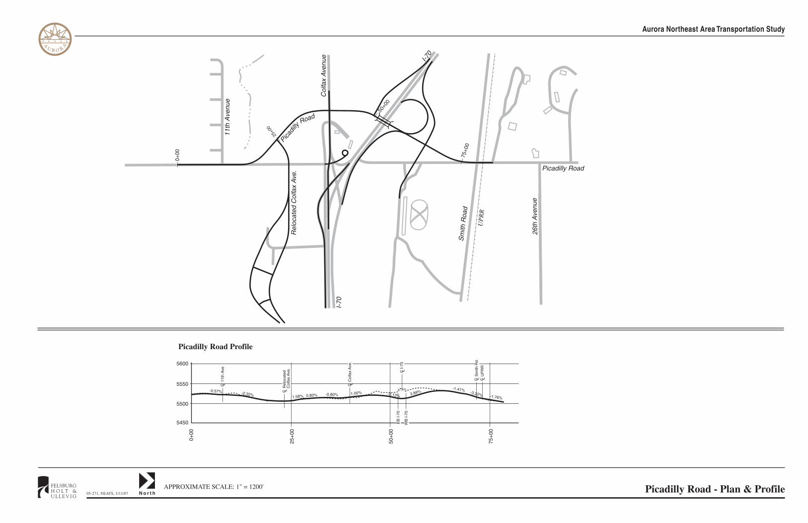
Picadilly Road - Plan & ProfileAPPROXIMATE SCALE: 1" = 1200'
Aurora Northeast Area Transportation Study
A
U R O R
A
Road
Rel
ocat
ed C
olfa
x A
ve.
Col
fax
Ave
nue
I-70
11th
Ave
nue
Picadilly Road
50+0
0
25+0
0
75+0
0
25+
00
50+
00
5500
5550
5450
75+
00
5600
0+00
0+00
Picadil
ly
I-70
26th
Ave
nue
Sm
ith R
oad
UP
RR
Picadilly Road Profile
1.58%-0.57%
WB
I-70
C LU
PR
R
C LR
eloc
ated
Col
fax
Ave
.
C LI-
70E
B I-
70
C LC
olfa
x A
ve.
C LS
mith
Rd.
-2.32% 0.80% -0.80% 1.00% -2.13% 3.89%-1.41% -3.22% -1.76%
C L11
th A
ve.

6300 S. Syracuse Way, Suite 600Centennial, CO 80111303.721.1440303.721.0832 faxwww.fhueng.com