august 12, 2011 - wredpwredp1.com/tiger/phaseiesa.pdf · august 12, 2011 denise steiger ......
TRANSCRIPT
August 12, 2011
Denise SteigerWickenburg Regional Economic Development Partnership510 W. Savage StreetWickenburg, AZ 85390
Atwell, LLC Project Number: 10001807
RE: Phase I ESA for the [building and property] located northwest of 436th Ave and USHighway 60, Maricopa County, Arizona (subject site)
Dear Ms. Steiger
Atwell, LLC is pleased to submit its report on the Phase I Environmental Site Assessmentconducted at the above referenced site.
The project objective was to perform a specified scope of research, evaluate the data, and rendera professional opinion on environmental conditions at the site. The information and opinionsincluded in this report are exclusively for the use of Wickenburg Regional EconomicDevelopment Partnership and the Town of Wickenburg.
We appreciate the opportunity to be of service to you on this project. Should you have anyquestions or desire further information, please contact us at (480) 218-8831.
Sincerely,ATWELL, LLC
Richard T. PetrusProject Manager
4700 East Southern Avenue, Mesa, AZ 85206 tel: 480-218-8831 fax: 480-830-4888 www.Atwell-Group.com

Phase I EnvironmentalSite Assessment Report
for the
Wickenburg/ForepaughW. US Highway 60/N. 436th Ave
Wickenburg, AZ 85390
Prepared For:
Wickenburg Regional Economic Development Partnership510 W. Savage Street
Wickenburg, AZ 85390
Atwell, LLC Project No. 10001897
08/12/2011
Powered By PARCEL

Table of Contents
Atwell, LLC
10001897
Acronyms & Abbreviations 1...........................................................................................................Detail Report 4..................................................................................................................................1.0 General Information 5................................................................................................................2.0 Executive Summary 7.................................................................................................................Current Use of Property 7...................................................................................................................
Database/Records Review 7................................................................................................................
Historical/Document Review 7...........................................................................................................
Site Reconnaissance Findings 7..........................................................................................................
Other Environmental Considerations 9...............................................................................................
Findings and Opinions 9.....................................................................................................................
Conclusions 12....................................................................................................................................
Suggested Actions to Address Business Environmental Risk 12........................................................
Disclaimer 12......................................................................................................................................
3.0 Introduction 14............................................................................................................................3.1 Purpose 14.....................................................................................................................................
3.2 Scope of Work 14..........................................................................................................................
3.3 Significant Assumptions 15..........................................................................................................
3.4 Limitations and Exceptions 15......................................................................................................
3.5 Deviations From the ASTM Standard 16......................................................................................
3.6 Special Terms and Conditions 16..................................................................................................
3.7 Reliance 16....................................................................................................................................
4.0 Site Description 16......................................................................................................................4.1 Location and Legal Description 16...............................................................................................
4.2 Site and Vicinity Description 16...................................................................................................
4.3 Current Use of Property 16...........................................................................................................
4.4 Description of Structures and Other Improvements 16................................................................
4.5 Current Adjoining Property Information 17.................................................................................
5.0 User Provided Information 17...................................................................................................5.1 Title Records 17............................................................................................................................
5.2 Environmental Liens and Activity/Use Limitations 17.................................................................
5.3 Specialized Knowledge 17............................................................................................................
5.4 Purchase Price and Market Value Comparison 17........................................................................
5.5 Valuation Reduction for Environmental Issues 17........................................................................
5.6 Owner, Property Manager, and Occupant Information 17............................................................
5.7 Reason For Performing Phase I 18...............................................................................................
6.0 Records Review 18......................................................................................................................6.1 Standard Environmental Records Sources 18...............................................................................
6.2 Additional Environmental Record Sources 19..............................................................................

Table of Contents
Atwell, LLC
10001897
6.3 Physical Setting Sources 19..........................................................................................................
6.4 Historical Use Information 20......................................................................................................
6.4.1 Historical Summary 20..............................................................................................................
6.4.2 City Directories 20.....................................................................................................................
6.4.3 Aerial Photos 22.........................................................................................................................
6.4.4 Sanborn/Historical Maps 23......................................................................................................
6.4.5 Other Environmental Reports 23...............................................................................................
7.0 Site Reconnaissance 24...............................................................................................................7.1 Methodology and Limiting Conditions 24....................................................................................
7.2 General Site Setting 25.................................................................................................................
7.3 Site Visit Findings 25....................................................................................................................
7.3.1 Hazardous Substances 25...........................................................................................................
7.3.2 Petroleum Products 25...............................................................................................................
7.3.3 USTs 25.....................................................................................................................................
7.3.4 ASTs 26......................................................................................................................................
7.3.5 Other Suspect Containers 26......................................................................................................
7.3.6 Equipment Likely to Contain PCBs 27......................................................................................
7.3.7 Staining/Corrosion 27................................................................................................................
7.3.8 Discharge Features 28................................................................................................................
7.3.9 Pits, Ponds, And Lagoons 29.....................................................................................................
7.3.10 Solid Waste Dumping/Landfills 30..........................................................................................
7.3.11 Stained Soil/Stressed Vegetation 30.........................................................................................
7.3.12 Wells 31....................................................................................................................................
8.0 Interviews 31................................................................................................................................9.0 Other Environmental Considerations 31..................................................................................9.1 Controlled Substances 31..............................................................................................................
9.2 Continuing Obligations 31............................................................................................................
9.3 Asbestos-Containing Materials 32................................................................................................
9.4 Lead-Based Paint 32.....................................................................................................................
9.5 Radon 32.......................................................................................................................................
9.6 Wetlands 32...................................................................................................................................
9.7 Mold Evaluation 32.......................................................................................................................
9.8 Items of Non-Compliance 32........................................................................................................
9.9 Client-Specific Items 32................................................................................................................
10.0 Phase I Findings/Opinions/Conclusions 32.............................................................................10.1 Report Findings and Opinions 32...............................................................................................
10.2 Conclusions 35............................................................................................................................

Table of Contents
Atwell, LLC
10001897
AppendicesAppendix A: References 36..............................................................................................................Appendix B: Qualifications 38.........................................................................................................Appendix C: Figures 43....................................................................................................................Appendix D: Photographs 47...........................................................................................................Appendix E: User Provided Information 76...................................................................................Appendix F: Historical Research Documentation 80....................................................................Appendix G: Regulatory Records Documentation 104.................................................................Appendix H: Records Documentation 176.....................................................................................Appendix I: Interview Documentation 181....................................................................................Appendix J: Miscellaneous Information 183..................................................................................

Acronyms and Abbreviations
AEC Atomic Energy Commission AIG American International Group AQCR Air quality control regions ARAR Applicable or relevant and appropriate requirement ARP Accidental Release Program AST Aboveground storage tank ASTM American Society for Testing and Materials BOD Biochemical oxygen demand BTU British thermal unit BTEX Benzene-toluene-ethylbenzene-xylene οC Degrees Celsius
CA California CAA (Federal) Clean Air Act CCME Canadian Council of Ministers of the Environment CDEP Connecticut Department of Environmental Protection CEPA Canadian Environmental Protection Act CERCLA (Federal) Comprehensive Environmental Response Compensation and Liability Act of 1980 CFC Chlorofluorocarbon C.F.R. Code of Federal Regulations CLP (EPA) Contract Laboratory Program CMHC Canada Mortgage and Housing Corporation CO Carbon monoxide CZMA (Federal) Coastal Zone Management Act DDT Dichloro diphenyl trichloro ethane DEC Department of Environmental Conversation (New York State) DEP Department for Environmental Protection (Florida; Massachusetts; New Jersey) DEPE Department of Environmental Protection and Energy (New Jersey) DEQ Department of Environmental Quality (Louisiana) DER Department of Environmental Resources (Pennsylvania) DMR Discharge Monitoring Report DI Deionized DNR Department of Natural Resources (Michigan) DOE (U.S.) Department of Energy DOH Department of Health (New York State) DOI (U.S.) Department of Interior DOL (U.S.) Department of Labor DOT (U.S.) Department of Transportation EIS Environmental Impact Statement EM Electromagnetic EP Extraction procedure EPA (U.S.) Environmental Protection Agency οF Degrees Fahrenheit
f/cc fibers per cubic centimeter Fed.Reg. Federal Register FID Flame ionization detector FOIA (Federal) Freedom of Information Act FWPCA Federal Water Pollution Control Act GC Gas chromatograph GC/MS Gas chromatography/mass spectrometry gal gallon

gph gallons per hour GPR Ground-penetrating radar H2S Hydrogen sulfide HA Halogenated aromatics HAP Hazardous air pollutant HCFC Hydrochlorofluorocarbons HCS (OHSA) Hazard Communication Standard HREC Historical Recognized Environmental Condition HRS Hazard Ranking System HSWA (Federal) Hazardous and Solid Waste Amendments of 1984 HWM Hazardous waste management (facilities) kPa kilopascal L liter LAER Lowest achievable emission rate LEL Lower explosive limit LNG Liquid natural gas LSP Licensed site professionals (Massachusetts) LUST Fund Leaking underground storage tank (petroleum) m3 cubic meter MCL Maximum contaminant level MCLG Maximum contaminant level goal MCP Massachusetts Contingency Plan MeV Million electron volts mg/l miligrams per liter ml milliliter MMS Minerals Management Service MS Mass spectrometry MSDS Material safety data sheet NFA No Further Action (letter) NGWA National Ground Water Association N02 Nitrogen dioxide Nox Nitrogen oxides NPDES National Pollutant Discharge Elimination System NPL National Priorities List NRC Nuclear Regulatory Commission O2 Oxygen O3 Ozone O&M Operating and maintenance ODCs Other direct costs OSHA Occupational Safety and Health Act OVA Organic vapor analyzer PCB Polychlorinated biphenyl PCi/l Picocuries per liter PEL Permissible airborne exposure level PID Photoionization detector POTW Publicly owned treatment works ppb parts per billion ppm parts per million PRPs Potentially responsible parties PSD Prevention of significant deterioration psi pounds per square inch

PVC Polyvinyl chloride QA Quality assurance QC Quality control R.A. Regional Administrator R&D Research and development RAP Remedial Assessment Plan RCP Response Claims Procedure RCRA (Federal) Resource Conservation and Recovery Act REC Recognized Environmental Condition rem Roentgen equivalent man [a measure of radiation] RI/FS Remedial Investigation & Feasibility Study RMP Risk management plan RMPP Risk Management and Prevention Programs ROD Record of Decision RQ Reportable quantity RUST Repair of Underground Storage Tank Program SARA (Federal) Superfund Amendments and Reauthorization Act of 1986 SDWA (Federal) Safe Drinking Water Act SEC Securities and Exchange Commission SOW Scope of work SPCC Plan Spill Prevention Control and Countermeasure Plan SPDES State Pollutant Discharge Elimination System (New York) SQG Small quantity generator SWDA (Federal) Solid Waste Disposal Act of 1965 SWMA Solid Waste Management Act (New Jersey) SWMU Solid waste management unit T Temperature TAT Turn-around time TBC To-be-considered (material) TCLP Toxicity characteristic leaching procedure TOC Total organic carbon TSCA (Federal) Toxic Substance Control Act UEL Upper explosive limit USGS United States Geological Survey UST Underground storage tank UV Ultraviolet vs. versus VCP Voluntary Cleanup VOA Volatile organic analyses VOC Volatile organic compound WQA (Federal) Water Quality Act

Detail Report

W. US Highway 60/N. 436th AveWickenburg, AZ
Wickenburg Regional Economic Development Partnership
1.0 General Information
Project Information:10001807-Wickenburg/Forepaugh -Wickenburg/Forepaugh10001897
Site Information:Wickenburg/ForepaughW. US Highway 60/N. 436th AveWickenburg, AZ 85390County: MaricopaLatitude, Longitude: 33.948700, -113.002700Site Access Contact: Denise Steiger
Consultant Information:Atwell, LLC4700 East Southern AvenueMesa, AZ 85206Phone: 480-218-8831Fax: 480-830-4888E-mail Address: [email protected] Date: 05/05/2011Report Date: 08/12/2011
Client Information:Wickenburg Regional Economic DevelopmentPartnershipDenise Steiger510 W. Savage StreetWickenburg, AZ 85390
Site Assessor:Keith A. Ross, R.G.Environmental Specialist III
Senior Reviewer:Richard T. PetrusProject Manager
General Notes:Atwell conducted the Phase I Environmental Site Assessment (ESA) in order to provide anindependent, professional opinion of the possible presence of Recognized Environmental Conditions(RECs) or other possible environmental concerns (if any) associated with the subject site as part ofenvironmental due diligence. An REC is defined as the presence or likely presence of any hazardous substance or petroleum producton a property under conditions that indicated an existing release, a past release, or a material threat of arelease of any hazardous or petroleum products into structures on the property or into the ground,groundwater, or surface water of the property. In accordance with the United States Environmental Protection Agency, 40 Code of FederalRegulations (CFR) Part 312, "All Appropriate Inquiry" (AAI), Atwell is providing the followingEnvironmental Professional (EP) declarations.
Atwell, LLC
10001897
Page 5 of 210

W. US Highway 60/N. 436th AveWickenburg, AZ
Wickenburg Regional Economic Development PartnershipEP Certification:
I declare that, to the best of my professional knowledge and belief, I meet the definition ofEnvironmental Professional as defined in 312.10 of this part.
Keith A. Ross, P.G. - Environmental Specialist III
AAI Certification:I have the specific qualifications based on education, training, and experience to assess a property ofthe nature, history, and setting of the subject property. I have developed and performed the allappropriate inquiries in conformance with the standards and practices set forth in 40 CFR Part 312.
Keith A. Ross, P.G. - Environmental Specialist III
Atwell, LLC
10001897
Page 6 of 210

W. US Highway 60/N. 436th AveWickenburg, AZ
Wickenburg Regional Economic Development Partnership
2.0 Executive SummaryCurrent Use of Property
The subject site consists of one former aircraft hanger and approximately 22 remnant concretefoundations/slabs identified as former barracks, offices and workshops/storage facilities located on thenorthern and eastern portions of the subject site. The western and southern portions of the subjectsite are undeveloped native desert land with scattered to dense native vegetation. The subject existingand former buildings occupy approximately 3 percent of the property.
Database/Records Review
Atwell retained EDR of Milford, Connecticut, to review federal, tribal, state and EDR proprietaryrecords related to the subject site and nearby properties within the ASTM approximate minimumsearch radius (as seen on the table below). However, Atwell typically reviews local, state, tribal orfederal database records of those sites of known environmental contamination (i.e., SHWS, LUST,CERCLIS, and NPL sites) within a one-quarter mile radius of the subject site. Atwell considers siteswithin this specified search radius as having the most potential to impact the subject site. Also, Atwelltypically reviews local, state, tribal or federal database records of those sites of suspectedenvironmental contamination (i.e., UST, Indian UST and RCRA generator sites), which adjoin thesubject site, or, in the professional opinion of Atwell, are of such nature and proximity to the subjectsite to represent RECs.
EDR did not identify any sites of known or suspect contamination located within one-quarter mile ofthe subject site. The EDR Radius Report with GeoChecklist Report is included in Appendix G.
Historical/Document Review
Based on information gathered during the site investigation, review of aerial photographs, review ofhistorical address indexes, and review of municipal records, Atwell concluded that the subject site waslikely undeveloped prior to development and use as a pilot training facility from approximately 1940 to1945. First as a glider pilot training (circa 1940 to 1942) (Arizona Gliding Academy) and then withpowered aircraft (circa 1942 to 1945) (Claiborne Flight Academy) for the United States Army AirForce during World War II. The military reportedly turned the airport over to civil control at the end ofWorld War II. Information reviewed from several websites on abandon airports report that the site wasalso used as a prison and to house migrant workers (no dates available) after the war. The Userquestionnaire also indicated that the site was used as a mine supply area and for film production (nodates). The subject site reportedly was used as the Wickenburg Municipal Airport from 1958 to 1962. The site has reportedly been abandoned since the late 1960s/1970s. The subject site has also beenoperated/identified under several different names during its history. Originally called WickenburgField/Echeverria Field in the 1940s it has also been known as the Wickenburg Airport, or theForepaugh Airport/Air Field. Several of the buildings have reportedly been destroyed by firesincluding some of the barracks.
Site Reconnaissance Findings
During the site reconnaissance, Atwell evaluated the subject site for the potential presence of thefollowing Recognized Environmental Conditions: (1) hazardous substances; (2) petroleum products;(3) evidence of the presence of underground storage tanks (USTs); (4) evidence of the presence ofaboveground storage tanks (ASTs); (5) other suspect containers; (6) polychlorinated biphenyl(PCB)-containing equipment; (7) interior or exterior staining/corrosion; (8) discharge features (i.e.,current or former septic/leaching fields, floor drains, oil/water separators); (9) pits, ponds or lagoons;(10) evidence of excavation and/or landfilling activities; (11) evidence of surface soil/surface waterstains and/or stressed vegetation; (12) water supply and/or groundwater monitoring wells, and (13)
Atwell, LLC
10001897
Page 7 of 210

W. US Highway 60/N. 436th AveWickenburg, AZ
Wickenburg Regional Economic Development Partnership
2.0 Executive Summary (continued)Site Reconnaissance Findings (continued)
observations of adjacent property uses and potential evidence of adverse environmental impactsassociated with adjoining properties. During the site reconnaissance, Atwell observed the following items and potenital RECs: Atwell evaluated the subject site for the possible presence of USTs. Typical indicators of USTsinclude: (1) gas pumps or pump islands; (2) vent pipes; (3) fill ports; or (4) unusual depressions.During the site reconnaissance, Atwell observed an approximately 25,000 gallon concrete septic tank inthe north west portion of the site and numerous pieces of clay pipe identified as the possible formerdrain field. The septic tank had approximately 1 foot of sludge and 4 feet of water in the tank. Atwelldid not observe any readily apparent evidence of the current/former presence of petroleum/chemicalUSTs at the subject site. The lack of visible evidence of any potential USTs and the fact that the individuals and agenciesidentified in this report were not aware of or did not have record of the presence of any USTs does notpreclude the possibility that USTs could be present at the subject site property. Visible evidence ofUSTs, such as fill ports or vent pipes, may have been obscured from view and USTs could have beenused at the subject site property without the knowledge of the current owner/operator, site contact orgovernment agency. Evidence of two ASTs were observed on the subject property during the site reconnaissance. BothAST's were empty and not in service at the time of the site reconnaissance. Details of the ASTs areprovided below. Atwell observed several 55-gallon steel drums and 5-gallon metal containers scattered throughout thenorthern portion of the subject site including in the northwest corner in the vicinity of the landdisturbances observed in the 1948 and 1951 aerial photographs. The drums and containers were inpoor condition (heavily rusted) with holes and dents. No product labels were observed or readable onany of the drums or containers. One empty 55-gallon drum labeled as a Quaker State drum but noproduct label was observed. No other suspect containers were identified on the subject property duringthe site reconnaissance. Atwell inspected the subject site for the presence of oil-cooled electrical equipment that may containPCBs. Atwell did not observe any readily apparent evidence for suspect PCB-containing equipmentlocated on the subject site. During the site reconnaissance, Atwell observed staining and etching on several of the concreteslabs/foundations during the site reconnaissance. The observed stains included paint, rust andunknown chemical(s).
It is the opinion of the EP that potential impact to the subsurface environment from historical leaks andspills of unknown chemicals including petroleum products and/or hazardous materials represents anREC to the subject site. During the site reconnaissance Atwell observed a septic tank and associated drain field and manholes,one floor drain and two catch basins for concrete pads (wash pads?) and a manhole with water present. Atwell observed one large pit and several smaller excavations in the northern portion of the subject siteduring the site reconnaissance. The large pit approximately 1000 to 1500 feet square andapproximately 8 to 10 feet deep had some debris including wood (lumber) fragments, metal pieces withthree soil stockpiles located south and east of the pit. Several smaller excavations were also observedin the northern portion of the site. These smaller excavations had debris including glass, metal, (cans,equipment), wood (lumber), charred debris, and other solid waste and appeared to have been partiallybackfilled. No staining was observed in any of the excavations or associated soil stockpiles.
Atwell, LLC
10001897
Page 8 of 210

W. US Highway 60/N. 436th AveWickenburg, AZ
Wickenburg Regional Economic Development Partnership
2.0 Executive Summary (continued)Site Reconnaissance Findings (continued)
During the site reconnaissance Atwell observed several areas with evidence of solid waste dumping,debris piles, soil/asphalt stockpiles on the subject property. Atwell observed one water supply well on the subject property during the site reconnaissance. Thewell is located just south of the northern property line in a former building. Building has been removedleaving the concrete slab and the well head. A 2-inch water supply line is present just south of the wellhead.
Other Environmental Considerations
During the site reconnaissance, Atwell did not observe any evidence (i.e., cases of cold tablets, dietpills, several containers of solvents) for the presence of controlled substances on the subject site.
During the site reconnaissance and review of reasonably ascertainable records, Atwell did not identifyany situations suggestive of continuing environmental obligations (i.e., institutional limitations,engineering controls). The scope of services for this Phase I ESA did not include: (1) an evaluation for the presence of suspectasbestos-containing materials; (2) an evaluation of the presence of lead-based paint on the subject site;(3) an evaluation for the potential presence of Radon in the area of the subject site; (4) an evaluation ofsuspect wetland areas on the subject site; (5) a mold evaluation; (6) an evaluation of items ofnon-compliance with applicable local, state, or federal regulations, and (7) addressing anyclient-specific items for the subject site. The following are several business environmental considerations that are beyond the scope of astandard ASTM or most AAI Phase I ESAs that can be addressed on a client-specific or lender-specificbasis. The scope of services for this Phase I ESA did not include addressing any client-specific items for thesubject site. The scope of services for this Phase I ESA did not include an evaluation of items of non-compliancewith applicable local, state, or federal regulations. The scope of services for this Phase I ESA did not include addressing any client-specific items for thesubject site.
Findings and Opinions
During the course of this Phase I ESA, Atwell identified and evaluated several potential environmentalconcerns and it is the opinion of the EP that no RECs have been identified for the subject site orassociated with nearby properties. OR During the course of this Phase I ESA, Atwell identified andevaluated several potential environmental concerns and it is the opinion of the EP that the followingRECs have been identified for the subject site and/or associated with nearby properties. During the course of this Phase I ESA, Atwell identified and evaluated the following known or suspectRECs associated with the subject site or nearby properties: • Slab #14 located to the east of the barrack complex appears to have been a building used for
material and chemical storage and possibly equipment/vehicle maintenance and repair. Numerous stains (brown to black) are present on the concrete slab on the western portion ofthe slab. These stains are associated with what appear to be impressions/rust stains from
Atwell, LLC
10001897
Page 9 of 210

W. US Highway 60/N. 436th AveWickenburg, AZ
Wickenburg Regional Economic Development Partnership
2.0 Executive Summary (continued)Findings and Opinions (continued)
55-gallon drums and other containers. Also the main floor of the building is dark brown withred areas also with container rings and paint stains present. Further, there is anapproximately 4 ft X 4 ft opening in the concrete slab with an approximately 3 ft diameterplastic/non metal vertical pipe in the opening. On the south side of the slab are twoapproximately 15 feet wide by 150 feet long concrete bermed areas with several very faint55-gallon drum marks in the concrete. The southern area shows evidence of an approximately1 foot wide trench having been excavated and backfilled (with concrete). There is also two2-inch PVC pipes just south of the 4 ft X 4 ft opening. Based on the observed evidence thisformer building appears to have been used for material and chemical storage and likely use ofmaterials and chemicals. No information is available regarding what chemicals may havebeen used or stored at the facility. However, based on the EP's experience and the history ofthe subject site (used as a pilot training facility with aircraft), it is likely that chemicalsincluded petroleum products including fuels, lubrication oils, cleaning solvent (petroleum andhalogenated based), and other hazardous and non-hazardous chemicals used to maintain theaircraft and support vehicles and equipment. The staining of the concrete indicates that spillsand releases occurred during the facility operations. It is the opinion of the EP that thesestains and likely historical use of the building represent a suspect REC and additionalassessment work is recommended.
• Pad # 3 is located to the west of the barrack complex and consists of a concrete slab with
remnant wall and a ramp. The northern portion of the slab appears to have had a small shedor other structure with at least one 55-gallon drum in the shed. Stains outline the base of aformer drum. The contents of the former 55-gallon drum are unknown. It is the opinion ofthe EP that the presence of the staining and the unknown history of the former buildingrepresent a potential REC and additional assessment work is recommended.
• The hanger building is the only building currently remaining on the subject site. The building
is in very poor condition with significant damage to the walls and roof areas. The concretefloor has two openings. One approximately 20-inch floor drain on the south side of the floor,and one approximately 3 ft X 15 ft opening on the northwest side of the floor. Both openingsare filled with dirt. The history of the hanger building is unknown but is likely to haveincluded aircraft servicing and repair. Several small stains were observed on the floor whichis partially covered by dirt and cow manure. Approximately 3 feet southwest of the hanger isa covered concrete manhole with liquid (water) present approximately 1 foot below the top ofthe concrete pipe. It is unknown where the manhole discharges and whether it is connected tothe on-site wastewater system. Based on the historical use of the building as a hanger likelyconducting servicing and repair of aircraft and equipment using various hazardous andnon-hazardous chemicals including petroleum products (fuels, oils and lubricants) andcleaning solvents, it is the opinion of the EP that the hanger represents a potential REC andadditional assessment work is recommended.
• Slab # 3 is located north of the Hanger building and consists of a concrete slab with remnant
walls surrounded by debris from the former building. The concrete slab is partially coveredby the debris and very faint suspect staining was observed on the exposed concrete. Thisbuilding appears to have burned (partially) and the debris from the building left in place. Thehistorical use of the building is unknown. However, due to the close proximity of this buildingwith the Hanger and asphalt paved ramps on the east side of the slab it is likely that thisbuilding was historically used to service/maintain equipment, aircraft, vehicles or used to storematerials and possibly chemicals used to maintain the facility equipment. It is the opinion ofthe EP that the presence of the staining and the unknown history of the former buildingrepresent a potential REC and additional assessment work is recommended.
Atwell, LLC
10001897
Page 10 of 210

W. US Highway 60/N. 436th AveWickenburg, AZ
Wickenburg Regional Economic Development Partnership
2.0 Executive Summary (continued)Findings and Opinions (continued)
• Two wash pads were observed on the site. One associated with the hanger and one located tothe south of Slab #8. These concrete pad were sloped to the center of the pad. The southernpad has a 20-inch square opening (former drain) at the center. The pad associated with thehanger is mostly covered by up to 6 inches of dirt and the center portion is not visible butbased on the slope of the exposed concrete is likely present at the center. The exposed concreteon the southern pad is heavily etched and very faint discolorations (staining?) were observed issome areas. The pads have been identified as wash pads likely for equipment, aircraft andvehicles. The use of and type of chemicals that may have been used historically is unknown. Based on EP experience with other similar facilities and wash pads it is likely that cleaningsolvents and petroleum products (fuel, oils lubricants) were used. It is the opinion of the EPthat the presence of the staining and the unknown history of the former pads represent apotential REC and additional assessment work is recommended.
• During the site reconnaissance numerous debris piles were observed throughout the northern
portion of the subject site. These debris piles appeared to be debris associated with the formerbuildings. The debris generally consisted of wood (lumber), stucco/plaster, metal (equipment,pipes, pieces, food cans, 5-gallon containers), clothing, glass, broken ceramics (toilets) andother solid waste. It is the opinion of the EP that based on the age of some of the buildingsasbestos may have been used in the buildings. Atwell recommends that debris associated withor containing building materials be tested for the presence of asbestos to evaluate the need toabate any identified asbestos containing building material.
• During the historical aerial review the northwest corner of the site appeared disturbed
(excavation/landfilling?). During the site reconnaissance the northwest corner was observedto have solid waste including metal food cans, ceramic pieces (toilets), wood and other debrisburied and partially buried. It is the opinion of the EP that the presence of the dump area withunknown historical disposal practices and materials represents a potential REC andadditional assessment work is recommended.
• One large pit and several smaller pits were observed during the site reconnaissance. The large
pit appeared to have been partially backfilled with wood (lumber) and metal pieces observedpartially buried in the bottom. The historical use of this pit is unknown and based on thepresence of metal and wood debris may have been a dump/solid waste disposal area. It is theopinion of the EP that the unknown historical use and the presence of solid waste that the pitmay represent a potential REC and additional assessment work is recommended.
• The subject site used an on-site wastewater treatment system for sewage disposal. The septic
tank was located to the northwest of the barrack complex approximately 400 to 450 feet withunderground piping connecting the former buildings to the septic tank through severalmanholes located at the corners of some of the buildings. While no odors were observed in theseptic tank water and sludge the facility has not operated for over 50 years and runoff mayhave wash any potential chemicals out of the tank and into the drain field. The drain field islikely to the west of the tank in an area with numerous broken clay pipes on the surface overan apparently disturbed area. The septic system was likely connected to the barracks andoffices, as well as the three or four buildings that appear to have stored and/or used chemicalsused to service and repair the various equipment, aircraft and vehicles on the subject site. Itis unlikely that discharges from the barracks and offices contained hazardous chemicals orpetroleum products, however, the three or four buildings that did apparently use or storethese chemicals could have the potential to have discharged these unknown chemicals andpetroleum products to the sewer system and eventually to the septic tank and drain field. It isthe opinion of the EP that there is a potential for historical discharges of unknown chemicalsand/or petroleum products to the on-site wastewater treatment facility and impacts to thesubsurface. Based on the potential for impacts to the subsurface additional assessment workis recommended for the on-site wastewater treatment system.
Atwell, LLC
10001897
Page 11 of 210

W. US Highway 60/N. 436th AveWickenburg, AZ
Wickenburg Regional Economic Development Partnership
2.0 Executive Summary (continued)Findings and Opinions (continued)
• During the aerial review and the site reconnaissance Atwell identified an area of soil staining
along the southern edge of the subject site that appears to be associated with theadjacent property to the south (residence/ranch). The soil staining has a very faint petroleumodor as well as an organic (manure) odor. Based on the pattern observed from the aerialphotographs it appears that runoff is migrating from the south adjacent property on to thesubject site. The area that the runoff appears to come from was observed to contain amaintenance shop, stored farm equipment (backhoe, tractor) and several plasticdrum containing oil/lubricants. The area is also used by a small herd of cattle. It is the opinionof the EP that the stained soil may represent a potential offsite impact to the subject site and isconsidered a potential REC. Additional assessment work is recommended for the stainedarea.
Conclusions
Atwell has performed this Phase I ESA in general conformance with the scope and limitations ofASTM Practice E1527-05 and AAI specifications for the subject site located at N. 436th Avenue andUS Highway 60, Maricopa County, Arizona. During the course of this Phase I ESA, the EP identifiedRECs associated with the subject site as previously identified. Therefore, Atwell recommends that a Phase II Subsurface Investigation be conducted to determine the nature, extent and materiality of theidentified potential RECs. Atwell was provided a "Final Site Cleanup and Remediation at Forepaugh Airfield, Wickenburg,Arizona" letter report prepared by Parsons Engineering Services, Inc. (PES) prepared for the Town ofWickenburg (TOW) dated April 4, 1995. The letter report indicated that four 55-gallon drums withcadmium contaminated soils from Waste Pile GS-10 and the ore hopper and furnace were transportedoffsite to Beatty, Nevada for hazardous waste disposal. The report also reported that 62 tons of"non-toxic" contaminated soils (contamination not listed), contents of 55-gallon drums and other sitesoils were disposed of at Butterfield Landfill in Mobile, Arizona. PES reported that confirmation soilsamples were collected and analyzed from beneath the Waste Pile GS-10 for compliance withregulatory cleanup levels. While the analytical results and information presented in the PES April 4,1995 report indicated that the areas of interest had been remediated the letter report did not include anysite maps/figures depicting the location(s) of any excavations, soil sampling, drums and ore hopper andfurnace. It is the opinion of the EP that it is possible that the remedial actions conducted by PES in1994/1995 may have included one or more potential RECs listed in Section 10.1. However, withoutinformation on location(s) of any excavations, soil samples, drums, leaching ponds, Waste Pile GS-10,ore hopper or ore furnace, it is the opinion of the EP that the listed potential RECs need to beaddressed. If additional information is provided that depicts the remediation areas, sampling locationsAtwell will review the provided information and modify the potential RECs as necessary.
Suggested Actions to Address Business Environmental Risk
The scope of services for this Phase I ESA did not include providing suggested actions to addressbusiness environmental risk.
Disclaimer
This report was prepared solely for the benefit of Wickenburg Regional Economic DevelopmentPartnership and the Town of Wickenburg and no other party or entity shall have any claim againstAtwell due to the performance or nonperformance of the services presented herein. Only WickenburgRegional Economic Development Partnership and the Town of Wickenburg may rely upon this report
Atwell, LLC
10001897
Page 12 of 210

W. US Highway 60/N. 436th AveWickenburg, AZ
Wickenburg Regional Economic Development Partnership
2.0 Executive Summary (continued)Disclaimer (continued)
for the sole purpose of obtaining financing, obtaining refinancing, acquisition of the subject site, leaseof the subject site, or sale of the subject site. Any other parties seeking reliance upon this report mustobtain Atwell's prior written approval. Atwell specifically renounces any and all claims by partiesasserting a third party beneficiary status.
Atwell, LLC
10001897
Page 13 of 210

W. US Highway 60/N. 436th AveWickenburg, AZ
Wickenburg Regional Economic Development Partnership
3.0 Introduction3.1 Purpose
Atwell conducted the Phase I Environmental Site Assessment (ESA) in order to provide anindependent, professional opinion of the possible presence of Recognized Environmental Conditions(RECs) or other possible environmental concerns (if any) associated with the subject site as part ofenvironmental due diligence. As defined in American Society for Testing and Materials (ASTM)Designation: E 1527-05, the term Recognized Environmental Conditions means "...the presence orlikely presence of any hazardous substances or petroleum products on a property under conditions thatindicate an existing release, a past release, or a material threat of a release of any hazardous substancesor petroleum products into structures on the property or into the ground, groundwater, or surface waterof the property".
Performance of the Phase I ESA was intended to reduce, but not eliminate, uncertainty regarding theexistence of Recognized Environmental Conditions in connection with the subject site.
3.2 Scope of Work
Atwell performed the Phase I ESA while using standards typically adhered to by other environmentalconsulting professionals. Atwell adheres to such professional standards in an effort to maintaininnocent landowner defense options for sellers, bona fide prospective purchasers, lenders and/orcontiguous property owners under guidelines set forth in the Federal Comprehensive EnvironmentalResponse, Compensation, and Liability Act (CERCLA). The Phase I ESA was performed to meet thestandard of "All Appropriate Inquiry" (AAI) as promulgated by the United States EnvironmentalProtection Agency (USEPA) to qualify for the CERCLA innocent landowner defenses.
The Phase I ESA was conducted in general conformance with the ASTM Designation: E 1527-05,Standard Practice For Conducting Environmental Site Assessments and 40 Code of FederalRegulations (CFR) Part 312, AAI [AND BANK GUIDELINES, IF APPLICABLE].
This Phase I ESA was performed to evaluate environmental risk and does not include any investigationinvolving business environmental risks.
The Scope of Work for the Phase I ESA included: • A visual inspection of the subject site on May 5, 2011, and all improvements thereon to evaluate
general environmental conditions; • Establishing the present and past land uses at and adjacent to the site through the review of: (1)
historical aerial photographs; (2) city directories; (3) the local topographic map; (4) localAssessment/Building Department/Tax records; (5) historical Sanborn Fire Insurance Maps, ifavailable; (6) the local Fire Department, and (7) interviews with present and past owners, operatorsand/or occupants, when available;
• A review and evaluation of the following databases of federal, tribal, state, and local known or
suspected sites of environmental contamination within the applicable ASTM recommended distancefrom the subject site, including but not limited to: (1) The United States Environmental ProtectionAgency's (USEPA's) National Priority List (NPL) records including, current NPL sites, proposedNPL sites, de-listed NPL sites and NPL recovery (Superfund Liens) sites; (2) TheUSEPA's Comprehensive Environmental Response, Compensation and Liability Act (CERCLA) listof known or suspected hazardous waste sites; (3) The USEPA's Comprehensive EnvironmentalResponse, Compensation and Liability Information System (CERCLIS)-No Further RemedialAction Planned (NFRAP) list of known or suspected hazardous waste sites; (4) The USEPA'sResource Conservation Recovery Act (RCRA) Corrective Action Report (CORRACTS) list forfacilities that produce small quantities, large quantities, or transport, store, or dispose (TSD) ofhazardous materials that are subject to corrective action under RCRA; (5) The USEPA's Resource
Atwell, LLC
10001897
Page 14 of 210

W. US Highway 60/N. 436th AveWickenburg, AZ
Wickenburg Regional Economic Development Partnership
3.0 Introduction (continued)3.2 Scope of Work (continued)
Conservation Recovery Information System (RCRIS) Non-CORRACTS notifier list for facilitiesthat generate small quantities, large quantities, or TSD of hazardous materials; (6) The USEPA'sEmergency Response Notification System (ERNS) list for reported releases of oil and hazardoussubstances; (7) USEPA's listing of sites with activity use limitations (AUL), engineering controls(US Eng. Controls), or sites with institutional controls in place (US Inst. Controls); (8) USEPA'slisting of Brownfields sites; (9) state and tribal-equivalent, prioritized listing of known sites ofenvironmental contamination [State Hazardous Waste Sites (SHWS)]; (10) state andtribal-equivalent listing of NPL sites; (11) state and tribal-equivalent listing of CERCLA sites; (12)state and tribal-equivalent listing of current and formerly licensed and/or unlicensed landfill anddisposal facilities (SWF/LF); (13) state and tribal-equivalent listing of Leaking UndergroundStorage Tank (LUST) sites; (14) state and tribal-equivalent listing of Registered Aboveground orUnderground Storage Tanks (AST/UST); (15) state and tribal-equivalent listing of sites subject toengineering controls (Eng Controls); (16) state and tribal-equivalent listing of sites which aresubject to institutional controls (Inst Controls); (17) state and tribal-equivalent listing of VoluntaryClean-up Sites (VCP); (18) state and tribal-equivalent listing of sites listing of Brownfield sites; (19)proprietary and state-specific environmental database sites within one-quarter mile of the subjectsite, and
• Atwell has also provided a list of references used to complete the project (Appendix A).
The Phase I ESA was conducted between the period of April 21, 2011 to June 1, 2011.
This Phase I ESA was completed by Keith Ross, RG, Environmental Specialist and EnvironmentalProfessional (EP) of Atwell, under the supervision of Rich Petrus, Team Leader and EP. The EP'sinvolvement includes the project planning; supervision; reviewing and interpreting all data collected;formation of findings and opinions; report review, and recommendations for any further investigations,if warranted. Personnel resumes are included in Appendix B.
3.3 Significant Assumptions
During the course of this Phase I ESA, no significant assumptions were made.
3.4 Limitations and Exceptions
Atwell has concluded that aerial photograph data failure occurred prior to 1948 and between theyears 1951 and 1981. No Sanborn maps were identified for this site and City Directories did not listany addresses for the subject site. Some areas of the site are covered by dense vegetation which limitsvisual observations. In addition, many of the remnant concrete building slabs and foundations arecovered by debris preventing visual observation of the concrete foundations/slabs for staining, pipes orother potential information. These gaps, conditions or absences of information represent data failure inrecords pertaining to the subject site.
The information obtained from external sources, to the extent it was relied upon to form Atwell'sopinion about the environmental condition of the site, was assumed to be complete and correct. Atwellcannot be responsible for the quality and content of information from these sources. However, based ona review of readily available and reasonably ascertainable information, Atwell concluded that theselimitations/data gaps should not materially limit the reliability of the report and that a thoroughdocumentation of the subject site's environmental condition has been conducted.
Atwell, LLC
10001897
Page 15 of 210

W. US Highway 60/N. 436th AveWickenburg, AZ
Wickenburg Regional Economic Development Partnership
3.0 Introduction (continued)3.5 Deviations From the ASTM Standard
No deviations from the recommended scope of ASTM Standard E 1527-05 or AAI were performed aspart of this Phase I ESA with the exception of any additions noted in Detailed Scope of Services or anyadditional items addressed in Section 9.0 (Other Environmental Considerations).
3.6 Special Terms and Conditions
Authorization to perform this assessment was given by the client on April 22, 2011. Instructions as tothe location of the property, access, and an explanation of the property and facilities to be assessedwere provided by Denise Steiger of the Wickenburg Regional Economic Development Partnership.
3.7 Reliance
Atwell stipulates that, as of the date of the report, the information and opinions included in this Phase IESA may be used and relied upon by the Wickenburg Regional Economic Development Partnership(WREDP) and the Town of Wickenburg.
4.0 Site Description4.1 Location and Legal Description
The subject site is located in the southwest quarter of Section 17, Township 7 North, Range 7West, Maricopa County, Arizona. A legal description (Parcel Number(s) 506-10-006, 506-10-007 &506-10-009) for the subject site is presented in Appendix H. The location of the subject site ispresented on the Site Location Map in Figure 1 (Appendix C).
4.2 Site and Vicinity Description
During the site reconnaissance, Atwell observed the subject site to be comprised of approximately 80acres of formerly developed land located approximately 1000 feet north and west of the intersection ofNorth 436th Avenue and US Highway 60, Maricopa County, Arizona. The subject site consists ofone existing former aircraft hanger building and approximately 22 remnant concrete foundations/slabson the northern and eastern portions and undeveloped native desert land on the south and westernportions of the subject site. The area surrounding the site is primarily undeveloped to the north andeast, residential/agricultural to the west and south. The Site Plan View is included as Figure 2(Appendix C).
4.3 Current Use of Property
The subject site consists of one former aircraft hanger and approximately 22 remnant concretefoundations/slabs identified as former barracks, offices and workshops/storage facilities located on thenorthern and eastern portions of the subject site. The western and southern portions of the subjectsite are undeveloped native desert land with scattered to dense native vegetation. The subject existingand former buildings occupy approximately 3 percent of the property.
4.4 Description of Structures and Other Improvements
The subject site has one existing building and an existing cistern. The subject site also hasapproximately 22 remnant concrete foundations/slabs of which approximately 20 may have beenformer buildings/structures. Table J-1 in Appendix J provides a description, size, possible use andlocation for all existing structures and improvements including the remnant concrete foundations/slabs,and tanks.
Atwell, LLC
10001897
Page 16 of 210

W. US Highway 60/N. 436th AveWickenburg, AZ
Wickenburg Regional Economic Development Partnership
4.0 Site Description (continued)4.4 Description of Structures and Other Improvements (continued)
With the exception of public utilities, no other improvements are located on the subject site. Refer toSection 6.2 for further information.
4.5 Current Adjoining Property Information
The subject site is bordered to the north by undeveloped native desert land, to the east by undevelopedland with former landing strips, to the south by a residential dwellings and horse ranch/farm and to thewest by residential property with horses.
5.0 User Provided Information5.1 Title Records
Atwell was provided limited ownership records for the subject site during the course of this Phase IESA, which indicated that the current property owner for the subject site is the Town of Wickenburg. The user questionnaire also reported that the previous owner was the United States FederalGovernment.
5.2 Environmental Liens and Activity/Use Limitations
The client/user indicated that they had no knowledge of any environmental liens or activity/uselimitations associated with the subject site.
5.3 Specialized Knowledge
Specialized knowledge in connection with the current or historical use of the subject site, facilityoperations or adjacent properties was identified by the user/client. According to the User the sitehistorically was used as a World War II Military Base, Mining supply area, film production, and havecattle roaming the property.
5.4 Purchase Price and Market Value Comparison
The user/client stated that the purchase price and market value comparison is not applicable becasuethe property is not being purchase but developed by the current owner.
5.5 Valuation Reduction for Environmental Issues
No environmental issues were identified by the user/client that could result in property value reduction.
5.6 Owner, Property Manager, and Occupant Information
According to the owner representative the subject site has had a environmental cleanup. A limitedreport was provided see Section 6.4.5 for details. No other pertinent information in connection with thesubject site was provided by the owner, the property manager or the occupant.
Atwell, LLC
10001897
Page 17 of 210

W. US Highway 60/N. 436th AveWickenburg, AZ
Wickenburg Regional Economic Development Partnership
5.0 User Provided Information (continued)5.7 Reason For Performing Phase I
The Phase I ESA is being conducted for WREDP as part of environmental due diligence prior toproperty development. The User Provided Information questionnaire is included in Appendix E.
6.0 Records Review6.1 Standard Environmental Records Sources
Atwell retained EDR of Milford, Connecticut, to review federal, tribal, state and EDR proprietaryrecords related to the subject site and nearby properties within the ASTM approximate minimumsearch radius (as seen on the table below). However, Atwell typically reviews local, state, tribal orfederal database records of those sites of known environmental contamination (i.e., SHWS, LUST,CERCLIS, and NPL sites) within a one-quarter mile radius of the subject site. Atwell considers siteswithin this specified search radius as having the most potential to impact the subject site. Also, Atwelltypically reviews local, state, tribal or federal database records of those sites of suspectedenvironmental contamination (i.e., UST, Indian UST and RCRA generator sites), which adjoin thesubject site, or, in the professional opinion of Atwell, are of such nature and proximity to the subjectsite to represent RECs.
EDR did not identify any sites of known or suspect contamination located within one-quarter mile ofthe subject site. The EDR Radius Report with GeoChecklist Report is included in Appendix G.
Map Findings Summary
Database TargetProperty
SearchDistance(Miles)
< 1/8 1/8 - 1/4 1/4 - 1/2 1/2 - 1 > 1 TotalPlotted
NPL 1 0 0 0 0 NR 0DELISTED NPL 1 0 0 0 0 NR 0CERCLIS 0.5 0 0 0 NR NR 0CERCLIS-NFRAP 0.5 0 0 0 NR NR 0CORRACTS 1 0 0 0 0 NR 0RCRA-TSDF 0.5 0 0 0 NR NR 0RCRA-LQG 0.25 0 0 NR NR NR 0RCRA-SQG 0.25 0 0 NR NR NR 0RCRA-CESQG 0.25 0 0 NR NR NR 0US ENG CONTROLS 0.5 0 0 0 NR NR 0US INST CONTROL 0.5 0 0 0 NR NR 0ERNS TP NR NR NR NR NR 0SHWS 1 0 0 0 0 NR 0SWF/LF 0.5 0 0 0 NR NR 0LUST 0.5 0 0 0 NR NR 0UST 0.25 0 0 NR NR NR 0VCP 0.5 0 0 0 NR NR 0BROWNFIELDS 0.5 0 0 0 NR NR 0WQARF 1 0 0 0 0 NR 0INDIAN LUST 0.5 0 0 0 NR NR 0INDIAN UST 0.25 0 0 NR NR NR 0INDIAN VCP 0.5 0 0 0 NR NR 0
Atwell, LLC
10001897
Page 18 of 210

W. US Highway 60/N. 436th AveWickenburg, AZ
Wickenburg Regional Economic Development Partnership
6.0 Records Review (continued)6.2 Additional Environmental Record Sources
Atwell reviewed current and historical files maintained by the Maricopa County offices for the subjectsite. The review of municipal records was conducted in order to identify possible environmentalconcerns (e.g., suspect building materials, USTs, ASTs, etc.) associated with the subject site. AssessingDepartment records indicate that there are no environmental records available for the subject site. Inaddition, Atwell requested any commonly known information from the assessing/building departmentrepresentatives. According to the Assessor's Office website the only information available indicatesthat commercial yard maintenance was conducted in 1998. Interview documentation is included inAppendix I. Records documentation is included in Appendix H.
Atwell contacted the Maricopa County offices to determine the zoning specifications for the subjectsite. The subject property is currently zoned IND-1 and IND-2 which is Light Industrial and RU-43which is Residential.
Atwell contacted the Town of Wickenburg Fire Department (TOWFD)for information regardingcurrent or former USTs or ASTs at the subject site, as well as, any hazardous material storage, spillresponse records or commonly known information that may be available from fire departmentrepresentatives. The TOWFD has not responded to the request in time for this report. Interviewdocumentation is included in Appendix I. Records documentation is included in Appendix H.
The subject site is not currently connected to any municipal or public utilities. Electric service isavailable through Arizona Public Service. Water was supplied through a onsite supply well and sewerwas treated via an onsite septic system. Natural gas (butane) was reportedly used onsite during the1940s probably for heating systems. Atwell reviewed the Arizona Department of Water Resourcesregistered well database for information on the on-site supply well. Records documentation is includedin Appendix H.
The Maricopa County Environmental Services Department (MCESD) maintain environmental files forsites throughout Maricopa County. The files contain field inspection reports from city inspectors,reported environmental problems, results of right-to-know programs and other miscellaneous data.Atwell submitted a FOIA request to the MCESD for any information regarding water wells, septicsystems, hazardous material storage or any commonly known information that may be available fromMCESD representatives. Ms. Jeanne Taylor of the MCESD indicated that there were no environmentalrecords available for the subject site. Atwell also submitted a FOIA to the MCESD Onsite WasterWater Program for septic system records. Atwell has not received a response as of the date of thisreport on septic system records. MCESD documentation is included in Appendix H. AND/ORInterview documentation is included in Appendix I. Atwell submitted a facility records review request with the Arizona Department of EnvironmentalQuality for additional information on the reported remediation conducted from November 1994 toMarch 1995. ADEQ Records Section has not provided Atwell with a date to review any records in timefor this report.
6.3 Physical Setting Sources
Atwell reviewed the USGS 7.5 Minute Topographic Map of the subject site and surrounding area. Thetopographic map reviewed was the 1990 Forepaugh Peak, Arizona Quadrangle. Surface drainage at thesubject site appears to be generally to the northwest, towards unnamed dry washes. According to theEDR, Physical Setting Source Summary, no groundwater flow direction data has been reported withinone mile of the subject site. Unless otherwise noted, the surface drainage flow direction has beeninferred from a review of regional topographical data. Site-specific conditions may vary due to avariety of factors, including geologic anomalies, utilities, nearby pumping wells (if present), and otherdevelopments.
Atwell, LLC
10001897
Page 19 of 210

W. US Highway 60/N. 436th AveWickenburg, AZ
Wickenburg Regional Economic Development Partnership
6.0 Records Review (continued)6.3 Physical Setting Sources (continued)
USGS Topographic MapsDate: 1990Quad ID: Forepaugh PeakFt. Above MSL: 2400Latitude: 33.948700Longitude: -113.002700Anticipated GW Flow Direction: NWDistance to SW Bodies: +1 mileSite Land Use:Subject site occupied by six buildingsAdjoining Properties Land Use:Adjoining property is depicted with various numbers of buildings to the west and south. A dirt oval isshown southwest of the subject site. A landing strip identified as Echeverria is shown on the adjacent1990 Outlaw Hill, Arizona Quad Map
Soil Conservation Service Soil MapDate: April 21, 2011Source: USDA SCSSoil Description: Mohave sandy loam. Class B Moderate infiltration rates. Deep and moderately
deep, moderately well and well drained soils with moderately coarse textures.Continental clay loam. Class C slow infiltration rates. Soils with layers impedingdownward movement of water, or soils with moderately fine or fine textures.Pinaleno very gravelly clay loam. Moderate infiltration rates. Deep and moderatelydeep, moderately well and well drained soils with moderately coarse textures.
6.4 Historical Use Information6.4.1 Historical Summary
Based on information gathered during the site investigation, review of aerial photographs, review ofhistorical address indexes, and review of municipal records, Atwell concluded that the subject site waslikely undeveloped prior to development and use as a pilot training facility from approximately 1940 to1945. First as a glider pilot training (circa 1940 to 1942) (Arizona Gliding Academy) and then withpowered aircraft (circa 1942 to 1945) (Claiborne Flight Academy) for the United States Army AirForce during World War II. The military reportedly turned the airport over to civil control at the end ofWorld War II. Information reviewed from several websites on abandon airports report that the site wasalso used as a prison and to house migrant workers (no dates available) after the war. The Userquestionnaire also indicated that the site was used as a mine supply area and for film production (nodates). The subject site reportedly was used as the Wickenburg Municipal Airport from 1958 to 1962. The site has reportedly been abandoned since the late 1960s/1970s. The subject site has also beenoperated/identified under several different names during its history. Originally called WickenburgField/Echeverria Field in the 1940s it has also been known as the Wickenburg Airport, or theForepaugh Airport/Air Field. Several of the buildings have reportedly been destroyed by firesincluding some of the barracks.
6.4.2 City Directories
Atwell retained EDR to conduct a review of historical cross-index directories (i.e., Cole Criss-CrossDirectory) on file for the subject site and immediately adjoining properties. Cole Criss' Cross-IndexDirectories compile historical addresses for sites located throughout central Arizona. EDR reviewedthe Cole Criss-Cross Directory for the Maricopa County area indexes in approximately five-year
Atwell, LLC
10001897
Page 20 of 210

W. US Highway 60/N. 436th AveWickenburg, AZ
Wickenburg Regional Economic Development Partnership
6.0 Records Review (continued)6.4 Historical Use Information (continued)
6.4.2 City Directories (continued)
intervals for the time period between 1965 to 2008. During the review of historical address directories,Atwell did not identify any occupants of environmental concern located on or adjacent to the subjectsite. Therefore, it is the opinion of the EP that city directories have not identified any RECs associatedwith the subject site or adjacent properties.
The following is a listing of the specific directories utilized and the occupants located at and adjacent tothe subject site:
Information Source: Cole Criss-CrossDirectory
Date(s): 1965Site: No Addresses FoundAdjoining: No Addresses Found
Information Source: Cole Criss-CrossDirectory
Date(s): 1971Site: No Addresses FoundAdjoining: No Addresses Found
Information Source: Cole Criss-CrossDirectory
Date(s): 1986Site: No Addresses FoundAdjoining: No Addresses Found
Information Source: Cole Criss-CrossDirectory
Date(s): 1991Site: No Addresses FoundAdjoining: No Addresses Found
Information Source: Cole Criss-CrossDirectory
Date(s): 1997Site: No Addresses FoundAdjoining: No Addresses Found
Information Source: Cole Criss-CrossDirectory
Date(s): 2001Site: No Addresses FoundAdjoining: No Addresses Found
Information Source: Cole Criss-CrossDirectory
Date(s): 2008Site: No Addresses FoundAdjoining: 43550 W. US Highway 60 is listed as residential
Atwell, LLC
10001897
Page 21 of 210

W. US Highway 60/N. 436th AveWickenburg, AZ
Wickenburg Regional Economic Development Partnership
6.0 Records Review (continued)6.4 Historical Use Information (continued)
6.4.3 Aerial Photos
Atwell reviewed aerial photographs for the years 1948, 1951, 1981, 1985, 1992, 1997, 2001, 2006 and2010 on file with EDR and the Maricopa Assessor's Office. Aerial photographs are included inAppendix F. Atwell observed an area in the northwest corner of the subject site that appears to evidence ofdisturbance (excavation) and in the southwest corner of parcel 506-20-007 that has been disturbed.
No other evidence of landfilling activities, waste dumping, unexplained excavation, or hazardousmaterial storage activities were observed during the review of historical aerial photographs.
The aerial photograph review is as follows:
Information Source: EDRDate(s): 1948Site: Site is depicted with the barrack complex (8 buildings surrounding the parade ground) and
eight to ten additional buildings including a two buildings northeast of the barracks, thecistern and two buildings north of the cistern, a large building to the west and twobuildings east of barracks complex. There are two areas that appear to be disturbed(excavation?). One in the northwest corner of the subject site (Parcel #506-10-006) and onesouthwest of the barracks in the southwest corner of Parcel #506-10-007.
Adjoining: Adjoining properties to the north, west and south are undeveloped. The property to theeast is shown with a large graded area immediately east of the subject site which isattached to a landing strip.
Information Source: EDRDate(s): 1951Site: The site appears much as it appears in the 1948 aerial photographAdjoining: The adjoining properties appear much as they appear in the 1948 aerial photograph.
Information Source: EDRDate(s): 1981Site: Very poor quality photograph. The site appears much as 1951 aerial photograph. Some
buildings appear to be gone. A dry wash with thick vegetation is visible trending southeastto northwest just south of the barracks complex.
Adjoining: The adjoining properties appear much as they appear in the 1948 aerial photograph. Somedevelopment visible to the south along US Hwy 60
Information Source: EDRDate(s): 1985Site: The site appears much as it appears in the 1981 aerial photograph.Adjoining: The adjoining properties appear much as they appear in the 1981 aerial photograph.
Information Source: EDRDate(s): 1992Site: Many of the site buildings (barracks, building north of the existing hanger, and buildings to
the east) appear to be gone with only concrete slabs/foundations visible. Adjoining: The adjoining properties to the west and south appear to be under development with single
family residential structures and roadways. The adjoining properties to the north and eastappear much as they appear in the 1985 aerial photograph.
Atwell, LLC
10001897
Page 22 of 210

W. US Highway 60/N. 436th AveWickenburg, AZ
Wickenburg Regional Economic Development Partnership
6.0 Records Review (continued)6.4 Historical Use Information (continued)
6.4.3 Aerial Photos (continued)
Information Source: EDRDate(s): 1997Site: Only the hanger,one barrack building and the cistern are visible as structures. The other
structures appear to be only foundations/slabs with debris covering parts of the slab.Adjoining: The adjoining properties appear much as they appear in the 1992 aerial photograph. A new
building is present to the south (non-residential?). Scattered residential structures arepresent to the west.
Information Source: Maricopa CountyAssessor's Office
Date(s): 2004Site: The site appears much as it appears in the 1997 aerial photograph. Only two buildings are
still standing the hanger and the well house. The remaining buildings are only visible asconcrete slabs/foundations.
Adjoining: The adjoining properties appear much as they appear in the 1997 aerial photographs.
Information Source: Maricopa CountyAssessor's Office
Date(s): 2007Site: The site appears much as it appears in the 2004 aerial photograph. The wellhouse appears
to be gone. Adjoining: The adjoining properties appear much as they appear in the 2004 aerial photographs.
Information Source: Maricopa CountyAssessor's Office
Date(s): 2010Site: The site appears much as it appears in the 2007 aerial photograph. Adjoining: The adjoining properties appear much as they appear in the 2007 aerial photographs.
6.4.4 Sanborn/Historical Maps
Atwell submitted a request to EDR for copies of available Sanborn Fire Insurance Maps that cover thesubject site and surrounding adjacent properties. These historical maps may provide informationpertaining to adverse land uses and the presence and/or location of USTs. EDR concluded thatSanborn/Fire Insurance Maps were not available for the subject site. The Sanborn Map No Coveragereceipt is included in Appendix F.
6.4.5 Other Environmental Reports
Atwell was provided a letter report on final site cleanup and remediation during the course of thisPhase I ESA.
Document Title/Source Date Conducted For Conducted ByFinal Site Cleanup and Remediationat Forepaugh Airfield, Wickenburg,Arizona
April 4, 1995 Town of Wickenburg Parsons EngineeringScience, Inc.
FindingsThe letter-report detailed the activities conducted at the site from November 17, 1994 to March 15, 1995. According to the letter indicated the following:
62 tons of non-toxic contaminated soils were excavated and transported to Butterfield Landfill for final
Atwell, LLC
10001897
Page 23 of 210
W. US Highway 60/N. 436th AveWickenburg, AZ
Wickenburg Regional Economic Development Partnership
6.0 Records Review (continued)6.4 Historical Use Information (continued)
6.4.5 Other Environmental Reports (continued)
disposal;
Waste Pile GS-10 and residual contents of the ore hopper and ore furnace were placed in four 55-gallondrums. The drums were disposed of at US Ecology facility in Beatty Nevada;
Contents of other 55-gallon drums and other site soils were transported to Butterfield Landfill;
Former leaching ponds were regraded by Wickenburg Street Department staff; and
Existing soils near the Waste Pile GS-10 are sampled for cleanup confirmation.
The letter report indicates that the confirmation soil samples are below cleanup levels. The concludes byhoping "that this letter will satisfy ADEQ regarding the final cleanup and closure of the Forepaugh WasteSite."
Document Title/Source Date Conducted For Conducted BySummary Report for Cleanup,Transportation and Disposal ofMining Waste in the PhoenixDistrict, Arizona, Bureau of LandManagement
July 10, 1995 Bureau of LandManagement
Zenitech Corporation
FindingsThe report summarized the June 1995 field activities of remediating and disposal of 4 piles of miningwaste located on the BLM land at the Forepaugh Airport. The report indicated that the waste piles wereeast of the subject site on the adjacent land that contained the former airstrip. According to the summaryreport, approximately 291 tons of mining waste that had leachable levels of lead, arsenic, and cadmiumwere stabilized on-site by mixing with cement and water then transported to Butterfield Station SubtitleD landfill for disposal after curing. Four clearance samples (composite) were collected (one from eachformer waste pile location) that indicated that the metals were below regulatory action levels.
7.0 Site Reconnaissance7.1 Methodology and Limiting Conditions
On May 5, 2011 Keith Ross, Environmental Specialist III for Atwell, conducted a walkingreconnaissance of the subject site. During the site reconnaissance, Atwell evaluated the subject site forthe potential presence of the following Recognized Environmental Conditions: (1) hazardoussubstances; (2) petroleum products; (3) evidence of the presence of underground storage tanks (USTs);(4) evidence of the presence of aboveground storage tanks (ASTs); (5) other suspect containers; (6)polychlorinated biphenyl (PCB)-containing equipment; (7) interior or exterior staining/corrosion; (8)discharge features (i.e., current or former septic/leaching fields, floor drains, oil/water separators); (9)pits, ponds or lagoons; (10) evidence of excavation and/or landfilling activities; (11) evidence ofsurface soil/surface water stains and/or stressed vegetation; (12) water supply and/or groundwatermonitoring wells, and (13) observations of adjacent property uses and potential evidence of adverseenvironmental impacts associated with adjoining properties (addressed in Section 4.5).
The weather condition at the time of the site reconnaissance was sunny and hot. The visualreconnaissance consisted of observing the boundaries of the property and systematically traversing thesite to provide an overlapping field of view, wherever possible. The periphery of the on-site structureswere observed along with interior accessible areas. The subject site is covered by vegetation rangingfrom scattered to dense. In some areas the vegetation prevented visual and physical observations. Alsoat the time of the site reconnaissance two bee hives and a wasp nest were observed in the northern wall
Atwell, LLC
10001897
Page 24 of 210

W. US Highway 60/N. 436th AveWickenburg, AZ
Wickenburg Regional Economic Development Partnership
7.0 Site Reconnaissance (continued)7.1 Methodology and Limiting Conditions (continued)
of the hanger building which limited access to the northwest corner of the hanger floor. In addition,many of the remnant concrete slabs are covered by debris limiting visual observation of the condition(stains, pipes, etc) of the concrete slab. Photographs of pertinent site features identified during the sitereconnaissance are included in Appendix D.
7.2 General Site Setting
During the site reconnaissance, Atwell observed the subject site to be comprised of approximately 80acres of predominately undeveloped land with remnant buildings located north of the intersection ofUS Highway 60 and N. 436th Avenue, Maricopa County, Arizona. The subject site consists ofone former hanger building and approximately 22 concrete slabs/foundations and associated wash pads,septic system and numerous soil/debris piles. The majority of the remnant buildings and features arelocated in the northeastern portion of the subject site with the south and west portionsbeing undeveloped land with scattered to dense native desert vegetation.
The Site Inspection Environmental Checklist is included in Appendix J.
Date Developed: 1940s currently abandonedProperty Size/Shape: 80 acres/rectangular in shape
UTILITIES (SERVICE PROVIDED BY)Electric: No service at this time.Gas: On-site butane gas tank-not in serviceWater: On-site supply well- not in serviceSewerage: On-site Septic system- not in service
Groundcover: Native desert trees, bushes and grasses.
Other Site Improvements: The site has approximately 22 concrete slabs/foundations where previous buildings or structures werelocated. A water storage tank and cistern were also located on the subject site.
7.3 Site Visit Findings7.3.1 Hazardous Substances
No hazardous substances were identified on the subject site during the site reconnaissance.
7.3.2 Petroleum Products
No petroleum products were identified on the subject site during the site reconnaissance.
7.3.3 USTs
Atwell evaluated the subject site for the possible presence of USTs. Typical indicators of USTsinclude: (1) gas pumps or pump islands; (2) vent pipes; (3) fill ports; or (4) unusual depressions.During the site reconnaissance, Atwell observed an approximately 25,000 gallon concrete septic tank inthe north west portion of the site and numerous pieces of clay pipe identified as the possible formerdrain field. The septic tank had approximately 1 foot of sludge and 4 feet of water in the tank. Atwelldid not observe any readily apparent evidence of the current/former presence of petroleum/chemicalUSTs at the subject site.
Atwell, LLC
10001897
Page 25 of 210

W. US Highway 60/N. 436th AveWickenburg, AZ
Wickenburg Regional Economic Development Partnership
7.0 Site Reconnaissance (continued)7.3 Site Visit Findings (continued)
7.3.3 USTs (continued)
The lack of visible evidence of any potential USTs and the fact that the individuals and agenciesidentified in this report were not aware of or did not have record of the presence of any USTs does notpreclude the possibility that USTs could be present at the subject site property. Visible evidence ofUSTs, such as fill ports or vent pipes, may have been obscured from view and USTs could have beenused at the subject site property without the knowledge of the current owner/operator, site contact orgovernment agency.
7.3.4 ASTs
Evidence of two ASTs were observed on the subject property during the site reconnaissance. BothAST's were empty and not in service at the time of the site reconnaissance. Details of the ASTs areprovided below.
Tank No. Specific Tank Location AST Construction Walls1 West of the Cistern in the
north central portion ofthe site
Steel Single walled
Product Installation Year Volume (Gals.) SecondaryContainment?
Water ~1940 10,000 NoActive? Leaking? Leak Detection System? Staining?No No No NoCondition Rust? Dents? Holes?Good No No NoUnstable? Other Damage Piping Location Piping ConstructionNo No Above ground SteelPiping WallsSingle walled
Tank No. Specific Tank Location AST Construction Walls2 Approximately 200 feet
south of the water tankSteel Single walled
Product Installation Year Volume (Gals.) SecondaryContainment?
Butane ~1940 10,000 NoActive? Leaking? Leak Detection System? Staining?No No No NoCondition Rust? Dents? Holes?good No No NoUnstable? Other Damage Piping Location Piping ConstructionNo No Underground SteelPiping WallsSingle walled
7.3.5 Other Suspect Containers
Atwell observed several 55-gallon steel drums and 5-gallon metal containers scattered throughout thenorthern portion of the subject site including in the northwest corner in the vicinity of the landdisturbances observed in the 1948 and 1951 aerial photographs. The drums and containers were inpoor condition (heavily rusted) with holes and dents. No product labels were observed or readable on
Atwell, LLC
10001897
Page 26 of 210

W. US Highway 60/N. 436th AveWickenburg, AZ
Wickenburg Regional Economic Development Partnership
7.0 Site Reconnaissance (continued)7.3 Site Visit Findings (continued)
7.3.5 Other Suspect Containers (continued)
any of the drums or containers. One empty 55-gallon drum labeled as a Quaker State drum but noproduct label was observed. No other suspect containers were identified on the subject property duringthe site reconnaissance.
7.3.6 Equipment Likely to Contain PCBs
Atwell inspected the subject site for the presence of oil-cooled electrical equipment that may containPCBs. Atwell did not observe any readily apparent evidence for suspect PCB-containing equipmentlocated on the subject site.
7.3.7 Staining/Corrosion
During the site reconnaissance, Atwell observed staining and etching on several of the concreteslabs/foundations during the site reconnaissance. The observed stains included paint, rust andunknown chemical(s).
It is the opinion of the EP that potential impact to the subsurface environment from historical leaks andspills of unknown chemicals including petroleum products and/or hazardous materials represents anREC to the subject site.
Material Specific Location Size (sq. ft)Rust/and unknown chemicalstaining
Pad #3- approximately 400 to 450feet west of the barrack complexsouthwest corner building
10
Source Specific Source Nearby Migratory PathwayUnknown Ground and concrete joints
Material Specific Location Size (sq. ft)Unknown/paint/rust/chemicaletching
Slab #14- Western portion andmain floor area
10 to 30
Source Specific Source Nearby Migratory PathwayUnknown Evidence of 55-gallon drum
storage and other containersConcrete joints/cracks
Material Specific Location Size (sq. ft)Unknown chemical/rust/paint Hanger building in northeast
portion of subject site10 to 20
Source Specific Source Nearby Migratory PathwayUnknown Floor drain
Material Specific Location Size (sq. ft)Unknown chemical/concreteetching
Wash pad south of Slab #8 2000
Source Specific Source Nearby Migratory PathwayUnknown Area likely used to wash
equipment/vehiclesConcrete is sloped to a centraldrain
Atwell, LLC
10001897
Page 27 of 210

W. US Highway 60/N. 436th AveWickenburg, AZ
Wickenburg Regional Economic Development Partnership
7.0 Site Reconnaissance (continued)7.3 Site Visit Findings (continued)
7.3.7 Staining/Corrosion (continued)
Material Specific Location Size (sq. ft)Unknown Wash pad south of the hanger
building?
Source Specific Source Nearby Migratory PathwayUnknown Likely from washing/servicing
equipment/vehiclesPad covered by dirt and debris itis not known whether a drain ispresent in the center of the padwhich is sloped to the center
7.3.8 Discharge Features
During the site reconnaissance Atwell observed a septic tank and associated drain field and manholes,one floor drain and two catch basins for concrete pads (wash pads?) and a manhole with water present.
Feature Identified Quantity Specific LocationSeptic tank(s) 1 West of the water tank and cistern
in the northwestern portion of thesite
Used for Waste Disposal Quantity Specific DetailsSystem not in service butapproximately 4 feet of water and1 foot of sludge was present inthe tank at the time of the sitevisit
Product Observed Quantity Specific DetailsNo No sheen was observed on the
waterOdor Noted? Quantity Specific DetailsNoStaining Observed? Quantity Specific DetailsNoUltimate Discharge Point Quantity Specific DetailsBelow ground Numerous clay pipes were
observed approximately 100 to150 west of the tank on theground surface in a disturbed area
Feature Identified Quantity Specific LocationFloor drain(s) 1 southern portion of the hanger
floor near the south openingUsed for Waste Disposal Quantity Specific Details
Unknown what was discharged tothe floor drain
Product Observed Quantity Specific DetailsNo drain filled with dirtOdor Noted? Quantity Specific DetailsNoStaining Observed? Quantity Specific DetailsYes Some staining was observed near
the floor drain
Atwell, LLC
10001897
Page 28 of 210

W. US Highway 60/N. 436th AveWickenburg, AZ
Wickenburg Regional Economic Development Partnership
7.0 Site Reconnaissance (continued)7.3 Site Visit Findings (continued)
7.3.8 Discharge Features (continued)
Ultimate Discharge Point Quantity Specific DetailsUnknown Possibly to manhole at the
southwest corner of the southopening to the hanger
Feature Identified Quantity Specific LocationCatch basin(s) 2 One observed in a concrete pad
south of Slab #8. Concrete padslopes towards the square drain.A second basin may be presentbeneath the dirt on the slopedconcrete pad south of the hanger.
Used for Waste Disposal Quantity Specific DetailsUnknown what may have beendischarged to the drains
Product Observed Quantity Specific DetailsNoOdor Noted? Quantity Specific DetailsNoStaining Observed? Quantity Specific DetailsYes concrete etching and brown
staining on concrete pad south ofSlab #8. Dirt and debris obscuresthe concrete pad south of thehanger
Ultimate Discharge Point Quantity Specific Details
Feature Identified Quantity Specific LocationOther 1 Manhole at southwest corner of
south opening to hangerUsed for Waste Disposal Quantity Specific Details
Unknown dischargesProduct Observed Quantity Specific Details
Water was observed in themanhole
Odor Noted? Quantity Specific DetailsNoStaining Observed? Quantity Specific DetailsUnkUltimate Discharge Point Quantity Specific DetailsUnknown Possible dry well or connected to
septic system?
7.3.9 Pits, Ponds, And Lagoons
Atwell observed one large pit and several smaller excavations in the northern portion of the subject siteduring the site reconnaissance. The large pit approximately 1000 to 1500 feet square andapproximately 8 to 10 feet deep had some debris including wood (lumber) fragments, metal pieces withthree soil stockpiles located south and east of the pit. Several smaller excavations were also observedin the northern portion of the site. These smaller excavations had debris including glass, metal, (cans,
Atwell, LLC
10001897
Page 29 of 210

W. US Highway 60/N. 436th AveWickenburg, AZ
Wickenburg Regional Economic Development Partnership
7.0 Site Reconnaissance (continued)7.3 Site Visit Findings (continued)
7.3.9 Pits, Ponds, And Lagoons (continued)
equipment), wood (lumber), charred debris, and other solid waste and appeared to have been partiallybackfilled. No staining was observed in any of the excavations or associated soil stockpiles.
7.3.10 Solid Waste Dumping/Landfills
During the site reconnaissance Atwell observed several areas with evidence of solid waste dumping,debris piles, soil/asphalt stockpiles on the subject property.
Material Dumped Quantity (cu yds.)/Size (sq. ft) Above/Below GradeMetal cans, clothing, glass,ceramics, metal parts, drums
Unknown area identified fromaerial photograph may be 40,000sq ft
Below grade
Specific LocationLocated in the northwest corner of the subject site. Area also identified on earlier aerial photographsSource, If KnownSource unknown likely waste materials from the training facility.
Material Dumped Quantity (cu yds.)/Size (sq. ft) Above/Below GradeSolid waste/burned debris: wood,metal, glass, stucco, plastic, paperetc.
See below Above grade
Specific LocationAt several locations on the northern and central portions of the subject site. Many associated withconcrete slabs. Also debris on many of the slabs. Approximately 10 to 15 separate debris piles observedduring the site reconnaissance excluding the debris on the slabs. Most piles are on the ground some havebeen partially buried or are in shallow depressions. Source, If KnownSource appears to be former building materials and building contents. Size of debris piles ranges from afew cubic feet to several cubic yards.
Material Dumped Quantity (cu yds.)/Size (sq. ft) Above/Below GradeSoil, asphalt Varies Above gradeSpecific LocationSeveral soil and asphalt stockpiles were observed on the subject site. One asphalt pile is on the concreteslab (Slab #14). Others are smaller and scattered around the site buildings. Soil stockpiles are present onthe western portion near the large pit and along the fence. The stockpiles vary from a few cubic feet toseveral cubic yards (large asphalt pile on Slab #14 approximately 100 to 150 cubic yards).Source, If KnownThe asphalt stockpile source(s) are unknown. Possible from former roads or runways. Soil stockpilesource(s) appear to be the many excavations observed at the site and did not have debris or visuallyimpacted soils.
7.3.11 Stained Soil/Stressed Vegetation
No stained soil or stressed vegetation was observed on the subject property during the sitereconnaissance.
Atwell, LLC
10001897
Page 30 of 210

W. US Highway 60/N. 436th AveWickenburg, AZ
Wickenburg Regional Economic Development Partnership
7.0 Site Reconnaissance (continued)7.3 Site Visit Findings (continued)
7.3.12 Wells
Atwell observed one water supply well on the subject property during the site reconnaissance. Thewell is located just south of the northern property line in a former building. Building has been removedleaving the concrete slab and the well head. A 2-inch water supply line is present just south of the wellhead.
Water SupplyWell(s)?
Quantity Location Depth (ft), ifknown
Water QualityData
Concerns?
Yes 1 Interior 1000+ No NoMonitoringWell(s)?
Quantity Location Range ofDepth (ft), ifknown
Range of Depthto H2O (ft), ifknown
Product?
Concerns? H2O Qual.Data?
Purpose of wells, if known
Well reportedly used for the domestic water supply to the formertraining facility.
8.0 Interviews
With the exception of previously mentioned interviews and/or information received from theClient, owner, occupants and/or municipal offices, no other interviews were conducted during thecourse of this Phase I ESA.
9.0 Other Environmental Considerations9.1 Controlled Substances
The presence of controlled substances on the subject site must be evaluated if the client is applying foror has been awarded a grant under CERCLA/EPA or if the property is considered abandoned. The term "controlled substance" means a drug or other substance, or immediate precursor, included inschedule I, II, III, IV, or V of part B of 21 US Code 802. The drugs include but are not limited toephedrine and pseudoephedrine, which are suppressants that are used in common over-the-counterweight control and decongestant drugs, as well as, acetone, toluene and other solvents. These"controlled substances" are used to manufacture various drugs for recreational use. Unusually largequantities (i.e., cases of cold tablets, diet pills, unexplained containers of solvents) would be observedif the substances were being misused and site use should be taken into account when evaluating for"controlled substances". The term does not include distilled spirits, wine, malt beverages, or tobacco, asthose terms are defined or used in subtitle E of the Internal Revenue Code of 1986. During the site reconnaissance, Atwell did not observe any evidence for the presence of controlledsubstances on the subject site.
9.2 Continuing Obligations
Owners or operators of real property may be subject to certain land use restrictions or institutionalcontrols as part of continued occupancy of a site. These obligations may include resource restrictions;conducting reasonable steps with respect to hazardous substance releases; provide full cooperation,assistance, and access to persons that are authorized to conduct response actions or natural resourcerestorations; comply with federal information requests and administrative subpoenas, and provide all
Atwell, LLC
10001897
Page 31 of 210

W. US Highway 60/N. 436th AveWickenburg, AZ
Wickenburg Regional Economic Development Partnership
9.0 Other Environmental Considerations (continued)9.2 Continuing Obligations (continued)
legally required notices. During the site reconnaissance and review of reasonably ascertainablerecords, Atwell did not identify any situations suggestive of continuing environmental obligations (i.e.,institutional limitations, engineering controls).
9.3 Asbestos-Containing Materials
The scope of services for this Phase I ESA did not include an inspection or sampling of suspect ACMs.
9.4 Lead-Based Paint
The scope of services for this Phase I ESA did not include an evaluation of the presence of lead-basedpaint on the subject site.
9.5 Radon
The scope of services for this Phase I ESA did not include an evaluation for the potential presence ofRadon in the area of the subject site.
9.6 Wetlands
The scope of services for this Phase I ESA did not include an evaluation of suspect wetland areas onthe subject site.
9.7 Mold Evaluation
The scope of services for this Phase I ESA did not include a mold evaluation on the subject site.
9.8 Items of Non-Compliance
The scope of services for this Phase I ESA did not include an evaluation of items of non-compliancewith applicable local, state, or federal regulations.
9.9 Client-Specific Items
The scope of services for this Phase I ESA did not include addressing any client-specific items for thesubject site.
10.0 Phase I Findings/Opinions/Conclusions10.1 Report Findings and Opinions
During the course of this Phase I ESA, Atwell identified and evaluated the following known or suspectRECs associated with the subject site or nearby properties: • Slab #14 located to the east of the barrack complex appears to have been a building used for
material and chemical storage and possibly equipment/vehicle maintenance and repair. Numerous stains (brown to black) are present on the concrete slab on the western portion ofthe slab. These stains are associated with what appear to be impressions/rust stains from55-gallon drums and other containers. Also the main floor of the building is dark brown withred areas also with container rings and paint stains present. Further, there is an
Atwell, LLC
10001897
Page 32 of 210

W. US Highway 60/N. 436th AveWickenburg, AZ
Wickenburg Regional Economic Development Partnership
10.0 Phase I Findings/Opinions/Conclusions (continued)10.1 Report Findings and Opinions (continued)
approximately 4 ft X 4 ft opening in the concrete slab with an approximately 3 ft diameterplastic/non metal vertical pipe in the opening. On the south side of the slab are twoapproximately 15 feet wide by 150 feet long concrete bermed areas with several very faint55-gallon drum marks in the concrete. The southern area shows evidence of an approximately1 foot wide trench having been excavated and backfilled (with concrete). There is also two2-inch PVC pipes just south of the 4 ft X 4 ft opening. Based on the observed evidence thisformer building appears to have been used for material and chemical storage and likely use ofmaterials and chemicals. No information is available regarding what chemicals may havebeen used or stored at the facility. However, based on the EP's experience and the history ofthe subject site (used as a pilot training facility with aircraft), it is likely that chemicalsincluded petroleum products including fuels, lubrication oils, cleaning solvent (petroleum andhalogenated based), and other hazardous and non-hazardous chemicals used to maintain theaircraft and support vehicles and equipment. The staining of the concrete indicates that spillsand releases occurred during the facility operations. It is the opinion of the EP that thesestains and likely historical use of the building represent a suspect REC and additionalassessment work is recommended.
• Pad # 3 is located to the west of the barrack complex and consists of a concrete slab with
remnant wall and a ramp. The northern portion of the slab appears to have had a small shedor other structure with at least one 55-gallon drum in the shed. Stains outline the base of aformer drum. The contents of the former 55-gallon drum are unknown. It is the opinion ofthe EP that the presence of the staining and the unknown history of the former buildingrepresent a potential REC and additional assessment work is recommended.
• The hanger building is the only building currently remaining on the subject site. The building
is in very poor condition with significant damage to the walls and roof areas. The concretefloor has two openings. One approximately 20-inch floor drain on the south side of the floor,and one approximately 3 ft X 15 ft opening on the northwest side of the floor. Both openingsare filled with dirt. The history of the hanger building is unknown but is likely to haveincluded aircraft servicing and repair. Several small stains were observed on the floor whichis partially covered by dirt and cow manure. Approximately 3 feet southwest of the hanger isa covered concrete manhole with liquid (water) present approximately 1 foot below the top ofthe concrete pipe. It is unknown where the manhole discharges and whether it is connected tothe on-site wastewater system. Based on the historical use of the building as a hanger likelyconducting servicing and repair of aircraft and equipment using various hazardous andnon-hazardous chemicals including petroleum products (fuels, oils and lubricants) andcleaning solvents, it is the opinion of the EP that the hanger represents a potential REC andadditional assessment work is recommended.
• Slab # 3 is located north of the Hanger building and consists of a concrete slab with remnant
walls surrounded by debris from the former building. The concrete slab is partially coveredby the debris and very faint suspect staining was observed on the exposed concrete. Thisbuilding appears to have burned (partially) and the debris from the building left in place. Thehistorical use of the building is unknown. However, due to the close proximity of this buildingwith the Hanger and asphalt paved ramps on the east side of the slab it is likely that thisbuilding was historically used to service/maintain equipment, aircraft, vehicles or used to storematerials and possibly chemicals used to maintain the facility equipment. It is the opinion ofthe EP that the presence of the staining and the unknown history of the former buildingrepresent a potential REC and additional assessment work is recommended.
• Two wash pads were observed on the site. One associated with the hanger and one located to
the south of Slab #8. These concrete pad were sloped to the center of the pad. The southernpad has a 20-inch square opening (former drain) at the center. The pad associated with the
Atwell, LLC
10001897
Page 33 of 210

W. US Highway 60/N. 436th AveWickenburg, AZ
Wickenburg Regional Economic Development Partnership
10.0 Phase I Findings/Opinions/Conclusions (continued)10.1 Report Findings and Opinions (continued)
hanger is mostly covered by up to 6 inches of dirt and the center portion is not visible butbased on the slope of the exposed concrete is likely present at the center. The exposed concreteon the southern pad is heavily etched and very faint discolorations (staining?) were observed issome areas. The pads have been identified as wash pads likely for equipment, aircraft andvehicles. The use of and type of chemicals that may have been used historically is unknown. Based on EP experience with other similar facilities and wash pads it is likely that cleaningsolvents and petroleum products (fuel, oils lubricants) were used. It is the opinion of the EPthat the presence of the staining and the unknown history of the former pads represent apotential REC and additional assessment work is recommended.
• During the site reconnaissance numerous debris piles were observed throughout the northern
portion of the subject site. These debris piles appeared to be debris associated with the formerbuildings. The debris generally consisted of wood (lumber), stucco/plaster, metal (equipment,pipes, pieces, food cans, 5-gallon containers), clothing, glass, broken ceramics (toilets) andother solid waste. It is the opinion of the EP that based on the age of some of the buildingsasbestos may have been used in the buildings. Atwell recommends that debris associated withor containing building materials be tested for the presence of asbestos to evaluate the need toabate any identified asbestos containing building material.
• During the historical aerial review the northwest corner of the site appeared disturbed
(excavation/landfilling?). During the site reconnaissance the northwest corner was observedto have solid waste including metal food cans, ceramic pieces (toilets), wood and other debrisburied and partially buried. It is the opinion of the EP that the presence of the dump area withunknown historical disposal practices and materials represents a potential REC andadditional assessment work is recommended.
• One large pit and several smaller pits were observed during the site reconnaissance. The large
pit appeared to have been partially backfilled with wood (lumber) and metal pieces observedpartially buried in the bottom. The historical use of this pit is unknown and based on thepresence of metal and wood debris may have been a dump/solid waste disposal area. It is theopinion of the EP that the unknown historical use and the presence of solid waste that the pitmay represent a potential REC and additional assessment work is recommended.
• The subject site used an on-site wastewater treatment system for sewage disposal. The septic
tank was located to the northwest of the barrack complex approximately 400 to 450 feet withunderground piping connecting the former buildings to the septic tank through severalmanholes located at the corners of some of the buildings. While no odors were observed in theseptic tank water and sludge the facility has not operated for over 50 years and runoff mayhave wash any potential chemicals out of the tank and into the drain field. The drain field islikely to the west of the tank in an area with numerous broken clay pipes on the surface overan apparently disturbed area. The septic system was likely connected to the barracks andoffices, as well as the three or four buildings that appear to have stored and/or used chemicalsused to service and repair the various equipment, aircraft and vehicles on the subject site. Itis unlikely that discharges from the barracks and offices contained hazardous chemicals orpetroleum products, however, the three or four buildings that did apparently use or storethese chemicals could have the potential to have discharged these unknown chemicals andpetroleum products to the sewer system and eventually to the septic tank and drain field. It isthe opinion of the EP that there is a potential for historical discharges of unknown chemicalsand/or petroleum products to the on-site wastewater treatment facility and impacts to thesubsurface. Based on the potential for impacts to the subsurface additional assessment workis recommended for the on-site wastewater treatment system.
Atwell, LLC
10001897
Page 34 of 210

W. US Highway 60/N. 436th AveWickenburg, AZ
Wickenburg Regional Economic Development Partnership
10.0 Phase I Findings/Opinions/Conclusions (continued)10.1 Report Findings and Opinions (continued)
• During the aerial review and the site reconnaissance Atwell identified an area of soil stainingalong the southern edge of the subject site that appears to be associated with theadjacent property to the south (residence/ranch). The soil staining has a very faint petroleumodor as well as an organic (manure) odor. Based on the pattern observed from the aerialphotographs it appears that runoff is migrating from the south adjacent property on to thesubject site. The area that the runoff appears to come from was observed to contain amaintenance shop, stored farm equipment (backhoe, tractor) and several plasticdrum containing oil/lubricants. The area is also used by a small herd of cattle. It is the opinionof the EP that the stained soil may represent a potential offsite impact to the subject site and isconsidered a potential REC. Additional assessment work is recommended for the stainedarea.
10.2 Conclusions
Atwell has performed this Phase I ESA in general conformance with the scope and limitations ofASTM Practice E1527-05 and AAI specifications for the subject site located at N. 436th Avenue andUS Highway 60, Maricopa County, Arizona. Any exceptions to, or deletions from, this practice aredescribed in Section 3.4 of this report. During the course of this Phase I ESA, the EP identified RECsassociated with the subject site as previously identified. Therefore, Atwell recommends that a Phase IISubsurface Investigation be conducted to determine the nature, extent and materiality of the identifiedpotential RECs. Atwell was provided a "Final Site Cleanup and Remediation at Forepaugh Airfield, Wickenburg,Arizona" letter report prepared by Parsons Engineering Services, Inc. (PES) prepared for the Town ofWickenburg (TOW) dated April 4, 1995. The letter report indicated that four 55-gallon drums withcadmium contaminated soils from Waste Pile GS-10 and the ore hopper and furnace were transportedoffsite to Beatty, Nevada for hazardous waste disposal. The report also reported that 62 tons of"non-toxic" contaminated soils (contamination not listed), contents of 55-gallon drums and other sitesoils were disposed of at Butterfield Landfill in Mobile, Arizona. PES reported that confirmation soilsamples were collected and analyzed from beneath the Waste Pile GS-10 for compliance withregulatory cleanup levels. While the analytical results and information presented in the PES April 4,1995 report indicated that the areas of interest had been remediated the letter report did not include anysite maps/figures depicting the location(s) of any excavations, soil sampling, drums and ore hopper andfurnace. It is the opinion of the EP that it is possible that the remedial actions conducted by PES in1994/1995 may have included one or more potential RECs listed in Section 10.1. However, withoutinformation on location(s) of any excavations, soil samples, drums, leaching ponds, Waste Pile GS-10,ore hopper or ore furnace, it is the opinion of the EP that the listed potential RECs need to beaddressed. If additional information is provided that depicts the remediation areas, sampling locationsAtwell will review the provided information and modify the potential RECs as necessary.
Atwell, LLC
10001897
Page 35 of 210

Appendix A:
References

REFERENCES
1. Aerial Photographs, EDR Aerial Photography Print Services
2. EDR’s Radius Map with GeoCheck, Milford, Connecticut, dated April 22, 2011
3. EDR’s, The Sanborn Library, LLC
4. EDR Geocheck Physical Setting Source Summary
5. United States Department of Agriculture (USDA) Soil Conservation Service Soil Survey of
Maricopa County, Arizona
6. USGS Topographic Map, Forepaugh, Arizona Quadrangle, 1990
7. USGS Topographic Map, Outlaw Hill, Arizona Quadrangle, 1990
8. Town of Wickenburg Planning and Development
9. Abandoned & Little Known Airfields: Western Arizona Website: http://www.airfields-
freeman.com/AZ/Airfields_AZ_W.html
10. Wikipedia website: http://en.wikipedia.org/wiki/Echeverria_Field
11. “Final Site Cleanup and Remediation at Forepaugh Airfield, Wickenburg, Arizona” letter
report, prepared by Parsons Engineering Services, Inc. dated April 4, 1995.
12. Maricopa County Assessing/Building/Planning Department Offices
13. Maricopa County Environmental Services Department
14. EDR City Directory Report utilizing Cross-Index City Directories
15. “Summary Report for Cleanup, Transportation and Disposal of Mining Waste in the Phoenix
District, Arizona, Bureau of Land Management” prepared by Zenitech Corportation, dated
July 10, 1995.

Appendix B:
Qualifications

Key Personnel
EDUCATION MA, Geology, University
of California at Santa Barbara
BA, Geology, University of the Pacific
CERTIFICATIONS Registered Geologist:
State of Arizona #27702 Professional Geologist:
State of California #5422
Licensed Geologist: State of Washington #1127
Licensed Hydrogeologist: State of Washington #1127
Certified Building Inspector-Asbestos #E4575
AFFILIATIONS Arizona Hydrological
Society, Vice President of Phoenix Chapter
National Ground Water Association
Environmental Professional of Arizona
KEITH A. ROSS, RG Senior Environmental Specialist Mr. Ross has over 23 years of experience in environmental site assessments, investigations/characterizations, remedial actions and regulatory permitting and compliance. Projects have included management and oversight on single and multi-site Environmental Site Assessments, LUST/UST, CERCLA and state superfund remedial investigation and actions in Arizona, Washington, Oregon, California and Montana. AREAS OF EXPERTISE
Managed and developed Phase I through Phase III Environmental Site Assessments.
Designed and supervised removal and closure work plans and projects for petroleum LUST/UST and state superfund facilities in compliance with Federal and state regulations.
Conducted Third Party Peer Reviews of Phase I and II ESAs for various clients to assess compliance with state and Federal regulations and general industry practices.
Conducted NEPA Section 106 Studies for the telecommunications industry on proposed and existing telecommunications sites.
Conducted yearly facility audits for compliance with regulations and business practices.
Provided task management and technical support for other project mangers.
Managed multi-project work load with multiple due dates, phases and priorities.
Initiated and conducted subsurface investigations that included regulatory compliant soil and groundwater sampling, and well design, and installation.
EXPERIENCE
Managed and conducted 800+ Phase I Environmental Site Assessments. Mr. Ross has conducted Phase I ESAs on a wide variety of facilities including commercial buildings, industrial and manufacturing facilities, petroleum service stations and refineries, dry cleaners, landfill and solid waste transfer facilities, agricultural property, cellular leases, and railroad yards.
Multiple ESAs for Wireless Industry – Washington, Oregon, Arizona, Montana. Projects included Phase I and II ESAs, NEPA and geotechnical studies. Sites ranged from vacant mountain tops to industrial facilities. Responsibilities included conducting field work and performing senior technical reviews of completed Phase I ESAs.
866.850.4200 | www.atwell-group.com

Key Personnel
KEITH A. ROSS, RG | Page 2 EXPERIENCE – CON’T
Phase I and Phase II Environmental Site Assessment, Industrial Park – Phoenix, Arizona. Mr. Ross performed a Phase I ESA and discovered a strong potential for impact to soil from past site uses. A Phase II involving drilling 6 soil boring ranging from 20 to 70 feet was conducted to confirm previous UST investigation, and to evaluate whether the inadequately abandoned dry well was impacted. No evidence of contamination was observed.
Multiple Phase I Environmental Site Assessments, Tosco Refining and Marketing – Arizona. Mr. Ross managed the multi-site project for baseline Phase I ESAs with a limited Phase II (soil sampling) for 20 new Exxon Service Stations being constructed by Tosco.
Phase I and Phase II ESAs, Walgreens – Arizona, Oregon, Washington. Mr. Ross managed the program for one of Walgreens’ developers to support development of several new drug store facilities. Program included coordination of several offices for the purpose of providing Phase I and Phase II ESAs, geotechnical investigations and remediation. These included over 25 Phase I ESAs, 10 Phase II ESAs (four of which were at sites which were former service stations), and six remedial action sites
Phase I ESAs through Remedial Action of two LUST sites – Washington. Mr. Ross conducted Phase I and II work that documented groundwater contamination. Additional work included the design and supervision of site characterization and remedial actions for two LUSTs site.
Phase II ESA and Site Characterization of suspected impacts from unknown source of chlorinated solvents – Puyallup, Washington. Mr. Ross developed the characterization strategy to identify a dissolved plume of chlorinated solvent along with potential source area(s). Characterization activities included advancement of soil borings, installation and monitoring of wells.
Voluntary Cleanup Program Site Closure – Seattle, Washington. Mr. Ross prepared Environmental Site Assessment reports including Phase I and II to delineate the extent of a LUST site contamination. Mr. Ross developed and managed the remedial action and obtained site closure from the regulatory agency overseeing the site.
Lender Driven Third Party Peer Reviews – Nationwide. Mr. Ross conducted third party peer reviews for several national lenders on environmental reports conducted by others for the lenders use. The peer review was conducted to insure that the report the lender was relying on was completed in accordance with appropriate industrial and professional standards including ASTM ESA standards, EPA AAI and/or state or federal regulations. Also that the methodology, conclusion/findings presented in the report were appropriate.
866.850.4200 | www.atwell-group.com

Key Personnel
866.850.4200 | www.atwell-group.com
EDUCATION MA, Geology, University
of Missouri BA, Geology, Slippery
Rock University CERTIFICATIONS Environmental Manager:
State of Nevada EM-1536
Registered Site Manager: State of North Carolina
Arizona Licensed Contractor Qualifying Party, Hazardous Material Abatement & Containment
AFFILIATIONS Arizona Hydrological
Society Arizona Association of
County Engineers Solid Waste Association
of North America Arizona Association of
Industries PUBLICATIONS & PRESENTATIONS Aquifer Storage and
Recovery Applications for Texas. Texas ASCE Fall Meeting, South Padre Island, TX
Aquifer Storage and Recovery C Kerrville, Texas, Case Study. Presented at the Fifth Biennial Artificial Recharge Symposium, Tucson, AZ
RICHARD T. PETRUS Project Manager, Environmental Services Mr. Petrus brings more than 30 years of experience to his role as Environmental Project Manager. He has conducted groundwater and contaminant investigations in the Phoenix metroplex for 18 years. His experience includes geotechnical, environmental, and hydrogeologic assessments, investigations, and remediation. He has managed numerous remedial investigations and feasibility studies at federal and state CERCLA sites. For the ADEQ he has been responsible for managing more than $10 million in project work for groundwater contamination sites within the Phoenix area. Mr. Petrus specializes in the investigation of PCE contaminated groundwater sites including work performed at the West Van Buren, Central and Camelback, and Cooper and Commerce WQARF sites. For the Washoe County Water Resources Department, he managed PCE investigations at three sites in the Reno area. These included passive soil gas sampling, monitor well installation, supply well rehabilitation, aquifer testing and groundwater modeling. Mr. Petrus has performed site investigations at more than 20 EPA NPL sites and was the assistant regional manager for a Region VI Superfund contract that involved a budget of more than $12 million, which included remedial investigations, feasibility studies, responsible party oversight and assistance with federal facility project plan reviews. EXPERIENCE
Early Response Action, Central and Camelback WQARF, ADEQ, Project Manager. Responsible for groundwater sampling, subsurface gas monitoring, operation of a 150-gallon-per-minute groundwater extraction system and water level monitoring at this PCE contaminated state superfund site. Project also included design and installation of a soil vapor extraction system to remediate soils beneath a former dry cleaner.
Early Response Action, Cooper and Commerce WQARF site, ADEQ, Project Manager. Responsible for conducting an evaluation of a PCE-contaminated state superfund site. Managed installation of groundwater pump and treat system and a soil vapor extraction system.
Sparks Avenue well investigation, Reno Nevada, Washoe County Department of Water Resources. Project Manager. Responsible for conducting an assessment to determine the source of PCE contamination to the Sparks Avenue and Poplar No. 2 well sites. These two municipal supply wells were impacted by PCE at concentrations above the MCL. Managed the installation of 14 monitoring wells and the conduct of aquifer tests, geophysical and borehole video logging.

Key Personnel
866.850.4200 | www.atwell-group.com
RICHARD T. PETRUS | Page 2 EXPERIENCE West Sky Harbor Airport Biosparging Project, City of Phoenix Aviation Department, Task Manager. Responsible for developing methane monitoring program for gas probes, buildings, sewers and sumps above jet fuel release. Developed the monitoring requirements, action levels, and response actions. Responsible for all permitting tasks for this LUST remediation project.
Remedial Investigation/Feasibility Study, West Van Buren WQARF Site, ADEQ, Project Manager. Responsible for the development of site water quality and elevation databases and maps, installation of groundwater monitoring wells, development of RI/FS workplans, and semi-annual sampling of site monitoring wells.
Buckhead Mesa and Russell Gulch Landfills, Payson and Globe, Arizona, Gila County Construction Manager. Responsible for the design, bidding, and construction control of more than 17 acres of double lined landfill liners with leachate collection systems. Included the installation of double lined leachate collection systems. Also performed groundwater and methane monitoring services, permitting of SWPPPs, financial assurance calculations, and Aquifer Protection Permit applications.

Appendix C:
Figures

SUBJECTPROPERTY
~80 Acres+/-
Engineering Environmental
Surveying Ecological
ATWELL LLCwww.atwell-group.com
4700 E. Southern Avenue
Mesa, AZ 85206
Figure 1: Site Location Map
Wickenburg/Forepaugh
436th Ave and US HWY 60
Wickenburg, ArizonaSurveying Ecological
Planning Water Resources480.218.8831 • FAX: 480.830.4888
Mesa, AZ 85206
PROJECT NO. 10001807

Hanger
Septic Tank
and Drain field
Cistern and water
tank
Undeveloped landS-1 and Registered Supply Well
P-1 & p-2
Re
side
ntia
l an
d u
nd
ev
elo
pe
d la
nd
Former dump area
Burned Debris pile
S-2
S-3
Pit and soil
stockpiles
Re
side
ntia
l an
d u
nd
ev
elo
pe
d la
nd
See Figure 3 for Details P-3
Barrack
Complex
APN 506-10-007
Un
de
ve
lop
ed
lan
d
(form
er
run
wa
ys)
APN 506-10-009
N. 4
36
thA
ve
Soil staining
S-2/P-1 Slab or Pad number refer to Appendix J- Table J-1
Engineering Environmental
Surveying EcologicalWickenburg, Arizona
Figure 2: Site Map
Wickenburg/Forepaugh
436th Ave and US HWY 60
ATWELL, LLCwww.atwell-group.com
4700 E. Southern Avenue
Mesa, AZ 85206
Horse Ranch/Farm
Soil staining
Way Drilling
Surveying Ecological
Planning Water Resources PROJECT NO. 10001807480.218.8831 • FAX: 480.830.4888
Mesa, AZ 85206

S-4
Butane Gas AST
Hanger and
wash pad
S-5
S-6
S-5
S-8
Road
Opening in Slab
14 with 3' pipe
Stained conctrete
Wash pad and drain
S-14
Parade
Grounds
Bermed areas
S-6
S-11
S-13
S-10
S-9
S-12 S-15P-4
P-3
Approximate extent of existing foundations and slabs
S-4/P-4 Foundation/ concrete pad number see Appendix J Table J-1 for description
Approximate location of sewer manholes
4-inch metal pipe
with "T"
P-6
S-16
Flagpole
Engineering Environmental
Surveying Ecological
ATWELL, LLC Figure 3: Site Detail Map
www.atwell-group.com Wickenburg/Forepaugh
436th Ave and US HWY 60
4700 E. Southern AvenueWickenburg, Arizona
Mesa, AZ 85206 Surveying Ecological
Planning Water Resources480.218.8831 • FAX: 480.830.4888 PROJECT NO. 10001807
Mesa, AZ 85206

Appendix D:
Photographs

W. US Highway 60/N. 436th AveWickenburg, AZ
Wickenburg Regional Economic Development Partnership
View looking east at the adjacent BLM land with the former landingstrip in the background.
View looking west-northwest at the adjacent property from thenorthwest corner of the subject site.
Photographer: Keith A. Ross, R.G.Date: 05/05/2011

W. US Highway 60/N. 436th AveWickenburg, AZ
Wickenburg Regional Economic Development Partnership
View looking south along western property line of the subject site fromthe northwest corner.
View looking northeast at the former landing strip.
Photographer: Keith A. Ross, R.G.Date: 05/05/2011

W. US Highway 60/N. 436th AveWickenburg, AZ
Wickenburg Regional Economic Development Partnership
View looking north from the northeast corner of the subject site. BLMland to the right and private land to the left.
View of site looking northeast from southwest corner of parcel506-10-007.
Photographer: Keith A. Ross, R.G.Date: 05/05/2011

W. US Highway 60/N. 436th AveWickenburg, AZ
Wickenburg Regional Economic Development Partnership
View looking northeast from the access road near the southeast cornerof the site to the adjacent BLM (former landing strip).
View looking west at residential dwelling adjacent to the west of thesubject site from near the west central edge of the subject site.
Photographer: Keith A. Ross, R.G.Date: 05/05/2011

W. US Highway 60/N. 436th AveWickenburg, AZ
Wickenburg Regional Economic Development Partnership
View looking southwest at the adjacent residence/ranch showingmaintenance shop and equipment. Note gray staining of soil in
foreground.
View looking southeast from the southwest corner of the subject site.
Photographer: Keith A. Ross, R.G.Date: 05/05/2011

W. US Highway 60/N. 436th AveWickenburg, AZ
Wickenburg Regional Economic Development Partnership
View looking east southeast at the adjacent property from the southeastcorner of the subject site.
View looking southwest at the former well/pump house. Well insouthwest corner of the concrete slab. Note debris pile on right side of
photograph-former building materials.
Photographer: Keith A. Ross, R.G.Date: 05/05/2011

W. US Highway 60/N. 436th AveWickenburg, AZ
Wickenburg Regional Economic Development Partnership
View looking southeast at the wellhead and supply pipe (nearclipboard).
View looking north at one of the debris piles with burned debris.
Photographer: Keith A. Ross, R.G.Date: 05/05/2011

W. US Highway 60/N. 436th AveWickenburg, AZ
Wickenburg Regional Economic Development Partnership
View of one of the typical 55-gallon drums observed on the subject site.
View looking north at debris pile adjacent to Slab #2.
Photographer: Keith A. Ross, R.G.Date: 05/05/2011

W. US Highway 60/N. 436th AveWickenburg, AZ
Wickenburg Regional Economic Development Partnership
View looking west-northwest at the former dump area. Note manysmall metal cans (food) and drum (unlabeled).
View looking south at the interior of the large excavated pit.
Photographer: Keith A. Ross, R.G.Date: 05/05/2011

W. US Highway 60/N. 436th AveWickenburg, AZ
Wickenburg Regional Economic Development Partnership
View looking south at the top of the septic tank.
View looking a typical partially buried trash/debris pile. Pile is near thenortheast corner of the site.
Photographer: Keith A. Ross, R.G.Date: 05/05/2011

W. US Highway 60/N. 436th AveWickenburg, AZ
Wickenburg Regional Economic Development Partnership
View looking east at the water storage AST and cistern (background).
View looking east at the interior of the cistern.
Photographer: Keith A. Ross, R.G.Date: 05/05/2011

W. US Highway 60/N. 436th AveWickenburg, AZ
Wickenburg Regional Economic Development Partnership
View looking north at Slab #2 north of the cistern.
View looking south across Slab #3 at the north side of the hangerbuilding. Note staining on the concrete and debris pile on the south side
of the slab.
Photographer: Keith A. Ross, R.G.Date: 05/05/2011

W. US Highway 60/N. 436th AveWickenburg, AZ
Wickenburg Regional Economic Development Partnership
View of the interior of the hanger building at the openings (drains) inthe floor. Small floor drain in foreground and larger opening in
background.
View looking north at the larger opening in the hanger floor.
Photographer: Keith A. Ross, R.G.Date: 05/05/2011

W. US Highway 60/N. 436th AveWickenburg, AZ
Wickenburg Regional Economic Development Partnership
View of manhole and cover at the southwest corner of the hanger southopening.
View looking northeast at the former gas storage AST located north ofthe barracks complex.
Photographer: Keith A. Ross, R.G.Date: 05/05/2011

W. US Highway 60/N. 436th AveWickenburg, AZ
Wickenburg Regional Economic Development Partnership
View looking south at the sewer manhole located north of Slab #4. Two pipes in manhole one trending south and one trending northwest.
View of broken manhole at the northwest corner of Slab #4.
Photographer: Keith A. Ross, R.G.Date: 05/05/2011
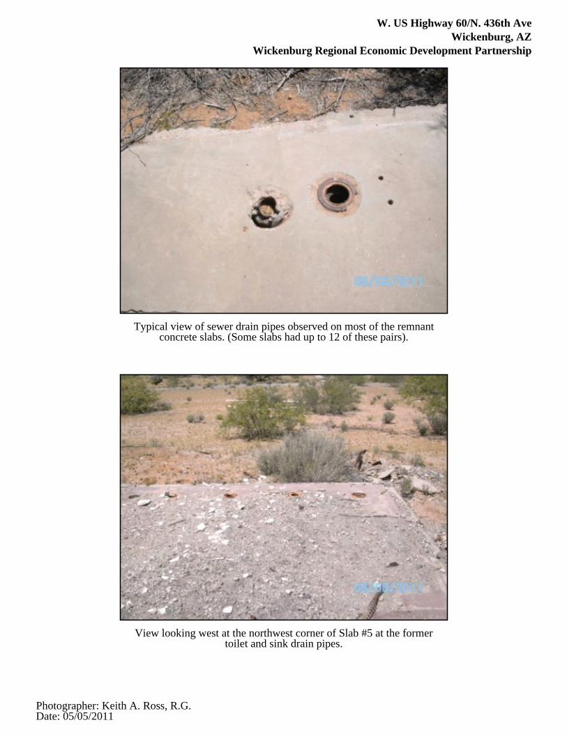
W. US Highway 60/N. 436th AveWickenburg, AZ
Wickenburg Regional Economic Development Partnership
Typical view of sewer drain pipes observed on most of the remnantconcrete slabs. (Some slabs had up to 12 of these pairs).
View looking west at the northwest corner of Slab #5 at the formertoilet and sink drain pipes.
Photographer: Keith A. Ross, R.G.Date: 05/05/2011

W. US Highway 60/N. 436th AveWickenburg, AZ
Wickenburg Regional Economic Development Partnership
View looking east along Slab #5 at burned debris and ash covering theslab.
View looking east at the bathroom area of Slab #7. Note toilet drains onthe right and shower drains on the left.
Photographer: Keith A. Ross, R.G.Date: 05/05/2011
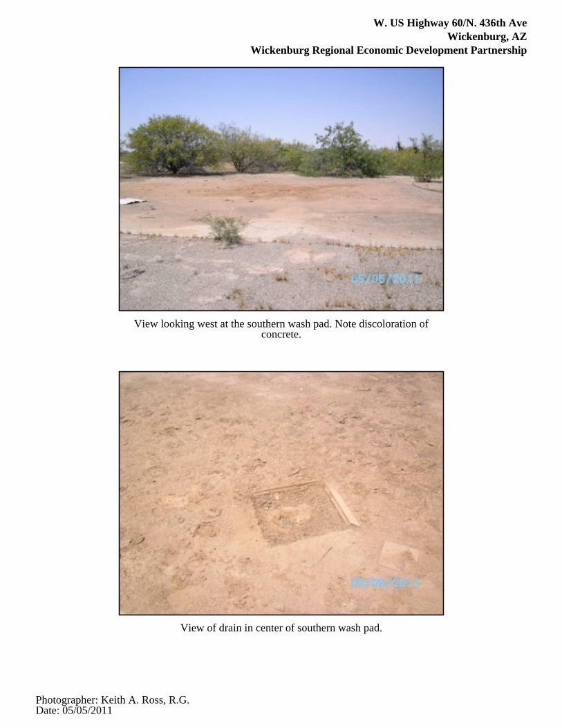
W. US Highway 60/N. 436th AveWickenburg, AZ
Wickenburg Regional Economic Development Partnership
View looking west at the southern wash pad. Note discoloration ofconcrete.
View of drain in center of southern wash pad.
Photographer: Keith A. Ross, R.G.Date: 05/05/2011

W. US Highway 60/N. 436th AveWickenburg, AZ
Wickenburg Regional Economic Development Partnership
View of overhead electrical services.
View looking north at Pad #3.
Photographer: Keith A. Ross, R.G.Date: 05/05/2011

W. US Highway 60/N. 436th AveWickenburg, AZ
Wickenburg Regional Economic Development Partnership
View of north end of Pad #3 at drum ring and staining.
View looking north from southeast corner of Slab #10. Note remnantwalls and debris.
Photographer: Keith A. Ross, R.G.Date: 05/05/2011

W. US Highway 60/N. 436th AveWickenburg, AZ
Wickenburg Regional Economic Development Partnership
View looking east at vertical metal pipe with "T" west of Slab #10.
View looking south at staining and cracks on the western edge of Slab#14. Note stain rings adjacent to the clipboard.
Photographer: Keith A. Ross, R.G.Date: 05/05/2011
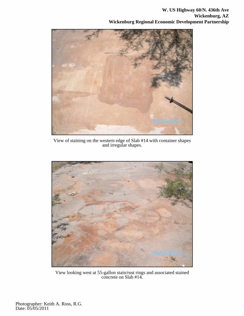
W. US Highway 60/N. 436th AveWickenburg, AZ
Wickenburg Regional Economic Development Partnership
View of staining on the western edge of Slab #14 with container shapesand irregular shapes.
View looking west at 55-gallon stain/rust rings and associated stainedconcrete on Slab #14.
Photographer: Keith A. Ross, R.G.Date: 05/05/2011

W. US Highway 60/N. 436th AveWickenburg, AZ
Wickenburg Regional Economic Development Partnership
View of Slab #14 looking southeast at staining and container storageevidence and the ground asphalt pile.
View looking south at the western portion of Slab #14. Note stainingadjacent to ground asphalt stockpile.
Photographer: Keith A. Ross, R.G.Date: 05/05/2011

W. US Highway 60/N. 436th AveWickenburg, AZ
Wickenburg Regional Economic Development Partnership
Typical view of Slab #14 discoloration, etching and cracks.
View looking west at non-metallic pipe in opening in center portion ofSlab #14.
Photographer: Keith A. Ross, R.G.Date: 05/05/2011

W. US Highway 60/N. 436th AveWickenburg, AZ
Wickenburg Regional Economic Development Partnership
View looking south at two 2-inch PVC pipes just south of the openingin Slab #14.
View looking west at the northern bermed area showing ramp and 1foot high concrete berm.
Photographer: Keith A. Ross, R.G.Date: 05/05/2011

W. US Highway 60/N. 436th AveWickenburg, AZ
Wickenburg Regional Economic Development Partnership
View looking west at the southern bermed area.
View looking north-northwest at open drain pipes adjacent to thebermed areas on Slab #14.
Photographer: Keith A. Ross, R.G.Date: 05/05/2011

W. US Highway 60/N. 436th AveWickenburg, AZ
Wickenburg Regional Economic Development Partnership
View of backfilled trench in the southern bermed area.
View looking east at Slab # 15.
Photographer: Keith A. Ross, R.G.Date: 05/05/2011

W. US Highway 60/N. 436th AveWickenburg, AZ
Wickenburg Regional Economic Development Partnership
View looking south at former flagpole concrete pad.
View looking south at the former restroom building near the access roadand intersection with the road to the former landing strip.
Photographer: Keith A. Ross, R.G.Date: 05/05/2011

Appendix E:
User Provided Information


Appendix F:
Historical Research Documentation

Certified Sanborn® Map Report
Wickenburg/Forepaugh
W. US Highway 60/N. 436th Ave
Wickenburg, AZ 85390
Inquiry Number: 3049411.3
April 22, 2011

Certified Sanborn® Map Report 4/22/11
Site Name:Wickenburg/ForepaughW. US Highway 60/N. 436thWickenburg, AZ 85390
Client Name:Atwell, LLCTwo Towne SquareSouthfield, MI 48076
EDR Inquiry # 3049411.3 Contact: Keith Ross
The complete Sanborn Library collection has been searched by EDR, and fire insurance maps covering the targetproperty location provided by Atwell, LLC were identified for the years listed below. The certified Sanborn Library searchresults in this report can be authenticated by visiting www.edrnet.com/sanborn and entering the certification number.Only Environmental Data Resources Inc. (EDR) is authorized to grant rights for commercial reproduction of maps bySanborn Library LLC, the copyright holder for the collection.
Certified Sanborn Results:
Site Name: Wickenburg/ForepaughAddress: W. US Highway 60/N. 436th AveCity, State, Zip: Wickenburg, AZ 85390Cross Street:P.O. # NAProject: 10001807-Wickenburg/ForepaughCertification # 2A66-430C-9269
Library of Congress
University Publications of America
EDR Private Collection
The Sanborn Library LLC Since 1866™
The Sanborn Library includes more than 1.2 millionSanborn fire insurance maps, which track historicalproperty usage in approximately 12,000 Americancities and towns. Collections searched:
Sanborn® Library search resultsCertification # 2A66-430C-9269
UNMAPPED PROPERTYThis report certifies that the complete holdings of the SanbornLibrary, LLC collection have been searched based on clientsupplied target property information, and fire insurance mapscovering the target property were not found.
Limited Permission To Make CopiesAtwell, LLC (the client) is permitted to make up to THREE photocopies of this Sanborn Map transmittal and each fire insurance map accompanyingthis report solely for the limited use of its customer. No one other than the client is authorized to make copies. Upon request made directly to anEDR Account Executive, the client may be permitted to make a limited number of additional photocopies. This permission is conditioned uponcompliance by the client, its customer and their agents with EDR's copyright policy; a copy of which is available upon request.
Disclaimer - Copyright and Trademark noticeThis Report contains certain information obtained from a variety of public and other sources reasonably available to Environmental Data Resources, Inc. It cannot beconcluded from this Report that coverage information for the target and surrounding properties does not exist from other sources. NO WARRANTY EXPRESSED ORIMPLIED, IS MADE WHATSOEVER IN CONNECTION WITH THIS REPORT. ENVIRONMENTAL DATA RESOURCES, INC. SPECIFICALLY DISCLAIMS THEMAKING OF ANY SUCH WARRANTIES, INCLUDING WITHOUT LIMITATION, MERCHANTABILITY OR FITNESS FOR A PARTICULAR USE OR PURPOSE. ALLRISK IS ASSUMED BY THE USER. IN NO EVENT SHALL ENVIRONMENTAL DATA RESOURCES, INC. BE LIABLE TO ANYONE, WHETHER ARISING OUT OFERRORS OR OMISSIONS, NEGLIGENCE, ACCIDENT OR ANY OTHER CAUSE, FOR ANY LOSS OF DAMAGE, INCLUDING, WITHOUT LIMITATION, SPECIAL,INCIDENTAL CONSEQUENTIAL, OR EXEMPLARY DAMAGES. ANY LIABILITY ON THE PART OF ENVIRONMENTAL DATA RESOURCES, INC. IS STRICTLYLIMITED TO A REFUND OF THE AMOUNT PAID FOR THIS REPORT. Purchaser accepts this Report "AS IS". Any analyses, estimates, ratings, environmental risklevels or risk codes provided in this Report are provided for illustrative purposes only, and are not intended to provide, nor should they be interpreted as providingany facts regarding, or prediction or forecast of, any environmental risk for any property. Only a Phase I Environmental Site Assessment performed by anenvironmental professional can provide information regarding the environmental risk for any property. Additionally, the information provided in this Report is not to beconstrued as legal advice.
Copyright 2011 by Environmental Data Resources, Inc. All rights reserved. Reproduction in any media or format, in whole or in part, of any report or map ofEnvironmental Data Resources, Inc., or its affiliates, is prohibited without prior written permission.
EDR and its logos (including Sanborn and Sanborn Map) are trademarks of Environmental Data Resources, Inc. or its affiliates. All other trademarks used herein arethe property of their respective owners.
3049411 - 3 page 2

EDR Historical Topographic Map Report
Wickenburg/Forepaugh
W. US Highway 60/N. 436th Ave
Wickenburg, AZ 85390
Inquiry Number: 3049411.4
April 22, 2011

EDR Historical Topographic Map Report
Environmental Data Resources, Inc.s (EDR) Historical Topographic Map Report is designed to assist professionals inevaluating potential liability on a target property resulting from past activities. EDRs Historical Topographic Map Reportincludes a search of a collection of public and private color historical topographic maps, dating back to the early 1900s.
Thank you for your business.Please contact EDR at 1-800-352-0050
with any questions or comments.
Disclaimer - Copyright and Trademark Notice
This Report contains certain information obtained from a variety of public and other sources reasonably available to Environmental Data Resources, Inc.It cannot be concluded from this Report that coverage information for the target and surrounding properties does not exist from other sources. NOWARRANTY EXPRESSED OR IMPLIED, IS MADE WHATSOEVER IN CONNECTION WITH THIS REPORT. ENVIRONMENTAL DATARESOURCES, INC. SPECIFICALLY DISCLAIMS THE MAKING OF ANY SUCH WARRANTIES, INCLUDING WITHOUT LIMITATION,MERCHANTABILITY OR FITNESS FOR A PARTICULAR USE OR PURPOSE. ALL RISK IS ASSUMED BY THE USER. IN NO EVENT SHALLENVIRONMENTAL DATA RESOURCES, INC. BE LIABLE TO ANYONE, WHETHER ARISING OUT OF ERRORS OR OMISSIONS, NEGLIGENCE,ACCIDENT OR ANY OTHER CAUSE, FOR ANY LOSS OF DAMAGE, INCLUDING, WITHOUT LIMITATION, SPECIAL, INCIDENTAL,CONSEQUENTIAL, OR EXEMPLARY DAMAGES. ANY LIABILITY ON THE PART OF ENVIRONMENTAL DATA RESOURCES, INC. IS STRICTLYLIMITED TO A REFUND OF THE AMOUNT PAID FOR THIS REPORT. Purchaser accepts this Report AS IS. Any analyses, estimates, ratings,environmental risk levels or risk codes provided in this Report are provided for illustrative purposes only, and are not intended to provide, nor should theybe interpreted as providing any facts regarding, or prediction or forecast of, any environmental risk for any property. Only a Phase I Environmental SiteAssessment performed by an environmental professional can provide information regarding the environmental risk for any property. Additionally, theinformation provided in this Report is not to be construed as legal advice.
Copyright 2011 by Environmental Data Resources, Inc. All rights reserved. Reproduction in any media or format, in whole or in part, of any report or mapof Environmental Data Resources, Inc., or its affiliates, is prohibited without prior written permission.
EDR and its logos (including Sanborn and Sanborn Map) are trademarks of Environmental Data Resources, Inc. or its affiliates. All other trademarksused herein are the property of their respective owners.

Historical Topographic Map
→
NTARGET QUADTARGET QUADNAME: FOREPAUGH PEAKMAP YEAR: 1990PROVISIONALSERIES: 7.5SCALE: 1:24000
SITE NAME: Wickenburg/Forepaugh ADDRESS: W. US Highway 60/N. 436th Ave
Wickenburg, AZ 85390LAT/LONG: 33.9487 / -113.0027
CLIENT: Atwell, LLCCONTACT: Keith RossINQUIRY#: 3049411.4RESEARCH DATE: 04/22/2011

Historical Topographic Map
→
N
ADJOINING QUADADJOINING QUADNAME: VULTURE MOUNTAINSMAP YEAR: 1961
SERIES: 15SCALE: 1:62500
SITE NAME: Wickenburg/Forepaugh ADDRESS: W. US Highway 60/N. 436th Ave
Wickenburg, AZ 85390LAT/LONG: 33.9487 / -113.0027
CLIENT: Atwell, LLCCONTACT: Keith RossINQUIRY#: 3049411.4RESEARCH DATE: 04/22/2011

Historical Topographic Map
→
N
ADJOINING QUADADJOINING QUADNAME: OUTLAW HILLMAP YEAR: 1990PROVISIONALSERIES: 7.5SCALE: 1:24000
SITE NAME: Wickenburg/Forepaugh ADDRESS: W. US Highway 60/N. 436th Ave
Wickenburg, AZ 85390LAT/LONG: 33.9487 / -113.0027
CLIENT: Atwell, LLCCONTACT: Keith RossINQUIRY#: 3049411.4RESEARCH DATE: 04/22/2011

The EDR Aerial Photo Decade Package
Wickenburg/Forepaugh
W. US Highway 60/N. 436th Ave
Wickenburg, AZ 85390
Inquiry Number: 3049411.5
April 26, 2011

EDR Aerial Photo Decade Package
Environmental Data Resources, Inc. (EDR) Aerial Photo Decade Package is a screening tool designed to assistenvironmental professionals in evaluating potential liability on a target property resulting from past activities. EDR’sprofessional researchers provide digitally reproduced historical aerial photographs, and when available, provide one photoper decade.
When delivered electronically by EDR, the aerial photo images included with this report are for ONE TIME USEONLY. Further reproduction of these aerial photo images is prohibited without permission from EDR. For moreinformation contact your EDR Account Executive.
Thank you for your business.Please contact EDR at 1-800-352-0050
with any questions or comments.
Disclaimer - Copyright and Trademark Notice
This Report contains certain information obtained from a variety of public and other sources reasonably available to Environmental Data Resources, Inc.It cannot be concluded from this Report that coverage information for the target and surrounding properties does not exist from other sources. NOWARRANTY EXPRESSED OR IMPLIED, IS MADE WHATSOEVER IN CONNECTION WITH THIS REPORT. ENVIRONMENTAL DATARESOURCES, INC. SPECIFICALLY DISCLAIMS THE MAKING OF ANY SUCH WARRANTIES, INCLUDING WITHOUT LIMITATION,MERCHANTABILITY OR FITNESS FOR A PARTICULAR USE OR PURPOSE. ALL RISK IS ASSUMED BY THE USER. IN NO EVENT SHALLENVIRONMENTAL DATA RESOURCES, INC. BE LIABLE TO ANYONE, WHETHER ARISING OUT OF ERRORS OR OMISSIONS, NEGLIGENCE,ACCIDENT OR ANY OTHER CAUSE, FOR ANY LOSS OF DAMAGE, INCLUDING, WITHOUT LIMITATION, SPECIAL, INCIDENTAL,CONSEQUENTIAL, OR EXEMPLARY DAMAGES. ANY LIABILITY ON THE PART OF ENVIRONMENTAL DATA RESOURCES, INC. IS STRICTLYLIMITED TO A REFUND OF THE AMOUNT PAID FOR THIS REPORT. Purchaser accepts this Report AS IS. Any analyses, estimates, ratings,environmental risk levels or risk codes provided in this Report are provided for illustrative purposes only, and are not intended to provide, nor should theybe interpreted as providing any facts regarding, or prediction or forecast of, any environmental risk for any property. Only a Phase I Environmental SiteAssessment performed by an environmental professional can provide information regarding the environmental risk for any property. Additionally, theinformation provided in this Report is not to be construed as legal advice.
Copyright 2011 by Environmental Data Resources, Inc. All rights reserved. Reproduction in any media or format, in whole or in part, of any report or mapof Environmental Data Resources, Inc., or its affiliates, is prohibited without prior written permission.
EDR and its logos (including Sanborn and Sanborn Map) are trademarks of Environmental Data Resources, Inc. or its affiliates. All other trademarksused herein are the property of their respective owners.

Date EDR Searched Historical Sources:Aerial PhotographyApril 26, 2011
Target Property:W. US Highway 60/N. 436th Ave
Wickenburg, AZ 85390
Year Scale Details Source
1948 Aerial Photograph. Scale: 1"=1000' Panel #: 33113-H1, Forepaugh Peak, AZ;/Flight Date: June 11,1948
EDR
1951 Aerial Photograph. Scale: 1"=750' Panel #: 33113-H1, Forepaugh Peak, AZ;/Flight Date: June 25,1951
EDR
1981 Aerial Photograph. Scale: 1"=1000' Panel #: 33113-H1, Forepaugh Peak, AZ;/Flight Date: May 30,1981
EDR
1985 Aerial Photograph. Scale: 1"=1000' Panel #: 33113-H1, Forepaugh Peak, AZ;/Flight Date: December04, 1985
EDR
1992 Aerial Photograph. Scale: 1"=750' Panel #: 33113-H1, Forepaugh Peak, AZ;/Flight Date: September07, 1992
EDR
1997 Aerial Photograph. Scale: 1"=750' Panel #: 33113-H1, Forepaugh Peak, AZ;/Flight Date: May 31,1997
EDR
3049411.52

INQUIRY #:
YEAR:
3049411.5
1948
= 1000'

INQUIRY #:
YEAR:
3049411.5
1951
= 750'

INQUIRY #:
YEAR:
3049411.5
1981
= 1000'

INQUIRY #:
YEAR:
3049411.5
1985
= 1000'

INQUIRY #:
YEAR:
3049411.5
1992
= 750'
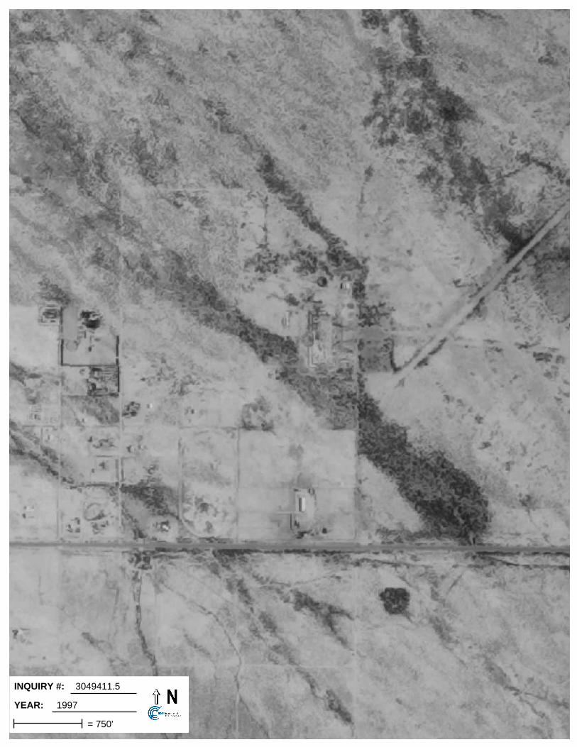
INQUIRY #:
YEAR:
3049411.5
1997
= 750'

Wickenburg/Forepaugh
W. US Highway 60/N. 436th AveWickenburg, AZ 85390
Inquiry Number: 3049411.6May 12, 2011
The EDR-City Directory Abstract
440 Wheelers Farms RoadMilford, CT 06461800.352.0050www.edrnet.comEnvironmental Data Resources IncEnvironmental Data Resources IncEnvironmental Data Resources IncEnvironmental Data Resources Inc

TABLE OF CONTENTS
SECTION
Executive Summary
Findings
Thank you for your business. Please contact EDR at 1-800-352-0050
with any questions or comments.
Disclaimer - Copyright and Trademark Notice
This Report contains certain information obtained from a variety of public and other sources reasonably available to Environmental Data Resources, Inc. It cannot be concluded from this Report that coverage information for the target and surrounding properties does not exist from other sources. NO WARRANTY EXPRESSED OR IMPLIED, IS MADE WHATSOEVER IN CONNECTION WITH THIS REPORT. ENVIRONMENTAL DATA RESOURCES, INC. SPECIFICALLY DISCLAIMS THE MAKING OF ANY SUCH WARRANTIES, INCLUDING WITHOUT LIMITATION, MERCHANTABILITY OR FITNESS FOR A PARTICULAR USE OR PURPOSE. ALL RISK IS ASSUMED BY THE USER. IN NO EVENT SHALL ENVIRONMENTAL DATA RESOURCES, INC. BE LIABLE TO ANYONE, WHETHER ARISING OUT OF ERRORS OR OMISSIONS, NEGLIGENCE, ACCIDENT OR ANY OTHER CAUSE, FOR ANY LOSS OR DAMAGE, INCLUDING, WITHOUT LIMITATION, SPECIAL, INCIDENTAL, CONSEQUENTIAL, OR EXEMPLARY DAMAGES. ANY LIABILITY ON THE PART OF ENVIRONMENTAL DATA RESOURCES, INC. IS STRICTLY LIMITED TO A REFUND OF THE AMOUNT PAID FOR THIS REPORT. Purchaser accepts this Report "AS IS". Any analyses, estimates, ratings, environmental risk levels or risk codes provided in this Report are provided for illustrative purposes only, and are not intended to provide, nor should they be interpreted as providing any facts regarding, or prediction orforecast of, any environmental risk for any property. Only a Phase I Environmental Site Assessment performed by an environmental professional can provide information regarding the environmental risk for any property. Additionally, the information provided in this Report is not to be construed as legal advice.
Copyright 2009 by Environmental Data Resources, Inc. All rights reserved. Reproduction in any media or format, in whole or in part, of any report or map of Environmental Data Resources, Inc. or its affiliates is prohibited without prior written permission.
EDR and its logos (including Sanborn and Sanborn Map) are trademarks of Environmental Data Resources, Inc. or its affiliates. All other trademarks used herein are the property of their respective owners.

EXECUTIVE SUMMARY
DESCRIPTION
Environmental Data Resources, Inc.’s (EDR) City Directory Abstract is a screening tool designed to assist environmental professionals in evaluating potential liability on a target property resulting from past activities. EDR’s City Directory Abstract includes a search and abstract of available city directory data. For each address, the directory lists the name of the corresponding occupant at five year intervals.
RESEARCH SUMMARY
The following research sources were consulted in the preparation of this report. An "X" indicates where information was identified in the source and provided in this report.
Source TPYear Adjoining Text Abstract Source Image
2008 Cole Criss-Cross Directory - X X -
2001 Cole Criss-Cross Directory - X X -
1997 Cole Criss-Cross Directory - X X -
1991 Cole Criss-Cross Directory - X X -
1986 Cole Criss-Cross Directory - X X -
1971 Cole Criss-Cross Directory - - - -
1965 Cole Criss-Cross Directory - - - -
3049411- 6 Page 1

EXECUTIVE SUMMARY
SELECTED ADDRESSES
The following addresses were selected by the client, for EDR to research. An "X" indicates where information was identified.
Address Type Findings
43501 W. US Highway 60 Client Entered
43550 W. US Highway 60 Client Entered X
3049411- 6 Page 2
FINDINGS
TARGET PROPERTY INFORMATION
ADDRESS
W. US Highway 60/N. 436th AveWickenburg, AZ 85390
FINDINGS DETAIL
Target Property research detail.
No Addresses Found
3049411- 6 Page 3

FINDINGS
ADJOINING PROPERTY DETAIL
The following Adjoining Property addresses were researched for this report. Detailed findings are provided for each address.
W. US Highway 60
W. US Highway 60
Year Uses Source
2008 No other addresses in range 43400 -43699 W US Hwy 60
Cole Criss-Cross Directory
2001 No other addresses in range 43400 -43699 W US Hwy 60
Cole Criss-Cross Directory
1997 No other addresses in range 43400 -43699 W US Hwy 60
Cole Criss-Cross Directory
1991 No other addresses in range 43400 -43699 W US Hwy 60
Cole Criss-Cross Directory
1986 No other addresses in range 43400 -43699 W US Hwy 60
Cole Criss-Cross Directory
43550 W. US Highway 60
Year Uses Source
2008 Residential Cole Criss-Cross Directory
43603 W. US Highway 60
Year Uses Source
2008 Apartments Cole Criss-Cross Directory
1997 Residential Cole Criss-Cross Directory
1991 Residential Cole Criss-Cross Directory
1986 Residential Cole Criss-Cross Directory
43605 W. US Highway 60
Year Uses Source
2008 Residential Cole Criss-Cross Directory
3049411- 6 Page 4

FINDINGS
STREET NOT IDENTIFIED IN RESEARCH SOURCE
The following Streets were researched for this report, and the Streets were not identified in the research source.
Street Researched Street Not Identified in Research Source
US Highway 60/N. 436th Ave 1971, 1965
W. US Highway 60 1971, 1965
TARGET PROPERTY: ADDRESS NOT IDENTIFIED IN RESEARCH SOURCE
The following Target Property addresses were researched for this report, and the addresses were not identified in the research source.
Address Researched Address Not Identified in Research Source
W. US Highway 60/N. 436th Ave
2008, 2001, 1997, 1991, 1986
ADJOINING PROPERTY: ADDRESSES NOT IDENTIFIED IN RESEARCH SOURCE
The following Adjoining Property addresses were researched for this report, and the addresses were not identified in research source.
Address Researched Address Not Identified in Research Source
W. US Highway 60 No Years Found
43501 W. US Highway 60 2008, 2001, 1997, 1991, 1986
43550 W. US Highway 60 2001, 1997, 1991, 1986
43603 W. US Highway 60 2001
43605 W. US Highway 60 2001, 1997, 1991, 1986

Appendix G:
Regulatory Records Documentation

FORM-STD-SPM
®kcehCoeG htiw tropeR ™paM suidaR RDE ehT
440 Wheelers Farms RoadMilford, CT 06461Toll Free: 800.352.0050www.edrnet.com
Wickenburg/ForepaughW. US Highway 60/N. 436th AveWickenburg, AZ 85390
Inquiry Number: 3049411.2sApril 22, 2011

SECTION PAGE
Executive Summary ES1
Overview Map 2
Detail Map 3
Map Findings Summary 4
Map Findings 7
Orphan Summary 8
Government Records Searched/Data Currency Tracking GR-1
GEOCHECK ADDENDUM
Physical Setting Source Addendum A-1
Physical Setting Source Summary A-2
Physical Setting SSURGO Soil Map A-5
Physical Setting Source Map A-10
Physical Setting Source Map Findings A-12
Physical Setting Source Records Searched A-34
TC3049411.2s Page 1
Thank you for your business.Please contact EDR at 1-800-352-0050
with any questions or comments.
Disclaimer - Copyright and Trademark Notice
This Report contains certain information obtained from a variety of public and other sources reasonably available to Environmental DataResources, Inc. It cannot be concluded from this Report that coverage information for the target and surrounding properties does not exist fromother sources. NO WARRANTY EXPRESSED OR IMPLIED, IS MADE WHATSOEVER IN CONNECTION WITH THIS REPORT. ENVIRONMENTALDATA RESOURCES, INC. SPECIFICALLY DISCLAIMS THE MAKING OF ANY SUCH WARRANTIES, INCLUDING WITHOUT LIMITATION,MERCHANTABILITY OR FITNESS FOR A PARTICULAR USE OR PURPOSE. ALL RISK IS ASSUMED BY THE USER. IN NO EVENT SHALLENVIRONMENTAL DATA RESOURCES, INC. BE LIABLE TO ANYONE, WHETHER ARISING OUT OF ERRORS OR OMISSIONS, NEGLIGENCE,ACCIDENT OR ANY OTHER CAUSE, FOR ANY LOSS OF DAMAGE, INCLUDING, WITHOUT LIMITATION, SPECIAL, INCIDENTAL,CONSEQUENTIAL, OR EXEMPLARY DAMAGES. ANY LIABILITY ON THE PART OF ENVIRONMENTAL DATA RESOURCES, INC. IS STRICTLYLIMITED TO A REFUND OF THE AMOUNT PAID FOR THIS REPORT. Purchaser accepts this Report "AS IS". Any analyses, estimates, ratings,environmental risk levels or risk codes provided in this Report are provided for illustrative purposes only, and are not intended to provide, norshould they be interpreted as providing any facts regarding, or prediction or forecast of, any environmental risk for any property. Only a Phase IEnvironmental Site Assessment performed by an environmental professional can provide information regarding the environmental risk for anyproperty. Additionally, the information provided in this Report is not to be construed as legal advice.
Copyright 2011 by Environmental Data Resources, Inc. All rights reserved. Reproduction in any media or format, in wholeor in part, of any report or map of Environmental Data Resources, Inc., or its affiliates, is prohibited without prior written permission.
EDR and its logos (including Sanborn and Sanborn Map) are trademarks of Environmental Data Resources, Inc. or its affiliates. All othertrademarks used herein are the property of their respective owners.
TABLE OF CONTENTS

EXECUTIVE SUMMARY
TC3049411.2s EXECUTIVE SUMMARY 1
A search of available environmental records was conducted by Environmental Data Resources, Inc (EDR).The report was designed to assist parties seeking to meet the search requirements of EPA’s Standardsand Practices for All Appropriate Inquiries (40 CFR Part 312), the ASTM Standard Practice forEnvironmental Site Assessments (E 1527-05) or custom requirements developed for the evaluation ofenvironmental risk associated with a parcel of real estate.
TARGET PROPERTY INFORMATION
ADDRESS
W. US HIGHWAY 60/N. 436TH AVEWICKENBURG, AZ 85390
COORDINATES
33.948700 - 33˚ 56’ 55.3’’Latitude (North): 113.002700 - 113˚ 0’ 9.7’’Longitude (West): Zone 12Universal Tranverse Mercator: 314925.4UTM X (Meters): 3758080.5UTM Y (Meters): 2411 ft. above sea levelElevation:
USGS TOPOGRAPHIC MAP ASSOCIATED WITH TARGET PROPERTY
33113-H1 FOREPAUGH PEAK, AZTarget Property Map:1990Most Recent Revision:
33112-H8 OUTLAW HILL, AZEast Map:1990Most Recent Revision:
AERIAL PHOTOGRAPHY IN THIS REPORT
2005, 2006, 2007Portions of Photo from:USDASource:
TARGET PROPERTY SEARCH RESULTS
The target property was not listed in any of the databases searched by EDR.
DATABASES WITH NO MAPPED SITES
No mapped sites were found in EDR’s search of available ("reasonably ascertainable ") governmentrecords either on the target property or within the search radius around the target property for thefollowing databases:
STANDARD ENVIRONMENTAL RECORDS
Federal NPL site list
NPL National Priority List

EXECUTIVE SUMMARY
TC3049411.2s EXECUTIVE SUMMARY 2
Proposed NPL Proposed National Priority List SitesNPL LIENS Federal Superfund Liens
Federal Delisted NPL site list
Delisted NPL National Priority List Deletions
Federal CERCLIS list
CERCLIS Comprehensive Environmental Response, Compensation, and Liability Information SystemFEDERAL FACILITY Federal Facility Site Information listing
Federal CERCLIS NFRAP site List
CERC-NFRAP CERCLIS No Further Remedial Action Planned
Federal RCRA CORRACTS facilities list
CORRACTS Corrective Action Report
Federal RCRA non-CORRACTS TSD facilities list
RCRA-TSDF RCRA - Treatment, Storage and Disposal
Federal RCRA generators list
RCRA-LQG RCRA - Large Quantity GeneratorsRCRA-SQG RCRA - Small Quantity GeneratorsRCRA-CESQG RCRA - Conditionally Exempt Small Quantity Generator
Federal institutional controls / engineering controls registries
US ENG CONTROLS Engineering Controls Sites ListUS INST CONTROL Sites with Institutional Controls
Federal ERNS list
ERNS Emergency Response Notification System
State- and tribal - equivalent NPL
AZ WQARF Water Quality Assurance Revolving Fund Sites
State- and tribal - equivalent CERCLIS
SPL Superfund Program ListSHWS ZipAcids List
State and tribal landfill and/or solid waste disposal site lists
SWF/LF Directory of Solid Waste Facilities
State and tribal leaking storage tank lists
LUST Leaking Underground Storage Tank Listing
EXECUTIVE SUMMARY
TC3049411.2s EXECUTIVE SUMMARY 3
INDIAN LUST Leaking Underground Storage Tanks on Indian Land
State and tribal registered storage tank lists
UST Underground Storage Tank ListingAST List of Aboveground Storage TanksINDIAN UST Underground Storage Tanks on Indian LandFEMA UST Underground Storage Tank Listing
State and tribal institutional control / engineering control registries
AUL DEUR DatabaseAZURITE Remediation and DEUR/VEMUR Tracking System
State and tribal voluntary cleanup sites
INDIAN VCP Voluntary Cleanup Priority ListingVCP Voluntary Remediation Program Sites
State and tribal Brownfields sites
BROWNFIELDS Brownfields Tracking System
ADDITIONAL ENVIRONMENTAL RECORDS
Local Brownfield lists
US BROWNFIELDS A Listing of Brownfields Sites
Local Lists of Landfill / Solid Waste Disposal Sites
DEBRIS REGION 9 Torres Martinez Reservation Illegal Dump Site LocationsODI Open Dump InventorySWTIRE Solid Waste Tire FacilitiesINDIAN ODI Report on the Status of Open Dumps on Indian Lands
Local Lists of Hazardous waste / Contaminated Sites
US CDL Clandestine Drug LabsAOCONCERN Superfund GIS InformationCDL Clandestine Drug LabsUS HIST CDL National Clandestine Laboratory Register
Local Land Records
LIENS 2 CERCLA Lien InformationLUCIS Land Use Control Information System
Records of Emergency Release Reports
HMIRS Hazardous Materials Information Reporting SystemSPILLS Hazardous Material Logbook
Other Ascertainable Records
RCRA-NonGen RCRA - Non Generators

EXECUTIVE SUMMARY
TC3049411.2s EXECUTIVE SUMMARY 4
DOT OPS Incident and Accident DataDOD Department of Defense SitesFUDS Formerly Used Defense SitesCONSENT Superfund (CERCLA) Consent DecreesROD Records Of DecisionUMTRA Uranium Mill Tailings SitesMINES Mines Master Index FileTRIS Toxic Chemical Release Inventory SystemTSCA Toxic Substances Control ActFTTS FIFRA/ TSCA Tracking System - FIFRA (Federal Insecticide, Fungicide, & Rodenticide Act)/TSCA (Toxic Substances Control Act)HIST FTTS FIFRA/TSCA Tracking System Administrative Case ListingSSTS Section 7 Tracking SystemsICIS Integrated Compliance Information SystemPADS PCB Activity Database SystemMLTS Material Licensing Tracking SystemRADINFO Radiation Information DatabaseFINDS Facility Index System/Facility Registry SystemRAATS RCRA Administrative Action Tracking SystemMANIFEST Facility and Manifest DataDRYCLEANERS Drycleaner Facility ListingAZ DOD Department of Defense SitesWWFAC Waste Water Treatment FacilitiesAquifer Waste Water Treatment FacilitiesDry Wells Drywell RegistrationAIRS Arizona Airs DatabaseINDIAN RESERV Indian ReservationsSCRD DRYCLEANERS State Coalition for Remediation of Drycleaners ListingCOAL ASH DOE Sleam-Electric Plan Operation DataPCB TRANSFORMER PCB Transformer Registration DatabaseCOAL ASH EPA Coal Combustion Residues Surface Impoundments List
EDR PROPRIETARY RECORDS
EDR Proprietary Records
Manufactured Gas Plants EDR Proprietary Manufactured Gas PlantsEDR Historical Auto Stations EDR Proprietary Historic Gas StationsEDR Historical Cleaners EDR Proprietary Historic Dry Cleaners
SURROUNDING SITES: SEARCH RESULTS
Surrounding sites were not identified.
Unmappable (orphan) sites are not considered in the foregoing analysis.

EXECUTIVE SUMMARY
TC3049411.2s EXECUTIVE SUMMARY 5
Due to poor or inadequate address information, the following sites were not mapped. Count: 20 records.
Site Name Database(s)____________ ____________
ENVIROTECH INDUSTRIES INTERNATIONA SWTIREMARICOPA COUNTY MORRISTOWN TRANSFE SWTIRESALT RIVER-PIMA INDIANTRIBE TRI CI LFSOUTHWEST REGIONAL LFSALT RIVER/PIMA TRIBE / TRI-CITY LFSCOTT’S AUTO USTWICKENBURG MUNICIPAL AIRPORT ASTWICKENBURG RANCH ASTUNITED PARCEL SVC WICKEN FINDS,RCRA-NLRSTAKER PAVING FINDS,RCRA-NLRSTAKER PAVING FINDS,RCRA-NLRFOREPAUGH PROPERTY FINDSWICKENBURG DOWNTOWN FLOODING HAZAR FINDSWICKENBURG MUNICIPAL AIRPORT FINDSWICKENBURG COUNTRY CLUB FINDSADOT - WICKENBURG MAINTENANCE YARD FINDSWICKENBURG RANCH WRF FINDSWICKENBURG MUNI FINDSWICKENBURG MOBILE (GOLD STAR II LL FINDSWICKENBURG, TOWN OF - WWTP FINDS
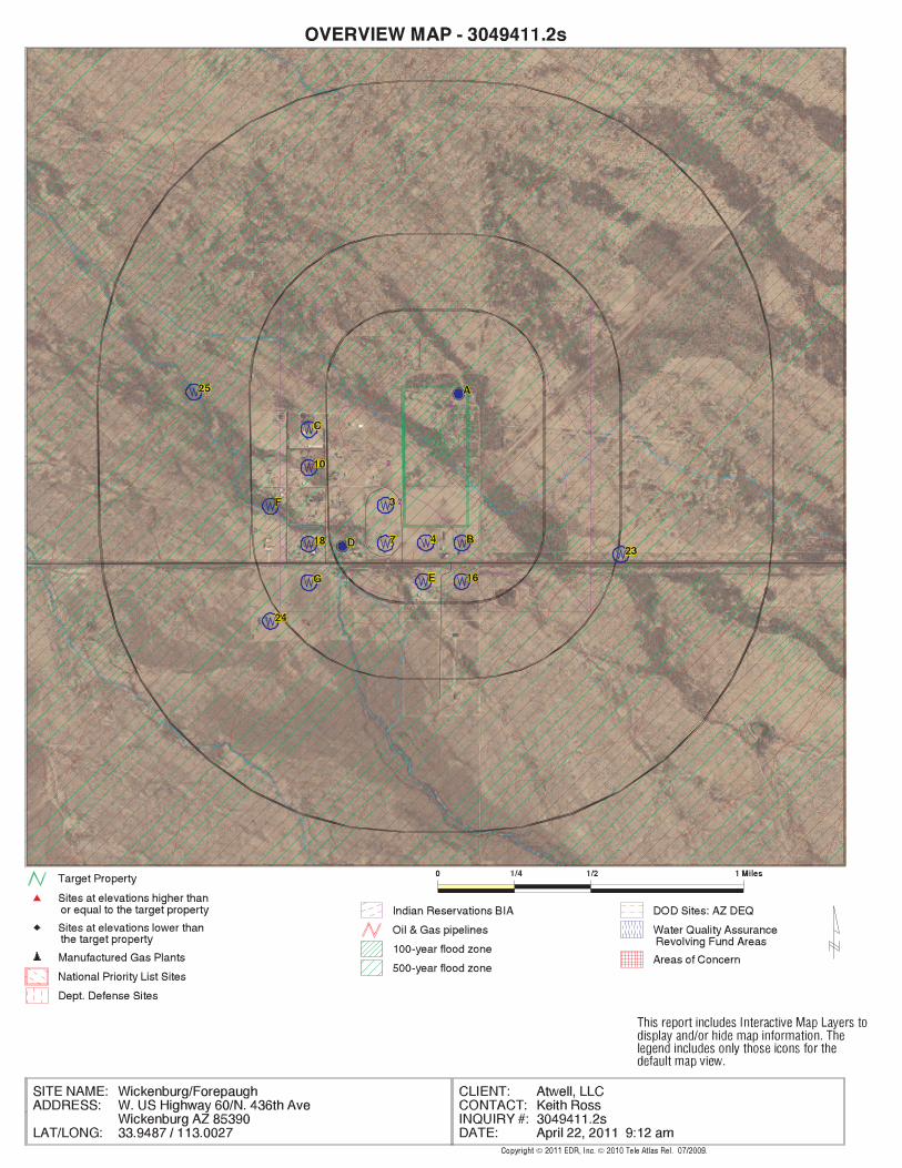
EDR Inc.EDR Inc.EDR Inc.EDR Inc.EDR Inc.EDR Inc.EDR Inc.EDR Inc.EDR Inc.EDR Inc.EDR Inc.EDR Inc.EDR Inc.EDR Inc.EDR Inc.EDR Inc.EDR Inc.EDR Inc.EDR Inc.EDR Inc.EDR Inc.EDR Inc.EDR Inc.EDR Inc.EDR Inc.EDR Inc.EDR Inc.EDR Inc.EDR Inc.EDR Inc.EDR Inc.EDR Inc.EDR Inc.EDR Inc.EDR Inc.EDR Inc.EDR Inc.EDR Inc.EDR Inc.EDR Inc.
23
60
24
00
2 4 0 0
24
00 2
4 40
24 0
0
2
4 40
2 4 4 0
2 4
4 0
2 4 8 0

EDR Inc.EDR Inc.EDR Inc.EDR Inc.EDR Inc.EDR Inc.EDR Inc.EDR Inc.EDR Inc.EDR Inc.EDR Inc.EDR Inc.EDR Inc.EDR Inc.EDR Inc.EDR Inc.EDR Inc.EDR Inc.EDR Inc.EDR Inc.EDR Inc.EDR Inc.EDR Inc.EDR Inc.EDR Inc.EDR Inc.EDR Inc.EDR Inc.EDR Inc.EDR Inc.EDR Inc.EDR Inc.EDR Inc.EDR Inc.EDR Inc.EDR Inc.EDR Inc.EDR Inc.EDR Inc.EDR Inc.
2 4
00
2 4 4 0

MAP FINDINGS SUMMARY
SearchTarget Distance Total
Database Property (Miles) < 1/8 1/8 - 1/4 1/4 - 1/2 1/2 - 1 > 1 Plotted
STANDARD ENVIRONMENTAL RECORDS
Federal NPL site list
0 NR 0 0 0 0 1.000NPL 0 NR 0 0 0 0 1.000Proposed NPL 0 NR NR NR NR NR TPNPL LIENS
Federal Delisted NPL site list
0 NR 0 0 0 0 1.000Delisted NPL
Federal CERCLIS list
0 NR NR 0 0 0 0.500CERCLIS 0 NR 0 0 0 0 1.000FEDERAL FACILITY
Federal CERCLIS NFRAP site List
0 NR NR 0 0 0 0.500CERC-NFRAP
Federal RCRA CORRACTS facilities list
0 NR 0 0 0 0 1.000CORRACTS
Federal RCRA non-CORRACTS TSD facilities list
0 NR NR 0 0 0 0.500RCRA-TSDF
Federal RCRA generators list
0 NR NR NR 0 0 0.250RCRA-LQG 0 NR NR NR 0 0 0.250RCRA-SQG 0 NR NR NR 0 0 0.250RCRA-CESQG
Federal institutional controls /engineering controls registries
0 NR NR 0 0 0 0.500US ENG CONTROLS 0 NR NR 0 0 0 0.500US INST CONTROL
Federal ERNS list
0 NR NR NR NR NR TPERNS
State- and tribal - equivalent NPL
0 NR 0 0 0 0 1.000AZ WQARF
State- and tribal - equivalent CERCLIS
0 NR 0 0 0 0 1.000SPL 0 NR 0 0 0 0 1.000SHWS
State and tribal landfill and/orsolid waste disposal site lists
0 NR NR 0 0 0 0.500SWF/LF
State and tribal leaking storage tank lists
0 NR NR 0 0 0 0.500LUST
TC3049411.2s Page 4
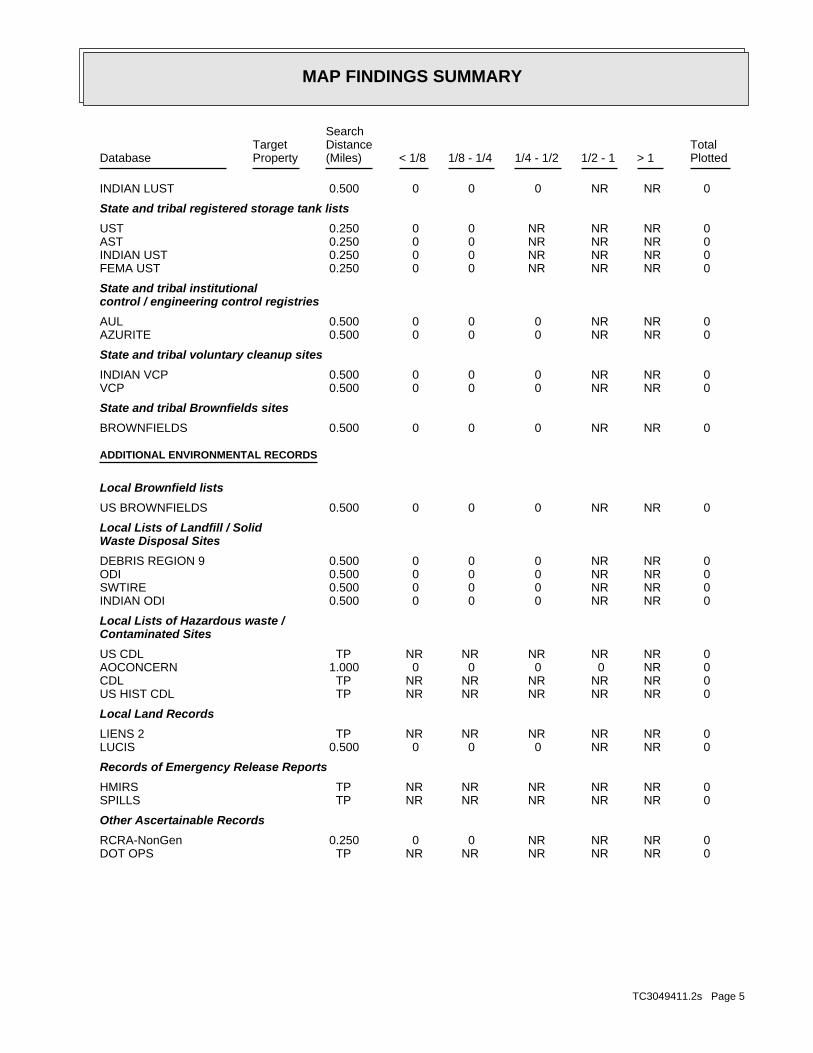
MAP FINDINGS SUMMARY
SearchTarget Distance Total
Database Property (Miles) < 1/8 1/8 - 1/4 1/4 - 1/2 1/2 - 1 > 1 Plotted
0 NR NR 0 0 0 0.500INDIAN LUST
State and tribal registered storage tank lists
0 NR NR NR 0 0 0.250UST 0 NR NR NR 0 0 0.250AST 0 NR NR NR 0 0 0.250INDIAN UST 0 NR NR NR 0 0 0.250FEMA UST
State and tribal institutionalcontrol / engineering control registries
0 NR NR 0 0 0 0.500AUL 0 NR NR 0 0 0 0.500AZURITE
State and tribal voluntary cleanup sites
0 NR NR 0 0 0 0.500INDIAN VCP 0 NR NR 0 0 0 0.500VCP
State and tribal Brownfields sites
0 NR NR 0 0 0 0.500BROWNFIELDS
ADDITIONAL ENVIRONMENTAL RECORDS
Local Brownfield lists
0 NR NR 0 0 0 0.500US BROWNFIELDS
Local Lists of Landfill / SolidWaste Disposal Sites
0 NR NR 0 0 0 0.500DEBRIS REGION 9 0 NR NR 0 0 0 0.500ODI 0 NR NR 0 0 0 0.500SWTIRE 0 NR NR 0 0 0 0.500INDIAN ODI
Local Lists of Hazardous waste /Contaminated Sites
0 NR NR NR NR NR TPUS CDL 0 NR 0 0 0 0 1.000AOCONCERN 0 NR NR NR NR NR TPCDL 0 NR NR NR NR NR TPUS HIST CDL
Local Land Records
0 NR NR NR NR NR TPLIENS 2 0 NR NR 0 0 0 0.500LUCIS
Records of Emergency Release Reports
0 NR NR NR NR NR TPHMIRS 0 NR NR NR NR NR TPSPILLS
Other Ascertainable Records
0 NR NR NR 0 0 0.250RCRA-NonGen 0 NR NR NR NR NR TPDOT OPS
TC3049411.2s Page 5

MAP FINDINGS SUMMARY
SearchTarget Distance Total
Database Property (Miles) < 1/8 1/8 - 1/4 1/4 - 1/2 1/2 - 1 > 1 Plotted
0 NR 0 0 0 0 1.000DOD 0 NR 0 0 0 0 1.000FUDS 0 NR 0 0 0 0 1.000CONSENT 0 NR 0 0 0 0 1.000ROD 0 NR NR 0 0 0 0.500UMTRA 0 NR NR NR 0 0 0.250MINES 0 NR NR NR NR NR TPTRIS 0 NR NR NR NR NR TPTSCA 0 NR NR NR NR NR TPFTTS 0 NR NR NR NR NR TPHIST FTTS 0 NR NR NR NR NR TPSSTS 0 NR NR NR NR NR TPICIS 0 NR NR NR NR NR TPPADS 0 NR NR NR NR NR TPMLTS 0 NR NR NR NR NR TPRADINFO 0 NR NR NR NR NR TPFINDS 0 NR NR NR NR NR TPRAATS 0 NR NR NR 0 0 0.250MANIFEST 0 NR NR NR 0 0 0.250DRYCLEANERS 0 NR NR 0 0 0 0.500AZ DOD 0 NR NR 0 0 0 0.500WWFAC 0 NR NR NR NR NR TPAquifer 0 NR NR NR NR NR TPDry Wells 0 NR NR NR NR NR TPAIRS 0 NR 0 0 0 0 1.000INDIAN RESERV 0 NR NR 0 0 0 0.500SCRD DRYCLEANERS 0 NR NR NR NR NR TPCOAL ASH DOE 0 NR NR NR NR NR TPPCB TRANSFORMER 0 NR NR 0 0 0 0.500COAL ASH EPA
EDR PROPRIETARY RECORDS
EDR Proprietary Records
0 NR 0 0 0 0 1.000Manufactured Gas Plants 0 NR NR NR 0 0 0.250EDR Historical Auto Stations 0 NR NR NR 0 0 0.250EDR Historical Cleaners
NOTES:
TP = Target Property
NR = Not Requested at this Search Distance
Sites may be listed in more than one database
TC3049411.2s Page 6

MAP FINDINGSMap IDDirection
EDR ID NumberDistanceEPA ID NumberDatabase(s)SiteElevation
NO SITES FOUND
TC3049411.2s Page 7

ORPHAN SUMMARY
City EDR ID Site Name Site Address Zip Database(s)
Count: 20 records.
WICKENBURG 1001480950 UNITED PARCEL SVC WICKEN HWY 60 AT TEXACO 85390 FINDS,RCRA-NLRWICKENBURG 1001959689 STAKER PAVING HWY 93 MP172 N OF WICKENBURG 85390 FINDS,RCRA-NLRWICKENBURG 1004675312 STAKER PAVING HWY 95 N OF WICKENBURG MP 160 85390 FINDS,RCRA-NLRWICKENBURG 1007145723 WICKENBURG, TOWN OF - WWTP WICKENBURG 85390 FINDSWICKENBURG 1011984656 WICKENBURG MUNI UNKNOWN 85390 FINDSWICKENBURG 1012130727 WICKENBURG COUNTRY CLUB 1420 N COUNTRY CLUB DR 85390 FINDSWICKENBURG 1012148481 ADOT - WICKENBURG MAINTENANCE YARD 52417 NW GRAND AVE 85390 FINDSWICKENBURG 1012149453 FOREPAUGH PROPERTY NO ADDRESS ON RECORD 85390 FINDSWICKENBURG 1012160781 WICKENBURG RANCH WRF 19175 W MERV GRIFFIN WAY 85390 FINDSWICKENBURG 1012160924 WICKENBURG MUNICIPAL AIRPORT 3540 W CALIFORNIA HWY 85390 FINDSWICKENBURG 1012160972 WICKENBURG DOWNTOWN FLOODING HAZAR NO ADDRESS ON RECORD 85390 FINDSWICKENBURG 1012161246 WICKENBURG MOBILE (GOLD STAR II LL 3770 S VULTURE MINE RD 85390 FINDSWICKENBURG A100156486 WICKENBURG MUNICIPAL AIRPORT HIGHWAY 60 ASTWICKENBURG A100355212 WICKENBURG RANCH 1 MILE NORTH OF HWY 93 85390 AST S106571128 ENVIROTECH INDUSTRIES INTERNATIONA 6 MILES WEST OF MOBILE, AZ ON SWTIRE S108414273 MARICOPA COUNTY MORRISTOWN TRANSFE 40135 N. US HIGHWAY 60 MARICOP SWTIRE S108630387 SALT RIVER-PIMA INDIANTRIBE TRI CI 13602 E BASELINE HWY LF S110143196 SALT RIVER/PIMA TRIBE / TRI-CITY 1 MILE NORTH OF MC DOWELL ON T LF S110487571 SOUTHWEST REGIONAL 24427 S HWY 85 LFWICKENBURG U004119914 SCOTT’S AUTO JUNCTION HWY 71 & 93 UST
TC3049411.2s Page 8

To maintain currency of the following federal and state databases, EDR contacts the appropriate governmental agencyon a monthly or quarterly basis, as required.
Number of Days to Update: Provides confirmation that EDR is reporting records that have been updated within 90 daysfrom the date the government agency made the information available to the public.
STANDARD ENVIRONMENTAL RECORDS
Federal NPL site list
NPL: National Priority ListNational Priorities List (Superfund). The NPL is a subset of CERCLIS and identifies over 1,200 sites for prioritycleanup under the Superfund Program. NPL sites may encompass relatively large areas. As such, EDR provides polygoncoverage for over 1,000 NPL site boundaries produced by EPA’s Environmental Photographic Interpretation Center(EPIC) and regional EPA offices.
Date of Government Version: 12/31/2010Date Data Arrived at EDR: 01/13/2011Date Made Active in Reports: 01/28/2011Number of Days to Update: 15
Source: EPATelephone: N/ALast EDR Contact: 04/13/2011Next Scheduled EDR Contact: 07/25/2011Data Release Frequency: Quarterly
NPL Site Boundaries
Sources:
EPA’s Environmental Photographic Interpretation Center (EPIC)Telephone: 202-564-7333
EPA Region 1 EPA Region 6Telephone 617-918-1143 Telephone: 214-655-6659
EPA Region 3 EPA Region 7Telephone 215-814-5418 Telephone: 913-551-7247
EPA Region 4 EPA Region 8Telephone 404-562-8033 Telephone: 303-312-6774
EPA Region 5 EPA Region 9Telephone 312-886-6686 Telephone: 415-947-4246
EPA Region 10Telephone 206-553-8665
Proposed NPL: Proposed National Priority List SitesA site that has been proposed for listing on the National Priorities List through the issuance of a proposed rulein the Federal Register. EPA then accepts public comments on the site, responds to the comments, and places onthe NPL those sites that continue to meet the requirements for listing.
Date of Government Version: 12/31/2010Date Data Arrived at EDR: 01/13/2011Date Made Active in Reports: 01/28/2011Number of Days to Update: 15
Source: EPATelephone: N/ALast EDR Contact: 04/13/2011Next Scheduled EDR Contact: 07/25/2011Data Release Frequency: Quarterly
NPL LIENS: Federal Superfund LiensFederal Superfund Liens. Under the authority granted the USEPA by CERCLA of 1980, the USEPA has the authorityto file liens against real property in order to recover remedial action expenditures or when the property ownerreceived notification of potential liability. USEPA compiles a listing of filed notices of Superfund Liens.
Date of Government Version: 10/15/1991Date Data Arrived at EDR: 02/02/1994Date Made Active in Reports: 03/30/1994Number of Days to Update: 56
Source: EPATelephone: 202-564-4267Last EDR Contact: 02/14/2011Next Scheduled EDR Contact: 05/30/2011Data Release Frequency: No Update Planned
TC3049411.2s Page GR-1
GOVERNMENT RECORDS SEARCHED / DATA CURRENCY TRACKING

Federal Delisted NPL site list
DELISTED NPL: National Priority List DeletionsThe National Oil and Hazardous Substances Pollution Contingency Plan (NCP) establishes the criteria that theEPA uses to delete sites from the NPL. In accordance with 40 CFR 300.425.(e), sites may be deleted from theNPL where no further response is appropriate.
Date of Government Version: 12/31/2010Date Data Arrived at EDR: 01/13/2011Date Made Active in Reports: 01/28/2011Number of Days to Update: 15
Source: EPATelephone: N/ALast EDR Contact: 04/13/2011Next Scheduled EDR Contact: 07/25/2011Data Release Frequency: Quarterly
Federal CERCLIS list
CERCLIS: Comprehensive Environmental Response, Compensation, and Liability Information SystemCERCLIS contains data on potentially hazardous waste sites that have been reported to the USEPA by states, municipalities,private companies and private persons, pursuant to Section 103 of the Comprehensive Environmental Response, Compensation,and Liability Act (CERCLA). CERCLIS contains sites which are either proposed to or on the National PrioritiesList (NPL) and sites which are in the screening and assessment phase for possible inclusion on the NPL.
Date of Government Version: 11/30/2010Date Data Arrived at EDR: 12/30/2010Date Made Active in Reports: 02/25/2011Number of Days to Update: 57
Source: EPATelephone: 703-412-9810Last EDR Contact: 03/01/2011Next Scheduled EDR Contact: 06/13/2011Data Release Frequency: Quarterly
FEDERAL FACILITY: Federal Facility Site Information listingA listing of National Priority List (NPL) and Base Realignment and Closure (BRAC) sites found in the ComprehensiveEnvironmental Response, Compensation and Liability Information System (CERCLIS) Database where EPAa??s FederalFacilities Restoration and Reuse Office is involved in cleanup activities.
Date of Government Version: 12/10/2010Date Data Arrived at EDR: 01/11/2011Date Made Active in Reports: 02/16/2011Number of Days to Update: 36
Source: Environmental Protection AgencyTelephone: 703-603-8704Last EDR Contact: 04/15/2011Next Scheduled EDR Contact: 07/25/2011Data Release Frequency: Varies
Federal CERCLIS NFRAP site List
CERCLIS-NFRAP: CERCLIS No Further Remedial Action PlannedArchived sites are sites that have been removed and archived from the inventory of CERCLIS sites. Archived statusindicates that, to the best of EPA’s knowledge, assessment at a site has been completed and that EPA has determinedno further steps will be taken to list this site on the National Priorities List (NPL), unless information indicatesthis decision was not appropriate or other considerations require a recommendation for listing at a later time.This decision does not necessarily mean that there is no hazard associated with a given site; it only means that,based upon available information, the location is not judged to be a potential NPL site.
Date of Government Version: 10/28/2010Date Data Arrived at EDR: 12/01/2010Date Made Active in Reports: 02/25/2011Number of Days to Update: 86
Source: EPATelephone: 703-412-9810Last EDR Contact: 03/01/2011Next Scheduled EDR Contact: 06/13/2011Data Release Frequency: Quarterly
Federal RCRA CORRACTS facilities list
CORRACTS: Corrective Action ReportCORRACTS identifies hazardous waste handlers with RCRA corrective action activity.
TC3049411.2s Page GR-2
GOVERNMENT RECORDS SEARCHED / DATA CURRENCY TRACKING
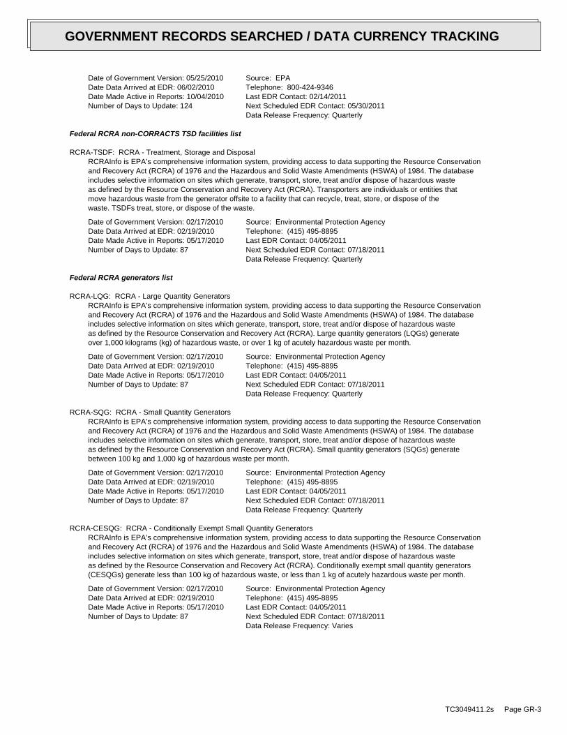
Date of Government Version: 05/25/2010Date Data Arrived at EDR: 06/02/2010Date Made Active in Reports: 10/04/2010Number of Days to Update: 124
Source: EPATelephone: 800-424-9346Last EDR Contact: 02/14/2011Next Scheduled EDR Contact: 05/30/2011Data Release Frequency: Quarterly
Federal RCRA non-CORRACTS TSD facilities list
RCRA-TSDF: RCRA - Treatment, Storage and DisposalRCRAInfo is EPA’s comprehensive information system, providing access to data supporting the Resource Conservationand Recovery Act (RCRA) of 1976 and the Hazardous and Solid Waste Amendments (HSWA) of 1984. The databaseincludes selective information on sites which generate, transport, store, treat and/or dispose of hazardous wasteas defined by the Resource Conservation and Recovery Act (RCRA). Transporters are individuals or entities thatmove hazardous waste from the generator offsite to a facility that can recycle, treat, store, or dispose of thewaste. TSDFs treat, store, or dispose of the waste.
Date of Government Version: 02/17/2010Date Data Arrived at EDR: 02/19/2010Date Made Active in Reports: 05/17/2010Number of Days to Update: 87
Source: Environmental Protection AgencyTelephone: (415) 495-8895Last EDR Contact: 04/05/2011Next Scheduled EDR Contact: 07/18/2011Data Release Frequency: Quarterly
Federal RCRA generators list
RCRA-LQG: RCRA - Large Quantity GeneratorsRCRAInfo is EPA’s comprehensive information system, providing access to data supporting the Resource Conservationand Recovery Act (RCRA) of 1976 and the Hazardous and Solid Waste Amendments (HSWA) of 1984. The databaseincludes selective information on sites which generate, transport, store, treat and/or dispose of hazardous wasteas defined by the Resource Conservation and Recovery Act (RCRA). Large quantity generators (LQGs) generateover 1,000 kilograms (kg) of hazardous waste, or over 1 kg of acutely hazardous waste per month.
Date of Government Version: 02/17/2010Date Data Arrived at EDR: 02/19/2010Date Made Active in Reports: 05/17/2010Number of Days to Update: 87
Source: Environmental Protection AgencyTelephone: (415) 495-8895Last EDR Contact: 04/05/2011Next Scheduled EDR Contact: 07/18/2011Data Release Frequency: Quarterly
RCRA-SQG: RCRA - Small Quantity GeneratorsRCRAInfo is EPA’s comprehensive information system, providing access to data supporting the Resource Conservationand Recovery Act (RCRA) of 1976 and the Hazardous and Solid Waste Amendments (HSWA) of 1984. The databaseincludes selective information on sites which generate, transport, store, treat and/or dispose of hazardous wasteas defined by the Resource Conservation and Recovery Act (RCRA). Small quantity generators (SQGs) generatebetween 100 kg and 1,000 kg of hazardous waste per month.
Date of Government Version: 02/17/2010Date Data Arrived at EDR: 02/19/2010Date Made Active in Reports: 05/17/2010Number of Days to Update: 87
Source: Environmental Protection AgencyTelephone: (415) 495-8895Last EDR Contact: 04/05/2011Next Scheduled EDR Contact: 07/18/2011Data Release Frequency: Quarterly
RCRA-CESQG: RCRA - Conditionally Exempt Small Quantity GeneratorsRCRAInfo is EPA’s comprehensive information system, providing access to data supporting the Resource Conservationand Recovery Act (RCRA) of 1976 and the Hazardous and Solid Waste Amendments (HSWA) of 1984. The databaseincludes selective information on sites which generate, transport, store, treat and/or dispose of hazardous wasteas defined by the Resource Conservation and Recovery Act (RCRA). Conditionally exempt small quantity generators(CESQGs) generate less than 100 kg of hazardous waste, or less than 1 kg of acutely hazardous waste per month.
Date of Government Version: 02/17/2010Date Data Arrived at EDR: 02/19/2010Date Made Active in Reports: 05/17/2010Number of Days to Update: 87
Source: Environmental Protection AgencyTelephone: (415) 495-8895Last EDR Contact: 04/05/2011Next Scheduled EDR Contact: 07/18/2011Data Release Frequency: Varies
TC3049411.2s Page GR-3
GOVERNMENT RECORDS SEARCHED / DATA CURRENCY TRACKING

Federal institutional controls / engineering controls registries
US ENG CONTROLS: Engineering Controls Sites ListA listing of sites with engineering controls in place. Engineering controls include various forms of caps, buildingfoundations, liners, and treatment methods to create pathway elimination for regulated substances to enter environmentalmedia or effect human health.
Date of Government Version: 01/05/2011Date Data Arrived at EDR: 01/14/2011Date Made Active in Reports: 01/28/2011Number of Days to Update: 14
Source: Environmental Protection AgencyTelephone: 703-603-0695Last EDR Contact: 03/14/2011Next Scheduled EDR Contact: 06/27/2011Data Release Frequency: Varies
US INST CONTROL: Sites with Institutional ControlsA listing of sites with institutional controls in place. Institutional controls include administrative measures,such as groundwater use restrictions, construction restrictions, property use restrictions, and post remediationcare requirements intended to prevent exposure to contaminants remaining on site. Deed restrictions are generallyrequired as part of the institutional controls.
Date of Government Version: 01/05/2011Date Data Arrived at EDR: 01/14/2011Date Made Active in Reports: 01/28/2011Number of Days to Update: 14
Source: Environmental Protection AgencyTelephone: 703-603-0695Last EDR Contact: 03/14/2011Next Scheduled EDR Contact: 06/27/2011Data Release Frequency: Varies
Federal ERNS list
ERNS: Emergency Response Notification SystemEmergency Response Notification System. ERNS records and stores information on reported releases of oil and hazardoussubstances.
Date of Government Version: 12/31/2010Date Data Arrived at EDR: 01/07/2011Date Made Active in Reports: 03/21/2011Number of Days to Update: 73
Source: National Response Center, United States Coast GuardTelephone: 202-267-2180Last EDR Contact: 04/05/2011Next Scheduled EDR Contact: 07/18/2011Data Release Frequency: Annually
State- and tribal - equivalent NPL
WQARF: Water Quality Assurance Revolving Fund SitesSites which may have an actual or potential impact upon the waters of the state, cause by hazardous substances.The WQARF program provides matching funds to political subdivisions and other state agencies for clean-up activities.
Date of Government Version: 09/01/2010Date Data Arrived at EDR: 09/08/2010Date Made Active in Reports: 09/22/2010Number of Days to Update: 14
Source: Department of Environmental QualityTelephone: 602-771-4360Last EDR Contact: 03/04/2011Next Scheduled EDR Contact: 06/13/2011Data Release Frequency: Annually
State- and tribal - equivalent CERCLIS
SPL: Superfund Program ListThe list is representative of the sites and potential sites within the jurisdiction of the Superfund Program Section.It is comprised of the following elements: 1) Water Quality Assurance Revolving Fund Registry Sites; 2) PotentialWQARF Registry sites; 3) NPL sites; and 4) Department of Defense sites requiring SPS oversight.
Date of Government Version: 08/25/2004Date Data Arrived at EDR: 12/03/2004Date Made Active in Reports: 01/25/2005Number of Days to Update: 53
Source: Department of Environmental QualityTelephone: 602-771-4360Last EDR Contact: 02/08/2011Next Scheduled EDR Contact: 05/23/2011Data Release Frequency: Semi-Annually
TC3049411.2s Page GR-4
GOVERNMENT RECORDS SEARCHED / DATA CURRENCY TRACKING

SHWS: ZipAcids ListThe ACIDS list consists of more than 750 locations subject to investigation under the State Water Quality AssuranceRevolving Fund (WQARF) and Federal CERCLA programs. The list is no longer updated by the state.
Date of Government Version: 01/03/2000Date Data Arrived at EDR: 04/11/2000Date Made Active in Reports: 05/16/2000Number of Days to Update: 35
Source: Department of Environmental QualityTelephone: 602-771-4360Last EDR Contact: 03/28/2011Next Scheduled EDR Contact: 07/11/2011Data Release Frequency: No Update Planned
State and tribal landfill and/or solid waste disposal site lists
SWF/LF: Directory of Solid Waste FacilitiesSolid Waste Facilities/Landfill Sites. SWF/LF type records typically contain an inventory of solid waste disposalfacilities or landfills in a particular state. Depending on the state, these may be active or inactive facilitiesor open dumps that failed to meet RCRA Subtitle D Section 4004 criteria for solid waste landfills or disposalsites.
Date of Government Version: 12/01/2010Date Data Arrived at EDR: 12/10/2010Date Made Active in Reports: 12/22/2010Number of Days to Update: 12
Source: Department of Environmental QualityTelephone: 602-771-2300Last EDR Contact: 03/11/2011Next Scheduled EDR Contact: 06/20/2011Data Release Frequency: Annually
State and tribal leaking storage tank lists
LUST: Leaking Underground Storage Tank ListingLeaking Underground Storage Tank Incident Reports. LUST records contain an inventory of reported leaking undergroundstorage tank incidents. Not all states maintain these records, and the information stored varies by state.
Date of Government Version: 01/27/2011Date Data Arrived at EDR: 01/28/2011Date Made Active in Reports: 02/03/2011Number of Days to Update: 6
Source: Department of Environmental QualityTelephone: 602-771-4345Last EDR Contact: 04/18/2011Next Scheduled EDR Contact: 08/01/2011Data Release Frequency: Semi-Annually
INDIAN LUST R7: Leaking Underground Storage Tanks on Indian LandLUSTs on Indian land in Iowa, Kansas, and Nebraska
Date of Government Version: 11/04/2009Date Data Arrived at EDR: 05/04/2010Date Made Active in Reports: 07/07/2010Number of Days to Update: 64
Source: EPA Region 7Telephone: 913-551-7003Last EDR Contact: 05/04/2010Next Scheduled EDR Contact: 05/16/2011Data Release Frequency: Varies
INDIAN LUST R6: Leaking Underground Storage Tanks on Indian LandLUSTs on Indian land in New Mexico and Oklahoma.
Date of Government Version: 02/03/2011Date Data Arrived at EDR: 02/04/2011Date Made Active in Reports: 03/21/2011Number of Days to Update: 45
Source: EPA Region 6Telephone: 214-665-6597Last EDR Contact: 01/31/2011Next Scheduled EDR Contact: 05/16/2011Data Release Frequency: Varies
INDIAN LUST R8: Leaking Underground Storage Tanks on Indian LandLUSTs on Indian land in Colorado, Montana, North Dakota, South Dakota, Utah and Wyoming.
Date of Government Version: 02/04/2011Date Data Arrived at EDR: 02/04/2011Date Made Active in Reports: 03/21/2011Number of Days to Update: 45
Source: EPA Region 8Telephone: 303-312-6271Last EDR Contact: 01/31/2011Next Scheduled EDR Contact: 05/16/2011Data Release Frequency: Quarterly
TC3049411.2s Page GR-5
GOVERNMENT RECORDS SEARCHED / DATA CURRENCY TRACKING

INDIAN LUST R1: Leaking Underground Storage Tanks on Indian LandA listing of leaking underground storage tank locations on Indian Land.
Date of Government Version: 09/01/2010Date Data Arrived at EDR: 11/05/2010Date Made Active in Reports: 01/28/2011Number of Days to Update: 84
Source: EPA Region 1Telephone: 617-918-1313Last EDR Contact: 02/03/2011Next Scheduled EDR Contact: 05/16/2011Data Release Frequency: Varies
INDIAN LUST R10: Leaking Underground Storage Tanks on Indian LandLUSTs on Indian land in Alaska, Idaho, Oregon and Washington.
Date of Government Version: 02/03/2011Date Data Arrived at EDR: 02/04/2011Date Made Active in Reports: 03/21/2011Number of Days to Update: 45
Source: EPA Region 10Telephone: 206-553-2857Last EDR Contact: 01/31/2011Next Scheduled EDR Contact: 05/16/2011Data Release Frequency: Quarterly
INDIAN LUST R9: Leaking Underground Storage Tanks on Indian LandLUSTs on Indian land in Arizona, California, New Mexico and Nevada
Date of Government Version: 01/31/2011Date Data Arrived at EDR: 02/01/2011Date Made Active in Reports: 03/21/2011Number of Days to Update: 48
Source: Environmental Protection AgencyTelephone: 415-972-3372Last EDR Contact: 01/31/2011Next Scheduled EDR Contact: 05/16/2011Data Release Frequency: Quarterly
INDIAN LUST R4: Leaking Underground Storage Tanks on Indian LandLUSTs on Indian land in Florida, Mississippi and North Carolina.
Date of Government Version: 08/27/2010Date Data Arrived at EDR: 08/30/2010Date Made Active in Reports: 10/04/2010Number of Days to Update: 35
Source: EPA Region 4Telephone: 404-562-8677Last EDR Contact: 02/16/2011Next Scheduled EDR Contact: 05/16/2011Data Release Frequency: Semi-Annually
State and tribal registered storage tank lists
UST: Underground Storage Tank ListingRegistered Underground Storage Tanks. UST’s are regulated under Subtitle I of the Resource Conservation and RecoveryAct (RCRA) and must be registered with the state department responsible for administering the UST program. Availableinformation varies by state program.
Date of Government Version: 01/24/2011Date Data Arrived at EDR: 01/28/2011Date Made Active in Reports: 02/04/2011Number of Days to Update: 7
Source: Department of Environmental QualityTelephone: 602-771-4345Last EDR Contact: 04/18/2011Next Scheduled EDR Contact: 08/01/2011Data Release Frequency: Annually
AST 2: Aboveground Storage Tank ListingA listing of aboveground storage tank site locations.
Date of Government Version: 02/24/2011Date Data Arrived at EDR: 02/25/2011Date Made Active in Reports: 03/07/2011Number of Days to Update: 10
Source: Department of Environmental QualityTelephone: 602-771-4380Last EDR Contact: 03/21/2011Next Scheduled EDR Contact: 07/04/2011Data Release Frequency: Varies
AST: List of Aboveground Storage TanksAboveground storage tanks that the Dept. of Building & Fire Safety have permitted.
TC3049411.2s Page GR-6
GOVERNMENT RECORDS SEARCHED / DATA CURRENCY TRACKING

Date of Government Version: 12/31/2000Date Data Arrived at EDR: 01/22/2001Date Made Active in Reports: 02/16/2001Number of Days to Update: 25
Source: Department of Building & Fire SafetyTelephone: 602-364-1003Last EDR Contact: 03/21/2011Next Scheduled EDR Contact: 07/04/2011Data Release Frequency: No Update Planned
INDIAN UST R1: Underground Storage Tanks on Indian LandThe Indian Underground Storage Tank (UST) database provides information about underground storage tanks on Indianland in EPA Region 1 (Connecticut, Maine, Massachusetts, New Hampshire, Rhode Island, Vermont and ten TribalNations).
Date of Government Version: 09/01/2010Date Data Arrived at EDR: 11/05/2010Date Made Active in Reports: 01/28/2011Number of Days to Update: 84
Source: EPA, Region 1Telephone: 617-918-1313Last EDR Contact: 02/03/2011Next Scheduled EDR Contact: 05/16/2011Data Release Frequency: Varies
INDIAN UST R10: Underground Storage Tanks on Indian LandThe Indian Underground Storage Tank (UST) database provides information about underground storage tanks on Indianland in EPA Region 10 (Alaska, Idaho, Oregon, Washington, and Tribal Nations).
Date of Government Version: 02/03/2011Date Data Arrived at EDR: 02/04/2011Date Made Active in Reports: 03/21/2011Number of Days to Update: 45
Source: EPA Region 10Telephone: 206-553-2857Last EDR Contact: 01/31/2011Next Scheduled EDR Contact: 05/16/2011Data Release Frequency: Quarterly
INDIAN UST R7: Underground Storage Tanks on Indian LandThe Indian Underground Storage Tank (UST) database provides information about underground storage tanks on Indianland in EPA Region 7 (Iowa, Kansas, Missouri, Nebraska, and 9 Tribal Nations).
Date of Government Version: 11/01/2010Date Data Arrived at EDR: 12/02/2010Date Made Active in Reports: 01/28/2011Number of Days to Update: 57
Source: EPA Region 7Telephone: 913-551-7003Last EDR Contact: 02/03/2011Next Scheduled EDR Contact: 05/16/2011Data Release Frequency: Varies
INDIAN UST R8: Underground Storage Tanks on Indian LandThe Indian Underground Storage Tank (UST) database provides information about underground storage tanks on Indianland in EPA Region 8 (Colorado, Montana, North Dakota, South Dakota, Utah, Wyoming and 27 Tribal Nations).
Date of Government Version: 02/04/2011Date Data Arrived at EDR: 02/04/2011Date Made Active in Reports: 03/21/2011Number of Days to Update: 45
Source: EPA Region 8Telephone: 303-312-6137Last EDR Contact: 01/31/2011Next Scheduled EDR Contact: 05/16/2011Data Release Frequency: Quarterly
INDIAN UST R9: Underground Storage Tanks on Indian LandThe Indian Underground Storage Tank (UST) database provides information about underground storage tanks on Indianland in EPA Region 9 (Arizona, California, Hawaii, Nevada, the Pacific Islands, and Tribal Nations).
Date of Government Version: 01/31/2011Date Data Arrived at EDR: 02/01/2011Date Made Active in Reports: 03/21/2011Number of Days to Update: 48
Source: EPA Region 9Telephone: 415-972-3368Last EDR Contact: 01/31/2011Next Scheduled EDR Contact: 05/16/2011Data Release Frequency: Quarterly
INDIAN UST R6: Underground Storage Tanks on Indian LandThe Indian Underground Storage Tank (UST) database provides information about underground storage tanks on Indianland in EPA Region 6 (Louisiana, Arkansas, Oklahoma, New Mexico, Texas and 65 Tribes).
TC3049411.2s Page GR-7
GOVERNMENT RECORDS SEARCHED / DATA CURRENCY TRACKING

Date of Government Version: 02/03/2011Date Data Arrived at EDR: 02/04/2011Date Made Active in Reports: 03/21/2011Number of Days to Update: 45
Source: EPA Region 6Telephone: 214-665-7591Last EDR Contact: 01/31/2011Next Scheduled EDR Contact: 05/16/2011Data Release Frequency: Semi-Annually
INDIAN UST R5: Underground Storage Tanks on Indian LandThe Indian Underground Storage Tank (UST) database provides information about underground storage tanks on Indianland in EPA Region 5 (Michigan, Minnesota and Wisconsin and Tribal Nations).
Date of Government Version: 02/11/2010Date Data Arrived at EDR: 02/11/2010Date Made Active in Reports: 04/12/2010Number of Days to Update: 60
Source: EPA Region 5Telephone: 312-886-6136Last EDR Contact: 01/31/2011Next Scheduled EDR Contact: 05/16/2011Data Release Frequency: Varies
INDIAN UST R4: Underground Storage Tanks on Indian LandThe Indian Underground Storage Tank (UST) database provides information about underground storage tanks on Indianland in EPA Region 4 (Alabama, Florida, Georgia, Kentucky, Mississippi, North Carolina, South Carolina, Tennesseeand Tribal Nations)
Date of Government Version: 08/27/2010Date Data Arrived at EDR: 08/30/2010Date Made Active in Reports: 10/04/2010Number of Days to Update: 35
Source: EPA Region 4Telephone: 404-562-9424Last EDR Contact: 02/16/2011Next Scheduled EDR Contact: 05/16/2011Data Release Frequency: Semi-Annually
FEMA UST: Underground Storage Tank ListingA listing of all FEMA owned underground storage tanks.
Date of Government Version: 01/01/2010Date Data Arrived at EDR: 02/16/2010Date Made Active in Reports: 04/12/2010Number of Days to Update: 55
Source: FEMATelephone: 202-646-5797Last EDR Contact: 04/18/2011Next Scheduled EDR Contact: 08/01/2011Data Release Frequency: Varies
State and tribal institutional control / engineering control registries
AUL: DEUR DatabaseActivity and use limitations include both engineering controls and institutional controls. DEUR and VEMUR sites.DEUR: Declaration of Environmental Use Restriction. A restrictive land use covenant that is required when a propertyowner elects to use an institutional (i.e., administrative) control or engineering (i.e., physical) controlas a means to meet remediation goals. The DEUR runs with and burdens the land, and requires maintenance of anyinstitutional or engineering controls. VEMUR: Voluntary Environmental Mitigation Use Restriction. A restrictiveland use covenant that, prior to July 18, 2000, was required when a property owner elected to remediate the propertyto non-residential uses. Effective July 18, 2000, the DEUR replaced the VEMUR as a restrictive use covenant.
Date of Government Version: 12/29/2010Date Data Arrived at EDR: 12/29/2010Date Made Active in Reports: 02/03/2011Number of Days to Update: 36
Source: Department of Environmental QualityTelephone: 602-771-4398Last EDR Contact: 03/29/2011Next Scheduled EDR Contact: 07/11/2011Data Release Frequency: Varies
AZURITE: Remediation and DEUR/VEMUR Tracking SystemADEQ maintains a repository listing sites remediated under programs administered by the department.
Date of Government Version: 12/29/2010Date Data Arrived at EDR: 12/29/2010Date Made Active in Reports: 02/03/2011Number of Days to Update: 36
Source: Department of Environmental QualityTelephone: 601-771-4396Last EDR Contact: 03/29/2011Next Scheduled EDR Contact: 07/11/2011Data Release Frequency: Quarterly
TC3049411.2s Page GR-8
GOVERNMENT RECORDS SEARCHED / DATA CURRENCY TRACKING

State and tribal voluntary cleanup sites
VCP: Voluntary Remediation Program SitesSites involved in the Voluntary Remediation Program.
Date of Government Version: 01/07/2011Date Data Arrived at EDR: 01/18/2011Date Made Active in Reports: 02/03/2011Number of Days to Update: 16
Source: Department of Environmental QualityTelephone: 602-771-4411Last EDR Contact: 03/28/2011Next Scheduled EDR Contact: 07/11/2011Data Release Frequency: Varies
INDIAN VCP R1: Voluntary Cleanup Priority ListingA listing of voluntary cleanup priority sites located on Indian Land located in Region 1.
Date of Government Version: 09/01/2010Date Data Arrived at EDR: 01/05/2011Date Made Active in Reports: 03/21/2011Number of Days to Update: 75
Source: EPA, Region 1Telephone: 617-918-1102Last EDR Contact: 04/05/2011Next Scheduled EDR Contact: 07/18/2011Data Release Frequency: Varies
INDIAN VCP R7: Voluntary Cleanup Priority LisitngA listing of voluntary cleanup priority sites located on Indian Land located in Region 7.
Date of Government Version: 03/20/2008Date Data Arrived at EDR: 04/22/2008Date Made Active in Reports: 05/19/2008Number of Days to Update: 27
Source: EPA, Region 7Telephone: 913-551-7365Last EDR Contact: 04/20/2009Next Scheduled EDR Contact: 07/20/2009Data Release Frequency: Varies
State and tribal Brownfields sites
BROWNFIELDS: Brownfields Tracking SystemInformation relating to Brownfields sites in Arizona.
Date of Government Version: 01/07/2011Date Data Arrived at EDR: 01/18/2011Date Made Active in Reports: 02/03/2011Number of Days to Update: 16
Source: Department of Environmental QualityTelephone: 602-771-4401Last EDR Contact: 03/28/2011Next Scheduled EDR Contact: 07/11/2011Data Release Frequency: Varies
ADDITIONAL ENVIRONMENTAL RECORDS
Local Brownfield lists
US BROWNFIELDS: A Listing of Brownfields Sites
TC3049411.2s Page GR-9
GOVERNMENT RECORDS SEARCHED / DATA CURRENCY TRACKING

Included in the listing are brownfields properties addresses by Cooperative Agreement Recipients and brownfieldsproperties addressed by Targeted Brownfields Assessments. Targeted Brownfields Assessments-EPA’s Targeted BrownfieldsAssessments (TBA) program is designed to help states, tribes, and municipalities--especially those without EPABrownfields Assessment Demonstration Pilots--minimize the uncertainties of contamination often associated withbrownfields. Under the TBA program, EPA provides funding and/or technical assistance for environmental assessmentsat brownfields sites throughout the country. Targeted Brownfields Assessments supplement and work with other effortsunder EPA’s Brownfields Initiative to promote cleanup and redevelopment of brownfields. Cooperative AgreementRecipients-States, political subdivisions, territories, and Indian tribes become Brownfields Cleanup RevolvingLoan Fund (BCRLF) cooperative agreement recipients when they enter into BCRLF cooperative agreements with theU.S. EPA. EPA selects BCRLF cooperative agreement recipients based on a proposal and application process. BCRLFcooperative agreement recipients must use EPA funds provided through BCRLF cooperative agreement for specifiedbrownfields-related cleanup activities.
Date of Government Version: 12/29/2010Date Data Arrived at EDR: 12/30/2010Date Made Active in Reports: 03/21/2011Number of Days to Update: 81
Source: Environmental Protection AgencyTelephone: 202-566-2777Last EDR Contact: 03/29/2011Next Scheduled EDR Contact: 07/11/2011Data Release Frequency: Semi-Annually
Local Lists of Landfill / Solid Waste Disposal Sites
DEBRIS REGION 9: Torres Martinez Reservation Illegal Dump Site LocationsA listing of illegal dump sites location on the Torres Martinez Indian Reservation located in eastern RiversideCounty and northern Imperial County, California.
Date of Government Version: 01/12/2009Date Data Arrived at EDR: 05/07/2009Date Made Active in Reports: 09/21/2009Number of Days to Update: 137
Source: EPA, Region 9Telephone: 415-947-4219Last EDR Contact: 03/28/2011Next Scheduled EDR Contact: 07/11/2011Data Release Frequency: No Update Planned
ODI: Open Dump InventoryAn open dump is defined as a disposal facility that does not comply with one or more of the Part 257 or Part 258Subtitle D Criteria.
Date of Government Version: 06/30/1985Date Data Arrived at EDR: 08/09/2004Date Made Active in Reports: 09/17/2004Number of Days to Update: 39
Source: Environmental Protection AgencyTelephone: 800-424-9346Last EDR Contact: 06/09/2004Next Scheduled EDR Contact: N/AData Release Frequency: No Update Planned
SWTIRE: Solid Waste Tire FacilitiesA waste tire "facility" means a solid waste facility at which waste tires are stored outdoors on any day.
Date of Government Version: 02/01/2011Date Data Arrived at EDR: 03/09/2011Date Made Active in Reports: 03/30/2011Number of Days to Update: 21
Source: Department of Environmental QualityTelephone: 602-771-4132Last EDR Contact: 03/07/2011Next Scheduled EDR Contact: 06/20/2011Data Release Frequency: Varies
INDIAN ODI: Report on the Status of Open Dumps on Indian LandsLocation of open dumps on Indian land.
Date of Government Version: 12/31/1998Date Data Arrived at EDR: 12/03/2007Date Made Active in Reports: 01/24/2008Number of Days to Update: 52
Source: Environmental Protection AgencyTelephone: 703-308-8245Last EDR Contact: 02/08/2011Next Scheduled EDR Contact: 05/23/2011Data Release Frequency: Varies
Local Lists of Hazardous waste / Contaminated Sites
TC3049411.2s Page GR-10
GOVERNMENT RECORDS SEARCHED / DATA CURRENCY TRACKING

US CDL: Clandestine Drug LabsA listing of clandestine drug lab locations. The U.S. Department of Justice ("the Department") provides thisweb site as a public service. It contains addresses of some locations where law enforcement agencies reportedthey found chemicals or other items that indicated the presence of either clandestine drug laboratories or dumpsites.In most cases, the source of the entries is not the Department, and the Department has not verified the entryand does not guarantee its accuracy. Members of the public must verify the accuracy of all entries by, for example,contacting local law enforcement and local health departments.
Date of Government Version: 12/03/2010Date Data Arrived at EDR: 12/30/2010Date Made Active in Reports: 02/16/2011Number of Days to Update: 48
Source: Drug Enforcement AdministrationTelephone: 202-307-1000Last EDR Contact: 03/08/2011Next Scheduled EDR Contact: 06/20/2011Data Release Frequency: Quarterly
AOCONCERN: Superfund GIS InformationA gis coverage for Department of Environmental Quality superfund sites, included WAQRF, DOD and NPL.
Date of Government Version: 02/28/2008Date Data Arrived at EDR: 04/01/2008Date Made Active in Reports: 10/23/2009Number of Days to Update: 570
Source: Department of Environmental QualityTelephone: 602-771-4173Last EDR Contact: 02/28/2011Next Scheduled EDR Contact: 06/13/2011Data Release Frequency: Varies
CDL: Clandestine Drug LabsA listing of drug lab seizures in Arizona.
Date of Government Version: 01/24/2011Date Data Arrived at EDR: 02/03/2011Date Made Active in Reports: 03/04/2011Number of Days to Update: 29
Source: Board of Technical RegistrationTelephone: 602-364-4931Last EDR Contact: 04/04/2011Next Scheduled EDR Contact: 07/18/2011Data Release Frequency: Varies
US HIST CDL: National Clandestine Laboratory RegisterA listing of clandestine drug lab locations. The U.S. Department of Justice ("the Department") provides thisweb site as a public service. It contains addresses of some locations where law enforcement agencies reportedthey found chemicals or other items that indicated the presence of either clandestine drug laboratories or dumpsites.In most cases, the source of the entries is not the Department, and the Department has not verified the entryand does not guarantee its accuracy. Members of the public must verify the accuracy of all entries by, for example,contacting local law enforcement and local health departments.
Date of Government Version: 09/01/2007Date Data Arrived at EDR: 11/19/2008Date Made Active in Reports: 03/30/2009Number of Days to Update: 131
Source: Drug Enforcement AdministrationTelephone: 202-307-1000Last EDR Contact: 03/23/2009Next Scheduled EDR Contact: 06/22/2009Data Release Frequency: No Update Planned
Local Lists of Registered Storage Tanks
AST 2: Aboveground Storage Tank ListingA listing of aboveground storage tank site locations.
Date of Government Version: 02/24/2011Date Data Arrived at EDR: 02/25/2011Date Made Active in Reports: 03/07/2011Number of Days to Update: 10
Source: Department of Environmental QualityTelephone: 602-771-4380Last EDR Contact: 03/21/2011Next Scheduled EDR Contact: 07/04/2011Data Release Frequency: Varies
Local Land Records
TC3049411.2s Page GR-11
GOVERNMENT RECORDS SEARCHED / DATA CURRENCY TRACKING

LIENS 2: CERCLA Lien InformationA Federal CERCLA (’Superfund’) lien can exist by operation of law at any site or property at which EPA has spentSuperfund monies. These monies are spent to investigate and address releases and threatened releases of contamination.CERCLIS provides information as to the identity of these sites and properties.
Date of Government Version: 11/09/2010Date Data Arrived at EDR: 11/16/2010Date Made Active in Reports: 02/16/2011Number of Days to Update: 92
Source: Environmental Protection AgencyTelephone: 202-564-6023Last EDR Contact: 01/31/2011Next Scheduled EDR Contact: 05/16/2011Data Release Frequency: Varies
LUCIS: Land Use Control Information SystemLUCIS contains records of land use control information pertaining to the former Navy Base Realignment and Closureproperties.
Date of Government Version: 12/09/2005Date Data Arrived at EDR: 12/11/2006Date Made Active in Reports: 01/11/2007Number of Days to Update: 31
Source: Department of the NavyTelephone: 843-820-7326Last EDR Contact: 02/22/2011Next Scheduled EDR Contact: 06/06/2011Data Release Frequency: Varies
Records of Emergency Release Reports
HMIRS: Hazardous Materials Information Reporting SystemHazardous Materials Incident Report System. HMIRS contains hazardous material spill incidents reported to DOT.
Date of Government Version: 12/31/2010Date Data Arrived at EDR: 01/05/2011Date Made Active in Reports: 02/25/2011Number of Days to Update: 51
Source: U.S. Department of TransportationTelephone: 202-366-4555Last EDR Contact: 04/05/2011Next Scheduled EDR Contact: 07/18/2011Data Release Frequency: Annually
SPILLS: Hazardous Material LogbookChemical spills and incidents referred to the Emergency Response Unit.
Date of Government Version: 11/15/2001Date Data Arrived at EDR: 06/28/2007Date Made Active in Reports: 07/24/2007Number of Days to Update: 26
Source: Department of Environmental QualityTelephone: 602-771-4153Last EDR Contact: 03/07/2011Next Scheduled EDR Contact: 06/20/2011Data Release Frequency: Varies
Other Ascertainable Records
RCRA-NonGen: RCRA - Non GeneratorsRCRAInfo is EPA’s comprehensive information system, providing access to data supporting the Resource Conservationand Recovery Act (RCRA) of 1976 and the Hazardous and Solid Waste Amendments (HSWA) of 1984. The databaseincludes selective information on sites which generate, transport, store, treat and/or dispose of hazardous wasteas defined by the Resource Conservation and Recovery Act (RCRA). Non-Generators do not presently generate hazardouswaste.
Date of Government Version: 02/17/2010Date Data Arrived at EDR: 02/19/2010Date Made Active in Reports: 05/17/2010Number of Days to Update: 87
Source: Environmental Protection AgencyTelephone: (415) 495-8895Last EDR Contact: 04/05/2011Next Scheduled EDR Contact: 07/18/2011Data Release Frequency: Varies
DOT OPS: Incident and Accident DataDepartment of Transporation, Office of Pipeline Safety Incident and Accident data.
TC3049411.2s Page GR-12
GOVERNMENT RECORDS SEARCHED / DATA CURRENCY TRACKING

Date of Government Version: 10/13/2010Date Data Arrived at EDR: 12/10/2010Date Made Active in Reports: 02/25/2011Number of Days to Update: 77
Source: Department of Transporation, Office of Pipeline SafetyTelephone: 202-366-4595Last EDR Contact: 02/11/2011Next Scheduled EDR Contact: 05/23/2011Data Release Frequency: Varies
DOD: Department of Defense SitesThis data set consists of federally owned or administered lands, administered by the Department of Defense, thathave any area equal to or greater than 640 acres of the United States, Puerto Rico, and the U.S. Virgin Islands.
Date of Government Version: 12/31/2005Date Data Arrived at EDR: 11/10/2006Date Made Active in Reports: 01/11/2007Number of Days to Update: 62
Source: USGSTelephone: 703-692-8801Last EDR Contact: 04/21/2011Next Scheduled EDR Contact: 08/01/2011Data Release Frequency: Semi-Annually
FUDS: Formerly Used Defense SitesThe listing includes locations of Formerly Used Defense Sites properties where the US Army Corps of Engineersis actively working or will take necessary cleanup actions.
Date of Government Version: 12/31/2009Date Data Arrived at EDR: 08/12/2010Date Made Active in Reports: 12/02/2010Number of Days to Update: 112
Source: U.S. Army Corps of EngineersTelephone: 202-528-4285Last EDR Contact: 03/15/2011Next Scheduled EDR Contact: 06/27/2011Data Release Frequency: Varies
CONSENT: Superfund (CERCLA) Consent DecreesMajor legal settlements that establish responsibility and standards for cleanup at NPL (Superfund) sites. Releasedperiodically by United States District Courts after settlement by parties to litigation matters.
Date of Government Version: 10/01/2010Date Data Arrived at EDR: 10/29/2010Date Made Active in Reports: 01/28/2011Number of Days to Update: 91
Source: Department of Justice, Consent Decree LibraryTelephone: VariesLast EDR Contact: 04/04/2011Next Scheduled EDR Contact: 07/18/2011Data Release Frequency: Varies
ROD: Records Of DecisionRecord of Decision. ROD documents mandate a permanent remedy at an NPL (Superfund) site containing technicaland health information to aid in the cleanup.
Date of Government Version: 02/25/2011Date Data Arrived at EDR: 03/16/2011Date Made Active in Reports: 03/21/2011Number of Days to Update: 5
Source: EPATelephone: 703-416-0223Last EDR Contact: 03/16/2011Next Scheduled EDR Contact: 06/27/2011Data Release Frequency: Annually
UMTRA: Uranium Mill Tailings SitesUranium ore was mined by private companies for federal government use in national defense programs. When the millsshut down, large piles of the sand-like material (mill tailings) remain after uranium has been extracted fromthe ore. Levels of human exposure to radioactive materials from the piles are low; however, in some cases tailingswere used as construction materials before the potential health hazards of the tailings were recognized.
Date of Government Version: 09/14/2010Date Data Arrived at EDR: 10/21/2010Date Made Active in Reports: 01/28/2011Number of Days to Update: 99
Source: Department of EnergyTelephone: 505-845-0011Last EDR Contact: 03/04/2011Next Scheduled EDR Contact: 06/13/2011Data Release Frequency: Varies
MINES: Mines Master Index FileContains all mine identification numbers issued for mines active or opened since 1971. The data also includesviolation information.
TC3049411.2s Page GR-13
GOVERNMENT RECORDS SEARCHED / DATA CURRENCY TRACKING

Date of Government Version: 08/04/2010Date Data Arrived at EDR: 09/09/2010Date Made Active in Reports: 12/02/2010Number of Days to Update: 84
Source: Department of Labor, Mine Safety and Health AdministrationTelephone: 303-231-5959Last EDR Contact: 03/09/2011Next Scheduled EDR Contact: 06/20/2011Data Release Frequency: Semi-Annually
TRIS: Toxic Chemical Release Inventory SystemToxic Release Inventory System. TRIS identifies facilities which release toxic chemicals to the air, water andland in reportable quantities under SARA Title III Section 313.
Date of Government Version: 12/31/2009Date Data Arrived at EDR: 12/17/2010Date Made Active in Reports: 03/21/2011Number of Days to Update: 94
Source: EPATelephone: 202-566-0250Last EDR Contact: 03/01/2011Next Scheduled EDR Contact: 06/13/2011Data Release Frequency: Annually
TSCA: Toxic Substances Control ActToxic Substances Control Act. TSCA identifies manufacturers and importers of chemical substances included on theTSCA Chemical Substance Inventory list. It includes data on the production volume of these substances by plantsite.
Date of Government Version: 12/31/2006Date Data Arrived at EDR: 09/29/2010Date Made Active in Reports: 12/02/2010Number of Days to Update: 64
Source: EPATelephone: 202-260-5521Last EDR Contact: 03/29/2011Next Scheduled EDR Contact: 07/11/2011Data Release Frequency: Every 4 Years
FTTS: FIFRA/ TSCA Tracking System - FIFRA (Federal Insecticide, Fungicide, & Rodenticide Act)/TSCA (Toxic Substances Control Act)FTTS tracks administrative cases and pesticide enforcement actions and compliance activities related to FIFRA,TSCA and EPCRA (Emergency Planning and Community Right-to-Know Act). To maintain currency, EDR contacts theAgency on a quarterly basis.
Date of Government Version: 04/09/2009Date Data Arrived at EDR: 04/16/2009Date Made Active in Reports: 05/11/2009Number of Days to Update: 25
Source: EPA/Office of Prevention, Pesticides and Toxic SubstancesTelephone: 202-566-1667Last EDR Contact: 02/28/2011Next Scheduled EDR Contact: 06/13/2011Data Release Frequency: Quarterly
FTTS INSP: FIFRA/ TSCA Tracking System - FIFRA (Federal Insecticide, Fungicide, & Rodenticide Act)/TSCA (Toxic Substances Control Act)A listing of FIFRA/TSCA Tracking System (FTTS) inspections and enforcements.
Date of Government Version: 04/09/2009Date Data Arrived at EDR: 04/16/2009Date Made Active in Reports: 05/11/2009Number of Days to Update: 25
Source: EPATelephone: 202-566-1667Last EDR Contact: 02/28/2011Next Scheduled EDR Contact: 06/13/2011Data Release Frequency: Quarterly
HIST FTTS: FIFRA/TSCA Tracking System Administrative Case ListingA complete administrative case listing from the FIFRA/TSCA Tracking System (FTTS) for all ten EPA regions. Theinformation was obtained from the National Compliance Database (NCDB). NCDB supports the implementation of FIFRA(Federal Insecticide, Fungicide, and Rodenticide Act) and TSCA (Toxic Substances Control Act). Some EPA regionsare now closing out records. Because of that, and the fact that some EPA regions are not providing EPA Headquarterswith updated records, it was decided to create a HIST FTTS database. It included records that may not be includedin the newer FTTS database updates. This database is no longer updated.
Date of Government Version: 10/19/2006Date Data Arrived at EDR: 03/01/2007Date Made Active in Reports: 04/10/2007Number of Days to Update: 40
Source: Environmental Protection AgencyTelephone: 202-564-2501Last EDR Contact: 12/17/2007Next Scheduled EDR Contact: 03/17/2008Data Release Frequency: No Update Planned
TC3049411.2s Page GR-14
GOVERNMENT RECORDS SEARCHED / DATA CURRENCY TRACKING

HIST FTTS INSP: FIFRA/TSCA Tracking System Inspection & Enforcement Case ListingA complete inspection and enforcement case listing from the FIFRA/TSCA Tracking System (FTTS) for all ten EPAregions. The information was obtained from the National Compliance Database (NCDB). NCDB supports the implementationof FIFRA (Federal Insecticide, Fungicide, and Rodenticide Act) and TSCA (Toxic Substances Control Act). SomeEPA regions are now closing out records. Because of that, and the fact that some EPA regions are not providingEPA Headquarters with updated records, it was decided to create a HIST FTTS database. It included records thatmay not be included in the newer FTTS database updates. This database is no longer updated.
Date of Government Version: 10/19/2006Date Data Arrived at EDR: 03/01/2007Date Made Active in Reports: 04/10/2007Number of Days to Update: 40
Source: Environmental Protection AgencyTelephone: 202-564-2501Last EDR Contact: 12/17/2008Next Scheduled EDR Contact: 03/17/2008Data Release Frequency: No Update Planned
SSTS: Section 7 Tracking SystemsSection 7 of the Federal Insecticide, Fungicide and Rodenticide Act, as amended (92 Stat. 829) requires allregistered pesticide-producing establishments to submit a report to the Environmental Protection Agency by March1st each year. Each establishment must report the types and amounts of pesticides, active ingredients and devicesbeing produced, and those having been produced and sold or distributed in the past year.
Date of Government Version: 12/31/2009Date Data Arrived at EDR: 12/10/2010Date Made Active in Reports: 02/25/2011Number of Days to Update: 77
Source: EPATelephone: 202-564-4203Last EDR Contact: 01/31/2011Next Scheduled EDR Contact: 05/16/2011Data Release Frequency: Annually
ICIS: Integrated Compliance Information SystemThe Integrated Compliance Information System (ICIS) supports the information needs of the national enforcementand compliance program as well as the unique needs of the National Pollutant Discharge Elimination System (NPDES)program.
Date of Government Version: 01/07/2011Date Data Arrived at EDR: 01/21/2011Date Made Active in Reports: 03/21/2011Number of Days to Update: 59
Source: Environmental Protection AgencyTelephone: 202-564-5088Last EDR Contact: 03/28/2011Next Scheduled EDR Contact: 07/11/2011Data Release Frequency: Quarterly
PADS: PCB Activity Database SystemPCB Activity Database. PADS Identifies generators, transporters, commercial storers and/or brokers and disposersof PCB’s who are required to notify the EPA of such activities.
Date of Government Version: 11/01/2010Date Data Arrived at EDR: 11/10/2010Date Made Active in Reports: 02/16/2011Number of Days to Update: 98
Source: EPATelephone: 202-566-0500Last EDR Contact: 01/21/2011Next Scheduled EDR Contact: 05/02/2011Data Release Frequency: Annually
MLTS: Material Licensing Tracking SystemMLTS is maintained by the Nuclear Regulatory Commission and contains a list of approximately 8,100 sites whichpossess or use radioactive materials and which are subject to NRC licensing requirements. To maintain currency,EDR contacts the Agency on a quarterly basis.
Date of Government Version: 03/18/2010Date Data Arrived at EDR: 04/06/2010Date Made Active in Reports: 05/27/2010Number of Days to Update: 51
Source: Nuclear Regulatory CommissionTelephone: 301-415-7169Last EDR Contact: 03/14/2011Next Scheduled EDR Contact: 06/27/2011Data Release Frequency: Quarterly
RADINFO: Radiation Information DatabaseThe Radiation Information Database (RADINFO) contains information about facilities that are regulated by U.S.Environmental Protection Agency (EPA) regulations for radiation and radioactivity.
TC3049411.2s Page GR-15
GOVERNMENT RECORDS SEARCHED / DATA CURRENCY TRACKING

Date of Government Version: 01/11/2011Date Data Arrived at EDR: 01/13/2011Date Made Active in Reports: 02/16/2011Number of Days to Update: 34
Source: Environmental Protection AgencyTelephone: 202-343-9775Last EDR Contact: 04/13/2011Next Scheduled EDR Contact: 07/25/2011Data Release Frequency: Quarterly
FINDS: Facility Index System/Facility Registry SystemFacility Index System. FINDS contains both facility information and ’pointers’ to other sources that contain moredetail. EDR includes the following FINDS databases in this report: PCS (Permit Compliance System), AIRS (AerometricInformation Retrieval System), DOCKET (Enforcement Docket used to manage and track information on civil judicialenforcement cases for all environmental statutes), FURS (Federal Underground Injection Control), C-DOCKET (CriminalDocket System used to track criminal enforcement actions for all environmental statutes), FFIS (Federal FacilitiesInformation System), STATE (State Environmental Laws and Statutes), and PADS (PCB Activity Data System).
Date of Government Version: 04/14/2010Date Data Arrived at EDR: 04/16/2010Date Made Active in Reports: 05/27/2010Number of Days to Update: 41
Source: EPATelephone: (415) 947-8000Last EDR Contact: 03/14/2011Next Scheduled EDR Contact: 06/27/2011Data Release Frequency: Quarterly
RAATS: RCRA Administrative Action Tracking SystemRCRA Administration Action Tracking System. RAATS contains records based on enforcement actions issued under RCRApertaining to major violators and includes administrative and civil actions brought by the EPA. For administrationactions after September 30, 1995, data entry in the RAATS database was discontinued. EPA will retain a copy ofthe database for historical records. It was necessary to terminate RAATS because a decrease in agency resourcesmade it impossible to continue to update the information contained in the database.
Date of Government Version: 04/17/1995Date Data Arrived at EDR: 07/03/1995Date Made Active in Reports: 08/07/1995Number of Days to Update: 35
Source: EPATelephone: 202-564-4104Last EDR Contact: 06/02/2008Next Scheduled EDR Contact: 09/01/2008Data Release Frequency: No Update Planned
BRS: Biennial Reporting SystemThe Biennial Reporting System is a national system administered by the EPA that collects data on the generationand management of hazardous waste. BRS captures detailed data from two groups: Large Quantity Generators (LQG)and Treatment, Storage, and Disposal Facilities.
Date of Government Version: 12/31/2007Date Data Arrived at EDR: 02/25/2010Date Made Active in Reports: 05/12/2010Number of Days to Update: 76
Source: EPA/NTISTelephone: 800-424-9346Last EDR Contact: 03/01/2011Next Scheduled EDR Contact: 06/13/2011Data Release Frequency: Biennially
AZ MANIFEST: Manifest InformationHazardous waste manifest information
Date of Government Version: 12/31/2007Date Data Arrived at EDR: 10/20/2009Date Made Active in Reports: 11/16/2009Number of Days to Update: 27
Source: Department of Environmental QualityTelephone: N/ALast EDR Contact: 03/28/2011Next Scheduled EDR Contact: 07/11/2011Data Release Frequency: Annually
DRYCLEANERS: Drycleaner Facility ListingA listing of drycleaner facilities in Arizona.
Date of Government Version: 01/20/2006Date Data Arrived at EDR: 01/25/2006Date Made Active in Reports: 02/15/2006Number of Days to Update: 21
Source: Department of Environmental QualityTelephone: 602-771-4335Last EDR Contact: 03/28/2011Next Scheduled EDR Contact: 07/11/2011Data Release Frequency: Varies
TC3049411.2s Page GR-16
GOVERNMENT RECORDS SEARCHED / DATA CURRENCY TRACKING
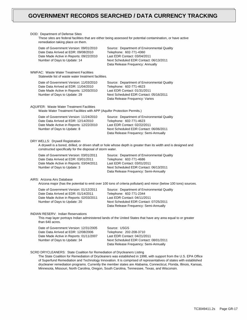
DOD: Department of Defense SitesThese sites are federal facilities that are either being assessed for potential contamination, or have activeremediation taking place on them.
Date of Government Version: 09/01/2010Date Data Arrived at EDR: 09/08/2010Date Made Active in Reports: 09/22/2010Number of Days to Update: 14
Source: Department of Environmental QualityTelephone: 602-771-4360Last EDR Contact: 03/04/2011Next Scheduled EDR Contact: 06/13/2011Data Release Frequency: Annually
WWFAC: Waste Water Treatment FacilitiesStatewide list of waste water treatment facilities.
Date of Government Version: 11/03/2010Date Data Arrived at EDR: 11/04/2010Date Made Active in Reports: 12/03/2010Number of Days to Update: 29
Source: Department of Environmental QualityTelephone: 602-771-4623Last EDR Contact: 01/31/2011Next Scheduled EDR Contact: 05/16/2011Data Release Frequency: Varies
AQUIFER: Waste Water Treatment FacilitiesWaste Water Treatment Facilities with APP (Aquifer Protection Permits.)
Date of Government Version: 11/24/2010Date Data Arrived at EDR: 12/14/2010Date Made Active in Reports: 12/22/2010Number of Days to Update: 8
Source: Department of Environmental QualityTelephone: 602-771-4623Last EDR Contact: 02/22/2011Next Scheduled EDR Contact: 06/06/2011Data Release Frequency: Semi-Annually
DRY WELLS: Drywell RegistrationA drywell is a bored, drilled, or driven shaft or hole whose depth is greater than its width and is designed andconstructed specifically for the disposal of storm water.
Date of Government Version: 03/01/2011Date Data Arrived at EDR: 03/01/2011Date Made Active in Reports: 03/04/2011Number of Days to Update: 3
Source: Department of Environmental QualityTelephone: 602-771-4686Last EDR Contact: 03/01/2011Next Scheduled EDR Contact: 06/13/2011Data Release Frequency: Semi-Annually
AIRS: Arizona Airs DatabaseArizona major (has the potential to emit over 100 tons of criteria pollutant) and minor (below 100 tons) sources.
Date of Government Version: 01/12/2011Date Data Arrived at EDR: 01/14/2011Date Made Active in Reports: 02/03/2011Number of Days to Update: 20
Source: Department of Environmental QualityTelephone: 602-771-2344Last EDR Contact: 04/11/2011Next Scheduled EDR Contact: 07/25/2011Data Release Frequency: Semi-Annually
INDIAN RESERV: Indian ReservationsThis map layer portrays Indian administered lands of the United States that have any area equal to or greaterthan 640 acres.
Date of Government Version: 12/31/2005Date Data Arrived at EDR: 12/08/2006Date Made Active in Reports: 01/11/2007Number of Days to Update: 34
Source: USGSTelephone: 202-208-3710Last EDR Contact: 04/21/2011Next Scheduled EDR Contact: 08/01/2011Data Release Frequency: Semi-Annually
SCRD DRYCLEANERS: State Coalition for Remediation of Drycleaners ListingThe State Coalition for Remediation of Drycleaners was established in 1998, with support from the U.S. EPA Officeof Superfund Remediation and Technology Innovation. It is comprised of representatives of states with establisheddrycleaner remediation programs. Currently the member states are Alabama, Connecticut, Florida, Illinois, Kansas,Minnesota, Missouri, North Carolina, Oregon, South Carolina, Tennessee, Texas, and Wisconsin.
TC3049411.2s Page GR-17
GOVERNMENT RECORDS SEARCHED / DATA CURRENCY TRACKING

Date of Government Version: 08/31/2010Date Data Arrived at EDR: 09/01/2010Date Made Active in Reports: 12/02/2010Number of Days to Update: 92
Source: Environmental Protection AgencyTelephone: 615-532-8599Last EDR Contact: 02/22/2011Next Scheduled EDR Contact: 05/09/2011Data Release Frequency: Varies
PCB TRANSFORMER: PCB Transformer Registration DatabaseThe database of PCB transformer registrations that includes all PCB registration submittals.
Date of Government Version: 01/01/2008Date Data Arrived at EDR: 02/18/2009Date Made Active in Reports: 05/29/2009Number of Days to Update: 100
Source: Environmental Protection AgencyTelephone: 202-566-0517Last EDR Contact: 02/04/2011Next Scheduled EDR Contact: 05/16/2011Data Release Frequency: Varies
FEDLAND: Federal and Indian LandsFederally and Indian administrated lands of the United States. Lands included are administrated by: Army Corpsof Engineers, Bureau of Reclamation, National Wild and Scenic River, National Wildlife Refuge, Public Domain Land,Wilderness, Wilderness Study Area, Wildlife Management Area, Bureau of Indian Affairs, Bureau of Land Management,Department of Justice, Forest Service, Fish and Wildlife Service, National Park Service.
Date of Government Version: 12/31/2005Date Data Arrived at EDR: 02/06/2006Date Made Active in Reports: 01/11/2007Number of Days to Update: 339
Source: U.S. Geological SurveyTelephone: 888-275-8747Last EDR Contact: 04/21/2011Next Scheduled EDR Contact: 08/01/2011Data Release Frequency: N/A
COAL ASH EPA: Coal Combustion Residues Surface Impoundments ListA listing of coal combustion residues surface impoundments with high hazard potential ratings.
Date of Government Version: 08/17/2010Date Data Arrived at EDR: 01/03/2011Date Made Active in Reports: 03/21/2011Number of Days to Update: 77
Source: Environmental Protection AgencyTelephone: N/ALast EDR Contact: 03/18/2011Next Scheduled EDR Contact: 06/27/2011Data Release Frequency: Varies
COAL ASH DOE: Sleam-Electric Plan Operation DataA listing of power plants that store ash in surface ponds.
Date of Government Version: 12/31/2005Date Data Arrived at EDR: 08/07/2009Date Made Active in Reports: 10/22/2009Number of Days to Update: 76
Source: Department of EnergyTelephone: 202-586-8719Last EDR Contact: 04/19/2011Next Scheduled EDR Contact: 08/01/2011Data Release Frequency: Varies
EDR PROPRIETARY RECORDS
EDR Proprietary Records
Manufactured Gas Plants: EDR Proprietary Manufactured Gas PlantsThe EDR Proprietary Manufactured Gas Plant Database includes records of coal gas plants (manufactured gas plants)compiled by EDR’s researchers. Manufactured gas sites were used in the United States from the 1800’s to 1950’sto produce a gas that could be distributed and used as fuel. These plants used whale oil, rosin, coal, or a mixtureof coal, oil, and water that also produced a significant amount of waste. Many of the byproducts of the gas production,such as coal tar (oily waste containing volatile and non-volatile chemicals), sludges, oils and other compoundsare potentially hazardous to human health and the environment. The byproduct from this process was frequentlydisposed of directly at the plant site and can remain or spread slowly, serving as a continuous source of soiland groundwater contamination.
Date of Government Version: N/ADate Data Arrived at EDR: N/ADate Made Active in Reports: N/ANumber of Days to Update: N/A
Source: EDR, Inc.Telephone: N/ALast EDR Contact: N/ANext Scheduled EDR Contact: N/AData Release Frequency: No Update Planned
TC3049411.2s Page GR-18
GOVERNMENT RECORDS SEARCHED / DATA CURRENCY TRACKING

EDR Historical Auto Stations: EDR Proprietary Historic Gas StationsEDR has searched selected national collections of business directories and has collected listings of potentialgas station/filling station/service station sites that were available to EDR researchers. EDR’s review was limitedto those categories of sources that might, in EDR’s opinion, include gas station/filling station/service stationestablishments. The categories reviewed included, but were not limited to gas, gas station, gasoline station,filling station, auto, automobile repair, auto service station, service station, etc.
Date of Government Version: N/ADate Data Arrived at EDR: N/ADate Made Active in Reports: N/ANumber of Days to Update: N/A
Source: EDR, Inc.Telephone: N/ALast EDR Contact: N/ANext Scheduled EDR Contact: N/AData Release Frequency: Varies
EDR Historical Cleaners: EDR Proprietary Historic Dry CleanersEDR has searched selected national collections of business directories and has collected listings of potentialdry cleaner sites that were available to EDR researchers. EDR’s review was limited to those categories of sourcesthat might, in EDR’s opinion, include dry cleaning establishments. The categories reviewed included, but werenot limited to dry cleaners, cleaners, laundry, laundromat, cleaning/laundry, wash & dry etc.
Date of Government Version: N/ADate Data Arrived at EDR: N/ADate Made Active in Reports: N/ANumber of Days to Update: N/A
Source: EDR, Inc.Telephone: N/ALast EDR Contact: N/ANext Scheduled EDR Contact: N/AData Release Frequency: Varies
OTHER DATABASE(S)
Depending on the geographic area covered by this report, the data provided in these specialty databases may or may not becomplete. For example, the existence of wetlands information data in a specific report does not mean that all wetlands in thearea covered by the report are included. Moreover, the absence of any reported wetlands information does not necessarilymean that wetlands do not exist in the area covered by the report.
CT MANIFEST: Hazardous Waste Manifest DataFacility and manifest data. Manifest is a document that lists and tracks hazardous waste from the generator throughtransporters to a tsd facility.
Date of Government Version: 12/31/2007Date Data Arrived at EDR: 08/26/2009Date Made Active in Reports: 09/11/2009Number of Days to Update: 16
Source: Department of Environmental ProtectionTelephone: 860-424-3375Last EDR Contact: 02/25/2011Next Scheduled EDR Contact: 06/06/2011Data Release Frequency: Annually
NY MANIFEST: Facility and Manifest DataManifest is a document that lists and tracks hazardous waste from the generator through transporters to a TSDfacility.
Date of Government Version: 12/31/2010Date Data Arrived at EDR: 02/09/2011Date Made Active in Reports: 03/04/2011Number of Days to Update: 23
Source: Department of Environmental ConservationTelephone: 518-402-8651Last EDR Contact: 02/09/2011Next Scheduled EDR Contact: 05/23/2011Data Release Frequency: Annually
RI MANIFEST: Manifest informationHazardous waste manifest information
Date of Government Version: 12/31/2009Date Data Arrived at EDR: 07/19/2010Date Made Active in Reports: 08/26/2010Number of Days to Update: 38
Source: Department of Environmental ManagementTelephone: 401-222-2797Last EDR Contact: 02/28/2011Next Scheduled EDR Contact: 06/13/2011Data Release Frequency: Annually
TC3049411.2s Page GR-19
GOVERNMENT RECORDS SEARCHED / DATA CURRENCY TRACKING

WI MANIFEST: Manifest InformationHazardous waste manifest information.
Date of Government Version: 12/31/2009Date Data Arrived at EDR: 07/06/2010Date Made Active in Reports: 07/26/2010Number of Days to Update: 20
Source: Department of Natural ResourcesTelephone: N/ALast EDR Contact: 03/21/2011Next Scheduled EDR Contact: 07/04/2011Data Release Frequency: Annually
Oil/Gas Pipelines: This data was obtained by EDR from the USGS in 1994. It is referred to by USGS as GeoData Digital Line Graphsfrom 1:100,000-Scale Maps. It was extracted from the transportation category including some oil, but primarilygas pipelines.
Electric Power Transmission Line DataSource: Rextag Strategies Corp.Telephone: (281) 769-2247U.S. Electric Transmission and Power Plants Systems Digital GIS Data
Sensitive Receptors: There are individuals deemed sensitive receptors due to their fragile immune systems and special sensitivityto environmental discharges. These sensitive receptors typically include the elderly, the sick, and children. While the location of allsensitive receptors cannot be determined, EDR indicates those buildings and facilities - schools, daycares, hospitals, medical centers,and nursing homes - where individuals who are sensitive receptors are likely to be located.
AHA Hospitals:Source: American Hospital Association, Inc.Telephone: 312-280-5991The database includes a listing of hospitals based on the American Hospital Association’s annual survey of hospitals.
Medical Centers: Provider of Services ListingSource: Centers for Medicare & Medicaid ServicesTelephone: 410-786-3000A listing of hospitals with Medicare provider number, produced by Centers of Medicare & Medicaid Services,a federal agency within the U.S. Department of Health and Human Services.
Nursing HomesSource: National Institutes of HealthTelephone: 301-594-6248Information on Medicare and Medicaid certified nursing homes in the United States.
Public SchoolsSource: National Center for Education StatisticsTelephone: 202-502-7300The National Center for Education Statistics’ primary database on elementaryand secondary public education in the United States. It is a comprehensive, annual, national statisticaldatabase of all public elementary and secondary schools and school districts, which contains data that arecomparable across all states.
Private SchoolsSource: National Center for Education StatisticsTelephone: 202-502-7300The National Center for Education Statistics’ primary database on private school locations in the United States.
Daycare Centers: Child Care Facilities & Group HomesSource: Department of Health ServicesTelephone: 602-674-4220
Flood Zone Data: This data, available in select counties across the country, was obtained by EDR in 2003 & 2009 from the FederalEmergency Management Agency (FEMA). Data depicts 100-year and 500-year flood zones as defined by FEMA.
NWI: National Wetlands Inventory. This data, available in select counties across the country, was obtained by EDRin 2002 and 2005 from the U.S. Fish and Wildlife Service.
State Wetlands Data: Riparian Vegetation Associated with Perennial WatersSource: State Land DepartmentTelephone: 602-542-4094
TC3049411.2s Page GR-20
GOVERNMENT RECORDS SEARCHED / DATA CURRENCY TRACKING

Scanned Digital USGS 7.5’ Topographic Map (DRG)Source: United States Geologic SurveyA digital raster graphic (DRG) is a scanned image of a U.S. Geological Survey topographic map. The map imagesare made by scanning published paper maps on high-resolution scanners. The raster imageis georeferenced and fit to the Universal Transverse Mercator (UTM) projection.
STREET AND ADDRESS INFORMATION
© 2010 Tele Atlas North America, Inc. All rights reserved. This material is proprietary and the subject of copyright protectionand other intellectual property rights owned by or licensed to Tele Atlas North America, Inc. The use of this material is subjectto the terms of a license agreement. You will be held liable for any unauthorized copying or disclosure of this material.
TC3049411.2s Page GR-21
GOVERNMENT RECORDS SEARCHED / DATA CURRENCY TRACKING

TC3049411.2s Page A-1
geologic strata.of the soil, and nearby wells. Groundwater flow velocity is generally impacted by the nature of theGroundwater flow direction may be impacted by surface topography, hydrology, hydrogeology, characteristics
2. Groundwater flow velocity. 1. Groundwater flow direction, and
Assessment of the impact of contaminant migration generally has two principle investigative components:
forming an opinion about the impact of potential contaminant migration.EDR’s GeoCheck Physical Setting Source Addendum is provided to assist the environmental professional in
1990Most Recent Revision:33112-H8 OUTLAW HILL, AZEast Map:
1990Most Recent Revision:33113-H1 FOREPAUGH PEAK, AZTarget Property Map:
USGS TOPOGRAPHIC MAP
2411 ft. above sea levelElevation:3758080.5UTM Y (Meters): 314925.4UTM X (Meters): Zone 12Universal Tranverse Mercator: 113.0027 - 113˚ 0’ 9.7’’Longitude (West): 33.94870 - 33˚ 56’ 55.3’’Latitude (North):
TARGET PROPERTY COORDINATES
WICKENBURG, AZ 85390W. US HIGHWAY 60/N. 436TH AVEWICKENBURG/FOREPAUGH
TARGET PROPERTY ADDRESS
GEOCHECK - PHYSICAL SETTING SOURCE ADDENDUM®

TC3049411.2s Page A-2
should be field verified.on a relative (not an absolute) basis. Relative elevation information between sites of close proximitySource: Topography has been determined from the USGS 7.5’ Digital Elevation Model and should be evaluated
SURROUNDING TOPOGRAPHY: ELEVATION PROFILES
Ele
vatio
n (f
t)E
leva
tion
(ft)
TP
TP0 1/2 1 Miles
✩Target Property Elevation: 2411 ft.
North South
West East
2445
2442
2435
2430
2426
2424
2421
2418
2415
2411
2408
2404
2402
2399
2397
2395
2392
2390
23872377
2381
2384
2385
2390
2396
2400
2405
2408
2411
2414
2418
2423
2426
2431
2432
2437
2443
2447
General NWGeneral Topographic Gradient:TARGET PROPERTY TOPOGRAPHY
should contamination exist on the target property, what downgradient sites might be impacted.assist the environmental professional in forming an opinion about the impact of nearby contaminated properties or,Surface topography may be indicative of the direction of surficial groundwater flow. This information can be used toTOPOGRAPHIC INFORMATION
collected on nearby properties, and regional groundwater flow information (from deep aquifers).sources of information, such as surface topographic information, hydrologic information, hydrogeologic datausing site-specific well data. If such data is not reasonably ascertainable, it may be necessary to rely on otherGroundwater flow direction for a particular site is best determined by a qualified environmental professionalGROUNDWATER FLOW DIRECTION INFORMATION
GEOCHECK - PHYSICAL SETTING SOURCE SUMMARY®

TC3049411.2s Page A-3
Not Reported
GENERAL DIRECTIONLOCATIONGROUNDWATER FLOWFROM TPMAP ID
hydrogeologically, and the depth to water table.authorities at select sites and has extracted the date of the report, groundwater flow direction as determinedflow at specific points. EDR has reviewed reports submitted by environmental professionals to regulatoryEDR has developed the AQUIFLOW Information System to provide data on the general direction of groundwater
AQUIFLOW®
Search Radius: 1.000 Mile.
Not found Status:1.25 miles Search Radius:
Site-Specific Hydrogeological Data*:
* ©1996 Site−specific hydrogeological data gathered by CERCLIS Alerts, Inc., Bainbridge Island, WA. All rights reserved. All of the information and opinions presented are those of the cited EPA report(s), which were completed undera Comprehensive Environmental Response Compensation and Liability Information System (CERCLIS) investigation.
contamination exist on the target property, what downgradient sites might be impacted.environmental professional in forming an opinion about the impact of nearby contaminated properties or, shouldof groundwater flow direction in the immediate area. Such hydrogeologic information can be used to assist theHydrogeologic information obtained by installation of wells on a specific site can often be an indicatorHYDROGEOLOGIC INFORMATION
YES - refer to the Overview Map and Detail MapNOT AVAILABLE
NATIONAL WETLAND INVENTORYNWI ElectronicData CoverageNWI Quad at Target Property
Not ReportedAdditional Panels in search area:
04013C - FEMA DFIRM Flood dataFlood Plain Panel at Target Property:
YES - refer to the Overview Map and Detail MapMARICOPA, AZ
FEMA FLOOD ZONEFEMA FloodElectronic DataTarget Property County
and bodies of water).Refer to the Physical Setting Source Map following this summary for hydrologic information (major waterways
contamination exist on the target property, what downgradient sites might be impacted.the environmental professional in forming an opinion about the impact of nearby contaminated properties or, shouldSurface water can act as a hydrologic barrier to groundwater flow. Such hydrologic information can be used to assistHYDROLOGIC INFORMATION
GEOCHECK - PHYSICAL SETTING SOURCE SUMMARY®
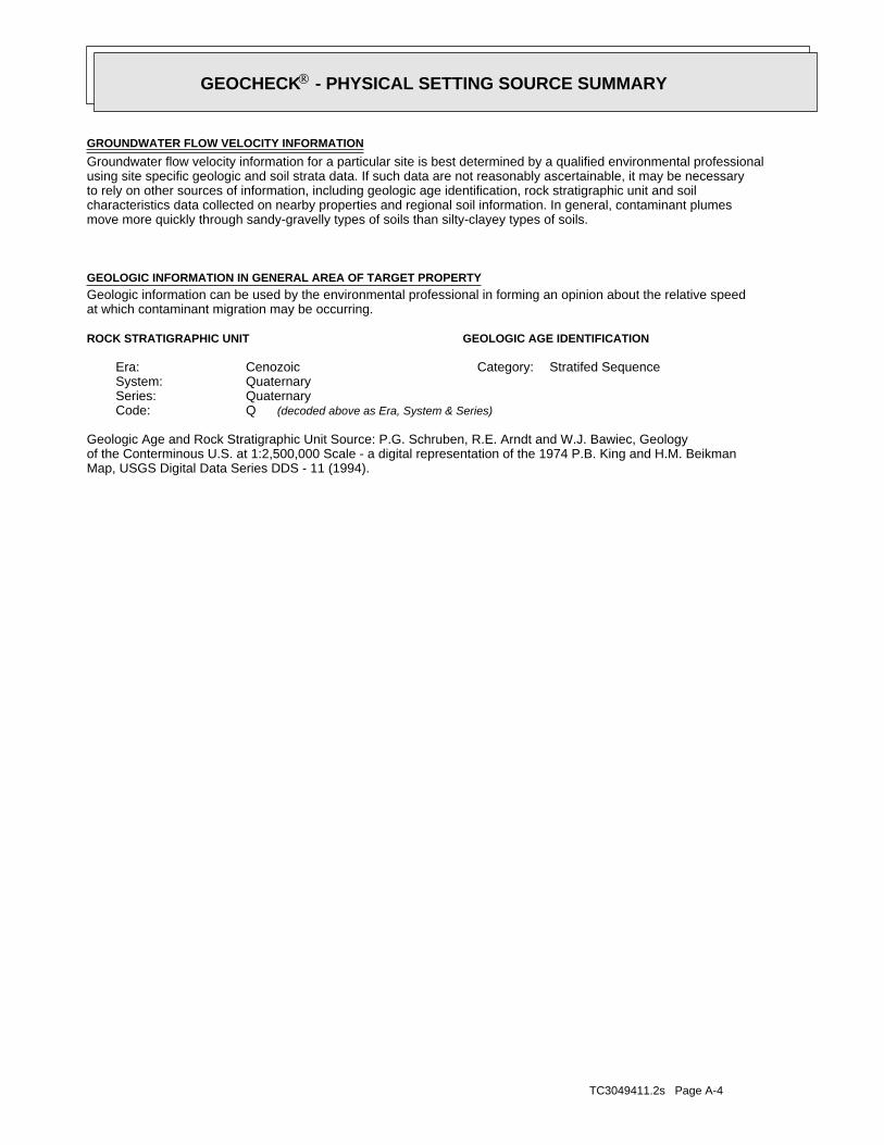
TC3049411.2s Page A-4
Map, USGS Digital Data Series DDS - 11 (1994).of the Conterminous U.S. at 1:2,500,000 Scale - a digital representation of the 1974 P.B. King and H.M. BeikmanGeologic Age and Rock Stratigraphic Unit Source: P.G. Schruben, R.E. Arndt and W.J. Bawiec, Geology
ROCK STRATIGRAPHIC UNIT GEOLOGIC AGE IDENTIFICATION
Stratifed SequenceCategory:CenozoicEra:QuaternarySystem:QuaternarySeries:QCode: (decoded above as Era, System & Series)
at which contaminant migration may be occurring.Geologic information can be used by the environmental professional in forming an opinion about the relative speedGEOLOGIC INFORMATION IN GENERAL AREA OF TARGET PROPERTY
move more quickly through sandy-gravelly types of soils than silty-clayey types of soils.characteristics data collected on nearby properties and regional soil information. In general, contaminant plumesto rely on other sources of information, including geologic age identification, rock stratigraphic unit and soilusing site specific geologic and soil strata data. If such data are not reasonably ascertainable, it may be necessaryGroundwater flow velocity information for a particular site is best determined by a qualified environmental professionalGROUNDWATER FLOW VELOCITY INFORMATION
GEOCHECK - PHYSICAL SETTING SOURCE SUMMARY®

EDR Inc.EDR Inc.EDR Inc.EDR Inc.EDR Inc.EDR Inc.EDR Inc.EDR Inc.EDR Inc.EDR Inc.EDR Inc.EDR Inc.EDR Inc.EDR Inc.EDR Inc.EDR Inc.EDR Inc.EDR Inc.EDR Inc.EDR Inc.EDR Inc.EDR Inc.EDR Inc.EDR Inc.EDR Inc.EDR Inc.EDR Inc.EDR Inc.EDR Inc.EDR Inc.EDR Inc.EDR Inc.EDR Inc.EDR Inc.EDR Inc.EDR Inc.EDR Inc.EDR Inc.EDR Inc.EDR Inc.
2
13
2
0 1/16 1/8 1/4 Miles

TC3049411.2s Page A-6
Min: 7.9Max: 8.4
Min: 4Max: 14
50%), silt.limit less thanClays (liquidSOILS, Silts andFINE-GRAINED50%), Lean Clay.limit less thanClays (liquidSOILS, Silts andFINE-GRAINED
and Sand.Clayey Gravel200), Silty, orpassing No.pct. or lessmaterials (35Granularclay loam20 inches 1 inches 2
Min: 7.9Max: 8.4
Min: 4Max: 14
50%), silt.limit less thanClays (liquidSOILS, Silts andFINE-GRAINED50%), Lean Clay.limit less thanClays (liquidSOILS, Silts andFINE-GRAINED
and Sand.Clayey Gravel200), Silty, orpassing No.pct. or lessmaterials (35Granularsandy loam 1 inches 0 inches 1
Soil Layer Information
Boundary Classification Saturatedhydraulicconductivitymicro m/sec
Layer Upper Lower Soil Texture Class AASHTO Group Unified Soil Soil Reaction(pH)
> 0 inchesDepth to Watertable Min:
> 0 inchesDepth to Bedrock Min:
HighCorrosion Potential - Uncoated Steel:
Hydric Status: Unknown
Well drainedSoil Drainage Class:
textures.moderately well and well drained soils with moderately coarseClass B - Moderate infiltration rates. Deep and moderately deep,Hydrologic Group:
sandy loamSoil Surface Texture:
MOHAVESoil Component Name:
Soil Map ID: 1
in a landscape. The following information is based on Soil Conservation Service SSURGO data.for privately owned lands in the United States. A soil map in a soil survey is a representation of soil patternsSurvey (NCSS) and is responsible for collecting, storing, maintaining and distributing soil survey informationThe U.S. Department of Agriculture’s (USDA) Soil Conservation Service (SCS) leads the National Cooperative Soil
DOMINANT SOIL COMPOSITION IN GENERAL AREA OF TARGET PROPERTY
GEOCHECK - PHYSICAL SETTING SOURCE SUMMARY®

TC3049411.2s Page A-7
Min: 7.4Max: 8.4
Min: 0.42Max: 1.4
more), Fat Clay.limit 50% orClays (liquidSOILS, Silts andFINE-GRAINED
Soils.200), Siltypassing No.than 35 pct.Materials (moreSilt-Clayclay loam 1 inches 0 inches 1
Soil Layer Information
Boundary Classification Saturatedhydraulicconductivitymicro m/sec
Layer Upper Lower Soil Texture Class AASHTO Group Unified Soil Soil Reaction(pH)
> 0 inchesDepth to Watertable Min:
> 0 inchesDepth to Bedrock Min:
HighCorrosion Potential - Uncoated Steel:
Hydric Status: Unknown
Well drainedSoil Drainage Class:
movement of water, or soils with moderately fine or fine textures.Class C - Slow infiltration rates. Soils with layers impeding downwardHydrologic Group:
clay loamSoil Surface Texture:
CONTINENTALSoil Component Name:
Soil Map ID: 2
Min: 7.9Max: 8.4
Min: 4Max: 14
50%), silt.limit less thanClays (liquidSOILS, Silts andFINE-GRAINED50%), Lean Clay.limit less thanClays (liquidSOILS, Silts andFINE-GRAINED
and Sand.Clayey Gravel200), Silty, orpassing No.pct. or lessmaterials (35Granularloam59 inches20 inches 3
Soil Layer Information
Boundary Classification Saturatedhydraulicconductivitymicro m/sec
Layer Upper Lower Soil Texture Class AASHTO Group Unified Soil Soil Reaction(pH)
GEOCHECK - PHYSICAL SETTING SOURCE SUMMARY®

TC3049411.2s Page A-8
Min: 7.9Max: 8.4
Min: 4Max: 14
50%), silt.limit less thanClays (liquidSOILS, Silts andFINE-GRAINED50%), Lean Clay.limit less thanClays (liquidSOILS, Silts andFINE-GRAINED
Soils.200), Clayeypassing No.than 35 pct.Materials (moreSilt-Clay
clay loamvery gravelly 1 inches 0 inches 1
Soil Layer Information
Boundary Classification Saturatedhydraulicconductivitymicro m/sec
Layer Upper Lower Soil Texture Class AASHTO Group Unified Soil Soil Reaction(pH)
> 0 inchesDepth to Watertable Min:
> 0 inchesDepth to Bedrock Min:
HighCorrosion Potential - Uncoated Steel:
Hydric Status: Unknown
Well drainedSoil Drainage Class:
textures.moderately well and well drained soils with moderately coarseClass B - Moderate infiltration rates. Deep and moderately deep,Hydrologic Group:
very gravelly clay loamSoil Surface Texture:
PINALENOSoil Component Name:
Soil Map ID: 3
Min: 7.4Max: 8.4
Min: 0.42Max: 1.4
more), Fat Clay.limit 50% orClays (liquidSOILS, Silts andFINE-GRAINED
Soils.200), Siltypassing No.than 35 pct.Materials (moreSilt-Clayclay59 inches 1 inches 2
Soil Layer Information
Boundary Classification Saturatedhydraulicconductivitymicro m/sec
Layer Upper Lower Soil Texture Class AASHTO Group Unified Soil Soil Reaction(pH)
GEOCHECK - PHYSICAL SETTING SOURCE SUMMARY®

TC3049411.2s Page A-9
1/4 - 1/2 Mile SWUSGS3070255 D171/4 - 1/2 Mile SouthUSGS3070258 41/8 - 1/4 Mile NNEUSGS3070095 A1
FEDERAL USGS WELL INFORMATION
LOCATIONFROM TPWELL IDMAP ID
1.000State DatabaseNearest PWS within 1 mileFederal FRDS PWS1.000Federal USGS
WELL SEARCH DISTANCE INFORMATION
SEARCH DISTANCE (miles)DATABASE
opinion about the impact of contaminant migration on nearby drinking water wells.professional in assessing sources that may impact ground water flow direction, and in forming anEDR Local/Regional Water Agency records provide water well information to assist the environmental
LOCAL / REGIONAL WATER AGENCY RECORDS
Min: 7.9Max: 8.4
Min: 4Max: 14
50%), silt.limit less thanClays (liquidSOILS, Silts andFINE-GRAINED50%), Lean Clay.limit less thanClays (liquidSOILS, Silts andFINE-GRAINED
Soils.200), Clayeypassing No.than 35 pct.Materials (moreSilt-Clayloam59 inches11 inches 3
Min: 7.9Max: 8.4
Min: 4Max: 14
50%), silt.limit less thanClays (liquidSOILS, Silts andFINE-GRAINED50%), Lean Clay.limit less thanClays (liquidSOILS, Silts andFINE-GRAINED
Soils.200), Clayeypassing No.than 35 pct.Materials (moreSilt-Clay
loamgravelly clay11 inches 1 inches 2
Soil Layer Information
Boundary Classification Saturatedhydraulicconductivitymicro m/sec
Layer Upper Lower Soil Texture Class AASHTO Group Unified Soil Soil Reaction(pH)
GEOCHECK - PHYSICAL SETTING SOURCE SUMMARY®
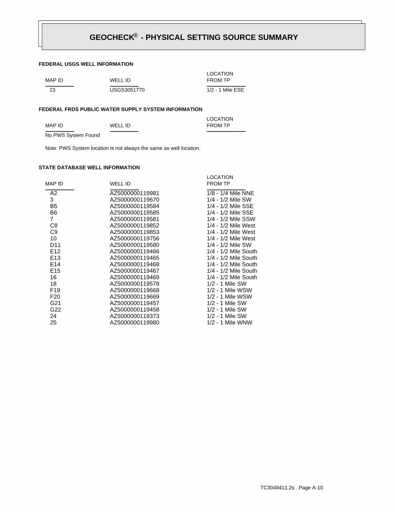
TC3049411.2s Page A-10
1/2 - 1 Mile WNWAZ5000000119980 251/2 - 1 Mile SWAZ5000000119373 241/2 - 1 Mile SWAZ5000000119458 G221/2 - 1 Mile SWAZ5000000119457 G211/2 - 1 Mile WSWAZ5000000119669 F201/2 - 1 Mile WSWAZ5000000119668 F191/2 - 1 Mile SWAZ5000000119578 181/4 - 1/2 Mile SouthAZ5000000119469 161/4 - 1/2 Mile SouthAZ5000000119467 E151/4 - 1/2 Mile SouthAZ5000000119468 E141/4 - 1/2 Mile SouthAZ5000000119465 E131/4 - 1/2 Mile SouthAZ5000000119466 E121/4 - 1/2 Mile SWAZ5000000119580 D111/4 - 1/2 Mile WestAZ5000000119756 101/4 - 1/2 Mile WestAZ5000000119853 C91/4 - 1/2 Mile WestAZ5000000119852 C81/4 - 1/2 Mile SSWAZ5000000119581 71/4 - 1/2 Mile SSEAZ5000000119585 B61/4 - 1/2 Mile SSEAZ5000000119584 B51/4 - 1/2 Mile SWAZ5000000119670 31/8 - 1/4 Mile NNEAZ5000000119981 A2
STATE DATABASE WELL INFORMATION
LOCATIONFROM TPWELL IDMAP ID
Note: PWS System location is not always the same as well location.
No PWS System Found
FEDERAL FRDS PUBLIC WATER SUPPLY SYSTEM INFORMATION
LOCATIONFROM TPWELL IDMAP ID
1/2 - 1 Mile ESEUSGS3051770 23
FEDERAL USGS WELL INFORMATION
LOCATIONFROM TPWELL IDMAP ID
GEOCHECK - PHYSICAL SETTING SOURCE SUMMARY®
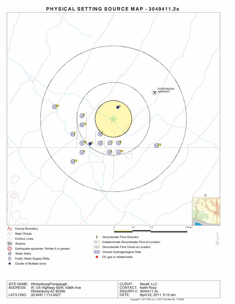
EDR Inc.EDR Inc.EDR Inc.EDR Inc.EDR Inc.EDR Inc.EDR Inc.EDR Inc.EDR Inc.EDR Inc.EDR Inc.EDR Inc.EDR Inc.EDR Inc.EDR Inc.EDR Inc.EDR Inc.EDR Inc.EDR Inc.EDR Inc.EDR Inc.EDR Inc.EDR Inc.EDR Inc.EDR Inc.EDR Inc.EDR Inc.EDR Inc.EDR Inc.EDR Inc.EDR Inc.EDR Inc.EDR Inc.EDR Inc.EDR Inc.EDR Inc.EDR Inc.EDR Inc.EDR Inc.EDR Inc.
AZ

TC3049411.2s Page A-12
A2NNE1/8 - 1/4 MileLower
AZ5000000119981AZ WELLS
1980-11-18 469.4 1980-11-18 469.41980-11-19 469.40 1980-11-19 469.40 Note: The site was being pumped.1985-12-09 546.40 Note: The site was being pumped.1985-12-09 546.401986-01-01 469.0 1986-01-01 469.01989-12-04 480.40 1989-12-04 480.40
DateFeet belowSurface
Feet toSealevel
-------------------------------------------------Date
Feet belowSurface
Feet toSealevel
-------------------------------------------------
Ground-water levels, Number of Measurements: 10
5Ground water data count:1989-12-04Ground water data end date:Ground water data begin date: 1980-11-181Water quality data count:1946-03-26Water quality data end date:1946-03-26Water quality data begin date:0Peak flow data count:0000-00-00Peak flow data end date:0000-00-00Peak flow data begin date:0Daily flow data count:0000-00-00Daily flow data end date:0000-00-00Daily flow data begin date:0Real time data flag:
MMUProject number:drillerSource of depth data:
966Hole depth:966.00Well depth:Not ReportedAquifer:Not ReportedAquifer Type:Single well, other than collector or Ranney typeType of ground water site:NLocal standard time flag:
MSTMean greenwich time offset:Not ReportedDate inventoried:1942Date construction:Ground-water other than SpringSite type:
Valley flatTopographic:Centennial Wash. Arizona. Area = 1940 sq.mi.Hydrologic:National Geodetic Vertical Datum of 1929Altitude datum:1.Altitude accuracy:Level or other surveying methodAltitude method:2410.00Altitude:
62500Map scale:AGUILALocation map:SESENES17 T07N R07W GLand net:USCountry:013County:04State:04District:NAD83Dec latlong datum:NAD27Latlong datum:FCoor accr:MCoor meth:-113.00185151Dec lon:33.95086192Dec lat:1130004Longitude:USGS3070095EDR Site id:335703Latitude:
B-07-07 17ADDSite name:335703113000401Site no:USGSAgency cd:
A1NNE1/8 - 1/4 MileLower
USGS3070095FED USGS
Map IDDirectionDistanceElevation EDR ID NumberDatabase
GEOCHECK - PHYSICAL SETTING SOURCE MAP FINDINGS®

TC3049411.2s Page A-13
0Half range:WEastwest:7Range:0Half towns:NNorthsouth:7Township:OUTSIDE OF AMA OR INAAma ina:MCMULLEN VALLEYSubbasin n:MCMULLEN VALLEYBasin name:
LOWER GILA RIVERWatershed:MARICOPACounty:55Program:604230Registryid:
3SW1/4 - 1/2 MileHigher
AZ5000000119670AZ WELLS
AZ5000000119981Site id:Not ReportedWell cance:85358Zip:AZState:WICKENBURGCity:
Not ReportedAddress2:PO BOX 1269Address1:WICKENBURG, TOWN OFCompany:Not ReportedFirst name:
Not ReportedLast name:Not ReportedDrill log:0Draw down:0Testedrate:0Pumprate:
NO POWER CODE LISTEDPump power:NO PUMP CODE LISTEDPump type:8Casing dia:1000Casing dep:STEEL - PERFORATED OR SLOTTED CASINGCasing typ:500Water leve:1000Well depth:
1/1/1942 12:00:00 AMInstalled:Not ReportedApproved:0Dlic num:Not ReportedWateruse3:
Not ReportedWateruse2:DOMESTICWateruse1:Not ReportedSiteuse3:Not ReportedSiteuse2:WATER PRODUCTIONSiteuse1:NON-EXEMPTWelltype:
3758545Utm y mete:315050.4Utm x mete:
B07007017ADDCadastral:SEAcre10:SEAcre40:NEAcre160:
17Section:0Half range:WEastwest:7Range:0Half towns:NNorthsouth:7Township:OUTSIDE OF AMA OR INAAma ina:MCMULLEN VALLEYSubbasin n:MCMULLEN VALLEYBasin name:
LOWER GILA RIVERWatershed:MARICOPACounty:55Program:805136Registryid:
GEOCHECK - PHYSICAL SETTING SOURCE MAP FINDINGS®

TC3049411.2s Page A-14
0000-00-00Peak flow data end date:0000-00-00Peak flow data begin date:0Daily flow data count:0000-00-00Daily flow data end date:0000-00-00Daily flow data begin date:0Real time data flag:
MMUProject number:Not ReportedSource of depth data:
580Hole depth:580.Well depth:Not ReportedAquifer:Not ReportedAquifer Type:Single well, other than collector or Ranney typeType of ground water site:NLocal standard time flag:
MSTMean greenwich time offset:Not ReportedDate inventoried:1945Date construction:Ground-water other than SpringSite type:
Valley flatTopographic:Centennial Wash. Arizona. Area = 1940 sq.mi.Hydrologic:National Geodetic Vertical Datum of 1929Altitude datum:1Altitude accuracy:Level or other surveying methodAltitude method:2415.Altitude:
62500Map scale:AGUILALocation map:SWSESES17 T07N R07W GLand net:USCountry:013County:04State:04District:NAD83Dec latlong datum:NAD27Latlong datum:SCoor accr:MCoor meth:-113.00351817Dec lon:33.94391766Dec lat:1130010Longitude:USGS3070258EDR Site id:335638Latitude:
B-07-07 17DDCSite name:335638113001001Site no:USGSAgency cd:
4South1/4 - 1/2 MileHigher
USGS3070258FED USGS
AZ5000000119670Site id:Not ReportedWell cance:98568Zip:WAState:OAKVILLECity:
Not ReportedAddress2:53 HOWANUT RDAddress1:Not ReportedCompany:Not ReportedFirst name:
KIRSCHLING,HLast name:Not ReportedDrill log:0Draw down:0Testedrate:0Pumprate:
NO POWER CODE LISTEDPump power:NO PUMP CODE LISTEDPump type:0Casing dia:0Casing dep:STEEL - PERFORATED OR SLOTTED CASINGCasing typ:350Water leve:750Well depth:
Not ReportedInstalled:Not ReportedApproved:0Dlic num:Not ReportedWateruse3:
DOMESTICWateruse2:STOCKWateruse1:Not ReportedSiteuse3:Not ReportedSiteuse2:WATER PRODUCTIONSiteuse1:NON-EXEMPTWelltype:
3757947Utm y mete:314633.9Utm x mete:
B07007017DCACadastral:NEAcre10:SWAcre40:SEAcre160:
17Section:
GEOCHECK - PHYSICAL SETTING SOURCE MAP FINDINGS®

TC3049411.2s Page A-15
AZ5000000119584Site id:Not ReportedWell cance:85390Zip:AZState:WICKENBURGCity:
Not ReportedAddress2:43550 W US HIGHWAY 20Address1:Not ReportedCompany:THOMAS BFirst name:
MC FARLANDLast name:XDrill log:0Draw down:0Testedrate:0Pumprate:
NO POWER CODE LISTEDPump power:NO PUMP CODE LISTEDPump type:7Casing dia:665Casing dep:STEEL - PERFORATED OR SLOTTED CASINGCasing typ:415Water leve:665Well depth:
3/28/1992 12:00:00 AMInstalled:Not ReportedApproved:0Dlic num:Not ReportedWateruse3:
Not ReportedWateruse2:DOMESTICWateruse1:Not ReportedSiteuse3:Not ReportedSiteuse2:WATER PRODUCTIONSiteuse1:EXEMPTWelltype:
3757741Utm y mete:315032.8Utm x mete:
B07007017DDDCadastral:SEAcre10:SEAcre40:SEAcre160:
17Section:0Half range:WEastwest:7Range:0Half towns:NNorthsouth:7Township:OUTSIDE OF AMA OR INAAma ina:MCMULLEN VALLEYSubbasin n:MCMULLEN VALLEYBasin name:
LOWER GILA RIVERWatershed:MARICOPACounty:55Program:534509Registryid:
B5SSE1/4 - 1/2 MileHigher
AZ5000000119584AZ WELLS
1957-07-19 487.28 1957-07-19 487.28
DateFeet belowSurface
Feet toSealevel
-------------------------------------------------Date
Feet belowSurface
Feet toSealevel
-------------------------------------------------
Ground-water levels, Number of Measurements: 2
1Ground water data count:1957-07-19Ground water data end date:Ground water data begin date: 1957-07-191Water quality data count:1957-07-19Water quality data end date:1957-07-19Water quality data begin date:0Peak flow data count:
GEOCHECK - PHYSICAL SETTING SOURCE MAP FINDINGS®

TC3049411.2s Page A-16
0Half range:WEastwest:7Range:0Half towns:NNorthsouth:7Township:OUTSIDE OF AMA OR INAAma ina:MCMULLEN VALLEYSubbasin n:MCMULLEN VALLEYBasin name:
LOWER GILA RIVERWatershed:MARICOPACounty:55Program:506400Registryid:
7SSW1/4 - 1/2 MileHigher
AZ5000000119581AZ WELLS
AZ5000000119585Site id:Not ReportedWell cance:85342Zip:AZState:MORRISTOWNCity:
Not ReportedAddress2:P.O. BOX 130Address1:Not ReportedCompany:ROBERT AND LEAFirst name:
WAYLast name:XDrill log:0Draw down:0Testedrate:0Pumprate:
Not ReportedPump power:Not ReportedPump type:5Casing dia:714Casing dep:STEEL - PERFORATED OR SLOTTED CASINGCasing typ:488Water leve:714Well depth:
Not ReportedInstalled:4/7/2004 9:05:04 AMApproved:0Dlic num:Not ReportedWateruse3:
STOCKWateruse2:DOMESTICWateruse1:Not ReportedSiteuse3:Not ReportedSiteuse2:Not ReportedSiteuse1:EXEMPTWelltype:
3757741Utm y mete:315032.8Utm x mete:
B07007017DDDCadastral:SEAcre10:SEAcre40:SEAcre160:
17Section:0Half range:WEastwest:7Range:0Half towns:NNorthsouth:7Township:OUTSIDE OF AMA OR INAAma ina:MCMULLEN VALLEYSubbasin n:MCMULLEN VALLEYBasin name:
LOWER GILA RIVERWatershed:MARICOPACounty:55Program:900228Registryid:
B6SSE1/4 - 1/2 MileHigher
AZ5000000119585AZ WELLS
Map IDDirectionDistanceElevation EDR ID NumberDatabase
GEOCHECK - PHYSICAL SETTING SOURCE MAP FINDINGS®

TC3049411.2s Page A-17
0Dlic num:Not ReportedWateruse3:
Not ReportedWateruse2:DOMESTICWateruse1:Not ReportedSiteuse3:Not ReportedSiteuse2:WATER PRODUCTIONSiteuse1:EXEMPTWelltype:
3758355Utm y mete:314239.3Utm x mete:
B07007017CAACadastral:NEAcre10:NEAcre40:SWAcre160:
17Section:0Half range:WEastwest:7Range:0Half towns:NNorthsouth:7Township:OUTSIDE OF AMA OR INAAma ina:MCMULLEN VALLEYSubbasin n:MCMULLEN VALLEYBasin name:
LOWER GILA RIVERWatershed:MARICOPACounty:55Program:087295Registryid:
C8West1/4 - 1/2 MileLower
AZ5000000119852AZ WELLS
AZ5000000119581Site id:Not ReportedWell cance:98568Zip:WAState:OAKVILLECity:
Not ReportedAddress2:53 HOWANUT RDAddress1:Not ReportedCompany:Not ReportedFirst name:
KIRSCHLING,HLast name:XDrill log:0Draw down:27Testedrate:27Pumprate:
ELECTRIC MOTOR 1 - 5 HPPump power:SUBMERSIBLEPump type:7Casing dia:750Casing dep:STEEL - PERFORATED OR SLOTTED CASINGCasing typ:0Water leve:750Well depth:
10/22/1983 12:00:00 AMInstalled:Not ReportedApproved:0Dlic num:Not ReportedWateruse3:
Not ReportedWateruse2:DOMESTICWateruse1:Not ReportedSiteuse3:Not ReportedSiteuse2:WATER PRODUCTIONSiteuse1:EXEMPTWelltype:
3757746Utm y mete:314629.8Utm x mete:
B07007017DCDCadastral:SEAcre10:SWAcre40:SEAcre160:
17Section:
GEOCHECK - PHYSICAL SETTING SOURCE MAP FINDINGS®
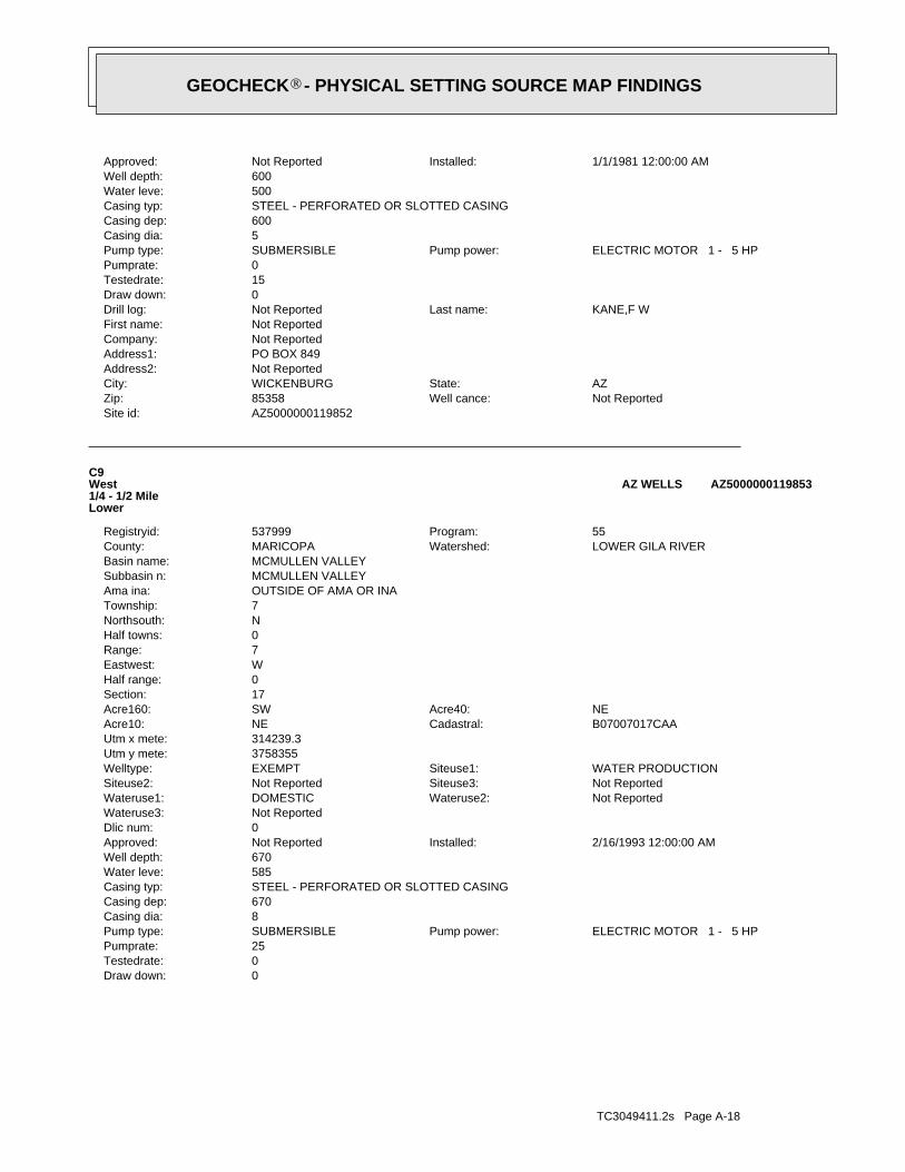
TC3049411.2s Page A-18
0Draw down:0Testedrate:25Pumprate:
ELECTRIC MOTOR 1 - 5 HPPump power:SUBMERSIBLEPump type:8Casing dia:670Casing dep:STEEL - PERFORATED OR SLOTTED CASINGCasing typ:585Water leve:670Well depth:
2/16/1993 12:00:00 AMInstalled:Not ReportedApproved:0Dlic num:Not ReportedWateruse3:
Not ReportedWateruse2:DOMESTICWateruse1:Not ReportedSiteuse3:Not ReportedSiteuse2:WATER PRODUCTIONSiteuse1:EXEMPTWelltype:
3758355Utm y mete:314239.3Utm x mete:
B07007017CAACadastral:NEAcre10:NEAcre40:SWAcre160:
17Section:0Half range:WEastwest:7Range:0Half towns:NNorthsouth:7Township:OUTSIDE OF AMA OR INAAma ina:MCMULLEN VALLEYSubbasin n:MCMULLEN VALLEYBasin name:
LOWER GILA RIVERWatershed:MARICOPACounty:55Program:537999Registryid:
C9West1/4 - 1/2 MileLower
AZ5000000119853AZ WELLS
AZ5000000119852Site id:Not ReportedWell cance:85358Zip:AZState:WICKENBURGCity:
Not ReportedAddress2:PO BOX 849Address1:Not ReportedCompany:Not ReportedFirst name:
KANE,F WLast name:Not ReportedDrill log:0Draw down:15Testedrate:0Pumprate:
ELECTRIC MOTOR 1 - 5 HPPump power:SUBMERSIBLEPump type:5Casing dia:600Casing dep:STEEL - PERFORATED OR SLOTTED CASINGCasing typ:500Water leve:600Well depth:
1/1/1981 12:00:00 AMInstalled:Not ReportedApproved:
GEOCHECK - PHYSICAL SETTING SOURCE MAP FINDINGS®

TC3049411.2s Page A-19
AZ5000000119756Site id:Not ReportedWell cance:85358Zip:AZState:WICKENBURGCity:
Not ReportedAddress2:PO BOX 2630Address1:Not ReportedCompany:Not ReportedFirst name:
BRIDGEWATER, ROSS,Last name:XDrill log:0Draw down:15Testedrate:15Pumprate:
ELECTRIC MOTOR 1 - 5 HPPump power:SUBMERSIBLEPump type:8Casing dia:620Casing dep:STEEL - PERFORATED OR SLOTTED CASINGCasing typ:465Water leve:620Well depth:
2/20/1987 12:00:00 AMInstalled:Not ReportedApproved:0Dlic num:Not ReportedWateruse3:
Not ReportedWateruse2:DOMESTICWateruse1:Not ReportedSiteuse3:Not ReportedSiteuse2:WATER PRODUCTIONSiteuse1:NON-EXEMPTWelltype:
3758154Utm y mete:314235Utm x mete:
B07007017CADCadastral:SEAcre10:NEAcre40:SWAcre160:
17Section:0Half range:WEastwest:7Range:0Half towns:NNorthsouth:7Township:OUTSIDE OF AMA OR INAAma ina:MCMULLEN VALLEYSubbasin n:MCMULLEN VALLEYBasin name:
LOWER GILA RIVERWatershed:MARICOPACounty:55Program:516528Registryid:
10West1/4 - 1/2 MileLower
AZ5000000119756AZ WELLS
AZ5000000119853Site id:Not ReportedWell cance:85358Zip:AZState:WICKENBURGCity:
Not ReportedAddress2:BOX 21591Address1:Not ReportedCompany:Not ReportedFirst name:
REID, CHUCK,Last name:XDrill log:
GEOCHECK - PHYSICAL SETTING SOURCE MAP FINDINGS®

TC3049411.2s Page A-20
0Half range:WEastwest:7Range:0Half towns:NNorthsouth:7Township:OUTSIDE OF AMA OR INAAma ina:MCMULLEN VALLEYSubbasin n:MCMULLEN VALLEYBasin name:
LOWER GILA RIVERWatershed:MARICOPACounty:55Program:577056Registryid:
E12South1/4 - 1/2 MileHigher
AZ5000000119466AZ WELLS
AZ5000000119580Site id:NWell cance:85358Zip:AZState:WICKENBURGCity:
Not ReportedAddress2:PO BOX 1917Address1:Not ReportedCompany:Not ReportedFirst name:
FOREPAUGH WTR ASSOC,Last name:Not ReportedDrill log:0Draw down:20Testedrate:20Pumprate:
NO POWER CODE LISTEDPump power:NO PUMP CODE LISTEDPump type:6Casing dia:650Casing dep:STEEL - PERFORATED OR SLOTTED CASINGCasing typ:540Water leve:650Well depth:
Not ReportedInstalled:Not ReportedApproved:0Dlic num:Not ReportedWateruse3:
Not ReportedWateruse2:UTILITY (WATER CO)Wateruse1:Not ReportedSiteuse3:Not ReportedSiteuse2:WATER PRODUCTIONSiteuse1:EXEMPTWelltype:
3757749Utm y mete:314428.3Utm x mete:
B07007017DCCCadastral:SWAcre10:SWAcre40:SEAcre160:
17Section:0Half range:WEastwest:7Range:0Half towns:NNorthsouth:7Township:OUTSIDE OF AMA OR INAAma ina:MCMULLEN VALLEYSubbasin n:MCMULLEN VALLEYBasin name:
LOWER GILA RIVERWatershed:MARICOPACounty:55Program:647309Registryid:
D11SW1/4 - 1/2 MileLower
AZ5000000119580AZ WELLS
Map IDDirectionDistanceElevation EDR ID NumberDatabase
GEOCHECK - PHYSICAL SETTING SOURCE MAP FINDINGS®

TC3049411.2s Page A-21
0Dlic num:Not ReportedWateruse3:
Not ReportedWateruse2:DOMESTICWateruse1:Not ReportedSiteuse3:Not ReportedSiteuse2:WATER PRODUCTIONSiteuse1:EXEMPTWelltype:
3757542Utm y mete:314827.3Utm x mete:
B07007020AABCadastral:NWAcre10:NEAcre40:NEAcre160:
20Section:0Half range:WEastwest:7Range:0Half towns:NNorthsouth:7Township:OUTSIDE OF AMA OR INAAma ina:MCMULLEN VALLEYSubbasin n:MCMULLEN VALLEYBasin name:
LOWER GILA RIVERWatershed:MARICOPACounty:55Program:569434Registryid:
E13South1/4 - 1/2 MileHigher
AZ5000000119465AZ WELLS
AZ5000000119466Site id:Not ReportedWell cance:85390Zip:AZState:WICKENBURGCity:
Not ReportedAddress2:43909 W HWY 60Address1:Not ReportedCompany:CAROLEFirst name:
JARVISLast name:XDrill log:0Draw down:0Testedrate:0Pumprate:
Not ReportedPump power:Not ReportedPump type:5Casing dia:700Casing dep:PLASTIC OR PVCCasing typ:496Water leve:700Well depth:
3/16/2000 12:00:00 AMInstalled:8/31/1999 12:00:00 AMApproved:0Dlic num:Not ReportedWateruse3:
Not ReportedWateruse2:DOMESTICWateruse1:Not ReportedSiteuse3:Not ReportedSiteuse2:WATER PRODUCTIONSiteuse1:EXEMPTWelltype:
3757542Utm y mete:314827.3Utm x mete:
B07007020AABCadastral:NWAcre10:NEAcre40:NEAcre160:
20Section:
GEOCHECK - PHYSICAL SETTING SOURCE MAP FINDINGS®

TC3049411.2s Page A-22
0Draw down:0Testedrate:0Pumprate:
Not ReportedPump power:Not ReportedPump type:6Casing dia:830Casing dep:PLASTIC OR PVCCasing typ:550Water leve:830Well depth:
Not ReportedInstalled:2/12/2002 12:00:00 AMApproved:0Dlic num:Not ReportedWateruse3:
Not ReportedWateruse2:DOMESTICWateruse1:Not ReportedSiteuse3:Not ReportedSiteuse2:WATER PRODUCTIONSiteuse1:EXEMPTWelltype:
3757542Utm y mete:314827.3Utm x mete:
B07007020AABCadastral:NWAcre10:NEAcre40:NEAcre160:
20Section:0Half range:WEastwest:7Range:0Half towns:NNorthsouth:7Township:OUTSIDE OF AMA OR INAAma ina:MCMULLEN VALLEYSubbasin n:MCMULLEN VALLEYBasin name:
LOWER GILA RIVERWatershed:MARICOPACounty:55Program:590909Registryid:
E14South1/4 - 1/2 MileHigher
AZ5000000119468AZ WELLS
AZ5000000119465Site id:Not ReportedWell cance:85390Zip:AZState:WICKENBURGCity:
Not ReportedAddress2:50009 N. 436TH AVEAddress1:Not ReportedCompany:JOHN J.First name:
SIGLERLast name:XDrill log:0Draw down:13Testedrate:13Pumprate:
OTHERPump power:SUBMERSIBLEPump type:7Casing dia:640Casing dep:PLASTIC OR PVCCasing typ:490Water leve:640Well depth:
9/3/1998 12:00:00 AMInstalled:7/10/1998 12:00:00 AMApproved:
GEOCHECK - PHYSICAL SETTING SOURCE MAP FINDINGS®

TC3049411.2s Page A-23
AZ5000000119467Site id:Not ReportedWell cance:Not ReportedZip:Not ReportedState:Not ReportedCity:
Not ReportedAddress2:Not ReportedAddress1:Not ReportedCompany:Not ReportedFirst name:
Not ReportedLast name:XDrill log:0Draw down:15Testedrate:15Pumprate:
ELECTRIC MOTOR 1 - 5 HPPump power:SUBMERSIBLEPump type:5Casing dia:760Casing dep:PLASTIC OR PVCCasing typ:499Water leve:760Well depth:
7/20/2000 12:00:00 AMInstalled:7/7/2000 12:00:00 AMApproved:0Dlic num:Not ReportedWateruse3:
Not ReportedWateruse2:DOMESTICWateruse1:Not ReportedSiteuse3:Not ReportedSiteuse2:WATER PRODUCTIONSiteuse1:EXEMPTWelltype:
3757542Utm y mete:314827.3Utm x mete:
B07007020AABCadastral:NWAcre10:NEAcre40:NEAcre160:
20Section:0Half range:WEastwest:7Range:0Half towns:NNorthsouth:7Township:OUTSIDE OF AMA OR INAAma ina:MCMULLEN VALLEYSubbasin n:MCMULLEN VALLEYBasin name:
LOWER GILA RIVERWatershed:MARICOPACounty:55Program:582053Registryid:
E15South1/4 - 1/2 MileHigher
AZ5000000119467AZ WELLS
AZ5000000119468Site id:Not ReportedWell cance:85390Zip:AZState:WICKENBURGCity:
Not ReportedAddress2:43909 W HWY 60Address1:Not ReportedCompany:CAROLEFirst name:
JARVISLast name:XDrill log:
GEOCHECK - PHYSICAL SETTING SOURCE MAP FINDINGS®

TC3049411.2s Page A-24
D17SW1/4 - 1/2 MileLower
USGS3070255FED USGS
AZ5000000119469Site id:Not ReportedWell cance:85390Zip:AZState:WICKENBURGCity:
Not ReportedAddress2:43827 W US 60Address1:Not ReportedCompany:Not ReportedFirst name:
PARSONS, JOHN,RLast name:XDrill log:10Draw down:14Testedrate:16Pumprate:
ELECTRIC MOTOR 1 - 5 HPPump power:SUBMERSIBLEPump type:7Casing dia:640Casing dep:STEEL - PERFORATED OR SLOTTED CASINGCasing typ:550Water leve:640Well depth:
5/1/1996 12:00:00 AMInstalled:Not ReportedApproved:0Dlic num:Not ReportedWateruse3:
Not ReportedWateruse2:DOMESTICWateruse1:Not ReportedSiteuse3:Not ReportedSiteuse2:WATER PRODUCTIONSiteuse1:EXEMPTWelltype:
3757539Utm y mete:315028.9Utm x mete:
B07007020AAACadastral:NEAcre10:NEAcre40:NEAcre160:
20Section:0Half range:WEastwest:7Range:0Half towns:NNorthsouth:7Township:OUTSIDE OF AMA OR INAAma ina:MCMULLEN VALLEYSubbasin n:MCMULLEN VALLEYBasin name:
LOWER GILA RIVERWatershed:MARICOPACounty:55Program:555863Registryid:
16South1/4 - 1/2 MileHigher
AZ5000000119469AZ WELLS
Map IDDirectionDistanceElevation EDR ID NumberDatabase
GEOCHECK - PHYSICAL SETTING SOURCE MAP FINDINGS®

TC3049411.2s Page A-25
18SW1/2 - 1 MileLower
AZ5000000119578AZ WELLS
1973-10-04 480.9 Note: The site had been pumped recently.1973-12-07 493.61982-01-07 484.3 1980-11-18 465.11985-02-28 484.10 1983-01-28 484.21986-01-01 465.0 1985-12-09 483.71987-12-11 485.00 1986-12-08 483.801989-11-30 491.20 1988-12-05 484.40 Note: The site had been pumped recently.1991-01-08 494.901992-11-16 485.1 1991-12-09 485.41994-11-07 486.0 1993-11-30 485.3 Note: The site had been pumped recently.1995-11-17 487.11997-11-10 487.5 1996-11-06 487.71999-11-15 487.2 1998-11-16 486.72001-11-13 491.6 2000-11-27 487.1
DateFeet belowSurface
Feet toSealevel
-------------------------------------------------Date
Feet belowSurface
Feet toSealevel
-------------------------------------------------
Ground-water levels, Number of Measurements: 24
24Ground water data count:2001-11-13Ground water data end date:Ground water data begin date: 1973-10-041Water quality data count:1980-08-14Water quality data end date:1980-08-14Water quality data begin date:0Peak flow data count:0000-00-00Peak flow data end date:0000-00-00Peak flow data begin date:0Daily flow data count:0000-00-00Daily flow data end date:0000-00-00Daily flow data begin date:0Real time data flag:
MMUProject number:Not ReportedSource of depth data:
660Hole depth:660.00Well depth:Not ReportedAquifer:Not ReportedAquifer Type:Single well, other than collector or Ranney typeType of ground water site:NLocal standard time flag:
MSTMean greenwich time offset:Not ReportedDate inventoried:19730910Date construction:Ground-water other than SpringSite type:
Valley flatTopographic:Centennial Wash. Arizona. Area = 1940 sq.mi.Hydrologic:National Geodetic Vertical Datum of 1929Altitude datum:10Altitude accuracy:Interpolated from topographic mapAltitude method:2409Altitude:
62500Map scale:AGUILALocation map:SWSWSES17 T07N R07W GLand net:USCountry:013County:04State:04District:NAD83Dec latlong datum:NAD27Latlong datum:FCoor accr:MCoor meth:-113.00851836Dec lon:33.94363989Dec lat:1130028Longitude:USGS3070255EDR Site id:335637Latitude:
B-07-07 17DCCSite name:335637113002801Site no:USGSAgency cd:
GEOCHECK - PHYSICAL SETTING SOURCE MAP FINDINGS®

TC3049411.2s Page A-26
0Half range:WEastwest:7Range:0Half towns:NNorthsouth:7Township:OUTSIDE OF AMA OR INAAma ina:MCMULLEN VALLEYSubbasin n:MCMULLEN VALLEYBasin name:
LOWER GILA RIVERWatershed:MARICOPACounty:55Program:534508Registryid:
F19WSW1/2 - 1 MileLower
AZ5000000119668AZ WELLS
AZ5000000119578Site id:Not ReportedWell cance:85358Zip:AZState:WICKENBURGCity:
Not ReportedAddress2:PO BOX 21031Address1:Not ReportedCompany:Not ReportedFirst name:
PUTNAM, THEO & ELSIE,Last name:XDrill log:5Draw down:13Testedrate:13Pumprate:
ELECTRIC MOTOR 1 - 5 HPPump power:SUBMERSIBLEPump type:8Casing dia:578Casing dep:PLASTIC OR PVCCasing typ:475Water leve:580Well depth:
2/7/1987 12:00:00 AMInstalled:Not ReportedApproved:0Dlic num:Not ReportedWateruse3:
Not ReportedWateruse2:DOMESTICWateruse1:Not ReportedSiteuse3:Not ReportedSiteuse2:WATER PRODUCTIONSiteuse1:EXEMPTWelltype:
3757751Utm y mete:314226.8Utm x mete:
B07007017CDDCadastral:SEAcre10:SEAcre40:SWAcre160:
17Section:0Half range:WEastwest:7Range:0Half towns:NNorthsouth:7Township:OUTSIDE OF AMA OR INAAma ina:MCMULLEN VALLEYSubbasin n:MCMULLEN VALLEYBasin name:
LOWER GILA RIVERWatershed:MARICOPACounty:55Program:516229Registryid:
GEOCHECK - PHYSICAL SETTING SOURCE MAP FINDINGS®

TC3049411.2s Page A-27
0Dlic num:Not ReportedWateruse3:
Not ReportedWateruse2:DOMESTICWateruse1:Not ReportedSiteuse3:Not ReportedSiteuse2:WATER PRODUCTIONSiteuse1:EXEMPTWelltype:
3757955Utm y mete:314029.3Utm x mete:
B07007017CDBCadastral:NWAcre10:SEAcre40:SWAcre160:
17Section:0Half range:WEastwest:7Range:0Half towns:NNorthsouth:7Township:OUTSIDE OF AMA OR INAAma ina:MCMULLEN VALLEYSubbasin n:MCMULLEN VALLEYBasin name:
LOWER GILA RIVERWatershed:MARICOPACounty:55Program:630619Registryid:
F20WSW1/2 - 1 MileLower
AZ5000000119669AZ WELLS
AZ5000000119668Site id:Not ReportedWell cance:85358Zip:AZState:WICKENBURGCity:
Not ReportedAddress2:BOX 21591Address1:Not ReportedCompany:Not ReportedFirst name:
REID, CHUCK,Last name:XDrill log:0Draw down:0Testedrate:0Pumprate:
NO POWER CODE LISTEDPump power:NO PUMP CODE LISTEDPump type:8Casing dia:660Casing dep:STEEL - PERFORATED OR SLOTTED CASINGCasing typ:600Water leve:660Well depth:
12/30/1992 12:00:00 AMInstalled:Not ReportedApproved:0Dlic num:Not ReportedWateruse3:
Not ReportedWateruse2:DOMESTICWateruse1:Not ReportedSiteuse3:CAPPEDSiteuse2:WATER PRODUCTIONSiteuse1:EXEMPTWelltype:
3757955Utm y mete:314029.3Utm x mete:
B07007017CDBCadastral:NWAcre10:SEAcre40:SWAcre160:
17Section:
GEOCHECK - PHYSICAL SETTING SOURCE MAP FINDINGS®

TC3049411.2s Page A-28
0Draw down:0Testedrate:0Pumprate:
Not ReportedPump power:Not ReportedPump type:6Casing dia:700Casing dep:PLASTIC OR PVCCasing typ:546Water leve:700Well depth:
4/7/2007 12:00:00 AMInstalled:2/7/2007 12:00:00 AMApproved:0Dlic num:Not ReportedWateruse3:
Not ReportedWateruse2:DOMESTICWateruse1:Not ReportedSiteuse3:Not ReportedSiteuse2:WATER PRODUCTIONSiteuse1:EXEMPTWelltype:
3757549Utm y mete:314222.8Utm x mete:
B07007020BAACadastral:NEAcre10:NEAcre40:NWAcre160:
20Section:0Half range:WEastwest:7Range:0Half towns:NNorthsouth:7Township:OUTSIDE OF AMA OR INAAma ina:MCMULLEN VALLEYSubbasin n:MCMULLEN VALLEYBasin name:
LOWER GILA RIVERWatershed:MARICOPACounty:55Program:214679Registryid:
G21SW1/2 - 1 MileLower
AZ5000000119457AZ WELLS
AZ5000000119669Site id:Not ReportedWell cance:80615Zip:COState:EATONCity:
Not ReportedAddress2:35607 WCR 49Address1:Not ReportedCompany:MATTHEW & ROBINFirst name:
WIKUMLast name:Not ReportedDrill log:0Draw down:10Testedrate:10Pumprate:
NO POWER CODE LISTEDPump power:NO PUMP CODE LISTEDPump type:8Casing dia:600Casing dep:STEEL - PERFORATED OR SLOTTED CASINGCasing typ:448Water leve:675Well depth:
12/9/1975 12:00:00 AMInstalled:Not ReportedApproved:
GEOCHECK - PHYSICAL SETTING SOURCE MAP FINDINGS®

TC3049411.2s Page A-29
AZ5000000119458Site id:Not ReportedWell cance:85390Zip:AZState:WICKENBURGCity:
Not ReportedAddress2:43909 W HWY 60Address1:Not ReportedCompany:CAROLEFirst name:
JARVISLast name:Not ReportedDrill log:0Draw down:0Testedrate:0Pumprate:
Not ReportedPump power:Not ReportedPump type:0Casing dia:0Casing dep:Not ReportedCasing typ:0Water leve:0Well depth:
Not ReportedInstalled:Not ReportedApproved:0Dlic num:Not ReportedWateruse3:
Not ReportedWateruse2:DOMESTICWateruse1:Not ReportedSiteuse3:Not ReportedSiteuse2:Not ReportedSiteuse1:EXEMPTWelltype:
3757549Utm y mete:314222.8Utm x mete:
B07007020BAACadastral:NEAcre10:NEAcre40:NWAcre160:
20Section:0Half range:WEastwest:7Range:0Half towns:NNorthsouth:7Township:OUTSIDE OF AMA OR INAAma ina:MCMULLEN VALLEYSubbasin n:MCMULLEN VALLEYBasin name:
LOWER GILA RIVERWatershed:MARICOPACounty:55Program:903165Registryid:
G22SW1/2 - 1 MileLower
AZ5000000119458AZ WELLS
AZ5000000119457Site id:Not ReportedWell cance:85390Zip:AZState:WICKENBURGCity:
Not ReportedAddress2:43909 W HWY 60Address1:Not ReportedCompany:CAROLEFirst name:
JARVISLast name:XDrill log:
GEOCHECK - PHYSICAL SETTING SOURCE MAP FINDINGS®

TC3049411.2s Page A-30
0Half range:WEastwest:7Range:0Half towns:NNorthsouth:7Township:OUTSIDE OF AMA OR INAAma ina:MCMULLEN VALLEYSubbasin n:MCMULLEN VALLEYBasin name:
LOWER GILA RIVERWatershed:MARICOPACounty:55Program:516230Registryid:
24SW1/2 - 1 MileHigher
AZ5000000119373AZ WELLS
Ground-water levels, Number of Measurements: 0
Not ReportedGround water data count:Not ReportedGround water data end date:Ground water data begin date: Not ReportedNot ReportedWater quality data count:Not ReportedWater quality data end date:Not ReportedWater quality data begin date:Not ReportedPeak flow data count:Not ReportedPeak flow data end date:Not ReportedPeak flow data begin date:Not ReportedDaily flow data count:Not ReportedDaily flow data end date:Not ReportedDaily flow data begin date:Not ReportedReal time data flag:
MMUProject number:Not ReportedSource of depth data:
500Hole depth:Not ReportedWell depth:Not ReportedAquifer:Not ReportedAquifer Type:Single well, other than collector or Ranney typeType of ground water site:NLocal standard time flag:
MSTMean greenwich time offset:Not ReportedDate inventoried:Not ReportedDate construction:Ground-water other than SpringSite type:
Not ReportedTopographic:Centennial Wash. Arizona. Area = 1940 sq.mi.Hydrologic:National Geodetic Vertical Datum of 1929Altitude datum:10Altitude accuracy:Interpolated from topographic mapAltitude method:2440.00Altitude:
Not ReportedMap scale:Not ReportedLocation map:SESESWS16 T07N R07W GLand net:USCountry:013County:04State:04District:NAD83Dec latlong datum:NAD27Latlong datum:TCoor accr:MCoor meth:-112.99240671Dec lon:33.94336216Dec lat:1125930Longitude:USGS3051770EDR Site id:335636Latitude:
B-07-07 16CDDSite name:335636112593001Site no:USGSAgency cd:
23ESE1/2 - 1 MileHigher
USGS3051770FED USGS
Map IDDirectionDistanceElevation EDR ID NumberDatabase
GEOCHECK - PHYSICAL SETTING SOURCE MAP FINDINGS®

TC3049411.2s Page A-31
0Dlic num:Not ReportedWateruse3:
Not ReportedWateruse2:DOMESTICWateruse1:Not ReportedSiteuse3:Not ReportedSiteuse2:WATER PRODUCTIONSiteuse1:EXEMPTWelltype:
3758565Utm y mete:313638.3Utm x mete:
B07007017BCCCadastral:SWAcre10:SWAcre40:NWAcre160:
17Section:0Half range:WEastwest:7Range:0Half towns:NNorthsouth:7Township:OUTSIDE OF AMA OR INAAma ina:MCMULLEN VALLEYSubbasin n:MCMULLEN VALLEYBasin name:
LOWER GILA RIVERWatershed:MARICOPACounty:55Program:516614Registryid:
25WNW1/2 - 1 MileLower
AZ5000000119980AZ WELLS
AZ5000000119373Site id:Not ReportedWell cance:85390Zip:AZState:WICKENBURGCity:
Not ReportedAddress2:43909 W HWY 60Address1:Not ReportedCompany:CAROLEFirst name:
JARVISLast name:XDrill log:0Draw down:10Testedrate:30Pumprate:
ELECTRIC MOTOR 1 - 5 HPPump power:SUBMERSIBLEPump type:8Casing dia:580Casing dep:STEEL - PERFORATED OR SLOTTED CASINGCasing typ:486Water leve:580Well depth:
1/30/1987 12:00:00 AMInstalled:Not ReportedApproved:0Dlic num:Not ReportedWateruse3:
Not ReportedWateruse2:DOMESTICWateruse1:Not ReportedSiteuse3:Not ReportedSiteuse2:WATER PRODUCTIONSiteuse1:EXEMPTWelltype:
3757349Utm y mete:314017.5Utm x mete:
B07007020BACCadastral:SWAcre10:NEAcre40:NWAcre160:
20Section:
GEOCHECK - PHYSICAL SETTING SOURCE MAP FINDINGS®

TC3049411.2s Page A-32
AZ5000000119980Site id:YWell cance:85332Zip:AZState:CONGRESSCity:
Not ReportedAddress2:BOX 261Address1:Not ReportedCompany:Not ReportedFirst name:
DAVIS, JAMES & LOIS,Last name:Not ReportedDrill log:0Draw down:0Testedrate:0Pumprate:
NO POWER CODE LISTEDPump power:NO PUMP CODE LISTEDPump type:0Casing dia:0Casing dep:NO CASING CODE LISTEDCasing typ:0Water leve:0Well depth:
Not ReportedInstalled:Not ReportedApproved:
GEOCHECK - PHYSICAL SETTING SOURCE MAP FINDINGS®

TC3049411.2s Page A-33
0%21%79%2.242 pCi/LBasement0%20%80%3.640 pCi/LLiving Area - 2nd Floor0%7%93%1.697 pCi/LLiving Area - 1st Floor
% >20 pCi/L% 4-20 pCi/L% <4 pCi/LAverage ActivityArea
Number of sites tested: 695
Federal Area Radon Information for MARICOPA COUNTY, AZ
: Zone 3 indoor average level < 2 pCi/L. : Zone 2 indoor average level >= 2 pCi/L and <= 4 pCi/L. Note: Zone 1 indoor average level > 4 pCi/L.
Federal EPA Radon Zone for MARICOPA County: 2
AREA RADON INFORMATION
GEOCHECK - PHYSICAL SETTING SOURCE MAP FINDINGSRADON
®
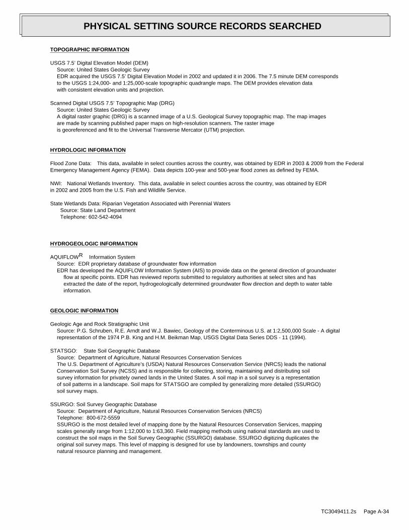
TOPOGRAPHIC INFORMATION
USGS 7.5’ Digital Elevation Model (DEM)Source: United States Geologic SurveyEDR acquired the USGS 7.5’ Digital Elevation Model in 2002 and updated it in 2006. The 7.5 minute DEM correspondsto the USGS 1:24,000- and 1:25,000-scale topographic quadrangle maps. The DEM provides elevation datawith consistent elevation units and projection.
Scanned Digital USGS 7.5’ Topographic Map (DRG)Source: United States Geologic SurveyA digital raster graphic (DRG) is a scanned image of a U.S. Geological Survey topographic map. The map imagesare made by scanning published paper maps on high-resolution scanners. The raster imageis georeferenced and fit to the Universal Transverse Mercator (UTM) projection.
HYDROLOGIC INFORMATION
Flood Zone Data: This data, available in select counties across the country, was obtained by EDR in 2003 & 2009 from the FederalEmergency Management Agency (FEMA). Data depicts 100-year and 500-year flood zones as defined by FEMA.
NWI: National Wetlands Inventory. This data, available in select counties across the country, was obtained by EDRin 2002 and 2005 from the U.S. Fish and Wildlife Service.
State Wetlands Data: Riparian Vegetation Associated with Perennial WatersSource: State Land DepartmentTelephone: 602-542-4094
HYDROGEOLOGIC INFORMATION
AQUIFLOW Information SystemR
Source: EDR proprietary database of groundwater flow informationEDR has developed the AQUIFLOW Information System (AIS) to provide data on the general direction of groundwater
flow at specific points. EDR has reviewed reports submitted to regulatory authorities at select sites and hasextracted the date of the report, hydrogeologically determined groundwater flow direction and depth to water tableinformation.
GEOLOGIC INFORMATION
Geologic Age and Rock Stratigraphic UnitSource: P.G. Schruben, R.E. Arndt and W.J. Bawiec, Geology of the Conterminous U.S. at 1:2,500,000 Scale - A digitalrepresentation of the 1974 P.B. King and H.M. Beikman Map, USGS Digital Data Series DDS - 11 (1994).
STATSGO: State Soil Geographic DatabaseSource: Department of Agriculture, Natural Resources Conservation ServicesThe U.S. Department of Agriculture’s (USDA) Natural Resources Conservation Service (NRCS) leads the nationalConservation Soil Survey (NCSS) and is responsible for collecting, storing, maintaining and distributing soilsurvey information for privately owned lands in the United States. A soil map in a soil survey is a representationof soil patterns in a landscape. Soil maps for STATSGO are compiled by generalizing more detailed (SSURGO)soil survey maps.
SSURGO: Soil Survey Geographic DatabaseSource: Department of Agriculture, Natural Resources Conservation Services (NRCS)Telephone: 800-672-5559SSURGO is the most detailed level of mapping done by the Natural Resources Conservation Services, mappingscales generally range from 1:12,000 to 1:63,360. Field mapping methods using national standards are used toconstruct the soil maps in the Soil Survey Geographic (SSURGO) database. SSURGO digitizing duplicates theoriginal soil survey maps. This level of mapping is designed for use by landowners, townships and countynatural resource planning and management.
TC3049411.2s Page A-34
PHYSICAL SETTING SOURCE RECORDS SEARCHED

LOCAL / REGIONAL WATER AGENCY RECORDS
FEDERAL WATER WELLS
PWS: Public Water SystemsSource: EPA/Office of Drinking WaterTelephone: 202-564-3750Public Water System data from the Federal Reporting Data System. A PWS is any water system which provides water to at
least 25 people for at least 60 days annually. PWSs provide water from wells, rivers and other sources.
PWS ENF: Public Water Systems Violation and Enforcement DataSource: EPA/Office of Drinking WaterTelephone: 202-564-3750Violation and Enforcement data for Public Water Systems from the Safe Drinking Water Information System (SDWIS) after
August 1995. Prior to August 1995, the data came from the Federal Reporting Data System (FRDS).
USGS Water Wells: USGS National Water Inventory System (NWIS)This database contains descriptive information on sites where the USGS collects or has collected data on surfacewater and/or groundwater. The groundwater data includes information on wells, springs, and other sources of groundwater.
STATE RECORDS
Arizona Well Registration DatabaseSource: Department of Water ResourcesTelephone: 602-417-2400The Wells database contains all wells registered in the state.
OTHER STATE DATABASE INFORMATION
Oil and Gas Well DatabaseSource: Arizona Geological SurveyTelephone: 520-770-3500This database contains Oil and Gas wells in the State of Arizona. Includes all wells that have been permitted
by the State Oil and Gas Conservation Commission (OGCC). Gas wells include natural gas, helium, and carbon dioxidewells.
RADON
State Database: AZ RadonSource: Arizona Radiation Regulatory AgencyTelephone: 602-255-4845State Indoor Radon Survey
Area Radon InformationSource: USGSTelephone: 703-356-4020The National Radon Database has been developed by the U.S. Environmental Protection Agency(USEPA) and is a compilation of the EPA/State Residential Radon Survey and the National Residential Radon Survey.The study covers the years 1986 - 1992. Where necessary data has been supplemented by information collected atprivate sources such as universities and research institutions.
EPA Radon ZonesSource: EPATelephone: 703-356-4020Sections 307 & 309 of IRAA directed EPA to list and identify areas of U.S. with the potential for elevated indoorradon levels.
OTHER
Airport Landing Facilities: Private and public use landing facilitiesSource: Federal Aviation Administration, 800-457-6656
Epicenters: World earthquake epicenters, Richter 5 or greaterSource: Department of Commerce, National Oceanic and Atmospheric Administration
TC3049411.2s Page A-35
PHYSICAL SETTING SOURCE RECORDS SEARCHED
STREET AND ADDRESS INFORMATION
© 2010 Tele Atlas North America, Inc. All rights reserved. This material is proprietary and the subject of copyright protectionand other intellectual property rights owned by or licensed to Tele Atlas North America, Inc. The use of this material is subjectto the terms of a license agreement. You will be held liable for any unauthorized copying or disclosure of this material.
TC3049411.2s Page A-36
PHYSICAL SETTING SOURCE RECORDS SEARCHED

Appendix H:
Records Documentation

1
Keith Ross
From: Jeannie Taylor - ENVX [[email protected]]Sent: Friday, April 22, 2011 10:21 AMTo: Keith RossSubject: Environmental Record SEarch for Wickenburg property
Found no record of illegal dumping, hazardous waste spills or other environmental concerns for the property near W. US Hwy 60 and 436th Ave., Wickenburg, AZ. Jeannie TaylorJeannie TaylorJeannie TaylorJeannie Taylor MCESD Records Management Specialist 1001 N. Central Ste 695
Phoenix, Arizona 85004
Ph # (602) 372-1778
Fax # (602) 372-0904 TDD # (602) 372-0622
Email [email protected]


Appendix I:
Interview Documentation


Appendix J:
Miscellaneous Information


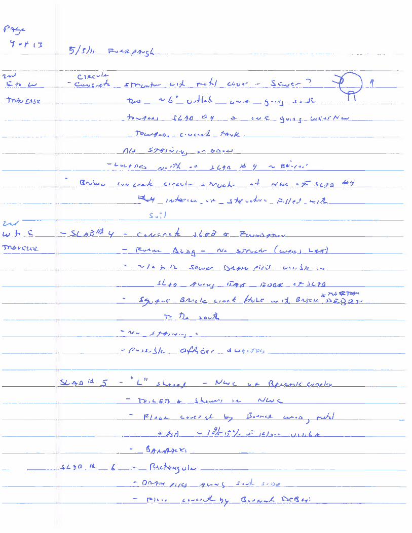

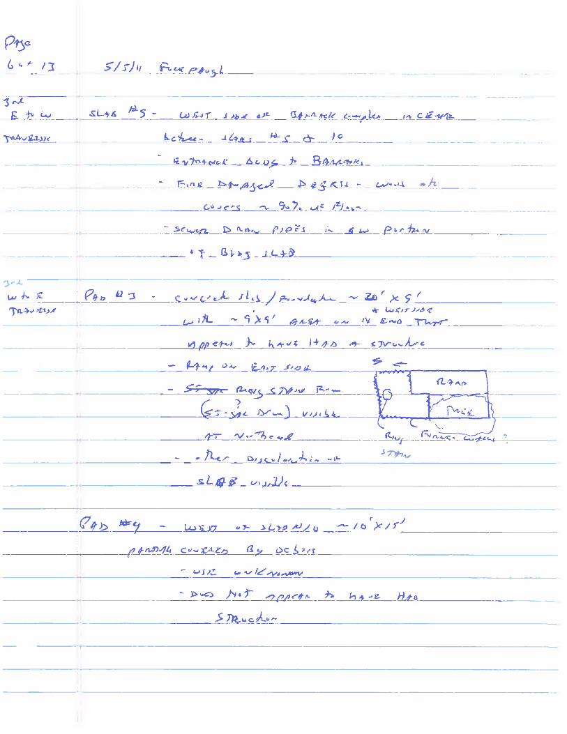


Table J-1: Existing and Former Structures Foundations
Description
Area
(approx) (sqft) Shape Location (Accessor Parcel Number) Description Possible Use
Slab #1 600 Rectangular
APN-506-10-006-adjacent to
northern property edge
Concrete slab with wellhead at east end. Remnant wall outlines for
interior and exterior walls Well/Pump House
Well/Pump House for
supply well
Slab #2 800 Rectangular APN 506-10-006-north of cistern
Concrete slab with remnant exterior wall outlines and several 2-inch
metal pipes extending from the concrete slab. Two raised concrete
pads adjacent to the open pipes.
Water
treatment/distribution
Slab #3 4000 Rectangular
APN 506-10-006-north of Hanger
bldg
Concrete slab with burned/charred debris surrounding the slab. Some
minor visible staining and spills visible on the concrete floor. No
drains observed (some of the slab is covered by debris. Remnant wall
outlines around the edge of the slab indicate exterior walls.
Maintenance shop for
aircraft/equipment/vehicl
es
Slab #4 8000 Rectangular
APN 506-10-007-north central
portion west of barrack complex
Concrete slab with remnant exterior wall outlines and several small
interior walls with sewer drain pipes. One brick lined hole in concrete
slab at north end of slab. Officers Quarters?
Slab #5 9600 "L"
APN 506-10-007-northwest
building of barrack complex
Concrete slab with sewer drains at the elbow of the "L". Slab 90%
covered by burned debris (wood, ceramics (toilets), metal, melted
glass). Barracks
Slab #6 4400 Rectangular
APN 506-10-007- north center
building of barrack complex
Concrete slab with sewer drain pipes along southern half of builing.
Remnant wall outlines visible along exterior edges and on the interior
areas of the slab. Slab 60% covered by burned debris (wood, metal,
glass etc) Barracks
Slab #7 6450 "L"
APN 506-10-007-northeast building
of barrack complex
Concrete slab with sewer drains at the elbow of the "L". Slab 40%
covered by burned debris (wood, ceramics (toilets), metal, melted
glass). Barracks
Slab #8 3750 Rectangular
APN 506-10-007-south of Hanger
across road and north of wash pad
Concrete slab with remnant exterior and interior wall outlines and
sewer drain pipes. No staining, debris scattered on the slab. Offices?
Slab #9 16000 Irregular
APN 506-10-007-between Slabs #5
and 10 on west side of complex
Concrete slab with remnant exterior and interior wall outlines with
sewer drain pipes visible in slab. Main barrack offices?
Slab #10 9600 "L"
APN 506-10-007-southwest
building of barrack complex
Concrete slab with sewer drains at the elbow of the "L". Slab 70%
covered by burned and non burned debris (wood, ceramics (toilets),
metal, melted glass). Barracks
Slab #11 4400 Rectangular
APN 506-10-007-south center
building of barrack complex
Concrete slab with remnant wall outlines (exterior) and sewer drain
pipes visible in the slab. Slab covered by debris similar to other slabs. Barracks
Slab #12 6450 "L"
APN 506-10-007-southeast building
of barrack complex
Concrete slab with sewer drains at the elbow of the "L". Slab 30%
covered by debris (wood, ceramics (toilets), metal, melted glass). Barracks
Slab #13 10000 Rectangular
APN 506-10-007-east building of
barrack complex
Concrete slab with remnant wall outlines (exterior) and sewer drain
pipes visible in the slab. Slab 20% covered by debris similar to other
slabs. Barracks
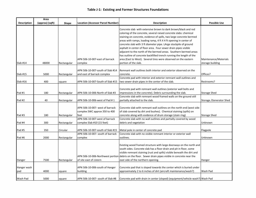
Table J-1: Existing and Former Structures Foundations
Description
Area
(approx) (sqft) Shape Location (Accessor Parcel Number) Description Possible Use
Slab #14 48000 Rectangular
APN 506-10-007-east of barrack
complex
Concrete slab with extensive brown to dark brown/black and red
coloring of the concrete, several raised concrete slabs: chemical
staining on concrete, evidence of spills, two large concrete bermed
areas with ramps, loading ramp, 4 ft X 4 ft opening in center of
concrete slab with 3 ft diameter pipe. LArge stockpile of ground
asphalt in center of floor area. Four sewer drain pipes visible
adjacent to the north of the bermed areas. Southern bermed areas
has outline of concrete backfilled trench running the length of the
area (East to West). Several tires were observed on the eastern
portion of the slab.
Maintenance/Materials
storage building
Slab #15 5000 Rectangular
APN 506-10-007-south of Slab #14
and east of barrack complex
Remnant wall outlines both interior and exterior observed on the
concrete. Offices?
Slab #16 400 square APN 506-10-007-South of Slab #15
Concrete pad with interior and exterior remnant wall outlines and
two sewer drain pipes in the center of the slab. Restrooms?
Pad #1 180 Rectangular APN 506-10-006-North of Slab #3
Concrete pad with remnant wall outlines (exterior wall bolts and
impressions in the concrete). Debris surrounding the slab. Storage Shed
Pad #2 40 Rectangular APN 506-10-006-west of Pad # 1
Concrete slab with remnant wood framed walls on the ground still
partially attached to the slab. Storage /Generator Shed
Pad #3 180 Rectangular
APN 506-10-007- west of barrack
complex SWC approx 350 to 400
feet
Concrete slab with remnant wall outlines on the north end (west side
of slab covered by dirt and bushes). Chemical staining (spills) on
concrete along with evidence of drum storage (stain ring) Storage Shed
Pad #4 300 Rectangular
APN 506-10-007-west of barrack
complex Slab #10 (15 feet)
Concrete slab with no wall outlines and partially covered by wood
debris and vegetation Unknown
Pad #5 350 Circular APN 506-10-007-south of Slab #15 Metal pole in center of concrete pad Flagpole
Pad #6 2000 Rectangular
APN 506-10-007- south of barrack
complex
Concrete slab with no visible remnant interior or exterior wall
outlines. Unknown
Hanger 7500 Rectangular
APN 506-10-006-Northwest portion
of site east of cistern
Existing wood framed structure with large doorways on the north and
south sides. Concrete slab has a floor drain and pit in floor, some
visible remnant staining (rust and spills) visible beneath the dirt and
debris on the floor. Sewer drain pipes visible in concrete near the
east side of the northern opening. Hanger
Hanger wash
pad 4000 square
APN 506-10-006-south of Hanger
building
Concrete pad that is sloped towards the center which is buried under
approximately 2 to 6 inches of dirt (aircraft maintenance/wash?) Wash Pad
Wash Pad 5000 square APN 506-10-007- south of Slab #8 Concrete pad with drain in center (sloped) (equipment/vehicle wash?) Wash Pad

Table J-1: Existing and Former Structures Foundations
Description
Area
(approx) (sqft) Shape Location (Accessor Parcel Number) Description Possible Use
Cistern 7500 Circular APN 506-10-006-west of Hanger Large circular struture. Cistern/Water storage
Water Tank 22 X 6 ft diameter Cylindrical APN 506-10-006-west of cistern Steel AST Water Storage
Butane AST 25 X 5 ft diameter Cylindrical
APN 506-10-007-north of barrack
complex Steel AST Fuel for heating
Concrete
Tank 25000 gallons Rectangular
APN 506-10-006-West-northwest
of water tank approx 420 to 450 ft
Large rectangular concrete tank with three 2 ftX 2 ft access ports. Still
has approximately 4 feet of water and 1 foot of sludge. No odors
from water or sludge. Wastewater treatment

Echeverria Field From Wikipedia, the free encyclopedia
Echeverria Field is an abandoned airfield, located approximately 15 miles (24 km) west of Wickenburg, Arizona.
History
Built by the United States Army Air Forces, Activated on 3 June 1942 as Wickenburg Field. Runway consisted of 4,000' NE/SW main (04/22) and 3,200' NW/SE (13/29). Main runway extended to 4,500' during 1943. Both runways were asphalt surfaced.
Initially used by 5th Glider Training detachment for unpowered gilder training. Primary use was basic flying training of flight cadets under contract to Claiborne Flight Academy. Flying training was performed with Fairchild PT-19s as the primary trainer. Also had several PT-17 Stearmans and a few P-40 Warhawks assigned. Had one satellite airfield located near Aguila, AZ.
Inactivated on 19 April 1944 with the drawdown of AAFTC's pilot training program. The airfield was turned over to civil control at the end of the war though the War Assets Administration (WAA). Was used by various private entities after the war, including being a prison & housing migrant workers. Wickenburg was used at some point between 1958-62 as a municipal airport for Wickenburg until a new facility was built closer to town.
Today the facility is abandoned. The main runway appears to have been extended after the war, secondary barley visible in aerial photography. Derelict hangar and a minor structure still standing, however some concrete building foundations is all that remain of the airport/airfield ground station and a street pattern in derelict condition.
Wickenburg Field
Part of Army Air Forces Training Command
Maricopa County, near Wickenburg, Arizona
USGS 1997 airphoto
Type Basic flying training airfield
Coordinates 33°57′14″N 112°59′32″W
Built 1942
In use 1942-1944
Current
condition
Abandoned
Current
owner
United States Army Air Forces
Controlled by USAAF West Coast Training
Center
Events World War II
Contents
� 1 History � 2 See also � 3 References � 4 External links
Coordinates: 33°57′14″N 112°59′32″W
Page 1 of 2Echeverria Field - Wikipedia, the free encyclopedia
5/4/2011http://en.wikipedia.org/wiki/Echeverria_Field

See also
� Arizona World War II Army Airfields
References
This article incorporates public domain material from websites or documents of the Air Force Historical Research Agency.
� Shaw, Frederick J. (2004), Locating Air Force Base Sites History’s Legacy, Air Force History and Museums Program, United States Air Force, Washington DC, 2004.
� Manning, Thomas A. (2005), History of Air Education and Training Command, 1942–2002. Office of History and Research, Headquarters, AETC, Randolph AFB, Texas ASIN: B000NYX3PC
External links
� Abandoned & Little-Known Airfields, Echeverria Field / Wickenburg Airport / Forepaugh Airport
Retrieved from "http://en.wikipedia.org/wiki/Echeverria_Field" Categories: 1942 establishments | USAAF Contract Flying School Airfields | Airfields of the United States Army Air Forces in Arizona | History of Maricopa County, Arizona | Buildings and structures in Maricopa County, Arizona
� This page was last modified on 31 January 2011 at 23:15. � Text is available under the Creative Commons Attribution-ShareAlike License; additional terms
may apply. See Terms of Use for details. Wikipedia® is a registered trademark of the Wikimedia Foundation, Inc., a non-profit organization.
Page 2 of 2Echeverria Field - Wikipedia, the free encyclopedia
5/4/2011http://en.wikipedia.org/wiki/Echeverria_Field
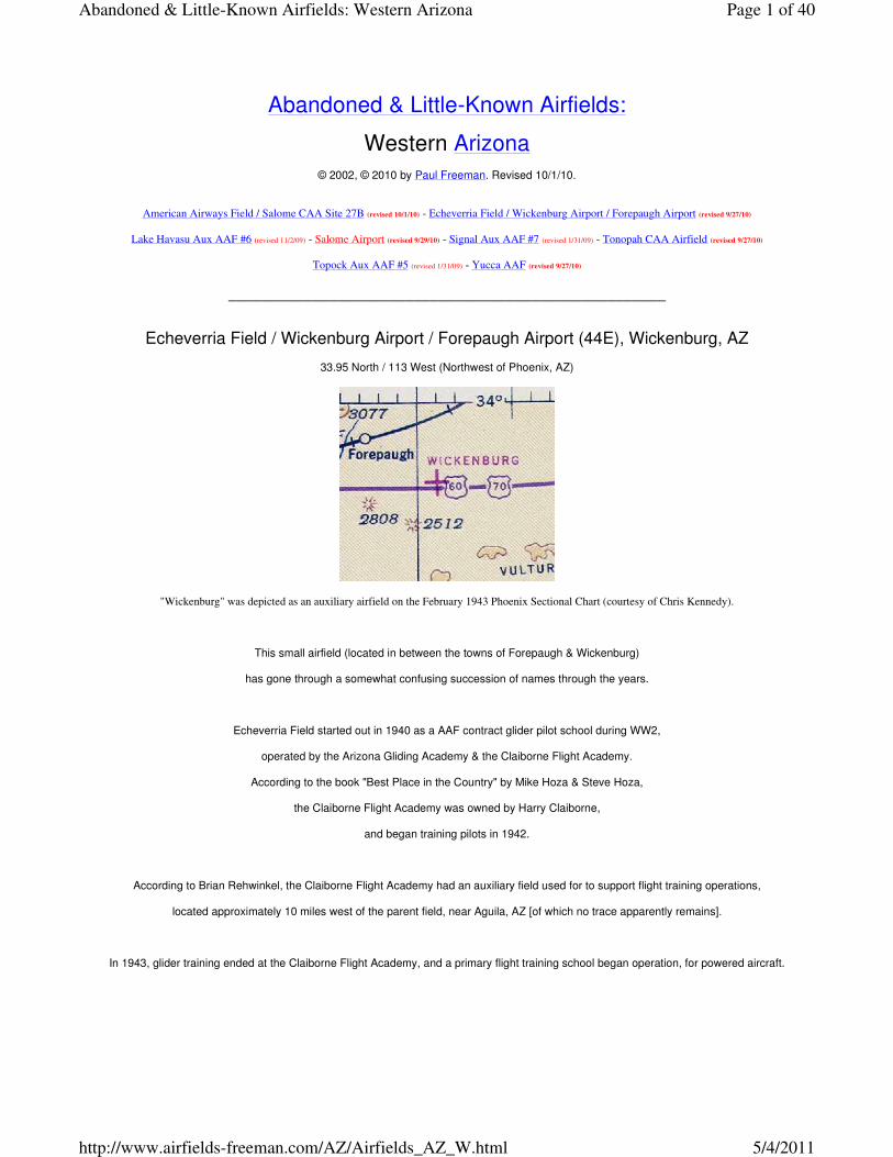
Abandoned & Little-Known Airfields:
Western Arizona
© 2002, © 2010 by Paul Freeman. Revised 10/1/10.
American Airways Field / Salome CAA Site 27B (revised 10/1/10) - Echeverria Field / Wickenburg Airport / Forepaugh Airport (revised 9/27/10)
Lake Havasu Aux AAF #6 (revised 11/2/09) - Salome Airport (revised 9/29/10) - Signal Aux AAF #7 (revised 1/31/09) - Tonopah CAA Airfield (revised 9/27/10)
Topock Aux AAF #5 (revised 1/31/09) - Yucca AAF (revised 9/27/10)
____________________________________________________
Echeverria Field / Wickenburg Airport / Forepaugh Airport (44E), Wickenburg, AZ
33.95 North / 113 West (Northwest of Phoenix, AZ)
"Wickenburg" was depicted as an auxiliary airfield on the February 1943 Phoenix Sectional Chart (courtesy of Chris Kennedy).
This small airfield (located in between the towns of Forepaugh & Wickenburg)
has gone through a somewhat confusing succession of names through the years.
Echeverria Field started out in 1940 as a AAF contract glider pilot school during WW2,
operated by the Arizona Gliding Academy & the Claiborne Flight Academy.
According to the book "Best Place in the Country" by Mike Hoza & Steve Hoza,
the Claiborne Flight Academy was owned by Harry Claiborne,
and began training pilots in 1942.
According to Brian Rehwinkel, the Claiborne Flight Academy had an auxiliary field used for to support flight training operations,
located approximately 10 miles west of the parent field, near Aguila, AZ [of which no trace apparently remains].
In 1943, glider training ended at the Claiborne Flight Academy, and a primary flight training school began operation, for powered aircraft.
Page 1 of 40Abandoned & Little-Known Airfields: Western Arizona
5/4/2011http://www.airfields-freeman.com/AZ/Airfields_AZ_W.html

An undated aerial view of a formation of PT-17s on the cover of “Wind Drift”, the Class Book of Claiborne Flight Academy's Class 44D.
A circa 1940s photo of PT-17s at the Claiborne Flight Academy.
A circa 1940s photo of men in front of a hangar at the Claiborne Flight Academy.
"Wickenburg" was depicted as an auxiliary airfield
on the 1943 Phoenix Sectional Chart (courtesy of Chris Kennedy).
To confuse matters somewhat, the separate "(Municipal) Wickenburg" Airport was also depicted several miles to the east,
adjacent to the northwest side of the town of Wickenburg.
According to Gary Anderson, “My father (Tom Anderson) was the chief flight instructor at this field before he went overseas.”
Page 2 of 40Abandoned & Little-Known Airfields: Western Arizona
5/4/2011http://www.airfields-freeman.com/AZ/Airfields_AZ_W.html

The name of the field was changed to "Echeverria"
on the March 1945 Phoenix Sectional Chart (courtesy of Chris Kennedy).
The 1945 AAF Airfield Directory (courtesy of Scott Murdock) described Echeverria Field
as a 1,440 acre square property having 2 asphalt runways (4,000' northeast./southwest & 3,200' northwest/southeast)
and a 2,300' square landing mat at the runway intersection.
The field was said to not have any hangars,
to be owned by the State of Arizona, and to be operated by the Defense Plant Corporation.
Brian Rehwinkel reported, “I found an article in a 1948 Prescott Evening Courier that indicated the 'large hangar' at the field
(which I believe to be the same Echeverria Field) burned on February 10, 1948.
There is yet another name used for the airport - The Hassayampa Flying Service Airport.”
It was labeled "Wickenburg" Airport once again on the 1949 Gila River World Aeronautical Chart (courtesy of Donald Felton),
and described as having a 4,500' hard-surface runway.
Military use of the airfield ended in 1950.
In the post-WW2 era it went on to a number of uses including being a prison & housing migrant workers.
Page 3 of 40Abandoned & Little-Known Airfields: Western Arizona
5/4/2011http://www.airfields-freeman.com/AZ/Airfields_AZ_W.html

The earliest photo which has been located of Echeverria Field is a 1951 US Government aerial view (courtesy of Brian Rehwinkel).
Brian observed, it “shows the field after the war… when if was probably not used very much.
However, you can see the pavement very well – and I am not sure if the runway outlines were postwar markings, or if they were left over from the field’s training days.
You can also see the buildings in the cantonment/administration area.
If you notice, there is a dark rectangular spot on the aircraft parking apron next to the buildings (on the north side of the apron).
That spot is apparently the location of a former aircraft hangar.”
Echeverria Field was not depicted at all on the 1956 Prescott Sectional Chart (courtesy of John Voss)
or the 1958 Phoenix Sectional Chart (according to Chris Kennedy).
Wickenburg was reused at some point between 1958-62
as the municipal airport for the town of Wickenburg (located 17 miles east)
until a new field was built closer to town.
It was listed among active airports in the 1962 AOPA Airport Directory,
Page 4 of 40Abandoned & Little-Known Airfields: Western Arizona
5/4/2011http://www.airfields-freeman.com/AZ/Airfields_AZ_W.html

with a single clay runway.
The field was depicted as "Wickenburg" Airport on the 1969 USGS topo map,
but only as "Landing Strip" on the 1980 & 1990 USGS topo maps.
No public-use airfield at the location was listed in the 1989 Airport/Facility Directory (courtesy of Chris Kennedy).
As seen in the 1997 USGS aerial photo, the airfield consists of a 6,000' unpaved Runway 3/21,
along with the shorter east/west runway, the remains of which are barely perceptible,
extending into the desert to the east from the southern end of the main runway.
There can also be seen the evidence of an original 2,500' square landing mat area
situated underneath the northeast portion of the main runway,
along with a northwest/southeast runway.
A recent photo of the main hangar & the pump house as they exist today.
As of the mid-1990s, one of the original barracks buildings was still standing,
Page 5 of 40Abandoned & Little-Known Airfields: Western Arizona
5/4/2011http://www.airfields-freeman.com/AZ/Airfields_AZ_W.html

but it has since been torn down.
Since then, the only remaining buildings are the main hangar & 2 outlying buildings.
A circa 2006 aerial view of Wickenburg / Forepaugh Airport.
As of 2006, this field is listed as an active public-use airport, under the name of Forepaugh Airport.
Only a 4,700' length of Runway 3/21 was listed as available.
The Civil Air Patrol has proposed building a training facility at the airfield,
plans which would include restoration of some of the airfield's historic buildings.
See also:
http://www.sonic.net/azfuller/WWIIfld.htm
http://www.airforcebase.net/aaf/cfs_list.html
____________________________________________________
Tonopah CAA Airfield, Tonopah, AZ
33.5 North / 112.85 West (Northwest of Phoenix, AZ)
Page 6 of 40Abandoned & Little-Known Airfields: Western Arizona
5/4/2011http://www.airfields-freeman.com/AZ/Airfields_AZ_W.html