attachment i.4 baseline report (part 4)
TRANSCRIPT
ATTACHMENT I.4
BASELINE REPORT (PART 4)
For
insp
ectio
n pur
pose
s only
.
Conse
nt of
copy
right
owne
r req
uired
for a
ny ot
her u
se.
EPA Export 28-07-2015:23:40:40
27/03/2014
Unit 12, Owenacurra Business Park, Midleton, Co. Cork
T +353 21 4631600 F +353 21 4638690 E [email protected]
Engineer: RPS Consulting Engineers,
Innishmore,
Ballincollig,
Co. Cork
Client: Medite Europe Ltd.
Redmondstown
Clonmel
Co. Tipperary
MEDITE,
PROJECTS SPATS
GROUND INVESTIGATION
DRAFT REPORT
NO. P13131
For in
spec
tion p
urpo
ses o
nly.
Conse
nt of
copy
right
owne
r req
uired
for a
ny ot
her u
se.
EPA Export 28-07-2015:23:40:40
For
insp
ectio
n pur
pose
s only
.
Conse
nt of
copy
right
owne
r req
uired
for a
ny ot
her u
se.
EPA Export 28-07-2015:23:40:40
__________________________________________________________________________________________ P13131_ Rp_D01 i 27/03/2014
TABLE OF CONTENTS
1 INTRODUCTION.............................................................................................................................. 1 1.1 SCOPE OF WORKS ......................................................................................................................... 1 1.2 REPORTING................................................................................................................................... 1
2 THE SITE ......................................................................................................................................... 2 2.1 PUBLISHED GEOLOGY ................................................................................................................... 2
2.1.1 Bedrock.............................................................................................................................. 2 2.1.2 Superficial Deposits ........................................................................................................... 2 2.1.3 Hydrology........................................................................................................................... 2
3 FIELDWORK.................................................................................................................................... 3 3.1 GENERAL ...................................................................................................................................... 3 3.2 EXPLORATORY HOLES ................................................................................................................... 4 3.3 SAMPLING ................................................................................................................................. 4 3.4 GROUNDWATER MONITORING......................................................................................................... 5 3.5 IN-SITU TESTING............................................................................................................................ 5
4 LABORATORY TESTING ............................................................................................................... 8 4.1 SOIL TESTING ............................................................................................................................... 8 4.2 ROCK TESTING ........................................................................................................................... 9
5 GROUND CONDITIONS................................................................................................................ 10 5.1 GROUNDWATER .......................................................................................................................... 11
6 SUMMARY..................................................................................................................................... 13
APPENDICES
APPENDIX A EXPLORATORY HOLE RECORDS APPENDIX B LABORATORY RESULTS APPENDIX C EXPLORATION LOCATION PLANS
For
insp
ectio
n pur
pose
s only
.
Conse
nt of
copy
right
owne
r req
uired
for a
ny ot
her u
se.
EPA Export 28-07-2015:23:40:40
______________________________________________________________________________________P13131_ Rp_D01 1 27/03/2014
1 INTRODUCTION
1.1 SCOPE OF WORKS
In November, 2013, Priority Geotechnical (PGL) were requested by RPS Consulting
Engineers, on behalf of their Client; Medite Europe, to undertake an ground investigation
for the proposed new manufacturing facility and wood production plant at Redmonstown,
Clonmel, Co. Tipperary.
The purpose of the investigation was to provide details of the ground and groundwater
conditions within the 2.825Ha site to allow for the design for the proposed facility
buildings, structures, hardstanding access roads and utilities.
The investigation, which was specified by RPS, initially comprised of; twelve (12)
number cable percussion boreholes, four (4) number rotary boreholes, twelve (12)
number trial pit excavations, two (2) number standpipe well installations, all appropriate
sampling, in situ testing, laboratory work and factual reporting. The fieldworks were
undertaken between the 10th of December, 2013 and the 07th of February, 2014. The
scope of works was subsequently revised, in consultation with PGL, to reflect changes to
the proposed site layout. The final works as completed are detailed in Section 3.2 of this
report.
The ground investigation was carried out in accordance with the contract specification:
Specification and Related Documents for Ground Investigation in Ireland (Engineers
Ireland, October 2006), Eurocode 7- Geotechnical Design Part 2, ground investigation
and testing (BS EN 1997-2: 2007) and the relevant British Standards.
1.2 REPORTING
This factual, geotechnical data report, (P13131_Rp_D01) presents the factual records
for the fieldwork with respect to the ground investigation contract undertaken for Project
SPATS, Medite Clonmel.
For
insp
ectio
n pur
pose
s only
.
Conse
nt of
copy
right
owne
r req
uired
for a
ny ot
her u
se.
EPA Export 28-07-2015:23:40:40
______________________________________________________________________________________P13131_ Rp_D01 2 27/03/2014
2 THE SITE
The greenfield site was located immediately North of the existing Medite Facility. The
site location is outlined on the exploration location layout presented in APPENDIX C of
this report.
2.1 PUBLISHED GEOLOGY
2.1.1 Bedrock
The Geological Survey of Ireland, 1:100,000 mapping (Sheet 22) indicated the geology
of the study area is characterised by Walsortian Limestone Formations (WA). The
Silverspring Formation (SS) lay immediately North of the study area. While the
Walsortian Limestone is known to be susceptible to karst features, a search of the GSI
karst data base indicated no such features within a 5km radius. The dolomitised
Limestone North of the site presented numerous karst features. Karst was not
considered a geohazard at the site.
2.1.2 Superficial Deposits
A review of Teagasc subsoil mapping in the vicinity of the study area indicated glacial till
derived from Namurian Shales and Sandstones (TNSSs). Bedrock outcropping was
noted approximately 800m west of the site at Powerstown.
2.1.3 Hydrology
A review of the OPW flood mapping identified some localised recurring localised flooding
in the vicinity of the study area.
For
insp
ectio
n pur
pose
s only
.
Conse
nt of
copy
right
owne
r req
uired
for a
ny ot
her u
se.
EPA Export 28-07-2015:23:40:40
______________________________________________________________________________________P13131_ Rp_D01 3 27/03/2014
3 FIELDWORK
3.1 GENERAL
The fieldwork was carried out in general accordance with BS EN1997-2: 2007, Eurocode
7 Geotechnical Design, Part 2, Ground investigation and testing and BS 5930 (1999)
Code of Practice for Site Investigation and Part 9 of BS 1377 (1990), Method of Tests for
Soil for Civil Engineering Purposes.
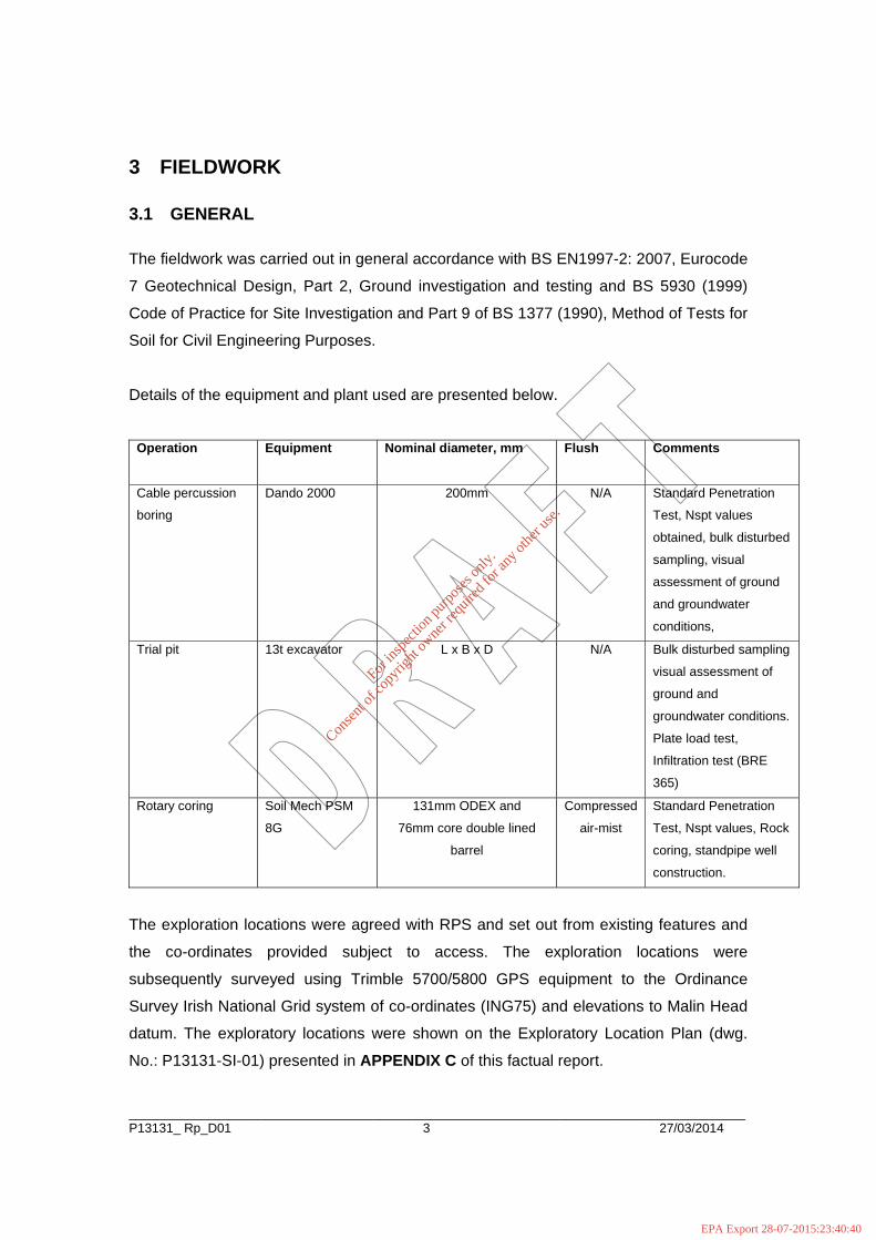
Details of the equipment and plant used are presented below.
Operation Equipment Nominal diameter, mm Flush Comments
Cable percussion
boring
Dando 2000 200mm N/A Standard Penetration
Test, Nspt values
obtained, bulk disturbed
sampling, visual
assessment of ground
and groundwater
conditions,
Trial pit 13t excavator L x B x D N/A Bulk disturbed sampling
visual assessment of
ground and
groundwater conditions.
Plate load test,
Infiltration test (BRE
365)
Rotary coring Soil Mech PSM
8G
131mm ODEX and
76mm core double lined
barrel
Compressed
air-mist
Standard Penetration
Test, Nspt values, Rock
coring, standpipe well
construction.
The exploration locations were agreed with RPS and set out from existing features and
the co-ordinates provided subject to access. The exploration locations were
subsequently surveyed using Trimble 5700/5800 GPS equipment to the Ordinance
Survey Irish National Grid system of co-ordinates (ING75) and elevations to Malin Head
datum. The exploratory locations were shown on the Exploratory Location Plan (dwg.
No.: P13131-SI-01) presented in APPENDIX C of this factual report.
For
insp
ectio
n pur
pose
s only
.
Conse
nt of
copy
right
owne
r req
uired
for a
ny ot
her u
se.
EPA Export 28-07-2015:23:40:40

______________________________________________________________________________________P13131_ Rp_D01 4 27/03/2014
3.2 EXPLORATORY HOLES
The exploratory holes as completed during the ground investigation are listed in the
following table:
SUMMARY OF EXPLORATORY HOLES Type Quantity Depth Range Remarks
Cable percussion boreholes 19No. 0.5m to 14.4m
BH01, BH02, BH03, BH04, BH05,
BH06, BH07, BH08, BH08A, BH09,
BH10, BH11, BH12, BH13, BH13A,
BH14, BH15, BH16 and BH17.
Rotary boreholes 6No. 15.0m to 20.2m RC01, RC02, RC03, RC04, RC05 and
RC06
Trial pit excavations
22No
1.4m to 4.5m
1.6m to 2.1m
1.5m
TP01, TP02, TP03, TP04, TP05, TP06,
TP07, TP08, TP09, TP10, TP11, TP12,
TP13, TP14, TP15 and TP16.
SK01 and SK02
PBT01, PBT02, PBT03 and PBT04
The exploration records are presented in APPENDIX A of this factual report and should
be read in conjunction with the key sheets included. The records provide descriptions, in
accordance with BS 5930 (1999) +A2: 2010 and Eurocode 7, Identification and
classification of soils, Part 1, Identification and description (BS EN ISO 14688-1: 2002),
of the materials encountered and details of the samples taken, together with any
observations made during the investigation.
3.3 SAMPLING
A total of one hundred and forty (140) bulk disturbed samples (B), sixty five (65) small
disturbed samples (D), one (1) water sample and continuous rock core (C) were taken.
For
insp
ectio
n pur
pose
s only
.
Conse
nt of
copy
right
owne
r req
uired
for a
ny ot
her u
se.
EPA Export 28-07-2015:23:40:40

______________________________________________________________________________________P13131_ Rp_D01 5 27/03/2014
3.4 GROUNDWATER MONITORING
Groundwater was recorded when encountered during boring and trial pit excavations.
Groundwater levels were monitored over a period of 20 minutes noting any changes that
may occur. It must be noted that the normal rate of cable percussion drilling may not
permit the recording of equilibrium groundwater levels. Groundwater may be excluded
from the boring as the casing progresses, particularly in cohesive deposits. Groundwater
level should be assessed from 50mm standpipe installations. Groundwater monitoring
standpipe wells were installed under instruction, otherwise the exploratory boreholes
were backfilled with arisings and bentonite grout.
GRAVEL Backfill to installation/ borehole
GROUT Backfill to installation/ borehole
BENTONITE Backfill to installation/ borehole
uPVC slotted pipe
3.5 IN-SITU TESTING
Standard penetration tests, Nspt values, were carried out in the cable percussion and
rotary boreholes. The Standard Penetration Test was carried out in accordance with
Geotechnical Investigation and Testing, Part 3 Standard penetration test, BS EN ISO
22476-3:2005+A1:2011. The data was presented on the relevant logs in APPENDIX A and presented graphically herein.
A single in situ falling head permeability tests were carried out in 200mm diameter
borehole casing at location BH17. In-situ permeability testing was carried out in
accordance with BS5930: 1999, Section 4: Cl. 25.4, within the superficial deposits over
duration of one (1) hour, as detailed on the borehole log, APPENDIX A of this report.
The processed test data was presented on the relevant borehole logs presented in
APPENDIX A of this factual report.
For
insp
ectio
n pur
pose
s only
.
Conse
nt of
copy
right
owne
r req
uired
for a
ny ot
her u
se.
EPA Export 28-07-2015:23:40:40
______________________________________________________________________________________P13131_ Rp_D01 6 27/03/2014
The shape or intake factor, f was derived from the condition at the base of the borehole
at the test depth and test geometry as per Hvorslev (1951).
The ratio L/d was 1.5, the casing being 0.3m above the test depth, giving a shape (or
intake) factor, f of 5 to 7; where permeability in the soil was assumed equal in both
horizontal and vertical direction, kH/ kV = 1.
Infiltration tests were carried out in general accordance with the BRE Digest 365, 2007
Soakway Design Standards. Due to the duration for the pit to drain a single cycle of
infiltration was undertaken at SK01 and not the three cycles outlined in the standard.
Infiltration was very poor with this pit failing to drain after a period of 24hours where
groundwater was at a depth 1.15m bgl. There was no groundwater encountered at test
location SK02 to a depth 2.1m bgl. Again a single cycle of drainage was undertaken.
The data from the testing was presented in APPENDIX A accompanying the relevant
exploratory records.
Plate loading tests were undertaken using 750mm diameter plate and 13t tracked
excavator for reaction, in accordance with EC7 Geotechnical design Pt. 2, ground
investigation and testing, EN 1997-2:2001 (E), Cl. 4.11, Plate loading test (Annex K).
The data was presented on the relevant logs in APPENDIX A.
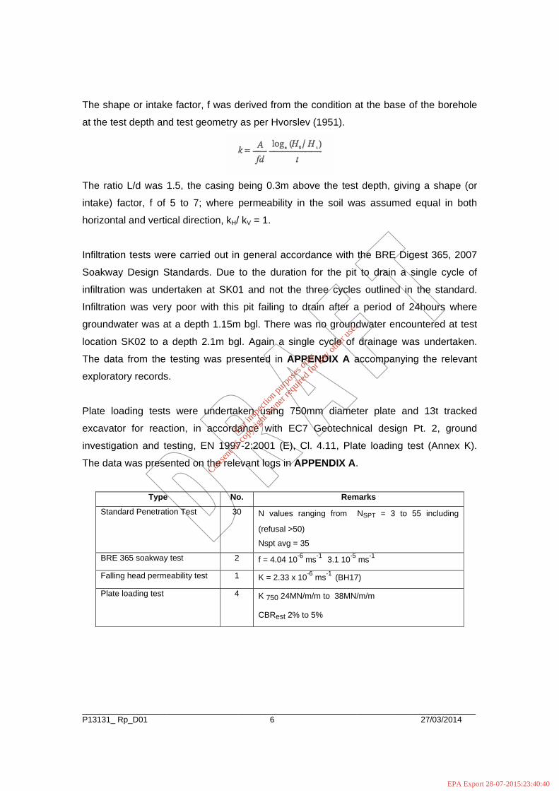
Type No. Remarks
Standard Penetration Test 30 N values ranging from NSPT = 3 to 55 including
(refusal >50)
Nspt avg = 35
BRE 365 soakway test 2 f = 4.04 10-6 ms-1 3.1 10-5 ms-1
Falling head permeability test 1 K = 2.33 x 10⁻⁶ ms-1 (BH17)
Plate loading test 4 K 750 24MN/m/m to 38MN/m/m
CBRest 2% to 5%
For
insp
ectio
n pur
pose
s only
.
Conse
nt of
copy
right
owne
r req
uired
for a
ny ot
her u
se.
EPA Export 28-07-2015:23:40:40
______________________________________________________________________________________P13131_ Rp_D01 7 27/03/2014
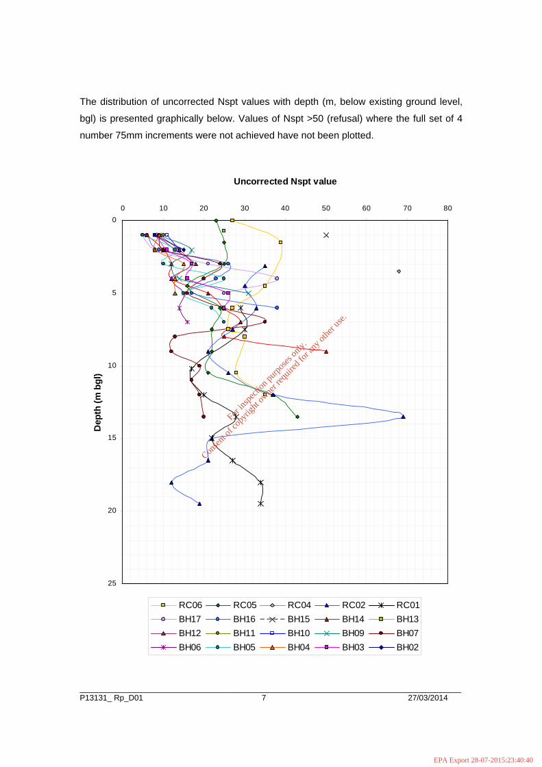
The distribution of uncorrected Nspt values with depth (m, below existing ground level,
bgl) is presented graphically below. Values of Nspt >50 (refusal) where the full set of 4
number 75mm increments were not achieved have not been plotted.
0
5
10
15
20
25
0 10 20 30 40 50 60 70 80
Uncorrected Nspt value
Dep
th (m
bgl
)
RC06 RC05 RC04 RC02 RC01BH17 BH16 BH15 BH14 BH13BH12 BH11 BH10 BH09 BH07BH06 BH05 BH04 BH03 BH02
For
insp
ectio
n pur
pose
s only
.
Conse
nt of
copy
right
owne
r req
uired
for a
ny ot
her u
se.
EPA Export 28-07-2015:23:40:40
______________________________________________________________________________________P13131_ Rp_D01 8 27/03/2014
4 LABORATORY TESTING
All samples were transported to Priority Geotechnical’s laboratory in Midleton, Co. Cork
examined and prepared for scheduled testing. Tests were scheduled by PGL being
approved by RPS. Testing was carried out by PGL in accordance with BS1377 (1990),
Methods of test for soils for civil engineering purposes and the ISRM suggested methods
for rock characterisation, testing and monitoring.
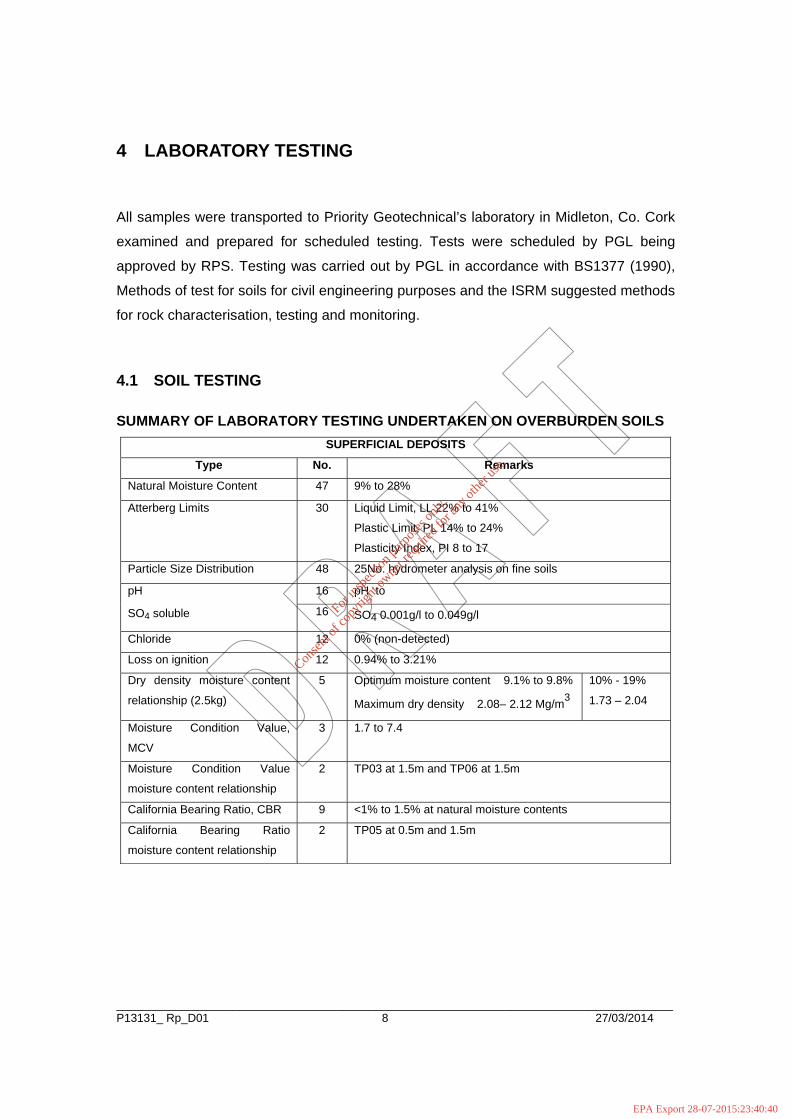
4.1 SOIL TESTING
SUMMARY OF LABORATORY TESTING UNDERTAKEN ON OVERBURDEN SOILS SUPERFICIAL DEPOSITS
Type No. Remarks
Natural Moisture Content 47 9% to 28%
Atterberg Limits 30 Liquid Limit, LL 22% to 41%
Plastic Limit, PL 14% to 24%
Plasticity Index, PI 8 to 17
Particle Size Distribution 48 25No. hydrometer analysis on fine soils
16 pH to pH
SO4 soluble 16 SO4 0.001g/l to 0.049g/l
Chloride 12 0% (non-detected)
Loss on ignition 12 0.94% to 3.21%
Dry density moisture content
relationship (2.5kg)
5 Optimum moisture content 9.1% to 9.8%
Maximum dry density 2.08– 2.12 Mg/m3
10% - 19%
1.73 – 2.04
Moisture Condition Value,
MCV
3 1.7 to 7.4
Moisture Condition Value
moisture content relationship
2 TP03 at 1.5m and TP06 at 1.5m
California Bearing Ratio, CBR 9 <1% to 1.5% at natural moisture contents
California Bearing Ratio
moisture content relationship
2 TP05 at 0.5m and 1.5m
For
insp
ectio
n pur
pose
s only
.
Conse
nt of
copy
right
owne
r req
uired
for a
ny ot
her u
se.
EPA Export 28-07-2015:23:40:40

______________________________________________________________________________________P13131_ Rp_D01 9 28/03/2014
4.2 ROCK TESTING
SUMMARY OF LABORATORY TESTING UNDERTAKEN ON ROCK SOLID GEOLOGY
Type No. Remarks
Point Load Index, IP50 9 1.5MPa to 6.8MPa
For
insp
ectio
n pur
pose
s only
.
Conse
nt of
copy
right
owne
r req
uired
for a
ny ot
her u
se.
EPA Export 28-07-2015:23:40:40
______________________________________________________________________________________P13131_ Rp_D01 10 27/03/2014
5 GROUND CONDITIONS
The site was characterised by glacial deposits (Boulder Clay), slightly sandy gravelly
CLAY with variable Cobbles and Boulder content to depths of 3.0m below existing
ground level (bgl) to 20.2m bgl (RC01). There was an increase in Gravel and Cobble
content below depths of 2.0m bgl. Clayey (very) sandy GRAVEL was identified below
1.8m bgl (BH12) and 4.0m bgl (BH04) to depths of 7.0m bgl and below a depth 8.0m bgl
(BH07) to a depth 14.4m bgl. Chiselling records indicated coarse particles (obstructions)
below depths of 0.9m bgl (BH08A) to 2.6m bgl (BH02), with stiff or dense deposits below
depths of 6.0m bgl to 9.0m bgl.
Topsoil where encountered was typically 300mm thick.
The bedrock profile was varied within the site. LIMESTONE was encountered at a depth
14.5m bgl at RC03 and RC06. LIMESTONE was encountered at a depth 4.5m bgl at
RC04. The Limestone was described as medium strong to strong.
Based on the Standard Penetration Test (SPT) NSPT values, the CLAY was described as
‘soft to firm’ to ‘firm to stiff’ (NSPT 5 to 17). BH09/ BH15 and BH17 indicated stiff deposits
below a depth 2.8m bgl to 5.0m bgl (NSPT 21 to 31). The NSPT data obtained from the
rotary coring correlated with this. The NSPT values indicated the GRAVEL deposits to be
medium dense (NSPT 13 to 26). The refusal NSPT values > 50 were attributed to the
Cobbles and Boulders present within the glacial deposits. Tactile assessment of the soil
strength, indicated soft to firm glacial deposits.
For
insp
ectio
n pur
pose
s only
.
Conse
nt of
copy
right
owne
r req
uired
for a
ny ot
her u
se.
EPA Export 28-07-2015:23:40:40
______________________________________________________________________________________P13131_ Rp_D01 11 27/03/2014
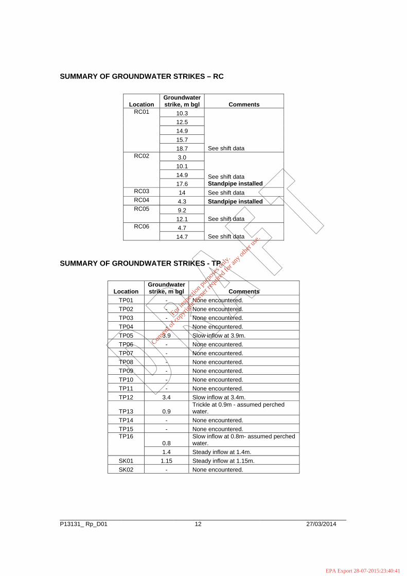
5.1 GROUNDWATER
Groundwater was noted in cable percussion at a depth of between 5.0m bgl to 9.4m bgl.
Groundwater was noted in rotary boreholes at a depth of between 3.0m bgl to 18.7m bgl.
Groundwater was noted in trial pit excavations at a depth of between 1.4m bgl to 3.9m
bgl.
Three (3) number 50mm diameter standpipe wells were constructed to allow for
groundwater monitoring. Details of the ground water are presented graphically on the
relevant exploratory logs within APPENDIX A of this factual report.
It should be appreciated that seasonal fluctuations in groundwater levels may occur. The
details reflect the ground water regime at the time of the investigation. See also detail
Section 3.4 in relation to the possible sealing-off of groundwater as the borehole casing
advances.
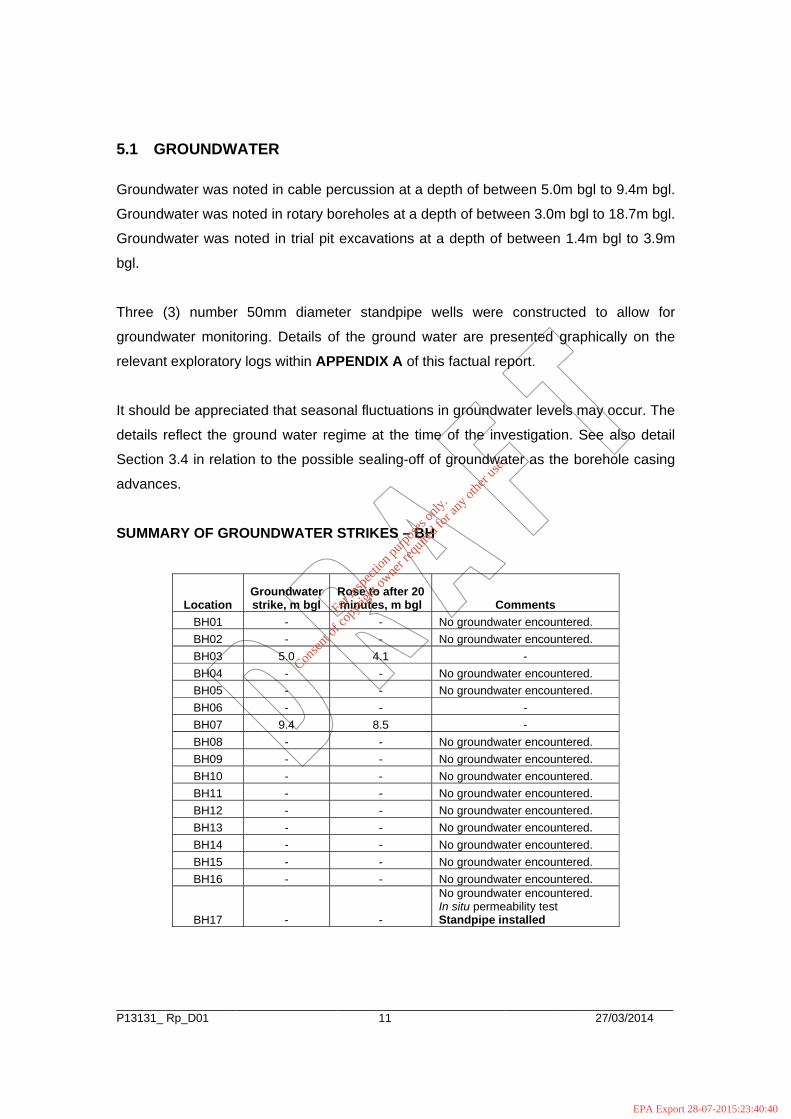
SUMMARY OF GROUNDWATER STRIKES – BH
Location Groundwater strike, m bgl
Rose to after 20 minutes, m bgl Comments
BH01 - - No groundwater encountered. BH02 - - No groundwater encountered. BH03 5.0 4.1 - BH04 - - No groundwater encountered. BH05 - - No groundwater encountered. BH06 - - - BH07 9.4 8.5 - BH08 - - No groundwater encountered. BH09 - - No groundwater encountered. BH10 - - No groundwater encountered. BH11 - - No groundwater encountered. BH12 - - No groundwater encountered. BH13 - - No groundwater encountered. BH14 - - No groundwater encountered. BH15 - - No groundwater encountered. BH16 - - No groundwater encountered.
BH17 - -
No groundwater encountered. In situ permeability test Standpipe installed
For
insp
ectio
n pur
pose
s only
.
Conse
nt of
copy
right
owne
r req
uired
for a
ny ot
her u
se.
EPA Export 28-07-2015:23:40:40
______________________________________________________________________________________P13131_ Rp_D01 12 27/03/2014
SUMMARY OF GROUNDWATER STRIKES – RC
Location Groundwater strike, m bgl Comments
10.3 12.5 14.9 15.7
RC01
18.7 See shift data 3.0 10.1 14.9
RC02
17.6 See shift data Standpipe installed
RC03 14 See shift data RC04 4.3 Standpipe installed
9.2 RC05
12.1 See shift data 4.7 RC06
14.7 See shift data SUMMARY OF GROUNDWATER STRIKES - TP
Location Groundwater strike, m bgl Comments
TP01 - None encountered. TP02 - None encountered. TP03 - None encountered. TP04 - None encountered. TP05 3.9 Slow inflow at 3.9m. TP06 - None encountered. TP07 - None encountered. TP08 - None encountered. TP09 - None encountered. TP10 - None encountered. TP11 - None encountered. TP12 3.4 Slow inflow at 3.4m.
TP13 0.9 Trickle at 0.9m - assumed perched water.
TP14 - None encountered. TP15 - None encountered.
0.8 Slow inflow at 0.8m- assumed perched water.
TP16
1.4 Steady inflow at 1.4m. SK01 1.15 Steady inflow at 1.15m. SK02 - None encountered.
For
insp
ectio
n pur
pose
s only
.
Conse
nt of
copy
right
owne
r req
uired
for a
ny ot
her u
se.
EPA Export 28-07-2015:23:40:41
______________________________________________________________________________________P13131_ Rp_D01 13 27/03/2014
6 SUMMARY
1. The site was characterised by glacial deposits of soft becoming stiff slightly
sandy gravelly CLAY and medium dense clayey sandy GRAVEL with variable
Cobble and Boulder content were encountered to depths of 14.5m bgl to 20.2m
bgl.
2. The bedrock profile was varied within the site. LIMESTONE was encountered at
a depth 4.5m bgl to 14.5m bgl.
3. Further details of the ground conditions encountered are provided for on the
exploratory records and the photographic records in APPENDIX A of this factual
report.
4. Groundwater was encountered between 1.4m bgl and 18.7m bgl. Details of
ground water encountered are presented on the relevant exploratory log
presented in APPENDIX A of this report and section 5.1.
5. Three (3) 50mm standpipe were installed to allow for groundwater monitoring.
6. Laboratory testing was undertaken to determine environmental characteristics of
the soil encountered during the ground investigation. The laboratory test data is
presented in APPENDIX B of this factual report.
7. An exploratory location plan is presented in APPENDIX C of this factual report.
For
insp
ectio
n pur
pose
s only
.
Conse
nt of
copy
right
owne
r req
uired
for a
ny ot
her u
se.
EPA Export 28-07-2015:23:40:41

APPENDIX A EXPLORATORY HOLE AND PHOTOGRAPHIC RECORDS
Cable percussion boreholes
BH01, BH02, BH03, BH04, BH05, BH06,
BH07, BH08, BH08A, BH09, BH10, BH11,
BH12, BH13, BH13A, BH14, BH15, BH16
and BH17.
Rotary boreholes RC01, RC02, RC03, RC04, RC05 and
RC06
Trial pits
TP01, TP02, TP03, TP04, TP05, TP06,
TP07, TP08, TP09, TP10, TP11, TP12,
TP13, TP14, TP15 and TP16.
SK01 and SK02
PBT01, PBT02, PBT03 and PBT04
For
insp
ectio
n pur
pose
s only
.
Conse
nt of
copy
right
owne
r req
uired
for a
ny ot
her u
se.
EPA Export 28-07-2015:23:40:41
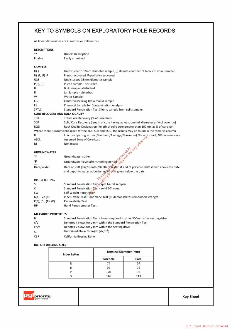
KEY TO SYMBOLS ON EXPLORATORY HOLE RECORDS
All linear dimensions are in metres or millimetres
DESCRIPTIONS** Drillers DescriptionFriable Easily crumbled
SAMPLESU( ) Undisturbed 102mm diameter sample, ( ) denotes number of blows to drive samplerU( )F, U( )P F‐ not recovered, P‐partially recoveredU38 Undisturbed 38mm diameter sampleP(F), (P) Piston sample ‐ disturbedB Bulk sample ‐ disturbedD Jar Sample ‐ disturbedW Water SampleCBR California Bearing Ratio mould sampleES Chemical Sample for Contamination AnalysisSPTLS Standard Penetration Test S lump sample from split samplerCORE RECOVERY AND ROCK QUALITYTCR Total Core Recovery (% of Core Run)SCR Solid Core Recovery (length of core having at least one full diameter as % of core run)RQD Rock Quality Designation (length of solid core greater than 100mm as % of core run)Where there is insufficient space for the TCR, SCR and RQD, the results may be found in the remarks columnIf Fracture Spacing in mm (Minimum/Average/Maximum) NI ‐ non intact, NR ‐ no recoveryAZCL Assumed Zone of Core LossNI Non intact
GROUNDWATERGroundwater strike__Groundwater level after standing period__
Date/Water Date of shift (day/month)/Depth to water at end of previous shift shown above the dateand depth to water at beginning of shift given below the date
INSITU TESTINGS Standard Penetration Test ‐ split barrel samplerC Standard Penetration Test ‐ solid 60⁰ coneSW Self Weight PenetrationIvp, HVp (R) In Situ Vane Test, Hand Vane Test (R) demonstrates remoulded strengthK(F), (C), (R), (P) Permeability TestHP Hand Penetrometer Test
MEASURED PROPERTIESN Standard Penetration Test ‐ blows required to drive 300mm after seating drivex/y Denotes x blows for y mm within the Standard Penetration Testx*/y Denotes x blows for y mm within the seating drivecu Undrained Shear Strength (kN/m2)
CBR California Bearing Ratio
ROTARY DRILLING SIZES
NHPS
120146
Key Sheet
92113
7599
Index LetterNominal Diameter (mm)
Borehole Core5476
For
insp
ectio
n pur
pose
s only
.
Conse
nt of
copy
right
owne
r req
uired
for a
ny ot
her u
se.
EPA Export 28-07-2015:23:40:41
Well / WaterStrikes
Depth (m)DepthLevel Legend(m)(m AOD)
Stratum Description
Project Name:
Client: Dates: Level:
Co-ords:Project No.
Borehole No
Scale
Logged By
Remarks:
Hole Type
Groundwater:Struck Sealed
Backfill
Depth (m) Level Depth
Rose to
Casing /
Casing
Equipment & Methods:
Drilled By
Hole Information:Hole Depth Casing Diameter
Chiselling:Depths (m) Time (hhmm) Tool
Water
Afterto
Shift Data: Shift (dd/mm/yyyy)
Flush
Casing depth Remarks
Comment
Groundwater
Hole Diameter
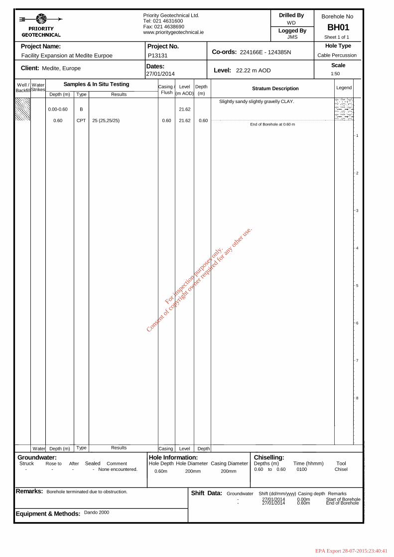
Facility Expansion at Medite Eurpoe
Medite, Europe
Borehole terminated due to obstruction.
Type
Type
Dando 2000
Samples & In Situ TestingResults
Results
Priority Geotechnical Ltd.Tel: 021 4631600Fax: 021 4638690www.prioritygeotechnical.ie
27/01/2014
P13131
22.22 m AOD
224166E - 124385N
WD
JMS
Cable Percussion
BH01
Hol
eBA
SE
III (
Bld
426
.58)
Sta
ndar
d B
oreh
ole
Log
v2 d
ated
27t
h N
ov 0
3
- - - - None encountered. 0.60m 200mm 200mm
--
0.60
27/01/201427/01/2014
0.60 0100
0.00m0.60m
Start of BoreholeEnd of Borehole
Chisel
0.00-0.60
0.60
B
CPT 25 (25,25/25) 0.60
21.62
21.62 0.60
Slightly sandy slightly gravelly CLAY.
End of Borehole at 0.60 m
1
2
3
4
5
6
7
8
1:50
Sheet 1 of 1
For
insp
ectio
n pur
pose
s only
.
Conse
nt of
copy
right
owne
r req
uired
for a
ny ot
her u
se.
EPA Export 28-07-2015:23:40:41
medium cobble content. Sand is fine to coarse.Gravel is fine to medium, subangular tosubrounded.
Increase in gravel content below 2.0m.
Chiselled from 3.0m to 3.1m for 1 hour.End of Borehole at 3.10 m
1
2
3
4
5
6
7
8
1:50
Sheet 1 of 1
Well / WaterStrikes
Depth (m)DepthLevel Legend(m)(m AOD)
Stratum Description
Project Name:
Client: Dates: Level:
Co-ords:Project No.
Borehole No
Scale
Logged By
Remarks:
Hole Type
Groundwater:Struck Sealed
Backfill
Depth (m) Level Depth
Rose to
Casing /
Casing
Equipment & Methods:
Drilled By
Hole Information:Hole Depth Casing Diameter
Chiselling:Depths (m) Time (hhmm) Tool
Water
Afterto
Shift Data: Shift (dd/mm/yyyy)
Flush
Casing depth Remarks
Comment
Groundwater
Hole Diameter
Facility Expansion at Medite Eurpoe
Medite, Europe
Borehole terminated due to obstruction.
Type
Type
Dando 2000.
Samples & In Situ TestingResults
Results
Priority Geotechnical Ltd.Tel: 021 4631600Fax: 021 4638690www.prioritygeotechnical.ie
16/01/2013-16/12/2013
P13131
22.14 m AOD
224138E - 124366N
WD
DMC
Cable Percussion
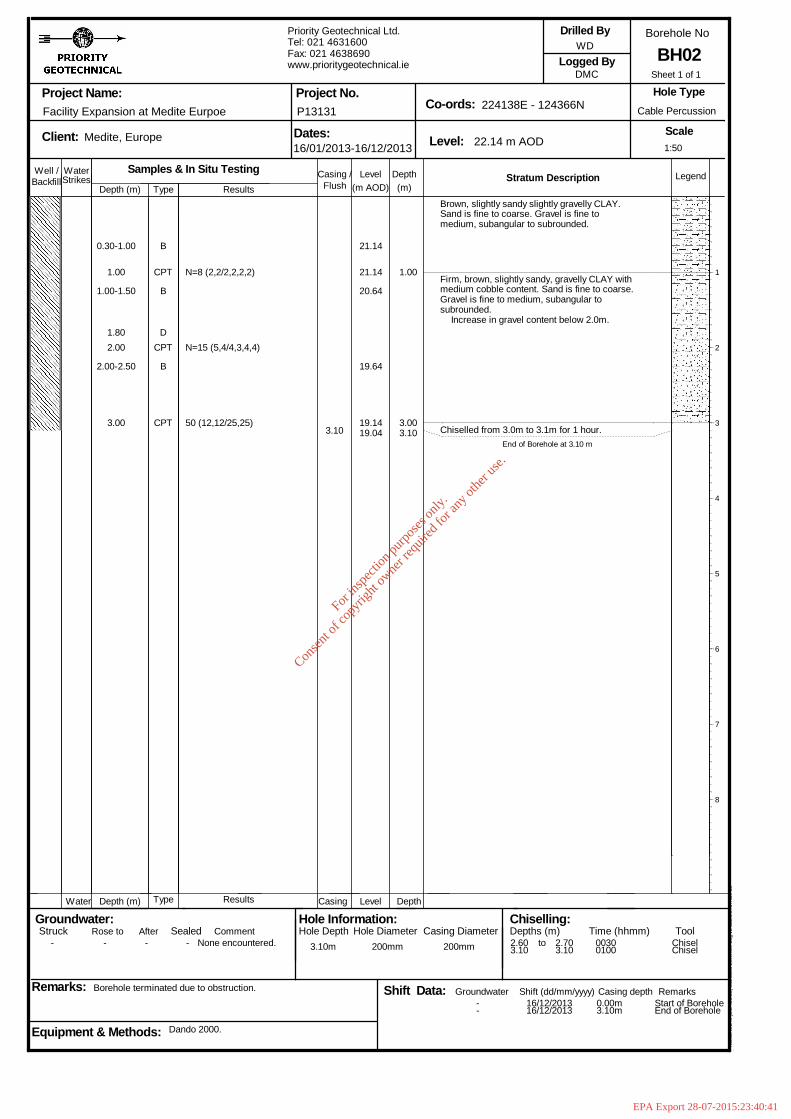
BH02
Hol
eBA
SE
III (
Bld
426
.58)
Sta
ndar
d B
oreh
ole
Log
v2 d
ated
27t
h N
ov 0
3
- - - - None encountered. 3.10m 200mm 200mm
--
2.603.10
16/12/201316/12/2013
2.703.10
00300100
0.00m3.10m
Start of BoreholeEnd of Borehole
ChiselChisel
0.30-1.00
1.00
1.00-1.50
1.802.00
2.00-2.50
3.00
B
CPT
B
DCPT
B
CPT
N=8 (2,2/2,2,2,2)
N=15 (5,4/4,3,4,4)
50 (12,12/25,25)3.10
21.14
21.14
20.64
19.64
19.1419.04
1.00
3.003.10
Brown, slightly sandy slightly gravelly CLAY.Sand is fine to coarse. Gravel is fine tomedium, subangular to subrounded.
Firm, brown, slightly sandy, gravelly CLAY with
For
insp
ectio
n pur
pose
s only
.
Conse
nt of
copy
right
owne
r req
uired
for a
ny ot
her u
se.
EPA Export 28-07-2015:23:40:41
DCPT
B
CPT
B
CPT
B
DCPT
CPT
N=8 (2,2/2,2,2,2)
N=11 (2,3/3,2,3,3)
N=17 (4,4/3,4,5,5)
N=16 (2,3/3,4,5,4)
N=26 (5,5/7,7,7,5)
N=25 (3,6/5,5,5,10)
50 (15,4/25,25 for 2mm)7.10
22.41
21.71
21.21
20.21
19.71
19.21
18.21
17.21
16.71
15.7115.61
0.30
1.00
3.00
6.00
7.007.10
Topsoil.
Brown, slightly gravelly, sandy CLAY.
Soft to firm, slightly sandy gravelly CLAY withmedium cobble content. Sand is fine to coarse.Gravel is fine to coarse, angular to rounded.Cobbles are angular to rounded, 150mm dia.
Increase in gravel content below 2.0m.Becoming firm.
Medium dense, clayey sandy GRAVEL with mediumcobble content. Sand is fine to coarse. Gravelis fine to coarse, angular to rounded. Cobblesare angular to rounded, 60-200mm dia.
Increase in sand content below 5.0m.
Medium dense, clayey sandy GRAVEL. Sand is fineto coarse. Gravel is fine to coarse, angularto rounded.
Chiselled from 7.0m to 7.1m for 1 hour.End of Borehole at 7.10 m
1
2
3
4
5
6
7
8
1:50
Sheet 1 of 1
Well / WaterStrikes
Depth (m)DepthLevel Legend(m)(m AOD)
Stratum Description
Project Name:
Client: Dates: Level:
Co-ords:Project No.
Borehole No
Scale
Logged By
Remarks:
Hole Type
Groundwater:Struck Sealed
Backfill
Depth (m) Level Depth
Rose to
Casing /
Casing
Equipment & Methods:
Drilled By
Hole Information:Hole Depth Casing Diameter
Chiselling:Depths (m) Time (hhmm) Tool
Water
Afterto
Shift Data: Shift (dd/mm/yyyy)
Flush
Casing depth Remarks
Comment
Groundwater
Hole Diameter
Facility Expansion at Medite Eurpoe
Medite, Europe
Borehole terminated due to obstruction.
Type
Type
Dando 2000
Samples & In Situ TestingResults
Results
Priority Geotechnical Ltd.Tel: 021 4631600Fax: 021 4638690www.prioritygeotechnical.ie
16/01/2014-17/01/2014
P13131
22.71 m AOD
224136E - 124411N
WD
DMC
Cable Percussion
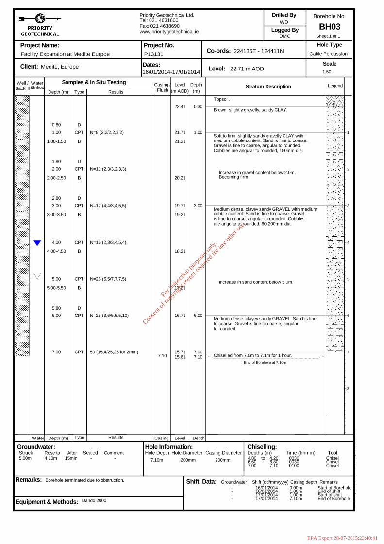
BH03
Hol
eBA
SE
III (
Bld
426
.58)
Sta
ndar
d B
oreh
ole
Log
v2 d
ated
27t
h N
ov 0
3
5.00m 4.10m 15min - - 7.10m 200mm 200mm
----
4.806.607.00
16/01/201416/01/201417/01/201417/01/2014
4.206.807.10
003000300100
0.00m1.00m1.00m7.10m
Start of BoreholeEnd of shiftStart of shiftEnd of Borehole
ChiselChiselChisel
0.801.00
1.00-1.50
1.802.00
2.00-2.50
2.803.00
3.00-3.50
4.00
4.00-4.50
5.00
5.00-5.50
5.806.00
7.00
DCPT
B
DCPT
B
For
insp
ectio
n pur
pose
s only
.
Conse
nt of
copy
right
owne
r req
uired
for a
ny ot
her u
se.
EPA Export 28-07-2015:23:40:41
6.10
23.91
23.21
22.71
22.21
21.71
21.21
20.21
19.21
18.71
18.21
18.2118.11
0.30
1.00
2.00
3.00
4.00
5.00
6.006.10
Topsoil.
Light brown CLAY.
Firm, brown, slightly sandy gravelly CLAY. Sandis fine to coarse. Gravel is fine to medium,angular.
Firm, brown, slightly sandy gravelly CLAY withlow cobble content and rootlets. Gravel is fineto coarse, subangular to rounded. Sand is fineto coarse.
Firm, brown, slightly sandy gravelly CLAY withmedium cobble content. Gravel is fine tocoarse, subangular to rounded. Sand is fine tocoarse. Cobbles are subangular to subrounded,60-100mm dia.
Medium dense, brown, clayey gravelly SAND withhigh cobble content. Gravel is fine to coarse,subangular to rounded. Sand is fine to coarse.Cobbles are subangular to subrounded, 60-70mmdia.
Medium dense, brown, very clayey very sandyGRAVEL with medium cobble content. Sand is fineto coarse. Gravel is fine to coarse,subangular to rounded. Cobbles are subangularto subrounded, 60-70mm dia.
Water added to aid drilling at 5.0m.
Chiselled from 6.0m to 6.1m for 1 hour.End of Borehole at 6.10 m
1
2
3
4
5
6
7
8
1:50
Sheet 1 of 1
Well / WaterStrikes
Depth (m)DepthLevel Legend(m)(m AOD)
Stratum Description
Project Name:
Client: Dates: Level:
Co-ords:Project No.
Borehole No
Scale
Logged By
Remarks:
Hole Type
Groundwater:Struck Sealed
Backfill
Depth (m) Level Depth
Rose to
Casing /
Casing
Equipment & Methods:
Drilled By
Hole Information:Hole Depth Casing Diameter
Chiselling:Depths (m) Time (hhmm) Tool
Water
Afterto
Shift Data: Shift (dd/mm/yyyy)
Flush
Casing depth Remarks
Comment
Groundwater
Hole Diameter
Facility Expansion at Medite Eurpoe
Medite, Europe
Borehole terminated due to obstruction.
Type
Type
Dando 2000.
Samples & In Situ TestingResults
Results
Priority Geotechnical Ltd.Tel: 021 4631600Fax: 021 4638690www.prioritygeotechnical.ie
15/01/2014-16/01/2014
P13131
24.21 m AOD
224085E - 124410N
WD
DMC
Cable Percussion
BH04
Hol
eBA
SE
III (
Bld
426
.58)
Sta
ndar
d B
oreh
ole
Log
v2 d
ated
27t
h N
ov 0
3
- - - - None encountered. 6.10m 200mm 200mm
----
6.00
15/01/201415/01/201416/01/201416/01/2014
6.10 0100
0.00m4.50m6.00m6.00m
Start of BoreholeEnd of shiftStart of shiftEnd of Borehole
Chisel
0.801.00
1.00-1.50
2.00
2.00-2.50
3.003.00
4.00
5.00
5.00-5.50
5.50-6.00
6.00
DCPT
B
CPT
B
CPTD
CPT
CPT
B
B
CPT
N=9 (2,2/2,2,2,3)
N=8 (2,2/2,2,2,2)
N=15 (4,5/5,4,3,3)
N=13 (3,3/3,4,3,3)
N=13 (4,3/3,3,4,3)
25 (25,25/25)
For
insp
ectio
n pur
pose
s only
.
Conse
nt of
copy
right
owne
r req
uired
for a
ny ot
her u
se.
EPA Export 28-07-2015:23:40:41
CPT
B
DCPT
B
DCPT
B
DCPT
B
CPT
N=5 (2,1/1,1,2,1)
N=13 (2,2/3,4,3,3)
N=10 (3,2/3,3,2,2)
N=25 (3,2/3,7,5,10)
N=15 (4,4/3,4,4,4)
N=22 (4,5/5,7,5,5)
N=25 (25,25/25,-,-,-) 7.00
23.15
22.45
22.45
21.95
20.95
20.45
19.95
18.95
17.95
17.95
16.95
16.45
0.30
1.00
3.00
5.50
7.00
Topsoil.
Brown, slightly gravelly sandy SILT. Gravel isfine to medium, subangular. Sand is fine tocoarse.
Loose, becoming medium dense, brown, clayeyvery sandy GRAVEL with high cobble content.Sand is fine to coarse. Gravel is fine tomedium, subangular.
Firm, brown, slightly sandy slightly gravellyCLAY with low cobble content. Sand is fine tocoarse. Gravel is fine to medium, subangular.
Medium dense, clayey very sandy GRAVEL withmedium cobble content. Gravel is fine tocoarse, subangular to rounded. Cobbles aresubrounded, 60-100mm dia.
End of Borehole at 7.00 m
1
2
3
4
5
6
7
8
1:50
Sheet 1 of 1
Well / WaterStrikes
Depth (m)DepthLevel Legend(m)(m AOD)
Stratum Description
Project Name:
Client: Dates: Level:
Co-ords:Project No.
Borehole No
Scale
Logged By
Remarks:
Hole Type
Groundwater:Struck Sealed
Backfill
Depth (m) Level Depth
Rose to
Casing /
Casing
Equipment & Methods:
Drilled By
Hole Information:Hole Depth Casing Diameter
Chiselling:Depths (m) Time (hhmm) Tool
Water
Afterto
Shift Data: Shift (dd/mm/yyyy)
Flush
Casing depth Remarks
Comment
Groundwater
Hole Diameter
Facility Expansion at Medite Eurpoe
Medite, Europe
Borehole terminated due to obstruction.
Type
Type
Dando 2000.
Samples & In Situ TestingResults
Results
Priority Geotechnical Ltd.Tel: 021 4631600Fax: 021 4638690www.prioritygeotechnical.ie
16/12/2013-17/12/2013
P13131
23.45 m AOD
224085E - 124371N
WD
DMC
Cable Percussion
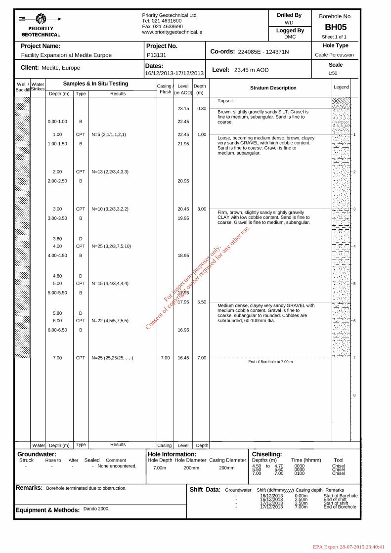
BH05
Hol
eBA
SE
III (
Bld
426
.58)
Sta
ndar
d B
oreh
ole
Log
v2 d
ated
27t
h N
ov 0
3
- - - - None encountered. 7.00m 200mm 200mm
----
4.505.507.00
16/12/201316/12/201317/12/201317/12/2013
4.705.607.00
003000300100
0.00m2.50m2.50m7.00m
Start of BoreholeEnd of shiftStart of shiftEnd of Borehole
ChiselChiselChisel
0.30-1.00
1.00
1.00-1.50
2.00
2.00-2.50
3.00
3.00-3.50
3.804.00
4.00-4.50
4.805.00
5.00-5.50
5.806.00
6.00-6.50
7.00
B
CPT
B
CPT
B
For
insp
ectio
n pur
pose
s only
.
Conse
nt of
copy
right
owne
r req
uired
for a
ny ot
her u
se.
EPA Export 28-07-2015:23:40:41

CPT
B
CPT
B
CPT
B
CPT
B
CPT
B
CPT
B
CPT
B
D
CPT
N=8 (2,2/2,2,2,2)
N=13 (2,3/3,4,3,3)
N=17 (3,3/4,4,4,5)
N=12 (3,3/3,3,3,3)
N=15 (4,4/4,3,4,4)
N=14 (4,4/3,4,4,3)
N=16 (3,4/4,5,4,3)
50 (12,14/25,25)9.20
24.72
24.02
23.52
23.02
22.52
21.52
20.52
19.52
18.52
18.02
17.52
17.02
15.82
0.30
2.00
7.00
9.20
Brown, slightly sandy slightly gravelly SILT.Sand is fine to medium. Gravel is fine tomedium, subangular.
Firm, brown, slightly sandy gravelly CLAY withmedium cobble content. Sand is fine to medium.Gravel is fine to medium, subangular.
Firm to stiff, brown, slightly sandy gravellyCLAY with medium cobble content. Sand is fineto coarse. Gravel is fine to coarse, subangularto subrounded. Cobbles are subrounded,60-110mm dia.
Medium dense, sandy GRAVEL with high cobblecontent. Sand is fine to coarse. Gravel is fineto coarse, subangular. Cobbles are subangular,60-110mm dia.
End of Borehole at 9.20 m
1
2
3
4
5
6
7
8
1:50
Sheet 1 of 1
Well / WaterStrikes
Depth (m)DepthLevel Legend(m)(m AOD)
Stratum Description
Project Name:
Client: Dates: Level:
Co-ords:Project No.
Borehole No
Scale
Logged By
Remarks:
Hole Type
Groundwater:Struck Sealed
Backfill
Depth (m) Level Depth
Rose to
Casing /
Casing
Equipment & Methods:
Drilled By
Hole Information:Hole Depth Casing Diameter
Chiselling:Depths (m) Time (hhmm) Tool
Water
Afterto
Shift Data: Shift (dd/mm/yyyy)
Flush
Casing depth Remarks
Comment
Groundwater
Hole Diameter
Facility Expansion at Medite Eurpoe
Medite, Europe
Borehole terminated due to obstruction.
Type
Type
Dando 2000
Samples & In Situ TestingResults
Results
Priority Geotechnical Ltd.Tel: 021 4631600Fax: 021 4638690www.prioritygeotechnical.ie
18/01/2014-19/01/2014
P13131
25.02 m AOD
224060E - 124394N
WN
JMS
Cable Percussion
BH06
Hol
eBA
SE
III (
Bld
426
.58)
Sta
ndar
d B
oreh
ole
Log
v2 d
ated
27t
h N
ov 0
3
- - - - - 9.20m 200mm 200mm
----
2.606.508.509.20
18/01/201418/01/201419/01/201419/01/2014
2.706.608.709.20
0030003000300030
0.00m6.00m6.00m9.20m
Start of BoreholeEnd of shiftStart of shiftEnd of Borehole
ChiselChiselChiselChisel
0.30-1.00
1.00
1.00-1.50
2.00
2.00-2.50
3.00
3.00-3.50
4.00
4.00-4.50
5.00
5.00-5.50
6.00
6.00-6.50
7.00
7.00-7.50
7.50-8.00
9.00
B
For
insp
ectio
n pur
pose
s only
.
Conse
nt of
copy
right
owne
r req
uired
for a
ny ot
her u
se.
EPA Export 28-07-2015:23:40:41
8.00
8.00-8.50
9.00
B
CPT
B
CPT
B
DCPT
B
CPT
B
CPT
B
CPT
B
BCPT
B
DCPT
B
CPTB
N=9 (2,2/2,2,3,2)
N=10 (3,3/2,3,3,2)
N=24 (4,3/7,6,5,6)
N=20 (4,4/5,6,5,4)
N=16 (4,3/4,4,4,4)
N=25 (3,4/5,7,5,8)
N=35 (3,3/4,10,10,11)
N=13 (4,3/4,3,3,3)
N=12 (3,3/3,2,3,4)
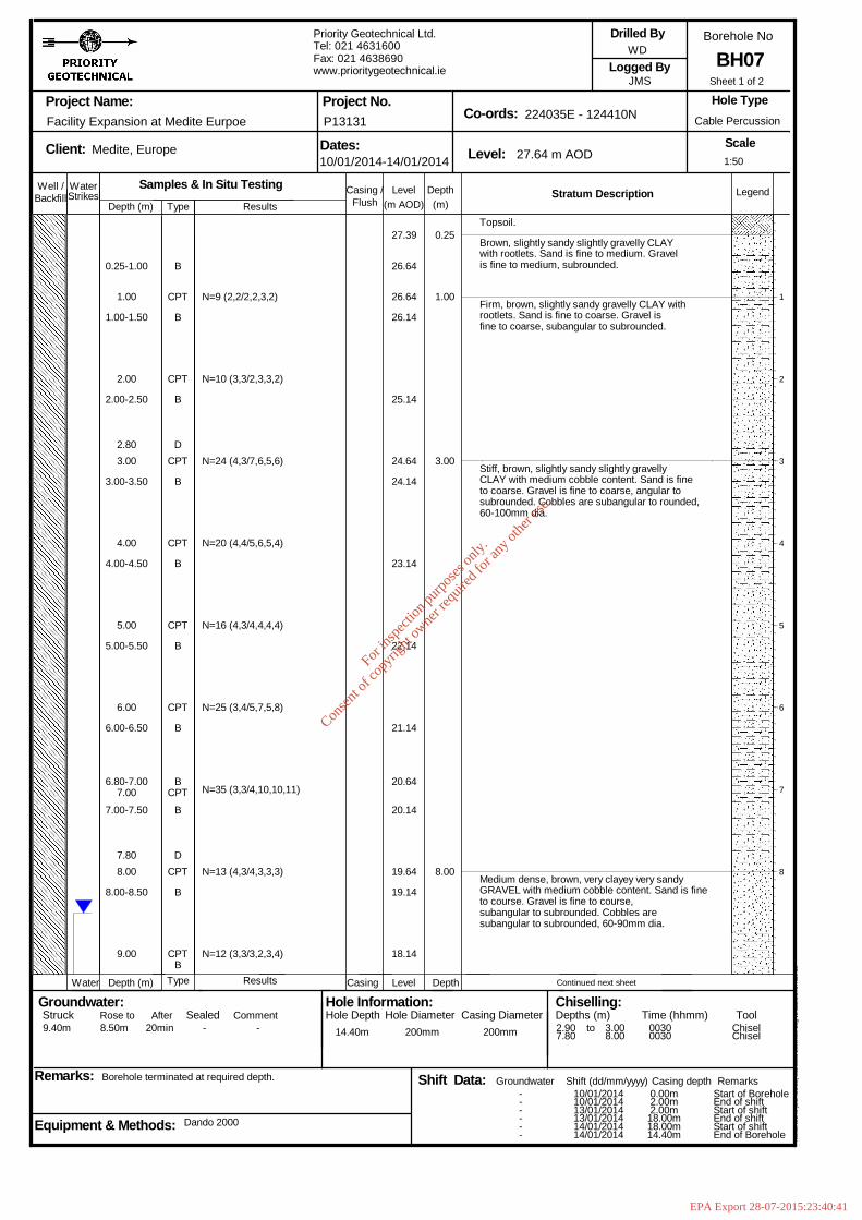
27.39
26.64
26.64
26.14
25.14
24.64
24.14
23.14
22.14
21.14
20.64
20.14
19.64
19.14
18.14
0.25
1.00
3.00
8.00
Topsoil.
Brown, slightly sandy slightly gravelly CLAYwith rootlets. Sand is fine to medium. Gravelis fine to medium, subrounded.
Firm, brown, slightly sandy gravelly CLAY withrootlets. Sand is fine to coarse. Gravel isfine to coarse, subangular to subrounded.
Stiff, brown, slightly sandy slightly gravellyCLAY with medium cobble content. Sand is fineto coarse. Gravel is fine to coarse, angular tosubrounded. Cobbles are subangular to rounded,60-100mm dia.
Medium dense, brown, very clayey very sandyGRAVEL with medium cobble content. Sand is fineto course. Gravel is fine to course,subangular to subrounded. Cobbles aresubangular to subrounded, 60-90mm dia.
Continued next sheet
1
2
3
4
5
6
7
8
1:50
Sheet 1 of 2
Well / WaterStrikes
Depth (m)DepthLevel Legend(m)(m AOD)
Stratum Description
Project Name:
Client: Dates: Level:
Co-ords:Project No.
Borehole No
Scale
Logged By
Remarks:
Hole Type
Groundwater:Struck Sealed
Backfill
Depth (m) Level Depth
Rose to
Casing /
Casing
Equipment & Methods:
Drilled By
Hole Information:Hole Depth Casing Diameter
Chiselling:Depths (m) Time (hhmm) Tool
Water
Afterto
Shift Data: Shift (dd/mm/yyyy)
Flush
Casing depth Remarks
Comment
Groundwater
Hole Diameter
Facility Expansion at Medite Eurpoe
Medite, Europe
Borehole terminated at required depth.
Type
Type
Dando 2000
Samples & In Situ TestingResults
Results
Priority Geotechnical Ltd.Tel: 021 4631600Fax: 021 4638690www.prioritygeotechnical.ie
10/01/2014-14/01/2014
P13131
27.64 m AOD
224035E - 124410N
WD
JMS
Cable Percussion
BH07
Hol
eBA
SE
III (
Bld
426
.58)
Sta
ndar
d B
oreh
ole
Log
v2 d
ated
27t
h N
ov 0
3
9.40m 8.50m 20min - - 14.40m 200mm 200mm
------
2.907.80
10/01/201410/01/201413/01/201413/01/201414/01/201414/01/2014
3.008.00
00300030
0.00m2.00m2.00m18.00m18.00m14.40m
Start of BoreholeEnd of shiftStart of shiftEnd of shiftStart of shiftEnd of Borehole
ChiselChisel
0.25-1.00
1.00
1.00-1.50
2.00
2.00-2.50
2.803.00
3.00-3.50
4.00
4.00-4.50
5.00
5.00-5.50
6.00
6.00-6.50
6.80-7.007.00
7.00-7.50
7.80
For
insp
ectio
n pur
pose
s only
.
Conse
nt of
copy
right
owne
r req
uired
for a
ny ot
her u
se.
EPA Export 28-07-2015:23:40:41
CPT
B
CPT
B
B
CPT
B
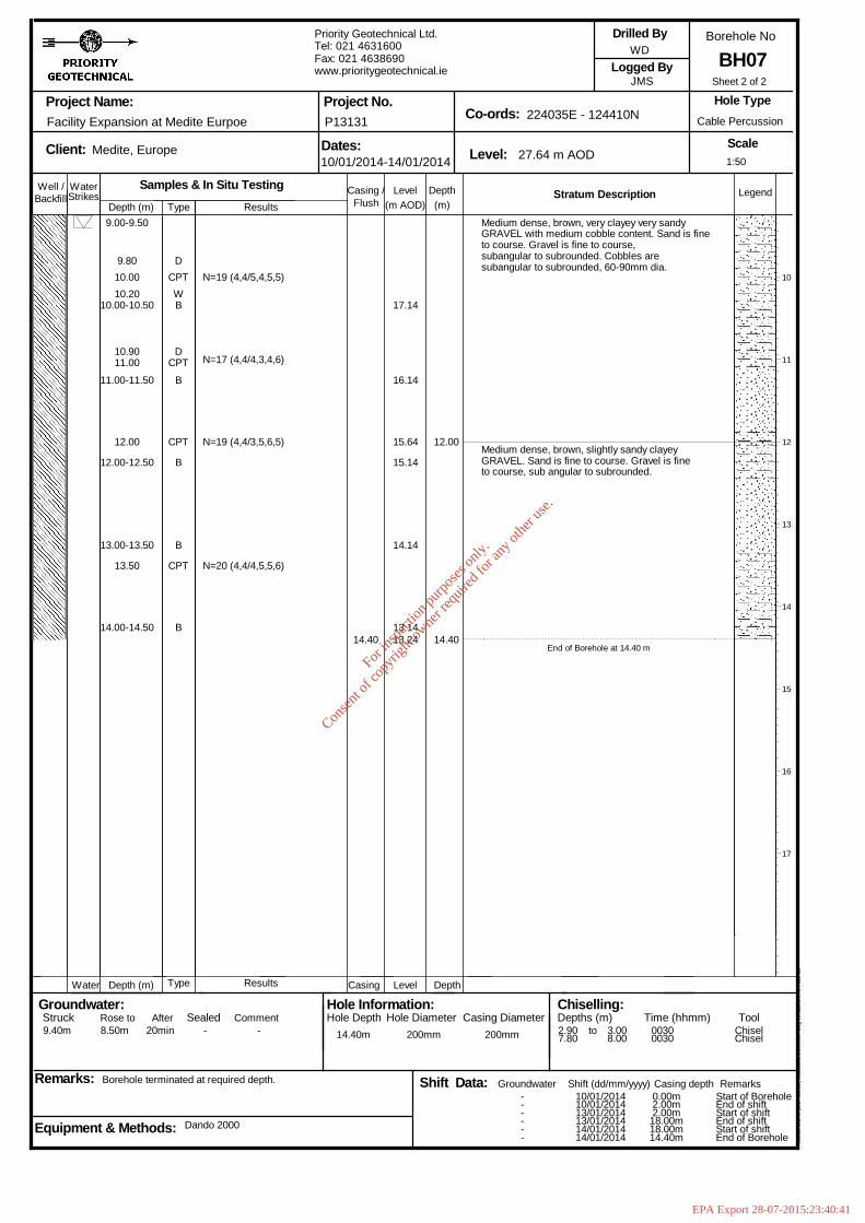
N=19 (4,4/5,4,5,5)
N=17 (4,4/4,3,4,6)
N=19 (4,4/3,5,6,5)
N=20 (4,4/4,5,5,6)
14.40
17.14
16.14
15.64
15.14
14.14
13.1413.24
12.00
14.40
Medium dense, brown, very clayey very sandyGRAVEL with medium cobble content. Sand is fineto course. Gravel is fine to course,subangular to subrounded. Cobbles aresubangular to subrounded, 60-90mm dia.
Medium dense, brown, slightly sandy clayeyGRAVEL. Sand is fine to course. Gravel is fineto course, sub angular to subrounded.
End of Borehole at 14.40 m
10
11
12
13
14
15
16
17
1:50
Sheet 2 of 2
Well / WaterStrikes
Depth (m)DepthLevel Legend(m)(m AOD)
Stratum Description
Project Name:
Client: Dates: Level:
Co-ords:Project No.
Borehole No
Scale
Logged By
Remarks:
Hole Type
Groundwater:Struck Sealed
Backfill
Depth (m) Level Depth
Rose to
Casing /
Casing
Equipment & Methods:
Drilled By
Hole Information:Hole Depth Casing Diameter
Chiselling:Depths (m) Time (hhmm) Tool
Water
Afterto
Shift Data: Shift (dd/mm/yyyy)
Flush
Casing depth Remarks
Comment
Groundwater
Hole Diameter
Facility Expansion at Medite Eurpoe
Medite, Europe
Borehole terminated at required depth.
Type
Type
Dando 2000
Samples & In Situ TestingResults
Results
Priority Geotechnical Ltd.Tel: 021 4631600Fax: 021 4638690www.prioritygeotechnical.ie
10/01/2014-14/01/2014
P13131
27.64 m AOD
224035E - 124410N
WD
JMS
Cable Percussion
BH07
Hol
eBA
SE
III (
Bld
426
.58)
Sta
ndar
d B
oreh
ole
Log
v2 d
ated
27t
h N
ov 0
3
9.40m 8.50m 20min - - 14.40m 200mm 200mm
------
2.907.80
10/01/201410/01/201413/01/201413/01/201414/01/201414/01/2014
3.008.00
00300030
0.00m2.00m2.00m18.00m18.00m14.40m
Start of BoreholeEnd of shiftStart of shiftEnd of shiftStart of shiftEnd of Borehole
ChiselChisel
9.00-9.50
9.8010.0010.20
10.00-10.50
10.9011.00
11.00-11.50
12.00
12.00-12.50
13.00-13.50
13.50
14.00-14.50
DCPT
BW
D
For
insp
ectio
n pur
pose
s only
.
Conse
nt of
copy
right
owne
r req
uired
for a
ny ot
her u
se.
EPA Export 28-07-2015:23:40:41

Well / WaterStrikes
Depth (m)DepthLevel Legend(m)(m AOD)
Stratum Description
Project Name:
Client: Dates: Level:
Co-ords:Project No.
Borehole No
Scale
Logged By
Remarks:
Hole Type
Groundwater:Struck Sealed
Backfill
Depth (m) Level Depth
Rose to
Casing /
Casing
Equipment & Methods:
Drilled By
Hole Information:Hole Depth Casing Diameter
Chiselling:Depths (m) Time (hhmm) Tool
Water
Afterto
Shift Data: Shift (dd/mm/yyyy)
Flush
Casing depth Remarks
Comment
Groundwater
Hole Diameter
Facility Expansion at Medite Eurpoe
Medite, Europe
Borehole terminated due to obstruction. Relocated to BH08A.
Type
Type
Dando 2000
Samples & In Situ TestingResults
Results
Priority Geotechnical Ltd.Tel: 021 4631600Fax: 021 4638690www.prioritygeotechnical.ie
20/01/2014
P13131
28.75 m AOD
224010E - 124393N
WD
ID
Cable Percussion
BH08
Hol
eBA
SE
III (
Bld
426
.58)
Sta
ndar
d B
oreh
ole
Log
v2 d
ated
27t
h N
ov 0
3
- - - - None encountered. 0.90m 200mm 200mm
--
0.80
20/01/201420/01/2014
0.90 0100
0.00m0.90m
Start of BoreholeEnd of Borehole
Chisel
0.25-1.000.80
BCPT 50 (17,25/25,25 for 4mm)
0.90
28.50
27.75
27.85
0.25
0.90
Topsoil.
Brown, slightly sandy slightly gravelly CLAYwith low cobble content. Sand is fine tocoarse. Gravel is fine to coarse, angular torounded. Cobbles are angular to rounded, 150mmdia.
End of Borehole at 0.90 m1
2
3
4
5
6
7
8
1:50
Sheet 1 of 1
For
insp
ectio
n pur
pose
s only
.
Conse
nt of
copy
right
owne
r req
uired
for a
ny ot
her u
se.
EPA Export 28-07-2015:23:40:41

Well / WaterStrikes
Depth (m)DepthLevel Legend(m)(m AOD)
Stratum Description
Project Name:
Client: Dates: Level:
Co-ords:Project No.
Borehole No
Scale
Logged By
Remarks:
Hole Type
Groundwater:Struck Sealed
Backfill
Depth (m) Level Depth
Rose to
Casing /
Casing
Equipment & Methods:
Drilled By
Hole Information:Hole Depth Casing Diameter
Chiselling:Depths (m) Time (hhmm) Tool
Water
Afterto
Shift Data: Shift (dd/mm/yyyy)
Flush
Casing depth Remarks
Comment
Groundwater
Hole Diameter
Facility Expansion at Medite Eurpoe
Medite, Europe
Borehole terminated due to obstruction.
Type
Type
Dando 2000
Samples & In Situ TestingResults
Results
Priority Geotechnical Ltd.Tel: 021 4631600Fax: 021 4638690www.prioritygeotechnical.ie
20/01/2014
P13131
28.65 m AOD
224010E - 124392N
WD
-
Cable Percussion
BH08A
Hol
eBA
SE
III (
Bld
426
.58)
Sta
ndar
d B
oreh
ole
Log
v2 d
ated
27t
h N
ov 0
3
1.20m 200mm 200mm
--
1.20
20/01/201420/01/2014
1.20 0100
0.00m1.20m
Start of BoreholeEnd of Borehole
Chisel
0.40
1.00
D
CPT 50 (14,10/25,25 for 2mm)1.20
28.40
27.45
0.25
1.20
Topsoil.
Brown, slightly sandy slightly gravelly CLAYwith low cobble content. Sand is fine tocoarse. Gravel is fine to coarse, angular torounded. Cobbles are angular to rounded, 150mmdia.
End of Borehole at 1.20 m
1
2
3
4
5
6
7
8
1:50
Sheet 1 of 1
For
insp
ectio
n pur
pose
s only
.
Conse
nt of
copy
right
owne
r req
uired
for a
ny ot
her u
se.
EPA Export 28-07-2015:23:40:41
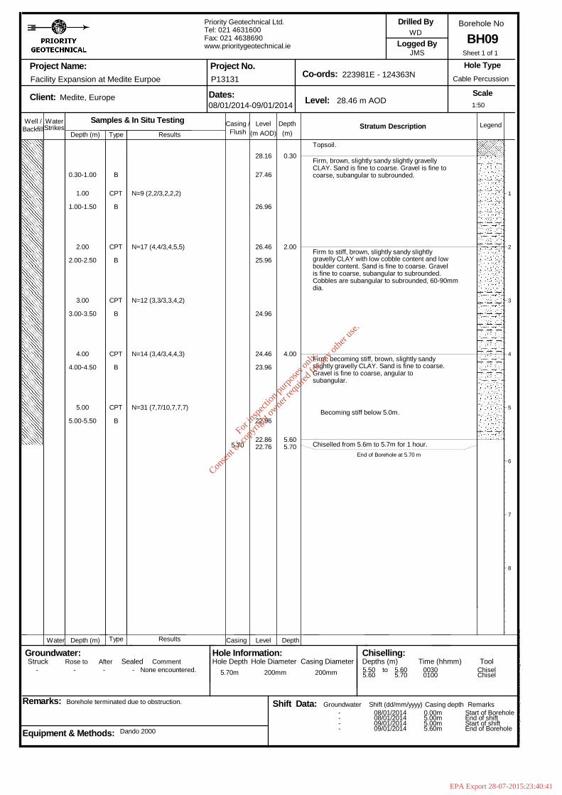
N=31 (7,7/10,7,7,7)
5.70
28.16
27.46
26.96
26.46
25.96
24.96
24.46
23.96
22.96
22.8622.76
0.30
2.00
4.00
5.605.70
Topsoil.
Firm, brown, slightly sandy slightly gravellyCLAY. Sand is fine to coarse. Gravel is fine tocoarse, subangular to subrounded.
Firm to stiff, brown, slightly sandy slightlygravelly CLAY with low cobble content and lowboulder content. Sand is fine to coarse. Gravelis fine to coarse, subangular to subrounded.Cobbles are subangular to subrounded, 60-90mmdia.
Firm, becoming stiff, brown, slightly sandyslightly gravelly CLAY. Sand is fine to coarse.Gravel is fine to coarse, angular tosubangular.
Becoming stiff below 5.0m.
Chiselled from 5.6m to 5.7m for 1 hour.End of Borehole at 5.70 m
1
2
3
4
5
6
7
8
1:50
Sheet 1 of 1
Well / WaterStrikes
Depth (m)DepthLevel Legend(m)(m AOD)
Stratum Description
Project Name:
Client: Dates: Level:
Co-ords:Project No.
Borehole No
Scale
Logged By
Remarks:
Hole Type
Groundwater:Struck Sealed
Backfill
Depth (m) Level Depth
Rose to
Casing /
Casing
Equipment & Methods:
Drilled By
Hole Information:Hole Depth Casing Diameter
Chiselling:Depths (m) Time (hhmm) Tool
Water
Afterto
Shift Data: Shift (dd/mm/yyyy)
Flush
Casing depth Remarks
Comment
Groundwater
Hole Diameter
Facility Expansion at Medite Eurpoe
Medite, Europe
Borehole terminated due to obstruction.
Type
Type
Dando 2000
Samples & In Situ TestingResults
Results
Priority Geotechnical Ltd.Tel: 021 4631600Fax: 021 4638690www.prioritygeotechnical.ie
08/01/2014-09/01/2014
P13131
28.46 m AOD
223981E - 124363N
WD
JMS
Cable Percussion
BH09
Hol
eBA
SE
III (
Bld
426
.58)
Sta
ndar
d B
oreh
ole
Log
v2 d
ated
27t
h N
ov 0
3
- - - - None encountered. 5.70m 200mm 200mm
----
5.505.60
08/01/201408/01/201409/01/201409/01/2014
5.605.70
00300100
0.00m5.00m5.00m5.60m
Start of BoreholeEnd of shiftStart of shiftEnd of Borehole
ChiselChisel
0.30-1.00
1.00
1.00-1.50
2.00
2.00-2.50
3.00
3.00-3.50
4.00
4.00-4.50
5.00
5.00-5.50
B
CPT
B
CPT
B
CPT
B
CPT
B
CPT
B
N=9 (2,2/3,2,2,2)
N=17 (4,4/3,4,5,5)
N=12 (3,3/3,3,4,2)
N=14 (3,4/3,4,4,3)
For
insp
ectio
n pur
pose
s only
.
Conse
nt of
copy
right
owne
r req
uired
for a
ny ot
her u
se.
EPA Export 28-07-2015:23:40:41
Chiselled from 2.5m to 2.7m.End of Borehole at 2.70 m
1
2
3
4
5
6
7
8
1:50
Sheet 1 of 1
Well / WaterStrikes
Depth (m)DepthLevel Legend(m)(m AOD)
Stratum Description
Project Name:
Client: Dates: Level:
Co-ords:Project No.
Borehole No
Scale
Logged By
Remarks:
Hole Type
Groundwater:Struck Sealed
Backfill
Depth (m) Level Depth
Rose to
Casing /
Casing
Equipment & Methods:
Drilled By
Hole Information:Hole Depth Casing Diameter
Chiselling:Depths (m) Time (hhmm) Tool
Water
Afterto
Shift Data: Shift (dd/mm/yyyy)
Flush
Casing depth Remarks
Comment
Groundwater
Hole Diameter
Facility Expansion at Medite Eurpoe
Medite, Europe
Borehole terminated due to obstruction.
Type
Type
Dando 2000
Samples & In Situ TestingResults
Results
Priority Geotechnical Ltd.Tel: 021 4631600Fax: 021 4638690www.prioritygeotechnical.ie
29/01/2014
P13131
32.76 m AOD
223978E - 124308N
wd
JMS
Cable Percussion
BH10
Hol
eBA
SE
III (
Bld
426
.58)
Sta
ndar
d B
oreh
ole
Log
v2 d
ated
27t
h N
ov 0
3
- - - - None encountered. 2.70m 200mm 200mm
--
2.50
29/01/201429/01/2014
2.70 0100
0.00m2.70m
Start of BoreholeEnd of Borehole
Chisel
0.50
1.00
1.00-1.50
1.50
2.00
2.00-2.50
2.70
D
CPT
B
D
CPT
B
CPT
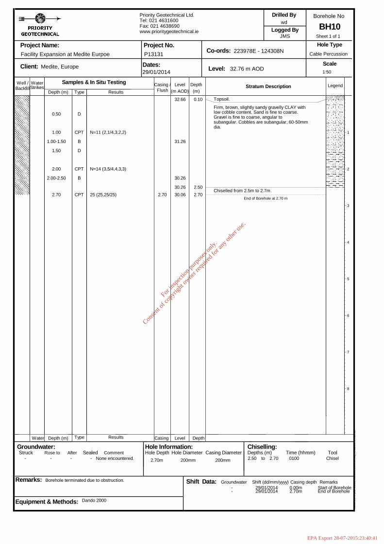
N=11 (2,1/4,3,2,2)
N=14 (3,5/4,4,3,3)
25 (25,25/25) 2.70
32.66
31.26
30.26
30.2630.06
0.10
2.502.70
Topsoil.
Firm, brown, slightly sandy gravelly CLAY withlow cobble content. Sand is fine to coarse.Gravel is fine to coarse, angular tosubangular. Cobbles are subangular, 60-50mmdia.
For
insp
ectio
n pur
pose
s only
.
Conse
nt of
copy
right
owne
r req
uired
for a
ny ot
her u
se.
EPA Export 28-07-2015:23:40:41
Gravel is subangular to subrounded. Sand isfine to coarse.
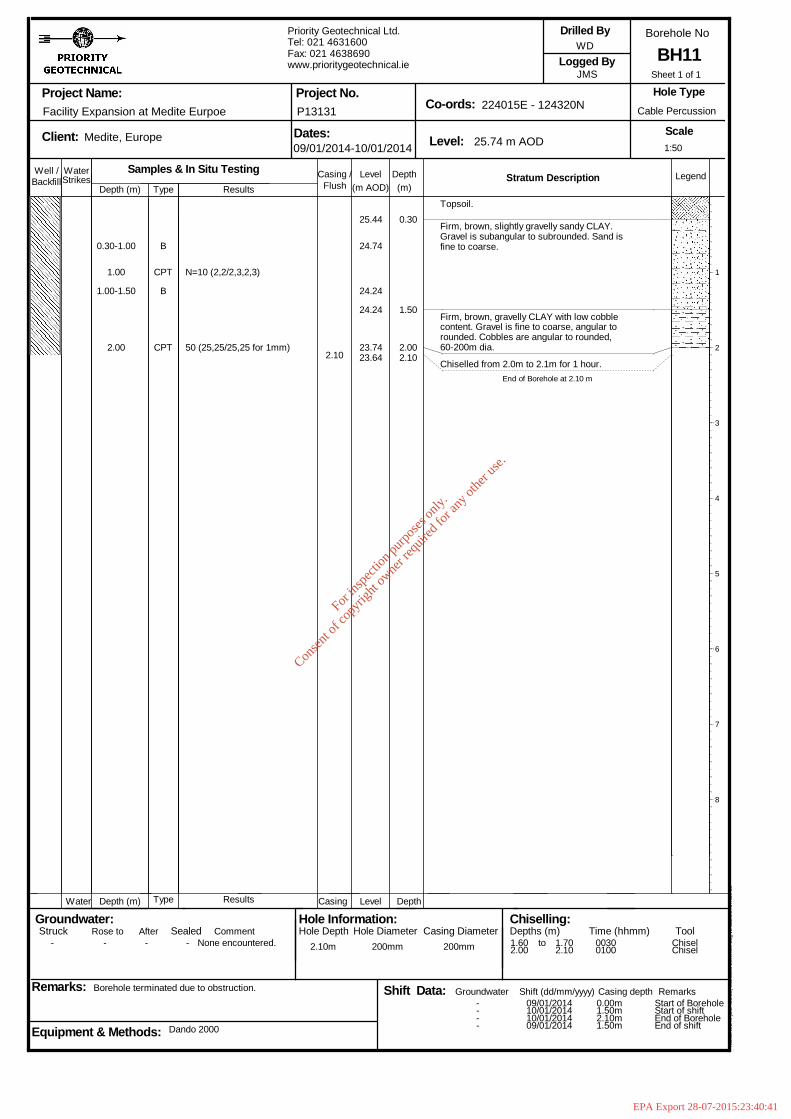
Firm, brown, gravelly CLAY with low cobblecontent. Gravel is fine to coarse, angular torounded. Cobbles are angular to rounded,60-200m dia.
Chiselled from 2.0m to 2.1m for 1 hour.End of Borehole at 2.10 m
1
2
3
4
5
6
7
8
1:50
Sheet 1 of 1
Well / WaterStrikes
Depth (m)DepthLevel Legend(m)(m AOD)
Stratum Description
Project Name:
Client: Dates: Level:
Co-ords:Project No.
Borehole No
Scale
Logged By
Remarks:
Hole Type
Groundwater:Struck Sealed
Backfill
Depth (m) Level Depth
Rose to
Casing /
Casing
Equipment & Methods:
Drilled By
Hole Information:Hole Depth Casing Diameter
Chiselling:Depths (m) Time (hhmm) Tool
Water
Afterto
Shift Data: Shift (dd/mm/yyyy)
Flush
Casing depth Remarks
Comment
Groundwater
Hole Diameter
Facility Expansion at Medite Eurpoe
Medite, Europe
Borehole terminated due to obstruction.
Type
Type
Dando 2000
Samples & In Situ TestingResults
Results
Priority Geotechnical Ltd.Tel: 021 4631600Fax: 021 4638690www.prioritygeotechnical.ie
09/01/2014-10/01/2014
P13131
25.74 m AOD
224015E - 124320N
WD
JMS
Cable Percussion
BH11
Hol
eBA
SE
III (
Bld
426
.58)
Sta
ndar
d B
oreh
ole
Log
v2 d
ated
27t
h N
ov 0
3
- - - - None encountered. 2.10m 200mm 200mm
----
1.602.00
09/01/201410/01/201410/01/201409/01/2014
1.702.10
00300100
0.00m1.50m2.10m1.50m
Start of BoreholeStart of shiftEnd of BoreholeEnd of shift
ChiselChisel
0.30-1.00
1.00
1.00-1.50
2.00
B
CPT
B
CPT
N=10 (2,2/2,3,2,3)
50 (25,25/25,25 for 1mm)2.10
25.44
24.74
24.24
24.24
23.7423.64
0.30
1.50
2.002.10
Topsoil.
Firm, brown, slightly gravelly sandy CLAY.
For
insp
ectio
n pur
pose
s only
.
Conse
nt of
copy
right
owne
r req
uired
for a
ny ot
her u
se.
EPA Export 28-07-2015:23:40:41
0.30
1.601.80
3.00
4.104.20
Topsoil.
Firm, brown, slightly gravelly slightly sandyCLAY with medium cobble content and rootlets.Gravel is fine to coarse, subangular. Sand isfine to coarse. Cobbles are subangular,60-100mm dia.
Grey, limestone BOULDER. Boulder is subangular,205mm dia.
Medium dense, brown, very clayey very sandyGRAVEL with low cobble content. Sand is fine tocoarse. Gravel is fine to coarse, subangular.Cobbles are subrounded, 60-100mm dia.
Medium dense, yellow/ brown, slightly clayeyvery sandy GRAVEL with medium cobble contentand grass roots. Gravel is fine to coarse,subangular. Sand is medium to coarse. Cobblesare subangular, 60-70mm dia.
Chiselled from 4.1m to 4.2m for 1 hour.End of Borehole at 4.20 m
1
2
3
4
5
6
7
8
1:50
Sheet 1 of 1
Well / WaterStrikes
Depth (m)DepthLevel Legend(m)(m AOD)
Stratum Description
Project Name:
Client: Dates: Level:
Co-ords:Project No.
Borehole No
Scale
Logged By
Remarks:
Hole Type
Groundwater:Struck Sealed
Backfill
Depth (m) Level Depth
Rose to
Casing /
Casing
Equipment & Methods:
Drilled By
Hole Information:Hole Depth Casing Diameter
Chiselling:Depths (m) Time (hhmm) Tool
Water
Afterto
Shift Data: Shift (dd/mm/yyyy)
Flush
Casing depth Remarks
Comment
Groundwater
Hole Diameter
Facility Expansion at Medite Eurpoe
Medite, Europe
Borehole terminated due to obstruction.
Type
Type
Dando 2000
Samples & In Situ TestingResults
Results
Priority Geotechnical Ltd.Tel: 021 4631600Fax: 021 4638690www.prioritygeotechnical.ie
07/01/2014
P13131
24.14 m AOD
224060E - 124318N
WD
JMS
Cable Percussion
BH12
Hol
eBA
SE
III (
Bld
426
.58)
Sta
ndar
d B
oreh
ole
Log
v2 d
ated
27t
h N
ov 0
3
- - - - None encountered. 4.20m 200mm 200mm
--
1.604.10
07/01/201407/01/2014
1.804.20
00300100
0.00m4.20m
Start of BoreholeEnd of Borehole
ChiselChisel
0.30-1.00
1.00
1.00-1.50
1.60-1.80
2.00
2.00-2.50
3.00
3.00-3.50
4.00
B
CPT
B
B
CPT
B
CPT
B
CPT
N=9 (2,2/3,2,2,2)
N=14 (2,3/4,4,3,3)
N=18 (4,4/5,4,4,5)
50 (12,11/25,25 for 2mm)4.20
23.84
23.14
22.64
22.5422.3422.34
21.64
21.14
20.64
20.0419.94
For
insp
ectio
n pur
pose
s only
.
Conse
nt of
copy
right
owne
r req
uired
for a
ny ot
her u
se.
EPA Export 28-07-2015:23:40:41
Well / WaterStrikes
Depth (m)DepthLevel Legend(m)(m AOD)
Stratum Description
Project Name:
Client: Dates: Level:
Co-ords:Project No.
Borehole No
Scale
Logged By
Remarks:
Hole Type
Groundwater:Struck Sealed
Backfill
Depth (m) Level Depth
Rose to
Casing /
Casing
Equipment & Methods:
Drilled By
Hole Information:Hole Depth Casing Diameter
Chiselling:Depths (m) Time (hhmm) Tool
Water
Afterto
Shift Data: Shift (dd/mm/yyyy)
Flush
Casing depth Remarks
Comment
Groundwater
Hole Diameter
Facility Expansion at Medite Eurpoe
Medite, Europe
Borehole terminated due to obstruction.
Type
Type
Dando 2000.
Samples & In Situ TestingResults
Results
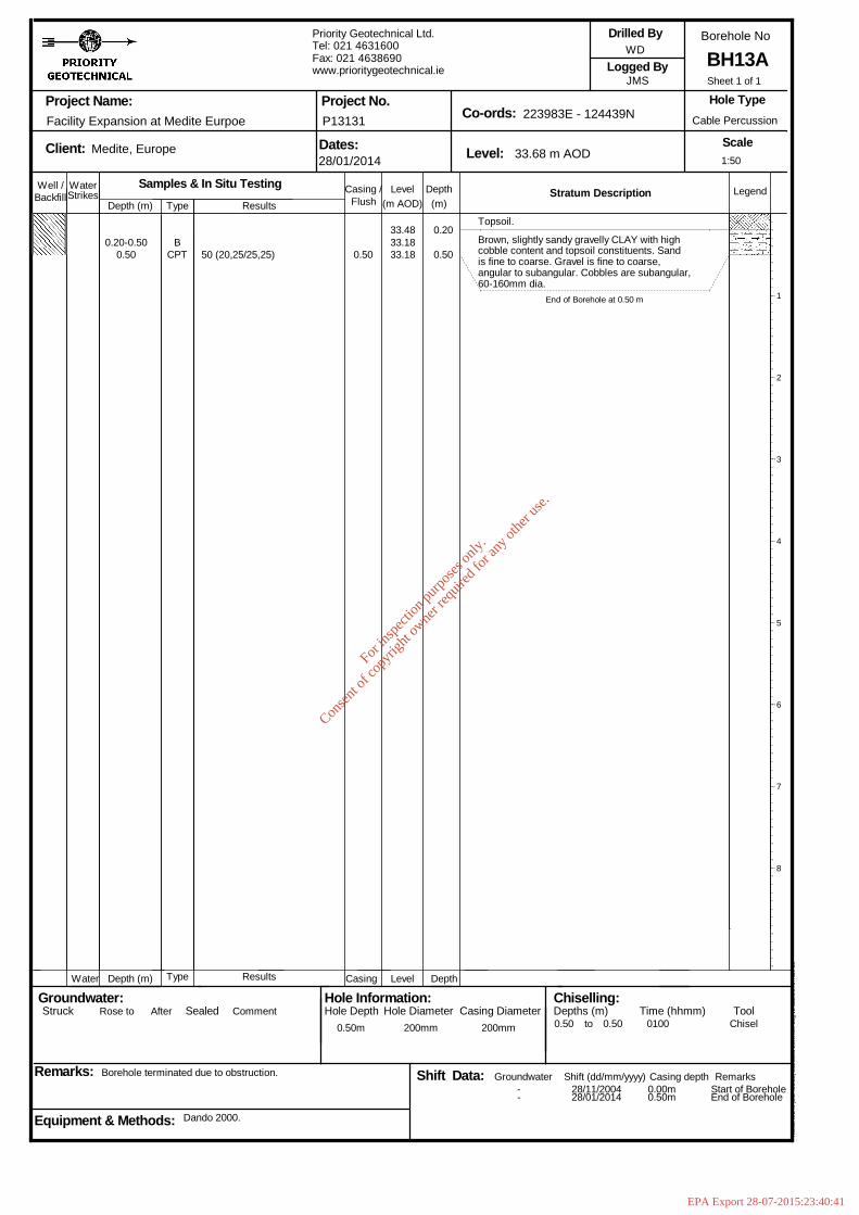
Priority Geotechnical Ltd.Tel: 021 4631600Fax: 021 4638690www.prioritygeotechnical.ie
28/01/2014
P13131
33.68 m AOD
223983E - 124439N
WD
JMS
Cable Percussion
BH13A
Hol
eBA
SE
III (
Bld
426
.58)
Sta
ndar
d B
oreh
ole
Log
v2 d
ated
27t
h N
ov 0
3
0.50m 200mm 200mm
--
0.50
28/11/200428/01/2014
0.50 0100
0.00m0.50m
Start of BoreholeEnd of Borehole
Chisel
0.20-0.500.50
BCPT 50 (20,25/25,25) 0.50
33.4833.1833.18
0.20
0.50
Topsoil.
Brown, slightly sandy gravelly CLAY with highcobble content and topsoil constituents. Sandis fine to coarse. Gravel is fine to coarse,angular to subangular. Cobbles are subangular,60-160mm dia.
End of Borehole at 0.50 m 1
2
3
4
5
6
7
8
1:50
Sheet 1 of 1
For
insp
ectio
n pur
pose
s only
.
Conse
nt of
copy
right
owne
r req
uired
for a
ny ot
her u
se.
EPA Export 28-07-2015:23:40:41
Well / WaterStrikes
Depth (m)DepthLevel Legend(m)(m AOD)
Stratum Description
Project Name:
Client: Dates: Level:
Co-ords:Project No.
Borehole No
Scale
Logged By
Remarks:
Hole Type
Groundwater:Struck Sealed
Backfill
Depth (m) Level Depth
Rose to
Casing /
Casing
Equipment & Methods:
Drilled By
Hole Information:Hole Depth Casing Diameter
Chiselling:Depths (m) Time (hhmm) Tool
Water
Afterto
Shift Data: Shift (dd/mm/yyyy)
Flush
Casing depth Remarks
Comment
Groundwater
Hole Diameter
Facility Expansion at Medite Eurpoe
Medite, Europe
Borehole terminated due to obstruction. Relocated to BH13A.
Type
Type
Dando 2000
Samples & In Situ TestingResults
Results
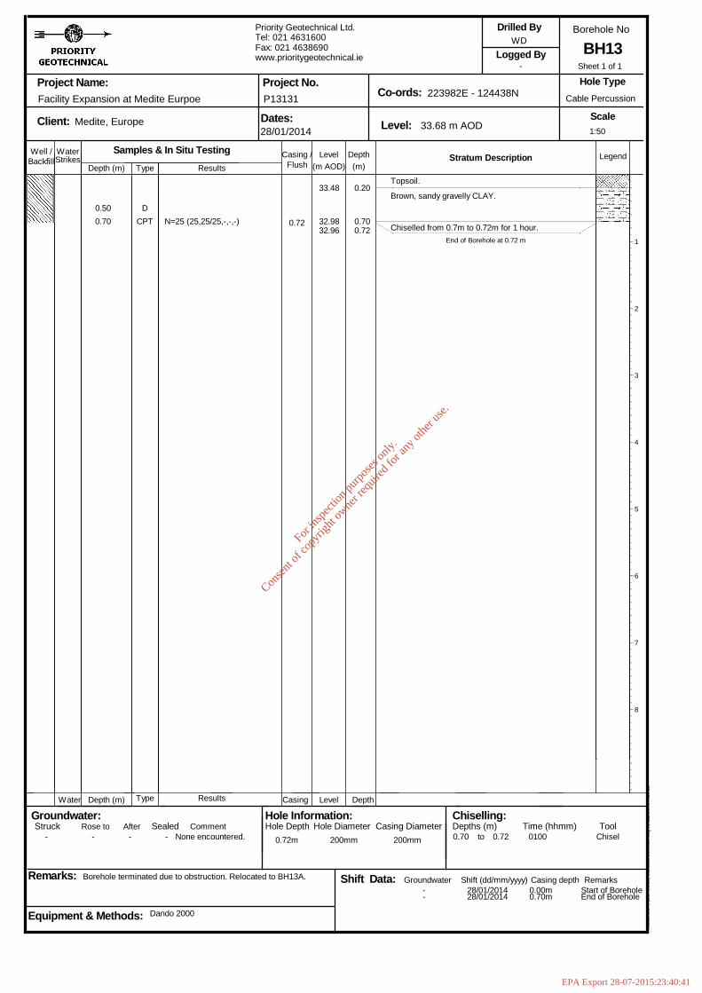
Priority Geotechnical Ltd.Tel: 021 4631600Fax: 021 4638690www.prioritygeotechnical.ie
28/01/2014
P13131
33.68 m AOD
223982E - 124438N
WD
-
Cable Percussion
BH13
Hol
eBA
SE
III (
Bld
426
.58)
Sta
ndar
d B
oreh
ole
Log
v2 d
ated
27t
h N
ov 0
3
- - - - None encountered. 0.72m 200mm 200mm
--
0.70
28/01/201428/01/2014
0.72 0100
0.00m0.70m
Start of BoreholeEnd of Borehole
Chisel
0.500.70
DCPT N=25 (25,25/25,-,-,-) 0.72
33.48
32.9832.96
0.20
0.700.72
Topsoil.
Brown, sandy gravelly CLAY.
Chiselled from 0.7m to 0.72m for 1 hour.End of Borehole at 0.72 m 1
2
3
4
5
6
7
8
1:50
Sheet 1 of 1
For
insp
ectio
n pur
pose
s only
.
Conse
nt of
copy
right
owne
r req
uired
for a
ny ot
her u
se.
EPA Export 28-07-2015:23:40:41
B
DCPT
B
DCPT
B
DCPT
B
CPT
B
CPT
B
CPT
B
CPT
CPT
N=6 (2,3/2,1,2,1)
N=10 (2,2/3,2,2,3)
N=12 (2,2/3,3,3,3)
N=12 (4,4/3,3,3,3)
N=21 (3,4/5,5,5,6)
N=25 (5,5/7,7,6,5)
N=29 (5,6/6,5,10,8)
N=25 (9,9/9,5,6,5)
N=50 (15,15/25,25,-,-)9.20
22.33
21.53
21.03
20.03
19.53
19.03
18.53
18.03
17.03
16.03
15.03
15.03
13.4313.33
0.20
1.00
3.00
4.00
7.50
9.109.20
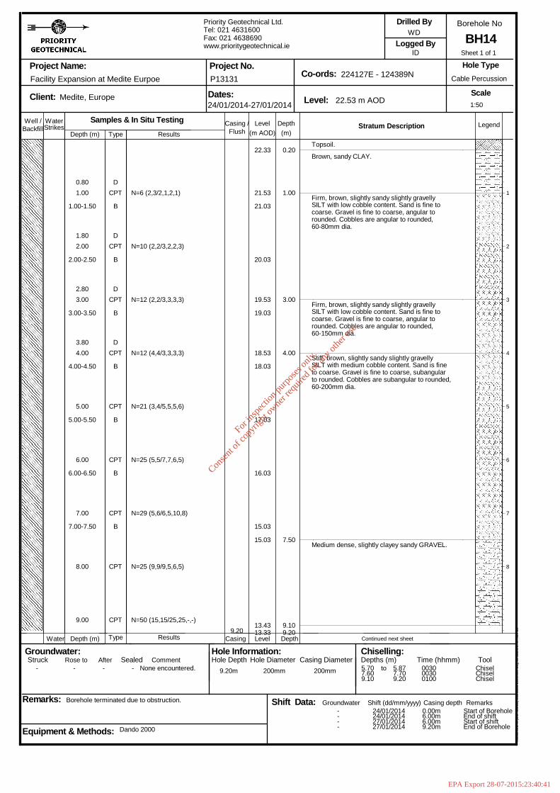
Topsoil.
Brown, sandy CLAY.
Firm, brown, slightly sandy slightly gravellySILT with low cobble content. Sand is fine tocoarse. Gravel is fine to coarse, angular torounded. Cobbles are angular to rounded,60-80mm dia.
Firm, brown, slightly sandy slightly gravellySILT with low cobble content. Sand is fine tocoarse. Gravel is fine to coarse, angular torounded. Cobbles are angular to rounded,60-150mm dia.
Stiff, brown, slightly sandy slightly gravellySILT with medium cobble content. Sand is fineto coarse. Gravel is fine to coarse, subangularto rounded. Cobbles are subangular to rounded,60-200mm dia.
Medium dense, slightly clayey sandy GRAVEL.
Continued next sheet
1
2
3
4
5
6
7
8
1:50
Sheet 1 of 1
Well / WaterStrikes
Depth (m)DepthLevel Legend(m)(m AOD)
Stratum Description
Project Name:
Client: Dates: Level:
Co-ords:Project No.
Borehole No
Scale
Logged By
Remarks:
Hole Type
Groundwater:Struck Sealed
Backfill
Depth (m) Level Depth
Rose to
Casing /
Casing
Equipment & Methods:
Drilled By
Hole Information:Hole Depth Casing Diameter
Chiselling:Depths (m) Time (hhmm) Tool
Water
Afterto
Shift Data: Shift (dd/mm/yyyy)
Flush
Casing depth Remarks
Comment
Groundwater
Hole Diameter
Facility Expansion at Medite Eurpoe
Medite, Europe
Borehole terminated due to obstruction.
Type
Type
Dando 2000
Samples & In Situ TestingResults
Results
Priority Geotechnical Ltd.Tel: 021 4631600Fax: 021 4638690www.prioritygeotechnical.ie
24/01/2014-27/01/2014
P13131
22.53 m AOD
224127E - 124389N
WD
ID
Cable Percussion
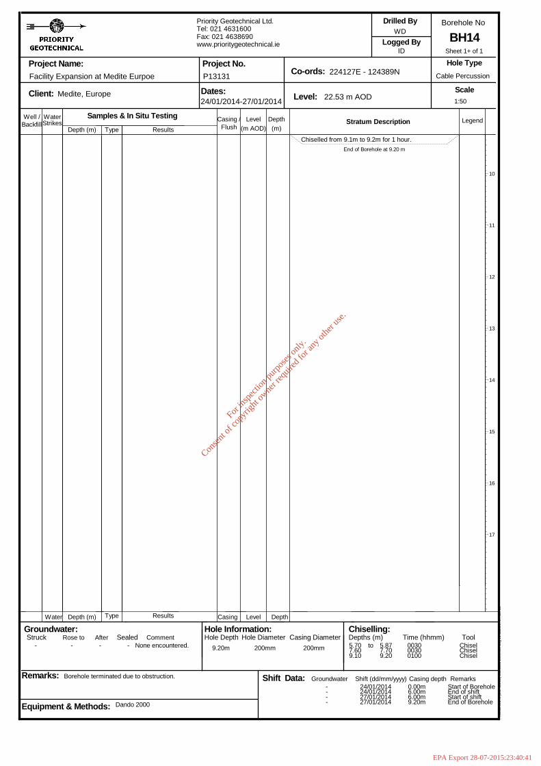
BH14
Hol
eBA
SE
III (
Bld
426
.58)
Sta
ndar
d B
oreh
ole
Log
v2 d
ated
27t
h N
ov 0
3
- - - - None encountered. 9.20m 200mm 200mm
----
5.707.609.10
24/01/201424/01/201427/01/201427/01/2014
5.877.709.20
003000300100
0.00m6.00m6.00m9.20m
Start of BoreholeEnd of shiftStart of shiftEnd of Borehole
ChiselChiselChisel
0.801.00
1.00-1.50
1.802.00
2.00-2.50
2.803.00
3.00-3.50
3.804.00
4.00-4.50
5.00
5.00-5.50
6.00
6.00-6.50
7.00
7.00-7.50
8.00
9.00
DCPT
For
insp
ectio
n pur
pose
s only
.
Conse
nt of
copy
right
owne
r req
uired
for a
ny ot
her u
se.
EPA Export 28-07-2015:23:40:41
Well / WaterStrikes
Depth (m)DepthLevel Legend(m)(m AOD)
Stratum Description
Project Name:
Client: Dates: Level:
Co-ords:Project No.
Borehole No
Scale
Logged By
Remarks:
Hole Type
Groundwater:Struck Sealed
Backfill
Depth (m) Level Depth
Rose to
Casing /
Casing
Equipment & Methods:
Drilled By
Hole Information:Hole Depth Casing Diameter
Chiselling:Depths (m) Time (hhmm) Tool
Water
Afterto
Shift Data: Shift (dd/mm/yyyy)
Flush
Casing depth Remarks
Comment
Groundwater
Hole Diameter
Facility Expansion at Medite Eurpoe
Medite, Europe
Borehole terminated due to obstruction.
Type
Type
Dando 2000
Samples & In Situ TestingResults
Results
Priority Geotechnical Ltd.Tel: 021 4631600Fax: 021 4638690www.prioritygeotechnical.ie
24/01/2014-27/01/2014
P13131
22.53 m AOD
224127E - 124389N
WD
ID
Cable Percussion
BH14
Hol
eBA
SE
III (
Bld
426
.58)
Sta
ndar
d B
oreh
ole
Log
v2 d
ated
27t
h N
ov 0
3
- - - - None encountered. 9.20m 200mm 200mm
----
5.707.609.10
24/01/201424/01/201427/01/201427/01/2014
5.877.709.20
003000300100
0.00m6.00m6.00m9.20m
Start of BoreholeEnd of shiftStart of shiftEnd of Borehole
ChiselChiselChisel
Chiselled from 9.1m to 9.2m for 1 hour.End of Borehole at 9.20 m
10
11
12
13
14
15
16
17
1:50
Sheet 1+ of 1
For
insp
ectio
n pur
pose
s only
.
Conse
nt of
copy
right
owne
r req
uired
for a
ny ot
her u
se.
EPA Export 28-07-2015:23:40:41
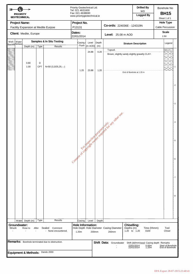
Well / WaterStrikes
Depth (m)DepthLevel Legend(m)(m AOD)
Stratum Description
Project Name:
Client: Dates: Level:
Co-ords:Project No.
Borehole No
Scale
Logged By
Remarks:
Hole Type
Groundwater:Struck Sealed
Backfill
Depth (m) Level Depth
Rose to
Casing /
Casing
Equipment & Methods:
Drilled By
Hole Information:Hole Depth Casing Diameter
Chiselling:Depths (m) Time (hhmm) Tool
Water
Afterto
Shift Data: Shift (dd/mm/yyyy)
Flush
Casing depth Remarks
Comment
Groundwater
Hole Diameter
Facility Expansion at Medite Eurpoe
Medite, Europe
Borehole terminated due to obstruction.
Type
Type
Dando 2000
Samples & In Situ TestingResults
Results
Priority Geotechnical Ltd.Tel: 021 4631600Fax: 021 4638690www.prioritygeotechnical.ie
22/01/2014
P13131
25.08 m AOD
224036E - 124319N
WD
-
Cable Percussion
BH15
Hol
eBA
SE
III (
Bld
426
.58)
Sta
ndar
d B
oreh
ole
Log
v2 d
ated
27t
h N
ov 0
3
- - - - None encountered. 1.20m 200mm 200mm
--
1.20
22/01/201422/01/2014
1.20 0100
0.00m1.20m
Start of BoreholeEnd of Borehole
Chisel
0.801.00
DCPT N=50 (3,3/25,25,-,-)
1.20
24.88
23.88
0.20
1.20
Topsoil.
Brown, slightly sandy slightly gravelly CLAY.
End of Borehole at 1.20 m
1
2
3
4
5
6
7
8
1:50
Sheet 1 of 1
For
insp
ectio
n pur
pose
s only
.
Conse
nt of
copy
right
owne
r req
uired
for a
ny ot
her u
se.
EPA Export 28-07-2015:23:40:41

B
DCPT
B
CPT
B
CPT
B
B
CPT
N=6 (2,1/1,2,2,1)
N=9 (2,2/3,2,2,2)
N=26 (4,5/7,6,5,8)
N=23 (5,4/4,5,7,7)
N=17 (4,4/4,4,4,5)
N=38 (1,3/6,10,14,8)
50 (3,19/25,25)7.90
26.53
25.78
25.28
24.28
23.28
22.28
21.28
19.78
19.28
18.88
0.25
7.90
Topsoil.
Firm, brown, slightly sandy slightly gravellyCLAY with medium cobble content. Sand is fineto coarse. Gravel is fine to coarse, angular torounded. Cobbles are angular to rounded,60-200mm dia.
CLAY is stiff below 3.0m.
End of Borehole at 7.90 m
1
2
3
4
5
6
7
8
1:50
Sheet 1 of 1
Well / WaterStrikes
Depth (m)DepthLevel Legend(m)(m AOD)
Stratum Description
Project Name:
Client: Dates: Level:
Co-ords:Project No.
Borehole No
Scale
Logged By
Remarks:
Hole Type
Groundwater:Struck Sealed
Backfill
Depth (m) Level Depth
Rose to
Casing /
Casing
Equipment & Methods:
Drilled By
Hole Information:Hole Depth Casing Diameter
Chiselling:Depths (m) Time (hhmm) Tool
Water
Afterto
Shift Data: Shift (dd/mm/yyyy)
Flush
Casing depth Remarks
Comment
Groundwater
Hole Diameter
Facility Expansion at Medite Eurpoe
Medite, Europe
Borehole terminated due to obstruction.
Type
Type
Dando 2000
Samples & In Situ TestingResults
Results
Priority Geotechnical Ltd.Tel: 021 4631600Fax: 021 4638690www.prioritygeotechnical.ie
20/01/2014-21/01/2014
P13131
26.78 m AOD
224013E - 124364N
WD
DI
Cable Percussion
BH16
Hol
eBA
SE
III (
Bld
426
.58)
Sta
ndar
d B
oreh
ole
Log
v2 d
ated
27t
h N
ov 0
3
- - - - None encountered. 7.90m 200mm 200mm
----
5.706.607.90
20/01/201420/01/201421/01/201421/01/2014
5.906.807.90
003000300100
0.00m2.00m2.00m7.90m
Start of BoreholeEnd of shiftStart of shiftEnd of Borehole
ChiselChiselChisel
0.25-1.00
1.00
1.00-1.50
2.00
2.00-2.50
3.00
3.00-3.50
3.804.00
4.00-4.50
5.00
5.00-5.50
6.00
6.50-7.00
7.00-7.50
7.70
B
CPT
B
CPT
B
CPT
For
insp
ectio
n pur
pose
s only
.
Conse
nt of
copy
right
owne
r req
uired
for a
ny ot
her u
se.
EPA Export 28-07-2015:23:40:41

N=8 (2,2/2,2,2,2)
N=21 (3,5/6,5,5,5)
N=38 (7,7/10,8,10,10)
N=25 (8,7/7,7,6,5)
50 (17,25/25,25)5.70
22.27
21.47
20.97
19.97
19.67
18.97
17.97
16.97
16.8716.77
0.20
1.00
2.80
5.605.70
Topsoil.
Light brown, sandy CLAY.
Soft, becoming firm, brown, slightly sandyslightly gravelly CLAY with medium cobblecontent. Sand is fine to coarse. Gravel is fineto coarse, angular to rounded. Cobbles areangular to rounded, 60-80mm dia.
Stiff, brown, slightly sandy slightly gravellyCLAY with medium cobble content. Sand is fineto coarse. Gravel is fine to coarse, angular torounded. Cobbles are angular to rounded,60-200mm dia.
Chiselled from 5.6m to 5.7m for 1 hour.End of Borehole at 5.70 m
1
2
3
4
5
6
7
8
1:50
Sheet 1 of 1
Well / WaterStrikes
Depth (m)DepthLevel Legend(m)(m AOD)
Stratum Description
Project Name:
Client: Dates: Level:
Co-ords:Project No.
Borehole No
Scale
Logged By
Remarks:
Hole Type
Groundwater:Struck Sealed
Backfill
Depth (m) Level Depth
Rose to
Casing /
Casing
Equipment & Methods:
Drilled By
Hole Information:Hole Depth Casing Diameter
Chiselling:Depths (m) Time (hhmm) Tool
Water
Afterto
Shift Data: Shift (dd/mm/yyyy)
Flush
Casing depth Remarks
Comment
Groundwater
Hole Diameter
Facility Expansion at Medite Eurpoe
Medite, Europe
Borehole terminated due to obstruction. Permeability test carried out.50mm standpipe installed, response zone from 5.6m to 1.0m.
Type
Type
Dando 2000
Samples & In Situ TestingResults
Results
Priority Geotechnical Ltd.Tel: 021 4631600Fax: 021 4638690www.prioritygeotechnical.ie
22/01/2014-23/01/2014
P13131
22.47 m AOD
224104E - 124332N
WD
ID
Cable Percussion
BH17
Hol
eBA
SE
III (
Bld
426
.58)
Sta
ndar
d B
oreh
ole
Log
v2 d
ated
27t
h N
ov 0
3
- - - - None encountered. 5.70m 200mm 200mm
----
5.60
22/01/201422/01/201423/01/201423/01/2014
5.70 0100
0.00m5.00m5.00m5.70m
Start of BoreholeEnd of shiftStart of shiftEnd of Borehole
Chisel
0.801.00
1.00-1.50
1.802.00
2.00-2.50
2.803.00
3.00-3.50
4.00
4.00-4.50
5.00
5.00-5.50
5.60
DCPT
B
DCPT
B
DCPT
B
CPT
B
CPT
B
CPT
N=5 (2,1/1,1,2,1)
For
insp
ectio
n pur
pose
s only
.
Conse
nt of
copy
right
owne
r req
uired
for a
ny ot
her u
se.
EPA Export 28-07-2015:23:40:41
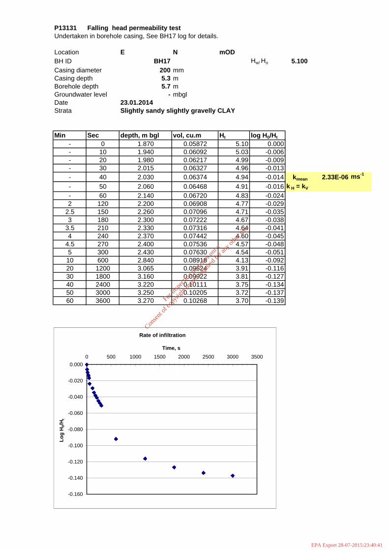
P13131 Falling head permeability testUndertaken in borehole casing, See BH17 log for details.
Location E N mODBH ID BH17 Hw/ Ho 5.100Casing diameter 200 mmCasing depth 5.3 mBorehole depth 5.7 mGroundwater level - mbglDate 23.01.2014Strata Slightly sandy slightly gravelly CLAY
Min Sec depth, m bgl vol, cu.m Ht log H0/Ht- 0 1.870 0.05872 5.10 0.000- 10 1.940 0.06092 5.03 -0.006- 20 1.980 0.06217 4.99 -0.009- 30 2.015 0.06327 4.96 -0.013- 40 2.030 0.06374 4.94 -0.014 kmean 2.33E-06 ms-1
- 50 2.060 0.06468 4.91 -0.016 k H = kV
- 60 2.140 0.06720 4.83 -0.0242 120 2.200 0.06908 4.77 -0.029
2.5 150 2.260 0.07096 4.71 -0.0353 180 2.300 0.07222 4.67 -0.038
3.5 210 2.330 0.07316 4.64 -0.0414 240 2.370 0.07442 4.60 -0.045
4.5 270 2.400 0.07536 4.57 -0.0485 300 2.430 0.07630 4.54 -0.05110 600 2.840 0.08918 4.13 -0.09220 1200 3.065 0.09624 3.91 -0.11630 1800 3.160 0.09922 3.81 -0.12740 2400 3.220 0.10111 3.75 -0.13450 3000 3.250 0.10205 3.72 -0.13760 3600 3.270 0.10268 3.70 -0.139
Rate of infiltration
-0.160
-0.140
-0.120
-0.100
-0.080
-0.060
-0.040
-0.020
0.0000 500 1000 1500 2000 2500 3000 3500
Time, s
Log
H0/H
t
For
insp
ectio
n pur
pose
s only
.
Conse
nt of
copy
right
owne
r req
uired
for a
ny ot
her u
se.
EPA Export 28-07-2015:23:40:41
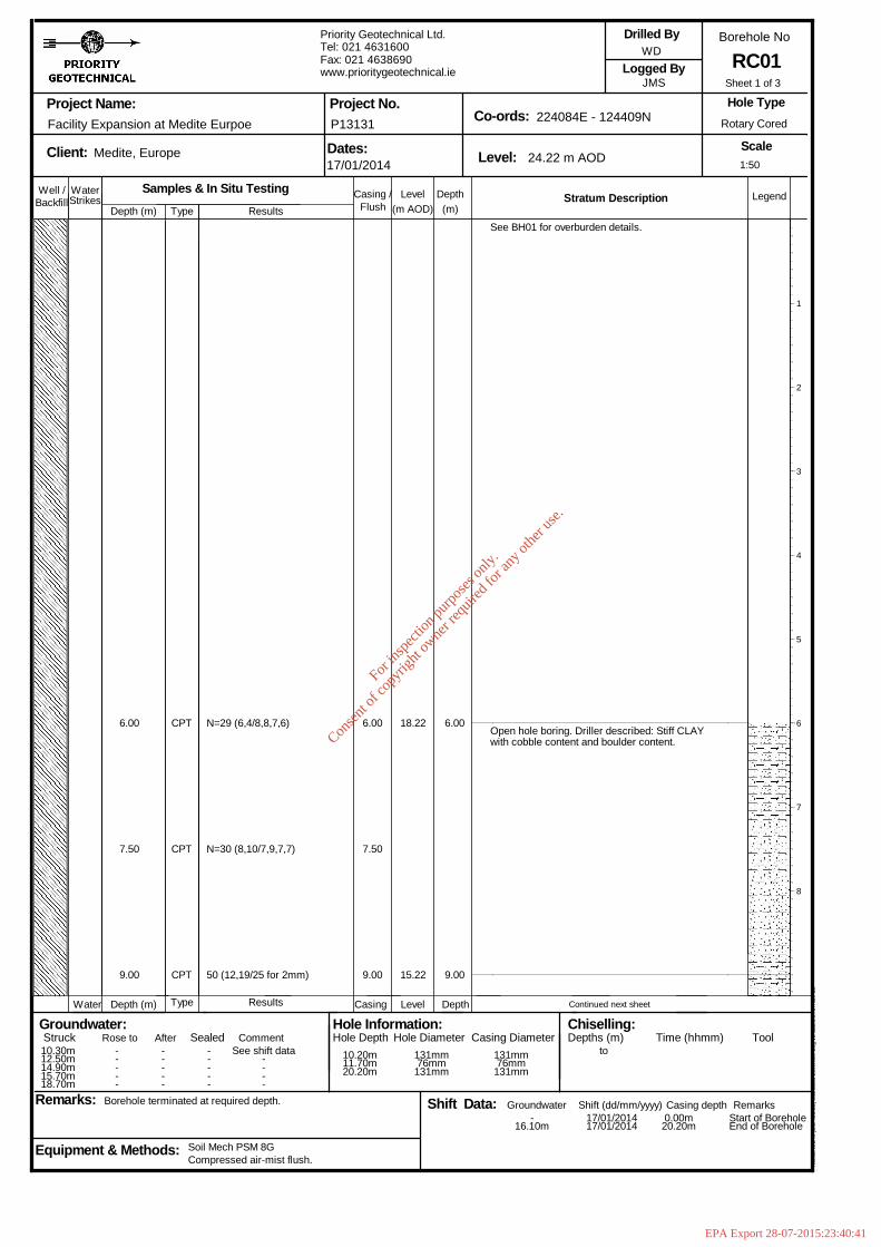
9.00
See BH01 for overburden details.
Open hole boring. Driller described: Stiff CLAYwith cobble content and boulder content.
Continued next sheet
1
2
3
4
5
6
7
8
1:50
Sheet 1 of 3
Well / WaterStrikes
Depth (m)DepthLevel Legend(m)(m AOD)
Stratum Description
Project Name:
Client: Dates: Level:
Co-ords:Project No.
Borehole No
Scale
Logged By
Remarks:
Hole Type
Groundwater:Struck Sealed
Backfill
Depth (m) Level Depth
Rose to
Casing /
Casing
Equipment & Methods:
Drilled By
Hole Information:Hole Depth Casing Diameter
Chiselling:Depths (m) Time (hhmm) Tool
Water
Afterto
Shift Data: Shift (dd/mm/yyyy)
Flush
Casing depth Remarks
Comment
Groundwater
Hole Diameter
Facility Expansion at Medite Eurpoe
Medite, Europe
Borehole terminated at required depth.
Type
Type
Compressed air-mist flush.Soil Mech PSM 8G
Samples & In Situ TestingResults
Results
Priority Geotechnical Ltd.Tel: 021 4631600Fax: 021 4638690www.prioritygeotechnical.ie
17/01/2014
P13131
24.22 m AOD
224084E - 124409N
WD
JMS
Rotary Cored
RC01
Hol
eBA
SE
III (
Bld
426
.58)
Sta
ndar
d B
oreh
ole
Log
v2 d
ated
27t
h N
ov 0
3
10.30m12.50m14.90m15.70m18.70m
-----
-----
-----
See shift data----
10.20m11.70m20.20m
131mm76mm131mm
131mm76mm131mm
-16.10m
17/01/201417/01/2014
0.00m20.20m
Start of BoreholeEnd of Borehole
6.00
7.50
9.00
CPT
CPT
CPT
N=29 (6,4/8,8,7,6)
N=30 (8,10/7,9,7,7)
50 (12,19/25 for 2mm)
6.00
7.50
9.00
18.22
15.22
6.00
For
insp
ectio
n pur
pose
s only
.
Conse
nt of
copy
right
owne
r req
uired
for a
ny ot
her u
se.
EPA Export 28-07-2015:23:40:41
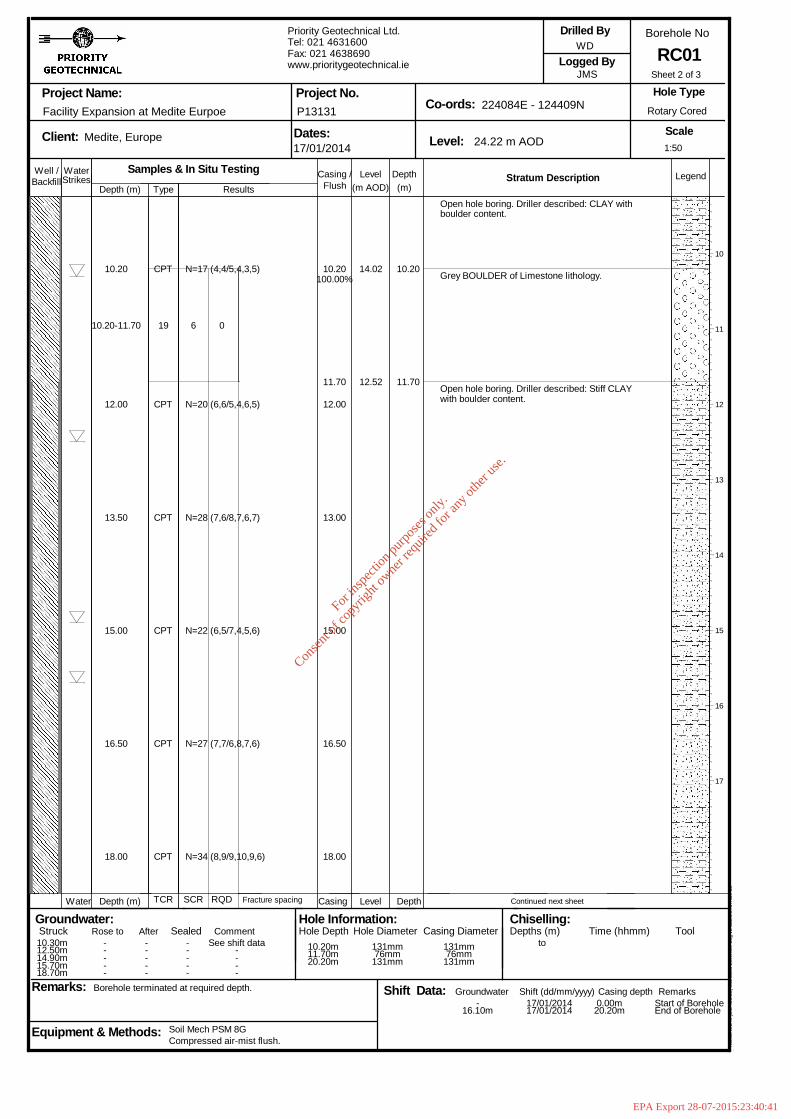
10.20
10.20-11.70
12.00
13.50
15.00
16.50
18.00
CPT
19
CPT
CPT
CPT
CPT
CPT
N=17 (4,4/5,4,3,5)
N=20 (6,6/5,4,6,5)
N=28 (7,6/8,7,6,7)
N=22 (6,5/7,4,5,6)
N=27 (7,7/6,8,7,6)
N=34 (8,9/9,10,9,6)
6 0
10.20100.00%
11.70
12.00
13.00
15.00
16.50
18.00
14.02
12.52
10.20
11.70
Open hole boring. Driller described: CLAY withboulder content.
Grey BOULDER of Limestone lithology.
Open hole boring. Driller described: Stiff CLAYwith boulder content.
Continued next sheet
10
11
12
13
14
15
16
17
1:50
Sheet 2 of 3
Well / WaterStrikes
Depth (m)DepthLevel Legend(m)(m AOD)
Stratum Description
Project Name:
Client: Dates: Level:
Co-ords:Project No.
Borehole No
Scale
Logged By
Remarks:
Hole Type
Groundwater:Struck Sealed
Backfill
Depth (m) Level Depth
Rose to
Casing /
Casing
Equipment & Methods:
Drilled By
Hole Information:Hole Depth Casing Diameter
Chiselling:Depths (m) Time (hhmm) Tool
Water
Afterto
Shift Data: Shift (dd/mm/yyyy)
Flush
Casing depth Remarks
Comment
Groundwater
Hole Diameter
Facility Expansion at Medite Eurpoe
Medite, Europe
Borehole terminated at required depth.
Type
TCR
Compressed air-mist flush.Soil Mech PSM 8G
SCR
Samples & In Situ Testing
RQD
Results
Fracture spacing
Priority Geotechnical Ltd.Tel: 021 4631600Fax: 021 4638690www.prioritygeotechnical.ie
17/01/2014
P13131
24.22 m AOD
224084E - 124409N
WD
JMS
Rotary Cored
RC01
Hol
eBA
SE
III (
Bld
426
.58)
Sta
ndar
d B
oreh
ole
Log
v2 d
ated
27t
h N
ov 0
3
10.30m12.50m14.90m15.70m18.70m
-----
-----
-----
See shift data----
10.20m11.70m20.20m
131mm76mm131mm
131mm76mm131mm
-16.10m
17/01/201417/01/2014
0.00m20.20m
Start of BoreholeEnd of Borehole
For
insp
ectio
n pur
pose
s only
.
Conse
nt of
copy
right
owne
r req
uired
for a
ny ot
her u
se.
EPA Export 28-07-2015:23:40:41
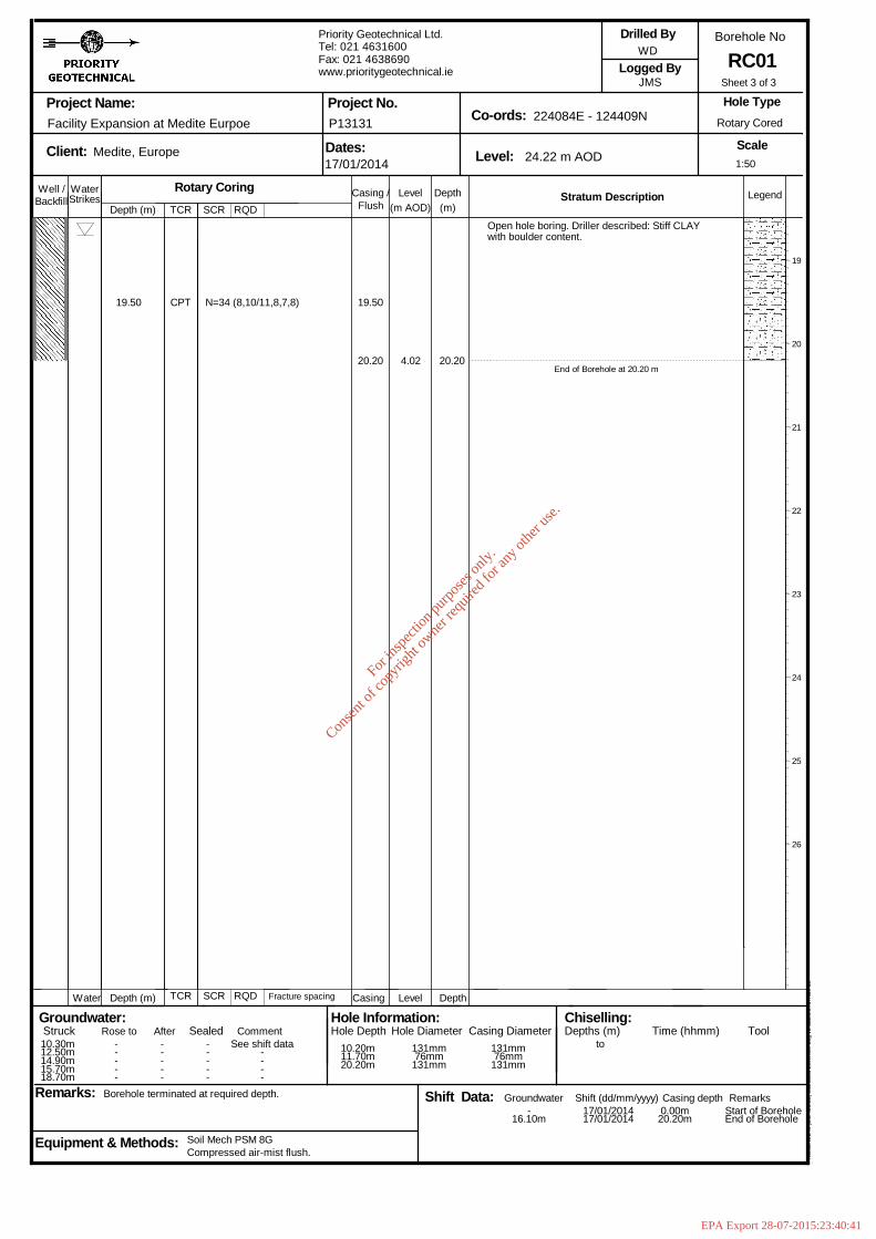
End of Borehole at 20.20 m
19
20
21
22
23
24
25
26
1:50
Sheet 3 of 3
Well / WaterStrikes
Depth (m)DepthLevel Legend(m)(m AOD)
Stratum Description
Project Name:
Client: Dates: Level:
Co-ords:Project No.
Borehole No
Scale
Logged By
Remarks:
Hole Type
Groundwater:Struck Sealed
Backfill
Depth (m) Level Depth
Rose to
Casing /
Casing
Equipment & Methods:
Drilled By
Hole Information:Hole Depth Casing Diameter
Chiselling:Depths (m) Time (hhmm) Tool
Water
Afterto
Shift Data: Shift (dd/mm/yyyy)
Flush
Casing depth Remarks
Comment
Groundwater
Hole Diameter
Facility Expansion at Medite Eurpoe
Medite, Europe
Borehole terminated at required depth.
TCR
TCR
Compressed air-mist flush.Soil Mech PSM 8G
SCR
SCR
Rotary CoringRQD
RQD Fracture spacing
Priority Geotechnical Ltd.Tel: 021 4631600Fax: 021 4638690www.prioritygeotechnical.ie
17/01/2014
P13131
24.22 m AOD
224084E - 124409N
WD
JMS
Rotary Cored
RC01
Hol
eBA
SE
III (
Bld
426
.58)
Sta
ndar
d B
oreh
ole
Log
v2 d
ated
27t
h N
ov 0
3
10.30m12.50m14.90m15.70m18.70m
-----
-----
-----
See shift data----
10.20m11.70m20.20m
131mm76mm131mm
131mm76mm131mm
-16.10m
17/01/201417/01/2014
0.00m20.20m
Start of BoreholeEnd of Borehole
19.50 CPT N=34 (8,10/11,8,7,8) 19.50
20.20 4.02 20.20
Open hole boring. Driller described: Stiff CLAYwith boulder content.
For
insp
ectio
n pur
pose
s only
.
Conse
nt of
copy
right
owne
r req
uired
for a
ny ot
her u
se.
EPA Export 28-07-2015:23:40:41
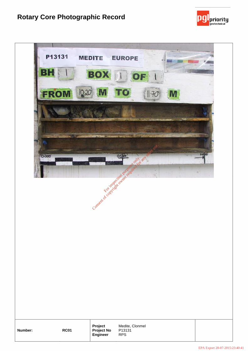
Rotary Core Photographic Record
Number:
RC01
Project Project No Engineer
Medite, Clonmel P13131 RPS
For
insp
ectio
n pur
pose
s only
.
Conse
nt of
copy
right
owne
r req
uired
for a
ny ot
her u
se.
EPA Export 28-07-2015:23:40:41
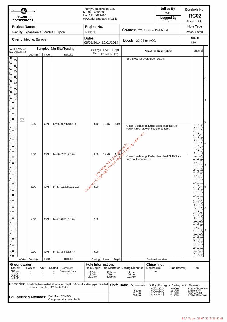
N=30 (7,7/8,9,7,6)
N=33 (12,6/6,10,7,10)
N=27 (6,8/8,6,7,6)
N=21 (3,4/6,5,6,4)
3.10
4.50
6.00
7.50
9.00
19.16
17.76
3.10
4.50
See BH02 for overburden details.
Open hole boring. Driller described: Dense,sandy GRAVEL with boulder content.
Open hole boring. Driller described: Stiff CLAYwith boulder content.
Continued next sheet
1
2
3
4
5
6
7
8
1:50
Sheet 1 of 3
Well / WaterStrikes
Depth (m)DepthLevel Legend(m)(m AOD)
Stratum Description
Project Name:
Client: Dates: Level:
Co-ords:Project No.
Borehole No
Scale
Logged By
Remarks:
Hole Type
Groundwater:Struck Sealed
Backfill
Depth (m) Level Depth
Rose to
Casing /
Casing
Equipment & Methods:
Drilled By
Hole Information:Hole Depth Casing Diameter
Chiselling:Depths (m) Time (hhmm) Tool
Water
Afterto
Shift Data: Shift (dd/mm/yyyy)
Flush
Casing depth Remarks
Comment
Groundwater
Hole Diameter
Facility Expansion at Medite Eurpoe
Medite, Europe
Borehole terminated at required depth. 50mm dia standpipe installed,response zone from 20.2m to 2.0m.
Type
Type
Compressed air-mist flush.Soil Mech PSM 8G
Samples & In Situ TestingResults
Results
Priority Geotechnical Ltd.Tel: 021 4631600Fax: 021 4638690www.prioritygeotechnical.ie
09/01/2014-10/01/2014
P13131
22.26 m AOD
224137E - 124370N
WD
-
Rotary Cored
RC02
Hol
eBA
SE
III (
Bld
426
.58)
Sta
ndar
d B
oreh
ole
Log
v2 d
ated
27t
h N
ov 0
3
3.00m10.10m14.90m17.60m
----
----
----
See shift data---
15.00m16.00m20.20m
131mm76mm131mm
131mm76mm131mm
-4.10m2.60m9.40m
09/01/201409/01/201410/01/201410/01/2014
0.00m15.00m15.00m20.20m
Start of BoreholeEnd of shiftStart of shiftEnd of Borehole
3.10
4.50
6.00
7.50
9.00
CPT
CPT
CPT
CPT
CPT
N=35 (9,7/10,8,8,9)
For
insp
ectio
n pur
pose
s only
.
Conse
nt of
copy
right
owne
r req
uired
for a
ny ot
her u
se.
EPA Export 28-07-2015:23:40:41
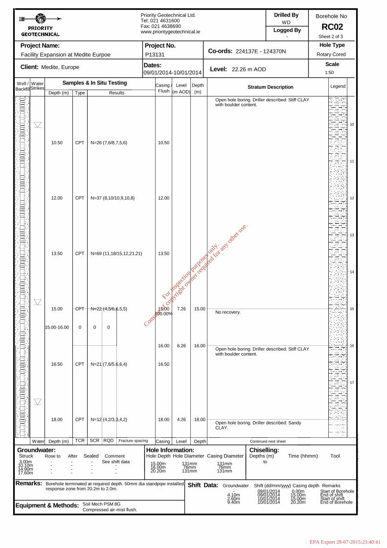
10.50
12.00
13.50
15.00
15.00-16.00
16.50
18.00
CPT
CPT
CPT
CPT
0
CPT
CPT
N=26 (7,6/8,7,5,6)
N=37 (8,10/10,9,10,8)
N=69 (11,18/15,12,21,21)
N=22 (4,5/6,6,5,5)
N=21 (7,6/5,6,6,4)
N=12 (4,2/3,3,4,2)
0 0
10.50
12.00
13.50
15.00100.00%
16.00
16.50
18.00
7.26
6.26
4.26
15.00
16.00
18.00
Open hole boring. Driller described: Stiff CLAYwith boulder content.
No recovery.
Open hole boring. Driller described: Stiff CLAYwith boulder content.
Open hole boring. Driller described: SandyCLAY.
Continued next sheet
10
11
12
13
14
15
16
17
1:50
Sheet 2 of 3
Well / WaterStrikes
Depth (m)DepthLevel Legend(m)(m AOD)
Stratum Description
Project Name:
Client: Dates: Level:
Co-ords:Project No.
Borehole No
Scale
Logged By
Remarks:
Hole Type
Groundwater:Struck Sealed
Backfill
Depth (m) Level Depth
Rose to
Casing /
Casing
Equipment & Methods:
Drilled By
Hole Information:Hole Depth Casing Diameter
Chiselling:Depths (m) Time (hhmm) Tool
Water
Afterto
Shift Data: Shift (dd/mm/yyyy)
Flush
Casing depth Remarks
Comment
Groundwater
Hole Diameter
Facility Expansion at Medite Eurpoe
Medite, Europe
Borehole terminated at required depth. 50mm dia standpipe installed,response zone from 20.2m to 2.0m.
Type
TCR
Compressed air-mist flush.Soil Mech PSM 8G
SCR
Samples & In Situ Testing
RQD
Results
Fracture spacing
Priority Geotechnical Ltd.Tel: 021 4631600Fax: 021 4638690www.prioritygeotechnical.ie
09/01/2014-10/01/2014
P13131
22.26 m AOD
224137E - 124370N
WD
-
Rotary Cored
RC02
Hol
eBA
SE
III (
Bld
426
.58)
Sta
ndar
d B
oreh
ole
Log
v2 d
ated
27t
h N
ov 0
3
3.00m10.10m14.90m17.60m
----
----
----
See shift data---
15.00m16.00m20.20m
131mm76mm131mm
131mm76mm131mm
-4.10m2.60m9.40m
09/01/201409/01/201410/01/201410/01/2014
0.00m15.00m15.00m20.20m
Start of BoreholeEnd of shiftStart of shiftEnd of Borehole
For
insp
ectio
n pur
pose
s only
.
Conse
nt of
copy
right
owne
r req
uired
for a
ny ot
her u
se.
EPA Export 28-07-2015:23:40:41
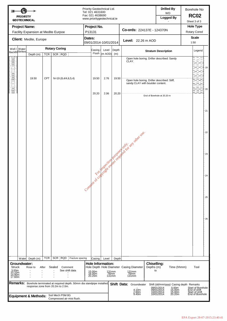
20.20
Open hole boring. Driller described: SandyCLAY.
Open hole boring. Driller described: Stiff,sandy CLAY with boulder content.
End of Borehole at 20.20 m
19
20
21
22
23
24
25
26
1:50
Sheet 3 of 3
Well / WaterStrikes
Depth (m)DepthLevel Legend(m)(m AOD)
Stratum Description
Project Name:
Client: Dates: Level:
Co-ords:Project No.
Borehole No
Scale
Logged By
Remarks:
Hole Type
Groundwater:Struck Sealed
Backfill
Depth (m) Level Depth
Rose to
Casing /
Casing
Equipment & Methods:
Drilled By
Hole Information:Hole Depth Casing Diameter
Chiselling:Depths (m) Time (hhmm) Tool
Water
Afterto
Shift Data: Shift (dd/mm/yyyy)
Flush
Casing depth Remarks
Comment
Groundwater
Hole Diameter
Facility Expansion at Medite Eurpoe
Medite, Europe
Borehole terminated at required depth. 50mm dia standpipe installed,response zone from 20.2m to 2.0m.
TCR
TCR
Compressed air-mist flush.Soil Mech PSM 8G
SCR
SCR
Rotary CoringRQD
RQD Fracture spacing
Priority Geotechnical Ltd.Tel: 021 4631600Fax: 021 4638690www.prioritygeotechnical.ie
09/01/2014-10/01/2014
P13131
22.26 m AOD
224137E - 124370N
WD
-
Rotary Cored
RC02
Hol
eBA
SE
III (
Bld
426
.58)
Sta
ndar
d B
oreh
ole
Log
v2 d
ated
27t
h N
ov 0
3
3.00m10.10m14.90m17.60m
----
----
----
See shift data---
15.00m16.00m20.20m
131mm76mm131mm
131mm76mm131mm
-4.10m2.60m9.40m
09/01/201409/01/201410/01/201410/01/2014
0.00m15.00m15.00m20.20m
Start of BoreholeEnd of shiftStart of shiftEnd of Borehole
19.50 CPT N=19 (8,4/4,6,5,4) 19.50
20.20
2.76
2.06
19.50
For
insp
ectio
n pur
pose
s only
.
Conse
nt of
copy
right
owne
r req
uired
for a
ny ot
her u
se.
EPA Export 28-07-2015:23:40:41
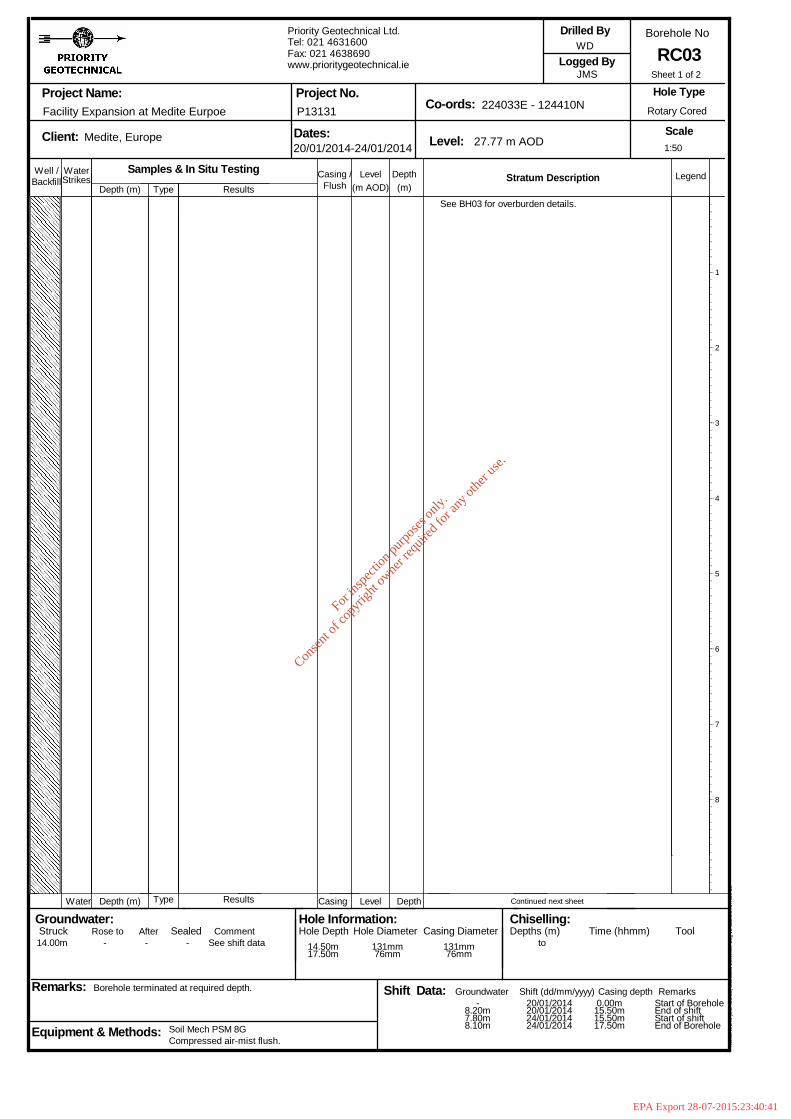
Well / WaterStrikes
Depth (m)DepthLevel Legend(m)(m AOD)
Stratum Description
Project Name:
Client: Dates: Level:
Co-ords:Project No.
Borehole No
Scale
Logged By
Remarks:
Hole Type
Groundwater:Struck Sealed
Backfill
Depth (m) Level Depth
Rose to
Casing /
Casing
Equipment & Methods:
Drilled By
Hole Information:Hole Depth Casing Diameter
Chiselling:Depths (m) Time (hhmm) Tool
Water
Afterto
Shift Data: Shift (dd/mm/yyyy)
Flush
Casing depth Remarks
Comment
Groundwater
Hole Diameter
Facility Expansion at Medite Eurpoe
Medite, Europe
Borehole terminated at required depth.
Type
Type
Compressed air-mist flush.Soil Mech PSM 8G
Samples & In Situ TestingResults
Results
Priority Geotechnical Ltd.Tel: 021 4631600Fax: 021 4638690www.prioritygeotechnical.ie
20/01/2014-24/01/2014
P13131
27.77 m AOD
224033E - 124410N
WD
JMS
Rotary Cored
RC03
Hol
eBA
SE
III (
Bld
426
.58)
Sta
ndar
d B
oreh
ole
Log
v2 d
ated
27t
h N
ov 0
3
14.00m - - - See shift data 14.50m17.50m
131mm76mm
131mm76mm
-8.20m7.80m8.10m
20/01/201420/01/201424/01/201424/01/2014
0.00m15.50m15.50m17.50m
Start of BoreholeEnd of shiftStart of shiftEnd of Borehole
See BH03 for overburden details.
Continued next sheet
1
2
3
4
5
6
7
8
1:50
Sheet 1 of 2
For
insp
ectio
n pur
pose
s only
.
Conse
nt of
copy
right
owne
r req
uired
for a
ny ot
her u
se.
EPA Export 28-07-2015:23:40:41

15.00-15.50
15.50-16.30
16.30-17.50
CPT
80
50
79
87
(50 for 2mm)
60
30
90
68
44
20
56
59
30mm min100mm avg210mm max
14.4014.50
100.00%
17.50
13.3713.27
10.27
14.4014.50
17.50
See BH03 for overburden details.
Open hole boring. Driller described: Rock.
Strong, grey, fossiliferous LIMESTONE withcalcite veining. Fractures: Weathering:Slightly weathered. Loss of strength. Claysmearing. Localised discolouration. Fractures:Closely to medium spaced. Fractures dipapproximately 65-90 degrees with planar andundulating surfaces.
14.5m - 15.0m: Fracture index - 5.15.0m - 15.5m: Fracture index - 5.15.5m - 16.3m: Fracture index - 8.
16.3m - 17.5m: Fracture index - 8.16.35m - 16.85m: Non-intact.
End of Borehole at 17.50 m
10
11
12
13
14
15
16
17
1:50
Sheet 2 of 2
Well / WaterStrikes
Depth (m)DepthLevel Legend(m)(m AOD)
Stratum Description
Project Name:
Client: Dates: Level:
Co-ords:Project No.
Borehole No
Scale
Logged By
Remarks:
Hole Type
Groundwater:Struck Sealed
Backfill
Depth (m) Level Depth
Rose to
Casing /
Casing
Equipment & Methods:
Drilled By
Hole Information:Hole Depth Casing Diameter
Chiselling:Depths (m) Time (hhmm) Tool
Water
Afterto
Shift Data: Shift (dd/mm/yyyy)
Flush
Casing depth Remarks
Comment
Groundwater
Hole Diameter
Facility Expansion at Medite Eurpoe
Medite, Europe
Borehole terminated at required depth.
Type
TCR
Compressed air-mist flush.Soil Mech PSM 8G
SCR
Samples & In Situ Testing
RQD
Results
Fracture spacing
Priority Geotechnical Ltd.Tel: 021 4631600Fax: 021 4638690www.prioritygeotechnical.ie
20/01/2014-24/01/2014
P13131
27.77 m AOD
224033E - 124410N
WD
JMS
Rotary Cored
RC03
Hol
eBA
SE
III (
Bld
426
.58)
Sta
ndar
d B
oreh
ole
Log
v2 d
ated
27t
h N
ov 0
3
14.00m - - - See shift data 14.50m17.50m
131mm76mm
131mm76mm
-8.20m7.80m8.10m
20/01/201420/01/201424/01/201424/01/2014
0.00m15.50m15.50m17.50m
Start of BoreholeEnd of shiftStart of shiftEnd of Borehole
14.40
14.50-15.00
For
insp
ectio
n pur
pose
s only
.
Conse
nt of
copy
right
owne
r req
uired
for a
ny ot
her u
se.
EPA Export 28-07-2015:23:40:41
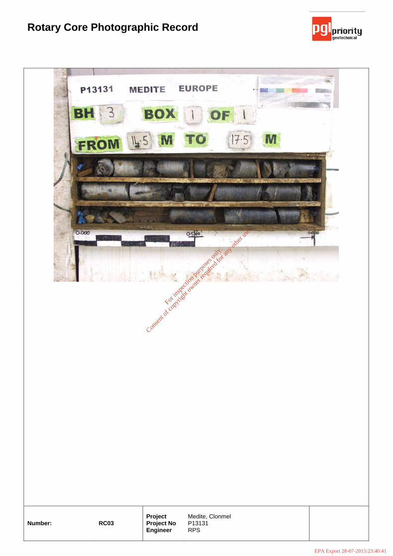
Rotary Core Photographic Record
Number:
RC03
Project Project No Engineer
Medite, Clonmel P13131 RPS
For
insp
ectio
n pur
pose
s only
.
Conse
nt of
copy
right
owne
r req
uired
for a
ny ot
her u
se.
EPA Export 28-07-2015:23:40:41
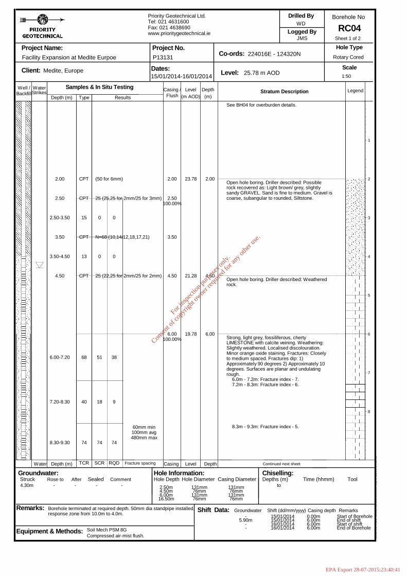
2.00
2.50
2.50-3.50
3.50
3.50-4.50
4.50
6.00-7.20
7.20-8.30
8.30-9.30
CPT
CPT
15
CPT
13
CPT
68
40
74
(50 for 6mm)
25 (25,25 for 2mm/25 for 3mm)
N=68 (10,14/12,18,17,21)
25 (22,25 for 2mm/25 for 2mm)
0
0
51
18
74
0
0
38
9
74
60mm min100mm avg480mm max
2.00
2.50100.00%
3.50
4.50
6.00100.00%
23.78
21.28
19.78
2.00
4.50
6.00
See BH04 for overburden details.
Open hole boring. Driller described: Possiblerock recovered as: Light brown/ grey, slightlysandy GRAVEL. Sand is fine to medium. Gravel iscoarse, subangular to rounded, Siltstone.
Open hole boring. Driller described: Weatheredrock.
Strong, light grey, fossiliferous, chertyLIMESTONE with calcite veining. Weathering:Slightly weathered. Localised discolouration.Minor orange oxide staining. Fractures: Closelyto medium spaced. Fractures dip: 1)Approximately 90 degrees 2) Approximately 10degrees. Surfaces are planar and undulatingrough.
6.0m - 7.2m: Fracture index - 7.7.2m - 8.3m: Fracture index - 6.
8.3m - 9.3m: Fracture index - 5.
Continued next sheet
1
2
3
4
5
6
7
8
1:50
Sheet 1 of 2
Well / WaterStrikes
Depth (m)DepthLevel Legend(m)(m AOD)
Stratum Description
Project Name:
Client: Dates: Level:
Co-ords:Project No.
Borehole No
Scale
Logged By
Remarks:
Hole Type
Groundwater:Struck Sealed
Backfill
Depth (m) Level Depth
Rose to
Casing /
Casing
Equipment & Methods:
Drilled By
Hole Information:Hole Depth Casing Diameter
Chiselling:Depths (m) Time (hhmm) Tool
Water
Afterto
Shift Data: Shift (dd/mm/yyyy)
Flush
Casing depth Remarks
Comment
Groundwater
Hole Diameter
Facility Expansion at Medite Eurpoe
Medite, Europe
Borehole terminated at required depth. 50mm dia standpipe installed,response zone from 10.0m to 4.0m.
Type
TCR
Compressed air-mist flush.Soil Mech PSM 8G
SCR
Samples & In Situ Testing
RQD
Results
Fracture spacing
Priority Geotechnical Ltd.Tel: 021 4631600Fax: 021 4638690www.prioritygeotechnical.ie
15/01/2014-16/01/2014
P13131
25.78 m AOD
224016E - 124320N
WD
JMS
Rotary Cored
RC04
Hol
eBA
SE
III (
Bld
426
.58)
Sta
ndar
d B
oreh
ole
Log
v2 d
ated
27t
h N
ov 0
3
4.30m - - - - 2.50m4.50m6.00m16.50m
131mm76mm131mm76mm
131mm76mm131mm76mm
-5.90m
--
15/01/201415/01/201416/01/201416/01/2014
0.00m6.00m6.00m6.00m
Start of BoreholeEnd of shiftStart of shiftEnd of Borehole
For
insp
ectio
n pur
pose
s only
.
Conse
nt of
copy
right
owne
r req
uired
for a
ny ot
her u
se.
EPA Export 28-07-2015:23:40:41
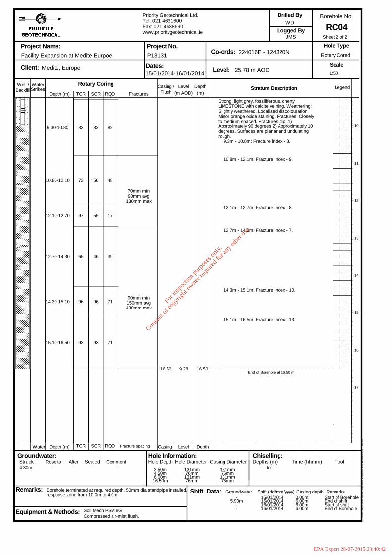
9.30-10.80
10.80-12.10
12.10-12.70
12.70-14.30
14.30-15.10
15.10-16.50
82
73
97
65
96
93
82
56
55
46
96
93
82
48
17
39
71
71
70mm min90mm avg
130mm max
90mm min150mm avg430mm max
16.50 9.28 16.50
Strong, light grey, fossiliferous, chertyLIMESTONE with calcite veining. Weathering:Slightly weathered. Localised discolouration.Minor orange oxide staining. Fractures: Closelyto medium spaced. Fractures dip: 1)Approximately 90 degrees 2) Approximately 10degrees. Surfaces are planar and undulatingrough.
9.3m - 10.8m: Fracture index - 8.
10.8m - 12.1m: Fracture index - 9.
12.1m - 12.7m: Fracture index - 8.
12.7m - 14.3m: Fracture index - 7.
14.3m - 15.1m: Fracture index - 10.
15.1m - 16.5m: Fracture index - 13.
End of Borehole at 16.50 m
10
11
12
13
14
15
16
17
1:50
Sheet 2 of 2
Well / WaterStrikes
Depth (m)DepthLevel Legend(m)(m AOD)
Stratum Description
Project Name:
Client: Dates: Level:
Co-ords:Project No.
Borehole No
Scale
Logged By
Remarks:
Hole Type
Groundwater:Struck Sealed
Backfill
Depth (m) Level Depth
Rose to
Casing /
Casing
Equipment & Methods:
Drilled By
Hole Information:Hole Depth Casing Diameter
Chiselling:Depths (m) Time (hhmm) Tool
Water
Afterto
Shift Data: Shift (dd/mm/yyyy)
Flush
Casing depth Remarks
Comment
Groundwater
Hole Diameter
Facility Expansion at Medite Eurpoe
Medite, Europe
Borehole terminated at required depth. 50mm dia standpipe installed,response zone from 10.0m to 4.0m.
TCR
TCR
Compressed air-mist flush.Soil Mech PSM 8G
SCR
SCR
Rotary CoringRQD
RQD Fracture spacing
Fractures
Priority Geotechnical Ltd.Tel: 021 4631600Fax: 021 4638690www.prioritygeotechnical.ie
15/01/2014-16/01/2014
P13131
25.78 m AOD
224016E - 124320N
WD
JMS
Rotary Cored
RC04
Hol
eBA
SE
III (
Bld
426
.58)
Sta
ndar
d B
oreh
ole
Log
v2 d
ated
27t
h N
ov 0
3
4.30m - - - - 2.50m4.50m6.00m16.50m
131mm76mm131mm76mm
131mm76mm131mm76mm
-5.90m
--
15/01/201415/01/201416/01/201416/01/2014
0.00m6.00m6.00m6.00m
Start of BoreholeEnd of shiftStart of shiftEnd of Borehole
For
insp
ectio
n pur
pose
s only
.
Conse
nt of
copy
right
owne
r req
uired
for a
ny ot
her u
se.
EPA Export 28-07-2015:23:40:42

Rotary Core Photographic Record
Number:
RC04
Project Project No Engineer
Medite, Clonmel P13131 RPS
For
insp
ectio
n pur
pose
s only
.
Conse
nt of
copy
right
owne
r req
uired
for a
ny ot
her u
se.
EPA Export 28-07-2015:23:40:42
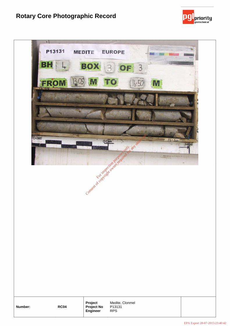
Rotary Core Photographic Record
Number:
RC04
Project Project No Engineer
Medite, Clonmel P13131 RPS
For
insp
ectio
n pur
pose
s only
.
Conse
nt of
copy
right
owne
r req
uired
for a
ny ot
her u
se.
EPA Export 28-07-2015:23:40:42
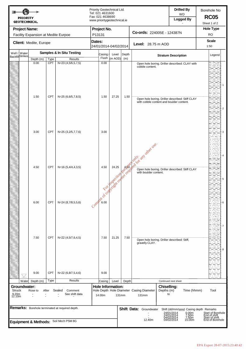
24.25
21.25
1.50
4.50
7.50
Open hole boring. Driller described: CLAY withcobble content.
Open hole boring. Driller described: Stiff CLAYwith cobble content and boulder content.
Open hole boring. Driller described: Stiff CLAYwith boulder content.
Open hole boring. Driller described: Stiff,gravelly CLAY.
Continued next sheet
1
2
3
4
5
6
7
8
1:50
Sheet 1 of 2
Well / WaterStrikes
Depth (m)DepthLevel Legend(m)(m AOD)
Stratum Description
Project Name:
Client: Dates: Level:
Co-ords:Project No.
Borehole No
Scale
Logged By
Remarks:
Hole Type
Groundwater:Struck Sealed
Backfill
Depth (m) Level Depth
Rose to
Casing /
Casing
Equipment & Methods:
Drilled By
Hole Information:Hole Depth Casing Diameter
Chiselling:Depths (m) Time (hhmm) Tool
Water
Afterto
Shift Data: Shift (dd/mm/yyyy)
Flush
Casing depth Remarks
Comment
Groundwater
Hole Diameter
Facility Expansion at Medite Eurpoe
Medite, Europe
Borehole terminated at required depth.
Type
Type
Soil Mech PSM 8G
Samples & In Situ TestingResults
Results
Priority Geotechnical Ltd.Tel: 021 4631600Fax: 021 4638690www.prioritygeotechnical.ie
24/01/2014-04/02/2014
P13131
28.75 m AOD
224005E - 124387N
WD
-
RO
RC05
Hol
eBA
SE
III (
Bld
426
.58)
Sta
ndar
d B
oreh
ole
Log
v2 d
ated
27t
h N
ov 0
3
9.20m12.10m
--
--
--
See shift data- 14.00m 131mm 131mm
---
12.40m
24/01/201424/01/201404/02/201404/02/2014
0.00m7.50m7.50m15.00m
Start of BoreholeEnd of shiftStart of shiftEnd of Borehole
0.00
1.50
3.00
4.50
6.00
7.50
9.00
CPT
CPT
CPT
CPT
CPT
CPT
CPT
N=23 (4,5/6,5,7,5)
N=25 (6,6/5,7,8,5)
N=25 (3,2/5,7,7,6)
N=16 (5,4/4,4,3,5)
N=24 (8,7/8,5,5,6)
N=22 (4,5/7,6,4,5)
N=22 (6,8/7,5,4,6)
0.00
1.50
3.00
4.50
6.00
7.50
9.00
27.25
For
insp
ectio
n pur
pose
s only
.
Conse
nt of
copy
right
owne
r req
uired
for a
ny ot
her u
se.
EPA Export 28-07-2015:23:40:42
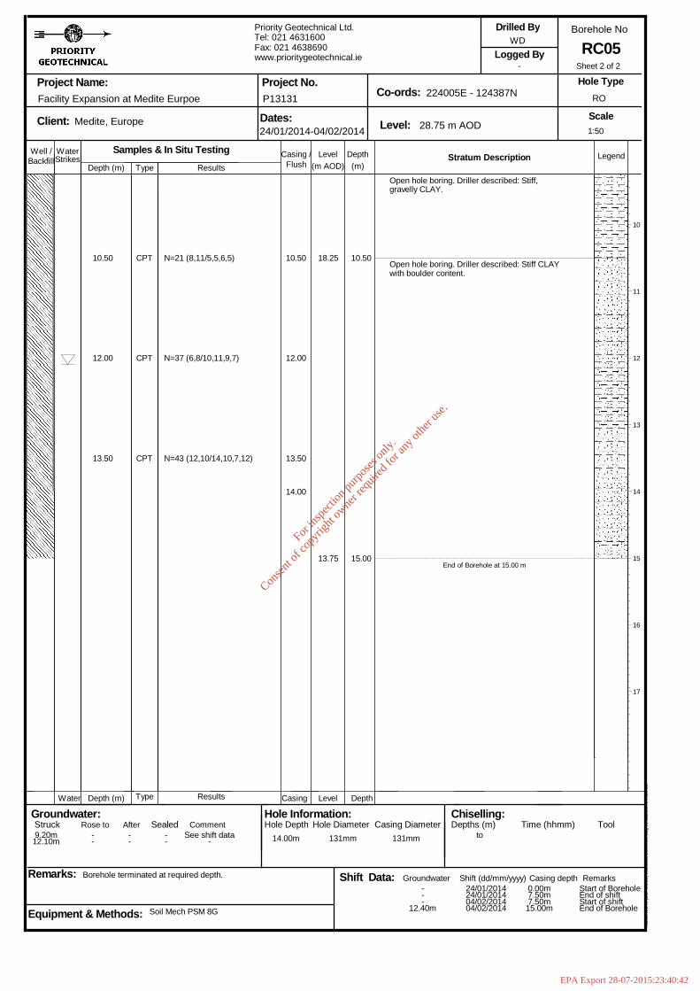
End of Borehole at 15.00 m
10
11
12
13
14
15
16
17
1:50
Sheet 2 of 2
Well / WaterStrikes
Depth (m)DepthLevel Legend(m)(m AOD)
Stratum Description
Project Name:
Client: Dates: Level:
Co-ords:Project No.
Borehole No
Scale
Logged By
Remarks:
Hole Type
Groundwater:Struck Sealed
Backfill
Depth (m) Level Depth
Rose to
Casing /
Casing
Equipment & Methods:
Drilled By
Hole Information:Hole Depth Casing Diameter
Chiselling:Depths (m) Time (hhmm) Tool
Water
Afterto
Shift Data: Shift (dd/mm/yyyy)
Flush
Casing depth Remarks
Comment
Groundwater
Hole Diameter
Facility Expansion at Medite Eurpoe
Medite, Europe
Borehole terminated at required depth.
Type
Type
Soil Mech PSM 8G
Samples & In Situ TestingResults
Results
Priority Geotechnical Ltd.Tel: 021 4631600Fax: 021 4638690www.prioritygeotechnical.ie
24/01/2014-04/02/2014
P13131
28.75 m AOD
224005E - 124387N
WD
-
RO
RC05
Hol
eBA
SE
III (
Bld
426
.58)
Sta
ndar
d B
oreh
ole
Log
v2 d
ated
27t
h N
ov 0
3
9.20m12.10m
--
--
--
See shift data- 14.00m 131mm 131mm
---
12.40m
24/01/201424/01/201404/02/201404/02/2014
0.00m7.50m7.50m15.00m
Start of BoreholeEnd of shiftStart of shiftEnd of Borehole
10.50
12.00
13.50
CPT
CPT
CPT
N=21 (8,11/5,5,6,5)
N=37 (6,8/10,11,9,7)
N=43 (12,10/14,10,7,12)
10.50
12.00
13.50
14.00
18.25
13.75
10.50
15.00
Open hole boring. Driller described: Stiff,gravelly CLAY.
Open hole boring. Driller described: Stiff CLAYwith boulder content.
For
insp
ectio
n pur
pose
s only
.
Conse
nt of
copy
right
owne
r req
uired
for a
ny ot
her u
se.
EPA Export 28-07-2015:23:40:42
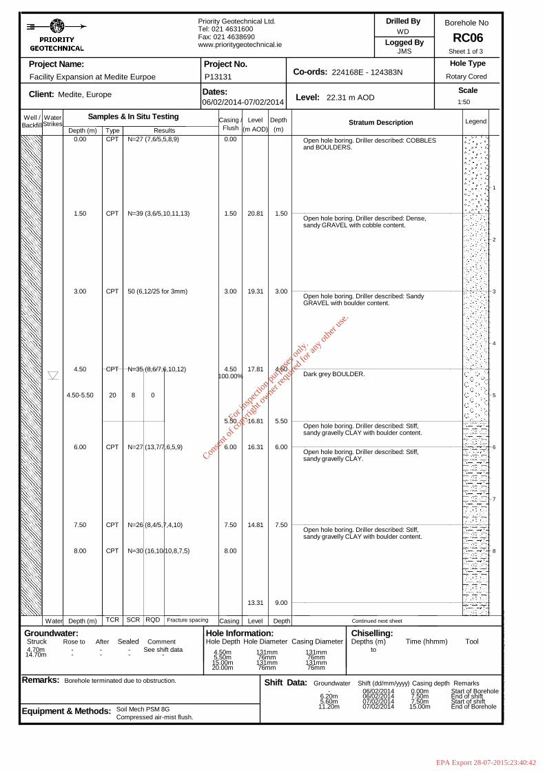
4.50
4.50-5.50
6.00
7.50
8.00
CPT
CPT
CPT
CPT
20
CPT
CPT
CPT
N=27 (7,6/5,5,8,9)
N=39 (3,6/5,10,11,13)
50 (6,12/25 for 3mm)
N=35 (8,6/7,6,10,12)
N=27 (13,7/7,6,5,9)
N=26 (8,4/5,7,4,10)
N=30 (16,10/10,8,7,5)
8 0
0.00
1.50
3.00
4.50100.00%
5.50
6.00
7.50
8.00
20.81
19.31
17.81
16.81
16.31
14.81
13.31
1.50
3.00
4.50
5.50
6.00
7.50
9.00
Open hole boring. Driller described: COBBLESand BOULDERS.
Open hole boring. Driller described: Dense,sandy GRAVEL with cobble content.
Open hole boring. Driller described: SandyGRAVEL with boulder content.
Dark grey BOULDER.
Open hole boring. Driller described: Stiff,sandy gravelly CLAY with boulder content.
Open hole boring. Driller described: Stiff,sandy gravelly CLAY.
Open hole boring. Driller described: Stiff,sandy gravelly CLAY with boulder content.
Continued next sheet
1
2
3
4
5
6
7
8
1:50
Sheet 1 of 3
Well / WaterStrikes
Depth (m)DepthLevel Legend(m)(m AOD)
Stratum Description
Project Name:
Client: Dates: Level:
Co-ords:Project No.
Borehole No
Scale
Logged By
Remarks:
Hole Type
Groundwater:Struck Sealed
Backfill
Depth (m) Level Depth
Rose to
Casing /
Casing
Equipment & Methods:
Drilled By
Hole Information:Hole Depth Casing Diameter
Chiselling:Depths (m) Time (hhmm) Tool
Water
Afterto
Shift Data: Shift (dd/mm/yyyy)
Flush
Casing depth Remarks
Comment
Groundwater
Hole Diameter
Facility Expansion at Medite Eurpoe
Medite, Europe
Borehole terminated due to obstruction.
Type
TCR
Compressed air-mist flush.Soil Mech PSM 8G
SCR
Samples & In Situ Testing
RQD
Results
Fracture spacing
Priority Geotechnical Ltd.Tel: 021 4631600Fax: 021 4638690www.prioritygeotechnical.ie
06/02/2014-07/02/2014
P13131
22.31 m AOD
224168E - 124383N
WD
JMS
Rotary Cored
RC06
Hol
eBA
SE
III (
Bld
426
.58)
Sta
ndar
d B
oreh
ole
Log
v2 d
ated
27t
h N
ov 0
3
4.70m14.70m
--
--
--
See shift data- 4.50m
5.50m15.00m20.00m
131mm76mm131mm76mm
131mm76mm131mm76mm
-6.20m5.60m11.20m
06/02/201406/02/201407/02/201407/02/2014
0.00m7.50m7.50m15.00m
Start of BoreholeEnd of shiftStart of shiftEnd of Borehole
0.00
1.50
3.00
For
insp
ectio
n pur
pose
s only
.
Conse
nt of
copy
right
owne
r req
uired
for a
ny ot
her u
se.
EPA Export 28-07-2015:23:40:42
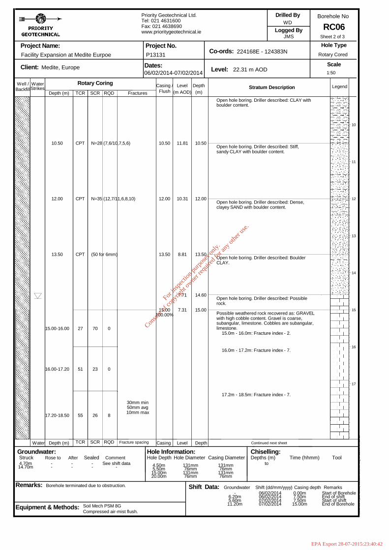
10.50
12.00
13.50
15.00-16.00
16.00-17.20
17.20-18.50
CPT
CPT
CPT
27
51
55
N=28 (7,6/10,7,5,6)
N=35 (12,7/11,6,8,10)
(50 for 6mm)
70
23
26
0
0
8
30mm min50mm avg10mm max
10.50
12.00
13.50
15.00100.00%
11.81
10.31
8.81
7.71
7.31
10.50
12.00
13.50
14.60
15.00
Open hole boring. Driller described: CLAY withboulder content.
Open hole boring. Driller described: Stiff,sandy CLAY with boulder content.
Open hole boring. Driller described: Dense,clayey SAND with boulder content.
Open hole boring. Driller described: BoulderCLAY.
Open hole boring. Driller described: Possiblerock.
Possible weathered rock recovered as: GRAVELwith high cobble content. Gravel is coarse,subangular, limestone. Cobbles are subangular,limestone.
15.0m - 16.0m: Fracture index - 2.
16.0m - 17.2m: Fracture index - 7.
17.2m - 18.5m: Fracture index - 7.
Continued next sheet
10
11
12
13
14
15
16
17
1:50
Sheet 2 of 3
Well / WaterStrikes
Depth (m)DepthLevel Legend(m)(m AOD)
Stratum Description
Project Name:
Client: Dates: Level:
Co-ords:Project No.
Borehole No
Scale
Logged By
Remarks:
Hole Type
Groundwater:Struck Sealed
Backfill
Depth (m) Level Depth
Rose to
Casing /
Casing
Equipment & Methods:
Drilled By
Hole Information:Hole Depth Casing Diameter
Chiselling:Depths (m) Time (hhmm) Tool
Water
Afterto
Shift Data: Shift (dd/mm/yyyy)
Flush
Casing depth Remarks
Comment
Groundwater
Hole Diameter
Facility Expansion at Medite Eurpoe
Medite, Europe
Borehole terminated due to obstruction.
TCR
TCR
Compressed air-mist flush.Soil Mech PSM 8G
SCR
SCR
Rotary CoringRQD
RQD Fracture spacing
Fractures
Priority Geotechnical Ltd.Tel: 021 4631600Fax: 021 4638690www.prioritygeotechnical.ie
06/02/2014-07/02/2014
P13131
22.31 m AOD
224168E - 124383N
WD
JMS
Rotary Cored
RC06
Hol
eBA
SE
III (
Bld
426
.58)
Sta
ndar
d B
oreh
ole
Log
v2 d
ated
27t
h N
ov 0
3
4.70m14.70m
--
--
--
See shift data- 4.50m
5.50m15.00m20.00m
131mm76mm131mm76mm
131mm76mm131mm76mm
-6.20m5.60m11.20m
06/02/201406/02/201407/02/201407/02/2014
0.00m7.50m7.50m15.00m
Start of BoreholeEnd of shiftStart of shiftEnd of Borehole
For
insp
ectio
n pur
pose
s only
.
Conse
nt of
copy
right
owne
r req
uired
for a
ny ot
her u
se.
EPA Export 28-07-2015:23:40:42
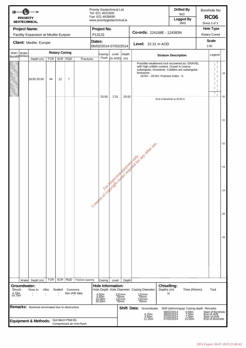
18.50-20.00 44 12 7
20.00 2.31 20.00
Possible weathered rock recovered as: GRAVELwith high cobble content. Gravel is coarse,subangular, limestone. Cobbles are subangular,limestone.
18.5m - 20.0m: Fracture index - 5.
End of Borehole at 20.00 m
19
20
21
22
23
24
25
26
1:50
Sheet 3 of 3
Well / WaterStrikes
Depth (m)DepthLevel Legend(m)(m AOD)
Stratum Description
Project Name:
Client: Dates: Level:
Co-ords:Project No.
Borehole No
Scale
Logged By
Remarks:
Hole Type
Groundwater:Struck Sealed
Backfill
Depth (m) Level Depth
Rose to
Casing /
Casing
Equipment & Methods:
Drilled By
Hole Information:Hole Depth Casing Diameter
Chiselling:Depths (m) Time (hhmm) Tool
Water
Afterto
Shift Data: Shift (dd/mm/yyyy)
Flush
Casing depth Remarks
Comment
Groundwater
Hole Diameter
Facility Expansion at Medite Eurpoe
Medite, Europe
Borehole terminated due to obstruction.
TCR
TCR
Compressed air-mist flush.Soil Mech PSM 8G
SCR
SCR
Rotary CoringRQD
RQD Fracture spacing
Fractures
Priority Geotechnical Ltd.Tel: 021 4631600Fax: 021 4638690www.prioritygeotechnical.ie
06/02/2014-07/02/2014
P13131
22.31 m AOD
224168E - 124383N
WD
JMS
Rotary Cored
RC06
Hol
eBA
SE
III (
Bld
426
.58)
Sta
ndar
d B
oreh
ole
Log
v2 d
ated
27t
h N
ov 0
3
4.70m14.70m
--
--
--
See shift data- 4.50m
5.50m15.00m20.00m
131mm76mm131mm76mm
131mm76mm131mm76mm
-6.20m5.60m11.20m
06/02/201406/02/201407/02/201407/02/2014
0.00m7.50m7.50m15.00m
Start of BoreholeEnd of shiftStart of shiftEnd of Borehole
For
insp
ectio
n pur
pose
s only
.
Conse
nt of
copy
right
owne
r req
uired
for a
ny ot
her u
se.
EPA Export 28-07-2015:23:40:42
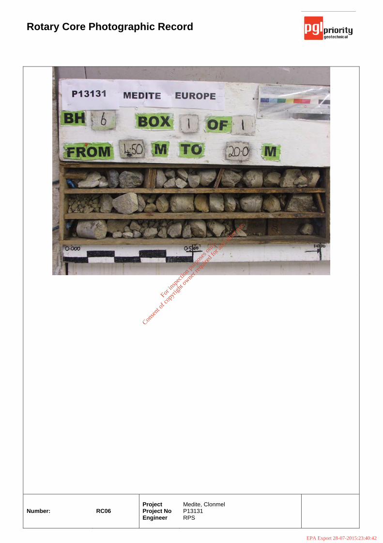
Rotary Core Photographic Record
Number:
RC06
Project Project No Engineer
Medite, Clonmel P13131 RPS
For
insp
ectio
n pur
pose
s only
.
Conse
nt of
copy
right
owne
r req
uired
for a
ny ot
her u
se.
EPA Export 28-07-2015:23:40:42
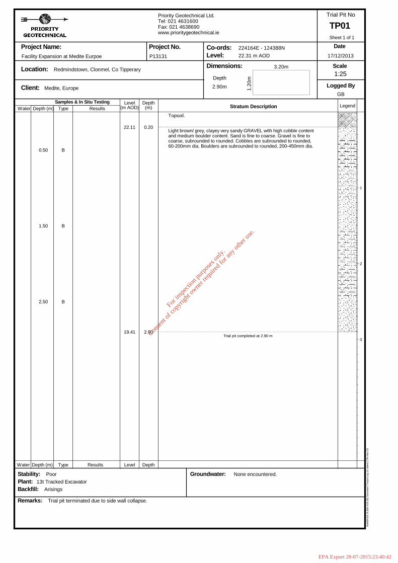
Samples & In Situ TestingDepth (m)
DepthLevel Legend(m)(m AOD) Stratum Description
Project Name:
Location:
Client:
Dimensions:Level:Co-ords:Project No.
Trial Pit No
Scale
Logged By
Remarks:
Date
Type Results
Groundwater:
Depth
Stability:
Water
Water Depth (m) Type Results Level Depth
Plant:Backfill:
Facility Expansion at Medite Eurpoe
13t Tracked Excavator
Medite, Europe
Arisings
Poor
Trial pit terminated due to side wall collapse.
Redmindstown, Clonmel, Co Tipperary
P13131
Priority Geotechnical Ltd.Tel: 021 4631600Fax: 021 4638690www.prioritygeotechnical.ie
2.90m
None encountered.
224164E - 124388N22.31 m AOD
1.20
m
3.20m
TP01
17/12/2013
GB
Hol
eBA
SE
III (
Bld
426
.58)
Sta
ndar
d Tr
ialp
it Lo
g v2
dat
ed 2
7th
Nov
03
0.50
1.50
2.50
B
B
B
22.11
19.41
0.20
2.90
Topsoil.
Light brown/ grey, clayey very sandy GRAVEL with high cobble contentand medium boulder content. Sand is fine to coarse. Gravel is fine tocoarse, subrounded to rounded. Cobbles are subrounded to rounded,60-200mm dia. Boulders are subrounded to rounded, 200-450mm dia.
Trial pit completed at 2.90 m
1
2
3
1:25
Sheet 1 of 1
For
insp
ectio
n pur
pose
s only
.
Conse
nt of
copy
right
owne
r req
uired
for a
ny ot
her u
se.
EPA Export 28-07-2015:23:40:42
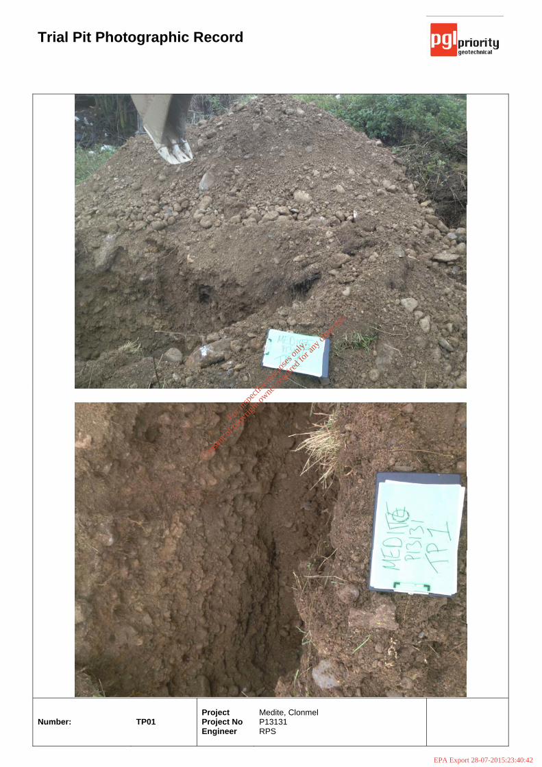
Trial Pit Photographic Record
Number:
TP01
Project Project No Engineer
Medite, Clonmel P13131 RPS
For
insp
ectio
n pur
pose
s only
.
Conse
nt of
copy
right
owne
r req
uired
for a
ny ot
her u
se.
EPA Export 28-07-2015:23:40:42
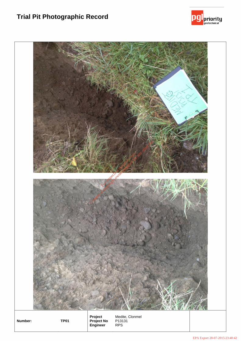
Trial Pit Photographic Record
Number:
TP01
Project Project No Engineer
Medite, Clonmel P13131 RPS
For
insp
ectio
n pur
pose
s only
.
Conse
nt of
copy
right
owne
r req
uired
for a
ny ot
her u
se.
EPA Export 28-07-2015:23:40:42

Samples & In Situ TestingDepth (m)
DepthLevel Legend(m)(m AOD) Stratum Description
Project Name:
Location:
Client:
Dimensions:Level:Co-ords:Project No.
Trial Pit No
Scale
Logged By
Remarks:
Date
Type Results
Groundwater:
Depth
Stability:
Water
Water Depth (m) Type Results Level Depth
Plant:Backfill:
Facility Expansion at Medite Eurpoe
13t Tracked Excavator
Medite, Europe
Arisings
Poor
Trial pit terminated due to side wall collapse.
Redmindstown, Clonmel, Co Tipperary
P13131
Priority Geotechnical Ltd.Tel: 021 4631600Fax: 021 4638690www.prioritygeotechnical.ie
3.10m
None encountered.
224152E - 124340N21.89 m AOD
1.10
m
3.20m
TP02
17/12/2013
GB
Hol
eBA
SE
III (
Bld
426
.58)
Sta
ndar
d Tr
ialp
it Lo
g v2
dat
ed 2
7th
Nov
03
0.50
1.50
2.50
B
B
B
21.64
20.99
18.79
0.25
0.90
3.10
Topsoil.
Soft, light brown, slightly gravelly sandy CLAY with low cobblecontent.
Light brown/ grey, clayey very sandy GRAVEL with high cobble content.Sand is fine to coarse. Gravel is fine to coarse, subrounded torounded. Cobbles re subrounded to rounded.
Trial pit completed at 3.10 m
1
2
3
1:25
Sheet 1 of 1
For
insp
ectio
n pur
pose
s only
.
Conse
nt of
copy
right
owne
r req
uired
for a
ny ot
her u
se.
EPA Export 28-07-2015:23:40:42
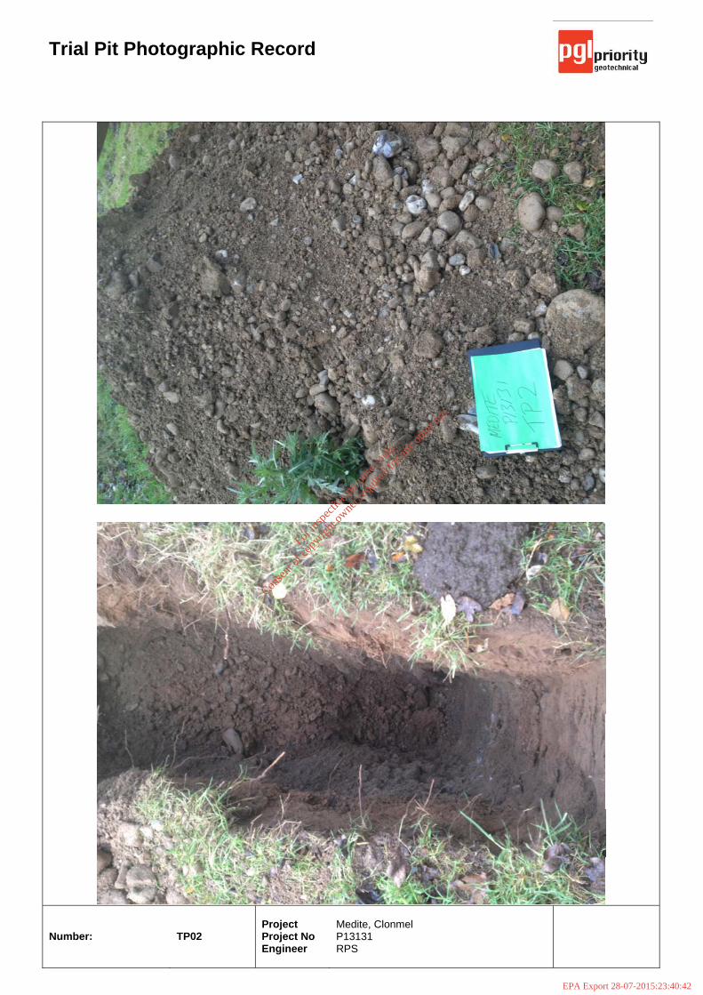
Trial Pit Photographic Record
Number:
TP02
Project Project No Engineer
Medite, Clonmel P13131 RPS
For
insp
ectio
n pur
pose
s only
.
Conse
nt of
copy
right
owne
r req
uired
for a
ny ot
her u
se.
EPA Export 28-07-2015:23:40:42
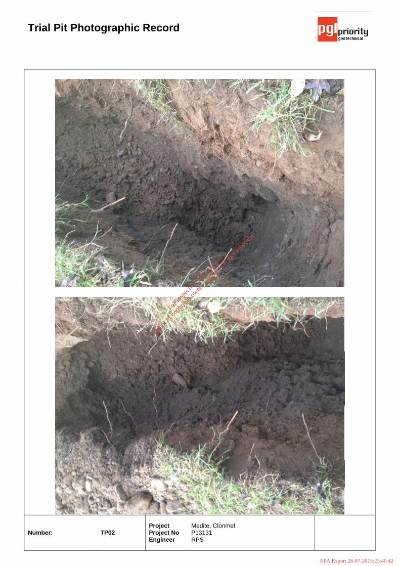
Trial Pit Photographic Record
Number:
TP02
Project Project No Engineer
Medite, Clonmel P13131 RPS
For
insp
ectio
n pur
pose
s only
.
Conse
nt of
copy
right
owne
r req
uired
for a
ny ot
her u
se.
EPA Export 28-07-2015:23:40:42
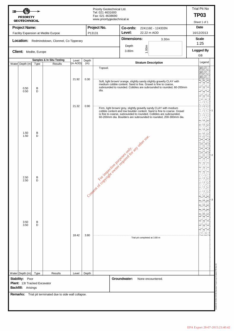
Samples & In Situ TestingDepth (m)
DepthLevel Legend(m)(m AOD) Stratum Description
Project Name:
Location:
Client:
Dimensions:Level:Co-ords:Project No.
Trial Pit No
Scale
Logged By
Remarks:
Date
Type Results
Groundwater:
Depth
Stability:
Water
Water Depth (m) Type Results Level Depth
Plant:Backfill:
Facility Expansion at Medite Eurpoe
13t Tracked Excavator
Medite, Europe
Arisings
Poor
Trial pit terminated due to side wall collapse.
Redmindstown, Clonmel, Co Tipperary
P13131
Priority Geotechnical Ltd.Tel: 021 4631600Fax: 021 4638690www.prioritygeotechnical.ie
3.80m
None encountered.
224116E - 124333N22.22 m AOD
1.00
m
3.30m
TP03
16/12/2013
GB
Hol
eBA
SE
III (
Bld
426
.58)
Sta
ndar
d Tr
ialp
it Lo
g v2
dat
ed 2
7th
Nov
03
0.500.50
1.501.50
2.502.50
3.503.50
BD
BD
BD
BD
21.92
21.32
18.42
0.30
0.90
3.80
Topsoil.
Soft, light brown/ orange, slightly sandy slightly gravelly CLAY withmedium cobble content. Sand is fine. Gravel is fine to coarse,subrounded to rounded. Cobbles are subrounded to rounded, 60-200mmdia.
Firm, light brown/ grey, slightly gravelly sandy CLAY with mediumcobble content and low boulder content. Sand is fine to coarse. Gravelis fine to coarse, subrounded to rounded. Cobbles are subrounded,60-200mm dia. Boulders are subrounded to rounded, 200-300mm dia.
Trial pit completed at 3.80 m
1
2
3
1:25
Sheet 1 of 1
For
insp
ectio
n pur
pose
s only
.
Conse
nt of
copy
right
owne
r req
uired
for a
ny ot
her u
se.
EPA Export 28-07-2015:23:40:42

Trial Pit Photographic Record
Number:
TP03
Project Project No Engineer
Medite, Clonmel P13131 RPS
For
insp
ectio
n pur
pose
s only
.
Conse
nt of
copy
right
owne
r req
uired
for a
ny ot
her u
se.
EPA Export 28-07-2015:23:40:42
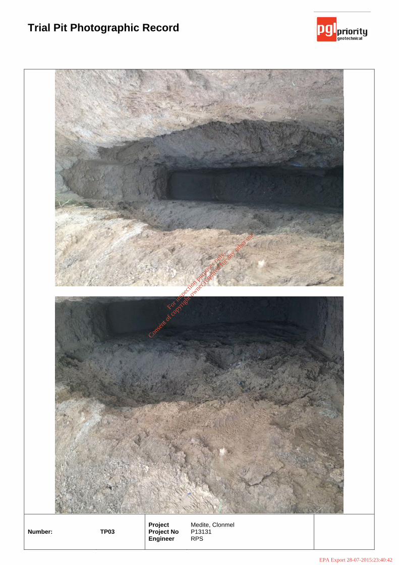
Trial Pit Photographic Record
Number:
TP03
Project Project No Engineer
Medite, Clonmel P13131 RPS
For
insp
ectio
n pur
pose
s only
.
Conse
nt of
copy
right
owne
r req
uired
for a
ny ot
her u
se.
EPA Export 28-07-2015:23:40:42
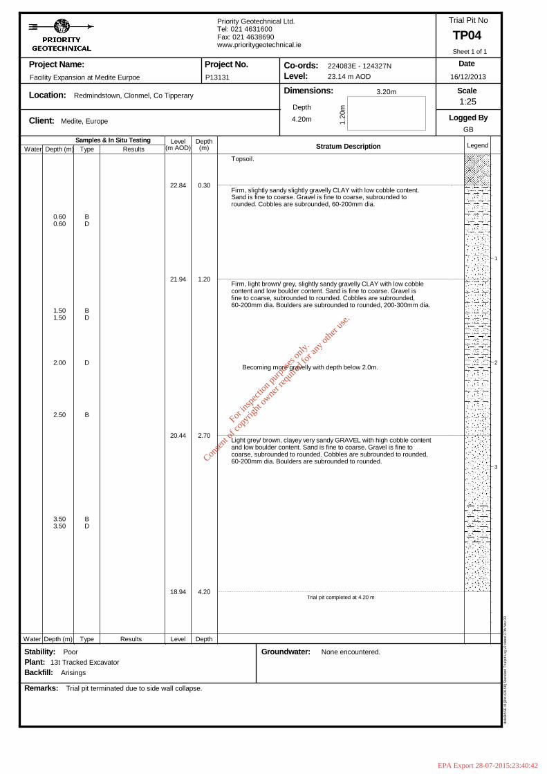
Samples & In Situ TestingDepth (m)
DepthLevel Legend(m)(m AOD) Stratum Description
Project Name:
Location:
Client:
Dimensions:Level:Co-ords:Project No.
Trial Pit No
Scale
Logged By
Remarks:
Date
Type Results
Groundwater:
Depth
Stability:
Water
Water Depth (m) Type Results Level Depth
Plant:Backfill:
Facility Expansion at Medite Eurpoe
13t Tracked Excavator
Medite, Europe
Arisings
Poor
Trial pit terminated due to side wall collapse.
Redmindstown, Clonmel, Co Tipperary
P13131
Priority Geotechnical Ltd.Tel: 021 4631600Fax: 021 4638690www.prioritygeotechnical.ie
4.20m
None encountered.
224083E - 124327N23.14 m AOD
1.20
m
3.20m
TP04
16/12/2013
GB
Hol
eBA
SE
III (
Bld
426
.58)
Sta
ndar
d Tr
ialp
it Lo
g v2
dat
ed 2
7th
Nov
03
0.600.60
1.501.50
2.00
2.50
3.503.50
BD
BD
D
B
BD
22.84
21.94
20.44
18.94
0.30
1.20
2.70
4.20
Topsoil.
Firm, slightly sandy slightly gravelly CLAY with low cobble content.Sand is fine to coarse. Gravel is fine to coarse, subrounded torounded. Cobbles are subrounded, 60-200mm dia.
Firm, light brown/ grey, slightly sandy gravelly CLAY with low cobblecontent and low boulder content. Sand is fine to coarse. Gravel isfine to coarse, subrounded to rounded. Cobbles are subrounded,60-200mm dia. Boulders are subrounded to rounded, 200-300mm dia.
Becoming more gravelly with depth below 2.0m.
Light grey/ brown, clayey very sandy GRAVEL with high cobble contentand low boulder content. Sand is fine to coarse. Gravel is fine tocoarse, subrounded to rounded. Cobbles are subrounded to rounded,60-200mm dia. Boulders are subrounded to rounded.
Trial pit completed at 4.20 m
1
2
3
1:25
Sheet 1 of 1
For
insp
ectio
n pur
pose
s only
.
Conse
nt of
copy
right
owne
r req
uired
for a
ny ot
her u
se.
EPA Export 28-07-2015:23:40:42
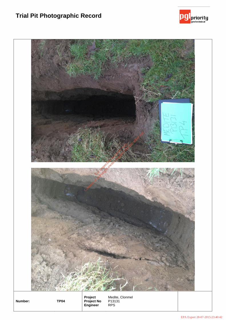
Trial Pit Photographic Record
Number:
TP04
Project Project No Engineer
Medite, Clonmel P13131 RPS
For
insp
ectio
n pur
pose
s only
.
Conse
nt of
copy
right
owne
r req
uired
for a
ny ot
her u
se.
EPA Export 28-07-2015:23:40:42

Trial Pit Photographic Record
Number:
TP04
Project Project No Engineer
Medite, Clonmel P13131 RPS
For
insp
ectio
n pur
pose
s only
.
Conse
nt of
copy
right
owne
r req
uired
for a
ny ot
her u
se.
EPA Export 28-07-2015:23:40:42

Samples & In Situ TestingDepth (m)
DepthLevel Legend(m)(m AOD) Stratum Description
Project Name:
Location:
Client:
Dimensions:Level:Co-ords:Project No.
Trial Pit No
Scale
Logged By
Remarks:
Date
Type Results
Groundwater:
Depth
Stability:
Water
Water Depth (m) Type Results Level Depth
Plant:Backfill:
Facility Expansion at Medite Eurpoe
13t Tracked Excavator
Medite, Europe
Arisings
Poor
Trial pit terminated due to groundwater inflow and side wall collapse.
Redmindstown, Clonmel, Co Tipperary
P13131
Priority Geotechnical Ltd.Tel: 021 4631600Fax: 021 4638690www.prioritygeotechnical.ie
4.20m
Slow inflow at 3.9m.
224078E - 124351N23.39 m AOD
1.20
m
3.50m
TP05
16/12/2013
GB
Hol
eBA
SE
III (
Bld
426
.58)
Sta
ndar
d Tr
ialp
it Lo
g v2
dat
ed 2
7th
Nov
03
0.500.50
1.501.50
3.503.50
4.004.00
BD
BD
BD
BD
23.09
22.39
20.19
19.19
0.30
1.00
3.20
4.20
Topsoil.
Firm, slightly sandy slightly gravelly SILT. Sand is fine to coarse.Gravel is fine to coarse, subrounded to rounded.
Firm, light brown/ grey, slightly sandy slightly gravelly CLAY withmedium cobble content and low boulder content. Sand is fine to coarse.Gravel is fine to coarse, subrounded to rounded. Cobbles aresubrounded, 60-200mm dia. Boulders are subrounded to rounded,200-300mm dia.
Light brown/ grey, very clayey very sandy GRAVEL with high cobblecontent and medium cobble content. Sand is fine to coarse. Gravel isfine to coarse, subrounded to rounded. Cobbles re subrounded torounded. Boulders are subrounded to rounded, 300-350mm dia.
Trial pit completed at 4.20 m
1
2
3
1:25
Sheet 1 of 1
For
insp
ectio
n pur
pose
s only
.
Conse
nt of
copy
right
owne
r req
uired
for a
ny ot
her u
se.
EPA Export 28-07-2015:23:40:42
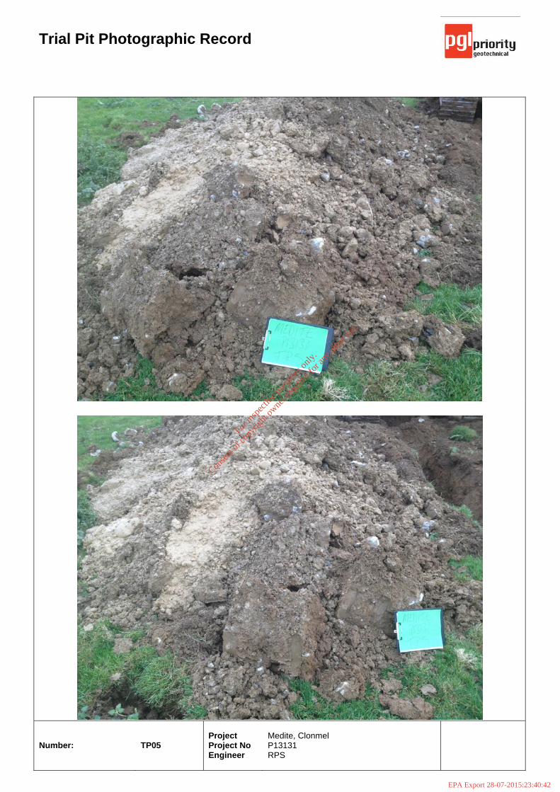
Trial Pit Photographic Record
Number:
TP05
Project Project No Engineer
Medite, Clonmel P13131 RPS
For
insp
ectio
n pur
pose
s only
.
Conse
nt of
copy
right
owne
r req
uired
for a
ny ot
her u
se.
EPA Export 28-07-2015:23:40:42
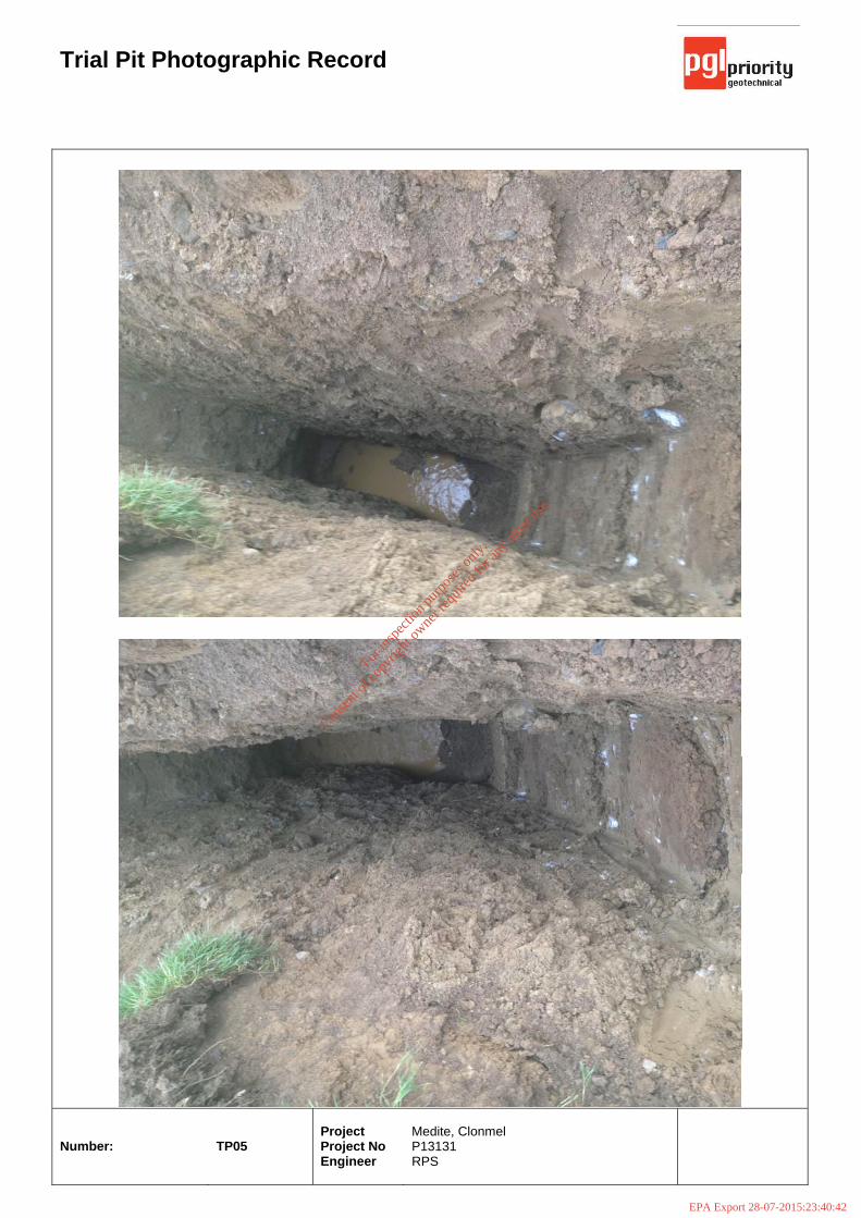
Trial Pit Photographic Record
Number:
TP05
Project Project No Engineer
Medite, Clonmel P13131 RPS
For
insp
ectio
n pur
pose
s only
.
Conse
nt of
copy
right
owne
r req
uired
for a
ny ot
her u
se.
EPA Export 28-07-2015:23:40:42
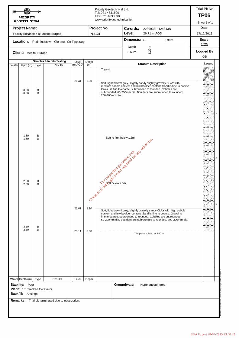
Samples & In Situ TestingDepth (m)
DepthLevel Legend(m)(m AOD) Stratum Description
Project Name:
Location:
Client:
Dimensions:Level:Co-ords:Project No.
Trial Pit No
Scale
Logged By
Remarks:
Date
Type Results
Groundwater:
Depth
Stability:
Water
Water Depth (m) Type Results Level Depth
Plant:Backfill:
Facility Expansion at Medite Eurpoe
13t Tracked Excavator
Medite, Europe
Arisings
Poor
Trial pit terminated due to obstruction.
Redmindstown, Clonmel, Co Tipperary
P13131
Priority Geotechnical Ltd.Tel: 021 4631600Fax: 021 4638690www.prioritygeotechnical.ie
3.60m
None encountered.
223993E - 124343N26.71 m AOD
1.20
m
3.30m
TP06
17/12/2013
GB
Hol
eBA
SE
III (
Bld
426
.58)
Sta
ndar
d Tr
ialp
it Lo
g v2
dat
ed 2
7th
Nov
03
0.500.50
1.501.50
2.502.50
3.503.50
BD
BD
BD
BD
26.41
23.61
23.11
0.30
3.10
3.60
Topsoil.
Soft, light brown/ grey, slightly sandy slightly gravelly CLAY withmedium cobble content and low boulder content. Sand is fine to coarse.Gravel is fine to coarse, subrounded to rounded. Cobbles aresubrounded, 60-200mm dia. Boulders are subrounded to rounded,200-300mm dia.
Soft to firm below 1.5m.
Soft below 2.5m.
Soft, light brown/ grey, slightly gravelly sandy CLAY with high cobblecontent and low boulder content. Sand is fine to coarse. Gravel isfine to coarse, subrounded to rounded. Cobbles are subrounded,60-200mm dia. Boulders are subrounded to rounded, 200-300mm dia.
Trial pit completed at 3.60 m
1
2
3
1:25
Sheet 1 of 1
For
insp
ectio
n pur
pose
s only
.
Conse
nt of
copy
right
owne
r req
uired
for a
ny ot
her u
se.
EPA Export 28-07-2015:23:40:42
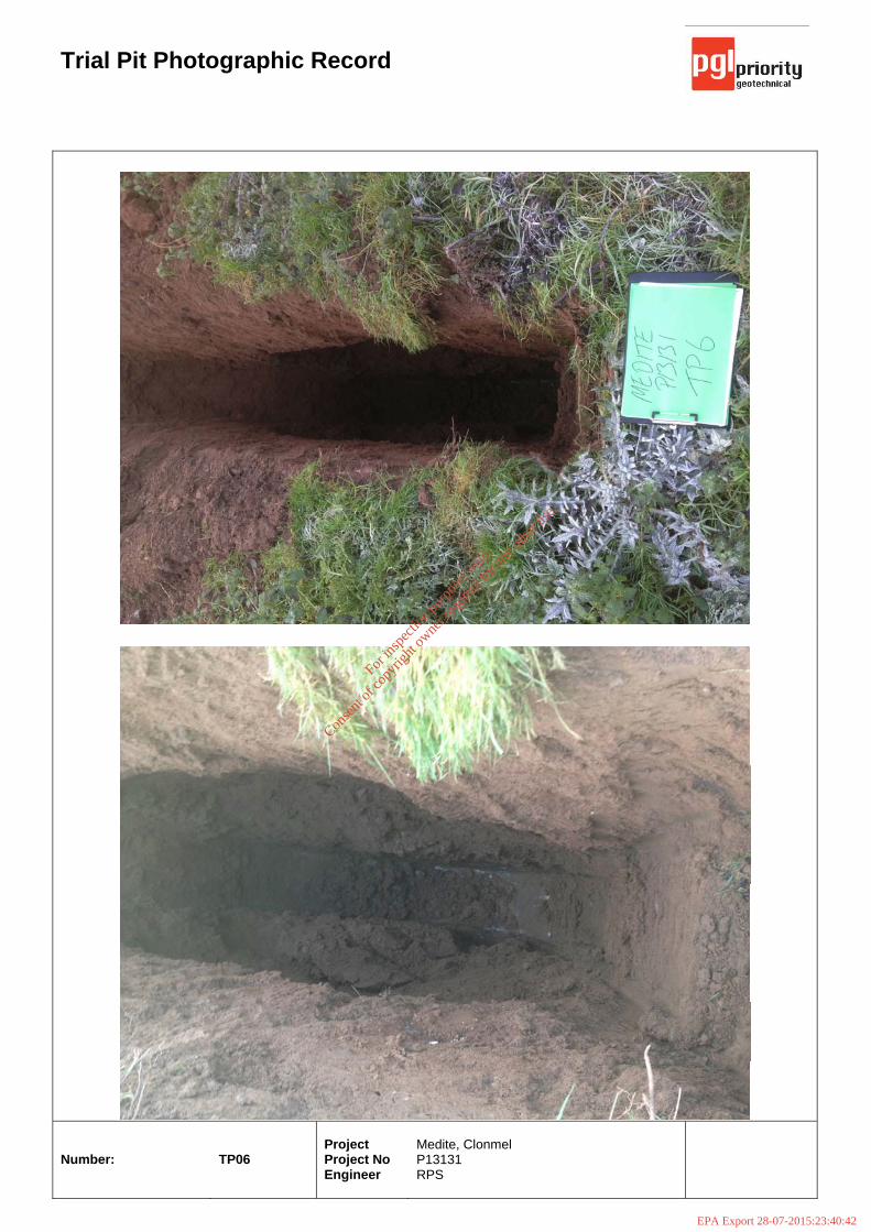
Trial Pit Photographic Record
Number:
TP06
Project Project No Engineer
Medite, Clonmel P13131 RPS
For
insp
ectio
n pur
pose
s only
.
Conse
nt of
copy
right
owne
r req
uired
for a
ny ot
her u
se.
EPA Export 28-07-2015:23:40:42
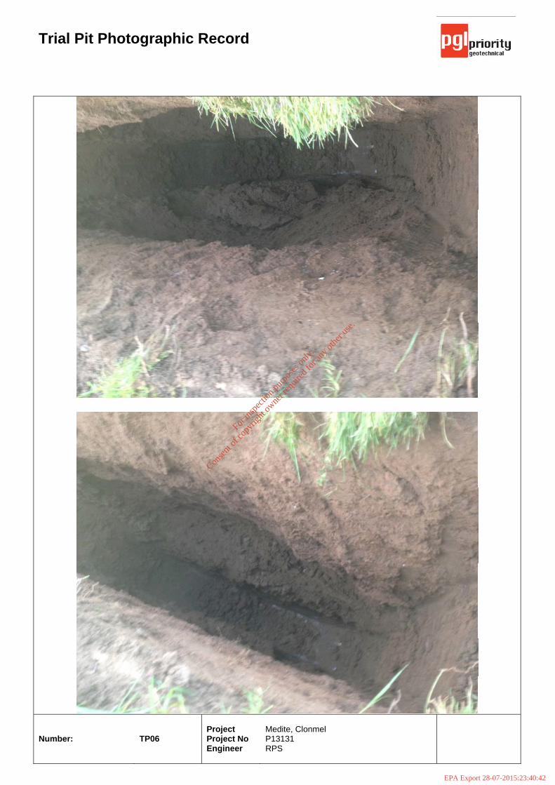
Trial Pit Photographic Record
Number:
TP06
Project Project No Engineer
Medite, Clonmel P13131 RPS
For
insp
ectio
n pur
pose
s only
.
Conse
nt of
copy
right
owne
r req
uired
for a
ny ot
her u
se.
EPA Export 28-07-2015:23:40:42
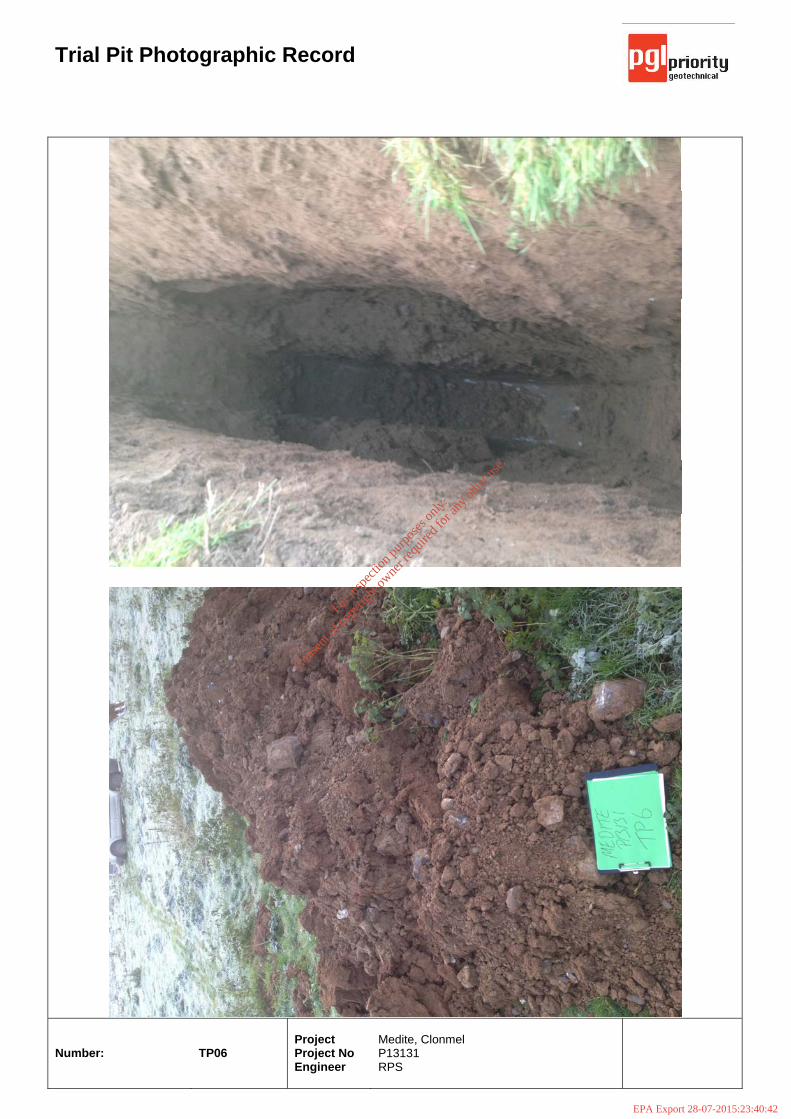
Trial Pit Photographic Record
Number:
TP06
Project Project No Engineer
Medite, Clonmel P13131 RPS
For
insp
ectio
n pur
pose
s only
.
Conse
nt of
copy
right
owne
r req
uired
for a
ny ot
her u
se.
EPA Export 28-07-2015:23:40:42
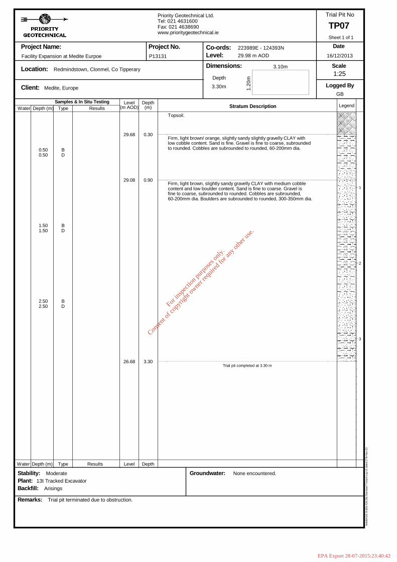
Samples & In Situ TestingDepth (m)
DepthLevel Legend(m)(m AOD) Stratum Description
Project Name:
Location:
Client:
Dimensions:Level:Co-ords:Project No.
Trial Pit No
Scale
Logged By
Remarks:
Date
Type Results
Groundwater:
Depth
Stability:
Water
Water Depth (m) Type Results Level Depth
Plant:Backfill:
Facility Expansion at Medite Eurpoe
13t Tracked Excavator
Medite, Europe
Arisings
Moderate
Trial pit terminated due to obstruction.
Redmindstown, Clonmel, Co Tipperary
P13131
Priority Geotechnical Ltd.Tel: 021 4631600Fax: 021 4638690www.prioritygeotechnical.ie
3.30m
None encountered.
223989E - 124393N29.98 m AOD
1.20
m
3.10m
TP07
16/12/2013
GB
Hol
eBA
SE
III (
Bld
426
.58)
Sta
ndar
d Tr
ialp
it Lo
g v2
dat
ed 2
7th
Nov
03
0.500.50
1.501.50
2.502.50
BD
BD
BD
29.68
29.08
26.68
0.30
0.90
3.30
Topsoil.
Firm, light brown/ orange, slightly sandy slightly gravelly CLAY withlow cobble content. Sand is fine. Gravel is fine to coarse, subroundedto rounded. Cobbles are subrounded to rounded, 60-200mm dia.
Firm, light brown, slightly sandy gravelly CLAY with medium cobblecontent and low boulder content. Sand is fine to coarse. Gravel isfine to coarse, subrounded to rounded. Cobbles are subrounded,60-200mm dia. Boulders are subrounded to rounded, 300-350mm dia.
Trial pit completed at 3.30 m
1
2
3
1:25
Sheet 1 of 1
For
insp
ectio
n pur
pose
s only
.
Conse
nt of
copy
right
owne
r req
uired
for a
ny ot
her u
se.
EPA Export 28-07-2015:23:40:42
Trial Pit Photographic Record
Number:
TP07
Project Project No Engineer
Medite, Clonmel P13131 RPS
For
insp
ectio
n pur
pose
s only
.
Conse
nt of
copy
right
owne
r req
uired
for a
ny ot
her u
se.
EPA Export 28-07-2015:23:40:42
Trial Pit Photographic Record
Number:
TP07
Project Project No Engineer
Medite, Clonmel P13131 RPS
For
insp
ectio
n pur
pose
s only
.
Conse
nt of
copy
right
owne
r req
uired
for a
ny ot
her u
se.
EPA Export 28-07-2015:23:40:42

Samples & In Situ TestingDepth (m)
DepthLevel Legend(m)(m AOD) Stratum Description
Project Name:
Location:
Client:
Dimensions:Level:Co-ords:Project No.
Trial Pit No
Scale
Logged By
Remarks:
Date
Type Results
Groundwater:
Depth
Stability:
Water
Water Depth (m) Type Results Level Depth
Plant:Backfill:
Facility Expansion at Medite Eurpoe
13t Tracked Excavator
Medite, Europe
Arisings
Poor
Trial pit terminated due to obstruction.
Redmindstown, Clonmel, Co Tipperary
P13131
Priority Geotechnical Ltd.Tel: 021 4631600Fax: 021 4638690www.prioritygeotechnical.ie
1.70m
None encountered.
224009E - 124434N31.27 m AOD
1.10
m
3.30m
TP08
17/12/2013
GB
Hol
eBA
SE
III (
Bld
426
.58)
Sta
ndar
d Tr
ialp
it Lo
g v2
dat
ed 2
7th
Nov
03
0.600.60
1.301.30
BD
BD
31.02
29.57
0.25
1.70
Topsoil.
Firm, light brown / grey, slightly sandy gravelly CLAY with highcobble content and high boulder content. Sand is fine to coarse.Gravel is fine to coarse, subrounded to rounded. Cobbles aresubrounded, 60-200mm dia. Boulders are subrounded to rounded,300-400mm dia.
Trial pit completed at 1.70 m
1
2
3
1:25
Sheet 1 of 1
For
insp
ectio
n pur
pose
s only
.
Conse
nt of
copy
right
owne
r req
uired
for a
ny ot
her u
se.
EPA Export 28-07-2015:23:40:42
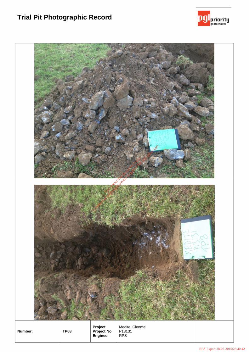
Trial Pit Photographic Record
Number:
TP08
Project Project No Engineer
Medite, Clonmel P13131 RPS
For
insp
ectio
n pur
pose
s only
.
Conse
nt of
copy
right
owne
r req
uired
for a
ny ot
her u
se.
EPA Export 28-07-2015:23:40:42

Trial Pit Photographic Record
Number:
TP08
Project Project No Engineer
Medite, Clonmel P13131 RPS
For
insp
ectio
n pur
pose
s only
.
Conse
nt of
copy
right
owne
r req
uired
for a
ny ot
her u
se.
EPA Export 28-07-2015:23:40:43
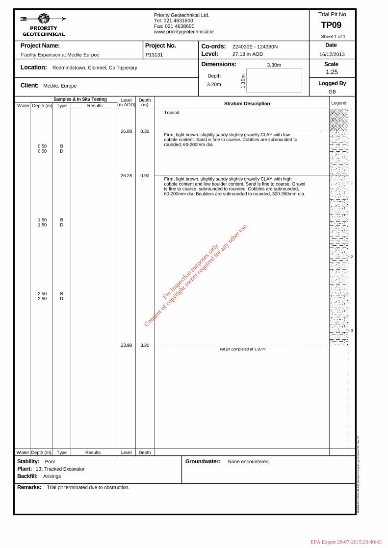
Samples & In Situ TestingDepth (m)
DepthLevel Legend(m)(m AOD) Stratum Description
Project Name:
Location:
Client:
Dimensions:Level:Co-ords:Project No.
Trial Pit No
Scale
Logged By
Remarks:
Date
Type Results
Groundwater:
Depth
Stability:
Water
Water Depth (m) Type Results Level Depth
Plant:Backfill:
Facility Expansion at Medite Eurpoe
13t Tracked Excavator
Medite, Europe
Arisings
Poor
Trial pit terminated due to obstruction.
Redmindstown, Clonmel, Co Tipperary
P13131
Priority Geotechnical Ltd.Tel: 021 4631600Fax: 021 4638690www.prioritygeotechnical.ie
3.20m
None encountered.
224030E - 124390N27.18 m AOD
1.10
m
3.30m
TP09
16/12/2013
GB
Hol
eBA
SE
III (
Bld
426
.58)
Sta
ndar
d Tr
ialp
it Lo
g v2
dat
ed 2
7th
Nov
03
0.500.50
1.501.50
2.502.50
BD
BD
BD
26.88
26.28
23.98
0.30
0.90
3.20
Topsoil.
Firm, light brown, slightly sandy slightly gravelly CLAY with lowcobble content. Sand is fine to coarse. Cobbles are subrounded torounded, 60-200mm dia.
Firm, light brown, slightly sandy slightly gravelly CLAY with highcobble content and low boulder content. Sand is fine to coarse. Gravelis fine to coarse, subrounded to rounded. Cobbles are subrounded,60-200mm dia. Boulders are subrounded to rounded, 300-350mm dia.
Trial pit completed at 3.20 m
1
2
3
1:25
Sheet 1 of 1
For
insp
ectio
n pur
pose
s only
.
Conse
nt of
copy
right
owne
r req
uired
for a
ny ot
her u
se.
EPA Export 28-07-2015:23:40:43
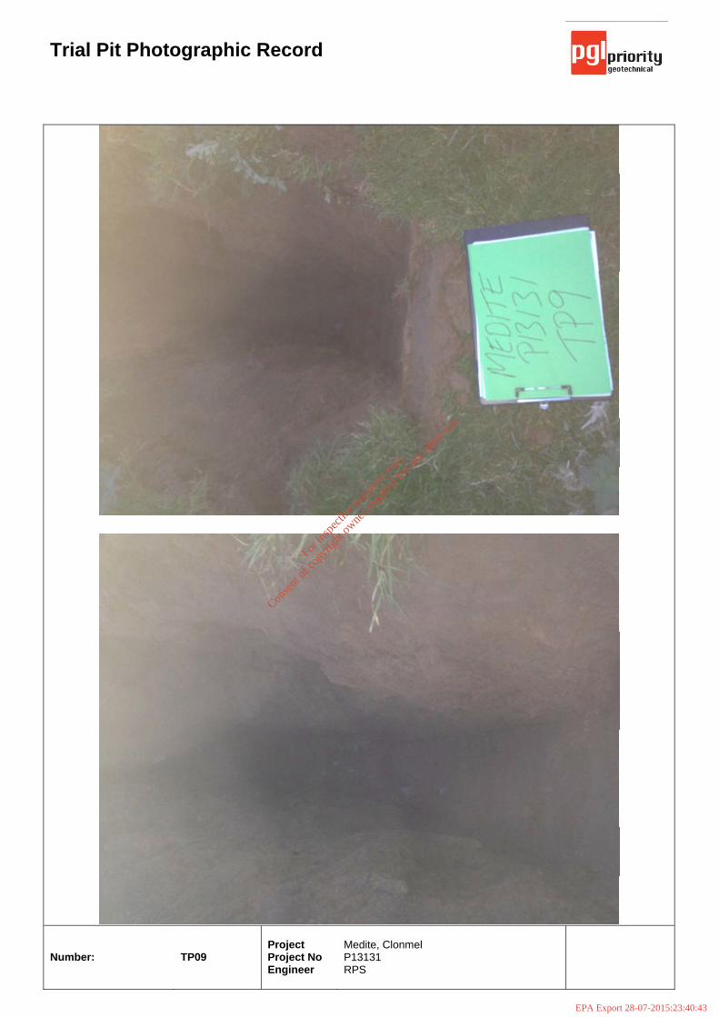
Trial Pit Photographic Record
Number:
TP09
Project Project No Engineer
Medite, Clonmel P13131 RPS
For
insp
ectio
n pur
pose
s only
.
Conse
nt of
copy
right
owne
r req
uired
for a
ny ot
her u
se.
EPA Export 28-07-2015:23:40:43

Trial Pit Photographic Record
Number:
TP09
Project Project No Engineer
Medite, Clonmel P13131 RPS
For
insp
ectio
n pur
pose
s only
.
Conse
nt of
copy
right
owne
r req
uired
for a
ny ot
her u
se.
EPA Export 28-07-2015:23:40:43