attachment f: marine mammal risk assessment · marine survey in support of ... carried out by...
TRANSCRIPT

. . . . . . . . .
ATTACHMENT F: MARINE MAMMAL RISK ASSESSMENT

. . . . . . . . .
Celtic Interconnector
Marine Mammal Risk Assessment - 2018 Geotechnical & Environmental
Marine Survey
In support of foreshore licence application FS006811 for geotechnical & environmental survey works
December 2017
The sole responsibility of this publication lies with the author. The European Union is not responsible for any use
that may be made of the information contained therein.

EIRGRID PLC – THE CELTIC INTERCONNECTOR
FORESHORE LICENCE APPLICATION FS006811
FS006811 ATTACHMENT F – MARINE MAMMAL RISK ASSESSMENT 20/12/2017
CONTENTS
1 INTRODUCTION ................................................................................................ 1
1.1 BACKGROUND .................................................................................................. 1
1.2 PURPOSE OF THE ASSESSMENT ................................................................... 2
1.3 OUTLINE SCOPE OF WORK ............................................................................. 2
1.4 SURVEY AREA .................................................................................................. 2
1.5 SCHEDULE OF WORKS .................................................................................... 3
2 DESCRIPTION OF THE PROPOSED GEOTECHNICAL ACOUSTIC SURVEY WORKS .............................................................................................. 5
2.1 SURVEY VESSELS ............................................................................................ 5
2.2 SOUND SOURCES ............................................................................................ 5
2.3 MARINE MAMMALS BASELINE ........................................................................ 6
3 IMPACT ASSESSMENT .................................................................................. 11
3.1 MITIGATION..................................................................................................... 11
3.2 SUMMARY ....................................................................................................... 11
4 REFERENCES ................................................................................................. 12
APPENDIX A: CO-ORDINATES OF PROPOSED SURVEY CORRIDOR ............... 13

EIRGRID PLC – THE CELTIC INTERCONNECTOR
FORESHORE LICENCE APPLICATION FS006811
FS006811 ATTACHMENT F – MARINE MAMMAL RISK ASSESSMENT 20/12/2017
TABLES
TABLE 2-1: EUROPEAN PROTECTED SPECIES (EPS) SIGHTED IN THE SURVEY AREA ...... 7
TABLE 3-2: SPL INJURY CRITERIA PROPOSED BY SOUTHALL ET.AL., FOR INDIVIDUAL
MARINE MAMMALS EXPOSED TO DISCRETE NOISE EVENTS ....................................... 9
TABLE 3-3: MARINE MAMMAL AUDITORY BAND WIDTH ................................................. 9
FIGURES
FIGURE 1-1: FORESHORE LICENCE APPLICATION AREA ................................................ 4

EIRGRID PLC – THE CELTIC INTERCONNECTOR
FORESHORE LICENCE APPLICATION FS006811
FS006811 ATTACHMENT F – MARINE MAMMAL RISK ASSESSMENT 1 20/12/2017
1 INTRODUCTION
1.1 BACKGROUND
EirGrid and RTE are investigating the feasibility of installing a power cable interconnector between Ireland and France. The project would include two High Voltage Direct Current (HVDC) converter stations, a 700+MW HVDC submarine interconnector between the converter stations and onshore lines/cables as appropriate.
In 2014 and 2015, EirGrid and RTE carried out geophysical and geotechnical marine surveys of possible marine cable routes under Foreshore Licences FS 006243 and FS 006446. EirGrid and RTE now intend to carry out further marine surveys of the nearshore approaches in order to assist in the refinement of marine routing for the proposed project. To this end, two new route corridor branches and three possible landfall locations have been identified for marine survey. The geophysical survey was undertaken in October 2017 with geotechnical and environmental surveys to be undertakin in 2018.
The surveys are intended to aid the design and routing of the HVDC cables by providing a baseline description of the seabed environment along the proposed cable route corridor. The data would also be used to inform environmental appraisals by providing information on the current situation and allowing impacts to be predicted, and subsequently, appropriate mitigation to be developed.
This marine mammal risk assessment is an update of the risk assessment carried out by Intertek for Foreshore Licence FS 006446 (Report Number: P1812_R3691_Rev1 Marine Mammal Risk Assessment - Attachment F 2014) and is based on the Department of Arts, Heritage and the Gaeltacht (DAHG) 2014 ‘Guidance to Manage the Risk to Marine Mammals from Man-made Sound Sources in Irish Waters’.
Under Article 6(3) of the EU Habitats Directive and the Irish Habitat Regulations (2011), project-related activities within Natura 2000 Sites, Special Areas of Conservation (SACs) designated for Annex II species of marine mammals (Bottlenose dolphin, harbour porpoise, grey seals and harbour seals), must be assessed with regard to their implications for the site conservation objectives. The legal obligation under Article 6 (3) also extends to ex situ activities i.e. activities outside an SAC must also be assessed.
Under Article 12 of the EU Habitats Directive Member States are further required to establish a system of strict protection for European Protected Species (EPS), as listed in Annex IV (which includes all cetaceans and all the turtle species which could occur in the area) across their entire range within the EU, both within and outside Natura 2000 Sites.
This assessment therefore specifically considers the implications of the geotechnical and environmental survey works on Annex II and Annex IV marine mammal species.
EIRGRID PLC – THE CELTIC INTERCONNECTOR
FORESHORE LICENCE APPLICATION FS006811
FS006811 ATTACHMENT F – MARINE MAMMAL RISK ASSESSMENT 2 20/12/2017
1.2 PURPOSE OF THE ASSESSMENT
The purpose of this risk assessment is to provide the competent authority with enough information to determine whether there is a significant risk to marine mammals.
1.3 OUTLINE SCOPE OF WORK
The geotechnical and environmental surveys consist of the following components:
Bore Holes / Trial Pits (intertidal only)
Thermal Resistivity Testing
Vibrocore Samples
Cone Penetrometer Testing (CPT) Samples
Grab Samples
Drop down Video and photographic sampling
ROV
Of these, the techniques which emit significant sound in the marine environment are Vibrocore and CPT and therefore have been considered in this assessment. Details of the equipment to be used during the geotechnical survey are yet to be finalised Therefore the marine mammals risk assessment has been undertaken using typical equipment specifications.
1.4 SURVEY AREA
The marine survey area to be investigated is located in south-east County Cork. Three possible cable landfall options under investigation are Ballinwilling Strand in Ballycotton Bay and Redbarn Beach and Claycastle Beach in Youghal Bay.
The proposed marine survey methodology remains exactly the same as those surveys previously undertaken and for which foreshore licences were granted. The survey route corridors have been altered by approx. 10-15km in places from previous corridors surveyed to take account of challenging geological features.
The total length of the survey area (two survey corridors out to intersection with previous marine survey extent near 12nm limit) is approximately 65.84km.
Data acquisition and coverage requirements are divided in to the three survey areas outlined below and shown in Figure 1-1:
1) Ballinwilling High Water Mark (HWM) to 10m LAT (Lowest Astronomical Tide) water depth - intertidal/shallow water survey area.
2) Redbarn Beach and Claycastle Beach HWM to 10m LAT water depth - intertidal/shallow water survey area.
3) Offshore Survey area seawards of the first 10m LAT water depth to 12nm limit.

EIRGRID PLC – THE CELTIC INTERCONNECTOR
FORESHORE LICENCE APPLICATION FS006811
FS006811 ATTACHMENT F – MARINE MAMMAL RISK ASSESSMENT 3 20/12/2017
The survey corridors will be nominally 250m wide for the intertidal and shallow water survey works within a 500m wide application area and 500m wide for the offshore survey works (full width of the 500m application area).
The Redbarn beach and Claycastle beach survey area is located within the enclose of Youghal Bay.
The co-ordinates of the proposed survey areas are provided in Appendix A.
1.5 SCHEDULE OF WORKS
The geotechnical and environmental surveys are planned to commence in May 2018 and last approximately 30 days. A contingency period will be required to allow for operational delays.

EIRGRID PLC – THE CELTIC INTERCONNECTOR
FORESHORE LICENCE APPLICATION FS006811
FS006811 ATTACHMENT F – MARINE MAMMAL RISK ASSESSMENT 4 20/12/2017
Figure 1-1: Foreshore Licence Application Area

EIRGRID PLC – THE CELTIC INTERCONNECTOR
FORESHORE LICENCE APPLICATION FS006811
FS006811 ATTACHMENT F – MARINE MAMMAL RISK ASSESSMENT 5 20/12/2017
2 DESCRIPTION OF THE PROPOSED
GEOTECHNICAL ACOUSTIC SURVEY WORKS
2.1 SURVEY VESSELS
Dedicated survey vessels will be used which are appropriate to the water depth of the survey area. A vessel with a shallow water draft will be utilised for the shallow water survey area and a larger vessel will be used from the 10m depth contour to the Irish territorial limit. The exact vessels and equipment to be utilised will be confirmed by the survey contractor prior to survey commencement.
2.2 SOUND SOURCES
Sound sources will vary to some extent with the type and design of equipment. As the geotechnical equipment is yet to be confirmed the sound pressure levels presented in this section are typical of equipment used to obtain the penetration depths required.
2.2.1 Vibrocore
Vibrocore is used to determine the sediment structure and composition of the sea bed. The unit is deployed via a crane or ‘A’ frame to recover a continuous seabed sample of 75mm and up to 5m in depth. The system uses an electrically driven vibrator motor, with a barrel of mild steel pipe lined with PVC material to enable sufficient sample for examination on site and in laboratory testing. The vibratory impacts cause the pipe to penetrate the upper seabed layers and a core sample is collected inside the PVC and pipe. There is strong acoustic coupling between the vibrator and water because the entire apparatus is submerged during operation. The sounds produced consist of a series of impulses corresponding to the movement and impacts of the vibrator on the pipe. Expected sound pressure levels generated by vibrocore equipment would be approximately 187.4 dB re 1 mPa@1m (LGL, 2010), which although may be audible to marine mammals (depending on the frequency), will not cause disturbance or permanent injury to animals (Southall et.al., 2007).
2.2.2 Cone Penetrometer Testing (CPT)
Cone Penetrometer Test (CPT) is used to determine the geotechnical engineering properties of sediments. The device may include a single phase hydraulic pump motor, which drives the tip of the penetrometer into the seabed to a penetration depth of up to 5m.
Use of the CPT will be confirmed based on interpretation of the geophysical survey findings. If sediments have are appropriate, the apparatus will be lowered to the seabed with a crane or ‘A’ frame, while the vessel is held in position.

EIRGRID PLC – THE CELTIC INTERCONNECTOR
FORESHORE LICENCE APPLICATION FS006811
FS006811 ATTACHMENT F – MARINE MAMMAL RISK ASSESSMENT 6 20/12/2017
There is very little published information on the sound pressure levels generated from CPT profiling equipment, either collected from field experimentation or from manufactures specifications. Data from a similar device, deep boring, indicates that SPL levels are typically within the range 118 - 145 decibels (dB) (BOEM 2012). Although these levels may be audible to marine mammals (depending on the associated frequencies), they are not at a level that is thought to cause a disturbance or injury to marine mammals (Southall et.al. 2007). This is discussed further in Section 4.
2.2.3 Vessel Noise
Vessels utilised for survey works will generate some subsea noise in the marine environment from engine noise and dynamic positioning thrusters. Shipping noise is typically within the 50-300 Hz frequency band and is the dominant noise source in deeper water (DECC, 2011). Propellers on vessels all have the potential to produce cavitation noise. This sound is caused by vacuum bubbles that were generated by the collapse of bubbles created by the spinning of the propellers. Medium sized vessels (<50m) produce an acoustic source level of approximately 160-175 dB re 1mPa@1m (DECC, 2011)
Thrusters, a form of rotatable propeller, can be mounted on the bow of the ship, or in the case of azimuth thrusters at the stern. Thrusters are used to maintain position and permit moving of the vessel and are widely used in offshore support vessels as a dynamic positioning (DP). Ships that use computer controlled dynamic positioning control the operation of the propellers and thrusters to enable precise movements to be made. DP vessels when in operation are likely to produce an acoustic source level of up to 190dB re 1mPa@1m (DECC, 2011).
Every vessel has a unique noise signature and for each vessel this can change in response to a number of factors, including; ship speed, operational status, vessel load, the condition of the vessel and even the properties of the water that the vessel is operating in.
2.3 MARINE MAMMALS BASELINE
All cetaceans are European Protected Species (EPS), protected under Annex IV of the EU Habitats Directive, which lists species of Community Interest in need of strict protection. It is an offence to deliberately capture, kill, injure or deliberately disturb animals classified as EPS.
An EPS risk assessment is therefore required to show that the geophysical survey proposal does not carry a risk of disturbance or injury to any EPS. This assessment will identify any potential risks and provide an assessment of the impacts of the survey activity.
Bottlenose dolphin, harbour porpoise, grey seals and harbour (or common) seals are also listed on Annex II of the Habitats directive.
One of the most important environmental concerns related to the proposed activities are the potential effects of underwater sound on different marine biota, in particular animals protected under the EU Habitats Directive.
EIRGRID PLC – THE CELTIC INTERCONNECTOR
FORESHORE LICENCE APPLICATION FS006811
FS006811 ATTACHMENT F – MARINE MAMMAL RISK ASSESSMENT 7 20/12/2017
In addition, under the Wildlife (Amendment) Act 1976-2005, all cetaceans and seals are protected species listed on the 5th Schedule. Under this Act, Natural Heritage Areas (NHAs) may be established to protect habitats or species. Whilst some terrestrial and coastal NHAs may encompass adjacent marine areas, no NHAs have been established for marine mammals to date.
2.3.1 Annex IV Species in Irish Waters
Cetaceans
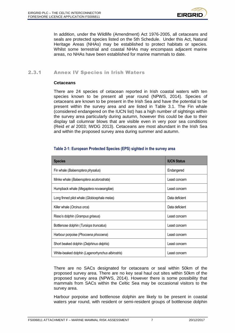
There are 24 species of cetacean reported in Irish coastal waters with ten species known to be present all year round (NPWS, 2014). Species of cetaceans are known to be present in the Irish Sea and have the potential to be present within the survey area and are listed in Table 3.1. The Fin whale (considered endangered on the IUCN list) has a high number of sightings within the survey area particularly during autumn, however this could be due to their display tall columnar blows that are visible even in very poor sea conditions (Reid et al 2003; IWDG 2013). Cetaceans are most abundant in the Irish Sea and within the proposed survey area during summer and autumn.
Table 2-1: European Protected Species (EPS) sighted in the survey area
Species IUCN Status
Fin whale (Balaenoptera physalus) Endangered
Minke whale (Balaenoptera acutorostrata) Least concern
Humpback whale (Megaptera novaeangliae) Least concern
Long finned pilot whale (Globicephala melas) Data deficient
Killer whale (Orcinus orca) Data deficient
Risso’s dolphin (Grampus griseus) Least concern
Bottlenose dolphin (Tursiops truncatus) Least concern
Harbour porpoise (Phocoena phocoena) Least concern
Short beaked dolphin (Delphinus delphis) Least concern
White-beaked dolphin (Lagenorhynchus albirostris) Least concern
There are no SACs designated for cetaceans or seal within 50km of the proposed survey area. There are no key seal haul out sites within 50km of the proposed survey area (NPWS, 2014). However there is some possibility that mammals from SACs within the Celtic Sea may be occasional visitors to the survey area.
Harbour porpoise and bottlenose dolphin are likely to be present in coastal waters year round, with resident or semi-resident groups of bottlenose dolphin

EIRGRID PLC – THE CELTIC INTERCONNECTOR
FORESHORE LICENCE APPLICATION FS006811
FS006811 ATTACHMENT F – MARINE MAMMAL RISK ASSESSMENT 8 20/12/2017
known to be present within Cork Harbour (IWDG 2013), located approximately 14km (following the coastline) from the closest proposed survey corridor (Ballycroneen Beach landfall option). Whilst bottlenose dolphin has been regularly reported at Cork Harbour, the survey area is not currently believed to contain key functional areas for these species. Displacement is therefore considered unlikely and if it does occur will be temporary.
Low numbers of at least ten species of marine mammal have the potential to be present within the survey area with the abundance of animals peaking in the autumn. Harbour porpoise, common dolphin and bottlenose dolphin are likely to be present in coastal waters year round. Records from the National biodiversity Data Centre (accessed March 2017) show regular observations of harbour porpoise and common dolphin along the coastline between Youghal and Ballycotton.
During the 2014 geophysical survey, the marine mammal observer (MMO) recorded four short-beaked common dolphins during one observation period. During the 2017 geophysical survey the following species were recorded, harbour propoise, common dolphin and also Atlantic white sided dolphin,
The southern coast of Ireland has been identified as an area of high numbers of sightings of fin whale (DAHG, 2014) and it is therefore possible that this species may be present during the geotechnical survey. Sighting data for the proposed survey area is limited. Therefore the number of animals which could be present during the proposed survey cannot be estimated from available data.
Breeding rates for cetacean species in this area is currently unknown. Any potential noise impacts are not likely to focus on a particular section of the population. The assessment criteria are based on the hearing thresholds of individual species, and do not consider the life stage of animals.
Harbour seals are likely to be pupping between June and July followed by moulting which takes approximately 4-5 weeks, when they are largely hauled out on land. During the rest of the year which includes the proposed survey period, harbour seals will be in the water where they have the potential to be exposed to survey noise. Grey seals typically breed on remote uninhabited islands or coasts and in small numbers in caves between September and December. Grey seal moulting occurs approximately 3-5 months after the end of the breeding season. There are no key seal haul out or breeding sites within 50km of the proposed survey area (NPWS, 2014),
During the 2014 geophysical survey, the MMO recorded one Grey seal and another unidentified seal during two separate observation periods. Two Grey seal observations were made in the 2017 geophyiscal survey period.
2.3.2 Marine Mammal Sensitivity to Noise
Both cetaceans and pinnipeds have evolved to use sound as an important aid in navigation, communication and hunting (Richardson et al, 1995). It is generally accepted that exposure to anthropogenic sound can induce a range of effects on marine mammals. These range from insignificant impacts to behavioural changes and also include non-injurious type effects including masking of biologically relevant sound signals, such as communication signals. Such effects may produce a temporary reduction in hearing sensitivity (termed Temporary Threshold Shift (TTS) which is reversible.

EIRGRID PLC – THE CELTIC INTERCONNECTOR
FORESHORE LICENCE APPLICATION FS006811
FS006811 ATTACHMENT F – MARINE MAMMAL RISK ASSESSMENT 9 20/12/2017
Activities that generate very high sound pressure levels can cause permanent auditory injuries and other types of physical injury and, in some circumstances, lead to the death of the receiver (Richardson et al, 1995; Southall et al, 2007). These impacts are considered to be permanent threshold shift (PTS) and are of particular concern (Southall et al, 2007). In order to evaluate the potential of the proposed survey equipment to cause harm to marine mammals, an assessment has been conducted using the Southall et al, (2007) approach. Southall et al, separated marine mammals into 5 groups based on their functional hearing, namely low-frequency cetaceans, mid frequency cetaceans, high frequency cetaceans, pinnipeds in water and pinnipeds in air. For each of these groups they proposed noise levels that would result in injury (PTS or TTS of hearing ability) for individuals exposed to single, multiple and non-pulsed sources (Table 3-2).
Table 2-2: SPL injury criteria proposed by Southall et.al., for individual marine mammals exposed to discrete noise events
Marine mammal group Injury criteria
TTS PTS
Low-frequency cetaceans 224 dB re: 1µPa (peak) 230 dB re: 1µPa (peak)
Mid-frequency cetaceans 224 dB re: 1µPa (peak) 230 dB re: 1µPa (peak)
High-frequency cetaceans 224 dB re: 1µPa (peak) 230 dB re: 1µPa (peak)
Pinnipeds (in water) 212 dB re: 1µPa (peak) 218 dB re: 1µPa (peak)
Marine mammals which may be present in the vicinity of the proposed survey area and their auditory band widths are outlined below in Table 3-3.
Table 2-3: Marine Mammal Auditory Band Width
Species Estimated Auditory Band Width (Hz)
Pinnipeds in water 75-75,000
Minke Whale 7-22,000
Fin whale 7-22,000
Humpback whale 7-22,000
Long finned pilot whale 150-160,000
Killer whale 150-160,000
Risso’s dolphin 150-160,000
Bottlenose dolphin 150-160,000
Harbour porpoise 200 - 180,000

EIRGRID PLC – THE CELTIC INTERCONNECTOR
FORESHORE LICENCE APPLICATION FS006811
FS006811 ATTACHMENT F – MARINE MAMMAL RISK ASSESSMENT 10 20/12/2017
Species Estimated Auditory Band Width (Hz)
Short beaked dolphin 150-160,000
White-beaked dolphin 150-160,000
Source: Southall et al. (2007)
As the exact specifications of the equipment to be used during the survey are not currently known, an impact assessment has been conducted based on published ‘typical’ values.

EIRGRID PLC – THE CELTIC INTERCONNECTOR
FORESHORE LICENCE APPLICATION FS006811
FS006811 ATTACHMENT F – MARINE MAMMAL RISK ASSESSMENT 11 20/12/2017
3 IMPACT ASSESSMENT
Potential for disturbance to individuals or populations of marine mammal species within or adjacent to the proposed survey area from geotechnical equipment.
The geotechnical sampling equipment may operate within the audible range for all cetacean and pinniped species in water. However, the level of sound produced is likely to be below 145 dB re: 1 mPa@1m. According to the behavioural response criteria proposed by Southall et al. (Table 3-2) this level will not elicit a behavioural response, temporary threshold shift (TTS) or permanent threshold shift (PTS) in marine mammals within the survey area . In addition the sound produced is intermittent and generated for short durations, resulting in minimal exposure periods.
Therefore the sensitivity and magnitude of the impact to marine mammals is considered to be low. The significance of impact to marine mammals from the use of geotechnical equipment is considered to be Not Significant.
Potential for disturbance to individuals or populations of marine mammal species within or adjacent to the proposed survey area from vessel noise
Shipping noise contributes to the ambient noise and animals are likely to be habituated to conditions within their surroundings. The operation of the survey vessel in the project area is not likely to significantly increase shipping vessel noise above existing levels. Vessel noise is likely to be of a frequency which is within the audible capacity of marine mammals. However, the volume produced, is below the threshold to cause disturbance or injury to marine mammals.
Dynamic positioned thrusters, and the associated cavitation noise, cause a significant elevation of the low frequency sounds from 3 - 30 Hz (DECC, 2011), however, as with vessel noise these noise levels produced are below the threshold for disturbance or injury to marine mammals. Therefore the impact to animals from dynamically positioned vessel noise is considered to be Not Significant.
3.1 MITIGATION
No mitigation measures are necessary as the sound produced during the geotechnical survey is not of sufficient level or duration to have a significant impact to marine mammals.
3.2 SUMMARY
Survey areas encompassing Redbarn beach and Claycastle beach are located within Youghal Bay. Ballinwilling Strand is not within an area defined to be a bay, inlet or estuary.
The subsea noise predicted to be generated by the geotechnical survey equipment is at a level below the threshold level indicated by Southall et al., (2007) for disturbance or injury to marine mammals. Therefore no significant impacts to marine mammals are expected.

EIRGRID PLC – THE CELTIC INTERCONNECTOR
FORESHORE LICENCE APPLICATION FS006811
FS006811 ATTACHMENT F – MARINE MAMMAL RISK ASSESSMENT 12 20/12/2017
4 REFERENCES
Bureau of Ocean Energy Management (BOEM) Office of Renewable Energy Programs (2012). Commercial Wind Lease Issuance and Site Assessment Activities on the Atlantic Outer Continental Shelf Offshore Massachusetts, Environmental Assessment. Published by U.S. Department of the Interior. October 2012.
DECC (2011), Review and Assessment of Underwater Sound Produced from Oil and Gas Sound Activities and Potential Reporting Requirements under the Marine Strategy Framework Directive. Document No: J71656-Final Report –G2
Department of Arts, Heritage and Gaeltacht (2014), Guidance to Manage the Risk to Marine Mammals from Man-made Sound Sources in Irish Waters.
LGL Alaska Research Associates and Jasco Applied Sciences (2010), Marine Mammal Monitoring and Mitigation During Marine Geophysical Surveys by Shell Offshore Inc. in the Alaskan Chukchi and Beaufort Seas, July – October 2010:90-Day Report
Intertek (2014) Unpublished report: Marine mammal observation report during cable route survey at Ballycotton Bay and Ballycroneen Bay East Cork, Ireland, September 2014.
Irish whale and dolphin Group (2013), Atlas of the Distribution and Relative Abundance of Marine Mammals in Irish Offshore Waters: 2005 – 2011
Reid, J., Evans, P.G.H. and Northridge, S. (2003). An atlas of cetacean distribution on the northwest European Continental Shelf. Joint Nature Conservation Committee, Peterborough
Richardson, W.J., Thomson, D.H., Green Jr, C.R. & and Malme, C.I. (1995), Marine mammals and noise. Academic Press, New York.
Southall B. L., Bowles A. E., Ellison W. T., Finneran J. J., Gentry R. L., Greene Jr. C. R., Kastak D., Ketten D. R., Miller J. H., Nachtigall P. E., Richardson W. J., Thomas J. A., and Tyack P. L.. (2007). Marine mammal noise exposure criteria: Initial scientific recommendations. Aquatic Mammals 33, 411-521.

EIRGRID PLC – THE CELTIC INTERCONNECTOR
FORESHORE LICENCE APPLICATION FS006811
FS006811 ATTACHMENT F – MARINE MAMMAL RISK ASSESSMENT 13 20/12/2017
Appendix A: Co-ordinates of proposed survey corridor

EIRGRID PLC – THE CELTIC INTERCONNECTOR
FORESHORE LICENCE APPLICATION FS006811
FS006811 ATTACHMENT F – MARINE MAMMAL RISK ASSESSMENT 14 20/12/2017
Geographic co-ordinates of the area under application in degrees minutes and
seconds WGS84 for offshore developments and where the area can also be
identified on the Ordnance Survey map and /or is connected to the
seashore/mainland , specify Ordnance Survey map no and Irish National Grid co-
ordinates
Coordinates for the proposed survey areas (WGS84 UTM Zone 29) Ballinwilling Strand 500m wide corridor from landfall to intersection with previous marine survey extent near 12nm limit (250m either side of below coordinates) 51° 51' 57.4300" N 7° 58' 45.7500" W 51° 51' 25.4822" N 7° 58' 37.3707" W 51° 50' 53.5343" N 7° 58' 28.9946" W 51° 50' 21.5862" N 7° 58' 20.6218" W 51° 50' 08.3632" N 7° 58' 17.1573" W 51° 49' 51.7183" N 7° 58' 02.4680" W 51° 49' 38.6735" N 7° 57' 50.9581" W 51° 49' 31.1426" N 7° 57' 47.7839" W 51° 49' 21.6307" N 7° 57' 50.9805" W 51° 49' 18.2226" N 7° 57' 52.1257" W 51° 48' 49.3556" N 7° 57' 50.4706" W 51° 48' 44.4465" N 7° 57' 50.1891" W 51° 48' 28.8423" N 7° 57' 55.6547" W 51° 48' 18.8406" N 7° 58' 04.7666" W 51° 48' 00.9628" N 7° 58' 21.0507" W 51° 47' 50.7510" N 7° 58' 25.1641" W 51° 47' 49.4429" N 7° 58' 25.2692" W 51° 47' 41.1028" N 7° 58' 25.9392" W 51° 47' 30.4735" N 7° 58' 31.8952" W 51° 47' 20.6945" N 7° 58' 45.1220" W 51° 47' 16.4515" N 7° 58' 50.8603" W 51° 47' 10.8035" N 7° 58' 54.8795" W 51° 46' 52.9365" N 7° 59' 11.5896" W 51° 46' 52.3976" N 7° 59' 12.0936" W 51° 46' 46.0677" N 7° 59' 14.9820" W 51° 46' 29.3787" N 7° 59' 27.3371" W 51° 46' 24.8897" N 7° 59' 27.8620" W 51° 46' 22.6884" N 7° 59' 26.7893" W 51° 46' 04.0631" N 7° 59' 17.7135" W 51° 45' 54.0935" N 7° 59' 04.4967" W 51° 45' 47.4576" N 7° 58' 55.7005" W 51° 45' 31.9454" N 7° 58' 26.6665" W 51° 45' 21.0340" N 7° 58' 06.2491" W 51° 45' 10.4519" N 7° 57' 47.6817" W 51° 45' 07.2491" N 7° 57' 42.0629" W 51° 44' 44.8917" N 7° 57' 15.9028" W 51° 44' 34.8410" N 7° 57' 04.1454" W 51° 44' 19.6151" N 7° 56' 43.3921" W 51° 43' 54.9051" N 7° 56' 09.7228" W 51° 43' 30.1925" N 7° 55' 36.0636" W 51° 43' 05.4772" N 7° 55' 02.4146" W 51° 42' 40.7592" N 7° 54' 28.7758" W 51° 42' 16.0387" N 7° 53' 55.1472" W 51° 41' 51.3154" N 7° 53' 21.5287" W 51° 41' 26.5896" N 7° 52' 47.9204" W 51° 41' 01.8611" N 7° 52' 14.3223" W 51° 40' 37.1299" N 7° 51' 40.7342" W 51° 40' 30.0003" N 7° 51' 31.0538" W 51° 40' 10.8090" N 7° 51' 10.5595" W 51° 39' 43.8432" N 7° 50' 41.7726" W 51° 39' 21.9600" N 7° 50' 18.4200" W
EIRGRID PLC – THE CELTIC INTERCONNECTOR
FORESHORE LICENCE APPLICATION FS006811
FS006811 ATTACHMENT F – MARINE MAMMAL RISK ASSESSMENT 15 20/12/2017
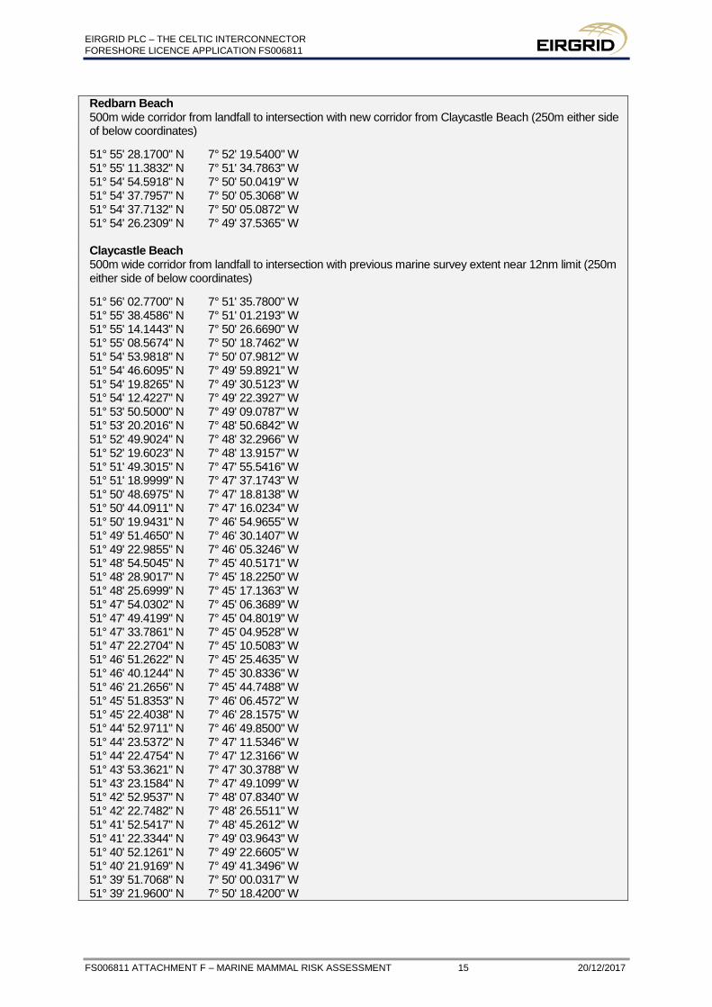
Redbarn Beach 500m wide corridor from landfall to intersection with new corridor from Claycastle Beach (250m either side of below coordinates)
51° 55' 28.1700" N 7° 52' 19.5400" W 51° 55' 11.3832" N 7° 51' 34.7863" W 51° 54' 54.5918" N 7° 50' 50.0419" W 51° 54' 37.7957" N 7° 50' 05.3068" W 51° 54' 37.7132" N 7° 50' 05.0872" W 51° 54' 26.2309" N 7° 49' 37.5365" W Claycastle Beach 500m wide corridor from landfall to intersection with previous marine survey extent near 12nm limit (250m either side of below coordinates)
51° 56' 02.7700" N 7° 51' 35.7800" W 51° 55' 38.4586" N 7° 51' 01.2193" W 51° 55' 14.1443" N 7° 50' 26.6690" W 51° 55' 08.5674" N 7° 50' 18.7462" W 51° 54' 53.9818" N 7° 50' 07.9812" W 51° 54' 46.6095" N 7° 49' 59.8921" W 51° 54' 19.8265" N 7° 49' 30.5123" W 51° 54' 12.4227" N 7° 49' 22.3927" W 51° 53' 50.5000" N 7° 49' 09.0787" W 51° 53' 20.2016" N 7° 48' 50.6842" W 51° 52' 49.9024" N 7° 48' 32.2966" W 51° 52' 19.6023" N 7° 48' 13.9157" W 51° 51' 49.3015" N 7° 47' 55.5416" W 51° 51' 18.9999" N 7° 47' 37.1743" W 51° 50' 48.6975" N 7° 47' 18.8138" W 51° 50' 44.0911" N 7° 47' 16.0234" W 51° 50' 19.9431" N 7° 46' 54.9655" W 51° 49' 51.4650" N 7° 46' 30.1407" W 51° 49' 22.9855" N 7° 46' 05.3246" W 51° 48' 54.5045" N 7° 45' 40.5171" W 51° 48' 28.9017" N 7° 45' 18.2250" W 51° 48' 25.6999" N 7° 45' 17.1363" W 51° 47' 54.0302" N 7° 45' 06.3689" W 51° 47' 49.4199" N 7° 45' 04.8019" W 51° 47' 33.7861" N 7° 45' 04.9528" W 51° 47' 22.2704" N 7° 45' 10.5083" W 51° 46' 51.2622" N 7° 45' 25.4635" W 51° 46' 40.1244" N 7° 45' 30.8336" W 51° 46' 21.2656" N 7° 45' 44.7488" W 51° 45' 51.8353" N 7° 46' 06.4572" W 51° 45' 22.4038" N 7° 46' 28.1575" W 51° 44' 52.9711" N 7° 46' 49.8500" W 51° 44' 23.5372" N 7° 47' 11.5346" W 51° 44' 22.4754" N 7° 47' 12.3166" W 51° 43' 53.3621" N 7° 47' 30.3788" W 51° 43' 23.1584" N 7° 47' 49.1099" W 51° 42' 52.9537" N 7° 48' 07.8340" W 51° 42' 22.7482" N 7° 48' 26.5511" W 51° 41' 52.5417" N 7° 48' 45.2612" W 51° 41' 22.3344" N 7° 49' 03.9643" W 51° 40' 52.1261" N 7° 49' 22.6605" W 51° 40' 21.9169" N 7° 49' 41.3496" W 51° 39' 51.7068" N 7° 50' 00.0317" W 51° 39' 21.9600" N 7° 50' 18.4200" W