attachment c: traffic and transportation technical report
TRANSCRIPT

DESERTXPRESS ENTERPRISES, LLC/XPRESSWEST HIGH-SPEED TRAIN FEDERAL RAILROAD ADMINISTRATION
SEPTEMBER 2020 PAGE 1
Attachment C: Traffic and Transportation Technical Report
1.0 Introduction The DesertXpress Enterprises, LLC XpressWest High-Speed Train Project (Project) entails construction and operation of a high-speed passenger train system between Apple Valley, California, and Las Vegas, Nevada. The Project was originally evaluated in the following documents (collectively referenced as the DesertXpress Environmental Impact Statement [EIS]):
• March 2009 Draft Environmental Impact Statement and 4(f) Evaluation for the proposed DesertXpress High-Speed Passenger Train (DesertXpress DEIS)
• April 2010 Supplemental Draft Environmental Impact Statement and 4(f) Evaluation for the proposed DesertXpress High-Speed Passenger Train (DesertXpress SEIS)
• March 2011 Final Environmental Impact Statement and 4(f) Evaluation for the proposed DesertXpress High-Speed Passenger Train Victorville, California to Las Vegas, Nevada (DesertXpress FEIS)
The Federal Railroad Administration (FRA) issued the Record of Decision DesertXpress High-Speed Passenger Train (DesertXpress ROD) in July 2011.
This technical report describes the potential changes to transportation impacts with the Project modifications. Attachment C1 provides supporting information to this technical report.
2.0 Regulatory Updates The regulatory environment related to traffic and transportation is described in Section 3.5.1 of the DesertXpress DEIS. The regulatory environment that affected the analysis of potential traffic and transportation effects remained unchanged since the publication of the DesertXpress EIS.
2.1 FEDERAL REGULATORY ENVIRONMENT
The Project is subject to environmental review under the National Environmental Policy Act (NEPA), which requires the consideration of potential environmental effects, including potential impacts to transportation and traffic systems, in the evaluation of any proposed Federal action. NEPA also obligates Federal agencies to consider the environmental consequences and costs of their projects and programs as part of the planning process. For the purposes of evaluating the effects of the Project modifications, this analysis follows the approach in the 2011 EIS and relies on FRA’s Procedures for Considering Environmental Impacts,1 which specifies that EISs consider potential impacts to all modes of transportation.2
1 64 Federal Register (FR) 28545 (May 26, 1999). 2 In October 2018, FRA aligned its NEPA and Section 4(f) implementing procedures with those of the Federal Highway
Administration (FHWA) and Federal Transit Administration (FTA), as described in Title 23 of the Code of Federal Regulations (23 CFR) parts 771 and 774. As the environmental review of the Project was initiated well before the effective date of this final rule, the analysis of the Project modifications is not subject to the revised guidelines. In either case, however, these changes do not substantively affect the analysis of the Project modifications as presented here.

DESERTXPRESS ENTERPRISES, LLC/XPRESSWEST HIGH-SPEED TRAIN FEDERAL RAILROAD ADMINISTRATION
SEPTEMBER 2020 PAGE 2
2.2 STATE AND LOCAL REGULATORY ENVIRONMENT
Compliance with state and local land use and permitting requirements, such as the California Environmental Quality Act (CEQA), is not expressly required. Specifically, the Surface Transportation Board (STB) issued a declaratory order on June 25, 2007 regarding STB’s authority under 49 U.S.C. 10901 that declared the Project to be exempt from CEQA and other state and local land use and environmental regulations.
While the regulatory environment in Nevada has remained largely unchanged since the publication of the DesertXpress EIS, substantive changes to the regulatory environment have occurred in California, most notably with the enactment of Senate Bill (SB) 743 (Steinberg, 2013), which changes the way transportation impacts are analyzed under CEQA. As a result of this legislation, California has now adopted vehicle miles traveled (VMT) in lieu of level of service (LOS) as the most appropriate metric for analyzing potential Project transportation impacts. The California Natural Resources Agency certified and adopted updates to the CEQA Guidelines, including the new section (§15064.3) implementing the transition from LOS to VMT, in December 2018.
The updated CEQA Guidelines allow CEQA lead agencies a grace period until July 1, 2020, at which point adoption of VMT for transportation impact analysis will become mandatory. Until then, CEQA lead agencies may continue to use LOS or may choose to opt-in before then and make a pre-emptive switch from LOS to VMT, as several local jurisdictions within California have already done. As of 2019, none of the local (county or municipal) jurisdictions along the California portion of the DesertXpress corridor have adopted VMT thresholds. At the state level, the California Department of Transportation (Caltrans) is in the process of updating its guidelines and methodologies for general transportation/traffic analysis of State Highway System projects, as well as for analysis of a given project’s transportation/traffic impacts to the State Highway System.
Outside of California’s transition from LOS to VMT, other changes to the regulatory environment since the publication of the DesertXpress EIS include updates to relevant standards and guidelines governing the design, construction, and operation of the transportation network, such as updates to the Manual on Uniform Traffic Control Devices (MUTCD) (including revisions to locally-adopted versions of the MUTCD, such as the California MUTCD) and Caltrans’s Highway Design Manual. These changes, however, do not substantively affect the analysis of potential environmental effects of the Project modifications. The changes may, for example, affect the ultimate design of station access improvements (e.g., new station access roads), but would not substantively affect level of service, VMT, or roadway safety such that there would be new or substantially larger impacts than those already disclosed herein.
3.0 Methodology of Evaluation of Impacts
3.1 GENERAL APPROACH
Due to the scope of Project modifications and the amount of time that has elapsed since the publication of the DesertXpress EIS, the analysis of the Project modifications incorporate updated existing and cumulative baselines, reflecting existing conditions and current knowledge of future conditions. In general, however, the Project modifications have been analyzed at the same level of detail and using the same general analysis approaches as in the DesertXpress EIS.
The analysis includes a LOS analysis for freeway mainline segments and ramp merge and diverge junctions and for selected study intersections near each new modified station site—including the newly

DESERTXPRESS ENTERPRISES, LLC/XPRESSWEST HIGH-SPEED TRAIN FEDERAL RAILROAD ADMINISTRATION
SEPTEMBER 2020 PAGE 3
considered location for the Dale Evans Station and Operations Maintenance and Storage Facility (OMSF) site and the Warm Springs Station, which is consistent with the approach taken in the DesertXpress EIS for the previously considered Victorville Station and Las Vegas Station sites. In addition, the analysis includes a separate discussion of the VMT-related effects of the Project, incorporating technical guidance published by the Governor’s Office of Planning and Research (OPR) of the State of California.
The analysis also includes a qualitative discussion of highway traffic safety, which is consistent with the approach taken in the DesertXpress EIS. The discussion focuses on Project modifications and the associated effects on clear zones, sight distance, and visual distraction.
Under the modified Project, the Maintenance of Way (MOW) facility previously located in Baker, California, would be relocated to the California Agricultural Inspection Station approximately six miles south of the California/Nevada state line. Access to the modified California MOW facility would be provided via Nipton Road. Unlike the original Baker MOW facility evaluated in the DesertXpress EIS, this facility would be utilized for passive equipment storage and would not provide an active staff headquarters. Employee access to the California MOW facility would be intermittent on an as-needed basis. Given the limited number of employees working at the Baker MOW facility, the DesertXpress EIS assumed that traffic impacts from this facility would be negligible and did not quantitatively analyze its impacts. The California MOW facility would require even fewer automobile employee trips, and as a result, the transportation effects associated with this facility would remain negligible and are not quantitatively analyzed herein.
The DesertXpress EIS assumed that emergency crossovers would be necessary to facilitate emergency vehicle access across the Project alignment, especially for alignment alternatives traveling within the I-15 freeway median. However, the DesertXpress EIS did not identify emergency crossover locations. The modified Project now specifies nine emergency crossover locations: eight in California and one in Nevada. Emergency crossovers would be located directly adjacent to the I-15 freeway travel lanes and would include ramp and bridge structures to allow for travel over the rail alignment. Access would be restricted to emergency vehicles and would not be accessible to the public. As emergency crossovers would not increase travel demand and would only facilitate emergency vehicle movements, they are not assessed in this report.
3.2 ANALYSIS SCENARIOS
The DesertXpress EIS evaluated “No Build” (without Project) and “Build” (with Project) scenarios for an opening year (2013) and a future horizon year (2030). A future horizon year of 2030 was selected because it was approximately 20 years after the start of construction and was the farthest year in the future for which regional travel demand forecasts were available at the time of the DesertXpress EIS analysis. Given the time that has elapsed since the DesertXpress EIS analysis, the new analysis evaluates No Build and Build scenarios for a new opening year (2023) and a new future horizon year (2042). As the latest versions of the regional travel demand forecasting models maintained by the San Bernardino County Transportation Authority (SBCTA) and the Regional Transportation Commission of Southern Nevada (RTCSNV) are based on a horizon year of 2040, a future horizon year of 2042 was selected as a reasonable analysis year for cumulative effects, being approximately 20 years after opening.

DESERTXPRESS ENTERPRISES, LLC/XPRESSWEST HIGH-SPEED TRAIN FEDERAL RAILROAD ADMINISTRATION
SEPTEMBER 2020 PAGE 4
Similar to the DesertXpress EIS, freeway mainline segments are evaluated for the peak hours as defined by the data sources,3 while intersections and freeway ramp junctions are evaluated for the weekday PM peak hour only.
3.3 STUDY AREA
This section identifies the study locations (intersections and freeway mainline segments and ramp junctions) for the new analysis. The modified Project would encompass two passenger stations (the Dale Evans Station in Apple Valley and the Warm Springs Station in Las Vegas), as well as an operations, maintenance, and storage facility (OMSF) collocated with the Dale Evans Station.
Both passenger stations would include adequate areas for public parking and passenger drop-off / pick-up activity, including “kiss-and-ride” (e.g., family, friends) and taxi / transportation network company (TNC) loading and staging / idling. Bus bays and curb space would also be provided to accommodate public transit and private (e.g., hotel) shuttle boarding / alighting and layover.
3.3.1 DALE EVANS STATION AND OMSF
The site access for the Dale Evans Station and OMSF and the selected study intersections are illustrated in Figure 3.3-1. The Dale Evans Station and OMSF would be located near Bell Mountain in the Town of Apple Valley, within the southeast quadrant of the Interstate 15 (I-15) freeway interchange at Dale Evans Parkway and directly opposite the I-15 freeway from the site originally analyzed as the “Preferred Alternative” (or “Victorville Station Option 3”) in the DesertXpress EIS. The DesertXpress EIS analyzed a total of eight study intersections for that site, including two existing intersections—the two ramp terminal intersections at the I-15 freeway interchange (Dale Evans Parkway / I-15 Freeway Northbound Ramps and Dale Evans Parkway / I-15 Freeway Southbound Ramps)—and six future intersections in the immediate vicinity of the Station providing ingress and egress for the site.
With the shift to the opposite side of the freeway, the new analysis evaluates a total of six intersections, including the two intersections at the Dale Evans Parkway interchange and four intersections on key access routes to and from the new station site:
1. Dale Evans Parkway / I-15 Freeway Southbound Ramps (unsignalized—two-way stop control);4 2. Dale Evans Parkway / I-15 Freeway Northbound Ramps (unsignalized—two-way stop control);5 3. Dale Evans Parkway / North Station Access Road (signalized);6 4. Willow Springs Road / Colusa Road (unsignalized—all-way stop control);
3 The data sources consulted for existing freeway mainline volumes provide data for the overall peak hour of each segment, regardless of whether that peak hour coincides with traditional weekday AM and PM peak periods for commute-based travel. For freeway mainline segments in California, for example, Caltrans provides traffic volumes and peak hour / directionality factors (“K” / “D” factors) which already account for the peaking pattern specific to each freeway count location. In the case of the I-15 freeway, for example, this means that the data already capture the inherent peaking in corridor-wide travel patterns, including heavy travel northbound Friday afternoons / evenings and southbound Sunday afternoons / evenings due to weekend leisure trips to Las Vegas.
As DesertXpress Enterprises, LLC has provided forecasts of average daily ridership by day of the week (i.e., Monday, Tuesday, Wednesday, Thursday, Friday, Saturday, and Sunday), AECOM has selected the ridership peak hour in each direction (e.g., Friday PM in the northbound direction, when load factors on the trains will be highest) and conservatively applied these directly to the base mainline volumes, regardless of whether the ridership peak hour matches the peak hour for the base volume. Additional information on the data sources for freeway mainline volumes is provided in Section 2.4.
4 Intersection analyzed in the DesertXpress EIS. 5 Intersection analyzed in the DesertXpress EIS. 6 Future signalized intersection to be constructed as part of the modified Project.

DESERTXPRESS ENTERPRISES, LLC/XPRESSWEST HIGH-SPEED TRAIN FEDERAL RAILROAD ADMINISTRATION
SEPTEMBER 2020 PAGE 5
5. Dale Evans Parkway / Colusa Road (unsignalized—two-way stop control); and, 6. Dale Evans Parkway / Stoddard Wells Road (unsignalized—two-way stop control).
These intersections were selected because they are in close proximity to the site and on key routes to / from the station and are the locations most likely to be affected by the Project modifications.
The Dale Evans Station and OMSF would have two access points, one directly off of Dale Evans Parkway at the northeast corner of the site (Intersection #3) and a second at the Willow Springs Road / Colusa Road intersection at the southeast corner of the site (Intersection #4). The new analysis assumes that both of these access points would be “full access,” allowing all movements into and out of the station site.
In terms of freeway operations, the DesertXpress EIS evaluated LOS on two mainline segments of the I-15 freeway for Victorville Station Option 3: one between Stoddard Wells Road (north) / Bell Mountain (Exit 157) and the junction with the Interstate 40 (I-40) freeway, and one between the I-40 freeway junction and the Nevada state line. The DesertXpress EIS also evaluated each merge (on-ramp) and diverge (off-ramp) junction at the I-15 freeway interchange with Dale Evans Parkway (a total of four locations) for Victorville Station Option 3. The new analysis evaluates these same mainline segments and ramp junctions for the Dale Evans Station and OMSF.
3.3.2 WARM SPRINGS STATION
The site access for the Warm Springs Station and the selected study intersections are illustrated in Figure 3.3-2. The Warm Springs Station would be located within the rectangular area bounded by South Las Vegas Boulevard on the east, the I-15 freeway on the west, West Warm Springs Road on the north, and Blue Diamond Road on the south. The southern boundary of the site abuts the former alignment of State Route (SR) 160 / Blue Diamond Road and its interchange with the I-15 freeway, before realignment to the south to connect with Windmill Lane in 2005–2006 and the construction of a new flyover from eastbound SR 160 to the northbound I-15 freeway.
As the site is not in proximity to any of the other Las Vegas station alternatives previously analyzed,7 this new analysis evaluates a new set of 11 study intersections for the Warm Springs Station, listed below. These study intersections were selected because they are in close proximity to the Warm Springs Station site and on key routes to / from the Warm Springs Station, and are the locations most likely to be affected by the modified Project.
1. South Las Vegas Boulevard / Hidden Well Road (East Maule Avenue) (signalized); 2. South Las Vegas Boulevard / George Crockett Road (signalized); 3. South Las Vegas Boulevard / Warm Springs Road (signalized); 4. South Las Vegas Boulevard / East Mardon Avenue (Las Vegas South Premium Outlets)
(unsignalized—two-way stop control); 5. South Las Vegas Boulevard / East Eldorado Lane (Las Vegas South Premium Outlets)
(unsignalized—two-way stop control); 6. South Las Vegas Boulevard / East Maulding Avenue (Las Vegas South Premium Outlets)
(unsignalized—two-way stop control);
7 Among the various Las Vegas station alternatives considered in the DEIS, SDEIS, and FEIS, the most proximate site is the Southern Station Alternative from the FEIS, located approximately 2½ miles to the north on the northeast quadrant of the I-15 freeway interchange at West Russell Road.

DESERTXPRESS ENTERPRISES, LLC/XPRESSWEST HIGH-SPEED TRAIN FEDERAL RAILROAD ADMINISTRATION
SEPTEMBER 2020 PAGE 6
7. South Las Vegas Boulevard / East Robindale Road (unsignalized—two-way stop control); 8. South Las Vegas Boulevard / East Mesa Verde Lane (unsignalized—two-way stop control); 9. South Las Vegas Boulevard / East Windmill Lane / Blue Diamond Road (signalized); 10. Blue Diamond Road / I-15 Freeway Northbound Ramps (signalized); and, 11. Blue Diamond Road / I-15 Freeway Southbound Ramps (signalized).
The Warm Springs Station would have three access points along South Las Vegas Boulevard at East Eldorado Lane (Intersection #5), East Robindale Road (Intersection #7), and midway between East Robindale Road and East Moberly Avenue. The first two locations are assumed to provide full access to and from both directions of South Las Vegas Boulevard, while the third location, at a mid-block location at the southeast corner of the site, is assumed to be a right-in, right-out access (ingress from and egress to southbound South Las Vegas Boulevard only).8
In terms of freeway operations, the DesertXpress EIS evaluated LOS on two mainline segments of the I-15 freeway for the previously considered Las Vegas station sites: one between Primm (i.e., East Primm Boulevard (Exit 1)) and Sloan (i.e., Sloan Road (Exit 25)), and one between Sloan and the junction with the I-215 freeway. The new analysis evaluates these same mainline locations for the Warm Springs Station.
3.4 DATA COLLECTION AND TRAFFIC FORECASTS
3.4.1 FREEWAYS
Existing freeway mainline volumes (average annual daily traffic (AADT)) were obtained from California Department of Transportation (Caltrans)9 and Nevada Department of Transportation (NDOT)10 databases, representing data from 2017 (for Caltrans) and 2018 (for NDOT). Peak hour and directional factors (“K” and “D” factors) to derive AM and PM peak hour volumes in each direction of the mainline were obtained from the Caltrans database. Because no K and D factors were available for the NDOT data, the K and D factors from the Caltrans database were applied to both the California and Nevada mainline segments. Ramp volumes for merge and diverge junction analyses at the Dale Evans Parkway interchange were obtained from the vehicle turning movement counts at the ramp terminal intersections, described in further detail below in Section 3.4.2.
Consistent with the DesertXpress EIS, future baseline (No Build) traffic volumes on freeway facilities were estimated using growth rates derived from the respective travel demand forecasting models maintained by SBCTA and RTCSNV.11 For California freeway facilities, four-hour peak period (AM and
8 DesertXpress Enterprises, LLC has indicated that the third access point is still under evaluation, and may serve as a general access open to the public or may be restricted to maintenance / employee access only. As the third access would only reduce the station ingress and egress traffic load at the other two intersections, the trip distribution for the intersection LOS analysis conservatively ignores the third access and assigns all Project-generated traffic to the two “full access” locations at East Eldorado Lane and East Robindale Road.
9 Data can be accessed from the Caltrans “Traffic Census Program” website at https://dot.ca.gov/programs/traffic-operations/census.
10 Data can be accessed from the NDOT Traffic Records Information Access (TRINA) database at http://ndot.maps.arcgis.com/apps/webappviewer/index.html?id=faed065cb86742af97a2c7e4293baf42.
11 For California, the new analysis uses the San Bernardino Transportation Analysis Model (SBTAM), a subregional TransCAD model that is consistent with the Southern California Association of Governments (SCAG) regional model, but with refinements focused on the San Bernardino area. For Nevada, the new analysis uses RTCSNV’s travel demand model (also based in TransCAD), which reflects the latest regional transportation plan (RTP), Access 2040: Enhancing Mobility for Southern Nevada Residents; Regional Transportation Plan for Southern Nevada; 2017 - 2040.

DESERTXPRESS ENTERPRISES, LLC/XPRESSWEST HIGH-SPEED TRAIN FEDERAL RAILROAD ADMINISTRATION
SEPTEMBER 2020 PAGE 7
Figure 3.4-1 Dale Evans Station and OMSF Site and Study Intersections

DESERTXPRESS ENTERPRISES, LLC/XPRESSWEST HIGH-SPEED TRAIN FEDERAL RAILROAD ADMINISTRATION
SEPTEMBER 2020 PAGE 8
Figure 3.4-2 Warm Springs Station Site and Study Intersections

DESERTXPRESS ENTERPRISES, LLC/XPRESSWEST HIGH-SPEED TRAIN FEDERAL RAILROAD ADMINISTRATION
SEPTEMBER 2020 PAGE 9
PM) volumes were extracted from the base year (2012) and forecast year (2040) SBCTA models. For Nevada freeway facilities, RTCSNV provided two-hour peak volumes for the AM and PM peak periods from their base year (2015) and forecast year (2040) models. Growth rates were then applied to the existing count data from the Caltrans and NDOT databases to extrapolate the volumes to opening year (2023) and future year (2042) conditions.
3.4.2 LOCAL INTERSECTIONS
Vehicle turning movement counts for the weekday PM peak hour12 were collected at each of the selected study intersections on a typical mid-day weekday (Tuesday, Wednesday, or Thursday) in October 2019. To estimate baseline (No Build) volumes, the “difference method”13 was applied to determine intersecting turning movement volumes for the future year (2042) based on the SBCTA and RTCSNV models. Baseline volumes for the opening year (2023) were then interpolated from the calculated future year (2042) volumes. Turning movement count data is included in Attachment C1, Part A for reference. Existing and baseline (opening year (2023) and future year (2042)) turning movement volumes, lane configurations, and traffic control at the study intersections are included in Attachment C1, Parts B.1 and B.2.
Under the opening year (2023) baseline, the analysis assumes no changes to lane configurations or traffic control from existing conditions. For the future year (2042) baseline, however, the analysis assumes that Dale Evans Parkway in California is expanded to a four-lane roadway (two lanes in each direction), plus a center left-turn lane.(14) The new future year (2042) baseline also assumes widening of the I-15 freeway northbound and southbound off-ramp approaches at Dale Evans Parkway from the current configuration of one all-movement lane to a widened configuration of one left-turn lane and one shared through–right lane, consistent with the DesertXpress EIS future year analysis (for 2030 conditions).
Under the Project (Build) scenarios, the analysis assumes new or modified intersections at both sites in Apple Valley and Las Vegas to provide safe and adequate station access within the existing circulation network (outlined in Table 3.4-1). DesertXpress Enterprises, LLC does not propose new or modified intersection in the 30 percent design package evaluated as part of the NEPA Reevaluation, and these intersection improvements have been included as mitigation obligations (see Section 5.0). DesertXpress Enterprises, LLC has agreed to incorporate these improvements as part of the Project modifications, pending local review and approval of the mitigation measures, and they are therefore assumed to be in place under the applicable Build scenarios.
12 Typically defined as the four consecutive 15-minute periods during the weekday PM peak period (4:00 PM to 6:00 PM) with the highest total count volume.
13 The “difference method” involves a comparison of relative differences between turning movement counts and model turning movement assignments for the base year and applying those relationships to future model turning movement assignments. More information on the difference method can be found in National Cooperative Highway Research Program (NCHRP) Report 765 (Analytical Travel Forecasting Approaches or Project-Level Planning and Design) (2014), published by the Transportation Research Board (TRB).
14 The Town of Apple Valley General Plan 2009 adopted on August 11, 2009 (https://www.applevalley.org/services/planning-division/2009-general-plan) designates Dale Evans Parkway as a “Major Divided Parkway” (142-foot-wide right-of-way) at full build-out, with three travel lanes, a bike lane or parking lane, and a 15-foot-wide sidewalk in each direction, plus a 20-foot-wide median. For future year (2042) scenarios, this analysis therefore assumes that Dale Evans Parkway is at an interim build-out condition with four travel lanes and a center left-turn lane.
DESERTXPRESS ENTERPRISES, LLC/XPRESSWEST HIGH-SPEED TRAIN FEDERAL RAILROAD ADMINISTRATION
SEPTEMBER 2020 PAGE 10
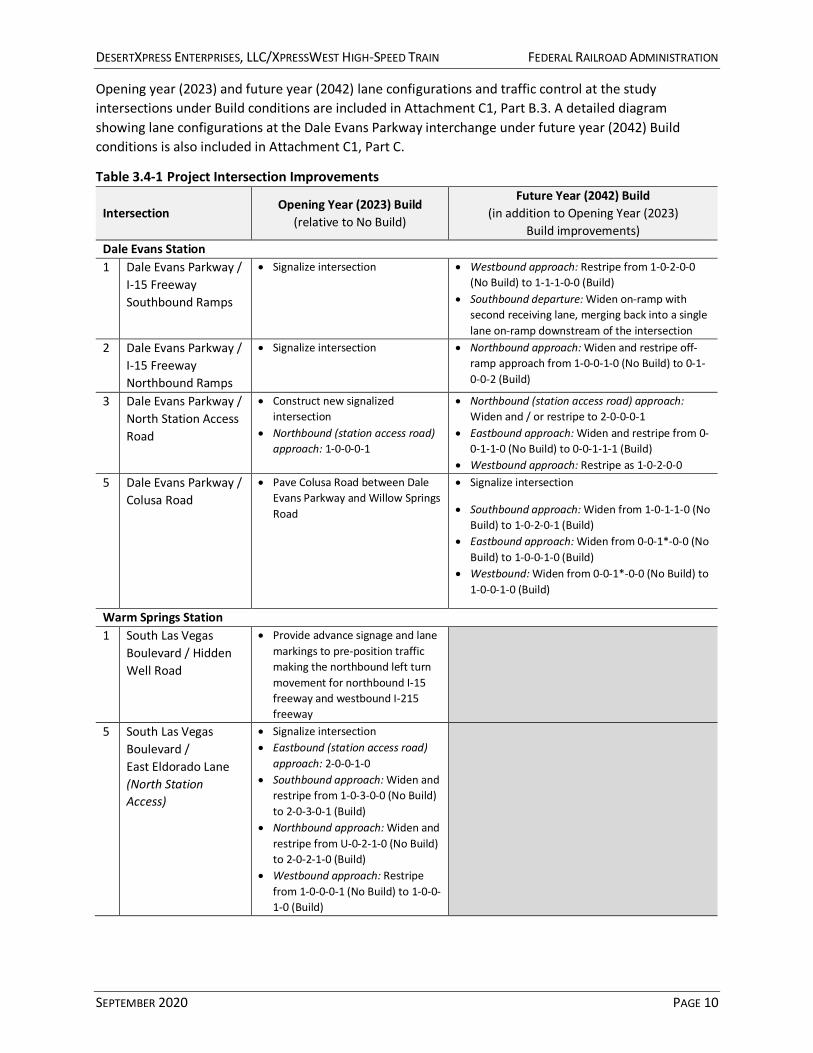
Opening year (2023) and future year (2042) lane configurations and traffic control at the study intersections under Build conditions are included in Attachment C1, Part B.3. A detailed diagram showing lane configurations at the Dale Evans Parkway interchange under future year (2042) Build conditions is also included in Attachment C1, Part C.
Table 3.4-1 Project Intersection Improvements
Intersection Opening Year (2023) Build
(relative to No Build)
Future Year (2042) Build (in addition to Opening Year (2023)
Build improvements) Dale Evans Station 1 Dale Evans Parkway /
I-15 Freeway Southbound Ramps
• Signalize intersection • Westbound approach: Restripe from 1-0-2-0-0 (No Build) to 1-1-1-0-0 (Build)
• Southbound departure: Widen on-ramp with second receiving lane, merging back into a single lane on-ramp downstream of the intersection
2 Dale Evans Parkway / I-15 Freeway Northbound Ramps
• Signalize intersection • Northbound approach: Widen and restripe off-ramp approach from 1-0-0-1-0 (No Build) to 0-1-0-0-2 (Build)
3 Dale Evans Parkway / North Station Access Road
• Construct new signalized intersection
• Northbound (station access road) approach: 1-0-0-0-1
• Northbound (station access road) approach: Widen and / or restripe to 2-0-0-0-1
• Eastbound approach: Widen and restripe from 0-0-1-1-0 (No Build) to 0-0-1-1-1 (Build)
• Westbound approach: Restripe as 1-0-2-0-0 5 Dale Evans Parkway /
Colusa Road • Pave Colusa Road between Dale
Evans Parkway and Willow Springs Road
• Signalize intersection
• Southbound approach: Widen from 1-0-1-1-0 (No Build) to 1-0-2-0-1 (Build)
• Eastbound approach: Widen from 0-0-1*-0-0 (No Build) to 1-0-0-1-0 (Build)
• Westbound: Widen from 0-0-1*-0-0 (No Build) to 1-0-0-1-0 (Build)
Warm Springs Station 1 South Las Vegas
Boulevard / Hidden Well Road
• Provide advance signage and lane markings to pre-position traffic making the northbound left turn movement for northbound I-15 freeway and westbound I-215 freeway
5 South Las Vegas Boulevard / East Eldorado Lane (North Station Access)
• Signalize intersection • Eastbound (station access road)
approach: 2-0-0-1-0 • Southbound approach: Widen and
restripe from 1-0-3-0-0 (No Build) to 2-0-3-0-1 (Build)
• Northbound approach: Widen and restripe from U-0-2-1-0 (No Build) to 2-0-2-1-0 (Build)
• Westbound approach: Restripe from 1-0-0-0-1 (No Build) to 1-0-0-1-0 (Build)

DESERTXPRESS ENTERPRISES, LLC/XPRESSWEST HIGH-SPEED TRAIN FEDERAL RAILROAD ADMINISTRATION
SEPTEMBER 2020 PAGE 11
Intersection Opening Year (2023) Build
(relative to No Build)
Future Year (2042) Build (in addition to Opening Year (2023)
Build improvements) 7 South Las Vegas
Boulevard / East Robindale Road (South Station Access)
• Signalize intersection • Eastbound (station access road)
approach: 2-0-0-1-0 • Southbound approach: Widen and
restripe from 1-0-3-0-0 (No Build) to 2-0-3-0-1 (Build)
• Northbound approach: Widen and restripe from 0-0-2-1-0 (No Build) to 2-0-2-1-0 (Build)
• Westbound approach: Widen and restripe from 1-0-0-0-1 (No Build) to 1-0-1-0-1 (Build)
Notes: Lane configuration key: L-LT-T-TR-R; L = left-turn; LT = shared through–left; T = through; TR = shared through–right; R = right-turn * = all-movement lane U = U-turn lane Implementation of these intersection improvements could require acquisition or easements beyond the public right-of-way.
3.5 TRAVEL DEMAND
3.5.1 TRIP GENERATION
DesertXpress Enterprises, LLC provided detailed ridership data for use in the analysis of the Project’s traffic and transportation effects. The data include passenger volumes at the two stations (Dale Evans Station in Apple Valley and Warm Springs Station in Las Vegas) by year of operation, day of the week, time of day (in two-hour blocks), and direction—i.e., boardings (departures) and alightings (arrivals). These ridership estimates were based on the investment-grade ridership and revenue study for the High Desert Corridor (HDC),15 and include revised assumptions based on updates to the modified Project. The detailed ridership data are included in Attachment, Part D.1 for reference.
Table 3.5-1 summarizes the assumed mode shares and average vehicle occupancies (AVOs) for access to and from the stations, as part of DesertXpress Enterprises, LLC’s ridership forecasts.
Table 3.5-1 Station Access Mode Shares and Average Vehicle Occupancies
Mode
Mode Share Average Vehicle
Occupancy (AVO)
Passenger Car Equivalent
(PCE)
Dale Evans Station
Warm Springs Station
Self-drive and park 66% 22% 1.85 1.00 Pick-up / drop-off 4% 7% 1.85 1.00 Taxi / TNC 15% 20% 1.00 1.00 Public transit (bus) 4% 3% 20.00 1.50 Private (e.g., hotel) shuttle 11% 48% 20.00 1.50
As indicated in Table 3.5-1, the majority (66 percent, or approximately two-thirds) of passengers at the Dale Evans Station is assumed to self-drive and park, followed by 15 percent using taxis or TNCs such as Uber and Lyft, and 11 percent using hotel shuttles and other private shuttles. At the Warm Springs
15 Steer Davies Gleave (for High Desert Corridor Joint Powers Authority). High Desert Corridor: Investment Grade Ridership & Revenue Forecasts. Final Report. November 2016.

DESERTXPRESS ENTERPRISES, LLC/XPRESSWEST HIGH-SPEED TRAIN FEDERAL RAILROAD ADMINISTRATION
SEPTEMBER 2020 PAGE 12
Station, nearly half (48 percent) of the passengers are assumed to use private shuttles, followed by 22 percent for self-drive and park and 20 percent for taxis and TNCs. DesertXpress Enterprise, LLC would achieve a high use of shuttles through partnering with the major hotels and casinos of Las Vegas. Also, DesertXpress Enterprises, LLC would coordinate with TNC providers to implement first-in first-out (FIFO) queuing protocols at the Warm Springs Station to facilitate trip linking and minimize traffic on the surrounding roadway network.
The trip generation calculations also account for the specialized effects of buses and shuttles on traffic operations through use of the passenger car equivalent (PCE) factors shown in Table 3.5-1. These vehicle types are generally larger, heavier, and less maneuverable than standard (household) automobiles, and therefore have an amplified effect on traffic operations that can be approximated through the application of these PCE factors. For taxi / TNC trips, the trip generation calculations take the larger of the arrival / departure passenger-trips to account for chaining (passenger drop-off at the station followed by passenger pick-up).
In addition to passenger trips, the Project’s trip generation also includes trips by train crews, station staff, maintenance workers, and other employees present either on board the trains or at stations (or, in the case of Southern California, at the OMSF adjacent to the station). Employee trip generation was based on estimates of staffing levels and approximate shift patterns provided by DesertXpress Enterprises, LLC. Approximately 320 employees daily are expected to be stationed out of the Dale Evans Station and OMSF site in the opening year (2023), increasing to 572 employees daily by the future year (2042). Approximately 210 employees daily are expected to be stationed out of the Warm Springs Station site in the opening year (2023), increasing to 462 employees in the future year (2042). DesertXpress Enterprises, LLC expects hourly turnover of employees to be approximately 15 percent. All employees are assumed to self-drive to and from the stations or OMSF, with an assumed AVO of 1.18 passengers per vehicle.16
The estimated trip generation (in PCEs) for the Friday PM peak hour for the modified Project is summarized in Table 3.5-2. Friday was selected for the analysis because the combination of Project ridership activity and background traffic (e.g., regular weekday commute travel) is generally expected to be highest on this day. Detailed trip generation calculations are included in Attachment C1, Part D.2.
Table 3.5-2 Project Trip Generation Summary (PM Peak Hour)
Mode
Dale Evans Station and OMSF Warm Springs Station Opening Year
(2023) Future Year (2042) Opening Year
(2023) Future Year (2042)
In Out Total In Out Total In Out Total In Out Total Passengers
Self-drive and park 258 310 568 852 929 1,781 103 86 189 307 282 589
Pick-up / drop-off 37 37 74 115 115 230 64 64 128 197 197 394
Taxi / TNC 131 131 262 392 392 784 175 175 350 523 523 1,046
Public transit (bus) 3 3 6 8 8 16 2 2 4 6 6 12
Private shuttle 8 8 16 22 22 44 32 32 64 95 95 190
16 Nationwide AVO for trips to / from work, from the 2017 National Household Travel Survey (https://nhts.ornl.gov/assets/2017_nhts_summary_travel_trends.pdf).

DESERTXPRESS ENTERPRISES, LLC/XPRESSWEST HIGH-SPEED TRAIN FEDERAL RAILROAD ADMINISTRATION
SEPTEMBER 2020 PAGE 13
Mode
Dale Evans Station and OMSF Warm Springs Station Opening Year
(2023) Future Year (2042) Opening Year
(2023) Future Year (2042)
In Out Total In Out Total In Out Total In Out Total Subtotal 437 489 926 1,389 1,466 2,855 376 359 735 1,128 1,103 2,231
Employees
Self-drive and park 20 20 41 36 36 73 13 13 27 29 29 59
Subtotal 20 20 41 36 36 73 13 13 27 29 29 59
Total
Self-drive and park 278 330 609 888 965 1,854 116 99 216 336 311 648
Pick-up / drop-off 37 37 74 115 115 230 64 64 128 197 197 394
Taxi / TNC 131 131 262 392 392 784 175 175 350 523 523 1,046
Public transit (bus) 3 3 6 8 8 16 2 2 4 6 6 12
Private shuttle 8 8 16 22 22 44 32 32 64 95 95 190
Total 457 509 967 1,425 1,502 2,928 389 372 762 1,157 1,132 2,290
Notes: Component values may not sum to total values due to rounding.
3.5.2 TRIP DISTRIBUTION
Trip distribution and assignment to the roadway network (freeways and local streets) was developed in coordination with DesertXpress Enterprises, LLC based on the expected origin and destination of passengers. The Warm Springs Station in Las Vegas, for example, is located south of the Strip, and the majority of passengers are expected to be heading to and from areas to the north of the station. As none of the Las Vegas station alternatives analyzed in the DesertXpress EIS are located near the Warm Springs Station site, a new trip distribution and assignment pattern was developed for the new analysis. Trip distribution and assignment was also developed based on the consideration that DesertXpress Enterprises, LLC would coordinate with TNC providers to implement FIFO queuing protocols at the Warm Springs Station to facilitate trip linking and minimize traffic on the surrounding roadway network.
For the Dale Evans Station and OMSF in Apple Valley, the modified station site is located opposite the I-15 freeway from the Preferred Victorville Station site analyzed in the DesertXpress EIS. Due to the proximity of the two locations, the trip distribution and assignment is assumed to be the same as in the DesertXpress EIS, transposed to the new station site. The majority of passengers are expected to arrive and depart via the I-15 freeway south of the Station site, heading over the San Gabriel Mountains and San Bernardino Mountains to or from the Inland Empire and the rest of the Greater Los Angeles area.
The assumed trip distribution for modified Project-generated traffic is illustrated in Attachment C1, Part D.3. Opening year (2023) and future year (2042) turning movement volumes under Build conditions are illustrated in Attachment C1, Part B.3.
3.6 ANALYSIS METHODS
For freeway and intersection LOS, the new analysis, like the DesertXpress EIS analysis, is consistent with the Highway Capacity Manual (HCM) methodology, and uses McTrans’s HCS 2010 Version 6.65 software package (for freeway LOS) and Trafficware’s Synchro 10 software package (for intersection LOS). For

DESERTXPRESS ENTERPRISES, LLC/XPRESSWEST HIGH-SPEED TRAIN FEDERAL RAILROAD ADMINISTRATION
SEPTEMBER 2020 PAGE 14
intersection LOS, the 2000 Highway Capacity Manual (HCM 2000) methodology was used to maximize consistency with the DesertXpress EIS analysis and avoid analysis limitations in the more recent HCM 6th edition (2016) methodology.17
4.0 Effects Analysis for Traffic and Transportation
4.1 FREEWAY LEVEL OF SERVICE
4.1.1 DALE EVANS STATION AND OMSF
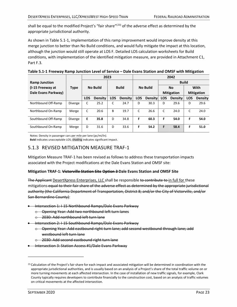
Table 4.1-1 and Table 4.1-2 summarize freeway LOS for the Dale Evans Station and OMSF for the opening year (2023) and future year (2042), under No Build and Build conditions, for mainline segments and ramp junctions, respectively. Detailed LOS calculation worksheets are provided in Attachment E.1 and Attachment C1, Parts E.2 (for mainline segments) and F (for ramp junctions).
As shown in Table 4.1-1 and Table 4.1-2, the modified Project would generally improve LOS along the I-15 freeway mainline and at the I-15 freeway ramp junctions at the Dale Evans Parkway interchange, largely due to a market shift from automobiles to the new high-speed train. While the modified Project would generate some induced demand, the effect of this added traffic would generally be outweighed by the reduction in freeway traffic from passengers who would otherwise have driven along the I-15 freeway between Southern California and Las Vegas. For most locations that would operate at unacceptable conditions (LOS E or LOS F) under Build conditions, the LOS and / or density would be better than under No Build conditions.
As shown in Table 4.1-2, however, the modified Project would increase density at the merge junction for the southbound on-ramp at the Dale Evans Parkway interchange. At this location, the modified Project would reduce traffic on the mainline, but these benefits would be outweighed by the addition of Project-generated traffic merging from the southbound on-ramp, resulting in an overall increase in vehicle density. Under the opening year (2023), this location would operate at an acceptable LOS D without implementation of the Project. The modified Project would result in an overall increase in density at this merge junction, but would not cause it to degrade to LOS E or worse under the opening year (2023). Under the future year (2042), however, this location would already operate at unacceptable conditions (LOS F) without implementation of the Project. The modified Project would exacerbate conditions on this merge junction by increasing the density, and would contribute to a significant impact at this location. Mitigation measures to fully mitigate this adverse effect are described in detail in Section 5.0.
17 For traffic signal phasing, the HCM 6th edition (HCM6) methodology cannot analyze non-NEMA (National Electrical Manufacturers Association) and customized schemes, which were required to ensure efficient operations at some of the Dale Evans Station study intersections. In addition, the HCM6 methodology also has limitations in analyzing U-turns and intersections with both shared and exclusive turn lanes (for the same movements). These two elements are common at several of the Warm Springs Station study intersections.

DESERTXPRESS ENTERPRISES, LLC/XPRESSWEST HIGH-SPEED TRAIN FEDERAL RAILROAD ADMINISTRATION
SEPTEMBER 2020 PAGE 15
Table 4.1-1 Freeway Mainline Level of Service – Dale Evans Station and OMSF
Mainline Segment (I-15 Freeway)
Peak Hour
2023 2042 No Build Build No Build Build
North-bound
South-bound
North-bound
South-bound
North-bound
South-bound
North-bound
South-bound
LOS Den-sity
LOS Den-sity
LOS Den-sity LOS Den-
sity LOS Den-sity LOS Den-
sity LOS Den-sity LOS Den-
sity
Stoddard Wells Rd. (north) ↔ I-40 Junction
AM D 28.9 D 33.6 D 27.4 D 32.6 F 54.3 F 46.2 F 47.5 E 40.0
PM C 19.7 E 39.7 C 18.5 E 36.5 C 24.7 F 101.0 C 21.0 F 71.5
I-40 Junction ↔ Nevada State Line
AM D 27.1 E 37.0 C 25.0 E 35.1 E 42.3 F 63.2 E 35.2 F 48.1
PM C 20.3 E 36.6 C 18.4 D 32.2 D 26.4 F 66.2 C 20.4 E 44.9
Notes: Density in passenger cars per mile per lane (pc/mi/ln). Bold indicates unacceptable LOS.
Table 4.1-2 Freeway Ramp Junction Level of Service – Dale Evans Station and OMSF Ramp Junction (I-15 Freeway at Dale Evans Parkway)
Type 2023 2042
No Build Build No Build Build LOS Density LOS Density LOS Density LOS Density
Northbound Off-Ramp Diverge C 25.2 C 24.7 D 30.3 D 29.6
Northbound On-Ramp Merge C 20.6 B 19.7 C 26.6 C 24.0
Southbound Off-Ramp Diverge E 35.8 D 34.8 F 60.3 F 54.0
Southbound On-Ramp Merge D 31.6 D 33.6 F 54.2 F 58.4
Notes: Density in passenger cars per mile per lane (pc/mi/ln). Bold indicates unacceptable LOS; shading indicates significant impact.
4.1.2 WARM SPRINGS STATION
Table 4.1-3 summarizes freeway mainline LOS for the Warm Springs Station for the opening year (2023) and future year (2042), under No Build and Build conditions. Detailed LOS calculation worksheets are provided in Attachment C1, Parts E.3 and E.4.
Similar to the results for the Dale Evans Station and OMSF in Section 3.1.1, the analysis shows that the Project modifications would generally have a beneficial effect to traffic operations along the I-15 freeway mainline in Nevada, improving LOS and reducing density by shifting travelers from automobiles to the high-speed train. For all locations that would operate at unacceptable conditions (LOS E or LOS F) under Build conditions, the density would be better than under No Build conditions. Therefore, the modified Project would not contribute to adverse effects at these locations. These findings are consistent with the findings outlined in the DesertXpress EIS.

DESERTXPRESS ENTERPRISES, LLC/XPRESSWEST HIGH-SPEED TRAIN FEDERAL RAILROAD ADMINISTRATION
SEPTEMBER 2020 PAGE 16
Table 4.1-3 Freeway Mainline Level of Service – Warm Springs Station
Mainline Segment (I-15 Freeway)
Peak Hour
2023 2042 No Build Build No Build Build
North-bound
South-bound
North-bound
South-bound
North-bound
South-bound
North-bound
South-bound
LOS Den-sity LOS Den-
sity LOS Den-sity LOS Den-
sity LOS Den-sity LOS Den-
sity LOS Den-sity LOS Den-
sity
Primm ↔ Sloan AM C 20.2 D 28.6 C 19.4 D 27.2 D 32.1 F 55.2 D 30.0 F 48.6
PM B 16.4 C 24.1 B 15.3 C 22.4 C 23.7 E 41.8 C 20.9 E 36.0
Sloan ↔ I-215 Junction AM C 19.3 D 28.8 C 19.2 D 28.5 F 323.5 F -- F 310.6 F --
PM B 16.0 C 23.4 B 15.8 C 23.0 F 74.9 F -- F 71.7 F --
Notes: Density in passenger cars per mile per lane (pc/mi/ln). Bold indicates unacceptable LOS. Where density is not reported, conditions fall outside the meaningful range of the analysis methodology.
4.2 INTERSECTION LEVEL OF SERVICE
4.2.1 DALE EVANS STATION AND OMSF
Table 4.2-1 summarizes intersection LOS for the Dale Evans Station and OMSF for the opening year (2023) and future year (2042), under No Build and Build conditions. Detailed LOS calculation worksheets are provided in Attachment C1, Part G.1.
Table 4.2-1 Intersection Level of Service – Dale Evans Station and OMSF
Intersection Traffic Control
2023 2042 No Build Build No Build Build
No Build
Build LOS Delay LOS Delay LOS Delay LOS Delay
1 Dale Evans Pkwy. / I-15 Freeway SB Ramps TWSC Signal B 11.2 B 14.5 C 15.7 C 29.4
2 Dale Evans Pkwy. / I-15 Freeway NB Ramps
TWSC Signal B 11.3 A 8.7 B 14.3 C 33.0
3 Dale Evans Pkwy. / N. Station Access Rd. -- Signal -- B 16.6 -- C 29.3
4 Willow Springs Rd. / Colusa Rd. AWSC AWSC A 6.8 A 8.0 A 7.0 B 14.0
5 Dale Evans Pkwy. / Colusa Rd. TWSC TWSC/Signal B 10.0 D 25.2 A 10.0 B 15.6
6 Dale Evans Pkwy. / Stoddard Wells Rd. TWSC TWSC B 12.7 C 15.4 C 15.1 C 22.5
Notes: Results are based on the 2000 HCM methodology. Build scenarios assume Project improvements at selected intersections as described in Table 3.4-1. AWSC = all-way stop control TWSC = two-way stop control; reported LOS and delay represent worst movement
As indicated in Table 4.2-1, all study intersections are expected to operate at acceptable conditions (LOS D or better), even under Build conditions. It should be noted, however, that the reported LOS and average delay for Build scenarios incorporates various intersection improvements included as part of the modified Project, as described earlier. As summarized in Table 3.4-1, the Project modifications include construction of a new signalized intersection for the North Station Access Road (Intersection #3), as well as signalization and lane configuration changes for the ramp terminal intersections at the Dale Evans

DESERTXPRESS ENTERPRISES, LLC/XPRESSWEST HIGH-SPEED TRAIN FEDERAL RAILROAD ADMINISTRATION
SEPTEMBER 2020 PAGE 17
Parkway interchange (Intersection #1 and Intersection #2) and for the Dale Evans Parkway / Colusa Road intersection (Intersection #5).
Without these improvements, Project-generated vehicle traffic would cause intersection LOS to degrade from acceptable conditions (LOS D or better) to unacceptable conditions (LOS E or LOS F), and would likely result in traffic safety issues due to increased turn conflicts, lack of adequate traffic control devices, and other effects. Without the improvements identified in Table 3.4-1, the modified Project would result in a significant impact at these intersections, and mitigation would be required. Mitigation measures are described in detail in Section 5.0.
4.2.2 WARM SPRINGS STATION
Table 4.2-2 summarizes intersection LOS for the Warm Springs Station for the opening year (2023) and future year (2042), under No Build and Build conditions. Detailed LOS calculation worksheets are provided in Attachment C1, Parts G.3 and G.4.
Table 4.2-2 Intersection Level of Service – Warm Springs Station
Intersection Traffic Control
2023 2042 No Build Build No Build Build
No Build
Build LOS Delay LOS Delay LOS Delay LOS Delay
1 S. Las Vegas Blvd. / Hidden Well Rd. Signal Signal D 36.7 D 42.9 D 40.2 E 57.7
2 S. Las Vegas Blvd. / George Crockett Rd. Signal Signal D 50.4 E 60.7 E 67.5 F >120.0
3 S. Las Vegas Blvd. / Warm Springs Rd. Signal Signal D 54.6 E 56.3 E 69.0 F 93.2
4 S. Las Vegas Blvd. / E. Mardon Ave. TWSC TWSC F 110.1 D 32.2 F >120.0 F* >120.0
5 S. Las Vegas Blvd. / E. Eldorado Ln. TWSC Signal F >120.0 C 24.1 F >120.0 D 39.7
6 S. Las Vegas Blvd. / E. Maulding Ave. TWSC TWSC F >120.0 E 35.2 F >120.0 D 29.1
7 S. Las Vegas Blvd. / E. Robindale Rd. TWSC Signal F >120.0 C 20.7 F >120.0 C 29.5
8 S. Las Vegas Blvd. / E. Mesa Verde Ln. TWSC TWSC B 11.5 B 12.7 B 11.9 C 16.8
9 S. Las Vegas Blvd. / Blue Diamond Rd. Signal Signal E 68.0 F 99.5 E 71.6 F >120.0
10 I-15 Freeway NB Ramps / Blue Diamond Rd. Signal Signal C 26.8 C 29.9 C 33.7 E 59.9
11 I-15 Freeway SB Ramps / Blue Diamond Rd.
Signal Signal C 21.0 C 23.0 B 19.6 C 32.8
Notes: Results are based on the 2000 HCM methodology. Build scenarios assume Project improvements at selected intersections as described in Table 3.4-1. TWSC = two-way stop control; reported LOS and delay represent worst movement Bold indicates unacceptable LOS; shading indicates significant impact. Average delays greater than 120.0 seconds are generally considered outside the meaningful range of the analysis methodology. *Average delay at Intersection #4 would exceed 120.0 seconds under 2042 Build conditions, but would be substantially lower than under 2042 No Build conditions due to increased frequency and size of gaps in traffic flow as a result of the signalization of Intersection #5.
As summarized in Table 3.4-1, the Project modifications include improvements at the South Las Vegas Boulevard intersections with East Eldorado Lane (Intersection #5) and East Robindale Road (intersection #7) to facilitate vehicle ingress and egress for the station site, including signalization and lane configuration changes.
DESERTXPRESS ENTERPRISES, LLC/XPRESSWEST HIGH-SPEED TRAIN FEDERAL RAILROAD ADMINISTRATION
SEPTEMBER 2020 PAGE 18
Without these improvements, Project-generated vehicle traffic would exacerbate unacceptable conditions (LOS E or LOS F) at these locations in excess of established significance thresholds, and would likely result in traffic safety issues due to increased turn conflicts, lack of adequate traffic control devices, and other effects. Without the improvements identified in Table 3.4-1, the modified Project would result in a significant impact at these intersections, and mitigation would be required.
The addition of Project-generated traffic would also contribute to significant impacts at seven of the other study intersections, as indicated in Table 4.2-2, and mitigation would also be required at these locations.
Mitigation measures to fully mitigate these adverse effects are described in detail in Section 5.0.
4.3 VEHICLE MILES TRAVELED
As discussed in detail in Section 2.2, the Project is exempt from state and local land use and environmental regulations, including CEQA and the CEQA Guidelines updates addressing VMT impacts of projects. While these updates to the CEQA Guidelines were adopted in December 2018, a brief discussion of the modified Project’s VMT-related effects is provided below for informational purposes. As mentioned in the DesertXpress EIS, VMT estimates are also required as part of characterizing potential impacts to air quality and energy. Therefore, the VMT discussion provided below is also intended to facilitate the NEPA Reevaluation of air quality and energy impacts for the Project modifications.
While neither Caltrans nor affected local jurisdictions have specific VMT significance thresholds adopted and in place at this time, the Governor’s Office of Planning and Research (OPR) of the State of California has issued a technical advisory that includes recommendations on evaluating VMT impacts of projects, including suggestions regarding significance thresholds and analysis approaches for specific project types. Specifically, OPR’s technical advisory provides the following guidance regarding transit and active transportation projects:
Transit and active transportation projects generally reduce VMT and therefore are presumed to cause a less-than-significant impact on transportation. This presumption may apply to all passenger rail projects, bus and bus rapid transit projects, and bicycle and pedestrian infrastructure Projects. Streamlining transit and active transportation projects aligns with each of the three statutory goals contained in SB 743 by reducing GHG emissions, increasing multimodal transportation networks, and facilitating mixed use development.(18)
As the modified Project is a passenger rail project, VMT-related impacts are therefore presumed to be less-than-significant, and a detailed VMT analysis is not warranted. While a detailed VMT analysis is not warranted, specific VMT-related effects of the modified Project can be easily quantified as order-of-magnitude estimates to clearly demonstrate that the Project would result in an overall reduction in annual VMT.
While the modified Project would result in the creation of some induced demand that is currently not served by the existing transportation network and available travel options, the HDC investment-grade
18 Governor’s Office of Planning and Research, State of California. Technical Advisory on Evaluating Transportation Impacts in CEQA. December 2018. Available online: http://opr.ca.gov/docs/20190122-743_Technical_Advisory.pdf. Accessed January 14, 2020.
DESERTXPRESS ENTERPRISES, LLC/XPRESSWEST HIGH-SPEED TRAIN FEDERAL RAILROAD ADMINISTRATION
SEPTEMBER 2020 PAGE 19
ridership and revenue study estimates that induced ridership would represent only 7 percent of the modified Project’s total forecasted ridership in 2042. The HDC study estimates that the remaining 93 percent of ridership would consist of existing demand captured from other modes, including approximately 62 percent shifted from automobiles, 30 percent shifted from air travel, and 1 percent shifted from buses. Using the values described above, for example, an estimate of the modified Project’s potential reduction in annual VMT associated with diversion from automobiles to rail can be derived as follows:
8,061,000 passengers (annual ridership diverted from automobiles in 2042) × 175 miles (approximate one-way travel distance between Dale Evans Station and Warm
Springs Station via the I-15 freeway) ÷ 2.50 passengers / vehicle (average vehicle occupancy)(19)
≈ 564 million VMT (reduction)
For the purposes of this demonstrative analysis, diversion from air travel can be ignored for simplicity, under the assumption that vehicle travel to and from airports would be replaced by vehicle travel to and from the modified stations. Diversion from buses can also be ignored for simplicity, both because the ridership (as a share of total Project ridership) is small (1 percent) and because much of the passenger market served by intercity and charter buses is expected to continue to prefer buses due to cost, convenience, and proximity (especially at the California end of the route).
In contrast, a conservative estimate of the increase in annual VMT associated with induced demand generated by the modified Project can be derived as follows:
851,000 passengers (annual ridership due to induced demand) × 2 stations (induced VMT is assumed to be generated at both the origin station and the
destination station) × 50 miles (assumed one-way average travel distance to or from the station) ÷ 1.85 passengers / vehicle (average vehicle occupancy)(20)
≈ 46 million VMT (increase)
This estimate assumes that all of the induced demand would travel to and from the stations by vehicle. As indicated by the station access mode shares in Table 3.5-1, however, this is unlikely to be the case, as the mode share for private (e.g., hotel) shuttles in Las Vegas alone would be approximately 48 percent.
It should also be noted that there would be an increase in VMT associated with employee commute trips to and from the two stations sites and the OMSF. A conservative estimate of this increase in annual VMT can be derived as follows:
(572 employees + 462 employees) (daily employees at Apple Valley and Las Vegas sites in 2042) × 365 days / year × 25 miles (assumed one-way average travel distance to or from the station or the OMSF) × 2 one-way trips / employee
19 Average vehicle occupancy based on behavioral surveys conducted for the HDC investment-grade ridership and revenue study. See Appendix C of the HDC study for more information.
20 Average vehicle occupancy for induced demand is conservatively assumed to be lower than for diversion from automobiles to account for taxi / TNC and passenger drop-off / pick-up. A higher assumed vehicle occupancy would result in a lower increase in VMT due to induced demand.
DESERTXPRESS ENTERPRISES, LLC/XPRESSWEST HIGH-SPEED TRAIN FEDERAL RAILROAD ADMINISTRATION
SEPTEMBER 2020 PAGE 20
÷ 1.18 passengers / vehicle (average vehicle occupancy for work commute trips)
≈ 16 million VMT (increase)
As indicated by this demonstrative analysis, even when explicitly accounting for components of the modified Project that would result in an increase in annual VMT—such as induced demand and employee commute travel—the modified Project would still result in a substantial reduction in annual VMT (approximately 502 million VMT) due to diversion from automobiles to rail within the I-15 freeway corridor.
The modified Project would also include several smaller components that would affect other transportation infrastructure or facilities, such as improvements to facilitate access to and from stations (e.g., lane configuration changes, installation of traffic control signals) and potential modifications to Caltrans facilities or within Caltrans right-of-way (ROW). OPR’s technical advisory identifies a list of such project types, which would “not likely lead to a substantial or measurable increase in vehicle travel, and therefore generally should not require an induced travel analysis”. These project types include (but are not limited to the following):21
• Rehabilitation, maintenance, replacement, safety, and repair projects designed to improve the condition of existing transportation assets (e.g., highways; roadways; bridges; culverts; Transportation Management System field elements such as cameras, message signs, detection, or signals; tunnels; transit systems; and assets that serve bicycle and pedestrian facilities) and that do not add additional motor vehicle capacity
• Roadside safety devices or hardware installation such as median barriers and guardrails • Roadway shoulder enhancements to provide “breakdown space,” dedicated space for use only by
transit vehicles, to provide bicycle access, or to otherwise improve safety, but which will not be used as automobile vehicle travel lanes
• Installation, removal, or reconfiguration of traffic lanes that are not for through traffic, such as left, right, and U-turn pockets, two-way left turn lanes, or emergency breakdown lanes that are not utilized as through lanes
• Grade separation to separate vehicles from rail, transit, pedestrians or bicycles, or to replace a lane in order to separate preferential vehicles (e.g., HOV, HOT, or trucks) from general vehicles
• Installation, removal, or reconfiguration of traffic control devices, including Transit Signal Priority (TSP) features
• Installation of traffic metering systems, detection systems, cameras, changeable message signs and other electronics designed to optimize vehicle, bicycle, or pedestrian flow
• Timing of signals to optimize vehicle, bicycle, or pedestrian flow • Initiation of new transit service • Addition of traffic wayfinding signage
Therefore, applicable components of the modified Project are presumed to have a negligible effect on VMT. Overall, the modified Project would result in a net reduction in VMT, resulting in a beneficial effect.
21 Governor’s Office of Planning and Research, State of California. Technical Advisory on Evaluating Transportation Impacts in CEQA. December 2018. Available online: http://opr.ca.gov/docs/20190122-743_Technical_Advisory.pdf. Accessed December 16, 2019.

DESERTXPRESS ENTERPRISES, LLC/XPRESSWEST HIGH-SPEED TRAIN FEDERAL RAILROAD ADMINISTRATION
SEPTEMBER 2020 PAGE 21
4.4 ROADWAY SAFETY
4.4.1 HIGHWAYS
The DesertXpress EIS included a qualitative discussion of highway traffic safety, primarily focusing on clear zones,22 sight distance, and visual distraction. The DesertXpress EIS concluded that the original Project could result in potential safety impacts and identified Mitigation Measure TRAF-4 (“Conduct a Design Review within the Parameters Defined in the Highway Interface Manual”) as appropriate mitigation to fully mitigate these adverse effects. Specifically, Mitigation Measure TRAF-4 involves coordination with Caltrans, NDOT, and the Federal Highway Administration (FHWA) for design review and approval of components of the modified Project located within the I-15 freeway ROW.
Project modifications include changes in alignment and other features, which would affect the ultimate design of XpressWest facilities, such as earthwork, structural supports, overhead catenary systems, and other components. While the geographic location of specific safety-related impacts would be different than the original Project evaluated in the DesertXpress EIS, the nature of these impacts would generally remain unchanged. These impacts could include potential effects related to obstruction of motorists’ sight distance, increased severity of run-off road crashes, and visual distractions for motorists (particularly train headlights) during operation of the modified Project, as well as temporary reductions in horizontal and vertical clearances during construction of the Project. The DesertXpress EIS also identified issues regarding clear zone requirements with respect to rail maintenance and operations, which would still be required for the modified Project.
Thus, the Project modifications would not substantially alter the analysis or conclusions in the DesertXpress EIS regarding highway safety impacts, and Mitigation Measure TRAF-4 would still be a feasible means of fully mitigating the modified Project’s potentially adverse effects on highway safety. Given the market diversion from automobiles to rail in the I-15 freeway corridor, the modified Project (and associated roadway modifications) would also result in some beneficial effects to highway safety due to a reduction in collisions.
While there have been some changes to the I-15 freeway that have been completed or proposed since the DesertXpress EIS analysis, particularly in the Nevada portion of the corridor, these changes are not expected to substantially affect the ability to implement the design review as described in Mitigation Measure TRAF-4 as a means of fully mitigating potentially adverse effects related to highway safety.
4.4.2 LOCAL STREETS
While the modified Project would result in added traffic on local streets surrounding the Dale Evans Station and OMSF and the Warm Springs Station, an increase in traffic alone would generally not constitute a safety hazard. The improvements shown in Table 3.4-1 for both station sites are specifically intended to provide safe and adequate connections between the station and the existing circulation network, and include new traffic signals, turn pockets, and other measures that would minimize traffic hazards such as ROW conflicts. All improvements would be designed according to accepted industry standards such as the MUTCD, the American Association of State Highway and Transportation Officials (AASHTO) Policy on Geometric Design of Highways and Streets, and the National Association of City
22 ”Clear zone” refers to the physical clearance / distance between DesertXpress facilities and the nearest travel lanes.

DESERTXPRESS ENTERPRISES, LLC/XPRESSWEST HIGH-SPEED TRAIN FEDERAL RAILROAD ADMINISTRATION
SEPTEMBER 2020 PAGE 22
Transportation Officials Urban Street Design Guide, and would be coordinated with local jurisdictions to ensure conformance with their specific design practices.
Without these improvements, however, the modified Project would likely result in traffic safety issues due to increased turn conflicts, lack of adequate traffic control devices, and other effects. These effects would constitute a significant impact, and mitigation would be required. Mitigation measures are described in detail in Section 5.0.
5.0 Mitigation Measures This section describes the changes to the transportation mitigation measures originally identified in the 2011 DesertXpress and their applicability to the Project modifications. Revisions to mitigation measures are included as strikeout underline following the applicable measure. Feasibility of the mitigation measures has not been verified through field surveys and will require further evaluation in subsequent stages of the Project (e.g., detailed design).
5.1 MITIGATION MEASURE TRAF-1
5.1.1 INTERSECTION IMPACTS
For the Victorville Station site, the DesertXpress EIS identified improvements to both I-15 freeway ramp terminal intersections (Intersection #1 and Intersection #2), as well as improvements to three additional station access intersections, under the original Project. The three station access intersections identified as impacts in the DesertXpress EIS do not apply to the Dale Evans Station and OMSF, which is located on the opposite side of the I-15 freeway from the Victorville Station site originally evaluated in the DesertXpress EIS.
However, without improvements to the ramp terminal intersections (Intersection #1 and Intersection #2), Intersection #3 (Dale Evans Parkway / North Station Access Road), and Intersection #5 (Dale Evans Parkway / Colusa Road) as described in Table 3.4-1, the Project modifications would not provide safe and adequate access for the Dale Evans Station and OMSF, as discussed in detail earlier under
Section 4.2.1 and Section 4.4.2. To reduce this potentially significant impact, DesertXpress Enterprises, LLC would be responsible for funding the improvements at the Dale Evans Station and OMSF study intersections identified in Table 3.4-1.
As discussed in Section 4.2.1 and shown in Table 4.2-1, implementation of these improvements would improve LOS at these locations to acceptable conditions, and would fully mitigate the impacts at these intersections. Detailed LOS calculation worksheets for Build conditions, with implementation of the identified mitigation measure, are provided in Attachment C1, Part G.2.
5.1.2 FREEWAY IMPACTS
As indicated in Table 4.1-2, the Project modifications would also contribute to a freeway impact at the merge junction for the southbound I-15 freeway on-ramp from Dale Evans Parkway for the Dale Evans Station and OMSF site. To reduce this potentially significant impact, DesertXpress Enterprises, LLC would be responsible for contribution toward the widening of the southbound on-ramp to provide two on-ramp lanes at the merge junction with the mainline. This would be achieved by extending the second receiving lane from the intersection with Dale Evans Parkway all the way downstream, removing the merge to a single-lane on-ramp south of the intersection. DesertXpress Enterprises, LLC’s contribution
DESERTXPRESS ENTERPRISES, LLC/XPRESSWEST HIGH-SPEED TRAIN FEDERAL RAILROAD ADMINISTRATION
SEPTEMBER 2020 PAGE 23
shall be equal to the modified Project’s “fair share”(23) of the adverse effect as determined by the appropriate jurisdictional authority.
As shown in Table 5.1-1, implementation of this ramp improvement would improve density at this merge junction to better than No Build conditions, and would fully mitigate the impact at this location, although the junction would still operate at LOS F. Detailed LOS calculation worksheets for Build conditions, with implementation of the identified mitigation measure, are provided in Attachment C1, Part F.3.
Table 5.1-1 Freeway Ramp Junction Level of Service – Dale Evans Station and OMSF with Mitigation
Ramp Junction (I-15 Freeway at Dale Evans Parkway)
Type
2023 2042
No Build Build No Build Build
No Mitigation
With Mitigation
LOS Density LOS Density LOS Density LOS Density LOS Density Northbound Off-Ramp Diverge C 25.2 C 24.7 D 30.3 D 29.6 D 29.6
Northbound On-Ramp Merge C 20.6 B 19.7 C 26.6 C 24.0 C 24.0
Southbound Off-Ramp Diverge E 35.8 D 34.8 F 60.3 F 54.0 F 54.0
Southbound On-Ramp Merge D 31.6 D 33.6 F 54.2 F 58.4 F 51.0
Notes: Density in passenger cars per mile per lane (pc/mi/ln). Bold indicates unacceptable LOS; shading indicates significant impact.
5.1.3 REVISED MITIGATION MEASURE TRAF-1
Mitigation Measure TRAF-1 has been revised as follows to address these transportation impacts associated with the Project modifications at the Dale Evans Station and OMSF site:
Mitigation TRAF-1: Victorville Station Site Option 3 Dale Evans Station and OMSF Site
The Applicant DesertXpress Enterprises, LLC shall be responsible to contribute to in full for these mitigations equal to their fair share of the adverse effect as determined by the appropriate jurisdictional authority (the California Department of Transportation, District 8; and/or the City of Victorville, and/or San Bernardino County):
• Intersection 1: I-15 Northbound Ramps/Dale Evans Parkway o Opening Year: Add two northbound left turn lanes o 2030: Add northbound left turn lane
• Intersection 2: I-15 Southbound Ramps/Dale Evans Parkway o Opening Year: Add eastbound right turn lane; add second westbound through lane; add
westbound left turn lane o 2030: Add second eastbound right turn lane
• Intersection 3: Station Access #1/Dale Evans Parkway
23 Calculation of the Project’s fair share for each impact and associated mitigation will be determined in coordination with the appropriate jurisdictional authorities, and is usually based on an analysis of a Project’s share of the total traffic volume on or more turning movements at each affected intersection. In the case of installation of new traffic signals, for example, Clark County typically requires developers to contribute financially to the construction cost, based on an analysis of traffic volumes on critical movements at the affected intersection.

DESERTXPRESS ENTERPRISES, LLC/XPRESSWEST HIGH-SPEED TRAIN FEDERAL RAILROAD ADMINISTRATION
SEPTEMBER 2020 PAGE 24
o Opening Year: Signalize; add second westbound left turn lane o 2030: N/A
• Intersection 5: Future Street/Dale Evans Parkway o Opening Year: Signalize; add second westbound left turn lane o 2030: Add third westbound left turn lane
• Intersection 7: Future Street/Station Access #4 o Opening Year: Signalize o 2030: N/A
• Intersection 1: Dale Evans Parkway / I-15 Southbound Ramps o Opening Year: Signalize o Future Year (2042): Restripe westbound approach from 1-0-2-0-0 to 1-1-1-0-0; widen
southbound departure (on-ramp) with second receiving lane, merging back into a single-lane on-ramp downstream of the intersection
• Intersection 2: Dale Evans Parkway / I-15 Northbound Ramps o Opening Year: Signalize o Future Year (2042): Widen and restripe northbound approach from 1-0-0-1-0 to 0-1-0-0-2
• Intersection 3: Dale Evans Parkway / North Station Access Road o Opening Year: Construct as new signalized intersection; design northbound (station access road)
approach with 1-0-0-0-1 o Future Year (2042): Widen and / or restripe northbound (station access road) approach to 2-0-0-
0-1; widen and restripe eastbound approach from 0-0-1-1-0 to 0-0-1-1-1 and restripe westbound approach as 1-0-2-0-0
• Intersection 5: Dale Evans Parkway / Colusa Road o Opening Year: Pave Colusa Road between Dale Evans Parkway and Willow Springs Road o Future Year (2042): Signalize; widen southbound approach from 1-0-1-1-0 to 1-0-2-0-1; widen
eastbound and westbound approaches from 0-0-1*-0-0 to 1-0-0-1-0
DesertXpress Enterprises, LLC shall also be responsible for contribution toward the widening of the southbound on-ramp to provide two on-ramp lanes at the merge junction with the mainline. This would be achieved by extending the second receiving lane from the intersection with Dale Evans Parkway all the way downstream, removing the merge to a single-lane on-ramp south of the intersection. DesertXpress Enterprises, LLC’s contribution shall be equal to the Project’s “fair share” of the adverse effect as determined by the appropriate jurisdictional authority.
5.2 MITIGATION MEASURES TRAF-2 AND TRAF-3
The Warm Springs Station site is not proximate to the Las Vegas station sites originally evaluated in the DesertXpress EIS. Therefore, the specific transportation improvements identified in Mitigation Measures TRAF-2 (Las Vegas Southern Station) and TRAF-3 (Las Vegas Central Station B) are not applicable to the Project modifications.
As indicated in Table 4.2-2, however, the Project modifications would contribute to intersection LOS impacts at seven study intersections for the Warm Springs Station. To reduce this potential impact, DesertXpress Enterprises, LLC shall be responsible for contribution toward the mitigations described in Table 5.2-1, equal to the modified Project’s “fair share” of the adverse effect as determined by the appropriate jurisdictional authority. As shown in Table 5.2-2, implementation of these mitigation requirements would improve LOS and average delay to at least as good as, or better than, No Build conditions, and would fully mitigate the impacts at these locations. Detailed LOS calculation worksheets

DESERTXPRESS ENTERPRISES, LLC/XPRESSWEST HIGH-SPEED TRAIN FEDERAL RAILROAD ADMINISTRATION
SEPTEMBER 2020 PAGE 25
for these intersections under Build conditions, with implementation of the identified mitigation measures, are provided in Attachment C1, Part G.5.
Without improvements to Intersection #5 (South Las Vegas Boulevard / East Eldorado Lane) and Intersection #7 (South Las Vegas Boulevard / East Robindale Road) as described in Table 3.4-1, the Project modifications would also result in adverse effects at these two locations. To reduce this potentially significant impact, DesertXpress Enterprises, LLC would be responsible for funding the improvements at the Warm Springs Station study intersections as identified in Table 3.4-1. As shown in Table 4.2-2, implementation of these improvements would improve LOS at these locations to acceptable conditions, and would fully mitigate the impacts at these intersections. Detailed LOS calculation worksheets for these intersections under Build conditions, with implementation of the identified mitigation measure, are provided in Attachment C1, Part G.2.
Table 5.2-1 Warm Springs Station Intersection Improvements
Intersection Opening Year (2023) Build Future Year (2042) Build)
(in addition to Opening Year (2023) Build mitigations)
1 South Las Vegas Boulevard / Hidden Well Road (East Maule Avenue)
No mitigation required • Widen and restripe westbound approach from 1-1-0-0-1 to 2-0-1-0-1
2 South Las Vegas Boulevard / George Crockett Road
• Widen eastbound approach from 1-1-0-0-1 to 1-1-0-1-1 and convert uncontrolled (yield) eastbound right-turn lane to signal control
• Restripe eastbound approach to 2-0-1-0-1 • Add 1 southbound receiving lane and provide
overlap phasing for eastbound right-turn movement from George Crockett Rd.
3 South Las Vegas Boulevard / Warm Springs Road
• Prohibit northbound and southbound U-turn movements
• Provide permissive and overlap right-turn phasing for eastbound and westbound approaches
• Prohibit eastbound and westbound U-turn movements
• Provide permissive and overlap right-turn phasing for northbound and southbound approaches
• Add 1 southbound receiving lane for right-turn movement from Warm Springs Blvd., continuing through Intersection #4 (E. Mardon Ave.) and becoming a right-turn lane at Intersection #5 (E. Eldorado Ln.)
4 South Las Vegas Boulevard / East Mardon Avenue (Las Vegas South Premium Outlets)
• Convert Premium Outlets driveway to right-in / right-out only
• Provide hard median and divert U-turn and left-turn movements to Intersection #5 (E. Eldorado Ln.)
• Add 1 southbound through lane for right-turn movement from Warm Springs Blvd., becoming a right-turn lane at Intersection #5 (E. Eldorado Ln.)
6 South Las Vegas Boulevard / East Maulding Avenue (Las Vegas South Premium Outlets)
• Convert Premium Outlets driveway to right-in / right-out only
• Provide hard median and divert U-turn and left-turn movements to Intersection #5 (E. Eldorado Ln.)
No mitigation required
9 South Las Vegas Boulevard /
• Add 1 westbound receiving lane for southbound right-turn movement from S. Las Vegas Blvd.
• Add 1 westbound right-turn lane
• Restrict southbound U-turn movement • Elevate all crosswalks

DESERTXPRESS ENTERPRISES, LLC/XPRESSWEST HIGH-SPEED TRAIN FEDERAL RAILROAD ADMINISTRATION
SEPTEMBER 2020 PAGE 26
Intersection Opening Year (2023) Build Future Year (2042) Build)
(in addition to Opening Year (2023) Build mitigations)
East Windmill Lane / Blue Diamond Road
• Prohibit northbound, eastbound, and westbound U-turn movements
• Provide permissive and overlap right-turn phasing for northbound, southbound, and eastbound approaches
• Provide free control for southbound right-turn movement
• Provide protected and overlap right-turn phasing for northbound, eastbound, and westbound approaches
10 Blue Diamond Road / I-15 Freeway Northbound Ramps
No mitigation required Restripe northbound approach from 1-1-0-0-1 to 1-0-1*-0-1
Note: Lane configuration key: L-LT-T-TR-R; L = left-turn; LT = shared through–left; T = through; TR = shared through–right; R = right-turn * = all-movement lane
Table 5.2-2 Intersection Level of Service – Warm Springs Station with Mitigation
Intersection
2023 2042
No Build Build
No Build Build
No Mitigation
With Mitigation
No Mitigation
With Mitigation
LOS Delay LOS Delay LOS Delay LOS Delay LOS Delay LOS Delay 1 S. Las Vegas Blvd. / Hidden Well Rd. D 36.7 D 42.9 D 41.0 D 40.2 E 57.7 D 47.3
2 S. Las Vegas Blvd. / George Crockett Rd. D 50.4 E 60.7 D 47.9 E 67.5 F >120.0 D 43.1
3 S. Las Vegas Blvd. / Warm Springs Rd. D 54.6 E 56.3 D 52.9 E 69.0 F 93.2 E 64.2
4 S. Las Vegas Blvd. / E. Mardon Ave. F 110.1 D 32.2 B 10.2 F >120.0 F >120.0 B 11.8
5 S. Las Vegas Blvd. / E. Eldorado Ln. F >120.0 C 24.1 C 34.5 F >120.0 D 39.7 C 31.5
6 S. Las Vegas Blvd. / E. Maulding Ave. F >120.0 E 35.2 A 9.9 F >120.0 D 29.1 B 10.8
7 S. Las Vegas Blvd. / E. Robindale Rd. F >120.0 C 20.7 C 21.7 F >120.0 C 29.5 C 20.2
8 S. Las Vegas Blvd. / E. Mesa Verde Ln. B 11.5 B 12.7 B 12.7 B 11.9 C 16.8 C 16.8
9 S. Las Vegas Blvd. / Blue Diamond Rd. E 68.0 F 99.5 E 62.3 E 71.6 F >120.0 E 65.7
10 I-15 Freeway NB Ramps / Blue Diamond Rd. C 26.8 C 29.9 C 29.3 C 33.7 E 59.9 D 38.5
11 I-15 Freeway SB Ramps / Blue Diamond Rd. C 21.0 C 23.0 C 23.1 B 19.6 C 32.8 C 25.9
Notes: Results are based on the 2000 HCM methodology. Bold indicates unacceptable LOS; shading indicates significant impact. Average delays greater than 120.0 seconds are generally considered outside the meaningful range of the analysis methodology.
Mitigation Measure TRAF-2 been revised as follows to address these transportation impacts associated with the Project modifications at the Warm Springs Station site.
Mitigation TRAF-2: Las Vegas Southern Station Warm Springs Station
The Applicant DesertXpress Enterprises, LLC shall be responsible in full for these mitigations:
Intersection 1: South Las Vegas Boulevard / Hidden Well Road

DESERTXPRESS ENTERPRISES, LLC/XPRESSWEST HIGH-SPEED TRAIN FEDERAL RAILROAD ADMINISTRATION
SEPTEMBER 2020 PAGE 27
o Opening Year: Provide advance signage and lane markings to pre-position traffic making the northbound left turn movement for northbound I-15 freeway and westbound I-215 freeway
o Future Year (2042): N/A Intersection 5: South Las Vegas Boulevard / East Eldorado Lane o Opening Year: Signalize; design eastbound (station access road) approach with 2-0-0-1-0; widen and restripe southbound approach from 1-0-3-0-0 to 2-0-3-0-1; widen and restripe northbound approach from U-0-2-1-0 to 2-0-2-1-0; restripe westbound approach from 1-0-0-0-1 to 1-0-0-1-0 o Future Year (2042): N/A
• Intersection 7: South Las Vegas Boulevard / East Robindale Road o Opening Year: Signalize; design eastbound (station access road) approach with 2-0-0-1-0; widen
and restripe southbound approach from 1-0-3-0-0 to 2-0-3-0-1; widen and restripe northbound approach from 0-0-2-1-0 to 2-0-2-1-0; widen and restripe westbound approach from 1-0-0-0-1 to 1-0-1-0-1
o Future Year (2042): N/A
If the Las Vegas Southern Station is constructed, the Applicant DesertXpress Enterprises, LLC shall also be responsible to contribute to these mitigations equal to their fair-share of the adverse effect as determined by the appropriate jurisdictional authority (the Nevada Department of Transportation and/or Clark County):
• Intersection 1: South Las Vegas Boulevard / Hidden Well Road (East Maule Avenue) o Opening Year: N/A o Future Year (2042): Widen and restripe westbound approach from 1-1-0-0-1 to 2-0-1-0-1
• Intersection 2: South Las Vegas Boulevard / George Crockett Road o Opening Year: Widen eastbound approach from 1-1-0-0-1 to 1-1-0-1-1 and convert uncontrolled
(yield) eastbound right-turn lane to signal control o Future Year (2042): Restripe eastbound approach to 2-0-1-0-1; add 1 southbound receiving lane
and provide overlap phasing for eastbound right-turn movement from George Crockett Rd. • Intersection 3: South Las Vegas Boulevard / Warm Springs Road
o Opening Year: Prohibit northbound and southbound U-turn movements; provide permissive and overlap right-turn phasing for eastbound and westbound approaches
o Future Year (2042): Prohibit eastbound and westbound U-turn movements; provide permissive and overlap right-turn phasing for northbound and southbound approaches; add 1 southbound receiving lane for right-turn movement from Warm Springs Blvd., continuing through Intersection #4 (E. Mardon Ave.) and becoming a right-turn lane at Intersection #5 (E. Eldorado Ln.)
• Intersection 4: South Las Vegas Boulevard / East Mardon Avenue o Opening Year: Convert Premium Outlets driveway to right-in / right-out only; provide hard
median and divert U-turn and left-turn movements to Intersection #5 (E. Eldorado Ln.) o Future Year (2042): Add 1 southbound through lane for right-turn movement from Warm
Springs Blvd., becoming a right-turn lane at Intersection #5 (E. Eldorado Ln.) • Intersection 6: South Las Vegas Boulevard / East Maulding Avenue
o Opening Year: Convert Premium Outlets driveway to right-in / right-out only; provide hard median and divert U-turn and left-turn movements to Intersection #5 (E. Eldorado Ln.)
o Future Year (2042): N/A • Intersection 9: South Las Vegas Boulevard / East Windmill Lane / Blue Diamond Road
DESERTXPRESS ENTERPRISES, LLC/XPRESSWEST HIGH-SPEED TRAIN FEDERAL RAILROAD ADMINISTRATION
SEPTEMBER 2020 PAGE 28
o Opening Year: Add 1 westbound receiving lane for southbound right-turn movement from S. Las Vegas Blvd; prohibit northbound, eastbound, and westbound U-turn movements; provide permissive and overlap right-turn phasing for northbound, southbound, and eastbound approaches
o Future Year (2042): Add 1 westbound right-turn lane; restrict southbound U-turn movement; elevate all crosswalks; provide free control for southbound right-turn movement; provide protected and overlap right-turn phasing for northbound, eastbound, and westbound approaches
• Intersection 10: Blue Diamond Road / I-15 Northbound Ramps o Opening Year: N/A o Future Year (2042): Restripe northbound approach from 1-1-0-0-1 to 1-0-1*-0-1
• Intersection 1: Tropicana/ Valley View o Opening Year: Add exclusive southbound free right turn lane. o 2030: Add exclusive westbound right turn lane; add second southbound left turn lane.
• Intersection 2: Tropicana/Dean Martin Drive-Industrial o Opening Year: Optimize signal offset along Tropicana o 2030: Add fourth eastbound through lane; add fourth westbound through lane.
• Intersection 3: Tropicana/I-15 NB Ramps o Opening Year: N/A o 2030: Add second northbound right turn lane.
• Intersection 6: Hacienda/Polaris o Opening Year: Signalize this intersection. o 2030: N/A
• Intersection 7: Hacienda/Valley View o Opening Year: N/A o 2030: Add second eastbound left turn lane; add exclusive eastbound right turn lane; add third
eastbound through lane; add exclusive westbound right turn lane; add third westbound through lane; add second northbound left turn lane; add third northbound through lane.
5.3 MITIGATION MEASURE TRAF-4
As discussed in Section 4.4, Mitigation Measure TRAF-4: Conduct a Design Review within the Parameters Defined in the Highway Interface Manual, would continue to apply to the Project modifications as for the original Project, and would mitigate potential adverse effects on highway traffic safety.
6.0 Attachment C1: Traffic and Transportation Supporting Information
The following parts of Attachment C1 provide information supporting this technical report.
Part A: Vehicle Turning Movement Counts at Study Intersections
Part B: Study Intersection Turning Movement Volumes, Lane Configurations, and Traffic Control B.1: Existing Conditions B.2: No Build Conditions B.3: Build Conditions
Part C: Dale Evans Parkway Interchange under Future Year (2042) Build Conditions

DESERTXPRESS ENTERPRISES, LLC/XPRESSWEST HIGH-SPEED TRAIN FEDERAL RAILROAD ADMINISTRATION
SEPTEMBER 2020 PAGE 29
Part D: Project Travel Demand D.1: Detailed Ridership Forecasts D.2: Trip Generation Calculations D.3: Assumed Trip Distribution
Part E: Freeway Mainline Level of Service Calculation Worksheets E.1: Dale Evans Station: No Build Conditions E.2: Dale Evans Station: Build Conditions E.3: Warm Springs Station: No Build Conditions E.4: Warm Springs Station: Build Conditions
Part F: Freeway Ramp Junction Level of Service Calculation Worksheets F.1: Dale Evans Station: No Build Conditions F.2: Dale Evans Station: Build Conditions F.3: Dale Evans Station: Build Conditions with Mitigation Measures
Part G: Intersection Level of Service and Queuing Calculation Worksheets G.1: Dale Evans Station: No Build Conditions G.2: Dale Evans Station: Build Conditions G.3: Warm Springs Station: No Build Conditions G.4: Warm Springs Station: Build Conditions G.5: Warm Springs Station: Build Conditions with Mitigation Measures