atsb transport safety report prelim.pdf · de havilland aircraft pty ltd dh-84 dragon - i - atsb...
TRANSCRIPT

ATSB TRANSPORT SAFETY REPORT Aviation Occurrence Investigation – AO-2012-130
Preliminary
Collision with terrain 36 km SW of Gympie, Queensland
1 October 2012 VH-UXG
de Havilland Aircraft Pty Ltd DH-84 Dragon


- i -
ATSB TRANSPORT SAFETY REPORT Aviation Occurrence Investigation
AO-2010-130 Preliminary
Collision with terrain 36 km SW of Gympie, Queensland
1 October 2012 VH-UXG
de Havilland Aircraft Pty Ltd DH-84 Dragon
Released in accordance with section 25 of the Transport Safety Investigation Act 2003

- ii -
Published by: Australian Transport Safety Bureau Postal address: PO Box 967, Civic Square ACT 2608 Office: 62 Northbourne Avenue Canberra, Australian Capital Territory 2601 Telephone: 1800 020 616, from overseas +61 2 6257 4150 Accident and incident notification: 1800 011 034 (24 hours) Facsimile: 02 6247 3117, from overseas +61 2 6247 3117 Email: [email protected] Internet: www.atsb.gov.au
© Commonwealth of Australia 2012
In the interests of enhancing the value of the information contained in this publication you may download, print, reproduce and distribute this material acknowledging the Australian Transport Safety Bureau as the source. However, copyright in the material obtained from other agencies, private individuals or organisations, belongs to those agencies, individuals or organisations. Where you want to use their material you will need to contact them directly.
ISBN and formal report title: see ‘Document retrieval information’ on page iii.

- iii -
DOCUMENT RETRIEVAL INFORMATION
Report No. AO-2012-130
Publication date 8 November 2012
No. of pages 11
ISBN 978-1-74251-298-3
Publication title Collision with terrain - 36 km SW of Gympie, Queensland - 1 October 2012 - VH-UXG - de Havilland Aircraft Pty Ltd DH-84 Dragon.
Prepared By Australian Transport Safety Bureau PO Box 967, Civic Square ACT 2608 Australia www.atsb.gov.au
Acknowledgements Figure 1: Google

- iv -
THE AUSTRALIAN TRANSPORT SAFETY BUREAU
The Australian Transport Safety Bureau (ATSB) is an independent Commonwealth Government statutory agency. The Bureau is governed by a Commission and is entirely separate from transport regulators, policy makers and service providers. The ATSB's function is to improve safety and public confidence in the aviation, marine and rail modes of transport through excellence in: independent investigation of transport accidents and other safety occurrences; safety data recording, analysis and research; fostering safety awareness, knowledge and action. The ATSB is responsible for investigating accidents and other transport safety matters involving civil aviation, marine and rail operations in Australia that fall within Commonwealth jurisdiction, as well as participating in overseas investigations involving Australian registered aircraft and ships. A primary concern is the safety of commercial transport, with particular regard to fare-paying passenger operations. The ATSB performs its functions in accordance with the provisions of the Transport Safety Investigation Act 2003 and Regulations and, where applicable, relevant international agreements. Purpose of safety investigations The object of a safety investigation is to identify and reduce safety-related risk. ATSB investigations determine and communicate the safety factors related to the transport safety matter being investigated. The terms the ATSB uses to refer to key safety and risk concepts are set out in the next section: Terminology Used in this Report. It is not a function of the ATSB to apportion blame or determine liability. At the same time, an investigation report must include factual material of sufficient weight to support the analysis and findings. At all times the ATSB endeavours to balance the use of material that could imply adverse comment with the need to properly explain what happened, and why, in a fair and unbiased manner. Developing safety action Central to the ATSB’s investigation of transport safety matters is the early identification of safety issues in the transport environment. The ATSB prefers to encourage the relevant organisation(s) to initiate proactive safety action that addresses safety issues. Nevertheless, the ATSB may use its power to make a formal safety recommendation either during or at the end of an investigation, depending on the level of risk associated with a safety issue and the extent of corrective action undertaken by the relevant organisation. When safety recommendations are issued, they focus on clearly describing the safety issue of concern, rather than providing instructions or opinions on a preferred method of corrective action. As with equivalent overseas organisations, the ATSB has no power to enforce the implementation of its recommendations. It is a matter for the body to which an ATSB recommendation is directed to assess the costs and benefits of any particular means of addressing a safety issue. When the ATSB issues a safety recommendation to a person, organisation or agency, they must provide a written response within 90 days. That response must indicate whether they accept the recommendation, any reasons for not accepting part or all of the recommendation, and details of any proposed safety action to give effect to the recommendation. The ATSB can also issue safety advisory notices suggesting that an organisation or an industry sector consider a safety issue and take action where it believes appropriate, or to raise general awareness of important safety information in the industry. There is no requirement for a formal response to an advisory notice, although the ATSB will publish any response it receives.

- v -
TERMINOLOGY USED IN THIS REPORT
Occurrence: accident or incident.
Safety factor: an event or condition that increases safety risk. In other words, it is something that, if it occurred in the future, would increase the likelihood of an occurrence, and/or the severity of the adverse consequences associated with an occurrence. Safety factors include the occurrence events (e.g. engine failure, signal passed at danger, grounding), individual actions (e.g. errors and violations), local conditions, current risk controls and organisational influences.
Contributing safety factor: a safety factor that, had it not occurred or existed at the time of an occurrence, then either: (a) the occurrence would probably not have occurred; or (b) the adverse consequences associated with the occurrence would probably not have occurred or have been as serious, or (c) another contributing safety factor would probably not have occurred or existed.
Other safety factor: a safety factor identified during an occurrence investigation which did not meet the definition of contributing safety factor but was still considered to be important to communicate in an investigation report in the interests of improved transport safety.
Other key finding: any finding, other than that associated with safety factors, considered important to include in an investigation report. Such findings may resolve ambiguity or controversy, describe possible scenarios or safety factors when firm safety factor findings were not able to be made, or note events or conditions which ‘saved the day’ or played an important role in reducing the risk associated with an occurrence. Safety issue: a safety factor that (a) can reasonably be regarded as having the potential to adversely affect the safety of future operations, and (b) is a characteristic of an organisation or a system, rather than a characteristic of a specific individual, or characteristic of an operational environment at a specific point in time. Risk level: the ATSB’s assessment of the risk level associated with a safety issue is noted in the Findings section of the investigation report. It reflects the risk level as it existed at the time of the occurrence. That risk level may subsequently have been reduced as a result of safety actions taken by individuals or organisations during the course of an investigation.
Safety issues are broadly classified in terms of their level of risk as follows:
• Critical safety issue: associated with an intolerable level of risk and generally leading to the immediate issue of a safety recommendation unless corrective safety action has already been taken.
• Significant safety issue: associated with a risk level regarded as acceptable only if it is kept as low as reasonably practicable. The ATSB may issue a safety recommendation or a safety advisory notice if it assesses that further safety action may be practicable.
• Minor safety issue: associated with a broadly acceptable level of risk, although the ATSB may sometimes issue a safety advisory notice.
Safety action: the steps taken or proposed to be taken by a person, organisation or agency in response to a safety issue.

- 1 -
FACTUAL INFORMATION The information contained in this preliminary factual report is derived from the initial investigation of the occurrence. Readers are cautioned that new evidence will become available as the investigation progresses that may alter the circumstances as depicted in this preliminary report. As such, no analysis or findings are included in this report.
History of the flight At about 1107 Eastern Standard Time1 on 1 October 2012, a de Havilland Aircraft Pty Ltd DH-84 Dragon, registered VH-UXG (UXG), took off from Monto on a private flight to Caboolture, Queensland under the visual flight rules2 (VFR). On board the aircraft were the pilot/owner and five passengers. The weather conditions on departure were reported to include a light south-easterly wind with a high overcast and good visibility.
Sometime after about 1230, the aircraft was seen near Tansey, about 150 km north-west of Caboolture on the direct track from Monto to Caboolture. The aircraft was reported flying in a south-easterly direction at the time, at an estimated height of 3,000 ft and in fine but overcast conditions.
At 1315, the pilot contacted Brisbane Radar air traffic control (ATC) and advised that the aircraft’s position was about 37 NM (69 km) north of Caboolture and requested navigation assistance. At 1318, the pilot advised ATC that the aircraft was in ‘full cloud’. For most of the remainder of the flight, the pilot and ATC exchanged communications, at times relayed through a commercial flight and a rescue flight in the area due to the limited ATC radio coverage in the area at low altitude.
At about 1320, a friend of one of the aircraft’s passengers received a telephone call from the passenger to say that she was in an aircraft and that they were ‘lost in a cloud’ and kept losing altitude. Witnesses in the Borumba Dam, Imbil and Kandanga areas 70 to 80 km north-north-west of Caboolture later reported that they heard and briefly saw the aircraft flying in and out of low cloud between about 1315 and 1415.
At 1348, the pilot advised ATC that the aircraft had about an hour’s endurance3 remaining. The pilot’s last recorded transmission was at 1404.
A search for the aircraft was coordinated by Australian Search and Rescue (AusSAR).4 The aircraft wreckage was located on 3 October 2012, about 87 km north-west of Caboolture on the northern side of a steep, densely wooded ridge about 500 m above mean sea level (Figure 1). The Australian Transport Safety
1 Eastern Standard Time (EST) was Coordinated Universal Time (UTC) + 10 hours. 2 Visual flight rules (VFR) are a set of regulations which allow a pilot to only operate an aircraft in
weather conditions generally clear enough to allow the pilot to see where the aircraft is going. 3 The maximum time in the conditions that the aircraft could remain airborne without refuelling. 4 AusSAR operates a 24-hour rescue coordination centre and is responsible for the national
coordination of search and rescue.

- 2 -
Bureau (ATSB) later determined that the aircraft probably impacted terrain at about 1421 on 1 October 2012.
Figure 1: Accident site location
The aircraft was destroyed by impact forces (Figure 2). There was no fire. The accident was not survivable and the six occupants were fatally injured.
Figure 2: Aircraft wreckage

- 3 -
Pilot information The pilot held a Private Pilot Licence (Aeroplane) (PPL(A)) that was issued on 25 June 1998 and a Class 2 Medical Certificate that was valid until 22 August 2014 and included a restriction that the pilot must wear vision correction for reading while flying. The pilot was endorsed on the DH-84 aircraft type in March 2003 and had satisfactorily completed an aeroplane proficiency check in UXG on 15 September 2012.
The last entry in the pilot’s logbook was dated 15 September 2012 and showed a total flying experience of 1,128.4 hours. The aircraft’s maintenance release indicated that since that date, the pilot had flown an additional 5.7 hours. The pilot’s total experience on type was 662.6 hours, representing almost all of his flying experience since March 2003. In the previous 90 days the pilot had flown 6.4 hours, all of it in UXG. In the 3 days prior to the accident, the pilot had flown 5.7 hours that included the flight from Caboolture to Monto and several local flights from Monto on the day before the accident.
The pilot did not hold an instrument rating but had recorded 3.7 hours of instrument flight time, most of which was gained during training for his PPL(A). The most recent instrument flying was recorded in March 1998.
The pilot was reported to have been in a normal, good mood on the morning of the flight.
Weather information
Forecast weather
The pilot was reported to have viewed the Area 40 forecast on the event organiser’s smart phone before departure and the planned flight was contained within Area 40.5 The Area 40 forecast most likely viewed by the pilot was issued at 0934 and valid from 0900 to 2100. It forecast isolated thunderstorms near the coast north of Maroochydore with scattered showers and drizzle along the coast and extending inland after midday to a line to the west of the direct track from Monto to Caboolture. The wind at 2,000 ft was forecast from 140 °(T) at 15 kts, a direct headwind along the intended track, and was forecast to be up to 30 kts near the coast north of Maroochydore. Visibility in the area was forecast to be 8 km in smoke haze near fires, reducing to 3,000 m in showers and rain.
There was no aerodrome forecast (TAF)6 for Caboolture. The nearest airports for which TAFs were available were Brisbane Airport (54 km to the south) and the Sunshine Coast Airport at Maroochydore (55 km to the north).
From 0900, the Sunshine Coast TAF predicted a south-easterly wind of 16 kts, a visibility greater than 10 km, showers and Scattered7 cloud at 2,500 ft and Broken
5 An area forecast issued for the purposes of providing aviation weather forecasts to pilots. Australia
is subdivided into a number of forecast areas. 6 An aerodrome forecast is a statement of meteorological conditions expected for a specific period
of time, in the airspace within a radius of 5 NM (9 km) of the aerodrome.

- 4 -
cloud at 4,000 ft. Intermittent deteriorations of up to 30 minutes duration were forecast after 1000, with visibility reduced to 4,000 m in rain showers and an overcast cloud base of 1,000 ft.
The Brisbane TAF indicated similar conditions as the Sunshine Coast from 0900 but with Scattered cloud base 3,500 ft and Broken cloud at 6,000 ft.
Witness reports of the weather in the area
A witness in the Glen Echo area, about 55 km north-north-west of the accident, reported that the weather in the area at the time was overcast, cloudy and misty. The clouds were low over the mountains and were moving very quickly at altitude. They were building over the range and moving in from the coast.
The weather in the Borumba Dam area, about 10km south-east of the accident site, was reported to be overcast and misty with occasional patches of sunlight. Witnesses in the Imbil, Brooloo and Kandanga areas, 20 km east and north-east of the accident respectively reported thick, low cloud obscuring the hill tops and visibility that was reduced in mist or drizzly rain.
The pilot of a commercial aircraft overflying the area reported that there was a solid undercast with no breaks or ‘holes’ visible, and that the cloud tops were over 10,000 ft. The pilot of a rescue helicopter flying in the area at the time reported that the coastal weather included a south-easterly wind with a cloud base between 1,000 ft and 2,500 ft and a visibility of 5 km. This pilot recalled that toward the area of the accident the conditions were considerably worse, with cloud on the hill tops and visibility reduced to between 1 to 2 km in drizzle and mist.
Aircraft information The aircraft, serial number 6077, was a twin-engine medium transport biplane manufactured in the United Kingdom in 1934, and first registered in Australia in 1936. It later underwent an almost complete rebuild, which was finalised in about 2002 (Figure 3).
7 Cloud cover is normally reported using expressions that denote the extent of the cover. The
expression Few indicates that up to a quarter of the sky was covered, Scattered indicates that cloud was covering between a quarter and a half of the sky. Broken indicates that more than half to almost all the sky was covered, while Overcast means all the sky was covered.

- 5 -
Figure 3: VH-UXG in 2006
The aircraft was powered by two four-cylinder de Havilland Gipsy Major engines that each drove a two-bladed aluminium propeller. The aircraft structure was primarily of fabric-covered timber.
At the time of the accident, the aircraft was fitted with a single, central pilot’s seat and five passenger seats in a staggered, side-by-side configuration.
The aircraft was not equipped or approved for operations under the instrument flight rules.8
Accident site examination Four ATSB investigators examined the accident site from 4 to 8 October 2012. During this period, the ATSB worked alongside but independently of the Queensland Police. The police were in control of the accident site until 7 October 2012.
Preliminary analysis indicated that the aircraft collided with trees and terrain at a moderate to high speed, with a left angle of bank. The aircraft’s direction of travel at impact was toward the south-south-west.
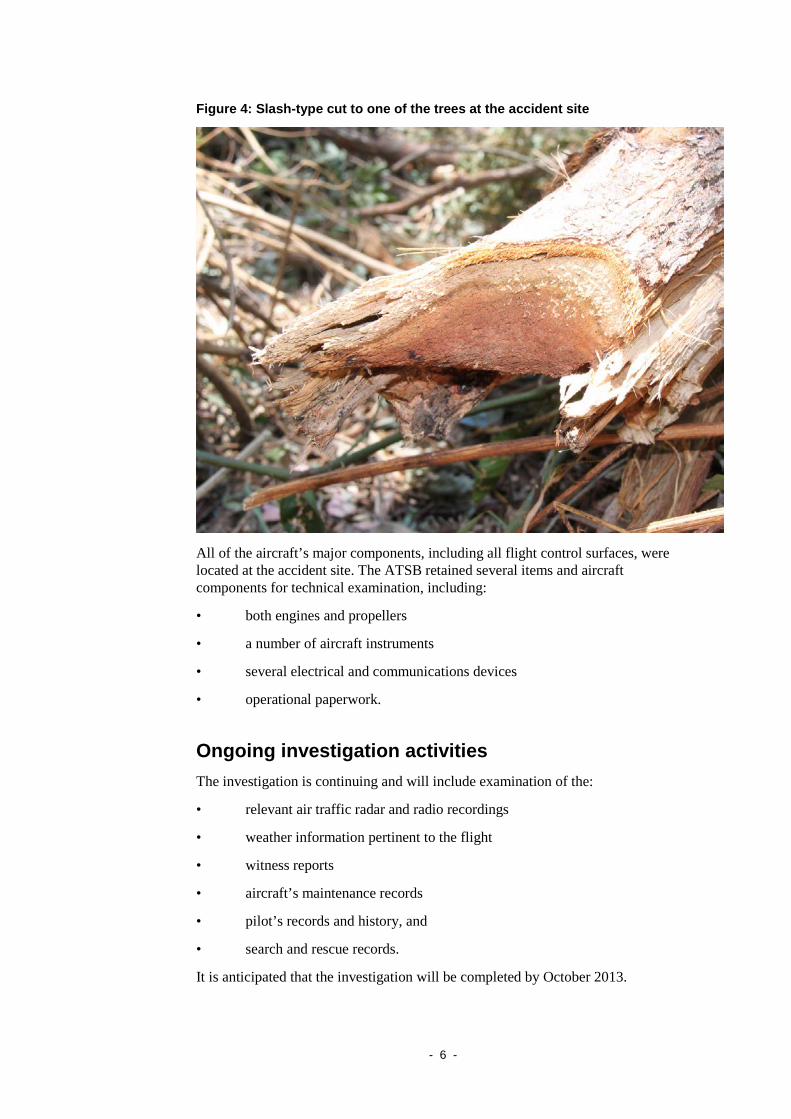
One of the trees sustained an 8 cm deep slash-type cut, consistent with impact by one of the propellers (Figure 4). Both of the aircraft’s fuel tanks were ruptured and there was about 7 L of aviation gasoline (AVGAS) remaining in the right fuel tank. There was evidence that fuel had drained from the left fuel tank after the impact with terrain.
8 Instrument flight rules (IFR) permit an aircraft to operate in instrument meteorological conditions
(IMC), which have much lower weather minimums than visual flight rules. Procedures and training are significantly more complex for operations under the IFR as a pilot must demonstrate competency in IMC conditions, while controlling the aircraft solely by reference to instruments. IFR-capable aircraft have greater equipment and maintenance requirements.
- 6 -
Figure 4: Slash-type cut to one of the trees at the accident site
All of the aircraft’s major components, including all flight control surfaces, were located at the accident site. The ATSB retained several items and aircraft components for technical examination, including:
• both engines and propellers
• a number of aircraft instruments
• several electrical and communications devices
• operational paperwork.
Ongoing investigation activities The investigation is continuing and will include examination of the:
• relevant air traffic radar and radio recordings
• weather information pertinent to the flight
• witness reports
• aircraft’s maintenance records
• pilot’s records and history, and
• search and rescue records.
It is anticipated that the investigation will be completed by October 2013.