atm and airlines operations in volcanic ashicrat.org/icrat/seminarcontent/2012/pdf/atm and airlines...
TRANSCRIPT

ATM and Airlines’Operations in Volcanic Ash
Tatjana Bolic, VIU22nd May 2012
ICRAT 2012, Berkeley, USA

Agenda
• Volcanic ash - what happens?• What’s all the fuss about?• Eyjafjallajökull eruption • Changes in the aftermath• VOLCEX 11/01 and Grimsvötn lessons• Status today

Volcanic Ash – what happens?

Volcanic Ash – what happens?The beginning of interest
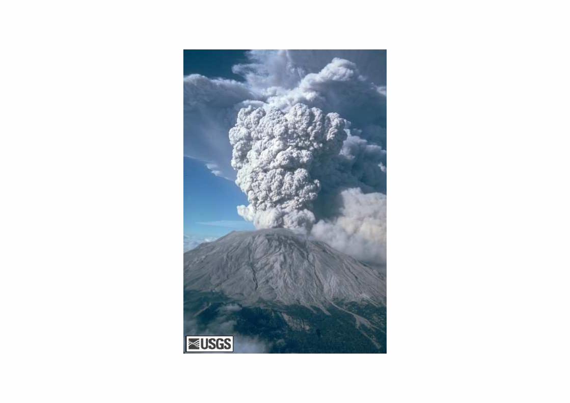
• Mount St. Helens 1980 (source: USGS)– Caused damage to several commercial aircraft:
• Windshield abrasions• The engine compressor blades abrasions• Plugged pitot static system• The wing leading edges – sandblasting effect• Engine oil containing high concentrations of sulfur• Engine flameout
– Ash fused in turbines
– Severe temperature stress and erosion– Compressor damage…

Source: Engine Damage to a NASA DC-8-72 Airplane From a High-Altitude Encounter With a Diffuse Volcanic Ash Cloud

Volcanic Ash – what happens?
• Galunggung, Redoubt, and Mount Pinatubo eruptions - the most well-known ones
• More than 100 commercial aircraft encountered volcanic ash and sustained damage from these encounters – of what is reported

Volcanic Ash – what happens?Safety and cost
• So far none of the volcanic ash encounters resulted in the aircraft crashes or loss of life
• The consequences of an encounter can be:– Immediate, reducing flight safety– Cost inducing later on: engine change or overhaul,
instrument repairs, windshield repairs, and additional aircraft downtime due to repairs

Volcanic Ash – what happens?Safety and cost
• The volcanic-ash-related costs to aviation are estimated to be much higher than $250 million (1982-2000), – $80 million for Boeing 747-400 which entered the ash cloud from
Redoubt Volcano, Alaska, US, in 1987
• NASA DC-8 engine damage from a high-altitude encounter with a diffuse volcanic ash cloud– Routine aircraft inspection after the encounter did not show the
traces of ash, – All 4 engines were overhauled
• Volcanic ash encounters can accelerate the usual maintenance cycle, thus causing additional maintenance costs.

Volcanic Ash – what happens?
• Volcanic Ash Warnings Study Group in 1982
• International Airways Volcano Watch in 1987
• Volcanic Ash Advisory Centers (VAACs) in 1990s

Volcanic Ash – what happens?
• When informed about eruption, the responsible VAAC provides the forecast for ash dispersion
• VAAC issues Volcanic Ash Advisory messages (VAA): – Meteorological Watch Offices (MWOs)
produce the SIGMET (significant weather) messages for aviation
– NOTAM Offices issue NOTAM (Notice to airmen)

Volcanic Ash – what happens?
• How does the crew recognize the ash cloud?– Visible ash
– Haze– St. Elmo’s fire
– Sulfuric odor in cabin– Smoke in cabin

What’s all the fuss about?

We have it covered,So what’s all the fuss about?
• Ash visibility• Satellite imagery• Concentration levels• Where, and how long?• Forecasts

Ash Visibility
Source: Ólafur Sigurjónsson via Iceland Met Office

Ash Visibility
• What about the IFR or night time flights?
– NASA DC-8 flight

Satellite Imagery
Iceland Met Office: Ash from Eyjafjallajökull volcano, 6 May, by EUMETSAT

Satellite Imagery
Source: http://volcanoes.usgs.gov/Imgs/Jpg/Rabaul/rabshut2_large.jpg

Satellite Imagery
Source: UK Met Office

Satellite Imagery
• MSG images are monitoring for the presence of volcanic ash emission in the vicinity of Iceland using infrared data from the Meteosat Second Generation (MSG) satellite. Because cloud particles and volcanic ash particles interact with the infrared radiation in different ways, data at several different wavelengths can be combined to identify the main ash plume, which, when present, would be shown as pink, yellow and orange colours in the images. However, it should be noted that it is only the thicker parts of the plume that are able to be detected by this method. In addition, the ash plume is often masked by overlying high cloud and therefore might not appear in the satellite image.

Ash Concentration Levels
• Every eruption, and therefore ash cloud, is different
• However, still no indications exist on the concentration levels that are “safe” for airframe and/or engine
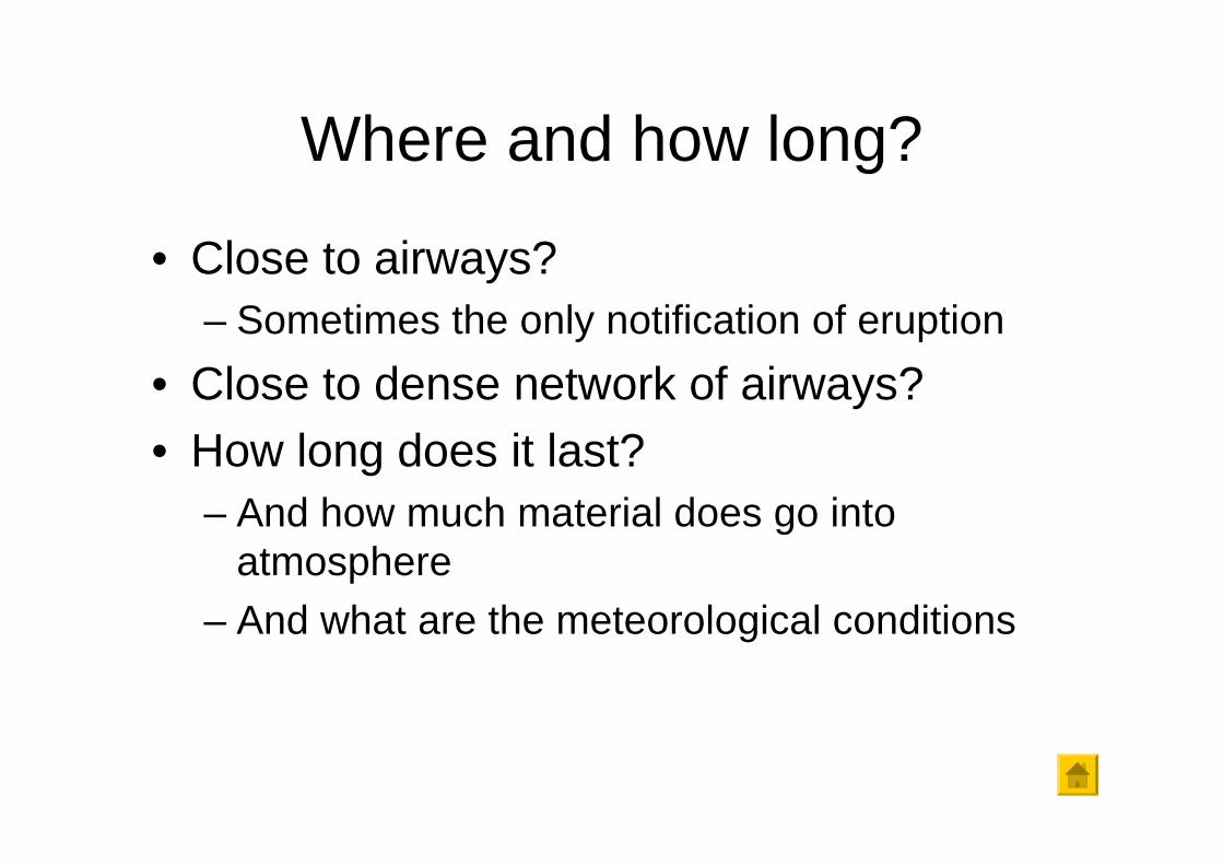
Where and how long?
• Close to airways?– Sometimes the only notification of eruption
• Close to dense network of airways?• How long does it last?
– And how much material does go into atmosphere
– And what are the meteorological conditions

Volcanic Ash Cloud Dispersion Forecasts
• Are forecasts!– Based on estimation of:
• Height of plume• Material composition• Material quantity
• NASA DC-8 flight
• Created a lot of problems during Eyjafjallajökulleruption

Eyjafjallajökull eruption

Eyjafjallajökull eruption
• 14th April – 28th April• European coordination • 3rd May to 23rd May• Key areas for improvement

Eyjafjallajökull eruption

Eyjafjallajökull eruptionAIM Message
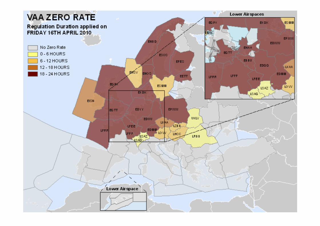
• VAAC London - First Volcanic Ash Advisory - 14 th April, CFMU issues AIM:
TITLE: VOLCANIC ASH----------------------------------------------------------------VALID FROM: 1000 UTC TO: 2359 UTC.CFMU HAS BEEN INFORMED THAT AN ERUPTION OF VOLCANO EYJAFJOLL (ICELAND)HAS STARTED. ACCS AFFECTED MAY REQUEST CFMU TO APPLY APPROPRIATE ATFCM MEASURES, SUCH AS ZERO-RATE REGULATIONS. IN THE MEANTIME AIRCRAFT OPERATORS ARE STRONGLY RECOMMENDED TO CLOSELY MONITOR ALL RELEVANT NOTAMS..THE HEIGHT OF THE PLUME AT THIS TIME IS FLOOO-FL220.CFMU OPS/BRUSSELS

Eyjafjallajökull eruptionFrom contingency to crisis
CFMU activates its volcanic ash contingency procedure
• Early warning – issue information on volcanic ash activity
• On request of national ATC providers : CFMU Applies measures
• Facilitate information exchange – organise teleconferences
Europe enters an ash aviation crisis on Thursday 15 April


Eyjafjallajökull eruptionImpact on European traffic
Daily Traffic per Volcano Activity Week
2857
8
2859
7
2265
3
2496
5
2812
6
2750
8
2808
7
2084
2
1165
9
933052
04
5335
2191
1
1310
1
0
5000
10000
15000
20000
25000
30000
35000
THU FRI SAT SUN MON TUE WED
W201015 W201016
• 54% of flights not operated
• More than 100,000 flights
• 1% of annual traffic
• Impacted 29% of global
aviation
• Affected 1.2 million
passengers a day.

0 100 200 300 400 500 600 700 800
PARIS CH DE GAULLE
FRANKFURT MAIN
LONDON/HEATHROW
MADRID BARAJAS
MUENCHEN 2
SCHIPHOL AMSTERDAM
ROME FIUMICINO
BARCELONA
WIEN SCHWECHAT
ISTANBUL-ATATURK
COPENHAGEN KASTRUP
ZURICH
PARIS ORLY
OSLO/GARDERMOEN
DUESSELDORF
BRUSSELS NATIONAL
STOCKHOLM-ARLANDA
ATHINAI/ELEFTHERIOS VENIZELOS
MILANO MALPENSA
GENEVA
W201016W201015
Eyjafjallajökull eruptionImpact on Airports (traffic)
In the area directly affected by the ash – 70% reduction
Outside of the area directly affected by the ash –
23% reduction

Eyjafjallajökull eruptionImpact on Aircraft Operators (traffic)
0 200 400 600 800 1000 1200 1400 1600 1800 2000
LUFTHANSA
RYANAIR
EASYJET
AIR FRANCE
SCANDINAVIAN AIRLINES SYSTEM
AIR BERLIN
TURKISH AIRLINES
KLM ROYAL DUTCH AIRLINES
ALITALIA
BRITISH AIRWAYS
IBERIA AIRLINES
AUSTRIAN AIRLINES
SWISS INTERNATIONAL AIR LINES
AIR NOSTRUM
NORWEGIAN AIR SHUTTLE
WIDEROES FLYVESELSKAP
TAP PORTUGAL
VUELING AIRLINES
LOT POLISH AIRLINES
OLYMPIC AIRLINES
W201015 W201016
In the area directly affected by the ash – average reduction of 67%
Outside affected areas - average reduction of 20%
Several airlines lost more than 80% of foreseen traffic.

• Unlocking the crisis: 19 th April:
– Close coordination – EC & EUROCONTROL• EC – political leadership • EUROCONTROL – network management
expertise
– EUROCONTROL proposes three options– Teleconference of the EUROCONTROL
Provisional Council (AM) & EU Council of Ministers (PM) – option 3
Eyjafjallajökull eruption

OPTION 3- NO FLY ZONE
- Contaminated Zone
- Ash Free Zone
Buffer
60NM
States
to decide on
NO FLY ZONE

Eyjafjallajökull eruption
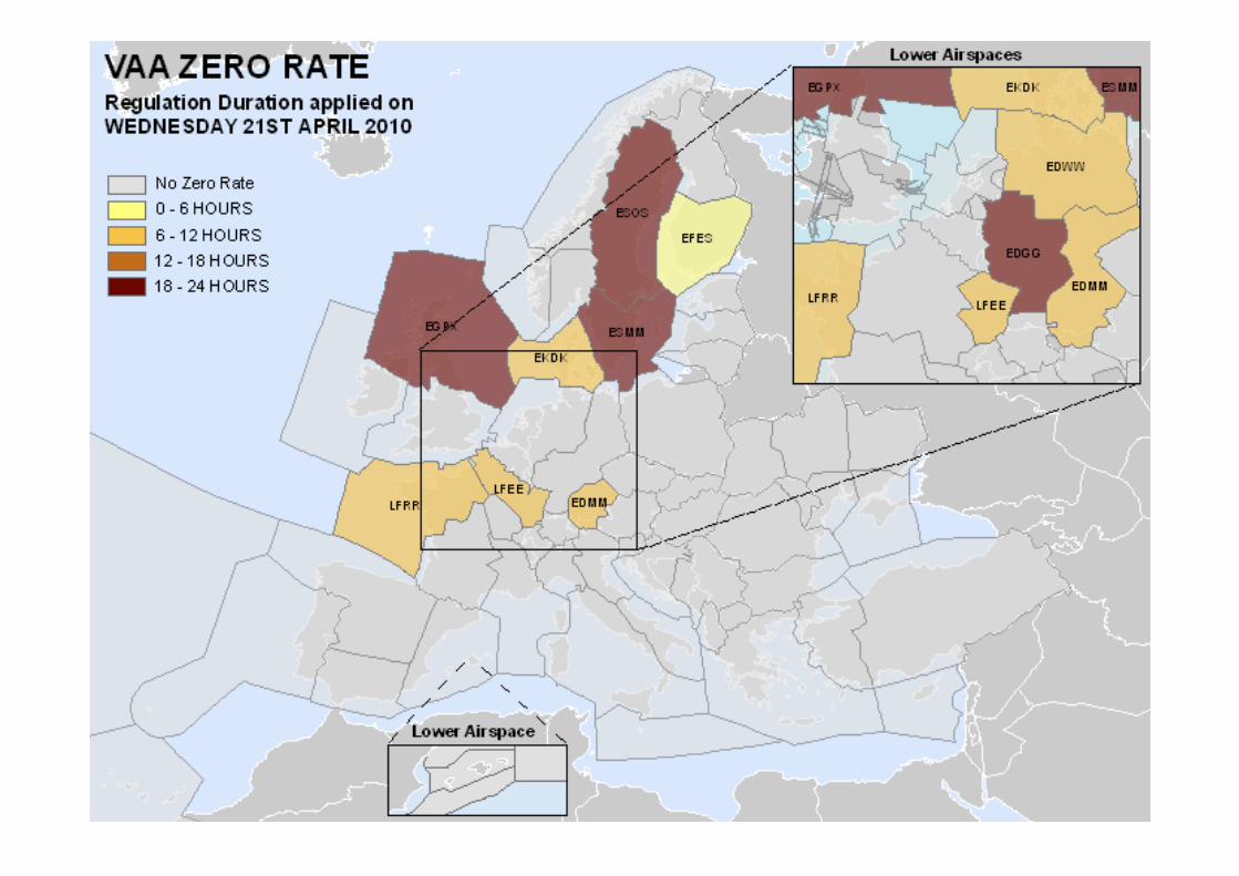
• No ash in eurocontrol zone April 28th –May 3rd, BUT…
• New eruption phase May 3rd-23rd
– Closures in UK and Ireland, then Portugal, Spain, Italy, Morocco
Icelandic Met Office: Flight over Eyjafjallajökull 13 May 2010. Photo: Árni Sigurðsson.

• 21st May – EASA issued a Safety Information Bulletin:
– NO FLY ZONE, – ENHANCED PROCEDURES ZONE:
GREY AND RED, – NORMAL ZONE
Eyjafjallajökull eruption

NEW UK MET OFFICE CHART

Eyjafjallajökull eruption
• Iceland Met Office: The first winter snow proves that the new lava, at the top crater of Eyjafjallajökull, has cooled somewhat. Photo: ÓlafurSigurjónsson, 9 October 2010 at 8:10.

Eyjafjallajökull EruptionLessons Learned
• No incidents• Heavy economic impact on airlines• Heavy impact on passengers• Why such impact?
– Ash cloud, pushed by high-altitude winds, dispersed over areas of very dense traffic flows
– The closure of a number of airspaces, based on the forecasted cloud dispersion - zero risk approach:
• The ICAO Manual on Volcanic Ash: “Unfortunately, at present there are no agreed values of ash concentration which constitute a hazard to jet aircraft engines... In view of this, the recommended procedure in the case of volcanic ash is exactly the same as with low-level wind shear, regardless of ash concentration — AVOID AVOID AVOID.”
– Duration– Many different countries, facing such crisis for the first time
Eyjafjallajökull EruptionLessons Learned
• Stakeholder involvement to solve the crisis resulted– Definition of the four zones and new graphical
product (non-standard)– Forming of International Volcanic Ash Task Force
• Not flying, implies losses, but, what is the economic impact of flying through the ash cloud?
• Need for efficient means of communication• Information exchange and monitoring

Eyjafjallajökull eruption

Eyjafjallajökull eruption
13.5 million hits
in one day!

Eyjafjallajökull eruption
Key areas for improvement:
1. Specify thresholds for:– Hazardous,– Costly, and– Minor ash impact.
2. Should volcanic ash be considered an airworthiness or ATM issue?
3. Ash dispersion models harmonization and enhancement of validation of results
4. Information exchange improvement

Changes in the aftermath

Aftermath
• International Volcanic Ash Task Force (IVATF) was held in Montreal, Canada in July 2010
• New Contingency Plan for EUR/NAT regions
• Volcanic Ash Exercise (VOLCEX) boom

Changes in Europe
• Ash concentration charts• European Aviation Crisis Coordination Cell
(EACCC) • Safety Risk Assessment approach: airlines
may decide to fly or not, based on their safety risk assessment
• Aircraft Operator Crisis Cell (AOCC)• European Crisis Visualization Interactive
Tool for ATFCM (EVITA) by Eurocontrol

VOLCEX 11/01 and Grimsvötnlessons

VOLCEX 11/01
• Volcanic Ash Exercise (VOLCEX)– Simulated Grimswötn eruption
– Test amended EUR/NAT contingency plan– Test information flow
– Test crisis coordination by EACCC– Test EVITA prototype

VOLCEX 11/01 - EVITA

VOLCEX 11/01 Feedback
• Participation increase– From about 30 to over 100
• Changes in contingency plan well received– Gives more flexibility to airlines
• Airline Operators’ feedback:– Would consider operations in low-medium ash
concentration areas (~77%)– Very different procedures for flying in or near
contaminated areas– High level of information duplication– AOCC good envoy for problem resolution

VOLCEX 11/01 Feedback
• Information issues– Too many different sources for airlines to
follow– Need for harmonization of content and format
• 300 NOTAMs per day…
– Teleconferences• Airlines ask for possibility of participation• Recommendations on nitty-gritty details, important
for real crisis

VOLCEX 11/01 Feedback
• EVITA feedback– Appreciated graphical presentation on
European level
– Not considered very user friendly– Improvements from human factors point of
view needed
– Video-like visualization of forecast requested

VOLCEX 11/01 Summary
• Good practice• Flexibility to airlines
– Even though not all the states accepted the recommendations
• Issues regarding SRA – State regulators – Acceptance by other states/actors
• Information exchange– The need for one point of access

Grimswötn Eruption
• One month after the exercise:CFMU have been adviced by Icelandic met office that there has been a volcanic eruption of volcano Grimsvötn in Iceland at 20110521 1900Z. The plume hight estimated by radar 15-17 km.ASH CLOUD IS EXPECTED TO REACH NORTH SCOTLAND ON TUEDSDAY 24TH MAY.IF VOLCANIC EMISSIONS CONTINUE WITH SAME INTENSITY CLOUD MIGHTREACH WEST FRENCH AIRSPACE AND NORTH SPAIN ON THURSDAY 26TH MAY.NO AIRSPACE CLOSURES ARE EXPECTED FOR TODAY AND TOMORROW EXCEPT IN ICELANDIC AIRSPACE/AERODROMES.ALL ICELANDIC A/D'S ARE CLOSED FOR IFR-TRAFFIC UNTIL 1900 UTC ON 22ND MAY, AND IT IS VERY LIKELY THAT THEY WILL CONTINUE TO BE CLOSED.NEXT TELECONFERENCE IS PLANNED AT 0800 UTC ON 23RD MAY.IN THE MEANTIME AIRCRAFT OPERATORS ARE STRONGLY RECOMMENDED TO CLOSELY MONITOR ALL RELEVANT NOTAMS, SIGMETS AND THE ASH CONCENTRATION CHARTS ON WWW.METOFFICE.GOV.UK FOR FURTHER INFORMATION AND UPDATES.AO'S CAN ASK QUESTIONS ABOUT VOLCANIC ACTIVITY AND RELEVANT AFTCM MEASURES BY EMAIL TO:[email protected]

Grimsvötn Eruption
• EVITA - European crisis VisualisationInteractive Tool for ATFCM is operational as from 08h00 UTC 25th May 2011
• Best practice: own SIGMET / NOTAM based on forecast and actual observation

Grimsvötn EruptionConclusions
• The biggest eruption in Iceland in last 100 years
• Why not such a big impact as Eyjafjallajökull?– Meteorological conditions


Grimsvötn EruptionConclusions
• The biggest eruption in Iceland in last 100 years
• Why not such a big impact as Eyjafjallajökull?– Meteorological conditions– Coordinated action through EACCC
– Better preparedness of all players

Status today

Status Today
• Ash concentration charts discontinued
• A standardized product to be issued by June• Aviation colour code
• Satellite sensors need improvement• No airspace closure
– Not all states are endorsing
• Long term goal: – One set of aeronautical information for one eruptive
event

Ash Concentration Charts
• Why?– Not reliable– Levels arbitrary– Spread of uncertainties– Lack of global user requirement
• Some airlines found it useful– Not all have their meteorologists
• Enhanced Weather Information System (EWINS) holders
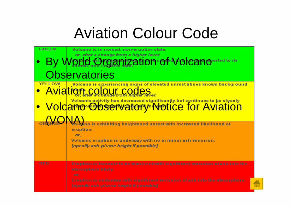
Aviation Colour Code
• By World Organization of Volcano Observatories
• Aviation colour codes• Volcano Observatory Notice for Aviation
(VONA)

Satellite Sensors
• Not always possible to discern ash from clouds
• IVATF conclusions include lobbying for satellite sensor improvements

Final Remarks
• Information exchange and monitoring important
• Forecasts + observations• Europe vs. other parts of the world• Intercontinental vs. regional airlines

Thank you!
Questions?

References• ICAO Docs 9974, 9859, 9691• IVATF Webpage:
http://www.icao.int/safety/meteorology/ivatf/Pages/default.aspx• Tatjana Bolic, Zarko Sivcev: “Eyjafjallajokull Eruption European Air
Traffic Management Experience”, Transportation Research Record: Journal of Transportation Research Board, Issue 2214, pp 136-143, 2011
• Marianne Guffanti, Thomas J. Casadevall, and Karin Budding : Encounters of Aircraft with Volcanic Ash Clouds: A Compilation of Known Incidents, 1953–2009, USGS
• USGS Website• UK Met Office Website• Iceland Met Office Website• And many other…