asx announcement asx: dyl otcqx: dyllf · asx announcement asx: dyl otcqx: dyllf 18 november 2019...
TRANSCRIPT
Unit 17, Spectrum Building, 100-104 Railway Road Subiaco WA 6008 / PO Box 1770 Subiaco WA 6904 Tel : 61 8 9286 6999 / ABN 97 006 391 948
Email: [email protected] / Website: www.deepyellow.com.au
ASX Announcement ASX: DYL OTCQX: DYLLF
18 November 2019
STRONG GROWTH CONTINUES AT REPTILE WITH A 34% INCREASE IN RESOURCE AT TUMAS 1 EAST
HIGHLIGHTS
• Resource extension drilling success at Tumas 1 East has produced an Inferred Mineral Resource Estimate of 24.8Mlb grading 319ppm eU3O8.
o Delivering an impressive 34% increase in resource growth.
• Resources within the Tumas palaeochannel system now 92.5Mlb at 303ppm eU3O8.
o This represents a near three-fold increase since November 2016.
• Overall palaeochannel-related Mineral Resources across the Namibian project portfolio have more than doubled in size to 110.5Mlb at 290ppm eU3O8.
• Deep Yellow continues to advance the project toward achieving its stated calcrete Mineral Resource target of 100M to 150Mlb at a grade range of 300ppm to 500ppm U3O8.
• Mineralisation is calcrete-associated and hosted in palaeochannels, similar to the Langer Heinrich uranium mine located 30km to the north-east.
• Only 60% of the known palaeochannel system has been drilled, with 60km of this target still to be tested.
Deep Yellow Limited (ASX: DYL) (Deep Yellow) is pleased to announce an updated Mineral Resource Estimate (MRE) for the Tumas 1 East deposit (Tumas 1 East), located within the Reptile Project.
At a 200ppm eU3O8 cut-off, Tumas 1 East has Inferred Mineral Resources of 24.8Mlb at 319ppm eU3O8, resulting in a 34% increase from the MRE announced in March 2019.
Total combined measured, indicated and inferred calcrete resources in the Tumas palaeochannel (Tumas 1E,1, 2, 3 and Tubas Red Sands/calcrete deposits) now stand at 92.5Mlb at 303ppm eU3O8.
These deposits occur on EPLs 3496 and 3497, held by Deep Yellow’s wholly owned subsidiary, Reptile Uranium Namibia (Pty) Ltd. The MRE was undertaken using various cut-off grades using a minimum thickness of 1m and conforms to the 2012 JORC Code of Mineral Resource Reporting.
Page 2 of 21
Resource extension RC drilling programs, carried out in April, July and August 2019, succeeded in closing off the Tributary 5 deposit (see Figures 1 and 2). This work also included some limited infill drilling within the Tributary 4 channel. Of the total 591 RC holes drilled for 6,281m during the Tumas 1 East drilling campaigns, 291 holes returned positive results, a pleasing overall success rate of 50%.
Commenting on the significant increase in resource at Tumas 1 East, Deep Yellow Managing Director and Chief Executive Officer, John Borshoff said:
“We continue to successfully develop our Namibian project portfolio. Deep Yellow is focused on executing its unique and differentiated dual-pillar strategy, which includes building a project with significant size and scale in Namibia as a critical component of this strategy.
We are fortunate enough to have a proven and experienced management team that understand the requirements of building a successful uranium operation - a factor that will continue to contribute to the remarkable turnaround in improving the potential offered by the Reptile Project. This has already enabled us to triple the resource at Reptile in a short space of time, importantly at a discovery cost of around $0.11/lb.
Results to date strongly justify our increased effort both in exploration to further increase the resource base and in evaluating the economic potential of this project with the initiation of a Scoping Study due for completion in December 2019. We fully expect this to progress to commencement of a pre-feasibility study in late January 2020”.
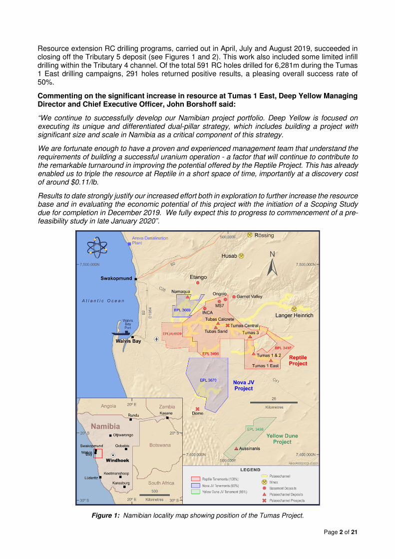
Figure 1: Namibian locality map showing position of the Tumas Project.

Page 3 of 21
The uranium mineralisation defined to date in the Tumas palaeochannel system occurs as three distinct mineralised bodies: the Tumas 1 and 2 deposits, now including the Tumas 1 East tributary extensions, the Tumas 3 deposit and the Tubas Red Sands/calcrete deposits (see Figure 1).
The Tumas 1 East deposit expansion and the associated new MRE are the subject of this announcement.
The combined overall Tumas palaeochannel resource now totals 92.5Mlb eU3O8 at 303ppm over EPLs 3496/97. With this addition to the Tumas palaeochannel uranium resource base, the Company’s overall total surficial calcrete-related Mineral Resources across its Namibian projects have more than doubled to 110.5Mlb U308.
The successful, low-cost development of the project portfolio fully vindicates the change of focus implemented in November 2016 from which the extensive, regionally occurring prospective palaeochannel system was identified.
Drilling programs completed at these highly prospective palaeochannels continue to produce extremely positive resource outcomes. The extensive channel system occurring away from the identified deposits has only been sparsely drilled with large sections remaining completely untested.
Exploration Target
As previously reported, Deep Yellow has identified 125km of highly prospective palaeochannel systems. To date, only 65km of these systems have been adequately tested, delivering an almost 3-fold increase in the resource base.
This provides Deep Yellow with a significant opportunity to increase the current resource base at Reptile through targeted exploration across the remaining 60km of channels yet to be tested.
Since November 2016, exploration and resource drilling has only focused on the eastern and central parts of the Tumas palaeochannel system. This work has been highly successful producing a cumulative 79.8Mlb eU3O8 at 347ppm calcrete-type resource associated within this 100% owned palaeochannel.
With the 34% increase to the Tumas 1 East calcrete-associated resource, Deep Yellow continues to advance towards its stated Exploration Target1 of 100M to 150Mlb at a grade range of 300ppm to 500ppm U3O8 for this type of uranium mineralisation.
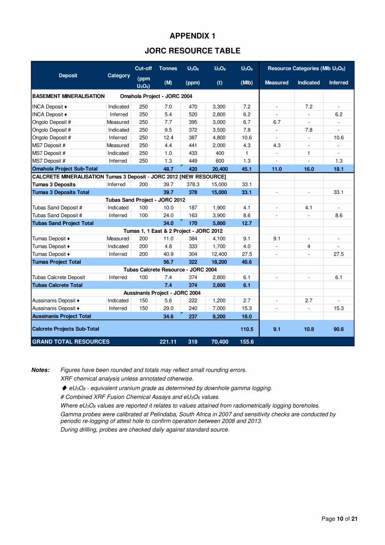
Deep Yellow’s total JORC compliant uranium Mineral Resources on its Namibian projects are shown in Appendix 1.
1 With the additional resources as announced herein, the Company has now determined an MRE of 110.5Mlb of calcrete
mineralisation - reaching the lower of its stated Exploration Target range of 100M to 150Mlb eU3O8. The Company however acknowledges that the potential quantity and grade of the Exploration Target is conceptual in nature. There is however significant and sufficient additional exploration information generated to give more confidence in achieving the stated Exploration Target objective. Additional exploration is planned; however, it is uncertain if this will result in the estimation of all the expanded Mineral Resource that has been predicted from the review and evaluation of calcrete associated mineralisation identified on the Company’s tenements which commenced in the December 2016 Quarter. With the subsequent exploration and resource drilling carried out over the past three years, the Company has a greater understanding of the stratigraphy and topography of the palaeochannels which host the uranium mineralisation. This work and the resource increase that is being achieved has provided renewed confidence that further mineralisation is likely to be identified in targeted palaeochannel areas on the Company’s tenements. Targeted tonnage/grades are based on results and understanding from work carried out over the past 14 years in this region and the Exploration Targets that have been defined will continue to be the focus the ongoing drilling investigations.
Page 4 of 21
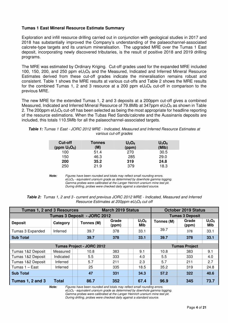
Tumas 1 East Mineral Resource Estimate Summary
Exploration and infill resource drilling carried out in conjunction with geological studies in 2017 and 2018 has substantially improved the Company’s understanding of the palaeochannel-associated calcrete-type targets and its uranium mineralisation. The upgraded MRE over the Tumas 1 East deposit, incorporating newly discovered tributaries, is the result of positive 2018 and 2019 drilling programs. The MRE was estimated by Ordinary Kriging. Cut-off grades used for the expanded MRE included 100, 150, 200, and 250 ppm eU3O8 and the Measured, Indicated and Inferred Mineral Resource Estimates derived from these cut-off grades indicate the mineralisation remains robust and consistent. Table 1 shows the MRE results at various cut-offs and Table 2 shows the MRE results for the combined Tumas 1, 2 and 3 resource at a 200 ppm eU3O8 cut-off in comparison to the previous MRE. The new MRE for the extended Tumas 1, 2 and 3 deposits at a 200ppm cut-off gives a combined Measured, Indicated and Inferred Mineral Resource of 79.8Mlb at 347ppm eU3O8 as shown in Table 2. The 200ppm eU3O8 cut-off has been selected as being the most appropriate for headline reporting of the resource estimations. When the Tubas Red Sands/calcrete and the Aussinanis deposits are included, this totals 110.5Mlb for all the palaeochannel-associated targets.
Table 1: Tumas 1 East - JORC 2012 MRE - Indicated, Measured and Inferred Resource Estimates at various cut-off grades
Cut-off
(ppm U3O8) Tonnes
(M) U3O8
(ppm) U3O8
(Mlb) 100 51.4 270 30.5 150 46.3 285 29.0 200 35.2 319 24.8 250 21.9 379 18.3
Note: Figures have been rounded and totals may reflect small rounding errors. eU3O8 - equivalent uranium grade as determined by downhole gamma logging. Gamma probes were calibrated at the Langer Heinrich uranium mine test pit. During drilling, probes were checked daily against a standard source.
Table 2: Tumas 1, 2 and 3 - current and previous JORC 2012 MRE - Indicated, Measured and Inferred Resource Estimates at 200ppm eU3O8 cut off
Tumas 1, 2 and 3 Resources March 2019 Status October 2019 Status
Tumas 3 Deposit - JORC 2012 Tumas 3 Deposit
Deposit Category Tonnes (M) Grade (ppm)
U3O8 Mlb
Tonnes (M) Grade (ppm)
U3O8 Mlb
Tumas 3 Expanded Inferred 39.7 378 33.1 39.7 378 33.1
Sub Total 39.7 378 33.1 39.7 378 33.1
Tumas Project - JORC 2012 Tumas Project
Tumas 1&2 Deposit Measured 10.8 383 9.1 10.8 383 9.1
Tumas 1&2 Deposit Indicated 5.5 333 4.0 5.5 333 4.0
Tumas 1&2 Deposit Inferred 5.7 211 2.3 5.7 211 2.7
Tumas 1 – East Inferred 25 335 18.5 35.2 319 24.8
Sub Total 47 331 34.3 57.2 322 40.6
Tumas 1, 2 and 3 Total 86.7 352 67.4 96.9 345 73.7
Note: Figures have been rounded and totals may reflect small rounding errors. eU3O8 - equivalent uranium grade as determined by downhole gamma logging. Gamma probes were calibrated at the Langer Heinrich uranium mine test pit. During drilling, probes were checked daily against a standard source.

Page 5 of 21
ASX Additional Information
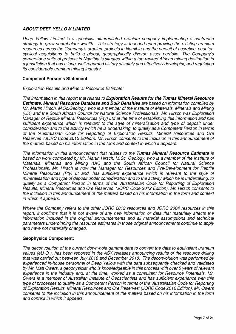
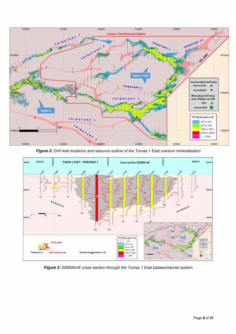
The following is a summary of the material information used to estimate the Mineral Resources as required by Listing Rule 5.8.1 and JORC 2012 Reporting Guidelines. Deposit Parameters: The Tumas 1 East uranium deposit is of the calcrete-hosted type, located at the eastern end of an extensive, regionally-occurring, mainly east-west and north/west-south/east trending palaeochannel system. The uranium mineralisation is in carnotite and occurs in conjunction with calcium carbonate precipitations (calcrete) in sediment-filled palaeovalleys. Uranium minerals mainly include uranium vanadates. Uranium is the only economically extractable metal in this type of mineralisation and the vanadium component is not considered in the evaluations at this stage. The geology of this type of mineralisation is well understood having been explored over many years. The Langer Heinrich uranium mine located 30km to the north-east exploits this type of deposit and has been mined since 2007. The mineralisation domains used for the current extended MRE study were interpreted to capture continuous zones of mineralisation above 100ppm eU3O8. The mineralisation included in this study has a strike length of approximately 9km and ranges in width from 100m to 600m, extending to a depth of 10m to 15m, averaging around 10m below surface along the main Tumas channel and its tributaries. The mineralisation occurs in a reasonably continuous, seam-like horizon and has been shown to continuously connect to west with the Tumas 1 deposit beyond the currently reported area. The main channel is closed off at the eastern end however Tributary 8, found to be mineralised in this area, remains to drilled out. Drilling for the project was based on RC methods only. Drill holes used in the Mineral Resource Estimation included 591 holes totalling 6,281m drilled in 2018 and 2019. Drilling achieved sample recoveries of around 90%. All drill chips were geologically logged and their radioactivity was measured downhole. All data were added to the verified database. At Tumas 1 East, where the continuity of the uranium mineralisation along the channel was very good, a drill density of 200m by 100m was deemed sufficient to define an Inferred Resource. Around some tributary palaeochannels drill spacing was reduced to 50m x 50m if required. Methodology: Data used in the MRE is largely based on down-hole radiometric gamma logging taken by a fully calibrated Aus Log gamma logging system which was used in the recent and previous drilling programs. Down-hole gamma readings were taken at 5cm intervals and converted into equivalent uranium values (eU3O8) before being combined to 1m intervals. Geochemical assays were collected from 1m RC-drilling intervals, which were split to 1kg to 1.5kg samples by riffle splitters. 120gm were further pulverised for use in regular XRF determinations and ICP-MS check analysis work. In the 2018 and 2019 programs,1 in 10 uranium intersections were tested by XRF analysis. For further description of sampling techniques and associated data see Appendix 2 Table 1. The geochemical assays were used to confirm the validity of the eU3O8 values determined by down-hole gamma probing. After validation, the eU3O8 values derived from the down-hole gamma logging were given preference over geochemical assays for the Mineral Resource Estimation. The relevant drill hole details and results were previously reported by Deep Yellow in announcements made to the ASX on 5 July 2018, 28 November 2018, 23 April 2019, 21 August 2019 and 21 October 2019. Figure 2 shows the Tumas 1 East deposit drill hole locations with drill hole collars coloured according to their grade thickness (GT- eU3O8ppm x metre thickness). Cross-sections through the deposit are shown in Figures 3 and 4.
Page 6 of 21
Prospectivity, High Potential and Future Drilling
The ongoing drilling of the Tumas palaeochannel continues to prove highly successful, fully endorsing the new approach that has been taken to test this very prospective regional target area identified. This work continues to add new uranium resources at Tumas 1, 2 and 3 with each resource drilling campaign that has been undertaken. Additionally, the investigations and exploration drilling during this current program have identified another untested Tributary that is considered very prospective.
The 79.8Mlb now attributable to Tumas 1, 2 and 3 translates to 1.9Mlb/km for the 38km over which these deposits occur. The 92.5Mlb of Measured, Indicated and Inferred Mineral Resources now attained from the Reptile Project Tumas palaeochannels represent a remarkable 185% increase in the calcrete resource base on this project since the new-focus investigations commenced. Deep Yellow is now very close to the first major milestone of 100Mlb eU3O8. from the Tumas palaeochannel alone. As has been previously stated, work is clearly confirming that increasing the palaeochannel calcrete resource base toward the range of 100M-150Mlb uranium resources in the 300ppm to 500ppm U3O8 grade range is considered as a realistic objective with Tumas 3 still open to the immediate west and the Tubas Red Sand and calcrete Deposit open both at depth and laterally within the 60km of highly prospective palaeochannel identified and remaining to be tested. The current drilling program is now testing the Tubas calcrete resource west of Tumas Central. The first part of this drilling program is planned to be completed by early December with results expected to be reported in the January 2020 quarter.
Exploration Efficiency
Since the change of management in late 2016, 60.3Mlb of Inferred U3O8 Resources have been added to the Reptile Project uranium inventory. This was achieved by concentrating the exploration effort on calcrete-associated uranium mineralisation within the eastern-occurring Tumas palaeochannel. Exploration expenditure from November 2016 to October 2019 on the Reptile Project is near to A$6.5M. This calculates into a discovery cost for delineation of the Inferred Resources that have been identified of only 11 cents/lb U3O8..This highlights the high discovery efficiency and the overall low cost for delineation of additional uranium resources when targeting these near-surface targets and working within a highly prospective palaeochannel.
Yours Faithfully
JOHN BORSHOFF Managing Director/CEO Deep Yellow Limited
For further information, contact:
John Borshoff Phone: +61 8 9286 6999 Managing Director/CEO Email: [email protected] For further information on the Company and its projects, please visit the website at: www.deepyellow.com.au
Page 7 of 21
ABOUT DEEP YELLOW LIMITED
Deep Yellow Limited is a specialist differentiated uranium company implementing a contrarian strategy to grow shareholder wealth. This strategy is founded upon growing the existing uranium resources across the Company’s uranium projects in Namibia and the pursuit of accretive, counter-cyclical acquisitions to build a global, geographically diverse asset portfolio. The Company’s cornerstone suite of projects in Namibia is situated within a top-ranked African mining destination in a jurisdiction that has a long, well regarded history of safely and effectively developing and regulating its considerable uranium mining industry.
Competent Person’s Statement
Exploration Results and Mineral Resource Estimate:
The information in this report that relates to Exploration Results for the Tumas Mineral Resource Estimate, Mineral Resource Database and Bulk Densities are based on information compiled by Mr. Martin Hirsch, M.Sc.Geology, who is a member of the Institute of Materials, Minerals and Mining (UK) and the South African Council for Natural Science Professionals. Mr. Hirsch was Exploration Manager of Reptile Mineral Resources (Pty) Ltd at the time of establishing this information and has sufficient experience which is relevant to the style of mineralisation and type of deposit under consideration and to the activity which he is undertaking, to qualify as a Competent Person in terms of the ‘Australasian Code for Reporting of Exploration Results, Mineral Resources and Ore Reserves’ (JORC Code 2012 Edition). Mr. Hirsch consents to the inclusion in this announcement of the matters based on his information in the form and context in which it appears.
The information in this announcement that relates to the Tumas Mineral Resource Estimate is based on work completed by Mr. Martin Hirsch, M.Sc. Geology, who is a member of the Institute of Materials, Minerals and Mining (UK) and the South African Council for Natural Science Professionals. Mr. Hirsch is now the Manager for Resources and Pre-Development for Reptile Mineral Resources (Pty) Lt and, has sufficient experience which is relevant to the style of mineralisation and type of deposit under consideration and to the activity which he is undertaking, to qualify as a Competent Person in terms of the ‘Australasian Code for Reporting of Exploration Results, Mineral Resources and Ore Reserves’ (JORC Code 2012 Edition). Mr. Hirsch consents to the inclusion in this announcement of the matters based on his information in the form and context in which it appears.
Where the Company refers to the other JORC 2012 resources and JORC 2004 resources in this report, it confirms that it is not aware of any new information or data that materially affects the information included in the original announcements and all material assumptions and technical parameters underpinning the resource estimates in those original announcements continue to apply and have not materially changed. Geophysics Component:
The deconvolution of the current down-hole gamma data to convert the data to equivalent uranium values (eU3O8), has been reported in the ASX releases announcing results of the resource drilling that was carried out between July 2018 and December 2018. The deconvolution was performed by experienced in-house personnel of Deep Yellow with the data subsequently checked and validated by Mr. Matt Owers, a geophysicist who is knowledgeable in this process with over 5 years of relevant experience in the industry and, at the time, worked as a consultant for Resource Potentials. Mr. Owers is a member of Australian Institute of Geoscientists and has sufficient experience with this type of processes to qualify as a Competent Person in terms of the ‘Australasian Code for Reporting of Exploration Results, Mineral Resources and Ore Reserves’ (JORC Code 2012 Edition). Mr. Owers consents to the inclusion in this announcement of the matters based on his information in the form and context in which it appears.
Page 8 of 21
Figure 2: Drill hole locations and resource outline of the Tumas 1 East uranium mineralisation
Figure 3: 526500mE cross-section through the Tumas 1 East palaeochannel system

Page 9 of 21
Figure 4: 526900mE cross-section through the Tumas 1 East palaeochannel system
Page 10 of 21
APPENDIX 1
JORC RESOURCE TABLE
Notes: Figures have been rounded and totals may reflect small rounding errors.
XRF chemical analysis unless annotated otherwise.
♦ eU3O8 - equivalent uranium grade as determined by downhole gamma logging.
# Combined XRF Fusion Chemical Assays and eU3O8 values.
Where eU3O8 values are reported it relates to values attained from radiometrically logging boreholes.
Gamma probes were calibrated at Pelindaba, South Africa in 2007 and sensitivity checks are conducted by periodic re-logging of attest hole to confirm operation between 2008 and 2013.
During drilling, probes are checked daily against standard source.
Cut-off Tonnes U3O8 U3O8 U3O8
(ppm
U3O8)(M) (ppm) (t) (Mlb) Measured Indicated Inferred
INCA Deposit ♦ Indicated 250 7.0 470 3,300 7.2 - 7.2 -
INCA Deposit ♦ Inferred 250 5.4 520 2,800 6.2 - - 6.2
Ongolo Deposit # Measured 250 7.7 395 3,000 6.7 6.7 - -
Ongolo Deposit # Indicated 250 9.5 372 3,500 7.8 - 7.8 -
Ongolo Deposit # Inferred 250 12.4 387 4,800 10.6 - - 10.6
MS7 Deposit # Measured 250 4.4 441 2,000 4.3 4.3 - -
MS7 Deposit # Indicated 250 1.0 433 400 1 - 1 -
MS7 Deposit # Inferred 250 1.3 449 600 1.3 - - 1.3
48.7 420 20,400 45.1 11.0 16.0 18.1
Tumas 3 Deposits Inferred 200 39.7 378.3 15,000 33.1
39.7 378 15,000 33.1 - - 33.1
Tubas Sand Deposit # Indicated 100 10.0 187 1,900 4.1 - 4.1 -
Tubas Sand Deposit # Inferred 100 24.0 163 3,900 8.6 - - 8.6
34.0 170 5,800 12.7
Tumas Deposit ♦ Measured 200 11.0 384 4,100 9.1 9.1 - -
Tumas Deposit ♦ Indicated 200 4.8 333 1,700 4.0 - 4 -
Tumas Deposit ♦ Inferred 200 40.9 304 12,400 27.5 - - 27.5
56.7 322 18,200 40.6
Tubas Calcrete Deposit Inferred 100 7.4 374 2,800 6.1 - - 6.1
7.4 374 2,800 6.1
Aussinanis Deposit ♦ Indicated 150 5.6 222 1,200 2.7 - 2.7 -
Aussinanis Deposit ♦ Inferred 150 29.0 240 7,000 15.3 - - 15.3
34.6 237 8,200 18.0
110.5 9.1 10.8 90.6
221.11 319 70,400 155.6
Tubas Calcrete Resource - JORC 2004
Tubas Calcrete Total
Aussinanis Project - JORC 2004
Aussinanis Project Total
Calcrete Projects Sub-Total
GRAND TOTAL RESOURCES
Tumas 3 Deposits Total
Tubas Sand Project - JORC 2012
Tubas Sand Project Total
Tumas 1, 1 East & 2 Project - JORC 2012
Tumas Project Total
Deposit Category
Resource Categories (Mlb U3O8)
BASEMENT MINERALISATION Omahola Project - JORC 2004
Omahola Project Sub-Total
CALCRETE MINERALISATION Tumas 3 Deposit - JORC 2012 [NEW RESOURCE]

APPENDIX 2: Table 1 Report (JORC Code 2012 addition)
Page 11 of 21
JORC Code, 2012 Edition – Table 1 report template
Section 1 Sampling Techniques and Data
(Criteria in this section apply to all succeeding sections.)
Criteria JORC Code explanation Commentary
Sampling techniques
• Nature and quality of sampling (e.g. cut channels, random chips, or specific specialised industry standard measurement tools appropriate to the minerals under investigation, such as down hole gamma sondes, or handheld XRF instruments, etc). These examples should not be taken as limiting the broad meaning of sampling.
• Include reference to measures taken to ensure sample representivity and the appropriate calibration of any measurement tools or systems used.
• Aspects of the determination of mineralisation that are Material to the Public Report.
• In cases where ‘industry standard’ work has been done this would be relatively simple (e.g. ‘reverse circulation drilling was used to obtain 1 m samples from which 3 kg was pulverised to produce a 30 g charge for fire assay’). In other cases, more explanation may be required, such as where there is coarse gold that has inherent sampling problems. Unusual commodities or mineralisation types (e.g. submarine nodules) may warrant disclosure of detailed information.
• The recent (2018-2019) drilling relies on down hole gamma data from calibrated probes which were converted into equivalent uranium values (eU3O8) by experienced DYL personnel and have been confirmed by a competent person (geophysicist). Geochemical assays were used to confirm the conversion results.
• Appropriate factors were applied to all downhole gamma counting results to make allowance for drill rod thickness, gamma probe dead times and incorporating all other applicable calibration factors.
Total gamma eU3O8
• 33mm Auslog total gamma probes were used and operated by Company personnel.
• RMR’s gamma probes were calibrated by a qualified technician at Langer Heinrich uranium mine in July 2018 (T003, T029, T030, T164 and T165) and in September 2019 (T029, T030, T161, T162, T164 and T165).
• Probing at Tumas East utilised probe T164. • During drilling, the probe was checked daily using sensitivity checks
against a standard source. • Gamma measurements were taken at 5cm intervals at a logging
speed of approximately 2m per minute. • Probing was done immediately after drilling mainly through the drill
rods and in some cases in the open holes. Rod factors were established to compensate for reduced gamma counts when logging through the rods.
• The gamma measurements were recorded in counts per second (c/s) and were converted to equivalent eU3O8 values over 1m intervals using probe-specific K-factors.
• Disequilibrium studies done in 2008 on 22 samples derived from the nearby Tumas 1 and 2 zones by ANSTO Minerals indicated that the U238 decay chains of the wider Tumas deposit of which Tumas 1 East is part are within an analytical error of ± 12% and considered to be in secular equilibrium.
APPENDIX 2: Table 1 Report (JORC Code 2012 addition) (continued)
Page 12 of 21
Criteria JORC Code explanation Commentary
Chemical assay data
• Geochemical samples were derived from Reverse Circulation (RC) drilling at intervals of 1m. Samples were split at the drill site using a riffle splitter to obtain a 1kg sample from which 120g was pulverized to produce a subset for XRF-analysis.
• 351 drill samples were dispatched to ALS in Johannesburg, South Africa for uranium and sulphur analysis using pressed powder pellet XRF and Leco Furnace and Infrared Spectroscopy, respectively.
• The samples were taken for confirmatory assay to be compared to the equivalent uranium values derived from down hole gamma logging.
• The assay results confirm equivalent uranium grades correlate and are within an acceptable statistically error margin of 10%.
Drilling techniques
• Drill type (eg core, reverse circulation, open-hole hammer, rotary air blast, auger, Bangka, sonic, etc) and details (eg core diameter, triple or standard tube, depth of diamond tails, face-sampling bit or other type, whether core is oriented and if so, by what method, etc).
• RC drilling was used throughout the Tumas 1 East campaign. • All holes were drilled vertically, and intersections measured present
true thicknesses.
Drill sample recovery
• Method of recording and assessing core and chip sample recoveries and results assessed.
• Measures taken to maximise sample recovery and ensure representative nature of the samples.
• Whether a relationship exists between sample recovery and grade and whether sample bias may have occurred due to preferential loss/gain of fine/coarse material.
• Drill chip recoveries were good, generally in excess of 90%. • Drill chip recoveries were assessed by weighing 1m drill chip
samples at the drill site. Weights were recorded in sample tag books.
• Sample loss was minimised by placing the sample bags directly underneath the cyclone.
Logging • Whether core and chip samples have been geologically and geotechnically logged to a level of detail to support appropriate Mineral Resource estimation, mining studies and metallurgical studies.
• Whether logging is qualitative or quantitative in nature. Core (or costean, channel, etc) photography.
• The total length and percentage of the relevant intersections logged.
• All drill holes were geologically logged. • The logging was qualitative in nature. A dominant (Lith1) and a
subordinate lithology type (Lith2) was determined for every sample representing a 1m interval with assessment of ratio/percentage.
• Other parameters routinely logged include colour, colour intensity, weathering, oxidation, alteration, alteration intensity, grain size, hardness, carbonate (CaCO3) content, sample condition (wet, dry) and a total gamma count was derived from a Rad-Eye scintillometer.
• 6,281m were geologically logged, which represents 100% of metres drilled.
• Lithology Codes for palaeochannel lithologies used are: AL=Alluvion, AG=Gravel, AGS=Gravel silty sandy, SAT=Silty sand, SR=Red sand, CA=Calcrete un-differentiated, CAW=Calcrete whitish, CAB=Calcrete brownish, CAF=Calcrete pale red _Fine
APPENDIX 2: Table 1 Report (JORC Code 2012 addition) (continued)
Page 13 of 21
Criteria JORC Code explanation Commentary
grained, SS=Sandstone, SC=Conglomerate, SA=Sand, SSF=Sandstone fine_CaCO3 cement, GY=Gypsum, CH=Chert, SSD=Dolomitic sandstone, QCO=Quartzitic conglomerate, CY=Clay, SH=Shale, REW=Reworked bedrock & calcrete.
• Lithology Codes for the channel floor or basement lithologies used are: SD=Dolomite, ST=Siltstone, SM=Mudstone, GG=Granite, ALAS=Alaskite, PQM=Micaceous quartzite, MS=Micaschis, MB=Marble, PSAM=Psammite, MPEL=Metapelite, HQ=Vein quartz, GZ=Pegmatite, PZ=Biotite gneiss, PQ=Quartzite, PG=Gneiss undifferentiated, PR=Magnetite gneiss, PT=Granitised gneiss, OD=Dolerite, HS=Skarn, PA=Amphibolite, BU=Mafic extrusive, MM=Massive magnetite, GD=Granodiorite, BI=Massive biotite, SB=Breccia, BR=Bedrock, PX=Calc-silicate, PK=Calc-silicate gneiss
Sub-sampling techniques and sample preparation
• If core, whether cut or sawn and whether quarter, half or all core taken.
• If non-core, whether riffled, tube sampled, rotary split, etc and whether sampled wet or dry.
• For all sample types, the nature, quality and appropriateness of the sample preparation technique.
• Quality control procedures adopted for all sub-sampling stages to maximise representivity of samples.
• Measures taken to ensure that the sampling is representative of the in-situ material collected, including for instance results for field duplicate/second-half sampling.
• Whether sample sizes are appropriate to the grain size of the material being sampled.
• Sample splitters used were a 2-tier riffle splitter mounted on the rig giving an 87.5% (reject) and a 12.5% sample (assay sample) and a portable 2-tier (75%/25%) splitter for any oversize assay samples. All sampling was dry.
• The sampling techniques are common industry practice. • Sample sizes are considered appropriate to the grain size of the
material being sampled. • Standards were inserted after each 23rd primary sample, followed by
a duplicate of the 22nd primary sample. • Blanks were inserted randomly, but commonly following a high-
grade primary sample. • RMR used two different standards, (AMIS0087 = alaskite,
Goanikontes) and (AMIS0092 = calcrete, Langer Heinrich uranium mine). AMIS0087 standards reported within two standards deviation at an average of 207ppm U3O8 while the expected value is 205ppm U3O8; AMIS0092 standards also performed within the acceptable limits of the two standard deviations at an expected value of 338ppm U3O8, against an average derived assay of 339ppm U3O8.
Quality of assay data and laboratory tests
• The nature, quality and appropriateness of the assaying and laboratory procedures used and whether the technique is considered partial or total.
• For geophysical tools, spectrometers, handheld XRF instruments, etc, the parameters used in determining the analysis including
• The analytical method employed was ICP-MS (Lithium Borate Fusion). The technique is industry standard and considered appropriate.
• AUSLog downhole gamma tools were used as explained under ‘Sampling techniques’. This is the principal evaluating technique.
APPENDIX 2: Table 1 Report (JORC Code 2012 addition) (continued)
Page 14 of 21
Criteria JORC Code explanation Commentary
instrument make and model, reading times, calibrations factors applied and their derivation, etc.
• Nature of quality control procedures adopted (eg standards, blanks, duplicates, external laboratory checks) and whether acceptable levels of accuracy (ie lack of bias) and precision have been established.
• AMIS standards AMIS0087and AMIS0092 were used in a ratio of 1: 21.
• Duplicates performed well producing a regression line of R2=0.9128 • Blanks performed well below 3 ppm (U) with 2 outliers recorded at
5ppm and 8ppm (U) representing a 3% failure rate.
Verification of sampling and assaying
• The verification of significant intersections by either independent or alternative company personnel.
• The use of twinned holes. • Documentation of primary data, data entry procedures, data
verification, data storage (physical and electronic) protocols. • Discuss any adjustment to assay data.
• The geology logs were recorded in the field using tablets and secured excel logging spreadsheets. Logging codes are derived from predefined pulldown menus minimizing miss logging misspelling. All digital information was downloaded to a server and validated by the geologist at the end of every drill day.
• Sample tag books were utilized for sample identification. • The field drill data of those logs and tag books (lithology, sample
specifications etc.) is QA-ed and validated by the relevant project geologist before dispatching for import into a geological database.
• Twinning of RC holes was not considered; the nugetty nature of the mineralisation distribution.
• Data was uploaded onto a file server following a strict validation protocol.
• Equivalent eU3O8 values are calculated from raw gamma files by applying calibration and casing factors where applicable.
• The adjustment factors are stored in a database on a file server. • Equivalent U3O8 data is composited from 5cm to 1m intervals. • The ratio of eU3O8 versus assayed U3O8 for matching composites is
used to quantify the statistical error. It was found that they all lie within statistically acceptable margins.
Location of data points
• Accuracy and quality of surveys used to locate drill holes (collar and down-hole surveys), trenches, mine workings and other locations used in Mineral Resource estimation.
• Specification of the grid system used. • Quality and adequacy of topographic control.
• The collars were surveyed by an in-house surveyor using a differential GPS.
• All drill holes are vertical and shallow; therefore, no down-hole surveying was required.
• The grid system is World Geodetic System (WGS) 1984, Zone 33.
Data spacing and distribution
• Data spacing for reporting of Exploration Results. • Whether the data spacing and distribution is sufficient to establish
the degree of geological and grade continuity appropriate for the Mineral Resource and Ore Reserve estimation procedure(s) and classifications applied.
• Whether sample compositing has been applied.
• The data spacing and distribution is optimized along the Tumas palaeochannel direction. The drill grid is close to 100m by 100m in EW and NS rectangular directions following the main channel.
• The drill pattern is considered sufficient to establish a Mineral Resource.

APPENDIX 2: Table 1 Report (JORC Code 2012 addition) (continued)
Page 15 of 21
Criteria JORC Code explanation Commentary
• The total gamma count data, which is recorded at 5cm intervals, is converted to equivalent uranium value (eU3O8) and composited to 1m intervals.
Orientation of data in relation to geological structure
• Whether the orientation of sampling achieves unbiased sampling of possible structures and the extent to which this is known, considering the deposit type.
• If the relationship between the drilling orientation and the orientation of key mineralised structures is considered to have introduced a sampling bias, this should be assessed and reported if material.
• Uranium mineralisation is strata bound and distributed in a fairly continuous horizontal layer. Holes were drilled vertically and mineralised intercepts represent the true width.
• All holes were sampled down-hole from surface. Geochemical samples were collected at 1m intervals. Total-gamma count data was collected at 5cm intervals.
Sample security
• The measures taken to ensure sample security. • 1m RC drill chip samples were prepared at the drill site. The assay samples were stored in plastic bags. Sample tags were placed inside the bags. The samples were placed into plastic crates and transported from the drill site to RMR’s site premises in Swakopmund by Company personnel. Sample preparation for dispatch to ALS laboratories in South Africa was done at RMR’s own prep-lab facility.
• Upon completion of the preparation work the remainder of the drill chip sample bags for each hole was packed back into crates and then stored in designated containers in chronological order, locked up and kept safe at RMR’s sample storage yard at Rocky Point located outside Swakopmund.
Audits or reviews
• The results of any audits or reviews of sampling techniques and data.
• Dr J Corbin from GeoViz Consulting Australia undertook a drilling data review. He concluded his audit commenting: “Overall, the data available is of reasonably good quality and easily accessible.”
Section 2 Reporting of Exploration Results
(Criteria listed in the preceding section also apply to this section.)
Criteria JORC Code explanation Commentary
Mineral tenement and land tenure status
• Type, reference name/number, location and ownership including agreements or material issues with third parties such as joint ventures, partnerships, overriding royalties, native title interests, historical sites, wilderness or national park and environmental settings.
• The security of the tenure held at the time of reporting along with any known impediments to obtaining a licence to operate in the area.
• The work to which the Exploration Results relate was undertaken on exclusive prospecting grant EPL3497, (Tumas Zone 1E).
• The EPL was originally granted to Reptile Uranium Namibia (Pty) Ltd (RUN) in June 2006. The EPL is in good standing and is valid until 04th August 2021.
• The EPL is located within the Namib Naukluft-National Park in Namibia.
• There are no known impediments to the project beyond Namibia’s standard permitting procedures.
APPENDIX 2: Table 1 Report (JORC Code 2012 addition) (continued)
Page 16 of 21
Criteria JORC Code explanation Commentary
Exploration done by other parties
• Acknowledgment and appraisal of exploration by other parties. • Prior to RUN’s ownership of these EPLs, some work was conducted by Anglo American Prospecting Services (AAPS), General Mining and Falconbridge in the 1970s.
• Assay results from the historical drilling are incomplete and available on paper logs only. There are no digital records available from this period.
Geology • Deposit type, geological setting and style of mineralisation. • Tumas mineralisation occurs as secondary carnotite enrichment of variably calcretised palaeochannel and sheet wash sediments and adjacent weathered bedrock.
• Uranium mineralisation at Tumas is surficial and stratabound in Cenozoic sediments, which include from top to bottom scree, sand, gravel, gypcrete, various intercalated calcareous sand and calcrete horizonts overlying discordant Damaran age folded sequences of meta-volcanics and meta-sediments. Predominant basement stratigraphy is Nosib-Swakop Group with Chuos Fm being the highest lithostratigraphic level in the project area exposed. East of Tumas 3 is Kuiseb Fm exposed forming the highest lithostratigraphic levels. All sequences are highly metamorphosed and characterized by isoclinal folding in partly over thrusted sheets lying staggered on top of each other. Strike is generally NE-SW to NNE-SSW, mostly steep dipping. 3 different folding events are observed.
• The majority of the mineralisation in the project area is hosted in calcrete. Locally, the underlying Proterozoic bedrock shows traces of mineralisation in weathered contact zones of more schistose basement types; this however seldomly occurs.
Drill hole Information
• A summary of all information material to the understanding of the exploration results including a tabulation of the following information for all Material drill holes: o easting and northing of the drill hole collar o elevation or RL (Reduced Level – elevation above sea level in
metres) of the drill hole collar o dip and azimuth of the hole o down hole length and interception depth o hole length.
• If the exclusion of this information is justified on the basis that the information is not Material and this exclusion does not detract from the understanding of the report, the Competent Person should clearly explain why this is the case.
• 591 RC holes were drilled over 6,281m. • All relevant drilling being done between July 2018 and October 2019. • All holes were drilled vertically and intersections measured present
true thicknesses.
APPENDIX 2: Table 1 Report (JORC Code 2012 addition) (continued)
Page 17 of 21
Criteria JORC Code explanation Commentary
Data aggregation methods
• In reporting Exploration Results, weighting averaging techniques, maximum and/or minimum grade truncations (eg cutting of high grades) and cut-off grades are usually Material and should be stated.
• Where aggregate intercepts incorporate short lengths of high grade results and longer lengths of low grade results, the procedure used for such aggregation should be stated and some typical examples of such aggregations should be shown in detail.
• The assumptions used for any reporting of metal equivalent values should be clearly stated.
• 5 cm gamma intervals were composited to 1 m intervals. • 1m composites of eU3O8 were used for the estimate.
• No grade truncations were applied.
Relationship between mineralisation widths and intercept lengths
• These relationships are particularly important in the reporting of Exploration Results.
• If the geometry of the mineralisation with respect to the drill hole angle is known, its nature should be reported.
• If it is not known and only the down hole lengths are reported, there should be a clear statement to this effect (eg ‘down hole length, true width not known’).
• The mineralisation is sub-horizontal and all drilling vertical, therefore, mineralised intercepts are considered to represent true widths.
Diagrams • Appropriate maps and sections (with scales) and tabulations of intercepts should be included for any significant discovery being reported These should include, but not be limited to a plan view of drill hole collar locations and appropriate sectional views.
• All relevant intercepts were included within the text and appendices of previous releases.
Balanced reporting
• Where comprehensive reporting of all Exploration Results is not practicable, representative reporting of both low and high grades and/or widths should be practiced to avoid misleading reporting of Exploration Results.
• Comprehensive reporting, including one previous announcement of Exploration Results covering the Tumas 1 East project area was practised throughout the drilling program.
Other substantive exploration data
• Other exploration data, if meaningful and material, should be reported including (but not limited to): geological observations; geophysical survey results; geochemical survey results; bulk samples – size and method of treatment; metallurgical test results; bulk density, groundwater, geotechnical and rock characteristics; potential deleterious or contaminating substances.
• The wider area of the Tumas palaeochannel was subject to some drilling in the 1970’s by Anglo American Prospecting Services, Falconbridge and General Mining.
• Downhole gamma-gamma density logging for bulk density was derived from earlier work at Tumas 1 and 2 and in analogy to the Langer Heinrich uranium mine mining in the same lithologies and geological settings East and North-East of Tumas Zone 3.
Further work • The nature and scale of planned further work (eg tests for lateral extensions or depth extensions or large-scale step-out drilling).
• Diagrams clearly highlighting the areas of possible extensions, including the main geological interpretations and future drilling areas, provided this information is not commercially sensitive.
• The palaeochannel mineralisation continues westwards from Tumas 1 and 2. It weakens east of the eastern EPL boundary with palaeochannels narrowing and becoming shallower.
APPENDIX 2: Table 1 Report (JORC Code 2012 addition) (continued)
Page 18 of 21
Section 3 Estimation and Reporting of Mineral Resources
(Criteria listed in section 1, and where relevant in section 2, also apply to this section.)
Criteria JORC Code explanation Commentary
Database integrity
• Measures taken to ensure that data has not been corrupted by, for example, transcription or keying errors, between its initial collection and its use for Mineral Resource estimation purposes.
• Data validation procedures used.
A set of SOPs (Standard Operating Procedures) was defined that safeguard data integrity which cover the following aspects:
• Capturing of all exploration data; geology and probing; • QA/QC of all drilling, geophysical and laboratory data; • Data storage (database management), security and back-up; and • Reporting and statistical analyses used Micromine (MM) software
and Minestis.
Site visits • Comment on any site visits undertaken by the Competent Person and the outcome of those visits.
• If no site visits have been undertaken indicate why this is the case.
• During all drilling programs regular site visits were conducted by the Company’s Competent Person who signed off on all exploration data.
• More recently, the Company’s current Competent Person has undertaken regular visits since with the most recent visit being in early October 2019.
Geological interpretation
• Confidence in (or conversely, the uncertainty of) the geological interpretation of the mineral deposit.
• Nature of the data used and of any assumptions made. • The effect, if any, of alternative interpretations on Mineral Resource
estimation. • The use of geology in guiding and controlling Mineral Resource
estimation. • The factors affecting continuity both of grade and geology.
• Confidence in the geological interpretation and modelling of the sedimentary channel fill is very high. This type of geology is well known and readily recognised in the RC drill chips. The factors affecting grade distribution are channel morphology and bedrock profile, with bedrock “barriers” where they occur forming areas of favourable mineralisation traps.
Dimensions • The extent and variability of the Mineral Resource expressed as length (along strike or otherwise), plan width, and depth below surface to the upper and lower limits of the Mineral Resource.
• The drilled orebody in Tumas 1 East Tributary 1 has a strike length of 7.4km, 200m to 900m wide, 3m to 20m deep and in tributary 5/5a, a further strike length of 3km higher grade mineralisation.
• The main mineralised calcrete reaches from a shallow depth below surface of -2m to -3m deep down to -20m/25m.
Estimation and modelling techniques
• The nature and appropriateness of the estimation technique(s) applied and key assumptions, including treatment of extreme grade values, domaining, interpolation parameters and maximum distance of extrapolation from data points. If a computer assisted estimation method was chosen include a description of computer software and parameters used.
• The availability of check estimates, previous estimates and/or mine production records and whether the Mineral Resource estimate takes appropriate account of such data.
• The assumptions made regarding recovery of by-products.
• The present estimates are based on grade thickness/grade/lithology domains controlling the interpolations into block estimates. Block sizes used are 50m East x 50m West x 3m elevation.
• Estimation of block values used Ordinary Kriging (OK). 100ppm U3O8 is the lower limit; no grade capping was applied. Search ranges were restricted to a max distance of 1½ drill hole spaces.
• Omnidirectional variograms are used in the current estimates. • Block validation was done using qualitative drill hole displays over block
estimates. The current block estimate throughout correlates nicely with composited eU3O8 GT (Grade-Thickness) data.
APPENDIX 2: Table 1 Report (JORC Code 2012 addition) (continued)
Page 19 of 21
Criteria JORC Code explanation Commentary
• Estimation of deleterious elements or other non-grade variables of economic significance (e.g. sulphur for acid mine drainage characterisation).
• In the case of block model interpolation, the block size in relation to the average sample spacing and the search employed.
• Any assumptions behind modelling of selective mining units. • Any assumptions about correlation between variables. • Description of how the geological interpretation was used to control
the resource estimates. • Discussion of basis for using or not using grade cutting or capping. • The process of validation, the checking process used, the
comparison of model data to drill hole data, and use of reconciliation data if available.
• No correction for water was made.
Moisture • Whether the tonnages are estimated on a dry basis or with natural moisture, and the method of determination of the moisture content.
• An optical assessment of sample material was done during the sampling process and samples were classified as either “dry” or “wet”. The current drilling program did intersect water at times.
• Tonnages are estimated dry.
Cut-off parameters
• The basis of the adopted cut-off grade(s) or quality parameters applied.
• Composites below 1m and composites below 1m eU3O8 100ppm were excluded from the estimation process.
• The range of cut-off grades was chosen based on “potentially economic” criteria (100ppm U3O8, 150ppm U3O8, 200ppm U3O8, 250ppm U3O8 300ppm U3O8 and 350ppm U3O8).
Mining factors or assumptions
• Assumptions made regarding possible mining methods, minimum mining dimensions and internal (or, if applicable, external) mining dilution. It is always necessary as part of the process of determining reasonable prospects for eventual economic extraction to consider potential mining methods, but the assumptions made regarding mining methods and parameters when estimating Mineral Resources may not always be rigorous. Where this is the case, this should be reported with an explanation of the basis of the mining assumptions made.
• Potential mining scenarios will be open-cast mining using one, two or three-metre high benches; after stripping of unconsolidated sandy grits and screes (free-digging).
Metallurgical factors or assumptions
• The basis for assumptions or predictions regarding metallurgical amenability. It is always necessary as part of the process of determining reasonable prospects for eventual economic extraction to consider potential metallurgical methods, but the assumptions regarding metallurgical treatment processes and parameters made when reporting Mineral Resources may not always be rigorous. Where this is the case, this should be reported with an explanation of the basis of the metallurgical assumptions made.
• More detailed mineralogical characterisation tests were conducted from the lower Tumas areas which presents the Company with a sound understanding of how a calcrete ore from Tumas would respond to beneficiation and further downstream processing.
• Also, the nearby Langer Heinrich uranium mine (LHU) has successfully mined and processed calcrete ore for almost a decade. Although it is under care and maintenance and LHU calcrete grade is higher; the mineralogical characteristics remain very similar.
APPENDIX 2: Table 1 Report (JORC Code 2012 addition) (continued)
Page 20 of 21
Criteria JORC Code explanation Commentary
Environmen-tal factors or assumptions
• Assumptions made regarding possible waste and process residue disposal options. It is always necessary as part of the process of determining reasonable prospects for eventual economic extraction to consider the potential environmental impacts of the mining and processing operation. While at this stage the determination of potential environmental impacts, particularly for a greenfields project, may not always be well advanced, the status of early consideration of these potential environmental impacts should be reported. Where these aspects have not been considered this should be reported with an explanation of the environmental assumptions made.
• SoftChem, as independent consultant completed a scoping level Environmental Impact Assessment for the Tumas Project in 2013.
• With mining progressing along the channel perimeter, waste material will be backfilled into mined-out areas so to provide for ongoing rehabilitation of the mined-out areas progressively throughout the life of the mine. Any remaining waste rock stockpiles will be shaped and contoured to blend into the surrounding environment.
Bulk density • Whether assumed or determined. If assumed, the basis for the assumptions. If determined, the method used, whether wet or dry, the frequency of the measurements, the nature, size and representativeness of the samples.
• The bulk density for bulk material must have been measured by methods that adequately account for void spaces (vugs, porosity, etc), moisture and differences between rock and alteration zones within the deposit.
• Discuss assumptions for bulk density estimates used in the evaluation process of the different materials.
• Bulk density was derived from borehole density logging (gamma-gamma) from drilling at Tumas 1 and 2 in 2014.
• 284 1m composites were measured resulting in an average density of 2.35.
• At the Langer Heinrich uranium mine bulk density is defined at an SI of 2.35 (after mining geologically equivalent material for 10 years).
• The current estimate is using an SI of 2.3.
Classification • The basis for the classification of the Mineral Resources into varying confidence categories.
• Whether appropriate account has been taken of all relevant factors (i.e. relative confidence in tonnage/grade estimations, reliability of input data, confidence in continuity of geology and metal values, quality, quantity and distribution of the data).
• Whether the result appropriately reflects the Competent Person’s view of the deposit.
• This Mineral Resource Estimate reflects an Inferred Mineral Resource. • Semi-variography modelling indicates grade continuity up to 155m. • Search ranges were used accordingly to max of 1 1/2 drill hole positions
along sections. • A max search of 145m (4 sectors) was used to assign a first eU3O8 block
estimate. • The average mineralised seam thickness is in the order of 2m to 10m. • The Competent Person is satisfied that the applied methodology is
appropriate for reporting an Inferred Mineral Resource and that the resulting block estimates are true reflections of the drilling data.
Audits or reviews
• The results of any audits or reviews of Mineral Resource estimates. • No additional reviews were conducted beyond those carried out by the various Competent Persons over time.
Discussion of relative accuracy/ confidence
• Where appropriate a statement of the relative accuracy and confidence level in the Mineral Resource estimate using an approach or procedure deemed appropriate by the Competent Person. For example, the application of statistical or geostatistical procedures to quantify the relative accuracy of the resource within stated confidence limits, or, if such an approach is not deemed appropriate, a qualitative
• The applied geostatistical approach applied to arrive at the current Inferred Mineral Resource is considered sound and does reflect an industry standard approach; as is applied across the globe and the industry.
• The presented block model is a true representation of the drilling data.
APPENDIX 2: Table 1 Report (JORC Code 2012 addition) (continued)
Page 21 of 21
Criteria JORC Code explanation Commentary
discussion of the factors that could affect the relative accuracy and confidence of the estimate.
• The statement should specify whether it relates to global or local estimates, and, if local, state the relevant tonnages, which should be relevant to technical and economic evaluation. Documentation should include assumptions made and the procedures used.
• These statements of relative accuracy and confidence of the estimate should be compared with production data, where available.
• It is this Competent Person’s opinion that the classification of this Inferred Mineral Resource can improve to Indicated by adding infill drilling aiding an improved definition of grade continuity.