association of missouri geologists field...
TRANSCRIPT

ASSOCIATION OF MISSOURI GEOLOGISTS FIELD TRIP GUIDEBOOK
56TH ANNUAL MEETING OCTOBER 16-17, 2009
FARMINGTON, MISSOURI
IGNEOUS GEOLOGY OF SOUTHEAST MISSOURI: VOLCANIC FEATURES, GRANITE EMPLACEMENT,
INTRUSIONS AND MINERALIZATION
Trip Leader: Robert C. Berri, Jr.
Berri Exploration Services St. Louis, Missouri

Berri Exploration Services 4352 Holly Hills Blvd.
St. Louis, Missouri 63122 (314) 457-9426
Second Printing
September 2011

1
MAIN ROUTE ALTERNATE ROUTE(S)
FIELD TRIP ROUTE MAP FRIDAY OCTOBER 16, 2009

2
MAIN ROUTE ALTERNATE ROUTE(S)
FIELD TRIP ROUTE MAP SATURDAY OCTOBER 17, 2009

3
Granites Rhyolites Lamotte Bonneterre-Davis Potosi-Eminence |------------Precambrian-----------|----------------------------------Cambrian-----------------------------------|
GEOLOGICAL MAP OF THE ST. FRANCOIS MOUNTAINS (Anderson, 1979)

4
Structural Relations and Petrology of the Eastern St. Francois Mountains Leave the Tradition Inn travelling west on St. Francois County Road W. Turn south onto US highway 67 and proceed toward Fredericktown. US 67 passes over the St. Francis River south of the village of Delassus (pronounced Della sue) and Farmington Industrial Park (located west of the highway). The St. Francis River begins as a small collection of intermittent creeks fed by surface runoff from Buford Mountain and Middlebrook Hill in the Graniteville area, and travels somewhat north and eastward approximately 9 miles before altering flow direction toward the southeast in an area located approximately 4 miles south of Park Hills. This change in flow direction is most likely the result of influence from the Simms Mountain fault system: which in this area strikes south 40 to 50 degrees east. The St. Francis River flow direction roughly parallels, and is bounded by the fault system for another 10 miles. The Bonneterre Formation is exposed in road cuts along US 67 for the next several miles. West of the intersection of US Highway 67 and County Road H, a quarry operated by Central Stone produces dolomite from the Bonneterre Formation. A series of en-echelon faults are exposed in the pit. Continue travelling south on US 67. US Highway 67 passes over the St. Francis River again. The highway also crosses over the Simms Mountain Fault system in this area. In this area the St. Francis River begins to flow southward and away from the influence of the fault system. Displacement due to the fault system results in uplifting of the Lamotte and underling Butler Hill granite relative to the Bonneterre Formation. The Simms Mountain fault system is effectively the northeastern boundary of the St. Francois Mountain tectonic block and igneous rock exposure area. Typically the displacement along the fault system is 400 to 500 feet (120 to 150 meters) with a maximum of 600 feet (180 meters) (McCracken, 1961). The St. Francois Mountain Tectonic Block is mostly the remnants of volcanic islands formed during the Proterozoic. Erosion has removed part of the volcanic ash and lava flows that were ejected during this period and exposed some of the underlying granites that at one time were the magma source for the eruptive activity of the volcanoes.

5
Stop 1. First road cut south of the St. Francis River. The Butler Hill Granite is overlain by coarse-grained Lamotte Sandstone in a non-conformable contact. The Butler Hill and Breadtray granites are the most extensively exposed granites in the St. Francois Mountains. They comprise an epizonal sub-volcanic massif that produced a suite of rhyolitic ash-flow tuffs; the tuffs now largely removed by erosion. Rhyolitic roof pendants are locally preserved within the massif and along its southwestern periphery. Age of emplacement for the Breadtray and Butler Hill Granites is approximately 1.3 to 1.6 billion years. (Bickford and Mose, 1975) In the outcrop the Butler Hill Granite has well-developed rapikivi texture; ovoidal pink alkali feldspars (orthoclase-microperthite) up to 3 centimeters in diameter surrounded by a thin white rim of oligoclase (Hebrank and Kisvarsanyi, 1981). A small aplite dike is exposed that follows the major joint directions and branches out into fractures. Small pegmatitic “pods” can also be noted in Butler Hill exposures in the Hill-O’Meara granite quarry ½ mile west of here. The erosional contact between the Butler Hill and the Lamotte is best exposed in the cut on the west side of the road. The uppermost weathered granite is overlain by a dark maroon, shaly, thin regolith or paleosol derived from the weathered granite. Bedding styles in the sandstone suggest alluvial or fluvial plains (Houseknecht and Ethridge, 1978). The Lamotte is somewhat arkosic near Precambrian contacts, but the feldspar content generally decreases with both distance and stratigraphic elevation from the igneous rock sources of feldspars and other mineral indicators of minimum weathering prior to lithification.
Most of the road cuts for the next several miles expose the Lamotte Sandstone. Contact between Lamotte Sandstone and Knob Lick Granite. Road cuts exposing the Knob Lick Granite are first noticed about 0.9 mile (1.5 km) north of the intersection of US 67 and St. Francois County Road DD and continue for approximately 0.9 mile (see previous note on distance conversion) south of County Road DD. By now, you have probably noticed the similarity between the St. Francis River and St. Francois County (and St. Francois Mountains), and may be wondering why

6
the spellings are different (especially since they are all pronounced St. Francis). The St. Francis name dates back to the time when Spain was the major influence in the area, and the St. Francois name is a remnant from the time period when the southeast part of Missouri was under French colonial control during the mid- 1700’s to early 1800’s. Many of the French names for people and areas became anglicized in spelling, pronunciation or both due to interaction with English- speaking settlers in the 1800’s. Although French is no longer a major language in the area, some French family names still exist, and a remnant of Normandic French is spoken by a few families in the Old Mines area north of Potosi. North of Knob Lick cuts on both sides of the highway expose the Knob Lick Granite. Here the granite is gray, porphyritic and contains some xenoliths. Fractures and joint surfaces are partly lined with epidote and a small hematite veinlet is present in one of the joints. Rock cuts on the east side of the highway were opened during construction of the north bound lanes in the late 1970’s. Intersection of US 67 and St. Francois County Road DD. Continue south on US 67. Intersection of southbound US 67 and Knob Lick Tower Road. Turn west onto Knob Lick Tower Road, proceed 80 feet (25 meters) and turn right. Follow the tower road to the top of Knob Lick Mountain. Exposures between here and County Road DD are Knob Lick ‘pink’ with enclaves. (Dymek, 1994) Stop 2. Knob Lick Mountain is a good location to see several aspects of the geology of the St. Francois Mountains. The Grassy Mountain ignimbrite (ash flow tuffs) is exposed at the top of Knob Lick Mountain along the north and west sides of the hill and as a belt stretching for approximately 10 miles southward from here. The ignimbrite is essentially a roof pendant bounded on the east by the by Knob Lick and on the west by the Butler Hill granites. The Knob Lick Granite intrusive is one of the smaller plutons in the St. Francois Mountains and is emplaced along the eastern edge of the Butler Hill caldera. Mineral composition, color and texture can vary more in the Knob Lick over a short distance than any of the other granites in southeast Missouri. The Knob Lick is most often noted as a medium to fine-grained granite consisting of sodic oligoclase (20-50%), orthoclase microperthite (30-45 %), with quartz noted mostly as fine grained grains and generally a minor portion of the composition.

7
Biotite and hornblende are common and can account for 10 to 15 % of the visual composition. The texture of the Knob Lick ranges from fine to medium-grained grains to porphyritic, with xenoliths noted in all phases of the intrusion. All gradations from felsitic to granular inclusions are present with a wide range of border sharpness: they may all be xenoliths exhibiting varying degrees of resorption. (Tolman and Robertson, 1969, p.44-45) A small quarry located 0.5 miles (0.8 km) north of the parking lot/tower area exposes the intrusive relationship of the granite with a remnant of rhyolite that partly forms a wall between the Knob Lick and Butler Hill granites. In the quarry, the contact between the rhyolite and the granite is well exposed. Some xenoliths of rhyolite can be noted in the granite, and some alteration of the rhyolite can be noted near the contact with the granite, although the granite indicates little change in grain size near the contact. Thin seams of epidote can also be seen at and near the contact between the granite and the rhyolite. (Snyder and Wagner, 1961) Epidote seams can also be found in fractures further down the hill in some of the granite exposures suggesting that either these areas were also close to the contact zone, or that some later remobilization has occurred along fractures and joints in the granite. From the parking lot-tower area the view to the south and west includes some of the other mountains in the area as well as the Flatwoods. The Flatwoods are a large area of relatively low topographic relief that extends several miles to the south and southwest and is primarily underlain by the Grassy Mountain Ignimbrite. (Pratt et al, 1979) Granite quarrying began in the Knob Lick area in 1874 near the community of Syenite north of Knob Lick. Quarrying in the area continued until the 1940’s, with minor production from the Hill O’Meara in the 1980’s. Granite production in the Farmington and Knob Lick area has been from the Knob Lick, Butler Hill and Breadtray granites, with the main products being cobblestones, curbing, crushed stone for granitoid, and ashlar. (Berri, 2002) Close set joints and color variations in the Knob Lick and Breadtray granites limited the amount of dimension and monument production to smaller sized blocks and slabs. Cobblestone and curbing from this area were often produced from small quarries or “motions” that were originally developed in spalled areas that could be split

8
from the underlying granite and then shaped by quarrymen or by or farmers during the winter months. The stone was then transported to St. Louis via rail through a stop at the Turpin switch between here and Doe Run.
Figure 1. Cross section of Knob Lick Mountain (From Kisvarsanyi and Hebrank, 1987: Modified from Davis, J.W., 1969 and Bickford and Sides, 1983)
Return to US 67, turn south and continue towards Fredericktown. Leaving St. Francois and entering Madison County, Missouri. Entrance to the S Bar F Boy Scout camp is on the east side of the road. Land and initial funding for the camp was provided by the Stix, Baer and Fuller Company. Bonneterre and Lamotte formations are exposed in ditches and cuts along US 67. South of the scout camp road cuts expose the Grassy Mountain Ignimbrite and Slabtown Granite.

9
At the top of an unnamed hill north of the intersection of US 67 and Copper Mines Road a swarm of basalt dikes intrudes the Slabtown Granite. Quartz veinlets are associated with some of the dikes and often a small amount of alteration is noted in areas surrounding the dikes. Sphalerite is also occasionally noted in these dikes: usually as a minor mineral associated with other sulfides such as pentlandite, pyrrhotite, pyrite or chalcopyrite. Usually microscopic, the sphalerite sometimes occurs in grains or crystals large enough to be visible to the naked eye. The strike of these dikes is toward the southwest in the general direction of Skrainka Hill, suggesting that they are related to the intrusion of Skrainka Diabase at that location. At both locations the intrusion consists of a fine-grained olivine diabase. Sphalerite has also been noted in a petrographic study of the Skrainka Diabase by Desborough (1963). Intersection of US 67 and Copper Mines Road. Continue south on US 67. Copper Mines Road is essentially the northern boundary of the Fredericktown Disseminated Lead district. Remnants of several surface and underground lead, copper and cobalt mines can be found along this road between here and Mine Lamotte (approximately 3 miles (4.8 km) to the northeast). Intersection of US 67 and County Road H. Catherine Mine (abandoned) is west of here on County Road H. Delta Asphalt of Cape Girardeau is the current owner, and they have a small quarry in the Bonneterre Formation at this location that is occasionally worked for construction material. Passing through the village of Catherine Place. Intersection of US 67 and Missouri Highway 72, continue south on US 67. South of Missouri Highway 72, US 67 passes over the Little St. Francis River. South of the Little St Francis River are several road cuts which were created when the Missouri Department of Transportation re-routed US 67 in the late 1990’s. The northernmost of these cuts can be seen along the side of US 67 near the south end of the floodplain of the Little St. Francis River in a cut through a short spur on the east side of Mount Devon. At this point the highway crosses over a

10
portion of the Mill Creek Fault system, where the Grassy Mountain Ignimbrite on the east side of the road has been uplifted relative to the Bonneterre Formation on the west side of the highway. Stop 3. Road cuts at the intersection of US 67, and County Road E expose units in another portion of Mount Devon. This area has been mapped and studied by Dolde (2004). The road cut is approximately ¼ mile (0.4km) in length and exposes pyroclastic materials including the Grassy Mountain Ignimbrite, as well as the Slabtown Granite, a rhyolite dike, part of the Mill Creek Fault System, flow banding, and an unconformity between the volcanic sequence and the overlying Bonneterre and Lamotte. Additional geological features of the east Mount Devon area include pyroclastic breccias with a large variety of minerals, and an unassigned granite intrusion. Alteration can be noted in several portions of the outcrop, and is related to the combination of volcanic intrusions and related faulting, with associated heat and stress causing metamorphism, hydrothermal leaching and remobilization of minerals. Fracture and joint surfaces in several parts of the road cut associated with the alteration exhibit coatings of quartz, epidote, iron oxides, chlorite and chalcopyrite. Several periods of faulting and fault gouge or brecciation can also be noted in the road cut area, especially toward the south end of the cut where the Bonneterre formation is partially thrust faulted over the Lamotte Sandstone as well as the Slabtown granite and Priday rhyolite. Brecciation is also noted in the Priday rhyolite near the rhyolite dike, and may be related to the intrusion of the dike. The rhyolite dike is an unusual feature in the southeast Missouri Precambrian suite. Overall the dike is approximately 20 feet thick and strikes N 80O W with a dip of 80-85 O. Mineralogical analysis of the dike indicates a primary composition of plagioclase, alkali feldspar, quartz, and tridymite, as well as smaller amounts of epidote, chlorite, zoisite and clinozoisite. Field mapping by Dolde at these road cuts and outcrops further east suggests that this area is part of a caldera collapse, with at least four separate periods of volcanism during the period of 1.5 to 1.0 Ga in the Fredericktown area.

11
.
Vertical Exaggeration =2x
Figure 2. Outcrop Cross Section at US 67 and Madison County Road E. (Dolde, 2004, p. 16)

12
Although it is not part of the stop, an unusual diabase porphyry dike is exposed on the north slope of Mt. Devon. (Muilenberg and Goldich, 1933) The diabase consists of large phenocrysts of pink and green plagioclase in a dark matrix. It is possible that the intrusion of this dike is related to the caldera either directly as part of the volcanic activity periods associated with the caldera, or indirectly as part of the periods of regional volcanism.
Figure 3. Mt Devon Diabase porphyry (Photograph by R. Berri) At the bottom of the exit ramp for County Road E, turn east, cross under US 67, and turn north onto US 67. Intersection of US 67 and Missouri State Highway 72, enter exit ramp for Fredericktown and Ironton, exit onto Missouri 72 and travel west toward Ironton. The first few rock exposures noted along the road are the Bonneterre Formation. Stop 4. Grassy Mountain ignimbrite and a diabase dike are exposed in road cuts along Missouri 72 east of the intersection with old Missouri 70 that leads toward Oak Grove. This is one of the classic stops for geology field trips in the St. Francois Mountains because of the exposure of the dike and the unconformity between the Precambrian and overlying basal boulder conglomerate on the south side of the road.

13
Near the base of the dike on the north side of the road are several phenocrysts of white to pink plagioclase. Although the previously mentioned diabase porphyry dike is approximately 1.5 miles (2.4 km) to the southeast, the exposure on Missouri 72 is in a direct line between the dike on Mt. Devon and the diabase exposure on Skrainka Hill. Field investigations by Denham (1934) also noted some of the same type of pink-green plagioclase phenocrysts in the diabase at Skrainka Hill. The dikes on US 67 north of Copper Mines Road also appear to be oriented toward Skrainka Hill. Spatially, these intrusions are part of the Skrainka mafic group (Sylvester, 1984), and it is a reasonable assumption that the dikes here, along US 67 near Copper Mines Road and the exposure on Skrainka Hill are most likely from a common event possibly centered near Skrainka Hill. Also of interest at this site are quartz veinlets in the rock intruded by the dike. The position of the veinlets and proximity to the dike suggest a related origin, possibly due to hydrothermal leaching and re-crystallization of silica from the surrounding ignimbrite. Slightly further away and 30 – 40 feet (10-11 m) west of the dike are several small hematite veinlets in the ignimbrite. These veinlets tend to have a thin alteration zone associated with them as well as small crystals of pyrite and chalcopyrite, and may be related to the dike either as a late stage of intrusion, or due to hydrothermal leaching of the surrounding rock . Continuing west on Missouri 72 are more road cut exposures of Grassy Mountain Ignimbrite with varying amounts of overlying basal conglomerate, and a few road cuts consisting only of the basal conglomerate . Intersection of Missouri 72 with County Road D. The Einstein Silver Mine area is approximately 2 miles southwest of here along the St. Francis River. These mines were operated during the 1870’s in galena and tungsten-bearing quartz veins in the Silvermine Granite, with a production history of 50 tons of lead and 3000 ounces of silver. Tungsten was produced during World Wars I and II and for a short time in the 1950’s. A variety of minerals can be found in the tailing piles including galena, wolframite, pyrite, fluorite, sphalerite and chalcopyrite. Basalt dikes are exposed next to a dam that was constructed to furnish power for the mining operations. Continue West on Missouri 72. Exposures are of Lamotte in the road cuts for the next two miles (3.2 km). Although they do not occur in many outcrops the Butler

14
Hill and Grassy Mountain units also underlie the scenery in part of this area. Intersection of Missouri 72 with County road K. Continue west on Missouri 72 Stop 5. Turn off for Millstream Gardens (Tieman Shut-in). Continue on asphalt and gravel roads toward the boat landing parking area near the St. Francois River.
Figure 4. Geology of the Tieman Shut-ins Area (From Young, 1994, p. 9)
15
The Silvermine Granite extends to this area and further west toward Roselle. In the area of Tieman Shut-in, the granite is intruded by aplite dikes and an abortive period of synplutonic dike emplacement with mafic intrusions. This relationship suggests that the Silvermine mafic intrusions described by Sylvester (1984) may be partly concurrent with the formation of the Silvermine Granite. Other features supporting this hypothesis include: mafic pillows, a variety of inclusion types, textural gradation between rupture mafic globules, host quartz ocelli and quench apatite in enclave matrices. Compositional contrasts between the host and mafics range from pronounced to negligible, with the latter feature due to diffusional exchange. (Young, 1994) Return to Missouri 72, and travel west toward Roselle. Cross the bridge over the St. Francis River. Intersection of Missouri 72 and County Road MM, turn North onto County road MM. MM turns into Road 537, before intersecting with County Road AA. Turn right onto County Road AA. (Alternately turn left on to AA to travel towards Doe Run, then east on Missouri 221 to Farmington. (Both routes have similar geology.) For the next 7 miles (11 km) the Breadtray granite is exposed as boulders and granite glades near the road. Several granite quarries have been operated in the Breadtray in this area, particularly at Klondike Hill where quarry production has included cobblestones, curbing, monument stone, and chicken grit. (Berri, 2002) The Breadtray is a light red fine to medium grained kalialaskite. The primary minerals are quartz, orthoclase microperthite and plagioclase (albite to sodic), with minor amounts of magnetite, garnet, zircon and chlorite. Fluorite and iron oxide sometimes line cavities in the granite, and the rock character can border on porphyritic (Tolman and Robertson, 1969, p. 40). The plagioclase grains sometimes enclose smaller grains of chlorite giving a slight greenish tinge to the color on polished pieces. Aplite dikes are common in some areas and are occasionally associated with alteration of nearby granite and the introduction of quartz veinlets and vugs, iron oxides, actinolite and sericite formation in fractures. Joint patterns tend to be somewhat close ranging from a few inches (10 – 30 cm) to approximately 12-16 feet (4 – 5 m) apart.

16
Highway AA generally follows the direction and location of the gradational contact between the Breadtray and Butler Hill Granites. The Breadtray is often thought of as a sub-unit of the Butler Hill partly due to the gradational contact between them. Although they are similar in composition, they are more likely two different granites formed by different intrusions from a related source. This interpretation is based partly on the higher percentage of mafic minerals in the Butler Hill. Based on Bowen’s Reaction series; if the two units were different facies of the same intrusion, cooling relations would have more mafic minerals occurring in the Breadtray. Alteration in the Butler Hill and Breadtray appears to be slightly different, with contact alteration more common in the Breadtray, and aplite composition similar to that of the Breadtray Granite. Cross over Doe Run Creek at the base of Klondike Hill. To the east of County Road AA is a small exposure of granite. Jointing in the granite has been weathered and eroded to give a grooved appearance. Further up this hill is an outcrop of Lamotte Formation illustrating the relationship with the Breadtray Granite. Intersection with County Road H, turn north onto County Road H. Travel 0.5 mile to the intersection of County Road H and US 67, turn onto US 67 and then travel north toward Farmington. Exit US 67 at County Road W and return to hotel.
Figure 5. Aplite dikes exposed at Tieman Shut Ins (Photograph by R. Berri, Jr.)

17
VOLCANIC FEATURES, GRANITEVILLE, AND IRON DEPOSITS Leave the Tradition Inn travelling west on St. Francois County Road W. Turn north onto US highway 67 and proceed toward Park Hills. Intersection of US 67 and Missouri Highway 32. Exit US 67, and travel west on Missouri 32. Outcrops and road cuts in this area mostly expose the Bonneterre Formation, although some exposures of Davis Shale can also be noted. Park Hills was formed in the 1990’s as a merger between Flat River, Elvins, and Esther to improve and consolidate emergency management services in this area. Park Hills is part of the lead mining district referred to as the Old Lead Belt which includes Bonne Terre, Park Hills, Desloge, Doe Run, Fredericktown and part of eastern Washington County. This district produced over 90 percent of the lead and zinc mined in Missouri prior to the advent of mining in the Viburnum trend located approximately 50 miles (80km) west and southwest of here. Nearly all mining in the Old Lead Belt before 1869 was from scatted and shallow workings in soils and rock above the water table. In 1864 a group of investors formed the St. Joe Lead company, predecessor of the Doe Run Company. The company purchased land that contained rich deposits of galena at or near the surface. The first production was from clay beds containing chunks of galena, leading to the name Bonne Terre (Good Earth) for the site. (Burford, 1978) Exploratory drilling by St. Joe led to the discovery of deeper ore in the Bonneterre Formation. St. Joe expanded to Leadwood and Flat River eventually taking over or merging with at least 14 other companies. Development led to a complex of underground mines in the district connected by more than 20 miles of tunnels. Mining in this area was more or less continuous until 1972. Lead and zinc were the primary commodities produced, with galena and sphalerite being the principal ore minerals. In early days of mining in the district, oxidized and weathered ores including cerussite (PbCO3), minium (PbO), hemimorphite (ZnSiO4), and smithsonite (ZnCO3) were also mined. (Seeger and Berri, 2001, p. 80)

18
Missouri Mines State historic site is located south of Missouri 32 in buildings formerly owned by the Federal Lead Company. Continue west on Missouri 32. Intersection of Missouri with County Road B, Simms Mountain is the large hill to the south. Continue west on Missouri 32. Shortly after the road to the village of Davis, Missouri 32 crosses over the Simms Mountain Fault Zone. Entering the town of Bismark, at the junction with Missouri 32 and County Road U turn north onto County Road U. Intersection of County Road U with County Road M, turn west onto County Road M and travel for approximately 2 miles (3.2 km) to the parking area for Hughes Mountain Conservation area. The trail to the top of Hughes Mountain is approximately ½ to ¾ miles (0.8 to 1.2 km). Stop 1. Hughes Mountain is mountain is primarily inter-layered volcanic ash and lava flows with a few features suggesting a nearby vent. Pratt et al (1979) mapped Hughes Mountain and the neighboring Round Mountain as unnamed quartz latites, with an adjoining southwest outcrop area mapped as Grassy Mountain Ignimbrite. Several volcanic jointing features are prominent at Hughes Mountain. Two prominent joint sets were noted and measured by Graves (1938, pp. 129 – 131). Based on readings taken at 25 locations, Graves noted orientation patterns of vertical joints to be approximately N 20 O E, and N 70 O W. Sheet jointing can be noted along the trail on the way to the top of Hughes Mountain. Sheet joints are broadly spaced, undulating and roughly parallel to the ground surface. They divide the rock into flat sheets, or lenticular tabs that lie so that the thick part of one lens lies upon the thin ends of two underlying lenses. The thickness of the slabs tends to increase with depth. This type of fracturing is believed to be due to the release of pressure, and consequent vertical expansion through removal of the overlying rock by erosion. (Lahee, 1961, p. 274)
19
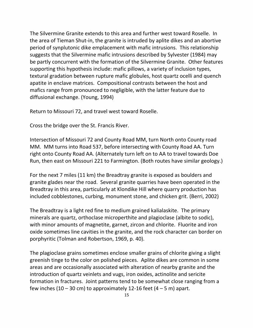
The trail eventually comes to a large open area of outcrops. The best way to get to the next stop is to head toward the left (north) edge of the trees and travel upward to an open area between a grove of trees and the edge of the glade. At the top of Hughes Mountain is a large area of columnar jointing approximately 10 acres in size (several thousand square meters give or take a few), locally known as the Devil’s Honeycomb. (Beveridge, 1980, p. 18 - 20) The columns tend to be square to rectangular in plan and are rarely more than 4 feet (1.2 m) high. This type of jointing is usually associated with a nearby eruptive vent, suggesting that the ash and lava vent for Hughes Mountain is nearby. Topographic relief of Hughes Mountain, Round Mountain and nearby hills also suggests that these features are erosional remnants of the edge of a volcanic crater or caldera.
Figure 6. Columnar jointing near the top of Hughes Mountain
(Photograph by K. Bradley) Vertical non-columnar joints and fractures near the mountain top occasionally have a leached appearance and are probably most often the result of weathering. In a few cases leaching may be due to hydrothermal leaching or thermal alteration related to heat transfer from overlying lava or volcanic ash flow.

20
Return to parking area and travel west on County Road M.
Figure 7. Topography of Hughes Mountain Area
Estimated Caldera Edges indicated by dashed lines (Irondale Quadrangle, U.S.G.S., 1982)

21
Intersection of County Road M and Missouri Highway 21. Turn south onto Missouri 21. Intersection of Missouri 21 and County Road C. Approximately 1.5 miles (3km) to the west of this intersection in the Dent Branch area, is a late Cambrian volcanic feature exposed along and north of County Road C. The Dent Branch structure consists of layered pyroclastic material ejected from a vent, deposited in a marine environment, and partially reworked. Exposures in this area consist of brecciated and chloritized dolostone sandstone and siltstone with varying amounts of tuffaceous materials. (Kisvarsanyi, 1969) Continue south on Missouri 21. Entering the city limits of Caledonia. Intersection of Missouri 21 and eastbound Missouri 32. Continue south on Missouri 21. Caledonia was founded in 1819 by Alexander Craighead. On December 1, 1807 the first Presbyterian Church service held west of the Mississippi River was conducted at the Presbyterian Cemetery located about 0.7 miles (1 km) northeast of this junction. (Martin and Knapp, 1961) Bridge over Cedar Creek. Unnamed rhyolite exposures are exposed in road cuts and outcrops. The Cedar Creek fault also crosses the highway in this area. Entering Belleview Valley. The Bonneterre Formation is exposed in rock outcrops and road cuts noted for the next few miles (kilometers). Belleview Valley (geologically referred to as the Belleview Basin), is an orthogonal basin with asymmetric filling of Lamotte Sandstone. The basin is bounded on the northeast by Buford Mountain and on the southeast by a range of hills containing Elephants Rock State Park. The Belleview Basin resembles block-faulted valleys found within rift settings. In the basin area, depositional asymmetry in both the Lamotte and Bonneterre formations is evidence of tilting and active faulting during deposition. (Seeger and Palmer, 1998) Buford Mountain is the long hill to the east and paralleling the highway for the new few miles. The mountain is surrounded by the Ironton, Munger and Simms

22
Figure 8. Exposure of Bell Mountain Rhyolite on Shut in Creek,
Bell Mountain Wilderness Area. (Photograph by R. Berri, Jr.)
Figure 9. Granite Boulders at Elephant Rocks State Park, Graniteville, MO
(Photograph by Robert Berri, Jr.)

23
Mountain faults. Field work by Darnell (1996) identified a sequence of ash flows indicating coarse, medium, and fine-grained rhyolite and volcanic materials, as well as a contamination zone that is possibly a volcanic vent area in the central portion of the block formed by the faulting. Other Precambrian formations exposed in the Buford Mountain block include: upper and lower Lake Killarney units, the Tribby Breccia, and the Grassy Mountain Ignimbrite. Uplifting due to the Ironton Fault also exposes a zone of Graniteville Granite along the southwestern base of Buford Mountain. City Limits of Belleview. Bell Mountain Wilderness area is southwest of here and west of County Road O. Igneous units mapped in the Bell Mountain area include the Bell Mountain and Lindsey Mountain rhyolites. (Pratt et al, 1979) Pillow remnants and “thunder eggs” are generally associated with the stratigraphic center of the Bell Mountain rhyolite. Although Bell Mountain is designated a wilderness area, the remnants of several small mines in the rhyolites can be found near and within the borders of this section of National Forest. Intersection of Missouri Highway 21 with County Road U. Two miles (3.2 km) east of here on County Road U is parking and access trails for the Buford Mountain Conservation area. Scenic view on east side of Missouri 21, continue south on Missouri Highway 21. Stop 2. Bonneterre exposed in road cut along the Missouri 21. Near the center of the outcrops on the east side of the road is the crest of a knob of white granite. Except for the white color, this granite is similar in appearance to the Graniteville Granite. Analytical test results of this granite provided by Mr. George Davis of the Missouri Department of Transportation provide a composition comparison with the Graniteville Granite. The white granite has slightly higher sodium content and slightly lower calcium values than an average Graniteville composition based on values from Kisvarsanyi (1972)(Sample numbers DGLS 55, 56, 57). This occurrence raises an interesting question. What is the relationship of this knob to the Graniteville pluton? One possibility is that the granite is a weathered surface of Graniteville Granite. This is partially supported by the presence of kaolinitic rims surrounding some of the feldspars, although the kaolin could just be due to the effects of weathering in a portion of the sample. Other possible
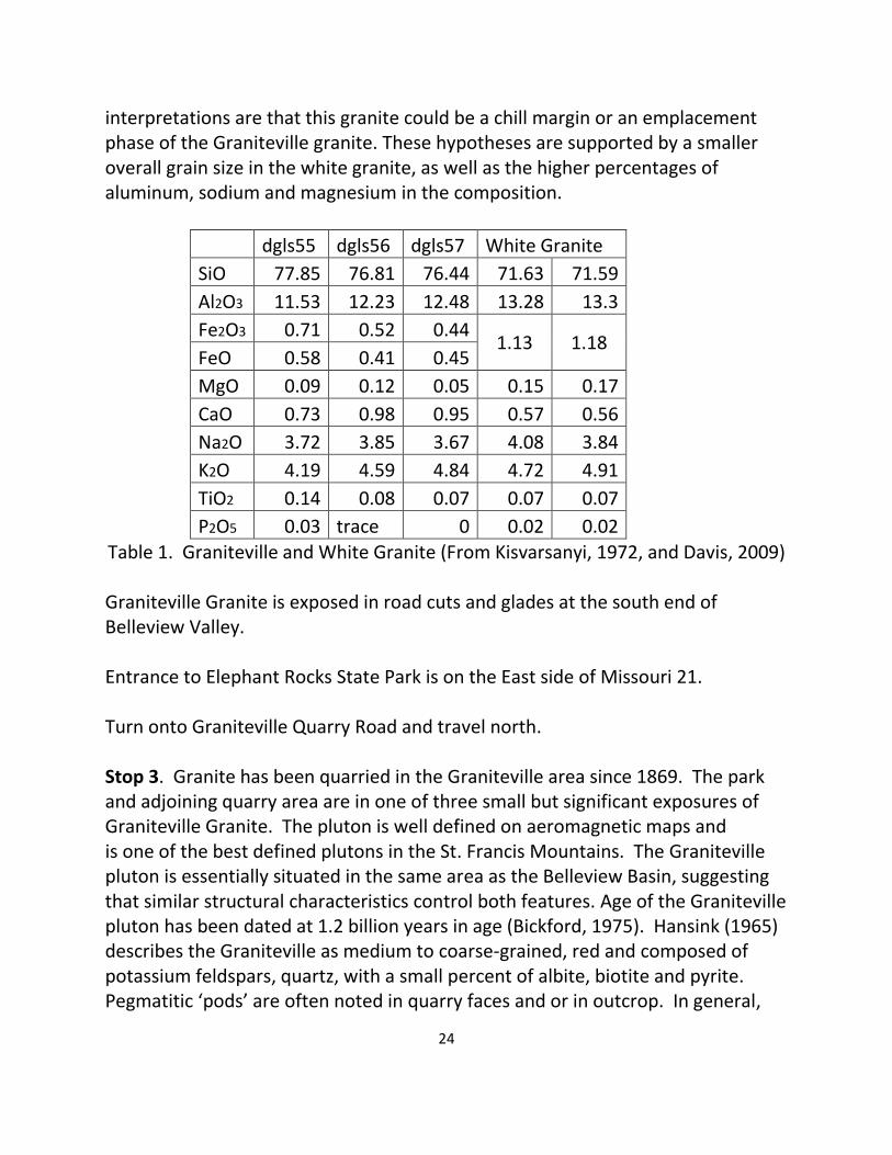
24
interpretations are that this granite could be a chill margin or an emplacement phase of the Graniteville granite. These hypotheses are supported by a smaller overall grain size in the white granite, as well as the higher percentages of aluminum, sodium and magnesium in the composition.
dgls55 dgls56 dgls57 White Granite
SiO 77.85 76.81 76.44 71.63 71.59
Al2O3 11.53 12.23 12.48 13.28 13.3
Fe2O3 0.71 0.52 0.44 1.13 1.18
FeO 0.58 0.41 0.45
MgO 0.09 0.12 0.05 0.15 0.17
CaO 0.73 0.98 0.95 0.57 0.56
Na2O 3.72 3.85 3.67 4.08 3.84
K2O 4.19 4.59 4.84 4.72 4.91
TiO2 0.14 0.08 0.07 0.07 0.07
P2O5 0.03 trace 0 0.02 0.02
Table 1. Graniteville and White Granite (From Kisvarsanyi, 1972, and Davis, 2009) Graniteville Granite is exposed in road cuts and glades at the south end of Belleview Valley. Entrance to Elephant Rocks State Park is on the East side of Missouri 21. Turn onto Graniteville Quarry Road and travel north. Stop 3. Granite has been quarried in the Graniteville area since 1869. The park and adjoining quarry area are in one of three small but significant exposures of Graniteville Granite. The pluton is well defined on aeromagnetic maps and is one of the best defined plutons in the St. Francis Mountains. The Graniteville pluton is essentially situated in the same area as the Belleview Basin, suggesting that similar structural characteristics control both features. Age of the Graniteville pluton has been dated at 1.2 billion years in age (Bickford, 1975). Hansink (1965) describes the Graniteville as medium to coarse-grained, red and composed of potassium feldspars, quartz, with a small percent of albite, biotite and pyrite. Pegmatitic ‘pods’ are often noted in quarry faces and or in outcrop. In general,

25
pegmatites in the Graniteville Granite are composed mostly of feldspar, quartz, mica, and chlorite. Several pegmatites in the Graniteville granite have been large enough to warrant detailed investigations due to unusual mineral content. (Tolman and Goldich, 1935) Adjoining the quarry area at Graniteville is Elephant Rocks State Park. The park area was donated to the State of Missouri by Dr. John S. Brown, with the intention of preserving and protecting the site and placing it in the stewardship of the people of Missouri. The park features asphalt hiking trails, with Braille signs for the visually handicapped, with signs at locations where features can be ‘seen’ by touch. The main features of the park are a collection of large granite boulders also referred to as a ‘tor’; a prominent residual mass of exposed bedrock formed by selective weathering and subsequent removal of the weathered materials. In the Graniteville area, and other granite areas in the St. Francois Mountains, as the granite cooled following emplacement, shrinkage in the rock material resulted in the formation of mostly vertical fractures and joints. Regional uplift and related stress enhanced the jointing. As a result of exposure to weather related erosional and freeze thaw action, the fractures and joints were enlarged, and large blocks of granite were broken free. Further erosion and weathering rounded corners and removed weathered material, creating the ‘elephants.’ (Beveridge, 1980) Several of the large boulders have initials carved in them. Many of these carvings were carved by stone workers who worked in the quarries that are now part of the park to show that they had passed their apprenticeship. Return to Missouri Highway 21 and continue travelling east. Junction of Missouri Highway 21 and County Road N. Johnson Shut-Ins State Park is located approximately 14 miles south of here on County Road N. In December of 2005, a partial collapse of the Taum Sauk Reservoir on Proffit Mountain flooded the Black River Valley leaving a large scour area on the southwest part of Proffit Mountain and damaging the park. The park and dam have since been redesigned and renovated, and were permanently re-opened in 2009. Also, 1.25 miles (2 km) south of here along County Road N, several more Graniteville granite quarries can be seen along the west side of the Taum Sauk Trail. Junction of Missouri 21 with Missouri Highway 221, turn east onto Missouri 221.

26
Middlebrook Hill is to the west side of Missouri 221. Stop 4. The old mine frame on the north side of Missouri 221 is part of the Iron Mountain Trap Rock property. Turn in to the first entrance on the left. Iron Mountain Trap Rock is a subsidiary of Fred Weber, Inc. At this location the company crushes screens and markets dense rhyolite for use as aggregate for road construction, railroad beds and landscaping use. Currently two quarries on this property produce rhyolite to meet specific production requirements. The Iron Mountain area was originally a land grant to James Pratt in 1797 as a concession for services to the Spanish government. Iron mining began on the property in the early 1800’s by production of hand-picked ore from weathered boulders and conglomerates. Hematite and magnetite was almost continuously mined from 1844 to 1966 with a total production of almost 9 million tons of iron ore concentrates. The ore minerals occur almost entirely as open space filling in fractured and brecciated andesite porphyry with minor wall rock replacement. The enclosing rock units are Precambrian in age and consist of a series of dacite, rhyolite, and andesite flows totaling almost 2000 feet (610 m) in thickness. The shape of the ore bodies, the brecciated character of the ore and the gangue mineralization are considered to be unique. One of the two main ore bodies is roughly dome-shaped with a tendency for development of concentric mineralized shells; the other is an elongated lens in plan but hooked in cross-section. Both have strong linear alignments striking northwest east-west or northeast. Several theories have been submitted for the causes of the breccias and structures, but none completely explain the features of the deposits. (Murphy and Ohle, 1970) Hansink (1965, p. 24) suggested that the source of the iron for Iron Mountain is a late stage of granite emplacement from the Graniteville Granite based on chemical composition and structural characteristics of these two features. The main ore mineral is hematite, with magnetite being less common. Important accessory minerals are quartz, calcite, actinolite, apatite, epidote, chlorite and andradite. Noteworthy at this deposit is the occurrence of green andradite in the ore bearing breccia zones Return to Missouri 221 and travel south toward Ironton. Junction of Missouri Highways 221 and 21. Continue straight along Missouri 21.

27
Rhyolitic ash flow tuff is noted in road cuts along Missouri 21 for the next 3 miles (4.8 km). The broken looking hill to the east of the intersection of Missouri 21 and County Road V is Pilot Knob. Iron mining began at the top of Pilot Knob in 1835, and continued intermittently until the 1920’s. A deep magnetite deposit was discovered under Pilot Knob in 1957. The underground mine went into full production in 1968 and closed permanently in November of 1980. Four rhyolitic ash flows and one sedimentary ore bed have been mapped on Pilot Knob. Several sedimentary features can be observed in the iron bearing unit including: ripple marks, raindrop impressions, mud cracks, graded bedding and cross bedding. The primary mineral in the ‘ore beds’ is hematite, with gangue minerals including, quartz, barite, feldspar, sphene and apatite. The ore bed can be as thick as 30 feet (9 m), but becomes thinner along its strike and dip. (Kisvarsanyi, Hebrank and Ryan, 1981) Studies of the deposits by Michel (1981) indicate three sources of ore genesis at Pilot Knob. The upper sedimentary layers of fine-banded rhyolitic tuff, hematite and quartz have a low temperature hydrothermal origin. Iron, quartz and feldspar intrusions are associated with a higher temperature hydrothermal source, and the deep magnetite ore is associated with a magmatic origin. Smaller iron deposits in the area include Shepherd Mountain, Cedar Hill and College Hill. These deposits apparently have low temperature origins, and include sedimentary features noted in the upper layer at Pilot Knob. (Dudley and Nold, 2004) Fort Davidson at the base of the mountain is associated with an important battle during the civil war, which ended with the Union forces blowing up the powder magazine and escaping from southern forces during the night. Continue south on Missouri 21. Missouri 21 merges with Missouri 72 at the north end of College Hill. Continue south on Missouri 21-72. Junction of County Road E with Missouri 21-72. Continue travelling south on Missouri 21-72.

28
The quarry to the west of Missouri 21-72 produces crushed rock from the Bonneterre Dolomite. A small area of rhyolite is exposed in part of the quarry. Missouri 21-72 bends around Vail Mountain. Float material and outcrops noted on Vail Mountain are primarily ash-flow tuff layers of the Russell Mountain, Taum Sauk, Lindsey Mountain, and Ironton rhyolites. Intersection of Missouri 21-72 and County Road CC, turn onto County Road CC and travel to the top of Taum Sauk Mountain. Approximately 0.2 – 0.4 miles (0.3 – 0.6 km) from Missouri 21, County Road C passes over a horst block that displaces the Lindsey Mountain and Ironton rhyolites relative to the surrounding rock units. Taum Sauk trail crosses County Road CC. The Royal Gorge Rhyolite is exposed on both sides of the road at this location with several examples of flow banding. Intersection of County Road CC and road to outlook area, continue to outlook area. Stop 5. Welcome to the highest mountain in the State of Missouri (1772 feet MSL). Taum Sauk Mountain is centrally located in the Taum Sauk Caldera, and as indicated on the geological map for Taum Sauk Mountain (Kisvarsanyi et al, 1981), several rhyolite units outcrop on Taum Sauk, Russell and Vail Mountains. The degree of faulting noted on this geological map and Pratt et al (1979) is the direct result of the collapse of the Taum Sauk Caldera. Spread out along the edge of the caldera, several small manganese and iron deposits and one copper-garnet deposit have been operated on a small scale basis. (Berri, 1991) Mina Sauk Falls, Missouri’s highest waterfall is located along the trail to the west of the tower and picnic area. A view of this waterfall is particularly spectacular during wet weather or shortly after a rainfall. An Indian legend about the falls tells a story about an Indian maiden from the Piankashaw tribe, Mina Sauk, who was in love with a young Osage warrior. The two young lovers were caught one day, and the young warrior was sentenced to death. The warrior was killed and thrown from the top of a cliff on the west side of Taum Sauk Mountain, finally dying in the valley below. Mina Sauk, upon seeing the dying body of her lover,

29
threw herself to death on the same cliffs. This displeased the Great Spirit, causing the earth to tremble and shake, and the mountain cracked open and a stream of water came forth and washed away the blood. (Bullis, 2007)
Figure 10. Geology of the Taum Sauk Mountain Area (From Kisvarsanyi, Hebrank and Ryan, 1981, p.55)
30
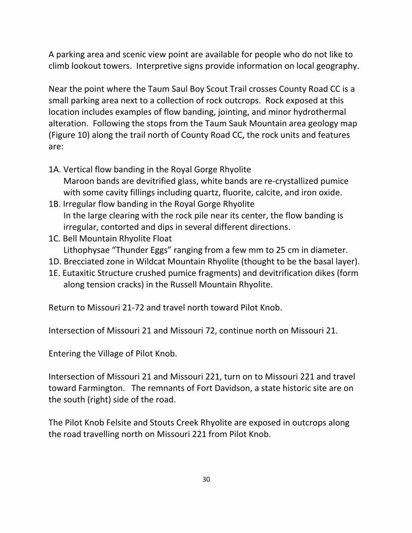
A parking area and scenic view point are available for people who do not like to climb lookout towers. Interpretive signs provide information on local geography. Near the point where the Taum Saul Boy Scout Trail crosses County Road CC is a small parking area next to a collection of rock outcrops. Rock exposed at this location includes examples of flow banding, jointing, and minor hydrothermal alteration. Following the stops from the Taum Sauk Mountain area geology map (Figure 10) along the trail north of County Road CC, the rock units and features are: 1A. Vertical flow banding in the Royal Gorge Rhyolite Maroon bands are devitrified glass, white bands are re-crystallized pumice with some cavity fillings including quartz, fluorite, calcite, and iron oxide. 1B. Irregular flow banding in the Royal Gorge Rhyolite In the large clearing with the rock pile near its center, the flow banding is irregular, contorted and dips in several different directions. 1C. Bell Mountain Rhyolite Float Lithophysae “Thunder Eggs” ranging from a few mm to 25 cm in diameter. 1D. Brecciated zone in Wildcat Mountain Rhyolite (thought to be the basal layer). 1E. Eutaxitic Structure crushed pumice fragments) and devitrification dikes (form along tension cracks) in the Russell Mountain Rhyolite. Return to Missouri 21-72 and travel north toward Pilot Knob. Intersection of Missouri 21 and Missouri 72, continue north on Missouri 21. Entering the Village of Pilot Knob. Intersection of Missouri 21 and Missouri 221, turn on to Missouri 221 and travel toward Farmington. The remnants of Fort Davidson, a state historic site are on the south (right) side of the road. The Pilot Knob Felsite and Stouts Creek Rhyolite are exposed in outcrops along the road travelling north on Missouri 221 from Pilot Knob.
31
Pilot Knob Lake on the left is a settling pond from mining operations at Pilot Knob now serving as wildlife and fishing area. Tribby Mountain can be seen on the far side of the lake. Intersection of Missouri 221 with Buck Mountain Road on the east, and King School Road to the west, continue north on Missouri 221. The hill to the right is Breadtray Mountain. Intersection of Missouri 221 and County Road NN. The large hill straight ahead is Stono Mountain. Turn left onto County Road NN and travel west toward Iron Mountain. Stop 6. The Breadtray granite outcrops in several areas along County Road NN. The best place for parking to inspect some of the outcrops is the white church (?) building and parking area on the south side of the road. Fine grained Breadtray Granite is exposed along the road west of here and on the hill behind the church. Return to County Road NN and travel east toward Farmington. Intersection of Missouri 221 and US 67, cross over US 67 and turn into parking lot at the Tradition Inn. Alternate Return Route to Farmington from Taum Sauk Mountain Return to Missouri Highway 21-72 via County Road CC, travel north on Missouri 21-72. Junction of Missouri 21-72 and County Road E, turn right onto County Road E. Several small manganese and iron deposits were worked in this area in the early 1900’s. (Grawe, 1943) The locations of these deposits are on the edge of, or within the boundaries of the Taum Sauk Caldera, and it is likely that the metal source for these deposits is related to volcanic activity from the caldera. Many of the small iron deposits in this area and in the upper unit at Pilot Knob also share characteristics of, and appear similar to iron formation, including sedimentary features associated with iron formation such as iron rich laminae, mud cracks and ripple marks (Dudley and Nold, 2004). The association of these characteristics
32
with potential sources of hydrothermal fluids from hot springs for leaching, remobilization and redeposition of iron from both volcaniclastic sediments and possibly concurrent magmatic iron sources suggests a depositional origin similar to the soft ores in the Marquette and other iron ranges as described by Boyum. (1977, p. 41) Mineralogical and petrologic field relations of these mineral deposits, as well as the Ketcherside Gap copper-garnet deposit, are associated with several forms of alteration including skarn, contact and low degrees of local metamorphism in a zone of the volcaniclastic sediments that covers a diameter of at least several miles from the caldera. (Lowell and Noll, 2001) Tolman and Robertson (1969) mapped many of the hills in this area as Stouts Creek rhyolite. Stouts Creek rhyolite is a maroon alkali rhyolitic ash with quartz and feldspar phenocrysts. Bonneterre Formation dolomite fills in the valleys between many of the hills. In this area and further east, some of the valley fill also includes small outcrops of Taum Sauk Marble. The Taum Sauk Marble is a pinkish sandy to conglomeritic limestone zone of the Bonneterre, where the dolomite grains have been altered to calcite (Brightman, G. F., 1938) Entering Madison County, continue east on County Road E. Stop 7. Entrance to Marble Creek Campground. Park in the lot near County Road E and walk toward the road. The Marble Creek area is the site of a small dam and mill built near a shut-in to make use of the increased water flow due to the constriction of the stream. Rock exposures in the area of the park are primarily red porphyritic rhyolite and rhyolitic ash flows. However, west of the park entrance a diabase dike (or sill?) occurs at approximately the same elevation as the County Road, and can be seen as a combination of outcrop and float material several hundred feet along the south side of the road in the ditch and along the hill, often with a greenish to gray weathered surface. The basalt is noted in several areas to be porphyritic, with primary phenocrysts in the basalt tending to be light gray plagioclase feldspar. Travelling east from Marble Creek Campground along County Road E, several outcrops of porphyritic rhyolite can be noted in the Marble Creek Stream bed and along the side of the road for approximately 0.5 mile (0.8 km).

33
Continue east on County Road E. Bonneterre Formation and some quartz latite outcrops along County Road E for approximately 2 miles. County Road E makes a 90 degree turn to the north to follow the St Francis River Valley. Stouts Creek Rhyolite is exposed in outcrops and as talus along the river valley. In this area the valley appears to follow a north-northeast trending fault. Mafic dikes intruding the rhyolites west of the fault probably are the result of intrusions into joints and fractures related to the faulting. Wet weather waterfalls can be noted on the west side of the road along this section of County Road E. North of County Road E and east of the St. Francis River is Tin Mountain. Tin Mountain gets its’ name from a short-lived tin boom in the late 1860’s. In 1886 an unemployed Cornish miner passing through southeast Missouri visited what is now known as Tin Mountain, pronounced the hill as ore bearing and entered a claim. In 1867 rumors began circulating that a mountain of tin had been discovered in Missouri, with a resulting rush of speculators and adventure seekers (Rowe, 1974, p. 162). The following year several tunnels were driven into the hill in preparation for mining. A mill was built on the site to process the expected tin ore, and several other buildings were constructed. When the furnace was completed it was charged with ore. Unfortunately, geological reports and assays that had been performed were exaggerated or falsified and the venture collapsed shortly thereafter. (Kidwell, Stewart and Aid, 1947, p.280 – 281) Interestingly enough, Cassiterite (SnO2) has been noted in the greisen associated with the quartz vein #1 in the Einstein Silver Mine area located approximately 3 miles (4.8 km) to the north (Singewald and Milton, 1929). This suggests a possibility that one of the prospectors in the area could have found some cassiterite placer material in the St. Francis River gravel and misidentified Tin Mountain as the source of the minerals. Continue east on County Road E. Intersection of County Road E with US 67. Turn north onto US 67, travel north to Farmington, and exit at intersection of US 67 and County Road W. Tradition Inn is to the east.

34
SILVER MINES RECREATION AREA From Farmington, travel south on US 67 to Missouri Highway 72, exit onto Missouri 72 and travel west to County Road D. Travel south on County Road D until you cross over the St. Francis River. Shortly after the bridge is a sign for Silver Mines Recreation area. The Silver Mine Granite is well exposed along the hill sides and river in this area, and is described by Tolman (1969, p 47) as a medium grained granite with almost equal amounts of orthoclase and plagioclase totaling approximately 65% of the composition, with quartz, hornblende and biotite present in smaller amounts. Trails on both sides of the St. Francis River lead up to the mine area where a partly collapsed dam crosses the river. Next to the dam are two basalt dikes. The larger dike is about 50 feet long and 2 feet wide on the downstream side of the dam, and the smaller dike is on the upstream side of the dam. Several pink-colored aplite dikes can also be seen in outcrops near the trail that leads to the dam on the northeastern side of the river. Mining began at Silver Mines in 1877 and continued until 1894 with a total production of 3000 ounces of silver and 50,000 pounds of lead. The mines were re-opened in 1916 and operated for tungsten intermittently until 1946, and for a short period in the 1950’s. The mines themselves are not very accessible, although a variety of minerals can be found in the tailings piles. The ore minerals mostly occur in quartz veins that intrude the Silver Mine granite. The primary minerals in the veins are galena, wolframite, sphalerite, and pyrite. The granite surrounding the veins has been partly metamorphosed into a high temperature alteration zone or ‘greisen’ by a combination of high temperature hydrothermal fluids and vapors. The greisen is grayish and slightly coarser than the granite, with various uncommon minerals, several of which are hard to identify without a good mineral microscope. Diagnostic minerals found in greisen are topaz and either muscovite or lithium mica, with typical accessory minerals being: tourmaline, apatite, fluorite, wolframite, cassiterite and rutile. (Williams, Turner, Gilbert, 1982, p. 172 – 173) Most of these minerals have been noted in the greisen at the Silver Mines area.
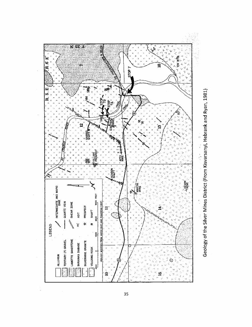
35

36
MISSOURI MINES STATE HISTORIC SITE From the Tradition Inn location in Farmington, travel west to the interchange between US Highway 67 and County Road W. Turn north onto US 67 and travel to the Park Hills exit at Missouri Highway 32. Exit onto Missouri 32 and travel west on Missouri 32 for approximately 2 miles. Exit Missouri 32, and follow the signs to the parking near the mine buildings south of the Highway. THE MUSEUM The powerhouse of Federal Mill No. 3 has been converted into a museum of Missouri mining, history, and technology. The first of three museum galleries retains remnants of the lockers and showers used by the miners and millworkers. It also features exhibits on geology, mineral resources and outstanding mineral specimens. The mineral specimens include a variety of Missouri minerals and fossils donated by members of the Mineral Area Gem and Mineral Society as well as other collectors. Cut and polished stones, translucent minerals, and jewelry featuring Missouri minerals are part of this exceptional display. A fluorescent mineral display is also part of the first gallery and has an array of excellent minerals that can be viewed under both short and long-wave ultraviolet light. Selected pieces of restored underground mining equipment are exhibited in the second gallery. The successful development of the Old Lead Belt can be attributed in part to equipment such as the St. Joe Shovel, diamond core drilling equipment and electric trains that replaced men and mules for hauling ore carts. The third gallery is the partially renovated power room. Pneumatic tools that supplied air power underground to operate the machinery in a network of multilevel mines can be seen. This gallery contains exhibits on mining history, mining technology and the economic uses of Missouri mineral resources. An orientation room has been turned into a small theatre that seats 25 people for programs, films and videos. Special programs can be shown to groups by appointment. Missouri Mines State Historic Site, P.O. Box 492, Park Hills, MO 63601 (573) 431-6226

37
REFERENCES Amos, Dewey H., Desborough, George A., 1970, Mafic Intrusive Rocks of Precambrian Age in Southeast Missouri, Missouri Geological Survey and Water Resources, Report of Investigations No. 47, 22 p., 3 maps. Anderson, Kenneth C., Coordinator, 1979, Geological Map of Missouri, Missouri Geological Survey and Water Resources, 1 sheet, scale 1:500,000 Berri, Robert C. Jr., 1991, Webster University Field Trip – General Geology and Mineral Deposits of Southeast Missouri, Unpublished Manuscript, 8 p. Berri, Robert C. Jr., 2002, (abstract) Economic Geology of Granite in Missouri in Seeger C.M., ed., 38th Forum on the Geology of Industrial Minerals, St. Louis, Missouri, Proceedings: Jefferson City, Missouri Division of Geology and Land Survey Beveridge, Thomas R., 1980, Geological Wonders of Missouri, Missouri Division of Geology and Land Survey, Educational Series No. 4, 1st edition, 451 p Bickford, M. E., Mose, D. G., 1975, Geochronology of Precambrian Rocks in the Saint Francois Mountains, Southeastern Missouri, Geological Society of America Special Paper 165, 48 p. Bickford, M. E, Sides, J. R., 1983, Geologic Map of Exposed Rocks in the Wachita Mountain (Fredericktown NW ¼) Quadrangle, Missouri (Contribution to Precambrian Geology No. 11): Missouri Department of Natural Resources, Geological Survey Open File Map OFM-83-161-MR, scale 1:24,000 Boyum, Burton H.,1977, The Marquette Mineral District of Michigan, Cleveland Cliffs Iron Company, Ishpeming, Michigan, 59 p., 11 plates. Brightman, G.F., 1938, The Taum Sauk Limestone Member of the Bonneterre Dolomite, Journal of Geology, Vol. 46,p. 248 – 267. Bullis, Mary E., 2007, Explore Taum Sauk Mountain State Park, Missouri State Parks.net, 4 p.
38
Burford, Jo, 1978, Underground Treasures: the Story of Mining in Missouri, in Kenneth M. Johnson, ed., Official Manual of the State of Missouri 1977 – 1978, p. 1 – 33. Darnell, Billy D., 1996, A Petrologic and Structural Analysis of the Buford Mountain Tectonic Block, Southeast Missouri State University, Unpublished Master’s Thesis, 104 p., 1 map. Davis, George H. 2009, Personal communication Davis, J. W., 1977, Petrogenesis and Structure of the Knob Lick Granite, Unpublished Master of Science Thesis, St. Louis University, Denham, Richard L., 1934, Igneous Rocks at Skrainka, Madison County, Missouri, Washington University, Unpublished Master of Science Thesis, 53 p. Desborough, George, 1963, Magmatic Sphalerite in Missouri Basic Rocks, Economic Geology, v. 58, p. 971 – 977. Dolde, John L., 2004, Structural and Petrographic Evidence for Caldera Subsidence, Fredericktown Area, Madison County, Missouri, Southeast Missouri State University, Unpublished Master of Science Thesis, 62 p. Dudley, Mark A., Nold, John L, 2004, (abs.) Mineralogy Textures and Environments of Deposition of Iron Deposits, St. Francois Igneous Terrane, Southeast Missouri, Geological Society of America, Abstracts with Programs, Vol. 36, Number 3, p. 20. Dymek, Robert F., 1994, Washington University - Igneous and Metamorphic Petrology field Trip, Unpublished Manuscript 11 p. Graves, Howard B. Jr., 1938, The Pre-Cambrian Structure of Missouri, Transactions of the Academy of Science of St. Louis, vol. 24, no. 5, p. 111-164. Grawe, Oliver R., Manganese Deposits of Missouri, Missouri Geological Survey and Water Resources, Appendix 6, 62nd Biennial Report, 77 p.

39
Hansink, James D., 1965, Geology of the Graniteville Granite, Saint Louis University, Unpublished Master of Science Thesis, 84 p. Hebrank, Arthur W., Kisvarsanyi, Eva B, 1976, Farmington to Arcadia via US Highway 67 and Missouri Highway 72, in Kisvarsanyi, Eva B., Editor, 1976, Studies in Precambrian Geology of Missouri with a Guidebook to Parts of the St. Francois Mountains. Missouri Department of Natural Resources Division of Geology and Land Survey, Report of Investigations No. 61, 190 pp. 17- 44. Houseknecht, D. W, Ethridge, F. G., 1978, Depositional History of the Lamotte Sandstone of Southeast Missouri, Journal of Sedimentary Petrology, vol. 48, pp. 575- 586. Kidwell, Albert L., Stewart, Dan R., Aid, Kenneth, 1947, Geology of the Fredericktown Quadrangle with a Chapter on Precambrian Geology By Forbes S. Robertson, Missouri Division of Geology and Water Resources, Unpublished Report. M.S. C-1535, 284 pp Kisvarsanyi, Eva B., 1969, Lapilli Tuffs and Associated Pyroclastic Sediments in Upper Cambrian Strata Along Dent Branch, Washington County, Missouri, Missouri Geological Survey and Water Resources, Report of Investigations No. 43, 80 p. Kisvarsanyi, Eva B., 1972, Petrochemistry of a Precambrian Igneous Province, Missouri Geological Survey and Water Resources, Report of Investigations No.51, 96 p. Kisvarsanyi, Eva B., Hebrank, Arthur W., Ryan, Richard F., 1981, Field Trip 2 in Guidebook to the Geology and Ore Deposits of the St. Francois Mountains, Missouri, Missouri Department of Natural Resources, Division of Geology and Land Survey, Report of investigations No. 67, 119 p. Kisvarsanyi, Eva B., Hebrank, Arthur W., 1987, Knob Lick Mountain Section: Intrusive Contact of Precambrian granite with Rhyolite in the St. Francois Mountains, Geological Society of America Centennial field Guide-North Central Section, pp. 155 – 158.

40
Lahee, Frederick H., 1961, Field Geology, McGraw Hill, New York, 926 p. Lowell, Gary R., Noll, P. D., 2001,Fe-Cu-Au Bearing Scapolite Skarn in Moat Sediments of the Taum Sauk Caldera, Southeastern Missouri, USA, Mineralogical Magazine, v. 65, p. 439-462. Martin, James A, Knapp, Donald K., 1961, Route Log 4 Ironton to Desoto in Hayes, William C., ed., Guidebook to the Geology of the St. Francois Mountain Area, Division of Geological Survey and Water Resources, Report of Investigations No. 26, pp. 61-77. Michel, Sandra Jo, 1981, The Petrologic Relationships between Magnetite and Hematite in the Pilot Knob Ore Deposit, Southeastern Missouri, Washington University, Unpublished Master of Science Thesis, 133 p. Muilenberg, Garrett A., Goldich, S.S., 1933, Petrography and Petrology of the Mount Devon Diabase Porphyry, American Journal of Science, Vol. 26, p. 355-367. Murphy, John E., Ohle, Ernest L., 1968, The Iron Mountain Mine, Iron Mountain, Missouri, in Ridge, J. D., ed., Ore Deposits of the United States, Graton-Sales Volume 1, American Institute of Mining, Metallurgical and Petroleum Engineers, New York, 991 p. Pratt, Walden P., Anderson, R. Ernest, Berry, Archie W., Jr., Bickford, M.E., Kisvarsanyi, Eva B., and Sides, Ronald J., 1979, Geologic Map Of Exposed Precambrian Rocks, Rolla 1O x 2O Quadrangle, Missouri, United States Geological Survey, Map I-1161, 8 pages, 1 map, 1:125,000. Rowe, John, 1974, Hard Rock Men, the Story of Cornish Miners in America, Harper and Row, London Seeger, Cheryl M., Berri, Robert C. Jr., 2001, Guide to the Geology and Tectonics of the St. Francois Mountains, in King, Patrick L., Editor, AEG-AIPG Field Trip Guidebook, Association of Engineering Geologists, College Station, TX, p. 63 – 87.

41
Seeger, Cheryl M., Palmer, James R., 1998, Sedimentary Tectonism in the St. Francois Mountains Region, Southeast Missouri, in Syndepositional Tectonics during the late upper Cambrian, Association of Missouri Geologists Guidebook, 45th Annual Field Trip, p. 1- 26. Singewald, Joseph T., Milton, C., 1929, Greisen and Associated Mineralization at Silvermine, Missouri, Economic Geology, Vol. 24, No. 6, p. 569 – 591. Snyder, Frank G., Wagner, Richard E., 1961, Route Log 1 (Arcadia to Farmington) in Hayes, William C., 1961, Guidebook to the Geology of the St. Francois Mountain Area, Division of Geological Survey and Water Resources, Report of Investigations No. 26, p. 11 – 18. Sylvester, Paul, 1984, Proterozoic Mafic Rocks of Missouri, Washington University Unpublished PhD Dissertation, 589 p. Tolman, Carl F., Goldich, Samuel S., 1935,Granite, Pegmatite and Replacement Veins in the Sheahan Quarry, Graniteville, Missouri, The American Mineralogist, Vol. 20, p. 229-239. Tolman, Carl F., Robertson, Forbes, 1969, Exposed Precambrian Rocks in Southeast Missouri, Missouri Geological Survey and Water Resources, Report of Investigations Number 44, 68 pages, 1 map. U.S. Geological Survey, 1958, Irondale, Missouri 7 1/2 minute Quadrangle, Photo-revised 1982. Williams, Howel, Turner, Francis J., Gilbert, Charles M., 1982, 2nd edition, Petrography: An introduction to the Study of Rocks in Thin Sections, W. H. Freeman and Company, San Francisco, 626 p. Young, Glen J., 1994, Interaction of Basaltic and Granitic Magmas at Tieman Shut-In, St. Francois Mountains, Missouri, Southeast Missouri State University, Unpublished Master’s Thesis, 99 p.