assignment and bill of saleocdimage.emnrd.state.nm.us/imaging/filestore/santafe...o bco> 431 page...
TRANSCRIPT

O BCO> 431 PAGE 0731
ASSIGNMENT AND BILL OF SALE
STATE OF NEW MEXICO ) ) KNOW ALL MEN BY THESE PRESENTS:
COUNTY OF EDDY )
THAT, MALLON OIL COMPANY, a Colorado corporation, being a subsidiary of Mallon Resources Corporation, whose address is 999 18th Street, Suite 1700,,Denver, Colorado, 80202 (hereinafter referred to as Assignor), for Ten and No/100 Dollars ($10.00) and other good, valuable and sufficient consideration, paid to an intermediary as part of a tax-deferred exchange pursuant to Section 1031 of the Internal Revenue Code, does hereby GRANT, SELL, CONVEY, ASSIGN, TRANSFER, SET OVER and DELIVER unto A J A G N U A y ^ ^ INC., a Texas corporation and a wholly-owned subsidiary of Magnun71?rjjrt^Resour^^ whose^ address is Post Office Box 140907, Irving, Texas, 75039, (hereinafter referred to as Assignee), its successors and assigns, all of its undivided right, title, and interest in and to the following:
1. Oil and Gas Interests. All the undivided right, title, and interest of Assignor, now owned in the oil, gas, casinghead gas, mineral leases, mineral interests, and estates, regardless of the nature of such interests, whether known or unknown, including any escrowed or accrued funds which have not been paid to Assignor as of the closing date hereof, in and under or covering the properties described in Exhibit "A", and any extensions or renewals thereof, attached hereto insofar as such leases, interests, and estates cover the acreage specifically described in Exhibit "A", and all the undivided right, title, and interest of Assignor now owned in the oil, gas, casinghead gas, mineral leases, mineral interests, and estates in and under or covering the properties identified in Exhibit "A" attached hereto, insofar as such leases, interests, and estates cover the acreage specifically described in Exhibit "A" attached hereto, together with any interests and estates with which any of the aforementioned interests and estates of Assignor in the properties described in Exhibit "A" are now or may hereinafter be spaced, pooled or unitized, and all real property, including buildings and shop facilities and improvements located on the acreage specifically described in Exhibit "A" attached -hereto used or useful in connection with the properties described in Exhibit "A". Further, Assignee will assume any production imbalance, regardless of when such imbalance . occurred, and Assignor shall be credited with ail oil in the tanks as of 7:00 a.m. of the \ effective date herein (all of the above hereinafter collectively referred to as "Oil and Gas Interests", whether one or more).
2. Equipment. All the undivided interest of Assignor in and to the wells, fixtures, facilities, pipelines and equipment attributable to the Oil and Gas Interests or used or useful in connection with the production, treatment, processing, gathering, sale, transportation or disposal of hydrocarbons, water or other substances produced therefrom including1 but not limited to each wellbore, all surface production equipment, tank batteries, pumping units, gas gathering system(s), compressors, separators and scrubbers, salt water disposal system(s), pumps, and all tangible property of any kind associated with the completion and production operation of the Oil and Gas Interests, and all excess materials, supplies, spare parts and
Oil Conservation Division WA50Uw~ - f W M , V f T i ^ /I^Case No. A Lfo Cdiwu MOO Ofexhibit N o ~ J "320/Ag ~& ^ 3 < ?

i?o>' 431^0732 ^
ASSIGNMENT AND BILL OF SALE -Eddy County, New Mexico Page 2 of4
equipment, including, but not limited to pumps and pump parts, electric motors, transformers, tubular goods, pumping units, tanks and production equipment in use or in inventory for use with the Oil and Gas Interests (all of the above hereinafter collectively referred to as "Equipment").
3. Contractual Rights. All the undivided interest of Assignor in those agreements by which Assignor acquired its interest in the Oil and Gas Interests and the Equipment, and all the undivided interest of Assignor in and to any and all other agreements usually associated with and customarily relating to the exploration, production, transportation, processing, gathering, treating, sale and/or disposal of hydrocarbons, water or other substances from or attributable to the Oil and Gas Interests, including, without limitation, permits, easements, servitudes, rights of way, licenses, purchase orders, oil and casinghead gas sales contracts, contact rights, operating agreements, and pooling and unitization agreements, and any other contract relating to such acquired interests.
4. Like Kind Exchange Option. Buyer may elect to effect a like-kind exchange or a reverse like-kind exchange pursuant to Section 1031 of the Internal Revenue Code, the regulations and procedures promulgated thereunder, with respect to any or all of the property (a "Like-Kind Exchange"). In order to effect a Like-Kind Exchange, Seller shall reasonably cooperate and do all acts as may be reasonably required or requested by Buyer with regard to effecting the Like-Kind exchange, including, but not limited to, permitting Buyer to assign its rights under this agreement to a qualified intermediary or exchange accommodation titleholder of Buyer's choice in accordance with Treasury Regulation Section 1.103 l(k)-1(g)(4); provided, however, that Seller shall incur no liability or expense in connection with such Like-Kind Exchange.
5. Other Agreements. This Assignment is subject to all agreements of record affecting the Lands and further is expressly made subject to the terms and conditions of that certain unrecorded Purchase and Sale Agreement dated August 7, 2001, by and between Mallon Resources Corporation, as Seller, and Magnum Hunter Production, Inc., as Buyer and any amendments thereto.
TO HAVE AND TO HOLD the Oil and Gas Interests, Equipment and Contractual Rights, together with the rights, titles, interests, estates, remedies, powers and privileges pertaining thereto, unto Assignee and its successors and assigns, together with all and singular the rights and appurtenances thereunto belonging unto Assignee, its successors and assigns, forever.
THIS ASSIGNMENT IS MADE WITHOUT ANY WARRANTY OR REPRESENTATION OF TITLE, EITHER EXPRESS, IMPLIED, STATUTORY OR OTHERWISE, AND WITHOUT ANY EXPRESS, IMPLIED STATUTORY OR OTHER WARRANTY OR REPRESENTATION

eco:« 431 PAGE 0733
ASSIGNMENT AND BILL OF SALE Eddy County, New Mexico Page 3 of 4
AS TO THE CONDITION, QUANTITY, QUALITY, FITNESS FOR A PARTICULAR PURPOSE, FREEDOM FROM REDHIBITORY VICES OR DEFECTS, CONFORMITY TO MODELS OR SAMPLES OF MATERIALS OR MERCHANTABILITY OF ANY OF THE EQUIPMENT OR ITS FITNESS FOR ANY PURPOSE, AND WITHOUT ANY OTHER EXPRESS, IMPLIED, STATUTORY OR OTHER WARRANTY OR REPRESENTATION WHATSOEVER. ASSIGNEE SHALL HAVE INSPECTED OR WAIVED ITS RIGHT TO INSPECT THE PROPERTY FOR ALL PURPOSES AND SATISFIED ITSELF AS TO THE PHYSICAL AND ENVIRONMENTAL CONDITION, BOTH SURFACE AND SUBSURFACE, INCLUDING BUT NOT LIMITED TO, CONDITIONS SPECIFICALLY RELATED TO THE PRESENCE, RELEASE OR DISPOSAL OF HAZARDOUS SUBSTANCES, AND THE CONDITION OF ANY WELL CASING, TUBING OR DOWNHQLE EQUIPMENT. ASSIGNEE IS RELYING SOLELY UPON ITS OWN INSPECTION OF THE PROPERTY, AND ASSIGNEE SHALL ACCEPT ALL OF THE SAME IN ITS "AS IS, WHERE IS" CONDITION. IN ADDITION, ASSIGNOR MAKES NO WARRANTY OR REPRESENTATION, EXPRESS, IMPLIED, STATUTORY OR OTHERWISE, AS TO THE ACCURACY OR COMPLETENESS OF ANY DATA, REPORTS, RECORDS, PROJECTIONS, INFORMATION OR MATERIALS NOW, HERETOFORE OR HEREAFTER FURNISHED OR MADE AVAILABLE TO ASSIGNEE IN CONNECTION WITH THIS ASSIGNMENT AND BILL OF SALE INCLUDING, WITHOUT LIMITATION, ANY DESCRIPTION OF THE PROPERTY, PRICING, ASSUMPTIONS OR QUALITY OR QUANTITY OF HYDROCARBON RESERVES (LF ANY) ATTRIBUTABLE TO THE PROPERTY, OR THE ABILITY OR POTENTIAL OF THE PROPERTY TO PRODUCE HYDROCARBONS OR THE ENVIRONMENTAL CONDITION OF THE PROPERTY OR ANY OTHER MATTERS CONTAINED IN THE PROPRIETARY DATA OR ANY OTHER MATERIALS FURNISHED OR MADE AVAILABLE TO ASSIGNEE BY ASSIGNOR OR BY ASSIGNOR'S AGENTS OR REPRESENTATIVES. ANY AND ALL SUCH DATA, RECORDS, REPORTS, PROJECTIONS, INFORMATION AND OTHER MATERIALS FURNISHED BY ASSIGNOR OR OTHERWISE MADE AVAILABLE. TO ASSIGNEE ARE PROVIDED TO ASSIGNEE AS A CONVENIENCE AND SHALL NOT CREATE OR GIVE RISE TO A LIABILITY OF OR AGAINST ASSIGNOR. ANY RELIANCE ON OR USE OF THE SAME SHALL BE AT ASSIGNEE'S SOLE RISK TO THE MAXIMUM EXTENT PERMITTED BY LAW.
This agreement may be executed in any number of counterparts, no one of which needs to be executed by all parties, or may be ratified or consented to by separate instrument, in writing, specifically referring hereto, and shall be binding upon all parties who have executed such counterpart, ratification or consent hereto with the same force and effect as if all parties had signed the same document.
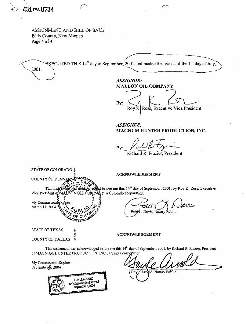
m> 431^0734 r r
ASSIGNMENT AND BILL OF SALE Eddy County, New Mexico Page 4 of4
ECUTED THIS 14th day of September, 2001, but made effective as of the 1st day of July,
ASSIGNOR: MALLON OIL COMPANY
Bv: \C Y^—-Roy K l Ross, Executive Vice President
ASSIGNEE: MAGNUM HUNTER PRODUCTION, INC.
By: Richard R. Frazier, President
STATE OF COLORADO § §
COUNTY OF DENV
This ins Vice President o,
My Commissio: March 11, 2004
ACKNOWLEDGEMENT
before me this 14* day of September, 2001, by Roy K. Ross, Executive , a Colorado corporation.
Patn/L. Davis, Notary Public
STATE OF TEXAS § §
COUNTY OF DALLAS §
ACKNOWLEDGEMENT
This instrument was acknowledged before me this 14* day of September, 2001, by Richard R. Frazier, President of MAGNUM HUNTER PRODUCTION, INC., a Texas corpc
My Commission Expires: Septembep̂ , 2004

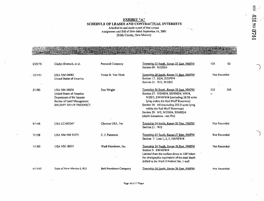
EXHIBIT "A" SCHEDULE OF LEASES AND CONTRACTUAL INTERESTS
Attached to and made a part of that certain Assignment and Bill of Sale dated September 14, 2001
(Eddy County, New Mexico)
111 i i
• 10/15/68 State of New Mexico [,-1514 Pennzoil United, Inc. Township 20 South. Ranee 28 East NMPM
Section 21: E/2SE/4, NW/4SW/4, N/2NE/4, SE/4SW/4, SW/4NE/4
Not Recorded
4/12/7! Marie T. Nca) D. L. Hannifin Township 21 South. Ranee 27 East NMPM Section 25: E/2NW/4
78 S75
4/5/71 Frank S. Jump, et al. D. L. Hannifin Township 21 South. Range 27 East. NMPM Section 25: E/2NW/4
78 873
Effective USA NM 0473303-A !<-'f/64 United States of America
W. Hirshon Township 22 South. Range 27 East NMPM Section 03: Lots 1, 2, S/2SE/4 Section 10: N/2NE/4
Not Recorded
12/15/65 Gertrude A. Echols, et al. E. S. Grear Township 23 South. Range 26 East. NMPM Section 12: NW/4NW/4SE/4, S/2NW/4SE/4,
N/2S/2SE/4, E/2SEV4SW/4, SW/4SE/4SW/4, SW/4SW/4SW/4
165 121
8/9/67 J. S. Gibson, et al. David J. Sorenson Township 23 South. Range 26 East. NMPM Section 12: NW/4NW/4SE/4, S/2NW/4SE/4,
N/2S/2SE/4, E/2SE/4SW/4, SW/4SE/4SW/4, SW/4SW/4SW/4
56 374
Mollic I . . Thoele David J. Sorenson Township 23 South. Ranee 26 East. NMPM Section 12: NW/4SE/4SW/4, NE/4SW/4SW/4
63 498
Page I of 17 Pages

EXHIBIT "A" SCHEDULE OF LEASES AND CONTRACTUAL INTERESTS
Attached to and made a part of that certain Assignment and Dill of Sale dated September 14,2001
(Eddy County, New Mexico)
mSKM m 1 »
8/14/68 Herbert J. Cook David J. Sorenson Township 23 South. Ranee 26 East NMPM Section 12: NW/4SE/4SW/4, NE/4SW/4SW74
63 502
8/14/68 Anna Muchenhausen David J. Sorenson Township 23 South. Ranee 26 East. NMPM Section 12: NW/4SE/4SW/4, NE/4SW/4SW/4
63 506
9/9/68 William Cook David J. Sorenson Township 23 South. Range 26 East NMPM Section 12: NW/4SE/4SW/4, NE/4SW/4SW/4
63 510
9/22/67 Joe Gant, et ux. David J. Sorenson Township 23 South. Ranee 26 East NMPM Section 12: SE/4SW/4SE/4
56 793
! 0/24/67 Edwin P. Edwards, cf ux. David J. Sorenson Township 23 South. Range 26 East NMPM Section 12: NW/4SW/4SW/4
58 316
9/27/67 C. C. Schachtsick, etal. David J. Sorenson Township 23 South. Range 26 East. NMPM Section 12: SW/4SE/4SE/4
58 451
7/1/58 USA NM-040547 United States of America
C. J- Patterson Township 23 South. Range 26 East NMPM SecUonOl: NE/4SW/4, S/2SW/4 Section 12: E/2NE/4, NE/4SE/4 Township 23 South. Range 27 East. NMPM Section 06: Lots 6, 7, E/2SW/4 Section 07: Lots 1,2,3, NE/4SW/4
Not Recorded
Page 2 of 17 Pages

EXHIBIT "A" SCHEDULE OF LEASES AND CONTRACTUAL INTERESTS
Attached to and made a part of that certain Assignment and Bill of Sale dated September 14,2001
(Eddy County, New Mexico)
4/1/65
6/14/65
Missouri-New Mexico Land Co. Socony Mobil Oi) Co.
Effective 11/1/56
Effective 8/1/63
3/17/70
Howard I. Everett and wife Acie R. Everett
USA NM-027994-D United States of America
USANM-0413245 United States of America
State of New Mexico L-4325
E. S. Grcar
George E. ConJey
James McTighe
PennzoiJ United, Inc.
Township 23 South. Ranee 27 East. NMPM Section 06: Lots 3,4, 5, SE/4NW/4, SE/4
Township 23 South. Range 26 East NMPM Section 01: NW/4SW/4 and all that part of the
NW/4 lying cast of Highway 62 Section 02: All that part of the NE/4SE/4 lying
cast of Highway 62
Township 23 South. Range 26 East NMPM Section 12: NW/4, W/2NE/4 Section 13: NE/4, S/2, E/2NW/4 Section 24: SE/4, S/2SW/4 Section 25: NE/4
Township 24 South. Range 26 East. NMPM Section 10: SE/4, SE/4SW/4
Township 24 South. Range 26 East. NMPM Section 02: NE/4SW/4, NW/4SE/4 Section 03: NE/4SE/4
155
158
27
Not Recorded
Not Recorded
Not Recorded
2/17/70
7/8/66
State of New Mexico L-4241
Fitz-Hugh Marshall
George A. Moberly
Earl S. Grcar
Township 23 South. Range 26 East. NMPM Section 34: NW/4NE/4
Township 23 South. Range 26 East. NMPM Section 01: Lots L & 2, S/2NE/4
Not Recorded
I6S 240
6/11/70 Warren T. Baczik, et ux. D. J. Sorenson Township 22 South. Range 26 East NMPM 73 697
Page 3 ofl 7 Pages

EXHIBIT "A" SCHEDULE OF LEASES AND CONTRACTUAL INTERESTS
Attached to and made a part of that certain Assignment and Bill of Sale dated September 14,2001
(Eddy County, New Mexico)
g j i l l l i n IHBI il'lidifilRiSSfQi ttiS? BfliPit'i
i l l
6/4/70
7/7/70
4/10/70
7/14/70
7/9/70
7/6/70
Jewel Barnes, a widow
Lee T. Scott, et ux.
G. R. Spencer, et ux.
E. J. Barton, et ux.
Elmer W. Rea, et ux.
E. W. Yarhrough, et ux.
D. J. Sorenson
D. J. Sorenson
D. J. Sorenson
D. J. Sorenson
D. J. Sorenson
D. J. Sorenson
Section 25: A portion of the NW/4 (see lease for exact description)
Township 22 South. Ranee 26 East. NMPM Section 25: A portion of the NW/4
(see lease for exact description)
Township 22 South. Range 26 East. NMPM Section 25: A portion of the NW/4
(see lease for exact description)
Township 22 South. Ranee 26 East. NMPM Section 25: A portion of the NW/4
(see lease for exact description)
Township 22 South. Range 26 East. NMPM Section 25: A portion of the NW/4
(see lease for exact description)
Township 22 South. Ranee 26 East. NMPM Section 25: A portion of the NW/4
(see lease for exact description)
Township 22 South. Ranee 26 East, NMPM Section 25: N/2SW/4NE'4NW/4
73
73
72
73
73
73
241
553
491
699
633
680
Page 4 nf 17 Pages

EXHIBIT "A" SCHEDULE OF LEASES AND CONTRACTUAL INTERESTS
Attached to and made a part of that certain Assignment and Bill of Sale dated September 14, 2001
(Eddy County, New Mexico)
i p j i i i i l l
7/9/70 Annie R. Kemp, a widow D. J. Sorenson Township 22 South. Ranee 26 East. NMPM Section 25: A portion of the NW/4
(see lease for exact description)
73 587
7/7/70 W. T. Ncison, et ux. D. J. Sorenson Township 22 South. Range 26 East. NMPM Section 25: A portion of the NW/4
(see lease for exact description)
73 631
6/10/70 Dwyatt B. Nesbit, et ux. D. J. Sorenson Township 22 South. Ranee 26 East. NMPM Section 25: A portion of the NW/4
(see lease for exact description)
73 371
6'! 0/70 Thomas Daniel Lawson, et ux. D, J. Sorenson Township 22 South. Ranee 26 East. NMPM Section 25: A portion of the NW/4
(see lease for exact description)
73 695
6/11/70 Thomas J. Ferguson, et ux. D. J, Sorenson Township 22 South. Range 26 East. NMPM Section 25: A portion of the NW/4
(see lease for exact description)
74 45
8/29/70 Opal M. Gant, et vir. D. J. Sorenson Township 22 South. Ranee 26 East NMPM Section 25: A portion of the NW/4
(see lease for exact description)
74 304
9/10/70 Leslie Bartlett, et ux- D. J. Sorenson Township 22 South. Ranee 26 East NMPM Section 25: A portion of the NW/4
(see lease for exact description)
75 999
5/26/70 David A. Spencer, et ux. D. J. Sorenson 73 856
Page 5 o f l 7 Pages

E X H I B I T "A" S C H E D U L E O F L E A S E S AND C O N T R A C T U A L I N T E R E S T S
Attached to and made a part of that certain Assignment and Bili of Sale dated September 14,2001
(Eddy County, New Mexico)
Section 25: A portion of the NW/4 (see lease for exact description)
Township 24 South. Ranee 26 East NMPM Section 02: Lot 1, SW/4NW/4, SE/4SE/4
SE/4SW/4
Not Recorded
Township 23 South. Ranee 26 East. NMPM Section 26: W/2NE/4, NE/4NW/4, SW/4NW/4,
E/2SE/4 Section 27: NE/4
Not Recorded
Township 22 South. Ranee 27 East NMPM Section 03: S/2NE/4, N/2SE/4 Section 04: Lots 3,4, S/2NW/4 Section 10: S/2NE/4
155
Township 24 South. Ranee 26 East. NMPM Section 21: E/2
Not Recorded
Township 24 South. Ranee 26 East NMPM Section 22: NW/4, S/2
Not Recorded
mm
mm am
8/20/68 State of New Mexico L-1073 Pennzoil United, Inc:
8/19/69 State of New Mexico L-3390 D. J. Sorenson
Effective USA NM-0454018 12/1 /63 United States of America
A. J. Heiser
9/25/63 USANM-0441951 United States of America
J. H. Leib
1/29/63 USANM-0475051 United States of America
Mary F. Balsam
Page 6 of 17 Pages

E X H I B I T "A" S C H E D U L E O F L E A S E S AND C O N T R A C T U A L I N T E R E S T S
Attached to and made a part of that certain Assignment and Bill of Sale dated September 14, 2001
(Eddy County, New Mexico)
IIS i i l l s i t
ma mSm USA NM-C402I70 United States of America
Flora Hook Township 24 South. Ranee 26 East. NMPM Section 14: SW/4 Section 15: E/2 Section 22: NE/4
Not Recorded
2/1/46 USA IX-06542] United States of America
M. M. Bradley Township 24 South. Range 26 East. NMPM Section 11: S/2 Section 14: N/2, SE/4
Not Recorded
9/1/48 USA LC-064200 Unitcd States of America
T. O. Shappell Township 24 South. Range 26 East. NMPM Section 10: N/2, N/2SW/4, SW/4SW/4 Section 11: N/2 Section 15: NW/4, N/2SW/4, SE/4SW/4
Not Recorded
12/1/63 USANM-0475051 (Extended) United States of America
MaryF. Balsam Township 24 South. Ranee 26 East. NMPM Section 09: N/2, N/2S/2, SE/4SW/4, S/2SE/4
Not Recorded
8/20/68 State of New Mexico L-l 110 Pennzoil United. Inc, Township 24 South. Ranee 26 East. NMPM Section 16: NE/4NE/4, SW/4SW/4
Not Recorded
10/21/69 State of New Mexico L-3652 Pennzoil United, Inc. Township 24 South, Range 26 East. NMPM Section 16: NW/4NE/4, NE/4SE/4
Not Recorded
! I/I 7/64 State of New Mexico K-4540 Mrs. Corinnc Grace Township 24 South. Ranee 26 East. NMPM Section 16: S/2NE/4, NW/4, N/2SW/4.
SR/4SW/4. W/2SE/4. SE/4SE/4
Not Recorded
Page 7 of 17 Pages

E X H I B I T "A"
S C H E D U L E O F L E A S E S AND C O N T R A C T U A L I N T E R E S T S Attached to and made a part of that certain
Assignment and Bill of Sale dated September 14, 2001 (Eddy County, New Mexico)
i p i i i 6/1/77
1/1/77
State of New Mexico LG-4215 Leo D. Catanach
i 0/15/68
5/1/77
12/1/59
11/1/81
1/1/60
9/1/80
State of New Mexico LG-396S R. M. Young, Jr.
State of New Mexico L-1513
State of New Mexico LG-4171
USA LC-062052 United States of America
USA LC-029388-D United States of America
USA LC-029388-A United States of America
USA LC-029388-C United States of America
Pennzoil United, Inc.
Leo D. Catanach
Hudson & Hudson, Inc.
Marathon Oil Company
Hudson & Hudson, Inc.
Marathon Oil Company
Township 18 South. Range 28 East. NMPM Section 35: E/2E/2
Township 18 South. Ranee 29 East. NMPM Section 18: E/2SW/4
Township 19 South. Range 29 East. NMPM Section 15: W/2SW/4 Section 16: NW74SW/4 Section 18: NE/4NW/4 Section 20: E/2SW/4, NE/4SE/4
Township 18 South. Range 29 East. NMPM Section 36: NE/4SE/4
Township 18 South. Ranee 31 East. NMPM Section 03: Lots 1,2, S/2NE/4, SW/4
Township 18 South. Range 31 East. NMPM Section 03: Lots 3,4, S/2NW/4, SE/4
Township 18 South. Ranee 31 East. NMPM Section 10: NE/4, SW/4
Township 18 South. Range 31 East. NMPM Section !0: NW/4, SE/4
Not Recorded
Not Recorded
Not Recorded
Not Recorded
Not Recorded
Not Recorded
Not Recorded
Not Recorded
Page 8 of 17 Pages

E X H I B I T "A" S C H E D U L E O F L E A S E S AND C O N T R A C T U A L I N T E R E S T S
Attached to and made a part of that certain Assignment and Bill of Sale dated September 14, 2001
(Eddy County, New Mexico)
I 2/18/69 State of New Mexico L-2473 Pennzoil United, Inc. Township 19 South. Ranee 29 East. NMPM
Section 16: NW/4 Not Recorded
8/10/46 State of New Mexico E-950 Repollo Oil Company Township 17 South. Ranee 29 East. NMPM Section 19: Lot 3
Not Recorded
4/22/65 Howard P. Hcmler, et ux. E. S. Grear Township 23 South. Ranee 27 East. NMPM Section 06: Lots 1, 2, S/2NE/4
156 212
2/1/71 State of New Mexico L-5154 Pennzoil United, Inc. Township 19 South. Range 24 East NMPM Section 20: SW/4NW/4, W/2SW/4
Not Recorded
4/22/65
6717/69
9/15/70
J. H. Aschbachcr, et ux.
New Mexico L-3020
New Mexico L-4894
E. S. Grear
Pennzoil United. Inc,
Pennzoil United. Inc.
Township 23 South. Ranee 27 East. NMPM Section 06: Lots 1,2, S/2NE/4
Township 22 South. Ranee 25 East. NMPM Section 16: S/2NE/4, NW/4NW/4
Township 22 South. Ranee 25 East. NMPM Section 16: N/2NE/4, NE/4NW/4, NE/4SW/4,
S/2SW/4, NE/4SE/4, SW/4SE/4
156 210
Not Recorded
Not Recorded
12/15/70 New Mexico L-5081 Pennzoil United, Inc. Township 22 South. Ranee 25 East NMPM Section 16: S/2NW/4, NW/4SW/4. NW/4SE/4,
SE/4SE/4
Not Recorded
Page 9 o n 7 Pages
E X H I B I T "A"
S C H E D U L E O F L E A S E S AND C O N T R A C T U A L I N T E R E S T S Attached to and made a part of that certain
Assignment and Bill of Sale dated September 14, 2001 (Eddy County, New Mexico)
mam mm. i i 1 2/25/76 Gladys Shanuck, et al. Pennzoil Company Township 22 South. Ranee 25 East. NMPM
Section 09: N/2SE/4 135 82
12/J/51
2/1/80
USA NM-04082 United States of America
USA NM-38636 United States of America Department of the Interior Bureau of Land Management BRUSHY DRAW PROSPECT
Victor B. Van Hook
Don Wright
Township 20 South. Ranee 31 East NMPM Section 17: SE/4, E/2SW/4 Section 21: W/2, W/2E/2
Township 26 South. Ranee 29 East. NMPM Section 27: N/2NE/4, SE/4NE/4, NW/4,
N/2S/2, SW/4SW/4 (excluding 38.08 acres lying within (he Red Bluff Reservoir)
Section 28: All (excluding 203.9 acres lying within the Red Bluff Reservoir)
Section 29: N/2, N/2SE/4, SE/4SE/4 (depth limitations - sec file)
Not Recorded
212 568
9/1/48
7/1/58
1/1/60
USA LC-065347
USA NMNM 91071
USA NM 18033
Chevron USA. Inc.
C. J. Patterson
Wadi Petroleum, Inc.
Township 24 South. Ranee 26 East. NMPM Section 21: W/2
Township 23 South. Ranee 27 East. NMPM Section 7: Lots 1, 2, 3, NE/4SW/4
Townsbip 24 South. Ranee 26 East. NMPM Section 9: SW/4SW/4 Limited from the surface down to 100* below the stratigraphic equivalent of the total depth drilled in the Wadi 9 Federal No. 1 well
Not Recorded
Not Recorded
Not Recorded
6/IS/6S State of New Mexico L-953 Bell Petroleum Company Township 24 South. Range 26 East NMPM Not Recorded
Page 10 of 17 Pages

EXHIBIT "A" SCHEDULE OF LEASES AND CONTRACTUAL INTERESTS
Attached to and made a part of that certain Assignment and Bill of Sale dated September 14, 2001
(Eddy County, New Mexico)
12/19/67 State of New Mexico L-487 Amoco Production Company
Section 3: Lots I , 2, S/2NE/4, WY2SE/4, SE/4SE/4
Township 20 South. Range 28 East. NMPM Not Recorded Section 21: SW/4
RIGHT-OF-WAY AND SURFACE USE AGREEMENTS:
USA NM NM 71599 3/14/88 Effective as of 4/1/88
10/29/97 Effective as of 11Z24/97
USA NMNM 98337
Red Bluff Water Power Control District
Mallon Oil Company
Township 26 South. Range 29 East NMPM Right of Way across 365.90 acres in Sections 27,28,33 and 34 (see right-of-way for complete description of lands covered)
Township 24 South. Ranee 26 East. NMPM Right-of-Way across N/2SW/4 of Section 9 30 feet wide, 2213.7 feet long containing 1.525 acres, more or less
Not recorded
Not recorded
9/17/96 Eugene Hood Mallon Oil Company Township 24 South. Ranee 26 East. NMPM 261 445 Pipeline Easement across the Southerly 25 feet wide and 803 linear feet of that part of a a tract of land in the NW/4SE/4 and NE/4SW/4 of Section 10
Page II of 17 Pages

E X H I B I T "A" S C H E D U L E O F L E A S E S AND C O N T R A C T U A L I N T E R E S T S
Attached to and made a part of that certain Assignment and Bill of Sale dated September 14, 2001
(Eddy County, New Mexico)
3/14/88 Effective as of 4/1/88
USA NMNM 62575 Red Bluff Water Power Control District
Township 26 South. Range 29 East NMPM Right of Way across 322.27 acres in Sections 17, 18, 19, 20 and 21 (sec right-of-way for complete description of lands covered)
17 755
ALSO MADE A PART OF THIS CONVEYANCE ARE ALL CONTRACTUAL INTERESTS, INCLUDING, BUT NOT LIMITED TO THE FOLLOWING:
That certain Operating Agreement dated September 15,1988, by and between Santa Fe Energy Operating Partners, LP., as Operator, and Pennzoil Company, ct al., as Non-Operators, covering the following described lands:
Township 22 South. Range 27 East NMPM Section 11: W/2 From the surface to the stratigraphic equivalent of 10,145 feet as found intheChascA 11 Federal Com No. 1 well located in the SE/4NW/4 of said Section 11, containing 320 acre, more or less, Eddy County, NM
That certain Operating Agreement dated September 1, 1978, by and between Continental Oil Company (predecessor in interest to Sidney Lanier), as Operator, and Exxon Corporation, et al., as Non-Operators, covering the S/2 of Section 19-I7S-29E, Eddy County, New Mexico, containing 294.90 acres, including rights from below 3100' to the base of the Morrow formation.
That certain Operating Agreement dated December 15, 1978, as amended, between Amoco Production Company, as Operator, and Pennzoil Company, et al., as Non-Operators, initially covering All of Section 2-23S-28E, Eddy County, NM
Page 12 of 17 Pages

E X H I B I T "A" S C H E D U L E O F L E A S E S AND C O N T R A C T U A L I N T E R E S T S
Attached to and made a part of that certain Assignment and Bill of Sale dated September 14, 2001
(Eddy County, New Mexico)
CONTRACTUAL INTERESTS (Continued):
That certain Operating Agreement dated August 25, 1981, as amended, between Harvey E. yates Company, as Operator, and Pennzoil Company, et al. as Non-Operators, entitled "Mcsquite Working Interest Unit" covering dcpOia between 5500 feet and 13116 feet as to the following described lands situated in Eddy County, NM, to-wit:
Township 17 South. Ranee 31 East NMPM Sections 34 and 35 Township 18 South. Ranee 31 East. NMPM Sections 2 and 3
That certain Operating Agreement dated November 4, 1968, as amended, between Union Oil Company of California, as Operator, and Pennzoil United, Inc., etal., as Non-Operators, initially covering all of Sections 2, 3,4,10 and 11 and All of Section 9, less and except the SE/4SE/4 thereof, all in Township 22 South, Range 27 East, Eddy County, NM.
Undivided one-eiehth of eicht-eishths f l/8th of 8/8ths1 overridine rovaltv interest acquired bv virtue of that certain Rovaltv Assienment dated January 29. 198). executed bv Yates Petroleum Corporation and Yates Employees 80 LTD, as Assignors, in favor of Pennzoil Company, as Assignee and recorded in Book 194 at Page 711 of the Miscellaneous Records of Eddv County. New Mexico, covering and affecting the following described Oil and Gas Lease and and Gas Lease and property covered thereby, to-wit:
Oil and Gas Lease dated February 1,1971, from the State of New Mexico, as Lessor to Pennzoil United, as Lessee, bearing State of New Mexico Lease No. L-5154 insofar as said Lease covers and affects the following described lands:
Township 19 South. Ranee 24 East. NMPM Section 20: SW/4NW/4, W/2SW/4 Eddy County, New Mexico
Page 13 ofl7 Pages

E X H I B I T "A" S C H E D U L E O F L E A S E S AND C O N T R A C T U A L I N T E R E S T S
Attached to and made a part of that certain Assignment and Bill of Sale dated September 14, 2001
(Eddy County, New Mexico)
CONTRACTUAL INTERESTS (Continued):
That certain Operating Agreement dated November 4, 1968, as amended, between Union Oil Company of California, as Operator, and Pennzoil United. Inc.. et al., as Non-Operators, covering the following described lands (as revised April 3, 1992):
Township 22 South. Ranee 27 East. NMPM Section 3: All Section 4: N/2
SE/4 below base of Morrow Section 9: NE/4, S/2 NW/4, SW/4, N/2 SE/4, SW/4 SE/4 Section 10: N/2, and that portion of the SE/4 lying north and east of the Pecos River Section 11: m SW/4
Page 14 of 17 Pages

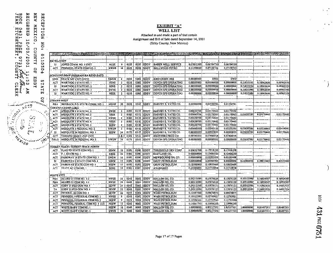
EXHIBIT "A" WELL LIST
Attached to and made a part of that certain Assignment and Bill of Sale dated September 14, 2001
(Eddy County, New Mexico)
BIG EDDY i ACT BIO EDDY UNIT NO. 12 NWNW 21 02OS 031E EDDY MALLON OIL CO. 0.52073100 0.409E4295 0.405710181
t JBLACK RIVER/BLACK RJVBR NORTU/BLACK RIVER WEST
SI MALLON 10 FEDERAL NO. 1 SWNW 10 QMS 026E EDDY MALLON OIL CO. 0.66718750 0.51681889 0J168ISS9
LOC MALLON 10 FEDERAL NO. 3 NWNW 10 024S 026E EDDY MALLON OIL CO- 0.66718750 0.51681889 0.51681889
— S [ MALLON 10FEDERAL NO.4 NWNE 10 024S 026E EDDY MALLON OIL CO. 0.72968750 0.56154999 0.56154999
~'"sT" MALLON 16 STATE NO. 1 SENW 16 0245 026E EDDY MALLON OIL CO. 1.00000000 0.81250000 0.S125000C i i
"" si WAD! IS FEDERAL NO. 1 NENW 15 0I4S | 026E EDDY MALLON OIL CO. 0.33385250 0.26708200 0.26708200
" LOC WADI 15 FEDERAL NO. 2 NWNW 15 024S 026E EDDY MALLON OIL CO. 0.1338 5250 0.26708200 0.26705200
ACT WAD! 9~FEDERAL NO. 1 "NW'SW"" 9 nu s 026E EDDY" MALLON OIL CO. £6497923 5 0.48741019 0.48741019
TA " WADI 9 FEDERAL NO. 2 NESW 024S 026E F.DDY MALLON OIL CO. _.9J7J37570 A C T C A R L S 1 I A D \ S T A T K C O M M . N " O . 1 "NWNE ~34 " "o2JS 026E EDDY KADEL&GUSSMAN 0.06250000 0.05427685 0.05427685
LOC MALlXtS 10 FEDERAL NO. 1 "NESW" '"to' 024S 026E ] EDDY MALLOW OIL CO. OM7187S0 0.51681889 0.51 £81889
LOC M A L L 6 N ~ 2 1 FEDERALNO. 1 NWNW 21 024S 026E EDDY MALLON OIL CO. i "'LOC"~ MALLON 21 FEDERAL NO. 1 NENE 21 0245 026E EDDY M A l i D N OIL CO.
' LOC \_ MALLON 21 FEDERAL NO. 3 NWSW 21 024S 026E EDDY MALLON OIL CO.
i
BRUSHY DRAW
SWO AMOCO FEDERAL NO. 01 (SWD) NESE 27 026S 029E EDDY MALLON OIL CO. 0.74341100 0.50059700 0.50059700
ACT AMOCO FEDERAL NO. 03 NWSE 27 02SS 029E EDDY MAJXONOILCO. 0,71822500 0,52708340 0,49859230
"ACT AMOCO FEDERAL NO. 04 SENE 27 026S 029E EDDY MALLON OIL CO. 0.71822500 0.527083401 0.49859230
""ACT AMOCO FEDERAL NO. 05 NENE 27 026S 029E EDDY MALLON OIL CO. 0.71S22500 0.52708340 0.49859230 i ACT AMOCO FEDERAL NO. OS NWNE 27 026S 029E EDDY MATJ.ON OIL CO. 0.71822500 0.52708340 0.49859230 "'1 ACT AMOCO FEDERAL NO. 07 NENW 27 026S 029E FJJDY M A I i O N OIL CO. 0.71822500 0.52708340 0.49859230 { __ ,., .
ACT " AMOCO FEDERAL NO. OS SENW 27 026Sl 029E EDDY MALLON OIL CO. 0.71822500 0.52708340 0.49859230 ACT : AMOCO FEDERAL NO. 05 NESW 27 026S Q29E EDDY MALLON OIL CO. 0.65572500 0.48129590 0.45527990 ; ACT AMOCO FEDERAL NO. 10 SWNW 27 Q26S 029E EDDY MALLON OIL CO- 0.71197500 0.52250470 0.49426120
ACT AMOCO FEDERAL NO. 11 NWNW 27 026S 029E EDDY MALLON OIL CO. 0.6B072500 0.49961090 0.47260490
"~ACT AMOCO FEDERAL NO.IJ NENE 28 026S 029E EDDY MALLON OIL CO. 0.69332430 0.50834100 O.4813360O O.7U97500 0.52-187792 0.49650610
" "ACT" AMOCO FEDERAL NO. 14 SWSE 23 026S 029E EDDY MALLON OIL CO. 0.69454720 0.50973700 0.48218370 0.71197500 0.52487792 0.49650610
...Afzi. '.-AMOCO RED BLUFF FEDERAL NO, 1 NWSW, 27 CGAS U29E EDDY MALLON OIL CO. 0.6086MJD 0.5AIAP600 OJII2W70
""'ACT" ' AMOCO RED BLUFF FEDERAL NO. 3 NWNE 28 026S 029E EDDY MAIJ.ON OIL CO. 0.41C69300 0.30974500 0.29497210
....... MALLON PECOS RtV 2B FED NO. 1 SENE 28 026S 0Z9E EDDY MALLON OIL CO. LDOOOOOOO 0.71414000 0.71414000
ACT SKINK PEDERAL 2B NO. 1 SWNW 27 0265 029E EDDY G P11 ENERGY 0.00000000 0.00104110 0.00104110 0.01301440 0.00911008 0.00911C08
__. 1
BURTON FLAT r 1 ACT STATE 21 COMM.NO. 1 NWNE 21 020S 028E EDDY PETROLEUM RESERVE 0.16750000 0.16283253 0.16283253
ACT STATE AC, COMM. NO. 1 NWSE 2J 020S 028E EDDY VISION ENERGY 0,00000000 0.062D312S 0,06203125 Q.25000000 0.21710938 17109.38 ACT STATE LEASE NO. 1 SWSW 21 020S 028E EDDY VISION ENERGY 0.32573250 0,27864235 037864235 0O5000000 0.21710938 0.21710938
" ACT 'STATE LEASE NO. 2 SWSE 21 020S 02BE KDDY VISION ENERGY 0.25000000 0.21710938 0.2171093 B
1 1 CARLSBAD EAST/CARLSBAD SOUTH
ACT iCHASE U FEDERAL COMM. NO. 1 SENW 11 022S 027E EDDY DEVON SFS OPR \ 6.04272720 0.03710390 0.03710590 ACT ;TOOTHMAN CASCOMM.NO.) NWSW_, 25 Q21S 027E lEpDY DELTA PETROLEUM 0.12500000 0.10467798 0.104*57798 ACT BELL 3 STATE COMM. NO. 1 >ENE(E/2 3 024S 026E EODY PITCO O.O56J770O 0.04S960O3 0.04SM003 ACT ' BLACK RIVER 10 FED COM. NO. 1 SWNW 10 024S 026E EDDY MALLON OIL CO. L_ 0.33593750 0.27085937 OJ708S937 ACT C A L V A N I COM NO, 1 NESW 9 022S 027E EDDY WILLOW CREEK O.I4954500 0.12987061 0.12987061 AC! COLLATT ESTATE NO. 1-5 J NWSE 1 023S 026E EDDY PERMIAN RESOURCES 0.00000000 0.00000000 0.00000000 0.21704925 0.19717809 o . ' i ^ m S
Page 15 nf 17 Pages

EXHIBIT "A" WELL LIST
Attached to and made a part or that certain Assignment and Bill of Sale dated September 14, 2001
(EiJdy County, New Mexico)
ffirSBBHt wmmmrnmsmmmsm ACT ECHOLS i S NWSE 12 023S 026E EDDY MALLON OIL CO. 0.22508650 0.18146350 0.18146350
ACT"" ESPERANZA NO, 1 SESli 4 022S 027E EDDY MANZANO OIL CORP 0.00000000 0.1 3079300 0.11079800
"ACT " ESPERANZA NO. 1 NWSE 4 022S 027E 1 EDDY MANZANO OIL CORP 0.00000000 0.00261595 0.00261595
ACT GO PO GO NO. 1 SWNE 25 022S 026 E 1=DDY MARBOB ENERGY 0.00000000 0.05187599 0.05187599 0.23865800 0.20725941 0,20725941
ACT GULF FEDERAL COM NO. I NESW 1 C23S 026E EDDY MALLON OIL CO, 0.5S21S380 0.4886811? 0.48868119
ACT GULF FEDERAL COM NO, 2 NWSW 6 023S 027E EDDY MALLON OIL CO. 0.78152250 0.68087842 0.68087842
ACT HUMBLE GRACE COM NO, 1 NESF. 2 023S [_026E EDDY MARBOB ENERGY 0.00000000 0.00717760 0.00717760 i ACT JOELL NO. 1 NENW 6 023S 027E EDDY CHAPARRAL On., LLC 0.00000000 0.02241561 0.02241561
""ACT" MALLON BELL 3 STATE COMM. NO. 2 NWSE 1 024S 026E EDDY MALLON OIL CO. 0.4765^422 0Ji54I22[0 0.H4I22IC O.5T6595O0 0.43949200 0.439492O0
ACT" MOBIL 12 FEDERAL 1 NWNE 12 023S D26E ihlDY MALLON OIL CO. D.584B0300 0.49721180 0.49721 ISO 0.5*480300 0.5044792K 0,50447928
- - MOBIL FEDERAL NO. 1 SENW 25 023S 026E EDDY VERNON E. FAULCONER, 0.059B958O 0,05015806 O.05015806
" s i " MOBIL LL NO. 1 (DUAL) SESW 13 023S 026E EDDY PRIZE OPERATING 0.35937500 0.27952671 0.27952671
ACT" MOHIL MM COM No. 1 SENW 13 02JS L § D D V PRIZE OPERATING O.2S953I00 0.22571137 0.22571137
ACT MOHII. RRUSIT SESW 24 023S 026E EDDY PRI2TE OPERATING 0.12052140 0.09320656 0.09820656 0.10781200 ~"b"0875T<i"54 "£03857454
si ONEi'LLHCOMM.NO.i NWSE 10 024S 026E EDDY MALLON OIL CO. 0.58444940 0.47306375 0.47306375
" ACT" O'NEILL FEDERAL NO- 1 (REC) NWSW 11 024S 026E iEDDY MALLON OIL CO. 0.85937500! 0.G286J285 0.6! 863285 0.859.17500 1)6:1040519 0.6.1040519
"'swo PENNZOfL 10 FEDERAL NO. 2 (SWD) NWSW to 024S 026E EDDY MALLON OIL CO. 0.95957020)
ACT" SOUTH CARLSBAD 4 GAS COM No. 1 SWNE 27 UPS 026E EDDY NEWFIELD KXPI. O.I2500OO0! 0.10355469 0,10355469
ACT STATE COM EU NO. 1 NWSE 26 02JS 026E EDDY NKWFiELD EXPL O.OOOOOOOO! 0.01550781 0.0| 550781 0.05000000 0.04342188 0.04342188
ORLG"* STATE COM EU NO. 2 SW 26 023S 026E EDDY NRWFIELD EXPL 0.05000000 0.04342188 0.04342188
ACT STEPHENS A COM NO. 1 fSESW 7 02JS 027E EDDY PERMIAN RESOURCES 0.11265750 ! 0.09782890 0.09782890
ACT STEPHENS COM NO, I SENW 7 023S 027E EDDY PERMIAN RESOURCES 0.11207660 0.09733158 0.09733158 1 1
FSPERANZA i
ACT FEDERAL AJ COMM. NO. 1 SWNE 10 022S 027E EDDY MATADOR OPERATING 0.17090880 0.09802311 0.09802311 0.17090880 0.10407127 0.10407127 ACT PENNZOIL FEDERAL NO. 2 NWNE 10 022S 027E |EDDY MATADOR OPERATING O.170908B0 0.09802317 0.09802317 0.17O9O8B0 0.11818343 0.1 IS 18343
""ACT"'"' TRACY NO. 1 NENW 10 022S 027E |EDDY MATADOR OPERATING • 0.17090580 0.14842341 0.14B4234I ACT WERSELL FEDERAL NO. 1 NENW 4 022S 027E EDDY MATADOR OPERATING 0.17090580 0.09802327 0.09802327 0.17090880 0.10407127 0.104O7J27
ESPERANZA FEE NO, 1 CSESW 022SJ '12711 EDDY DEVON ENERGY O.OO00O0W) n.OOOIifiOtJO O.OOOOOOOO 0.0320=1340 0.104O7J27
1
PARKWAY WEST 1
NC BPO -MAGNUM STATE "16* NO. 2 NE 16 019S 029E EDDY MAGNUM HUNTER'GRUY O.OOOOOOOO 0.00000000 0.07812500 0.06615041> U.06615040
P&A PARKWAY WEST UNIT NO. 01 NENW 28 019S 02PE EDDY OCEAN ENERGY 0.00000000 0.00000000 . O.OOOOOOOO 0.01562500 0.01356946 0.01356946
" ACT PARKWAY WEST UNIT NO. 02 SWNE 29 019S 029E EDDY OCEAN ENERGY 0.O1562S00 0X11356934 0.01356934
DUAL PARKWAY WEST UNIT NO- 03 NESW 29 019S 029E EDDY OCEAN ENERGY 0.00000000 0.00000000 0.00000000 0.01562500 0.01356934 0.01356934
ACT PARKWAY WEST UNIT NO. 05 SESW 20 019S 029E EDDY OCEAN ENERGY 0,01788081 0.01551907 0.01551907 O.O156250Oj 0.01356934 0.013S6934
ACT PARKWAY WEST UNIT NO. 06 SWSE 21 0195 029E iEDDY OCEAN ENERGY 0.01578274 0.01369537 0.01369537 0.01562500 0.01356934 0.01356934
" ACT PARKWAY WEST UNIT NO. 07 NENW 22 019S 029E KDDY OCEAN ENERGY O.O156250O 0,01356934 0.01356934
ACT PARKWAY WEST UNITN0. 08 NESW 22 019S 029E EDDY OCEAN ENERGY 0.00000000 0X10000000 0.00000000 0.01562500 0.01356934 0.01336934 SI PARKWAY WEST UNIT NO. 09 SWNE 21 019S 029E EDDY OCEAN ENERGY 0.00000000 0X10000000 0,00000000 0.01562500 0.01356934 0.01356934 SI PARKWAY WEST UNIT NO. 10 SWNE 27 019S 029E EDDY OCEAN ENERGY 0X10000000 0.00000000 0.00000000 0.01562500 0.01356934 0.01356934
ACT PARKWAY WEST UNIT NO. 11 E/2 20 019S 029E EDDY OCEAN ENERGY 0.(il 562500 0.01356934 0.01356934
"DRLO" PARKWAY WEST UNIT NO. 12 N/2 21 0'i9S~l 029E EDDY OCEAN ENERGY 0.02247653 0.01951947 0.01695144 0.01562500 0.01356934 0.OI3S6934 LOC PARKWAY WEST UNIT NO. 13 NE/4 20 0I9S 029F. rsnoY OCEAN ENKJKiY 0,0)562500 0.01356934 0.01*569.14
ACT"" PARKWAY WEST UNITN0.2B-2 SWNW 28 019S 029E EDDY OCEAN ENERGY 01)2076719 O.01798953 0.01798953 0.01562500 0.01356934 0.013S6934 ACT PARKWAY WEST UNIT NO. 28-3 swsw 28 019S 029E EDDY OCEAN ENERGY 0.01562500 0.01356934 0.01356934
ACT PARKWAY WEST UNIT NO. 28-4 NENW "28 019S 029E"1 EDDY OCEAN ENERGY O-OI562500 0.01356934 0.01356934
"ACT " STATE 16 A COM NO. 1 SWSE (S/2 16 Q19S 029E jEDDY GRUY PETROLEUM H 0.00000000 0.03876953 0.03876953 SI STATE 16 COM NO, 1 ENW (J4/3 16 019S 029E [EDDY GRUY PETROLEUM 0.1562SOOO 0.13569331 0.13569331 , i
Page 16 of 17 Pages
to a: M O pa > o n a
o to
m o a w
(-•̂ o w t i H a a t " n is;
i - 1 a O n as
W > . \ o w o i±i n W W to o
5 - o O HI
n u © K o O H
a O *i
>• W Ul t i
a ^ «(
S ' H w A 5S W
O
EXHIBIT "A" WELL LIST
Attached lo and made a part of thai certain Assignment and Bill of Sale dated September 14, 2001
(Eddy County, New Mexico)
IBIBGiBllliRM i . I !
REVELATION 1
SI JONES COMM. NO. 1 UNIT NESE 9 022S 0251- BODY BABER WELL SERVICE 0.07812500 0.06784730 0.06784730
ACT PENNZOIL STATE COM NO. I NWNB 16 022S 025E EDDY_ HALLWOOD PETRO 031250000 0.27138722 0.27138722
5COGG/NS DRA W {IIERRADURA BEND EAST)
SWD STATE 'GO' UNIT (SWD) SWNW 2 023S 'HsT EDDY BIRD CREEK RES 0.00000000 SWD SWD i
ACT WARTHOG 2 STATE NO. 1 NENE 2 023S 0286 EDDY DEVON SFS OPERATING 0.00000000 0.00000000 0.00000000 0.21835350 0.18962636 0.18962636
"'"si"" WARTHOG 2 STATE NO. 2 SENE 2 023S 02BE EDDY DEVON SFS OPERATING 0.00000000 0.00000000 0.00000000 0.21835350 0.18962636 D.l 8962636
ACT WARTHOG2 STATENO. 3 SWNE 2 "023S 028E [EDDY DEVON SFS OPERATING O.OOOOOOOO O.OOOOOOOO 0.00000000 0.21835300 0,18962640 0.18962640
si" WARTHOG 2 STATE NO. 4 NESE 2 023S 028E EDDY DEVON SFS OPERATING 0.00000000 0.00000000 0.00000000 0.21835300 0.18962636 0.13962636
STRAWN WEST
PScA HOGBACK P.O. STATE COMM. NO. 1 NENW 20 019S 02-iE EDDY HARVEY R. YATES CO. 0.00000000 0.01550781 0.01550781
TAMANO (CEDAR LAKE) •.ACT MESQUITE 2 STATE NO. 1 SWSE 2 01 ss 0318 EDDY HARVEY E. YATES CO. 0.O363070O 0.0317044Z 0.03170442
ACT MESQU1TE 2 STATE NO. 2 SESE 2 01 ss 03 IE EDDY HARVEY E. YATES CO. 0.O366O556 L_ 0.03178965 0.03178965 0.03650700 0.03170442 0.03170442
ACT MESQUITE 2 STATE NO. 3 NWSE 2 0IBS 031E EDDY HARVEY E. YATES CO. 0.O365O70O 0.03170442 0.03170442
MESQUITE 2 STATE NO, 4 NESE 2 01 SS 03 IE EDDY HARVEY E. YATES CO, 0.O365O70O 0.03170442 0,03170442
J.AO) ' MESQUITE 2 STATE NO. 3 SESW 2 0I8S 031E EDDY HARVEY E. YATES CO. 0.03650700 0.03170442 0.03170442
"ACT MESQUITE 3 FEDERAL NO. 2 NWSW 3 01 SS 031E EDDY (HARVEY E. YATES CO. 0.03660500 0.03245100 0.02253393 0.03650700 0.03226662 0.O2434O43
f SI" MESQUITE 34 FEDERAL NO. 1 SESW 34 017S 03 IE EDDY HARVEY E. YATES CO. 0.00000000 0.00905855 0.00905855 0.03650700 0.03170442 0.03170442
'""ACT^ TAMANO (BSSC) UNIT (Wf) Oft 1 01SS 03 IE EDDY BROTHERS PROD CO 0.09540500 0.07406918 0.07406918
VDRLG" MESQUITE 34 FEDERAL NO. 1 NWSW 34 OPS 03 IE EDDY DEVON SFS OPERATING 0.00000000 0.00000000 O.OOOOOOOOf 0.03650700 0.03170442 0.03170442
TURKEY TRACK/ TURKEY TRACK NORTH \
ACT 'FLAG TD STATE COM NO. 1 SENW IS 019S 029E EDDY THRESHOLD DEV CORP 0,20632700 0.17918198 0.17918198 i ACT P. J. STATE NO. 1 [__NES£ 36 018S 029E EDDY EASTLAND OIL o!oooooboo 0.12406250 ~""o7l2406250 ! ACT PARKWAY 16 STATE COM NO. 1 SWSW 16 019S 029E EDDY MEWBOURNE OIL CO. 0.00000000 0.03295403 0.03295408
sr;; PARKWAY C STATE COM NO. 1 SENW j 15 019S 029E jiDDY GRUY PETROLEUM 0.00000000 0,00000000 0,00000000 O.I25O000O 0.10855469 0JOV55469 ACT PARKWAY STATE COM NO. 1 NESW 15 019S 029E EDDY GRUY PETROLEUM 0.12500000 0.10855469 0.10855469
ACT" STATE AC COM NO. 1 SENE 35 01 ss 02KE EDDY ANADARK0 0.25000000 O.217I093B 0.21710938
t _
WHITS CITY i P&A ALLIED 21 COM NO. 1 J NWSE 21 024S D2GE EDDY MALLON OIL CO, 050312500 0,15876129 0.158.76)29 0.20312500 0.16924507 0.16924507 P&A ALLIED 21 COM NO. I J NWSE 21 024S D26E EDDY MALLON OIL CO. 020312500 0.15876129 0.15876129 0.20312500 0.16924507 0T69245O7
ACT EDDY 2t FED COM NO. 1 SENW 21 024S 026E EDDY MALLON OIL CO. 0.2O312500 O.I5876I23 0.1587612.' 0.20312500 0.1688.3326 a.l68BJ8Z/.
TA EDDY 21 FED COM NO. 1 SENW 21 024S 02SE EDDY MALLON OIL CO. 020312500 O.I5876I23 0.15876123 020312500 0.16883826 0.I6JS3.IS26
"ACT" FEDERAL 22 COM NO. 1 SENW 22 024S 026B EDDY WADI PETROLEUM 0.12187500 0.09676875 0.09676875
ACT [PENNZOIL 9 FEDERAL COM NO. 1 NWSE 024S 026E EDDY WADI PETROLEUM 0,16113300 0.12793921 0,12793921
ACT PENNZOIL 9 FEDERAL COM NO. 2 NESW 9 024S 026E EDDY WADI PETROLEUM 0.1 (if)86344 0.12793940 0.12793940
ACT PENNZOIL FEDERAL COM NO. 1 (IS) NESW 15 024S 026E EDDY WAD] PETROLEUM I} .1406I730 0.1099624S 0.10996248 1 ACT WHITE BABY COM NO. I NESW 16 024S 026E EDDY MALLON OIL CO, 1.00000000 0.8023750.1 0.BO237501 1.00000000 0.86487501! 0.86487501
ACT WHITE BABY COM NO. 2 SWNE 16 024S 026E EDDY MALLON OIL CO. 1.00000000 0.80237501 0.80237501 1.00000000 O.S64S7S0I 0JW4S750]
Page 17 o f ] 7 Pages
3 •CD
o