assigning biotopes to seasearch data · joint nature conservation committee (jncc) ... separate...
TRANSCRIPT

JNCC Report No: 418
Assigning Biotopes to Seasearch Data
Marine Conservation Society (MCS) & Seasearch
December 2007
© JNCC, Peterborough 2007

For further information please contact: Chris Wood National Seasearch Coordinator Marine Conservation Society Unit 3, Wolf Business Park, Alton Road, Ross on Wye, HR9 5NB. This report should be cited as: MCS/SEASEARCH (2007) Assigning Biotopes to Seasearch Data. Joint Nature Conservation Committee, Peterborough. 82 pages. JNCC report No. 418
ii Assigning Biotopes to Seasearch Data

Contents Executive Summary iv 1. Background
1.1 Seasearch Data 1 1.2 Aims of contract 2
2. Outcomes 2.1 Biotope Key (Phase 1) 3 2.2 Assessment of Biotopes 3 2.3 Quality Assurance Check (Phase 1) 4 2.4 Biotope Key (Phase 2) 5 2.5 Amendments to Seasearch Survey Form 5 2.6 Quality Assurance Check (Phase 2) 6
3. Conclusions 3.1 The quality of the Seasearch data 8 3.2 Assessor variability 8 3.3 Guidance availability to assessors 9 3.4 JNCC biotopes 10 3.5 Comparing the value of Seasearch seabed cover types and JNCC 11 biotopes 3.6 Overall conclusion 11
4. Annexes 1 Schedule of Biotopes assessed by Sea-Scope 12 2 Summary of responses to questionnaire 13 3 Draft amended Seasearch Survey Form 16 4 Results of Quality Assurance check – Phase 1 20 5 Results of Quality Assurance check – Phase 2 22 6 Comparison of results from expert assessors 24 7 Comparison of same forms from 1st and 2nd assessments 25 The Seasearch Biotope Key – December 2007 is produced as a separate document.
iii Assigning Biotopes to Seasearch Data

Executive Summary This report demonstrates the outcomes of a programme to assign JNCC biotopes to volunteer marine data provided through the Seasearch programme. Seasearch is providing the main source of volunteer data on UK marine species and habitats. JNCC wishes to make better use of the data, especially for habitat mapping, by ensuring that JNCC biotopes are assigned to suitable Seasearch data. This comprised 356 Seasearch Survey records in 2006, but has risen in 2007. It was the original intention that both a Biotope Key would be prepared to enable those dealing with the Seasearch data to assign biotopes in future and also that a significant number of Survey forms would have been biotope coded and entered into the Marine Recorder database by the end of this contract. In the event the preparation of a Biotope Key involved much more work and a much more complex document than anticipated and assessors did not find it straightforward to use it in conjunction with the JNCC website. A consistency check was carried out and it became clear that with the current level of guidance available the level of consistency between assessors was unsatisfactory and that it would be unwise to assign biotopes to a large number of Seasearch forms at the present time. Accordingly work has focused on making the Biotope Key less repetitive of material already available on the JNCC website and following a standard key approach concentrating on the features of biotopes provided within Seasearch data. The revised key was completed by mid November and has been used (with the JNCC website) in a second consistency check, the results of which continue to show that an acceptable level on consistency between assessors is still not being achieved. Amendments to the Seasearch Survey form are proposed to provide better information for biotope assignment purposes and these will be initiated for the 2008 survey season. The accompanying Guidance Notes and the Seasearch Surveyor Training Programme will be revised to emphasise the information needed for biotope assignment. However, we do not believe that we have yet reached a stage where JNCC biotopes can be consistently assigned to Seasearch survey data. We are not confident that the changes to be implemented above will resolve the problems in inconsistency since they are, to a great extent, the result of the way the hierarchy of biotopes has been devised. We will therefore implement the improvements to forms and training, circulate the revised biotope manual but not commence the process of allocating biotopes to 2007, or earlier data, until we can be more confident of a consistent outcome.
iv Assigning Biotopes to Seasearch Data

4. Background a. Seasearch Data Seasearch was conceived in the late 1980s as an initiative between the then Nature Conservancy Council and the Marine Conservation Society (MCS) to provide data on marine habitats and species collected by volunteer divers to supplement the Marine Nature Conservation Review (MNCR) programme then being initiated. The initial recording forms were based closely on MNCR forms and were used on a number of Seasearch expeditions in the 1980s and 1990s. The value of volunteer data was recognised by a number of other organisations and Seasearch was developed along broadly parallel lines by MCS, Scottish Natural Heritage, Dorset Wildlife Trust and Sussex Seasearch. In 1999 the organisations involved came together and formed the Seasearch Steering Group in order to achieve the full potential of the project. This involves a wide range of organisations and individuals working together. The current membership of the Steering Group comprises:
Marine Conservation Society (MCS) The Wildlife Trusts (TWT) Joint Nature Conservation Committee (JNCC) Natural England (NE) Countryside Council for Wales (CCW) Scottish Natural Heritage (SNH) Environment and Heritage Service (Northern Ireland) (EHS) Environment Agency (EA) British Sub-Aqua Club (BSAC) Professional Association of Diving Instructors (PADI) Scottish Sub-Aqua Club (SSAC) Sub-Aqua Association (SAA) Marine Biological Association (MarLIN) Nautical Archaeology Society (NAS) and independent marine life experts
The Steering Group sought to widen the appeal of Seasearch to recreational divers by appointing a National Coordinator and the development of a three tier recording programme to allow volunteers to take part at an appropriate level for their skills. The recording forms were revised and a training programme was developed prior to a re-launch of the project in 2003. Today Seasearch is a UK-wide project which is the main provider of volunteer data on marine habitats and species. There is a National Coordinator and a team of Local Coordinators involved in delivering training, organising surveys and promoting recording by volunteer divers. In excess of 1,000 ovservation and survey forms are completed annually and all data is entered into the JNCC’s Marine Recorder database and made available in this format to all of the conservation agencies and local biological data centres who wish to receive it. The data is contributed to the National Biodiversity Network (NBN) and is available for all to access freely through the NBNGateway website.
1 Assigning Biotopes to Seasearch Data

The habitat data collected includes written descriptions, sketches and the identification of seabed types and seabed cover types. The range of seabed types comprises:
• Rocky reef • Boulders • Cobble/pebbles • Mixed ground • Sand/gravel • Mud • Wreckage • other
The seabed cover types recorded are: • kelp forest • kelp park • mixed seaweeds • encrusting pink algae • short animal turf on rocks • tall animal turf on rocks • animal bed (specified) • sediment with life apparent • barren sediment
The seabed cover types are entered into Marine Recorder in the Biotopes section as a separate category of biotope to the JNCC biotope suite. The Seasearch Survey Form (the higher level at which data is recorded) should provide sufficient information to allow the assignment of a JNCC biotope code. There is a box on the form to allow this to be done, but prior to this exercise there was no guidance to recorders, post-survey assessors or data entry personnel on how to go about the process. Consequently very little of the Seasearch Survey Form data has had biotope codes assigned. The survey form data comprised 356 Seasearch Survey records in 2006, but this has risen in 2007. .
1.2 Aims of this contract The JNCC has supported Seasearch and funds have been used primarily to support the entry of data into Marine Recorder and its management and transfer to the NBNGateway. In addition to the general support JNCC wished to see the Seasearch survey data assigned JNCC biotopes and sought the undertaking of the following:
1. Assign biotopes to 250 Survey Forms (2003-2005) from different geographical areas and including JNCC’s priority area of NE Scotland
2. Produce a short report on how the two habitat schemes fit together and advise on any adjustments to Seasearch Survey form which would aid biotope assignment in future
3. Prepare a biotope checklist or key to aid in future biotope assignment of Seasearch data
4. Test the assignment validity by assigning biotopes to all 2006 survey form data (340 forms)
5. Provide revised NBNDATA file with all biotope assigned data to date.
2 Assigning Biotopes to Seasearch Data

The reminder of this document analyses the work undertaken and the development of the exercise in response to the initial results.
2 Outcomes 2.1 Biotope Key (Phase 1) MCS sub contracted three elements of the programme to Sea-Scope, a contractor with experience both of Seasearch and the JNCC biotope codes. These were: 1. the preparation of a biotope checklist or key for entering Seasearch data 2. the assignment of 250 survey forms in two stages 3. advise on and implement adjustments to the Seasearch survey form In the event, within the funding made available the contractor was able only to prepare the key and assign 25 forms. The Draft Seasearch Biotope Key was produced in mid June and is available but not attached as it has been superseded The document comprised: Introduction (2 pages) Making sense of biotopes – an explanation of the concept of biotopes and how the JNCC
biotope codes are constructed (4 pages) How to use the key – further explanation and how to enter the data into Marine Recorder
(3 pages) Your habitat description – a key to assess habitats into the three relevant broad habitats
(infralittoral rock, circalittoral rock and sublittoral sediment), explanations of the exposure and tidal streams categories, and tables showing the level 3 main habitats and the range of biotopes within them (21 pages)
Summary descriptions of biotopes – a summary of each of the biotopes considered relevant to Seasearch records, derived mainly from the JNCC website (123 pages)
Quick Search – a list of some distinctive biotopes which can be identified without going through the full key process (2 pages)
Appendicies – definition of terms, the full suite of JNCC biotopes listed (16 pages) 2.2 Assessment of Biotopes 25 Seasearch Survey Forms were coded by SeaScope. These are shown in Annex 1 and cover sites from 4 surveys in NE Scotland dating from 2005 and 2006. The draft biotope key was distributed to a range of Seasearch data entry personnel together with a questionnaire. The aim was for them to use the document to assign codes to a limited number of Survey Forms from their own area and to report back on how they found the process and the key. There was a closing date of the end of July for responses. Responses were received from four assessors who had coded a further 95 forms covering locations as diverse as NE Scotland, Northern Ireland, Isles of Scilly, Lyme Bay and the Channel Islands.
3 Assigning Biotopes to Seasearch Data

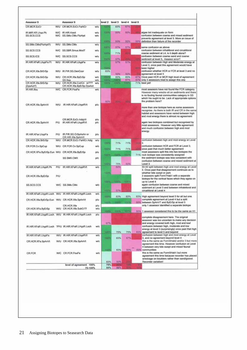
This means that a total of 120 forms had codes assigned. A summary of the responses to the questionnaire, which also includes comments from JNCC, is shown in Annex 2. It was clear that assessors did not find the process straightforward and had relatively little confidence in the biotope assessments they had made. Whilst parts of the draft Biotope Key were felt to be helpful, others were less so and some assessors felt the information already available on the JNCC website was more helpful. It was therefore considered important to assess the consistency of the allocations before encouraging the coding of large numbers of forms as originally intended. 2.3 Quality Assurance Check (Phase 1) The purpose of this additional stage was to test the consistency of biotopes allocated by different assessors using the draft biotope key. A set of 10 Seasearch Survey Forms was distributed, containing descriptions of 27 habitats, and assessors were asked to allocate codes to each. The forms included some that had been originally assessed, and those filled in both by experienced surveyors (in once case a former member of the MNCR team) and new Seasearch surveyors. Two of the forms were from the same site and completed by different surveyors. A table of the results of this assessment is attached as Annex 3. This shows the allocations made by the 6 assessors together with comments. The level of agreement is shown by colour coding with 100% agreement shown as dark green >70% agreement in light green, 50-70% agreement as pink and <50% agreement as red. It is clear that the level of consistency was unacceptably low, even at biotope complex level (level 4). Some of the main issues to be addressed are: Survey Data
• some of the forms were difficult to assess because of the lack of information on algae and ‘turf’ species on which many biotopes are based,
• some recorders had identified habitats that contained more than one biotope, whilst marine recorder allows for more than one biotope to be allocated to one survey sample assessors differed in their approach to this,
• Forms do not include exposure and tidal stream information making energy level assessments problematic.
Biotope key
• Whilst the key started well it was not easy to use at the biotope complex/detailed biotope level and involved time consuming trawls through a long list of biotopes. The key approach was not carried far enough,
• A number of assessors found it much more straightforward to use the JNCC website and expandable hierarchy and gave up using the biotope key at an early stage.
The suite of biotopes
• Assessors had considerable problems with the assessment of energy regimes with the overlap between high and moderate energy producing the most problems,
4 Assigning Biotopes to Seasearch Data

though in one case different assessors identified the same habitat as high, moderate and low energy! This is a critical issue and is the main reason for the poor level of consistency at Level 3, and thus prevents identification of biotope complexes (level 4),
• There was confusion between coarse sediment (SCS) and mixed sediment (SMx) as it seems that both can also include a wide range of cobbles, pebbles, gravel and sands. Again this leads to divergence at a very early stage (level 3),
• There was also confusion between infralittoral and circalittoral sediments as in the absence of seaweeds it is unclear how you distinguish the two, except by depth,
• Many of the Seasearch habitats contain wrecks. Some assessors did not find the ‘fouling communities’ complexes and when they did they seem to be generalised.
Under the circumstances it was considered unwise to continue to assign biotopes without further consideration, guidance and training and that little confidence could be placed in the results if the programme of allocating biotopes to over 500 forms as originally envisaged was to be continued. For this reason no further forms have had biotopes assigned and none of those already assigned have been entered into Marine Recorder. 2.4 Biotope Key (Phase 2) In order to address the issues that had arisen, it was decided that the biotope key should be re-visited. The existing draft was too lengthy and involved much overlap with what is already available on the JNCC website. Because it was intended to be used as a Word/PDF document it was not easy to use simultaneously with the JNCC website unless the assessor had access to two computers. The following broad changes were therefore proposed to the draft document:
• Production as a paper document, allowing assessors to use both it and the JNCC website at the same time,
• Retention of all of the introductory material, • Preparation of keys to the Infralittoral Rock, Circalittoral Rock and Sublittoral
Sediment main habitats, • Removal of all of the detailed habitat pages, relying on assessors to check these on
the JNCC website once they have gone as far as they can with the Key approach. The resulting key was produced in November 2007 as a 45 page printed document which concentrates on a key approach to three relevant broad habitats, Infralittoral Rock, Circalittoral Rock and Sublittoral Sediment. 2.5 Amendments to Seasearch Survey Form The Seasearch Survey Form has been reviewed to identify how it could be improved to ease the process of biotope assignment. A draft revised form is attached as Annex 4. The main changes are: Page1 inclusion of tick boxes covering wave exposure and tidal streams (not previously
on the form at all, Page 2 inclusion of tick boxes covering seabed type and main communities for each
habitat (previously only provided for the site as a whole), Page 4 structured species list to ease assessment of communities. inclusion of Superabundant in the abundance categories
5 Assigning Biotopes to Seasearch Data

recording where photographs of species exist It is considered that these changes would not significantly increase the level of information surveyors need to provide, but would ensure that the data needed for biotope allocation is more consistently provided and organised. The revised form was presented to the Steering Group in October and to the Annual Seasearch Workshop in November and comments were sought. No adverse comments have been received and the revised form will be used for 2008 surveys onwards. 2.6 Quality Assurance Check (Phase 2) A second consistency check was undertaken in November/December using 10 Survey Forms containing 33 habitat descriptions. Eight different assessors used the revised Biotope Key, the JNCC website and their existing experience to assign biotopes to the forms supplied. The forms were designed to cover a range of geographical locations and habitats, and included those completed by experienced marine biologists and recorders as well as by relatively inexperienced volunteers. Three of the forms were also included in the Phase 1 quality check so that the results of using the different types of guidance could be assessed. The assessors were also varied – two of them had been closely involved with the MNCR and biotope coding (Drs Rohan Holt and Keith Hiscock), three were experienced in interpreting and entering Seasearch data into Marine Recorder (Dr Claire Goodwin, Suzanne Mitchell and Chris Wood), two are Seasearch coordinators and Surveyors (Sally Sharrock and Dr Elisabeth Morris) and our JNCC liaison officer Paolo Pizzolla. In addition to the quality check, the comments of the assessors were sought on the revised Biotope Key, mistakes in the latter, use of the key with the JNCC website, what was missing from the forms and problems with the biotopes themselves. The results of the quality check are shown in Annex 5. Regrettably these do not show a significantly improved level of consistency over the first exercise. At biotope complex level (level 4), which is the stage at which this process might provide better data than the existing Seasearch seabed types and seabed cover types already allocated, total agreement is limited to 27% of the habitats assessed. If the acceptable level of agreement is reduced to 70% then there is still only 51% consistency. At biotope level (level 5) 100% agreement is reduced to 6% which is clearly unacceptable. There are four elements, any or all of which could contribute to the lack of consistency:
• Quality of the data received • Assessor variability • Guidance available to assessors • The Biotopes themselves
These are assessed in the conclusions below. The views of the assessors in response to the questionnaire were as follows:
6 Assigning Biotopes to Seasearch Data

Revised Biotope key – all but one assessor found it useful and better than the previous version. The other (experienced) assessor felt it was of no value as it still was based at an early stage on exposure and energy levels. It needed to give equal emphasis to species and physical parameters and therefore you need a variety of entry points – he used the website and prior knowledge and not the key. The other experienced assessor adopted the following approach:
1. are there characterising species? if so do a search on the website and see what comes out, 2. if no characterising species use the key, 3. once you have reached possible biotopes see if they have already been recorded from the area, 4. ignore seasonal or variable species such as Corymorpha (note that at least one biotope is characterised by Neopentadactyla mixta which is a seasonal species!)
Errors in the key – a numbers of errors and omissions were identified and have been amended in the final version (Annex 8). Using the key and JNCC website – all of those who used both found this satisfactory Problems with survey form data –
• a number of forms mixed habitats (e.g. horizontal kelp and vertical rock below or boulders and sediment),
• there is a need to improve recognition of turfs (hydroid/bryozoan etc) even if individual species not known.
• Should have Superabundant on the abundance scale • Soft sediments not always well recognised and identified • Infaunal based biotopes will never be well recorded • Seaweed ID needs to be improved • Wave exposure and tidal stream information + other suggested changes will help
Problems with the suite of biotopes – most assessors found difficulties
• Not comprehensive, there are distinctive habitats and species assemblages not covered and no mechanism for identifying new ones
• Boulders amongst cobble/pebble/mixed ground not catered for • Mixed ground with red algae not covered • At extremes the energy level concept works but most are in the middle where it is
much more complex • There are differences in the level of detail – e.g. many kelp biotopes but few wreck
ones • Difficult to subdivide mixed areas, and they can be found in both Infralittoral Rock
and Sublittoral Sediment • Wreck biotopes are inadequate – some examples of distinct wreck habitats are:
o Vertical faces with Metridium, Sagartia elegans and/or Alcyonium digitatum
o Flat plates with sparse algae o Flat plates with pink sea fan forest
Can we assess biotopes with confidence after improvements suggested? – most assessors remained uncertain and felt that more training of surveyors (including a refresher for
7 Assigning Biotopes to Seasearch Data

existing surveyors) and/or more training of assessors was required. The hierarchy does not lend itself to having confidence at the higher levels as differences frequently occur at level 3 – ‘main habitats’ (where the energy differences kick in). One assessor felt you needed a number of forms from an area to iron our surveyor bias and provide a wider species list. There was also concern about the time that would be taken to assign biotopes and if the task loading was becoming too high for volunteers and coordinators/data entry personnel. In order to assess the potential benefits of training for assessors we compared the results of the biotopes allocated by the two experienced ex MNCR personnel (Drs Rohan Holt and Keith Hiscock). This is shown in Annex 6. There are significant disagreements between the two though the level of agreement at biotope complex level is 69% which may be considered acceptable, and compares with 27% for the whole group of 8. Whilst the number in the larger group is likely to provide more room for disagreement, the comparison does suggest that experience in allocating biotopes leads to greater consistency. On the other hand the agreement between the two experienced assessors at biotope level is only 41% which is below the level of acceptability. We also assessed the results between the first and second assessments for the 3 forms that were common to both. This is shown in Annex 7. In only one case was there complete agreement at biotope level 5 between the two assessments, elsewhere there were variations, in particular between coarse and mixed sediments (level 3) and between high and moderate energy infralittoral rock (level 3). This casts further doubt on the robustness of the results being achieved.
3. Conclusions
The aim of this work was to assess JNCC biotopes to Seasearch data. At the outset both parties hoped this would be a reasonably straightforward process and a significant amount of Seasearch survey data would have biotopes assigned, entered into Marine Recorder and thus made available for JNCC and other parties. In the event the process has proved much more complex and the focus has changed to assessing whether Seasearch data can be used consistently for biotope allocation. This has involved quality assurance checks which were not originally envisaged and these continue to show significant discrepancies which cast doubt on the value of biotopes which could assigned. The assignment process has not been continued and currently 2007 data is being entered into Marine Recorder using the simplified Seasearch seabed cover types. The four main variables which need to be considered are:
• The quality of the data received • Assessor variability • The guidance available to assessors • The biotopes themselves
3.1 The quality of the Seasearch data The data received comes from volunteers with a range of backgrounds, ranging from marine biologists to non specialist recorders who have gone through a training programme.
8 Assigning Biotopes to Seasearch Data

The forms at present do not ask questions which are important for biotope allocation and volunteers receive limited training in the identification and recording of separate habitats. These problems can be alleviated by the following actions:
• Improving the survey form by: o Adding exposure and tidal stream data questions o Adding seabed type and seabed cover type to the information collected for
each habitat rather than for the site as a whole o Adding an animal turf box for each habitat o Adding Superabundant to the abundance scale o Adding a record of photographs available
• Improving the training and advice available to volunteer recorders by: o Revising the Guidance notes that accompany the Survey Form o Revising the Seasearch Surveyor Training Course to put greater emphasis
on the data needed for biotope assignment and explain how it will be used o Contacting all existing volunteer surveyors sending them copies of the
revised Survey Form and Guidance Notes o Offering a one-day surveyor refresher course covering habitat and
community identification and recording • Improving the guidance available to survey coordinators and data entry personnel
by o Circulating the revised Biotope Key o Offering the opportunity to attend one or more training days
3.2 Assessor variability The quality assurance assessments have shown an unacceptable divergence of outcomes. Some of this can be put down to variability in the experience of assessors as the experienced assessors reached a higher level of agreement than the group as a whole. Even then it was not acceptable beyond biotope complex level. In a few cases errors can be identified but generally the differences come down to fine decisions, often on energy regimes or type of sediment, which are unlikely to be made much easier by the improvements to the forms and training described above. Even if it were shown to significantly improve results by having experienced ex MNCR assessors code the forms this would be impractical because of the limited number of individuals with this experience and the limitations on funding to achieve it. 3.3 Guidance available to assessors The second version of the Biotope Key was welcomed and thought to be useful by all but one of the assessors. However it did not result in a significantly improved level of agreement between them with the first and second assessments producing similarly diverse outcomes. Both of the experienced assessors preferred to start with characterising species and work backwards. If that is the best way to approach the assignment of biotopes then a key approach, such as we have adopted, cannot be devised as the hierarchy is seen by the experienced assessors, as unhelpful. The essential of a key is a hierarchical approach and it will not work if the hierarchy is invalid. A number of errors in the key, mostly minor, have been identified and corrected in the final version attached as Appendix 8. It is difficult to see how this approach can be taken further.
9 Assigning Biotopes to Seasearch Data

The other form of guidance to assessors would be in the form of training days as suggested above. However this cannot be achieved internally within Seasearch and would need support in terms of expertise from JNCC staff. We would also benefit from advice from those using the biotope data. 3.4 The JNCC biotopes We believe there are significant issues around the structure of the JNCC biotopes which make their assignment to Seasearch data problematic or unfeasible. The major problem is with energy regimes. In both the Infralittoral and Circaittoral rock main habitats these come in at the second level. At the extremes, such as sea lochs on the one hand and offshore islands like St Kilda on the other, they are straightforward. However, for most sites the energy levels are somewhere in the middle and there are wide overlaps between the definitions. This is the main factor which produces a low level of agreement between assessors since if the wrong energy level is selected you are taken down differing paths to different biotopes, even where the fundamental biotope is apparent. For example kelp forest is frequently identified in Seasearch surveys and is straightforward and easily appreciated by volunteers. It is however extremely difficult to assess a biotope as kelp forests are found in high, medium and low energy infralittoral rock regimes as well as on some sediments. If the biotope hierarchy included such easily identified communities at a higher level then the levels of agreement between assessors would significantly increase. In the Sublittoral sediment main habitat there is confusion in assessors’ minds between coarse sediment and mixed sediment. Again this is an early level of distinction in the hierarchy and a divergence here leads to quite different biotopes being assigned. Mixed ground appears commonly on Seasearch forms and commonly involves boulders lying on sediments such as cobbles and pebbles, coarse sediments or sand. The species composition between the boulders and sediment is quite different but as they are mixed volunteers will normally include them as a single habitat. Whilst we can tell volunteers to separate out such habitats into two for biotoping purposes, it might be more realistic in the long term to accept that there are habitats covering both rock and sediment and allow for them. At present, unless the assessor splits the information provided he/she has to take a decision on whether to go down the rock or sediment route at the first stage. Vertical and overhanging faces may create problems in deciding if they are in the Infralittoral or Circalittoral zones because of the lack of algae in the sample. Whilst in some cases they can be compared to less steep faces at the same depth to come to a decision, in others this comparison is not available and the assessor needs a good knowledge of the area to know if the given depth is infralittoral or circalittoral. A similar problem arises with infralittoral and circalittoral sediments. Again these may not contain algae and many Seasearch dives take place between 10-20m depth which is the area of overlap between the two. Again only good local knowledge can distinguish the two, but we question the value of the differentiation where similar sediments and species mixes can occur.
10 Assigning Biotopes to Seasearch Data

Wreck habitats are poorly covered in the suite of biotopes. They are a habitat often covered in volunteer surveys and in some areas can be biologically significant (particularly where they provide the only hard surfaces in an area). At present very diverse habitats have to be shoehorned into the limited range of biotopes available. 3.5 Comparing the value of Seasearch seabed cover types and
JNCC biotopes The decision not to attempt to allocate JNCC biotopes to Seasearch data was originally taken because of the perceived difficulties of the process and to make Seasearch data collection more user-friendly to non specialists. This decision has been vindicated both by the increasing amount of data collected by Seasearch volunteers and the huge difficulties in reaching consistency over biotopes identified in this exercise. The Seasearch seabed cover types are very coarse covering kelp forest, kelp park, mixed seaweeds, short and tall animal turf, animal beds, sediment with life apparent and barren sediment. There is clearly the possibility of refining these by using them as the starting point for a hierarchical structure (for instance identifying different types of kelp forest by species, and understory flora/fauna), but this would not aid biotope allocation as it would not resolve the problems around energy regime or type of sediment. We have not suggested this approach as it would not make the data more useable by JNCC, however other users looking for a less coarse approach which does not involve the full details of the JNCC biotope system might find it valuable. 3.6 Overall Conclusion We do not believe that we have yet reached a stage where JNCC biotopes can be consistently assigned to Seasearch survey data. We have suggested and will implement improvements to the Survey Form and training of volunteer surveyors, but are not confident that this will resolve the problems in inconsistency since they are, to a great extent, the result of the way the hierarchy of biotopes has been devised. We will therefore implement the improvements to forms and training, circulate the revised biotope manual but not commence the process of allocating biotopes to 2007, or earlier data, until we can be more confident of a consistent outcome.
11 Assigning Biotopes to Seasearch Data

ANNEX 1 – Biotopes Assigned by Sea-Scope
12 Assigning Biotopes to Seasearch Data

ANNEX 2: RESPONSES TO QUESTIONNAIRE Seasearch Biotope key Draft June 2007
120 1. How many Seasearch Survey Forms have you coded? (Please list the form numbers at the foot of this questionnaire)
2. How many habitats have you coded at each level?
Category Code example Number coded level 1 ‘environment’ Marine 3 1.2% level 2 ‘broad habitats’ CR 1 0.4% level 3 ‘main habitats’ CR.HCR 17 6.8% level 4 ‘biotope complexes’ CR.HCR.XFa 55 22.1% level 5 ‘biotopes’ CR.HCR.XFa.ByErSp 117 47.0% level 6 ‘sub-biotopes’ CR.HCR.XFa.ByErSp.DysAct 56 22.5%
3. Assess your confidence level with each allocated habitat: number of
habitats percentage
high confidence – good match to level 5 or 6 81 32.7 reasonably confident – reasonable match at level 5 or 6 but some discrepancies of species etc.
86 34.7
could not match at level 5 or 6 but confident assessment at level 4
47 19.0
uncertain match at level 4 18 7.2 only able to allocate to level 3 16 6.4 4. What information was lacking on the Survey forms to enable you to assess
biotopes with confidence? (expand text box if necessary)
Where no survey summary – tidal streams and exposure, both critical. Difficult to assess whether high or moderate energy site though it is helpful if you know the sites yourself – ie they are ‘on your patch’ Some forms lacking an algal id – a main component of some biotopes Habitat info – many surveyors had difficulty determining sediment composition –especially muddysand/sandy mud Species info sometimes inadequate Many recorders use common names and jumbled lists – works better assessing after species entered into MR
5. How did you find the structure and layout of the Draft Biotope Key – how could it be improved?
13 Assigning Biotopes to Seasearch Data

• Found that the key was only useful to get you up to a level 3 allocation - after that it was a process of working through the descriptions one by one to see if they fitted - I did not think that the key was any more useful than working through the online version of the manual itself. There was no real help with deciding what the habitats could be (e.g. if there is kelp park go to 3, if kelp forest go to 4) so apart from a lot of cut and pasting the key does not seem to have involved much original work.
• Feel it is too complex to be a key but falls short of being a manual – falls between the stools and satisfies neither. Would prefer to have a much more straightforward key, to be used in conjunction with JNCC material on website for detail. The key elements start off but then stop and you end up scrolling through many options which you could as easily (and sometimes more easily) do on the JNCC site.
• First part is much the most useful. Scrolling through detailed biotope pages is frustrating and slow
• Many links, esp. at biotope level don’t work (commented on by all) • Put in links to go back to the layer above in the key – at the middle stages too. • P23 – SS.Ssa link goes to SS.SCS on p 25, other links don’t work well either.
SS.SCS link goes to the chart on p24 which is much better place to work from. • Would have preferred hard copy. You need to be able to look at it overall to see
what the range of options is. Sometimes I thought I had a match but later on came across something that fitted as well if not better!
• It is much easier to use the JNCC website version of the full code at least for the hierarchy page that you can expand and contract – particularly when deciding about options for the biotopes within complexes – part of the issue is that links within the key don’t work, but it is very nice to have a list just in front of you so you know all the options before you go through each separate page for the biotopes. A list in the key stage of the biotope options would be good.
• The structure of the key was clear and where habitats clearly fell into one of the habitat types there were few problems in following it and usually biotopes or sub-biotopes could be allocated.
• I felt that allocation of exposure was quite subjective and it was hard to determine if current or wave exposure was more important – although some guidance was given on this it could be expanded (possibly with examples?), particularly as it is so important for classification of rock biotopes..
• I felt it hard to distinguish between SS.SCS and SS.SMx and felt that some more definition of sediment terms earlier in the key would have been helpful. There is a mistake in the sediment decrisption for SMx on page 27 – it is a repetition of the SMu description.
• The incorporation of some sample forms with biotopes allocated and the process for determining these would be a useful addition to the key.
• I felt that the allocation of biotopes was quite complex and to have any confidence in my allocations some sort of assessed training would be necessary. I seem to have allocated large numbers of forms to the same biotopes and am not sure if this is because I am overlooking other, similar biotopes. Although I have allocated a high number of forms to the “high confidence” category this is more because there did not seem to be any species discrepancies rather than because I am completely confident they are the correct biotope.
• Circalittoral fine sand has been left out of the key. • Maerl beds are found by divers doing Seasearch in Scotland – they should be
included in the key • A list of characterising species and habitats where they are typically found would be
useful – and points to consider when they are dominant/prominent features in several biotopes.
14 Assigning Biotopes to Seasearch Data

• Would be very helpful to have a key to help decide which biotopes to consider for specific features… eg: if you have ripples in sand, or eg: silted infralittoral rock which are the potential options for biotopes. At the moment these kind of things are not part of the key – the quick find at the back is a start but should be incorporated more into the key which at present has few key like issues and is not much of an improvement to the full JNCC biotopes available on the web, which can be easily worked through and have the advantage of the expandable hierarchy so you can see at once what all the options are in a list without having to read through lots of pages.
6. Which habitats did you have difficulty categorizing and why? Please attach photocopies with a note on each of the problems encountered.
(some of the specific problems will be included in the sample forms for everybody to have a go at – comments below limited to general issues)
• Mixed boulder/cobble/sand habitats which were difficult to even identify to broad habitat level.
• Many biotopes have very prescriptive species lists – if your species list doesn’t fit the detail, you have to decide if it is close enough or go up another level. Many of the habitats looked at do not fit any of the suite of biotopes if you are strict about species composition.
• Wreck habitats very poorly covered by biotope codes. • It was also difficult to allocate biotopes in some cases where energy regimes
were intermediate between two categories (e.g high or moderate energy sites) –in some cases habitats fitted the description of several biotopes that lay on the borderline between categories.
• Several habitats took a long time largely as species lists were not very strong on the algae species that habitats are defined by.
• I also had difficulty deciding between high exposure and moderate exposure sites – since many of these east coast sites are exposed to high wave action over winter and I don’t have the relevant charts available to determine tidal streams etc. Usually no information is given on the form regarding wave exposure. Some recorders did mention wave/tidal surge which meant surge gullies were relatively quick biotopes to determine!
• Many of the species on the key seem to be ones that are either not easily recognized and recorded or just not there – in other words you are pretty sure that
7. How long did it take to assess each habitat? 1 – 50 mins!
(enter maximum time and minimum tine taken)
15 Assigning Biotopes to Seasearch Data

16 Assigning Biotopes to Seasearch Data
SEASEARCH SURVEY FORM ANNEX 3: REVISED SURVEY FORM
• If anything is unclear please refer to the Guidance Notes. • Each pair of divers should complete a form between them. • Please complete all parts of the form. Where there is a *
only fill in the information if you know it.
Recorder leave blank – for Seasearch use Your details
Name Tel No: hm/wk
Address Email:
Buddy’s Name
Name of group or survey
Postcode Dive/Site details Site name Date of dive: dd / mm / yy
General location Start of dive: : (24hr)
Dive duration: (mins)
U/W visibility: m
Sea temperature: 0c
Position Latitude Longitude W or E Drift dive? yes / no
Centre of site 0 . 0 . Night dive? yes / no
For drift dives Did you or your buddy take any of the following?From 0 . 0 .
To 0 . 0 .
Or OS Grid Reference
Position derived from: (circle) GPS Datum (circle) GPS Admiralty chart OS map other WGS84 OSGB36
Exposure of site: extremely exposed v exposed exposed For the area surveyed, what was
mod exposed sheltered v sheltered ext sheltered the shallowest depth? (m) bsl bcd
Max tidal stream: the deepest depth? (m) bsl bcd
>6kt 3-6kt 1-3kt <1kt v. weak Tidal correction to chart datum m* Seabed summary Summarise: a. the main features of the seabed, b. any unusual features or species, c. any human activities or impacts at the site.
photographs yes / no
video footage yes / no
specimens yes / no
seaweeds for pressing yes / no
SS1 10/07 1
Validated by Date Entered by Date MR Ref
Form No (leave blank)

17 Assigning Biotopes to Seasearch Data
Habitat descriptions
Complete a box below for each habitat you found on your dive. Normally the shallowest habitat is No. 1 even if you have done the dive deepest first. Each written description should tally with the information entered in the columns and diagrams on the next page. If you found more than 3 habitats, continue your descriptions on another form. Tick boxes where shown, and insert percentages (they must add up to 100%) or assign a score from 1-5 as appropriate. If you are uncertain leave the box blank. The biotope code will be assigned later from your description.
1. DESCRIPTION (PHYSICAL + COMMUNITY)
Seabed type: rock boulders cobbles pebbles gravel sand mud wreckage other
Communities: kelp forest kelp park red seaweeds enc pink algae animal turf
animal bed sediment with life barren sediment BIOTOPE CODE
2. DESCRIPTION (PHYSICAL + COMMUNITY)
Seabed type: rock boulders cobbles pebbles gravel sand mud wreckage other
Communities: kelp forest kelp park red seaweeds enc pink algae animal turf
animal bed sediment with life barren sediment BIOTOPE CODE
3. DESCRIPTION (PHYSICAL + COMMUNITY)
Seabed type: rock boulders cobbles pebbles gravel sand mud wreckage other
Communities: kelp forest kelp park red seaweeds enc pink algae animal turf
animal bed sediment with life barren sediment BIOTOPE CODE

18 Assigning Biotopes to Seasearch Data
1 2 3 1 2 3 m DEPTH LIMITS 1-5 FEATURES - ROCK (all categories)
Upper (from sea level) (i.e. minimum) Relief of habitat (even - rugged) Lower (from sea level) (i.e. maximum) Texture (smooth - pitted) Upper (from chart datum) * Stability (stable - mobile) Lower (from chart datum) * Scour (none - scoured) Silt (none - silted)
% SUBSTRATUM Fissures > 10 mm (none - many) Bedrock type?: Crevices < 10 mm (none - many) Boulders - very large > 1.0 m Boulder/cobble/pebble shape - large 0.5 - 1.0 m (rounded - angular) - small 0.25 - 0.5 m Sediment on rock? (tick if present) Cobbles (fist - head size) Pebbles (50p - fist size) FEATURES – SEDIMENT (1)
Gravel - stone Mounds / casts - shell fragments Burrows / holes Sand - coarse Waves (>10 cm high) - medium Ripples (< 10 cm high) - fine Subsurface coarse layer?
Mud Subsurface anoxic (black) layer? Shells (empty - or as large pieces) Shells (living - eg mussels, limpets) 1-5 FEATURES – SEDIMENT (2)
Artificial - metal Firmness (firm - soft) - concrete Stability (stable - mobile) - wood Sorting (well - poor) Other (state) 100 100 100 Total
Sketches and plans Draw a profile and/or plan of the sea bed you encountered on your dive in the space below. Mark (& number) the different habitats, corresponding to the written descriptions on p.2. Indicate conspicuous and/or characteristic species. Make sure you include depth(s) (vertical axis) and a distance scale (horizontal axis) for a profile and scale and north point for a plan. Indicate the direction of the profile or plan and the direction of any current.

Assigning Biotopes to Seasearch Data
Species List Score the abundance of each group of animals and plants in each habitat alongside the name. In the blank spaces list the seaweeds & animals which you were able to identify positively from the different habitats. Use latin names if possible, but if you don't know them, common or descriptive names are acceptable. If you are not 100% sure about any, add a question mark. Do not enter names as guesses - it’s better to exclude them than to include incorrect identifications. Give abundances in the columns: Super abundant, Abundant, Common, Frequent, Occasional & Rare. If you did not note abundances, simply enter a P for Present. Continue on a separate sheet, if necessary. If you have a photograph of the species tick the ph column. ph 1 2 3 ph 1 2 3 sponges echinoderms cnidarians: hydroids, anemones, corals, sea squirts fishes worms crustaceans seaweeds molluscs other or continuations bryozoans Continue on a separate sheet if you need to
19
Once completed, return the form to the Dive Organiser or to: Seasearch, Marine Conservation Society, Unit 3, Wolf Business Park, Alton Road, Ross on Wye, HR9 5NB. Your contact details will be included on the Seasearch database and those of partner organisations and will be used to send you information about Seasearch and associated projects. They will not be passed to third parties without your consent. The location, dive details, habitats and species information and the name of the recorder will be entered into a database and made available to the participating organisations and the general public through the Seasearch and NBN websites. If you do not agree with this use of the data do not submit the form. 4

20 Assigning Biotopes to Seasearch Data
21 Assigning Biotopes to Seasearch Data

22 Assigning Biotopes to Seasearch Data

23 Assigning Biotopes to Seasearch Data

24 Assigning Biotopes to Seasearch Data
SEASEARCH BIOTOPE CODING CONSISTENCY ASSESSMENT - December 2007 ANNEX 6 Results from experienced assessors Form No Hab No Assessor 2 Assessor 8
1 1 IR.FIR.SG.CC.BalPom W/C IR.FIR.SG.CC.BalPom W/U 2 IR.MIR.KR.Lhyp.Pk W/C IR.HIR.KFar.LhypR.Pk W/C Disagree at energy level 3 3 CR.MCR.EcCr.FaAlCr.(Flu) W/U CR.MCR.EcCr.FaAlCr.Flu W/U
2 1 IR.FIR.SG.CrSpAsAn W/C IR.FIR.SG.CrSpAsAn W/U 2 IR.HIR.KfaR.LhypRVt W/C IR.HIR.KFar.LhypR.Pk W/C
agree to biotope complex level
3 CR.MCR.EcCr.CarSwi.LgAs W/C CR.MCR.EcCr.CorSwi.LgAs W/C 4 - -
3 1 SS.SMp.KSwSS.LsacR.Mu P/U LR.LLR.F.Fserr.X P/U IR.LIR.K.Far.Lsac.Ft W/C no agreement even at broad habitat level 2 2 CR.LCR.BrAs.AmenCio.Ant W/C CR.LCR.BrAs.NeoPro. W/C agree to biotope complex level 3 CR.LCR.BrAs.NeoPro.(FS) W/C CR.LCR.BrAs.NeoPro. W/C
4 1 SS.SMX.CMx.FluHyd W/U CR.HCR.XFa.SpNem.Adig W/U no agreement even at broad habitat level 2 2 SS.SMx.CMX W/U SS.SMp.KSwSS.LsacR.CbPb W/U disagree at main habitat level 3 3 SS.SSa W/U SS.SCS.ICS W/U disagree at main habitat level 3
5 1 IR.MIR.KR.Lhyp.Ft W/C IR.MIR.KR.Lhyp.Ft W/C 2 IR.FIR.SG.(CrSpAsAn) W/U CR.FCR.Cv.SpCup W/C no agreement even at broad habitat level 2 3 CR.HCR.XFa.ByErSp W/C CR.HCR.XFa.ByErSp.DysAct 4 SS.SSa W/C SS.SSa.CFiSa W/U
6 1 CR.HCR.XFa.ByErSp W/C CR.HCR.XFa.FluCoAs W/U agree to biotope complex level 2 SS.SCS.CCS.Nmix W/C SS.SCS.CCS.Nmix W/C
7 1 CR.FCR.FouFa.AdigMetsen W/C CR.FCR.FouFa.AdigMsen W/U 2 CR.FCR.FouFa W/C CR.MCR.EcCr.FaAlCr.Flu W/U Disagree at energy level 3 3 SS.SSa W/U Not known
8 1 IR.HIR.KfaR or Lhyp.Ft P/U CR.HCR.XFa.SpAnVt P/U no agreement even at broad habitat level 2 IR.FIR.SG.CRspAsAn P/U CR.HCR.Xfa.EcCr.CorSp P/U 2 CR.HCR.Xfa.ByErSp.Eun W/C CR.HCR.XFa.ByErSp.Eun P/U 3 CR.HCR.Xfa.ByErSp.Eun P/C CR.MCR.EcCr.UrtScr W/C Disagree at energy level 3 SS.SSa P/U
9 1 IR.HIR.Kfar.LhypFa or LhypR.Ft
P/U IR.HIR.KFar.LhypR P/U agree to biotope complex level
IR.FIR.SG.CRspAsAn P/U 2 IR.HIR.KfaR.LhypR.Pk W/C IR.HIR.KFaR.LhypR P/U agree to biotope complex level 3 CR.HCR.Xfa.CvirCri W/U CR.FCR.Cv.SpCup W/C disagree at level 3
10 1 IR.HIR.KSed W/U IR.HIR.KSed.LsacSac W/U 2 IR.MIR.KR.LhypT.Ft W/C IR.MIR.KR.LhypTx.Pk W/U agree to biotope complex level level of agreement 100% 41% level 3 69%

ANNEX 7 SEASEARCH BIOTOPE CODING CONSISTENCY ASSESSMENT - December 2007 Comparison of two assessments for the same form level2 level 3 level 4 level 5 level2 level 3 level 4 level 5
Little Skerrie, Portrush, Northern Ireland First Assessment
Second assessment
1 SS SMx CMx FlyHyd SS SCS CCS 2 SS SCS ICS SS SMp KSwSS LSacR 3 SS SCS SS SCS ICS
White Arch, Anglesey First Assessment
Second assessment
1 IR HIR KFaR LhypFa IR MIR KR Lhyp.FT 2 CR HCR XFa CR FCR CV SpCup 3 CR HCR XFa ByErSp CR HCR XFa ByErSp 4 SS SSa IFiSa IMoSa SS SSa
St Esquere Bay, Alderney
1 IR IR HIR 2 IR HIR KFaR LHypRLoch IR MIR KR LhypTX
25 Assigning Biotopes to Seasearch Data

ANNEX 8 – THE SEASEARCH BIOTOPE KEY The revised version of the Biotope Key incorporating comments received during the consultation process is produced as a separate document.
26