assessment of hydrocarbon potential in the niobrara ... library/research/oil-gas/2015-urtec... ·...
TRANSCRIPT

1
URTeC: 2153622
Assessment of Hydrocarbon Potential in the Niobrara Formation, Rosebud Sioux Reservation, South Dakota Daniel J. Soeder*, National Energy Technology Laboratory, Morgantown, WV; J. Foster Sawyer and Amy Freye, South Dakota School of Mines and Technology, Rapid City, SD; Subodh Singh, Sinte Gleska University, Mission, SD. Copyright 2015, Unconventional Resources Technology Conference (URTeC) DOI 10.15530/urtec-2015-2153622
This paper was prepared for presentation at the Unconventional Resources Technology Conference held in San Antonio, Texas, USA, 20-22 July 2015. * denotes speaker
The URTeC Technical Program Committee accepted this presentation on the basis of information contained in an abstract submitted by the author(s). The contents of this paper
have not been reviewed by URTeC and URTeC does not warrant the accuracy, reliability, or timeliness of any information herein. All information is the responsibility of, and, is
subject to corrections by the author(s). Any person or entity that relies on any information obtained from this paper does so at their own risk. The information herein does not
necessarily reflect any position of URTeC. Any reproduction, distribution, or storage of any part of this paper without the written consent of URTeC is prohibited.
Summary
Beginning in 2012, the American Indian Higher Education Consortium (AIHEC) and the American Indian Science
and Engineering Society (AISES) have funded a cooperative education program between a Lakota (Sioux Indian)
tribal college, Sinte Gleska University on the Rosebud Reservation in South Dakota, and the South Dakota School of
Mines and Technology to assess the hydrocarbon potential of the Niobrara Formation in south-central South Dakota.
The intent was to introduce Native American students to the energy resource evaluation process, providing context
and experience that could perhaps lead to greater interest and expanded career opportunities in energy exploration
and production. If the resource proves viable and the tribe decides to move forward with developing it, potential
benefits to the reservation could include more jobs, economic development, and a local, affordable energy supply.
The National Energy Technology Laboratory of the U.S. Department of Energy was engaged to provide expertise on
shale gas development and the mitigation of possible environmental impacts. Objectives of the study were to
characterize stratigraphy, lithology, mineral composition, organic content, thermal maturity, depositional
environments, reservoir properties, regional trends, structural features, and potentially hydrocarbon-productive
horizons and locations within the Niobrara Formation in South Dakota. The Niobrara is an active play farther west
in Colorado and Wyoming, but it is not typically produced commercially in South Dakota. Nevertheless, natural gas
shows are often encountered in the unit across South Dakota, and some wells have reportedly supplied gas from the
Niobrara to individual farms for up to twenty years. The approach for this project was to use available geological
data and models to determine gas-in-place and ultimate expected recovery. Niobrara drill cores from Nebraska,
Wyoming and South Dakota were sampled at the U.S. Geological Survey core library in Denver for source rock
analysis and petrography. Although no public cores were available close to the Rosebud Reservation, trends in the
regional samples indicated that the Niobrara in south-central South Dakota may contain organic matter contents as
high as 6% by weight, derived largely from Type II kerogen, with thermal maturity in the biogenic gas window.
Porosity in the carbonate units may be quite high, and hold significant quantities of shallow gas. The South Dakota
Geological Survey has provided a new core from the Pierre/Niobrara section south of Presho, SD for access to fresh
samples that are closer to the reservation. The Niobrara Formation at Rosebud Reservation is too shallow to produce
the large quantities of natural gas favored by commercial energy companies. However, the relatively inexpensive
drilling costs and potential for modest production may provide the tribe with a secure and economical energy
supply, suggesting a smaller-scale approach for unconventional gas development that could be applied elsewhere.
Introduction
The Niobrara Formation is an Upper Cretaceous chalk, marl and calcareous shale that is present throughout the
central Rocky Mountain region and high plains to the east (Estes-Jackson and Anderson, 2011). It was named by
Meek and Hayden in 1862 from exposures along the Missouri River near the confluence with the Niobrara River in
northern Nebraska (Steece, 1989). From an outcrop belt around the Black Hills uplift, the Niobrara is widely
distributed eastward in the subsurface throughout South Dakota, extending almost to the border with Minnesota. An
eastern outcrop belt is present in deep stream valleys along the Missouri River (Steece, 1989).
URTeC: 2153622 2
The Niobrara Formation comprises part of an extensive accumulation of marine sediments deposited across South
Dakota in the Cretaceous Interior Seaway. The Niobrara consists primarily of chalk in the eastern part of the state,
where a broad carbonate platform received less clastic input than areas to the west. In western South Dakota, the
Niobrara contains more fine-grained clastics and is thicker, consisting of alternating beds of chalky marl and shale
(Longman, et al., 1998). In south-central South Dakota, it varies in thickness from 60 to 120 meters (200 to 400
feet). Most facies changes trend west-to-east; the lithology varies less in a north-to-south direction (Longman, et al.,
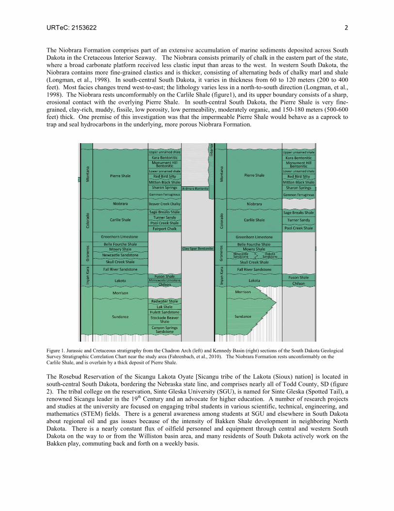
1998). The Niobrara rests uncomformably on the Carlile Shale (figure1), and its upper boundary consists of a sharp,
erosional contact with the overlying Pierre Shale. In south-central South Dakota, the Pierre Shale is very fine-
grained, clay-rich, muddy, fissile, low porosity, low permeability, moderately organic, and 150-180 meters (500-600
feet) thick. One premise of this investigation was that the impermeable Pierre Shale would behave as a caprock to
trap and seal hydrocarbons in the underlying, more porous Niobrara Formation.
Figure 1. Jurassic and Cretaceous stratigraphy from the Chadron Arch (left) and Kennedy Basin (right) sections of the South Dakota Geological
Survey Stratigraphic Correlation Chart near the study area (Fahrenbach, et al., 2010). The Niobrara Formation rests unconformably on the
Carlile Shale, and is overlain by a thick deposit of Pierre Shale.
The Rosebud Reservation of the Sicangu Lakota Oyate [Sicangu tribe of the Lakota (Sioux) nation] is located in
south-central South Dakota, bordering the Nebraska state line, and comprises nearly all of Todd County, SD (figure
2). The tribal college on the reservation, Sinte Gleska University (SGU), is named for Sinte Gleska (Spotted Tail), a
renowned Sicangu leader in the 19th Century and an advocate for higher education. A number of research projects
and studies at the university are focused on engaging tribal students in various scientific, technical, engineering, and
mathematics (STEM) fields. There is a general awareness among students at SGU and elsewhere in South Dakota
about regional oil and gas issues because of the intensity of Bakken Shale development in neighboring North
Dakota. There is a nearly constant flux of oilfield personnel and equipment through central and western South
Dakota on the way to or from the Williston basin area, and many residents of South Dakota actively work on the
Bakken play, commuting back and forth on a weekly basis.

URTeC: 2153622 3
Two low-temperature geothermal wells drilled in Mellette County north of the reservation in 2011 showed
indications of gas in the Niobrara Formation. The initial idea for this project was to determine if this gas could be
produced as a source of income for the tribe. The modest potential size of the resource and the long distance to the
nearest transmission pipeline precluded that as an option. However, if significant quantities of gas could be
produced economically from the relatively shallow formation and utilized locally, this may represent a new
paradigm for shale gas development. Many shale plays contain vast areas of “stranded” gas that is not produced
because it is located too far from the interstate transmission pipelines. Using such gas locally is a way to help
develop these resources. Possible ideas for local use of Niobrara gas on the reservation included electrical power
generation, low-cost heating for buildings, conversion of motor vehicles to burn compressed natural gas as a fuel,
the development of an industrial park by the tribe using low-cost energy supplies to improve economic
competitiveness, and the construction of community greenhouses for local, fresh food production that could be
heated cheaply in the winter with natural gas.
The study area comprises the Rosebud Reservation and surrounding territory. Although the intent of the project was
to perform an assessment of the gas potential of the Niobrara on the reservation itself, no cores and very little data
were available within Todd County or any of the surrounding counties. As such, the investigation relied on
publicly-accessible drill cores at the U.S. Geological Survey (USGS) core library in Lakewood, Colorado, regional
Niobrara outcrops, logs and data from the South Dakota Geological Survey, and the available scientific literature.
Along with the two geothermal wells, a number of lines of evidence suggested that the Niobrara Formation might
have some gas potential at the Rosebud Reservation. The Niobrara is often penetrated by water well drillers seeking
access to the Dakota Aquifer at the base of the Cretaceous (equivalent to the Inyan Kara Group in figure 1).
Published documents (i.e. Steece, 1989) have reported a number of gas shows from the Niobrara throughout South
Dakota, including at least one within the boundary of the reservation itself (figure 2). Some drillers have even flared
Niobrara gas in wells. Although the gas shows tend to be more frequent in the central and northwestern parts of the
state, the fact that there is still a presence around the reservation is encouraging. In addition, an assessment of the
Niobrara chalk as a possible feedstock for cement production (Rothrock, 1931) found significant differences in the
amount of “volatile matter” present in unweathered, fresh material (i.e. “black chalk”) compared to weathered
Niobrara from outcrops (“white chalk”). These and other findings were compelling enough to make the gas
potential of the Niobrara Formation in South Dakota worth investigating.
Figure 2. Map of Niobrara Formation in South Dakota, showing locations of outcrops and reported gas shows with respect to the Rosebud
Reservation. Modified after Steece, 1989.

URTeC: 2153622 4
The bulk of commercial Niobrara oil and natural gas production is in the Denver-Julesburg basin of Colorado, far to
the southwest of the Rosebud Reservation. By late 2014, liquids production in the Denver-Julesburg basin from the
Niobrara had reached nearly 400,000 barrels of oil equivalent (64 million liters) per day, and natural gas production
was steady at about 4.5 billion cubic feet (127 million cubic meters) per day (USEIA, 2015). The Niobrara also
produces more modest quantities of oil and gas in Wyoming and in eastern Colorado. One of the challenges of
Niobrara production is the presence of swelling clay in the formation, which reacts to water and chemicals in drilling
mud, cutting off permeability (Steece, 1989). Drilling with air in South Dakota is probably a better option, as
recommended by Steece (1989), and currently in use by shallow Niobrara drillers in eastern Colorado (Roy Long,
USDOE, personal communication, 2014).
Approach
Graduate students from the South Dakota School of Mines and Technology (SDSM&T) searched available cores at
the USGS Core Library in Lakewood, Colorado (near Denver) for well locations in or near Todd County that
contained Niobrara Formation intervals. Although none were found from areas near the Rosebud Reservation, a
number of cores were identified in Nebraska, Wyoming, and western South Dakota (figure 3) that enabled a regional
assessment. Ten slabbed cores were sampled in the summer of 2012. In addition, outcrop samples (designated WP
or “waypoint” locations on figure 3) from the Slim Butte area in Shannon County, SD (WP107), outcrops in the
southern Black Hills (WP99), and exposures along the Missouri River (WP113) were also used. Late in 2014, the
South Dakota Geological Survey (SDGS) began drilling a continuous core of the Pierre Shale and underlying
Niobrara Formation south of the town of Presho, in Lyman County northeast of the reservation (figure 3). This
drilling, which is expected to reach a total depth of about 300 meters (1000 feet) and terminate in the Carlile Shale
in the summer of 2015 will provide “local” samples of Niobrara for geochemistry, petrography and core analysis.
Figure 3. Locations of publicly-available Niobrara cores at the USGS from areas surrounding the Rosebud Reservation. The “WP” sites represent
Niobrara outcrops. The new Pierre/Niobrara core being drilled by the South Dakota Geological Survey is shown south of Presho, near the White River to the northeast of the reservation. Modified after Marzolf, 2013.

URTeC: 2153622 5
The cores available at the USGS had been slabbed lengthwise, so only relatively limited amounts of material from
the thinner or “butt” side of the slab were available for sampling. The cores were comprised of a variety of Niobrara
settings and zones – some intervals were very chalky, while others were organic and shaly (figure 4). The
transitions were abrupt in some cases, and gradational in others. Nearly all the core was calcareous, including the
shaly zones. Samples were selected from a variety of different intervals in each core, in an attempt to test the
Niobrara vertically as well as laterally. Individual cores had small segments referred to as “billets” designated in
white pencil for removal (figure 4). These were sawed out by technicians at the USGS, and sent to the DOE
National Energy Technology Laboratory (NETL) in Morgantown, WV for analysis.
Figure 4. (Left) Chalky to shaly transition of Niobrara Formation at a depth of 1213 feet in USGS core T713 from Lincoln County, Nebraska. The area marked “DOE” in white pencil was removed by the USGS and provided to DOE as a billet for a thin section and rock eval. (Right)
SDSM&T graduate student Kelsey Marzolf with tables full of Niobrara core at the USGS core library. Photos by Subodh Singh, SGU, 2012.
At NETL, the samples were further subdivided to provide pieces for thin sectioning and small chips for source rock
analysis (SRA), also known as “rock eval.” SRA uses a process called pyrolysis to heat a sample in a controlled
manner, and measures the volatiles driven off at different temperatures with a flame ionization detector or by other
means. The SRA at NETL was preoccupied with a backlog of samples from another project, so the rock eval work
on the Niobrara was performed by a commercial lab in Houston. The thin section billets were also sent out to a
commercial lab for preparation. Each billet was impregnated with blue-dyed epoxy to reveal the pore structure
before being cut and polished into a 30 micrometer-thick microscope slide. The completed thin sections were also
dipped halfway into Alazarin red dye to stain calcium carbonate while leaving the other half unstained.
In addition to the cores, SDSM&T students used published geologic quadrangles, cross-sections, geophysical logs,
well data and correlation charts to construct structure contour and isochore maps (Marzolf, 2013). Maps of the
Niobrara Formation were produced in Petrel and ArcMap to interpret downhole information. Resistivity data
gathered by remote sensing were also used to try to determine porosity and fluid saturation trends in the formation.
Some engineering students investigated well designs and drilling patterns to maximize potential gas recovery from
the formation, while others looked into environmental monitoring of air, water and land around a hypothetical well
field. A number of students who are enrolled members of the Sicangu Lakota Oyate were engaged on the project,
both at SGU and at SDSM&T. Several graduate student interns at NETL were also involved.
A number of field sites were visited in an attempt to gain a better understanding of the stratigraphic and lithologic
character of the Niobrara than could be gleaned from short segments of drill core. Outcrops in the area of Slim
Butte, on the Chadron Arch in Shannon County, SD (designated WP 107 in figure 3), clearly showed a vertical
transition from organic-rich calcareous shales and marls at the base to organic-lean but porous white chalk near the
top (figure 5). If the lower, organic-rich part of the Niobrara Formation serves as the source rock for gas or oil, and
the more porous chalk up above serves as a reservoir rock, then significant quantities of hydrocarbons may have
been generated and accumulated within the unit. When the clay-rich, impervious Pierre Shale capping the chalk is

URTeC: 2153622 6
also considered, the Niobrara may in fact behave like a hybrid reservoir: it is “unconventional” in the sense that the
source rock and reservoir rock are part of the same formation, while at the same time it is “conventional” because
the Pierre Shale overlies the porous chalk and creates a classic stratigraphic trap.
Figure 5. Shaly, organic-rich, lower part of the Niobrara Formation exposed on a bluff below lighter-colored chalk beds at Slim Butte, Shannon County, South Dakota. Rock hammer for scale is 13 inches (33 cm) in length. Photo by Dan Soeder, NETL, 2013.
Results and Discussion
Thin sections and the rock eval data suggest that the Niobrara has the potential to produce moderate but not
commercial amounts of natural gas. The thermal maturity determined by pyrolysis (table 1) is fairly low, which was
expected because the rock never experienced really deep burial. It is interpreted as being immature, and in the
“condensate-wet gas” window (figure 6). The total organic carbon (TOC) contents are surprisingly high, in some
cases above 5 or 6 percent by weight. As shown in the figure 5 photograph above, the Niobrara at Slim Butte
doesn’t look especially dark in outcrop. However, this Niobrara outcrop had a significantly higher TOC content
than a nearby exposure of Pierre Shale that appeared to be much darker and more of a classic “black” shale (table 1).
The thin sections (figures 7 and 8) show a framework of fine-grained clay, biomicrite and various types of marine
organic material supporting microfossil shells and pellet clasts. The staining indicates that the Niobrara is calcareous
throughout, even at very small scales. Primary porosity is present as tiny pores within the clay and organic matrix,
but a considerable amount of secondary porosity has developed in parts of the unit in the form of macroscopic
solution pores created by the dissolution of shells and pellets. Solution pores are created by fluids moving through
the rock matrix, suggesting that such pore systems may remain well-connected. Flowpaths through such secondary

URTeC: 2153622 7
porosity could provide a matrix pathway for gas to move through the rock. The secondary porosity can be quite
substantial, as shown in figure 8. If this is common throughout the formation, and the Pierre Shale acts as a trap and
seal, the Niobrara could hold significant quantities of natural gas.
Table 1: Rock Eval pyrolysis data on Niobrara core samples from USGS core library, plus outcrop samples of Pierre Shale and Niobrara
Formation from Slim Butte, Shannon County, SD.
Sample
TOC Wt. %
S1 mg/g
S2 mg/g
S3 mg/g
HI OI PI Tmax °C
S1 / TOC
Pierre Shale below ash 2.44 0.07 1.93 2.89 79 118 0.04 423 2.87
Pierre Shale above ash 2.72 0.08 1.96 3.37 72 124 0.04 417 2.94
Niobrara Slim Butte 4.37 0.24 16.68 3.91 382 89 0.01 420 5.49
DOE B329 1084.3 ft 5.37 0.67 27.64 2.98 515 55 0.02 410 12.48
DOE B329 1092.5 ft 4.08 0.35 20.24 1.91 496 47 0.02 414 8.58
DOE B329 1128.5 ft 1.29 0.07 4.44 0.97 344 75 0.02 423 5.43
DOE B331 1002.5 ft 5.29 0.34 19.77 2.63 374 50 0.02 412 6.43
DOE B331 1005.5 ft 5.53 0.36 30.06 2.52 544 46 0.01 410 6.51
DOE B331 1010.7 ft 4.19 0.26 21.12 2.01 504 48 0.01 412 6.21
DOE D135 4887.8 ft 4.16 1.44 18.32 0.55 440 13 0.07 435 34.62
DOE D135 4901.0 ft 3.07 2.48 17.94 0.61 584 20 0.12 433 80.78
DOE D135 4929.1 ft 2.06 1.00 9.25 0.56 449 27 0.10 437 48.54
DOE D206 5879.0 ft 2.98 2.62 12.62 0.69 423 23 0.17 432 87.92
DOE D206 5904.0 ft 2.95 2.21 15.28 0.81 518 18 0.13 434 74.92
DOE D779 10381.5 ft 2.84 0.99 4.39 0.51 155 18 0.18 449 34.86
DOE D779 10386.8 ft 2.25 1.37 4.40 0.89 196 40 0.24 445 60.89
DOE D779 10413.0 ft 4.04 0.91 6.57 0.97 163 24 0.12 449 22.52
DOE E815 9137.6 ft 1.03 0.30 1.59 0.37 154 36 0.16 446 29.13
DOE E815 9164.2 ft 1.12 0.31 1.61 0.43 144 38 0.16 450 27.68
DOE E815 9188.9 ft 0.37 0.11 0.49 0.25 132 68 0.18 444 29.73
DOE T712 848.5 ft * 0.04 0.01 0.03 0.91 75 2275 0.25 386 25.00
DOE T712 906.3 ft 3.60 0.35 19.24 2.18 534 61 0.02 408 9.72
DOE T712 1104.9 ft 2.59 0.31 12.54 2.11 484 81 0.02 410 11.97
DOE T713 941.0 ft 4.93 0.30 22.23 2.40 451 49 0.01 406 6.09
DOE T713 1213.1 ft 6.23 0.57 30.44 3.60 489 58 0.02 408 9.15
DOE T713 1259.6 ft 5.40 0.64 28.88 3.02 535 56 0.02 408 11.85
DOE T714 976.0 ft 5.09 0.42 27.34 2.71 537 53 0.02 407 8.25
DOE T714 992.0 ft 3.96 0.17 18.70 1.92 472 48 0.01 405 4.29
*Note: T712 848.5 is an olive-gray shaly limestone, similar in appearance to other samples from this core. It is unclear why the TOC is so low.
The map and model interpretations suggest that a structurally-high area along the eastern edge of Todd County may
have the best potential for producing gas from the Niobrara Formation in the area of the Rosebud Reservation. The
underlying structure, lineament trends and historical gas shows all appear to favorably align in this area (Marzolf,
2013). The structural top of the Niobrara Formation in eastern Todd County and western Tripp County is at a depth
of about 487 meters (1,600 feet) below the surface, and the thickness through this area is approximately 76 meters
(250 feet). The depth is shallower in the western part of Todd County as the unit comes onto the Chadron Arch, and
the formation is thinner to the north and south (Marzolf, 2013).
Wireline logs and geophysical data indicate that porosity values in the Niobrara may be as high as 45% in eastern
Todd County (Marzolf, 2013), which appears to be confirmed in some of the thin sections (figure 8). The resistivity
values associated with the high porosity zone are low, suggesting the pores contain saltwater that may be potentially
accompanied by hydrocarbons (Marzolf, 2013). The preliminary data gathered so far indicates that the best place to
drill a demonstration production well in the Niobrara, should the tribal government decide to move forward with

URTeC: 2153622 8
such a project, would be in the eastern part of Todd County. However, the Niobrara ought to be reasonably
productive just about anywhere in the vicinity of the Rosebud Reservation, and future work will help to better define
this potential.
Figure 6. Rock eval pyrolysis plot of Niobrara core samples listed above in Table 1. Most of the organic material in the formation is Type II
marine kerogen, as expected, and the thermal maturity index is quite low, in the immature, wet gas zone, also as expected.
Production of gas from the Niobrara at the Rosebud Reservation, should it take place, will require a technique that is
different from the typical horizontal drilling and staged hydraulic fracturing methodology used on most shale gas
wells. The Niobrara Formation is too shallow in south-central South Dakota for hydraulic fracturing. Such
fracturing works by applying hydraulic pressure to the formation in excess of the mechanical strength of the rock,
causing it to crack (Hubbert and Willis, 1957). However, when the rocks are too shallow, typically at depths of less
than about 800 meters (2,500 feet), the net overburden stress is not high enough to force the induced fractures to
break vertically, and horizontal fractures are created instead. These are not very effective for creating high-
permeability pathways into the reservoir, so an alternative production approach is needed.

URTeC: 2153622 9
Figure 7. Thin section photomicrograph in transmitted white light of Niobrara Formation from Core T713 at a depth of 1213 feet. This thin
section was made from the billet shown in figure 4. Blue areas are epoxy-filled pore space, including some secondary solution pores and
fractures. The right side of the slide was stained to reveal carbonate, which is abundant throughout. Various types of orange, brown, and black marine organic material can be seen, along with a fine-grained clay matrix surrounding tiny shells of foraminifera and calcareous algae. This
sample had the highest TOC of all the cores tested, at 6.23 percent by weight. Scale bar is 0.5 mm. Photograph by Yael Tucker, NETL.
Figure 8. Thin section photomicrograph in transmitted white light of Niobrara Formation from Core B329 at a depth of 1084.3 feet. This core
contains a great deal of porosity created from solution-dissolved pellets and shells in a framework of fine-grained clay, biomicrite, and organic material. The red stain on the left indicates that significant amounts of carbonate remain in the rock. Photograph by Yael Tucker, NETL.

URTeC: 2153622 10
Coalbed methane wells, designed to remove natural methane gas from coal seams for mine safety improvements or
as a produced resource, are often too shallow for hydraulic fracturing. Coal is also mechanically weak and ductile,
and thus does not fracture very well. A technology developed a decade ago by DOE and currently in use for such
shallow gas production is called coiled tubing drilling (Long and Soeder, 2011). A coiled tubing rig uses a drilling
motor and bit constructed into a bottomhole assembly. Rather than turning a bit from the surface, the down-hole
motor is powered by the hydraulic pressure of the drilling mud, and turns the bit without the need to rotate the drill
string, cutting through the rock at rates as high as 30 meters (100 feet) per hour (Long and Soeder, 2011). The mud
is delivered downhole through a flexible hose or “coiled tubing.” Compared to rigid, steel drill pipe, this flexible
tubing allows the boreholes to make very tight turns, drill “S” shapes, and penetrate long horizontal distances
through productive formations. Coiled tubing rigs were originally only able to operate at relatively shallow depths,
but advances in materials and the development of hybrid designs now allow these rigs to reach depths of 3,500
meters (12,000 feet) or more (Long and Soeder, 2011).
A style of drilling that can be readily accomplished with a coiled tubing rig in lieu of hydraulic fracturing is a
vertical hole drilled from the surface that can then be turned to a horizontal orientation to stay within the target
formation. These horizontal borings, called laterals, can extend significant distances. The tight steering ability of
the coiled tubing rig allows numerous side laterals to be drilled off the main laterals, creating a total length of
wellbore that can be up to 4.5 km (15,000 feet). This large amount of contact area between the wellbore and the
target formation is critical for producing economical volumes of gas from low permeability formations. Horizontal
boreholes with numerous side laterals are a type of drilling called “pinnate” because the branched laterals resemble
the structure of a feather. An example is shown in figure 9.
Figure 9. Schematic showing a plan for “pinnate drilling,” named for the feather-like branches of side laterals drilled directionally off a number of
main laterals. Image courtesy of Roy Long, USDOE-NETL.
Coiled tubing rigs have in fact been employed with great success in the shallow parts of the Niobrara Formation in
eastern Colorado and western Kansas, producing 28 billion cubic meters (a trillion cubic feet) of gas that would
otherwise have been bypassed (Long and Soeder, 2011). Because of the concerns over possible formation damage
from swelling clay if the rock is exposed to drilling fluids, a coiled tubing rig that uses compressed air instead of
mud has been developed for clay-sensitive formations. According to Roy Long (personal communication, 2014), it
has been utilized successfully in the Niobrara Formation of eastern Colorado.
Conclusions and Future Work
The Niobrara Formation underlying the Rosebud Reservation in south-central South Dakota has the potential to
produce significant amounts of natural gas. The analyses performed so far on the limited number of samples
available indicate that organic content of the Niobrara is as high as 5 or 6 percent by weight, and although thermal
maturity is low, it is still within the “wet gas” window. The thin sections analyzed to date show that the rock

URTeC: 2153622 11
contains fair to abundant porosity, and is more of a clay-rich chalk than a typical gas shale. Even the shaly zones
that are present in the Niobrara tend to be chalky and calcareous. Regional geophysics and well log analysis
suggest that the most productive part of the Niobrara under the Rosebud Reservation will be to the east, near the
border between Todd and Tripp Counties.
A number of graduate and undergraduate students at the South Dakota School of Mines and Technology have
contributed significantly to these assessments, and continue to do so. Likewise, a number of undergraduate students
at Sinte Gleska University have also been engaged, participating in lectures, classroom discussions, and geological
field trips, attending a regional oil and gas conference held in Rapid City, and visiting the South Dakota Geological
Survey drill rig south of Presho to assist with core recovery and processing (figure 10). Several student interns from
NETL were also involved. These engagements are expected to continue, and possibly expand.
Future work on the project will rely on fresh Niobrara Formation core from the Presho site, expected to be obtained
in the summer of 2015. Additional thin section petrography and source rock analysis will be performed on this core,
as well as some geochemical studies, biostratigraphy, and core analysis. The latter should provide porosity and
permeability information on the Niobrara, including pore size distribution, capillary entry pressures, two phase flow
behavior and other petrophysical data sets. This type of information will be very useful for assessing the viability of
developing the Niobrara as an energy resource on the Rosebud Reservation. The current phase of the project is
expected to conclude in 2015 with a report delivered to the tribal government from Sinte Gleska University,
summarizing the data and providing recommendations for development of the resource should the tribal government
decide to do so.
If the resource is developed, the assessment research team is interested in helping to optimize production, assist with
plans for local utilization, and provide environmental monitoring of air, land and water on the reservation during the
drilling and completion phases of the gas wells. Engaging students in each of these tasks will help introduce them to
various aspects of the energy industry, and potentially prepare them for future careers in the field.
Figure 10. Sarah Chadima (left) of the SDGS and Mikal Bordeaux, a student at Sinte Gleska University, photographed with a segment of Pierre Shale core from an SDGS drill hole south of Presho, SD, October 2014. Photo by Foster Sawyer, SDSM&T.

URTeC: 2153622 12
References Cited
Estes-Jackson, Jane E. and Anderson, Donna S. (editors), 2011, Revisiting and Revitalizing the Niobrara in the
Central Rockies: Rocky Mountain Association of Geologists, Denver, CO, 524 p.
Fahrenbach, M.D., Steece, F.V., Sawyer, J.F., McCormick, K.A., McGillivray, G.L., Schulz, L.D., Redden, J.A.,
2010, South Dakota stratigraphic correlation chart: South Dakota Geological Survey, Oil and Gas Investigations 3,
Report Series: GQ250K-1, single sheet, 36 x 55 inches.
Hubbert, M. and Willis, D., 1957, Mechanics of hydraulic fracturing: Petroleum Transactions, AIME, v. 210,
p.153–168.
Long, Roy C., and Soeder, Dan, 2011, New and Innovative Drilling Technologies: Paper No. 73-3, Special Session:
The Past Yucca Mountain Project—Advancing Science and Technology for the Future: Was It Worth the Cost?
2011 Geological Society of America Annual Meeting, Minneapolis, MN, 9–12 October 2011: Geological Society of
America Abstracts with Programs, v. 43, no. 5, p. 196
Longman, M.W., Luneau, B.A., and Landon, S.M., 1998, Nature and distribution of Niobrara lithlologies in the
Cretaceous Western Interior Seaway of the Rocky Mountain region: The Mountain Geologist, v. 35, no.4, p. 137-
170.
Marzolf, Kelsey R., 2013, Hydrocarbon Production Potential of the Niobrara Formation in the Kennedy Basin, M.S.
thesis, South Dakota School of Mines and Technology, Rapid City, SD, 78 p.
Rothrock, E.P., 1931, A preliminary report on the chalk of eastern South Dakota: South Dakota Geological Survey,
Report of Investigations, No. 2, 51 p.
Steece, Fred V., 1989, Natural Gas Prospects in the Niobrara Formation in South Dakota, p. 73-81: in Eisert, J.L.
(editor) Gas Resources of Wyoming-40th Annual Field Conference Guidebook: Wyoming Geological Association,
Casper, WY, 288 p.
USEIA (U.S. Energy Information Administration), 2015, Drilling Productivity Report for key tight oil and shale gas
regions: February 2015, 11 p. (http://www.eia.gov/petroleum/drilling/pdf/dpr-full.pdf)

URTeC: 2153622 13
Appendix: USGS Niobrara Core Sample Summary
State Core ID Depth (ft) Color* Lithology SD B329 1084.3 5Y4/1 Limy shale, olive gray, lam, shells>clay, org frags
SD B329 1092.5 5Y5/2 Limy shale, lite olive gray, shells+clay+org frags
SD B329 1128.5 N4 Shaly LS, med dark gray, calc mud+shells+pyrite+org frags
SD B331 1002.5 5Y4/1 Limy shale, olive gray; laminated, clay < shell
SD B331 1005.5 5Y3/1 Limy shale, olive gray; laminated, clay < shell
SD B331 1010.7 5Y3/2 Limy shale, olive gray, clay > shell
WY D135 4887.8 5Y2/1 Limy shale, olive black, pyritic, w/org frags
WY D135 4901.0 5Y4/1 Limy shale, olive gray w/darker laminae, shells
WY D135 4929.1 5Y4/1 Shaly LS, olive gray w/shell bed & dark laminae
WY D206 5879.0 5Y2/1 Limy shale, uniform, olive black, clay>shell, org frags
WY D206 5904.0 5Y2/1 Limy shale, uniform, olive black, clay>shell, org frags
WY D206 6111.0 5Y6/1 Quartz SS w/biotite, lite olive gray, faintly lam (Frontier Fm.)
WY D779 10381.5 N2 Limy shale, uniform, gray black, clay>shell
WY D779 10386.9 N2 Limy shale, gray black, pyritic, shell frags
WY D779 10413.0 N2 Limy shale, gray black, pyritic, shell frags
WY E815 9137.6 N2 Limy shale, gray black, uniform, pyritic
WY E815 9164.2 N1 Black shale, pyritic w/calcareous laminae
WY E815 9188.9 N3 Shaly LS, dark gray, bioturbated
NE T712 848.5 5Y4/1 Shaly LS, olive gray, friable, shell>clay, hash
NE T712 906.3 5Y4/1 Shaly LS, olive gray, shell>clay, hash, clay laminae
NE T712 1104.9 5Y3/2 Shaly LS, olive gray, organic, friable, shell>clay
NE T713 941.0 5Y3/2 Shaly LS, olive gray, organic, friable, shell>clay
NE T713 1213.1 N5 Shaly chalk, med gray, burrowed, laminated, shell>clay
NE T713 1259.6 5Y4/1 Shaly chalk, olive gray, clay + organic laminae
NE T714 976.0 5Y3/2 Limy shale, uniform, olive gray, clay>shell
NE T714 992.0 5Y4/1 Shaly chalk, olive gray, friable on shell laminae
* Color of wet core determined using Munsell color values on GSA Rock Color Chart