assessment guide for gcse geography a€¦ · the gcse geography a course consists of three...
TRANSCRIPT

Assessment Guide for GCSE
Geography A (Version 1.1)
GCSE (9-1) Geography A Pearson Edexcel Level 1/Level 2 GCSE (9-1) in Geography A (1GA0)

Assessment Guide for GCSE (9-1) Geography A (Version 1.1)
© Pearson Education Ltd 2018.
1
Contents
1. Introduction 2
1. Exam structure 3
2. Command words and mark tariffs 8
3. Tackling the extended response questions 12
4. Marking the extended response questions 19
5. Examiner marked exemplars with commentaries 25

Assessment Guide for (9-1) GCSE Geography A (Version 1.1)
© Pearson Education Ltd 2018.
2
1. Introduction
Our exam papers are designed to encourage all students to show what they know and
understand about geography to the best of their ability. This guide is designed to support teachers and their students to help them understand the requirements for the GCSE (9-1) Geography A exam papers. Please note this is version 1.1 of the guide
with corrections to Table 2 on page 5 and Table 3 on page 6.
It contains information and advice on:
1. The structure of the exam papers 2. Information on question styles, command words and mark tariffs 3. Guidance on interpreting our levels based mark schemes
4. Guidance on tackling the 8 mark and 12 mark extended response questions and strategies for answering these questions in the exam.
5. Understanding how students can demonstrate the mark scheme requirements through examiner marked exemplar student responses to questions in the
Specimen Papers (SAMS2)

Assessment Guide for GCSE (9-1) Geography A (Version 1.1)
© Pearson Education Ltd 2018.
3
1. Exam structure
The GCSE Geography A course consists of three externally-examined
papers.
In Papers 1 and 2, there are three 30-mark sections. Of the 94 raw marks
available, up to 4 marks are awarded for SPaG.
In Paper 3, of the 64 raw marks available, up to 4 marks are awarded for
SPaG.
In each component, the marks for SPaG will be included in the final
question in Section C.
In Papers 1, 2 and 3 there will be a variety of multiple-choice questions, short open, open response, calculations and 8-mark writing questions;
there will also be one 12-mark extended writing question at the end of Paper 3.
The exam structure for the qualification is shown in Table 1 below:
GCSE Geography A exam structure
Paper 1: The
Physical Environment
Total Marks: 94
Weighting: 37.5%
Optionality:
Section A
Exam time: 1
hour and 30 minutes
Section A: The Changing landscapes of the UK
Students answer Question 1 and choose two from three optional questions (Question 2 Coasts, Question
3 Rivers, Question 4 Glaciated upland landscapes and processes).
Section B: Weather hazards and climate change
Students answer all questions from Section B.
Section C: Ecosystems, biodiversity and
management
Students answer all questions from Section C.
Paper 2: The
Human Environment
Total Marks: 94
Weighting: 37.5%
Optionality:
Section C
Exam time: 1
hour and 30
minutes
Section A: Changing cities
Students answer all questions from Section A.
Section B: Global development
Students answer all questions from Section B.
Section C: Resource management
Students answer Question 3 and choose one from two optional questions (Question 4 Energy resource
management or Question 5 Water resource management).
Paper 3:
Geographical Investigations: Fieldwork and
Section A: Geographical investigations
– physical environments
Students choose one from two optional questions
(Rivers or Coasts)

Assessment Guide for (9-1) GCSE Geography A (Version 1.1)
© Pearson Education Ltd 2018.
4
UK Challenges
Total Marks: 64
Weighting: 25%
Optionality:
Sections A and B
Exam time: 1
hour and 30 minutes
Section B: Geographical investigations
– human environments
Students choose one from two optional questions
(Central/Inner Urban Area or Rural Settlements)
Section C: UK Challenges
Students answer all questions from Section C.
Table 1
A range of different question types will be used within all examinations in order
to assess a variety of requirements across different AOs (Assessment Objectives)
and facilitate differentiation. The different questions types that are used are:
Multiple choice questions (MCQ) where students are required to select
the correct answer from a choice of four. A variation of this that might be used is where students are required to select two correct answers from a
choice of five.
Short open response: Ranging from a single word, up to a couple of
sentences, for between one and three marks.
Open response: Usually a few sentences or a short paragraph for four
marks.
Calculation: These could both be short or long, and thus varying in mark
allocations.
Extended open response: Where students are required to assess the
ability to develop extended written arguments and to draw well-evidenced
and informed conclusions about geographical questions and issues. Utilises a levels-based mark scheme.
There is ramped demand of questions within sections and papers with mark
tariffs ranging from 1 – 12 marks. Table 2 (below) provides an at a glance guide
to where extended response questions will appear across the three exam papers. The final question of each section in Papers 1 and 2 and Sections A and B in Paper 3 will be an 8 mark extended response question. The final question of
Section C in Paper 3 will be a 12 mark extended response question.
The mark tariff and AOs (Assessment Objectives) for extended response
questions do vary across the three exam papers depending on the type of question and command word used. Later in this Guide (in Section 3), there is
more detailed information about the AO’s that are targeted by different question types and command words.

Assessment Guide for GCSE (9-1) Geography A (Version 1.1)
© Pearson Education Ltd 2018.
5
Mark tariffs to exam time ratio at a glance
Content Total
marks
Suggested
time (mins)
Maximum
mark tariff
Paper 1: The Physical Environment
Section A: Changing landscapes of the
UK
30 30 2 x 8-mark
questions
Section B: Weather hazards and climate
change
30 30 1 x 8-mark
question
Section C: Ecosystems, biodiversity and
management
34 30 1 x 8-mark
question
(+ 4 marks SPaG)
Paper 2: The Human Environment
Section A: Changing cities 30 30 1 x 8-mark questions
Section B: Global development 30 30 1 x 8-mark
question
Section C: Resource management 34 30 1 x 8-mark
question
(+ 4 marks SPaG)
Paper 3: Geographical Investigations: Fieldwork and UK Challenges
Section A: Geographical Investigations - Physical
18 25 1 x 8-mark question
Section B: Geographical Investigations -
Human
18 25 1 x 8-mark
question
Section C: UK Challenges 28 40 1 x 12-mark
question
(+ 4 marks
SPaG)
Table 2

Assessment Guide for (9-1) GCSE Geography A (Version 1.1)
© Pearson Education Ltd 2018.
6
Table 3 (below) provides a description of the different types of extended open
response questions in each paper and the skills students will be required to
demonstrate.
Component Extended open response questions
Paper 1:
The Physical Environment
In Section A, there will be two 8 mark extended writing
questions. There will be one 8 mark extended writing question in each of Sections B and C.
In Section A, the 8 mark extended response questions always
use the command word, ‘Examine’ and be linked to an
unfamiliar resource. This question will always target the use of geographical skills to extract relevant information from a resource and the application of knowledge and understanding
to interpret the information in the resource.
The 8 mark extended response questions in Sections B and C
will require students to make links between concepts within a topic or apply their understanding to a geographical context
and/or a resource.
In Section C an additional 4 marks will be available for SPaG in
the extended response question.
Paper 2:
The Human
Environment
One 8 mark extended writing question in each of Sections A, B
and C.
The 8 mark extended response questions will require students to apply their understanding to a geographical context and/or a
resource. The extended response question in Section C will have 4 marks available for SPaG.
Paper 3:
Geographical
Investigations:
Fieldwork and UK Challenges
One 8 mark extended writing question in each of Sections A and B.
These 8 mark extended response questions will require
students to apply their fieldwork understanding to analyse, evaluate and make judgements, and to communicate their findings from fieldwork investigations.
One 12 mark extended writing question in Section C. This 12-
mark extended response question, will always appear at the end of Paper 3 and will require students to apply their geographical skills to investigate a contemporary UK challenge,
drawn from at least one of the themes in Topic 8. An additional four marks will be available for SPaG.
Table 3

Assessment Guide for GCSE (9-1) Geography A (Version 1.1)
© Pearson Education Ltd 2018.
7
Paper 3 – variations in exam structure
Sections A and B in Paper 3 assesses the student’s own experience (familiar context) and their ability to engage with a fieldwork scenario provided in the
exam (unfamiliar context). For questions set in an unfamiliar context, it is worth remembering that whilst the fieldwork information and data provided will be
unfamiliar, the investigation focus and data collection methods will be familiar to students as these are prescribed in the specification.
Each year, students will answer one set of short answer questions in each
context, and one extended writing question in each context.
Table 4 shows the two ways that questions might be structured in order to assess the familiar and unfamiliar context appropriately:
Structure 1:
Section Focus for the multiple-choice, short open,
open and calculation questions (10 marks)
Focus for the extended writing
question
(8 marks)
A: Geographical
investigations – human: either
question 1 (rivers) or question 2 (coasts).
Application of the
students’ own fieldwork experience to an
unfamiliar context.
Assessment of the
students’ own fieldwork experience.
B: Geographical investigations –
physical: either question 3 (urban) or
question 4 (rural).
Assessment of the students’ own fieldwork
experience.
Application of the students’ own fieldwork
experience to an unfamiliar context.
Structure 2:
Section Focus for the multiple-
choice, short open, open and calculation
questions (10 marks)
Focus for the
extended writing question
(8 marks)
A: Geographical investigations –
human: either question 1 (rivers) or
question 2 (coasts).
Assessment of the students’ own fieldwork
experience.
Application of the students’ own fieldwork
experience to an unfamiliar context.
B: Geographical
investigations – physical: either
question 3 (urban) or question 4 (rural).
Application of the
students’ own fieldwork experience to an
unfamiliar context.
Assessment of the
students’ own fieldwork experience.
Table 4

Assessment Guide for (9-1) GCSE Geography A (Version 1.1)
© Pearson Education Ltd 2018.
8
2. Command words and mark tariffs
Command words are used consistently in our exam papers to assess particular skills, making it clear the type of response that is required. Table 5 lists the 13 command
words that could be used in the examinations for this qualification and their definitions. Our command word definitions will stay the same for the lifetime of the
qualification and, together with question styles, will enable students to focus on ‘thinking geographically’ rather than understanding the mechanics of individual question items.
Command Word
Definition
Identify/Stat
e/Name
Recall or select one or more pieces of information.
Define State the meaning of a term.
Calculate Produce a numerical answer, showing relevant working.
Draw/plot Create a graphical representation of geographical information.
Label Add a label/labels to a given resource, graphic or image.
Describe Give an account of the main characteristics of something or the
steps in a process. Statements in the response should be developed but do not need to include a justification or reason.
Compare Find the similarities and differences of two elements given in a question. Each response must relate to both elements and must
include a statement of their similarity/difference.
Explain Provide a reasoned explanation of how or why something occurs. An explanation requires a justification/exemplification of a point.
Some questions will require the use of annotated diagrams to support explanation.
Suggest Apply understanding to provide a reasoned explanation of how or why something may occur. A suggested explanation requires a justification/exemplification of a point.
Examine Break something down into individual components/processes and say how each one individually contributes to the question’s
theme/topic and how the components/processes work together and interrelate.
Assess Use evidence to determine the relative significance of something. Give consideration to all factors and identify which are the most
important.

Assessment Guide for GCSE (9-1) Geography A (Version 1.1)
© Pearson Education Ltd 2018.
9
Discuss Explore the strengths and weaknesses of different sides of an issue/question. Investigate the issue by reasoning or argument.
Evaluate Measure the value or success of something and ultimately provide a substantiated judgement/conclusion. Review
information and then bring it together to form a conclusion, drawing on evidence such as strengths, weaknesses, alternatives
and relevant data.
Table 5
Our command words will be used consistently to assess particular skills and across
mark tariffs. Table 6 shows the mark tariffs for different command words. The command words ‘Examine’, ‘Assess’ and ‘Evaluate’ are the three command words that
could be used for the 8 mark extended response questions. The command word ‘Examine’ will only appear in Paper 1 Section A. The command word ‘Discuss’ will only be used for the final part of the synoptic UK Challenges question in Paper 3, which will
always be worth 12 marks. Section 3 of the guide provides guidance on the requirements of these different command words and question types.
1 2 3 4 8 12
Identify/State/Name * *
Define *
Calculate * *
Label * * *
Draw/plot * * *
Compare * *
Describe * * *
Explain * * *
Suggest * * *
Examine *
Assess *
Evaluate *
Discuss *
Table 6

Assessment Guide for (9-1) GCSE Geography A (Version 1.1)
© Pearson Education Ltd 2018.
10
Differences between command words
It is not uncommon for students to confuse the meanings and demands of
different command words; in particular, the differences between the commands of ‘Explain’ and ‘Suggest’ or ‘Assess’ and ‘Evaluate’ are not always understood.
‘Describe’ and ‘Explain’
Description is not the recall of learnt knowledge but might be used to
explore how a technique can be applied to a particular situation, often but not exclusively in a fieldwork situation. It might also be used in
conjunction with resources.
In both contexts some candidates find it very hard to resist adding
explanatory reasons which cannot be credited and wastes time.
‘Explain’ and ‘Suggest’
‘Explain’ is used when the student is required to provide a reasoned
explanation of how or why something occurs by developing a point with some justification/exemplification. ‘Explain’ may target explanation of specification content (AO1 and AO2) or resource material (AO2 and AO3).
‘Suggest’ is only used when the question requires students to speculate
beyond the learned content of the speculation and will link to a resource. These types of questions require students to apply their understanding to an unfamiliar context (AO2 and AO3) – and to provide a reasoned
explanation of how or why something may occur. As with the ‘explain’ command, ‘suggest’ requires the development of a point with some
justification/exemplification.
‘Explain one…’, ‘Explain two…’, ‘Suggest one…’, Suggest two…’
Students should be careful not to offer more or less than is needed with
these command phrases. If one explanation or suggestion is sought, then
obviously only one is rewardable and the basic explanatory point will be with one mark and it is that basic point that has to be extended and developed to pick up a further mark or marks.
Annotation – a note
Although not a command some ‘Explain’ questions, might also request that
students are to provide an annotated diagram to support and develop their explanation. It is important to note that annotations are a form of
explanatory labelling.
‘Assess’ and ‘Evaluate’
‘Assess’ is used for extended writing questions in which the student is required to use evidence from located examples / a case study to
determine the relative significance of something. This is done by considering all the factors and identifying which are the most important;
for example, the relative impact of two things or the extent to which something happens in different circumstances. ‘Assess’ does not require a conclusion.

Assessment Guide for GCSE (9-1) Geography A (Version 1.1)
© Pearson Education Ltd 2018.
11
‘Evaluate’ is used for extended writing questions in which the student must
appraise things by measuring the value or success of something and
ultimately come to a definite judgement/conclusion. This is done by reviewing information and then bringing it together to form a conclusion, drawing on evidence such as advantages, disadvantages, strengths,
weaknesses, alternatives and relevant data / details from located examples and/or a case study; for example, evaluate which approach was
most successful.

Assessment Guide for (9-1) GCSE Geography A (Version 1.1)
© Pearson Education Ltd 2018.
12
3. Tackling the extended response questions
Extended response questions are unstructured questions that are worth either 8 or 12
marks. These are generally reserved for exploration of an issue and/or the construction of an argument. As these questions are more open-ended, they are marked using levels-based mark schemes (see Section 5 of this guide).
Different types of 8-mark extended response questions
Some 8-mark extended response questions will not include any stimulus
material and will be assessing a students’ geographical understanding and
their ability to apply this through either ‘assessment’ or ‘evaluation’. These questions will have a weighting of four AO2 marks (for knowledge and understanding) and a further four marks for AO3 (for the successful
application of this within the context of the question).
Some 8–mark questions will have some form of resource linked to the
question; again, there will be four marks available for AO3, but now there will be four marks available for AO4 rather than AO2; this is because
students are being tested on their ability to select, adapt and use a variety of skills and techniques to investigate questions and issues and
communicate findings.
On the next page, Table 7 shows the different command words that can be used for extended writing questions (using levels-based mark schemes) with the weightings of
marks by assessment objective (further information about assessment objectives can be found on page 34 of the Specification). These will remain the same for the lifetime
of the specification to ensure consistency year-on-year when meeting the assessment objectives. This means you can also see the proportion of the different skills required of students in extended responses so they can be clear what is required of them for
each command word.

Assessment Guide for GCSE (9-1) Geography A (Version 1.1)
© Pearson Education Ltd 2018.
13
Total
marks*
AO2
(understanding)
AO3
(application of K and U)
AO4
(use of geographical
skills/stimulus material)
Paper 1
Section A:
Examine
8 4 4
Sections B and C:
Assess or Evaluate
8 4 4
Paper 2
Sections A,
B and C:
Assess or Evaluate
8 4 4
Paper 3
Sections A
and B
(fieldwork): Assess or Evaluate
8 4 4
Section C
(UK challenges): Discuss
12 4 4 4
*not including any additional SPaG marks
Table 7
Tackling ‘Examine’ questions on Paper 1 (AO3 and AO4)
‘Examine’ questions are always worth 8 marks and a marked using a levels-based mark scheme (see part 4 of the guide).
They only appear in Section A, Questions 2, 3 and 4, and will be linked to resource material; therefore, the breakdown of marks will always be 4 x AO3
and 4 x AO4. Students will answer two from Question 2 Coastal landscapes and processes,
Question 3 River landscapes and processes, Question 4 Glaciated upland
landscapes and processes. Each question will culminate in an 8 mark ‘Examine’ question.
Assessment Guide for (9-1) GCSE Geography A (Version 1.1)
© Pearson Education Ltd 2018.
14
When answering this type of question, successful candidates will extract relevant information from the resource(s) AO4, and use this information to support description
and explanation.
E.g. Question 3b on Paper 1 of the Specimen Paper:
In this question, students are expected to identify the different processes and
activities shown on the resource (AO4) and say how each one individually might affect flooding in the area shown in Figure 4. The most successful candidates will not only be able to apply their knowledge and
understanding to the unfamiliar context of the question, but will also be able to make links between different factors; for example, in response to this question students
might consider the interrelationship between soil type, drainage basin density, land use and climate.
Tacking ‘Assess’ and ‘Evaluate’ questions (AO2 and AO3 or AO3 and AO4)
‘Assess’ or ‘Evaluate’ questions are always worth 8 marks and a marked using a levels-based mark scheme (see part 4 of the guide).
In Papers 1 and 2, these questions will not be linked to any resource material (4 x AO2 and 4 x AO3).
In Paper 3, the question will be linked to familiar or unfamiliar fieldwork (4 x
AO3 and 4 x AO4).
‘Assess’
When answering this type of question, successful candidates will use evidence (e.g. applying knowledge from a case study or located example, which is AO3) to determine
the relative significance of something. Unlike ‘evaluate’, ‘assess’ does not need a substantiated judgement/conclusion
For example, in question 1f on Paper 2 (“Assess the impacts of…”), candidates would
receive credit for information about one or more impacts (AO2) which is knowledge and understanding from the specification. However, to access Level 3 the candidate
must give consideration to a wide range of impacts and explain why some are more important than others (AO3).
Therefore, the AO2 marks come from an understanding of the different impacts of
migration, and the AO3 marks for the application of this information to different contexts and the reasoning as to why some impacts are more important than others.
Assessment Guide for GCSE (9-1) Geography A (Version 1.1)
© Pearson Education Ltd 2018.
15
‘Evaluate’
When answering this type of question, successful candidates will use evidence (e.g. applying knowledge from a case study or located example, which is AO3) to measure
the value or success of something and ultimately provide a substantiated judgement/conclusion – which can be a final paragraph or something that can be
integrated throughout the response.
For example, in question 7e on Paper 1 (“Evaluate the different approaches….”),
candidates are expected to review different approaches that have been tried, and then draw a conclusion about which the best/worst approach by including evidence such as data, alternative approaches and successes that an approach may already have had.
Therefore, the AO2 marks come from an understanding of the different approaches, and the AO3 marks for the appraisal of this information, enabling a summative
conclusion to be reached.
Tacking the ‘Discuss’ question on Paper 3 (AO2, AO3 and AO4)
• There is only one ‘Discuss’ question – and it appears at the end of Paper 3 and is worth 12 marks (4 x AO2, 4 x AO3 and 4 x AO4) plus a further 4 marks for
SPaG.
• Like the other types of extended response question, ‘Discuss’ questions are
marked using a levels-based mark scheme (see Section 4 of the guide).
• The question will assess students’ ability to develop extended written
arguments and to use a range of stimulus material from the Resource Booklet and their own knowledge and understanding from the rest of the course to
drawn substantiated conclusions about one or more of the themes from Topic 8 (page 30 of the Specification).
When answering this type of question, successful students will explore the strengths
and weaknesses of different sides of an issue or argument.
There will always be multiple resources linked to this question, hence the 4 x AO4
marks, but students will also be required to describe and apply their knowledge and
understanding from the taught detailed content from the UK Challenges section of the specification.
Successful students will be able to investigate an issue/challenge in depth by
providing a range of detailed reasons to formulate strong arguments (see Paper 3
Exemplar Booklet on the website).

Assessment Guide for (9-1) GCSE Geography A (Version 1.1)
© Pearson Education Ltd 2018.
16
Five strategies that students might use to answer extended response questions
1. De-coding the question (BUG or CUBE the question)
BUG the question
Box the command word
Underline the geography
Glance back at the question
as you write the answer
2. Use of reflective language
A useful strategy to help students get to grips with the demands of ‘assess’, ‘evaluate’ and ‘discuss’ extent’ is to use evaluative language in answers; when a student does this, it shows that they are considering different perspectives,
arguments and positions:
CUBE the question
Circle the command word
Underline the key
geographical words
Box any figures you must refer
to
Explain the question in your
own words
Assessment Guide for GCSE (9-1) Geography A (Version 1.1)
© Pearson Education Ltd 2018.
17
3. Balance your argument
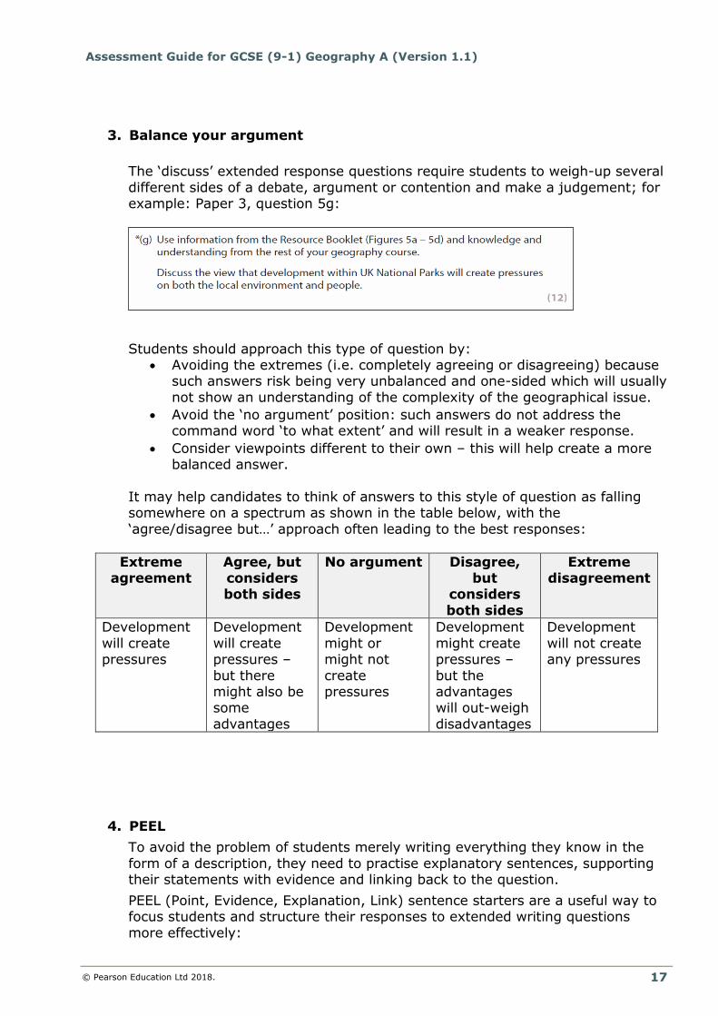
The ‘discuss’ extended response questions require students to weigh-up several
different sides of a debate, argument or contention and make a judgement; for example: Paper 3, question 5g:
Students should approach this type of question by: Avoiding the extremes (i.e. completely agreeing or disagreeing) because
such answers risk being very unbalanced and one-sided which will usually
not show an understanding of the complexity of the geographical issue.
Avoid the ‘no argument’ position: such answers do not address the command word ‘to what extent’ and will result in a weaker response.
Consider viewpoints different to their own – this will help create a more balanced answer.
It may help candidates to think of answers to this style of question as falling somewhere on a spectrum as shown in the table below, with the
‘agree/disagree but…’ approach often leading to the best responses:
Extreme agreement
Agree, but considers both sides
No argument Disagree, but
considers
both sides
Extreme disagreement
Development
will create pressures
Development
will create pressures –
but there might also be some
advantages
Development
might or might not
create pressures
Development
might create pressures –
but the advantages will out-weigh
disadvantages
Development
will not create any pressures
4. PEEL
To avoid the problem of students merely writing everything they know in the
form of a description, they need to practise explanatory sentences, supporting their statements with evidence and linking back to the question.
PEEL (Point, Evidence, Explanation, Link) sentence starters are a useful way to focus students and structure their responses to extended writing questions
more effectively:

Assessment Guide for (9-1) GCSE Geography A (Version 1.1)
© Pearson Education Ltd 2018.
18
Point Evidence Explanation Link
It has been
suggested that…
Figure X clearly shows
…
The trend in Figure
X goes up because ….
With this in mind,
it is evident that …
It is believed that… This is supported by … This shows us that
…
Therefore, it is
evident that …
Some people argue
that…
This is demonstrated by
…
It is clear from this
that ….
All this evidence
demonstrates …
Many people believe that…
Figure X tells us that … This evidence explains that …
This also links to the idea that …
One argument that… Figure X suggests that
…
This means that … This is what I
expected because …
One school of thought is that …
The evidence provided from Figure X suggests
….
This supports my argument because
…
It is clear that …
One of the main
causes/advantages
…
The pattern on Figure X
suggests …
This demonstrates
that …
Therefore, I can
conclude that …
5. Use of a ‘washing line’
This is a useful strategy where a ‘washing line’ is used to arrange factors in order of importance. This is useful for extended response questions that imply that a
range of factors/approaches/solutions need to be considered. This type of approach is useful in terms of planning, organising thoughts and providing a
structure to use when writing the answer. A good example of this is Paper 2, question 4e:
When planning an answer for this type of question, students might consider the possible renewable energy sources
that could be discussed and arrange them on a ‘washing line’ from the most to least suitable in terms of
sustainability. It is inevitable that renewable energy will feature heavily
in the answer, but other energy sources could be considered such as natural gas (the ‘cleanest’ fossil fuel,
widely available and currently low cost).

Assessment Guide for GCSE (9-1) Geography A (Version 1.1)
© Pearson Education Ltd 2018.
19
4. Marking the extended response questions
All extended response questions are marked using a levels-based mark scheme rather than point-marking. The level-based mark schemes used to assess the 8-mark and 12-mark extended-response questions are explicit about the type of response and
skills required.
These mark schemes have two sections:
1. Indicative content: this reflects specific points that a student might make under the relevant assessment objective when answering that question. At the
top of the indicative content section, the AO weightings must be included. In the case of a questions where a resource(s) is used (AO4), the indicative content will be quite prescriptive because it is tied to the geographical information in the
Figure(s) the candidate is asked to study. In the case of the 12-mark ‘discuss’ question on Paper 3, the indicative content is little more than a suggestion,
because students are asked to, “…use the information from the Resource Booklet and knowledge and understanding from the rest of your geography course of study to support your answer”. Indicative content is specific to a
question.
The indicative content is purely a suggestion of the different aspects of the detailed content in the specification that a student may include in a response to

Assessment Guide for (9-1) GCSE Geography A (Version 1.1)
© Pearson Education Ltd 2018.
20
the question - it is entirely possible that a top performing student mentions very few of the points covered by this if they are still able to demonstrate the skills
required by the question and outlined in the level descriptors.
Here is an example from Paper 1 of the SAMs to show how the indicative content section might be used
Question 2a (iv), “Study Figure 2. Examine how physical processes work together in the formation of the spit shown in Figure 2.”
2. Levels descriptors: these detail the AO related skills that a student is expected
to show when answering the question. Level descriptors appear in table format at the end of each mark scheme. They do not change from exam series to exam
series. There’s a consistent approach across questions that test the same assessment objectives and comparable qualities, so you can focus on the geographical skills and understanding rather than mechanics of individual
questions. Answers are marked on the basis of ‘best fit’ i.e. the whole of a student’s answer is considered, and it is then placed in the appropriate level. A

Assessment Guide for GCSE (9-1) Geography A (Version 1.1)
© Pearson Education Ltd 2018.
21
student gaining a Level 3 mark may not have covered every aspect of the Level 3 descriptors but will have demonstrated some aspects of Level 3 quality work
to lift them out of Level 2.
It is important that students have looked at the levels descriptors in the SAMs, or Specimen Papers, and are familiar with their demands and the language used in
them: The levels descriptors make it clear what is required to gain a mark band. Generic responses, not supported by place-based evidence and examples –
or those which fail to make judgements and come to conclusions – may not be able to access the higher bands in the levels descriptors.
Our mark schemes are designed in a similar way at AS and A level too, so students
can see how to progress in their geography studies across the Key Stages. Here is an example to show how the level descriptors are applied, based on the same question as above.

Assessment Guide for (9-1) GCSE Geography A (Version 1.1)
© Pearson Education Ltd 2018.
22
Guidance on interpreting the level descriptors Each level descriptor is linked to an Assessment Objective (see page 34 of the
Specification). Table 8 suggests some practical ways of helping students interpret the levels descriptors:
Assessment Objective
How could a Level 2 student demonstrate this?
How might a Level 3 student demonstrate this?
AO2: Demonstrates
geographical understanding of concepts and
inter-relationships
between how they are used in relation to
places, environments
and processes.
Some use of appropriate geographical terminology.
Several ideas have been clearly described.
Some basic reasons have
been given, but these are undeveloped e.g. ‘The tropical
climate with heavy rain makes deforestation more serious’.
Lacks the use of examples to support their answer and
exemplification used is generalised e.g. ‘Top down developments such as big
dams often displace people’.
Accurate use of geographical
terminology. Developed explanations showing accurate
understanding of relevant processes and
concepts e.g. ‘Heavy rainfall removes the topsoil after
deforestation which makes areas infertile
because the source of nutrients has been removed’.
Use of detailed and accurate place
knowledge (located examples or case studies) to support
their answer e.g. ‘The Three Gorges Dam is
believed to have led to 1.5 million people leaving their homes by
2012, disrupting their economic and social
lives very significantly’.
AO3: Applies knowledge and
understanding to interpret,
analyse and evaluate
geographical information and issues to make
judgements
An imbalanced response, for example may focus mainly on the advantages, strengths
and/or success of something, without considering the other
side of the argument. For ‘Evaluate’ questions,
conclusions/judgements may be made but these are not wholly based upon evidence.
Some use of relevant located examples/case studies to
support arguments.
A balanced, well-developed argument that recognises the complexity of an issue and
considers a range of factors linked to both sides of the
argument. For ‘Evaluate’ questions,
different perspectives are weighted up and a conclusions is reached that is
supported by evidence. Effective use of located
examples or case studies to support evidence used to formulate a conclusion or
judgement.

Assessment Guide for GCSE (9-1) Geography A (Version 1.1)
© Pearson Education Ltd 2018.
23
Table 8
There are a number of misconceptions about levels-based marking that are useful for
centres and their candidates to understand.
1. There are no ‘hidden hurdles’ or ‘golden tickets’ in levels-based mark schemes.
Examiners select whichever levels descriptors best fit the answer in front of them. Answers may not meet all the criteria in one level but, nonetheless, be
best placed in that level. Similarly, an answer that, for example, contains material that satisfies one aspect of, for example, a Level 3 response will not automatically be placed in that level in other aspects of the response do not
meet the other criteria.
AO4: Selects, adapts and uses a
variety of skills and techniques
to investigate questions and
issues, and communicate findings.
Some evidence of use of the resource(s) or the enquiry process that the student has
been asked to study. Some evidence from the
resource(s) or from their own fieldwork has been
extracted and included in their answer.
Answer is supported by the
use of geographical skills and has communicated fieldwork
findings or resource evidence with some clarity using relevant geographical
terminology occasionally. E.g. ‘We interviewed lots of
people but we didn’t have enough time’ or ‘Figure 7 shows that the south of the
UK is much better paid than the north’.
Evidence from the resource(s) and their own fieldwork has been ‘lifted’, but also
manipulated and/or analysed to investigate the issue or
concept. Frequently uses evidence
from the resource(s) and their own fieldwork to add depth to explanations and
make links between geographical theory and the
context used in the question. Addressed all relevant aspects of the enquiry
process and their answer is supported by the use of
geographical skills. Communicated enquiry-specific fieldwork findings
with clarity, and uses relevant geographical
terminology consistently. E.g. ‘We interviewed 40 people although some were
probably interviewed twice. Interviews were rushed as we
only had 40 minutes in the town centre’ or ‘Figure 7 shows that south east
England has by far the highest wages although even
here there are pockets of low wages as in East Kent’.

Assessment Guide for (9-1) GCSE Geography A (Version 1.1)
© Pearson Education Ltd 2018.
24
2. Although the mark schemes divide marks between different AO’s - (AO2 and
AO3 or AO3 and AO4) these are not then point marked within the AO
categories. In other words, making 4 points is not the same as satisfying the level descriptor, which will remain constant for the life of the specification.
3. The indicative content of each levels-based mark scheme is not a definitive list
of everything that candidates might offer but simply an ‘indication’ of the material that they might offer. Some excellent responses may include little or
nothing of the published indicative content. This element of the mark scheme is often amended during the pre-standardisation and standardisation meetings
when actual candidate responses have been discussed. It is also important to note that the language used throughout the mark schemes will not necessarily be that expected from candidates.

Assessment Guide for GCSE (9-1) Geography A (Version 1.1)
© Pearson Education Ltd 2018.
25
5. Examiner marked exemplars with commentaries
NOTE: All of the questions below are taken from the published Specimen Papers.
Paper 1: Question 3b:
Study Figure 4 in the Resource Booklet.
Examine how physical processes and human activities affect the risk of river flooding
in this landscape. (8)
Exemplar answer:
Three large rivers meet at a confluence point on the River Ouse about 6km north of York’s
town centre. There is a high risk of flooding in this area because there is a higher discharge
at this point as the water from these three large rivers are now concentrated at one place, so
there’s suddenly a much higher volume of water. This places the area at particularly high
risk, especially during periods of high rainfall when the discharge from all three rivers
increases and ends up at the confluence, which increases the likelihood of flooding.
The human activity of urbanisation also increases the chances of flooding in this area. Figure
4 states that York has a population of 182 000 and covers 272km2, which suggests that there
will be many roads and houses in this area to meet the needs of the population. These man-
made features are impermeable; therefore, the rainfalls infiltration rates are not going to be
as high compared to rural areas, and surface run-off increases, increasing flood risk – in
particular the risk of flash floods on roads and pavements. Also, increased surface run-off in
the built-up area leads to the water reaching rivers much quicker on the other side of York,
increasing the risk of flooding.
Figure 4 shows that December 2015 was the wettest month on record. This would have
increased the flooding risk as intense, prolonged rainfall would have saturated the ground, so
the water could not infiltrate the soil, again increasing run-off meaning that lag-times will be
shortened, speeding up the rise in water levels of the channel.
In Marston Moor, 10km west of York, there has been a large area of trees removed for crops.
This deforestation increases the risk of flooding as there are fewer leaves and branches to
intercept the rainfall before it hits the ground, therefore it reaches the river much faster.
Examiner commentary:
This a Level 3 answer and was awarded 8 marks in total (4 x AO3 + 4 x AO4):
Frequent links Figure 4 e.g. “it says large areas of trees have been removed” and, “three large rivers join the River Ouse” (AO4).
There is a good range of evidence / reference to specific locations on
the map to support geographical knowledge and understanding (AO4). A number of developed explanations with a clear cause-effect link, with
links to impact on flooding, incorporating physical and human triggers that may increase flood risk (AO3).

Assessment Guide for (9-1) GCSE Geography A (Version 1.1)
© Pearson Education Ltd 2018.
26
Paper 2: Question 2g:
Assess the factors that have influenced the growth of core and peripheral areas within
either a named developing or emerging country. (8)
Exemplar answer:
Named developing or emerging country: Brazil
The concept of ‘core’ and ‘periphery’ is that some areas of a country develop faster because
of more favourable human and physical factors which turn an area into the core and other
areas that lack human and physical advantages become the less important periphery. Core
areas are likely to experience greater growth, investment and net migration gain, while the
peripheries may well be exploited and suffer from lack of investment
Brazil’s ‘core’ is in the south of the country and contains the cities of São Paulo, Rio de
Janeiro and Belo Horizonte. The first reason why this area has developed is because there are
particularly fertile soils and suitable climate for farming, growing coffee beans, around Sao
Paulo which triggered the growth of its international coffee industry. The second factor for the
growth of the core region is that Rio de Janeiro’s geographical location on the east coast,
facing Africa and Europe, meant that it developed a major port allowing trade. This was one
of the most important factors in the growth of the core because this encouraged foreign
direct investment into the area as global businesses and TNCs were attracted by the good
infrastructure (including efficient roads and railways) and Brazil’s governments own
investment in this area. For example, Germany has invested $10 billion into Brazil and there
are over 1000 German companies (e.g. Volkswagen) operating in Brazil’s core region, which
will mean that the gap between core and periphery is likely to get wider in the future.
On the other hand, the west, north and north-east areas of Brazil developed as peripheral
areas mainly because of a lack of investment by the government and from international
businesses and organisations. The reason for this is because these parts of Brazil is the
physical geography is not as favourable to farming – the periphery suffers from rainfall
extremes and dense tropical rainforest which means that cash crops cannot be grown. Linked
to this, these areas are geographically a long way from the core areas and they are difficult
to access due to a lack of ports and roads, which makes trading difficult. Another problem
facing the periphery is that due to a lack of government investment and FDI, many industries
have declined, and many the workforce have migrated to the core area in search of a better
quality of life which has to problems an ageing population and a fall in productivity – making
the gap bigger.
Examiner commentary: This a Level 3 answer and was awarded 8 marks in total (4 x AO2 + 4 x AO3):
The first paragraph shows a clear understanding of what the question is asking (AO2).
The second paragraph includes detailed place-specific information about the Brazil, and this is used to support a range of human and physical factors that have led to
growth of the core (AO3). The third paragraph adds to the ‘balance’ of the response, considering the ‘periphery’ (AO3).
The demand of the command word ‘assess’ is met by weighing up the significance of different factors and identifying which have been most important (AO3).

Assessment Guide for GCSE (9-1) Geography A (Version 1.1)
© Pearson Education Ltd 2018.
27
Paper 1: Question 7e:
Evaluate the different approaches used to manage the threats facing deciduous
woodlands in a named region. (8) + (4 SPAG)
Exemplar answer:
Examiner commentary: This a Level 3 answer and was awarded 12 marks in total (4 x AO2 + 4 x AO3) + 4
SPAG: The first paragraph shows a clear understanding of what the questing is asking
(AO2).
There is detailed place-specific information about the New Forest throughout the response (AO3).
A range of approaches have been included, and links made between the strategy and sustainability have been made (AO3)..
The demand of the command word ‘evaluate’ is met by reflecting on each
approach and coming to a conclusion at the end of the response (AO3).. SPAG: a well-structured response with key terms used appropriately
throughout.
The New Forest is a deciduous woodland in the UK which is facing a number of threats as a
result of deforestation for timber and arable farming and increased urbanisation as the
population grows due to in-migration and natural increase. Another threat caused by
humans is the enhanced greenhouse effect which may lead to warmer winters and drier
summers. These climatic changes can be very damaging to food chains, for example by
delaying seed germination as it is colder for longer periods in winters. Different
approaches are being used to manage these threats in the New Forest, and some have
been more sustainable than others. It is important that approaches are sustainable it is
important to protect the woodland but also the needs of people as tourism is worth over
£500 million each year to the local economy.
Firstly, one approach in the New Forest is to replace all trees that are cut down with trees
that are native to the area, which means that the number of trees is increasing and
therefore the deciduous woodland ecosystem continues to thrive. This is mainly done
during the winter when fewer visitors come to the area and therefore does not have a
negative impact on the local economy.
Another approach has been to manage and plan for the possible negative impacts of
tourism by controlling where the tourists can go and park so that they are kept away from
the most fragile areas and don’t interfere with the local people at work. A good example of
where this has worked is the Wilverley Plain and Inclosure where designated footpaths are
used to keep tourists away from vulnerable areas and they are also given the ‘Five Ways
to Love our Forest’ leaflet which educates them about sustainable tourism. A third
approach has been to provide locals with grants to help improve biodiversity. Local
landowners have been planting native deciduous species and using traditional techniques
such as coppicing which controls tree growth in a sustainable manner without affecting the
ecosystem in a negative way.
Overall, all these management techniques have been effective in managing the deciduous
woodlands in the New Forest as the woodlands are still being used by tourists and for
timber, but in a way that the locals do not damage the woodlands and deforestation is
done in a way that can be sustained well into the future without damaging the woodland ecosystem.
Assessment Guide for (9-1) GCSE Geography A (Version 1.1)
© Pearson Education Ltd 2018.
28
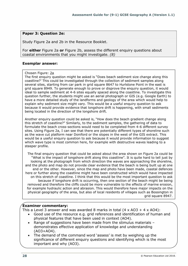
Paper 3: Question 2e:
Study Figure 2a and 2b in the Resource Booklet.
For either Figure 2a or Figure 2b, assess the different enquiry questions about coastal environments that you might investigate. (8)
Exemplar answer:
Examiner commentary: This a Level 3 answer and was awarded 8 marks in total (4 x AO3 + 4 x AO4):
Good use of the resource e.g. grid references and identification of human and
physical features that have been used in context (AO4). Range of suggestions have been made from the stimulus materials –
demonstrates effective application of knowledge and understanding (AO3+AO4).
The demand of the command word ‘assess’ is met by weighing up the
significance of different enquiry questions and identifying which is the most important and why (AO3).
Chosen Figure: 2a
The first enquiry question might be asked is “Does beach sediment size change along this
coastline?’ This could be investigated through the collection of sediment samples along
several sites, starting from car park in grid square 8647 to Hurlstone Point in the east is
grid square 8949. To generate enough to prove or disprove the enquiry question, it would
ideal to sample sediment at 4-6 sites equally spaced along the coastline. To investigate this
question further, the students might use an aerial photograph or GIS (e.g. Google Earth) to
have a more detailed study of the landforms and geology of the area which would help to
explain why sediment size might vary. This would be a useful enquiry question to ask
because it would provide evidence that longshore drift is happening, with small sediments
being located in the direction of the longshore drift.
Another enquiry question could be asked is, “How does the beach gradient change along
this stretch of coastline?” Similarly, to the sediment samples, the gathering of data to
formulate the beach cross-sections would need to be completed from 4-6 different survey
sites. Using Figure 2a, I can see that there are potentially different types of shoreline such
as the wave cut platform near Doniford or the slopes in the west of the GIS extract. This
would be a useful enquiry question to ask because it would provide information to suggest
which wave type is most common here, for example with destructive waves leading to a
steeper profile.
The final enquiry question that could be asked about the area shown on Figure 2a could be
“What is the impact of longshore drift along this coastline”. It is quite hard to tell just by
looking at the photograph from which direction the waves are approaching the shoreline,
and the photo and map do not provide clear evidence that the beach is being built up at one
end or the other. However, since the map and photo have been made, coastal defences
here or further along the coastline might have been constructed which would have impacted
on this stretch of coastline. I think that this would be the most important question to ask
because if longshore drift is occurring, then one section of the beach might be being
removed and therefore the cliffs could be more vulnerable to the effects of marine erosion,
for example hydraulic action and abrasion. This would therefore have major impacts on the
physical geography of the area, but also of local residents of villages such as Bossington in grid square 8947.

Assessment Guide for GCSE (9-1) Geography A (Version 1.1)
© Pearson Education Ltd 2018.
29
Paper 3: Question 3d:
You have studied an urban area as part of your fieldwork.
Evaluate the different techniques used to analyse your fieldwork data. (8)
Exemplar answer:
Examiner commentary: This a Level 3 answer and was awarded 8 marks in total (4 x AO3 + 4 x AO4):
Detailed discussion about a range of techniques, offering evaluative comments about the effectiveness of each one (AO3).
AO4 is very strong, with student’s own fieldwork experiences covered in
detail. The demand of the command word ‘evaluate’ is met by drawing conclusion
about the effectiveness of each approach as part of an on-going reflection (AO3).
I have carried out my primary data collection Leeds as part of my urban fieldwork
investigation. During my day in Leeds, I carried out a range of different fieldwork
methods to find out about how the environmental quality and land use changed across
the city.
One qualitative fieldwork method that I used was a questionnaire designed to collect the
views of 20 people about the quality of the urban environment, such as noise, litter and
street lighting on a scale of 0 to 10 with 10 being the best. The technique that I used to
analyse this data was to input everything onto an excel spreadsheet and then rank all of
the scores so that I could work out the modal score for each category at each of my six
sample sites. On reflection, I do not think that this was the best measure of central
tendency for two reasons. Firstly, there was more than one mode for some of the
categories and secondly, for one of the sites, there was not actually a mode because all
of the numbers for each of the categories were different. Next time, it might be better to
use the mean as this would take every single piece of data into account during the
calculation and gave a figure for each category that I could compare against each sample
site. Nevertheless, I would still have the problem of not being able to discriminate
between visitors and locals when analysing this data to see if there was a variance of
opinion – but this is due to the design of the questionnaire rather than a shortcoming of
this method.
My field sketches to record the land use were difficult to analyse because I only did them
at two of the six sample sites and the weather was really poor whilst I was doing them
and I didn’t have time to add many labels, so I couldn’t really remember exactly what it
was like when I go back to school. Also, most of my labels were focussed on the ground-
floor usage of buildings, ignoring what the second / third floors were like. This meant
that when I did a tally chart to analyse the numbers of different types of land use, the
results were skewed more towards ‘retail’ when there were other uses in the buildings,
such as upstairs cafes or gyms, that were ignored and were therefore omitted from the
analysis. On reflection, I should perhaps had also taken a photo on my phone and added
some annotations immediately which will make for more meaningful analysis back at
school. I would also have done this at all of the six sample sites, rather than just two –
which may have given quite a biased view on land use. If I had carried out sketches at all
6 sites, my analysis would have been more accurate as I would have gained a more representative sample of what the land use was like.