assessment and management of key environmental issues · r5 berwick farm b jarema r6 spring valley...
TRANSCRIPT

ENVIRONMENTAL IMPACT STATEMENT EOE (NO.75) PTY LIMITED
Section 4 – Assessment and Management of Ardlethan Tin Mine
Key Environmental Issues Report No. 754/08
4-1
Section 4
Assessment and
Management of Key
Environmental Issues
PREAMBLE
This section describes the specific environmental features of the Mine Site and its surrounds that would or may be affected during the life of the Ardlethan Tin Mine Rehabilitation and Tailings Reprocessing Project. The proposed design and/or operational safeguards and management measures are presented, followed by an assessment of the predicted level of impact the proposed activities may have after implementation of these measures. Where appropriate, proposed monitoring programs are also described.

EOE (NO.75) PTY LIMITED ENVIRONMENTAL IMPACT STATEMENT
Ardlethan Tin Mine Section 4 – Assessment and Management of
Report No. 754/08 Key Environmental Issues
4-2
This page has intentionally been left blank

ENVIRONMENTAL IMPACT STATEMENT EOE (NO.75) PTY LIMITED
Section 4 – Assessment and Management of Ardlethan Tin Mine
Key Environmental Issues Report No. 754/08
4-3
4.1 ENVIRONMENTAL SETTING
Introduction 4.1.1
The descriptions of various environmental aspects of the Proposal throughout this section are
reliant upon a range of background information common to many of the key environmental
issues. In this subsection, the local setting is described and background information is provided
on the topography, climate, geological setting and land ownership and land uses of the Mine
Site and surrounds. The information presented in this subsection provides a general overview of
the environmental setting of the Mine Site. More specific information in relation to particular
environmental aspects of the Proposal is presented in the following subsections.
Topography and Drainage 4.1.2
Regional Topography and Drainage 4.1.2.1
The Mine Site is located in an area of generally flat topography which slopes gently to the
southeast towards the Murrumbidgee River, with occasional localised hills and ridges
(Figure 4.1). Maximum elevations include
360m AHD at the Bygoo Hills, approximately 6km to the northeast of the Mine
Site;
399m AHD at Bolero Mountain, approximately 5km north-northwest of the Mine
Site; and
400m AHD at the Colinroobie Hills, approximately 25km southwest of the Mine
Site (Figure 4.1).
The Mine Site is located within the Murrumbidgee Catchment which drains an area of
approximately 84 000km2 within the Murray-Darling Basin. The Murrumbidgee River
headwaters are situated in the Monaro Plains near Cooma, NSW and the river travels
approximately 1 600km west to its junction with the Murray River near Balranald, Victoria. A
number of hydraulic controls have been constructed within the Murrumbidgee system with
Blowering Dam on the Tumut River (1 628GL capacity) and Burrinjuck Dam on the
Murrumbidgee River (1 026GL capacity) the two largest.
Local Topography and Drainage 4.1.2.2
Locally, the Mine Site occupies an area of elevated topography, with Taylors Hill in the
southern section of the Mine Site rising to an elevation of approximately 355m AHD
(Figure 4.2). The surrounding land typically has elevations of between 200m AHD and
260m AHD.
Local drainage consists of scattered indistinct watercourses converging on Bolaro and Mirrool
Creeks, approximately 4km south of the Mine Site (Figures 4.1 and 4.2). These creeks flow in
a westerly direction before dissipating into flat land approximately 25km to the west of the
Mine Site. The prevailing land use in the region is associated with agricultural and horticultural
activity and this has led to the construction of a number of farm dams in the surrounding region
that opportunistically capture overland flow for farm use.

EOE (NO.75) PTY LIMITED ENVIRONMENTAL IMPACT STATEMENT
Ardlethan Tin Mine Section 4 – Assessment and Management of
Report No. 754/08 Key Environmental Issues
4-4
Figure 4.1 Regional Topography and Drainage
A4 Colour / portrait
Figure dated 20/12/16 and inserted 20/12/16

ENVIRONMENTAL IMPACT STATEMENT EOE (NO.75) PTY LIMITED
Section 4 – Assessment and Management of Ardlethan Tin Mine
Key Environmental Issues Report No. 754/08
4-5
Figure 4.2 Local Topography and Drainage
A4 colour / portrait
Figure dated 7/12/16 and inserted 20/12/16

EOE (NO.75) PTY LIMITED ENVIRONMENTAL IMPACT STATEMENT
Ardlethan Tin Mine Section 4 – Assessment and Management of
Report No. 754/08 Key Environmental Issues
4-6
Mine Site Topography and Drainage 4.1.2.3
Historic mining activity has significantly influenced topography and drainage features of the
Mine Site (Figure 4.3). The maximum elevation is approximately 315m AHD on the Main
Waste Rock Emplacement. Three open cuts exist, the Ardwest/Wild Cherry, While Crystal and
Stackpool Open Cuts. The largest of these, the Ardwest/Wild Cherry Open Cut has a minimum
elevation of approximately 124m AHD or approximately 150m below the natural surface. The
smaller White Crystal Open cut has been partially backfilled with tailings and with a minimum
elevation of 255m AHD is only 5m lower than the invert of the open cut at 260m AHD. Two
Tailings Storage Facilities exist within the Mine Site, with the Main Tailings Storage Facility
having a surface elevation between 310 AHD and 270m AHD.
Surface water drainage within the Mine Site is described in detail in Section 4.2.2.1.
Climate 4.1.3
Introduction and Data Sources 4.1.3.1
Meteorological conditions have the potential to influence a range of Proposal-related impacts
on surrounding residences and the environment. This subsection provides a brief overview of
the meteorological conditions surrounding the Mine Site; focusing particularly on those aspects
of the climate that are likely to influence the potential Proposal-related environmental impacts.
Climate data has been sourced from the following Bureau of Meteorology (BoM) weather
stations.
Ardlethan Post Station (BoM ID 074000), situated approximately 5km southeast
of the Mine Site – 1909 to present. Temperature data for this station is not
continuous after 1975.
Yanco Agricultural Institute (BoM ID 074037) – situated approximately 55km
southwest of the Mine Site.
Temora Research Station (BoM ID 073038) – situated approximately 65km
southeast of the Mine Site.
Climate data sourced from the above stations is presented in Table 4.1.
Temperature 4.1.3.2
January is typically the hottest month, with an average maximum temperature of 33.8ºC. July is
the coldest month with a mean maximum temperature of 14.3°C and a mean minimum
temperature of 5.0°C.

ENVIRONMENTAL IMPACT STATEMENT EOE (NO.75) PTY LIMITED
Section 4 – Assessment and Management of Ardlethan Tin Mine
Key Environmental Issues Report No. 754/08
4-7
Figure 4.3 Mine Site Topography and Drainage
A4 colour portrait
Figure dated 20/12/16 and inserted 20/12/16

EOE (NO.75) PTY LIMITED ENVIRONMENTAL IMPACT STATEMENT
Ardlethan Tin Mine Section 4 – Assessment and Management of
Report No. 754/08 Key Environmental Issues
4-8
Table 4.1
Climate Data
Jan Feb Mar April May June July Aug Sept Oct Nov Dec Annual
Temperature (C°) – Yanco Agricultural Institute (BoM ID 074037) (1999 to present)
Mean maximum temperature
33.8 32.4 28.8 24.2 19.0 15.1 14.3 16.3 20.4 24.9 28.9 31.0 24.1
Mean minimum temperature
18.8 18.5 15.3 11.7 7.8 5.9 5.0 5.4 7.7 10.5 14.4 16.3 11.4
Rainfall (mm) – Ardlethan Post Office (BoM ID 074000) (1909 – present)
Mean rainfall 42.7 39.9 37.9 35.5 39.7 42.5 42.3 42.2 38.9 43.9 39.7 37.0 486.8
Highest rainfall 229.0 219.6 195.2 155.4 143.9 177.4 121.3 101.0 148.8 141.2 184.0 172.0 863.9
Lowest rainfall 0 0 0 0 0 0.6 2.0 3.3 1.0 0 0 0 184.9
Highest daily rainfall 99.2 122.9 106.4 50.8 50.8 49.5 46.0 41.4 60.7 49.0 83.6 75.4 122.9
Evaporation (mm) – Temora Research Station (BoM ID 073038) (1978 to 2011)
Mean daily evaporation 8.7 7.8 5.9 3.6 2.0 1.2 1.3 1.8 2.9 4.4 6.5 7.9 4.5
Rainfall 4.1.3.3
Rainfall data has been recorded at the Ardlethan Post Office since 1909. Mean annual rainfall is
486.8mm, with rainfall evenly distributed throughout the year ranging between 43.9mm and
35.5mm falling on average each month (Table 4.1). The driest year on record was 1967 when
184.9mm of rain was recorded. By contrast, the wettest year on record was 1956 when
863.9mm of rain was recorded.
The maximum daily rainfall recorded is 122.9mm which was recorded on 17 February 1928.
Maximum daily rainfall exceeds monthly average rainfall for all months, with the exception of
August, indicating that high intensity storms with significant rainfall over a relatively short
duration may occur, particularly in the summer months.
Evaporation 4.1.3.4
Mean evaporation at the Temora Research Station throughout the year is 4.5mm per day or 1
642mm per year. Mean daily evaporation varies between 1.2mm per day in June and 8.7mm per
day in January. Based on the mean daily evaporation, the calculated mean monthly pan
evaporation is greater than mean monthly rainfall in all months with the exception of June.
Wind Speed and Direction 4.1.3.5
Pacific Environment Limited (PEL) (2016) reviewed local wind data sources and established
that limited information was available close to the Mine Site. In the absence of this data,
PEL (2016) generated wind data using The Air Pollution Model (TAPM), a three dimensional
meteorological and air pollution modelling code developed by the CSIRO.
The annual and seasonal wind roses compiled by TAPM for the local setting are presented as
representative wind roses on Figure 4.4. In summary, winds on an annual basis are
predominantly from the southwest and the northeast. Seasonally, winds from the southwest
feature during autumn and winter whilst in summer, winds from the northeast prevail in
summer with spring generally reflecting the annual pattern. The annual average wind speed
generated from TAPM was estimated to be approximately 3.3m/s.

ENVIRONMENTAL IMPACT STATEMENT EOE (NO.75) PTY LIMITED
Section 4 – Assessment and Management of Ardlethan Tin Mine
Key Environmental Issues Report No. 754/08
4-9
Figure 4.4 TAPM - generated Wind Roses
A4 colour / Portrait
Figure dated 7/12/16 and inserted 20/12/16

EOE (NO.75) PTY LIMITED ENVIRONMENTAL IMPACT STATEMENT
Ardlethan Tin Mine Section 4 – Assessment and Management of
Report No. 754/08 Key Environmental Issues
4-10
Regional and Mine Site Geology 4.1.4
The following description of the regional and Mine Site geology has been drawn from Pitt and
Sherry (2016).
The Mine Site is in the western section of the Lachlan Fold Belt[1]
within the Wagga
Anticlinorial Zone. The oldest rocks are Upper Ordovician clastic sedimentary rocks which
have been tightly folded in a north to north-northwest trend, and undergone low-grade regional
metamorphism.
The Upper Ordovician sediments have been intruded by two types of Upper granitic rocks,
namely:
the Kikoira or Mine Granite (approximately 417 million years old); and
the Ardlethan Granite (approximately 410 million years old) (Figure 4.5).
During the Quaternary and Tertiary Periods, erosion produced cassiterite-bearing alluvial
deposits emanating from the subdued uplands around the mine site.
Land Ownership, Residences and Land Use 4.1.5
Land Ownership 4.1.5.1
Figure 4.6 presents the existing land ownership and residences surrounding the Mine Site. In
summary, land within the Mine Site is largely owned by the Applicant, with small sections of
land being Crown Land or road reserves and land owned by BJ, RJ and JC Rush and NG and
KC Morris.
Residences 4.1.5.2
Sensitive receivers, such as residences have been identified surrounding the Mine Site
(Figure 4.6) and classified as being occupied, unoccupied or uninhabitable.
Table 4.2 identifies the residence identifiers used in this report, the property name and
registered landowner.
Table 4.2
Surrounding Land Ownership and Residences
Identifier Property Landowner
R1 Clonmel B.J, R.J and J.C Rush
R2 Bungalong N.G and K.C Morris
R3 Glenmore B.J, R.J and J.C Rush
R4 Coo-I-Noo B.D Rayment
R5 Berwick Farm B Jarema
R6 Spring Valley W.S and B.J Wood
R7 Brooklyn Estate of L.W Spencer
R8 Mona Leigh G Carney
R9 Hillview B Jarema
[1]
The Lachlan Fold Belt or Geosyncline is a large geological terrain stretching from
Tasmania to Queensland along the eastern portion of the Australian continent. It is composed of folded and faulted rocks of Middle Palaeozoic age (450 to 340 million years ago)

ENVIRONMENTAL IMPACT STATEMENT EOE (NO.75) PTY LIMITED
Section 4 – Assessment and Management of Ardlethan Tin Mine
Key Environmental Issues Report No. 754/08
4-11
Source: Pitt and Sherry (2016) – Figure 3
Figure 4.5
REGIONAL GEOLOGY

EOE (NO.75) PTY LIMITED ENVIRONMENTAL IMPACT STATEMENT
Ardlethan Tin Mine Section 4 – Assessment and Management of
Report No. 754/08 Key Environmental Issues
4-12
Figure 4.6 Land Ownership and Residences
A4 colour / Portrait
Figure dated 1/12/16 and inserted 20/12/16

ENVIRONMENTAL IMPACT STATEMENT EOE (NO.75) PTY LIMITED
Section 4 – Assessment and Management of Ardlethan Tin Mine
Key Environmental Issues Report No. 754/08
4-13
Surrounding Land Use 4.1.5.3
Land uses surrounding the Project Site include the following (Figure 4.7).
Agriculture – principally grazing and cropping and some areas of rural residential
(Zone RU4) to the south and east of the Mine Site.
Village residential – the Ardlethan village is located approximately 5km to the
southeast of the Mine Site.
Transport – Road and railway infrastructure exist in the vicinity of the Mine Site,
with the Newell Highway and Burley Griffin Way and the Temora – Hilston
Railway top the south and east of the Mine Site.
A bulk grain handling and rail loading facility operated by Graincorp Operations Limited is
located approximately 4km southeast of the Mine Site.
4.2 SURFACE WATER
Introduction 4.2.1
The SEARs require the EIS to include an assessment of the potential impacts of the Proposal on
water which include the following requirements relevant to the assessment of surface water
resources:
an annual site water balance for representative years over the life of the
development and demonstration that sufficient water supplies would be available
to meet operational requirements;
identification of any licensing requirements or other approvals required;
an assessment of activities that could cause erosion or sedimentation issues, and
the proposed measures to prevent or control these impacts;
an assessment of the likely impacts of the development on the quality and quantity
of surface water resources;
a description of the proposed water management system, water monitoring
program and other measures to mitigate surface water impacts and
an assessment of the likely impacts of the potential downstream impacts from
surface water runoff.
DPI – Water and EPA also identified water related matters for consideration within the EIS.
The SEARs and requirements of DPI – Water and EPA are included in full as Appendix 2.
A surface water impact assessment for the Proposal has been undertaken by RW Corkery & Co
Pty Limited. The full report is presented as Appendix 4 and is hereafter referred to as
RWC (2016). This subsection provides an overview of the existing surface water environment,
licencing issues and potential surface water impacts, management and mitigation measures that
would be implemented and an assessment of the adequacy of existing site infrastructure to
contain sediment-laden or contaminated surface water on site. Section 2.7 presents an overview
of the results of the water balance presented in RWC (2016).

EOE (NO.75) PTY LIMITED ENVIRONMENTAL IMPACT STATEMENT
Ardlethan Tin Mine Section 4 – Assessment and Management of
Report No. 754/08 Key Environmental Issues
4-14
Figure 4.7 Surrounding Land Uses and Zoning
A4 colour / Portrait
Figure dated 20/12/16 and inserted 20/12/16

ENVIRONMENTAL IMPACT STATEMENT EOE (NO.75) PTY LIMITED
Section 4 – Assessment and Management of Ardlethan Tin Mine
Key Environmental Issues Report No. 754/08
4-15
Existing Surface Water Environment 4.2.2
Drainage and Catchments 4.2.2.1
Regional, local and Mine Site drainage is described in Section 4.1.2 and Figures 4.1, 4.2
and 4.3. In summary, the Mine Site is located within the Mirrool Creek catchment of the
Murrumbidgee River. Historic site water management infrastructure has created a number of
catchments on the Mine Site that drain to internal water storages or open cuts, capturing all
runoff generated on disturbed catchments. The Mine Site catchments include the following.
Spring Valley Freshwater Dam: Situated in the southwestern section of the Mine
Site. This catchment collects runoff from Spring Valley tailings storage facility
and naturally vegetated granite hills via overland flow.
Mill Reclaim Dam: Centrally located within the Mine Site. This catchment
collects runoff from Main, Lower and Horseshoe Tailings Storage Facilities as
well as the former processing plant area via overland flow and pipes. Captured
runoff is collected in the dam and discharged under gravity to the Ardwest/Wild
Cherry Open Cut via pipe.
Processing Plant Area Catchment: Situated in the eastern section of the Mine Site.
This catchment collects runoff from the area surrounding the proposed processing
plant area.
Ardwest/Wild Cherry Open Cut: Located in the central north section of the Mine
Site. This catchment collects runoff from cleared areas and the southern face of
the Main Waste Rock Emplacement via overland flow. Captured runoff and direct
rainfall is stored in the Ardwest/Wild Cherry Open Cut.
White Crystal Open Cut: Located in the eastern section of the Mine Site. This
catchment collects runoff from a waste rock emplacement and former open cut via
overland flow.
Stackpool Open Cut: Located in the eastern section of the Mine Site. This
catchment collects runoff from a waste rock emplacement and naturally vegetated
areas via overland flow. Runoff is directed to Stackpool Open Cut via perimeter
drain and overland flow.
Eastern Evaporation Ponds: Located in the northeastern section of the Mine Site.
This catchment collects runoff from a waste rock emplacement and cleared area
via overland flow. Runoff directed to evaporation ponds for natural attenuation.
Northern Evaporation Ponds: Located in the northern section of the Mine Site.
This catchment collects runoff from a waste rock emplacement and cleared area
via overland flow and open channel. Runoff directed to sequential evaporation
ponds for natural attenuation.
Water Quality 4.2.2.2
Water quality data collected at DPI-Water monitoring station 4100093 (Old Man Creek) 64km
south of the Mine Site (Figure 4.1) was reviewed to establish likely water quality in
Murrumbidgee River tributaries similar to Bolaro and Mirrool Creeks. In summary, data from
EOE (NO.75) PTY LIMITED ENVIRONMENTAL IMPACT STATEMENT
Ardlethan Tin Mine Section 4 – Assessment and Management of
Report No. 754/08 Key Environmental Issues
4-16
that station for the period 22 July 1976 to 30 November 2016 indicated that the 75th
percentile
electrical conductivity is 212µS/cm. This is within the desired range of the water quality
objective (35µS/cm to 350µS/cm) for uncontrolled streams in the Murrumbidgee River and
Lake George catchment (DECCW, 2006).
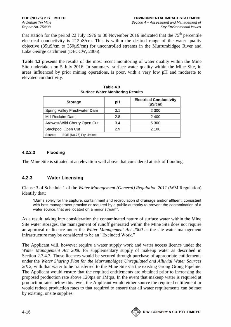
Table 4.3 presents the results of the most recent monitoring of water quality within the Mine
Site undertaken on 5 July 2016. In summary, surface water quality within the Mine Site, in
areas influenced by prior mining operations, is poor, with a very low pH and moderate to
elevated conductivity.
Table 4.3
Surface Water Monitoring Results
Storage pH Electrical Conductivity
(µS/cm)
Spring Valley Freshwater Dam 3.1 2 300
Mill Reclaim Dam 2.8 2 400
Ardwest/Wild Cherry Open Cut 3.4 5 300
Stackpool Open Cut 2.9 2 100
Source: EOE (No.75) Pty Limited
Flooding 4.2.2.3
The Mine Site is situated at an elevation well above that considered at risk of flooding.
Water Licensing 4.2.3
Clause 3 of Schedule 1 of the Water Management (General) Regulation 2011 (WM Regulation)
identify that;
“Dams solely for the capture, containment and recirculation of drainage and/or effluent, consistent with best management practice or required by a public authority to prevent the contamination of a water source, that are located on a minor stream”.
As a result, taking into consideration the contaminated nature of surface water within the Mine
Site water storages, the management of runoff generated within the Mine Site does not require
an approval or licence under the Water Management Act 2000 as the site water management
infrastructure may be considered to be an “Excluded Work.”
The Applicant will, however require a water supply work and water access licence under the
Water Management Act 2000 for supplementary supply of makeup water as described in
Section 2.7.4.7. Those licences would be secured through purchase of appropriate entitlements
under the Water Sharing Plan for the Murrumbidgee Unregulated and Alluvial Water Sources
2012, with that water to be transferred to the Mine Site via the existing Grong Grong Pipeline.
The Applicant would ensure that the required entitlements are obtained prior to increasing the
proposed production rate above 120tpa or 1Mtpa. In the event that makeup water is required at
production rates below this level, the Applicant would either source the required entitlement or
would reduce production rates to that required to ensure that all water requirements can be met
by existing, onsite supplies.

ENVIRONMENTAL IMPACT STATEMENT EOE (NO.75) PTY LIMITED
Section 4 – Assessment and Management of Ardlethan Tin Mine
Key Environmental Issues Report No. 754/08
4-17
Potential Impacts 4.2.4
The potential sources of water pollution from the activities within the Mine Site would be as
follows.
Runoff from Tailings Storage Facilities.
Runoff from historically disturbed catchments.
Runoff from tailings stockpiled for reprocessing.
Runoff from roads and hardstand surfaces.
Surface runoff from rehabilitated areas prior to full stabilisation.
Leakage or spillage of hydrocarbons.
As identified in Section 4.2.2.2 surface water from disturbed sections of the Mine Site typically
has a low pH and moderate electrical conductivity. These waters may also contain suspended
sediment. As a result, discharge of these waters is likely to be the major source of surface water
pollution arising from the Proposal.
Management and Mitigation Measures 4.2.5
The Applicant would implement the following management and mitigation measures to
minimise the potential for offsite discharge of surface water.
Ensure that during operations, existing surface water controls, including perimeter
drains and pipes and inlets are inspected monthly and following significant rain
events (>10mm in 24 hours) and maintained as required to ensure that the
hydraulic performance of the site water management system is maintained.
Ensure that water levels within the Spring Valley Fresh Water Dam are kept as
low as possible to minimise the potential for discharge and to minimise the
surface area available for evaporation.
Ensure that the inlet for the transfer pipeline from the Mill Reclaim Dam to the
Ardwest/Wild Cherry Open Cut is kept clear of debris and that flow into the
pipeline is not restricted.
Ensure that rehabilitated areas are removed from the contaminated water circuit
once monitoring indicates that surface water runoff is suitable for discharge to
natural drainage.
Prepare and implement a Water Management Plan describing the management
and mitigation measures and monitoring to be implemented to ensure that
sediment-laden and contaminated water is retained on site.
Assessment of Impacts 4.2.6
As described in Section 4.2.2.1, all potentially sediment-laden and contaminated water is
captured on site and directed to either the Spring Valley Fresh Water Dam or the Ardwest/Wild
Cherry or Stackpool Open Cuts. The Applicant is not aware of any potentially sediment-laden

EOE (NO.75) PTY LIMITED ENVIRONMENTAL IMPACT STATEMENT
Ardlethan Tin Mine Section 4 – Assessment and Management of
Report No. 754/08 Key Environmental Issues
4-18
or contaminated water being discharged from the Mine Site. RWC (2016) presents assessment
of the hydraulic performance of the existing Mine Site water management infrastructure in
response to a 1% Annual Exceedance Probability (AEP) rainfall event. In summary, that
assessment relied on the following empirical methods.
Estimation of Peak Flow: Rational Method.
Open Channel Capacity: Manning’s formula.
Pipe Capacity: Hazen-Williams equation.
That assessment determined the following.
Spring Valley Catchment - The Spring Valley Fresh Water Dam has adequate
capacity to store a 1% AEP rainfall event without discharging.
Mill Reclaim Catchment – the Mill Reclaim Dam and associated discharge pipe to
the Ardwest/Wild Cherry Open Cut have sufficient capacity to retain and transfer
all surface water from a 1% AEP rainfall event from this catchment to the
Ardwest/Wild Cherry Open Cut.
Ardwest/Wild Cherry Open Cut Catchment – the Ardwest/Wild Cherry Open Cut
has adequate capacity to store a 1% AEP rainfall event from the Mill Reclaim and
Stackpool Catchments, as well rainfall within the open cut catchment, including
once the open cut has been filled with tailings.
Stackpool Open Cut Catchment – The Stackpool contaminated water channel has
adequate capacity to transfer water from a 1% AEP rainfall event to the Stackpool
Open Cut.
As a result, RWC (2016) concludes that the Mine Site infrastructure is adequate to retain all
potentially sediment-laden and contaminated water up to a 1% AEP rainfall event within the
Mine Site until the footprints of the tailings storage facilities have been rehabilitated and
surface water flows can be directed off site.
Monitoring 4.2.7
The Applicant would undertake monitoring of pH, electrical conductivity and water levels
within the following water storages.
Spring Valley Fresh Water Dam.
Mill Reclaim Dam.
Processing Plant Detention Pond.
Ardwest/Wild Cherry Open Cut.
Stackpool Open Cut.
Monitoring would be undertaken monthly during operations using a hand held meter. The
results of the monitoring program would be included in internal monthly reporting and in
Annual Reviews/Reports. The Annual Reviews/Reports would once accepted by the relevant
government agencies, be published on the Applicant’s website.

ENVIRONMENTAL IMPACT STATEMENT EOE (NO.75) PTY LIMITED
Section 4 – Assessment and Management of Ardlethan Tin Mine
Key Environmental Issues Report No. 754/08
4-19
4.3 GROUNDWATER
Introduction 4.3.1
The SEARs require the EIS to include an assessment of the potential impacts of the Proposal on
water which include the following requirements relevant to the assessment of groundwater
resources:
identification of any licensing requirements or other approvals required
an assessment of the likely impacts of the development on the quality and quantity
of groundwater resources; and
a description of the proposed water management system, water monitoring
program and other measures to mitigate groundwater impacts.
As noted in Section 3.2.1.2, DPI – Water and EPA also identified water related matters for
consideration within the EIS. The SEARs and requirements of DPI – Water and EPA are
included in full as Appendix 2.
Pitt and Sherry (Operations) Pty Ltd (Pitt and Sherry) have prepared a groundwater impact
assessment for the Proposal. The resulting report, referred to hereafter as Pitt and Sherry
(2016), is presented as Part 1 of the Specialist Consultant Studies Compendium. The following
sub-sections consider the existing groundwater environment, the proposed groundwater bores,
proposed management and mitigation measures and present an assessment of groundwater-
related impacts.
Existing Groundwater Environment 4.3.2
Introduction 4.3.2.1
Geologically, the Mine Site is situated within the Wagga Anticlinorial Zone of the Lachlan Fold
Belt which is comprised (in part) of tightly folded clastic sedimentary rocks that have
undergone low-grade regional metamorphism (Paterson, 1990). The groundwater resources in
the vicinity of the Mine Site are covered by the Water Sharing Plan Murray-Darling Basin
Fractured Rock Groundwater Sources: Lachlan Fold Belt Groundwater Source 2012.
Regional Groundwater System 4.3.2.2
Pitt and Sherry (2016) conducted a search of the Department of Primary Industries – Water
Registered Groundwater Bore database in September 2016 for bores surrounding the Mine Site.
That search revealed 40 registered groundwater bores within a 1,000km2 area centred on the
Mine Site, of which 13 occur within 10km of the Mine Site (Figure 4.8). A review of pertinent
information relating to the bores indicated the following
The average total depth is 79m (range: 8m to 218m).
The underlying geology varied, and included limestone, granite and
unconsolidated sediments.
Limited groundwater occurrence was recorded (18 or 45% of the 40 bores
registered).

EOE (NO.75) PTY LIMITED ENVIRONMENTAL IMPACT STATEMENT
Ardlethan Tin Mine Section 4 – Assessment and Management of
Report No. 754/08 Key Environmental Issues
4-20
Figure 4.8 Registered Bores in the Vicinity of the Mine Site
A4 colour / Portrait
Figure dated 20/12/16 and inserted on 20/12/16

ENVIRONMENTAL IMPACT STATEMENT EOE (NO.75) PTY LIMITED
Section 4 – Assessment and Management of Ardlethan Tin Mine
Key Environmental Issues Report No. 754/08
4-21
The average reported standing water level in 16 of the 18 bores was 55m below
ground (mbg) and ranged from 3mbg to 72mbg. The remaining two bores did not
have a reported standing water level.
Bore yields averaged 0.7L/s (range 0.01L/s to 5L/s). Only one bore yield
exceeded 1.5L/s, namely GW416109 with a recorded yield of 5L/s (Figure 4.8),
and if this outlier is excluded from the data, the average yield is 0.4L/s.
Of the five registered bores within 4km of the Mine Site, four have casing
diameters of 50mm, indicating that they are monitoring bores, and one,
GW000462, has had the casing withdrawn. As a result, there are no known
groundwater users within a radius of at least 4km of the Mine Site.
Pitt and Sherry (2016) indicated that, based on the review of the regional groundwater bore
inventory, the regional groundwater system is typically an unconfined fractured rock system
overlain in part by unconsolidated alluvial aquifers. The reviewed low groundwater yields,
coupled with the paucity of groundwater bores over a wide area suggests low groundwater
prospectivity in the region.
Mine Site Groundwater System 4.3.2.3
Pitt and Sherry (2016) reviewed historical mine documents, environmental and geotechnical
investigations. The following observations of relevance to the groundwater impact assessment
were made.
During open cut and underground mining, no major aquifers were encountered.
Groundwater was not recorded during production drilling within the
Ardwest/Wild Cherry Open Cut.
Water pumped from the underground workings averaged less than 2L/s.
Areas exposed by mining such as the open cut wall remained dry for the life of the
mine.
Blasting of wall rocks had no observable effect on water inflow into the open cuts.
The results of falling head permeability tests conducted on 11 bores within the
Mine Site (BH01 to BH09, P581 and P585 – Figure 4.9) returned permeabilities
between 5 x 10⁻¹⁰
m/s to 4 x 10⁻⁹
m/s, with a geometric mean of 1 x 10⁻⁹
m/s. It is
noted that many of these bores tested were situated downgradient of water storage
or collection dams within the Mine Site.
Groundwater Quality 4.3.2.4
Regional Groundwater Quality
Pitt and Sherry (2016) indicated that, based on the review of the regional groundwater bore
inventory, the groundwater quality was variable with Total Dissolved Solids (TDS) ranging
between 1 000mg/L and 14 000mg/L. It is noted however, that water quality information was
available for only 4 out of the total of 40 groundwater bore records reviewed.

EOE (NO.75) PTY LIMITED ENVIRONMENTAL IMPACT STATEMENT
Ardlethan Tin Mine Section 4 – Assessment and Management of
Report No. 754/08 Key Environmental Issues
4-22
Figure 4.9 Historic and Current Mine Site Groundwater Monitoring Bores
A4 colour / Portrait
Figure dated 19/12/16 and inserted on 20/12/16

ENVIRONMENTAL IMPACT STATEMENT EOE (NO.75) PTY LIMITED
Section 4 – Assessment and Management of Ardlethan Tin Mine
Key Environmental Issues Report No. 754/08
4-23
Mine Site Groundwater Quality
Pitt and Sherry (2016) reviewed historic groundwater quality monitoring data from the Mine
Site collected between 1995 and 2011, as well as data collected in November 2016 which
included sampling of the pit lake in the Ardwest\Wild Cherry Open Cut. That data indicated the
following (Table 4.4).
pH of groundwater in all bore holes was near neutral. However, pH of water
within the Ardwest/Wild Cherry Open Cut was strongly acidic.
The salinity of groundwater in BH1, BH5, BH9 and the Ardwest\Wild Cherry
Open Cut was elevated with the salinity of water in BH9 increasing markedly,
potentially reflecting the fact that this bore is associated with the Northern
Evaporation Ponds.
Groundwater sampled in BH9 (sodium chloride), near the Northern evaporation
ponds exhibits a different chemical signature (major ion chemistry) to BH 1
(sodium sulphate) and the Ardwest\Wild Cherry Open Cut (sodium, magnesium,
sulphate and chloride) which may indicate a lack of connectivity with the
Ardwest\Wild Cherry Open Cut.
Table 4.4
Groundwater Monitoring Results: 1995 and 2016
Groundwater Monitoring Bore ID
pH Total Dissolved Solids (mg/L)
1995 2016 1995 2016
BH 1 No data 6.7 No data 6 100
BH 3 7.4 No data 1 060 No data
BH 5 7.4 6.2 3 240 7 000
BH 9 7.1 5.9 1 290 21 000
Ardwest/Wild Cherry Open Cut No data 3.1 No data 4 200
Source: Pitt and Sherry (2016) – after Tables 2 and 4
Surface Water and Groundwater Interaction 4.3.2.5
The main zone of interaction between surface water and groundwater with the Mine Site is the
Ardwest/Wild Cherry Open Cut. Pitt and Sherry (2016) applied steady-state analytical
equations (Marinelli and Niccoli, 2000) to estimate groundwater flow to the Ardwest/Wild
Cherry Open Cut that indicated that the Ardwest/Wild Cherry Open Cut is a groundwater
discharge zone on the local scale. Groundwater is flowing towards the Ardwest/Wild Cherry
Open Cut from all directions. The steady-state calculations indicate that approximately
20ML/year of groundwater enters the Ardwest/Wild Cherry Open Cut. Figure 4.10 displays a
cross section illustrating the conceptual hydrogeological model developed by Pitt and
Sherry (2016).

EOE (NO.75) PTY LIMITED ENVIRONMENTAL IMPACT STATEMENT
Ardlethan Tin Mine Section 4 – Assessment and Management of
Report No. 754/08 Key Environmental Issues
4-24
Figure 4.10 Conceptual Hydro-geological Cross Section
A4 colour / Portrait
Figure dated 20/12/16 and inserted on 20/12/16

ENVIRONMENTAL IMPACT STATEMENT EOE (NO.75) PTY LIMITED
Section 4 – Assessment and Management of Ardlethan Tin Mine
Key Environmental Issues Report No. 754/08
4-25
Classification Under the Aquifer Interference Policy 4.3.2.6
Based on the above, Pitt and Sherry (2016) note that:
groundwater quality measurements indicate that total dissolved solids in the
vicinity of the Mine Site are greater than 1 500mg/L; and,
there are no groundwater registered supply works yielding water at a flow rate
greater than 5L/second.
As a result, and in accordance with the Aquifer Interference Policy 2012 (AIP), Pitt and Sherry
(2016) classified the groundwater source in the Mine Site as being a less productive porous or
fractured rock aquifer.
Assessment Methodology 4.3.3
Introduction 4.3.3.1
Pitt and Sherry (2016) undertook an assessment of groundwater-related impacts associated with
the Proposal as follows.
A conceptual model of groundwater processes within the Mine Site was
established based on available groundwater and geochemical data.
An analytical model was used to quantify groundwater impacts within the Mine
Site.
This subsection provides an overview of each of the above assessment methodologies.
Conceptual Model 4.3.3.2
In order to facilitate an assessment of the anticipated groundwater-related impacts associated
with the Proposal, Pitt and Sherry (2016) developed a conceptual hydrogeological model based
on the information reviewed (Figure 4.10). The main features of the groundwater system that
were identified from this model were as follows.
The Mine Site is situated on elevated, undulating and locally disturbed
topographic high, and surrounded by a gently undulating to flat plain.
Groundwater on the Mine Site is contained within a single unconfined, fractured
rock aquifer.
Unconfined alluvial aquifers are located in the surrounding plains to the southeast,
east and northeast of the topographic high.
Regional-scale groundwater flow occurs beneath the topographic high from the
northeast to the southwest.
Intermediate-scale groundwater flow radiates in all directions from the
topographic high, but at very low rates of movement in bedrock due to very low
fracture permeability.

EOE (NO.75) PTY LIMITED ENVIRONMENTAL IMPACT STATEMENT
Ardlethan Tin Mine Section 4 – Assessment and Management of
Report No. 754/08 Key Environmental Issues
4-26
Local-scale groundwater occurs with variable flow directions, except in the
vicinity of the Ardwest/Wild Cherry Open Cut, where groundwater enters from all
horizontal directions with a radius of influence of approximately 350m.
The water surface of the Ardwest/Wild Cherry Open Cut forms a groundwater outflow zone;
which would ordinarily constitute conditions supporting a groundwater dependent ecosystem
(GDE), except that there are no known GDE to support within the pit lake. All other discharge
areas are considered to be localised.
Numerical Model 4.3.3.3
Pitt and Sherry (2016) developed a regional and intermediate scale numerical groundwater flow
model based on water level data in two bores north and south of the Mine Site, namely
GW4022126 and GW0000720 (refer Figure 4.8), and water level records of five bores drilled
within the Mine Site in 1995, namely BH 3, BH 5, BH 6, BH 7, and BH 9 (Figure 4.9). The
model indicated that groundwater flow directions are from the northeast to the southwest whilst
at the local to intermediate scale, flow direction varied. The model also indicated that
groundwater flow rates also varied, from very low rates over most of the modelled area, to
higher rates on lower, flatter ground. The low flow rates are caused by very low permeability
fractured bedrock, whilst the high flow rates were influenced by higher permeability
unconsolidated alluvial materials.
Analytical Model 4.3.3.4
Pitt and Sherry (2016) used an analytical model developed by Marinelli and Niccoli (2000) to
estimate the potential groundwater impacts of the Proposal. That analytical model is presented
in detail in Section 5.9 of Pitt and Sherry (2016). In summary, the Marinelli and Niccoli model
assumes the following.
The proposed open cuts are approximated as a cylinder.
Groundwater flow is horizontal.
The water table is approximately horizontal.
Uniform distributed recharge occurs as a result of surface infiltration from
rainfall; all recharge within the radius of influence (cone of depression), of the
excavation is assumed to be captured by the excavation.
Groundwater flow toward the excavation is axially symmetric.
The aquifer is infinite in extent (i.e. the cone of depression does not encounter any
zero recharge boundaries).
Management and Mitigation Measures 4.3.4
The Applicant would implement following management and mitigation measures to minimise
the potential for groundwater-related impacts.
Ensure that the volumes of water pumped through the process water circuit and
decant return system are monitored and recorded to inform volumetric
calculations.

ENVIRONMENTAL IMPACT STATEMENT EOE (NO.75) PTY LIMITED
Section 4 – Assessment and Management of Ardlethan Tin Mine
Key Environmental Issues Report No. 754/08
4-27
Ensure that standing water levels in surrounding monitoring bores and the pit lake
are monitored monthly.
Store all hydrocarbon and chemical products within a bunded area in accordance
with AS1940 – The storage and handling of flammable and combustible liquids.
Ensure that Material Safety Data Sheets and appropriate spill management
equipment is available in the vicinity of all chemical storage areas.
Develop and implement a management plan for the storage and handling of fuels
throughout the life of the Project.
Ensure all relevant personnel are provided with appropriate training in proper
handling techniques for hydrocarbon and chemical products.
Secure the necessary licences and volume of water under the Water Sharing Plan
Murray-Darling Basin Fractured Rock Groundwater Sources: Lachlan Fold Belt
Groundwater Source 2012 to account for groundwater inflows to the
Ardwest/Wild Cherry Open Cut.
Prepare and implement a Water Management Plan describing the management
and mitigation measures and monitoring to be implemented to ensure that
groundwater resources are appropriately monitored and groundwater discharge, if
it occurs, it measured and appropriate mitigation measures are implemented.
Assessment of Impacts 4.3.5
Introduction 4.3.5.1
A detailed assessment of groundwater impacts was undertaken by Pitt and Sherry (2016) and is
presented in Sections 6 and 7 of Pitt and Sherry (2016). The following subsections present a
summary of those impacts.
Water Table Impacts 4.3.5.2
Water for reprocessing the tailings would be taken from the Ardwest/Wild Cherry Open Cut.
The removed water, with the addition of reprocessed tailings and any makeup water added to
the processing stream, would be returned to the Ardwest/Wild Cherry Open Cut in essentially a
closed circuit
In the Ardwest/Wild Cherry Open Cut, the added tailings would increase the water level in the
open cut. The increased water level would result in a decreasing rate of groundwater discharge
into the Ardwest/Wild Cherry Open Cut. Whilst ever the water level within the open cut
remains below the pre-mining groundwater level, the Ardwest/Wild Cherry Open Cut would
remain a groundwater inflow zone.
Table 4.5 presents the results of modelling of water levels within the Ardwest/Wild Cherry
Open Cut throughout the life of the Proposal. In summary, Pitt and Sherry (2016) determined
that the water level within the open cut would be expected to remain below the level of the pre-
existing groundwater level until the end of Year 11, at which time, depending on the settled
density of the tailings, the water level would be likely to be similar to the level of the pre-
existing groundwater level.

EOE (NO.75) PTY LIMITED ENVIRONMENTAL IMPACT STATEMENT
Ardlethan Tin Mine Section 4 – Assessment and Management of
Report No. 754/08 Key Environmental Issues
4-28
Table 4.5
Groundwater Level and Flow Modelling Results
Year
1 2 3 4 5 6 7 8 9 10 11 12 13
Tailings reprocessed (Mt)
0.25 0.25 0.25 0.5 0.5 0.5 1.0 1.0 1.0 1.0 1.5 1.5 1.5
Cumulative tailings reprocessed (Mt)
0.25 0.5 0.75 1.25 1.75 2.25 3.25 4.25 5.25 6.25 7.75 9.25 10.75
Volume of tailings reprocessed (1 000m3)
150 147 147 294 294 294 588 588 588 588 882 882 882
Cumulative volume of tailings reprocessed (1 000m3)
140 290 440 740 1 030 1 320 1 910 2 500 3 090 3 680 4 560 5 440 6 320
Surface area of lake (1 000m2)
47 50 50.5 55 59 61 66 74 76 79 82 97 103
Water level (m AHD) at end of year (less evaporation
191 193 194 198 201 204 211 218 224 229 238 245 252
Freeboard (m) remaining in excavation
69 67 66 62 59 56 49 42 36 31 22 15 8
Head difference (m) driving water inflow to Open Cut
69 67 66 62 59 56 49 42 36 31 22 15 8
Groundwater entering Open Cut based on above input assumptions?
Yes Yes Yes Yes Yes Yes Yes Very probably
Very probably
Probably Probably Uncertain Uncertain
Source: Pitt and Sherry (2016) – After Table 9
In the event that the water level within the open cut increased above the level of the pre-mining
groundwater table, Pitt and Sherry (2016) note that the hydraulic gradient would be reversed.
However, Pitt and Sherry (2016) also note that the zone of influence of the open cut is
approximately 350m and that groundwater inflows are limited, indicating limit pit flows in the
event of a reversal of the groundwater gradient. Accordingly, Pitt and Sherry (2016) concluded
that no measures are necessary to protect groundwater conditions outside the radius of influence
before, during and after reprocessing operations.
The closest non-Proposal related bore located downgradient of the Mine Site (GW031241) is
approximately 7km from the Ardwest/Wild Cherry Open Cut and the closest high priority
groundwater dependent ecosystem is more than 40km from the Mine Site. As a result, no
impacts on non-Proposal related groundwater users are anticipated.
In light of the above, Pitt and Sherry (2016) state that the Proposal falls within Level 1 Minimal
Impact Considerations (water levels) under the AIP.
Water Pressure Impacts 4.3.5.3
Pitt and Sherry (2016) conducted a review of available regional bore data (refer Section 4.3.2.1)
which established that no active production bores were situated within at least 4km of the Mine
Site.
Pitt and Sherry concluded that, given that the potential area of groundwater impact is restricted
to a radius of influence of approximately 350m and, in the absence of any recorded beneficial
use, the Proposal falls within Level 1 Minimal Impact Considerations (water pressure) under
the AIP.

ENVIRONMENTAL IMPACT STATEMENT EOE (NO.75) PTY LIMITED
Section 4 – Assessment and Management of Ardlethan Tin Mine
Key Environmental Issues Report No. 754/08
4-29
Water Quality Impacts 4.3.5.4
Pitt and Sherry (2016) identified the Ardwest/Wild Cherry Open as currently being a
groundwater inflow zone, with groundwater entering from all sides. On the basis that operations
will retain water in the Ardwest/Wild Cherry Open Cut, and that on balance no nett water
leaves the excavation other than via evaporation, Pitt and Sherry (2016) considered it unlikely
that chemical changes to the contained water would be environmentally significant.
Pitt and Sherry (2016) concluded that the Proposal falls within Level 1 Minimal Impact
Considerations (water quality) under the AIP.
Groundwater Inflows 4.3.5.5
Pitt and Sherry (2016) identified the Ardwest/Wild Cherry Open Cut as a groundwater
discharge zone on a local scale that currently receives approximately 20ML/year of
groundwater inflows. The Applicant would secure the necessary allocations and licences to
account for this water under the relevant Water Sharing Plan. It is noted that, groundwater
inflows to the Ardwest/Wild Cherry Open Cut can be expected to reduce over the life of the
Proposal as the void space in the open cut is reduced as a result of reprocessing operations.
Monitoring 4.3.6
The Applicant would monitor the groundwater levels, pH and electrical conductivity in the
vicinity of the Ardwest/Wild Cherry Open Cut and the standing water levels of the
Ardwest/Wild Cherry Open Cut monthly. Should an unexpected change in standing water
levels or water quality be detected, the advice of a suitably qualified hydrogeologist would be
sought.
4.4 AIR QUALITY
Introduction 4.4.1
The SEARs require the EIS to include an assessment of the likely air quality impacts in
accordance with the Approved Methods for the Modelling and Assessment of Air Pollutants in
NSW (DEC, 2005).
The SEARs requested that particular attention is paid to:
“potential dust impacts on any nearby private receivers due to construction activities, the operation of the mine and/or road haulage”.
Coolamon Shire Council and the EPA also identified air quality related matters for
consideration within the EIS. The SEARs and requirements of Council and the EPA are
included in full as Appendix 2.
An air quality impact assessment for the Proposal has been undertaken by Pacific Environment
Limited (PEL) in accordance with DEC (2005). The full report is presented as Part 2 of the
Specialist Consultant Studies Compendium and is hereafter referred to as PEL (2016) and this
subsection provides a summary of the methods, recommended mitigation and impacts of
PEL (2016).

EOE (NO.75) PTY LIMITED ENVIRONMENTAL IMPACT STATEMENT
Ardlethan Tin Mine Section 4 – Assessment and Management of
Report No. 754/08 Key Environmental Issues
4-30
Existing Air Quality Environment 4.4.2
Air Emissions 4.4.2.1
Dust generation or particulate matter is the main air quality issue relevant to the Proposal.
Particulate matter refers to a category of airborne particulates, typically less than
30 microns (µm) in diameter and ranging down to 0.1µm. This type of dust is termed Total
Suspended Particulates (TSP).
Emissions of particulate matter less than 10µm (termed as PM10 and PM2.5 in the following
subsections) are considered to be an important influence on human health as it has the ability to
penetrate the respiratory system and cause cardiovascular and respiratory diseases, pulmonary
and heart diseases, as well as reduced lung capacity.
Particles that are too large to remain in suspension in the air are referred to as ‘deposited dust’
and are typically greater than 35µm in diameter. Even though these particles lack the ability to
cause significant harm to human health, they can contribute to reductions in amenity and
therefore are considered as part of the air quality assessment, e.g. dust on window sills or cars.
Local Emission Sources 4.4.2.2
There are a variety of land uses within the local setting likely to generate air emissions. The
principal sources of emissions in the vicinity of the Mine Site include the following.
Land cultivation for cropping or pasture improvement.
The movement of farm vehicles or livestock over unsealed access roads, farm
tracks and areas devoid of vegetation.
Land clearing and earthworks for industrial and commercial development.
Vehicle movements on local roads.
Residential wood fire emissions (for heating).
Wind-blown dust from cleared or heavily grazed areas.
Existing Air Quality 4.4.2.3
As no air quality monitoring data is available locally, PEL (2016) has drawn from available
monitoring data across western NSW to establish annual average background concentrations for
airborne particulate matter and deposited dust.
Deposited dust: 2.0g/m2/month
TSP: 40µg/m3
PM10: 16µg/m3
PM2.5: 7µg/m3

ENVIRONMENTAL IMPACT STATEMENT EOE (NO.75) PTY LIMITED
Section 4 – Assessment and Management of Ardlethan Tin Mine
Key Environmental Issues Report No. 754/08
4-31
Sensitive Receivers 4.4.2.4
Sensitive receivers in the form of existing residences in the vicinity of the Mine Site have been
identified as potentially affected by dust emissions from the Proposal (refer Figure 4.6).
Potential Sources of Air Contaminants 4.4.3
Proposed activities that would generate particulate matter include the following.
Extraction activities (excavators, front-end loaders, trucks loading and unloading).
Material blending.
Transfer of materials into the processing plant.
Vehicle movements on unsealed roads.
Rehabilitation activities (unloading and spreading of growth medium).
Wind erosion from:
– exposed extraction areas;
– exposed rehabilitation areas;
– historically disturbed areas;
– in situ tailings areas; and
– soil borrow pit areas.
PEL (2016) provides an inventory of predicted dust emission from each of these sources based
on various assumptions regarding emission factors, locations and periods of operation or
occurrence.
Assessment Criteria 4.4.4
Table 4.6 presents the air quality assessment criteria identified by PEL (2016).
Table 4.6
Air Quality Assessment Criteria
Pollutant Averaging Period Criteria Reference
Deposited dust Annual 2g/m2/month1
4g/m2/month2
DEC (2005) TSP Annual 90µg/m³
PM10 24-hour 50µg/m³
Annual 30µg/m³
PM2.5 24-hour 25µg/m³ Advisory reporting goal issued by the NPEC in 2016 Annual 8µg/m³
Note 1: Maximum increase
Note 2: Maximum total
Source: PEL (2016) – after Table 4.1 and 4.2

EOE (NO.75) PTY LIMITED ENVIRONMENTAL IMPACT STATEMENT
Ardlethan Tin Mine Section 4 – Assessment and Management of
Report No. 754/08 Key Environmental Issues
4-32
Management and Mitigation Measures 4.4.5
The Applicant proposes to implement management and mitigation practices that limit the
generation of dust from the potential sources of air contaminants identified in Section 4.4.3.
Ensure a water cart is operated and apply water at a rate of at least 0.4L/m2/hr
(during operations) during hot and/or windy conditions. The rate of watering
would be reduced as appropriate during cooler, wetter periods and ceased during
and immediately following rain.
Ensure that the compacted haul road surface is regularly watered and maintained
to reduce the potential for mobilisation of wheel generated dust.
Ensure that all vehicles travelling on internal unsealed roads are limited to a speed
appropriate for the conditions and safety, i.e. less than 40km/hr.
Ensure that care is taken to avoid spillage during loading.
Minimise dump heights from trucks and front-end loaders.
Implement a complaints management system to ensure that all complaints are
dealt with through investigation and implementation of corrective treatments.
Assessment Methodology 4.4.6
The overall approach to the assessment undertaken by PEL (2016) follows the published
guidelines for the assessment of air pollution sources using dispersal methods (DEC 2005).
DEC (2005) specifies how assessments based on the use of atmospheric dispersion models
should be completed.
The proposed operations were analysed and estimates of dust emissions for the key dust
generating activities made by PEL (2016). Emission factors developed both in Australia, and by
the US EPA, were applied to estimate the amount of dust produced by each activity. The
emission factors applied are considered to be the most reliable, contemporary methods for
determining dust generation rates.
The proposed development sequence of the Proposal was analysed and a detailed dust
emissions inventory was developed by PEL (2016) for the worst-case operational scenario. This
scenario is representative of Stage 2 of the extraction sequence (refer Section 2.3.3) with the
operational locations shown on Figure 4.11 and details on the sources of dust generation
presented in Table 4.7.
The dispersion modelling code “AERMOD” was selected as the most suitable model due to the
source types, location of the nearest receivers and the nature of the local topography. AERMOD
generates predictive TSP, PM10 and PM2.5 concentrations and dust deposition rates, both the
incremental increase, directly attributable to the Proposal and cumulative, using the existing air
quality information presented in Section 4.4.2.3.
To assess the impact of the Proposal, the incremental contribution of dust, TSP, PM10 and PM2.5
predicted at each representative residence was compared against the air quality assessment
criteria nominated in Section 4.4.4.

ENVIRONMENTAL IMPACT STATEMENT EOE (NO.75) PTY LIMITED
Section 4 – Assessment and Management of Ardlethan Tin Mine
Key Environmental Issues Report No. 754/08
4-33
Figure 4.11 Air Quality Model Scenario
A4 colour Portrait
Figure dated 20/12/16 and inserted on 20/12/16

EOE (NO.75) PTY LIMITED ENVIRONMENTAL IMPACT STATEMENT
Ardlethan Tin Mine Section 4 – Assessment and Management of
Report No. 754/08 Key Environmental Issues
4-34
Table 4.7
Air Quality Model Scenario
Domain Area Dust Generation
1 Loading, unloading, stockpiling and mixing of tailings material
2 Placement of material during rehabilitation activities
3 Tailings extraction operations
4A Exposed tailings (in situ)
4B Exposed tailings (in situ)
5A Exposed area as a result of historic disturbance
5B Exposed area as a result of historic disturbance
6 Extraction of growth medium
7 Reprocessed tailings deposition area
8 Unprocessed tailings deposition area
Assessment of Impacts 4.4.7
Annual Averages 4.4.7.1
Table 4.8 summarises the annual average predicted particulate matter and deposited dust
concentrations at nine representative receivers surrounding the Mine Site (see Figure 4.6) for
the worst-case operational scenario shown on Figure 4.11. The predicted incremental
contribution of the Proposal to annual average TSP, PM10 and PM2.5 concentrations and dust
deposition rates, as well as cumulative emissions when considering background emissions.
Table 4.8
Summary of Annual Average Particulate Matter Concentration
Emission Type
PM10
(g/m3)
PM2.5
(g/m3)
TSP
(g/m3)
Dust Deposition (g/m
2/month)
Criteria 30 8 90 4
Receiver Proposal
alone Cumulative Proposal
alone Cumulative Proposal
alone Cumulative Proposal
alone Cumulative
R1 0.2 16 < 0.1 8 2.3 42 0.2 2.2
R2 0.4 16 0.1 8 4.2 44 0.4 2.4
R3 0.2 16 < 0.1 8 2.9 43 0.3 2.3
R4
0.6 17 0.1 8 10.3 50 1.0 3.0
R5 0.5 16 0.1 8 5.9 46 0.6 2.6
R6 0.2 16 < 0.1 8 2.8 43 0.3 2.3
R7 0.2 16 < 0.1 8 2.7 43 0.3 2.3
R8 0.1 16 < 0.1 8 1.2 41 0.1 2.1
R9 0.3 16 < 0.1 8 3.4 43 0.3 2.3
Source: PEL (2016) – after Tables 8.1 and 8.2
Figure 4.12 provides contour plots for annual average emissions of the Proposal cumulatively
with background emissions.

ENVIRONMENTAL IMPACT STATEMENT EOE (NO.75) PTY LIMITED
Section 4 – Assessment and Management of Ardlethan Tin Mine
Key Environmental Issues Report No. 754/08
4-35
Figure 4.12 Cumulative Annual Average PM10
A4 colour
Figure dated 20/12/16 and inserted on 20/12/16

EOE (NO.75) PTY LIMITED ENVIRONMENTAL IMPACT STATEMENT
Ardlethan Tin Mine Section 4 – Assessment and Management of
Report No. 754/08 Key Environmental Issues
4-36
The results of the dispersion modelling presented in Table 4.8 and Figure 4.12 presents the
annual cumulative emissions. In summary, the emissions attributable to the Proposal would
comply with annual average air quality criteria at all surrounding residences.
Cumulative 24-hour Average 4.4.7.2
Variability in ambient dust levels on a daily basis as result of spatial and temporal variations in
natural events and anthropogenic activity, compound the difficulties in predicting the
cumulative 24-hour impacts to PM2.5 and PM10 concentrations. In many cases, the worst-case
inferred 24-hour average PM10 concentrations are strongly influenced by these external factors.
Whilst it is noted that the Proposal would contribute to elevated PM10 concentrations, these
would be expected to be localised.
As the air quality at the Mine Site is likely to be similar to other rural areas in NSW, a time
series of the PM2.5 and PM10 concentrations, measured at the Office of Environment and
Heritage (OEH), Wagga Wagga North rural air monitoring and the predicted 24-hour PM2.5 and
PM10 concentrations at the nearest residence to the Mine Site (R4), are presented in
Figure 4.13. In summary, the Proposal’s contributions to the ambient air quality are very minor
and would not result in any additional exceedances of the air quality criterion.
Monitoring 4.4.8
The Applicant proposes to implement a program of monthly dust deposition monitoring for the
Proposal. The results of all deposited dust monitoring would be documented, compiled and
presented in Annual Reports and Returns prepared in compliance with the development consent
and Environment Protection Licence.
4.5 NOISE
Introduction 4.5.1
The SEARs require the EIS to include an assessment of the potential impacts of the Proposal on
noise, including:
an assessment of the likely construction and operational noise impacts of the
development (including any cumulative impacts) in accordance with the NSW
Industrial Noise Policy and the Interim Construction Noise Guideline; and
an assessment of the likely road noise impacts (traffic and haulage) of the
development under the NSW Road Noise Policy.
Coolamon Shire Council and the EPA also identified noise related matters for consideration
within the EIS. The SEARs and requirements of Council and the EPA are included in full as
Appendix 2.
A noise impact assessment for the Proposal was undertaken by Muller Acoustic Consulting Pty
Ltd (MAC). The full report is presented as Part 3 of the Specialist Consultant Studies
Compendium and is hereafter referred to as MAC (2016). The following subsections provide a
summary of the noise impact assessment, and describe the operational safeguards and
management measures to be implemented by the Applicant.

ENVIRONMENTAL IMPACT STATEMENT EOE (NO.75) PTY LIMITED
Section 4 – Assessment and Management of Ardlethan Tin Mine
Key Environmental Issues Report No. 754/08
4-37
Source: PEL (2016) – after Figures 8.11 and 8.12
Figure 4.13 CUMULATIVE 24-HOUR AVERAGE PM10 AND PM2.5 AT R4
PM2.5
PM10

EOE (NO.75) PTY LIMITED ENVIRONMENTAL IMPACT STATEMENT
Ardlethan Tin Mine Section 4 – Assessment and Management of
Report No. 754/08 Key Environmental Issues
4-38
Existing Noise Climate and Receivers 4.5.2
The noise climate in the area surrounding the Mine Site is typical of a rural setting, with no
significant surrounding industrial noise sources. Noises which are currently audible at
surrounding residences include the following.
Traffic on local roads, particularly Bygoo Road.
Agricultural and rural noises such as farm machinery, stock, birds and insects.
Domestic noises such as lawn mowers, pumps, dogs, etc.
Wind generated noises such as wind in trees.
It is noted that operations at the Graincorp-operated bulk grain handling and rail loading facility
would be audible in the vicinity of that facility, particularly during harvest when the facility is
likely to be operating for extended periods.
Assessment Criteria 4.5.3
Introduction 4.5.3.1
The noise impact assessment was completed to quantify potential impacts associated with the
Proposal on the surrounding community in accordance with relevant policies and guidelines.
The criteria adopted for the noise impact assessment and a justification for their use is presented
below.
Construction Noise Assessment Criterion 4.5.3.2
The NSW Interim Construction Noise Guideline (ICNG) (DECC, 2009a) nominates
construction noise management levels that are the sum of the management level and the rating
background level (RBL). As construction activities associated with the Proposal are relatively
limited and include the installation of the modular processing plant in existing hardstand areas,
it is anticipated that the noise associated with construction activities would be similar to the
noise emissions associated with operational activities. The adopted operational noise criterion
(35dBA LAeq(15 minute)) is the same as the most conservative construction noise criterion.
Therefore, the construction noise criterion adopted for this assessment is 35dBA LAeq(15 minute).
Operational Noise Assessment Criterion 4.5.3.3
The NSW Industrial Noise Policy (INP) (EPA, 2000) establishes the process for identifying
noise criteria relevant to the management of noise emissions from premises scheduled under the
NSW Protection of the Environment Operations Act 1997. In accordance with the INP, the
equivalent continuous noise level (LAeq) from the Proposal should be no greater than 5dB above
the minimum rating background level (RBL). In accordance with Section 3 of the INP, an RBL
of 30dBA was adopted with the operational noise assessment criterion being
35dBA LAeq(15 minute).

ENVIRONMENTAL IMPACT STATEMENT EOE (NO.75) PTY LIMITED
Section 4 – Assessment and Management of Ardlethan Tin Mine
Key Environmental Issues Report No. 754/08
4-39
Sleep Disturbance Assessment Criterion 4.5.3.4
The INP nominates that a sleep disturbance assessment criterion equivalent to an
RBL (LAeq(90 minute)) of 30dB plus 15dB calculated one metre from the façade of the nearest
residential properties. As the Proposal would conduct processing operations 24-hours per day,
the potential for sleep disturbance as a consequence of the Proposal was assessed. The adopted
sleep disturbance criterion adopted for this assessment is therefore 45dBA LAmax.
Road Noise Assessment Criterion 4.5.3.5
The NSW Road Noise Policy (RNP) (DECCW, 2011) nominates noise criteria applicable to
different road classifications to quantify traffic noise impacts from development. The
‘freeway/sub-arterial road’ category was adopted for Bygoo Road for this assessment. The RNP
specifies day and night criteria for assessing this road category as well as ‘relative increase
criteria’, whereby the increase in the total traffic noise level experienced at a residential
location as a consequence or traffic generation from the Proposal must also be considered. The
road noise criteria adopted for this assessment are as follows.
Day (7:00am to 10:00pm): 60dBA LAeq(15 hour).
Night (10:00pm to 7:00am): 55dBA LAeq(9 hour).
Relative increase: 12dB (above existing).
Consolidated Assessment Criteria 4.5.3.6
The assessment criteria determined by MAC (2016) for the Proposal are presented in Table 4.9.
Table 4.9
Noise Assessment Criteria
Construction noise criteria
(Daytime)
Operational noise criteria
(All times)
Sleep disturbance
criteria
Road noise criteria1
Day (7:00am to 10:00pm)
Assessment criteria
35dBA LAeq(15 minute)
35dBA LAeq(15 minute)
45dBA Lmax
60dBA LAeq(15 hour)
(external)
Note 1: Transportation operations are not proposed during the night-time period
Source: MAC (2016) – After Section 4
Assessment Methodology 4.5.4
Introduction 4.5.4.1
The following provides a brief overview of the noise assessment methodology. Section 5 of
MAC (2016) includes a full description of the modelling and assessment methodology.
Residential Receivers 4.5.4.2
Figure 4.6 shows the locations of the residential receivers assessed by MAC (2016).

EOE (NO.75) PTY LIMITED ENVIRONMENTAL IMPACT STATEMENT
Ardlethan Tin Mine Section 4 – Assessment and Management of
Report No. 754/08 Key Environmental Issues
4-40
Adverse Weather Conditions 4.5.4.3
Noise emissions from industry can be significantly influenced by prevailing weather conditions
such as source to receiver winds and temperature inversions. Wind has the potential to increase
noise at a receiver when it is at low speeds and from the direction of the noise source. The INP
specifies that the source to the receiver wind component for speeds up to 3m/s for 30% or more
of the time in any seasonal period (i.e. day, evening or night), are feature winds and must be
assessed.
Wind data was obtained from the Bureau of Meteorology’s (BoM) Narrandera Airport weather
station and subsequently analysed using the EPA’s Noise Enhancement Wind Analysis
(NEWA) program to determine the frequency occurrence for winds of speeds of up to 3m/s in
each season. Table 4.10 presents the results of the NEWA analysis, including the dominant
wind direction and seasonal percentage occurrence. In summary, there are no prevailing winds
of less than 3m/s for more than 30% of the time in any season.
In addition, MAC (2016) identified a stability Class F temperature inversion (moderately stable
conditions) as being relevant to the Mine Site.
Table 4.10
Modelled Sound Power Levels – Operation
Season Wind Direction (+/- 45º)
Wind Speeds % (0.05/s – 3 m/s)
Day Evening Night Day Evening Night
Summer WSW SSW ESE 9 6 13
Autumn WSW WSW ESE 13 12 18
Winter WSW WNW ESE 13 1 16
Spring WSW SW ESE 11 13 6
Source: MAC (2016) – After Table 7
Construction and Operational Noise Assessment Methodology 4.5.4.4
Brüel and Kjær Predictor Type 7810 (Version 11.10) noise modelling software was employed
to calculate and predict LAeq noise levels arising from construction activities using methods in
accordance with ISO 9613-1. The model utilises relevant noise source data, ground type,
acoustic shielding (such as barriers and/or adjacent buildings) and atmospheric information to
predict noise levels at the nearest potentially affected receivers.
A worst-case construction noise modelling scenario was adopted to represent maximum noise
emissions during construction activities at the Mine Site, with the modelled sound power levels
for the construction noise assessment presented in Table 4.11.
Table 4.11
Modelled Sound Power Levels - Construction
Equipment Number Sound Power Level
(Lw dB(A), Leq(15 minute)) Period of Operation
Backhoe (small) 1 103 Day Only
Road Truck 1 102 Day Only
Grader 1 108 Day Only
Hand Tools Multiple 97 Day Only
Source: MAC (2016) – After Table 10

ENVIRONMENTAL IMPACT STATEMENT EOE (NO.75) PTY LIMITED
Section 4 – Assessment and Management of Ardlethan Tin Mine
Key Environmental Issues Report No. 754/08
4-41
Similarly, a range of noise sources representing an assumed worst-case noise emission scenario
were modelled for the operational noise assessment, with the assumed equipment locations
shown on Figure 4.14 and modelled sound power levels for the operational noise assessment
presented in Table 4.12.
Table 4.12
Modelled Sound Power Levels – Operation
Equipment Number Sound Power Level (Lw dB(A), Leq(15 minute))
Period of Operation
Day Evening Night
Bulldozer 1 110 x x
Excavator 2 109 x x
Front End Loader 2 106
Forklift 1 87 x x
Generator (small) 1 76 x x
Generator (large) 1 93 x x
Haul Truck 2 108 x x
Water Truck 1 101 x x
Processing Plant 115
Source: MAC (2016) – After Table 9
It is noted that the assessment of sleep disturbance utilised typical LAmax noise levels from a
front end loader loading the processing plant within the Mine Site assessed to the nearest
residential receivers. The use of the LAmax noise level provides a worst-case prediction since the
LA1(1 minute) noise level of a noise event is likely to be less than the LAmax. For the sleep
disturbance assessment, a sound power level of 120dBA was adopted, with MAC (2016)
considering this to be representative of the maximum noise emissions associated with metallic
impact noise (i.e. loader bucket impacts).
Road Noise Assessment Methodology 4.5.4.5
Transportation of product from the Mine Site would be to and from the south via Bygoo Road,
predominantly using standard road trucks. The road noise assessment assumed proposed daily
transport movements at maximum production levels as follows.
Truck movements: 4 trips per day (2 in / 2 out)
Light vehicle movements: 40 trips per day (20 in / 20 out)
Road traffic noise was modelled using the methods presented in the US Environmental
Protection Agency document No. 550/9-74-004 to predict the LAeq noise levels of Proposal
related vehicles travelling past residential receivers on public roads.

EOE (NO.75) PTY LIMITED ENVIRONMENTAL IMPACT STATEMENT
Ardlethan Tin Mine Section 4 – Assessment and Management of
Report No. 754/08 Key Environmental Issues
4-42
Figure 4.14 Operational Noise Scenario
A4 colour /Portrait
Figure dated 20/12/16 and inserted on 20/12/16

ENVIRONMENTAL IMPACT STATEMENT EOE (NO.75) PTY LIMITED
Section 4 – Assessment and Management of Ardlethan Tin Mine
Key Environmental Issues Report No. 754/08
4-43
Management and Mitigation Measures 4.5.5
The Applicant would implement the following management and mitigation measures to
minimise the potential noise-related impacts associated with the Proposal.
Comply with the proposed hours of operation identified in Section 2.11.2.
Regularly service all equipment on site to ensure sound power levels of each item
remains at or below the default/or factory-set values.
Install frequency modulated reversing alarms to all mobile equipment.
Ensure that all truck drivers involved in operational or construction activities be
required to comply with a Code of Conduct outlining procedures for reducing
noise impacts during transportation within the Mine Site and off site.
Maintain an open dialogue with the surrounding community and neighbours to
ensure any concerns over noise or vibration are addressed.
Assessment of Impacts 4.5.6
Construction Noise 4.5.6.1
MAC (2016) determined that potential noise emissions from the proposed construction of the
processing plant would be below 20dBA LAeq(15 minute). Therefore construction noise levels at all
residences would not exceed the construction noise assessment criterion of 35dBA LAeq(15 minute).
Operational Noise 4.5.6.2
The predicted operational noise levels at surrounding residences for calm and adverse
meteorological conditions are presented in Table 4.13 and noise contours for daytime
operations are presented on Figure 4.15. In summary, there are no predicted exceedances of
operational noise criteria at any surrounding residences during the worst-case operational noise
modelling scenario.
Table 4.13
Predicted Worst-Case Operational Noise Levels
Receiver Prediction for Calm (Day
1)
dBA LAeq(15 minute)
Prediction for Temperature Inversion (Night
2)
dBA LAeq(15 minute)
Assessment Criteria dBA LAeq(15 minute)
R1 <20 <20 35
R2 21 21 35
R3 21 20 35
R4 26 22 35
R5 23 24 35
R6 25 27 35
R7 26 27 35
R8 <20 <20 35
R9 22 23 35
Note 1: Day period is 7:00am to 6:00pm
Note 2: Based on highest predicted noise levels during night time temperature inversions
Source: MAC (2016) – After Table 11

EOE (NO.75) PTY LIMITED ENVIRONMENTAL IMPACT STATEMENT
Ardlethan Tin Mine Section 4 – Assessment and Management of
Report No. 754/08 Key Environmental Issues
4-44
Figure 4.15 Predicted Noise Level - Daytime
A4 colour / Portrait
Figure dated 20/12/16 and inserted on 20/12/16

ENVIRONMENTAL IMPACT STATEMENT EOE (NO.75) PTY LIMITED
Section 4 – Assessment and Management of Ardlethan Tin Mine
Key Environmental Issues Report No. 754/08
4-45
Sleep Disturbance 4.5.6.3
The predicted noise levels from LAmax events for assessed receivers are presented in Table 4.14.
The results identify that sleep the disturbance criterion will be satisfied for all assessed
receivers.
Table 4.14
Predicted Worst-Case Sleep Disturbance Noise Levels
Receiver Predicted LAmax
Events dBA1
Assessment Criteria dBA LAmax
R1 <20 45
R2 25 45
R3 23 45
R4 27 45
R5 30 45
R6 34 45
R7 33 45
R8 <20 45
R9 28 45
Note 1: Includes assessment of noise emissions during temperature inversions
Source: MAC (2016) – After Table 12
Road Noise 4.5.6.4
The predicted road noise levels from Proposal generated traffic for receivers 15m from the
roadway are presented Table 4.15. The results of the calculations indicate that noise levels
would remain below the relevant day criteria and that additional traffic on the road network as a
consequence of the Proposal would not lead to an increase in noise levels above the relative
increase criteria.
Table 4.15
Predicted Road Traffic Noise Levels
Distance to Nearest Receiver
Assessment Criteria LAeq(15 hour)dBA
Calculated Project Road Noise
LAeq(15 hour)dBA
15m 60 44.91
Note 1: Calculated value assuming 44 vehicle trips per day (22 in/ 22 out)
Source: MAC (2016) – After Table 14

EOE (NO.75) PTY LIMITED ENVIRONMENTAL IMPACT STATEMENT
Ardlethan Tin Mine Section 4 – Assessment and Management of
Report No. 754/08 Key Environmental Issues
4-46
4.6 TRAFFIC AND TRANSPORTATION
Introduction 4.6.1
The SEARs issued for the Proposal identified transport as a key issue, requiring that the EIS
include:
an assessment of potential traffic impacts on the capacity, efficiency and safety of
the local and State road networks, detailing the nature of the traffic generated,
transport routes, traffic volumes and potential impacts on local and regional roads;
and
a description of the measures that would be implemented to maintain and/or
improve the capacity, efficiency and safety of the road network (particularly the
proposed transport routes) over the life of the development.
Coolamon Shire Council and the RMS also identified traffic and transport as matters for
consideration within the EIS. The SEARs and requirements of Council and the RMS are
included in full as Appendix 2.
A Traffic Impact Assessment for the Proposal has been completed by Barnson Pty Ltd. That
report is presented as Part 4 of the Specialist Consultant Studies Compendium and is hereafter
referred to as Barnsons (2016). The following subsection draws on information presented in
that report and describes the existing traffic environment, predicted changes to the traffic
environment as a result of the Proposal, the proposed management and mitigation measures and
an assessment of traffic related impacts.
Mine Site Access 4.6.2
All vehicles accessing the Mine Site would travel via Tin Mines Road and Bygoo Road. The
majority of operational vehicles entering and exiting the Mine Site from the external road
network are expected to originate or have their destinations within the local area and
surrounding towns, including West Wyalong, Griffith and Wagga Wagga. Limited numbers of
vehicles, predominantly those transporting concentrate from the Mine Site would originate from
or travel outside the local area.
Figure 4.16 presents the heavy vehicle transport route. In summary, heavy vehicles
transporting concentrate would exit the Mine Site via Tin Mines Road, turn right (south) onto
Bygoo Road and access the Newell Highway via Wilson, Ariah and Mirrool Streets and Burley
Griffin Way.
However, Coolamon Shire Council has advised the Applicant that Bygoo Road/Wilson St is to
be realigned to allow for more direct heavy vehicle access from Bygoo Road towards Burley
Griffin Way, thus bypassing the central section of Ardlethan. The diversion will be designed to
facilitate Road Train access, with this vehicle size exceeding the anticipated product transport
vehicle size for the Proposal, namely a 19m semi-trailer).
As the construction phase of the realignment project is expected to commence in mid to late
2017 and be completed by late 2018, the existing road design and layout of Mirrool Street and
Ariah Street has not been considered for the traffic assessment as the majority of the operational
traffic for the Proposal would utilise the realigned route.

ENVIRONMENTAL IMPACT STATEMENT EOE (NO.75) PTY LIMITED
Section 4 – Assessment and Management of Ardlethan Tin Mine
Key Environmental Issues Report No. 754/08
4-47
Figure 4.16 Heavy Vehicle Transportation Route
A4/colour
Figure dated 20/12/16 and inserted on 20/12/16

EOE (NO.75) PTY LIMITED ENVIRONMENTAL IMPACT STATEMENT
Ardlethan Tin Mine Section 4 – Assessment and Management of
Report No. 754/08 Key Environmental Issues
4-48
Existing Road Traffic Environment 4.6.3
Road Network 4.6.3.1
The following provides a description of the existing road network in the vicinity of the Mine
Site (Figure 4.16).
Newell Highway
The Newell Highway (A39) forms a national highway which runs north-south connecting
Tocumwal in Victoria to Goondiwindi in Queensland. The highway acts as the primary freight
route for inland New South Wales, as well as a route for tourists.
In proximity to Burley Griffin Way, the Newell Highway is a two-way, two-lane undivided
road with 3.5m wide lanes and 3m wide sealed shoulders. The posted speed limit is 110km/hr.
Burley Griffin Way
Burley Griffin Way (B94) is a State controlled route running east-west connecting the Hume
Highway near Yass with Griffith. The road consists of a two-way, two-lane undivided sealed
road with 3.5m wide lanes and between 2m to 3m unsealed shoulders each side. Between the
Newell Highway and a point 500m west of the Mirrool Street intersection the road has a posted
speed limit of 50km/hr. West of this point, the posted speed limit is 100km/hr.
Mirrool Street/Ariah Street
Mirrool Street is a local road which connects the state (B94) and national highways (A39) with
the town of Ardlethan. Mirrool Street has a 24m wide sealed cross-section with kerb and
channel which is not line marked.
Mirrool Street merges with Ariah Street via a 90 degree bend to the east. There is a give way
“T” intersection at this corner with a small local street to the north of the intersection which
services several residential properties.
Bygoo Road
Bygoo Road is a distributor road connecting Ardlethan with West Wyalong. The road is a two-
way road with a 7m wide sealed roadway and unsealed shoulders. This road is flat and straight
and is not line marked. The posted speed limit for Bygoo Road within the Ardlethan town limits
is 50km/hr which reduces to a 40km/hr school zone adjacent to the Ardlethan Primary School.
North of the town, the posted speed limit is 100km/hr.
Tin Mines Road
Tin Mines Road is a no through local road which services one rural property, a power sub-
station and the Mine Site. The road has a 5.4m wide sealed cross section with unsealed
shoulders. Shoulders range in width of 0.5m to 2m, however it was noted that shoulders in
some locations are heavily vegetated. The posted speed limit of Tin Mines Road is 100km/hr.

ENVIRONMENTAL IMPACT STATEMENT EOE (NO.75) PTY LIMITED
Section 4 – Assessment and Management of Ardlethan Tin Mine
Key Environmental Issues Report No. 754/08
4-49
Intersections 4.6.3.2
Newell Highway/Burley Griffin Way
Burley Griffin Way forms a “T” intersection with the Newell Highway. A channelized right
turn (CHR) and Auxiliary Left Turn (AUL) have been provided on the Newell Highway.
Traffic controls consist of giveaway signs and hold lines on the Burley Griffin Way approach.
The sight distances provided are suitable and exceed the design guidance for trucks presented in
Austroads (2011a).
Burley Griffin Way/Mirrool Street
Mirrool Street forms a “T” intersection with Burley Griffin Way. An Auxiliary Right Turn
(AUR) and AUL have been provided on Burley Griffin Way. Traffic controls consist of one
giveway sign on the Mirrool Street approach. The sight distances provided are suitable and
exceed the design guidance for trucks presented in Austroads (2011a).
Ariah Street/Bygoo Road
Bygoo Street forms a “T” intersection with Mirrool Street. No give way signs have been
provided at this intersection. The sight distances provided are suitable and exceed the design
guidance for trucks presented in Austroads (2011a).
Bygoo Road/Tin Mines Road
Tin Mines Road forms a “T” intersection with Bygoo Road. Each road has provisions for a
Basic Auxiliary Right (BAR) and Basic Auxiliary Left (BAL) turn treatment. One giveway sign
has been provided on the Tin Mines Road approach.
The sight distances provided are suitable and exceed the design guidance for trucks presented in
Austroads (2011a).
Condition 4.6.3.3
The road network was assessed by Barnsons (2016) using Surface Inspection Ratings based
upon evaluation methods presented in VicRoads (2009) and Austroads (2011b). The mode of
distress, extent and severity of the distress was recorded along the roads identified within the
traffic assessment.
Both core and non-core assessment criteria were used to estimate the current condition of road
surfaces with core criteria establishing the level of integrity of the surfacing layer and thus
providing an indication of the remaining service life of the pavement whilst non-core criteria
are secondary criteria used to assess the expected performance of the surfacing with regard to
issues of traffic safety and ride quality.
Overall, the Newell Highway, Burley Griffin Way, Mirrool Street/Ariah Street and Bygoo Road
were noted to be in good condition with no maintenance required.
Tin Mines Road was also noted to be in reasonable condition. It is noted that the road has not
been maintained for a prolonged period, however due to the negligible volumes traversing the
road, the pavement was considered to be in good condition with limited distress.

EOE (NO.75) PTY LIMITED ENVIRONMENTAL IMPACT STATEMENT
Ardlethan Tin Mine Section 4 – Assessment and Management of
Report No. 754/08 Key Environmental Issues
4-50
Traffic Volumes 4.6.3.4
Information on traffic volume counts undertaken in 2010, for the Newell Highway and Burley
Griffin Way was obtained via the RMS Volume Viewer website and from Coolamon Shire
Council. Table 4.16 presents Average Annual Daily Traffic (AADT) by vehicle type for each
location.
Table 4.16
Existing Traffic Volumes – AADT
Road
Source Two-way
AADT
Heavy Vehicle (% of AADT)
Year
Newell Highway
RMS Counter 95227 1691 34% 2010
Burley Griffin Way
RMS Counter 95299 921 19% 2010
Bygoo Road
Coolamon Shire Council 111 8% 2011
Note 1: See Figure 4.16
Source: Barnsons (2016) – After Table 4
Advice from Coolamon Shire Council suggests that traffic volumes on Bygoo Road increases
fourfold during harvest, with the majority of this increased traffic being heavy vehicles.
Whilst no counts have been undertaken on Tin Mines Road, Coolamon Shire Council advises
that volumes are not expected to exceed 20 vehicles per day in 2016.
Proposal-related Traffic 4.6.4
Light Vehicles 4.6.4.1
For the purposes of this assessment, Barnsons (2016) assumed that a maximum of 28 staff
would be on the Mine Site at any one time. However, the Applicant notes that the maximum
number of employees would be expected to be approximately 28 persons, divided across two
shifts working an even time roster (i.e. 4 crews, with one crew on dayshift, one on night shift
and two on break). As a result, the assumed maximum number of employees, and therefore
vehicle movements, is likely to be highly conservative.
The Applicant expects to operate two 12-hour shifts, with start and finish times at 7:00am and
7:00pm. Employees will therefore arrive and leave the Mine Site outside of the peak hours of
the external road network.
Heavy Vehicles 4.6.4.2
Site Establishment
Site establishment traffic would consist of heavy vehicles transporting equipment and the
modular processing plant to the Mine Site. Site establishment traffic is forecast to be between
12 and 15 heavy vehicles travelling to/from the site over a period of 3 months.

ENVIRONMENTAL IMPACT STATEMENT EOE (NO.75) PTY LIMITED
Section 4 – Assessment and Management of Ardlethan Tin Mine
Key Environmental Issues Report No. 754/08
4-51
Furthermore, it is anticipated that less than half of these heavy vehicles would be over size and
over mass vehicles and that, should they be required, these vehicles would travel outside the
peak periods of the surrounding road network, (for example after 6:00pm).
The impact of over size and over mass vehicles on the road pavement would be minimal due to
the low volume and speed of the vehicles.
Operations
At maximum production rate of 1.5Mtpa the Mine Site would produce 12 semi-trailer vehicle
movements per week (6 in / 6 out). Delivery of production consumables, such as diesel fuel, is
anticipated to require two semi-trailer movements per week (1 in / 1 out). Fewer heavy vehicle
movements would be required at lower production rates
Therefore, the heavy vehicle traffic generated by the Proposal is considered to be negligible,
with a maximum of 4 vehicle trips per day (2 in / 2 out).
Decommissioning
Decommissioning traffic would consist of heavy vehicles transporting equipment, infrastructure
and plant to and from the Mine Site. This traffic is forecast to be approximately 20 heavy
vehicles travelling to/from the Mine Site over a period of 6 months.
Furthermore, it is anticipated that less than half of these heavy vehicles would be over size and
over mass vehicles and that, should they be required, these vehicles would travel outside the
peak periods of the surrounding road network, (for example after 6:00pm).
The impact of over size and over mass vehicles on the road pavement would be minimal due to
the low volume and speed of the vehicles.
Traffic Generation Summary 4.6.4.3
Based upon the traffic generation information presented above, the maximum traffic generated
per day by the Proposal would be:
56 light vehicle movements (28 in / 28 out); and
6 heavy vehicle movements (3 in / 3 out).
Vehicle Parking 4.6.4.4
On-site vehicle parking would be would be designed in accordance with AS2890-2004 Parking
Facilities – off-street car parking, with abundant hardstand areas available for the required
number of car parks.
Management and Mitigation Measures 4.6.5
The Applicant would implement the following staged management and mitigation measures to
minimise the potential traffic and transport-related impacts associated with the Proposal. Where
required, these management measures would be implemented in consultation with Coolamon
Shire Council.

EOE (NO.75) PTY LIMITED ENVIRONMENTAL IMPACT STATEMENT
Ardlethan Tin Mine Section 4 – Assessment and Management of
Report No. 754/08 Key Environmental Issues
4-52
Processing up to 500 000tpa
Implement a suitable Code of Conduct for drivers of heavy vehicles, including
subcontractors where applicable. Consult with all relevant road users during
preparation of the Code of Conduct, including:
– surrounding residents;
– Coolamon Shire Council; and
– operators of school bus routes on Bygoo Road.
Ensure all loose loads on public roads are covered to prevent materials falling
onto the roadway or the creation of excessive dust.
Install the following signs would be erected prior to site establishment activities
commencing.
– A ‘Truck Entering’ sign on Bygoo Road on the southern and northern
approaches to Tin Mines Road.
– A ‘Stop’ sign for drivers exiting the Mine Site via the Tin Mines Road.
– A ‘Call in’ sign for truck drivers entering Tin Mines Road.
Install holding line road markings would on the Tin Mines Road approach to the
Bygoo Road/ Tin Mines Road intersection.
Processing more than 500 000tpa
In addition to the management and mitigation measures presented above, the Applicant would,
upon the Prior to the commencement of reprocessing operations, upgrade Tin Mines Road to
provide a minimum 7.2m sealed pavement and 0.5m unsealed shoulders.
Assessment of Impacts 4.6.6
Barnsons (2016) determined that traffic volumes generated by the Proposal would have a
negligible effect on the operation of the surrounding road network, with no changes to Levels of
Service or intersection performance as a result. Implementation of the proposed management
and mitigation measures would ensure that the Proposal would not result in significant traffic
and transport impacts.
4.7 ECOLOGY
Introduction 4.7.1
The SEARs require the EIS to assess potential impacts to biodiversity within and surrounding
the Mine Site, including a description of measures that would be implemented to manage
mitigate potential impacts. In addition, the Office of Environment and Heritage (OEH) have
requested an assessment of impacts on flora, fauna, threatened species, populations,
communities and their habitats. The SEARs and OEH requirements are included in full as
Appendix 2.

ENVIRONMENTAL IMPACT STATEMENT EOE (NO.75) PTY LIMITED
Section 4 – Assessment and Management of Ardlethan Tin Mine
Key Environmental Issues Report No. 754/08
4-53
EnviroKey Pty Ltd prepared an ecological assessment for the Proposal. The resulting report,
referred to hereafter as EnviroKey (2016), is presented as Part 5 of the Specialist Consultant
Studies Compendium. The following subsections draw on information provided by
EnviroKey (2016) and:
describe the predicted and observed regional and local flora, fauna and vegetation
communities, including threatened flora and fauna species within the Mine Site;
identify potential ecological impacts of the Proposal;
present proposed management and mitigation measures; and
determine the potential impact of the Proposal on flora, fauna, threatened species,
populations, communities and their habitats.
Assessment Methodology 4.7.2
Overview and Scope 4.7.2.1
EnviroKey (2016) combined a desktop analysis to consider the biodiversity of those sections of
the Mine Site that would potentially be impacted with a targeted field survey to identify the
presence of any species, populations or communities of conservation significance.
Desktop Assessment 4.7.2.2
EnviroKey (2016) conducted a search over an area of 10km radius centred on the Mine Site of
the following information sources to develop a predictive model for threatened flora and fauna
to be recorded in the Ecology Study Area.
Aerial photograph interpretation of the landscape and previous vegetation maps.
Previous assessment within the local setting and the OEH maintained database of
Biometric Vegetation Communities.
The NSW Threatened Species Database (searched 9 October 2016).
Environmental Protection and Biodiversity Conservation Act (EPBC) Protected
Matters Search Tool (searched 11 October 2016).
DPI Weed Wise and DPI Records Viewer (searched 9 October 2016).
NSW Bionet GIS data request and website search (searched 11 October 2016).
Royal Botanical Gardens (PlantNet NSW Flora Online).
Field Assessment Methodology 4.7.2.3
A field survey was completed on 5 and 6 October 2016 to:
collect species richness and diversity data to classify vegetation communities
present;

EOE (NO.75) PTY LIMITED ENVIRONMENTAL IMPACT STATEMENT
Ardlethan Tin Mine Section 4 – Assessment and Management of
Report No. 754/08 Key Environmental Issues
4-54
determine if species, populations or communities listed under the schedules of the
Environment Protection and Biodiversity Conservation Act 1999 (EPBC Act) or
Threatened Species Act 1995 (TSC Act) would be, or have potential to be,
affected by the Proposal; and
describe the quality and value of the habitat that would be affected by the
Proposal.
The field survey covered an area identified as the Ecology Study Area (Figure 4.17).
The field survey techniques used were in accordance with relevant guidelines for flora and
fauna surveys (for example DEC, 2004 and OEH, 2014) and are presented in detail in
Sections 5 and 6 of EnviroKey (2016). In summary, survey techniques included the following.
Figure 4.18 presents the locations of each of the survey points.
Use of 20m x 20m quadrats, 50m x 1m transects, 20m x 50m habitat plots and
random meander surveys to identify flora and fauna species.
Ecological community identification and condition classification following
Benson (2008) and DECC (2009b).
Habitat surveys, including examination of trees (for hollows, feeding habitat,
roosting habitat, and/or nests), and indirect signs of fauna such as scats, calls, fur,
feathers, sloughed skins.
Opportunistic sighting of fauna (birds) during random meanders and habitat
surveys.
Ecological Setting of the Project Site 4.7.3
Vegetation Communities 4.7.3.1
Figure 4.17 identifies the vegetation communities within the Ecology Study Area. In summary,
the vegetation communities may be described as follows.
Cleared/Disturbed Land – these sections of the Mine Site has been subjected to
extensive prior mining activity and, as a consequence, vegetation is mostly absent
and these areas have little or no ecological value
MR558 Dwyer’s Red Gum – White Cypress Pine – Currawang shrubby woodland
– this community occupies approximately 28% (46ha) of the Ecology Study Area.
While EnviroKey (2016) noted some variation within the community attributed to
historic mining, the community was assessed as being in Moderate to Good
condition
Flora 4.7.3.2
EnviroKey (2016) identified a total of 54 flora species, comprising 45 native species and
9 exotic species. No threatened flora species and one noxious weed species, namely Athel Pine
(Tamarix aphylla) (Figure 4.17) was recorded during field surveys. A full list of identified flora
species is presented in Appendix 4 of EnviroKey (2016).

ENVIRONMENTAL IMPACT STATEMENT EOE (NO.75) PTY LIMITED
Section 4 – Assessment and Management of Ardlethan Tin Mine
Key Environmental Issues Report No. 754/08
4-55
Figure 4.17 Vegetation Communities
A4/colour
Figure dated 20/12/16 and inserted on 20/12/16

EOE (NO.75) PTY LIMITED ENVIRONMENTAL IMPACT STATEMENT
Ardlethan Tin Mine Section 4 – Assessment and Management of
Report No. 754/08 Key Environmental Issues
4-56
Figure 4.18 Survey Locations, Fauna Habitats and Threatened and Migratory Species Locations
A4/colour
Figure dated 20/12/16 and inserted on 20/12/16

ENVIRONMENTAL IMPACT STATEMENT EOE (NO.75) PTY LIMITED
Section 4 – Assessment and Management of Ardlethan Tin Mine
Key Environmental Issues Report No. 754/08
4-57
Fauna 4.7.3.3
A total of 57 fauna species were recorded within Ecology Study Area by EnviroKey (2016)
comprising:
39 bird species;
8 reptile species;
5 frog species; and,
5 mammal species (including 2 bat species).
Two threatened or migratory fauna species were identified within or adjacent to the Ecology
Study Area (refer Figure 4.18), these being:
Grey-crowned Babbler (Pomatostomus temporalis temporalis) listed as
Vulnerable under the TSC Act. This species was recorded along Tin Mines Road,
outside the Mine Site.
Rainbow Bee-eater (Merops ornatus) listed as Migratory under the EPBC Act.
This species was recorded flying over the Mine Site.
Habitat Condition 4.7.3.4
EnviroKey (2016) recorded two general habitats within the Ecology Study Area, namely:
Disturbed Woodland (corresponding to MR558); and
Cleared/Disturbed Land (Figure 4.17).
Field survey of these habitats concluded that they were in moderate to poor condition across the
Mine Site.
Landscape Connectivity 4.7.3.5
EnviroKey (2016) concluded that the general landscape in the vicinity of the Mine Site has
been significantly compromised by previous large-scale land clearing for agricultural purposes.
Whilst linear strips of remnant vegetation traverse the regional landscape and contribute to
landscape connectivity, the Mine Site is unlikely to significantly contribute to landscape scale
connectivity given more apparent corridors are located to the east and west of the Mine Site.
Potential Impacts 4.7.4
Loss of Vegetation and Habitat 4.7.4.1
Clearing of native vegetation is a key threatening process listed under the TSC Act and the
EPBC Act. The Proposal would result in disturbance of approximately
9.6ha of MR558 Dwyer’s Red Gum – White Cypress Pine – Currawang shrubby
woodland; and
83.6ha of Cleared/Disturbed Land.

EOE (NO.75) PTY LIMITED ENVIRONMENTAL IMPACT STATEMENT
Ardlethan Tin Mine Section 4 – Assessment and Management of
Report No. 754/08 Key Environmental Issues
4-58
As no threatened ecological communities listed under the EPBC Act or the TSC Act occur
within the Ecology Study Area, none would be impacted by the Proposal.
Threatened Species Habitat 4.7.4.2
Based on the field survey conducted, EnviroKey (2016) identified that the Ecology Study Area
is unlikely to be utilised by threatened fauna on a permanent basis. The Grey-crowned Babbler,
recorded along Tin Mines Road approximately 2km from the Mine Site, generally has small
home ranges varying from 1ha to 50ha, dependant on the size of the family ‘troupe’ and the
quality of habitat. Four or five birds were recorded within this family troupe. EnviroKey (2016)
estimate that the likely home range of this troupe would be approximately 7ha and likely to be
contained within the patch of habitat along Tin Mines Road with some movement also
occurring along the vegetated road reserve, particularly for dispersal and genetic exchange.
Injury and Mortality 4.7.4.3
Fauna injury of mortality may occur during extraction operations leading to habitat removal or
as a result of vehicle collision.
Weeds 4.7.4.4
There is some potential to disperse seeds and plant material into adjoining areas of native
vegetation that are presently (relatively) weed-free. The most likely cause would be through the
movement of soil by construction vehicles and machinery involved with any initial clearing and
earthworks. There is also some minor potential for disturbance areas to be colonised by weed
species. However, this is considered unlikely given the lack of germination to date across the
already heavily disturbed areas.
Pests and Pathogens 4.7.4.5
Pests
A number of pest species are known in the locality and some of these have been recorded
within the Mine Site. These species have the potential to increase in abundance as a
consequence of further disturbance on the Mine Site. Five key threatening processes as listed by
the TSC Act and the EPBC Act relate to the invasion and establishment of these species. The
TSC Act key threatening processes relating to these introduced species are listed as follows.
Competition and grazing by the feral European rabbit.
Competition and habitat degradation by feral goats.
Predation by the European red fox.
Predation by the feral cat.
Predation, habitat degradation, competition and disease transmission by feral pigs.

ENVIRONMENTAL IMPACT STATEMENT EOE (NO.75) PTY LIMITED
Section 4 – Assessment and Management of Ardlethan Tin Mine
Key Environmental Issues Report No. 754/08
4-59
The EPBC Act key threatening processes relating to these introduced species are listed as
follows:
Competition and land degradation by rabbits.
Competition and land degradation by unmanaged goats.
Predation by European red fox.
Predation by feral cats.
Predation, habitat degradation, competition and disease transmission by feral pigs.
The proposed activity may exacerbate these processes across the Mine Site.
Pathogens
The following pathogens are known in inland NSW. These are also listed as key threatening
processes.
Phytophthora causing vegetation dieback – listed under the TSC Act and
EPBC Act.
Amphibian Chytrid Fungus which infects frogs and causes chytridiomycosis –
listed under the TSC Act and EPBC Act.
Only the Phytophthora has the potential to impact flora in the Mine Site given the absence of
suitable aquatic habitats for frogs.
Groundwater Dependent Ecosystems 4.7.4.6
EnviroKey (2016) considers that the proposed activity is unlikely to result in a significant
reduction in both the water flow and water table height given the absence of aquatic habitats.
Noise and Light 4.7.4.7
Noise is likely to occur as a result of the proposed activities. EnviroKey (2016), based on
previous studies at other mine sites, do not anticipate that operational noise would have a
significant effect where threatened species have been recorded foraging and breeding directly
adjacent to active mining operations.
Whilst light has the potential to disturb sleeping activity for diurnal fauna and foraging activity
for nocturnal fauna, impacts to diurnal fauna would be limited to a small area of the Mine Site
and it is not anticipated that these fauna would be significantly affected. For nocturnal fauna, a
recent study at an existing mine site near Cobar found that lighting associated with mine
operations had provided positive benefits for microchiropteran bat foraging as operational
lighting attracted moths and other flying insects (Envirokey, 2012).

EOE (NO.75) PTY LIMITED ENVIRONMENTAL IMPACT STATEMENT
Ardlethan Tin Mine Section 4 – Assessment and Management of
Report No. 754/08 Key Environmental Issues
4-60
Cumulative Impacts 4.7.4.8
EnviroKey (2016) considered the potential for impacts arising from the Proposal to negatively
affect biodiversity at the landscape scale. EnviroKey (2016) concluded that, as the majority of
Proposal activity would be carried out on Cleared/Disturbed Land and, in the absence of other
known projects, the relatively minor impacts to native vegetation are unlikely to contribute to
cumulative impacts to biodiversity at any scale.
Management and Mitigation Measures 4.7.5
The Applicant would implement the following management and measures to minimise impacts
on threatened species, by firstly avoiding and then mitigating potential biodiversity impacts.
Prepare and implement a weed and pest animal management plan as part of the
Mining Operations Plan targeting the introduced Fox, European Rabbit and Feral
Cat as well as noxious weeds
Ensure that all vegetation to be retained is clearly marked to ensure no accidental
clearing occurs.
Ensure all machinery required for operational activities remains on designated
access tracks or within approved disturbance areas
Speed limits for all motor vehicles within the Mine Site and along Tin Mines
Road, would be set and enforced.
Ensure disturbed areas are revegetated as soon as practicable with native species
using locally sourced seed
Ensure that revegetated areas are monitored to ensure native vegetation
regeneration is successful and implement remediation actions if required.
Assessment of Impacts 4.7.6
Significance assessments for each of the species identified during the assessment are presented
in full in Section 10 of EnviroKey (2016). In summary, EnviroKey (2016) determined that the
Proposal is unlikely to have a significant effect on any threatened species, communities,
populations and their habitats under the TSC Act.
In addition, EnviroKey (2016) determined that the Proposal is unlikely to have a significant
effect on any listed threatened and migratory species and their habitats identified under the
EPBC Act and therefore a referral to the Commonwealth Environment Minister is not
warranted.
Wildlife connectivity would not be affected by the Proposal which, if the measures nominated
in Section 4.7.5 are implemented, should not result in any increase in weed or pest species
distribution or density.
On the basis of the above, the impact of the Proposal on biodiversity is assessed to be relatively
minor and mitigated to the greatest extent practical.

ENVIRONMENTAL IMPACT STATEMENT EOE (NO.75) PTY LIMITED
Section 4 – Assessment and Management of Ardlethan Tin Mine
Key Environmental Issues Report No. 754/08
4-61
4.8 HERITAGE
Introduction 4.8.1
The SEARs identify “heritage” as a key issue for assessment in the EIS requiring
“an assessment of the potential impacts on Aboriginal heritage (cultural and
archaeological), including evidence of appropriate consultation with relevant Aboriginal
communities/parties and documentation of the views of these stakeholders regarding the
likely impact of the development on their cultural heritage”.
In addition, OEH have requested an assessment of impacts to Aboriginal cultural heritage sites
and objects. The EARs and OEH requirements are included in full as Appendix 2.
Colin Pardoe Bio-Anthropology and Archaeology was engaged to prepare an Aboriginal
Cultural Heritage Due Diligence Assessment Report. That assessment was undertaken in
accordance with the Due Diligence Code of Practice for the Protection of Aboriginal Objects in
New South Wales (OEH 2010) and included a field investigation undertaken on 29 and
30 September 2016. That report is referred to as Pardoe (2016) and is presented as Part 6 of the
Specialist Consultant Studies Compendium.
History of the Mine Site 4.8.2
The Mine Site is located within the Murray Darling Basin, which includes the three largest
rivers in Australia; the Murray River, the Darling River and the Murrumbidgee River. This
region has been occupied by Aboriginal people for over 40 000 years, with early occupation
concentrated around the freshwater lakes and rivers and their floodplains.
A number of different land development practices have taken place in the region over the last
200 years. Land clearance in the late 19th and early 20th centuries was widespread in the region
surrounding the Mine Site and has had a major impact with most trees in the region being
cleared. There were, however, large areas of open grassy plains which would not have been
affected in this way, but which were subject to damage from stock and agricultural activities.
Within the Mine Site, mining has had the most significant impact. Early mining exploration in
the region may still be seen in some of the small shafts and working in the granite outcrops.
More recent mining, including the establishment of three open cuts, two tailings storages, two
waste rock emplacements, several dams, haul roads, fire breaks, hardstand areas and buildings
has disturbed much of the land within the Mine Site.
Registered Sites of Aboriginal Significance 4.8.3
A number of state and national registers were reviewed as part of the Due Diligence process to
obtain information on Aboriginal sites previously documented by archaeologists and cultural
heritage workers. These included the following.
Coolamon Shire Local Environment Plan 2011.
Aboriginal Heritage Information Management System (AHIMS).
Commonwealth Heritage List.

EOE (NO.75) PTY LIMITED ENVIRONMENTAL IMPACT STATEMENT
Ardlethan Tin Mine Section 4 – Assessment and Management of
Report No. 754/08 Key Environmental Issues
4-62
National Heritage List.
Register of the National Estate.
Australian Heritage Places Inventory.
The AHIMS database is considered the most comprehensive of these and this was searched on
the 22 September 2016. Six Aboriginal sites were documented with one site, 49-3-0001 (ATM-
SW/OS-1; Kelton 1996) being situated within the Mine Site boundary. Table 4.17 and
Figure 4.19 presents the locations of the AHIMS registered sites within 5km of the Mine Site
Boundary.
Table 4.17
AHIMS sites recorded in the vicinity of the Mine Site
Site name AHIMS ID Distance from Mine Site Boundary (m)
ATM-SW/OS-1 49-3-0001 1001
ATM-1F-12
49-3-0002 590
ATM-OS-1 49-3-0003 910
ATM-IF-2 49-3-0004 1 080
ATM-ST-1 49-3-0005 3 170
ATM-IF-12
49-3-0012 590
Note 1: Location is within the Mine Site Boundary with distance to nearest area of disturbance provided
Note 2: ATM-IF-1 and ATM-1F-1 are presumed to be duplicate sites
Source: Pardoe (2016) – After Table 2
No items of Aboriginal heritage significance were identified from the other sources of
information reviewed.
No other sites were registered in the wider region to enable further predictions on the likely
occurrence of additional sites to be made.
Likelihood of Aboriginal Objects within the Mine Site Boundary 4.8.4
The likelihood of Aboriginal Objects, including features and sites, being present on the Mine
Site was considered to be extremely low with the exception of two areas as follows
(Pardoe, 2016).
The granite outcrop known as Taylors Hill (Figure 4.19) includes the AHIMS
registered site 49-3-0001. This site consists of a small artefact concentration and
rock wells. It should be noted that the landform has been subject to considerable
erosion following 19th
century clearance and is situated beyond any area of
activity associated with the Project.
Areas of flat ground close to watercourses have a low likelihood of Aboriginal
objects being present. In addition, these area have typically been heavily disturbed
by previous agricultural or mining activities, suggesting that the integrity of the
sites would have been damaged. While individual lithic items might be present
and undamaged, Pardoe (2016) considers it unlikely that they would be in situ.

ENVIRONMENTAL IMPACT STATEMENT EOE (NO.75) PTY LIMITED
Section 4 – Assessment and Management of Ardlethan Tin Mine
Key Environmental Issues Report No. 754/08
4-63
Figure 4.19 Aboriginal Heritage Visual Inspection Area and Registered Sites
A4/colour
Figure dated 20/12/16 and inserted on 20/12/16

EOE (NO.75) PTY LIMITED ENVIRONMENTAL IMPACT STATEMENT
Ardlethan Tin Mine Section 4 – Assessment and Management of
Report No. 754/08 Key Environmental Issues
4-64
Visual inspection 4.8.5
Figure 4.19 identifies those areas that were the subject of a visual inspection on 29 to
30 September 2016. The visual inspection focused in particular on those areas of the Mine Site
that had lower or unknown levels of previous disturbance, or landforms considered
archaeologically sensitive under the Due Diligence Code of Practice. Most of the land within
the Inspection Area has been completely disturbed by mining activity and any archaeological
materials, if present, were likely destroyed. Four areas within the Mine Site Boundary,
identified on Figure 4.19 are considered to have higher archaeological potential and are
discussed separately.
Northern Evaporation Ponds
The area surrounding the Northern Evaporation Ponds is situated on coluvium, consisting of
slope wash from the granite hills to the south. The land in this area has been heavily disturbed,
with topsoil removal from the eastern side and significant disturbance on the west from
ploughing, channel and dam cutting.
Pardoe (2016) considered it unlikely that any undisturbed Aboriginal heritage objects, features
or sites are present in this area. It is possible, however, that disturbed lithic items may be
present in soils that have been moved to construct the dams and storages.
Northwestern Open Plains
A small area of open grassland has been cleared historically with two artificial drainage
channels also being constructed / excavated at some time in the past. A natural channel was also
observed although it had been partially obscured by ploughing or sedimentation. This channel is
a minor drainage feature from the adjacent hills, with a correspondingly low likelihood that
Aboriginal objects may be present adjacent to the drainage.
Taylors Hill
Taylors Hill is relatively undisturbed except for small diggings, possibly from historic mining
activities.. Historic tree removal was also noted with some soil loss from subsequent erosion.
The open site and rock well (AHIMS 49-3-0001) is located in this area. Although it is not
known whether the rock well was modified by Aboriginal people, made by mining exploration
or is simply a gnamma hole, namely a natural cavity commonly found in hard rock, particularly
granite outcrops, commonly used by Aboriginal peoples for water supply. Notwithstanding this,
recorded artefacts that were located nearby indicate that the place was used in traditional times.
It is possible that other gnamma holes may be located on Taylors Hill and adjacent granite
outcrops, however none were observed during the visual inspection conducted for this
assessment (Pardoe, 2016).
Granite Hills
There are two low hills on either side of the Spring Valley Fresh Water Dam (refer
Figure 4.19). These are similar to Taylors Hill, but have lower elevation and slightly denser
vegetation. They are mainly steep sided ridges, with little opportunity for sites of any
description. There were no outcrops of bare granite observed.

ENVIRONMENTAL IMPACT STATEMENT EOE (NO.75) PTY LIMITED
Section 4 – Assessment and Management of Ardlethan Tin Mine
Key Environmental Issues Report No. 754/08
4-65
Management and Mitigation Measures 4.8.6
The Applicant acknowledged its obligations under Section 86 of the National Parks and
Wildlife Act 1974. In order to ensure compliance with those obligations, the Applicant would
implement the following management and measures to minimise the potential to disturb
Aboriginal objects.
Mark out and clearly demarcate approved areas of disturbance to ensure that non-
approved areas are not disturbed
Develop and implement an unanticipated finds protocol to identify and protect
unanticipated Aboriginal heritage sites or artefacts within the Mine Site.
Assessment of Impacts 4.8.7
Activities associated with the Proposal are not planned to disturb any areas of previously
undisturbed land containing archaeological sites. Activity associated with the Project on the
landform containing the AHIMS registered site, 49-3-0001 are not proposed, with the existing
fire trail demarcating the boundary of Project related activity. Therefore, as no Aboriginal sites
or areas of archaeological potential were observed during the survey, and that no disturbance
would occur in the vicinity of the sole AHIMS registered site, it is assessed that the Proposal
would not impact significantly on Aboriginal heritage.
4.9 VISUAL AMENITY
Introduction 4.9.1
The SEARs issued for the Proposal identified visual amenity as a key issue, requiring that the
EIS include an assessment of the likely visual impacts of the development on any surrounding
private landowners and key vantage points in the public domain, paying particular attention to
impacts on any nearby private residences and road users.
The following subsections have been prepared by RW Corkery & Co Pty Limited and consider
the existing visual environment, the likely changes to the visual amenity of the Mine Site, and
the management and mitigation measures that would be implemented, and assesses the visual
impact of the Proposal.
It is noted at the outset that the value placed upon visual amenity and the impacts upon
surrounding visual amenity varies from person to person and from location to location. As a
result, a visual amenity assessment is, by its nature, is highly subjective. Emphasis has therefore
been placed on providing a description of the existing visual amenity surrounding the Mine Site
and the measures that would be undertaken by the Applicant to minimise potential visual
amenity-related impacts on surrounding residents and others.
Existing Visual Environment 4.9.2
The existing visual amenity environment surrounding the Mine Site is typical of rural areas in
Western NSW, with the outlook from most rural residences and other vantage points
predominantly that of scrubby vegetation within land used for agriculture.

EOE (NO.75) PTY LIMITED ENVIRONMENTAL IMPACT STATEMENT
Ardlethan Tin Mine Section 4 – Assessment and Management of
Report No. 754/08 Key Environmental Issues
4-66
Being elevated in the landscape, the Mine Site is visible from surrounding publicly available
vantage points and surrounding residences. In summary, such views may include the following.
East to southeast of the Mine Site – views of the tailings storage facility
embankments. Ardwest/Wild Cherry Open Cut high wall and waste rock
emplacements.
South to west of the Mine Site – views are typically obscured by Taylors Hill and
vegetation to the west of the Main and SC Tailings Storage Facilities.
Northwest to east of the Mine Site – views of the northern faces of the Main and
White Crystal Waste Rock Emplacements and associated infrastructure.
It is noted that surrounding residences are typically located more than 2km from the Mine Site
and that intervening vegetation obscures views of the Mine Site.
Finally, the Mine Site is located in a landscape with very few artificial light sources.
Management and Mitigation Measure 4.9.3
The Applicant would implement the following management and mitigation measures to
minimise the potential visual amenity-related impacts associated with the Proposal.
Ensure that active dust suppression is undertaken to reduce the potential for the
creation of a ‘dust cloud’.
Construct the Processing Plant using non-reflective, neutral coloured materials.
Ensure that night-time lighting is the minimum required for safe operations and
that lighting is directed towards the ground (minimising the light spill from the
Mine Site).
Ensure that lighting not required would be turned off, particularly in elevated
sections of the Mine Site.
Undertake regular consultation with surrounding residents and address any visual
amenity-related concerns to the extent reasonable and practicable.
Promptly rehabilitate and revegetate disturbed sections of the Mine Site no longer
required for tailings extraction operations.
Assessment of Impacts 4.9.4
As the Mine Site is situated in an elevated location, the potential for visual amenity impacts
exists.
Notwithstanding the above, given the small scale of the Proposal and the limited night-time
lighting that would be required, it is assessed that the proposed activities would not impact
significantly on visual amenity, including night-time visual amenity, at surrounding residences
or publicly available vantage points.

ENVIRONMENTAL IMPACT STATEMENT EOE (NO.75) PTY LIMITED
Section 4 – Assessment and Management of Ardlethan Tin Mine
Key Environmental Issues Report No. 754/08
4-67
Furthermore, the Proposal would result in rehabilitation of the existing disturbed sections of the
Mine Site, removing an existing visual amenity impact.
As a result, visual amenity-related impacts associated with the Proposal are assessed as
negligible.
4.10 SOILS AND LAND CAPABILITY
Introduction 4.10.1
The SEARs require the EIS to include an assessment of the potential impacts of the Proposal on
‘land’, including:
the potential impacts on the quality and quantity of Mine Site soil and land
capability including the likely disturbance of contaminated soils;
compatibility with other land uses; and
avoid impacts to adjacent Crown Land.
The following subsections have been prepared by RW Corkery & Co Pty Limited. Reliance in
relation to the soils within the borrow pit has been placed on a report entitled Soil Survey
Report and Rehabilitation Strategies for the Proposed Ardlethan Mine Rehabilitation and
Landfill Project prepared by Global Soil Systems in 1999. That report, referred to hereafter as
GSS (1999), is presented as Part 7 of the Specialist Consultant Studies Compendium..
The following subsection review the local setting of the Mine Site soils, identify the potential
impacts and specific management issues, propose and describe the operational safeguards and
management measures to be implemented by the Applicant, and assess the significance of any
residual impacts following the implementation of these.
Existing Soils Environment 4.10.2
Disturbed sections of the Mine Site 4.10.2.1
Historic mining disturbance has severely impacted the soils environment of the Mine Site. In
summary, no soils exist within the following disturbed sections of the Mine Site (Figure 2.1).
Main and Spring Valley Tailings Storage Facility.
Ardwest/Wild Cherry, White Crystal and Stackpool Open Cuts.
Former infrastructure area, including the proposed processing plant area.
Spring Valley Fresh Water Dam and Mill Reclaim Dam.
In addition, leakage of low pH water from the Spring Valley Tailings Storage Facility has
resulted in scalding and degradation of soils within and adjacent to the drainage line between
the SC Tailings Storage Facility and Fresh Water Dam.

EOE (NO.75) PTY LIMITED ENVIRONMENTAL IMPACT STATEMENT
Ardlethan Tin Mine Section 4 – Assessment and Management of
Report No. 754/08 Key Environmental Issues
4-68
Borrow Pit 4.10.2.2
GSS (1999) undertook an assessment of the soils within the borrow pit for their use as cover
and rehabilitation materials for a previous waste-related Proposal. In summary GSS (1999)
determined that the soils within the borrow pit may be classified as a “Brown Gradational” soil.
GSS (1999) describes the soil profile as follows.
Surface to 20cm – Dark brown loam. The soil is weakly structured and has 20mm
to 50mm subangular blocky primary peds. Secondary peds are 10mm to 20mm.
The soil has a sandy fabric and crack size is 2mm to 5mm. Stones occur at less
than 2%. Many roots are evident. A clear, wavy boundary to the underlying layer
was evident.
20cm to 60cm – Dark brown sandy loam. The soil is weakly structured. Peds are
50mm to 100mm, are rough-faced and are sub-angular blocky in shape. Crack size
is 10mm to 20mm. Sub-rounded, 2mm to 6mm strongly weathered granite stones
occur at10% to 20% in a dispersed manner. Roots are common. A clear, wavy
boundary to the underlying layer was evident.
60cm to more than 1.5m – Dark greyish brown sandy clay which is apedal and
massive. Sub-rounded 2mm to 20mm strongly weathered granite stones are
dispersed at 10% to 20%. Few roots are present.
Table 4.18 presents an overview of the laboratory testing of the soils within the borrow pit.
Table 4.18
Summary of Soil Laboratory Results
Analyte Topsoil
(0cm to 20cm) Subsoil
(<20cm below surface)
Physical
Texture Sandy loam to loam Sandy clay
Structure Weak Apedal Massive
Disnersiveness Low Moderate
Available Water Capacity High High
Chemical
pH Acidic Alkaline
Conductivity Low Low
Cation Exchange Capacity Low High
Exchangeable Cation Ratio Desirable Undesirable
Nitrogen Low Low
Phosphorus Low Low
Trace Elements Low Low
Source: GSS (1999) – After Table 1
GSS (1999) determined that the soils within the borrow pit were suitable for use during
rehabilitation operations provided that the soils are amended physically and chemically to
enhance their capacity to and that suitable rehabilitation techniques are utilised to ensure
optimum vegetative establishment and sustainability.

ENVIRONMENTAL IMPACT STATEMENT EOE (NO.75) PTY LIMITED
Section 4 – Assessment and Management of Ardlethan Tin Mine
Key Environmental Issues Report No. 754/08
4-69
Land and Soil Capability 4.10.3
The Mine Site’s Land and Soil Capability is assessed by considering its biophysical features
and individual hazards in accordance with the document The Land and Soil Capability
Assessment Scheme (OEH, 2012). In summary, the land and soil capability of soils within the
Mine Site may be classified as follows.
Disturbed Sections of the Mine Site – Class 8 land or “Extremely low capability
land: Limitations are so severe that the land is incapable of sustaining any land
use apart from nature conservation.”
Borrow pit – Class 6 land or “Low capability land: Land has very high limitations
for high-impact land uses. Land use restricted to low-impact land uses such as
grazing, forestry and nature conservation.”
Management and Mitigation Measures 4.10.4
The Applicant would implement the following management and mitigation measures to
minimise the potential soil and Land capability-related impacts associated with the Proposal.
These measures have been largely drawn from Section 6 of GSS (1999).
Engage a suitably experienced soils expert to prepare a detailed Growth Medium
Management Plan for the Proposal prior to commencing extraction of material
from the borrow pit. That report would:
– review and update the findings of GSS (1999); and
– provide further recommendations in relation to the measures to be
implemented during stripping and placement of growth medium to ensure that
the final land use of nature conservation is achieved.
Install suitable sediment and erosion controls prior to commencing extraction
operations.
Directly place a minimum of 150mm of stripped growth medium within areas to
be rehabilitated.
Revegetate the placed growth medium as soon as practicable following
placement.
Assessment of Impacts 4.10.5
Based on the highly disturbed nature of the Mine Site and the proposed management and
mitigation measures, it is assessed that the Proposal would not result in significant soil or land
capability impacts.

EOE (NO.75) PTY LIMITED ENVIRONMENTAL IMPACT STATEMENT
Ardlethan Tin Mine Section 4 – Assessment and Management of
Report No. 754/08 Key Environmental Issues
4-70
4.11 SOCIO-ECONOMIC ENVIRONMENT
Introduction 4.11.1
The socio-economic assessment has been prepared by RWC Corkery & Co Pty Limited. This
subsection provides an overview of the existing socio-economic setting, describes the economic
contribution of the proposal, outlines the proposed management and mitigation measures and
reviews the potential impacts upon the local and wider communities.
The SEARs require the EIS to assess the likely social and economic impacts of the Proposal,
including:
consideration of the significance of the resource; and
the costs and benefits of the project.
Community Profile 4.11.2
Surrounding Communities 4.11.2.1
The Project Site is located approximately 5km northwest of the village of Ardlethan in southern
NSW. The Project Site is located within the Coolamon Local Government Area (LGA),
approximately 1km south of the boundary with Bland LGA and approximately 2km east of the
boundary with the Narrandera LGA. As a result, all three LGAs have been be considered for the
purpose of the socio-economic assessment.
Communities surrounding the Project Site include the following.
Immediate neighbours and local residents surrounding the Project Site
(Figure 4.6).
Residents of the towns of Ardlethan, Moombooldool, Barellan, Beckom, Mirrool,
Ariah Park, Temora and other towns surrounding the Project Site.
Residents of surrounding rural properties and other areas within the Coolamon,
Bland and Narrandera LGAs.
Each of these communities would be impacted to a greater or lesser degree depending on their
proximity to the Mine Site and the size, resilience and cohesiveness of the relevant community
and its economy. For the purpose of this assessment, particular focus is placed on those
communities most likely to be impacted by the Proposal, including the regional towns of
Ardlethan and Beckom, and the Coolamon, Bland and Narrandera LGAs.
Ardlethan is a town of approximately 360 people located approximately 400km west-southwest
of Sydney. The town was originally established in the 19th
century following the discovery of
gold nearby. Tin mining commenced in 1912 and continued until closure in the 1980s.
The Coolamon LGA is located in the Riverina region of southern NSW and is surrounded by
the Bland LGA to the north, the Termora LGA to the northeast, the Junee LGA to the east, the
Wagga Wagga LGA to the southeast, the Lockhart LGA to the south, the Urana LGA to the
southwest and the Narrandera LGA to the west (Figure 1.1). Coolamon is the largest populated
town within the Coolamon LGA, with the population recorded in the 2011 Census as 1 589.
The LGA is generally supported by agricultural production.

ENVIRONMENTAL IMPACT STATEMENT EOE (NO.75) PTY LIMITED
Section 4 – Assessment and Management of Ardlethan Tin Mine
Key Environmental Issues Report No. 754/08
4-71
The Bland LGA is also located in the Riverina region of southern NSW. West Wyalong is the
largest populated town within the Bland LGA, with the population recorded in the 2011 Census
as 2 643. The LGA is generally supported by agricultural production and mining.
The Narrandera LGA is also located in the Riverina region of southern NSW. Narrandera is the
largest populated town within the Narrandera LGA, with the population recorded in the 2011
Census as 3 871. The LGA is generally supported by agricultural production.
Community Statistics 4.11.2.2
The following demographic data was sourced primarily from the Australian Bureau of Statistics
(ABS) 2011 census data, with limited supporting data from the 2006 census (where available).
All data has been gathered from the community profile tables and quick data sets from the ABS
website (http://www.abs.gov.au/). Information is provided for the “Ardlethan State Suburb”
(Ardlethan SS), the “Beckom State Suburb” (Beckom SS), and the Coolamon, Bland and
Narrandera LGAs (Figure 4.20) as well as utilising NSW data for comparison purposes.
Figure 4.20 Census Areas
A5/colour
Figure dated 20/12/16 and inserted on 20/12/16
Population and Age Characteristics
Table 4.19 presents the population data from both the 2006 and 2011 census. In summary, the
population of Ardlethan SS and Beckom SS in 2001 were 364 and 218 respectively, and the
population of Coolamon LGA, Bland LGA and Narrandera LGA were 4 099, 5 865 and 5 902
respectively.

EOE (NO.75) PTY LIMITED ENVIRONMENTAL IMPACT STATEMENT
Ardlethan Tin Mine Section 4 – Assessment and Management of
Report No. 754/08 Key Environmental Issues
4-72
Population growth between 2006 and 2011 within the Ardlethan SS (-22%), the Coolamon
LGA (1.8%), the Bland LGA (3.9%) and the Narrandera LGA (1.8%) was significantly lower
than the NSW average, including population declines within the Ardlethan SS, the Bland LGA
and the Narrandera LGA, compared with a 5.3% gain for NSW as a whole.
Table 4.20 presents the 2011 Census population data broken down by age. In summary, the
Beckom SS, the Coolamon LGA, the Bland LGA and the Narrandera LGA age statistics are
generally comparable to the whole of NSW. In contrast, Ardlethan SS had a lower proportion of
people aged 0 to 14 years old and 15 to 54 years old, and a higher proportion of people aged
over 65 years old. This potentially reflects limited economic and employment opportunities for
those in the early stages of their working life and with young families.
Employment
Table 4.21 presents employment statistics from the 2011 Census. These indicate that the
Beckom SS (65.5%), the Coolamon LGA (55.3%), the Bland LGA (58.8%) and the Narrandera
LGA (55.2%) have equivalent levels of full-time and part-time employment in comparison to
NSW (59.7%). In comparison the Ardlethan SS (38.8%) has a substantially lower equivalent
level of full-time and part-time employment.
Industry of Employment
Table 4.22 presents employment by industry statistics from the 2011 Census. The most
significant industry of employment in the Beckom SS (58.7%), the Coolamon LGA (23.7%),
the Bland LGA (28.2%) and the Narrandera LGA (19.0%) is agriculture, forestry and fishing,
compared to the State average of 2.2%. Ardlethan SS also has a higher percentage of workers
(9.7%) in the agriculture, forestry and fishing industry. Importantly, mining comprised 5.8% of
employment within the Ardlethan SS, compared with the State average of 1.0%. This reflects
the importance of mining within the local community and the reliance that the community
places on the off-farm income that the industry provides.
Income
Table 4.23 presents income statistics from the 2011 Census. The data indicates that the median
individual, family and household incomes in the Ardlethan SS are less than the Beckom LGA,
the Coolamon LGA, the Bland LGA and the Narrandera LGA which are in turn less than for
NSW as a whole.
Housing Cost
Table 4.24 presents housing cost statistics from the 2011 Census. The data indicates that the
median housing loan payments and rent in the Ardlethan SS are less than the Coolamon LGA,
the Bland LGA and the Narrandera LGA, which are in turn less than for NSW as a whole.
It is noted that the median weekly rent in the Beckom LGA ($25) is 8% of the NSW average
($300), while the median housing loan ($1,029) is 52% of the NSW average ($1,993). This is
likely to be either data error or a result of the ownership trends of farms and large rural
properties in the Beckom LGA.

EN
VIR
ON
ME
NT
AL
IMP
AC
T S
TA
TE
ME
NT
E
OE
(NO
.75
) PT
Y L
IMIT
ED
Se
ctio
n 4
– A
ssessm
en
t an
d M
an
ag
em
en
t of
Ard
leth
an
Tin
Min
e
Ke
y E
nviro
nm
en
tal Is
su
es
Rep
ort N
o. 7
54
/08
4-7
3
Table 4.19
2006 and 2011 Census Population Statistics
Ardlethan SS Beckom SS Coolamon LGA Bland LGA Narrandera LGA NSW
2006 2011 % 2006 2011 % 2006 2011 % 2006 2011 % 2006 2011 % 2006 2011 %
Total 468 364 -22.2 170 218 28.2 4 028 4 099 1.8 6 102 5 865 -3.9 6 012 5 902 -1.8 6 549 177 6 917 658 5.3
Males 237 173 -27.0 91 114 25.3 1 994 2 006 0.6 3 046 2 919 -4.2 2 977 2 919 -1.9 3 228 451 3 408 878 5.3
Females 231 191 -17.3 73 104 42.5 2 034 2 093 2.9 3 056 2 946 -3.6 3 035 2 983 -1.7 3 320 726 3 508 780 5.4
Source: ABS 2011 and 2006 Census
Table 4.20
2011 Census Age Statistics
Ardlethan SS Beckom SS Coolamon LGA Bland LGA Narrandera LGA NSW
No. % No. % No. % No. % No. % No. %
Children
0-4 15 0.8 12 5.5 254 6.2 460 7.8 446 7.6 458 735 6.6
5-14 47 2.4 36 16.5 665 16.2 826 14.0 796 13.5 873 776 12.6
Studying or Working
15-19 20 4.1 8 3.7 260 6.3 351 6.0 382 6.5 443 416 6.4
20-24 11 5.8 11 5.0 174 4.2 240 4.1 232 3.9 449 687 6.5
25-34 23 7.4 13 6.0 314 7.7 579 9.9 568 9.6 941 496 13.6
35-44 37 9.1 26 11.9 492 12.0 699 12.0 660 11.2 971 629 14.1
45-54 56 10.8 42 19.2 595 14.5 824 14.1 854 14.5 950 451 13.7
Approaching Retirement or Retired
55-64 56 12.4 28 12.8 514 12.5 761 13.0 796 13.5 810 290 11.7
65-74 70 14.1 18 8.3 456 11.12 561 9.6 578 9.8 541 687 7.8
75-84 20 15.7 21 9.6 275 6.7 412 7.0 428 7.2 336 756 4.9
85+ 9 17.4 3 1.4 100 2.4 151 2.6 162 2.7 139 735 2.0
Total 364 218 4 099 5 865 5 902 6 917 658
Source: ABS 2011 Census

EO
E (N
O.7
5) P
TY
LIM
ITE
D
EN
VIR
ON
ME
NT
AL
IMP
AC
T S
TA
TE
ME
NT
Ard
leth
an
Tin
Min
e
Se
ctio
n 4
– A
ssessm
en
t an
d M
an
ag
em
en
t of
Re
po
rt No. 7
54
/08
K
ey E
nviro
nm
en
tal Is
su
es
4-7
4
Table 4.21
2011 Census Employment Statistics
Ardlethan SS Beckom SS Coolamon LGA Bland LGA Narrandera LGA NSW
2011
Employed
Full-time1 60 (50.8%) 76 (67.9%) 1 102 (62.5%) 1 765 (63.2%) 1 556 (60.4%) 2 007 925 (63.1%)
Part-time 31 (26.3%) 27 (24.1%) 479 (27.2%) 735 (26.3%) 694 (27.0%) 939 464 (29.9%)
Employed, away from work
12 (10.2%) 6 (5.4%) 74 (4.2%) 104 (3.7%) 123 (4.8%) 120 121 (3.8%)
Employed, hours not stated
3 (2.5%) 3 (2.7%) 45 (2.6%) 91 (3.3%) 68 (2.6%) 70 821 (2.2%)
Total 106 112 1 700 2 695 2 441 3 138 331
Unemployed, Looking for
Full-time work 9 (7.6%) 0 (0%) 42 (2.4%) 57 (2.0%) 90 (3.5%) 116 697 (1.7%)
Part-time work 3 (2.5%) 0 (0%) 19 (1.1%) 42 (1.5%) 44 (1.7%) 79 829 (1.2%)
Total 12 0 61 99 134 196 526
Labour Force Participation
Total labour force 118 112 1 761 2 794 2 575 3 334 857
Not in labour force 171 44 1 239 1 610 1 764 1 933 275
Labour force status not stated
15 15 182 180 327 317 017
Total Persons 304 171 3 182 4 584 4 663 5 585 149
Labour force participation
38.8% 65.5% 55.3% 58.8% 55.2% 59.7%
Source: ABS 2011 Census

EN
VIR
ON
ME
NT
AL
IMP
AC
T S
TA
TE
ME
NT
E
OE
(NO
.75
) PT
Y L
IMIT
ED
Se
ctio
n 4
– A
ssessm
en
t an
d M
an
ag
em
en
t of
Ard
leth
an
Tin
Min
e
Ke
y E
nviro
nm
en
tal Is
su
es
Rep
ort N
o. 7
54
/08
4-7
5
Table 4.22
2011 Census Industry of Employment Statistics
Ardlethan SS Beckom SS Coolamon LGA Bland LGA Narrandera LGA NSW
2011 % of
Labour Force
2011 % of
Labour Force
2011 % of
Labour Force
2011 % of
Labour Force
2011 % of
Labour Force
2011 % of
Labour Force
Agriculture, forestry & fishing 10 9.7 64 58.7 404 23.7 760 28.2 464 19.0 69 576 2.2
Mining 6 5.8 0 0.0 8 0.5 250 9.3 9 0.4 31 186 1.0
Manufacturing 0 0.0 3 2.8 127 7.5 93 3.4 260 10.6 264 865 8.4
Electricity, gas, water & waste services 0 0.0 0 0.0 16 0.9 20 0.7 26 1.1 34 203 1.1
Construction 6 5.8 0 0.0 96 5.6 112 4.2 128 5.2 230 057 7.3
Wholesale trade 3 2.9 0 0.0 72 4.2 88 3.3 66 2.7 138 890 4.4
Retail trade 12 11.7 6 5.5 135 7.9 242 9.0 220 9.0 324 727 10.4
Accommodation & food services 9 8.7 3 2.8 70 4.1 163 6.0 176 7.2 210 380 6.7
Transport, postal & warehousing 12 11.7 3 2.8 85 5.0 150 5.6 141 5.8 155 027 4.9
Information media & telecommunications
0 0.0 0 0.0 15 0.9 8 0.3 6 0.2 72 488 2.3
Financial & insurance services 3 2.9 3 2.8 19 1.1 28 1.0 29 1.2 158 422 5.1
Rental, hiring & real estate services 0 0.0 0 0.0 3 0.2 10 0.4 17 0.7 51 554 1.6
Professional, scientific & technical services
6 5.8 3 2.8 55 3.2 63 2.3 56 2.3 247 295 7.9
Administrative & support services 0 0.0 0 0.0 29 1.7 36 1.3 40 1.6 102 354 3.3
Public administration & safety 6 5.8 0 0.0 126 7.4 151 5.6 175 7.2 192 634 6.1
Education & training 13 12.6 18 16.5 176 10.3 187 6.9 180 7.4 248 951 7.9
Health care & social assistance 11 10.7 0 0.0 159 9.3 163 6.0 278 11.4 364 321 11.6
Arts & recreation services 3 2.9 0 0.0 16 0.9 12 0.4 16 0.7 46 330 1.5
Other services 0 0.0 3 2.8 50 2.9 92 3.4 81 3.3 117 615 3.8
Inadequately described/Not stated 3 2.9 3 2.8 41 2.4 68 2.5 75 3.1 77 455 2.5
Total 103 109 1 702 2 696 2 443 3 138 330
Source: ABS 2011 Census

EOE (NO.75) PTY LIMITED ENVIRONMENTAL IMPACT STATEMENT
Ardlethan Tin Mine Section 4 – Assessment and Management of
Report No. 754/08 Key Environmental Issues
4-76
Table 4.23
2011 Census Income Statistics
Ardlethan
SS Beckom
SS Coolamon
LGA Bland LGA
Narrandera LGA
NSW
Median individual income (weekly)
$334 $480 $452 $459 $453 $561
Median family income (weekly)
$558 $1,264 $1,037 $1,072 $1,013 $1,477
Median household income (weekly)
$552 $1,208 $857 $879 $810 $1,237
Source: ABS 2011 Census
Table 4.24
2011 Census Cost of Housing and Household Size Statistics
Ardlethan
SS Beckom
SS Coolamon
LGA Bland LGA
Narrandera LGA
NSW
Median housing loan repayment (monthly)
$607 $1,029 $1,192 $1,070 $1,075 $1,993
Median rent (weekly) $90 $25 $125 $130 $140 $300
Average number of persons per bedroom
1.1 1.1 1.1 1.1 1.1 1.1
Average household size 2.1 2.8 2.6 2.4 2.4 2.6
Source: ABS 2011 Census
Education
Table 4.25 presents post-school education statistics from the 2011 Census. The data indicates
that fewer people hold bachelor degrees, graduate diplomas and postgraduate degrees
(university level education) in the Ardlethan SS, the Beckom SS, the Coolamon LGA, the
Bland LGA and the Narrandera LGA than for NSW as a whole. By contrast, people with
certificate levels and advanced diplomas (TAFE level education) were more common in the
Ardlethan SS, the Beckom SS, the Coolamon LGA, the Bland LGA and the Narrandera LGA
when compared to NSW. This may reflect the general lack of accessible universities for
residents and limited professional opportunities for those with such qualification. By contrast,
the higher proportion of TAFE-based qualification identifies that the TAFE locations at
Griffith, West Wyalong, Leeton and Narrandera are critical infrastructure for the local
population.
Potential Socio-Economic Impacts 4.11.3
Potential exists for both positive and negative socio-economic impacts associated with the
Proposal. Potential adverse socio-economic impacts include the following.
Increased competition for skilled and semi-skilled labour.
Increased demand for housing and associated community services.

ENVIRONMENTAL IMPACT STATEMENT EOE (NO.75) PTY LIMITED
Section 4 – Assessment and Management of Ardlethan Tin Mine
Key Environmental Issues Report No. 754/08
4-77
Table 4.25
2011 Census Post School Level of Education
Ardlethan
SS Beckom
SS Coolamon
LGA Bland LGA
Narrandera LGA
NSW
Postgraduate Degree Level
0 (0.0%)
0 (0.0%)
42 (2.8%)
21 (1.0%)
32 (1.5%)
238 851 (7.5%)
Graduate Diploma and Graduate Certificate Level
3 (2.5%)
3 (4.4%)
32 (2.2%)
31 (1.5%)
44 (2.1%)
82 617 (2.6%)
Bachelor Degree Level 16
(13.3%) 10
(14.7%) 239
(16.2%) 289
(14.3%) 280
(13.1%) 787 336 (24.6%)
Advanced Diploma and Diploma Level
15 (12.5%)
15 (22.1%)
177 (12.0%)
224 (11.1%)
210 (9.8%)
462 059 (14.4%)
Certificate Level 53
(44.2%) 19
(27.9%) 585
(39.6%) 961
(47.7%) 860
(40.1%) 986 704 (30.9%)
Level of education inadequately described
0 (0.0%)
0 (0.0%)
49 (3.3%)
66 (3.3%)
66 (3.1%)
100 290 (3.1%)
Level of education not stated
33 (27.5%)
21 (30.9%)
354 (24.0%)
424 (21.0%)
652 (30.4%)
539 067 (16.9%)
Total 120 68 1 478 2 016 2 144 3 196 924
Source: ABS 2011 Census
Potential positive or beneficial impacts associated with the Proposal include the following.
The Proposal would provide direct full-time employment for up to 28 people. As
it is the Applicant’s intention to offer all positions on a residential basis, these
positions would be based in Ardlethan or the surrounding towns. As many of the
positions would be on an event time (e.g. 4-on / 4-off or similar) roster,
opportunity exists for local farmers and others to generate an off-farm income
while continuing to manage their properties.
The Proposal would also contribute up to approximately $4.2 million per year to
the local and regional economies through the purchase of consumables and
payment of wages. This expenditure is likely to generate additional economic
activity and flow on effects within the Coolamon, Bland and Narrandera LGAs,
providing further employment opportunities. The Proposal would also generate
ongoing support for training and education of employees.
The Project would also contribute to the national and State economies through the
payment of taxes and royalties and the purchase of goods and services from
outside the local area.
Management and Mitigation Measures 4.11.4
In addition to the mitigation measures and management procedures relating to amenity aspects
such as noise, air quality, visibility, transportation, etc. described previously in Section 4, the
Applicant would implement the following management and mitigation measures to ensure that

EOE (NO.75) PTY LIMITED ENVIRONMENTAL IMPACT STATEMENT
Ardlethan Tin Mine Section 4 – Assessment and Management of
Report No. 754/08 Key Environmental Issues
4-78
Proposal-related benefits for the community surrounding the Project Site are maximised and
adverse impacts are minimised, particularly given the small size of the surrounding
communities.
Engage in regular dialogue with surrounding residents in relation to the
Applicant’s activities and implement and maintain an “open door” policy for
interested parties to discuss aspects of those activities that may be perceived as
problematic.
Negotiate a Voluntary Planning Agreement with Coolamon Shire Council to
ensure an equitable contribution to the local community, without adversely
impacting on the financial robustness of the Proposal.
Support community organisations, groups and events, as appropriate, and review
any request by a community organisation for support or assistance.
Maintain a community complaints telephone line and ensure that the existence of
the number is advertised widely.
Give preference when engaging new employees, where practicable, to candidates
from the surrounding communities over candidates with equivalent experience
and qualifications from elsewhere and ensure that the mining and other
contractors do so as well.
Facilitate seasonal, part time and casual work that takes into account the
requirements of surrounding agricultural operations.
Encourage the involvement of the local Aboriginal community in the workforce.
Encourage and support participation of locally-based employees and contractors
in training or education programs to impart the appropriate skillsets and
qualifications in them for continued development and economic growth within the
surrounding communities following completion of the Proposal.
Give preference, where practicable and cost-competitive, to suppliers of
equipment, services or consumables located within the surrounding communities.
Encourage and support, in consultation with the local community, the provision of
services to the community. These may include health, education, transportation
and other services.
Impact Assessment 4.11.5
Section 2.12 describes Proposal’s employment and economic contributions that would result in
a range of socio-economic benefits to the community surrounding the Project Site. These
benefits would include the following.
Ongoing employment for up to 28 persons on a full time equivalent basis.
Contribution to the local, Regional, State and National economies, including
contributions of up to approximately $4.2 million per year within the local and
regional economy through wages and salaries and purchase of goods and services,
with additional indirect contributions. A further up to approximately $1.3 million
per year would be contributed to the State and national economy.

ENVIRONMENTAL IMPACT STATEMENT EOE (NO.75) PTY LIMITED
Section 4 – Assessment and Management of Ardlethan Tin Mine
Key Environmental Issues Report No. 754/08
4-79
Maintenance and upgrade of Tin Mines Road and contributions to the
maintenance of Bygoo Road through a Voluntary Planning Agreement with
Coolamon Shire Council.
Continued support for local Community Organisations and Services.
Assessment of the potential socio-economic impacts demonstrates the beneficial impacts of the
Proposal far outweigh any minor adverse impacts associated with the operations.

EOE (NO.75) PTY LIMITED ENVIRONMENTAL IMPACT STATEMENT
Ardlethan Tin Mine Section 4 – Assessment and Management of
Report No. 754/08 Key Environmental Issues
4-80
This page has intentionally been left blank