assessing the perception of drones in the construction...
TRANSCRIPT
S.L. (Simon) Janssen, s1009877 UNIVERSITY OF TWENTE. DECEMBER 7, 2015
Assessing the perception of drones in the construction industry BACHELOR THESIS

1
Author
S.L. (Simon) Janssen E-mail: [email protected] Phone: +31 (0)6 301 65 117 Postal address: Mina Krusemanstraat 33
7513 HA Enschede
Educational institution
University of Twente.
Faculty
Constructional Technical Science, Construction Management & Engineering
Supervisor
dr. ir. A.G. (Bram) Entrop E-mail: [email protected] Phone: +31 (0)53 489 6860 Postal address: Universiteit Twente
CTW (Horsttoren) Postbus 217 7500 AE Enschede
2
Preface In front of you lies my report of the research conducted about the acceptance of drones in the
construction industry. The report was written as my thesis for the Bachelor Civil Engineering as an
internal assignment to the Department of Construction Management & Engineering of the University
of Twente.
Sustainable building has always been a discipline I have been interested in. When I heard about plans
to introduce drones in the construction industry I was immediately interested. The concept is very new
to the construction industry and the process of implementation is in its early stages. This research will
give insight in the willingness of the construction industry to implement drones such that an
implementation plan could be made for drone technology. The research functions as a base that will
hopefully support the implementation of drones in the construction industry as part of the 3TU
Lighthouse Research Project "Throw in the i-Drone”.
For making it possible for me to finish this research and report I would like to thank some people. First
I would like to thank my parents and girlfriend, who always supported me, kept encouraging me and
never stopped believing in my potential. Then, I would especially like to thank my supervisor dr. ir.
Bram Entrop for all the support and feedback during the research. He also has my great appreciation
being the encouraging mind behind the bigger “Throw in the i-Drone” research project.
Simon Janssen
Enschede
December 2015
3
Summary This research is done as an internal research project at the department of Construction Management
& Engineering of the University of Twente and has drones in the construction industry as its subject.
Drones can be used for several applications, but they have not been implemented in the construction
industry while they might improve the construction process on several levels.
Unmanned Aerial Vehicles, better known as ‘drones’ are aircrafts that can be remotely controlled or
even fly autonomously. The drones that this research discusses are multi-copter drones that can fly
and hover in the air with the help of multiple rotor blades. Drones are often equipped with camera’s
making them ideal for visual inspections. The research conducted will serve as the base of another
research that will try to make the construction industry enthusiast to implement drones in that
industry.
The goal of this research is to provide more insight in what is necessary to encourage the construction
industry to implement drones. This will be achieved by answering the main research question: “What
is the perception of the application of drones in the construction industry?”.
In order to answer this question it was first researched what drones could do in the construction
industry. This is mostly with the use of cameras. One of these applications of drones could be
conducting visual inspections of objects at height while the operator is safe on the ground. This is not
only safer, it is also a lot faster than sending an inspector to a roof. The potential users of the research
were found to be contractors, local governments and consultancy agencies.
After the literature study a survey and interviews were put together. The questions asked in the survey
were based on the outcome of the literature study. The survey was spread under the potential users
found earlier in the research. In order to get good insight in what the potential users of drones expect
drones to do there were also three interviews conducted.
These interviews gave a great in depth view to the expectations the potential users have of drones.
The results of the survey and interviews were processed and the data analysed by comparing the
results. After this, conclusions were drawn and recommendations for further research were made.

4
Table of contents
Preface ..................................................................................................................................................... 2
Summary ................................................................................................................................................. 3
1. Introduction ..................................................................................................................................... 6
1.1. Drones in the news .................................................................................................................. 6
1.2. Motivation for the research .................................................................................................... 6
1.3. Scope of the research .............................................................................................................. 6
1.4. Reading guide .......................................................................................................................... 7
2. Research setup ................................................................................................................................ 8
2.1. Problem definition ................................................................................................................... 8
2.2. Goals of the research .............................................................................................................. 8
2.3. Research questions & research method ................................................................................. 9
3. Drones and their applications ....................................................................................................... 10
3.1. Drones ................................................................................................................................... 10
3.2. Applications of drones available now ................................................................................... 11
3.3. Applications of drones available in the near future .............................................................. 13
3.4. Preliminary conclusions ......................................................................................................... 14
4. Drones and their users .................................................................................................................. 15
4.1. The potential users of drones................................................................................................ 15
4.2. Advantages/disadvantages for the potential users of drones .............................................. 16
4.3. Preliminary conclusions ......................................................................................................... 18
5. Empirical data perceptions drone usage ....................................................................................... 19
5.1. Developing a survey .............................................................................................................. 19
5.2. Data collected by the survey ................................................................................................. 20
5.3. Developing interviews ........................................................................................................... 21
5.4. Data collected by the interviews ........................................................................................... 21
6. Expectations of drones .................................................................................................................. 24
6.1. The expected applications of drones .................................................................................... 24
6.2. Expected advantages/disadvantages of drones .................................................................... 25
6.3. Valuation of drones ............................................................................................................... 26
6.4. Preliminary conclusions ......................................................................................................... 27
7. Analysis .......................................................................................................................................... 28
7.1. Applications of drones ........................................................................................................... 28
7.2. Advantages/disadvantages ................................................................................................... 29
8. Discussion ...................................................................................................................................... 31
9. Conclusions and recommendations .............................................................................................. 32
5
9.1. Conclusions ............................................................................................................................ 32
9.2. Recommendations................................................................................................................. 33
References ............................................................................................................................................. 35
Appendix A: Survey – Innovation in the construction industry ............................................................. 37
Appendix B: Meeting & interview company K & company L ................................................................ 42
Appendix C: Interview company M ....................................................................................................... 46
Appendix D: Interview Company N ....................................................................................................... 54
6
1. Introduction Unmanned Aerial Vehicles (UAVs) or better known as ‘drones’ are aerial modules that are operated by
a manned remote or by a predetermined flightpath. Since the invention of the drone it had been
utilised and developed mainly by militaries. But nowadays drones in the form of multi-copters are
more accessible to general people and therefore can be used by companies in a very wide array of
tasks. More detailed information about what a drone is can be found in section 3.1.
This chapter will include some occasion drones were in the news, the motivation that lead to this
research, the scope of the research and a reading guide for the report.
1.1. Drones in the news Nowadays drones are also very often the subject of news headlines. For example the TU Delft has
developed an ‘Ambulance-drone’ that sends a drone equipped with a defibrillator to a victim of cardiac
arrest (TU Delft, 2014). But drones are also used in other disaster scenario’s. A drone has also been
used by the Dutch government to investigate the cause of an incident of a fallen construction crane in
the middle of a residential area in Alphen aan den Rijn in the beginning of this month (Algemeen
Dagblad, 2015). During the SAR Katwijk a drone has been used for demonstrational purposes to show
the public that drones can be used for Search And Rescue missions above sea to find castaways
(Demonstratie inzet drone bij het opsporen van drenkelingen tijdens SAR Katwijk, 2015).
1.2. Motivation for the research In order to implement drones in the construction industry there needs to be support for the concept.
Because the concept of utilising drones in construction industry an implementation plan is needed. In
order to get to that implementation plan there is a need for information about the concept and the
perception and knowledge the construction industry has regarding drones. To gather that data and
gain insight in the current perception of the usage of drones and knowledge about drones in the
construction industry, this research was conducted.
1.3. Scope of the research As stated above the study will be about gathering insight in the opinions of companies in the
construction industry regarding the utilization of drones in the construction industry. Writing a plan
about how drones should be implemented is not included in this study, recommendations about the
core elements such plan should contain is. Further because of the enormous amount of company types
and possible users of drones in the construction industry not all will be included. The most important
and likely users will have to be found in advance and the unlikely users will not be part of the next
steps in this study.
A downside, and possible but unlikely threat to the implementation of the technology, is that drones
are still illegal in most parts of The Netherlands. In urban areas drones are not allowed and in about
half of Noord- and Zuid-Holland because of the two airports that are situated there (NOS, 2014). But
since October 1st 2014 regulations are made easier for drones under 4kg, flying in urban areas however
is still restricted. Since we cannot change regulations made by the government regulations are
mentioned but it are on the edge of the research scope being mentioned as a disadvantage but not
something that immediately wipes the whole concept off the table.
7
1.4. Reading guide This research report will start in chapter 2 with the explanation of the setup of the report. This will
include the problem definition and goals that form the base of the research. The research method is
given here as well. With this the framework for the report is formed which gives the outline for the
rest of the report.
Chapter 3 will give an overview of what a drone is and what the most important parts of a drone are.
This makes the report understandable for the readers that do not know anything about drones. After
this chapter 3 gives the applications that drones can be used for, divided in the applications that are
currently available and applications that will be available in the future.
Chapter 4 will give insight in the potential users for drones, these users are selected from a list of
stakeholders involved in a construction project. The advantages and disadvantages of drones for these
potential users will also be assessed in this chapter.
In order to gather empirical data a survey and interviews were conducted. Chapter 5 gives how these
methods were put together and what their results were. After this chapter 6 will give the expectations
the potential users found in chapter 4 have for drones. This is done by giving the possible applications
and stating what their advantages and disadvantages were according to the results given in chapter 5.
A comparison of the results found by chapters 3 and 4, and the results of the empirical data given in
chapter 6 will be made as the analyses of the data collected. This will be chapter 7.
Chapter 8 will contain the discussion regarding the research, this includes the findings the researcher
found during the research and what went right and wrong with the research. It also includes what the
researcher thought of drones before the research and whether this was changed due to the research.
The last chapter of the research will be the conclusions drawn from the research. Recommendations
for further research will also be given here.
8
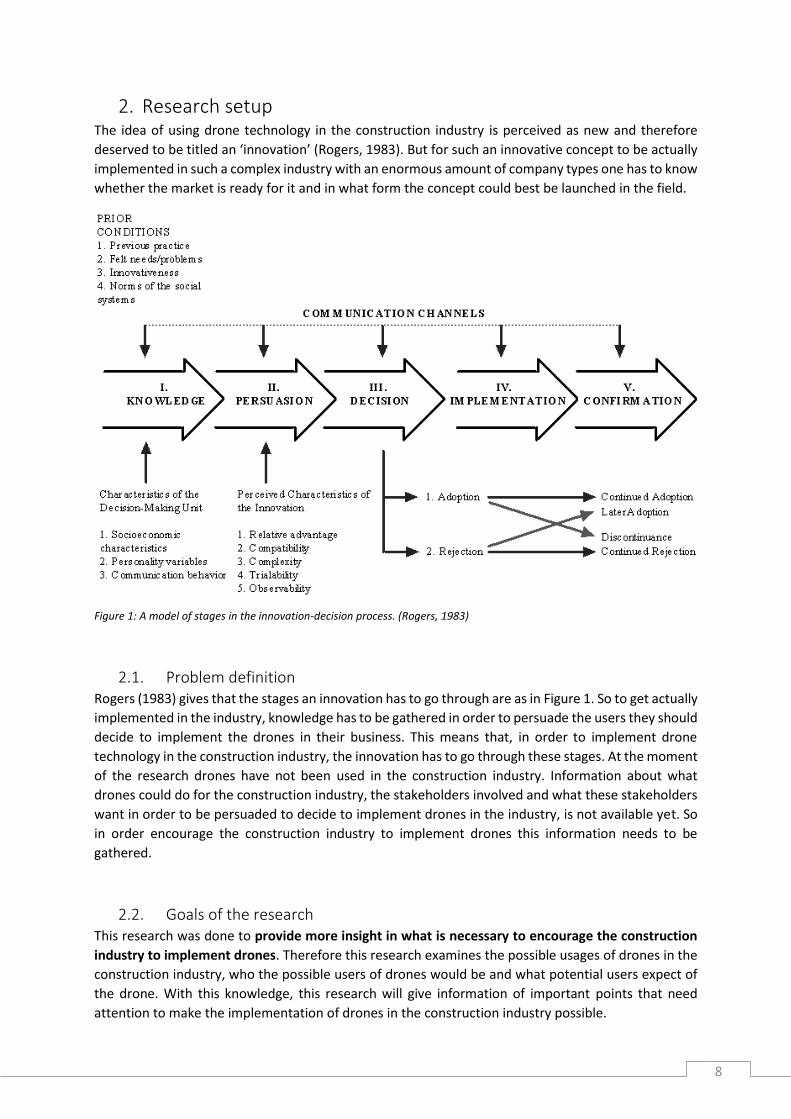
2. Research setup The idea of using drone technology in the construction industry is perceived as new and therefore
deserved to be titled an ‘innovation’ (Rogers, 1983). But for such an innovative concept to be actually
implemented in such a complex industry with an enormous amount of company types one has to know
whether the market is ready for it and in what form the concept could best be launched in the field.
Figure 1: A model of stages in the innovation-decision process. (Rogers, 1983)
2.1. Problem definition Rogers (1983) gives that the stages an innovation has to go through are as in Figure 1. So to get actually
implemented in the industry, knowledge has to be gathered in order to persuade the users they should
decide to implement the drones in their business. This means that, in order to implement drone
technology in the construction industry, the innovation has to go through these stages. At the moment
of the research drones have not been used in the construction industry. Information about what
drones could do for the construction industry, the stakeholders involved and what these stakeholders
want in order to be persuaded to decide to implement drones in the industry, is not available yet. So
in order encourage the construction industry to implement drones this information needs to be
gathered.
2.2. Goals of the research This research was done to provide more insight in what is necessary to encourage the construction
industry to implement drones. Therefore this research examines the possible usages of drones in the
construction industry, who the possible users of drones would be and what potential users expect of
the drone. With this knowledge, this research will give information of important points that need
attention to make the implementation of drones in the construction industry possible.

9
2.3. Research questions & research method In this section the study questions, and the method that will be used to answer them will be explained.
It gives the framework for the research that will be followed in order to achieve the set goal: provide
more insight in what is necessary to encourage the construction industry to implement drones.
The main question to be answered is as following:
What is the perception of the applications of drones in the construction industry?
This question is interesting to science because when answered it gives us the possibility to adapt the
drone technology to a level that drones will be accepted and in the near future drones will be
implemented in the construction industry.
When this question will be answered one could form a plan to make the likely users of drone
technology enthusiast and make sure they will be persuaded to make the decision to implement
drones in their business. Therefore, the attributes given by Rogers (1983) for the persuasion stage will
be used throughout the research.
To get a clear answer to the research question sub questions will help structuring the research and
keep a clear overview.
These sub questions are:
1. For what purposes can drones be used?
2. Who are the potential users of drones?
3. What would the users of drone technology expect from this technology?
Questions 1 and 2 will be answered with a literature study, the results will be compared to the results
of the survey and interviews. Question 3 will be answered with the help of a survey and interviews.
1. For what purposes can drones be used?
As mentioned drones gain in popularity due to their vast amount of possible utilities. In order to answer
this question a proper description of a drone is given. After this the applications drones could have in
the construction industry is split in two sections. Applications available now, and application that will
be available in the future. The methodology to get to an answer to this question is through a literature
study.
2. Who would be the potential users of drones?
To find the potential users for the applications that are found list of stakeholders involved in
construction project given in ‘Managing Construction Projects’ by Winch (2010). A selection of these
that could be interested in drones are picked from this list. These stakeholders are the potential users
of drones and will be described. Then the advantages/disadvantages of drones for these potential
users are given.
3. What would the users of drone technology expect from this technology?
In order to find an answer to this question the potential users found with question 2 need to be asked
about what was found as applications for drones by question 1 and ask the potential users about their
opinions regarding drones. This will be done using a combination of a survey set out under companies
that fit the description of a potential user and conduct interviews at some of these companies.
10
3. Drones and their applications Drones gain in popularity due to their vast amount of possible utilities and increased availability to the
general people. In this section a proper description of a drone is given such that it is known what is
actually talked about in this report. Then the applications drones could have for the construction
industry are given. This will be split in the applications that are available now and applications that
could become available in the future. The information gathered here will eventually be used to draw
preliminary conclusions that can be used to answer sub question 1.
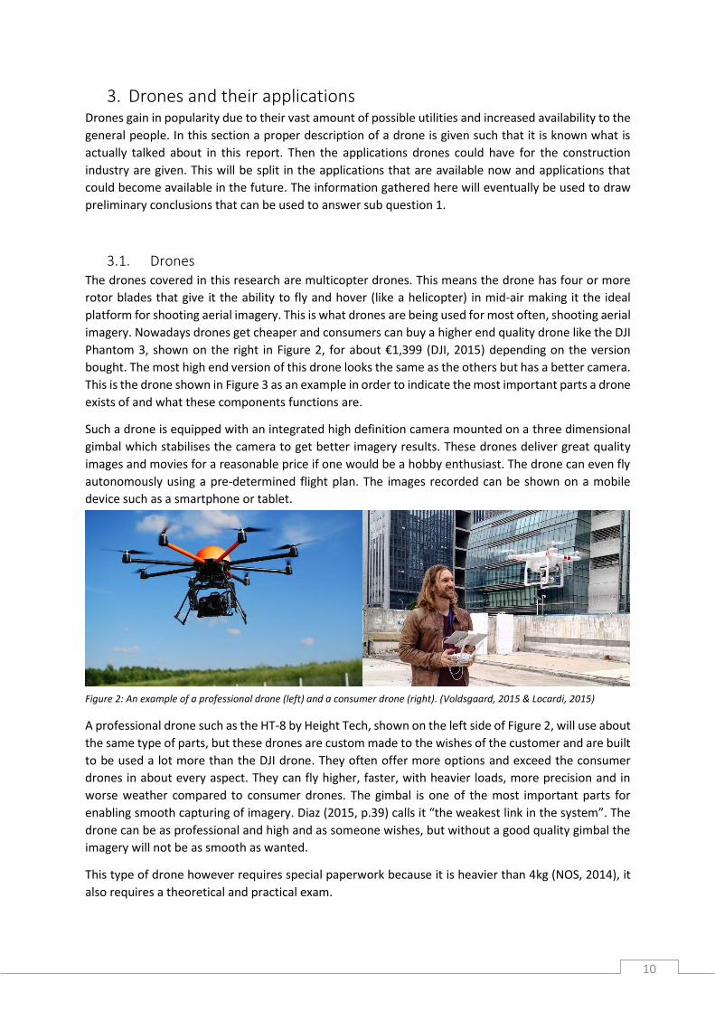
3.1. Drones The drones covered in this research are multicopter drones. This means the drone has four or more
rotor blades that give it the ability to fly and hover (like a helicopter) in mid-air making it the ideal
platform for shooting aerial imagery. This is what drones are being used for most often, shooting aerial
imagery. Nowadays drones get cheaper and consumers can buy a higher end quality drone like the DJI
Phantom 3, shown on the right in Figure 2, for about €1,399 (DJI, 2015) depending on the version
bought. The most high end version of this drone looks the same as the others but has a better camera.
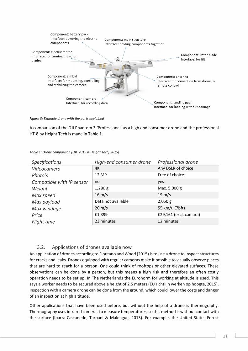
This is the drone shown in Figure 3 as an example in order to indicate the most important parts a drone
exists of and what these components functions are.
Such a drone is equipped with an integrated high definition camera mounted on a three dimensional
gimbal which stabilises the camera to get better imagery results. These drones deliver great quality
images and movies for a reasonable price if one would be a hobby enthusiast. The drone can even fly
autonomously using a pre-determined flight plan. The images recorded can be shown on a mobile
device such as a smartphone or tablet.
A professional drone such as the HT-8 by Height Tech, shown on the left side of Figure 2, will use about
the same type of parts, but these drones are custom made to the wishes of the customer and are built
to be used a lot more than the DJI drone. They often offer more options and exceed the consumer
drones in about every aspect. They can fly higher, faster, with heavier loads, more precision and in
worse weather compared to consumer drones. The gimbal is one of the most important parts for
enabling smooth capturing of imagery. Diaz (2015, p.39) calls it “the weakest link in the system”. The
drone can be as professional and high and as someone wishes, but without a good quality gimbal the
imagery will not be as smooth as wanted.
This type of drone however requires special paperwork because it is heavier than 4kg (NOS, 2014), it
also requires a theoretical and practical exam.
Figure 2: An example of a professional drone (left) and a consumer drone (right). (Voldsgaard, 2015 & Locardi, 2015)
11
Figure 3: Example drone with the parts explained
A comparison of the DJI Phantom 3 ‘Professional’ as a high end consumer drone and the professional
HT-8 by Height Tech is made in Table 1.
Table 1: Drone comparison (DJI, 2015 & Height Tech, 2015)
Specifications High-end consumer drone Professional drone
Videocamera 4K Any DSLR of choice
Photo’s 12 MP Free of choice
Compatible with IR sensor no yes
Weight 1,280 g Max. 5,000 g
Max speed 16 m/s 19 m/s
Max payload Data not available 2,050 g
Max windage 20 m/s 55 km/u (7bft)
Price €1,399 €29,161 (excl. camara)
Flight time 23 minutes 12 minutes
3.2. Applications of drones available now An application of drones according to Floreano and Wood (2015) is to use a drone to inspect structures
for cracks and leaks. Drones equipped with regular cameras make it possible to visually observe places
that are hard to reach for a person. One could think of rooftops or other elevated surfaces. These
observations can be done by a person, but this means a high risk and therefore an often costly
operation needs to be set up. In The Netherlands the Euronorm for working at altitude is used. This
says a worker needs to be secured above a height of 2.5 meters (EU richtlijn werken op hoogte, 2015).
Inspection with a camera drone can be done from the ground, which could lower the costs and danger
of an inspection at high altitude.
Other applications that have been used before, but without the help of a drone is thermography.
Thermography uses infrared cameras to measure temperatures, so this method is without contact with
the surface (Ibarra-Castanedo, Tarpani & Maldague, 2013). For example, the United States Forest
12
Service are trying to apply drones with infrared equipment to monitor wildfires and smouldering hot
spots (Freeman and Freeland, 2014).
Thermography makes it possible for an audit of an existing building (Balaras & Argiriou, 2002). With
infrared cameras one can detect areas that are or could become a problem for the building integrity
before they become serious problems that are costly to repair. Thermography makes it possible to
inspect electromechanical installations for flaws. Wet spots in a wall or roof can also be detected using
thermal images. This is useful for someone who is selling or buying a building, or for example in a
renovation project. Take a house as an example. When a property developer is buying a building in
order to revise it and sell it with a profit, leaking plumbing that needs to be repaired can seriously harm
his revenue of the project. A building integrity report is often required before one buys a building.
Those thermal readings are done primarily inside the building. Evidently it is more appropriate to do
this type of indoor inspection with a handheld thermal camera instead of a drone for residential
buildings or offices. But a drone could be useful when properly inspecting large factory halls where
walls and roofs are out of reach of the handheld cameras without additional equipment. Drones are
becoming more and more controllable such that they can be flown indoors with the proper training
and experience with the drone.
Measuring weak spots (moisture) in concrete structures is another possibility with thermal images
retrieved from an IR-drone. This could mean flying over a hardened or hardening concrete foundation
in order to scan the concrete for heat or cold spots that could indicate moisture leaks from cracks in
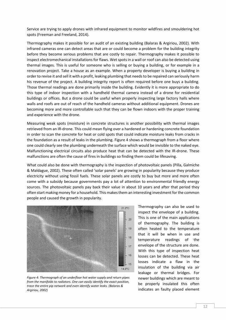
the foundation as a result of leaks in the plumbing. Figure 4 shows a thermograph from a floor where
one could clearly see the plumbing underneath the surface which would be invisible to the naked eye.
Malfunctioning electrical circuits also produce heat that can be detected with the IR-drone. These
malfunctions are often the cause of fires in buildings so finding them could be lifesaving.
What could also be done with thermography is the inspection of photovoltaic panels (Pilla, Galmiche
& Maldague, 2002). These often called ‘solar panels’ are growing in popularity because they produce
electricity without using fossil fuels. These solar panels are costly to buy but more and more often
come with a subsidy because governments pay a lot of attention to environmental friendly energy
sources. The photovoltaic panels pay back their value in about 10 years and after that period they
often start making money for a household. This makes them an interesting investment for the common
people and caused the growth in popularity.
Thermography can also be used to
inspect the envelope of a building.
This is one of the main applications
of thermography. The building is
often heated to the temperature
that it will be when in use and
temperature readings of the
envelope of the structure are done.
With this type of inspection heat
losses can be detected. These heat
losses indicate a flaw in the
insulation of the building via air
leakage or thermal bridges. For
newer buildings which are meant to
be properly insulated this often
indicates an faulty placed element
Figure 4: Thermograph of an underfloor hot water supply and return pipes from the manifolds to radiators. One can easily identify the exact position, trace the entire pip network and even identify water leaks. (Balaras & Argiriou, 2002)

13
of the building. A window could be wrongly installed or insulation is placed improperly causing it to
sag. Scanning the building after finishing its construction with an IR-drone could make it possible to
find these errors and fix them before the building is yielded to the client. This could prevent costly
compensation claims afterwards.
Drones are already being used to gather data for polar research, volcano studies and wildlife biology.
They become indispensable and revolutionary technology (Marris, 2013).
3.3. Applications of drones available in the near future Drones equipped with regular cameras can be used to check whether the maximum amount of built
surface is not exceeded. This would be based on the potential drones have “to collect detailed
geospatial information in real time at relative low cost” (Fornace, Drakeley, William, Espino & Cox,
2014, p. 514).
Construction site management could be assisted by data gathered by drones. This could include tracing
building materials’ locations on site. The visual system of a drone will be co-operating with classifier
software that identifies the objects seen by the drone (Bieda, Jaskot, Jędrasiak & Nawrat, 2013). The
data gathered by the drone will produce a so called ‘pointcloud’. Figure 5 shows how the information
gathered could produce a 3D image of the scans made by the drone. Going forward on this technology
of tracking of materials is alerting the contractor if materials are used in the wrong way or at the wrong
position. Going even further with this would be a link to the construction plans and the therefrom
following needed materials compared to the materials in stock which can notify the constructor new
materials need to be ordered. This eliminates unnecessary waiting times because someone forgot to
order new materials. These sort of technology is not available yet because the software processing the
data collected by the drone is not yet available for real-time output which would be needed. This needs
very complicated programming and testing before it could be used in the construction industry. Static
scanning had already being used. For example sensing data on landslides in France (Niethammer,
James, Rothmund, Travelletti & Joswig, 2012).
Figure 5: Mapping of 3D object points onto 2D points in two aerial frame images. (Verhoeven, Doneus, Briese, Vermeulen, 2012)

14
Google and Amazon have spent millions of dollars in the development of drones that can deliver small
packages (West, 2015) so if this growth holds on it might also get possible for drones to transport
materials or tools to the workers on site. As the researcher has seen and experienced many times with
construction projects a lot of time is wasted because a worker forgot a tool and needed to recover it.
Unfortunately equipment in the construction industry almost always is quite heavy so this application
might take a while before it is possible.
3.4. Preliminary conclusions Drones main application is forming a flying platform that can be mounted with a camera in order to
get imagery of constructions taken from the air. It depends on the purpose of the drone will be used
for whether a professional drone is necessary or not. Consumer drones deliver fine quality imagery,
but often are hard to use with an infrared camera. In order to make a pointcloud using several images
the quality of these pictures needs to be very high. This does not only depend on the camera but also
on the stability of the drone. A big difference between consumer and customised professional drones
is that the professional drones will deliver higher quality imagery because they are more stable and it
is possible to mount a DSLR to the drone.
The applications drones can now be used for in the construction industry include:
Easy inspection of hard to reach areas that used to be hard to reach or were costly to reach.
Thermography
o For energy certifications of constructions
o To find flaws in the insulation in order to insulate efficiently
o Check for weak spots in concrete during curing
o Check photovoltaic panels for proper functioning
Applications that will be possible in the near future include:
Check the amount of built surface
Supporting in construction site management as an extra pair of eyes or identifying flaws and
mapping progress
3D scanning of construction using imagery to get to a pointcloud 3D model
Transportation of materials or tools
15
4. Drones and their users The applications found in chapter 3 are or will be technologically available. But in order to be
implemented it is important to know who would use a drone for the applications found. In the
construction industry there are a lot of stakeholders involved. Some of these could be interested in
drones, these are described in this chapter. Also the advantages/disadvantages of using a drone are
explained using the attributes given by Rogers (1983).
4.1. The potential users of drones In the sections above the applications of drones are mentioned. But there still need to be stakeholders
who will be involved with the technology. These people need to be evaluated to find which would be
most interested in the technology. The stakeholders involved in a construction process and therefore
potential users of drone technology are of the following categories given by Winch (2011, p.75) in
Table 1 which was retrieved from Entrop (2013, p.118).
Table 2: Involved stakeholders in construction projects (Entrop, 2013, p.118)
The most important ones are mentioned below:
Contractors
Contractors could very well use infrared equipped drones to monitor the heat footprint of a
construction that is built. For a clear thermal emission of the building it needs to be heated to the
temperature the building would have during its use. This is almost impossible during construction
because in most phases of the raw construction the building is not closed yet. Roofs or windows are
missing which make it impossible to get a usable thermal shot of the entities that would be monitored.
Besides infrared imagery, contractors could also use a drone with a regular camera for project
management on site. The camera footage would mean the foreman is not required to keep walking
the site such that he could inspect more of the process in less time and therefore will detect an error
in the process way faster than with a manual inspection. Also some errors that occur are not monitored
at all until it becomes a serious problem causing high repair costs and spilled time which in itself could
raise costs with enormous amounts of money. When the drone footage had been analysed by specially
written software is possible to identify the objects seen. When identified they could be linked to the
construction plans and irregularities are immediately flagged as an error. This will be sent to the
foreman who can tell his workers to repair the error as soon as possible to minimize the damage.
Going further on this technology would be that the software fed by the drone footage would identify
the amount of materials in storage and automatically knowing if more materials should be ordered.
Placing the order automatically or pushing forward a message to the person responsible for ordering
materials. This eliminates the builders running out of materials causing a delay because someone
forgot to order new construction materials.
16
Local government
A municipality could use drones to check construction sites and compare them to the licences given
for the construction. This can also be done for constructions that are already finished. For example,
when someone has built a shed in his backyard without permission, or exceeded the premised size of
the shed the municipality could warn or fine this person.
Consultants (engineers)
Consultancy companies provide insight in often complicated situations that need an analysis from a
specialised company. These consultancy companies will deliver the customer a report of their research
of the object and their professional opinion regarding the further steps in the construction process.
For example, a contractor is assigned with a revision project of a school but the contractor is not sure
of the concrete integrity of the structure and is lacking the knowledge or resources for an inspection.
In such case a consultancy company which do have these resources can be hired to provide some
professional advice regarding the problem. This also spreads the risk of a project because in case of an
accident the contractor could fall back to the report of the consultant.
Other types of stakeholders
Getting good quality images from every angle imaginable and delivering reports regarding building
integrity for customers is also important to brokers (client) who are trying to sell a property or
architects to check if the design he created is actually being build according to his wishes.
4.2. Advantages/disadvantages for the potential users of drones Drone technology, like everything, comes with advantages and disadvantages. To get an overview of
the advantages and disadvantages the attributes of Rogers (1983) are used. Which also gives insight
to the information needed to persuade the potential users of drones.
Relative advantage
“Relative advantage is the degree to which an innovation is perceived as being better than the idea it
supersedes.” (Rogers, 1983, p.213). This can be determined by economic or social advantages of
drones in comparison to its alternatives.
The alternative to thermography with a drone is thermography using a handheld infrared camera. This
has been used in the construction industry for a long time, this option of course is cheaper than
mounting such a camera on an expensive drone. But when measurements at height need to be done
the handheld temperature readings are getting more expensive because a scaffold or work platform
needs to be facilitated. Also the inspector will need to work at height, which brings costs and dangers
with it. In theory one would give the drone the advantage for the hard to reach places of a construction.
Conventional management of the construction site has worked for several years, the contractor could
be assisted by his employees by sending him a picture of an error via whatsapp or an app alike. The
alternative to the drone therefore could be other types of camera’s where smartphones and tablets
are expected to be the most important alternatives. But with the use of a drone, the contractor can fly
to the location wanted and ask for real time
Instead of making a pointcloud with the help of high quality pictures with a drone it is also possible to
scan a construction the object with a 3D laser scanner. This scanner also gives an export possibility to
17
CAD models (Valerio, Adan & Cerrada, 2012). These laser scanners however need to be on a steady
platform and are not very mobile, so scanning will be time consuming.
What needs to be mentioned is that drones do not operate well (or at all) in bad weather conditions.
The DJI drone from Table1 can be operated until a windage of 55 km/h and drones cannot be used in
the rain. This means the alternatives have the advantage if the weather is bad.
Compatibility
“Compatibility is the degree to which an innovation is perceived as consistent with the existing values,
past experiences, and needs of potential adopters.” (Rogers, 1983, p.223). The degree of the
compatibility will be known at the end this research. In chapter 3 the possibilities of the technology
are already given. In chapter 6 the needs of the potential users are given and in chapter 7 these two
will be compared. This will give the degree of compatibility.
Complexity
Another attribute Rogers (1983) has given is the ‘complexity’. The more complex the technology is
perceived, the less likely users will be able to use it. “Complexity is the degree to which an innovation
is perceived as relatively difficult to understand and use.” (Rogers, 1983, p.230).
Drones are getting easier to fly, but in order to control a drone and get high quality camera recordings
there need to be two persons operating the drone and camera in perfect cooperation. Especially when
using a thermal camera under a drone it is important the camera operator knows what to look for. The
drone can nowadays fly on its own, but needs a back-up operator in case GPS is lost.
Further drones bring legal complexity with them. Public opinion about drones vary from enthusiastic
drone hobbyists to anti-drone protests because people think drones will have a great impact to their
privacy and are afraid drones will do harm. A crashing drone indeed could make some impact.
Then there is the drone itself, which is quite a complicated system with a lot of complex parts
cooperating in order to make it fully functional. Because professional drones are specialised equipment
they are not readily available and the amount of suppliers is limited. The 5P’s model of Porter gives
that due to the high complexity of the drone itself it puts these suppliers in a strong place in the market.
Therefore they can ask larger margins of profit if wanted. A complexity of the drone therefore will be
the price of the drone.
One of biggest limitation of drones at the moment is the short fly time. A drone of this moment will fly
about 25 minutes on one battery charge, of course with multiple battery packs a drone could fly all
day, but the battery has to be replaced every 25 minutes. Which of course is very inconvenient.
But battery development is also in great progress, largely because nearly every piece of equipment
man uses all day rely on its battery. Think about smartphones, electric cars, laptops and smartphones.
Better lightweight high-capacity batteries such as the ‘high performance Li-ion battery’ described by
Kim et al. (2012) are getting available which would give drones much more flight time which would
mean they can be used to scan larger objects for a longer time and the asset would become more
valuable. This is because one does not lose the time needed to change a battery pack and can
continuously keep scanning or monitoring the construction site. This opens the possibility to
thoroughly scan an area which is particularly useful when checking large fields of photovoltaic panels
or for government uses such as checking for illegal structures.
18
Trialability
“Trialability is the degree to which an innovation may be experimented with on a limited basis.”
(Rogers, 1983, p.231). As mentioned in Table 1, a high-end consumer drone costs about €1,400 and a
professional drone €23,161. The mentioned price of the professional drone was without a camera or
autonomous flight unit. It should be mentioned the consumer drone is ready to fly out of the box and
the professional drone needs special training to operate it properly. Therefore the trialability of the
customer drone scores high and because of the special training and the high cost the trialabilty of the
professional drone is low. As mentioned in chapter 3 there are a lot of applications for drones, some
of these applications require more advanced drones with different sensors. Because of this the prices
are variating a lot as well as the required trainings (Height Tech, 2015). Therefore, the degree of
trialability depends on the application.
Observability
“Observability is the degree to which the results of an innovation are visible to others.” (Rogers, 1983,
p.232). The degree of observability for drones in the construction industry is unknown because it has
not been used yet. But from other industries it can be concluded that the results of using a drone gives
a lot of advantages compared to their older methods (Marris, 2013 & Fornace et al., 2014).
4.3. Preliminary conclusions Out of the stakeholders mentioned by Winch (2010) the ones that are likely to be potential users of a
drone were selected to be: the contractor, consultancy agencies or local government. Each with their
own applications for the drone.
Advantages for the potential users are that, compared to the alternatives of drones, the hard to reach
areas (mainly at height, e.g. rooftops) are easy to see with the help of a drone. It also makes it possible
to save money and time compared to the alternatives, this is partly because it saves on the expenses
for safety measures. Using drone gives a lot of advantages in other areas so therefore it is expected
that the observability will be high too for the construction industry. Sadly it is not possible to give the
advantages on the attributes compatibility and trialability.
The disadvantages are the large variating prices which are largely depend of the application of the
drone. Another disadvantage is that the most drones are not usable under bad weather conditions.
Drones have a high complexity which brings some disadvantages with like legal issues and short flight
times because of the limited capacity of the batteries.
19
5. Empirical data perceptions drone usage Due to the nature of drones in the construction industry being very new and innovative, a research
towards change is best to be done. Such research is aimed at implementing improvements. This
includes monitoring possible problems that can withhold the implementation of the innovation
(Verschuren & Doorewaard, 2007). The best strategy to get good insight in the situation as it is would
be by using the research strategy of an interview. But interviews take a lot of time to process, so in
order to save the researcher some time it was chosen develop a survey and combine the survey with
a small amount of interviews.
5.1. Developing a survey The survey will be in Dutch because this the native language of both parties. The list of questions is
based on what is found in literature. The questions to be asked will be in the form of closed questions
which have pre-formulated answers, this makes the results easier to process and analyse. Often the
option of ‘Other, namely’ will be given, this gives the respondent the opportunity to give an answer
the researcher might not have thought about yet of about what the respondent would want from
imagery.
The goals of the survey will be to get insight in how often imagery is made, with what devices it is
made, what the subject being photographed/filmed is, to see which devices are most preferable, when
the imagery is made and eventually whether people are familiar with drones and if they are willing to
adopt drones in their business. This will eventually give insight in how far the industry is ready for
drones and will help to answer the research questions and/or test the answers found in literature.
After some iterations about the questions that needed to be in the survey in consultation with the
supervisor the final survey was put together on paper and translated to a digital format with the help
of Thesistools.com. This format is easy in use and makes good quality surveys that can be spread
through an internet link. The printable version of the survey can be found in Appendix A. The chosen
method of spreading was preferably by spreading it under the members of associations that represent
companies in the construction industry. Only one of those associations was willing to post the link to
the survey in their newsletter to the members. Another association was not willing to spread the
survey under their members but had the contacts of these companies on their website. The researcher
called these companies in the name of the university in order to spread the survey. Unfortunately the
companies were unwilling to cooperate. They get requests too often to do this. An answer that is gives
as well is to send an e-mail with the description and the link of the survey so the secretary could
forward it to their PR section. As time goes by the researcher asked for the status of the spreading of
the survey. No update could be given or the request to spread the survey was denied.
Another method of spreading the survey was by the LinkedIn of the supervisor. This fortunately lead
to a better response rate. In consultation with the supervisor a combination of the survey with
interviews at companies would be the method of getting the data wanted. The researcher later visited
a meeting from the platform Pioneering about energy saving housing in order to spread the survey
there. This is why the printable version of Appendix A is made. Unfortunately the meeting could not
aid in spreading the survey.

20
5.2. Data collected by the survey Eventually there were 18 respondents. Six of those respondents eventually turned out to be not usable
at all, one of them seemed to be a hoax only filling in he was a swimming pool lifeguard working for
the municipality. One filled in the first three questions and the other four only filled in what their
function was and/or at what type of organisation they were working. One of the respondent eventually
stopped halfway after question 8. This respondent it kept in the first 8 questions because those
answers are still useable for the outcome of those questions. The answers given can be found through
tables and diagrams in Appendix A.
When we look at the survey, we see most of the respondents are consultants or members of
management teams of consultancy agencies or contractors. The respondents think they use imagery
in most of their cases with the biggest category being between 61-80% of their total projects and the
second most chosen category is the even higher one with 81-100% of usage of imagery in projects. We
can also conclude that out of this group there was no one who thinks they will be using less imagery in
the future, half thinks that they will increase the amount of imagery made and the other half says they
will continue making the amount of imagery they were already doing.
If we look at the object that imagery is made of this is mostly the object as a whole, imperfections,
progress of the project and the work in progress itself. Less popular subjects being photographed are
electrical systems, piping- and plumbing systems. The most preferred method of shooting imagery
turned out to be by smartphone (9 out of the 12 respondents), with the compact camera as a close
second (7 out of 12 respondents), one of the respondents gave a drone as a way to make imagery. The
smartphone also turned out to be the most useful device of making imagery with an average score of
8.8/10 for usefulness, this time followed by the DSLR with 7.9/10. When we look at the average mark
the respondents gave the devices the drone actually was marked higher (9.0/10) than the smartphone,
but this is due the fact that only one respondent gave the drone as an option.
The imagery is mostly used for internal communication and external promotion (both were filled in 8
times), inspections were also an important use of imagery (6 times filled in).
To the question about the shooting of thermal imagery almost all of the respondents answered they
use thermal imagery for about 0-20% of their projects. During the finishing and usage of the project
the most imagery is taken and the main reasons to make imagery is internal and external
communication. Both method of communication were appointed 8 times versus the 6 times
inspections were mentioned as usage for the imagery. Real-time imagery turned out to be fairly useful
to neutral, so it is a nice bonus, but had no real added value according to the results of the survey.
Most people think they are familiar with drones, no one has not already heard of a drone, 9% has heard
from a drone and the rest knows what drones are or have even flown with one. The respondents think
that drones would be most useful to shoot imagery of rooftops and objects as whole. The respondents
of the survey would use a drone to make imagery within the range of 0-40% of their projects (45% said
0-20% and another 45% said 21-40%). But when asked if a drone could be a problem in the construction
industry 73% of them say drones could be a problem indeed for a variety of reasons (privacy,
regulations, it is new for the industry). One person said drones in his opinion only have added value
for the construction industry. One person came with the suggestion to use drones to scare away
nesting birds another person gave the option of using Google Glass as form of imagery on construction
sites.
21
5.3. Developing interviews The interviews will take place in approximately 60 minutes and will include some general questions
about the person and the company interviewed in order to get a fair comparison between the
interviews. A longer interview is too hard to process and analyze for the time that is available. The
interview will be composed of open questions and some questions where it is asked to choose from
some options and explain his/her choice. The open questions give the person that is interviewed the
chance to use his or her creative mind and outgiving to answer the question.
Interviews can be held in a variety of ways. Interviews can be face-to-face, via telephone, or nowadays
even with the help of software like Skype. The preferred way of conducting an interview is face-to-face
by visiting the company being interviewed. This gives the most pure and unfiltered results as body
language can also tell a lot and the more personal approach of a face-to-face interview will probably
be more attractive to the respondent. The companies that will be interviewed are mostly within short
range of the city of Enschede. This is done to save time for the researcher, also the number of
interviews is limited to three. Interviews will be recorded so they can be transcribed to a text format,
but the researcher will also take notes. This will be done by hand or if possible with specialised
transcription software. The interviews will take about one hour and as mentioned will be conducted
in Dutch because both parties will probably speak Dutch more fluently and answers will be more
accurate. The questions asked in the interview will be mostly based on the survey questions above,
but since it is an interview the respondent will be asked to give as many answers he could think of by
himself and is given the opportunity to give his thoughts about the questions asked. Something which
is not possible with just an online survey.
5.4. Data collected by the interviews Here the results of the interviews will be presented. The full results can be found in Appendices B, C
and D. The results of the interview with company K and L are combined because they were retrieved
from a meeting of both companies followed by an interview to company L.
Company K & company L
The meeting with company L, a company that was planning to use a drone within their work
environment, and drone builder company K gave a lot of insight about the regulations regarding
drones. Unfortunately the surroundings were too noisy to make recordings, so the researcher made
extra notes and processed the conversations partly from memory. The proceedings of the meeting and
combined interview can be found in Appendix B.
Company L is interested in using a drone to measure the rooftops of barns in the agriculture industry.
These measurements are now done by hand and need to be done twice. The first time will be a rough
measurement in order to get a price indication to the customer, if the customer agrees a second,
accurate, measurement will be done. This cost time and company L believes a drone could do this work
much faster for them with the added bonus of working safer from the ground instead of on the roof.
Company K can offer the total package of the drone including the software that can be used to make
the measurements or make an export to CAD to make the measurements in CAD if wanted. The drone
flies autonomous with the help of a programmed flight path which uses Google Maps.
Respondent A of company K also made clear operating a drone needs special training and a lot of
paperwork needs to be arranged before it is allowed to fly the drone in The Netherlands. Implementing
an infrared camera to the drone is also possible, but company L was nog interested in this technology.

22
It also was mentioned that obstacles do not form a problem for the scanning of the roof because the
technology uses a pointcloud of about 25 high quality images made by the drone and DSLR. Flight time
of a drone from company K is guaranteed to 12 minutes, bus since the drone will be done taking the
images in about 5 minutes this faces no problem and if company L wants to use the system for 6
projects a day they could purchase extra batteries in order to keep going all day.
Company L further makes use of images made by smartphones and other camera’s. Google Maps is
often being used to orient the environment of a possible project. They want to improve their working
speed and accuracy in order to save costs, be innovative and gain positive publicity. They do not use
thermal imagery yet.
Company M
The full proceedings of the interview with respondent D, the director of two departments of company
M in the Twente region can be found in Appendix C. Company M is a constructor and a developer. They
do projects all the way from the initiative phase till maintenance. An important usage of imagery for
them is communication (marketing) to their customer, but also for internal communication. For every
project they use imagery, often professional photographs are hired to make these pictures. What could
be seen is the rise of the importance of imagery over the last years. “16 years ago we had Polaroids on
site in order to get a fast picture” said respondent D, director of two departments in the east of The
Netherlands of company M. “Nowadays digital pictures are stored in a ‘Cloud’ and images are of high
professional quality”. Videos are often made and spread via social media like YouTube, LinkedIn,
Twitter or Facebook.
Imagery on the construction site is most often made from work in progress in order to guarantee the
quality company M delivered. They also use special software application that store imagery so it is
possible to check how something is done on a later moment in time. The pictures on site are more
including people in them in order to make them more attractive for marketing purposes. Google Earth
and Streetview are mentioned as imagery that is also used a lot.
Every devise for making imagery is being used by company M, from smartphones to webcams. The
webcams monitor the progress of the project and offer a semi real-time image of the site. Recordings
are delayed 30 minutes in order to prevent spreading if an accident happens. Company M also uses
sensor triggered cameras to secure the site against thievery. Also infrared imagery is made in about
60% of their projects, in Germany respondent D thinks this rate is about 90%. The infrared imagery is
being used in order to get the evidence for BREEAM like certificates. Company M owns an infrared
camera, but usually hires an external specialised company to make the reports.
Company M has used drones just to make video footage for marketing purposes, but respondent D
knows about the possibilities for measuring that drones can offer. Respondent D believes drones could
be used for a lot of applications, namely inspections of rooftops from a safe position. But he thinks
drones could also do some work in the future, he has mentioned moving bricks as an example in order
to save time the workers could use to actually build the building instead of getting tools or materials.
Respondent D further believes drones could project measurements and construction drawings to the
site in order to prevent misplacement of elements.
Company M would probably not buy a drone in the future to get imagery, but would rather hire an
external company to do this for them. Respondent D had his doubt about the regulations needed for
flying a drone and thinks the drone might cause a distraction. Further respondent D states “if someone
is not convinced a new technology will work for him he is not probable to use the technology a lot”.
23
He is not interested in what the drone is supposed to cost, but more in what it will make for company
M and that is hard to say.
Company N
The full proceedings of the interview with respondent E, the vice-CEO of the northern and eastern
parts of The Netherlands for company N can be found in Appendix D. Company N is a construction
company and developer that realises projects for utility construction, housing and also does renovation
and maintenance projects. They use imagery mainly for communicative purposes. This means
communications to the customer (marketing) and internal communication in order to guard the quality
company N delivers. The current form of imagery was not used 10 year ago, then it was a bundle of
white drawings from an architect and now we use 3D and BIM models to visualise projects. Company
N uses imagery in every project they do. On the constructions site respondent E believes imagery is
just at the beginning. Nowadays the executers of company N all are given iPads with an app
(EdControls) for quality surveillance. The worker makes a photo of it, describes what is wrong and
sends it to the person who can fix it. That person accepts the work, fixes the problem and hits the
button that says he is done. The work is al recorded in the logbook. This method is used by all the
bigger construction companies according to respondent E. Company N uses infrared imagery for
blowdoortests in order to test if their construction complies with the demands given. These demands
are often that the construction needs to have the BREEAM certificate. Company N hires external
companies to do this for them. Video footage is also used to distribute on YouTube or other social
media for marketing purposes. Occasionally company N uses webcams at construction sites for
monitoring the progress of the project. Sensor triggered cameras to secure the site from thievery is
also used. 3D have also been used by company N in order to make visualisation and respondent E told
company N is starting to test virtual reality glasses with 3D imagery to let someone walk in a room of
a conceptual building in the beginning of the construction progress. According to respondent E in the
near future we will ideally see that new technologies like interactive pairs of glasses for every person
on site that gives real-time to the worker what he needs to do and where he needs to do that.
Most imagery in the form of pictures is shot during construction in order to monitor the progress of
the project and to guard for the quality delivered. Real-time images from for example webcams are
seen as an extra bonus but not for great added value.
Company N had worked with drones in order to shoot aerial footage for marketing purposes. A
colleague of respondent E owns a drone. Respondent E imagines that a drone could be of added value
to an executer as an extra pair of eyes. The executer can monitor the other side of the site without
having to constantly walk in circles. He also believes that about 50% of the work on site is actually of
added value according to the Lean principles. The rest of the time is wasted with getting tools and
materials. If a drone could bring the worker his tools or materials this would improve efficiency. He
also thinks inspecting a high construction would be doable with the help of a drone as a replacement
for scaffolds. Or other hard to reach areas like crawl spaces if the drone would be very small and able
to fly indoors. He also thinks drones should be able to fly autonomously via a predetermined route.
Respondent E thinks another use for drones would be for the infrastructure industry. The often need
level heights or need to know how much sand there is in the heap of sand. That could be determined
with the help of a drone (quad or fixed wing). The doubt respondent E has with drones lie with the
regulations around drones and the fear people have for their privacy and the distraction a drone would
create excludes its use around working times. Company N would also need 2 fte’s in order to operate
the drone, so that would cost them around €120.000 a year. Hiring a specialised company therefore
would be more preferable, but company N could use a drone for about 5-10 weeks an year estimates
respondent E.

24
6. Expectations of drones The survey and interviews provide empirical data that indicate the expectations the respondents have
of drones. This will be divided in the expected applications, expected advantages/disadvantages and
the valuation the respondents would give to drones.
6.1. The expected applications of drones The expected applications drones can be used for, found by the empirical data will be divided in two
parts. This is because the survey and interviews give a lot of information about the shooting and usage
of imagery within the construction industry. Therefore the first part will discuss the applications
imagery is used for, which can be obtained using a drone, but now often is captured with another
camera device. The second part will be regarding the direct applications the respondents gave when
specifically thinking of a drone.
When looking at how and when imagery is obtained and what it is used for in the construction industry
it can be seen that imagery is most often shot during construction. It depends on the purpose of the
imagery how it is shot. A lot of imagery is shot by the constructors with smartphones and tablets using
special software which enables the constructors on site to upload photos of a phase or flaw and check
it in as finished, or ask for the right person to fix the flaw that was found (respondents D and E). The
imagery could also serve as evidence when problems with other stakeholders occur (respondents D
and E, and mentioned as an answer to question 10 of the survey as well). There are also a lot of images
taken when the building is finished, this is done with professional photographers and the images will
be used for promotional purposes (this is the top answer to question 10 of the survey ). Monitoring
the progress of a construction project is also supported with imagery, so this could also be done using
a drone. Thermography is not used a lot according to the respondents of the survey, one respondent
answered that imagery is used for certifications. The interviews however give that thermography is
used in almost all projects because customers ask to deliver constructions with energy certifications.
This is done with the help of specialized external companies because the contractors lack the expertise
of thermography (respondents D and E).
The survey and interviews agree that almost every project nowadays uses imagery, often for several
reasons. The most important reason for shooting and using imagery of to use it as a method of
communication within a company and to others as a method of marketing. Internal communication
often is about guarding the quality the organisation delivers. Interviews and the survey also agree that
shooting imagery has developed from scratch to a very important tool of which the industry cannot
imagine doing without.
When specifically looking at what drones could mean for the construction industry it can be seen that
the potential users expect drones to shoot imagery from places that are hard to reach during the whole
construction process in order to conduct a visual inspection.
In the survey the respondents were asked to give a selection of objects they take imagery of. It was
also asked which objects they think are possible to take imagery of with a drone (this can also be an
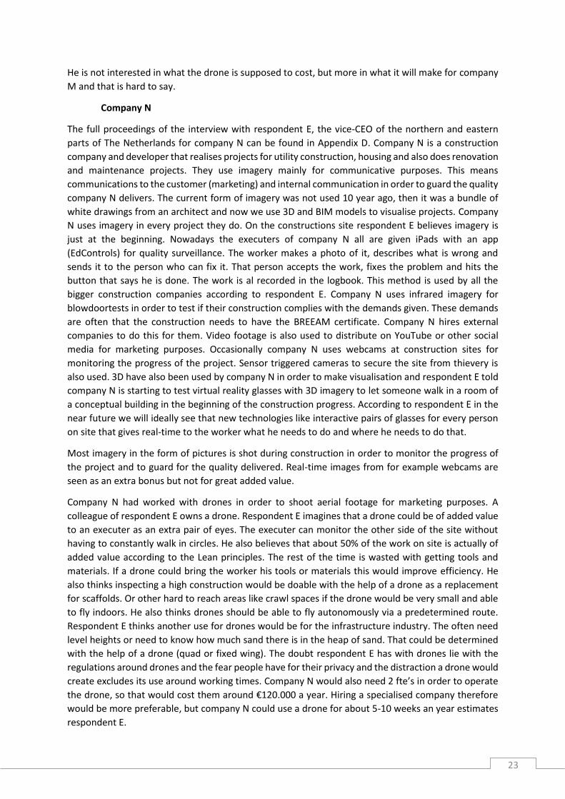
object they currently do not take imagery of). The results of these question are given in Figure 6. As
stated before the potential users especially want to use drones to take imagery of places that are hard
to reach. Figure 6 supports this, for example two respondents gave they would take imagery of
rooftops with current camera devices and six respondents said they would take imagery of a rooftop
if a drone would also be available.
25
Figure 6: Objects of imagery now compared to with a drone
Respondents B and C from company L, an asbestos removal and rooftop renovator, expect a drone to
scan a roof and export an exact 3D model where precise measuring can be done. The survey points out
the potential users expect drones to be able to shoot imagery from rooftops and the objects as a whole.
Respondent D also mentioned drones could be able to use a laser to project construction plans on site
to indicate the locations of various entities. Thermal imagery shot with the help of drones was
mentioned but was not as interesting to the respondents as monitoring the progress of the project or
taking promotional imagery.
An alternative use of drones in a construction project is given by one respondent of the survey,
mentioning drones could be used to scare off nesting birds from a construction site. This option was
not found earlier but this could be useful to the industry.
6.2. Expected advantages/disadvantages of drones The advantages and disadvantages according to the potential users are given in this section. The
attributes of Rogers (1983) are applied again.
Relative advantage
Respondents B and C said they think using a drone would save them a lot of time in their work because
the drone could be used to measure a roof in a short amount of time (this is confirmed by respondent
A of company K, a professional drone producer). The drone takes 10 minutes to start up, the flight
itself would take about 5 minutes. Including the creation of a flight plan and export to measurable 3D
model, the whole project would take about an hour of time on location. Instead of someone who needs
to go up the roof, estimating measurements and come back a second time for the exact
measurements. Using a drone also gives safety advantages according to respondents B and C.
Drones also come with some disadvantages. In the survey the issue of violation of privacy was
mentioned twice as a disadvantage. But also the fear of drones crashing and harming persons or
materials was given by respondent E, this was also mentioned by one of the respondents of the survey.
Further, regulations were mentioned three times in the survey and in all of the interviews to be a
limiting factor to the usage of drones.
0123456789
Objects of imagery now vs. drones
Now
Drone

26
Compatibility
To assess the compatibility of drones it is necessary to know the existing values, past experience and
needs of potential users. A disadvantage for the use of drones is the existing value regarding privacy,
as mentioned above. Imagery in a construction project gained in popularity over the past 20 years from
nearly nothing to polaroids to mobile devices such as smartphones and tablets (respondents D and E).
Imagery captured using a drone would be the next step forwards. There is not a lot of experience with
drones during construction projects, but companies M and N have used drones before in order to
obtain promotional images and videos of projects. The imagery gives new angles that have good
promotional values. The needs of the potential user depends on the application the user wants. The
applications are described in section 6.1.
Complexity
Company K produces professional drones, they can deliver a special ‘waypoint’ package that enables
the user to program a pre-determined flight path using Google maps so the drone will operate
autonomously. This of course makes the drone quite easy to use. But flying the drone manually is
always required as a backup, this takes some time to learn and theoretical and practical exams are
required. In order to obtain goo quality imagery with a drone there should be an operator for the drone
itself and one for the camera. This was mentioned as a disadvantage by respondent E, two fte’s.
Trialability
The interview of company L was combined with a meeting with company K (a drone producer) because
company L wanted to assess the possibilities that a drone could offer for their work. Company L
definitely wanted to try using a drone, but the information given by respondent A regarding the price
and regulations were discouraging. The price of the drone was quite high for a trial. Further, the
regulations regarding professional usage of drones are strict and costly as well. For company B the
prohibition of drone in the urban environment was not a big problem. But as mentioned three times
by the respondents of the survey and respondents D and E this definitely is a disadvantage for using
drones. One of the respondents of the survey also pointed out that drones “are not common good in
the construction industry yet” which discourages potential users to use drones.
Observability
Drones are quite a phenomenon. Because it is so innovative in the construction industry, respondents
B and C from company L believe adopting a drone in their company will give them positive marketing
value. A disadvantage of the visibility of a drone can be that workers get distracted by the drone flying
around the construction site. This could have a negative effect on the efficiency of the workers, but it
could also create unsafe situations as was stated by respondent D.
6.3. Valuation of drones The fact that both the survey and one interview gives that they would use a drone to shoot imagery
for somewhere around 20% of their projects indicates that drones have added value for the user. Given
in the interview with respondent D is that the cost of drone technology does not matter too much, the
added value is what counts. Not one of the respondents was able to get an indication to the amount
of money they were willing to pay for a drone or drone inspection. The meeting with Company K and
L made clear a drone capable of making measurements with the proper papers and training for the
operators would cost about €44,000 which would be a lot of money if one would only take some
pictures and shoot some promotional videos with it. But if operated for cost reducing activities to their
27
work, a cost reduction of €8,800 a year would make the drone break even. This seems to be an easy
task given the time a drone could spare a company. Yet still it seems people are too afraid to take the
step towards the usage of drones.
6.4. Preliminary conclusions The expected applications found by the empirical data were divided between what the respondents
use imagery for and what they thought a drone could do for them.
Information regarding imagery can be summed up as:
Imagery is shot preferably with a smartphone (9/12 respondents of the survey);
In cooperation with the smartphone contractors use tablets with special construction
management software on them that use imagery as input (respondents D and E of the
interviews);
Imagery is used for quality control, project progress monitoring and promotional purposes;
Infrared imagery is not often used according to respondent B and the survey (0-20% of the
projects), respondents D and E did mention to use thermography in almost every project.
Application of drones the respondents gave:
Inspection of hard to reach areas (all of the interviews and mentioned in the survey);
Scanning to 3D export where measurements can me made (respondents A, B and C);
Projecting drawings and measurements using a laser.
Drones or drone technology are hard to attach a price tag on. This was regarded unimportant to
respondent D because he was more interested in what the drone could mean for him.
28
7. Analysis In this chapter the results of the survey and interviews will be compared to the outcome of the
literature study.
7.1. Applications of drones From the literature it was found drones could be used for:
Visual inspections in hard to reach places in order to save time, increase safety and reduce
costs because of regulations for working at height (Euronorm, 2015);
Thermographic imagery to detect construction integrity (Balaras & Argiriou, 2002);
Insulation flaws (Balaras & Argiriou, 2002);
Weak spots in concrete (Balaras & Argiriou, 2002);
Flaws in electrical of mechanical installations (Balaras & Argiriou, 2002);
Check photovoltaic cells (Pilla, Galmiche & Maldague, 2002);
Check if maximum amount of built surface is not exceeded (Fornace, Drakeley, William, Espino
& Cox, 2014);
Identifying the location of materials on the construction site in real-time with the use of a
special software layer (Bieda, Jaskot, Jędrasiak & Nawrat, 2013 & Niethammer, James,
Rothmund, Travelletti & Joswig, 2012);
Using a drone as a transportation device (West, 2015).
The empirical data gives the following expected applications for drones according to the potential
users:
Shooting imagery for marketing purposes (8/12 respondents of the survey and respondents D
and E in the interviews);
Infrared images for BREEAM certification (1 respondent in the survey and respondents D and
E in the interviews);
Inspection of rooftops (6/11 respondents in the survey and respondents A, B, C, D and E in the
interviews);
Monitoring the work in progress (3/11 respondents in the survey and respondents C and D in
the interviews);
Shooting images at hard to reach places and of the object as a whole (6/11 respondents of the
survey and respondents C and D in the interviews);
Making 3D models that include measurements (respondents A, B and C in the meeting and
interview);
Aiding the contractor to monitor the construction site (respondents D and E in the interviews);
Projecting measurements and construction plans for the workers (respondent D in the
interview);
Transporting materials and tools to and from the worker (respondent D and E in the
interviews);
Scaring of nesting birds from a construction site (1 respondent of the survey).
When comparing these results it can be found that both the information from the literature and the
empirical data from the survey and interviews point out that drones can be used to conduct inspections
at locations that are hard to reach (especially locations at height).
The potential users know about the applications of visual inspection of hard to reach locations,
detecting insulation flaws and in the future transportation of materials. But many of the applications
29
found in the literature are not known by the potential users. For example, checking photovoltaic cells
with the help of an infrared-drone.
Further there is a gap between what the potential users want with a drone, but which has not been
found in the literature. This means the potential user does not have a good overview of the possibilities
a drone has to offer. For example, the potential user expects that it is possible to project
measurements on the construction site with the help of a drone. But there were no cases of such an
application found in literature.
7.2. Advantages/disadvantages In this section, the results of the advantages and disadvantages found in the research will be compared.
A summary of the results of section 4.2 and section 6.2 in perspective to the attributes of Rogers (1983)
is given in Table 3.
From Table 3 it can be concluded that for the attribute ‘relative advantage’ the theoretical outcome
and the empirical data gathered do not match. The theoretical outcome was mostly focused on the
technical abilities and not so much on economic and social aspects. The potential users were focussed
a lot more to the economic and social aspects. This can indicate to a lack of knowledge of the potential
users to the technical abilities a drone has to offer.
The degree of compatibility is low, this was shown in section 7.1 because it is found that there is a
mismatch between what the potential user believes the drone can do and what a drone could do
according to the literature study.
For the potential users of drones knowledge about the legal issues and regulations need to be clarified,
because this is a very complex issue for them. The legal issues surrounding drones were not elaborated
in the literature study because it was out of the scope of the research. The complexity of flying a drone
had gotten better because of the ability to fly using a pre-determined flight-path. This was found in
both the literature study and the empirical data.
The trialability of drone technology in the construction industry was found to be is very low because
of the high investment costs in both the empirical data and the literature study. Further, the potential
users are also demotivated to try using a drone because of the regulations in the Netherlands which
was found as a disadvantage in the literature study as well.
Because drones have not been implemented in the construction industry it cannot be seen whether
drones would visually get good or bad results. In other industries drones were used successfully. An
advantage found by the empirical data is the good marketing position a company could achieve when
implementing an innovation like drones. A downside of the observability of a drone is that it could
form a distraction to the workers on site which results in dangerous situations.

30
Table 3: Analysis of the advantages/disadvantages in the perspective of Rogers’ (1983) attributes.
Attribute of Rogers (1983) Theoretical outcome Empirical data
Relative advantage Drones offer a relative advantage to alternatives when working at height and offering a contractor an extra pair of eyes on site. Also, drones supersede 3D laser scanning because a drone will make a 3D scan faster and does not require a stable underground. A disadvantage of drones is that they do not operate in bad weather conditions.
Drones save time, and therefore money. Using drones would also increase safety. Disadvantages found were violation of privacy, the fear of a crashing drone and the regulations regarding drones in the Netherlands.
Compatability For this attribute the results of the empirical data were needed.
Drones are not compatible with the current values for privacy, but drones are in line with the increased usage of imagery in the construction industry. The needs the potential user has for a drone relies heavily to the purpose he has for the drone.
Complexity Drones need two persons to operate the drone itself and the camera mounted to it. Nowadays drones can also fly autonomously using GPS. The complexity of flying a drone has gotten lower because of this GPS, but a drone itself remains a complex divide.
Drones are getting more autonomous using waypoint flight-paths with the help pf Google Maps. Which makes it easy to operate, but regulations in The Netherlands are very strict and require a lot of complex paperwork.
Trialability Trialability depends on the application the user wants for the drone. If a professional drone is required triability is low because of the high investment costs and regulations around these drone. If a (high-end) consumer drone would be sufficient the investment cost are not so high making them a lot more triable.
The high price of a drone decreases the degree of triability, this will further decreased because of the regulations in The Netherlands.
Observability From other industries it can be seen that drones give advantages compared to the older methods.
Drones can be seen in a lot of places and opinion are divided. But using a drone in the construction industry would form a good marking position. A downside is that a drone often forms a distraction. This would make a drone in the construction industry dangerous to the workers.

31
8. Discussion This chapter will contain the discussion regarding the research results.
Results of the research
The results found in the literature study were not always very conclusive. Information found was about
the subject, but in another industry or setting. This is because the combination of drones in the
construction industry is new and there is no real research conducted about this specifically.
The surveys response rate was very low, regardless of the attempts of the researcher to spread the
survey. The link on LinkedIn page of the supervisor is believed to be a turning point for the survey.
Before this link was posted, in a feedback moment with the supervisor, it was decided to start with
interviews to support the survey for gathering empirical data for the research.
It was intended to record every interview, however, the meeting between company A and company B
was in a noisy hotel restaurant. That made recording the meeting and interview afterwards impossible.
The interview was also not fully conducted as was intended, but this was because a lot of the questions
that were going to be asked in the interview were already answered in the meeting between the
companies A & B.
When the survey results were exported to Excel it turned out that some of the respondents only filled
the first couple of questions in, these did not add any usable information to the research so they were
neglected. There was one respondent that stopped with the survey halfway. The results of this
respondent for the first 8 questions were processed.
32
9. Conclusions and recommendations With the information gathered and analysed, conclusions can be drawn. With these conclusions the
research questions will be answered. The last part of this research report will be the recommendations
for further research.
9.1. Conclusions Before the research question “What is the perception of the applications of drones in the construction
industry?” will be answered, the sub questions will first be answered.
Sub question 1: For what purposes can drones be used?
From the literature study it was found that drones can have the following applications in the
construction industry:
Visual inspections in hard to reach places in order to save time, increase safety and reduce
costs because of regulations for working at height (Euronorm, 2015);
Thermographic imagery to detect construction integrity (Balaras & Argiriou, 2002);
Insulation flaws (Balaras & Argiriou, 2002);
Weak spots in concrete (Balaras & Argiriou, 2002);
Flaws in electrical of mechanical installations (Balaras & Argiriou, 2002);
Check photovoltaic cells (Pilla, Galmiche & Maldague, 2002);
Check if maximum amount of built surface is not exceeded (Fornace, Drakeley, William, Espino
& Cox, 2014);
Identifying the location of materials on the construction site in real-time with the use of a
special software layer (Bieda, Jaskot, Jędrasiak & Nawrat, 2013 & Niethammer, James,
Rothmund, Travelletti & Joswig, 2012);
Using a drone as a transportation device (West, 2015).
Sub question 2: Who are the potential users of drones?
Out of the stakeholders mentioned by Winch (2010) the ones that are likely to be potential users of a
drone were selected to be: the contractor, consultancy agencies or local government. Each with their
own applications for the drone. The contractor could use a drone equipped with an infrared camera
to monitor the heat footprint of a construction that was built. A drone with a regular camera could be
used by the contractor for project management on the construction site. A municipality could use
drones to check construction sites in order to compare them to the licenses given. This can also be
done for constructions that are already finished to check whether a lot succeeded its allowed built
surface. Consultants could conduct inspections when the contractor does not feel his expertise is
sufficient to a certain case. The consultant would offer his professional opinion. The inspections done
by the consultant could be done with the help of a drone.
Sub question 3: What would the users of drone technology expect from this technology?
The potential users expect that drones can be used for the following applications:
Imagery is used for quality control, project progress monitoring and promotional purposes;
Infrared imagery is not often used according to respondent B and the survey (0-20% of the
projects), respondents D and E did mention to use thermography in almost every project;
Inspection of hard to reach areas (all of the interviews and mentioned in the survey);
33
Scanning to 3D export where measurements can me made (respondents A, B and C);
Projecting drawings and measurements using a laser.
They expect a drone to give them benefits on an economic scale, time reduction on activities but are
not convinced the potential benefits will compensate for the problems on the social and legal
environment they also expect.
The social and legal problems expected are regarding the violation of privacy of the people nearby the
project. The potential users clearly mentioned a certain fear towards a drone crashing and harming
people or materials. Also the regulations regarding drones, that require a lot of costly paperwork,
discourages the potential users of implementing drones in their work.
Research question: What is the perception of the applications of drones in the construction industry?
The perception of the applications of drone technology is that the potential users do not have enough
knowledge to make a proper consideration of the advantages and disadvantages for applying drones
in their industry.
The expectations of the potential users do not match with what drones could do for the construction
industry according to the literature study. This indicated a low degree of compatibility. The potential
users focus on the advantages and disadvantages on the social and economic scale. The technical
advantages and disadvantages are not taken into account. This can indicate that the potential users
lack the knowledge about the technical issues and therefore are not aware of other possible
applications of drones in the construction industry. The expected complexity of using a drone varied
in the results of this research. The trialability of drones is low because of the high investment costs.
Drones in the construction industry are innovative, therefore there are no direct previous results which
makes the degree of observability also low.
The most discouraging factor, according to the respondents, of applying drones in the construction
industry are the legal issues and regulations around the drone.
The attributes of Rogers (1983) are all rated low, which means that the gathered data indicates the
potential users are not likely to be persuaded to decide to implement drones in the construction
industry.
9.2. Recommendations Looking back at the research and its intended purpose some recommendations can be made. These
recommendations are meant for the follow-up researches that will try to make the construction
industry more enthusiast about drones and their applications.
Because the potential users of drones lack the knowledge about the possible applications of drones it
is recommended to inform them about the technical aspect and the methods of operating a drone.
Knowledge after all is the step before persuasion in Rogers’ (1983) innovation-decision process.
It is also recommended to create guidelines about what kind of a drone potential users get for a certain
price range.
34
For the further 3TU Lighthouse research “Throw in the i-drone” it is recommended to take a deeper
look at the regulations regarding drones in The Netherlands and properly inform the potential users
about these regulations.
Recommendations towards producers of drones is to look into the applications the potential users
mentioned that were not found in the literature study.
35
References Algemeen Dagblad. (2015). Kraanongeval Alphen wordt onderzocht met drone [Press release].
Retrieved from http://www.ad.nl/ad/nl/35664/Ongeval-met-bouwkraan-
Alphen/article/detail/4114975/2015/08/06/Kraanongeval-Alphen-wordt-onderzocht-met-
drone.html
Balaras, C.A., & Argiriou, A.A. (2002). Infrared thermography for building diagnostics. Energy and
Buildings, 34, 171-183. doi:10.1016/S0378-7788(01)00105-0
Bieda, R., Jaskot, K., Jędrasiak, K., & Nawrat, A. (2013). Recognition and Location of Objects in the
Visual Field of a UAV Vision System. Vision Based Systems for UAV Applications, 27-45. doi:
10.1007/978-3-319-00369-6_2
Demonstratie inzet drone bij het opsporen van drenkelingen tijdens SAR Katwijk. (2015). Retrieved
from http://www.drones.nl/demonstratie-inzet-drone-bij-het-opsporen-van-drenkelingen-
tijdens-sar-katwijk/
Diaz, T.J. (2015). Lights, Drone… Action. Spectrum IEEE, 52(7), 36-41. doi:
10.1109/MSPEC.2015.7131693
DJI. (2015). PHANTOM 3 PROFESSIONALSPECS. Retrieved from
http://www.dji.com/product/phantom-3-pro/info
Entrop, A.G. (2013). Assessing energy techniques and measures in residential buildings: A
multidisciplinary perspective (Doctoral dissertation). Retrieved from
http://doc.utwente.nl/86188/1/thesis_A_Entrop.pdf
Euronorm. (2015). EU richtlijn werken op hoogte. Retrieved from
http://www.euronorm.net/content/template2.php?itemID=2199
Floreano, D., & Wood, R.J., (2015). Science, technology and the future of small autonomous drones.
Nature, 521, 460-466. doi:10.1038/nature14542
Fornace, K.M., Drakeley, C.J., William, T., Espino, F., & Cox, J. (2014). Mapping infectious disease
landscapes: unmanned aerial vehicles and epidemiology. Trends in Parasitology, 30(11),
514-519. doi:10.1016/j.pt.2014.09.001
Freeman, P.K. & Freeland, R.S. (2014). Politics & technology: U.S. policies restricting unmanned
aerial systems in agriculture. Food Policy, 49, 302-311. doi:10.1016/j.foodpol.2014.09.008
Height Tech. (2015). Pro-Line vliegrobots Height Tech Benelux B.V. [Brochure]
Ibarra-Castanedo, C., Tarpani, J.R., & Maldague, X.P.V. (2013). Nondestructive testing with
thermography. European Journal of Physics, 34, 92-110. doi:10.1088/0143-0807/34/6/s91
Kim, H., Kim, H., Kim, S-W., Park, K-Y., Kim, J., Joen, S., & Kang, K. (2012). Nano-graphite platelet
loaded with LiFePO4 nanoparticles used as the cathode in a high performance Li-ion battery.
Carbon, 50(5). 1966-1971. doi:10.1016/j.carbon.2011.12.052
Locardi, E. (2015). DJI Phantom 3 Review - A New Perspective On The World. Retrieved from
https://fstoppers.com/aerial/dji-phantom-3-review-new-perspective-world-71783
Marris, E. (2013) Drones in schiende: Fly and bring me data. Nature, 498, 156-158. doi:
10.1038/498156a
36
Niethammer, E., James, M.R., Rothmund, S., Travelletti, J., & Joswig, M. (2012). UAV-based remote
sensing of the Super-Sauze landslide: Evaluation and results. Engineering Geology, 128, 2-11.
doi:10.1016/j.enggeo.2011.03.012
NOS. (2014). Drone-industrie pleit voor EU-regels [Press release]. Retrieved from
http://nos.nl/artikel/683666-drone-industrie-pleit-voor-eu-regels.html
Pilla, M., Galmiche, F., & Maldague, X.P. (2002). Thermographic inspection of cracked solar cells.
Proc. SPIE, 4710. 699-703. doi:10.1117/12.459624
Rogers, E.M. (1983). Diffusion of innovations (third edition). New York: The Free Press.
TU Delft. (2014). Ambulance-drone TU Delft vergroot overlevingskans bij hartstilstand drastisch.
Retrieved from http://www.tudelft.nl/nl/actueel/laatste-nieuws/artikel/detail/ambulance-
drone-tu-delft-vergroot-overlevingskans-bij-hartstilstand-drastisch/
Valero, E., Adan, A., & Cerrada, C. (2012). Automatic Construction of 3D Basic-Semantic Models of
Inhabited Interiors Using Laser Scanners and RFID Sensors. Sensors, 12, 5705-5724. doi:
10.3390/s120505705
Verhoeven, G., Doneus, M., Briese, Ch., & Vermeulen, F. (2012). Mapping by matching: a computer
vision-based approach to fast and accurate georeferencing of archeological aerial
photographs. Journal of Archelogical Science, 39, 2060-2070. doi:10.1016/j.jas.2012.02.022
Verschuren, P., & Doorewaard, H. (2007). Het ontwerpen van een onderzoek (vierde druk). Den Haag:
Uitgeverij LEMMA
Voldsgaard, P. J. (2015). Height Tech Drone for Inspection & Surveillance. Retrieved from
http://www.blue-ocean-robotics.com/en/products#15458
Winch, G.M. (2010). Managing construction projects; an information processing approach (2nd Edition). Wiley-Blackwell
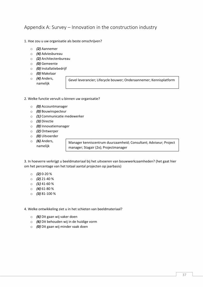
37
Appendix A: Survey – Innovation in the construction industry
1. Hoe zou u uw organisatie als beste omschrijven?
o (2) Aannemer
o (4) Adviesbureau
o (2) Architectenbureau
o (0) Gemeente
o (0) Installatiebedrijf
o (0) Makelaar
o (4) Anders,
namelijk
2. Welke functie vervult u binnen uw organisatie?
o (0) Accountmanager
o (0) Bouwinspecteur
o (1) Communicatie medewerker
o (3) Directie
o (0) Innovatiemanager
o (2) Ontwerper
o (0) Uitvoerder
o (6) Anders,
namelijk
3. In hoeverre verkrijgt u beeldmateriaal bij het uitvoeren van bouwwerkzaamheden? (het gaat hier
om het percentage van het totaal aantal projecten op jaarbasis)
o (2) 0-20 %
o (2) 21-40 %
o (1) 41-60 %
o (4) 61-80 %
o (3) 81-100 %
4. Welke ontwikkeling ziet u in het schieten van beeldmateriaal?
o (6) Dit gaan wij vaker doen
o (6) Dit behouden wij in de huidige vorm
o (0) Dit gaan wij minder vaak doen
Manager kenniscentrum duurzaamheid; Consultant; Adviseur; Project
manager; Stagair (2x); Projectmanager
Gevel leverancier; Lifecycle bouwer; Onderaannemer; Kennisplatform
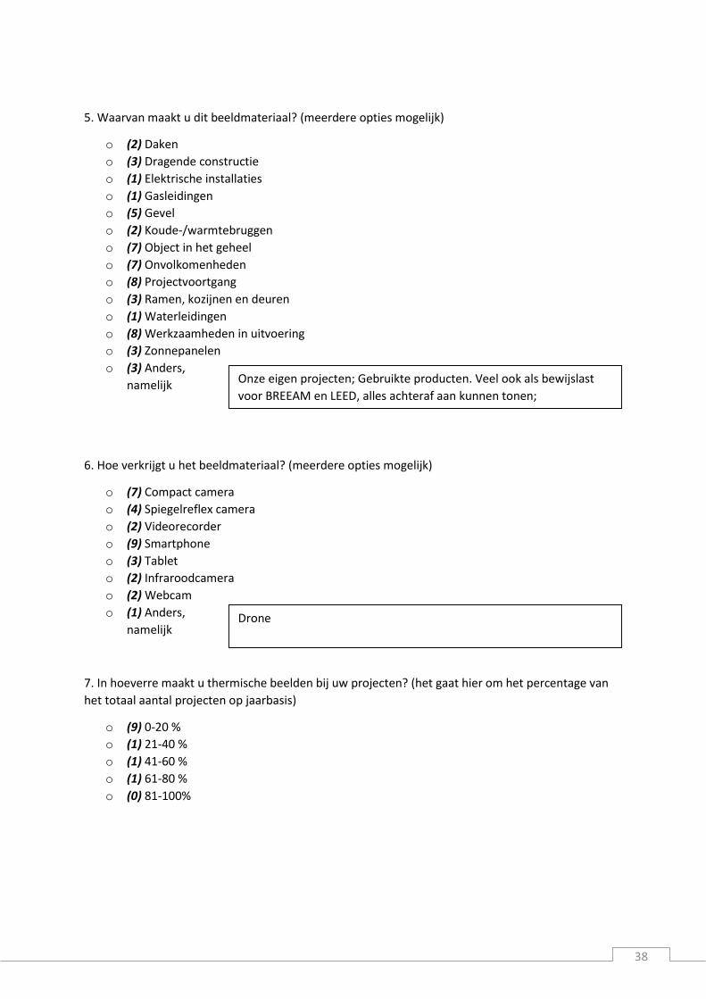
38
5. Waarvan maakt u dit beeldmateriaal? (meerdere opties mogelijk)
o (2) Daken
o (3) Dragende constructie
o (1) Elektrische installaties
o (1) Gasleidingen
o (5) Gevel
o (2) Koude-/warmtebruggen
o (7) Object in het geheel
o (7) Onvolkomenheden
o (8) Projectvoortgang
o (3) Ramen, kozijnen en deuren
o (1) Waterleidingen
o (8) Werkzaamheden in uitvoering
o (3) Zonnepanelen
o (3) Anders,
namelijk
6. Hoe verkrijgt u het beeldmateriaal? (meerdere opties mogelijk)
o (7) Compact camera
o (4) Spiegelreflex camera
o (2) Videorecorder
o (9) Smartphone
o (3) Tablet
o (2) Infraroodcamera
o (2) Webcam
o (1) Anders,
namelijk
7. In hoeverre maakt u thermische beelden bij uw projecten? (het gaat hier om het percentage van
het totaal aantal projecten op jaarbasis)
o (9) 0-20 %
o (1) 21-40 %
o (1) 41-60 %
o (1) 61-80 %
o (0) 81-100%
Drone
Onze eigen projecten; Gebruikte producten. Veel ook als bewijslast
voor BREEAM en LEED, alles achteraf aan kunnen tonen;
Voorbereiding

39
8. Hoe bruikbaar vindt u de onderstaande opname apparatuur voor u (waarbij 1 uitermate
onbruikbaarst aangeeft en 10 uitermate bruikbaar)?
9. In welke fase van het bouwproces schiet u het meeste beeldmateriaal? (één antwoord mogelijk)
o (1) Initiatief
o (1) Ontwerp
o (0) Bouwrijp maken
o (1) Aanleggen fundering
o (1) Bouwen draagconstructie
o (0) Plaatsen binnenwanden
o (0) Aanleggen voorzieningen
o (0) Bouwen omhulling
o (2) Afwerking
o (2) Gebruik
o (2) Anders,
namelijk
10. Waarvoor gebruikt u het beeldmateriaal? (meerdere antwoorden mogelijk)
o (6) Inspectie
o (8) Interne communicatie
o (8) Externe promotie
o (5) Toezicht houden
o (0) Bewaking tegen diefstal
o (1) Bewaking werkveiligheid
o (1) Anders,
namelijk
1 2 3 4 5 6 7 8 9 10 AVG
Compact camera 2 2 4 2 1 7,5
Spiegelreflex camera 1 2 2 4 7,9
Videorecorder 3 1 1 2 1 1 1 4,8
Smartphone 1 1 2 2 5 8,8
Tablet 1 1 1 2 1 1 2 6,2
Infraroodcamera 2 1 1 2 1 2 5,6
Webcam 2 1 2 2 2 4,2
Anders, namelijk: drone
1 9
Bewijslast bij problemen en t.b.v. certificeringen
Bij evenementen; Afbouw fase
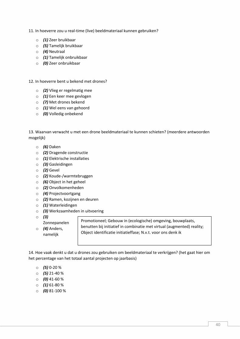
40
11. In hoeverre zou u real-time (live) beeldmateriaal kunnen gebruiken?
o (1) Zeer bruikbaar
o (5) Tamelijk bruikbaar
o (4) Neutraal
o (1) Tamelijk onbruikbaar
o (0) Zeer onbruikbaar
12. In hoeverre bent u bekend met drones?
o (2) Vlieg er regelmatig mee
o (1) Een keer mee gevlogen
o (7) Met drones bekend
o (1) Wel eens van gehoord
o (0) Volledig onbekend
13. Waarvan verwacht u met een drone beeldmateriaal te kunnen schieten? (meerdere antwoorden
mogelijk)
o (6) Daken
o (2) Dragende constructie
o (1) Elektrische installaties
o (3) Gasleidingen
o (2) Gevel
o (2) Koude-/warmtebruggen
o (6) Object in het geheel
o (2) Onvolkomenheden
o (4) Projectvoortgang
o (2) Ramen, kozijnen en deuren
o (1) Waterleidingen
o (3) Werkzaamheden in uitvoering
o (3)
Zonnepanelen
o (4) Anders,
namelijk
14. Hoe vaak denkt u dat u drones zou gebruiken om beeldmateriaal te verkrijgen? (het gaat hier om
het percentage van het totaal aantal projecten op jaarbasis)
o (5) 0-20 %
o (5) 21-40 %
o (0) 41-60 %
o (1) 61-80 %
o (0) 81-100 %
Promotioneel; Gebouw in (ecologische) omgeving, bouwplaats,
benutten bij initiatief in combinatie met virtual (augmented) reality;
Object identificatie initiatieffase; N.v.t. voor ons denk ik
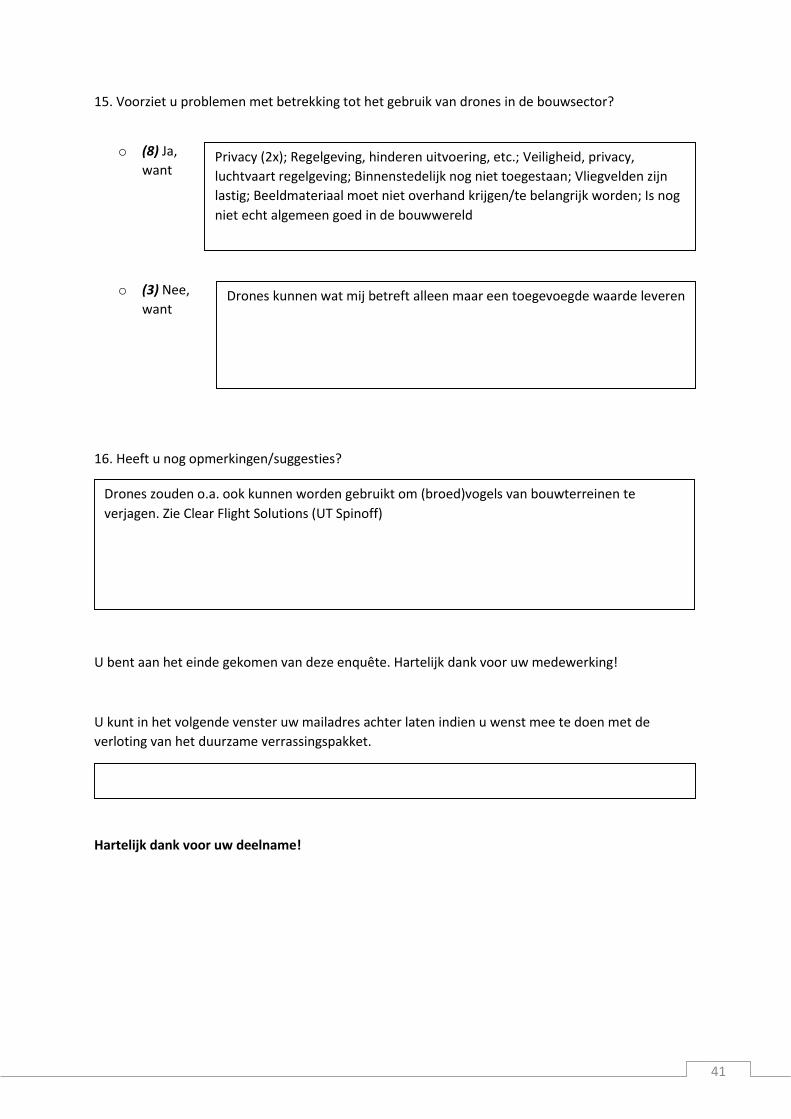
41
15. Voorziet u problemen met betrekking tot het gebruik van drones in de bouwsector?
o (8) Ja,
want
o (3) Nee,
want
16. Heeft u nog opmerkingen/suggesties?
U bent aan het einde gekomen van deze enquête. Hartelijk dank voor uw medewerking!
U kunt in het volgende venster uw mailadres achter laten indien u wenst mee te doen met de
verloting van het duurzame verrassingspakket.
Hartelijk dank voor uw deelname!
Drones zouden o.a. ook kunnen worden gebruikt om (broed)vogels van bouwterreinen te
verjagen. Zie Clear Flight Solutions (UT Spinoff)
Privacy (2x); Regelgeving, hinderen uitvoering, etc.; Veiligheid, privacy,
luchtvaart regelgeving; Binnenstedelijk nog niet toegestaan; Vliegvelden zijn
lastig; Beeldmateriaal moet niet overhand krijgen/te belangrijk worden; Is nog
niet echt algemeen goed in de bouwwereld
Drones kunnen wat mij betreft alleen maar een toegevoegde waarde leveren

42
Appendix B: Meeting & interview company K & company L Zwolle, 30 oktober 2015
Aanwezigen:
Respondent A (bedrijf K)
Respondent B (bedrijf L)
Respondent C (bedrijf L)
Simon Janssen (Universiteit Twente)
B: Ik zal wat informatie geven over bedrijf L en wat wij zoal willen.
Wij hebben wat taken binnen onze werkzaamheden waarvoor wij graag zouden zien dat we dit met
behulp van een drone gaan doen. Met een drone zouden wij veel tijdswinst moeten behalen bij het
inmeten van onze projecten. Nu moeten wij voor een factuur, dus dan ben je nog niet eens zeker dat
het werk ook een opdracht wordt naar locatie en moeten we het dakoppervlak handmatig inmeten en
berekenen. Dit zouden wij graag willen doen door met een drone over het te meten dak te vliegen
waarbij we graag een CAD implementatie zouden zien zonder dat er bestaande tekeningen
beschikbaar zijn. Vervolgens willen wij op locatie een factuur op kunnen stellen, dit wordt gedaan aan
de hand van het totale dakoppervlak.
Ons bedrijf richt zich op asbest sanering, waarbij afhankelijk van het type dak er in eerste instantie
visueel vast te stellen is of er asbest in het dak zit, bij onduidelijkheid zal een monster genomen worden
en dient een laboratorium onderzoek uitsluitsel te geven. Dat zal nog niet kunnen met een drone maar
de visuele inspectie en bemeting van het dak wel. De daadwerkelijke sanering van de asbest besteden
we uit, waarna we zorgen voor passende nieuwe dakbedekking. Het leveren van zonnepanelen
behoort ook tot de mogelijkheden.
Onze markt is hoofdzakelijk de agrarische sector. In veel boerenschuren zit asbest verwerkt, dit moet
van de overheid voor 2024 allemaal weg zijn vanwege de schadelijkheid voor de gezondheid. Dit is dus
voornamelijk in het buitengebied met een vrije omgeving, wat volgens ons positief is met betrekking
tot de regelgeving voor drones. Heel af en toe doen we ook kleinschalige projecten binnen de
bebouwde kom, maar de agrarische sector is wel waar wij het meest ageren.
Met het gebruik van een drone voor onze werkzaamheden zouden wij voor zover ons bekend is de
eerste zijn. Door ons op deze innovatieve manier te onderscheiden van de concurrent kunnen wij beter
toetreden tot de markt. Ook doordat we hiermee sneller werker dan de concurrent. Nauwkeurige
metingen zijn voor ons dan ook voor belang. Dan hoeven we maar één keer op locatie te meten in
plaats van een ruwe meting verrichten voor de offerte en een nauwkeurige als het werk daadwerkelijk
opdracht is.
Veiligheid is uiteraard ook een punt van aandacht. Nu worden schattingen vanaf de grond gedaan. Die
zijn dus niet heel accuraat, precieze metingen worden vrijwel altijd op het dak gedaan. Dat kan weer
onveilig zijn, zeker ook aangezien vaak alleen gewerkt wordt en hulp niet dichtbij is.
A: Height Tech: sinds 6 jaar bezig, voorheen werd er fotografie gemaakt met heli’s. Het is een Duits
bedrijf en heeft inmiddels zo’n 675 grote professionele systemen verkocht. Maatwerk leveren middels
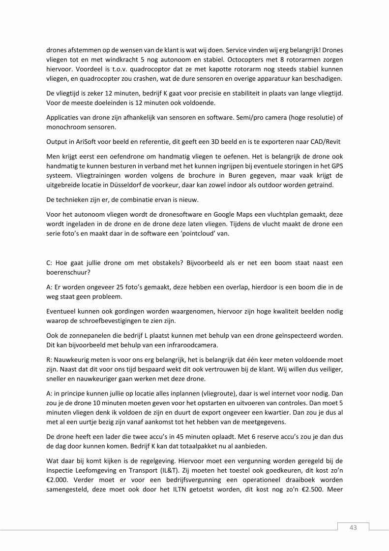
43
drones afstemmen op de wensen van de klant is wat wij doen. Service vinden wij erg belangrijk! Drones
vliegen tot en met windkracht 5 nog autonoom en stabiel. Octocopters met 8 rotorarmen zorgen
hiervoor. Voordeel is t.o.v. quadrocoptor dat ze met kapotte rotorarm nog steeds stabiel kunnen
vliegen, en quadrocopter zou crashen, wat de dure sensoren en overige apparatuur kan beschadigen.
De vliegtijd is zeker 12 minuten, bedrijf K gaat voor precisie en stabiliteit in plaats van lange vliegtijd.
Voor de meeste doeleinden is 12 minuten ook voldoende.
Applicaties van drone zijn afhankelijk van sensoren en software. Semi/pro camera (hoge resolutie) of
monochroom sensoren.
Output in AriSoft voor beeld en referentie, dit geeft een 3D beeld en is te exporteren naar CAD/Revit
Men krijgt eerst een oefendrone om handmatig vliegen te oefenen. Het is belangrijk de drone ook
handmatig te kunnen besturen in verband met het kunnen ingrijpen bij eventuele storingen in het GPS
systeem. Vliegtrainingen worden volgens de brochure in Buren gegeven, maar vaak krijgt de
uitgebreide locatie in Düsseldorf de voorkeur, daar kan zowel indoor als outdoor worden getraind.
De technieken zijn er, de combinatie ervan is nieuw.
Voor het autonoom vliegen wordt de dronesoftware en Google Maps een vluchtplan gemaakt, deze
wordt ingeladen in de drone en de drone deze laten vliegen. Tijdens de vlucht maakt de drone een
serie foto’s en maakt daar in de software een ‘pointcloud’ van.
C: Hoe gaat jullie drone om met obstakels? Bijvoorbeeld als er net een boom staat naast een
boerenschuur?
A: Er worden ongeveer 25 foto’s gemaakt, deze hebben een overlap, hierdoor is een boom die in de
weg staat geen probleem.
Eventueel kunnen ook gordingen worden waargenomen, hiervoor zijn hoge kwaliteit beelden nodig
waarop de schroefbevestigingen te zien zijn.
Ook de zonnepanelen die bedrijf L plaatst kunnen met behulp van een drone geïnspecteerd worden.
Dit kan bijvoorbeeld met behulp van een infraroodcamera.
R: Nauwkeurig meten is voor ons erg belangrijk, het is belangrijk dat één keer meten voldoende moet
zijn. Naast dat dit voor ons tijd bespaard wekt dit ook vertrouwen bij de klant. Wij willen dus veiliger,
sneller en nauwkeuriger gaan werken met deze drone.
A: in principe kunnen jullie op locatie alles inplannen (vliegroute), daar is wel internet voor nodig. Dan
zou je de drone 10 minuten moeten geven voor het opstarten en uitvoeren van controles. Dan moet 5
minuten vliegen denk ik voldoen de zijn en duurt de export ongeveer een kwartier. Dan zou je dus al
met al een uurtje bezig zijn vanaf aankomst tot het hebben van de meetgegevens.
De drone heeft een lader die twee accu’s in 45 minuten oplaadt. Met 6 reserve accu’s zou je dan dus
de dag door kunnen komen. Bedrijf K kan dat totaalpakket nu al aanbieden.
Wat daar bij komt kijken is de regelgeving. Hiervoor moet een vergunning worden geregeld bij de
Inspectie Leefomgeving en Transport (IL&T). Zij moeten het toestel ook goedkeuren, dit kost zo’n
€2.000. Verder moet er voor een bedrijfsvergunning een operationeel draaiboek worden
samengesteld, deze moet ook door het ILTN getoetst worden, dit kost nog zo'n €2.500. Meer
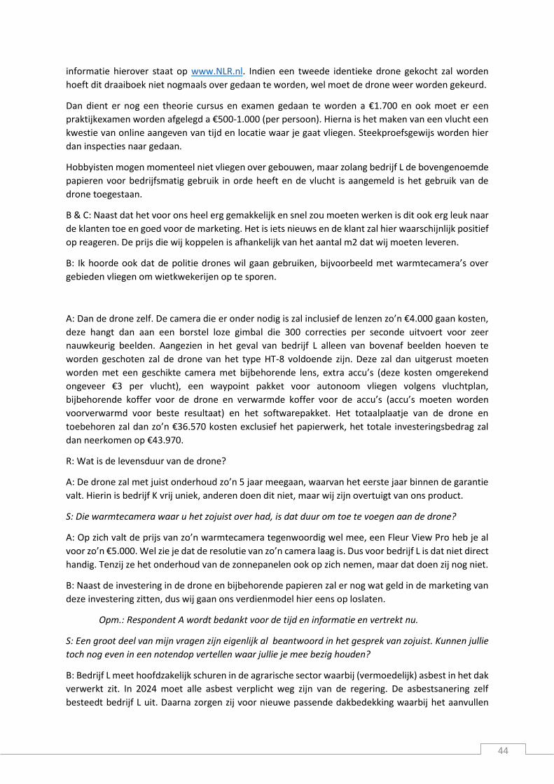
44
informatie hierover staat op www.NLR.nl. Indien een tweede identieke drone gekocht zal worden
hoeft dit draaiboek niet nogmaals over gedaan te worden, wel moet de drone weer worden gekeurd.
Dan dient er nog een theorie cursus en examen gedaan te worden a €1.700 en ook moet er een
praktijkexamen worden afgelegd a €500-1.000 (per persoon). Hierna is het maken van een vlucht een
kwestie van online aangeven van tijd en locatie waar je gaat vliegen. Steekproefsgewijs worden hier
dan inspecties naar gedaan.
Hobbyisten mogen momenteel niet vliegen over gebouwen, maar zolang bedrijf L de bovengenoemde
papieren voor bedrijfsmatig gebruik in orde heeft en de vlucht is aangemeld is het gebruik van de
drone toegestaan.
B & C: Naast dat het voor ons heel erg gemakkelijk en snel zou moeten werken is dit ook erg leuk naar
de klanten toe en goed voor de marketing. Het is iets nieuws en de klant zal hier waarschijnlijk positief
op reageren. De prijs die wij koppelen is afhankelijk van het aantal m2 dat wij moeten leveren.
B: Ik hoorde ook dat de politie drones wil gaan gebruiken, bijvoorbeeld met warmtecamera’s over
gebieden vliegen om wietkwekerijen op te sporen.
A: Dan de drone zelf. De camera die er onder nodig is zal inclusief de lenzen zo’n €4.000 gaan kosten,
deze hangt dan aan een borstel loze gimbal die 300 correcties per seconde uitvoert voor zeer
nauwkeurig beelden. Aangezien in het geval van bedrijf L alleen van bovenaf beelden hoeven te
worden geschoten zal de drone van het type HT-8 voldoende zijn. Deze zal dan uitgerust moeten
worden met een geschikte camera met bijbehorende lens, extra accu’s (deze kosten omgerekend
ongeveer €3 per vlucht), een waypoint pakket voor autonoom vliegen volgens vluchtplan,
bijbehorende koffer voor de drone en verwarmde koffer voor de accu’s (accu’s moeten worden
voorverwarmd voor beste resultaat) en het softwarepakket. Het totaalplaatje van de drone en
toebehoren zal dan zo’n €36.570 kosten exclusief het papierwerk, het totale investeringsbedrag zal
dan neerkomen op €43.970.
R: Wat is de levensduur van de drone?
A: De drone zal met juist onderhoud zo’n 5 jaar meegaan, waarvan het eerste jaar binnen de garantie
valt. Hierin is bedrijf K vrij uniek, anderen doen dit niet, maar wij zijn overtuigt van ons product.
S: Die warmtecamera waar u het zojuist over had, is dat duur om toe te voegen aan de drone?
A: Op zich valt de prijs van zo’n warmtecamera tegenwoordig wel mee, een Fleur View Pro heb je al
voor zo’n €5.000. Wel zie je dat de resolutie van zo’n camera laag is. Dus voor bedrijf L is dat niet direct
handig. Tenzij ze het onderhoud van de zonnepanelen ook op zich nemen, maar dat doen zij nog niet.
B: Naast de investering in de drone en bijbehorende papieren zal er nog wat geld in de marketing van
deze investering zitten, dus wij gaan ons verdienmodel hier eens op loslaten.
Opm.: Respondent A wordt bedankt voor de tijd en informatie en vertrekt nu.
S: Een groot deel van mijn vragen zijn eigenlijk al beantwoord in het gesprek van zojuist. Kunnen jullie
toch nog even in een notendop vertellen waar jullie je mee bezig houden?
B: Bedrijf L meet hoofdzakelijk schuren in de agrarische sector waarbij (vermoedelijk) asbest in het dak
verwerkt zit. In 2024 moet alle asbest verplicht weg zijn van de regering. De asbestsanering zelf
besteedt bedrijf L uit. Daarna zorgen zij voor nieuwe passende dakbedekking waarbij het aanvullen

45
van het dak met zonnepanelen tot de opties behoort. De jaarlijkse inspectie en schoonmaakbeurt van
de zonnepanelen worden uitbesteed.
S: Waarmee maken jullie beeldmaterialen?
B: Als men kijkt naar de manieren waarom bedrijf L beeldmateriaal maakt en gebruikt is dat momenteel
vaak met allerhande fotocamera’s, smartphones en ook wordt Google Maps vaak geraadpleegd.
bedrijf L wil snel werk leveren en doelt op goede marketing om te door te groeien. Dit is een van de
redenen waarom we willen kijken naar de optie om drones te gebruiken. Het doeleinde waar wij de
drone voor willen gebruiken (inmeten van daken) wordt nog niet gedaan waardoor dit innovatieve
idee ons hopelijk sterker op de markt zet. Een ander gevolg hiervan is dat er nog geen ervaringen zijn
en we dus een beetje in het diepe springen hiermee. We dachten aanvankelijk voor 2 a 3 drones te
gaan, maar de investeringssom en met name het aandeel dat niets toevoegt aan de drone zelf (het
papierwerk) maakt dat we eerst ons verdienmodel erop moeten naslaan en de afschrijvingsperiode
van 5 jaar viel ons een tegen.
S: In hoeverre maken jullie al of willen jullie infraroodbeelden maken?
B: Momenteel zijn wij nog niet geïnteresseerd in het gebruik van infraroodcamera’s, maar in 2018
komt er weer nieuwe regelgeving m.b.t. de luchtdichtheid. Hierdoor kan IR voor renovatie projecten
wel interessant worden.
Mogelijkheden die we voorzien zijn bijvoorbeeld het aanbieden van drones op basis van een
leasecontract zoals bij auto’s veel gebeurd. Maar wat voor ons toch vooral een voordeel zou zijn is dat
je maar één keer naar de (mogelijke) klant heen hoeft te gaan in plaats van eerst een keer voor het
inmeten ten behoeve van de offerte en nog een tweede keer voor het nauwkeurig opmeten voor de
dakbedekking. Daarbij kan zo’n drone achter in de auto en hoeft er geen aanhanger mee. Hierdoor kun
je op de snelweg weer harder rijden en al met al kan zo’n drone ons aardig wat tijd en dus geld
uitsparen.
Wij vragen ons af of we niet ergens een subsidiepotje kunnen vinden voor een dergelijk pilot project
als deze.
Aan overige mogelijkheden zien we misschien wel het uitvoeren van controles en inspecties maar ook
pakjestransport voor bijvoorbeeld de postorderbedrijven.

46
Appendix C: Interview company M Hengelo, 5 november 2015
Aanwezigen:
Respondent D (bedrijf M)
Simon Janssen (Universiteit Twente)
S: Hoe zou u bedrijf M als beste omschrijven, wat is jullie core business?
D: Bedrijf M is een bouw- en ontwikkelingsbedrijf. Een van onze kenmerken is dat wij een familiebedrijf
zijn, onze grote aandeelhouder is de familie De Leeuw en daarnaast is het bedrijf in de handen van de
Rabobank met een minderheidsbelang. Grote landelijke speler, top 10 bouwbedrijf in Nederland.
Verschil met andere top 10 bedrijven is dat wij veel decentraler zijn georganiseerd, we hebben
bijvoorbeeld 26 vestigingen waarbij andere bedrijven dat met misschien 10 of 8 doen. We zijn dus heel
decentraal, heel dicht bij de klant. Ondernemerschap laag in de organisatie. Kenmerk van ons is dat
we actief zijn, we doen meer dan bouwen, in de initiatieffase, ontwikkelingsfase, realiseren, en beheer
en onderhoud. Voor bedrijven, corporaties maar ook particulieren bieden we onderhoud aan de
gebouwen verrichten. Ook nieuw initiatief ontwikkelen om bestaande gebouwen te herbestemmen.
Dat is in grote lijnen bedrijf M, een mooi bedrijf, financieel krachtig bedrijf.
S: Welke functie vervult u bij bedrijf M?
D: Ik ben bedrijfsleider van de vestiging Hengelo en ik heb die functie ook in Eibergen. We hebben in
Oost een aantal vestigingen waarvan Hengelo en Enschede de vestigingen zijn die de Achterhoek en
Twente bedienen. Dus mijn werkgebied ligt heel lokaal. Ik ben actief in de Twentse steden en daarnaast
is de Achterhoek een werkgebied waar ik incidenteel wel eens zit, er zijn collega’s die daar actiever
zijn. Bedrijfsleider houdt in dat ik mij met voornamelijk bezig houd met de voorzijde van het project,
dus op het moment dat de realisatie start is mijn werk vaak gedaan. Dan hou ik nog wel contact met
de klant, ik kom nog wel op de bouwplaats, dat wel. Maar ik ben niet degene die direct de uitvoerende
werkzaamheden aanstuurt, dus ik zit vooral aan de voorzijde. Het eerste contact met de klanten, maar
ook soms het contact met klanten tot stand brengen omdat wij denken dat bijvoorbeeld de huisvesting
van de klant op een andere locatie efficiënter zou kunnen. Dat hebben we bijvoorbeeld bij Stork gezien,
Stork heeft een nieuwe fabriek gebouwd. Daar hebben we de financiering voor georganiseerd. We
hebben ook de oude locatie van Stork verworven tot herbestemmingsgebied voor woningbouw.
Het mooie van dit vak, dat je vaak ziet dat het gebouw, of dat nou een woning is of een fabriek een
kantoor of een poppodium, je ziet dat er door het nieuwe gebouw binnen je bedrijf ook een nieuwe
dynamiek ontstaat. Een nieuwe manier van werken, anders wonen anders leven. Dat is het mooiste
van het werk, het contact met de mensen. Vroeger dacht ik altijd dat techniek heel interessant was,
maar dat is eigenlijk helemaal niet zo.
S: In hoeverre gebruiken jullie al beeldmateriaal?
D: een plaatje zegt meer dan duizend woorden, dat is ook echt zo. Daar zijn wij heel erg mee bezig, dat
zie je bijvoorbeeld in hoe wij presentaties voor nieuwe werken aanvliegen. We worden steeds vaker

47
gevraagd om een plan van aanpak te maken, wij hebben het maken, inhoudelijk vullen van zo’n plan
van aanpak doen wij zelf. Wel met bijvoorbeeld ondersteuning van een tekstschrijver die we eens
vragen om te kijken of de tekst goed loopt en begrijpbaar is. Kun je dat als leek ook snappen. Daar
komen wel eens leuke dingen uit, zoals bijvoorbeeld CV’s op een andere manier gaan presenteren.
Maar wat je ziet is dat we de hele opmaak en het gebruik maken van beeldmateriaal doen we ook in
eigen huis. Daarmee zijn we denk ik wat verder dan sommige andere partijen. We werken daar onder
andere voor met InDesign. We hebben een aparte afdeling waar voornamelijk dames, of een enkele
heer bezig zijn met specifiek dat soort zaken.
Opm.: Een voorbeeld van brochure wordt geshowd.
Zoals je ziet is dat beeld heel belangrijk. Er wordt volop gebruik gemaakt van beeldmateriaal, foto’s,
artist impressions. In overleg met de klant gaan we zelf altijd foto’s maken met vaste fotografen. Wij
werken zeker heel veel met beeldmateriaal. Eigenlijk zo’n beetje bij ieder project.
S: Welke ontwikkeling zien jullie met het schieten van beeldmateriaal?
D: Wat je ziet is dat als ik een paar jaar terug kijk, dan hadden we natuurlijk geen camera’s en dit
(brochures met beeldmateriaal) hadden we toen nog niet. De kwaliteit van de foto’s met een telefoon
zijn gigantisch verbeterd. Ik doe dit werk nu 16 jaar en toen ik begin hadden we nog een Polaroids op
de bouw. Ik ben begonnen als assistent uitvoerder en dan maakten wij Polaroids. En dat is dus 16 jaar
geleden, wat op zich nog niet zo heel erg lang geleden is. Die foto’s hadden we vaak snel nodig, en
later kwam dan de digitale fotografie en de geheugensticks en dan werd zo’n foto geprint. Dat is
natuurlijk voorbij, dat staat nu allemaal in de Cloud. Daarnaast zie je dat het gebruik maken van
professionele fotografen die ons hebben voorzien van beeldmateriaal voor onze eigen projecten dat
neemt ook toe. En waarom neemt dat toe? We zijn zo langzamerhand volledig van de markt die puur
om de prijs gaat. We werken allen nog in een markt waarin we meerwaarde kunnen leveren, waarin
het niet gaat om de laagste prijs, maar waar het gaat om je plan en om je visie. Uiteraard gaat het ook
om de prijs, dat is natuurlijk ook belangrijk, maar het gaat niet uitsluitend om de prijs. Dan is
beeldmateriaal en hoe je dat presenteert gewoon heel belangrijk. Dat zie je in fotomateriaal, dat zie je
ook in films. Beeldmateriaal is redelijk vrij binnen het bedrijf, ook hoe je daarmee omgaat qua social
media. Je ziet qua filmpjes, bedrijf M heeft uiteraard een eigen YouTube kanaal, je ziet wel dat als er
filmpjes zijn, die wel redelijk steng bekeken moeten worden of die er wel of niet op komen.
S: Je moet natuurlijk niet scheef gefilmd materiaal hebben waar dingen op staan die je liever niet
openbaar hebt.
D: Niet alle films komen erop, de kwaliteit van de filmpjes zijn over het algemeen prima, maar ze komen
er niet allemaal op. Je ziet bij beeldmateriaal (foto’s) dat we daar wat vrijer in zijn.
We zetten nu als bedrijf M filmpjes op internet, en volgens mij is de volgende stap dat iedere
willekeurige medewerker dat gaat doet op allerlei kanalen. Dat gebeurt nu al met Facebook, met
Twitter, LinkedIn. Dat is een aantal jaar geleden volledig vrijgegeven, tot voor kort (aantal jaargeleden)
was dat nog gereguleerd. Dan moest je dus toestemming vragen om iets op Twitter te zetten. Dat
werkt niet, dat is nu niet meer logisch. Het is denk ik wat anders als je woordvoerder namens een
bedrijf bent, dan Twitter je namens het bedrijf, het is toch vaak een persoonlijke titel en daar zullen
soms wat ongelukjes uit komen.
48
S: Bijvoorbeeld de politie in Almelo met de Poolse draaideurcrimineel en de wijkagent met pistool.
D: Dat inderdaad, maar dat kun je ook niet tegenhouden, daar kun je mensen in coachen en als je geen
visie ontwikkeld op dat gebied kun je ook niet verwachten dat mensen dat goed of fout gaan doen.
S: Als we dan wat meer op de bouw gaan kijken, waarvan maken jullie dan het meeste
beeldmateriaal?
D: als het puur om beeldmateriaal gaat zie je natuurlijk dat we veel beelden maken tijdens de
uitvoering, maar dat is vooral beeldmateriaal dat geschoten wordt om later en tijdens de bouw te
kunnen aantonen dat we een bepaalde kwaliteit hebben gehaald. Maar ook om na de bouw je revisie
stukken op orde te hebben. Wat je ziet bij complexere werken, is het bijzonder handig als je later nog
eens een keer terug kan kijken om te kijken hoe dat ook al weer zat. Daar hebben we een apart appje
voor, wij doen dat met twee apps ED Control of Field en dat werkt fantastisch. Dat zijn de uitvoerders
die de beelden vastleggen.
Wat je daarnaast ziet is dat we beelden schieten tijdens de uitvoering voor dit soort plannen van
aanpak en dat we foto’s maken van het eindproduct. Daarin zie je dat we vooral tijdens de uitvoering
we langzamerhand steeds meer bewegen naar de beelden met de medewerkers erop. Het gaat om
mensen. Voorbeeld wordt gezocht. Dit soort beelden van onze meldkamer in Deventer, waar we ons
dagelijks onderhoud verrichten. Dit (foto van medewerker op een steiger met iPad in de hand) is
misschien ook wel aardig, je ziet in een steeds digitaler wordende wereld met steeds perfectere
‘digitale bouwplaatsen’. Een foto van een bouwplaats inrichting is niet heel verleidelijk zo, maar door
er mensen toe te voegen triggert het meer. Zo worden er bijvoorbeeld ook vaak pasfoto’s van
betrokken medewerkers toegevoegd die een bouwproject moeten gaan trekken.
S: Dus als ik het goed begrijp gebruiken jullie beeldmateriaal vaak voor interne communicatie of als
een vorm van promotie naar buiten toe?
D: Ja, extern. Maar ook intern, we hebben de Spatpen dat is ons personeelsblad, dat verschijnt deels
digitaal, deels wordt het gedrukt en verschijnt 6 keer per jaar. Drie keer gedrukt en drie keer digitaal.
En we hebben een relatiemagazine, ‘Op de korrel’, daar wordt natuurlijk veel beeldmateriaal voor
gebruikt, de website, Twitter, Facebook, LinkedIn zijn we ook heel actief mee bezig. Houden we ook
veel op bij hoe wij staan ten opzichte van de rest, loopt de rest op ons uit of lopen wij uit op de rest.
Dat is ook wel aardig om te zien. Je ziet op Facebook bijvoorbeeld dat we groter (meer volgers hebben)
zijn dan andere bedrijven die groter zijn dan ons. Op Twitter zijn wij bijvoorbeeld weer wat kleiner.
S: Hoe verkrijgen jullie het beeldmateriaal? Dus meer richting de systemen denken waarmee het
geschoten wordt. U noemde al de fotograaf, die gebruikt neem ik aan een DSLR. Maar wordt ook
gebruik gemaakt van bijvoorbeeld smartphones of zoals net op de foto al met een iPad? Dat wordt
natuurlijk steeds makkelijker. Gebruiken jullie bijvoorbeeld ook webcams op de bouwplaats?
D: Ja webcams gebruiken we ook, niet op iedere bouwplaats. Die gebruiken we eigenlijk voor twee
doelen. Enerzijds voor veiligheid en controle, maar wel redelijk low-tech. Het is niet zo dat we een
melding krijgen als er iets gebeurt. Het is zo dat die camera erop staat, we hebben hem ook altijd in de
vertraging van een half uur. Dus mocht er een ongeval plaatsvinden dan kan de uitvoerder de camera
of in ieder geval de verbinding naar buiten toe uitzetten. Dan liggen de beelden wel vast, maar dan
49
heb je niet dat de halve wereld kan zien dat de medewerkers iets overkomt. Dat is niet prettig. Dat
soort dingen hebben we dus over nagedacht.
S: Eigenlijk zo’n beetje iedere vorm van het verkrijgen van beeldmateriaal wordt wel gebruikt.
S: Als je dan wat verder gaat denken qua apparatuur, gebruiken jullie dan ook wel eens
infraroodcamera’s?
D: Ja zeker, die gebruiken we ook. Met name, wat je ziet is dat steeds meer opdrachtgevers om een
certificaat vragen. Er zijn ook opdrachtgevers die het niet vragen en die we het vervolgens aanbieden,
we kunnen uw gebouw of product (soms hebben ze al een gebouw en verrichten wij daar
werkzaamheden aan) leveren met een certificaat of test. En daarvoor moet je meten, dat kun je onder
andere met een infraroodbeelden doen. Maar je ziet het bijvoorbeeld ook met het duurzaamheidslabel
(BREEAM). Dan moet je aantonen dat je de isolatie en de luchtdichtheid aangebracht hebt zoals is
overeengekomen.
S: Doen jullie dat dan ook zelf?
D: Ja deels, wat je ziet is dat we wel zelf een camera in het bezit hebben, maar wat je ziet is dat als je
zo’n BREEAM achtig certificaat wil hebben we daar vaak vaste partners voor inschakelen. Bijvoorbeeld
Nieman bouwen (bouwfysisch adviseur). Dan laten we Niemand die rapportage maken.
En we hebben een dingetje om in de spouw te kunnen kijken, dat is niet zozeer beeld, maar meer een
vochtmeter. Warmtecamera’s met lekkages in isolatiesystemen. Ik denk dat we op dat gebied nog
maar aan het begin zitten, dat gaat nog een gigantische sprong nemen.
Ik kan me nog herinneren toen ik 16 jaar geleden in Almere op de bouwplaats liep, daar kregen we
betonelementen. Die consoles waren van buiten allemaal gelijk, maar qua wapening verschilden zij
i.v.m. het verschil in krachten dat ze moesten opnemen. Die werden voorzien van een label en aan de
hand van dat label wist je welke console waar moest komen. Dat was de enige manier waarop je die
consoles kon achterhalen, maar als die codes eraf waren had je geen idee welke console waar geplaatst
moest worden. En dat gebeurt nogal eens. Je ziet nu dat dat verandert is met streepjescodes
bijvoorbeeld. Ik denk dat dat nog veel verder gaat, het traceerbaar maken van materialen met
beeldmateriaal.
S: Welke kant zit u dan op te denken?
D: Bijvoorbeeld wat VBI doet, de kanaalplaat komt er aan. Dan projecteren ze met laserlicht waar de
sparing in de plaat moet komen. Dat soort technieken zijn in de fabrieken al heel ver, maar dat gaat in
de uitvoering ook verschijnen op de bouw. Dat de tekening gedigitaliseerd worden en misschien we
geprojecteerd wordt in het gebouw. Deels doet we dat natuurlijk al met onze maatvoeringen, maar
die markeren we dan nog met een spuitbus of een potloodje of een latje. Dat gaat anders worden.
S: Kunt u een schatting maken van het percentage van de projecten waarbij jullie gebruik maken van
thermische beelden?
D: Ik denk 60% en ik verwacht dat in Duitsland men dat in 90% van de gevallen doet, dus dat zegt wel
iets. Ik denk dat als je naar de hele Nederlandse markt kijkt het over 20% gaat.
50
S: Hoe bruikbaar vindt u de opnameapparatuur die we zojuist besproken hebben?
D: Daar is nog wel een slag in te maken, ik heb dus de nieuwste van het nieuwste vochtmeter gekocht,
maar dat ding kan met niemand communiceren. Hij laat zien wat hij uitleest, maar er kan geen export
van gemaakt worden. Wat is doe is dat ik met mijn smartphone een foto maak van wat ik aflees. Zo zie
je dat met meer dingen, bijvoorbeeld afstandsmeters.
S: Welke fase van het bouwproject u het beeldmateriaal schiet hebben we het zojuist al even over
gehad. Eigenlijk vanaf initiatief tot en met onderhoud.
D: Even tussendoor, wat ik natuurlijk ontzettend veel gebruik (en ik niet alleen) is Google Earth. Waar
je zag dat we voorheen met een project bezig waren waarbij we naar bv. Nijmegen moesten om te
kijken naar de omgeving. En nu is een van de eerste dingen die we gaan doen kijken waar we moeten
zijn en hoe de omgeving eruit ziet. Je ziet allen wel dat ze het nog niet helemaal op orde hebben, in dit
gebied zijn de beelden van Google bijvoorbeeld nog van 2008, terwijl bijvoorbeeld Streetview wel heel
actueel is.
S: Als we kijken naar de bouwfases, in welke fase maken jullie dan het meeste beeldmateriaal?
D: Als je kijkt naar de absolute aantallen dan is dat zeker tijdens de uitvoering. Als je gaat kijken naar
welke beelden er het vaakst worden gebruikt, dan zijn dat wel de foto’s van wanneer het klaar is. En
een keer een enkele actiefoto. Ik denk dat dat een beetje is hoe het werkt. Heel veel technische foto’s
van de uitvoering worden daarna niet meer gebruikt, tenzij er gedoe is.
D: Wat ook wel een aardig dingetjes is voor beeldmateriaal wat heel specifiek voor de bouw is of
eigenlijk het maken van foto’s van werkzaamheden is het onderdeeltje veiligheid. Je ziet het hier op
deze foto ook. Deze man heeft handschoenen aan gehoorbescherming op, veiligheidsschoenen aan.
Dat is best wel een aandachtspunt, je ziet dat een gemiddelde fotograaf gewoon een foto maakt. Zelfs
al doet hij niets anders dan bouwfoto’s maken en wij hebben altijd nog weer dat het goed is om nog
even goed kritisch te kijken. En je ziet het op de gekste plekken, de Cobouw, tijdschriften. Daar staan
soms foto’s in waar ik van schrik. Als het goed zou zijn zou je niets kunnen fotograferen wat niet goed
zit, maar niets is perfect.
S: Doorgaand op veiligheid. Je ziet hier dat de man veilig aan het werk is. Maar als bijvoorbeeld met die
webcam gezien wordt dat iemand zijn helm niet draagt, is dat dan ook een manier van kijken?
D: Nee, het is niet zo dat wij ’s ochtens om half 8 op de webcam kijken om te checken of iedereen op
de steiger is of om te kijken of iedereen beschermende middelen gebruikt nee. Wat ik wel zelf erg
handig vind van een webcam is dat als projecten verder weg zijn, je bent er dus niet iedere dag, je vaak
terug kan kijken. Of als je bijvoorbeeld een afspraak hebt op een bouwplaats waar je zelf een week
niet bent geweest, dan vind ik het handig om een dag van tevoren nog even te kijken hoever we zijn.
Zijn we dan ook echt zo ver als we afgesproken hebt, dan moet je als je daar aankomt natuurlijk nog
wel even een rondje lopen. Maar soms ontbreek je ook aan tijd en dan is het wel handig als je dit soort
middelen hebt.
S: Een hele andere kant van veiligheid. Er word meestal niet 24/7 gebouwd, er zijn tegenwoordig
instanties als Bouwatch die de boel voor je in de gaten houden. Maken jullie daar dan ook gebruik van?
51
D: Ja daar maken we ook gebruik van, je ziet alleen nog niet dat er een integratie is tussen de twee.
We hebben verschillende webcamleveranciers, die leveren een webcam. Daarnaast werken we met
Bouwatch achtige bedrijven en dan met name met sensoren (camera geactiveerd door beweging) en
dat werkt voortreffelijk . Als je een beetje een groot werk hebt en je doet niets dan is het een kwestie
van tijd en dan ben je de Sjaak. Er komen en gaan heel veel mensen op zo’n bouwplaats. Er is heel veel
verkeer overdag en je kan nooit weten wie het zijn, dat kan intern zijn dat kan extern zijn. Ik ben niet
van het inzetten van een beveiligingsbedrijf die langsrijden. Dan wachten ze (de crimineel) tot het witte
busje langs is en komen dan wel. Maar op het moment dat die sensoren er staan, ja dat zet zoden aan
de dijk.
S: Er wordt dus middels de webcams een soort van real-time beelden gemaakt (met een half uur
vertraging erin).
D: Ja, maar even voor de duidelijkheid. Dat doen we niet, ja als er wat aan de hand is dan hebben we
de beelden gewoon. Dat communiceren we ook naar onze medewerkers en leveranciers. Iedereen
krijg een introductiefolder, die moet men ondertekenen dat men die gehad heeft. Daar staat ook in
wat we aan het doen zijn en wie waarvoor de contactpersonen zijn. Vaak staat er ook iets in over de
opdrachtgever. Daarin geven we ook aan dat er een webcam is en dat men gefilmd kan worden.
S: Zijn jullie bekend met drones?
D: Een drone ken ik wel iets van ja. We andere voor een film voor de nieuwe fabriek van Stork hebben
wij gebruik gemaakt met beelden van een drone. Daarvoor hebben we een extern bureau (JLS Studio)
ingehuurd en we gebruiken hem dus alleen nog maar voor marketing achtige doeleinden. Dus we
gebruiken hem niet voor de maatvoering, niet in de uitvoering.
Wat ook wel leuk is om daar over te vertellen uit ervaring. We hebben voor een ander project ook
gebruik gemaakt van beelden van een drone. Daarbij waren twee dingen aan de hand: als eerste was
dat iemand die een drone had als hobby en die redelijk met dat ding overweg kon, maar toen we heel
kritisch naar de beelden gingen kijken waren de beelden toch een beetje scheef. Dat is nog niet het
ergste, dat was namelijk dat er uiteindelijk qua vergunningen niks geregeld was. Het waren prachtige
beelden, maar die kunnen we als bedrijf niet gebruiken. Voor mezelf als privépersoon wel heel leuk.
Qua papierwerk moet er dan toch nog wel het een en ander geregeld worden, maar dat zie je
bijvoorbeeld wel met meer dingen. Bijvoorbeeld een filmpje met muziek, als we voorheen een filmpje
wilde maken plakten we een leuk muziekje onder. Dat doen we nu niet meer, wij gebruiken nu alleen
nog rechten vrije muziek.
S: We hebben het net over een aantal toepassingen van beeldmateriaal gehad. Waarvan zouden
jullie kunnen voorzien dat een drone ook gebruikt zou kunnen worden?
D: Ik denk voor heel veel dingen. Inspecties is een mooi natuurlijk, wat je nu ziet is dat dakbedekking
ieder jaar geïnspecteerd moet worden. Dat kun je doen door ieder jaar het dak op te klimmen, dan
moet je maatregelen nemen (dat je er niet af kan vallen). En met zo’n drone kun je er gewoon overheen
vliegen. Dat is natuurlijk wel weer, dat als je dan vervuiling aantreft op dat dak, dan moet je daar wat
mee en dat kan die drone waarschijnlijk nog niet.

52
Wat je ziet is beelden op grote hoogte, en op de lange duur kun je bedenken dat een drone ook
werkzaamheden kan verrichten. Het wordt uiteindelijk gewoon een vliegende robot. En als hij die
stenen kan stapelen, als we dat dan überhaupt nog doen, dan scheelt dat natuurlijk. Dan hebben we
de steiger niet meer nodig en hoeft dat mannetje de steiger niet meer op die er na een uurtje weer
vanaf moet omdat hij naar de wc moet of koffie wil.
Allerlei schieten/maken van beelden. Thermografisch. Je zou ook kunnen denken aan wat ik net zei bij
VBI, dat die drone de maatvoering uitzet. Voorheen maakten we een bouwraam met vier piketjes en
latten en dan ging je met touw de maatvoering uitzetten. Je kunt ook die drone erboven hangen en
die projecteert wat er moet gebeuren en dat die drone dan een signaal geeft als de boel goed staat.
Dat is dan hoofdzakelijk maatgevende werkzaamheden bij beginnende bouwputten, maar zolang je
geen dak hebt kun je natuurlijk nog heel veel. Ik weet niet of je met zo’n ding binnen kan vliegen maar
dat is dan een volgende stap.
Misschien kun je als hij wat groter en zwaarder is gaan gebruiken als transporteur. Wat je ziet is dat de
man die op de bouwplaats de werkzaamheden verricht heel veel verloren uren heeft. Persoonlijke
verzorging (schaft, toilet, koffie) en dat is allemaal prima, dat geeft niet. Maar wat vooral veel tijd kost
is het halen van vergeten spullen. Ik zeg altijd maar een luie timmerman is de beste timmerman want
een luie timmerman denkt de hele dag na, zorgt dat hij alles nodig heeft en loopt dus geen meter te
veel. Het is niet altijd dat de harde werker de beste is, want die loopt zich de hele dag de benen onder
het lijf om vergeten spullen te halen. En als zo’n drone daar in zou kunnen helpen zou dat fantastisch
zijn.
Wat heel gebruikelijk is, is een bouwlift die veel gebruikt wordt en wat je dan ’s ochtens vroeg gebeurt
is dat die mannen voor de lift staan te wachten die in gebruik is. Dat duurt een hele tijd, dus een aantal
van die mannen willen dan geen 10 minuten wachten en zeulen dan hun zware emmers de trap op en
gaan aan het werk. Als je daar de boel in zou kunnen verlichten zou dat heel erg helpen. Met name in
de bouw zijn de materialen vaak vrij zwaar, en dat is nou net niets wat zo’n drone nog niet kan.
S: Hoe veel zou u in de toekomst een drone willen gebruiken om beeldmateriaal mee te schieten?
D: Ik denk dat het steeds meer die kant op gaat. We doen het alleen niet zelf. We hebben zelf wel
fantastische camera’s, maar onze core business is niet foto’s schieten en ook niet met drones vliegen
en daar beelden mee schieten, dus dat zullen we toch 90% van de tijd nu in ieder geval nog extern
zetten. Wat je daar wel ziet is dat het een verhaal is omtrent wet- en regelgeving.
S: Is dat voor jullie op het moment dan ook de grootste hobbel om geen drones te gebruiken?
D: Nee dat niet, als wij denken dat we die beelden nodig hebben dan gaan we dat gewoon organiseren.
Maar het is wel, kijk dit (normale fotografie) is heel snel. En met een drone vergt het wat meer
planning. Je bent afhankelijk van het krijgen van de vergunning en van het weer.
Wat ik wel grappig vind van die dingen is dat ik laatst bij Heracles-Ajax was, daar vlogen ze ook met
zo’n ding en je ziet dat iedereen ermee bezig is. Terwijl iedereen wel weet wat het is, maar toch zie je
mensen wijzen en kijken, het heeft een hele hoge attentiewaarde.
Thales heeft nu een radar laten zien die drones kan oppikken, de Amerikanen dachten dat met kerst
2015 er een miljoen extra drones in de lucht zouden komen omdat dat het kerstcadeautje gaat worden.

53
S: Veel mensen zijn natuurlijk laaiend enthousiast over drones, maar heel veel mensen vrezen ook voor
hun privacy.
D: Nouja, of er nou een vliegtuigje of een luchtballon boven mijn tuin vliegt of een drone. Dat voelt
toch ineens heel anders. Dat was voorheen natuurlijk net zo met dat vliegtuigje, daar was men in het
begin daar ook angstig voor.
S: Voorziet u nog problemen met betrekking tot het gebruik van drones binnen de bouw? Behalve
dan de aspecten die u zojuist al noemde (vergunningen en te weinig liftvermogen).
D: Ik voorzie niet zozeer problemen ik zie vooral kansen, maar je zult eerst nog het een en ander
moeten organiseren voordat je er iets mee kunt. Wat voor alle techniek geldt is dat het het leven
mooier en makkelijker moet maken, email is bijvoorbeeld een verbetering, maar is op sommige
gebieden ook een verslechtering. Dit (face-to-face) contact is ook belangrijk, je krijgt nu andere
informatie dan wanneer je me een enquête had toegestuurd en ik die had ingevuld.
Wat je heel veel ziet met nieuwe technieken die worden geïntroduceerd op een bepaald moment, dan
moet dat het gaan doen. Als iemand daarmee aan het werk gaat en er niet van overtuigt is dat het hem
wat brengt. Dan gaat hij er niet zo veel mee doen. Ik denk dat je heel goed moet weten wat een bepaald
type drone kan toevoegen aan dat proces en wie daar dan belang bij heeft en wie je zo’n ding eerst
laat gebruiken, voordat de massa het gaat gebruiken. Dat zie je bijvoorbeeld bij gehoorbescherming
en veiligheidsschoenen. Twintig jaar geleden deed niemand dat en tien jaar geleden vond je nog steeds
mensen die vonden dat ze op klompen op de bouw moesten lopen. Dat is nu vrijwel verdwenen en is
iedereen ervan overtuigt dat veiligheidsschoenen toch wel het beste werken en dat ze ook gewoon
prima lopen en dat je er geen zere voeten van krijgt.
S: Stel nou dat jullie in de toekomst zelf ook een drone zouden aanschaffen, wat zou zo’n ding dan in
principe mogen kosten?
D: Geen idee, ik ben veel meer geneigd te zeggen “Wat levert het op?”. Dus eigenlijk is dat niet eens
zo heel erg interessant, het gaat om het rendement. Laten we bij de veiligheidsschoenen blijven, als
iedereen op goedkope schoenen loopt en ze hebben aan het eind van de dag zere voeten en ze lopen
drie keer per week te mopperen op die schoenen kun je beter twee tientjes meer uitgeven aan goede
schoenen waarmee ze aan het eind van de dag nog goed kunnen lopen. En dat geldt voor zo’n drone
ook. Dat zie je in algemene zin natuurlijk in heel veel van wat wij gebruiken. In veel gereedschappen
zijn een, twee of drie partij marktleider en wat de andere maken is niet interessant. Zeker in de
professionele markt heeft zogenoemde ‘Chinese rommel’ gewoon geen zin als je daar dagelijks mee
wil werken. Dus wat die drone moet kosten is zo heel moeilijk te zeggen.
54
Appendix D: Interview Company N Enschede, 5 november 2015
Aanwezigen:
Respondent E (bedrijf N)
Simon Janssen (Universiteit Twente)
S: Hoe zou u bedrijf N als beste omschrijven, het is natuurlijk een vrij groot bedrijf. Maar wat is nou
jullie core business?
E: Bedrijf N houdt zich bezig met projectontwikkeling voor utiliteitsbouw, woningbouw, renovatie en
onderhoud. Ik zeg wel eens “in de gebouwde omgeving doet bedrijf N alles wat boven de grond uit
komt”. We bouwen wel kelders, maar geen civiel werk als waterwegen en infrastructuur. Al het
burgerlijke, of utilitaire werk zoals dat zo mooi heet. Geen klantenwerk, we werken niet met
particulieren altijd met grotere partijen.
S: Welke functie vervult u binnen bedrijf N?
E: Ik ben adjunct directeur van bedrijf N Oost en Noord. Ik verantwoordelijk voor een deel van de
acquisitie van oost Nederland, dus tot en met Apeldoorn. We hebben meerdere vestigingen en zitten
eigenlijk in het midden van het land. Niet in het hoge noorden, niet in het diepe zuiden. Maar wel de
hele band rond de A12 en de A1 om maar zo te zeggen. De helft van mijn werk is dus het krijgen van
werken voor deze regio voor al die takken van sport. Andere deel van mijn werk is het begeleiden van
utilitaire tenders van grote complexe projecten. Dan moet je denken aan ziekenhuizen, we zijn nu met
een terminal voor een luchthaven uitgenodigd. Dat soort klussen. Een van de grootste projecten, en
die hebben we niet alleen gedaan hoor maar met partners, dat was het ziekenhuis (MST) in Enschede,
dat is net opgeleverd.
S: Dat zijn dus wel de grotere projecten waar jullie je op richten, dus bijvoorbeeld een corporatie als de
SJHT (Stichting JongerenHuisvesting Twente) valt niet binnen jullie doelgroep?
E: De SJHT ken ik zo niet, maar we hebben we een afdeling kleinbouw zoals dat heet. Dat is ook die
renovatie en onderhoudsdiensten en die doen kleinere klussen voor corporaties hier in de stad en in
andere steden. Dat gaat vaak om het renoveren van een paar woningen. Als je naar de nieuwbouw
kijkt gaat dat meestal over vanaf 10 woningen ongeveer. Dat is zo’n beetje het minimale project wat
wij doen, de kleinere projecten zijn kleinere bouwbedrijven veel beter in, dus dat doen we niet.
S: In hoeverre maakt bedrijf N al beeldmateriaal?
Opm.: Respondent E haalt even wat voorbeelden op van beeldmateriaal.
E: Van verkoopprojecten maken we dit soort brochures. Dat spreekt wel voor zich. Voor tenders die
wij dus voor de markt maken, maar op uitnodiging maken we dus ook boekjes. Met plannen van
aanpak, visies, vaak is het een ontwerp of is het van hoe wij werken. Plan van aanpak hoe we het gaan
bouwen en hoe we het proces gaan managen. Dat is beeldmateriaal dat wij maken en gebruiken. Dit
is projectgericht, een verkoopbrochhure, ook projectgericht op een plan in Nijmegen dat we realiseren.
55
Dat zijn voor particulieren en voor huurders verkoopdocumentatie, maar dat is dus ook voor
professionele opdrachtgevers. Kortom het verkopen van al onze diensten, namelijk het ontwikkelen,
bouwen en beheren van gebouwen, en hoe we dat denken aan te pakken.
Als je naar de corparate kant kijkt doen we dat ook, dat moet je eigenlijk in drie lijnen zien: conceptuele
woningbouw, utiliteitsbouw (wat we doen, welke projecten en wat onze visie daarbij is), en dan nog
de ‘nieuwbouw, renovatie en vernieuwbouw’ (met hoe we dat aanpakken, dit is bijvoorbeeld een
maatschappelijk jaarverslag van wat wij ook vertellen wat we naast de financiële kant ook op
maatschappelijk vlak doen).
Dit is niet voor niks vrij nieuw, ook in de afgelopen 10 jaar dat ik nu bij bedrijf N zit van helemaal niets
tot nu dit en ik weet niet waar het nog naartoe gaat. We zijn steeds tot een bedrijf gekomen dat onze
producten vermarkten. We zijn niet meer een aannemer door wie een gebouw gebouwd wordt. We
verkopen huisvestingsoplossingen en dit is daar de verbeelding van. Dit is papier, uiteraard staat dit
ook op de website en onze Facebook pagina zo zullen wij dit veel meer via allerhande media berichten
en versturen/verspreiden.
S: Dat is dan dus beeldmateriaal dat hoofdzakelijk voor marketing doeleinde gebruikt wordt?
E: Ja, we hebben als je er in kijkt, als je dat ook onder beeldmateriaal schaart, werken we heel veel met
3D, steeds meer BIM achtige modellen waar ook heel veel in gevisualiseerd wordt. Dat is iets wat weer
niet zozeer hierin, maar meer in de engineering zit. Dat is ook beeldmateriaal, of eigenlijk een
visualisatie van de projecten waar je mee bezig bent. Vroeger waren dat platte tekeningen, nu wordt
er steeds meer op deze manier gewerkt. Er is haast geen denken meer aan de oude manier.
S: Dus jullie gebruiken bij vrijwel ieder project dat jullie doen beeldmateriaal?
E: Ja. Ofwel in presentatievorm ofwel in verkoopvorm. Heel plat gezegd wordt er altijd wel een boekje
gemaakt voor een project.
S: En op de bouwplaats zelf?
E: Dat is een goede, ik denk dat het daar nog wat in de kinderschoenen staat en dat daar qua visualisatie
nog wel een flinke slag gemaakt kan worden. Je ziet nu dat wij alle uitvoerders een iPad hebben
gegeven waarop met bepaalde programmatuur alle informatie beschikbaar is. Idealiter zou je iedereen
met een mooie interactieve bril () op, op de bouwplaats hebben lopen. Dat er gewoon real-time
geprojecteerd wordt wat er moet komen en dat je dat kan toetsen. Zover is het nog niet, maar daar
zijn we wel al stapjes in aan het zetten.
S: Dus als ik de vraag zou stellen welke ontwikkeling u ziet met betrekking tot beeldmateriaal in de
bouw dan is dat in de afgelopen 10 jaar heel erg toegenomen van helemaal niks tot heel veel.
E: In onze branche is dat inderdaad van stapels witte tekeningen van architecten tot hoe we er nu voor
staan. We zijn nog geen volleerd marketing bedrijf, maar als je kijkt naar andere bedrijven in andere
branches dan zie je dat die al langer brochures en folder maakt. Dan gaat het voor ons dus niet zozeer
om de techniek maar echt meer om de beleving. En dat wordt steeds meer en meer. Wij gaan steeds
meer onszelf op de klant/afnemer richten en vroeger wilden wij onze klant wel eens zien als de

56
corporatie als klant, nu denken we meer aan de huurders als klant. Dat proberen we dan ook te
visualiseren zodat we altijd eigen mensen en gebruikers hebben in die beeldmaterialen.
S: We hadden het net al even over de interactieve bril, de soort Google Glass.
E: Ik doelde meer op de Oculus Rift, dat is op dit moment de virtuele realiteitsbril. Daar zijn we ook
mee aan het experimenteren. We hebben een demonstratie gezien waarbij je met die bril heel
makkelijk een huis kan aanpassen naar wat men wil en dan kun je door het huis heen lopen en erom
heenlopen om te kijken of dat is wat je in gedachte had.
S: Waarvan schieten jullie beeldmateriaal?
E: Het gebouw, onze mensen en de klant. Eigenlijk altijd wel die drie-eenheid. We bouwen voor onze
klant, we doen dat met onze mensen (een bouwbedrijf is een mensenbedrijf, we hebben hier geen
lopende banden die het werk doen) en uiteindelijk komt daar een product uit. Maar dat is eigenlijk
haast een bijproduct, die samenwerking vinden wij belangrijk.
S: Hoe verkrijgen jullie het beeldmateriaal?
E: We hebben geen professionele fotograaf in dienst, die huren we in. Ook dat is heel belangrijk, tussen
een foto en een foto zit nogal een verschil.
S: Wordt er bijvoorbeeld ook gebruik gemaakt van webcams op de bouwplaats?
E: Ja, af en toe. Dat is niet standaard, maar we hebben ze wel eens.
S: U zei net al uitvoerders met iPads, wordt er ook beeldmateriaal geschoten met smartphones?
E: Ook ja, uiteraard.
S: Dus eigenlijk gebruiken jullie wel het hele scala aan beeldopnameapparatuur? Bijvoorbeeld ook
warmtecamera’s?
E: Ja, die gebruiken we ook voor bijvoorbeeld blowdoortests. Wat misschien ook wel grappig is zijn 3D
scans bij renovaties met behulp van een 3D (waarschijnlijk laser) scanner. Die maakt een pointcloud
die vertaalt wordt naar een 3D model die in Revit te zien is.
S: Is dat dan van de schil van de bouw of van een ruimte binnen?
E: Dat kan alles zijn, voor rennovaties kan dat de schil zijn. Voor nieuwbouw is het vaak de casco, dus
de dragers waar we op gaan verder bouwen.
S: Waar gebruiken jullie de beeldmaterialen dan zoal voor? Ook bijvoorbeeld voor interne
communicatie? Dus de uitvoerder wil graag overleggen over iets wat hij ziet en whatsappt een fotootje
door naar de ander.
E: Dat is eigenlijk begonnen bij nazorg, de opleveringen. Dat is niet alleen tijdens de bouw, op die iPad
zit software (EdControls) die de kwaliteitsbewaking kan koppelen aan beeldmateriaal en weer kan
koppelen aan de verantwoordelijke. Je kunt je voorstellen dat op een bouwplaats heel veel partijen
57
aan de slag zijn. En zo’n uitvoerder ziet iets, een opleverpunt of een gebrek, dan maakt hij daar een
foto van. Dan kan hij erbij schrijven wat er te zien is, bijvoorbeeld een kras op de deur die moet worden
bijgewerkt. Dan kan hij de email van de schilder aanklikken en kan hij vervolgens de klacht doorsturen
naar de schilder. Die kan dan het probleem oplossen en afmelden en dan heb je je logpunt klaar dat
de klacht verholpen is. We zijn daar nu mee bezig dat ook naar de voorkant te halen, dus dat je tijdens
de bouw de eigen kwaliteit ook goed kan toetsen. Dus als er een vloer gestort wordt maak je een foto
van de wapening om aan te tonen dat die erin zit. Je zet het in het systeem, de opzichter ziet dat en
dan heb je je dag-/logboek goed op orde.
S: Dat is wel een vrij vergevorderde manier van werken.
E: Volgens mij is het al vrij gebruikelijk. De toonaangevende bouwbedrijven doen dit allemaal. Dus het
is niet zo dat het echt innovatief is. In wielertermen is het kopgroep werk en niet iets voor het peloton.
De meest terughoudende uitvoerders van zeg maar 55+ zijn hier erg blij mee.
S: In hoeverre maken jullie infraroodbeelden?
E: Soms is dit voorgeschreven, maar wat je ziet is dat we dit tegenwoordig bij all projecten wel doen.
Je ziet in de algemeenheid in de bouw dat in de oude organisatie de opdrachtgever een opdracht in de
markt zetten en een aanbesteding en ontwerp ging maken. De bouwer ging dat dan uitvoeren. De
toetsing van de kwaliteitsbewaking lag toen heel vaak bij de opdrachtgever. Nu wordt dat heel vaak
omgedraaid, dus dan ontkom je er niet aan om dit zelf te toetsen. Dus als je bepaalde
luchtdichtheidsklasses hebt of bepaalde isolatiewaarde is het prettig om aan te kunnen tonen dat er
geen warmtelekken in zitten.
S: Doen jullie die warmtemetingen zelf of huren jullie daar een extern bureau voor in?
E: Meestal huren we daar een externe voor in omdat we daar zelf niet voldoende continuïteit in
hebben.
S: De bruikbaarheid van opnameapparatuur is bij jullie dus eigenlijk heel erg hoog. Zijn er nog andere
manieren van beeldmaterialen krijgen die jullie toepassen?
E: Film wordt natuurlijk ook gemaakt. Van de bouw of interviews, die worden dan op de website of op
YouTube gezet.
S: Welke fase van het bouwproces wordt het meeste beeldmateriaal gemaakt?
E: Dat hangt er vanaf of je een tekening ook beeldmateriaal noemt. Als je die buiten beschouwing laat
is dat over het algemeen aan de voorkant van het project. Dus om het project aan de man te brengen.
Als je dan specifiek naar cameraopnames kijkt is dat met name tijdens de bouw en na oplevering.
Tijdens de bouw worden heel veel foto’s gemaakt, ook naast die iPad foto’s worden er ook normale
foto’s gemaakt van bijzondere momenten, maar ook van gewone bezigheden.
S: En als je dan kijkt naar wanneer het meeste beeldmateriaal wordt geschoten, is dat dan tijdens de
bouw of daarna?
E: Het meeste toch wel tijdens de bouw van de delen waar men dan mee bezig is. Van de fundatie tot
ruwbouw tot gevels, afbouw, ingebruikname. Dus eigenlijk de hele voortgang van het proces.

58
S: Dus het kijken naar de voortgang van het project.
E: Ja, en natuurlijk de bewaking van de kwaliteit.
S: Kwaliteitsbewaking, kan dat dan ook om de veiligheid van het personeel?
E: Ja. Vaak worden van onveilige situaties foto’s gemaakt om mensen te alerteren. Zowel door de eigen
mensen als de mensen die daar op toezien. Bijvoorbeeld een missende leuning. Daar waarschuw je ze
dan voor en dat is wel belangrijk.
S: Andere toepassingen die u zo snel ziet voor beeldmateriaal in de bouw?
E: Veiligheid, kwaliteitsbewaking of bijvoorbeeld communicatie naar klanten toe. Het gebeurt vaak dat
er een Facebookpagina wordt gemaakt van een bepaald project waar uitvoerders en medewerkers
foto’s kunnen plaatsen om te laten zien waar ze mee bezig zijn. Dat is ook fijn voor de investeerders.
S: Een ander stukje veiligheid, maken jullie gebruik van beeldmateriaal voor de beveiliging van de
bouwplaats (tegen criminaliteit)?
E: Dat gaat niet met beeldmateriaal, of eigenlijk wel. Dat gaat met digitale bewaking. Dat is een
systeem dat gaat filmen op het moment dat er beweging is.
S: Maken jullie wel eens gebruik van real-time beelden en in hoeverre vinden jullie dat bruikbaar?
E: Ja webcams. Real-time is nu een leuk extraatje. Het is niet zo dat dit enorm veel toegevoegde waarde
voor ons heeft.
S: Bent u bekend met drones?
E: Ja. Ik heb met regelmaat zowel privé als op het werk een zien vliegen. Daar ken ik het van. Dat zijn
de helicopter-drones en niet de vliegtuigdrones. Een collega van mij heeft wel een drone, hij heeft die
ook wel eens gebruikt om beelden te maken voor ons.
S: Waar denkt u dat een drone in het bouwproces gebruikt zou kunnen worden?
E: Luchtfotografie. Bij grote bouwplaatsen kan ik me voorstellen dat een uitvoerder met ogen en oren
krijg over wat er op de bouwplaats gaande is. Hij kan vanuit z’n keet naar de andere kant van de
bouwplaats vliegen om te kijken de mensen doen wat ze moeten doen, of er ergens problemen zijn of
bijvoorbeeld of er iets in de weg staat. Dat scheelt steeds heel veel lopen. Ik weet alleen niet hoe de
bouwvakkers daarop gaan reageren.
Het is op een bouwplaats een sport om snel door te werken als ze weten dat er een opzichter aan komt
en dan weer rustig aan te doen als die weer weg is. Het schijnt dat ze nu al een groepsapp hebben
waarin ze doorsturen dat de baas er aan komt. Misschien moeten we dan ook telefoons innemen op
de bouwplaats. Je ziet ook veel ZZP’ers die op de bouwplaats driftig aan het doorwerken (bellen) zijn
en dat zorgt toch wel voor veel tijdsverlies.

59
S: Heeft u nog andere toepassingen die u zou kunnen bedenken voor een drone binnen de bouw?
E: Misschien wel inspecties en onderzoek of iets dergelijks. Als je een gevel moet opnemen, maar het
is een hoge toer dan kun je niet zo makkelijk bij komen en met drones kun je natuurlijk van dichtbij
bepaalde opnames maken.
Als je een kleine drone zou hebben kun je misschien wel naar kruipruimtes gaan die heel vaak voor
mensen moeilijk bereikbaar zijn. En misschien zelfs wel in kanalen.
Opm.: Aan het eind van het interview kwam de onderstaande optie nog naar voren:
Ik denk dat er zo’n 50% van de uren echt effectief gebruikt wordt aan metselen of timmeren. In Lean
termen wordt dat aangegeven met rood en groen. Bij het MST is gebruik gemaakt van ‘runners’ die
een deel van het werk, het halen en brengen van materialen, van de werkers uit handen nam waardoor
er meer tijd besteed kon worden aan daadwerkelijk bouwen. Als je dat met drones zou kunnen doen
zo dat natuurlijk mooi zijn.
Bij inspecties denk ik aan een visuele inspectie van de gevel. Zeker bij grote gebouwen, daar moet je
nu met een hoogwerker bij en dat is natuurlijk ideaal voor een drone. Dat is een enorme tijd en geld
winst. Ik denk wel dat het goed zal zijn als ze dan computer gestuurd worden. Ik heb wel eens gezien
dat iemand met een vrij zware camera in een vrij zware multicopter vloog en hij had er behoorlijk
moeite mee om dat ding te besturen. Dus als je een soort coördinaten zou kunnen invoeren en dat
ding zelf zou kunnen laten vliegen zou dat heel veel helpen.
S: Dat wordt tegenwoordig vaak gedaan met behulp van Google Maps.
E: Ooh ja, dat gebruik ik eigenlijk dagelijks. En als ik het dan niet kan vinden op Google ga ik naar Bing
Maps en dan krijg je weer andere plaatjes. Of via Google StreetView kun je heel veel zien.
S: Dus hoofdzakelijk inspecties en onderzoeken.
E: Ja dus met name tijdens en na de bouw, en misschien gedurende het hele proces. Wat is de
regelgeving eigenlijk omtrent drones?
S: Dat is inderdaad nog een puntje, momenteel is dat nog vrij stroef. Het kan wel vrij gemakkelijk met
de juiste papieren en in het buitengebied.
E: En in een stad?
S: Dat is al lastiger, je vliegt over een woonwijk heen en dat is qua veiligheid en privacy nog niet
geaccepteerd.
E: Ja als je zo’n apparaat op je voorruit krijgt wordt je daar niet vrolijk van. En je kunt er zo je buurvrouw
mee bekijken.
Voor de infrabouwers zou het ideale toepassingen kunnen hebben. Om bijvoorbeeld peilhoogtes op
te nemen of als je een berg zand hebt kun je real-time bijhouden hoeveel zand daar nog ligt.

60
S: Stel nou dat bedrijf N een drone in het bezit zou hebben, hoe vaak zou die dan gebruikt worden?
E: Dat ligt aan de beschikbaarheid van degene die hem gaat bedienen. Als je dat goed wil doen denk ik
dat je eigenlijk wel 2 fte’s nodig hebt om zo’n drone te bedienen. Die kosten zijn dan natuurlijk veel
hoger (2x €60.000 op jaarbasis). Dan kun je dus beter een extern bureau inhuren.
S: Welke percentage van de bouwprojecten zouden jullie dan gebruik willen maken van een drone?
E: Das vind ik lastig om te zeggen, een aanbod schept ook een vraag. Ik denk dat als je dat nuttig zou
willen besteden op jaarbasis 10 projecten een week lang zou zijn. Dus 10 weken, dat is nog vrij veel.
Dus zeg 5-10 weken per jaar.
S: Voorziet u nog problemen met betrekking tot het gebruik van drones in de bouw?
E: Het zou hinderlijk kunnen zijn voor buren. Ik denk dat je het buiten werktijden om moet plannen
omdat het afleiding of gevaar kan opleveren.