aspects and methods in reconstructing the medieval terrain
TRANSCRIPT

lable at ScienceDirect
Quaternary International xxx (2014) 1e6
Contents lists avai
Quaternary International
journal homepage: www.elsevier .com/locate/quaint
Aspects and methods in reconstructing the medieval terrain anddeposits in Vilnius
Aldona Baubinien _e a, Regina Mork�unait _e a, *, Daumantas Bau�za a,Gediminas Vaitkevi�cius b, Rimantas Petro�sius a
a Nature Research Center, Institute of Geology and Geography, 08412 Vilnius, Akademijos str. 2, Lithuaniab The Lithuanian Institute of History, 01108 Vilnius, Kra�ziu str. 5, Lithuania
a r t i c l e i n f o
Article history:Available online xxx
Keywords:TerrainLandscapeGeophysicDepositsReconstruction
* Corresponding author.E-mail address: [email protected] (R. Mork�unait _e
http://dx.doi.org/10.1016/j.quaint.2014.09.0681040-6182/© 2014 Elsevier Ltd and INQUA. All rights
Please cite this article in press as: BaubinienQuaternary International (2014), http://dx.d
a b s t r a c t
The article deals with the geomorphological diversity (confluence of Neris and Vilnia rivers, junction oftwo ice ages, erosion hill terrains, terrace levels, etc.) of Vilnius city which played an important role inchoosing the place for the city to be established and in formation of its defence structure. The diversity ofterrain of Vilnius city and its environs is demonstrated by the distinguished morphogenetic zones: 20morphogenetic units including 5 zones within the area of the medieval city. From the point of view of thehistory of environment, the historical relief of Vilnius city has five types of relief. The research wascarried out in one of the five types of city topography: moraines left by glaciers (part of theKuprijoni�sk _es-Salininkai morainic complex). The shallow till acted as an impermeable barrier andcreated conditions for accumulation of groundwater. Springs emanated at the slope bottom turning intostreams. The largest among them is the Vingr _e River, which marks the boundary between two types oftopography. The studied territory occupies 2.6 km2. Through the reconstruction of the primordial terrain,it would be possible to trace the direction of Vingr _e stream and the location of the defensive wall. LIDARtopography and borehole data, topographic maps of 1842 and 1994, and archaeological data were used.Geophysical and digital methods were applied. The research contributes to reconstruction of the pre-anthropogenic terrain, indicating possibilities for its optimal use and living conditions.
© 2014 Elsevier Ltd and INQUA. All rights reserved.
1. Introduction
Land topography is the totality of the vertical and horizontaldimensions (unevenness) of the land's surface as well as a sys-tematic combination of shapes. It is one of the most stable com-ponents of inanimate nature and at the same time a geosystemdistinguished by causative relationships and dynamics(�Cesnulevi�cius, 1998).
Settlements were usually established in watersheds, most ofterrain being later altered. Representative investigations of urban-ised terrain and anthropogenic deposit changes have been carriedout by Popov (2007), Kotlov (1977), Licha�ciova (2007) andLicha�ciova et al. (1981). They present methods for reconstructingthe original urban terrain and evaluating the degree of its change.Urban anthropogenic or ‘fill-cultural’ deposits have been investi-gated in many cities, reconstructions of the original terrain havingbeen made in Cardiff, London, Paris, St. Petersburg, Odessa, Kiev,
).
reserved.
_e, A., et al., Aspects and metoi.org/10.1016/j.quaint.2014.0
etc. In Moscow, fragments of the natural landscape have survivedonly in parks and squares. In Moscow, there are currently about 800waterways, of which 115e140 are functioning rivers according tothe author's work (Nasimovi�c, 1997), the remainder draining intounderground collectors. The city of Vilnius also has channelleddrainage.
Many research papers have addressed the three-dimensionalaspect of historical cartography and focused on an image-basedreconstruction and geometrical evaluation of one of the mostremarkable landscape models in history, the topography of FranzLudwig Pfyffer. Lieutenant General Franz Ludwig Pfyffer vonWyher(1716e1802) devoted 20 years of his life to constructing the topog-raphy of Central Switzerland (Niederoest, 2002). According to Fuseand Shimizu (2003, 2005), historical maps are precious materials,which show the spatial distribution of land use, streets, etc. thatwereof historical importancewhen themapswere created. Theycanbe a dependable source of information for previous city planningconcepts. The reconstruction of Tallinn's historical terracesmade byEstonian archaeologists is comparable to the present authors' workin respect to methodology (Nurk et al., 2012, Kadak, 2013).
hods in reconstructing the medieval terrain and deposits in Vilnius,9.068

Fig. 1. Main scheme (1. Vilnius city limits; 2. Railways; 3. Insets (Location of Vilnius in SELithuania (A); map of Vilnius (B); location of the reference data discussed in the text(C); 4. Suburban areas; 5. River Neris; 6. Streets mentioned in the article (D) Inset; 7. Thestreets named: (1. �Svitrigailos; 2. Vivulskio; 3. Kalinausko; 4. Tauro; 5. Kudirkos; 6.Naugarduko; 7. Basanavi�ciaus; 8. Valan�ciaus; 9. Mindaugo; 10. Pylimo; 11. Algirdo; 12.Sierakausko; 13. �Sev�cenkos; 14. Gedimino; 15. Jogailos; 16. Smolensko; 17. Daukanto;18. Cathedral Square; 19. Vilniaus; 20. Bazilijonu; 21. �Zygimantu; 22. Vingriu; 23.U�zupio; 24. Mal�unu.) 8. Vilnius Region).
A. Baubinien _e et al. / Quaternary International xxx (2014) 1e62
For theauthors' research, the investigationofmedieval terrainwasa prerequisite in evaluating the role of natural landforms in thefounding and expansion of Vilnius and the development of itstransport system. The interpretations of historical sources have longbeenguidedbypolitical considerations, but theoldcityplansofBraun(1572), Getkant (1648), andvonFürstenhoff (1793) (Mork�unait _e et al.,2008, Mork�unait _e, 2010) were created using contemporary sourcesand lack precision. Geological geomorphological and geophysicalinvestigationswere used to determine the scale of the anthropogenicchanges. The geomorphology and relief forming processes of Vilniuscity (Mork�unait _e, 2010) has been described in detail by Dvareckas(1961), Vodzinskas (1963e1964), Basalykas and Dvareckas (1981),Gaigalas (1985e1986), Guobyt _e (2000, 2008), and others in recentdecades.
The landscape of the Sapiegin _e hill terrain of the 14th century infront of theGediminasMountwas described and evaluated from thepoint of view of city needs by Vaitkevi�cius and Ki�skien _e (2010),Vaitkevi�cius (2010). These authors made use of geomorphologicalmethods. The primary relief of Vilnius Table Mount (Stalo Kalnas)was reconstructedusing the complex in situmethodandgeophysicaland geological investigations (Sarcevi�cius, 2011). The reconstructionof Vilnia valley palaeohydrology and the existence of a high saddlehill between theGediminas and Three Crosses (Triju Kry�ziu)mounts(at the time of formation of the high terraces) were described bySatk�unas (2012). Some researchers think that the impact of thegeological and geomorphological processes that formed the topog-raphy of Vilnius cannot be compared to the degree of the anthro-pogenic changes (�Sliaupa, 1999). The analysis of this degreepresented here was designed to support or oppose this opinion.
Reconstructing the natural terrain helps to determine the in-fluence of the natural heritage, i.e. the geological and geomor-phological factors, on the development of Vilnius and the change inits hydrographical network. This reconstruction was made byeliminating the thickness of the anthropogenic layer from the ab-solute altitude. Stratigraphic diagrams and an evaluation of thecity's geomorphological-lithogenic conditions were used for this.Landform reconstruction according to topographic map data isusually made using a computer program but also requires analyt-ical methods.
The goal of the present researchwas to reconstruct themedievalterrain of the study site by eliminating the upper layer of anthro-pogenic deposits. The subgoals were to determine the possibilitiesfor building roads, the directions of any transit roads, and thechanges in the hydrographic network.
2. Study sites
The investigation was conducted in one of the city's five land-scapes, morainic hills where groundwater accumulates on shallowtill, an impermeable barrier (Fig. 1). The springs at the bottom ofslopes are the sources of streams. The largest stream, Vingr _e, di-vides the landscape into two terrains. It is important in the 2.6 km2
study site to determine the changes in the original terrain and toevaluate its influence on the city's development. The selectedlandscape represents the city only partially, i.e. as a territory, wheresurface deposits cover moraine left by the second-to-last glaciationand where one of the main streams that supplied water to the in-habitants flowed on a scarp in Medieval and later times.
3. Sources and methods used in the topographyreconstruction
Archival data was obtained from the Vilnius County Archives,historical data from the monographs and funds of the LithuanianInstitute of History, sample cores from the Lithuanian Geological
Please cite this article in press as: Baubinien _e, A., et al., Aspects and metQuaternary International (2014), http://dx.doi.org/10.1016/j.quaint.2014.0
Survey (LGS), data from the archaeological atlas of Vilnius, and datafrom a geo-scanner (geophysical measurements), gamma radiom-eter, etc. The following methods were used:
� an archival material analysis� an analysis and survey of historical sources and of cartographicand visual material
� an analysis of geological boreholes and sections� geophysical methods.
An archival material analysis was made to determine thedevelopment of the hydrographic objects in Vilnius and some of theproblematic old areas of water use, especially springs, bogs, andstreams and to check the geological borehole data on groundwaterdepth and impermeable layers. Maps and plans of springs in Vilniuswere examined at the Vilnius County Archives. In order to recon-struct the change in natural conditions, borehole data from theVilnius Geological Survey were analysed for the lithology of thevarious layers (especially surface layers) and the thickness of theupper (anthropogenic) layers down to the Medieval surface. In or-der to compile cartographic diagrams, the geological borehole data(depth, date, geographical coordinates, layer thicknesses) weredigitised using computer programs and a databasewas created. Theborehole sites were plotted on an orthophotographic basis.
The geomagnetometer Geo-Scanner BPT-3010 was used tomeasure the average and extreme values of the magnetic field.Under field conditions, the device determines the magnetic fieldvalues in 20 linear points, saves the values tomemory, and with the
hods in reconstructing the medieval terrain and deposits in Vilnius,9.068
A. Baubinien _e et al. / Quaternary International xxx (2014) 1e6 3
help of the operating system draws profiles of the various magneticfields. These data were transferred to a PC and processed usingGeoReader and Surfer to produce profiles or area maps. Becausethis was the first time this method was used, the minimal andmaximal magnetic field values were checked using an analoguemethod. The magnetic field strength was measured in an area withknown underground stratigraphy and structure.
In addition, gamma radiation was measured in the same areasusing a scintillating SRP-68 gamma radiometer. The results werepresented together with a situation of the study area part. Thesegeophysicalmethodswere used to determinemagnetic and gammafield anomalies, indicative of old watercourses. This investigationallowed the original terrain to be reconstructed, changes to bedetermined, and the living conditions and changes in the hydro-graphic network to be described.
4. Results: analysis of the current and reconstructed terrain
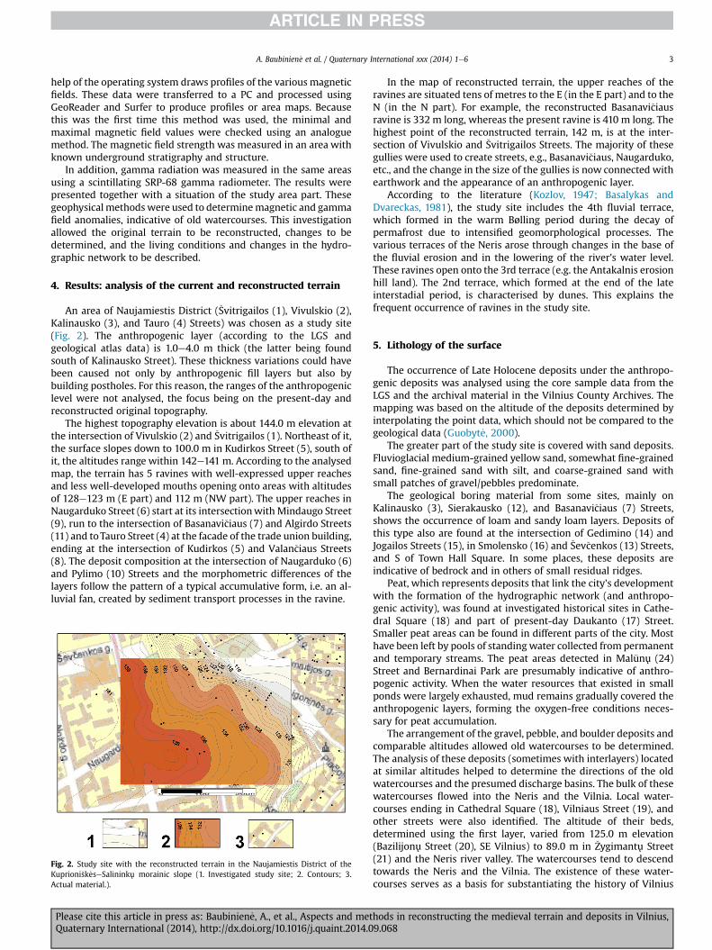
An area of Naujamiestis District (�Svitrigailos (1), Vivulskio (2),Kalinausko (3), and Tauro (4) Streets) was chosen as a study site(Fig. 2). The anthropogenic layer (according to the LGS andgeological atlas data) is 1.0e4.0 m thick (the latter being foundsouth of Kalinausko Street). These thickness variations could havebeen caused not only by anthropogenic fill layers but also bybuilding postholes. For this reason, the ranges of the anthropogeniclevel were not analysed, the focus being on the present-day andreconstructed original topography.
The highest topography elevation is about 144.0 m elevation atthe intersection of Vivulskio (2) and �Svitrigailos (1). Northeast of it,the surface slopes down to 100.0 m in Kudirkos Street (5), south ofit, the altitudes range within 142e141 m. According to the analysedmap, the terrain has 5 ravines with well-expressed upper reachesand less well-developed mouths opening onto areas with altitudesof 128e123 m (E part) and 112 m (NW part). The upper reaches inNaugarduko Street (6) start at its intersectionwith Mindaugo Street(9), run to the intersection of Basanavi�ciaus (7) and Algirdo Streets(11) and toTauro Street (4) at the facade of the trade union building,ending at the intersection of Kudirkos (5) and Valan�ciaus Streets(8). The deposit composition at the intersection of Naugarduko (6)and Pylimo (10) Streets and the morphometric differences of thelayers follow the pattern of a typical accumulative form, i.e. an al-luvial fan, created by sediment transport processes in the ravine.
Fig. 2. Study site with the reconstructed terrain in the Naujamiestis District of theKuprioni�sk _eseSalininku morainic slope (1. Investigated study site; 2. Contours; 3.Actual material.).
Please cite this article in press as: Baubinien _e, A., et al., Aspects and metQuaternary International (2014), http://dx.doi.org/10.1016/j.quaint.2014.0
In the map of reconstructed terrain, the upper reaches of theravines are situated tens of metres to the E (in the E part) and to theN (in the N part). For example, the reconstructed Basanavi�ciausravine is 332 m long, whereas the present ravine is 410 m long. Thehighest point of the reconstructed terrain, 142 m, is at the inter-section of Vivulskio and �Svitrigailos Streets. The majority of thesegullies were used to create streets, e.g., Basanavi�ciaus, Naugarduko,etc., and the change in the size of the gullies is now connected withearthwork and the appearance of an anthropogenic layer.
According to the literature (Kozlov, 1947; Basalykas andDvareckas, 1981), the study site includes the 4th fluvial terrace,which formed in the warm Bølling period during the decay ofpermafrost due to intensified geomorphological processes. Thevarious terraces of the Neris arose through changes in the base ofthe fluvial erosion and in the lowering of the river's water level.These ravines open onto the 3rd terrace (e.g. the Antakalnis erosionhill land). The 2nd terrace, which formed at the end of the lateinterstadial period, is characterised by dunes. This explains thefrequent occurrence of ravines in the study site.
5. Lithology of the surface
The occurrence of Late Holocene deposits under the anthropo-genic deposits was analysed using the core sample data from theLGS and the archival material in the Vilnius County Archives. Themapping was based on the altitude of the deposits determined byinterpolating the point data, which should not be compared to thegeological data (Guobyt _e, 2000).
The greater part of the study site is covered with sand deposits.Fluvioglacial medium-grained yellow sand, somewhat fine-grainedsand, fine-grained sand with silt, and coarse-grained sand withsmall patches of gravel/pebbles predominate.
The geological boring material from some sites, mainly onKalinausko (3), Sierakausko (12), and Basanavi�ciaus (7) Streets,shows the occurrence of loam and sandy loam layers. Deposits ofthis type also are found at the intersection of Gedimino (14) andJogailos Streets (15), in Smolensko (16) and �Sev�cenkos (13) Streets,and S of Town Hall Square. In some places, these deposits areindicative of bedrock and in others of small residual ridges.
Peat, which represents deposits that link the city's developmentwith the formation of the hydrographic network (and anthropo-genic activity), was found at investigated historical sites in Cathe-dral Square (18) and part of present-day Daukanto (17) Street.Smaller peat areas can be found in different parts of the city. Mosthave been left by pools of standing water collected from permanentand temporary streams. The peat areas detected in Mal�unu (24)Street and Bernardinai Park are presumably indicative of anthro-pogenic activity. When the water resources that existed in smallponds were largely exhausted, mud remains gradually covered theanthropogenic layers, forming the oxygen-free conditions neces-sary for peat accumulation.
The arrangement of the gravel, pebble, and boulder deposits andcomparable altitudes allowed old watercourses to be determined.The analysis of these deposits (sometimes with interlayers) locatedat similar altitudes helped to determine the directions of the oldwatercourses and the presumed discharge basins. The bulk of thesewatercourses flowed into the Neris and the Vilnia. Local water-courses ending in Cathedral Square (18), Vilniaus Street (19), andother streets were also identified. The altitude of their beds,determined using the first layer, varied from 125.0 m elevation(Bazilijonu Street (20), SE Vilnius) to 89.0 m in �Zygimantu Street(21) and the Neris river valley. The watercourses tend to descendtowards the Neris and the Vilnia. The existence of these water-courses serves as a basis for substantiating the history of Vilnius
hods in reconstructing the medieval terrain and deposits in Vilnius,9.068
A. Baubinien _e et al. / Quaternary International xxx (2014) 1e64
city planning and highlights many issues related with the popula-tion history of Vilnius.
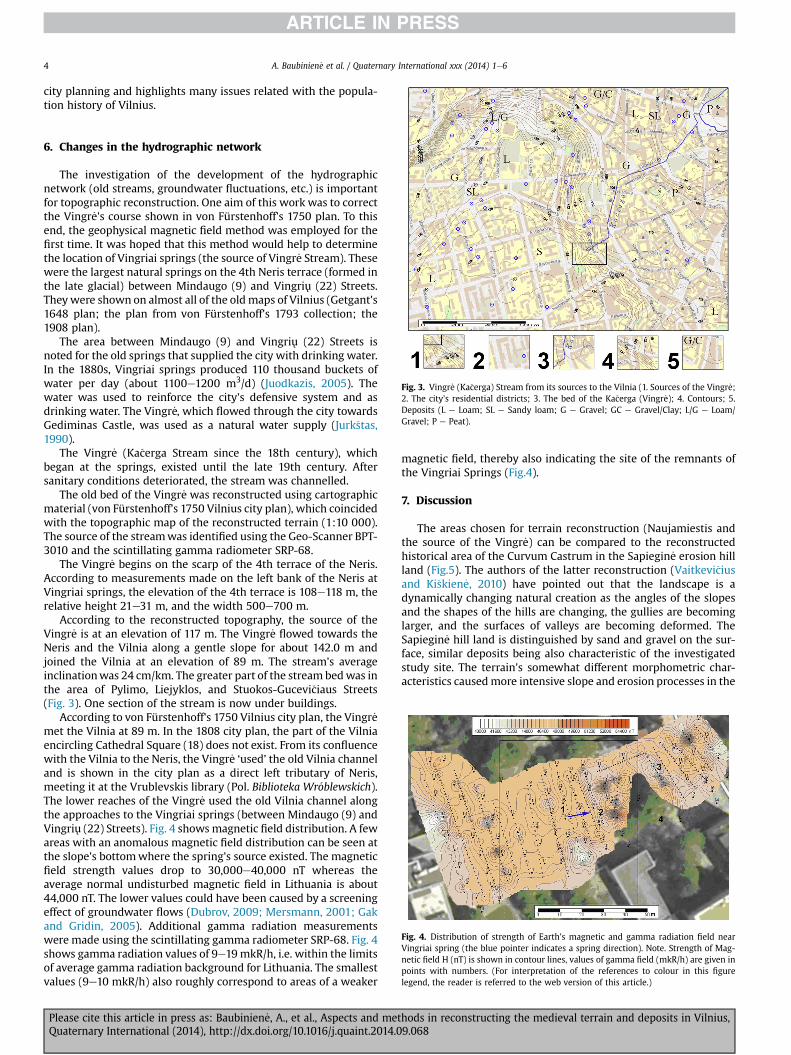
Fig. 3. Vingr _e (Ka�cerga) Stream from its sources to the Vilnia (1. Sources of the Vingr _e;2. The city's residential districts; 3. The bed of the Ka�cerga (Vingr _e); 4. Contours; 5.Deposits (L e Loam; SL e Sandy loam; G e Gravel; GC e Gravel/Clay; L/G e Loam/Gravel; P e Peat).
Fig. 4. Distribution of strength of Earth's magnetic and gamma radiation field nearVingriai spring (the blue pointer indicates a spring direction). Note. Strength of Mag-netic field H (nT) is shown in contour lines, values of gamma field (mkR/h) are given inpoints with numbers. (For interpretation of the references to colour in this figurelegend, the reader is referred to the web version of this article.)
6. Changes in the hydrographic network
The investigation of the development of the hydrographicnetwork (old streams, groundwater fluctuations, etc.) is importantfor topographic reconstruction. One aim of this work was to correctthe Vingr _e's course shown in von Fürstenhoff's 1750 plan. To thisend, the geophysical magnetic field method was employed for thefirst time. It was hoped that this method would help to determinethe location of Vingriai springs (the source of Vingr _e Stream). Thesewere the largest natural springs on the 4th Neris terrace (formed inthe late glacial) between Mindaugo (9) and Vingriu (22) Streets.Theywere shown on almost all of the oldmaps of Vilnius (Getgant's1648 plan; the plan from von Fürstenhoff's 1793 collection; the1908 plan).
The area between Mindaugo (9) and Vingriu (22) Streets isnoted for the old springs that supplied the city with drinking water.In the 1880s, Vingriai springs produced 110 thousand buckets ofwater per day (about 1100e1200 m3/d) (Juodkazis, 2005). Thewater was used to reinforce the city's defensive system and asdrinking water. The Vingr _e, which flowed through the city towardsGediminas Castle, was used as a natural water supply (Jurk�stas,1990).
The Vingr _e (Ka�cerga Stream since the 18th century), whichbegan at the springs, existed until the late 19th century. Aftersanitary conditions deteriorated, the stream was channelled.
The old bed of the Vingr _e was reconstructed using cartographicmaterial (von Fürstenhoff's 1750 Vilnius city plan), which coincidedwith the topographic map of the reconstructed terrain (1:10 000).The source of the streamwas identified using the Geo-Scanner BPT-3010 and the scintillating gamma radiometer SRP-68.
The Vingr _e begins on the scarp of the 4th terrace of the Neris.According to measurements made on the left bank of the Neris atVingriai springs, the elevation of the 4th terrace is 108e118 m, therelative height 21e31 m, and the width 500e700 m.
According to the reconstructed topography, the source of theVingr _e is at an elevation of 117 m. The Vingr _e flowed towards theNeris and the Vilnia along a gentle slope for about 142.0 m andjoined the Vilnia at an elevation of 89 m. The stream's averageinclinationwas 24 cm/km. The greater part of the stream bedwas inthe area of Pylimo, Liejyklos, and Stuokos-Gucevi�ciaus Streets(Fig. 3). One section of the stream is now under buildings.
According to von Fürstenhoff's 1750 Vilnius city plan, the Vingr _emet the Vilnia at 89 m. In the 1808 city plan, the part of the Vilniaencircling Cathedral Square (18) does not exist. From its confluencewith the Vilnia to the Neris, the Vingr _e ‘used’ the old Vilnia channeland is shown in the city plan as a direct left tributary of Neris,meeting it at the Vrublevskis library (Pol. Biblioteka Wr�oblewskich).The lower reaches of the Vingr _e used the old Vilnia channel alongthe approaches to the Vingriai springs (between Mindaugo (9) andVingriu (22) Streets). Fig. 4 showsmagnetic field distribution. A fewareas with an anomalous magnetic field distribution can be seen atthe slope's bottomwhere the spring's source existed. The magneticfield strength values drop to 30,000e40,000 nT whereas theaverage normal undisturbed magnetic field in Lithuania is about44,000 nT. The lower values could have been caused by a screeningeffect of groundwater flows (Dubrov, 2009; Mersmann, 2001; Gakand Gridin, 2005). Additional gamma radiation measurementswere made using the scintillating gamma radiometer SRP-68. Fig. 4shows gamma radiation values of 9e19mkR/h, i.e. within the limitsof average gamma radiation background for Lithuania. The smallestvalues (9e10 mkR/h) also roughly correspond to areas of a weaker
Please cite this article in press as: Baubinien _e, A., et al., Aspects and metQuaternary International (2014), http://dx.doi.org/10.1016/j.quaint.2014.0
magnetic field, thereby also indicating the site of the remnants ofthe Vingriai Springs (Fig.4).
7. Discussion
The areas chosen for terrain reconstruction (Naujamiestis andthe source of the Vingr _e) can be compared to the reconstructedhistorical area of the Curvum Castrum in the Sapiegin _e erosion hillland (Fig.5). The authors of the latter reconstruction (Vaitkevi�ciusand Ki�skien _e, 2010) have pointed out that the landscape is adynamically changing natural creation as the angles of the slopesand the shapes of the hills are changing, the gullies are becominglarger, and the surfaces of valleys are becoming deformed. TheSapiegin _e hill land is distinguished by sand and gravel on the sur-face, similar deposits being also characteristic of the investigatedstudy site. The terrain's somewhat different morphometric char-acteristics causedmore intensive slope and erosion processes in the
hods in reconstructing the medieval terrain and deposits in Vilnius,9.068

Fig. 5. Reconstructed relief of ravines: (1. Investigated areas: (1. Naujamiestis; 2. Oldcity; 3. Vilnia River neighbour; 4. Sapiegine hills terrain); 2. Rivers; 3. Vilniusdevelopments.).
A. Baubinien _e et al. / Quaternary International xxx (2014) 1e6 5
Curvum Castrum area. Similar processes in the study site alsooccurred in U�zupis and partially in the section of the Neris valleyabove the mouth of the Vilnia. In these two cases, the erosionprocesses affected the settlement of those parts of the city verydifferently. The changes in the Curvum Castrum landscape played adecisive role in the defensive functions of the city. Investigationrevealed that due to different natural conditions (morainic plateau,groundwater depth, and the distance from the Vilnia), the studysite was settled only in the 17th century. Naujamiestis' maximumaltitude is 144.0 m an abs a. The cultural layer is 4.0 m thick. Thealtitude variations (of up to 40 m) in the study site's relief are lessconspicuous than in the Sapiegin _e hill land (70% of area havingslopes >25�). The reconstruction of the terrain revealed onlychanges in the ravines, which are today over 80mwider and longer.Although the cultural layers were thin, considerable changes in thenegative terrain forms were traced back. The recent erection ofbuildings with piles, which hindered the determination of thecultural layer, and the thinness of the cultural layer made it difficultto reconstruct the terrain in detail. The precise channel of theVingr _e, however, was successfully reconstructed because it waspossible to follow the gullies and, as expected, the changes in them.
The identification of the remnants of the watercourses based ondeposits and their altitudes is another aspect of terrain recon-structionworthy of discussion. From a historical perspective, a planof the watercourses would be very helpful in substantiating thecity's settlement and would determine the influence of naturalconditions on the development of the environment and the pop-ulation. From a natural-geological perspective, the watercoursesshow the supply basins and drainage zones. These factors allow thenatural medieval urban environment prior to the intensification ofthe anthropogenic processes to be properly evaluated.
The investigation of the geomagnetic field in order to identifyremnant watercourses (e.g., the source of the Vingr _e) in anurbanised landscape is problematic due to the dense network of
Please cite this article in press as: Baubinien _e, A., et al., Aspects and metQuaternary International (2014), http://dx.doi.org/10.1016/j.quaint.2014.0
underground utility lines and other sources of magnetic fielddistortion. After the introduction of additional research in thefuture, this method could become promising.
8. Conclusions
The geomorphologicalegeological diversity of Vilnius may havedetermined the city's historical beginning and development asshown by the reconstruction of the original topography and de-posits. The obtained data show the historical conditions and theiremployment for human needs, such as the stream beds used forNaugarduko and Basanavi�ciaus Streets. Reconstruction of thetopography of the study site (Naujamiestis District) indicates thatthe ravines were 80 m longer than they are now, but in other studysites (Old Town), lowering of the height by 2 m is also seen.
The lithological composition of the deposits in the study sitealso affected the gully formation processes. After eliminating theanthropogenic layer, it was determined that the bulk of the studysite has been covered by sandy deposits. Medium-grained yellowsand predominates, fine-grained sand with silt or coarse-grainedsand with a gravel or pebble admixture occurring in places. Thesand is of mainly fluvioglacial origin.
The historical sources mention that the Vingr _e had the mostwater with other streams being regarded as its tributaries. Based onthe reconstructed topography, the length and channel of the Vingr _ewas determined and, after reconstructing the topography, theVingr _e’s outflow was ascertained using geophysical methods to beat 117 m elevation. This location corresponds to the scarp of the 4thterrace, at a relative height of 21e30 m above the Neris. The Vingr _ewas found to have been 1142 m long, flowing into the former Vilniachannel at 98 m.
The reconstruction of the topography of Vilnius, especially of theOld Town, is less effective than that of the Sapiegin _e hill land due tothe contrasts of the topography and existing buildings. The pres-ence of watercourses in the lithological cover under the culturallayer is debatable, but can explain the town's road constructionpossibilities.
The study site was settled only in the 17th century due to itsgreater distance from the Vilnia and from the terraced valley of theOld Town with its greater mineral resources. The data obtained byreconstructing the terrain will help to reveal the city's cultural,technological, and defensive history (urban development).
References
Basalykas, A., Dvareckas, V., 1981. Vilniaus apylinkes geomorfologiniu atzvilgiu.Geografija 17.
�Cesnulevi�cius, A., 1998. Geomorfologija. Jandrija, Vilnius.Dubrov, A.P., 2009. Biologicheskaya geofizika. Polia. Zemlia. Chelovek i kosmos.
Follium, Moskva.Dvareckas, V., 1961. Neries slenio Lietuvos TSR ribose geomorfologine saranga.
Geografinis metrastis 4, 65e87.Fuse, T., Shimizu, E., 2003. Rubber-sheeting of historical maps in GIS and its
application to landscape visualization of old-time cities: focusing on Tokyo ofthe past. In: Proceedings of the 8th International Conference on Computers inUrban Planning and Urban Management.
Fuse, T., Shimizu, E., 2005. Visualizing the Landscape of Old-time Tokyo (EDO City).http://citeseerx.ist.psu.edu/viewdoc/summary?doi¼10.1.1.145.2625.
Gaigalas, A., Banys, J., Lasavickas, S., Lisanka, A., Mele�syt _e, M., 1985-1986. Vilniauspiliu teritorijos aplinkos salygu kitimo poledynmetyje svarbiausi etapai ir juradiokarboninis datavimas. Geografijos metrastis 22e23. Vilnius.
Gak, E.Z., Gridin, V.I., 2005. Vozdeistvie krajevych effektov anomalij gravitacionogopolia na objekty zhivoj i nezhivoj prirody. Biogeofizika 4, 4e10.
Guobyt _e, R., 2000. Geomorfologinio �zem _elapio M 1:200 000 revizija. Rankra�stis(GFNr. 5478).
Guobyt _e, R., 2008. Vilniaus piliu teritorijos egzoti�skasis reljefas ir gelmiu sandara.Lietuvos pilys, Vilnius, pp. 24e35.
Juodkazis, V., 2005. Senojo Vilniaus vandentiekio paveldas. Geologijos akira�ciai 1,43e55.
Jurk�stas, J., 1990. Senojo Vilniaus vandenys. Vilnius, p. 139.
hods in reconstructing the medieval terrain and deposits in Vilnius,9.068

A. Baubinien _e et al. / Quaternary International xxx (2014) 1e66
Kadakas, Ulla, Toos, Guido, Kalm, Anneli, Nurk, Ragnar, Vedru, Gurly, Tasuja, Kristi,Kadakas, Villu, 2013. Medieval and early modern suburban site in Tallinn, TartuRd. 1: contexts and structures. Arheoloogilised v€alit€o€od Eestis ¼ Archeologicalfieldwork in Estonia 133e148.
Kotlov, F.V., 1977. Antropogenije geologiceskije procesy i javlenija na teritoriji gor-oda. Izdatelstvo Nauka, Moskva, p. 170.
Kozlov, P., 1947. Otchiot o geologicheskich isledovanijach teritoriji gor, vol. 1947.godu, Vilniusa.
Licha�ciova, E.A., Zejegofer, J.O., Krasnov, A.F., Sipiagina, I.K., Petrenko, S.I., 1981. Opytocenki izmenenija reljefa gorodskoj teritoriji (na primere g. Moskvy). Noveisijemetody geomorfologi�ceskich isledovanij, Moskva, pp. 72e83.
Licha�ciova, E.A., 2007. Ekologicheskije kroniki Moskvi. M. Media-Press, p. 93.Mersmann, L., 2001. Ein ewiger Vergleich: Rute und Messger€at. Technische
Anomalien des Erdmagnetfelde. €Osterreichischer Verband für Radi€asthesie undGeobiologie 66, 44e47.
Mork�unait _e, R., 2010. Ivadin _es mintys apie Vilniaus miesto istorini zemevaizdi.Miestu praeitis. El. i�st, Vilnius, pp. 1e3.
Mork�unait _e, R., Vaitkevi�cius, G., Valionien _e, O., 2008. The Geomorphology of theVilnia and the Environs of Vilnius. Geographia studia et dissertationes, Kato-wice, pp. 47e58.
Please cite this article in press as: Baubinien _e, A., et al., Aspects and metQuaternary International (2014), http://dx.doi.org/10.1016/j.quaint.2014.0
Nasimovi�c, J., 1997. Hidrograficheskaja set. Moskva: geologija i gorod. M.: Mos-kovskije uchebniki i kartolitografija, pp. 27e34.
Niederoest, J., 2002. Landscape as a historical object: 3D reconstruction and eval-uation of a relief model from the 18th century. The International Archives of thePhotogrammetry, Remote Sensing and Spatial Information Sciences 34.
Nurk, R., Kadakas, V., Toos, G., 2012. Preliminary archaeological investigations in thearea of the medieval and post-medieval harbour of Tallinn. Arheoloogilisedv€alit€o€od Eestis ¼ Archeological fieldwork in Estonia 125e136.
Popov, O.V., 2007. Narushenije vzaimodeistvija poverchnostnich i podzemnich vodpod vlijanijem urbanizaciji. Gidrologicheskije aspekty urbanizaciji. M. Moskva-Press, pp. 36e42.
Sarcevi�cius, S., 2011. Stalo kalno paleoreljefo tyrimai Vilniuje, vol. 3. Miestu praeitis.Satk�unas, J., 2012. Vilniaus kalvyno susiformavimas. In: Pranesimas Vilniaus miesto
seminare.�Sliaupa, A., 1999. Ataskaita uz mokslini darba “Vilniaus miesto ir rajono kartografinio
ekogeologinio modelio M 1:50000 paruosimas geologiniu duomenu pagrindu”.Vaitkevi�cius, G., 2010. Vilniaus tarpsmas, vol. 2. Miestu praeitis.Vaitkevi�cius, G., Ki�skien _e, M., 2010. Kreivasis miestas, vol. 2. Miestu praeitis.Vodzinskas, E., 1963e1964. Trumpos pastabos apie Vilnios �zemupio raida prie-
�sistoriniu ir istoriniu laikotarpiu. Geografinis metra�stis 6e7. Vilnius.
hods in reconstructing the medieval terrain and deposits in Vilnius,9.068