asfpm 2015 atlanta - floods 2015 atlanta automated ... • linked to hydrograph generator (excel) to...
TRANSCRIPT
ASFPM 2015 Atlanta
Automated Hydrological and Hydraulic (2D and 1D-2D) Model
Construction, Model Running, and Flood Map Production
Dr Richard Crowder
Elise Ibendahl

2 Automated Hydrological and Hydraulic (2D and 1D-2D) Model Construction, Model Running, and Flood Map Production
Content
• The challenge and opportunities
• The Technology Framework
• Case studies
3 Automated Hydrological and Hydraulic (2D and 1D-2D) Model Construction, Model Running, and Flood Map Production
4 Automated Hydrological and Hydraulic (2D and 1D-2D) Model Construction, Model Running, and Flood Map Production

5 Presentation Title
The challenges and opportunities
6 Automated Hydrological and Hydraulic (2D and 1D-2D) Model Construction, Model Running, and Flood Map Production
7 Automated Hydrological and Hydraulic (2D and 1D-2D) Model Construction, Model Running, and Flood Map Production
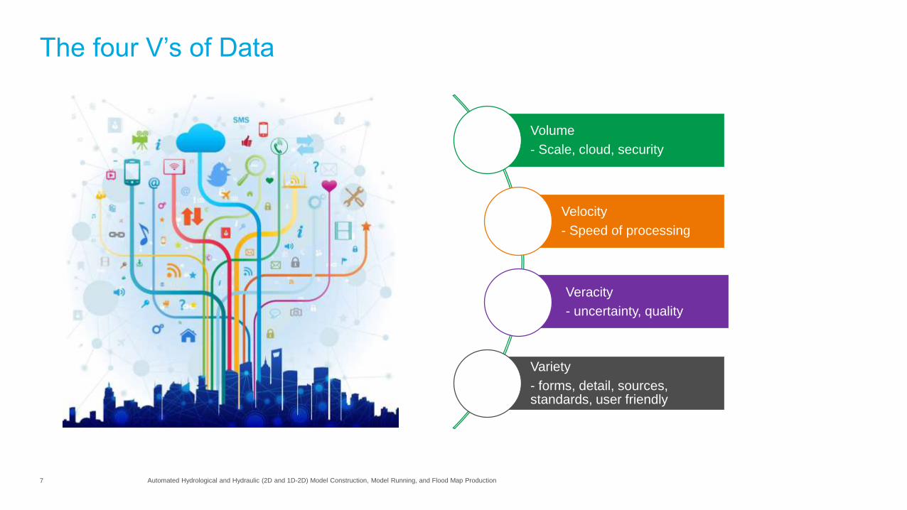
The four V’s of Data
Volume
- Scale, cloud, security
Velocity
- Speed of processing
Veracity
- uncertainty, quality
Variety
- forms, detail, sources, standards, user friendly

8 Presentation Title
The technology framework

9 Presentation Title
The Technology Framework
Any sufficiently advanced technology is equivalent to magic.
Arthur C. Clarke (Author)
Computers are useless. They can only give you answers.
Pablo Picasso (Artist)
If we continue to develop our technology without wisdom or prudence, our servant may prove to be our executioner.
Omar Bradley (General, US Army)
10 Automated Hydrological and Hydraulic (2D and 1D-2D) Model Construction, Model Running, and Flood Map Production
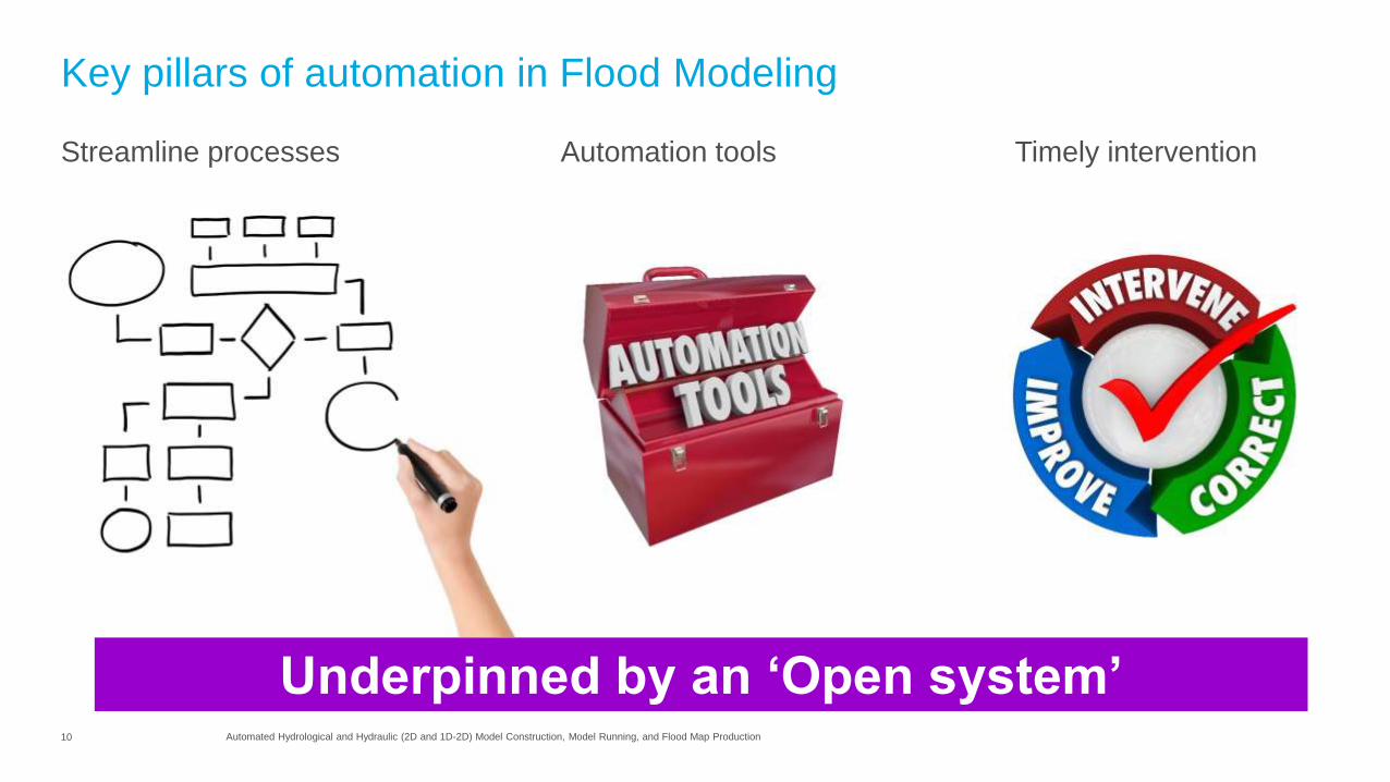
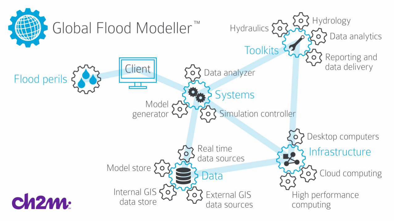
Key pillars of automation in Flood Modeling
Streamline processes Timely interventionAutomation tools
Underpinned by an ‘Open system’
11 Automated Hydrological and Hydraulic (2D and 1D-2D) Model Construction, Model Running, and Flood Map Production
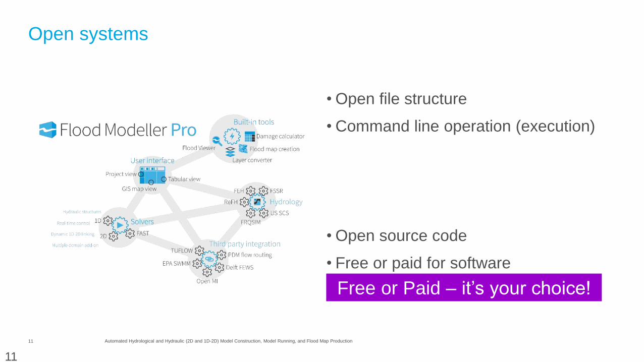
Open systems
• Open file structure
• Command line operation (execution)
• Open source code
• Free or paid for software
11
Free or Paid – it’s your choice!
12 Automated Hydrological and Hydraulic (2D and 1D-2D) Model Construction, Model Running, and Flood Map Production
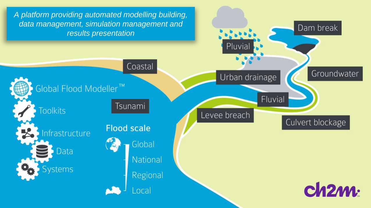
A platform providing automated modelling building,
data management, simulation management and
results presentation
TM
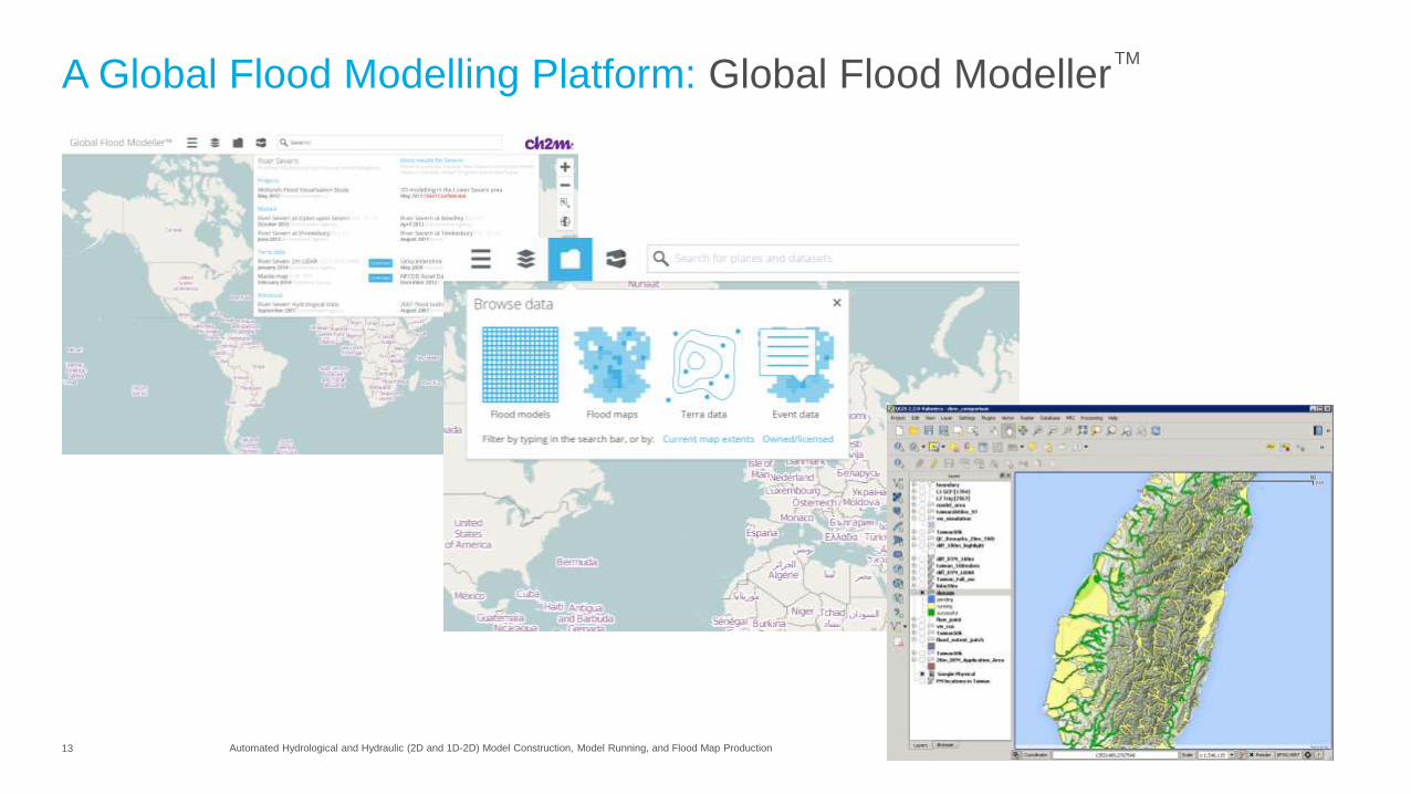
13 Automated Hydrological and Hydraulic (2D and 1D-2D) Model Construction, Model Running, and Flood Map Production
A Global Flood Modelling Platform: Global Flood ModellerTM
14 Automated Hydrological and Hydraulic (2D and 1D-2D) Model Construction, Model Running, and Flood Map Production
TM
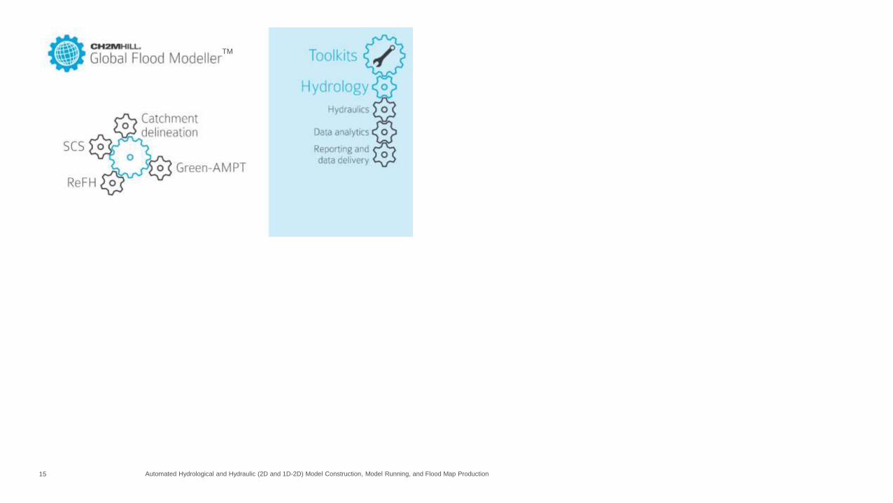
15 Automated Hydrological and Hydraulic (2D and 1D-2D) Model Construction, Model Running, and Flood Map Production
TM
16 Automated Hydrological and Hydraulic (2D and 1D-2D) Model Construction, Model Running, and Flood Map Production
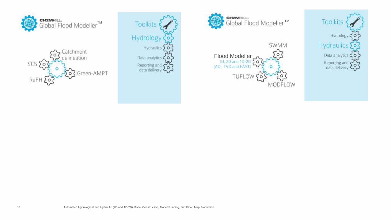
Flood Modeller
TM TM

17 Automated Hydrological and Hydraulic (2D and 1D-2D) Model Construction, Model Running, and Flood Map Production
Flood Modeller
TM TM
TM
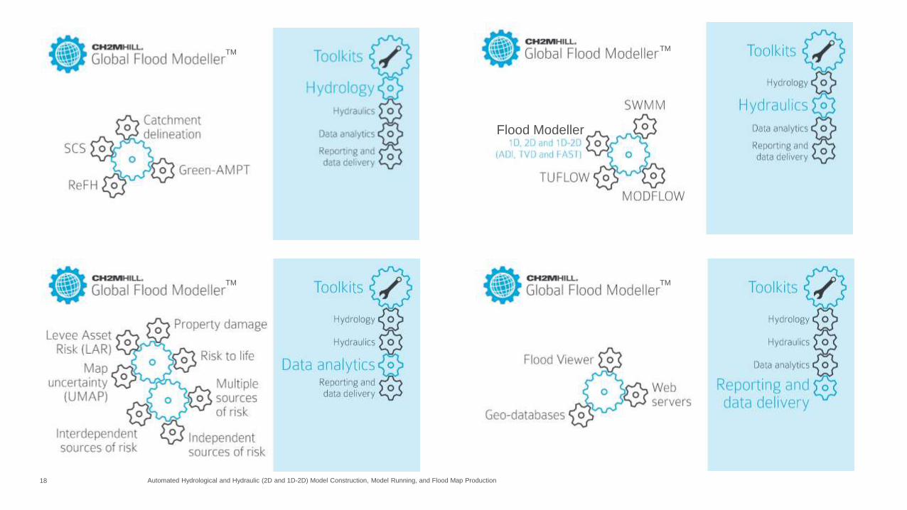
18 Automated Hydrological and Hydraulic (2D and 1D-2D) Model Construction, Model Running, and Flood Map Production
Flood Modeller
TM TM
TM TM
19 Automated Hydrological and Hydraulic (2D and 1D-2D) Model Construction, Model Running, and Flood Map Production
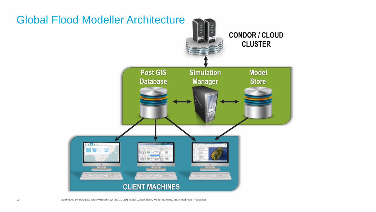
CONDOR / CLOUD
CLUSTER
Model
Generator
Simulation
Controller
Review
Tool
CLIENT MACHINES
Simulation
Manager
Post GIS
Database
Model
Store
Global Flood Modeller Architecture
20 Automated Hydrological and Hydraulic (2D and 1D-2D) Model Construction, Model Running, and Flood Map Production
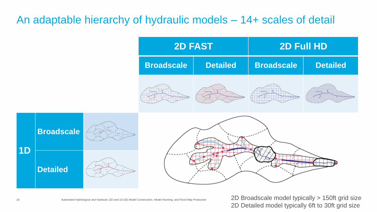
An adaptable hierarchy of hydraulic models – 14+ scales of detail
2D FAST 2D Full HD
Broadscale Detailed Broadscale Detailed
1D
Broadscale
Detailed
2D Broadscale model typically > 150ft grid size
2D Detailed model typically 6ft to 30ft grid size

21 Automated Hydrological and Hydraulic (2D and 1D-2D) Model Construction, Model Running, and Flood Map Production
Simulation management (Condor)
• Run c100 models simultaneously on
dedicated internal cloud
• Borrow internal network computers for
computation boost or push to 3rd party cloud
• Monitor simulation status
22 Automated Hydrological and Hydraulic (2D and 1D-2D) Model Construction, Model Running, and Flood Map Production
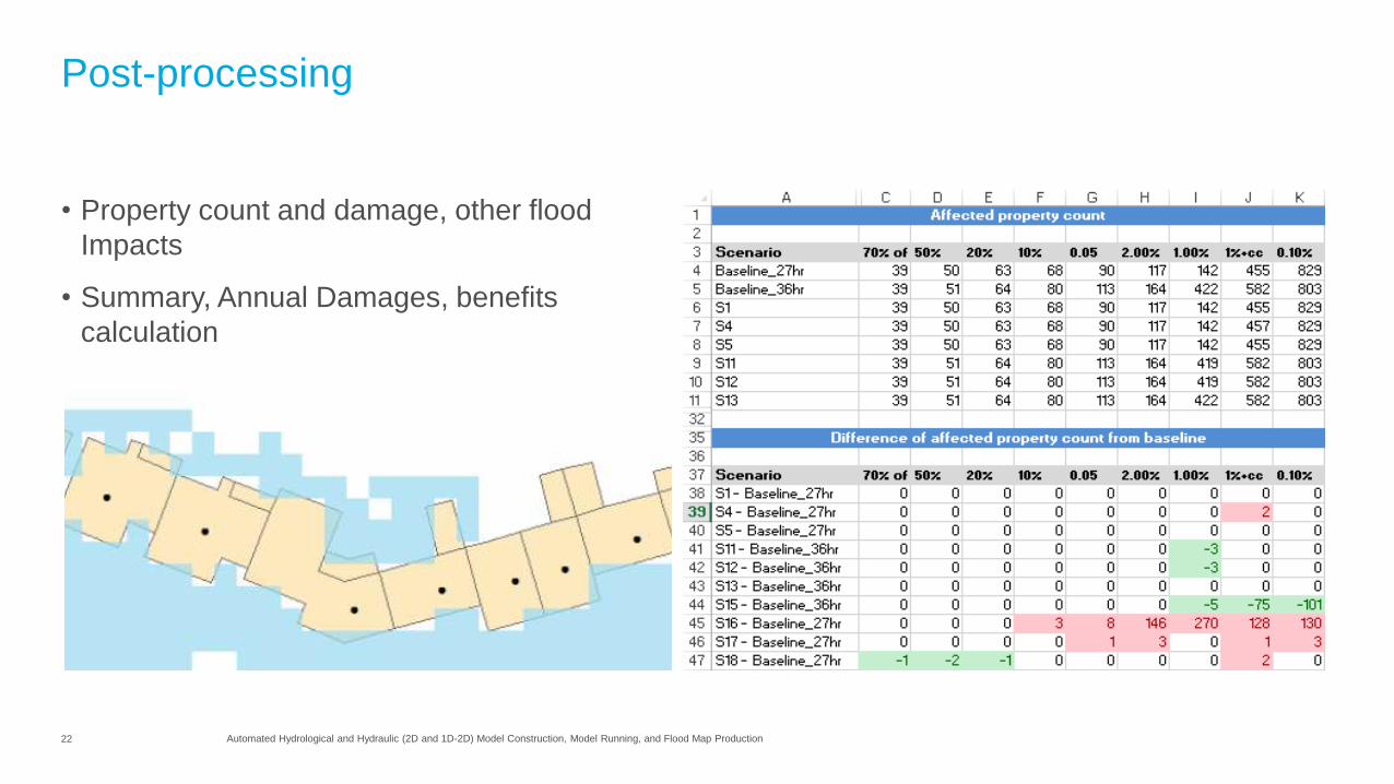
Post-processing
• Property count and damage, other flood
Impacts
• Summary, Annual Damages, benefits
calculation
23 Automated Hydrological and Hydraulic (2D and 1D-2D) Model Construction, Model Running, and Flood Map Production
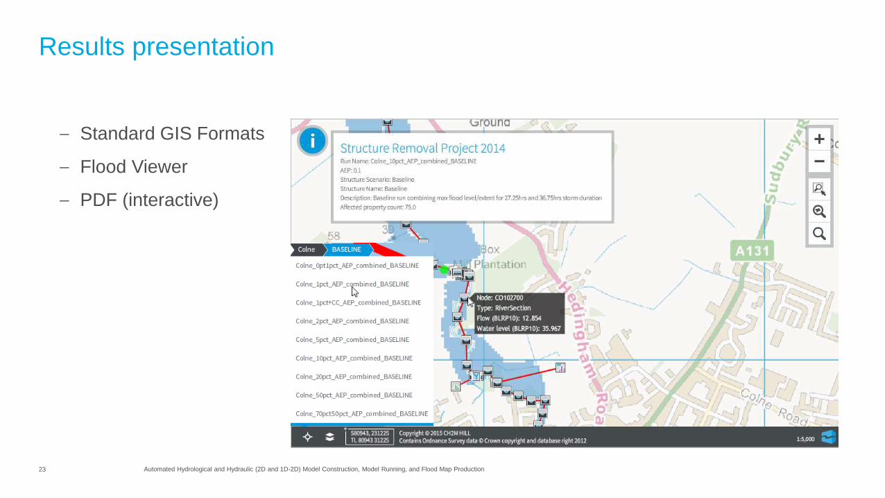
Results presentation
– Standard GIS Formats
– Flood Viewer
– PDF (interactive)

24 Presentation Title
Case study 1 – levee failure
(local scale – applied nationally)
1st Generation of model automation
Levee failure on the Upper Jones Tract in the Delta Region on June 4, 2004.
Image credit: California Department of Water Resources
Greatham, UK, December 2013,
Image credit: CH2M HILL
25 Automated Hydrological and Hydraulic (2D and 1D-2D) Model Construction, Model Running, and Flood Map Production
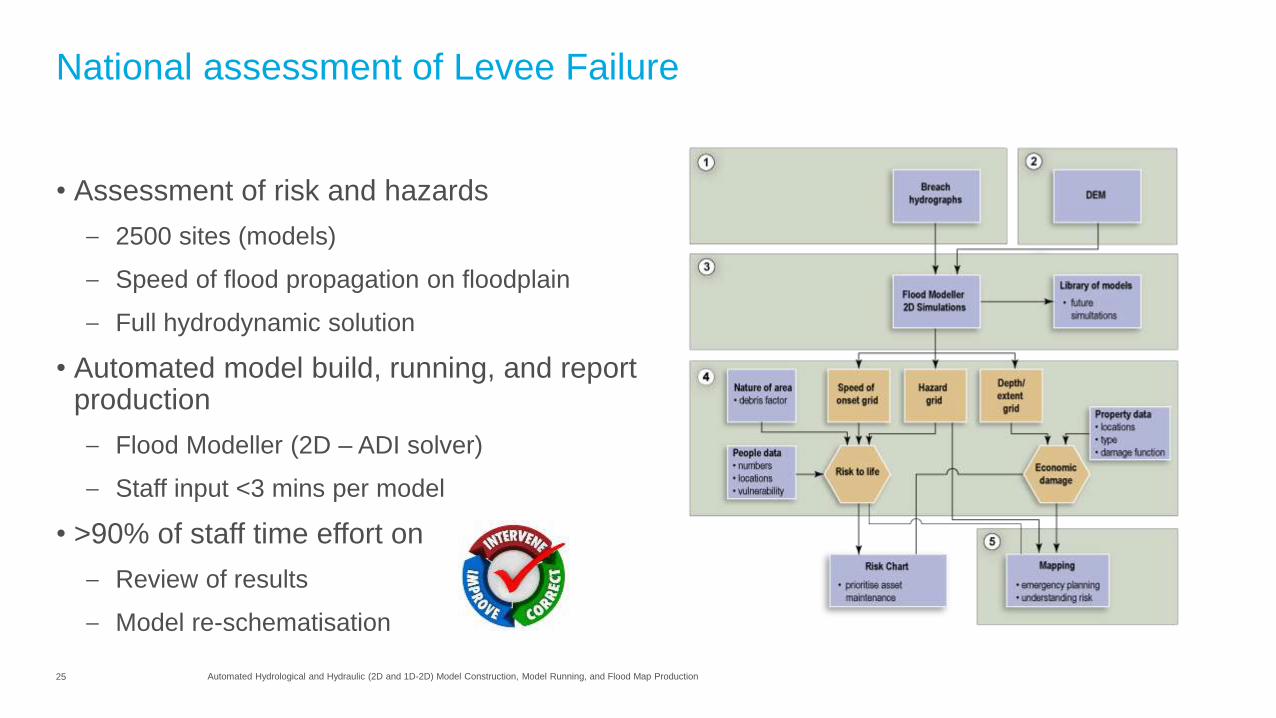
National assessment of Levee Failure
• Assessment of risk and hazards
– 2500 sites (models)
– Speed of flood propagation on floodplain
– Full hydrodynamic solution
• Automated model build, running, and report production
– Flood Modeller (2D – ADI solver)
– Staff input <3 mins per model
• >90% of staff time effort on
– Review of results
– Model re-schematisation
26 Automated Hydrological and Hydraulic (2D and 1D-2D) Model Construction, Model Running, and Flood Map Production
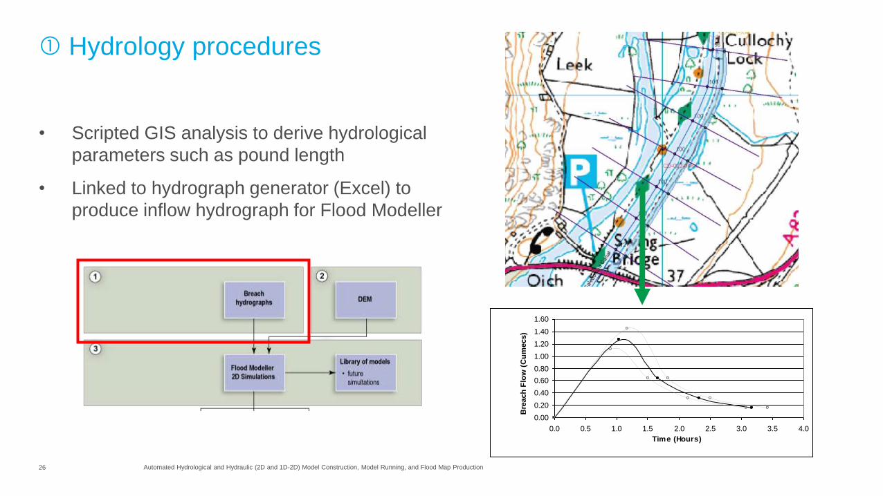
Hydrology procedures
0.00
0.20
0.40
0.60
0.80
1.00
1.20
1.40
1.60
0.0 0.5 1.0 1.5 2.0 2.5 3.0 3.5 4.0
Time (Hours)
Bre
ach
Flo
w (
Cu
mecs)
• Scripted GIS analysis to derive hydrological
parameters such as pound length
• Linked to hydrograph generator (Excel) to
produce inflow hydrograph for Flood Modeller
27 Automated Hydrological and Hydraulic (2D and 1D-2D) Model Construction, Model Running, and Flood Map Production
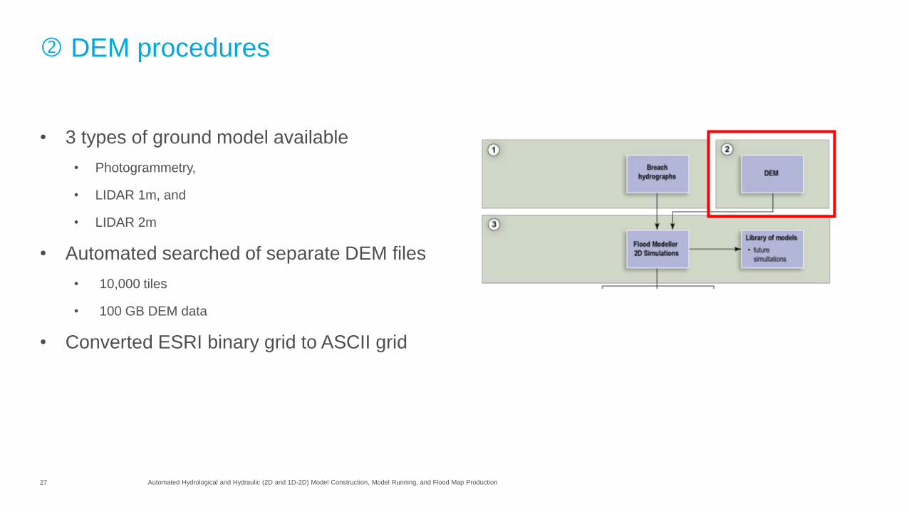
DEM procedures
• 3 types of ground model available
• Photogrammetry,
• LIDAR 1m, and
• LIDAR 2m
• Automated searched of separate DEM files
• 10,000 tiles
• 100 GB DEM data
• Converted ESRI binary grid to ASCII grid
28 Automated Hydrological and Hydraulic (2D and 1D-2D) Model Construction, Model Running, and Flood Map Production
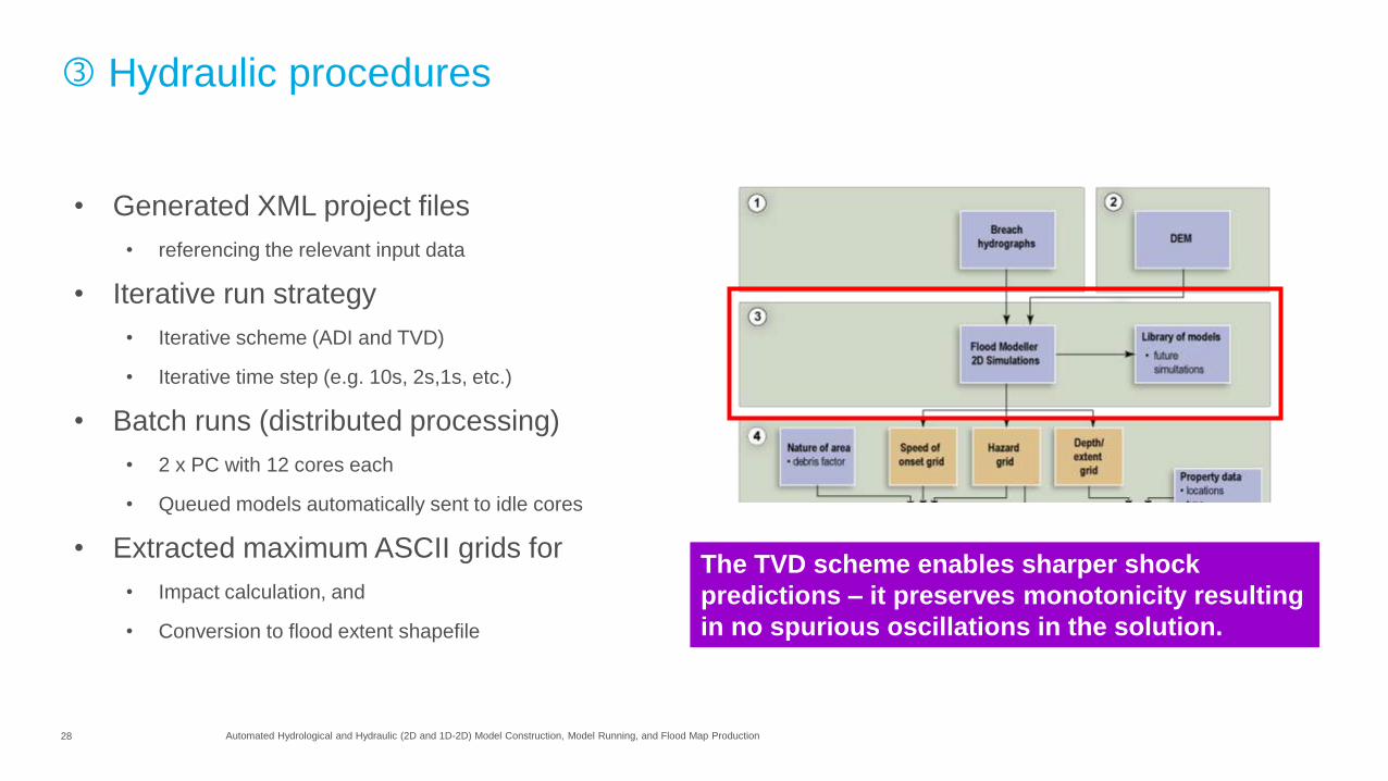
Hydraulic procedures
• Generated XML project files
• referencing the relevant input data
• Iterative run strategy
• Iterative scheme (ADI and TVD)
• Iterative time step (e.g. 10s, 2s,1s, etc.)
• Batch runs (distributed processing)
• 2 x PC with 12 cores each
• Queued models automatically sent to idle cores
• Extracted maximum ASCII grids for
• Impact calculation, and
• Conversion to flood extent shapefile
The TVD scheme enables sharper shock
predictions – it preserves monotonicity resulting
in no spurious oscillations in the solution.
29 Automated Hydrological and Hydraulic (2D and 1D-2D) Model Construction, Model Running, and Flood Map Production
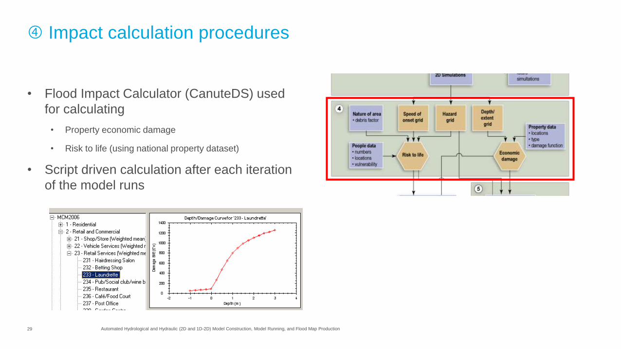
Impact calculation procedures
• Flood Impact Calculator (CanuteDS) used
for calculating
• Property economic damage
• Risk to life (using national property dataset)
• Script driven calculation after each iteration
of the model runs
30 Automated Hydrological and Hydraulic (2D and 1D-2D) Model Construction, Model Running, and Flood Map Production
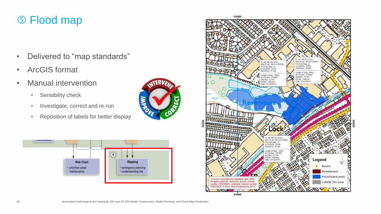
Flood map
• Delivered to “map standards”
• ArcGIS format
• Manual intervention
• Sensibility check
• Investigate, correct and re-run
• Reposition of labels for better display
31 Automated Hydrological and Hydraulic (2D and 1D-2D) Model Construction, Model Running, and Flood Map Production
Key statistics
• 1 Team of smart software developers
• 1 Freely available software
• 1 Open source GIS database
• 1 Open minded client (aren't they all)
• 2 Desktop computers
• 2 Hydraulic solvers (ADI and TVD)
• 3 types of DTM
• <3 Mins per model
• c9 Months start to finish (including code development)
• 2500 Models
32 Presentation Title
Case study 2 – surface water flood risk
(regional scale)
2nd Generation of model automation
33 Automated Hydrological and Hydraulic (2D and 1D-2D) Model Construction, Model Running, and Flood Map Production
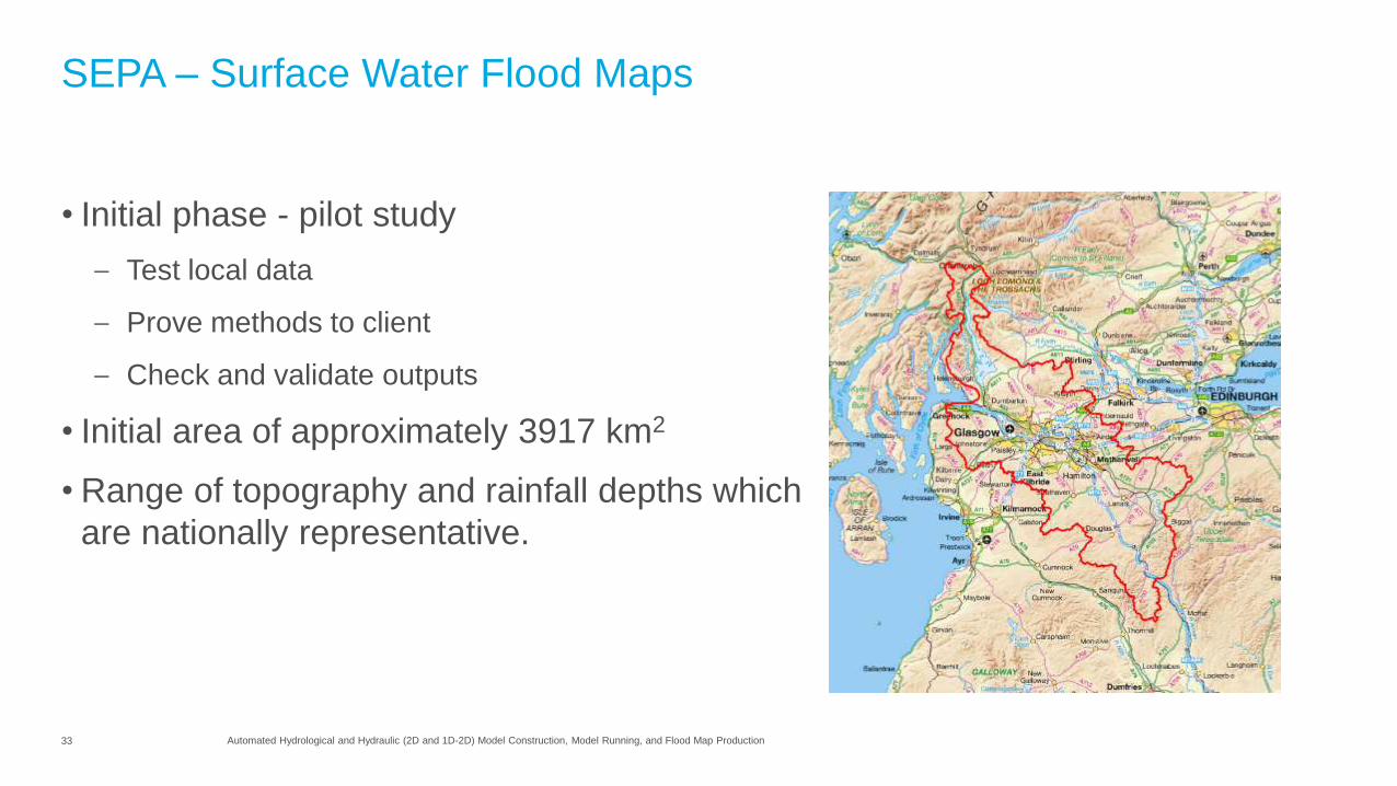
SEPA – Surface Water Flood Maps
• Initial phase - pilot study
– Test local data
– Prove methods to client
– Check and validate outputs
• Initial area of approximately 3917 km2
• Range of topography and rainfall depths which
are nationally representative.
34 Automated Hydrological and Hydraulic (2D and 1D-2D) Model Construction, Model Running, and Flood Map Production
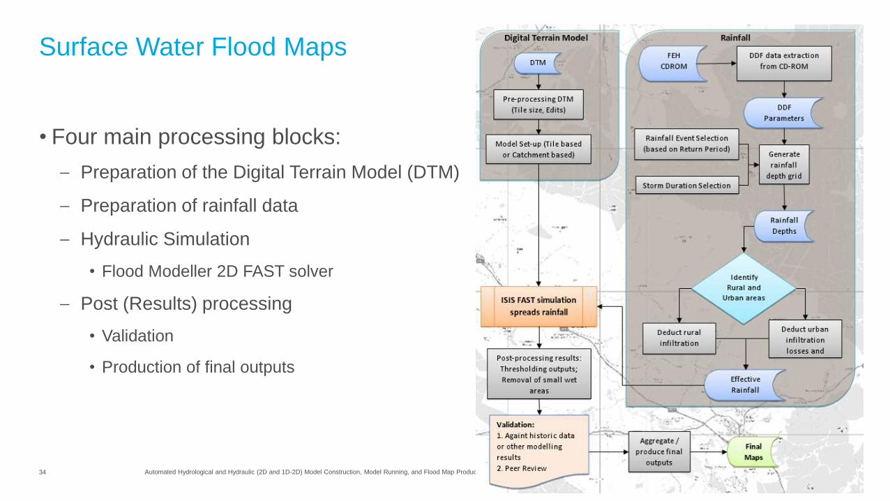
Surface Water Flood Maps
• Four main processing blocks:
– Preparation of the Digital Terrain Model (DTM)
– Preparation of rainfall data
– Hydraulic Simulation
• Flood Modeller 2D FAST solver
– Post (Results) processing
• Validation
• Production of final outputs
35 Automated Hydrological and Hydraulic (2D and 1D-2D) Model Construction, Model Running, and Flood Map Production
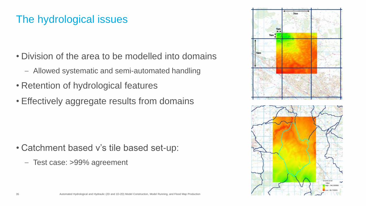
The hydrological issues
• Division of the area to be modelled into domains
– Allowed systematic and semi-automated handling
• Retention of hydrological features
• Effectively aggregate results from domains
• Catchment based v’s tile based set-up:
– Test case: >99% agreement
36 Automated Hydrological and Hydraulic (2D and 1D-2D) Model Construction, Model Running, and Flood Map Production
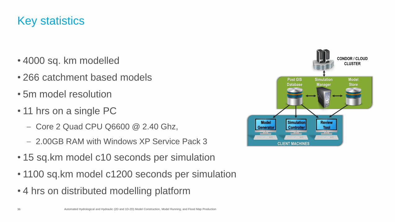
Key statistics
• 4000 sq. km modelled
• 266 catchment based models
• 5m model resolution
• 11 hrs on a single PC
– Core 2 Quad CPU Q6600 @ 2.40 Ghz,
– 2.00GB RAM with Windows XP Service Pack 3
• 15 sq.km model c10 seconds per simulation
• 1100 sq.km model c1200 seconds per simulation
• 4 hrs on distributed modelling platform
CONDOR / CLOUD
CLUSTER
Model
Generator
Simulation
Controller
Review
Tool
CLIENT MACHINES
Simulation
Manager
Post GIS
Database
Model
Store
37 Presentation Title
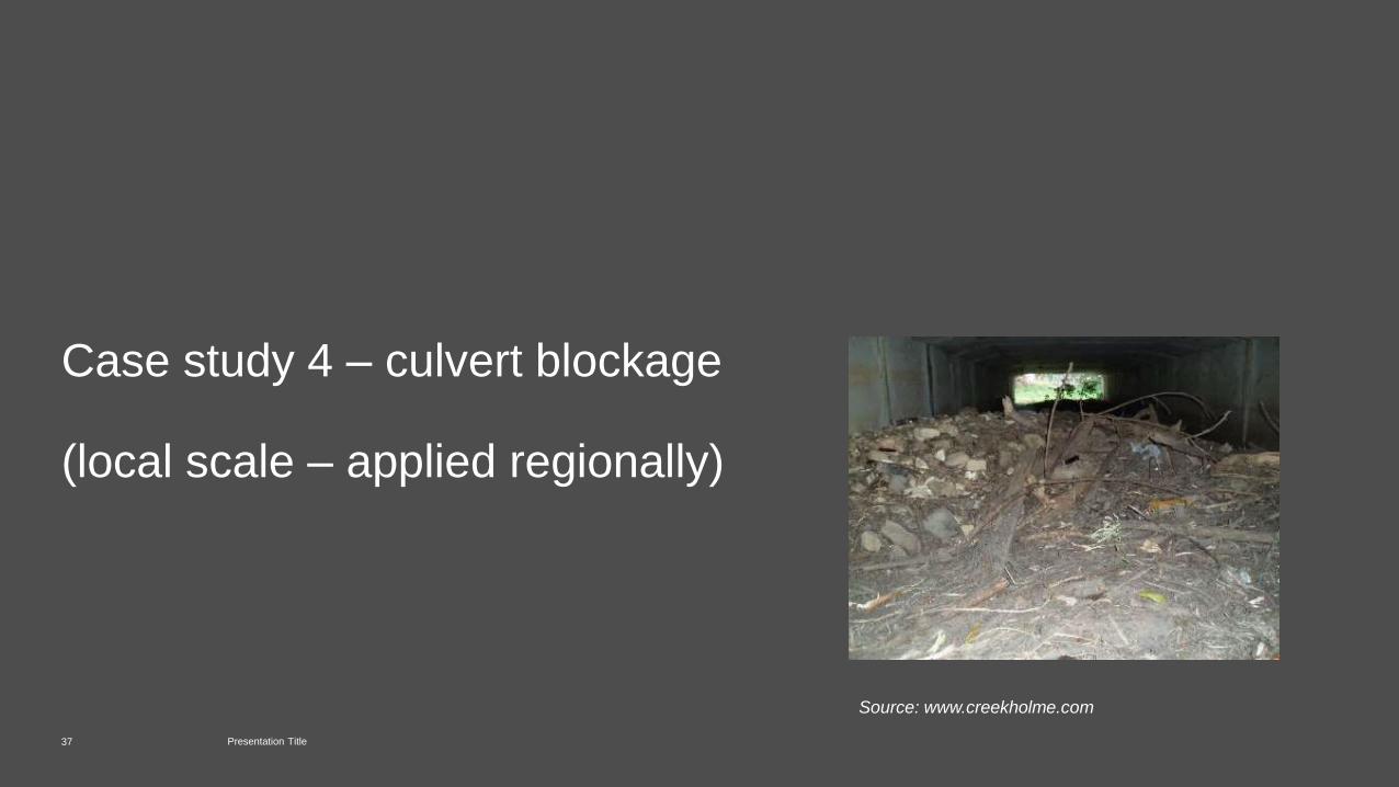
Case study 4 – culvert blockage
(local scale – applied regionally)
Source: www.creekholme.com

38 Automated Hydrological and Hydraulic (2D and 1D-2D) Model Construction, Model Running, and Flood Map Production
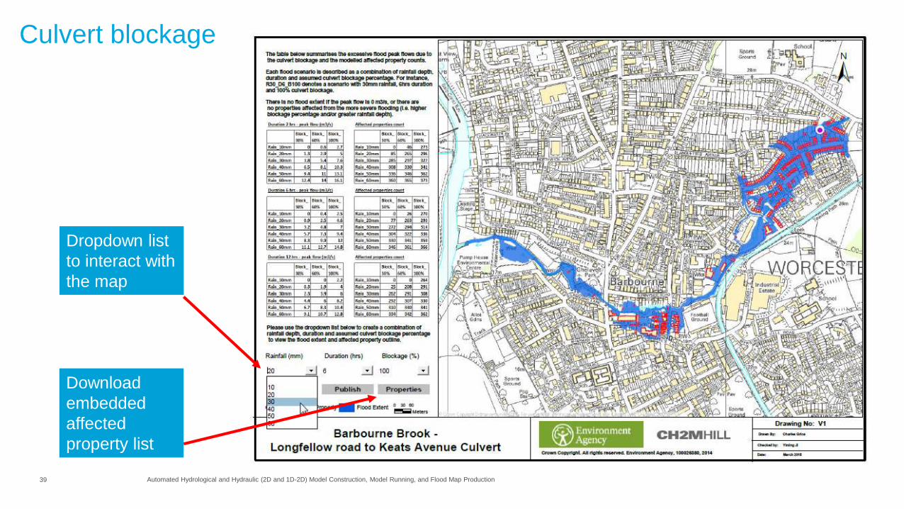
Culvert blockage
Flood mapping for 60 culverts, each with 54 scenarios consisting of:
– Blockage scenarios for 30%, 60% and 100%
– Rainfall depths of 10mm, 20mm, 30mm, 40mm, 50mm, 60mm
– Rainfall durations of 2 hours, 6 hours, and 12 hours.
39 Automated Hydrological and Hydraulic (2D and 1D-2D) Model Construction, Model Running, and Flood Map Production
Culvert blockage
Dropdown list
to interact with
the map
Download
embedded
affected
property list
40 Automated Hydrological and Hydraulic (2D and 1D-2D) Model Construction, Model Running, and Flood Map Production
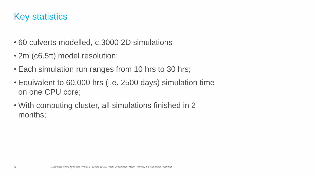
Key statistics
• 60 culverts modelled, c.3000 2D simulations
• 2m (c6.5ft) model resolution;
• Each simulation run ranges from 10 hrs to 30 hrs;
• Equivalent to 60,000 hrs (i.e. 2500 days) simulation time
on one CPU core;
• With computing cluster, all simulations finished in 2
months;

41 Presentation Title
Case study 5 – National Flood Risk Assessment
(national scale)
42 Automated Hydrological and Hydraulic (2D and 1D-2D) Model Construction, Model Running, and Flood Map Production
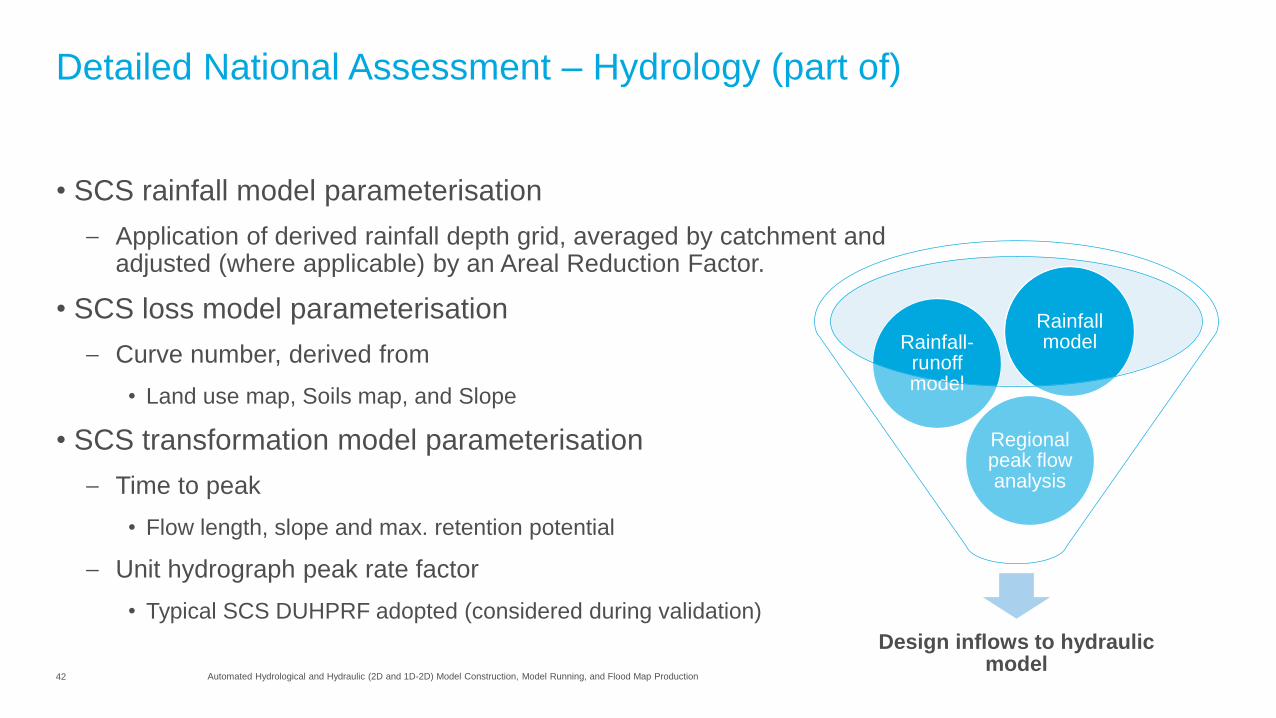
Detailed National Assessment – Hydrology (part of)
• SCS rainfall model parameterisation
– Application of derived rainfall depth grid, averaged by catchment and adjusted (where applicable) by an Areal Reduction Factor.
• SCS loss model parameterisation
– Curve number, derived from
• Land use map, Soils map, and Slope
• SCS transformation model parameterisation
– Time to peak
• Flow length, slope and max. retention potential
– Unit hydrograph peak rate factor
• Typical SCS DUHPRF adopted (considered during validation)
Design inflows to hydraulic model
Regional peak flow analysis
Rainfall-runoff model
Rainfall model
43 Automated Hydrological and Hydraulic (2D and 1D-2D) Model Construction, Model Running, and Flood Map Production
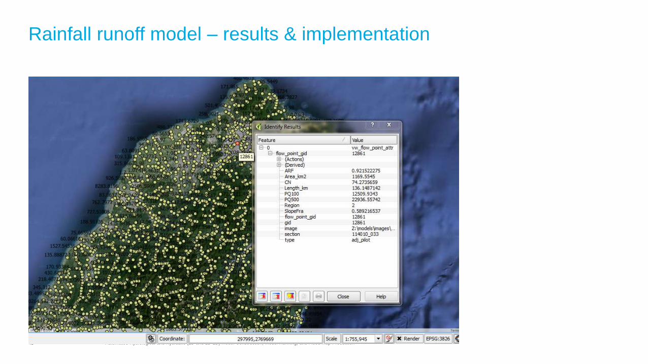
Rainfall runoff model – results & implementation
44 Automated Hydrological and Hydraulic (2D and 1D-2D) Model Construction, Model Running, and Flood Map Production
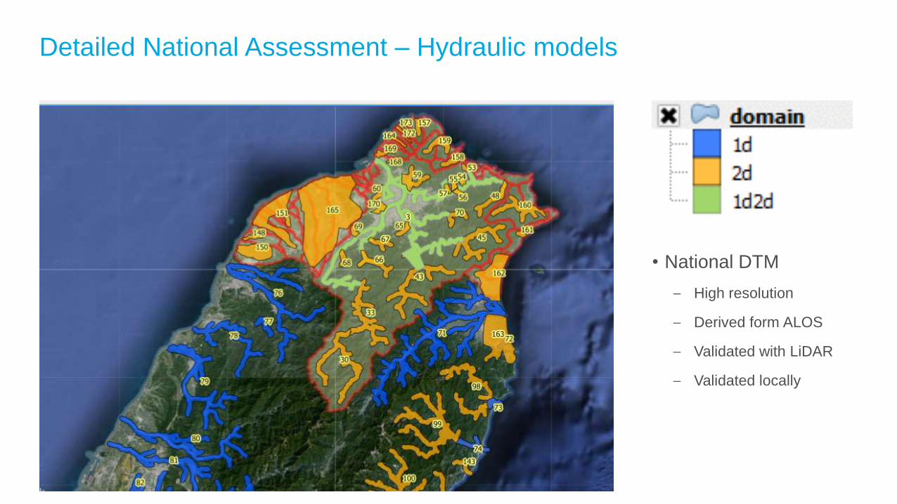
Detailed National Assessment – Hydraulic models
• National DTM
– High resolution
– Derived form ALOS
– Validated with LiDAR
– Validated locally

45 Presentation Title
Summary
46 Automated Hydrological and Hydraulic (2D and 1D-2D) Model Construction, Model Running, and Flood Map Production
Automated Hydrological and Hydraulic (2D and 1D-2D) Model Construction, Model Running, and Flood Map Production
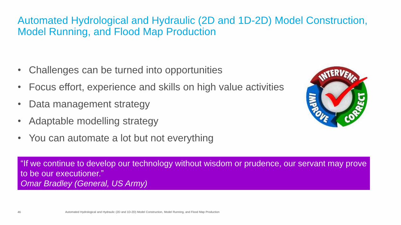
• Challenges can be turned into opportunities
• Focus effort, experience and skills on high value activities
• Data management strategy
• Adaptable modelling strategy
• You can automate a lot but not everything
“If we continue to develop our technology without wisdom or prudence, our servant may prove
to be our executioner.”
Omar Bradley (General, US Army)