asean connectivity in indonesian...
TRANSCRIPT
ASEAN Connectivity in Indonesian Context
A Preliminary Study on Geopolitics of Hydropower and Maritime Transport
Centre of Policy Analysis and Development for Asia-Pacific and African Regions Policy Analysis and Development Agency
Ministry of Foreign Affairs of the Republic of Indonesia 2011
ASEAN Connectivity in Indonesian Context A Preliminary Study of Geopolitics of Hydropower and Maritime Transport Revised Edition 2011 First Published in Indonesia in 2011 by: Centre of Policy Analysis and Development on Asia-Pacific and African Regions Policy Analysis and Development Agency Ministry of Foreign Affairs of the Republic of Indonesia Jalan Taman Pejambon no.6 Jakarta Pusat 10110 Indonesia Email: [email protected] Editor : Siswo Pramono, et al. Cover Design : Imad Yousry Layout: Donny Warmadewa ©2011 Centre for Policy Analysis and Development on Asia-Pacific and African Regions The responsibility for facts and opinions expressed in this publication rests exclusively with the investigators and their interpretations do not necessarily reflect the views nor the policy of the Ministry of Foreign Affairs of the Republic of Indonesia. Indonesian National book Catalogue (Katalog Dalam Terbitan/KDT) ASEAN Connectivity in Indonesian Context A Preliminary Study on Geopolitics of Hydropower and Maritime Transport, Revised Edition Jakarta: Penerbit P3K2 Aspasaf x+ 150 hlm,; 21 cm x 29 cm ISBN: 978-602-99703-1-9

The views expressed in this book are those of the investigators, and not necessarily those of the Ministry of Foreign Affairs of the Republic of Indonesia

i
Table of Contents Table of Contents ................................................................................................................................. i
List of Figures ................................................................................................................................... iv
List of Tables ................................................................................................................................... vi
Preface .................................................................................................................................. vii
Executive Summary ............................................................................................................................ xi
Chapter 1 | INTRODUCTORY ESSAY: Hydropower as a Pull Factor for Connectivity in Mainland and Archipelagic Regions of ASEAN ............................................................................................................. 1
Background of ASEAN Connectivity ............................................................................................................ 1
Connectivity in ASEAN Context ................................................................................................................... 1
Identification of Issues ................................................................................................................................ 3
Connectivity as the Focus of the Current Research .................................................................................... 3
Aim and Purpose of the Research ............................................................................................................... 4
The Thesis: Pull factors should be determined to promote connectivity ................................................... 4
Why Hydropower? ...................................................................................................................................... 6
Energy Mix ................................................................................................................................................... 8
Hydropower is heavily exploited in the Western Part of ASEAN: China’s role ........................................... 8
Hydropower as a Pull Factor: Ecological approach needed ...................................................................... 11
Hydropower Potential in ASEAN ............................................................................................................... 12
Electricity and Connectivity: ASEAN Power Grid ....................................................................................... 13
Hydropower potential in Indonesian context: the future “trade battles” are also about cheap renewable energy and connectivity ............................................................................................................................ 15
Industry and Connectivity: Public Private Partnership .............................................................................. 16
Progress of ASEAN Integration with Regional and Global Economies ...................................................... 18
The Score Card: Weak competitiveness .................................................................................................... 18
Connectivity and Energy as Key Factors of Competitiveness .................................................................... 19
ASEAN must overcome the uneven connectivity ...................................................................................... 21
Connectivity in the Western Part of ASEAN is well in progress ................................................................ 22
Poor connectivity in the Eastern Part of ASEAN........................................................................................ 24
Chapter 2 | WESTERN PART OF ASEAN: The Making of Land Connectivity and Economic Corridors .. 29
Connectivity in the Greater Mekong Sub-region (GMS) ........................................................................... 29
The Rationale behind the Success Story of the GMS ............................................................................ 30
From Transport Corridor to Economic Corridor .................................................................................... 36
The China’s Role .................................................................................................................................... 38
Case Study: East-West Economic Corridor ................................................................................................ 40
Physical Connectivity ............................................................................................................................. 41
People-to-people Connectivity ............................................................................................................. 44
ii
Pitfalls ................................................................................................................................................... 44
GMS Vision on ‘connectivity plus’: Lesson learned from Viet Nam and Myanmar .............................. 47
Connectivity in Indonesia, Malaysia, Thailand – Growth Triangle ............................................................ 49
Challenge for Connectivity .................................................................................................................... 50
Economic Corridors .............................................................................................................................. 50
Maritime Connectivity in IMT-GT ......................................................................................................... 52
Chapter 3 | EASTERN PART OF ASEAN: Maritime Connectivity and Economic Corridors ................... 57
ERIA and ADB studies on BIMP-EAGA’s Connectivity ............................................................................... 57
Case Study 1: Strong Republic Nautical Highway ..................................................................................... 60
The Administration of the SRNH ........................................................................................................... 62
Strong Republic Nautical Highway in the context of ASEAN Connectivity ........................................... 63
The Economic Significance of SRNH ..................................................................................................... 64
Case Study 2: Indonesian Ferry Belts ........................................................................................................ 67
Current development of Indonesian Ferry – PT ASDP .......................................................................... 67
The potential of Bali-Timor traditional shipping route to become a bridging line connecting Western part and Eastern part of Indonesia ....................................................................................................... 69
Bali – Timor Connection........................................................................................................................ 69
Prospect of ASEAN “connectivity plus” with Southwest Pacific ........................................................... 71
Australia’s Role ..................................................................................................................................... 72
Challenges of “connectivity plus” with Southwest Pacific .................................................................... 73
Possible Study on Ro-Ro Network and Short-Sea Shipping .................................................................. 76
Potential for Further Feasibility Studies ............................................................................................... 77
Pitfalls ................................................................................................................................................... 78
Chapter 4 | TOWARDS A REGIONAL HYDROPOLICY? ...................................................................... 79
China’s Energy Policy: Competitive Industry, Renewable Energy, Energy Efficiency ............................... 79
China’s Grand Strategy on Hydropower ............................................................................................... 80
Energy Efficiency ................................................................................................................................... 81
Large Hydropower Plants ..................................................................................................................... 82
Striking the Balance .............................................................................................................................. 82
Challenge .............................................................................................................................................. 83
Ecological and Social Aspects of Conventional Dams: Guangxi’s Longtan Hydropower Project .............. 83
The Business of Medium Hydro: Asahan-1 and Nam Lik-2 Hydropower Projects .................................... 86
Mega-Hydro as Pull Factor of Industrialisation: Bakun Hydro-Electric Power in Sarawak ....................... 89
Batang Ai Hydro Electric Power Plant ................................................................................................... 90
Bakun Hydro Electric Power Plant ........................................................................................................ 90
Trans-Borneo Power Grid ..................................................................................................................... 93
Bakun as a Pull Factor of Industrialisation ............................................................................................ 94
Run-off-River: Sabah Hydropower Potentials ........................................................................................... 95
The prospect of mini-hydropower projects .......................................................................................... 96
iii
Tenom Pangi run-off-river HEP ............................................................................................................. 97
Prospects ............................................................................................................................................... 98
In the Quest of Larger Market: PNG-Australia Cross-border Hydropower Cooperation .......................... 99
Nature of Cooperation: Domestic and Foreign Market ........................................................................ 99
Challenges ............................................................................................................................................. 99
The Cooperation Begins ...................................................................................................................... 103
Prospects ............................................................................................................................................. 104
Papua: An ASEAN Gate to the Pacific with Big Potential of Energy Mix ................................................. 104
Urumuka “run-off-river” Hydropower Potential ................................................................................. 105
Mamberamo Hydropower Potential ................................................................................................... 106
Eastern Gate of ASEAN and the Pacific ............................................................................................... 106
Lesson Learned from the GMS: what is relevant to IMT-GT and BIMP-EAGA? ...................................... 108
Lesson learned from SRNH: what is relevant to Eastern Part of Indonesia? .......................................... 110
More lessons learned on maritime connectivity ..................................................................................... 111
Recommendations .................................................................................................................................. 112
List of Abbreviations ........................................................................................................................ 118
List of Interviewees.......................................................................................................................... 121
About Investigators ......................................................................................................................... 124
Annex ................................................................................................................................ 128
Declaration on the Master Plan on ASEAN Connectivity ........................................................................ 128
Declaration of the 6th East Asia Summit on ASEAN Connectivity ............................................................ 129
Abstract of the Master Plan on Acceleration and Expansion on Indonesia Economic Development ..... 131
iv
List of Figures Figure 1: Interaction between ASEAN Connectivity and ASEAN Community ................................................. 2 Figure 2: The Western and the Eastern Parts of ASEAN ................................................................................. 3 Figure 3: Connection between connectivity, industry and renewable energy ............................................... 4 Figure 5: Inalum’s Asahan-2 Hydro Electric Power Plant and its Smelting Plant ............................................ 6 Figure 6: Average Power Production Expense per kWh ................................................................................. 7 Figure 7: Mekong Basin Hydropower ............................................................................................................ 10 Figure 7: Heart of Borneo Initiative .............................................................................................................. 11 Figure 8: Identified Hydro Potential (MW) on ASEAN Power Grid ............................................................... 12 Figure 9: ASEAN Generation Capacity by Country and Fuel, 2007 and outlook for 2030 ............................. 13 Figure 10: Existing and Proposed ASEAN Power Grid Interconnections ....................................................... 14 Figure 12: Investing through Public-Private Partnership .............................................................................. 16 Figure 14: Quality of Infrastructure, 2009 .................................................................................................... 20 Figure 15: Toyota Regional Production Base ................................................................................................ 20 Figure 16: Japan’s Vision on ASEAN Connectivity (Vision 2) – “Maritime ASEAN Economic Corridor” ........ 21 Figure 17: Economic Corridors in GMS ......................................................................................................... 23 Figure 18: Maritime connectivity is currently concentrated in the Western Part of ASEAN ........................ 23 Figure 19: GMS location at Heart of Asia ...................................................................................................... 30 Figure 21: Map of Transport Corridors in the GMS ...................................................................................... 34 Figure 22: Transformation from Transport Corridors into Economic Corridors ........................................... 37 Figure 23: Nanning – Singapore Economic Corridor ..................................................................................... 38 Figure 24: East-West Transport Corridor Project of GMS ............................................................................. 40 Figure 25: Challenge for connectivity: Belawan – Penang case .................................................................... 50 Figure 26: IMT-GT Economic Connectivity Corridors .................................................................................... 51 Figure 27: Transportation cost significantly higher for inland mines ........................................................... 52 Figure 29: Map of Brunei, Indonesia, Malaysia, Philippines East ASEAN Growth Area ................................ 57 Figure 30: Energy Efficiency of Selected Mode of Transport ........................................................................ 58 Figure 31: SRNH as an Inter-modal Transportation System (Land-RoRo-Land) ............................................ 60 Figure 32: The Strong Republic Nautical Highway Routes ............................................................................ 61 Figure 33: The SRNH and ASEAN Connectivity .............................................................................................. 63 Figure 34: Vision for Archipelagic ASEAN: BIMP-EAGA-RoRo- Network ....................................................... 64 Figure 35: Passenger Traffic in millions ......................................................................................................... 64 Figure 36: Cargo Traffic via SRNH in metric tons .......................................................................................... 65 Figure 40: Map of Ro-Ro Ports in Bali and the Nusa Tenggaras.................................................................... 69 Figure 41: Prospect of ASEAN Connectivity in the Eastern Part of Indonesia............................................... 72 Figure 42: Sea Lanes of Communication and National Sea Lanes ................................................................. 73 Figure 43: Indotrans’ Shipping Service in South East Asia and Southwest Pacific ........................................ 76 Figure 44: Possible Study on Ro-Ro Network and Short-Sea Shipping ......................................................... 77 Figure 45: Electricity Production, Industrial Growth and Economic Growth in China, 1992-2008 ............... 79 Figure 46: China’s Electricity Generation Capacity by Energy Type, 2000 .................................................... 80 Figure 47: Two Views of China’s Electricity Generating Mix in 2030 ............................................................ 81 Figure 48: CO2 Emissions in China, 2000-2050 ............................................................................................. 83 Figure 49: Map of Guanxi Zhuang Autonomous Region ............................................................................... 84 Figure 50: Hydropower Projects in Sarawak, 2008 - 2020 ............................................................................ 89 Figure 51: Transmission Development Plan of Sarawak Hydropower to 2017............................................. 92 Figure 52: Transmission Development Plan of Sabah Electricity .................................................................. 95 Figure 53: Energy Forecast: Electricity demand is expected to reach 1,500 MW by the year 2020 ............ 98 Figure 54: PNG-Queensland Hydropower Cooperation .............................................................................. 100 Figure 55: Papua New Guinea Electricity Systems ...................................................................................... 100 Figure 56: Australian Electricity Generation by fuel, 2007-2008 ................................................................ 102 Figure 57: Urumuka Hydro Electric Power Potential .................................................................................. 105

v
Figure 58: Mamberamo Hydropower Potentials ......................................................................................... 106 Figure 59: Comparison on Flow of Goods between Containerized Shipping and Ro-Ro Shipping .............. 110
vi
List of Tables Table 1: Estimated Levelized Cost of New Generation Resources, 2016 ........................................................ 7 Table 3: Examples of Public Private Partnership Projects in Indonesia ready for bidding (in USD million) .. 17 Table 5: Comparison on Physical Connectivity Projects under The Master Plan on ASEAN Connectivity and ASEAN – Dialogue Partners Cooperation in the Archipelagic and the Mainland Regions of ASEAN ............ 22 Table 6: Composition of Ferry Fleet in Indonesia ......................................................................................... 24 Table 7: Number of Ro-Ro Vessels and Ports ................................................................................................ 24 Table 8: Priority Projects in the Vientiane Plan of Action 2008 – 2012 vis-à-vis the MPAC ......................... 32 Table 9: Transport Corridors of the GMS ...................................................................................................... 33 Table 10: Yunnan’s, Guangxi’s and Guangdong’s Trade with ASEAN and GMS Countries, 2009 ................. 39 Table 11: Navigable length of inland waterways transport in ASEAN member states ................................. 58 Table 12: Cost Comparison between Traditional and Ro-Ro Shipping ......................................................... 66 Table 13: Comparison of Ro-Ro Network in the Eastern and Western Part of Indonesia ............................ 68 Table 14: Profile of Pacific Island Countries .................................................................................................. 74 Table 15: Indicative Export Freight Rates in Indonesia ................................................................................. 75 Table 16: Potential Ro-Ro Routes in the perspective of MP3EI and MPAC .................................................. 76 Table 17: Proposed Feasibility Studies for Ro-Ro and Short-Sea Shipping Connectivity .............................. 77 Table 18: Top Hydropower Producers and Top Hydropower Installed Capacity Countries ......................... 81 Table 19: Large Hydropower Plants in China: Recently built and planned through 2010 ............................ 82 Table 20: Comparison between Asahan-1 HEP and Nam Lik-2 HEP ............................................................. 88 Table 21: Main Features of Bakun HEP Project............................................................................................. 90 Table 22: Most Likely Scenarios for Power Transfer from Bakun HEP .......................................................... 93 Table 23: Identified Hydropower Potential sites in Sabah ............................................................................ 96 Table 24: Identified Micro Hydropower Potential Sites in Sabah ................................................................. 97 Table 25: Forecasted Demand at the National Level and in Selected Town Centres (MWh) ..................... 101 Table 26: Key Performance Indicators for the Australian Electricity Industry ............................................ 102
vii
Preface
An inter-connected ASEAN through enhanced physical connectivity, institutional connectivity, and people-to-people connectivity looms high as the priority during Indonesian Chairmanship in ASEAN.
In the national context, the issue of connectivity has been the one of priority projects under the Master Plan for Acceleration and Expansion of Indonesia Economic Development (MP3EI), which is intended to attain high, balanced, fair and sustainable economic growth for all Indonesians.
Having the task of undertaking analysis and development in foreign policy and international relations, the Policy Analysis and Development Agency of the Ministry of Foreign Affairs (hereafter called “the Agency”) is committed itself to provide a strategic recommendation to the Foreign Ministry and other stakeholders on how the welfare of the nations can be enhanced by building a better connectivity, both in regional level (ASEAN), and in domestic level (Indonesian Archipelago).
To reach this goal, the Agency charged the Centre for Policy Analysis and Development of Asia Pacific and African Regions (hereafter called “P3K2 Aspasaf”) to undertake research based on field studies in various locations throughout the mainland and the archipelagic regions of ASEAN, and the contiguous areas as well.
It should be noted in advance, that the findings of this research, as documented in the book, titled: “ASEAN Connectivity in Indonesian Context: A Preliminary Study on Geopolitics of Hydropower and Maritime Transport”, have not qualified yet as a policy. Thus this book should not be regarded as the official position of the Indonesian Foreign Ministry.
It is my sincere hope that this research can contribute positively to the discourse of connectivity, both at national and regional level of ASEAN.
Herewith, I would like to appreciate all members of the Investigating Team - diplomats with strong idealism and dedication to their profession - for all the efforts and risks they took in completing this research.
Indeed, this research project cannot be completed without invaluable input and help from the advisors, and reviewers. I would like herewith to convey my highest appreciation to all of the distinguished advisors and reviewers for their generosity and help rendered to the Investigating Team.
Last but not least, allow me to extend my gratitude and appreciation to all of the facilitators and many other parties, who I could not mention one by one, who have made this project possible. For the Agency, this book is not the end of the research on ASEAN Connectivity, since we are going to revise and update it from time to time to meet the dynamic development in Southeast Asia and its immediate regions.
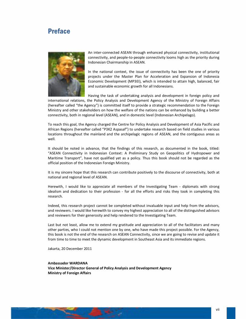
Jakarta, 20 December 2011 Ambassador WARDANA Vice Minister/Director General of Policy Analysis and Development Agency Ministry of Foreign Affairs
viii
PATRON:
Ambassador Wardana
INVESTIGATING TEAM:
The Centre for Policy Analysis and Development on Asia Pacific and African Regions (P3K2 Aspasaf)
Chief Investigator:
Siswo Pramono, LLM., Ph.D.
Investigators:
Lukman Hakim Siregar, M.IS., M.Si.
Arianto Surojo, S.S., M.A.
Donny Warmadewa, S.IP., MM., DEA
Sigit Aris Prasetyo, S.S., M.Hum.
Christine Refina, S.IP, MIS.
Adinda Hutabarat, S.Hum., M.M.
Yudho Priambudi Asruchin, S.H.
Eva K. Situmorang, S.Hum.
M. Reza Adenan, B.A.
Banga Malewa, S.Pd.
Indri Yanuarti, S.Sos.
Adkhilni M.Sidqi, S.IP.
Imad Yousry, S.Hum.
Ivan Namanto, B.A.
CONSULTANT:
Ambassador Amiruddin Noor
ix
ADVISORS: (In Personal Capacity) Ambassador I Gede Ngurah Swajaya, Indonesian Permanent Representative to ASEAN Chair of ASEAN Connectivity Coordinating Committee Drs. Erlangga Mantik, M.A. Deputy for Macroeconomic and Financial Coordination The Coordinating Ministry of Economic Affairs of the Republic of Indonesia
Ir. Bambang Hermawanto, M.Sc. Chairman of ASEAN Power Grid Consultative Committee Dr. Oktorialdi,
The Head of the Center for Data and Information Development Planning The National Development Planning Agency of the Republic of Indonesia Ir. Djoko Prasetijo, Ph.D. Head of System Planning Division of PT PLN (Persero) Drs. Youlman Jamal, Director of Bussiness Ferry Transportation of PT Indonesia Ferry (Persero) Ir. Bambang Purnomo Hidayat, M.BA.
Assistant Vice President of PT Bajra Daya Sentra Nusa (Asahan 1 Hydro Electric Power Plant)
REVIEWERS: (In Personal Capacity) Dr. Ir. Bambang Susantono, MCE. Vice Minister for Transportation of the Republic of Indonesia High Level Task Force on ASEAN Connectivity Mahendra Siregar, SE., MA. Vice Minister for Trade of the Republic of Indonesia Professor Dr. Dewi Fortuna Anwar, MA. Deputy for Political Affairs, Secretariat of the Vice President of the Republic of Indonesia
x
FACILITATORS: H.E. Da'i Bachtiar,
Ambassador of the Republic of Indonesia in Kuala Lumpur
H.E. Kria Fahmi Pasaribu, Ambassador of the Republic of Indonesia in Vientiane
H.E. Mohammad Hatta, Ambassador of the Republic of Indonesia in Bangkok
H.E. Pitono Purnomo, Ambassador of the Republic of Indonesia in Hanoi
H.E. Sebastianus Sumarsono, Ambassador of the Republic of Indonesia in Yangon
H.E. Yohanes Kristiarto Soeryo Legowo, Ambassador of the Republic of Indonesia in Manila
H.E. Handriyo Kusumo Priyo, Ambassador of the Republic of Indonesia in Bandar Seri Begawan
H.E. Soehardjono Sastromihardjo, Ambassador of the Republic of Indonesia in Phnom Penh
Kenssy Dwi Ekaningsih, Chargé d’affaires a.i., Embassy of the Republic of Indonesia in Singapore
H.E. Imron Cotan, Ambassador of the Republic of Indonesia in Beijing
H.E. Eddy Setiabudhi, Ambassador of the Republic of Indonesia in Dili
H.E. Andreas Sitepu, Ambassador of the Republic of Indonesia in Port Moresby
H.E. Aidil Chandra Salim, Ambassador of the Republic of Indonesia in Suva
Bambang Tarsanto, Consul General of the Republic of Indonesia in Ho Chi Minh City
Soepeno Sahid, Consul General of the Republic of Indonesia in Kota Kinabalu
Gary R. M. Jusuf, Consul General of the Republic of Indonesia in Sydney
Edi Yusup, Consul General of the Republic of Indonesia in Guangzhou
Lalu Malik Partawana, Consul General of the Republic of Indonesia in Davao City
Joko Suprapto, Acting Consul General of the Republic of Indonesia in Kuching
xi
Executive Summary The research will focus on two challenges of ASEAN Connectivity, in particular the maritime one. First is the discrepancy in the progress of connectivity between the Western part of ASEAN which is largely a land mass, and the Eastern Part of ASEAN, which is an archipelago. Second is the Eastern Part of ASEAN, which represents a weak link in the overall ASEAN maritime connectivity, despite the sub-region potential. This sub-region largely consists of the Philippines and the Eastern Part of Indonesia. The research concludes that economic pull factors are needed to speed up the development of connectivity in the Eastern Part of ASEAN. Cheap and abundant energy mix of hydro and coal power can become the pull factor to attract energy-intensive processing industries (i.e. smelters) to come to the region. The growing economic activity will eventually, as business dictates, induce development of connectivity in the archipelagic region of ASEAN.
The “ASEAN Connectivity in Indonesian Context: A Preliminary Study on Geopolitics of Hydropower and Maritime Transport” is the fruit of field research conducted by the Centre for Policy Analysis and Development on Asia Pacific and African Regions (P3K2 Aspasaf), the Ministry of Foreign Affairs of the Republic of Indonesia from December 2010 to July 2011. The field research was commenced in the Greater Mekong Sub-region (GMS), followed by field research in Indonesia-Malaysia-Thailand Growth Triangle (IMT-GT) and Brunei-Indonesia-Malaysia-Philippines – East ASEAN Growth Area (BIMP-EAGA) regions. The P3K2 Aspasaf investigating team has also conducted a field observation for the connectivity segments within the Pacific island states, the island of New Guinea (Papua and PNG), and the islands stretched across from Bali to Timor.
The objective of this book is to trigger the discourse regarding the connectivity in the Archipelagic Region of ASEAN (or Eastern Part of ASEAN), aside from being the initial input for the decision makers and general public in ASEAN regions.
It should be noted in advance that this research is not about hydropower and transport policy per se, nor about the Master Plan on the Acceleration and Expansion of Indonesian Economic Development (MP3EI). It is about the geopolitics of connectivity and energy, using maritime transport and hydropower as examples, since connectivity (including the maritime one) and energy represent strategic issues with economic and political implication to ASEAN integration.
The striking character of “connectivity” is its double edge nature. One needs to be careful in designing ASEAN Connectivity, or the national connectivity as expressed by Master Plan for Acceleration and Expansion of Indonesia Economic Development (MP3EI). Connectivity by nature works at both sides. Connectivity might lead into a better economic integration but somehow it might also lead into economic vulnerability, even disintegration, if the region is not well prepared for it. The phenomenon of “ASEAN divides” can be read as a new drive in the part of mainland region of ASEAN to integrate economically, due to geographical proximity, with the rising China. Thus consequently, this might lead into an “isolation” of the archipelagic region of ASEAN from the rest of the ASEAN region.
Assumedly, the more an economy is integrated, the more it becomes vulnerable to the negative impact of integration. The striking example was the Asian economic meltdown in 1997-1998. Most of the CLMV countries (Cambodia, Laos, Myanmar, Viet Nam), which then, had not yet been well integrated economically with the rest of the region, were relatively immune from the devastating, domino effect of the crisis. But, Indonesia and other ASEAN countries which had already been integrated with the economics of the region, suffered the most.
It is not to say that ASEAN should perceive “integration” with a negative tone, apprehensively ASEAN should only be aware of, and be prepared for, the possible unpredictability impact of such connectivity. Connectivity is the natural order of globalisation, what ASEAN needs to do is to maximize efforts to attain positive impact of connectivity while negating the negative impact. This is exactly the perspective of Indonesia should be when it attempts to fit the MP3EI into a broader ASEAN Connectivity, and ASEAN connectivity plus.
xii
One needs also to comprehend the complexity of connectivity. Connectivity might produce an unexpected outcome. It has been observed in the current research how connectivity works in the Philippines as exemplified by the success story of Strong Republic Nautical Highway, but the same connectivity produces less desired impact in the GMS as is the case with the East-West Economic Corridor (while many other corridors in GMS are successful).
ASEAN saw the once widening gap among countries in the mainland region; and now it also sees the gaps within and among economies in the archipelagic side of ASEAN. Therefore ASEAN should be able to address this very multiple challenges. The future of ASEAN Community, ASEAN centrality or ASEAN capacity to play a central role, against the backdrop of the dynamic regional architecture, much also depends on ASEAN capacity to narrow or to bridge the gaps within ASEAN and within ASEAN member countries as well.
It is thus important for the ASEAN strategists to understand the nature of archipelagic-mainland characters of connectivity, and thus the associated perspectives. ASEAN is not either archipelagic or mainland, but consists of the both characteristics. Thus ASEAN should not employ “one size fits all” approach to the problem among or within members. The solution for “land-locked” dis-connectivity in the mainland side is different from the solution for “isolated island” dis-connectivity in the archipelagic side. Building a road or a trail to an isolated land-locked area is different from establishing a shipping line to an isolated island area.
Technology, which will be materialized into the right infrastructure, will change the feature of most isolated islands areas in the archipelagic ASEAN. But technology, and the associated infrastructure, is expensive while most of the isolated regions are poor. But, ASEAN Community would agree that a common action is needed to break all of the dis-connectivity, if integration, economic or otherwise, is the common ideal of all peoples of ASEAN.
In practical level, it is imperative for Indonesia to address the gap within its maritime belts, which is largely the consequence of the economics of scale (i.e. load factors). Most of the maritime belts in the Western Part of Indonesia have already been commercialised due to the high level of economic activity in the West, and thus can easily be integrated into the regional or even global maritime connectivity. Most of the maritime belts in the Eastern Part of Indonesia remains largely pioneered due to the lack of economic activity in the sub-region, and thus cannot be easily integrated with the regional maritime connectivity. In a way, the improvement of maritime belts from the Western Part to the Eastern Part of Indonesia will be great contribution for the connectivity within ASEAN and beyond.
One possibility for ASEAN to help improve its maritime connectivity is by assisting Indonesia and the Philippines, for instance, to interconnect the Eastern belts of the Indonesian archipelago with the Strong Republic Nautical Highway of the Philippines.
On the archipelagic perspective of “connectivity plus”, it is necessary for ASEAN and for Indonesia to undertake feasibility study on the possible connectivity between Aceh, in the Western tip of Indonesian archipelago, with the new hubs of Myanmar’s Dawei, Yangon and Kyaukphyu in the Andaman Sea. On the other end, more study is needed in the possible development of “ASEAN connectivity plus” towards the Pacific, using Papua as the ASEAN Eastern gate to reach Papua New Guinea, Solomon Islands, the Northern part of Australia and the rest of the Pacific island states.
It should be noted, that ASEAN once vigorously pursues cooperation on the development of fertilizer industry to sustain ASEAN’s agriculture. In the light of ASEAN archipelagic perspective, it is necessary for ASEAN to enhance cooperation in the maritime-related strategic industry, which includes, but not limited, to shipping industry, shipyard, and development of maritime science and technology.
As the gap between the Western Part of ASEAN, which is heavily invested with infrastructure to boost economic development, and the Eastern Part of ASEAN which is lacking the supporting infrastructure, is a nowadays reality, ASEAN should devise a strategy for an even connectivity through industrialisation.
Learning from the experience of the Western Part of ASEAN, in particular the GMS region, one may infer that a pull factor is needed to accelerate the industrialisation process. The new government of Myanmar, for instance, is contemplating on a “water law” to support the development of agriculture, mining, and
xiii
power generation industries. For Myanmar, the mighty river such as Irrawaddy is a blessing given by nature to support industrialisation, both in term of its potential development into effective irrigation and prospective hydropower. The mighty Mekong River (or Lancang River) assumes the same role. Mekong River is not only the life vein for agro-industry in the GMS, but also a vital source of hydropower. In other words, in the Western Part of ASEAN, hydropower represents an effective pull factor, if not in a lesser role as a main supporting infrastructure, for industrialisation.
The Eastern Part of ASEAN is also blessed with the mighty rivers. It is time to explore and exploit in the most sustainable way the mighty rivers such as Rajang River in the Island of Borneo or Mamberamo and Purari rivers in the Island of New Guinea as the pull factor to bring energy intensive industry to come to the Eastern Part of ASEAN. Equally important, run-off-rivers such as Urumuka and Asahan, also need to be sustainably explored and exploited.
Sarawak offers good example about the use of hydropower as a pull factor for industrialisation. The development of Bakun Hydro Electric Power mega project in Sarawak has induced the relocation of industry from Peninsular Malaysia to Sarawak or the establishment of completely new industry in Sarawak. The industrialisation of Sarawak will give economic and social impact in the neighbouring regions of Kalimantans and beyond. It is yet to see, however, how the commissioning of Bakun in 2011, which means the availability of an additional 2,400 MW of electricity in Sarawak, which will provide a considerable surplus to be absorbed by the coming energy intensive industry, will be able to bring economic progress, industrialisation and otherwise, in the Northern Part of Borneo.
In the same way, the commencement of Purari project which is adjacent to Merauke, will bring more economic activity in the Southern Part of PNG. As previously mentioned, the main problem of development of the Eastern Part of ASEAN and hence the Eastern Part of Indonesia, is the economics of scale. The market is too small to sustain durable economic activities. The development of electricity generation has always been hampered by the very limited domestic demand, since the users are largely, scattered households. To develop a project like Bakun would prerequisite a larger market, and thus a higher demand of electricity. Compared with other commodities, electricity has a specific characteristic that is the electricity is produced and consumed at the same time. The fact that PNG is able to beneficially combine PNG’s market and Queensland’s market to sustain the development of electric power industry, poses a challenge for Papua to be creative in finding the way to break the vicious circle of the “chicken and egg” phenomenon. The question for Papua is: what should be developed first. It is the basic infrastructure including electricity to attract industry; or the business activity to encourage the development of basic infrastructure, including electricity?
The exportation (or exchange) of electricity aside, mega projects like Bakun in the Northern Part of Borneo, and Purari across the border of Papua, should bring awareness for those in the Eastern Part of ASEAN, on the importance of energy exchange as the efficient way to provide industry with reliable source of electricity. In Borneo Island, interchange is possible, as it has been proved nowadays, albeit limited, between Kalimantans and Sarawak or Sabah. In the future, with the development of coal-rich Kalimantan Corridor as the source of fossil energy, wider interchange between coal-based and hydro-based across Borneo is possible. The industrialisation of the Eastern Part of ASEAN should take this possibility, and opportunity, into consideration.
At the end of the day, the ASEAN competitiveness, in the long-term, in particular when the labour pools in the region are exhausted, will also much depend on the availability of cheap, reliable source of energy, such as hydropower, in ASEAN industry. The presence of hydro mega projects in the Southern Part of China, in the GMS region, and recently in Sarawak, is not without thorough calculation. It represents the quest for competitive energy, for competitive industry.
As such, it is timely and important for ASEAN to devise the region with a common platform that enable it to develop a regional understanding to support development of ASEAN as a single, competitive production base with supporting infrastructure such as maritime connectivity and competitive energy mix (including hydro and coal).

ASEAN Connectivity in Indonesian Context – A Preliminary Study on Geopolitics of Hydropower and Maritime Transport
1
Chapter 1 | INTRODUCTORY ESSAY: Hydropower as a Pull Factor for Connectivity in Mainland and Archipelagic Regions of ASEAN
Background of ASEAN Connectivity
Before discussing the role of hydropower and connectivity in the economic development and economic integration in the mainland and archipelagic regions of ASEAN, the introductory essay will start with the background of ASEAN Connectivity.
The idea of ASEAN connectivity was first proposed by Thai Prime Minister Abhisit Vejjajiva at the Opening Ceremony of the 42nd ASEAN Foreign Ministers’ Meeting on 20 July 2009 in Phuket. As the Chairman of ASEAN, Prime Minister Abhisit proposed that a “Community of Connectivity” should be one of the objectives of ASEAN Community 2015. It means that goods and peoples, investment and initiatives, can travel obstacle-free throughout the region. A fully integrated ASEAN economy as a single market and production base must have such connectivity built into both its hardware and software1. It is expected that through a well-connected Community, ASEAN can realize its full economic potentials as well as take maximum advantage of the strategic location linking the massive economies of South Asia on the West and Northeast Asia to the North.
This initiative was endorsed with the adoption of the ASEAN Leaders’ Statement on ASEAN Connectivity at the 15th ASEAN Summit held in Hua Hin on 24 October 2009. ASEAN Leaders mandated the creation of a High Level Task Force (HLTF) on ASEAN Connectivity to devise a Master Plan on ASEAN Connectivity by the 17th ASEAN Summit 2010. The Master Plan is both a strategic document for achieving overall ASEAN Connectivity and a plan of action for immediate implementation for the period 2011 – 2015 to connect ASEAN through enhanced physical infrastructure development (physical connectivity), effective institutional arrangement (institutional connectivity) and empowered people (people–to–people connectivity)2.
On 28 October 2010, ASEAN Leaders adopted the Ha Noi Declaration of the Adoption of the Master Plan on ASEAN Connectivity. In this Declaration, the ASEAN Leaders recognized that the Master Plan on ASEAN Connectivity will promote economic growth, narrow development gaps, speed up ASEAN integration and Community building process, enhance competitiveness of ASEAN, promote deeper social and cultural understanding, smooth people mobility, and connects its Member States within the region and with the rest of the world.
The Leaders also tasked the Ministers, the ASEAN Connectivity Coordinating Committee and the National Coordinators, supported by the ASEAN Secretariat, to coordinate and oversee the implementation of the Master Plan on ASEAN Connectivity and to report to the ASEAN Leaders about the progress of the implementation on a regular basis through the ASEAN Coordinating Council.
Connectivity in ASEAN Context
As such, ‘connectivity’, according to the document of the Master Plan on ASEAN Connectivity, refers to the physical, institutional and people-to-people linkages that comprise the foundational support and
1 Statement of Prime Minister of Thailand, H.E. Mr. Abhisit Vejjajiva at the Opening Ceremony of the 42nd ASEAN Foreign Ministers’ Meeting in Phuket, 20 July 2009. 2 Master Plan on ASEAN Connectivity, Executive Summary, p.i.
ASEAN Connectivity in Indonesian Context – A Preliminary Study on Geopolitics of Hydropower and Maritime Transport
2
facilitative means to achieve the political-security, economic, and socio-cultural pillars towards realizing the vision of an integrated ASEAN Community.
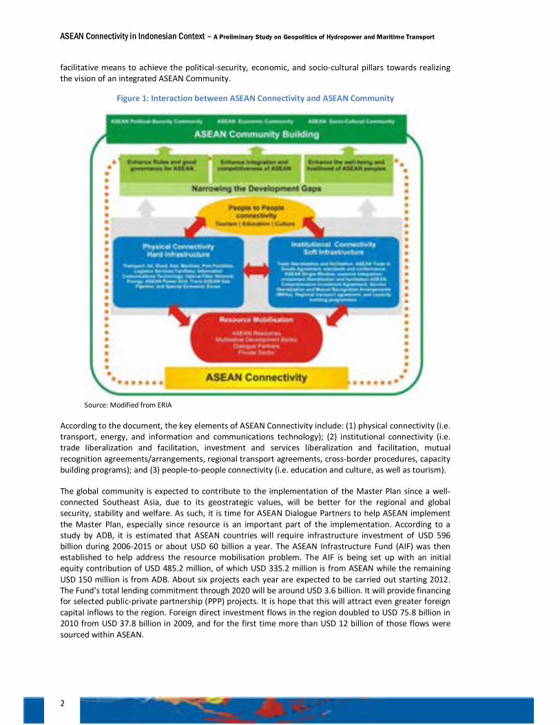
Figure 1: Interaction between ASEAN Connectivity and ASEAN Community
Source: Modified from ERIA
According to the document, the key elements of ASEAN Connectivity include: (1) physical connectivity (i.e. transport, energy, and information and communications technology); (2) institutional connectivity (i.e. trade liberalization and facilitation, investment and services liberalization and facilitation, mutual recognition agreements/arrangements, regional transport agreements, cross-border procedures, capacity building programs); and (3) people-to-people connectivity (i.e. education and culture, as well as tourism).
The global community is expected to contribute to the implementation of the Master Plan since a well-connected Southeast Asia, due to its geostrategic values, will be better for the regional and global security, stability and welfare. As such, it is time for ASEAN Dialogue Partners to help ASEAN implement the Master Plan, especially since resource is an important part of the implementation. According to a study by ADB, it is estimated that ASEAN countries will require infrastructure investment of USD 596 billion during 2006-2015 or about USD 60 billion a year. The ASEAN Infrastructure Fund (AIF) was then established to help address the resource mobilisation problem. The AIF is being set up with an initial equity contribution of USD 485.2 million, of which USD 335.2 million is from ASEAN while the remaining USD 150 million is from ADB. About six projects each year are expected to be carried out starting 2012. The Fund’s total lending commitment through 2020 will be around USD 3.6 billion. It will provide financing for selected public-private partnership (PPP) projects. It is hope that this will attract even greater foreign capital inflows to the region. Foreign direct investment flows in the region doubled to USD 75.8 billion in 2010 from USD 37.8 billion in 2009, and for the first time more than USD 12 billion of those flows were sourced within ASEAN.
ASEAN Connectivity in Indonesian Context – A Preliminary Study on Geopolitics of Hydropower and Maritime Transport
3
The 6th East Asia Summit, held in Bali, 19 November 2011, has declared its support to the implementation of the Master Plan on ASEAN Connectivity. As such, it is time for the governments of the ASEAN Member States to work closely together with the private sectors and the governments of (in alphabetical order) Australia, China, India, Japan, Republic of Korea, New Zealand, Russia and the United States to materialize, in a comprehensive manner, the ASEAN Connectivity. EAS notwithstanding, cooperation with other members of global community of nation is well expected. Such cooperation should be focused particularly in mobilization of resources and expertise, information sharing, and identification of specific cooperation projects where the EAS Partners could participate in the three dimensions of physical, institutional, and people-to-people connectivity. EAS aside, the UN has also lent supports to the implementation of the ASEAN Connectivity.
Identification of Issues
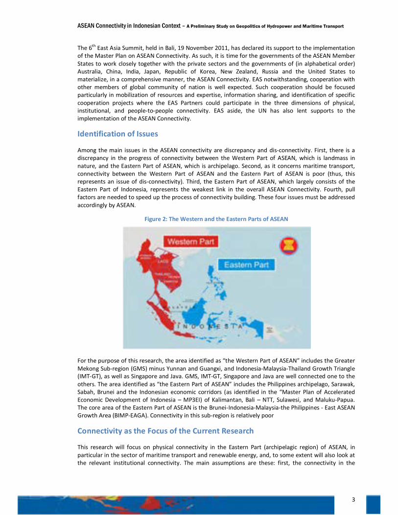
Among the main issues in the ASEAN connectivity are discrepancy and dis-connectivity. First, there is a discrepancy in the progress of connectivity between the Western Part of ASEAN, which is landmass in nature, and the Eastern Part of ASEAN, which is archipelago. Second, as it concerns maritime transport, connectivity between the Western Part of ASEAN and the Eastern Part of ASEAN is poor (thus, this represents an issue of dis-connectivity). Third, the Eastern Part of ASEAN, which largely consists of the Eastern Part of Indonesia, represents the weakest link in the overall ASEAN Connectivity. Fourth, pull factors are needed to speed up the process of connectivity building. These four issues must be addressed accordingly by ASEAN.
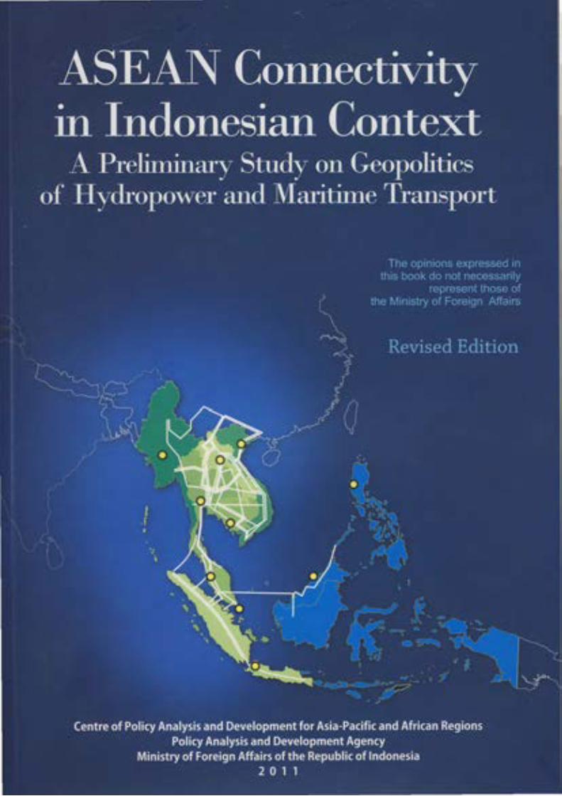
Figure 2: The Western and the Eastern Parts of ASEAN
For the purpose of this research, the area identified as “the Western Part of ASEAN” includes the Greater Mekong Sub-region (GMS) minus Yunnan and Guangxi, and Indonesia-Malaysia-Thailand Growth Triangle (IMT-GT), as well as Singapore and Java. GMS, IMT-GT, Singapore and Java are well connected one to the others. The area identified as “the Eastern Part of ASEAN” includes the Philippines archipelago, Sarawak, Sabah, Brunei and the Indonesian economic corridors (as identified in the “Master Plan of Accelerated Economic Development of Indonesia – MP3EI) of Kalimantan, Bali – NTT, Sulawesi, and Maluku-Papua. The core area of the Eastern Part of ASEAN is the Brunei-Indonesia-Malaysia-the Philippines - East ASEAN Growth Area (BIMP-EAGA). Connectivity in this sub-region is relatively poor
Connectivity as the Focus of the Current Research
This research will focus on physical connectivity in the Eastern Part (archipelagic region) of ASEAN, in particular in the sector of maritime transport and renewable energy, and, to some extent will also look at the relevant institutional connectivity. The main assumptions are these: first, the connectivity in the
ASEAN Connectivity in Indonesian Context – A Preliminary Study on Geopolitics of Hydropower and Maritime Transport
4
archipelagic region of ASEAN can be achieved by enhancing maritime connectivity and the related institutional connectivity, thereby reducing the costs of investment and the cost of international trade in goods and services, including services link costs and network set-up costs. Second, enhanced physical and institutional connectivity can contribute to narrowing development gaps in the archipelagic region as well as the gap between the archipelagic and the mainland regions of ASEAN, by expanding the frontiers of production/distribution networks. Yet, the augmenting people-to-people connectivity, will further nurture a sense of community in ASEAN as a whole.
Aim and Purpose of the Research
The aim of this research is three-folds. The first one is to observe the current state of affairs in the implementation of the Master Plan on ASEAN Connectivity, which is, as previously mentioned, marked by the stark discrepancy between the rapid infrastructure development in the mainland region of ASEAN and the slow, if not neglected, infrastructure development in the archipelagic region of ASEAN. The second one is to study how the two main regions of ASEAN, the mainland and the archipelago, could enhance, and thus benefit from, an even, yet effective, regional connectivity. Third, is to investigate the pull factors that can be used as a leverage to draw connectivity from the mainland region to the archipelagic regions of ASEAN.
The purpose of this research is to provoke public opinion moulders (i.e. the general public, academicians, and decision makers) to pay more attention, to have more debates, to undertake more feasibility studies, and thus to devise better policy dedicated to the development of maritime connectivity in the Eastern Part of ASEAN. Having set the aim and purpose of the research, a thesis thus needs to be formulated.
The Thesis: Pull factors should be determined to promote connectivity
The main thesis of this research is as follows: the hydropower potentials in the Eastern Part of ASEAN, in particular in the islands of New Guinea and Borneo, should be carefully explored and sustainably developed in order to support the availability of the cheap, competitive energy mix, that is able to function as a pull factor to drive economic activity, that will eventually drive an even connectivity within the archipelagic region of ASEAN, as well as between the archipelagic and the mainland regions of ASEAN.
As such, the research will focus on the inter-link between hydropower as potential renewable energy in the energy mix (and thus part of a potential pull factor for trade and industrialisation projects) and the development of maritime connectivity.
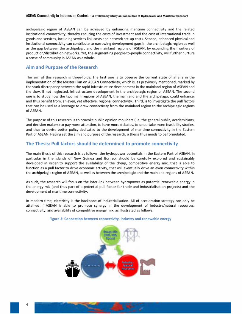
In modern time, electricity is the backbone of industrialisation. All of acceleration strategy can only be attained if ASEAN is able to promote synergy in the development of industry/natural resources, connectivity, and availability of competitive energy mix, as illustrated as follows:
Figure 3: Connection between connectivity, industry and renewable energy
ASEAN Connectivity in Indonesian Context – A Preliminary Study on Geopolitics of Hydropower and Maritime Transport
5
The point is this: first the government needs to develop power plants, or otherwise to make electricity available, in the area projected as industrial zone. The availability of competitive energy mix will attract investors to invest on energy intensive industry and in that particular industrial zone. As the energy-intensive industry flourishes, investors are keen to invest further in the related downstream industries. Investors, too, are likely interested in connecting such industrial areas with the market or other production centres. It should be noted that the reference of “industry/natural resources” is used, because in Indonesia’s perspective as expressed in the Master Plan of Acceleration and Expansion of Indonesia Economic Development (MP3EI), the type of industry developed in the eastern corridors (i.e. Kalimantan, Sulawesi, Maluku-Papua) is the one which is correlated with the existing main natural resources (i.e. Kalimantan as a centre for production and processing of national mining and energy reserves; Sulawesi as a centre for production and processing of agriculture, plantation, fishery, oil and gas, and mining; Maluku-Papua as a centre for development of food, fishery, energy, and national mining).
In BIMP-EAGA context, for instance, the development of 2,400 MW hydro-electric power plant in Bakun (Sarawak), adding to Sarawak’s generating capacity of 1,300 MW, which will be discussed in Chapter 4, will incite the relocation of industry from Peninsular Malaysia to Sarawak and the establishment of new industry in Sarawak. Because of the availability of cheap hydro-electric energy, investors are interested in developing energy intensive industry, such as aluminium smelters, in Sarawak. At present, some MoUs have been concluded between the Government of Sarawak and some smelters. And in the later stage, the investors will likely be interested in developing connectivity between Peninsular Malaysia to Sarawak and from Sarawak to other regional and global markets. Thus, in this case, Bakun has functioned as the pull factor for industrialisation in Sarawak.
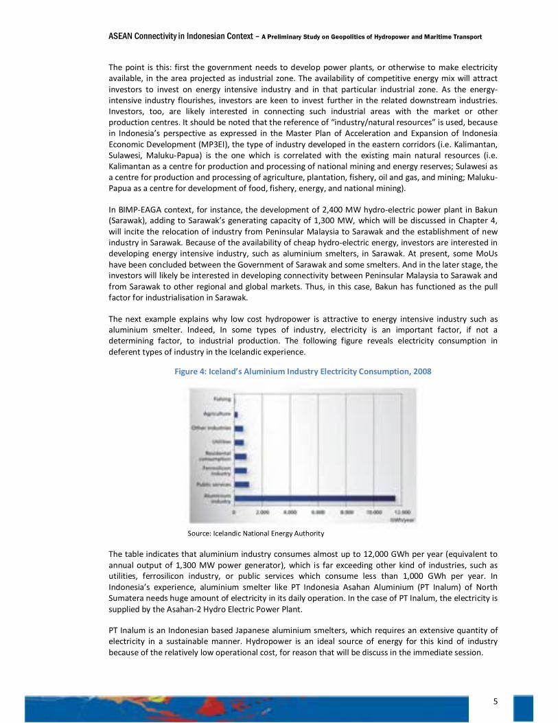
The next example explains why low cost hydropower is attractive to energy intensive industry such as aluminium smelter. Indeed, In some types of industry, electricity is an important factor, if not a determining factor, to industrial production. The following figure reveals electricity consumption in deferent types of industry in the Icelandic experience.
Figure 4: Iceland’s Aluminium Industry Electricity Consumption, 2008
Source: Icelandic National Energy Authority
The table indicates that aluminium industry consumes almost up to 12,000 GWh per year (equivalent to annual output of 1,300 MW power generator), which is far exceeding other kind of industries, such as utilities, ferrosilicon industry, or public services which consume less than 1,000 GWh per year. In Indonesia’s experience, aluminium smelter like PT Indonesia Asahan Aluminium (PT Inalum) of North Sumatera needs huge amount of electricity in its daily operation. In the case of PT Inalum, the electricity is supplied by the Asahan-2 Hydro Electric Power Plant.
PT Inalum is an Indonesian based Japanese aluminium smelters, which requires an extensive quantity of electricity in a sustainable manner. Hydropower is an ideal source of energy for this kind of industry because of the relatively low operational cost, for reason that will be discuss in the immediate session.
ASEAN Connectivity in Indonesian Context – A Preliminary Study on Geopolitics of Hydropower and Maritime Transport
6
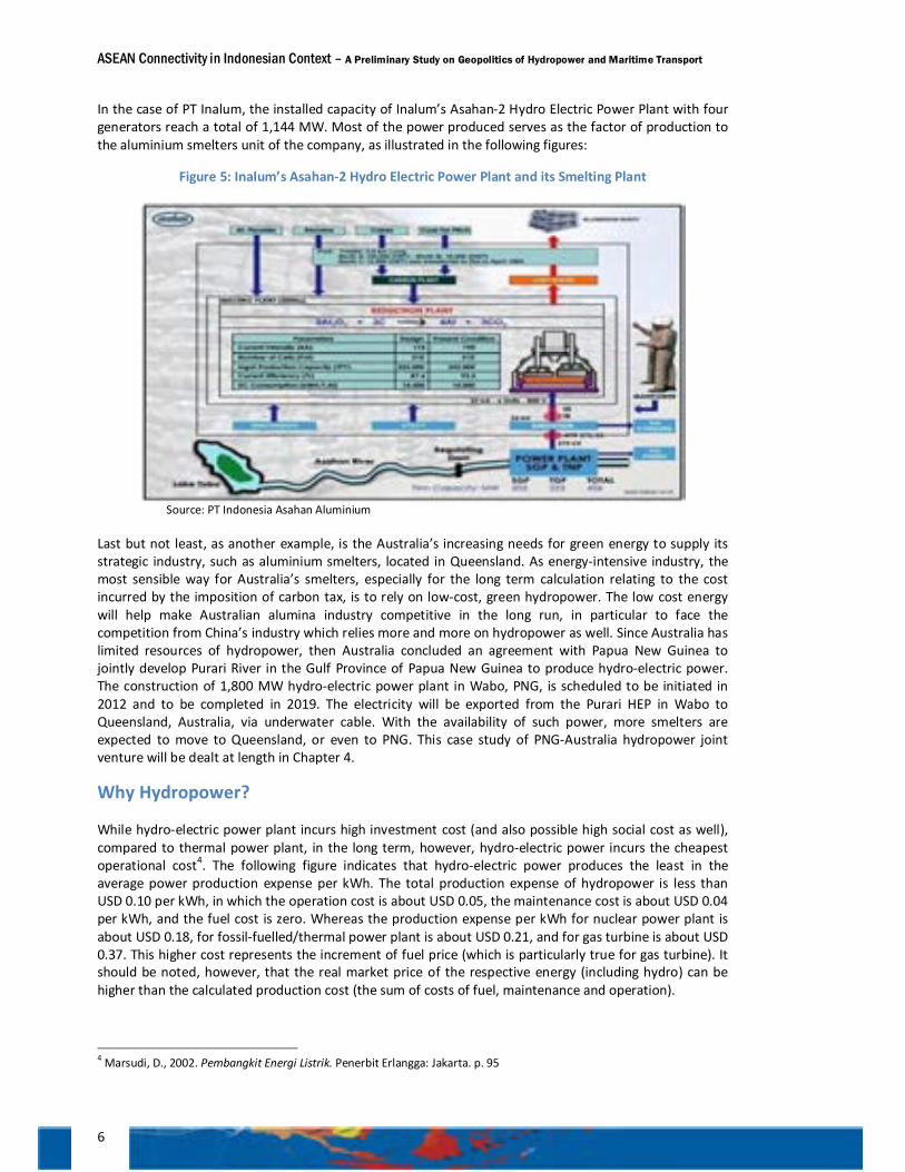
In the case of PT Inalum, the installed capacity of Inalum’s Asahan-2 Hydro Electric Power Plant with four generators reach a total of 1,144 MW. Most of the power produced serves as the factor of production to the aluminium smelters unit of the company, as illustrated in the following figures:
Figure 5: Inalum’s Asahan-2 Hydro Electric Power Plant and its Smelting Plant
Source: PT Indonesia Asahan Aluminium
Last but not least, as another example, is the Australia’s increasing needs for green energy to supply its strategic industry, such as aluminium smelters, located in Queensland. As energy-intensive industry, the most sensible way for Australia’s smelters, especially for the long term calculation relating to the cost incurred by the imposition of carbon tax, is to rely on low-cost, green hydropower. The low cost energy will help make Australian alumina industry competitive in the long run, in particular to face the competition from China’s industry which relies more and more on hydropower as well. Since Australia has limited resources of hydropower, then Australia concluded an agreement with Papua New Guinea to jointly develop Purari River in the Gulf Province of Papua New Guinea to produce hydro-electric power. The construction of 1,800 MW hydro-electric power plant in Wabo, PNG, is scheduled to be initiated in 2012 and to be completed in 2019. The electricity will be exported from the Purari HEP in Wabo to Queensland, Australia, via underwater cable. With the availability of such power, more smelters are expected to move to Queensland, or even to PNG. This case study of PNG-Australia hydropower joint venture will be dealt at length in Chapter 4.
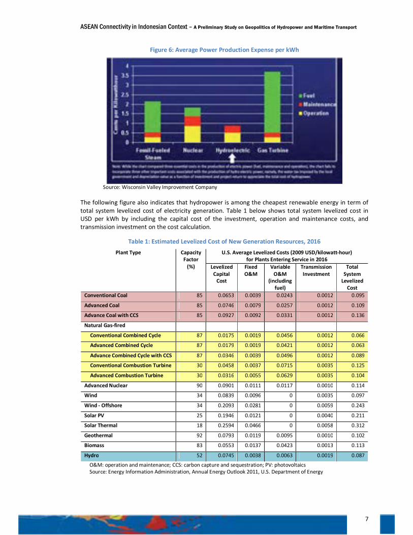
Why Hydropower?
While hydro-electric power plant incurs high investment cost (and also possible high social cost as well), compared to thermal power plant, in the long term, however, hydro-electric power incurs the cheapest operational cost4. The following figure indicates that hydro-electric power produces the least in the average power production expense per kWh. The total production expense of hydropower is less than USD 0.10 per kWh, in which the operation cost is about USD 0.05, the maintenance cost is about USD 0.04 per kWh, and the fuel cost is zero. Whereas the production expense per kWh for nuclear power plant is about USD 0.18, for fossil-fuelled/thermal power plant is about USD 0.21, and for gas turbine is about USD 0.37. This higher cost represents the increment of fuel price (which is particularly true for gas turbine). It should be noted, however, that the real market price of the respective energy (including hydro) can be higher than the calculated production cost (the sum of costs of fuel, maintenance and operation).
4 Marsudi, D., 2002. Pembangkit Energi Listrik. Penerbit Erlangga: Jakarta. p. 95
ASEAN Connectivity in Indonesian Context – A Preliminary Study on Geopolitics of Hydropower and Maritime Transport
7
Figure 6: Average Power Production Expense per kWh
Source: Wisconsin Valley Improvement Company
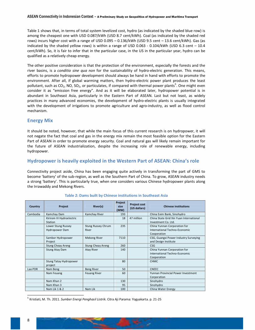
The following figure also indicates that hydropower is among the cheapest renewable energy in term of total system levelized cost of electricity generation. Table 1 below shows total system levelized cost in USD per kWh by including the capital cost of the investment, operation and maintenance costs, and transmission investment on the cost calculation.
Table 1: Estimated Levelized Cost of New Generation Resources, 2016
Plant Type Capacity Factor
(%)
U.S. Average Levelized Costs (2009 USD/kilowatt-hour) for Plants Entering Service in 2016
Levelized Capital
Cost
Fixed O&M
Variable O&M
(including fuel)
Transmission Investment
Total System
Levelized Cost
Conventional Coal 85 0.0653 0.0039 0.0243 0.0012 0.095
Advanced Coal 85 0.0746 0.0079 0.0257 0.0012 0.109
Advance Coal with CCS 85 0.0927 0.0092 0.0331 0.0012 0.136
Natural Gas-fired
Conventional Combined Cycle 87 0.0175 0.0019 0.0456 0.0012 0.066
Advanced Combined Cycle 87 0.0179 0.0019 0.0421 0.0012 0.063
Advance Combined Cycle with CCS 87 0.0346 0.0039 0.0496 0.0012 0.089
Conventional Combustion Turbine 30 0.0458 0.0037 0.0715 0.0035 0.125
Advanced Combustion Turbine 30 0.0316 0.0055 0.0629 0.0035 0.104
Advanced Nuclear 90 0.0901 0.0111 0.0117 0.0010 0.114
Wind 34 0.0839 0.0096 0 0.0035 0.097
Wind - Offshore 34 0.2093 0.0281 0 0.0059 0.243
Solar PV 25 0.1946 0.0121 0 0.0040 0.211
Solar Thermal 18 0.2594 0.0466 0 0.0058 0.312
Geothermal 92 0.0793 0.0119 0.0095 0.0010 0.102
Biomass 83 0.0553 0.0137 0.0423 0.0013 0.113
Hydro 52 0.0745 0.0038 0.0063 0.0019 0.087
O&M: operation and maintenance; CCS: carbon capture and sequestration; PV: photovoltaics Source: Energy Information Administration, Annual Energy Outlook 2011, U.S. Department of Energy
ASEAN Connectivity in Indonesian Context – A Preliminary Study on Geopolitics of Hydropower and Maritime Transport
8
Table 1 shows that, in terms of total system levelized cost, hydro (as indicated by the shaded blue row) is among the cheapest one with USD 0.087/kWh (USD 8.7 cent/kWh). Coal (as indicated by the shaded red rows) incurs higher cost with a range of USD 0.095 – 0.136/kWh (USD 9.5 cent – 13.6 cent/kWh). Gas (as indicated by the shaded yellow rows) is within a range of USD 0.063 - 0.104/kWh (USD 6.3 cent – 10.4 cent/kWh). So, it is fair to infer that in the particular case, in the US in the particular year, hydro can be qualified as a relatively cheap energy.
The other positive consideration is that the protection of the environment, especially the forests and the river basins, is a conditio sine qua non for the sustainability of hydro-electric generation. This means, efforts to promote hydropower development should always be hand in hand with efforts to promote the environment. After all, if global warming matters, then hydro-electric power plant produces the least pollutant, such as CO2, NO, SO2, or particulates, if compared with thermal power plants5. One might even consider it as “emission free energy”. And as it will be elaborated later, hydropower potential is in abundant in Southeast Asia, particularly in the Eastern Part of ASEAN. Last but not least, as widely practices in many advanced economies, the development of hydro-electric plants is usually integrated with the development of irrigations to promote agriculture and agro-industry, as well as flood control mechanism.
Energy Mix
It should be noted, however, that while the main focus of this current research is on hydropower, it will not negate the fact that coal and gas in the energy mix remain the most feasible option for the Eastern Part of ASEAN in order to promote energy security. Coal and natural gas will likely remain important for the future of ASEAN industrialization, despite the increasing role of renewable energy, including hydropower.
Hydropower is heavily exploited in the Western Part of ASEAN: China’s role
Connectivity project aside, China has been engaging quite actively in transforming the part of GMS to become ‘battery’ of the sub-region, as well as the Southern Part of China. To grow, ASEAN industry needs a strong ‘battery’. This is particularly true, when one considers various Chinese hydropower plants along the Irrawaddy and Mekong Rivers.
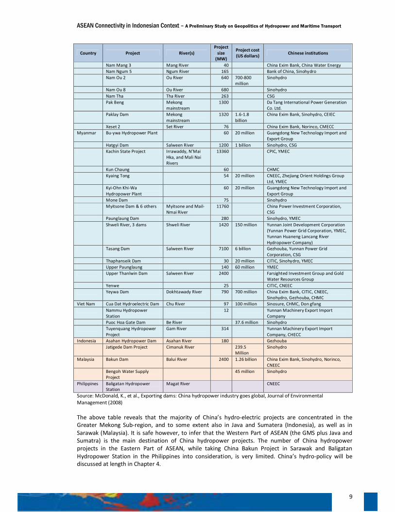
Table 2: Dams built by Chinese institutions in Southeast Asia
Country Project River(s) Project
size (MW)
Project cost (US dollars) Chinese institutions
Cambodia Kamchay Dam Kamchay River 193 China Exim Bank, Sinohydro Kirirom III Hydroelectric
Station 18 47 million China State Grid Xin Yuan International
Investment Co. Ltd. Lower Stung Russey
Hydropower Dam Stung Russey Chrum River
235 China Yunnan Corporation for International Techno-Economic Cooperation
Sambor Hydropower Project
Mekong River 7110 CSG, Guangxi Power Industry Surveying and Design Institute
Stung Cheay Areng Stung Cheay Areng 260 CSG Stung Atay Dam Atay River 140 China Yunnan Corporation for
International Techno-Economic Cooperation
Stung Tatay Hydropower project
80 CHMC
Lao PDR Nam Beng Beng River 50 CNEEC Nam Feuang Feuang River 60 Yunnan Provincial Power Investment
Corporation Nam Khan 2 130 Sinohydro Nam Khan 3 95 Sinohydro Nam Lik 1 & 2 Nam Lik 100 China Water Energy
5 Kristiati, M. Th. 2011. Sumber Energi Penghasil Listrik. Citra Aji Parama: Yogyakarta. p. 21-25
ASEAN Connectivity in Indonesian Context – A Preliminary Study on Geopolitics of Hydropower and Maritime Transport
9
Country Project River(s) Project
size (MW)
Project cost (US dollars) Chinese institutions
Nam Mang 3 Mang River 40 China Exim Bank, China Water Energy Nam Ngum 5 Ngum River 165 Bank of China, Sinohydro Nam Ou 2 Ou River 640 700-800
million Sinohydro
Nam Ou 8 Ou River 680 Sinohydro Nam Tha Tha River 263 CSG Pak Beng Mekong
mainstream 1300 Da Tang International Power Generation
Co. Ltd. Paklay Dam Mekong
mainstream 1320 1.6-1.8
billion China Exim Bank, Sinohydro, CEIEC
Xeset 2 Set River 76 China Exim Bank, Norinco, CMECC Myanmar Bu-ywa Hydropower Plant 60 20 million Guangdong New Technology Import and
Export Group Hatgyi Dam Salween River 1200 1 billion Sinohydro, CSG Kachin State Project Irrawaddy, N’Mai
Hka, and Mali Nai Rivers
13360 CPIC, YMEC
Kun Chaung 60 CHMC Kyaing Tong 54 20 million CNEEC, Zhejiang Orient Holdings Group
Ltd, YMEC Kyi-Ohn Khi-Wa
Hydropower Plant 60 20 million Guangdong New Technology Import and
Export Group Mone Dam 75 Sinohydro Myitsone Dam & 6 others Myitsone and Mail-
Nmai River 11760 China Power Investment Corporation,
CSG Paunglaung Dam 280 Sinohydro, YMEC Shweli River, 3 dams Shweli River 1420 150 million Yunnan Joint Development Corporation
(Yunnan Power Grid Corporation, YMEC, Yunnan Huaneng Lancang River Hydropower Company)
Tasang Dam Salween River 7100 6 billion Gezhouba, Yunnan Power Grid Corporation, CSG
Thaphanseik Dam 30 20 million CITIC, Sinohydro, YMEC Upper Paunglaung 140 60 million YMEC Upper Thanlwin Dam Salween River 2400 Farsighted Investment Group and Gold
Water Resources Group Yenwe 25 CITIC, CNEEC Yeywa Dam Dokhtawady River 790 700 million China Exim Bank, CITIC, CNEEC,
Sinohydro, Gezhouba, CHMC Viet Nam Cua Dat Hydroelectric Dam Chu River 97 100 million Sinosure, CHMC, Don gfang Nammu Hydropower
Station 12 Yunnan Machinery Export Import
Company Puoc Hoa Gate Dam Be River 37.6 million Sinohydro Tuyenquang Hydropower
Project Gam River 314 Yunnan Machinery Export Import
Company, CHECC Indonesia Asahan Hydropower Dam Asahan River 180 Gezhouba Jatigede Dam Project Cimanuk River 239.5
Million Sinohydro
Malaysia Bakun Dam Balui River 2400 1.26 billion China Exim Bank, Sinohydro, Norinco, CNEEC
Bengoh Water Supply Project
45 million Sinohydro
Philippines Baligatan Hydropower Station
Magat River CNEEC
Source: McDonald, K., et al., Exporting dams: China hydropower industry goes global, Journal of Environmental Management (2008)
The above table reveals that the majority of China’s hydro-electric projects are concentrated in the Greater Mekong Sub-region, and to some extent also in Java and Sumatera (Indonesia), as well as in Sarawak (Malaysia). It is safe however, to infer that the Western Part of ASEAN (the GMS plus Java and Sumatra) is the main destination of China hydropower projects. The number of China hydropower projects in the Eastern Part of ASEAN, while taking China Bakun Project in Sarawak and Baligatan Hydropower Station in the Philippines into consideration, is very limited. China’s hydro-policy will be discussed at length in Chapter 4.
ASEAN Connectivity in Indonesian Context – A Preliminary Study on Geopolitics of Hydropower and Maritime Transport
10
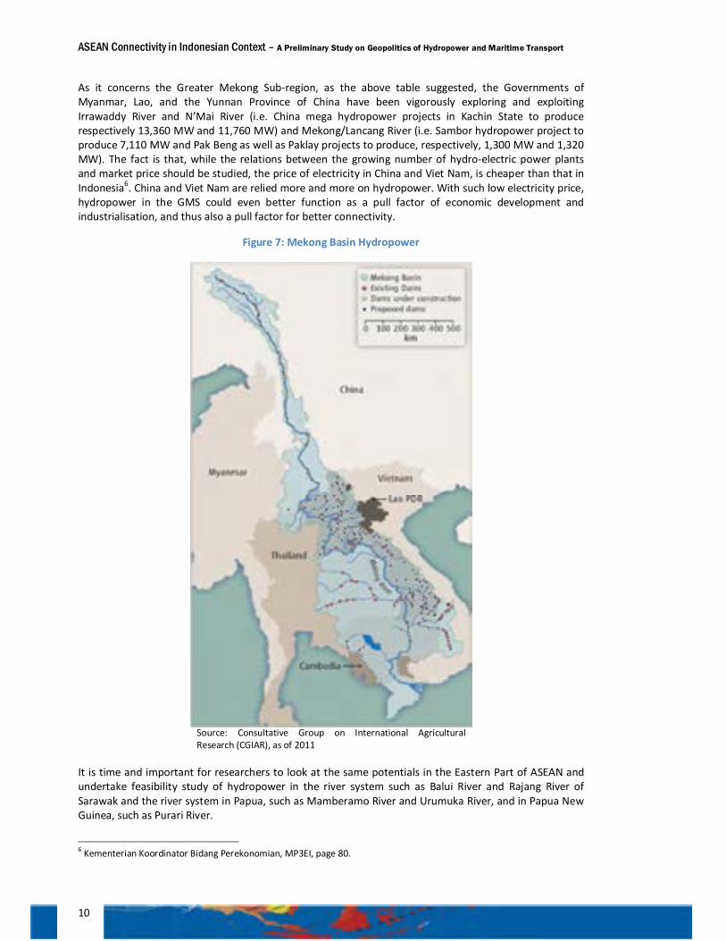
As it concerns the Greater Mekong Sub-region, as the above table suggested, the Governments of Myanmar, Lao, and the Yunnan Province of China have been vigorously exploring and exploiting Irrawaddy River and N’Mai River (i.e. China mega hydropower projects in Kachin State to produce respectively 13,360 MW and 11,760 MW) and Mekong/Lancang River (i.e. Sambor hydropower project to produce 7,110 MW and Pak Beng as well as Paklay projects to produce, respectively, 1,300 MW and 1,320 MW). The fact is that, while the relations between the growing number of hydro-electric power plants and market price should be studied, the price of electricity in China and Viet Nam, is cheaper than that in Indonesia6. China and Viet Nam are relied more and more on hydropower. With such low electricity price, hydropower in the GMS could even better function as a pull factor of economic development and industrialisation, and thus also a pull factor for better connectivity.
Figure 7: Mekong Basin Hydropower
Source: Consultative Group on International Agricultural Research (CGIAR), as of 2011
It is time and important for researchers to look at the same potentials in the Eastern Part of ASEAN and undertake feasibility study of hydropower in the river system such as Balui River and Rajang River of Sarawak and the river system in Papua, such as Mamberamo River and Urumuka River, and in Papua New Guinea, such as Purari River.
6 Kementerian Koordinator Bidang Perekonomian, MP3EI, page 80.
ASEAN Connectivity in Indonesian Context – A Preliminary Study on Geopolitics of Hydropower and Maritime Transport
11
Hydropower as a Pull Factor: Ecological approach needed
Learning from the experience of China and the GMS countries, the nagging issue is how the development of hydropower will not be prejudicial to the environment, and hence, the interest of sustainable development. As is noted, hydropower development along the Lancang/Mekong River has created disputes between countries in the upper stream and countries in the lower stream. The development of Lao’s hydropower project in Xayaboury Province, in the lower Mekong River which has been disputed between Lao in the one side, and Viet Nam, Cambodia, and Thailand in the other side, is the case in point7. Such dispute is less likely to happen in Myanmar, since most of the main river system is within the territory of Myanmar. Yet, disputes might not be avoidable within Myanmar, and particular between government and the environmentalist NGOs, against the backdrop of Myanmar new political environment.
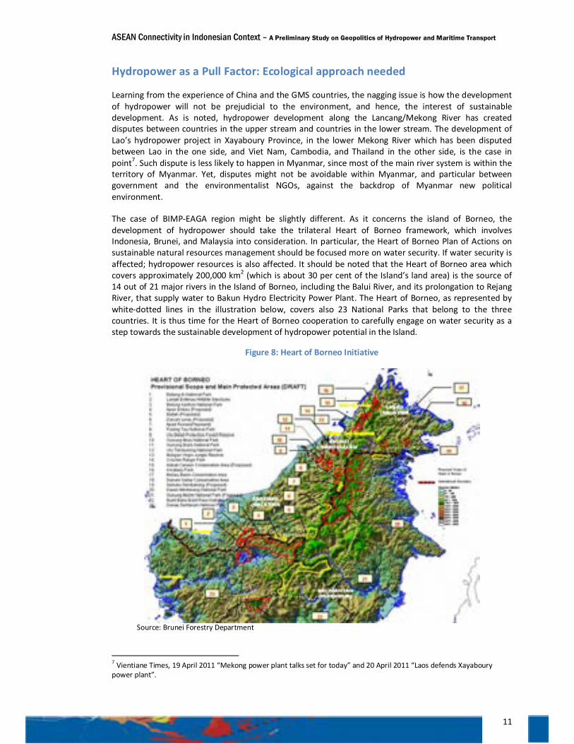
The case of BIMP-EAGA region might be slightly different. As it concerns the island of Borneo, the development of hydropower should take the trilateral Heart of Borneo framework, which involves Indonesia, Brunei, and Malaysia into consideration. In particular, the Heart of Borneo Plan of Actions on sustainable natural resources management should be focused more on water security. If water security is affected; hydropower resources is also affected. It should be noted that the Heart of Borneo area which covers approximately 200,000 km2 (which is about 30 per cent of the Island’s land area) is the source of 14 out of 21 major rivers in the Island of Borneo, including the Balui River, and its prolongation to Rejang River, that supply water to Bakun Hydro Electricity Power Plant. The Heart of Borneo, as represented by white-dotted lines in the illustration below, covers also 23 National Parks that belong to the three countries. It is thus time for the Heart of Borneo cooperation to carefully engage on water security as a step towards the sustainable development of hydropower potential in the Island.
Figure 8: Heart of Borneo Initiative
Source: Brunei Forestry Department
7 Vientiane Times, 19 April 2011 “Mekong power plant talks set for today” and 20 April 2011 “Laos defends Xayaboury power plant”.
ASEAN Connectivity in Indonesian Context – A Preliminary Study on Geopolitics of Hydropower and Maritime Transport
12
The case of Bakun is a testimony of how hydropower has been used as a pull factor of industrialisation. With the operation of Bakun by the end of 2011, Sarawak managed to conclude agreements or MoUs with international energy intensive industries. The example includes the plan of the Australian’s Rio Tinto to conclude a joint venture with Cahya Mata Sarawak in building a USD 2 billion aluminium smelter in Sarawak; a Chinese main power grid operator is planning to invest USD 8 billion in an aluminium smelter. Many companies such as Australian’s manganese produces OMH Holdings, chemical maker Tokuyama Corporation and China’s aluminium group Chinalco will follow suit8. It is estimated that the industrialisation of Sarawak will open a new opportunity for 1.6 million new jobs in Sarawak9.
Likewise, Papua, which has prepared a plan to develop hydropower in Mamberamo River and Bongrang Industrial Estate, should, through the national investment board (BKPM), be able to strike a preliminary deal with partner countries to relocate some of their energy intensive industry to Papua. With such a deal, the market for the Mamberamo Hydro Electric Power would be secured.
The development of hydropower potential in the island of New Guinea, which consists of the Indonesian Provinces of Western Papua and Papua, and the State of Papua New Guinea, should take the principle of single island ecosystem approach into consideration.
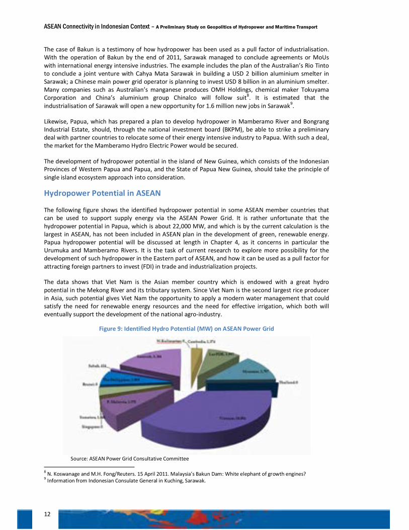
Hydropower Potential in ASEAN
The following figure shows the identified hydropower potential in some ASEAN member countries that can be used to support supply energy via the ASEAN Power Grid. It is rather unfortunate that the hydropower potential in Papua, which is about 22,000 MW, and which is by the current calculation is the largest in ASEAN, has not been included in ASEAN plan in the development of green, renewable energy. Papua hydropower potential will be discussed at length in Chapter 4, as it concerns in particular the Urumuka and Mamberamo Rivers. It is the task of current research to explore more possibility for the development of such hydropower in the Eastern part of ASEAN, and how it can be used as a pull factor for attracting foreign partners to invest (FDI) in trade and industrialization projects.
The data shows that Viet Nam is the Asian member country which is endowed with a great hydro potential in the Mekong River and its tributary system. Since Viet Nam is the second largest rice producer in Asia, such potential gives Viet Nam the opportunity to apply a modern water management that could satisfy the need for renewable energy resources and the need for effective irrigation, which both will eventually support the development of the national agro-industry.
Figure 9: Identified Hydro Potential (MW) on ASEAN Power Grid
Source: ASEAN Power Grid Consultative Committee
8 N. Koswanage and M.H. Fong/Reuters. 15 April 2011. Malaysia’s Bakun Dam: White elephant of growth engines? 9 Information from Indonesian Consulate General in Kuching, Sarawak.
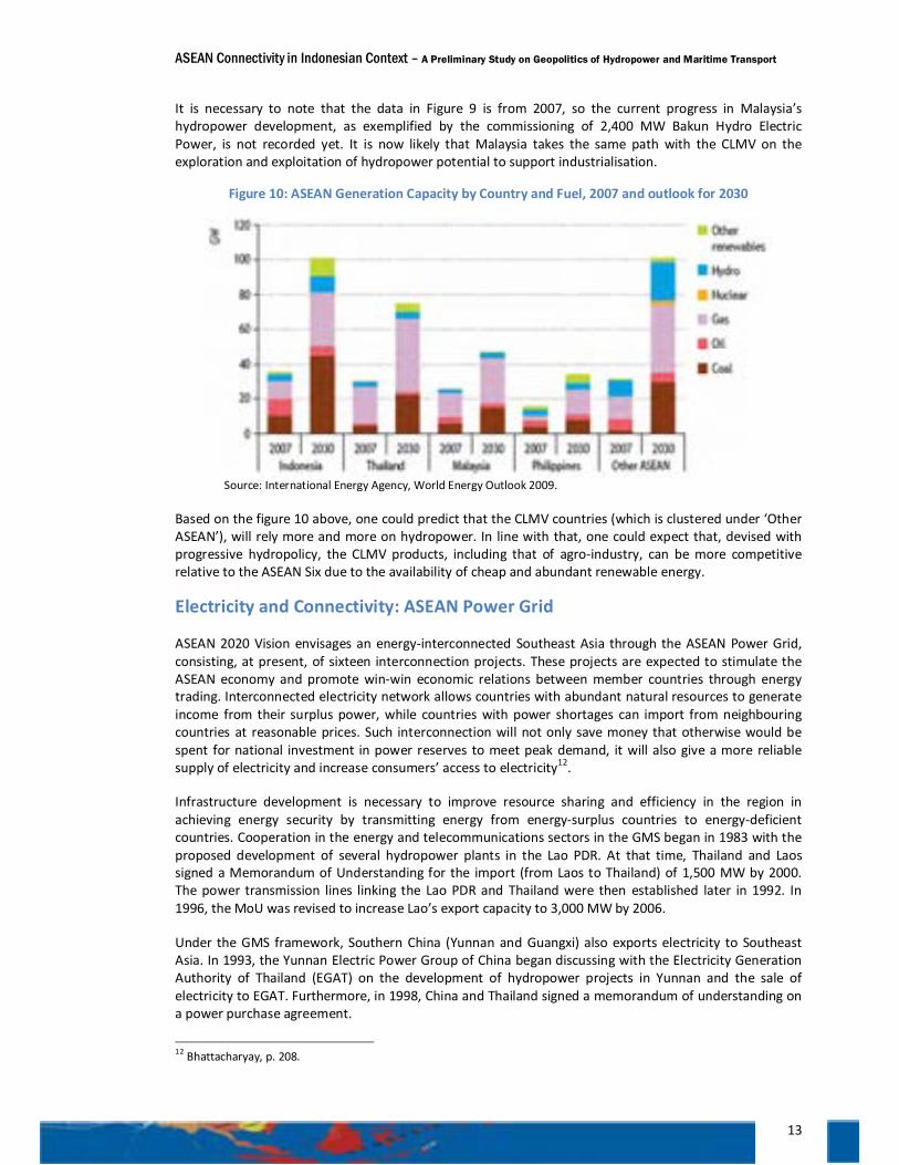
ASEAN Connectivity in Indonesian Context – A Preliminary Study on Geopolitics of Hydropower and Maritime Transport
13
It is necessary to note that the data in Figure 9 is from 2007, so the current progress in Malaysia’s hydropower development, as exemplified by the commissioning of 2,400 MW Bakun Hydro Electric Power, is not recorded yet. It is now likely that Malaysia takes the same path with the CLMV on the exploration and exploitation of hydropower potential to support industrialisation.
Figure 10: ASEAN Generation Capacity by Country and Fuel, 2007 and outlook for 2030
Source: International Energy Agency, World Energy Outlook 2009.
Based on the figure 10 above, one could predict that the CLMV countries (which is clustered under ‘Other ASEAN’), will rely more and more on hydropower. In line with that, one could expect that, devised with progressive hydropolicy, the CLMV products, including that of agro-industry, can be more competitive relative to the ASEAN Six due to the availability of cheap and abundant renewable energy.
Electricity and Connectivity: ASEAN Power Grid
ASEAN 2020 Vision envisages an energy-interconnected Southeast Asia through the ASEAN Power Grid, consisting, at present, of sixteen interconnection projects. These projects are expected to stimulate the ASEAN economy and promote win-win economic relations between member countries through energy trading. Interconnected electricity network allows countries with abundant natural resources to generate income from their surplus power, while countries with power shortages can import from neighbouring countries at reasonable prices. Such interconnection will not only save money that otherwise would be spent for national investment in power reserves to meet peak demand, it will also give a more reliable supply of electricity and increase consumers’ access to electricity12.
Infrastructure development is necessary to improve resource sharing and efficiency in the region in achieving energy security by transmitting energy from energy-surplus countries to energy-deficient countries. Cooperation in the energy and telecommunications sectors in the GMS began in 1983 with the proposed development of several hydropower plants in the Lao PDR. At that time, Thailand and Laos signed a Memorandum of Understanding for the import (from Laos to Thailand) of 1,500 MW by 2000. The power transmission lines linking the Lao PDR and Thailand were then established later in 1992. In 1996, the MoU was revised to increase Lao’s export capacity to 3,000 MW by 2006.
Under the GMS framework, Southern China (Yunnan and Guangxi) also exports electricity to Southeast Asia. In 1993, the Yunnan Electric Power Group of China began discussing with the Electricity Generation Authority of Thailand (EGAT) on the development of hydropower projects in Yunnan and the sale of electricity to EGAT. Furthermore, in 1998, China and Thailand signed a memorandum of understanding on a power purchase agreement.
12 Bhattacharyay, p. 208.
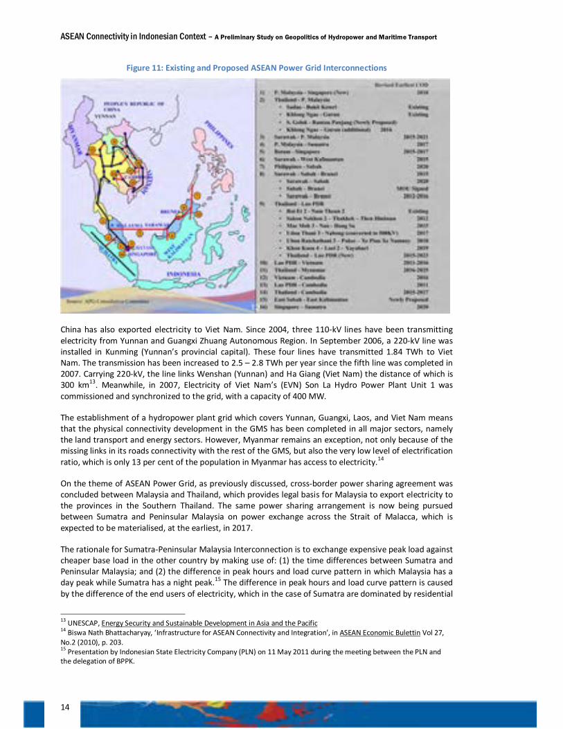
ASEAN Connectivity in Indonesian Context – A Preliminary Study on Geopolitics of Hydropower and Maritime Transport
14
Figure 11: Existing and Proposed ASEAN Power Grid Interconnections
China has also exported electricity to Viet Nam. Since 2004, three 110-kV lines have been transmitting electricity from Yunnan and Guangxi Zhuang Autonomous Region. In September 2006, a 220-kV line was installed in Kunming (Yunnan’s provincial capital). These four lines have transmitted 1.84 TWh to Viet Nam. The transmission has been increased to 2.5 – 2.8 TWh per year since the fifth line was completed in 2007. Carrying 220-kV, the line links Wenshan (Yunnan) and Ha Giang (Viet Nam) the distance of which is 300 km13. Meanwhile, in 2007, Electricity of Viet Nam’s (EVN) Son La Hydro Power Plant Unit 1 was commissioned and synchronized to the grid, with a capacity of 400 MW.
The establishment of a hydropower plant grid which covers Yunnan, Guangxi, Laos, and Viet Nam means that the physical connectivity development in the GMS has been completed in all major sectors, namely the land transport and energy sectors. However, Myanmar remains an exception, not only because of the missing links in its roads connectivity with the rest of the GMS, but also the very low level of electrification ratio, which is only 13 per cent of the population in Myanmar has access to electricity.14
On the theme of ASEAN Power Grid, as previously discussed, cross-border power sharing agreement was concluded between Malaysia and Thailand, which provides legal basis for Malaysia to export electricity to the provinces in the Southern Thailand. The same power sharing arrangement is now being pursued between Sumatra and Peninsular Malaysia on power exchange across the Strait of Malacca, which is expected to be materialised, at the earliest, in 2017.
The rationale for Sumatra-Peninsular Malaysia Interconnection is to exchange expensive peak load against cheaper base load in the other country by making use of: (1) the time differences between Sumatra and Peninsular Malaysia; and (2) the difference in peak hours and load curve pattern in which Malaysia has a day peak while Sumatra has a night peak.15 The difference in peak hours and load curve pattern is caused by the difference of the end users of electricity, which in the case of Sumatra are dominated by residential
13 UNESCAP, Energy Security and Sustainable Development in Asia and the Pacific 14 Biswa Nath Bhattacharyay, ‘Infrastructure for ASEAN Connectivity and Integration’, in ASEAN Economic Bulettin Vol 27, No.2 (2010), p. 203. 15 Presentation by Indonesian State Electricity Company (PLN) on 11 May 2011 during the meeting between the PLN and the delegation of BPPK.
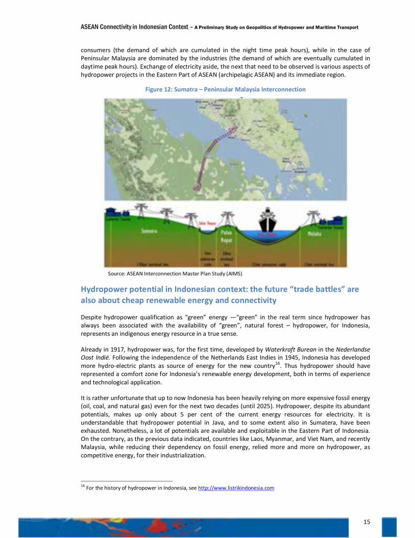
ASEAN Connectivity in Indonesian Context – A Preliminary Study on Geopolitics of Hydropower and Maritime Transport
15
consumers (the demand of which are cumulated in the night time peak hours), while in the case of Peninsular Malaysia are dominated by the industries (the demand of which are eventually cumulated in daytime peak hours). Exchange of electricity aside, the next that need to be observed is various aspects of hydropower projects in the Eastern Part of ASEAN (archipelagic ASEAN) and its immediate region.
Figure 12: Sumatra – Peninsular Malaysia Interconnection
Source: ASEAN Interconnection Master Plan Study (AIMS)
Hydropower potential in Indonesian context: the future “trade battles” are also about cheap renewable energy and connectivity
Despite hydropower qualification as “green” energy —“green” in the real term since hydropower has always been associated with the availability of “green”, natural forest – hydropower, for Indonesia, represents an indigenous energy resource in a true sense.
Already in 1917, hydropower was, for the first time, developed by Waterkraft Burean in the Nederlandse Oost Indië. Following the independence of the Netherlands East Indies in 1945, Indonesia has developed more hydro-electric plants as source of energy for the new country16. Thus hydropower should have represented a comfort zone for Indonesia’s renewable energy development, both in terms of experience and technological application.
It is rather unfortunate that up to now Indonesia has been heavily relying on more expensive fossil energy (oil, coal, and natural gas) even for the next two decades (until 2025). Hydropower, despite its abundant potentials, makes up only about 5 per cent of the current energy resources for electricity. It is understandable that hydropower potential in Java, and to some extent also in Sumatera, have been exhausted. Nonetheless, a lot of potentials are available and exploitable in the Eastern Part of Indonesia. On the contrary, as the previous data indicated, countries like Laos, Myanmar, and Viet Nam, and recently Malaysia, while reducing their dependency on fossil energy, relied more and more on hydropower, as competitive energy, for their industrialization.
16 For the history of hydropower in Indonesia, see http://www.listrikindonesia.com
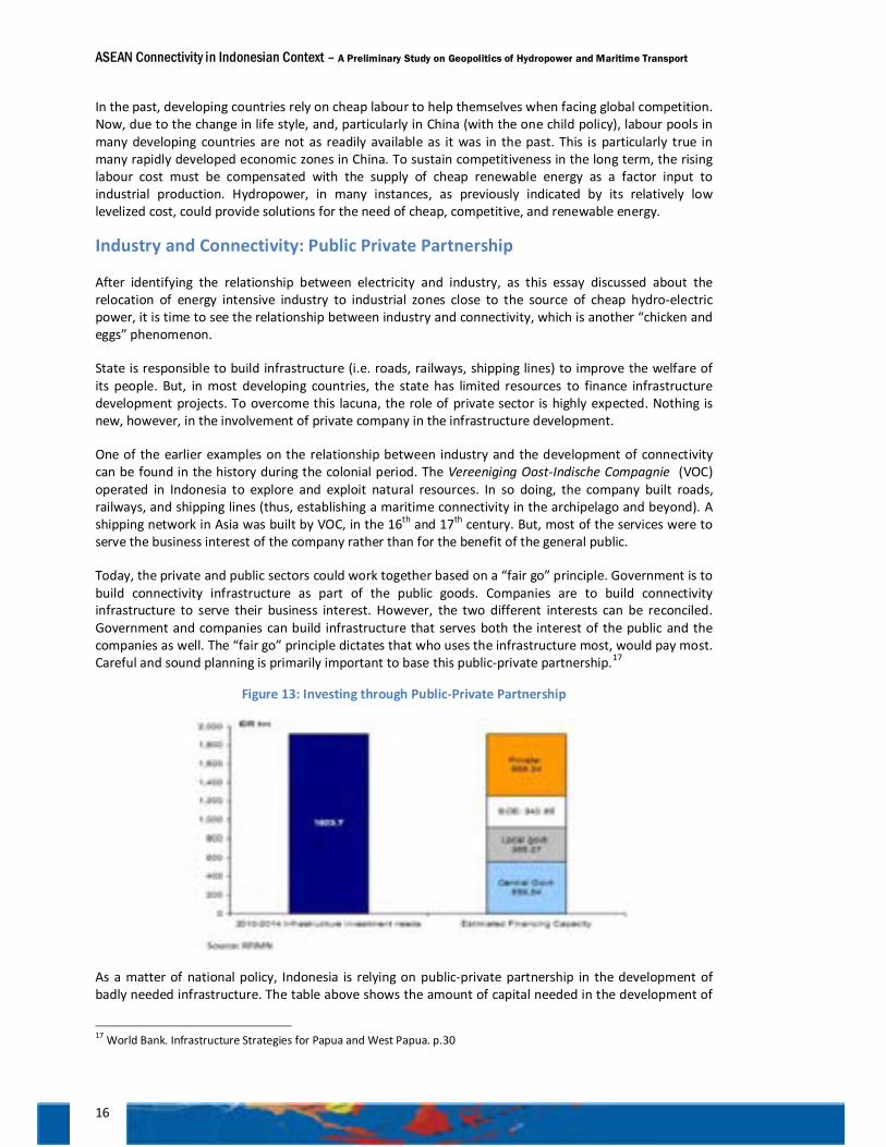
ASEAN Connectivity in Indonesian Context – A Preliminary Study on Geopolitics of Hydropower and Maritime Transport
16
In the past, developing countries rely on cheap labour to help themselves when facing global competition. Now, due to the change in life style, and, particularly in China (with the one child policy), labour pools in many developing countries are not as readily available as it was in the past. This is particularly true in many rapidly developed economic zones in China. To sustain competitiveness in the long term, the rising labour cost must be compensated with the supply of cheap renewable energy as a factor input to industrial production. Hydropower, in many instances, as previously indicated by its relatively low levelized cost, could provide solutions for the need of cheap, competitive, and renewable energy.
Industry and Connectivity: Public Private Partnership
After identifying the relationship between electricity and industry, as this essay discussed about the relocation of energy intensive industry to industrial zones close to the source of cheap hydro-electric power, it is time to see the relationship between industry and connectivity, which is another “chicken and eggs” phenomenon.
State is responsible to build infrastructure (i.e. roads, railways, shipping lines) to improve the welfare of its people. But, in most developing countries, the state has limited resources to finance infrastructure development projects. To overcome this lacuna, the role of private sector is highly expected. Nothing is new, however, in the involvement of private company in the infrastructure development.
One of the earlier examples on the relationship between industry and the development of connectivity can be found in the history during the colonial period. The Vereeniging Oost-Indische Compagnie (VOC) operated in Indonesia to explore and exploit natural resources. In so doing, the company built roads, railways, and shipping lines (thus, establishing a maritime connectivity in the archipelago and beyond). A shipping network in Asia was built by VOC, in the 16th and 17th century. But, most of the services were to serve the business interest of the company rather than for the benefit of the general public.
Today, the private and public sectors could work together based on a “fair go” principle. Government is to build connectivity infrastructure as part of the public goods. Companies are to build connectivity infrastructure to serve their business interest. However, the two different interests can be reconciled. Government and companies can build infrastructure that serves both the interest of the public and the companies as well. The “fair go” principle dictates that who uses the infrastructure most, would pay most. Careful and sound planning is primarily important to base this public-private partnership.17
Figure 13: Investing through Public-Private Partnership
As a matter of national policy, Indonesia is relying on public-private partnership in the development of badly needed infrastructure. The table above shows the amount of capital needed in the development of
17 World Bank. Infrastructure Strategies for Papua and West Papua. p.30
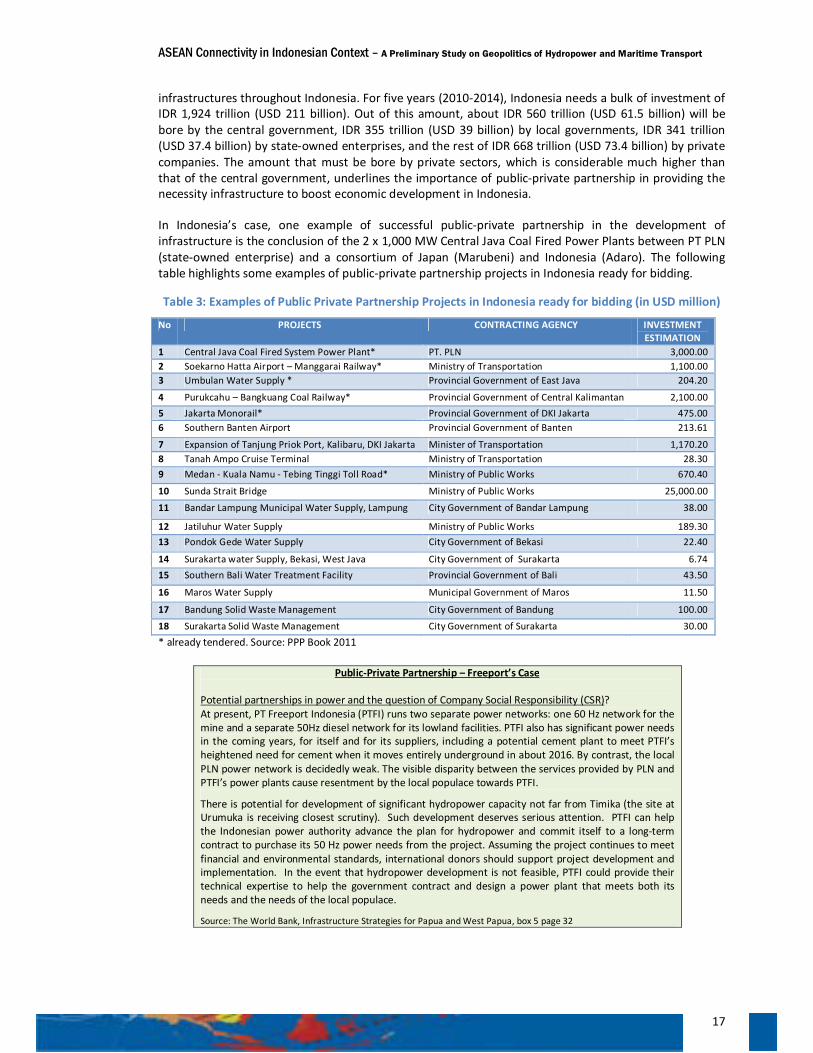
ASEAN Connectivity in Indonesian Context – A Preliminary Study on Geopolitics of Hydropower and Maritime Transport
17
infrastructures throughout Indonesia. For five years (2010-2014), Indonesia needs a bulk of investment of IDR 1,924 trillion (USD 211 billion). Out of this amount, about IDR 560 trillion (USD 61.5 billion) will be bore by the central government, IDR 355 trillion (USD 39 billion) by local governments, IDR 341 trillion (USD 37.4 billion) by state-owned enterprises, and the rest of IDR 668 trillion (USD 73.4 billion) by private companies. The amount that must be bore by private sectors, which is considerable much higher than that of the central government, underlines the importance of public-private partnership in providing the necessity infrastructure to boost economic development in Indonesia.
In Indonesia’s case, one example of successful public-private partnership in the development of infrastructure is the conclusion of the 2 x 1,000 MW Central Java Coal Fired Power Plants between PT PLN (state-owned enterprise) and a consortium of Japan (Marubeni) and Indonesia (Adaro). The following table highlights some examples of public-private partnership projects in Indonesia ready for bidding.
Table 3: Examples of Public Private Partnership Projects in Indonesia ready for bidding (in USD million)
No PROJECTS CONTRACTING AGENCY INVESTMENT ESTIMATION
1 Central Java Coal Fired System Power Plant* PT. PLN 3,000.00 2 Soekarno Hatta Airport – Manggarai Railway* Ministry of Transportation 1,100.00 3 Umbulan Water Supply * Provincial Government of East Java 204.20
4 Purukcahu – Bangkuang Coal Railway* Provincial Government of Central Kalimantan 2,100.00 5 Jakarta Monorail* Provincial Government of DKI Jakarta 475.00 6 Southern Banten Airport Provincial Government of Banten 213.61
7 Expansion of Tanjung Priok Port, Kalibaru, DKI Jakarta Minister of Transportation 1,170.20 8 Tanah Ampo Cruise Terminal Ministry of Transportation 28.30 9 Medan - Kuala Namu - Tebing Tinggi Toll Road* Ministry of Public Works 670.40
10 Sunda Strait Bridge Ministry of Public Works 25,000.00
11 Bandar Lampung Municipal Water Supply, Lampung City Government of Bandar Lampung 38.00
12 Jatiluhur Water Supply Ministry of Public Works 189.30 13 Pondok Gede Water Supply City Government of Bekasi 22.40
14 Surakarta water Supply, Bekasi, West Java City Government of Surakarta 6.74 15 Southern Bali Water Treatment Facility Provincial Government of Bali 43.50
16 Maros Water Supply Municipal Government of Maros 11.50
17 Bandung Solid Waste Management City Government of Bandung 100.00
18 Surakarta Solid Waste Management City Government of Surakarta 30.00 * already tendered. Source: PPP Book 2011
Public-Private Partnership – Freeport’s Case Potential partnerships in power and the question of Company Social Responsibility (CSR)? At present, PT Freeport Indonesia (PTFI) runs two separate power networks: one 60 Hz network for the mine and a separate 50Hz diesel network for its lowland facilities. PTFI also has significant power needs in the coming years, for itself and for its suppliers, including a potential cement plant to meet PTFI’s heightened need for cement when it moves entirely underground in about 2016. By contrast, the local PLN power network is decidedly weak. The visible disparity between the services provided by PLN and PTFI’s power plants cause resentment by the local populace towards PTFI.
There is potential for development of significant hydropower capacity not far from Timika (the site at Urumuka is receiving closest scrutiny). Such development deserves serious attention. PTFI can help the Indonesian power authority advance the plan for hydropower and commit itself to a long-term contract to purchase its 50 Hz power needs from the project. Assuming the project continues to meet financial and environmental standards, international donors should support project development and implementation. In the event that hydropower development is not feasible, PTFI could provide their technical expertise to help the government contract and design a power plant that meets both its needs and the needs of the local populace.
Source: The World Bank, Infrastructure Strategies for Papua and West Papua, box 5 page 32

ASEAN Connectivity in Indonesian Context – A Preliminary Study on Geopolitics of Hydropower and Maritime Transport
18
Public-partner partnership notwithstanding, the government is the one which is responsible to provide public needs and interest. The government should be able to develop a synergy between the development of energy, connectivity, and industry/management of natural resources. At the regional level, a sound planning and implementation of connectivity will bring progress towards economic integration.
Progress of ASEAN Integration with Regional and Global Economies
The Master Plan on ASEAN Connectivity is purportedly to boost the attainment of ASEAN Economic Community. The ultimate aim of ASEAN Economic Community is to create ASEAN as a highly competitive single market and production base, which at the end will promote equitable economic development for the ten ASEAN countries. ASEAN Economic Community is also an ASEAN’s strategic step to integrate with global economy.
ASEAN has concluded Free Trade Agreements (FTA) with China, India, Japan, the Republic of Korea, Australia, and New Zealand. Hence, ASEAN is paving the way (i.e. conducting studies) towards the attainment of East Asia Free Trade Area (EAFTA), comprising ASEAN + China, the Republic of Korea, and Japan (ASEAN +3); and comprehensive economic partnership on East Asia (CEPEA) comprising ASEAN + Australia, India, and New Zealand (another ASEAN +3). EAFTA and CEPEA are part of the ASEAN attempts to engage major economies in the regions in attaining common stability, security, and prosperity through the dynamic equilibrium approach. The progress of the economic integration is monitored by a score card system.
The Score Card: Weak competitiveness
In order to monitor the progress of the attainment of ASEAN Economic Community and integration with global economy, the ASEAN Secretariat provides a score card, which is subsequently updated in four phases (2008-09; 2010-11; 2012-13; 2014-15). This score card, however, functions more as an indicative compliant tool (some kind of check list) rather than an impact assessment.18 Economic Research Institute for ASEAN and East Asia (ERIA) is now undertaking a study to improve the ASEAN Economic Community score card system. Among others, ERIA is developing a rigorous methodology and a set of indicators to assess the status and progress of ASEAN Economic Community.19
ASEAN, according to the ASEAN Secretariat, was initially concerned whether it can comply with the ASEAN Economic Community Blue Print. However, in 2009, the Blue Print has been well executed to achieve equitable economic development and integration with the global economy (respectively 100 per cent of targets achieved). Nonetheless ASEAN has been lacking on the compliance for the attainment of competitive economic region (50 per cent of target achieved). Transport and energy, and their related infrastructure are key factors to foster the competitiveness of regional economy;20 and, in the case of ASEAN, failure to develop reliable transport and reliable supply of energy represents the serious impediments to the advancement of ASEAN Economic Community. This assertion is well taken by the current research and thus provides a basis, as it concerns the archipelagic region of ASEAN, for focusing on maritime transport and renewable energy particularly hydropower.
The current score card, as provided by the ASEAN Secretariat, notwithstanding, can serve as indication about the progress of ASEAN economic integration, as shown in the following figure:
18 Bambang Irawan. 2011. AEC Scorecard: The Road to ASEAN Single Market. Slide presentation at Joint Workshop ADBI-ERIA “Realizing the ASEAN Economic Community: Aspirations and Challenges”, Jakarta, 4 April 2011. 19 PoncianoIntal, Jr and Dionisius Narjoko. Improving the AEC Scorecard System: ERIA Study. Slide presentation at Joint Workshop ADBI-ERIA “Realizing the ASEAN Economic Community: Aspirations and Challenges”, Jakarta, 4 April 2011. 20 Aladdin D. Rillo. 2011. AEC Scorecard: The Road to ASEAN Single Market. Slide presentation at Conference on Network of Reformers, Mombasa, 4 February 2011.
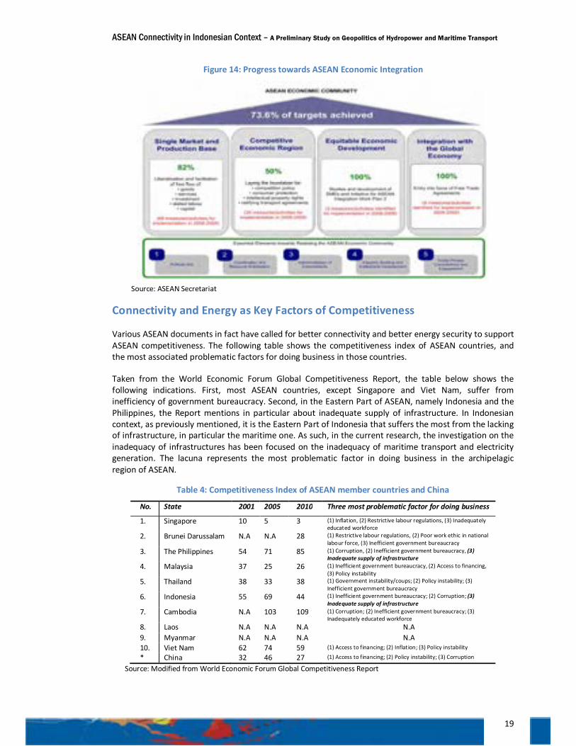
ASEAN Connectivity in Indonesian Context – A Preliminary Study on Geopolitics of Hydropower and Maritime Transport
19
Figure 14: Progress towards ASEAN Economic Integration
Source: ASEAN Secretariat
Connectivity and Energy as Key Factors of Competitiveness
Various ASEAN documents in fact have called for better connectivity and better energy security to support ASEAN competitiveness. The following table shows the competitiveness index of ASEAN countries, and the most associated problematic factors for doing business in those countries.
Taken from the World Economic Forum Global Competitiveness Report, the table below shows the following indications. First, most ASEAN countries, except Singapore and Viet Nam, suffer from inefficiency of government bureaucracy. Second, in the Eastern Part of ASEAN, namely Indonesia and the Philippines, the Report mentions in particular about inadequate supply of infrastructure. In Indonesian context, as previously mentioned, it is the Eastern Part of Indonesia that suffers the most from the lacking of infrastructure, in particular the maritime one. As such, in the current research, the investigation on the inadequacy of infrastructures has been focused on the inadequacy of maritime transport and electricity generation. The lacuna represents the most problematic factor in doing business in the archipelagic region of ASEAN.
Table 4: Competitiveness Index of ASEAN member countries and China
No. State 2001 2005 2010 Three most problematic factor for doing business
1. Singapore 10 5 3 (1) Inflation, (2) Restrictive labour regulations, (3) Inadequately educated workforce
2. Brunei Darussalam N.A N.A 28 (1) Restrictive labour regulations, (2) Poor work ethic in national labour force, (3) Inefficient government bureaucracy
3. The Philippines 54 71 85 (1) Corruption, (2) Inefficient government bureaucracy, (3) Inadequate supply of infrastructure
4. Malaysia 37 25 26 (1) Inefficient government bureaucracy, (2) Access to financing, (3) Policy instability
5. Thailand 38 33 38 (1) Government instability/coups; (2) Policy instability; (3) Inefficient government bureaucracy
6. Indonesia 55 69 44 (1) Inefficient government bureaucracy; (2) Corruption; (3) Inadequate supply of infrastructure
7. Cambodia N.A 103 109 (1) Corruption; (2) Inefficient government bureaucracy; (3) Inadequately educated workforce
8. Laos N.A N.A N.A N.A 9. Myanmar N.A N.A N.A N.A 10. Viet Nam 62 74 59 (1) Access to financing; (2) Inflation; (3) Policy instability * China 32 46 27 (1) Access to financing; (2) Policy instability; (3) Corruption
Source: Modified from World Economic Forum Global Competitiveness Report
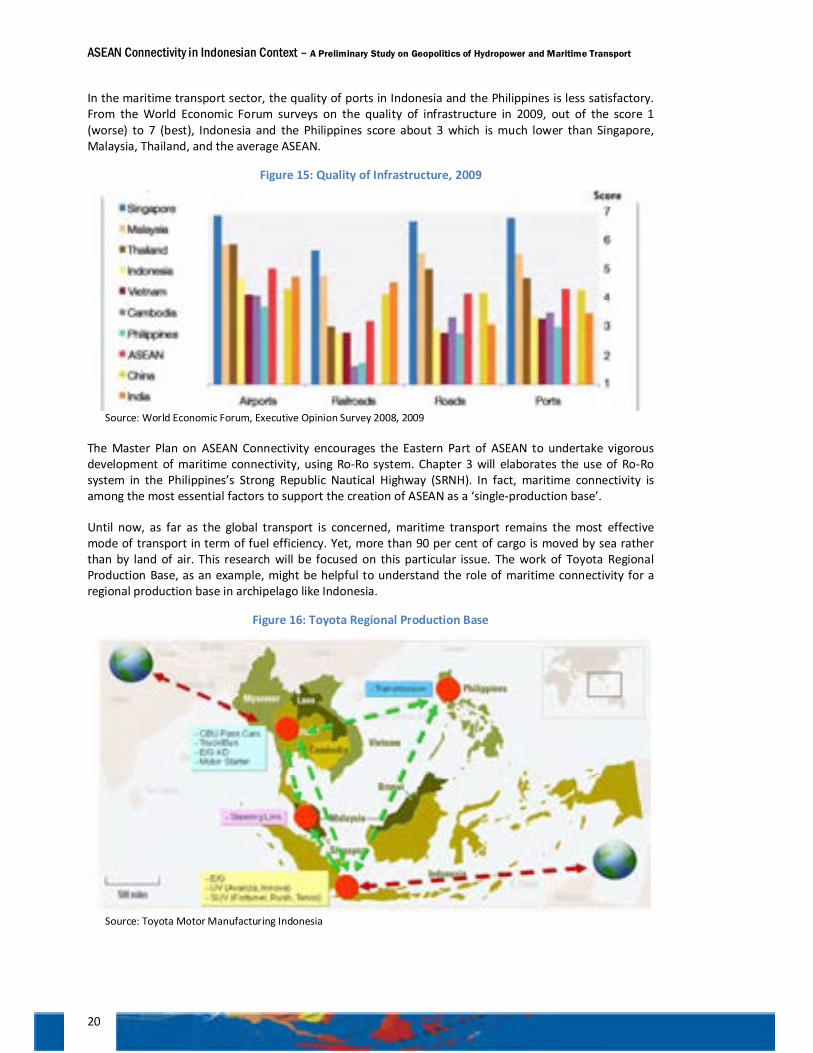
ASEAN Connectivity in Indonesian Context – A Preliminary Study on Geopolitics of Hydropower and Maritime Transport
20
In the maritime transport sector, the quality of ports in Indonesia and the Philippines is less satisfactory. From the World Economic Forum surveys on the quality of infrastructure in 2009, out of the score 1 (worse) to 7 (best), Indonesia and the Philippines score about 3 which is much lower than Singapore, Malaysia, Thailand, and the average ASEAN.
Figure 15: Quality of Infrastructure, 2009
Source: World Economic Forum, Executive Opinion Survey 2008, 2009
The Master Plan on ASEAN Connectivity encourages the Eastern Part of ASEAN to undertake vigorous development of maritime connectivity, using Ro-Ro system. Chapter 3 will elaborates the use of Ro-Ro system in the Philippines’s Strong Republic Nautical Highway (SRNH). In fact, maritime connectivity is among the most essential factors to support the creation of ASEAN as a ‘single-production base’.
Until now, as far as the global transport is concerned, maritime transport remains the most effective mode of transport in term of fuel efficiency. Yet, more than 90 per cent of cargo is moved by sea rather than by land of air. This research will be focused on this particular issue. The work of Toyota Regional Production Base, as an example, might be helpful to understand the role of maritime connectivity for a regional production base in archipelago like Indonesia.
Figure 16: Toyota Regional Production Base
Source: Toyota Motor Manufacturing Indonesia
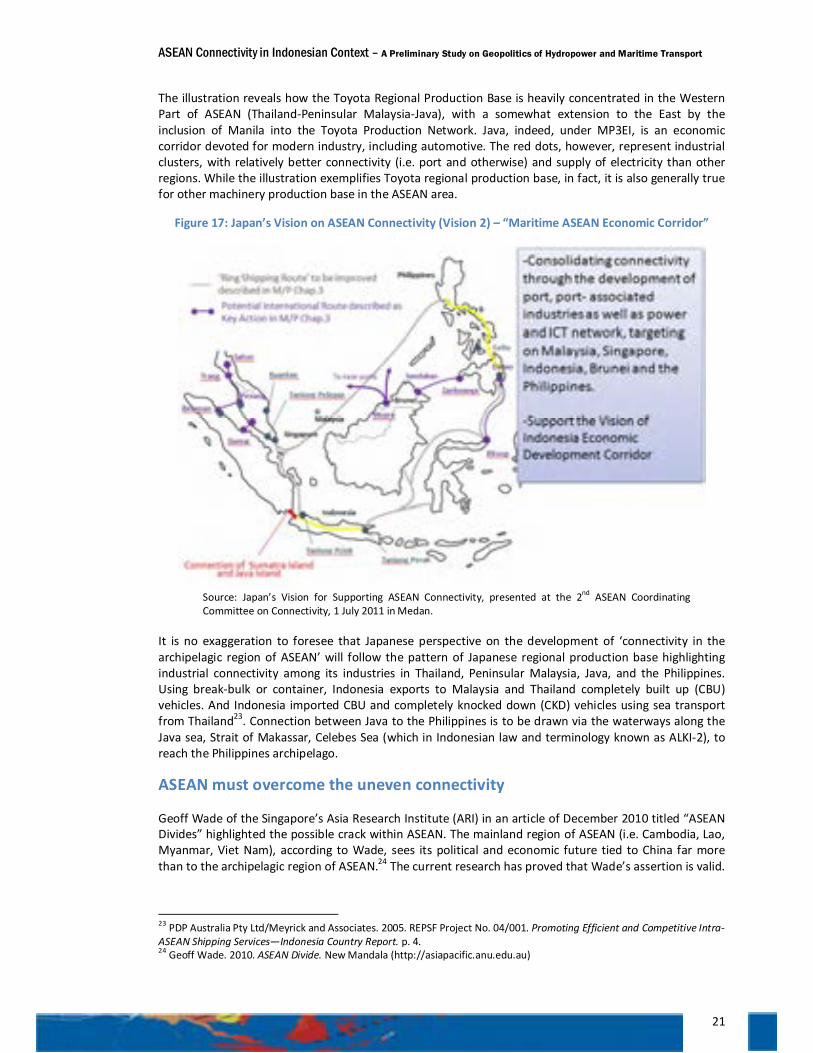
ASEAN Connectivity in Indonesian Context – A Preliminary Study on Geopolitics of Hydropower and Maritime Transport
21
The illustration reveals how the Toyota Regional Production Base is heavily concentrated in the Western Part of ASEAN (Thailand-Peninsular Malaysia-Java), with a somewhat extension to the East by the inclusion of Manila into the Toyota Production Network. Java, indeed, under MP3EI, is an economic corridor devoted for modern industry, including automotive. The red dots, however, represent industrial clusters, with relatively better connectivity (i.e. port and otherwise) and supply of electricity than other regions. While the illustration exemplifies Toyota regional production base, in fact, it is also generally true for other machinery production base in the ASEAN area.
Figure 17: Japan’s Vision on ASEAN Connectivity (Vision 2) – “Maritime ASEAN Economic Corridor”
Source: Japan’s Vision for Supporting ASEAN Connectivity, presented at the 2nd ASEAN Coordinating Committee on Connectivity, 1 July 2011 in Medan.
It is no exaggeration to foresee that Japanese perspective on the development of ‘connectivity in the archipelagic region of ASEAN’ will follow the pattern of Japanese regional production base highlighting industrial connectivity among its industries in Thailand, Peninsular Malaysia, Java, and the Philippines. Using break-bulk or container, Indonesia exports to Malaysia and Thailand completely built up (CBU) vehicles. And Indonesia imported CBU and completely knocked down (CKD) vehicles using sea transport from Thailand23. Connection between Java to the Philippines is to be drawn via the waterways along the Java sea, Strait of Makassar, Celebes Sea (which in Indonesian law and terminology known as ALKI-2), to reach the Philippines archipelago.
ASEAN must overcome the uneven connectivity
Geoff Wade of the Singapore’s Asia Research Institute (ARI) in an article of December 2010 titled “ASEAN Divides” highlighted the possible crack within ASEAN. The mainland region of ASEAN (i.e. Cambodia, Lao, Myanmar, Viet Nam), according to Wade, sees its political and economic future tied to China far more than to the archipelagic region of ASEAN.24 The current research has proved that Wade’s assertion is valid.
23 PDP Australia Pty Ltd/Meyrick and Associates. 2005. REPSF Project No. 04/001. Promoting Efficient and Competitive Intra-ASEAN Shipping Services—Indonesia Country Report. p. 4. 24 Geoff Wade. 2010. ASEAN Divide. New Mandala (http://asiapacific.anu.edu.au)
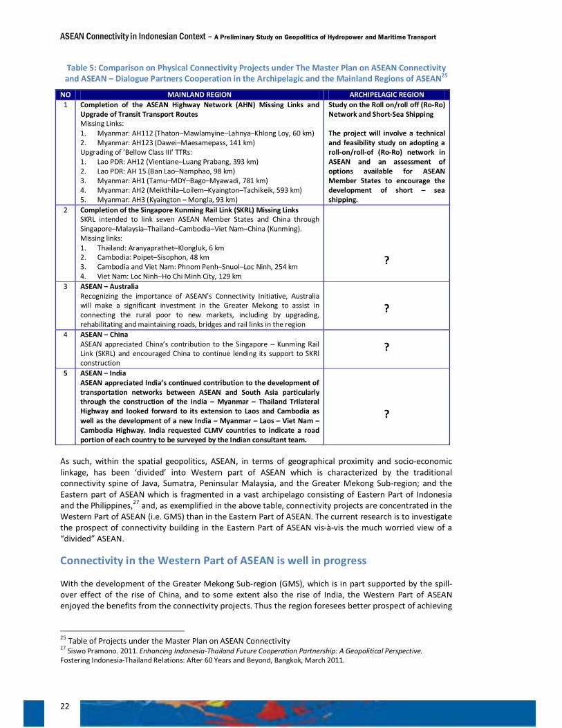
ASEAN Connectivity in Indonesian Context – A Preliminary Study on Geopolitics of Hydropower and Maritime Transport
22
Table 5: Comparison on Physical Connectivity Projects under The Master Plan on ASEAN Connectivity and ASEAN – Dialogue Partners Cooperation in the Archipelagic and the Mainland Regions of ASEAN25
NO MAINLAND REGION ARCHIPELAGIC REGION 1 Completion of the ASEAN Highway Network (AHN) Missing Links and
Upgrade of Transit Transport Routes Missing Links: 1. Myanmar: AH112 (Thaton–Mawlamyine–Lahnya–Khlong Loy, 60 km) 2. Myanmar: AH123 (Dawei–Maesamepass, 141 km) Upgrading of ’Bellow Class III’ TTRs: 1. Lao PDR: AH12 (Vientiane–Luang Prabang, 393 km) 2. Lao PDR: AH 15 (Ban Lao–Namphao, 98 km) 3. Myanmar: AH1 (Tamu–MDY–Bago–Myawadi, 781 km) 4. Myanmar: AH2 (Meikthila–Loilem–Kyaington–Tachikeik, 593 km) 5. Myanmar: AH3 (Kyaington – Mongla, 93 km)
Study on the Roll on/roll off (Ro-Ro) Network and Short-Sea Shipping The project will involve a technical and feasibility study on adopting a roll-on/roll-of (Ro-Ro) network in ASEAN and an assessment of options available for ASEAN Member States to encourage the development of short – sea shipping.
2 Completion of the Singapore Kunming Rail Link (SKRL) Missing Links SKRL intended to link seven ASEAN Member States and China through Singapore–Malaysia–Thailand–Cambodia–Viet Nam–China (Kunming). Missing links: 1. Thailand: Aranyaprathet–Klongluk, 6 km 2. Cambodia: Poipet–Sisophon, 48 km 3. Cambodia and Viet Nam: Phnom Penh–Snuol–Loc Ninh, 254 km 4. Viet Nam: Loc Ninh–Ho Chi Minh City, 129 km
?
3 ASEAN – Australia Recognizing the importance of ASEAN’s Connectivity Initiative, Australia will make a significant investment in the Greater Mekong to assist in connecting the rural poor to new markets, including by upgrading, rehabilitating and maintaining roads, bridges and rail links in the region
?
4 ASEAN – China ASEAN appreciated China’s contribution to the Singapore – Kunming Rail Link (SKRL) and encouraged China to continue lending its support to SKRl construction
?
5 ASEAN – India ASEAN appreciated India’s continued contribution to the development of transportation networks between ASEAN and South Asia particularly through the construction of the India – Myanmar – Thailand Trilateral Highway and looked forward to its extension to Laos and Cambodia as well as the development of a new India – Myanmar – Laos – Viet Nam – Cambodia Highway. India requested CLMV countries to indicate a road portion of each country to be surveyed by the Indian consultant team.
?
As such, within the spatial geopolitics, ASEAN, in terms of geographical proximity and socio-economic linkage, has been ‘divided’ into Western part of ASEAN which is characterized by the traditional connectivity spine of Java, Sumatra, Peninsular Malaysia, and the Greater Mekong Sub-region; and the Eastern part of ASEAN which is fragmented in a vast archipelago consisting of Eastern Part of Indonesia and the Philippines,27 and, as exemplified in the above table, connectivity projects are concentrated in the Western Part of ASEAN (i.e. GMS) than in the Eastern Part of ASEAN. The current research is to investigate the prospect of connectivity building in the Eastern Part of ASEAN vis-à-vis the much worried view of a “divided” ASEAN.
Connectivity in the Western Part of ASEAN is well in progress
With the development of the Greater Mekong Sub-region (GMS), which is in part supported by the spill-over effect of the rise of China, and to some extent also the rise of India, the Western Part of ASEAN enjoyed the benefits from the connectivity projects. Thus the region foresees better prospect of achieving
25 Table of Projects under the Master Plan on ASEAN Connectivity 27 Siswo Pramono. 2011. Enhancing Indonesia-Thailand Future Cooperation Partnership: A Geopolitical Perspective. Fostering Indonesia-Thailand Relations: After 60 Years and Beyond, Bangkok, March 2011.
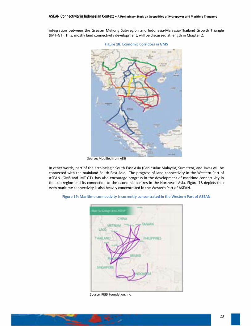
ASEAN Connectivity in Indonesian Context – A Preliminary Study on Geopolitics of Hydropower and Maritime Transport
23
integration between the Greater Mekong Sub-region and Indonesia-Malaysia-Thailand Growth Triangle (IMT-GT). This, mostly land connectivity development, will be discussed at length in Chapter 2.
Figure 18: Economic Corridors in GMS
Source: Modified from ADB
In other words, part of the archipelagic South East Asia (Peninsular Malaysia, Sumatera, and Java) will be connected with the mainland South East Asia. The progress of land connectivity in the Western Part of ASEAN (GMS and IMT-GT), has also encourage progress in the development of maritime connectivity in the sub-region and its connection to the economic centres in the Northeast Asia. Figure 18 depicts that even maritime connectivity is also heavily concentrated in the Western Part of ASEAN.
Figure 19: Maritime connectivity is currently concentrated in the Western Part of ASEAN
Source: REID Foundation, Inc.
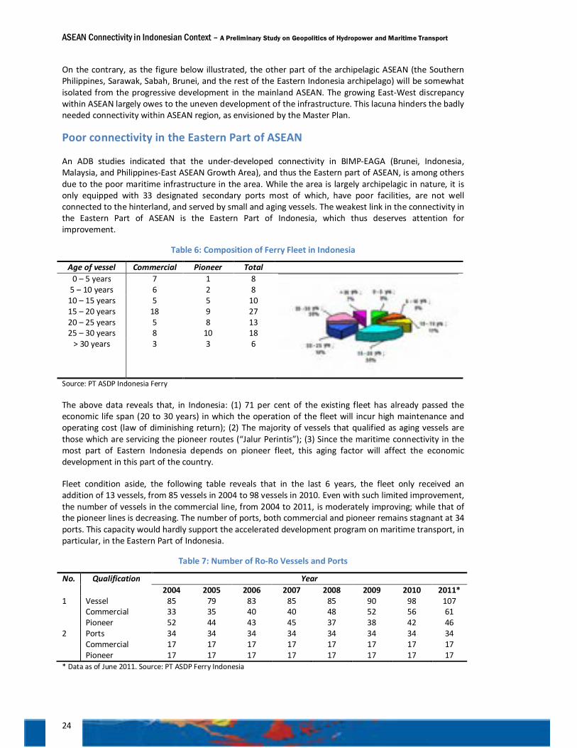
ASEAN Connectivity in Indonesian Context – A Preliminary Study on Geopolitics of Hydropower and Maritime Transport
24
On the contrary, as the figure below illustrated, the other part of the archipelagic ASEAN (the Southern Philippines, Sarawak, Sabah, Brunei, and the rest of the Eastern Indonesia archipelago) will be somewhat isolated from the progressive development in the mainland ASEAN. The growing East-West discrepancy within ASEAN largely owes to the uneven development of the infrastructure. This lacuna hinders the badly needed connectivity within ASEAN region, as envisioned by the Master Plan.
Poor connectivity in the Eastern Part of ASEAN
An ADB studies indicated that the under-developed connectivity in BIMP-EAGA (Brunei, Indonesia, Malaysia, and Philippines-East ASEAN Growth Area), and thus the Eastern part of ASEAN, is among others due to the poor maritime infrastructure in the area. While the area is largely archipelagic in nature, it is only equipped with 33 designated secondary ports most of which, have poor facilities, are not well connected to the hinterland, and served by small and aging vessels. The weakest link in the connectivity in the Eastern Part of ASEAN is the Eastern Part of Indonesia, which thus deserves attention for improvement.
Table 6: Composition of Ferry Fleet in Indonesia
Age of vessel Commercial Pioneer Total 0 – 5 years 7 1 8
5 – 10 years 6 2 8 10 – 15 years 5 5 10 15 – 20 years 18 9 27 20 – 25 years 5 8 13 25 – 30 years 8 10 18
> 30 years 3 3 6
Source: PT ASDP Indonesia Ferry
The above data reveals that, in Indonesia: (1) 71 per cent of the existing fleet has already passed the economic life span (20 to 30 years) in which the operation of the fleet will incur high maintenance and operating cost (law of diminishing return); (2) The majority of vessels that qualified as aging vessels are those which are servicing the pioneer routes (“Jalur Perintis”); (3) Since the maritime connectivity in the most part of Eastern Indonesia depends on pioneer fleet, this aging factor will affect the economic development in this part of the country.
Fleet condition aside, the following table reveals that in the last 6 years, the fleet only received an addition of 13 vessels, from 85 vessels in 2004 to 98 vessels in 2010. Even with such limited improvement, the number of vessels in the commercial line, from 2004 to 2011, is moderately improving; while that of the pioneer lines is decreasing. The number of ports, both commercial and pioneer remains stagnant at 34 ports. This capacity would hardly support the accelerated development program on maritime transport, in particular, in the Eastern Part of Indonesia.
Table 7: Number of Ro-Ro Vessels and Ports
No. Qualification Year 2004 2005 2006 2007 2008 2009 2010 2011*
1 Vessel Commercial Pioneer
85 33 52
79 35 44
83 40 43
85 40 45
85 48 37
90 52 38
98 56 42
107 61 46
2 Ports Commercial Pioneer
34 17 17
34 17 17
34 17 17
34 17 17
34 17 17
34 17 17
34 17 17
34 17 17
* Data as of June 2011. Source: PT ASDP Ferry Indonesia
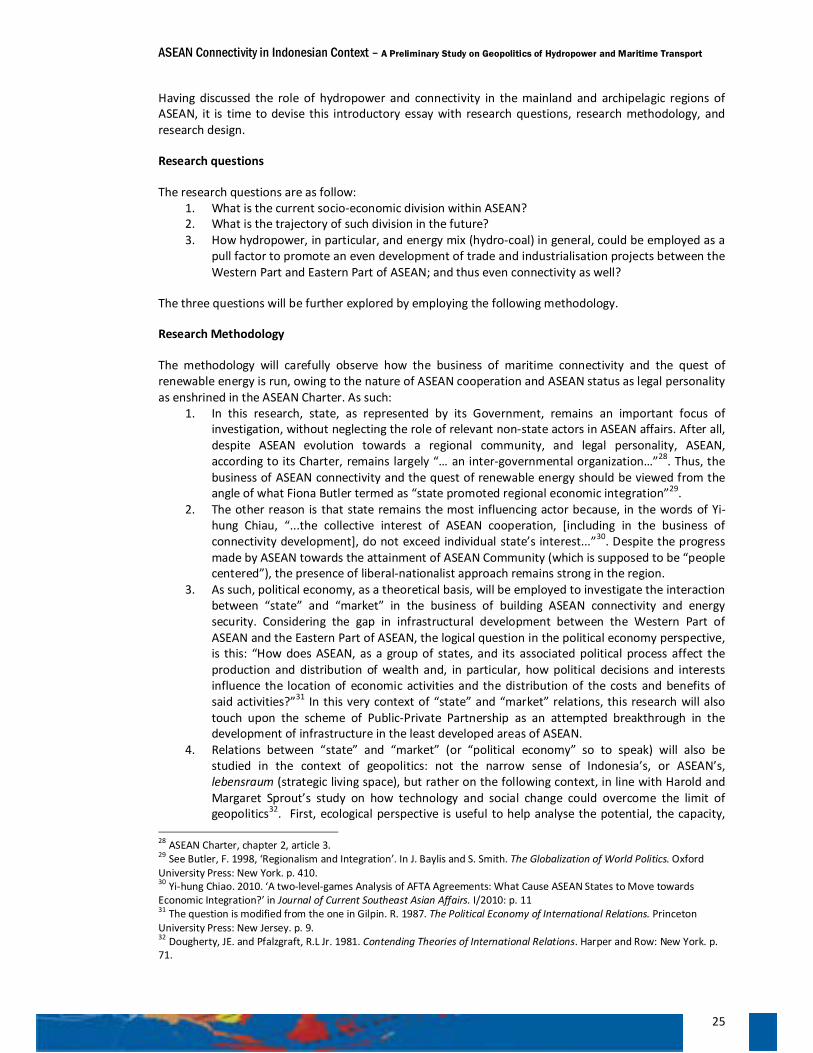
ASEAN Connectivity in Indonesian Context – A Preliminary Study on Geopolitics of Hydropower and Maritime Transport
25
Having discussed the role of hydropower and connectivity in the mainland and archipelagic regions of ASEAN, it is time to devise this introductory essay with research questions, research methodology, and research design.
Research questions
The research questions are as follow: 1. What is the current socio-economic division within ASEAN? 2. What is the trajectory of such division in the future? 3. How hydropower, in particular, and energy mix (hydro-coal) in general, could be employed as a
pull factor to promote an even development of trade and industrialisation projects between the Western Part and Eastern Part of ASEAN; and thus even connectivity as well?
The three questions will be further explored by employing the following methodology.
Research Methodology
The methodology will carefully observe how the business of maritime connectivity and the quest of renewable energy is run, owing to the nature of ASEAN cooperation and ASEAN status as legal personality as enshrined in the ASEAN Charter. As such:
1. In this research, state, as represented by its Government, remains an important focus of investigation, without neglecting the role of relevant non-state actors in ASEAN affairs. After all, despite ASEAN evolution towards a regional community, and legal personality, ASEAN, according to its Charter, remains largely “… an inter-governmental organization…”28. Thus, the business of ASEAN connectivity and the quest of renewable energy should be viewed from the angle of what Fiona Butler termed as “state promoted regional economic integration”29.
2. The other reason is that state remains the most influencing actor because, in the words of Yi-hung Chiau, “...the collective interest of ASEAN cooperation, [including in the business of connectivity development], do not exceed individual state’s interest...”30. Despite the progress made by ASEAN towards the attainment of ASEAN Community (which is supposed to be “people centered”), the presence of liberal-nationalist approach remains strong in the region.
3. As such, political economy, as a theoretical basis, will be employed to investigate the interaction between “state” and “market” in the business of building ASEAN connectivity and energy security. Considering the gap in infrastructural development between the Western Part of ASEAN and the Eastern Part of ASEAN, the logical question in the political economy perspective, is this: “How does ASEAN, as a group of states, and its associated political process affect the production and distribution of wealth and, in particular, how political decisions and interests influence the location of economic activities and the distribution of the costs and benefits of said activities?”31 In this very context of “state” and “market” relations, this research will also touch upon the scheme of Public-Private Partnership as an attempted breakthrough in the development of infrastructure in the least developed areas of ASEAN.
4. Relations between “state” and “market” (or “political economy” so to speak) will also be studied in the context of geopolitics: not the narrow sense of Indonesia’s, or ASEAN’s, lebensraum (strategic living space), but rather on the following context, in line with Harold and Margaret Sprout’s study on how technology and social change could overcome the limit of geopolitics32. First, ecological perspective is useful to help analyse the potential, the capacity,
28 ASEAN Charter, chapter 2, article 3. 29 See Butler, F. 1998, ‘Regionalism and Integration’. In J. Baylis and S. Smith. The Globalization of World Politics. Oxford University Press: New York. p. 410. 30 Yi-hung Chiao. 2010. ‘A two-level-games Analysis of AFTA Agreements: What Cause ASEAN States to Move towards Economic Integration?’ in Journal of Current Southeast Asian Affairs. I/2010: p. 11 31 The question is modified from the one in Gilpin. R. 1987. The Political Economy of International Relations. Princeton University Press: New Jersey. p. 9. 32 Dougherty, JE. and Pfalzgraft, R.L Jr. 1981. Contending Theories of International Relations. Harper and Row: New York. p. 71.
ASEAN Connectivity in Indonesian Context – A Preliminary Study on Geopolitics of Hydropower and Maritime Transport
26
and the limitation of the Eastern Part of ASEAN (and the associated Eastern Part of Indonesia). Second, investigation should be focused on “such limiting condition as the level of available technology, cognition of essential factors, and the ratio of available resources to commitment [of governments]”33.
As such, the methodology employed in this paper is political economy, in liberal tradition with nationalist inclination, framed in geopolitics in a contemporary context.
Research design With such methodology, the research is designed as follows:
Stock-taking workshop
As an early preparation, the research began with a stock-taking workshop on ASEAN Connectivity held in Bogor in December 2010, which resulted in the formulation of a Terms of Reference (TOR) for the research.
Library research
The next step was a series of library research in Jakarta, in the Library of Indonesian Institute of Science (LIPI) and the National Library (Perpustakaan Nasional); in Singapore, in Rajaratnam School of International Studies (RSIS), National University of Singapore, and the Institute of Southeast Asian Studies (ISEAS); in Manila, in the University of the Philippines; in Suva, in University of South Pacific; and in Sydney, in the University of Sydney and the University of New South Wales.
Field studies
The library research, and the associated reading sessions and explorations, was then followed by the formation of investigating teams to undertake field observations, named the Nusantaras. Investigating teams conduct about ten rounds of field studies in Southeast Asia and the Pacific, about 70 interviews with officials responsible for project under investigation, and interviews with members of community related to the operation of the projects (i.e. connectivity or energy projects). There were ten investigating teams, and herewith is referred to as “the investigating team”; each was responsible for particular sub-research project:
1. Nusantara I, conducted field research along the East-West Economic Corridor (a corridor connecting Myanmar, Thailand, Laos, Viet Nam), field observation of the Mekong Delta region and the Hanoi region in the Northern part of Viet Nam (as part of Hanoi-Nanning Economic Corridor). Thus, the purpose was to investigate the extend of physical connectivity in Greater Mekong Sub-region;
2. Nusantara II, conducted field research along the Strong Republic Nautical Highway Inland-Waterways Network in the Philippines, which stretches from Manila to Mindanao. The investigating team in particular investigated the Ro-Ro-land connectivity in the Western Corridor that connects Batangas, Calapan, and Roxas; in the Central Corridor that connects Daanbantayan, Mandaue City, Jagbilaran, and Jagna; and in the Connecting Corridor that consists of Toleo, Mandeau, Maasin, and Liloan. Thus, the team investigated a compact system combining maritime and land transport in an archipelagic setting. The purpose was to seek the possible application of such nautical highway in Indonesian context, in particular in Bali-Timor corridor.
3. Nusantara III, conducted field research about Bali-Timor Inland-Waterways Network that stretches from Bali, Lombok, Sumbawa, Flores, and Timor. The purpose is to observe the
33 Idem.
ASEAN Connectivity in Indonesian Context – A Preliminary Study on Geopolitics of Hydropower and Maritime Transport
27
possible implementation of a system like Strong Republic Nautical Highway in this Bali-Timor connection.
4. Nusantara IV, conducted field study concerning Papua New Guinea - Australia Cross-border Hydropower Cooperation. The research was focused on the joint venture between Origin Energy of Australia and Papua New Guinea Sustainable Development Program of PNG on hydropower project in Wabo, that would supply the State of Queensland with hydro-electricity via underwater cable across the Torres Strait. Thus, the purpose of the investigation is to observe how electricity power interconnection (cross border) can help industrialisation, and hence connectivity, between provinces in Papua New Guinea and states in Australia. In a more general perspective, the team is to observe how developing countries, such as Papua New Guinea, can tap the benefit from larger market in developed countries, such as Australia, in the effort to develop the badly needed electricity infrastructure despite of limited budget. Thus, the Purari case can be used as a good reference of Public-Private Partnership involving developing and developed partners.
5. Nusantara V, conducted field research in Jayapura and Mamberamo River to study the hydropower potential in Papua, particularly in the Mamberamo Raya Region. Thus, the team investigated the prospect of hydropower development in Papua. Learning from the plan of Papua New Guinea – Australia electricity power connectivity, the team investigated the possible role of hydropower in Papua as a pull factor of industrialisation (such as the case of Bakun HEP in Sarawak), and thus enhancing connectivity, in the Eastern Part of ASEAN in which Indonesia will highly likely benefit from the Sub-region project.
6. Nusantara VI, conducted field research in Sarawak to observe the development of hydropower projects in Batang Ai and Bakun, which the later represent substantial hydro-electric power plant of Sarawak. The purpose of the research is to investigate the extent of hydro-electricity working as the pull factor for industrialisation, and the possibility of exchange in electricity between Sarawak and Kalimantan through Trans Borneo Power Grid initiative.
7. Nusantara VII, conducted field research in Sabah to observe the development of hydropower in Tenom Pangi. The purpose of the research is to seek the possibility of exchange of electricity between Sabah and East Kalimantan.
8. Nusantara VIII, conducted field research in North Sumatera, in particular to investigate the role of hydro-electric plant of Asahan-1 in the Northern part of Sumatera power grid. The purpose of the research is to investigate the Asahan-1 contribution to North Sumatera grid and to see the environment aspect of hydropower project.
9. Nusantara IX, conducted field research in Guangxi Zhuang, Autonomous Region of China. The purpose of the research is to see how hydropower could contribute substantially to the attainment of green economy, and in particular, to observe the development of hydropower in the Hongsui River and its role in the Southern China power grid and beyond.
10. Nusantara X, conducted field research in Aceh, with a purpose to observe the possible new Ro-Ro connectivity (and connectivity plus) between Aceh and Myanmar via the Andaman and Nicobar islands.
Public Lectures
All of the field researches have been compiled in a comprehensive report and presented for further inputs through a series of public lectures by the investigating team, respectively in Lao’s Institute of Foreign Affairs in Vientiane, Diplomatic Academy of Viet Nam in Hanoi, University of South Pacific in Suva, University of Papua New Guinea in Port Moresby, the Office of Government of Queensland in Brisbane, Chulalongkorn University in Bangkok, the Myanmar Institute of Strategic and International Studies in Yangon, and University of Cendrawasih in Jayapura. And, in the latter stage, the team has
ASEAN Connectivity in Indonesian Context – A Preliminary Study on Geopolitics of Hydropower and Maritime Transport
28
also presented the revised version of the report through public lectures in the University of Pretoria – South Africa, and Institute of Southeast Asia Studies (ISEAS) – Singapore.
Experts Group Meetings
The findings of the research have been consulted to experts through Experts Group Meetings. The first Experts Group Meeting was conducted in April 2011 in Cisarua, Bogor, in which the findings were consulted with the Chairman of ASEAN Power Grid Consultative Committee and the Head of Business Development of PT ASDP Indonesia Ferry (Persero). The second Experts Group Meeting was conducted in Jakarta in June 2011, which was attended by Deputy-I of the Coordinating Ministry for Economic Affairs, Director of Transport of PT ASDP Indonesia Ferry (Persero), Head of Division of System Planning of PT PLN (Persero), Head of the Centre of Data and Information of Development Planning-Bappenas, and the Assistant Vice President of PT Bajra Daya Sentra Nusa (Asahan-1 Hydro-Electric Power Plant). The third (and final) Experts Group Meeting was conducted in Bogor in July 2011 to finalize the draft report of the research (the book).
Consultation with Indonesian Missions in ASEAN countries
During the research, consultations with Heads of Indonesian Representatives in ASEAN countries as well as related regions (ambassadors and consul generals) have always been maintained. As such, the investigating teams have maintained communication for exchange of data and information with Indonesian Representatives in Yangon, Bangkok, Vientiane, Phnom Penh, Hanoi, Manila, Singapore, Kuala Lumpur, Bandar Seri Begawan, Beijing, Dili, Port Moresby, Suva, Davao, Kuching, Ho Chi Minh City, Kota Kinabalu, Guangzhou, and Sydney. The first field study, as far as the current investigation is concerned, was conducted in the Great Mekong Sub-region. Chapter 2 will provide a lesson learned from the GMS experience. This Chapter will also provide a broader basis to understand connectivity in a complex, broader context. Thus, it will discuss how connectivity in the mainland region of ASEAN has been built and how, in the process, ASEAN’s presence has become less visible in this important region.
ASEAN Connectivity in Indonesian Context – A Preliminary Study on Geopolitics of Hydropower and Maritime Transport
29
Chapter 2 | WESTERN PART OF ASEAN: The Making of Land Connectivity and Economic Corridors
Connectivity in the Greater Mekong Sub-region (GMS)
Unlike the archipelagic regions in the Eastern part of ASEAN, the Western part can tap the benefit from its strategic location in the hip of the Asian continent. And, due to the nature of the Greater Mekong Sub-region (GMS) in the mainland Southeast Asia, the Sub-region has a better sub-regional connectivity and greater opportunity to enhance intra and inter sub-regional cooperation, both within ASEAN and beyond (the latter is termed as “connectivity plus”). As part of the mainland area of Asia, it is easier for the GMS to physically connect the overall Mekong sub-region by land transport through various corridors, in which Thailand serves as the strategic hub of transportation. Within the ASEAN context, the objectives of promoting connectivity in the Mekong sub-region are to accelerate the sub-regional economic and social development process, to enhance economic integration, to develop regional value and supply chain with the goal of increasing competitiveness and economic bargaining power, and to expand trade and investment in the region.
Since the establishment of GMS in 1992, the leaders of Cambodia, the People's Republic of China (as represented by Yunnan Province and Guangxi Zhuang Autonomous Region), the Lao People's Democratic Republic (Lao PDR), Myanmar, Thailand, and Viet Nam, with support from the Asia Development Bank (ADB) and many other donors, have realized the economic advantage to be gained from the development of cross border infrastructure (CBI). In the GMS’s case, CBI can help reduce inequalities across the sub-region by providing small, landlocked, or low-income countries with access to the larger regional market, linking them to production networks and supply chains, and supporting the formation of industrial clusters or zones.
The accessibility of the GMS countries and their connectivity to the other sub-regions has been at the heart of the GMS development strategy of promoting integration within the regional and global economy. Thus, infrastructure plays a significant role in integrating this vast and diverse sub-region. Individually, in various degrees, the countries in the GMS enjoyed the growing infrastructural connectivity for the enhancement of their trade, economic growth, and competitiveness34.
In turn, connecting the GMS to other sub-regions in South and East Asia, particularly the larger markets of India and China, will encourage inflow of investment from these two rising economies. As China, India, and ASEAN are emerging as the three major growth centres in Asia, the connectivity between the GMS and the Indonesia – Malaysia – Thailand Growth Triangle (IMT-GT), the Ayeyawady – Chao Phraya – Mekong Economic Cooperation Strategy (ACMECS), or the Bay of Bengal Initiative for Multi-Sectoral Technical and Economic Cooperation (BIMSTEC) will be important for pan-Asian connectivity and integration. The core strategy for the GMS is thus to promote economic cooperation with China, while engaging the rest of Southeast Asia, India, and the rest of South Asian countries.
To achieve this objective, the GMS established the East – West Corridor and North – South Corridor as pilot projects. The East – West Corridor creates a passage which connects the South China Sea to the Indian Ocean, the Middle East, and even Eastern coast of Africa through the Andaman Sea, whereas the 34 There are 11 sectors of cooperation in the GMS, namely, Agriculture, Energy, Environment, Human Resource Development, Investment, Telecommunications, Tourism, Trade, Transport, Multi-sector, and Development of Economic Corridors.
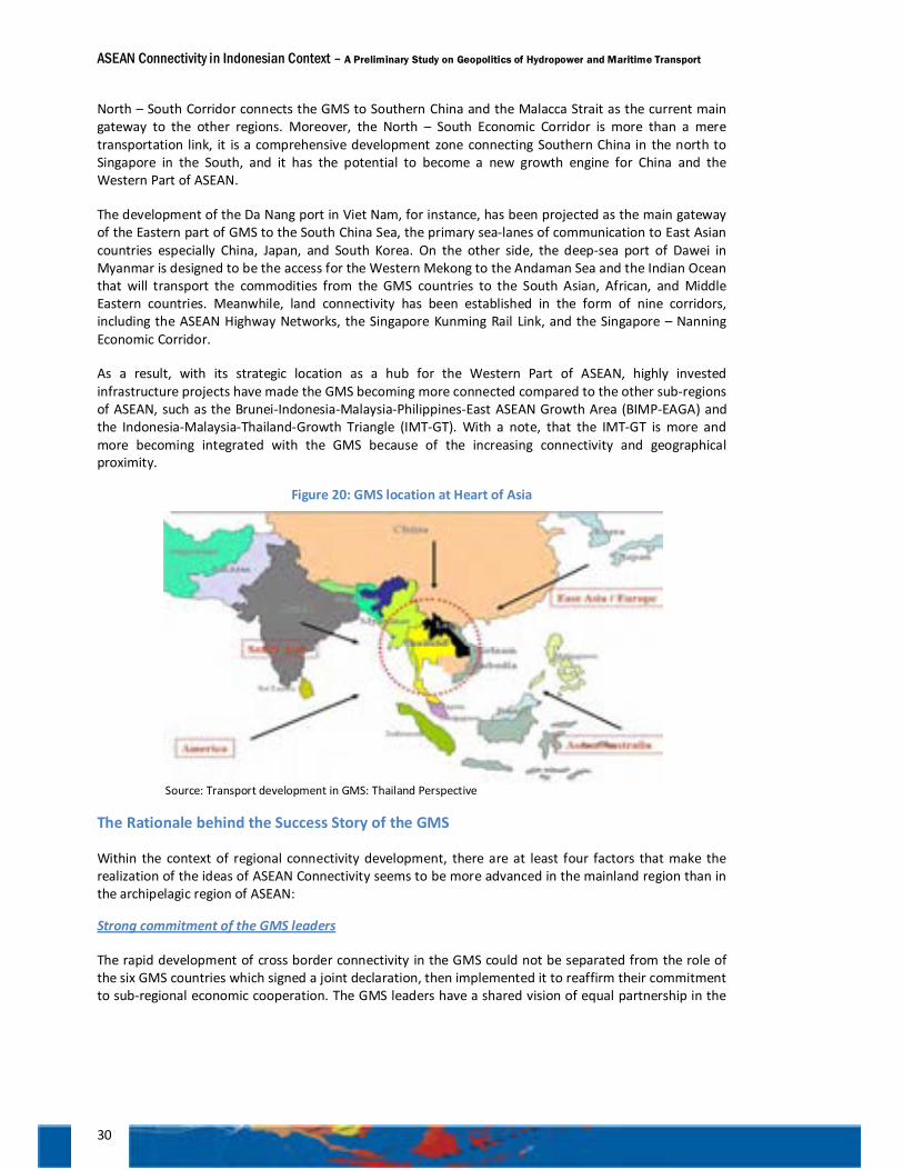
ASEAN Connectivity in Indonesian Context – A Preliminary Study on Geopolitics of Hydropower and Maritime Transport
30
North – South Corridor connects the GMS to Southern China and the Malacca Strait as the current main gateway to the other regions. Moreover, the North – South Economic Corridor is more than a mere transportation link, it is a comprehensive development zone connecting Southern China in the north to Singapore in the South, and it has the potential to become a new growth engine for China and the Western Part of ASEAN.
The development of the Da Nang port in Viet Nam, for instance, has been projected as the main gateway of the Eastern part of GMS to the South China Sea, the primary sea-lanes of communication to East Asian countries especially China, Japan, and South Korea. On the other side, the deep-sea port of Dawei in Myanmar is designed to be the access for the Western Mekong to the Andaman Sea and the Indian Ocean that will transport the commodities from the GMS countries to the South Asian, African, and Middle Eastern countries. Meanwhile, land connectivity has been established in the form of nine corridors, including the ASEAN Highway Networks, the Singapore Kunming Rail Link, and the Singapore – Nanning Economic Corridor.
As a result, with its strategic location as a hub for the Western Part of ASEAN, highly invested infrastructure projects have made the GMS becoming more connected compared to the other sub-regions of ASEAN, such as the Brunei-Indonesia-Malaysia-Philippines-East ASEAN Growth Area (BIMP-EAGA) and the Indonesia-Malaysia-Thailand-Growth Triangle (IMT-GT). With a note, that the IMT-GT is more and more becoming integrated with the GMS because of the increasing connectivity and geographical proximity.
Figure 20: GMS location at Heart of Asia
Source: Transport development in GMS: Thailand Perspective
The Rationale behind the Success Story of the GMS
Within the context of regional connectivity development, there are at least four factors that make the realization of the ideas of ASEAN Connectivity seems to be more advanced in the mainland region than in the archipelagic region of ASEAN:
Strong commitment of the GMS leaders
The rapid development of cross border connectivity in the GMS could not be separated from the role of the six GMS countries which signed a joint declaration, then implemented it to reaffirm their commitment to sub-regional economic cooperation. The GMS leaders have a shared vision of equal partnership in the
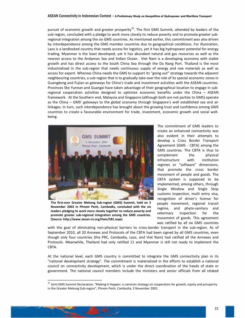
ASEAN Connectivity in Indonesian Context – A Preliminary Study on Geopolitics of Hydropower and Maritime Transport
31
pursuit of economic growth and greater prosperity35. The first GMS Summit, attended by leaders of the sub-region, concluded with a pledge to work more closely to reduce poverty and to promote greater sub-regional integration among the six GMS countries. As mentioned earlier, this commitment was also driven by interdependence among the GMS member countries due to geographical conditions. For illustration, Laos is a landlocked country that needs access for logistics, yet it has big hydropower potential for energy trading. Myanmar is the least developed, yet it has abundant natural and gas resources as well as the nearest access to the Andaman Sea and Indian Ocean. Viet Nam is a developing economy with stable growth and has direct access to the South China Sea through the Da Nang Port. Thailand is the most industrialized in the sub-region that needs continuous supply of energy and raw materials as well as access for export. Whereas China needs the GMS to support its “going out” strategy towards the adjacent neighbouring countries, a sub-region that is to gradually take over the role of its special economic zones in Guangdong and Fujian as gateways for China’s trade and investment activities with the ASEAN countries. Provinces like Yunnan and Guangxi have taken advantage of their geographical location to engage in sub-regional cooperation activities designed to optimize economic benefits under the China – ASEAN framework. At the Southern end, Malaysia and Singapore (although both are not parties to GMS) operate as the China – GMS’ gateways to the global economy through Singapore’s well established sea and air linkages. In turn, such interdependence has brought about the growing trust and confidence among GMS countries to create a favourable environment for trade, investment, economic growth and social well-being.
The commitment of GMS leaders to create an enhanced connectivity was also evident in their attempts to develop a Cross Border Transport Agreement (GMS - CBTA) among the GMS countries. The CBTA is thus to complement the physical infrastructure with institution regimes or “software” dimensions, that promote the cross border movement of people and goods. The CBTA system is supposed to be implemented, among others, through Single Window and Single Stop customs inspection, multi entry visa, recognition of driver’s license for people movement, regional transit regime, and phyto-sanitary and veterinary inspection for the movement of goods. This agreement was ratified by all six GMS countries
with the goal of eliminating non-physical barriers to cross-border transport in the sub-region. As of September 2010, all 20 Annexes and Protocols of the CBTA had been signed by all GMS countries, even though only four countries (the PRC, Cambodia, Laos, and Viet Nam) had ratified all the Annexes and Protocols. Meanwhile, Thailand had only ratified 11 and Myanmar is still not ready to implement the CBTA.
At the national level, each GMS country is committed to integrate the GMS connectivity plan in its “national development strategy”. The commitment is materialized in the efforts to establish a national council on connectivity development, which is under the direct coordination of the heads of state or government. The national council members include the ministers and senior officials from all related
35 Joint GMS Summit Declaration, “Making it Happen: a common strategy on cooperation for growth, equity and prosperity in the Greater Mekong Sub-region”, Phnom Penh, Cambodia, 3 November 2002.
The first-ever Greater Mekong Sub-region (GMS) Summit, held on 3 November 2002 in Phnom Penh, Cambodia, concluded with the six leaders pledging to work more closely together to reduce poverty and promote greater sub-regional integration among the GMS countries. (Source: http://www.asean-cn.org/Item/581.aspx)
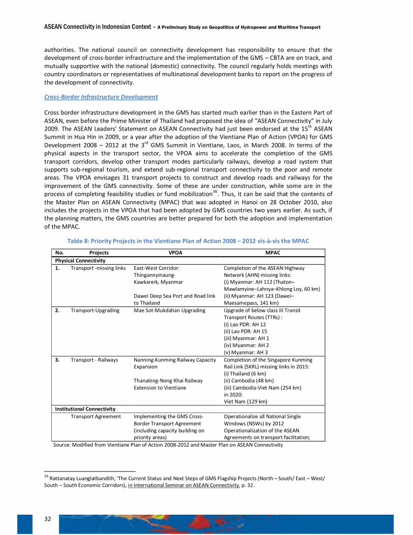
ASEAN Connectivity in Indonesian Context – A Preliminary Study on Geopolitics of Hydropower and Maritime Transport
32
authorities. The national council on connectivity development has responsibility to ensure that the development of cross-border infrastructure and the implementation of the GMS – CBTA are on track, and mutually supportive with the national (domestic) connectivity. The council regularly holds meetings with country coordinators or representatives of multinational development banks to report on the progress of the development of connectivity.
Cross-Border Infrastructure Development
Cross border infrastructure development in the GMS has started much earlier than in the Eastern Part of ASEAN, even before the Prime Minister of Thailand had proposed the idea of “ASEAN Connectivity” in July 2009. The ASEAN Leaders’ Statement on ASEAN Connectivity had just been endorsed at the 15th ASEAN Summit in Hua Hin in 2009, or a year after the adoption of the Vientiane Plan of Action (VPOA) for GMS Development 2008 – 2012 at the 3rd GMS Summit in Vientiane, Laos, in March 2008. In terms of the physical aspects in the transport sector, the VPOA aims to accelerate the completion of the GMS transport corridors, develop other transport modes particularly railways, develop a road system that supports sub-regional tourism, and extend sub-regional transport connectivity to the poor and remote areas. The VPOA envisages 31 transport projects to construct and develop roads and railways for the improvement of the GMS connectivity. Some of these are under construction, while some are in the process of completing feasibility studies or fund mobilization36. Thus, it can be said that the contents of the Master Plan on ASEAN Connectivity (MPAC) that was adopted in Hanoi on 28 October 2010, also includes the projects in the VPOA that had been adopted by GMS countries two years earlier. As such, if the planning matters, the GMS countries are better prepared for both the adoption and implementation of the MPAC.
Table 8: Priority Projects in the Vientiane Plan of Action 2008 – 2012 vis-à-vis the MPAC
No. Projects VPOA MPAC Physical Connectivity 1. Transport -missing links East-West Corridor:
Thingannyinaung- Kawkareik, Myanmar Dawei Deep Sea Port and Road link to Thailand
Completion of the ASEAN Highway Network (AHN) missing links: (i) Myanmar: AH 112 (Thaton–Mawlamyine–Lahnya–Khlong Loy, 60 km) (ii) Myanmar: AH 123 (Dawei–Maesamepass, 141 km)
2. Transport-Upgrading Mae Sot-Mukdahan Upgrading Upgrade of below class III Transit Transport Routes (TTRs) : (i) Lao PDR: AH 12 (ii) Lao PDR: AH 15 (iii) Myanmar: AH 1 (iv) Myanmar: AH 2 (v) Myanmar: AH 3
3. Transport - Railways Nanning-Kunming Railway Capacity Expansion Thanaleng-Nong Khai Railway Extension to Vientiane
Completion of the Singapore Kunming Rail Link (SKRL) missing links in 2015: (i) Thailand (6 km) (ii) Cambodia (48 km) (iii) Cambodia-Viet Nam (254 km) in 2020: Viet Nam (129 km)
Institutional Connectivity Transport Agreement Implementing the GMS Cross-
Border Transport Agreement (including capacity building on priority areas)
Operationalize all National Single Windows (NSWs) by 2012 Operationalization of the ASEAN Agreements on transport facilitation;
Source: Modified from Vientiane Plan of Action 2008-2012 and Master Plan on ASEAN Connectivity
36 Rattanatay Luanglatbandith, ‘The Current Status and Next Steps of GMS Flagship Projects (North – South/ East – West/ South – South Economic Corridors), in International Seminar on ASEAN Connectivity, p. 32.
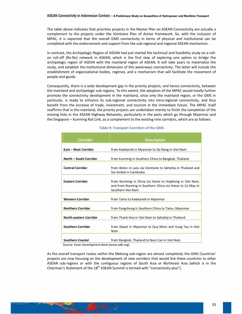
ASEAN Connectivity in Indonesian Context – A Preliminary Study on Geopolitics of Hydropower and Maritime Transport
33
The table above indicates that priorities projects in the Master Plan on ASEAN Connectivity are actually a complement to the projects under the Vientiane Plan of Action framework. So, with the inclusion of MPAC, it is expected that the overall GMS connectivity in terms of physical and institutional can be completed with the endorsement and support from the sub-regional and regional ASEAN mechanism.
In contrast, the Archipelagic Region of ASEAN had just started the technical and feasibility study on a roll-on roll-off (Ro-Ro) network in ASEAN, which is the first step of exploring one option to bridge the archipelagic region of ASEAN with the mainland region of ASEAN. It will take years to materialize the study, and establish the institutional dimension of this waterways connectivity. The latter will include the establishment of organizational bodies, regimes, and a mechanism that will facilitate the movement of people and goods.
Consequently, there is a wide development gap in the priority projects, and hence connectivity, between the mainland and archipelagic sub-regions. To this extent, the adoption of the MPAC would totally further promote the connectivity development in the mainland, since only the mainland region, or the GMS in particular, is ready to enhance its sub-regional connectivity into intra-regional connectivity, and thus benefit from the increase of trade, investment, and tourism in the immediate future. The MPAC itself reaffirms that in the mainland, the priority projects are undertaken merely to finish the completion of the missing links in the ASEAN Highway Networks, particularly in the parts which go through Myanmar and the Singapore – Kunming Rail Link, as a complement to the existing nine corridors, which are as follows:
Table 9: Transport Corridors of the GMS
Corridor Description
East – West Corridor from Kawkareik in Myanmar to Da Nang in Viet Nam
North – South Corridor from Kunming in Southern China to Bangkok, Thailand
Central Corridor from Boten in Laos via Vientiane to Sattahip in Thailand and Sre Ambel in Cambodia
Eastern Corridor from Kunming in China via Hanoi to Haiphong in Viet Nam, and from Nanning in Southern China via Hanoi to Ca Mau in Southern Viet Nam
Western Corridor from Tamu to Kawkareik in Myanmar
Northern Corridor from Fangcheng in Southern China to Tamu, Myanmar
North-eastern Corridor from Thanh Hoa in Viet Nam to Sattahip in Thailand
Southern Corridor from Dawei in Myanmar to Quy Nhon and Vung Tau in Viet Nam
Southern Coastal from Bangkok, Thailand to Nam Can in Viet Nam Source: Asian Development Bank (www.adb.org)
As the overall transport routes within the Mekong sub-region are almost completed, the GMS Countries’ projects are now focusing on the development of new corridors that would link these countries to other ASEAN sub-regions or with the contiguous regions of South Asia or Northeast Asia (which is in the Chairman’s Statement of the 18th ASEAN Summit is termed with “connectivity plus”).
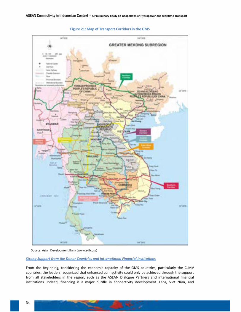
ASEAN Connectivity in Indonesian Context – A Preliminary Study on Geopolitics of Hydropower and Maritime Transport
34
Figure 21: Map of Transport Corridors in the GMS
Source: Asian Development Bank (www.adb.org)
Strong Support from the Donor Countries and International Financial Institutions
From the beginning, considering the economic capacity of the GMS countries, particularly the CLMV countries, the leaders recognized that enhanced connectivity could only be achieved through the support from all stakeholders in the region, such as the ASEAN Dialogue Partners and international financial institutions. Indeed, financing is a major hurdle in connectivity development. Laos, Viet Nam, and
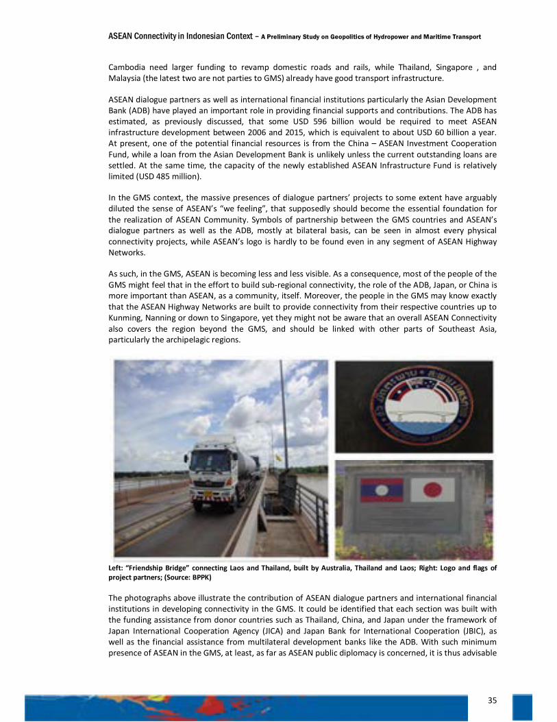
ASEAN Connectivity in Indonesian Context – A Preliminary Study on Geopolitics of Hydropower and Maritime Transport
35
Cambodia need larger funding to revamp domestic roads and rails, while Thailand, Singapore , and Malaysia (the latest two are not parties to GMS) already have good transport infrastructure.
ASEAN dialogue partners as well as international financial institutions particularly the Asian Development Bank (ADB) have played an important role in providing financial supports and contributions. The ADB has estimated, as previously discussed, that some USD 596 billion would be required to meet ASEAN infrastructure development between 2006 and 2015, which is equivalent to about USD 60 billion a year. At present, one of the potential financial resources is from the China – ASEAN Investment Cooperation Fund, while a loan from the Asian Development Bank is unlikely unless the current outstanding loans are settled. At the same time, the capacity of the newly established ASEAN Infrastructure Fund is relatively limited (USD 485 million).
In the GMS context, the massive presences of dialogue partners’ projects to some extent have arguably diluted the sense of ASEAN’s “we feeling”, that supposedly should become the essential foundation for the realization of ASEAN Community. Symbols of partnership between the GMS countries and ASEAN’s dialogue partners as well as the ADB, mostly at bilateral basis, can be seen in almost every physical connectivity projects, while ASEAN’s logo is hardly to be found even in any segment of ASEAN Highway Networks.
As such, in the GMS, ASEAN is becoming less and less visible. As a consequence, most of the people of the GMS might feel that in the effort to build sub-regional connectivity, the role of the ADB, Japan, or China is more important than ASEAN, as a community, itself. Moreover, the people in the GMS may know exactly that the ASEAN Highway Networks are built to provide connectivity from their respective countries up to Kunming, Nanning or down to Singapore, yet they might not be aware that an overall ASEAN Connectivity also covers the region beyond the GMS, and should be linked with other parts of Southeast Asia, particularly the archipelagic regions.
Left: “Friendship Bridge” connecting Laos and Thailand, built by Australia, Thailand and Laos; Right: Logo and flags of project partners; (Source: BPPK)
The photographs above illustrate the contribution of ASEAN dialogue partners and international financial institutions in developing connectivity in the GMS. It could be identified that each section was built with the funding assistance from donor countries such as Thailand, China, and Japan under the framework of Japan International Cooperation Agency (JICA) and Japan Bank for International Cooperation (JBIC), as well as the financial assistance from multilateral development banks like the ADB. With such minimum presence of ASEAN in the GMS, at least, as far as ASEAN public diplomacy is concerned, it is thus advisable
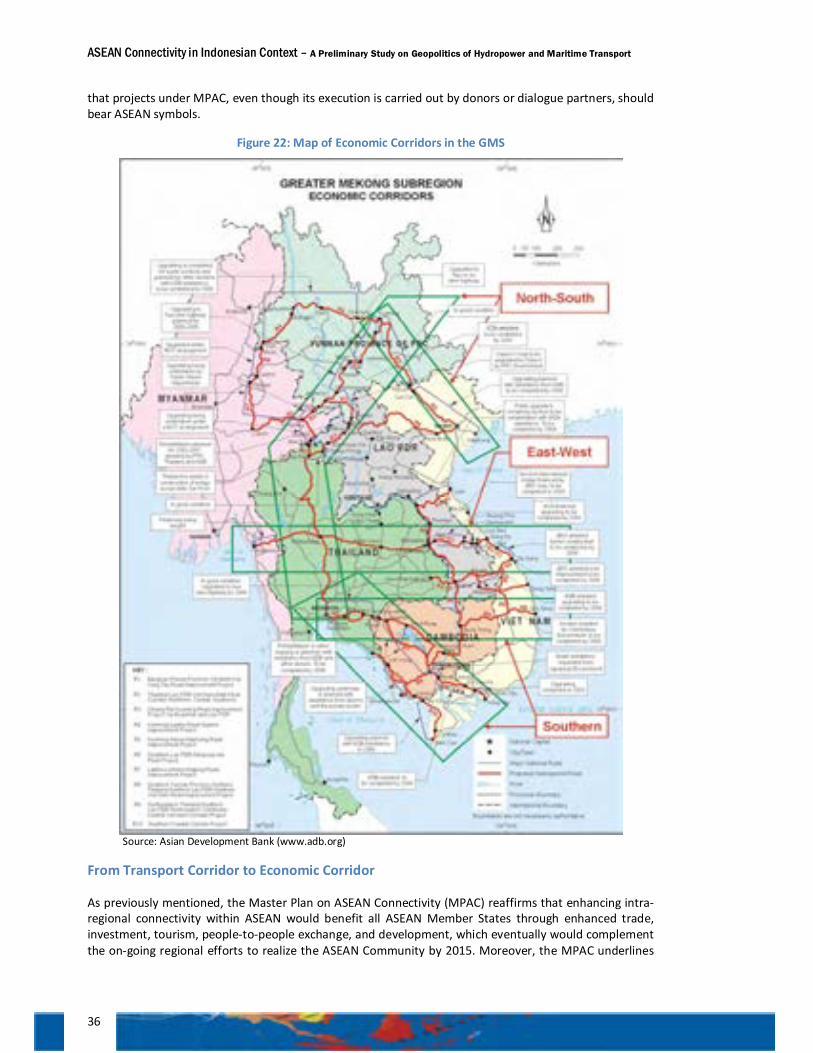
ASEAN Connectivity in Indonesian Context – A Preliminary Study on Geopolitics of Hydropower and Maritime Transport
36
that projects under MPAC, even though its execution is carried out by donors or dialogue partners, should bear ASEAN symbols.
Figure 22: Map of Economic Corridors in the GMS
Source: Asian Development Bank (www.adb.org)
From Transport Corridor to Economic Corridor
As previously mentioned, the Master Plan on ASEAN Connectivity (MPAC) reaffirms that enhancing intra-regional connectivity within ASEAN would benefit all ASEAN Member States through enhanced trade, investment, tourism, people-to-people exchange, and development, which eventually would complement the on-going regional efforts to realize the ASEAN Community by 2015. Moreover, the MPAC underlines
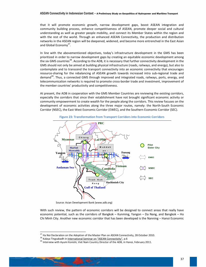
ASEAN Connectivity in Indonesian Context – A Preliminary Study on Geopolitics of Hydropower and Maritime Transport
37
that it will promote economic growth, narrow development gaps, boost ASEAN integration and community building process, enhance competitiveness of ASEAN, promote deeper social and cultural understanding as well as greater people mobility, and connect its Member States within the region and with the rest of the world. Through an enhanced ASEAN Connectivity, the production and distribution networks in the ASEAN region will be deepened, widened, and become more entrenched in the East Asian and Global Economy37.
In line with the abovementioned objectives, today’s infrastructure development in the GMS has been prioritized in order to narrow development gaps by creating an equitable economic development among the six GMS countries38. According to the ADB, it is necessary that further connectivity development in the GMS should not only be aimed at building physical infrastructure (roads, railways, and energy), but also to contemplate and to transcend the transport connectivity into an economic connectivity that encourages resource-sharing for the rebalancing of ASEAN growth towards increased intra sub-regional trade and demand39. Thus, a connected GMS through improved and integrated roads, railways, ports, energy, and telecommunication networks is required to promote cross-border trade and investment, improvement of the member countries’ productivity and competitiveness.
At present, the ADB in cooperation with the GMS Member Countries are reviewing the existing corridors, especially the corridors that since their establishment have not brought significant economic activity or community empowerment to create wealth for the people along the corridors. This review focuses on the development of economic activities along the three major routes, namely: the North-South Economic Corridor (NSEC), the East-West Economic Corridor (EWEC), and the Southern Economic Corridor (SEC).
Figure 23: Transformation from Transport Corridors into Economic Corridors
Source: Asian Development Bank (www.adb.org)
With such review, the pattern of economic corridors will be designed to connect areas that really have economic potential, such as the corridors of Bangkok – Kunming, Yangon – Da Nang, and Bangkok – Ho Chi Minh City. Another new economic corridor that has been developed is the Nanning – Hanoi Economic
37 Ha Noi Declaration on the Adoption of the Master Plan on ASEAN Connectivity, 28 October 2010. 38 Kalaya Tingsabadh in International Seminar on “ASEAN Connectivity”, p.6 39 Interview with Ayumi Konishi, Viet Nam Country Director of the ADB, in Hanoi, February 2011.
Yangon
Lao PDR
PRC
Danang
Gulf of Thailand
Andaman Sea Vietnam
Myanmar
BKK.
C h i a n g
R a i
M u k d a h
a n -
S a v a n n a
k h e t
MaeSod-Myawaddy
T r a d - K o h
K o n g Hochiminh City
Cambodia
PilotSister City
SEC
EWEC
NSEC
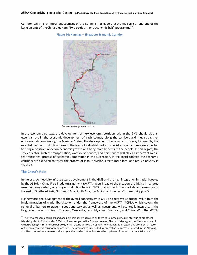
ASEAN Connectivity in Indonesian Context – A Preliminary Study on Geopolitics of Hydropower and Maritime Transport
38
Corridor, which is an important segment of the Nanning – Singapore economic corridor and one of the key elements of the China-Viet Nam “Two corridors, one economic belt” programme40.
Figure 24: Nanning – Singapore Economic Corridor
Source: www.gxnews.com.cn
In the economic context, the development of new economic corridors within the GMS should play an essential role in the economic development of each country along the corridor, and thus strengthen economic relations among the Member States. The development of economic corridors, followed by the establishment of production bases in the form of industrial parks or special economic zones are expected to bring a positive impact on economic growth and bring more benefits to the people. In this regard, the service sector, such as transportation, warehouse service, and port service will play an important role in the transitional process of economic composition in this sub-region. In the social context, the economic corridors are expected to foster the process of labour division, create more jobs, and reduce poverty in the area.
The China’s Role
In the end, connectivity infrastructure development in the GMS and the high integration in trade, boosted by the ASEAN – China Free Trade Arrangement (ACFTA), would lead to the creation of a highly integrated manufacturing system, or a single production base in GMS, that connects the markets and resources of the rest of Southeast Asia, Northeast Asia, South Asia, the Pacific, and beyond (“connectivity plus”).
Furthermore, the development of the overall connectivity in GMS also receives additional value from the implementation of trade liberalization under the framework of the ACFTA. ACFTA, which covers the removal of barriers to trade in goods and services as well as investment, will eventually integrate, in the long term, the economies of Thailand, Cambodia, Laos, Myanmar, Viet Nam, and China. With the ACFTA, 40 The “two economic corridors and one belt” initiative was raised by the Viet Namese prime minister during his official friendship visit to China in May 2004 and it was supported by Chinese premier. The two sides signed the Memorandum of Understanding on 16th November 2006, which clearly defined the sphere, key cooperation sectors and preferential sectors of the two economic corridors and one belt. The programme is included to streamline immigration procedures in Nanning and Hanoi, as well as eliminate trains stop at the border that will shorten the trip from 13 hours to be only 3-4 hours.
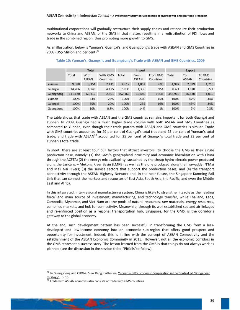
ASEAN Connectivity in Indonesian Context – A Preliminary Study on Geopolitics of Hydropower and Maritime Transport
39
multinational corporations will gradually restructure their supply chains and rationalize their production networks to China and ASEAN, or the GMS in that matter, resulting in a redistribution of FDI flows and trade in the combined region, thus promoting more growth to GMS.
As an illustration, below is Yunnan’s, Guangxi’s, and Guangdong’s trade with ASEAN and GMS Countries in 2009 (US$ Million and per cent)41
Table 10: Yunnan’s, Guangxi’s and Guangdong’s Trade with ASEAN and GMS Countries, 2009
The table shows that trade with ASEAN and the GMS countries remains important for both Guangxi and Yunnan. In 2009, Guangxi had a much higher trade volume with both ASEAN and GMS Countries as compared to Yunnan, even though their trade pattern with ASEAN and GMS countries is similar. Trade with GMS countries accounted for 29 per cent of Guangxi’s total trade and 25 per cent of Yunnan’s total trade, and trade with ASEAN42 accounted for 35 per cent of Guangxi’s total trade and 33 per cent of Yunnan’s total trade.
In short, there are at least four pull factors that attract investors to choose the GMS as their single production base, namely: (1) the GMS’s geographical proximity and economic liberalization with China through the ACFTA; (2) the energy mix availability, sustained by the cheap hydro-electric power produced along the Lancang – Mekong River Basin (LMRB) as well as the one produced along the Irrawaddy, N’Mai and Mali Nai Rivers; (3) the service sectors that support the production bases; and (4) the transport connectivity through the ASEAN Highway Network and, in the near future, the Singapore Kunming Rail Link that can connect the markets and resources of East Asia, South Asia, the Pacific, and even the Middle East and Africa.
In this integrated, inter-regional manufacturing system, China is likely to strengthen its role as the ‘leading force’ and main source of investment, manufacturing, and technology transfer, while Thailand, Laos, Cambodia, Myanmar, and Viet Nam are the pools of natural resources, raw materials, energy resources, combined markets, and hub for connectivity. Meanwhile, through its well established sea and air linkages and re-enforced position as a regional transportation hub, Singapore, for the GMS, is the Corridor’s gateway to the global economy.
At the end, such development pattern has been successful in transforming the GMS from a less-developed and low-income economy into an economic sub-region that offers good prospect and opportunity for investment. Indeed, this is in line with the concept of ASEAN Connectivity and the establishment of the ASEAN Economic Community in 2015. However, not all the economic corridors in the GMS represent a success story. The lesson learned from the GMS is that things do not always work as planned (see the discussion in the session titled “Pitfalls”to follow).
41 Lu Guangsheng and CHONG Siew Keng, Catherine, Yunnan – GMS Economic Cooperation in the Context of “Bridgehead Strategy”, p. 13. 42 Trade with ASEAN countries also consists of trade with GMS countries
Total Import Export Total With
ASEAN With GMS Countries
Total From ASEAN
From GMS Countries
Total To ASEAN
To GMS Countries
Yunnan 9,588 3,151 2,411 4,612 1,052 695 4,987 2,099 1,716 Guangxi 14,206 4,948 4,175 5,835 1,330 954 8371 3,618 3,221 Guangdong 611,120 63,310 2,861 252,160 36,480 1,831 358,960 26,830 1,030 Yunnan 100% 33% 25% 100% 23% 15% 100% 42% 34% Guangxi 100% 35% 29% 100% 235 16% 100% 43% 34% Guangdong 100% 10% 0.5% 100% 14% 1% 100% 7% 0.3%
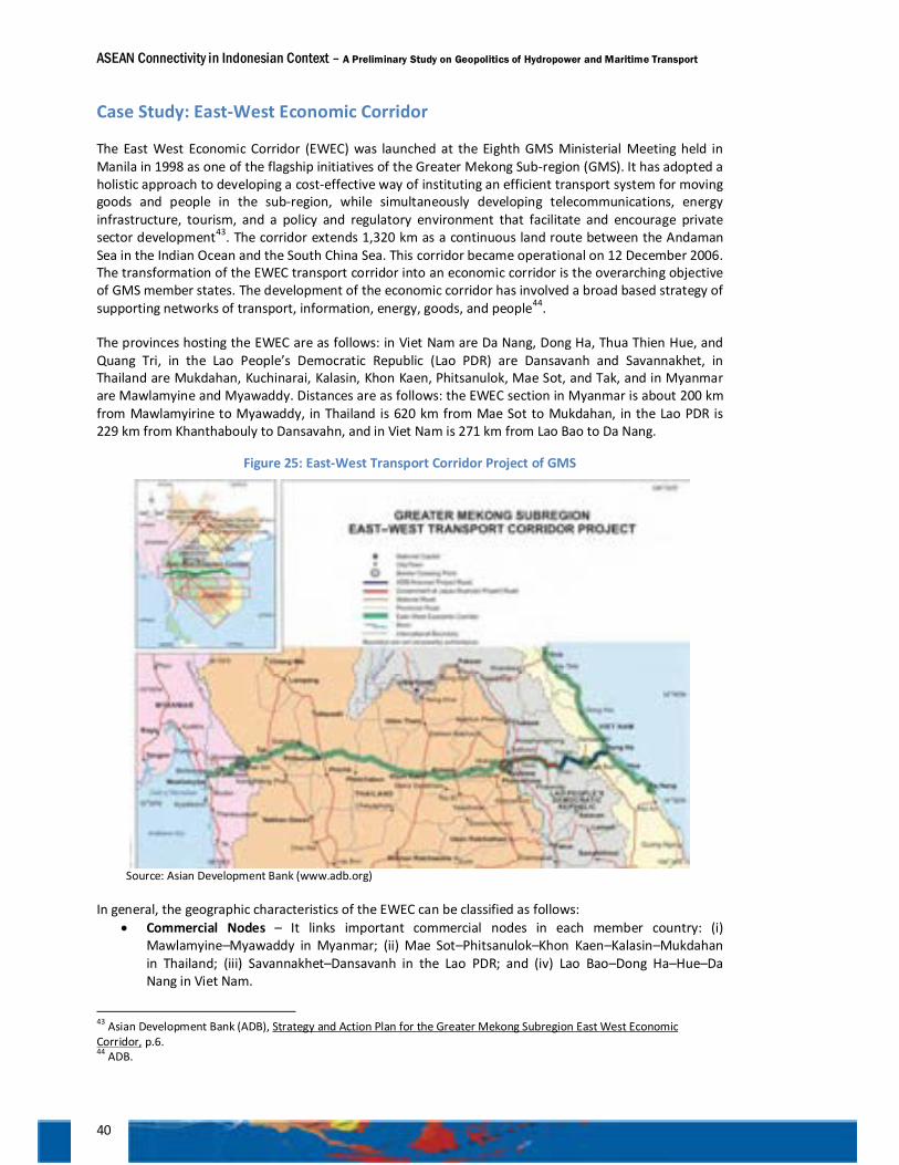
ASEAN Connectivity in Indonesian Context – A Preliminary Study on Geopolitics of Hydropower and Maritime Transport
40
Case Study: East-West Economic Corridor
The East West Economic Corridor (EWEC) was launched at the Eighth GMS Ministerial Meeting held in Manila in 1998 as one of the flagship initiatives of the Greater Mekong Sub-region (GMS). It has adopted a holistic approach to developing a cost-effective way of instituting an efficient transport system for moving goods and people in the sub-region, while simultaneously developing telecommunications, energy infrastructure, tourism, and a policy and regulatory environment that facilitate and encourage private sector development43. The corridor extends 1,320 km as a continuous land route between the Andaman Sea in the Indian Ocean and the South China Sea. This corridor became operational on 12 December 2006. The transformation of the EWEC transport corridor into an economic corridor is the overarching objective of GMS member states. The development of the economic corridor has involved a broad based strategy of supporting networks of transport, information, energy, goods, and people44.
The provinces hosting the EWEC are as follows: in Viet Nam are Da Nang, Dong Ha, Thua Thien Hue, and Quang Tri, in the Lao People’s Democratic Republic (Lao PDR) are Dansavanh and Savannakhet, in Thailand are Mukdahan, Kuchinarai, Kalasin, Khon Kaen, Phitsanulok, Mae Sot, and Tak, and in Myanmar are Mawlamyine and Myawaddy. Distances are as follows: the EWEC section in Myanmar is about 200 km from Mawlamyirine to Myawaddy, in Thailand is 620 km from Mae Sot to Mukdahan, in the Lao PDR is 229 km from Khanthabouly to Dansavahn, and in Viet Nam is 271 km from Lao Bao to Da Nang.
Figure 25: East-West Transport Corridor Project of GMS
Source: Asian Development Bank (www.adb.org)
In general, the geographic characteristics of the EWEC can be classified as follows: • Commercial Nodes – It links important commercial nodes in each member country: (i)
Mawlamyine–Myawaddy in Myanmar; (ii) Mae Sot–Phitsanulok–Khon Kaen–Kalasin–Mukdahan in Thailand; (iii) Savannakhet–Dansavanh in the Lao PDR; and (iv) Lao Bao–Dong Ha–Hue–Da Nang in Viet Nam.
43 Asian Development Bank (ADB), Strategy and Action Plan for the Greater Mekong Subregion East West Economic Corridor, p.6. 44 ADB.
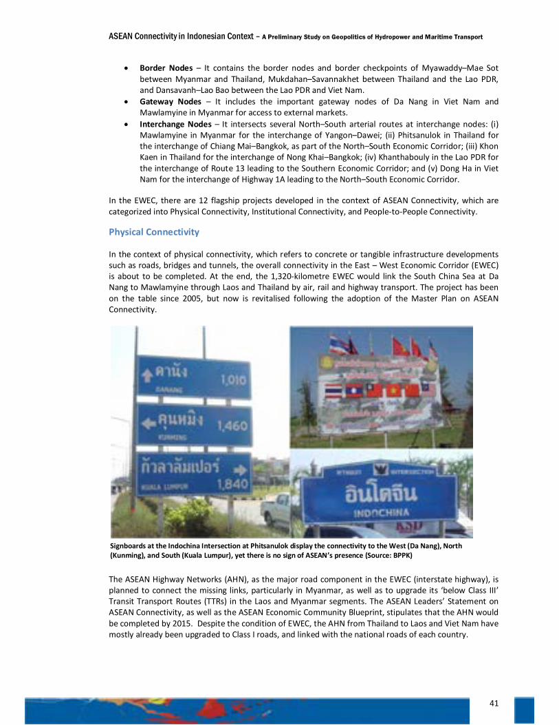
ASEAN Connectivity in Indonesian Context – A Preliminary Study on Geopolitics of Hydropower and Maritime Transport
41
• Border Nodes – It contains the border nodes and border checkpoints of Myawaddy–Mae Sot between Myanmar and Thailand, Mukdahan–Savannakhet between Thailand and the Lao PDR, and Dansavanh–Lao Bao between the Lao PDR and Viet Nam.
• Gateway Nodes – It includes the important gateway nodes of Da Nang in Viet Nam and Mawlamyine in Myanmar for access to external markets.
• Interchange Nodes – It intersects several North–South arterial routes at interchange nodes: (i) Mawlamyine in Myanmar for the interchange of Yangon–Dawei; (ii) Phitsanulok in Thailand for the interchange of Chiang Mai–Bangkok, as part of the North–South Economic Corridor; (iii) Khon Kaen in Thailand for the interchange of Nong Khai–Bangkok; (iv) Khanthabouly in the Lao PDR for the interchange of Route 13 leading to the Southern Economic Corridor; and (v) Dong Ha in Viet Nam for the interchange of Highway 1A leading to the North–South Economic Corridor.
In the EWEC, there are 12 flagship projects developed in the context of ASEAN Connectivity, which are categorized into Physical Connectivity, Institutional Connectivity, and People-to-People Connectivity.
Physical Connectivity
In the context of physical connectivity, which refers to concrete or tangible infrastructure developments such as roads, bridges and tunnels, the overall connectivity in the East – West Economic Corridor (EWEC) is about to be completed. At the end, the 1,320-kilometre EWEC would link the South China Sea at Da Nang to Mawlamyine through Laos and Thailand by air, rail and highway transport. The project has been on the table since 2005, but now is revitalised following the adoption of the Master Plan on ASEAN Connectivity.
The ASEAN Highway Networks (AHN), as the major road component in the EWEC (interstate highway), is planned to connect the missing links, particularly in Myanmar, as well as to upgrade its ‘below Class III’ Transit Transport Routes (TTRs) in the Laos and Myanmar segments. The ASEAN Leaders’ Statement on ASEAN Connectivity, as well as the ASEAN Economic Community Blueprint, stipulates that the AHN would be completed by 2015. Despite the condition of EWEC, the AHN from Thailand to Laos and Viet Nam have mostly already been upgraded to Class I roads, and linked with the national roads of each country.
Signboards at the Indochina Intersection at Phitsanulok display the connectivity to the West (Da Nang), North (Kunming), and South (Kuala Lumpur), yet there is no sign of ASEAN’s presence (Source: BPPK)
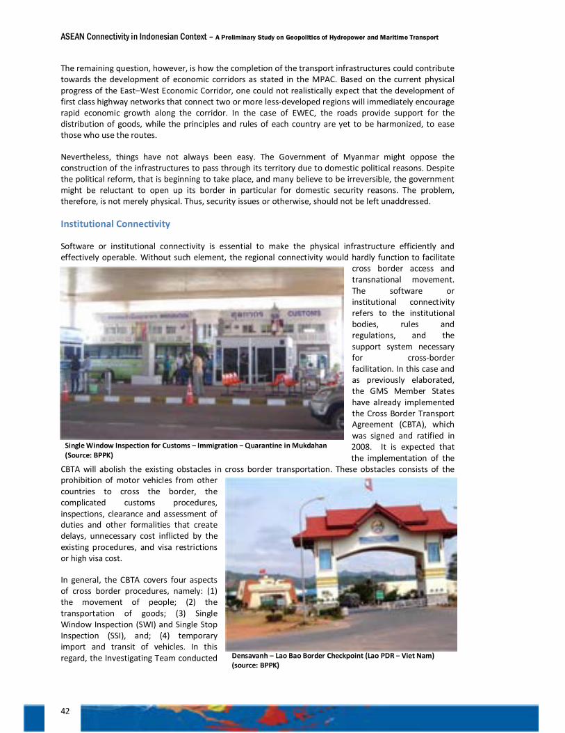
ASEAN Connectivity in Indonesian Context – A Preliminary Study on Geopolitics of Hydropower and Maritime Transport
42
The remaining question, however, is how the completion of the transport infrastructures could contribute towards the development of economic corridors as stated in the MPAC. Based on the current physical progress of the East–West Economic Corridor, one could not realistically expect that the development of first class highway networks that connect two or more less-developed regions will immediately encourage rapid economic growth along the corridor. In the case of EWEC, the roads provide support for the distribution of goods, while the principles and rules of each country are yet to be harmonized, to ease those who use the routes.
Nevertheless, things have not always been easy. The Government of Myanmar might oppose the construction of the infrastructures to pass through its territory due to domestic political reasons. Despite the political reform, that is beginning to take place, and many believe to be irreversible, the government might be reluctant to open up its border in particular for domestic security reasons. The problem, therefore, is not merely physical. Thus, security issues or otherwise, should not be left unaddressed.
Institutional Connectivity
Software or institutional connectivity is essential to make the physical infrastructure efficiently and effectively operable. Without such element, the regional connectivity would hardly function to facilitate
cross border access and transnational movement. The software or institutional connectivity refers to the institutional bodies, rules and regulations, and the support system necessary for cross-border facilitation. In this case and as previously elaborated, the GMS Member States have already implemented the Cross Border Transport Agreement (CBTA), which was signed and ratified in 2008. It is expected that the implementation of the
CBTA will abolish the existing obstacles in cross border transportation. These obstacles consists of the prohibition of motor vehicles from other countries to cross the border, the complicated customs procedures, inspections, clearance and assessment of duties and other formalities that create delays, unnecessary cost inflicted by the existing procedures, and visa restrictions or high visa cost.
In general, the CBTA covers four aspects of cross border procedures, namely: (1) the movement of people; (2) the transportation of goods; (3) Single Window Inspection (SWI) and Single Stop Inspection (SSI), and; (4) temporary import and transit of vehicles. In this regard, the Investigating Team conducted Densavanh – Lao Bao Border Checkpoint (Lao PDR – Viet Nam)
(source: BPPK)
Single Window Inspection for Customs – Immigration – Quarantine in Mukdahan (Source: BPPK)

ASEAN Connectivity in Indonesian Context – A Preliminary Study on Geopolitics of Hydropower and Maritime Transport
43
a field study on the border checkpoints at Mukdahan (Thailand) and Savannakhet (Lao PDR), as well as at Densavanh (Lao PDR) and Lao Bao (Viet Nam), to observe the implementation of the CBTA.
The movement of people, as stipulated by the CBTA is already well implemented by simplifying the procedures. The arrangement includes the implementation of border pass in lieu of passport for the people who live in the bordering countries, multiple entries visas are issued for drivers or crew of commercial vehicles, driving licenses are mutually recognised and duty free allowance for temporary import of personal effects. Such travelling convenience is also supported by the availability of international public transport facility such as international bus and ferry crisscrossing the Mekong River.
Announcements are posted in various public places around the checkpoints regarding the restriction of carrying dangerous goods such as explosives, gases, flammable substances, toxic and infectious substances, and radioactive materials. Procedures for perishable goods, such as livestock, foodstuffs, live flowers, and cut flowers, are simplified and prioritized.
The Investigating Team found that the implementation of the SWI and SSI in the border was effectively carried out by the Customs, Immigration and Quarantine (CIQ). Agencies involved in this inspection are the Ministry for Finance for customs, the Ministry of Internal Affairs for immigration, and the Ministry of Health together with the Ministry of Agriculture for quarantine of goods. The SSI works. Every vehicle subjects to CIQ is inspected only once at the border of the importing country instead of being subject to inspection twice – at the border of exporting countries and at the borders of the importing countries. Challenges in the
implementation of the SWI and SSI are mostly related to the inadequate infrastructure at the border checkpoints, including the availability of container scanners. There are also complaints concerning the lack of coordination and cooperation among the relevant authorities.
In relation to the CBTA regulation on temporary imports, the Investigating Team found that under this scheme, motor vehicles carrying goods are exempted from duty when crossing one country’s border. The system also includes duty free for engines and spare parts in receiving countries, and duty free for fuel consumption and wear and tear. Duty is also free for containers crossing a border under the system of temporary import of containers.
However, according to the officials from related institutions in Thailand, Laos, and Viet Nam, the implementation of the CBTA actually still faces some transnational problems and challenges related to the opening up of the flow of goods and people across national boundaries of GMS members due to the complexity in adjusting domestic laws of member countries to the CBTA. The challenges range from different traffic regulation among the GMS nations to overlapping and contradictory domestic and bilateral agreements and regulations. Most of the cases are related to the different systems between the two bordering countries. A bilateral technical arrangement is thus needed.
One of the obstacles is the difference in the driving system between Thailand and Viet Nam, making the cargo trucks from Thailand unable to enter the roads in Viet Nam and vice-versa. Meanwhile, the other remaining issues related to the delays of ratification of all annexes and protocols by all GMS members regarding the capacity building at national and border levels, the establishment of border infrastructures,
Single Window Inspection in Savannakhet Lao PDR (Source: BPPK)
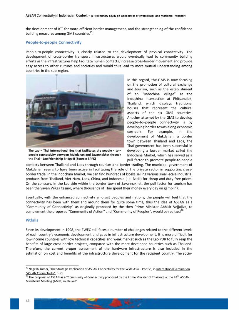
ASEAN Connectivity in Indonesian Context – A Preliminary Study on Geopolitics of Hydropower and Maritime Transport
44
the development of ICT for more efficient border management, and the strengthening of the confidence building measures among GMS countries45.
People-to-people Connectivity
People-to-people connectivity is closely related to the development of physical connectivity. The development of cross-border transport infrastructures would eventually lead to community building efforts as the infrastructures help facilitate human contacts, increase cross-border movement and provide easy access to other cultures and societies and would thus lead to more mutual understanding among countries in the sub-region.
In this regard, the GMS is now focusing on the promotion of cultural exchange and tourism, such as the establishment of an “Indochina Village” at the Indochina Intersection at Phitsanulok, Thailand, which displays traditional houses that represent the cultural aspects of the six GMS countries. Another attempt by the GMS to develop people–to–people connectivity is by developing border towns along economic corridors. For example, in the development of Mukdahan, a border town between Thailand and Laos, the Thai government has been successful in developing a border market called the Indochina Market, which has served as a pull factor to promote people-to-people
contacts between Thailand and Laos through tourism and border trading. The municipal government of Mukdahan seems to have been active in facilitating the role of the private sector in supporting cross-border trade. In the Indochina Market, we can find hundreds of kiosks selling various small-scale industrial products from Thailand, Viet Nam, Laos, China, and Indonesia (i.e. Batik) for cheap and duty-free prices. On the contrary, in the Lao side within the border town of Savannakhet, the pull factor for tourism has been the Savan Vegas Casino, where thousands of Thai spend their money every day on gambling.
Eventually, with the enhanced connectivity amongst peoples and nations, the people will feel that the connectivity has been with them and around them for quite some time, thus the idea of ASEAN as a “Community of Connectivity” as originally proposed by the then Prime Minister Abhisit Vejjajiva, to complement the proposed “Community of Action” and “Community of Peoples”, would be realized46.
Pitfalls
Since its development in 1998, the EWEC still faces a number of challenges related to the different levels of each country’s economic development and gaps in infrastructure development. It is more difficult for low-income countries with low technical capacities and weak market such as the Lao PDR to fully reap the benefits of large cross-border projects, compared with the more developed countries such as Thailand. Therefore, the current proper assessment of the hardware infrastructure is also included in the estimation on cost and benefits of the infrastructure development for the recipient country. The socio-
45 Nagesh Kumar, ‘The Strategic Implication of ASEAN Connectivity for the Wide Asia – Pacific’, in International Seminar on “ASEAN Connectivity”, p. 23. 46 The proposal of ASEAN as a “Community of Connectivity proposed by the Prime Minister of Thailand, at the 42nd ASEAN Ministerial Meeting (AMM) in Phuket”
The Lao – Thai International Bus that facilitates the people – to – people connectivity between Mukdahan and Savannakhet through the Thai – Lao Friendship Bridge II (Source: BPPK)
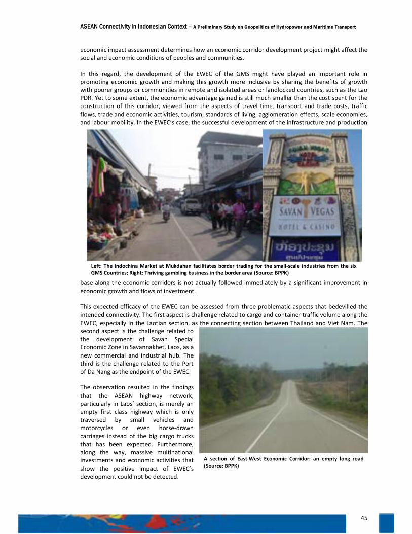
ASEAN Connectivity in Indonesian Context – A Preliminary Study on Geopolitics of Hydropower and Maritime Transport
45
economic impact assessment determines how an economic corridor development project might affect the social and economic conditions of peoples and communities.
In this regard, the development of the EWEC of the GMS might have played an important role in promoting economic growth and making this growth more inclusive by sharing the benefits of growth with poorer groups or communities in remote and isolated areas or landlocked countries, such as the Lao PDR. Yet to some extent, the economic advantage gained is still much smaller than the cost spent for the construction of this corridor, viewed from the aspects of travel time, transport and trade costs, traffic flows, trade and economic activities, tourism, standards of living, agglomeration effects, scale economies, and labour mobility. In the EWEC’s case, the successful development of the infrastructure and production
base along the economic corridors is not actually followed immediately by a significant improvement in economic growth and flows of investment.
This expected efficacy of the EWEC can be assessed from three problematic aspects that bedevilled the intended connectivity. The first aspect is challenge related to cargo and container traffic volume along the EWEC, especially in the Laotian section, as the connecting section between Thailand and Viet Nam. The second aspect is the challenge related to the development of Savan Special Economic Zone in Savannakhet, Laos, as a new commercial and industrial hub. The third is the challenge related to the Port of Da Nang as the endpoint of the EWEC.
The observation resulted in the findings that the ASEAN highway network, particularly in Laos’ section, is merely an empty first class highway which is only traversed by small vehicles and motorcycles or even horse-drawn carriages instead of the big cargo trucks that has been expected. Furthermore, along the way, massive multinational investments and economic activities that show the positive impact of EWEC’s development could not be detected.
Left: The Indochina Market at Mukdahan facilitates border trading for the small-scale industries from the six GMS Countries; Right: Thriving gambling business in the border area (Source: BPPK)
A section of East-West Economic Corridor: an empty long road (Source: BPPK)
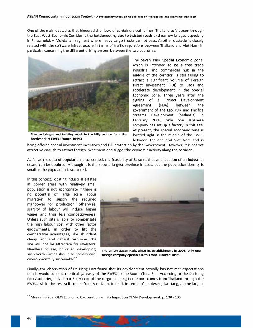
ASEAN Connectivity in Indonesian Context – A Preliminary Study on Geopolitics of Hydropower and Maritime Transport
46
One of the main obstacles that hindered the flows of containers traffic from Thailand to Vietnam through the East West Economic Corridor is the bottlenecking due to twisted roads and narrow bridges especially in Phitsanulok – Mukdahan segment where heavy cargo trucks cannot pass. Another obstacle is closely related with the software infrastructure in terms of traffic regulations between Thailand and Viet Nam, in particular concerning the different driving system between the two countries.
The Savan Park Special Economic Zone, which is intended to be a free trade industrial and commercial hub in the middle of the corridor, is still failing to attract a significant volume of Foreign Direct Investment (FDI) to Laos and accelerate development in the Special Economic Zone. Three years after the signing of a Project Development Agreement (PDA) between the government of the Lao PDR and Pacifica Streams Development (Malaysia) in February 2008, only one Japanese company has set-up a factory in this site. At present, the special economic zone is located right in the middle of the EWEC between Thailand and Viet Nam and is
being offered special investment incentives and full protection by the Government. However, it is not yet attractive enough to attract foreign investment and trigger the economic activity along the corridor.
As far as the data of population is concerned, the feasibility of Savannakhet as a location of an industrial estate can be doubted. Although it is the second largest province in Laos, but the population density is small as the population is scattered.
In this context, locating industrial estates at border areas with relatively small population is not appropriate if there is no potential of large scale labour migration to supply the required manpower for production; otherwise, scarcity of labour will induce higher wages and thus less competitiveness. Unless such site is able to compensate the high labour cost with other factor endowments, in order to lift the comparative advantages, like abundant cheap land and natural resources, the site will not be attractive for investors. Needless to say, however, developing such border areas should be socially and environmentally sustainable47.
Finally, the observation of Da Nang Port found that its development actually has not met expectations that it would become the final gateway of the EWEC to the South China Sea. According to the Da Nang Port Authority, only about 5 per cent of the cargo handling in the port comes from Thailand through the EWEC, while the rest still comes from Viet Nam. Indeed, in terms of hardware, Da Nang, as the largest
47 Masami Ishida, GMS Economic Cooperation and its Impact on CLMV Development, p. 130 - 133
The empty Savan Park. Since its establishment in 2008, only one foreign company operates in this zone. (Source: BPPK)
Narrow bridges and twisting roads in the hilly section form the bottleneck of EWEC (Source: BPPK)
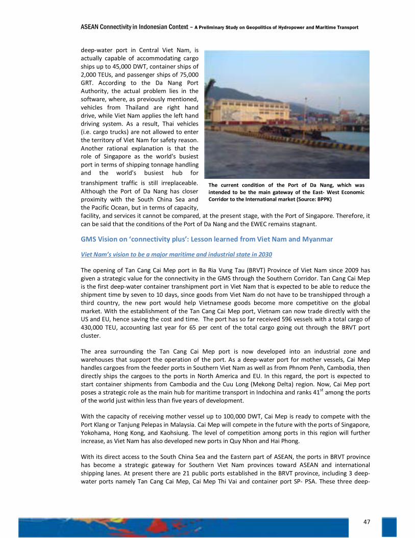
ASEAN Connectivity in Indonesian Context – A Preliminary Study on Geopolitics of Hydropower and Maritime Transport
47
deep-water port in Central Viet Nam, is actually capable of accommodating cargo ships up to 45,000 DWT, container ships of 2,000 TEUs, and passenger ships of 75,000 GRT. According to the Da Nang Port Authority, the actual problem lies in the software, where, as previously mentioned, vehicles from Thailand are right hand drive, while Viet Nam applies the left hand driving system. As a result, Thai vehicles (i.e. cargo trucks) are not allowed to enter the territory of Viet Nam for safety reason. Another rational explanation is that the role of Singapore as the world's busiest port in terms of shipping tonnage handling and the world's busiest hub for transhipment traffic is still irreplaceable. Although the Port of Da Nang has closer proximity with the South China Sea and the Pacific Ocean, but in terms of capacity, facility, and services it cannot be compared, at the present stage, with the Port of Singapore. Therefore, it can be said that the conditions of the Port of Da Nang and the EWEC remains stagnant.
GMS Vision on ‘connectivity plus’: Lesson learned from Viet Nam and Myanmar
Viet Nam’s vision to be a major maritime and industrial state in 2030
The opening of Tan Cang Cai Mep port in Ba Ria Vung Tau (BRVT) Province of Viet Nam since 2009 has given a strategic value for the connectivity in the GMS through the Southern Corridor. Tan Cang Cai Mep is the first deep-water container transhipment port in Viet Nam that is expected to be able to reduce the shipment time by seven to 10 days, since goods from Viet Nam do not have to be transhipped through a third country, the new port would help Vietnamese goods become more competitive on the global market. With the establishment of the Tan Cang Cai Mep port, Vietnam can now trade directly with the US and EU, hence saving the cost and time. The port has so far received 596 vessels with a total cargo of 430,000 TEU, accounting last year for 65 per cent of the total cargo going out through the BRVT port cluster.
The area surrounding the Tan Cang Cai Mep port is now developed into an industrial zone and warehouses that support the operation of the port. As a deep-water port for mother vessels, Cai Mep handles cargoes from the feeder ports in Southern Viet Nam as well as from Phnom Penh, Cambodia, then directly ships the cargoes to the ports in North America and EU. In this regard, the port is expected to start container shipments from Cambodia and the Cuu Long (Mekong Delta) region. Now, Cai Mep port poses a strategic role as the main hub for maritime transport in Indochina and ranks 41st among the ports of the world just within less than five years of development.
With the capacity of receiving mother vessel up to 100,000 DWT, Cai Mep is ready to compete with the Port Klang or Tanjung Pelepas in Malaysia. Cai Mep will compete in the future with the ports of Singapore, Yokohama, Hong Kong, and Kaohsiung. The level of competition among ports in this region will further increase, as Viet Nam has also developed new ports in Quy Nhon and Hai Phong.
With its direct access to the South China Sea and the Eastern part of ASEAN, the ports in BRVT province has become a strategic gateway for Southern Viet Nam provinces toward ASEAN and international shipping lanes. At present there are 21 public ports established in the BRVT province, including 3 deep-water ports namely Tan Cang Cai Mep, Cai Mep Thi Vai and container port SP- PSA. These three deep-
The current condition of the Port of Da Nang, which was intended to be the main gateway of the East- West Economic Corridor to the International market (Source: BPPK)
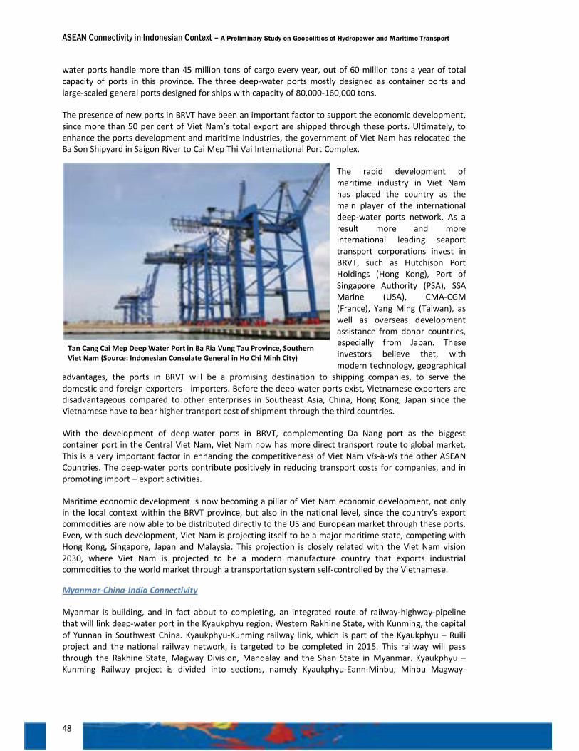
ASEAN Connectivity in Indonesian Context – A Preliminary Study on Geopolitics of Hydropower and Maritime Transport
48
water ports handle more than 45 million tons of cargo every year, out of 60 million tons a year of total capacity of ports in this province. The three deep-water ports mostly designed as container ports and large-scaled general ports designed for ships with capacity of 80,000-160,000 tons.
The presence of new ports in BRVT have been an important factor to support the economic development, since more than 50 per cent of Viet Nam’s total export are shipped through these ports. Ultimately, to enhance the ports development and maritime industries, the government of Viet Nam has relocated the Ba Son Shipyard in Saigon River to Cai Mep Thi Vai International Port Complex.
The rapid development of maritime industry in Viet Nam has placed the country as the main player of the international deep-water ports network. As a result more and more international leading seaport transport corporations invest in BRVT, such as Hutchison Port Holdings (Hong Kong), Port of Singapore Authority (PSA), SSA Marine (USA), CMA-CGM (France), Yang Ming (Taiwan), as well as overseas development assistance from donor countries, especially from Japan. These investors believe that, with modern technology, geographical
advantages, the ports in BRVT will be a promising destination to shipping companies, to serve the domestic and foreign exporters - importers. Before the deep-water ports exist, Vietnamese exporters are disadvantageous compared to other enterprises in Southeast Asia, China, Hong Kong, Japan since the Vietnamese have to bear higher transport cost of shipment through the third countries.
With the development of deep-water ports in BRVT, complementing Da Nang port as the biggest container port in the Central Viet Nam, Viet Nam now has more direct transport route to global market. This is a very important factor in enhancing the competitiveness of Viet Nam vis-à-vis the other ASEAN Countries. The deep-water ports contribute positively in reducing transport costs for companies, and in promoting import – export activities.
Maritime economic development is now becoming a pillar of Viet Nam economic development, not only in the local context within the BRVT province, but also in the national level, since the country’s export commodities are now able to be distributed directly to the US and European market through these ports. Even, with such development, Viet Nam is projecting itself to be a major maritime state, competing with Hong Kong, Singapore, Japan and Malaysia. This projection is closely related with the Viet Nam vision 2030, where Viet Nam is projected to be a modern manufacture country that exports industrial commodities to the world market through a transportation system self-controlled by the Vietnamese.
Myanmar-China-India Connectivity
Myanmar is building, and in fact about to completing, an integrated route of railway-highway-pipeline that will link deep-water port in the Kyaukphyu region, Western Rakhine State, with Kunming, the capital of Yunnan in Southwest China. Kyaukphyu-Kunming railway link, which is part of the Kyaukphyu – Ruili project and the national railway network, is targeted to be completed in 2015. This railway will pass through the Rakhine State, Magway Division, Mandalay and the Shan State in Myanmar. Kyaukphyu – Kunming Railway project is divided into sections, namely Kyaukphyu-Eann-Minbu, Minbu Magway-
Tan Cang Cai Mep Deep Water Port in Ba Ria Vung Tau Province, Southern Viet Nam (Source: Indonesian Consulate General in Ho Chi Minh City)
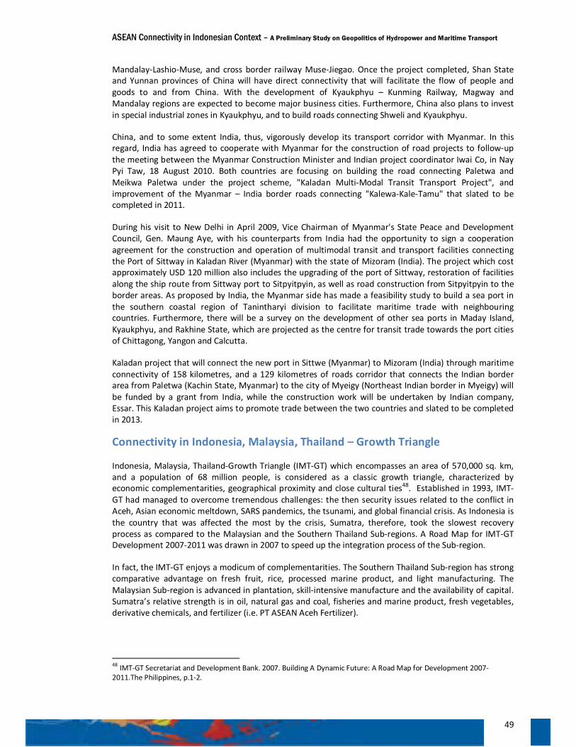
ASEAN Connectivity in Indonesian Context – A Preliminary Study on Geopolitics of Hydropower and Maritime Transport
49
Mandalay-Lashio-Muse, and cross border railway Muse-Jiegao. Once the project completed, Shan State and Yunnan provinces of China will have direct connectivity that will facilitate the flow of people and goods to and from China. With the development of Kyaukphyu – Kunming Railway, Magway and Mandalay regions are expected to become major business cities. Furthermore, China also plans to invest in special industrial zones in Kyaukphyu, and to build roads connecting Shweli and Kyaukphyu.
China, and to some extent India, thus, vigorously develop its transport corridor with Myanmar. In this regard, India has agreed to cooperate with Myanmar for the construction of road projects to follow-up the meeting between the Myanmar Construction Minister and Indian project coordinator Iwai Co, in Nay Pyi Taw, 18 August 2010. Both countries are focusing on building the road connecting Paletwa and Meikwa Paletwa under the project scheme, "Kaladan Multi-Modal Transit Transport Project", and improvement of the Myanmar – India border roads connecting "Kalewa-Kale-Tamu" that slated to be completed in 2011.
During his visit to New Delhi in April 2009, Vice Chairman of Myanmar's State Peace and Development Council, Gen. Maung Aye, with his counterparts from India had the opportunity to sign a cooperation agreement for the construction and operation of multimodal transit and transport facilities connecting the Port of Sittway in Kaladan River (Myanmar) with the state of Mizoram (India). The project which cost approximately USD 120 million also includes the upgrading of the port of Sittway, restoration of facilities along the ship route from Sittway port to Sitpyitpyin, as well as road construction from Sitpyitpyin to the border areas. As proposed by India, the Myanmar side has made a feasibility study to build a sea port in the southern coastal region of Tanintharyi division to facilitate maritime trade with neighbouring countries. Furthermore, there will be a survey on the development of other sea ports in Maday Island, Kyaukphyu, and Rakhine State, which are projected as the centre for transit trade towards the port cities of Chittagong, Yangon and Calcutta.
Kaladan project that will connect the new port in Sittwe (Myanmar) to Mizoram (India) through maritime connectivity of 158 kilometres, and a 129 kilometres of roads corridor that connects the Indian border area from Paletwa (Kachin State, Myanmar) to the city of Myeigy (Northeast Indian border in Myeigy) will be funded by a grant from India, while the construction work will be undertaken by Indian company, Essar. This Kaladan project aims to promote trade between the two countries and slated to be completed in 2013.
Connectivity in Indonesia, Malaysia, Thailand – Growth Triangle
Indonesia, Malaysia, Thailand-Growth Triangle (IMT-GT) which encompasses an area of 570,000 sq. km, and a population of 68 million people, is considered as a classic growth triangle, characterized by economic complementarities, geographical proximity and close cultural ties48. Established in 1993, IMT-GT had managed to overcome tremendous challenges: the then security issues related to the conflict in Aceh, Asian economic meltdown, SARS pandemics, the tsunami, and global financial crisis. As Indonesia is the country that was affected the most by the crisis, Sumatra, therefore, took the slowest recovery process as compared to the Malaysian and the Southern Thailand Sub-regions. A Road Map for IMT-GT Development 2007-2011 was drawn in 2007 to speed up the integration process of the Sub-region.
In fact, the IMT-GT enjoys a modicum of complementarities. The Southern Thailand Sub-region has strong comparative advantage on fresh fruit, rice, processed marine product, and light manufacturing. The Malaysian Sub-region is advanced in plantation, skill-intensive manufacture and the availability of capital. Sumatra’s relative strength is in oil, natural gas and coal, fisheries and marine product, fresh vegetables, derivative chemicals, and fertilizer (i.e. PT ASEAN Aceh Fertilizer).
48 IMT-GT Secretariat and Development Bank. 2007. Building A Dynamic Future: A Road Map for Development 2007-2011.The Philippines, p.1-2.
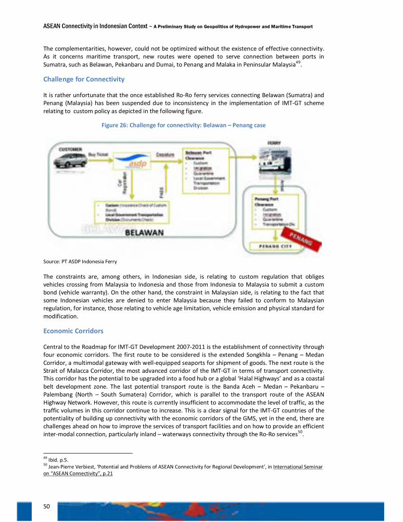
ASEAN Connectivity in Indonesian Context – A Preliminary Study on Geopolitics of Hydropower and Maritime Transport
50
The complementarities, however, could not be optimized without the existence of effective connectivity. As it concerns maritime transport, new routes were opened to serve connection between ports in Sumatra, such as Belawan, Pekanbaru and Dumai, to Penang and Malaka in Peninsular Malaysia49.
Challenge for Connectivity
It is rather unfortunate that the once established Ro-Ro ferry services connecting Belawan (Sumatra) and Penang (Malaysia) has been suspended due to inconsistency in the implementation of IMT-GT scheme relating to custom policy as depicted in the following figure.
Figure 26: Challenge for connectivity: Belawan – Penang case
Source: PT ASDP Indonesia Ferry
The constraints are, among others, in Indonesian side, is relating to custom regulation that obliges vehicles crossing from Malaysia to Indonesia and those from Indonesia to Malaysia to submit a custom bond (vehicle warranty). On the other hand, the constraint in Malaysian side, is relating to the fact that some Indonesian vehicles are denied to enter Malaysia because they failed to conform to Malaysian regulation, for instance, those relating to vehicle age limitation, vehicle emission and physical standard for modification.
Economic Corridors
Central to the Roadmap for IMT-GT Development 2007-2011 is the establishment of connectivity through four economic corridors. The first route to be considered is the extended Songkhla – Penang – Medan Corridor, a multimodal gateway with well-equipped seaports for shipment of goods. The next route is the Strait of Malacca Corridor, the most advanced corridor of the IMT-GT in terms of transport connectivity. This corridor has the potential to be upgraded into a food hub or a global ‘Halal Highways’ and as a coastal belt development zone. The last potential transport route is the Banda Aceh – Medan – Pekanbaru – Palembang (North – South Sumatera) Corridor, which is parallel to the transport route of the ASEAN Highway Network. However, this route is currently insufficient to accommodate the level of traffic, as the traffic volumes in this corridor continue to increase. This is a clear signal for the IMT-GT countries of the potentiality of building up connectivity with the economic corridors of the GMS, yet in the end, there are challenges ahead on how to improve the services of transport facilities and on how to provide an efficient inter-modal connection, particularly inland – waterways connectivity through the Ro-Ro services50.
49 Ibid. p.5. 50 Jean-Pierre Verbiest, ‘Potential and Problems of ASEAN Connectivity for Regional Development’, in International Seminar on “ASEAN Connectivity”, p.21
ASEAN Connectivity in Indonesian Context – A Preliminary Study on Geopolitics of Hydropower and Maritime Transport
51
Another daunting issue is how to narrow the infrastructure gap between the Straits of Melaka Economic Corridor and Banda Aceh-Medan-Pekanbaru-Palembang Economic Corridor. Study by ADB in 2007 revealed that the North-South corridor in Sumatra was (and is) hardly able to cope with the increasing traffic volume. The average travel speed in Sumatra corridor is about 50 km/hour. The average travel speed in Strait of Malacca corridor (the highway connecting Southern Thailand to Peninsular Malaysia) is almost 100 km/hour51.
Figure 27: IMT-GT Economic Connectivity Corridors
This gap must be addressed immediately by improving the road and bridge condition along the Trans-Sumatra Highway, which is, in some parts, marred with heavy damages and susceptible to landslides. The slow speed is also due to unstandardized road width, which varies from 10 to 5 meter (bottlenecking)53; zigzag type of road (i.e. ‘Kelok Delapan’ in Limapuluh Kota regency, West Sumatra); the absence of ring road or by-pass so that the traffic should pass through major cities such as in Jambi or Pekanbaru; and, last but not least, the unstandardized maximum tonnage of vehicle.
51 ADB, 2007, Expanding Horizon: A Study on the Development of the Indonesia, Malaysia, Thailand Growth-Triangle Economic Connectivity Corridors, p. iv. 53 Ibid, p.18.
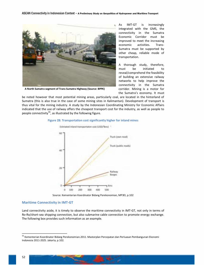
ASEAN Connectivity in Indonesian Context – A Preliminary Study on Geopolitics of Hydropower and Maritime Transport
52
As IMT-GT is increasingly integrated with the GMS, the connectivity in the Sumatra Economic Corridor must be improved to meet the increasing economic activities. Trans-Sumatra must be supported by other cheap, reliable mode of transportation.
A thorough study, therefore, must be initiated to reveal/comprehend the feasibility of building an extensive railway networks to help improve the connectivity in the Sumatra corridor. Mining is a motor for the Sumatra’s economy. It must
be noted however that most potential mining areas, particularly coal, are located in the hinterland of Sumatra (this is also true in the case of some mining sites in Kalimantan). Development of transport is thus vital for the mining industry. A study by the Indonesian Coordinating Ministry for Economic Affairs indicated that the use of railway offers the cheapest transport cost for the industry, as well as people to people connectivity56, as illustrated by the following figure.
Figure 28: Transportation cost significantly higher for inland mines
Source: Kementerian Koordinator Bidang Perekonomian, MP3EI, p.102
Maritime Connectivity in IMT-GT
Land connectivity aside, it is timely to observe the maritime connectivity in IMT-GT, not only in terms of Ro-Ro/short-sea shipping connection, but also submarine cable connection to promote energy exchange. The following box provides such information as an example.
56 Kementerian Koordinator Bidang Perekonomian.2011. Masterplan Percepatan dan Perluasan Pembangunan Ekonomi Indonesia 2011-2025. Jakarta, p.102.
A North Sumatra segment of Trans Sumatra Highway (Source: BPPK)
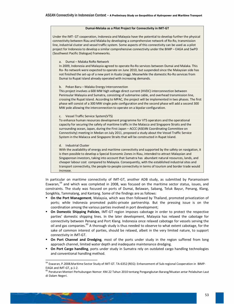
ASEAN Connectivity in Indonesian Context – A Preliminary Study on Geopolitics of Hydropower and Maritime Transport
53
Dumai-Melaka as a Pilot Project for Connectivity in IMT-GT
Under the IMT- GT cooperation, Indonesia and Malaysia have the potential to develop further the physical connectivity between Riau and Malaka by developing a comprehensive network of Ro-Ro, transmission line, industrial cluster and vessel traffic system. Some aspects of this connectivity can be used as a pilot project for Indonesia to develop a similar comprehensive connectivity under the BIMP – EAGA and SwPD (Southwest Pacific Dialogue) frameworks.
a. Dumai – Malaka RoRo Network In 2009, Indonesia and Malaysia agreed to operate Ro-Ro services between Dumai and Malaka. This Ro- Ro network were expected to operate on June 2010, but suspended since the Malaysian side has not finished the set-up of a new port in Kuala Linggi. Meanwhile the domestic Ro-Ro services from Dumai to Rupat Island already operated with increasing demands. b. Pekan Baru – Malaka Energy Interconnection This project involves a 600 MW high voltage direct current (HVDC) interconnection between Peninsular Malaysia and Sumatra, consisting of submarine cable, and overhead transmission line, crossing the Rupat Island. According to MPAC, the project will be implemented in two phases. The first phase will consist of a 300 MW single pole configuration and the second phase will add a second 300 MW pole allowing the interconnection to operate on a bipolar configuration. c. Vessel Traffic Service System(VTS) To enhance human resources development programme for VTS operators and the operational capacity for securing the safety of maritime traffic in the Malacca and Singapore Straits and the surrounding ocean, Japan, during the First Japan – ACCC (ASEAN Coordinating Committee on Connectivity) meeting in Medan on July 2011, proposed a study about the Vessel Traffic Service System in the Malacca and Singapore Straits that will be constructed in Rupat Island. d. Industrial Cluster With the availability of energy and maritime connectivity and supported by the safety on navigation, it is then possible to develop a Special Economic Zones in Riau, intended to attract Malaysian and Singaporean investors, taking into account that Sumatra has abundant natural resources, lands, and cheaper labour cost compared to Malaysia. Consequently, with the established industrial sites and transport connectivity, the people-to-people connectivity in terms of tourism and border trade would increase.
In particular on maritime connectivity of IMT-GT, another ADB study, as submitted by Paramasivam Eswaran,59 and which was completed in 2008, was focused on the maritime sector status, issues, and constraints. The study was focused on ports of Dumai, Belawan, Sabang, Teluk Bayur, Penang, Klang, Songkhla, Tammalang, and Kantang. Some of the findings are as follows: On the Port Management, Malaysia, which was then followed by Thailand, promoted privatization of
ports; while Indonesia promoted public-private partnership. But the pressing issue is on the coordination among the various parties involved in port development;
On Domestic Shipping Policies, IMT-GT region imposes cabotage in order to protect the respective parties’ domestic shipping lines. In the later development, Malaysia has relaxed the cabotage for connectivity between Penang and Port Klang. Indonesia once relaxed cabotage for vessels serving the oil and gas companies.60 A thorough study is thus needed to observe to what extent cabotage, for the sake of common interest of parties, should be relaxed, albeit in the very limited nature, to support connectivity in IMT-GT.
On Port Channel and Dredging, most of the ports under study in the region suffered from long approach channel, limited water depth and inadequate maintenance dredging.
On Port Cargo handling, ports under study in Sumatra rely on outdated cargo handling technologies and conventional handling method.
59 Eswaran, P.2008.Maritime Sector Study of IMT-GT. TA-6352 (REG): Enhancement of Sub-regional Cooperation in BIMP-EAGA and IMT-GT, p.1-2. 60 Peraturan Menteri Perhubungan Nomor: KM.22 Tahun 2010 tentang Pengangkutan Barang/Muatan antar Pelabuhan Laut di Dalam Negeri.
ASEAN Connectivity in Indonesian Context – A Preliminary Study on Geopolitics of Hydropower and Maritime Transport
54
On Port Operational Efficiency, the operational performance of ports under study is not satisfactory. On Custom Facilitation, there is no standardized practice and procedure in IMT-GT region. On Port Traffic Potential, all ports under study, except Songkhla, is undergoing annual growth in
overall traffic between 7 to 13 per cent. On Port Services Pricing, ports need to be in tune with the modern practices of pricing. On Passenger Terminal Connectivity, improvements are needed for some ports in order to foster the
growth of tourism and of handling cruise vessels. On New Port Development and Cross-border Movement of Containers, the development of ports at
Pakbara (in the Southern Thailand), and the development of ports in Dawei and Kyaukphyu in Myanmar as well as the completion of the Trans Asian Railways will have important impact on maritime connectivity in the IMT-GT region.
As it concerns the development of economic corridor of Sumatra under the Master Plan of Acceleration and Expansion of Indonesia Economic Development (MP3EI) all of the above focuses on the maritime sector status, issues, and constraints, must be addressed accordingly. Under Indonesian Master Plan (MP3EI), the development of Sumatra corridor will be focused on agriculture production and industry, as well as centre for energy development both at the national level and beyond. As such, the development of maritime connectivity, inland connectivity, and electricity in Sumatra would be a prerequisite for helping the Sumatra corridor fit-in into the greater ASEAN Connectivity.
Prospect of Aceh as a Hub for Indonesia – Myanmar Connectivity
Located at the Westernmost of Indonesia and bordered by Andaman Sea to the North, the Indian Ocean to the West and South, and the Strait of Malacca to the East, Aceh has strategic position to develop inter-states ASEAN Ro-Ro, or short-sea shipping network, both within the framework of the IMT-GT sub-region, or between the IMT-GT and the GMS. Even in the context of "connectivity plus" Aceh is very strategic to reach India, in particular to the Andaman - Nicobar Islands which is only approximately 150 km or 93 nautical miles from Banda Aceh. Beyond the Andaman – Nicobar Islands towards the North, this ferry line could reach the port of Kyaukphyu in Myanmar, a deep-water port which is currently being developed by China. As it concerns the Chinese interest on access to the Indian Ocean, the development of a deep-water port at Kyaukphyu would have strategic implication because it could bypass the Straits of Malacca, as currently, the supply of energy to China from the Middle East should sail the Indian Ocean, passing through the Straits of Malacca, before it reaches China’s ports in South China Sea. The Kyaukphyu-Kunming economic corridor, in which China has invested a lot, will consist of gas pipelines, railroads, and highways, that directly connect Kyaukphyu with Yunnan, China. Thus, the oil and other goods from the Indian Ocean could be unloaded in Kyaukphyu then sent off to the China’s interior61. It is, therefore, connectivity from Aceh to Kyaukphyu via Andaman-Nicobar islands would provide a strategic logistical road that connects Indonesia with the Southern Part of China via Myanmar.
Feasibility study on the development of Ro-Ro network connectivity, particularly between Aceh - Kyaukphyu, as part of the implementation of Master Plan on ASEAN Connectivity can be considered as an effort to enhance ASEAN connectivity in order to narrow the connectivity development gap between the mainland and the archipelagic sub-regions of ASEAN. Moreover both Aceh and Myanmar have just opened the isolation caused by the natural disasters and domestic political conditions, so that they need the better connectivity to support their economic development and develop trade, investment, tourism and people-to-people exchanges, as well as an effort to realize the people oriented ASEAN Community.
The Ro-Ro connectivity or short sea-shipping between Aceh and Kyaukphyu, and the possible extension to Yunnan, is considered more efficient as compared to the traditional land connectivity via Singapore-Peninsular Malaysia. Land transport connectivity through Singapore - Malaysia - Thailand – Myanmar is not only farther, but also less efficient because it must pass through the customs, immigration and
61 Besides Kyaukphyu, China also builds deepwater ports namely Gwadar in Baluchistan (Pakistan), Chittagong in Bangladesh, and Hambantotta in Sri Lanka (http://syedsoutsidethebox.blogspot.com/2010/10/china-encircles-globe.html)
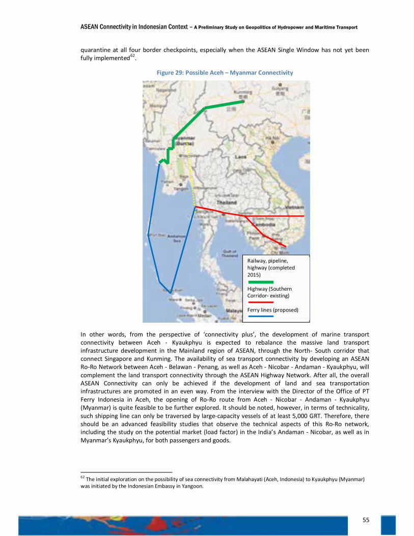
ASEAN Connectivity in Indonesian Context – A Preliminary Study on Geopolitics of Hydropower and Maritime Transport
55
quarantine at all four border checkpoints, especially when the ASEAN Single Window has not yet been fully implemented62.
Figure 29: Possible Aceh – Myanmar Connectivity
In other words, from the perspective of ‘connectivity plus’, the development of marine transport connectivity between Aceh - Kyaukphyu is expected to rebalance the massive land transport infrastructure development in the Mainland region of ASEAN, through the North- South corridor that connect Singapore and Kunming. The availability of sea transport connectivity by developing an ASEAN Ro-Ro Network between Aceh - Belawan - Penang, as well as Aceh - Nicobar - Andaman - Kyaukphyu, will complement the land transport connectivity through the ASEAN Highway Network. After all, the overall ASEAN Connectivity can only be achieved if the development of land and sea transportation infrastructures are promoted in an even way. From the interview with the Director of the Office of PT Ferry Indonesia in Aceh, the opening of Ro-Ro route from Aceh - Nicobar - Andaman - Kyaukphyu (Myanmar) is quite feasible to be further explored. It should be noted, however, in terms of technicality, such shipping line can only be traversed by large-capacity vessels of at least 5,000 GRT. Therefore, there should be an advanced feasibility studies that observe the technical aspects of this Ro-Ro network, including the study on the potential market (load factor) in the India’s Andaman - Nicobar, as well as in Myanmar’s Kyaukphyu, for both passengers and goods.
62 The initial exploration on the possibility of sea connectivity from Malahayati (Aceh, Indonesia) to Kyaukphyu (Myanmar) was initiated by the Indonesian Embassy in Yangoon.
Railway, pipeline, highway (completed 2015) Highway (Southern Corridor- existing) Ferry lines (proposed)
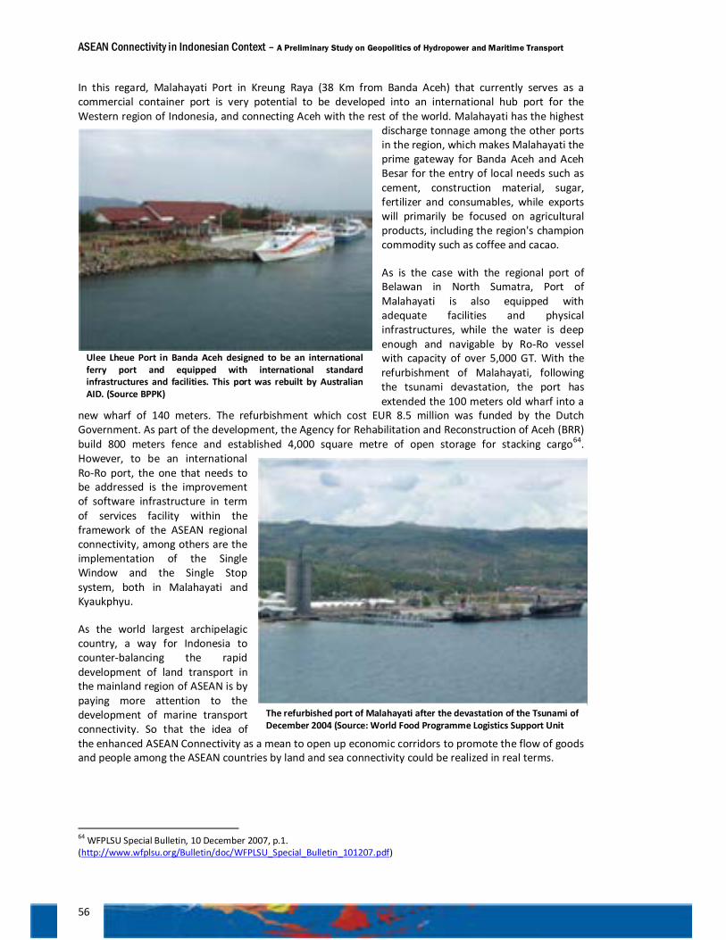
ASEAN Connectivity in Indonesian Context – A Preliminary Study on Geopolitics of Hydropower and Maritime Transport
56
In this regard, Malahayati Port in Kreung Raya (38 Km from Banda Aceh) that currently serves as a commercial container port is very potential to be developed into an international hub port for the Western region of Indonesia, and connecting Aceh with the rest of the world. Malahayati has the highest
discharge tonnage among the other ports in the region, which makes Malahayati the prime gateway for Banda Aceh and Aceh Besar for the entry of local needs such as cement, construction material, sugar, fertilizer and consumables, while exports will primarily be focused on agricultural products, including the region's champion commodity such as coffee and cacao.
As is the case with the regional port of Belawan in North Sumatra, Port of Malahayati is also equipped with adequate facilities and physical infrastructures, while the water is deep enough and navigable by Ro-Ro vessel with capacity of over 5,000 GT. With the refurbishment of Malahayati, following the tsunami devastation, the port has extended the 100 meters old wharf into a
new wharf of 140 meters. The refurbishment which cost EUR 8.5 million was funded by the Dutch Government. As part of the development, the Agency for Rehabilitation and Reconstruction of Aceh (BRR) build 800 meters fence and established 4,000 square metre of open storage for stacking cargo64. However, to be an international Ro-Ro port, the one that needs to be addressed is the improvement of software infrastructure in term of services facility within the framework of the ASEAN regional connectivity, among others are the implementation of the Single Window and the Single Stop system, both in Malahayati and Kyaukphyu.
As the world largest archipelagic country, a way for Indonesia to counter-balancing the rapid development of land transport in the mainland region of ASEAN is by paying more attention to the development of marine transport connectivity. So that the idea of the enhanced ASEAN Connectivity as a mean to open up economic corridors to promote the flow of goods and people among the ASEAN countries by land and sea connectivity could be realized in real terms.
64 WFPLSU Special Bulletin, 10 December 2007, p.1. (http://www.wfplsu.org/Bulletin/doc/WFPLSU_Special_Bulletin_101207.pdf)
Ulee Lheue Port in Banda Aceh designed to be an international ferry port and equipped with international standard infrastructures and facilities. This port was rebuilt by Australian AID. (Source BPPK)
The refurbished port of Malahayati after the devastation of the Tsunami of December 2004 (Source: World Food Programme Logistics Support Unit
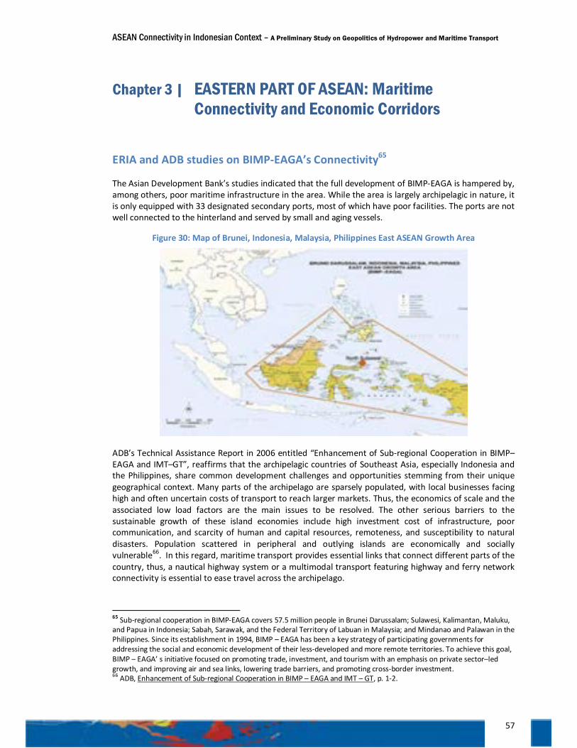
ASEAN Connectivity in Indonesian Context – A Preliminary Study on Geopolitics of Hydropower and Maritime Transport
57
Chapter 3 | EASTERN PART OF ASEAN: Maritime Connectivity and Economic Corridors
ERIA and ADB studies on BIMP-EAGA’s Connectivity65
The Asian Development Bank’s studies indicated that the full development of BIMP-EAGA is hampered by, among others, poor maritime infrastructure in the area. While the area is largely archipelagic in nature, it is only equipped with 33 designated secondary ports, most of which have poor facilities. The ports are not well connected to the hinterland and served by small and aging vessels.
Figure 30: Map of Brunei, Indonesia, Malaysia, Philippines East ASEAN Growth Area
ADB’s Technical Assistance Report in 2006 entitled “Enhancement of Sub-regional Cooperation in BIMP–EAGA and IMT–GT”, reaffirms that the archipelagic countries of Southeast Asia, especially Indonesia and the Philippines, share common development challenges and opportunities stemming from their unique geographical context. Many parts of the archipelago are sparsely populated, with local businesses facing high and often uncertain costs of transport to reach larger markets. Thus, the economics of scale and the associated low load factors are the main issues to be resolved. The other serious barriers to the sustainable growth of these island economies include high investment cost of infrastructure, poor communication, and scarcity of human and capital resources, remoteness, and susceptibility to natural disasters. Population scattered in peripheral and outlying islands are economically and socially vulnerable66. In this regard, maritime transport provides essential links that connect different parts of the country, thus, a nautical highway system or a multimodal transport featuring highway and ferry network connectivity is essential to ease travel across the archipelago.
65 Sub-regional cooperation in BIMP-EAGA covers 57.5 million people in Brunei Darussalam; Sulawesi, Kalimantan, Maluku, and Papua in Indonesia; Sabah, Sarawak, and the Federal Territory of Labuan in Malaysia; and Mindanao and Palawan in the Philippines. Since its establishment in 1994, BIMP – EAGA has been a key strategy of participating governments for addressing the social and economic development of their less-developed and more remote territories. To achieve this goal, BIMP – EAGA’ s initiative focused on promoting trade, investment, and tourism with an emphasis on private sector–led growth, and improving air and sea links, lowering trade barriers, and promoting cross-border investment. 66 ADB, Enhancement of Sub-regional Cooperation in BIMP – EAGA and IMT – GT, p. 1-2.
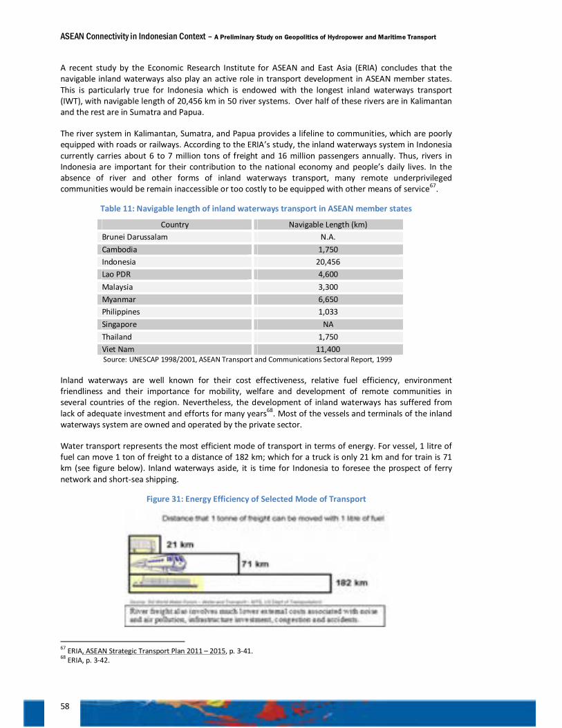
ASEAN Connectivity in Indonesian Context – A Preliminary Study on Geopolitics of Hydropower and Maritime Transport
58
A recent study by the Economic Research Institute for ASEAN and East Asia (ERIA) concludes that the navigable inland waterways also play an active role in transport development in ASEAN member states. This is particularly true for Indonesia which is endowed with the longest inland waterways transport (IWT), with navigable length of 20,456 km in 50 river systems. Over half of these rivers are in Kalimantan and the rest are in Sumatra and Papua.
The river system in Kalimantan, Sumatra, and Papua provides a lifeline to communities, which are poorly equipped with roads or railways. According to the ERIA’s study, the inland waterways system in Indonesia currently carries about 6 to 7 million tons of freight and 16 million passengers annually. Thus, rivers in Indonesia are important for their contribution to the national economy and people’s daily lives. In the absence of river and other forms of inland waterways transport, many remote underprivileged communities would be remain inaccessible or too costly to be equipped with other means of service67.
Table 11: Navigable length of inland waterways transport in ASEAN member states
Country Navigable Length (km) Brunei Darussalam N.A. Cambodia 1,750 Indonesia 20,456 Lao PDR 4,600 Malaysia 3,300 Myanmar 6,650 Philippines 1,033 Singapore NA Thailand 1,750 Viet Nam 11,400 Source: UNESCAP 1998/2001, ASEAN Transport and Communications Sectoral Report, 1999
Inland waterways are well known for their cost effectiveness, relative fuel efficiency, environment friendliness and their importance for mobility, welfare and development of remote communities in several countries of the region. Nevertheless, the development of inland waterways has suffered from lack of adequate investment and efforts for many years68. Most of the vessels and terminals of the inland waterways system are owned and operated by the private sector.
Water transport represents the most efficient mode of transport in terms of energy. For vessel, 1 litre of fuel can move 1 ton of freight to a distance of 182 km; which for a truck is only 21 km and for train is 71 km (see figure below). Inland waterways aside, it is time for Indonesia to foresee the prospect of ferry network and short-sea shipping.
Figure 31: Energy Efficiency of Selected Mode of Transport
67 ERIA, ASEAN Strategic Transport Plan 2011 – 2015, p. 3-41. 68 ERIA, p. 3-42.
ASEAN Connectivity in Indonesian Context – A Preliminary Study on Geopolitics of Hydropower and Maritime Transport
59
The presence of the two largest archipelagos, Indonesia and the Philippines as the members of BIMP–EAGA, has made this sub-regional cooperation unique compared to the GMS. In BIMP-EAGA, ferry network and short-sea shipping have been, and should be, the primary transport corridors. Learning from the GMS experience, the problem for BIMP-EAGA is how to transform this maritime transport corridor into full-fledged economic corridors, to speed up the development in the remote parts of the sub-region, and to make growth more inclusive. Thus, the task of the government is to build a physical connectivity that comprises of highway and ferry network, known as nautical highway system, in this sub-region. At the same time, it is important for the government to develop an integrated policy on the transportation of goods and people in the most effective and efficient manner. Efficient transport system is of paramount important in the development of the border trading opportunity and people-to-people contacts that benefit all member countries, which includes states and provinces in the BIMP-EAGA.
The ADB study also confirmed that regional cooperation in BIMP-EAGA is noteworthy because it is not just sub-regional cooperation but also sub-national one. Islands that make up BIMP-EAGA are mostly closer to one another than to their respective capitals, implying greater potential for trade amongst themselves, or directly with the external world, than to trade with other fellow provinces in their own countries69. Therefore, different strategy is required to BIMP- EAGA Sub-regional cooperation, as compared to mainland ASEAN, in order to promote ASEAN regional cooperation and overall connectivity.
In 2006, BIMP-EAGA formulated its transport sector strategy and action plan, which emphasized the crucial role of cross-border air, sea and land transport connectivity in achieving BIMP-EAGA’s objective of stimulating economic activity by encouraging intra and extra BIMP-EAGA trade, investment, and tourism movement in their sub-region70. Furthermore, in 2007, the BIMP-EAGA Transport Ministers reached three transport agreements aimed at facilitating cross-border air, sea, and land connectivity. These include (i) the landmark "open skies" agreement, granting the fifth freedom of traffic rights to the selected major international airports in the sub-region; (ii) the memorandum of understanding in facilitating the cross-border movement of buses and coaches; and (iii) the memorandum of understanding in strengthening cooperation on the expansion of sea linkages and the establishment of pioneer sea routes and gateway ports. The transport sector strategy also proposed the adoption of the economic corridor concept as a means for facilitating the development of transport networks within the sub-region, namely, the Western Borneo Economic Corridor (WBEC) and the Greater Sulu Sulawesi Corridor (GSSC).
The recent development on connectivity within the BIMP-EAGA was made in the 7th Summit on May 2011 in Jakarta, Indonesia, where leaders acknowledged that for the past 17 years, BIMP-EAGA has served as a vital mechanism in the process of actualizing BIMP-EAGA collective vision and confident of its continued significance in such crucial initiatives particularly in transport connectivity, and trade facilitation71.
In this connection, Coordinating Minister for Economic Affairs of Indonesia underlined that while on sea linkages, roll-on roll-off (Ro-Ro) services between Brunei Darussalam and Malaysia have already been commenced, a study to expand the Ro-Ro network in BIMP-EAGA will be carried out72. The study seeks to align the Ro-Ro priorities of BIMP-EAGA with that of the ASEAN Ro-Ro network as part of the implementation of priority projects and key actions of the MPAC. Ultimately, it is expected that the ASEAN Ro-Ro network would link the intra-BIMP-EAGA shipping routes into one seamless connected region and therefore will support the development of domestic connectivity, transportation, and infrastructure of the six economic corridors of Indonesia of which four are located in Eastern Part of Indonesia and part of BIMP-EAGA sub-region.
69 ADB, p.2. 70 BIMP – EAGA, Roadmap to Development 2006 – 2010, p. 2. 71 Opening statement by H.E. Benigno Simeon Aquino III, President of the Philippines at the 7th BIMP-EAGA Summit in Jakarta 72 Roll-on/Roll-off (Ro-Ro) is vessel designed to carry wheeled cargo such as automobiles, trucks, semi-trailer trucks, trailers, or railroad cars that are driven on and off the ship on their own wheels.
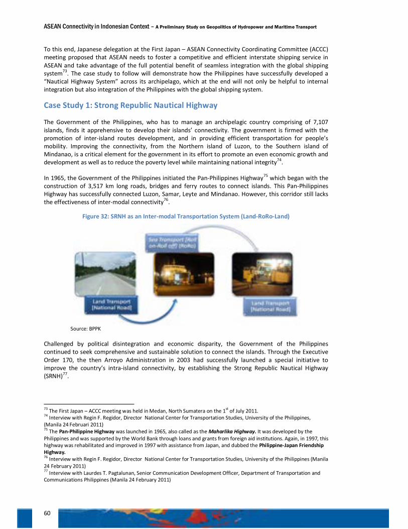
ASEAN Connectivity in Indonesian Context – A Preliminary Study on Geopolitics of Hydropower and Maritime Transport
60
To this end, Japanese delegation at the First Japan – ASEAN Connectivity Coordinating Committee (ACCC) meeting proposed that ASEAN needs to foster a competitive and efficient interstate shipping service in ASEAN and take advantage of the full potential benefit of seamless integration with the global shipping system73. The case study to follow will demonstrate how the Philippines have successfully developed a “Nautical Highway System” across its archipelago, which at the end will not only be helpful to internal integration but also integration of the Philippines with the global shipping system.
Case Study 1: Strong Republic Nautical Highway
The Government of the Philippines, who has to manage an archipelagic country comprising of 7,107 islands, finds it apprehensive to develop their islands’ connectivity. The government is firmed with the promotion of inter-island routes development, and in providing efficient transportation for people’s mobility. Improving the connectivity, from the Northern island of Luzon, to the Southern island of Mindanao, is a critical element for the government in its effort to promote an even economic growth and development as well as to reduce the poverty level while maintaining national integrity74.
In 1965, the Government of the Philippines initiated the Pan-Philippines Highway75 which began with the construction of 3,517 km long roads, bridges and ferry routes to connect islands. This Pan-Philippines Highway has successfully connected Luzon, Samar, Leyte and Mindanao. However, this corridor still lacks the effectiveness of inter-modal connectivity76.
Figure 32: SRNH as an Inter-modal Transportation System (Land-RoRo-Land)
Source: BPPK
Challenged by political disintegration and economic disparity, the Government of the Philippines continued to seek comprehensive and sustainable solution to connect the islands. Through the Executive Order 170, the then Arroyo Administration in 2003 had successfully launched a special initiative to improve the country’s intra-island connectivity, by establishing the Strong Republic Nautical Highway (SRNH)77.
73 The First Japan – ACCC meeting was held in Medan, North Sumatera on the 1st of July 2011. 74 Interview with Regin F. Regidor, Director National Center for Transportation Studies, University of the Philippines, (Manila 24 Februari 2011) 75 The Pan-Philippine Highway was launched in 1965, also called as the Maharlika Highway. It was developed by the Philippines and was supported by the World Bank through loans and grants from foreign aid institutions. Again, in 1997, this highway was rehabilitated and improved in 1997 with assistance from Japan, and dubbed the Philippine-Japan Friendship Highway. 76 Interview with Regin F. Regidor, Director National Center for Transportation Studies, University of the Philippines (Manila 24 February 2011) 77 Interview with Laurdes T. Pagtalunan, Senior Communication Development Officer, Department of Transportation and Communications Philippines (Manila 24 February 2011)
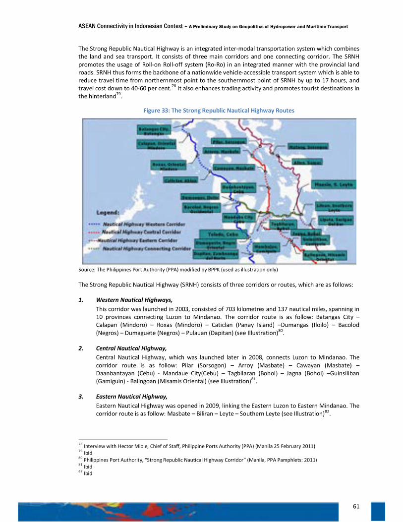
ASEAN Connectivity in Indonesian Context – A Preliminary Study on Geopolitics of Hydropower and Maritime Transport
61
The Strong Republic Nautical Highway is an integrated inter-modal transportation system which combines the land and sea transport. It consists of three main corridors and one connecting corridor. The SRNH promotes the usage of Roll-on Roll-off system (Ro-Ro) in an integrated manner with the provincial land roads. SRNH thus forms the backbone of a nationwide vehicle-accessible transport system which is able to reduce travel time from northernmost point to the southernmost point of SRNH by up to 17 hours, and travel cost down to 40-60 per cent.78 It also enhances trading activity and promotes tourist destinations in the hinterland79.
Figure 33: The Strong Republic Nautical Highway Routes
Source: The Philippines Port Authority (PPA) modified by BPPK (used as illustration only)
The Strong Republic Nautical Highway (SRNH) consists of three corridors or routes, which are as follows:
1. Western Nautical Highways, This corridor was launched in 2003, consisted of 703 kilometres and 137 nautical miles, spanning in 10 provinces connecting Luzon to Mindanao. The corridor route is as follow: Batangas City – Calapan (Mindoro) – Roxas (Mindoro) – Caticlan (Panay Island) –Dumangas (Iloilo) – Bacolod (Negros) – Dumaguete (Negros) – Pulauan (Dapitan) (see Illustration)80.
2. Central Nautical Highway, Central Nautical Highway, which was launched later in 2008, connects Luzon to Mindanao. The corridor route is as follow: Pilar (Sorsogon) – Arroy (Masbate) – Cawayan (Masbate) – Daanbantayan (Cebu) - Mandaue City(Cebu) – Tagbilaran (Bohol) – Jagna (Bohol) –Guinsiliban (Gamiguin) - Balingoan (Misamis Oriental) (see Illustration)81.
3. Eastern Nautical Highway, Eastern Nautical Highway was opened in 2009, linking the Eastern Luzon to Eastern Mindanao. The corridor route is as follow: Masbate – Biliran – Leyte – Southern Leyte (see Illustration)82.
78 Interview with Hector Miole, Chief of Staff, Philippine Ports Authority (PPA) (Manila 25 February 2011) 79 Ibid 80 Philippines Port Authority, “Strong Republic Nautical Highway Corridor” (Manila, PPA Pamphlets: 2011) 81 Ibid 82 Ibid
ASEAN Connectivity in Indonesian Context – A Preliminary Study on Geopolitics of Hydropower and Maritime Transport
62
To connect these three corridors, the Government of the Philippines has created a connecting corridor which is currently still under construction, in particular projects relating to expansions of ports and Ro-Ro networks along the designated corridor.
The Administration of the SRNH
The SRNH is managed under the coordination of the National Economic Development Authority (NEDA) and involving intra-departments and institutions arrangements. Those involved include the Department of Interior and Local Government, the Local Government Units (LGUs), the Department of Transportation and Communication (DoTC), the Department of Public Works and Highways (DPWH), the Department of Trade and Industry (DTI) and the Department of Agriculture83. Sailing authorization and ports facilities of the SRNH are operated by Maritime Industry Authority (MARINA) and the Philippines Ports Authority (PPA), both are under the Department of Transportation and Communication (DoTC)84.
In developing the routes and the necessary infrastructures, the government engages national banks, with the main participation of the Development Bank of the Philippines (DPB) that actively funds the construction of ports and roads, including the procurement of the Ro-Ro ferries85. The government also facilitates the cooperation between DPB with Japan International Bank, to fund SRNH infrastructures86.
The respective institutions, as mentioned above, are mandated with the following functions and authorities: 1. The National Economic Development Authority (NEDA) is to provide recommendation based on
studies and analysis in preparing the ‘blue-print’ and monitor the further development of SRNH. 2. The Department of Interior and Local Government is to ensure that there is no additional taxation
and fees levied to passengers and Ro-Ro ferries passing through the 65 Local Government Units in the SRNH routes.87
3. The Department of Transportation and Communication (DoTC) is to regulate transportation tariffs, monitor public and private ports authorities, monitor public and private ferries and Ro-Ro service provider, formulate SRNH policies, and to assess possible development of new routes with Department of Public Works and Highways (DPWH).
4. The Department of Public Works and Highways (DPWH) is to develop the land network of the SRNH, and to facilitate inter-modal connectivity.
5. The Department of Trade and Industry is to provide incentive to companies to open-up new routes, and integrating the SRNH with industrial sites and networks.
6. The Department of Agriculture is to integrate food distribution network into SRNH framework. 7. The Maritime Industry Authority (MARINA) is to issue license for ferry and Ro-Ro services. 8. The Philippines Ports Authority (PPA) is to manage and develop ports and its usage, in order to
maximize the outputs of the ports.
All of the above institutions are working closely together under the coordination of the National Economic Development Authority and guided directly by the President88. The SRNH provides a good example of coordination among stakeholders to collaborate in a systematic way. The central government is able to manage a good team work, consisting of related department and institutions, as the regulator of the SRNH. Meanwhile, the local government, society as well as private sectors work together in a clear and
83 Interview with Melvin Navaro, Director for Planning Services, Department of Public Works and Highways (DPWH), (Manila 25 February 2011) 84 Ibid 85 Ibid 86 Ibid 87 Based on Memorandum Circular no. 2006-70 (June 26, 2006). 88 Interview with Melvin Navaro, Director for Planning Services, Department of Public Works and Highways (DPWH), (Manila 25 February 2011)
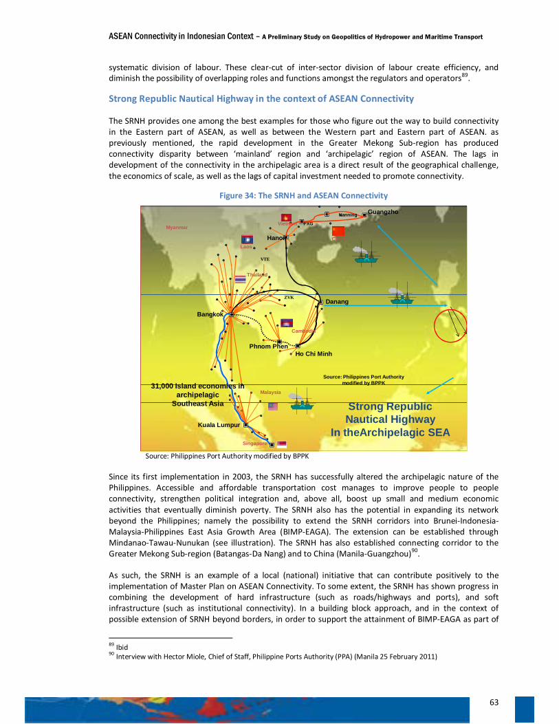
ASEAN Connectivity in Indonesian Context – A Preliminary Study on Geopolitics of Hydropower and Maritime Transport
63
systematic division of labour. These clear-cut of inter-sector division of labour create efficiency, and diminish the possibility of overlapping roles and functions amongst the regulators and operators89.
Strong Republic Nautical Highway in the context of ASEAN Connectivity
The SRNH provides one among the best examples for those who figure out the way to build connectivity in the Eastern part of ASEAN, as well as between the Western part and Eastern part of ASEAN. as previously mentioned, the rapid development in the Greater Mekong Sub-region has produced connectivity disparity between ‘mainland’ region and ‘archipelagic’ region of ASEAN. The lags in development of the connectivity in the archipelagic area is a direct result of the geographical challenge, the economics of scale, as well as the lags of capital investment needed to promote connectivity.
Figure 34: The SRNH and ASEAN Connectivity
VTE
Singapore
Kuala Lumpur
Phnom Phen
Malaysia
Bangkok
Ho Chi Minh
VietnamzG
Laos
Myanmar
Danang
Guangzho
PXG
Cambodia
Hanoi China�í
Nanning
Thailand
ZVK
VTE
Strong RepublicNautical Highway
In theArchipelagic SEA
Source: Philippines Port Authority modified by BPPK31,000 Island economies in
archipelagicSoutheast Asia
Source: Philippines Port Authority modified by BPPK
Since its first implementation in 2003, the SRNH has successfully altered the archipelagic nature of the Philippines. Accessible and affordable transportation cost manages to improve people to people connectivity, strengthen political integration and, above all, boost up small and medium economic activities that eventually diminish poverty. The SRNH also has the potential in expanding its network beyond the Philippines; namely the possibility to extend the SRNH corridors into Brunei-Indonesia-Malaysia-Philippines East Asia Growth Area (BIMP-EAGA). The extension can be established through Mindanao-Tawau-Nunukan (see illustration). The SRNH has also established connecting corridor to the Greater Mekong Sub-region (Batangas-Da Nang) and to China (Manila-Guangzhou)90.
As such, the SRNH is an example of a local (national) initiative that can contribute positively to the implementation of Master Plan on ASEAN Connectivity. To some extent, the SRNH has shown progress in combining the development of hard infrastructure (such as roads/highways and ports), and soft infrastructure (such as institutional connectivity). In a building block approach, and in the context of possible extension of SRNH beyond borders, in order to support the attainment of BIMP-EAGA as part of
89 Ibid 90 Interview with Hector Miole, Chief of Staff, Philippine Ports Authority (PPA) (Manila 25 February 2011)
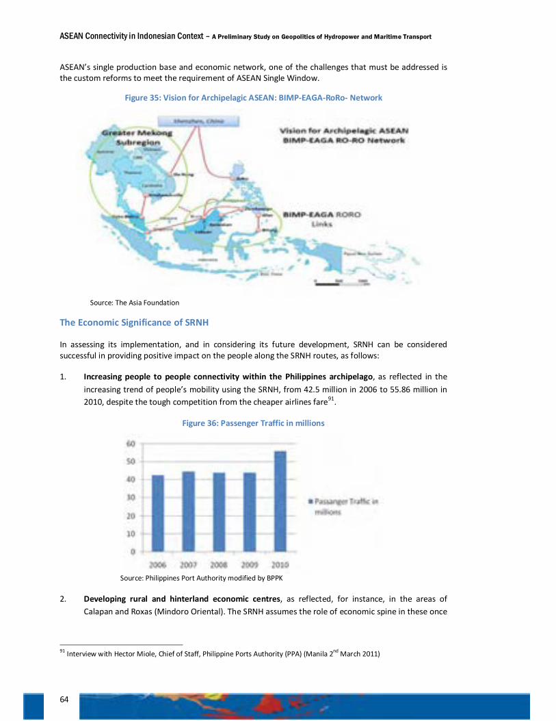
ASEAN Connectivity in Indonesian Context – A Preliminary Study on Geopolitics of Hydropower and Maritime Transport
64
ASEAN’s single production base and economic network, one of the challenges that must be addressed is the custom reforms to meet the requirement of ASEAN Single Window.
Figure 35: Vision for Archipelagic ASEAN: BIMP-EAGA-RoRo- Network
Source: The Asia Foundation
The Economic Significance of SRNH
In assessing its implementation, and in considering its future development, SRNH can be considered successful in providing positive impact on the people along the SRNH routes, as follows:
1. Increasing people to people connectivity within the Philippines archipelago, as reflected in the increasing trend of people’s mobility using the SRNH, from 42.5 million in 2006 to 55.86 million in 2010, despite the tough competition from the cheaper airlines fare91.
Figure 36: Passenger Traffic in millions
Source: Philippines Port Authority modified by BPPK
2. Developing rural and hinterland economic centres, as reflected, for instance, in the areas of Calapan and Roxas (Mindoro Oriental). The SRNH assumes the role of economic spine in these once
91 Interview with Hector Miole, Chief of Staff, Philippine Ports Authority (PPA) (Manila 2nd March 2011)
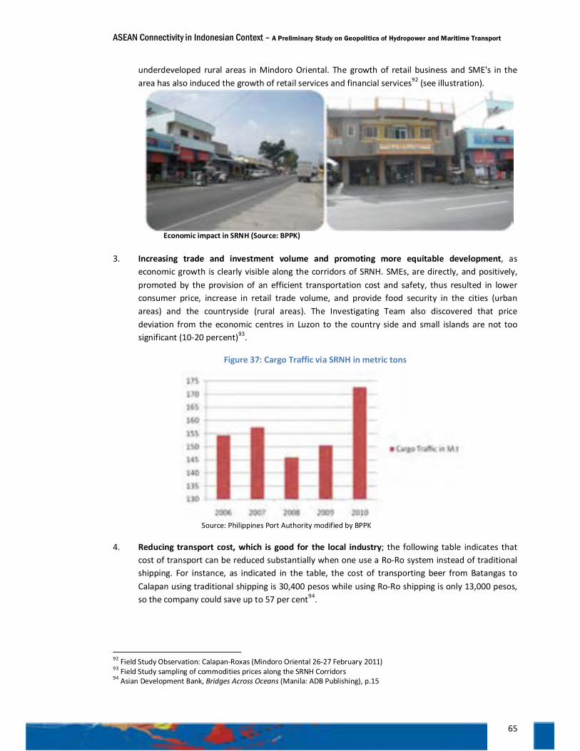
ASEAN Connectivity in Indonesian Context – A Preliminary Study on Geopolitics of Hydropower and Maritime Transport
65
underdeveloped rural areas in Mindoro Oriental. The growth of retail business and SME's in the area has also induced the growth of retail services and financial services92 (see illustration).
Economic impact in SRNH (Source: BPPK)
3. Increasing trade and investment volume and promoting more equitable development, as economic growth is clearly visible along the corridors of SRNH. SMEs, are directly, and positively, promoted by the provision of an efficient transportation cost and safety, thus resulted in lower consumer price, increase in retail trade volume, and provide food security in the cities (urban areas) and the countryside (rural areas). The Investigating Team also discovered that price deviation from the economic centres in Luzon to the country side and small islands are not too significant (10-20 percent)93.
Figure 37: Cargo Traffic via SRNH in metric tons
Source: Philippines Port Authority modified by BPPK
4. Reducing transport cost, which is good for the local industry; the following table indicates that cost of transport can be reduced substantially when one use a Ro-Ro system instead of traditional shipping. For instance, as indicated in the table, the cost of transporting beer from Batangas to Calapan using traditional shipping is 30,400 pesos while using Ro-Ro shipping is only 13,000 pesos, so the company could save up to 57 per cent94.
92 Field Study Observation: Calapan-Roxas (Mindoro Oriental 26-27 February 2011) 93 Field Study sampling of commodities prices along the SRNH Corridors 94 Asian Development Bank, Bridges Across Oceans (Manila: ADB Publishing), p.15
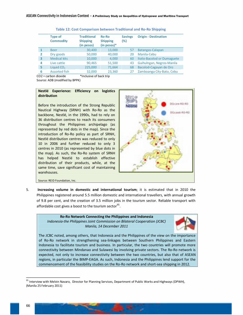
ASEAN Connectivity in Indonesian Context – A Preliminary Study on Geopolitics of Hydropower and Maritime Transport
66
Table 12: Cost Comparison between Traditional and Ro-Ro Shipping
Type of Commodity
Traditional Shipping (in pesos)
Ro-Ro Shipping (in pesos)*
Savings (%)
Origin - Destination
1 Beer 30,400 13,000 57 Batangas-Calapan 2 Dry goods 50,000 40,000 20 Manila-Cebu 3 Medical kits 10,000 4,000 60 Iloilo-Bacolod or Dumaguete 4 Live cattle 90,465 51,500 43 Guihulngan, Negros-Manila 5 Liquid CO2 225,000 71,664 68 Bacolod-Cagayan de Oro 6 Assorted fish 32,000 23,360 27 Zamboanga City-Bato, Cebu
CO2 = carbon dioxide *Inclusive of back trip Source: ADB (modified by BPPK)
5. Increasing volume in domestic and international tourism; it is estimated that in 2010 the Philippines registered around 5.5 million domestic and international travellers, with annual growth of 9.8 per cent, and the creation of 3.5 million jobs in the tourism sector. Reliable transport with affordable cost gives a boost to the tourism sector95.
Ro-Ro Network Connecting the Philippines and Indonesia
Indonesia-the Philippines Joint Commission on Bilateral Cooperation (JCBC) Manila, 14 December 2011
The JCBC noted, among others, that Indonesia and the Philippines of the view on the importance of Ro-Ro network in strengthening sea-linkages between Southern Philippines and Eastern Indonesia to facilitate tourism and business. In particular, the two countries will promote more connectivity between Mindanao and Sulawesi by involving private sectors. The Ro-Ro network is expected, not only to increase connectivity between the two countries, but also that of ASEAN regions, in particular the BIMP-EAGA. As such, Indonesia and the Philippines lend support for the commencement of the feasibility studies on the Ro-Ro network and short-sea shipping in 2012.
95 Interview with Melvin Navaro, Director for Planning Services, Department of Public Works and Highways (DPWH), (Manila 25 February 2011)
Nestlé Experience: Efficiency on logistics distribution Before the introduction of the Strong Republic Nautical Highway (SRNH) with Ro-Ro as the backbone, Nestlé, in the 1990s, had to rely on 36 distribution centres to reach its consumers throughout the Philippines archipelago (as represented by red dots in the map). Since the introduction of Ro-Ro policy as part of SRNH, Nestlé distribution centres was reduced to only 10 in 2006 and further reduced to only 3 centres in 2010 (as represented by blue dots in the map). As such, the Ro-Ro system of SRNH has helped Nestlé to establish effective distribution of their products, while, at the same time, save significant cost of maintaining warehouses. Source: REID Foundation, Inc.
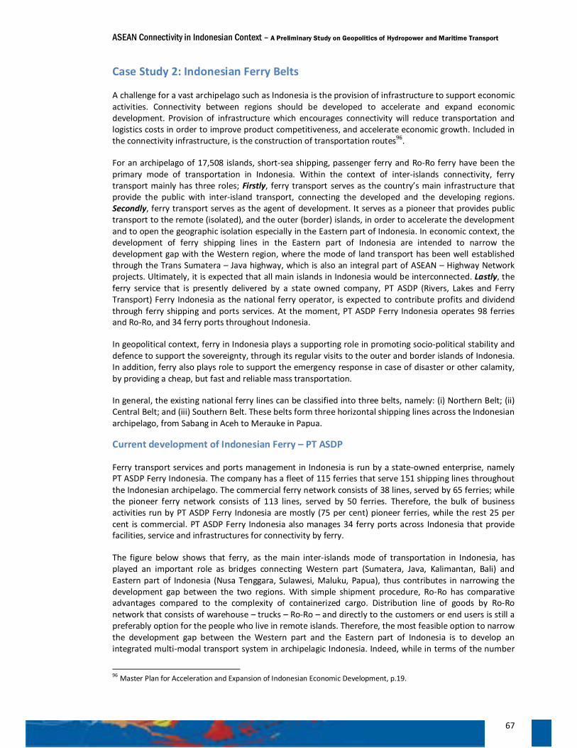
ASEAN Connectivity in Indonesian Context – A Preliminary Study on Geopolitics of Hydropower and Maritime Transport
67
Case Study 2: Indonesian Ferry Belts
A challenge for a vast archipelago such as Indonesia is the provision of infrastructure to support economic activities. Connectivity between regions should be developed to accelerate and expand economic development. Provision of infrastructure which encourages connectivity will reduce transportation and logistics costs in order to improve product competitiveness, and accelerate economic growth. Included in the connectivity infrastructure, is the construction of transportation routes96.
For an archipelago of 17,508 islands, short-sea shipping, passenger ferry and Ro-Ro ferry have been the primary mode of transportation in Indonesia. Within the context of inter-islands connectivity, ferry transport mainly has three roles; Firstly, ferry transport serves as the country’s main infrastructure that provide the public with inter-island transport, connecting the developed and the developing regions. Secondly, ferry transport serves as the agent of development. It serves as a pioneer that provides public transport to the remote (isolated), and the outer (border) islands, in order to accelerate the development and to open the geographic isolation especially in the Eastern part of Indonesia. In economic context, the development of ferry shipping lines in the Eastern part of Indonesia are intended to narrow the development gap with the Western region, where the mode of land transport has been well established through the Trans Sumatera – Java highway, which is also an integral part of ASEAN – Highway Network projects. Ultimately, it is expected that all main islands in Indonesia would be interconnected. Lastly, the ferry service that is presently delivered by a state owned company, PT ASDP (Rivers, Lakes and Ferry Transport) Ferry Indonesia as the national ferry operator, is expected to contribute profits and dividend through ferry shipping and ports services. At the moment, PT ASDP Ferry Indonesia operates 98 ferries and Ro-Ro, and 34 ferry ports throughout Indonesia.
In geopolitical context, ferry in Indonesia plays a supporting role in promoting socio-political stability and defence to support the sovereignty, through its regular visits to the outer and border islands of Indonesia. In addition, ferry also plays role to support the emergency response in case of disaster or other calamity, by providing a cheap, but fast and reliable mass transportation.
In general, the existing national ferry lines can be classified into three belts, namely: (i) Northern Belt; (ii) Central Belt; and (iii) Southern Belt. These belts form three horizontal shipping lines across the Indonesian archipelago, from Sabang in Aceh to Merauke in Papua.
Current development of Indonesian Ferry – PT ASDP
Ferry transport services and ports management in Indonesia is run by a state-owned enterprise, namely PT ASDP Ferry Indonesia. The company has a fleet of 115 ferries that serve 151 shipping lines throughout the Indonesian archipelago. The commercial ferry network consists of 38 lines, served by 65 ferries; while the pioneer ferry network consists of 113 lines, served by 50 ferries. Therefore, the bulk of business activities run by PT ASDP Ferry Indonesia are mostly (75 per cent) pioneer ferries, while the rest 25 per cent is commercial. PT ASDP Ferry Indonesia also manages 34 ferry ports across Indonesia that provide facilities, service and infrastructures for connectivity by ferry.
The figure below shows that ferry, as the main inter-islands mode of transportation in Indonesia, has played an important role as bridges connecting Western part (Sumatera, Java, Kalimantan, Bali) and Eastern part of Indonesia (Nusa Tenggara, Sulawesi, Maluku, Papua), thus contributes in narrowing the development gap between the two regions. With simple shipment procedure, Ro-Ro has comparative advantages compared to the complexity of containerized cargo. Distribution line of goods by Ro-Ro network that consists of warehouse – trucks – Ro-Ro – and directly to the customers or end users is still a preferably option for the people who live in remote islands. Therefore, the most feasible option to narrow the development gap between the Western part and the Eastern part of Indonesia is to develop an integrated multi-modal transport system in archipelagic Indonesia. Indeed, while in terms of the number
96 Master Plan for Acceleration and Expansion of Indonesian Economic Development, p.19.
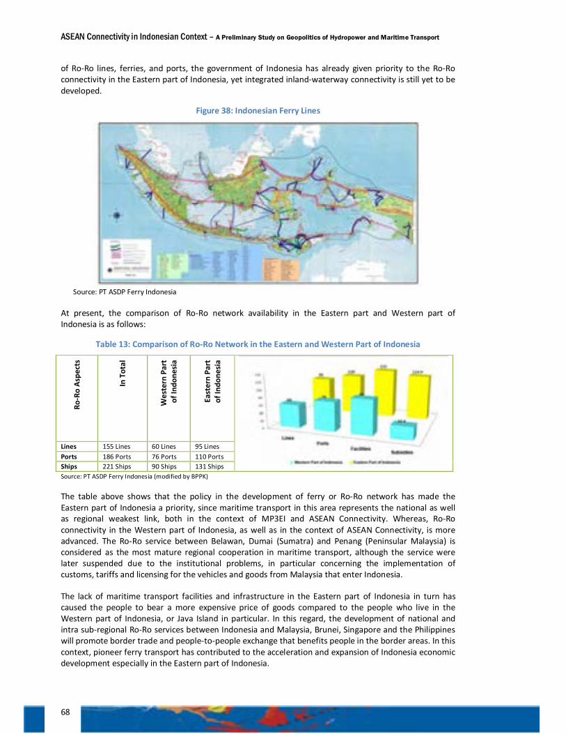
ASEAN Connectivity in Indonesian Context – A Preliminary Study on Geopolitics of Hydropower and Maritime Transport
68
of Ro-Ro lines, ferries, and ports, the government of Indonesia has already given priority to the Ro-Ro connectivity in the Eastern part of Indonesia, yet integrated inland-waterway connectivity is still yet to be developed.
Figure 38: Indonesian Ferry Lines
Source: PT ASDP Ferry Indonesia
At present, the comparison of Ro-Ro network availability in the Eastern part and Western part of Indonesia is as follows:
Table 13: Comparison of Ro-Ro Network in the Eastern and Western Part of Indonesia
Ro-R
o As
pect
s
In T
otal
Wes
tern
Par
t of
Indo
nesi
a
East
ern
Part
of
Indo
nesi
a
Lines 155 Lines 60 Lines 95 Lines Ports 186 Ports 76 Ports 110 Ports Ships 221 Ships 90 Ships 131 Ships Source: PT ASDP Ferry Indonesia (modified by BPPK)
The table above shows that the policy in the development of ferry or Ro-Ro network has made the Eastern part of Indonesia a priority, since maritime transport in this area represents the national as well as regional weakest link, both in the context of MP3EI and ASEAN Connectivity. Whereas, Ro-Ro connectivity in the Western part of Indonesia, as well as in the context of ASEAN Connectivity, is more advanced. The Ro-Ro service between Belawan, Dumai (Sumatra) and Penang (Peninsular Malaysia) is considered as the most mature regional cooperation in maritime transport, although the service were later suspended due to the institutional problems, in particular concerning the implementation of customs, tariffs and licensing for the vehicles and goods from Malaysia that enter Indonesia.
The lack of maritime transport facilities and infrastructure in the Eastern part of Indonesia in turn has caused the people to bear a more expensive price of goods compared to the people who live in the Western part of Indonesia, or Java Island in particular. In this regard, the development of national and intra sub-regional Ro-Ro services between Indonesia and Malaysia, Brunei, Singapore and the Philippines will promote border trade and people-to-people exchange that benefits people in the border areas. In this context, pioneer ferry transport has contributed to the acceleration and expansion of Indonesia economic development especially in the Eastern part of Indonesia.
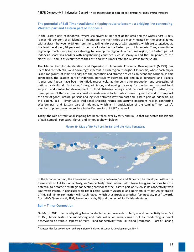
ASEAN Connectivity in Indonesian Context – A Preliminary Study on Geopolitics of Hydropower and Maritime Transport
69
The potential of Bali-Timor traditional shipping route to become a bridging line connecting Western part and Eastern part of Indonesia
In the Eastern part of Indonesia, where sea covers 83 per cent of the area and the waters host 11,056 islands (63 per cent of all islands of Indonesia), the main cities are mostly located on the coastal zones with a distant between 0-15 km from the coastline. Moreover, of 123 regencies, which are categorized as the least developed, 62 per cent of them are located in the Eastern part of Indonesia. Thus, a maritime-region approach is required as a strategy to develop the region. As a maritime region, the Eastern part of Indonesia share sea-borders with neighbouring countries such as Malaysia and the Philippines to the North; PNG, and Pacific countries to the East, and with Timor Leste and Australia to the South.
The Master Plan for Acceleration and Expansion of Indonesia Economic Development (MP3EI) has identified the potentials and advantages inherent in each region throughout Indonesia, where each major island (or groups of major islands) has the potentials and strategic roles as an economic corridor. In this connection, the Eastern part of Indonesia, particularly Sulawesi, Bali and Nusa Tenggara, and Maluku Islands and Papua, have been identified, respectively, as the centre for production and processing of national agricultural, plantation, fishery, oil & gas, and mining; gateway for tourism and national food support; and centre for development of food, fisheries, energy, and national mining97. Indeed, the development of these economic corridors needs connectivity routes connecting each corridor to support the flow of goods, natural persons and logistics between Western part and Eastern part of Indonesia. To this extent, Bali – Timor Leste traditional shipping routes can assume important role in connecting Western part and Eastern part of Indonesia, which is, in anticipation of the coming Timor Leste’s membership, in connecting regions in the Eastern Part of ASEAN as well.
Today, the role of traditional shipping has been taken over by ferry and Ro-Ro that connected the islands of Bali, Lombok, Sumbawa, Flores, and Timor, as shown below:
Figure 39: Map of Ro-Ro Ports in Bali and the Nusa Tenggaras
In the broader context, the inter-islands connectivity between Bali and Timor can be developed within the framework of ASEAN Connectivity, or ‘connectivity plus’, where Bali – Nusa Tenggara corridor has the potential to become a strategic connecting corridor for the Eastern part of ASEAN in its connectivity with Southwest Pacific, in particular with Timor Leste, Western Australia and Northern Territory. An extension of this Bali-Timor connection will reach Papua, which thus provides another “connectivity plus” towards Australia’s Queensland, PNG, Solomon Islands, Fiji and the rest of Pacific islands states.
Bali – Timor Connection
On March 2011, the Investigating Team conducted a field research on ferry – land connectivity from Bali to Dili, Timor Leste. The monitoring and data collection were carried out by conducting a direct observation on various aspects of ferry – land connectivity from Bali Island (Denpasar – Port of Padang 97 Master Plan for acceleration and expansion of Indonesia Economic Development, p.46-47.
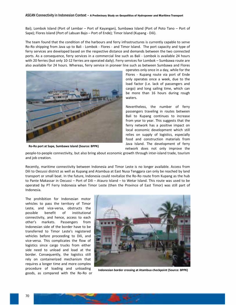
ASEAN Connectivity in Indonesian Context – A Preliminary Study on Geopolitics of Hydropower and Maritime Transport
70
Bai); Lombok Island (Port of Lembar – Port of Kayangan), Sumbawa Island (Port of Poto Tano – Port of Sape); Flores Island (Port of Labuan Bajo – Port of Ende); Timor Island (Kupang - Dili).
The team found that the condition of the harbours and ferry infrastructures is currently capable to serve Ro-Ro shipping from Java up to Bali - Lombok - Flores - and Timor Island. The port capacity and type of ferry services are developed based on the respective distance and demands between the two connected ports. As a consequence, ferry services in a commercial line such as Bali - Lombok is available 24 hours with 20 ferries (but only 10-12 ferries are operated daily). Ferry services for Lombok – Sumbawa route are also available for 24 hours. Whereas, ferry service in pioneer line such as between Sumbawa and Flores
operates only once in a day, while for the Flores - Kupang route via port of Ende only operates once a week, due to the load factor (i.e. lack of passengers and cargo) and long sailing time, which can be more than 16 hours during rough waters.
Nevertheless, the number of ferry passengers traveling in routes between Bali to Kupang continues to increase from year to year. This suggests that the ferry network has a positive impact on local economic development which still relies on supply of logistics, especially food and construction materials from Java Island. The development of ferry network does not only improve the
people-to-people connectivity, but also bring about economic growth through inter-island trade, tourism and job creation.
Recently, maritime connectivity between Indonesia and Timor Leste is no longer available. Access from Dili to Oecussi district as well as Kupang and Atambua at East Nusa Tenggara can only be reached by land transport or small boat. In the future, Indonesia could revitalize the Ro-Ro route from Kupang as the hub to Pante Makassar in Oecussi – Port of Dili – Atauro Island – to Wetar Island. This route was used to be operated by PT Ferry Indonesia when Timor Leste (then the Province of East Timor) was still part of Indonesia.
The prohibition for Indonesian motor vehicles to pass the territory of Timor Leste, and vice-versa, obstructs the possible benefit of institutional connectivity, and hence, access to each other’s markets. Passengers from Indonesian side of the border have to be transferred to Timor Leste’s registered vehicles before proceeding to Dili, and vice-versa. This complicates the flow of logistics since cargo trucks from either side need to unload and load at the border. Consequently, the logistics still rely on containerized mechanism that requires a longer time and more complex procedure of loading and unloading goods, as compared with the Ro-Ro or
Ro-Ro port at Sape, Sumbawa Island (Source: BPPK)
Indonesian border crossing at Atambua checkpoint (Source: BPPK)
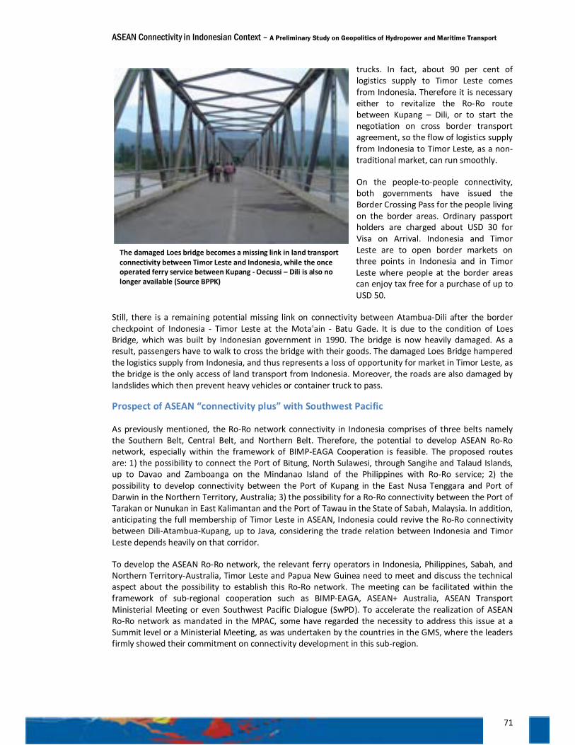
ASEAN Connectivity in Indonesian Context – A Preliminary Study on Geopolitics of Hydropower and Maritime Transport
71
trucks. In fact, about 90 per cent of logistics supply to Timor Leste comes from Indonesia. Therefore it is necessary either to revitalize the Ro-Ro route between Kupang – Dili, or to start the negotiation on cross border transport agreement, so the flow of logistics supply from Indonesia to Timor Leste, as a non-traditional market, can run smoothly.
On the people-to-people connectivity, both governments have issued the Border Crossing Pass for the people living on the border areas. Ordinary passport holders are charged about USD 30 for Visa on Arrival. Indonesia and Timor Leste are to open border markets on three points in Indonesia and in Timor Leste where people at the border areas can enjoy tax free for a purchase of up to USD 50.
Still, there is a remaining potential missing link on connectivity between Atambua-Dili after the border checkpoint of Indonesia - Timor Leste at the Mota'ain - Batu Gade. It is due to the condition of Loes Bridge, which was built by Indonesian government in 1990. The bridge is now heavily damaged. As a result, passengers have to walk to cross the bridge with their goods. The damaged Loes Bridge hampered the logistics supply from Indonesia, and thus represents a loss of opportunity for market in Timor Leste, as the bridge is the only access of land transport from Indonesia. Moreover, the roads are also damaged by landslides which then prevent heavy vehicles or container truck to pass.
Prospect of ASEAN “connectivity plus” with Southwest Pacific
As previously mentioned, the Ro-Ro network connectivity in Indonesia comprises of three belts namely the Southern Belt, Central Belt, and Northern Belt. Therefore, the potential to develop ASEAN Ro-Ro network, especially within the framework of BIMP-EAGA Cooperation is feasible. The proposed routes are: 1) the possibility to connect the Port of Bitung, North Sulawesi, through Sangihe and Talaud Islands, up to Davao and Zamboanga on the Mindanao Island of the Philippines with Ro-Ro service; 2) the possibility to develop connectivity between the Port of Kupang in the East Nusa Tenggara and Port of Darwin in the Northern Territory, Australia; 3) the possibility for a Ro-Ro connectivity between the Port of Tarakan or Nunukan in East Kalimantan and the Port of Tawau in the State of Sabah, Malaysia. In addition, anticipating the full membership of Timor Leste in ASEAN, Indonesia could revive the Ro-Ro connectivity between Dili-Atambua-Kupang, up to Java, considering the trade relation between Indonesia and Timor Leste depends heavily on that corridor.
To develop the ASEAN Ro-Ro network, the relevant ferry operators in Indonesia, Philippines, Sabah, and Northern Territory-Australia, Timor Leste and Papua New Guinea need to meet and discuss the technical aspect about the possibility to establish this Ro-Ro network. The meeting can be facilitated within the framework of sub-regional cooperation such as BIMP-EAGA, ASEAN+ Australia, ASEAN Transport Ministerial Meeting or even Southwest Pacific Dialogue (SwPD). To accelerate the realization of ASEAN Ro-Ro network as mandated in the MPAC, some have regarded the necessity to address this issue at a Summit level or a Ministerial Meeting, as was undertaken by the countries in the GMS, where the leaders firmly showed their commitment on connectivity development in this sub-region.
The damaged Loes bridge becomes a missing link in land transport connectivity between Timor Leste and Indonesia, while the once operated ferry service between Kupang - Oecussi – Dili is also no longer available (Source BPPK)
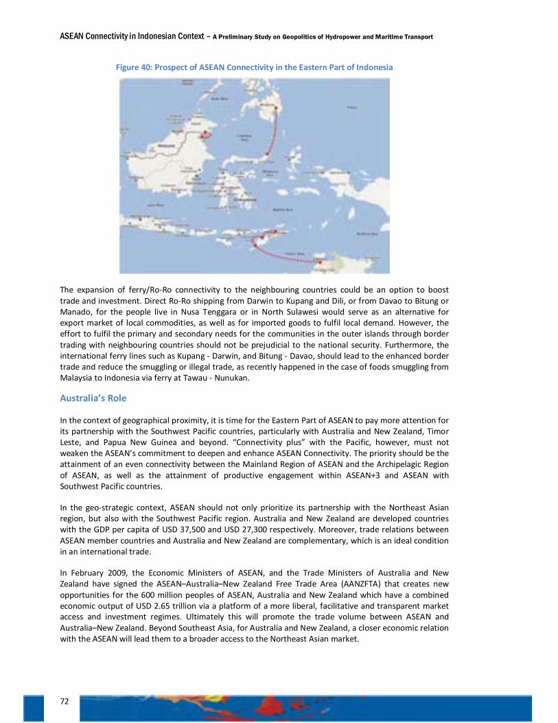
ASEAN Connectivity in Indonesian Context – A Preliminary Study on Geopolitics of Hydropower and Maritime Transport
72
Figure 40: Prospect of ASEAN Connectivity in the Eastern Part of Indonesia
The expansion of ferry/Ro-Ro connectivity to the neighbouring countries could be an option to boost trade and investment. Direct Ro-Ro shipping from Darwin to Kupang and Dili, or from Davao to Bitung or Manado, for the people live in Nusa Tenggara or in North Sulawesi would serve as an alternative for export market of local commodities, as well as for imported goods to fulfil local demand. However, the effort to fulfil the primary and secondary needs for the communities in the outer islands through border trading with neighbouring countries should not be prejudicial to the national security. Furthermore, the international ferry lines such as Kupang - Darwin, and Bitung - Davao, should lead to the enhanced border trade and reduce the smuggling or illegal trade, as recently happened in the case of foods smuggling from Malaysia to Indonesia via ferry at Tawau - Nunukan.
Australia’s Role
In the context of geographical proximity, it is time for the Eastern Part of ASEAN to pay more attention for its partnership with the Southwest Pacific countries, particularly with Australia and New Zealand, Timor Leste, and Papua New Guinea and beyond. “Connectivity plus” with the Pacific, however, must not weaken the ASEAN’s commitment to deepen and enhance ASEAN Connectivity. The priority should be the attainment of an even connectivity between the Mainland Region of ASEAN and the Archipelagic Region of ASEAN, as well as the attainment of productive engagement within ASEAN+3 and ASEAN with Southwest Pacific countries.
In the geo-strategic context, ASEAN should not only prioritize its partnership with the Northeast Asian region, but also with the Southwest Pacific region. Australia and New Zealand are developed countries with the GDP per capita of USD 37,500 and USD 27,300 respectively. Moreover, trade relations between ASEAN member countries and Australia and New Zealand are complementary, which is an ideal condition in an international trade.
In February 2009, the Economic Ministers of ASEAN, and the Trade Ministers of Australia and New Zealand have signed the ASEAN–Australia–New Zealand Free Trade Area (AANZFTA) that creates new opportunities for the 600 million peoples of ASEAN, Australia and New Zealand which have a combined economic output of USD 2.65 trillion via a platform of a more liberal, facilitative and transparent market access and investment regimes. Ultimately this will promote the trade volume between ASEAN and Australia–New Zealand. Beyond Southeast Asia, for Australia and New Zealand, a closer economic relation with the ASEAN will lead them to a broader access to the Northeast Asian market.

ASEAN Connectivity in Indonesian Context – A Preliminary Study on Geopolitics of Hydropower and Maritime Transport
73
Figure 41: Sea Lanes of Communication and National Sea Lanes
Source: MP3EI
To this extent, Indonesia, especially the Eastern part of Indonesia that poses the strategic geographic location, can benefit from its strategic cooperation with Australia, as well as New Zealand, PNG, and other Pacific islands states. Within the Indonesian archipelago, there are several sea lanes with high strategic value for both economic and military interest. These sea lanes are located in the Straits of Malacca, the Sunda Strait (ALKI 1), the Straits of Lombok and Makassar Straits (ALKI 2), and the Strait of Ombai Wetar (ALKI 3). Most of the world’s major shipping and cruise liners pass and use these sea lanes as part of their shipping routes. The next is how Indonesia maximizes the utilization of SLoC (Sea Lane of Communication) and Indonesia Archipelagic Sea Lanes (Alur Laut Kepulauan Indonesia-ALKI) to tap the benefits from these maritime advantages. It can begin by accelerating growth in various regions in Indonesia (especially in Eastern Indonesia), improve the maritime competitiveness, and enhance national security and economic sovereignty of Indonesia100. Besides the improved economic relations with Australia and New Zealand, another advantage that can be gained by the enhanced connectivity with Southwest Pacific region is in the context of people-to-people exchange, particularly in education, transfer of technology, job opportunities, and tourism industry.
In short, to promote the ASEAN overall connectivity, ASEAN and ASEAN Dialogue Partners should help Indonesia improve connectivity in the Eastern Part of Indonesia, and its connectivity with markets in Southwest Pacific region, such as in Timor Leste; Australia’s Queensland, Northern Territory, Western Australia; PNG, Solomon Island, Fiji, and other island states.
Challenges of “connectivity plus” with Southwest Pacific
An ADB study in 2007 reveals that challenges in the transport sectors in Southwest Pacific are: (1) long distance between ports; (2) small population and low density; (3) small trade volumes; (4) trade in-balances; and (5) inadequate port facilities101. These, as previously discussed, also represent the challenge for the maritime connectivity in the Eastern Part of ASEAN (and the Eastern Part of Indonesia as well). As it concern the economics of scale as the main challenge of small islands economies, the prospect of connectivity between Eastern Part of ASEAN and Southwest Pacific should carefully consider the economic features of each country in the Pacific.
100 MP3EI, p. 34. 101 ADB. 2007. Pacific Studies Series. “Oceanic Voyage: Shipping in the Pacific” ADB p. xi.
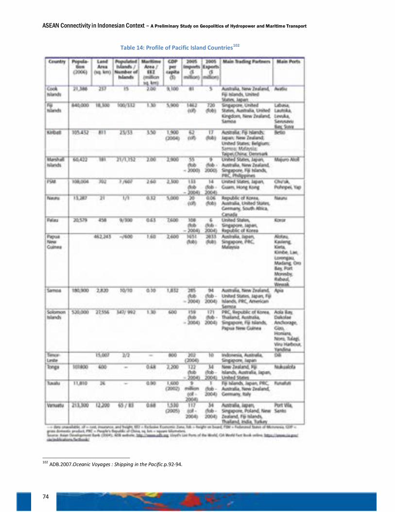
ASEAN Connectivity in Indonesian Context – A Preliminary Study on Geopolitics of Hydropower and Maritime Transport
74
Table 14: Profile of Pacific Island Countries102
102 ADB.2007.Oceanic Voyages : Shipping in the Pacific.p.92-94.
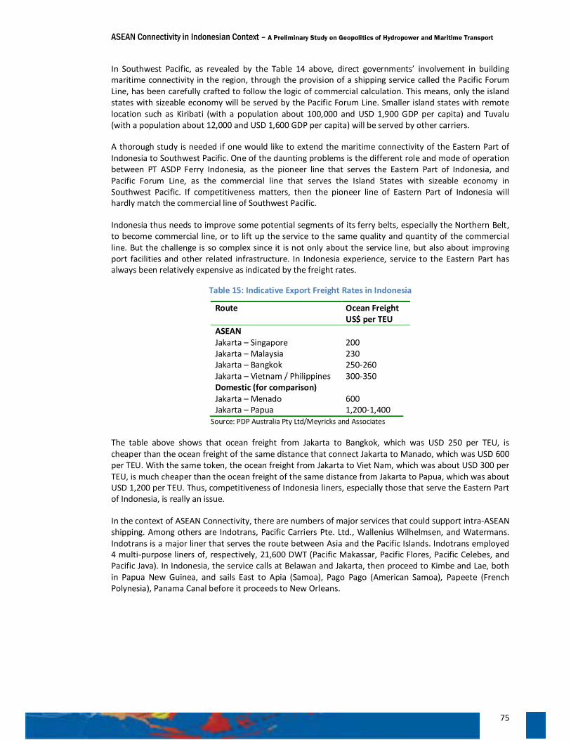
ASEAN Connectivity in Indonesian Context – A Preliminary Study on Geopolitics of Hydropower and Maritime Transport
75
In Southwest Pacific, as revealed by the Table 14 above, direct governments’ involvement in building maritime connectivity in the region, through the provision of a shipping service called the Pacific Forum Line, has been carefully crafted to follow the logic of commercial calculation. This means, only the island states with sizeable economy will be served by the Pacific Forum Line. Smaller island states with remote location such as Kiribati (with a population about 100,000 and USD 1,900 GDP per capita) and Tuvalu (with a population about 12,000 and USD 1,600 GDP per capita) will be served by other carriers.
A thorough study is needed if one would like to extend the maritime connectivity of the Eastern Part of Indonesia to Southwest Pacific. One of the daunting problems is the different role and mode of operation between PT ASDP Ferry Indonesia, as the pioneer line that serves the Eastern Part of Indonesia, and Pacific Forum Line, as the commercial line that serves the Island States with sizeable economy in Southwest Pacific. If competitiveness matters, then the pioneer line of Eastern Part of Indonesia will hardly match the commercial line of Southwest Pacific.
Indonesia thus needs to improve some potential segments of its ferry belts, especially the Northern Belt, to become commercial line, or to lift up the service to the same quality and quantity of the commercial line. But the challenge is so complex since it is not only about the service line, but also about improving port facilities and other related infrastructure. In Indonesia experience, service to the Eastern Part has always been relatively expensive as indicated by the freight rates.
Table 15: Indicative Export Freight Rates in Indonesia
Route Ocean Freight US$ per TEU
ASEAN Jakarta – Singapore 200 Jakarta – Malaysia 230 Jakarta – Bangkok 250-260 Jakarta – Vietnam / Philippines 300-350 Domestic (for comparison) Jakarta – Menado 600 Jakarta – Papua 1,200-1,400
Source: PDP Australia Pty Ltd/Meyricks and Associates
The table above shows that ocean freight from Jakarta to Bangkok, which was USD 250 per TEU, is cheaper than the ocean freight of the same distance that connect Jakarta to Manado, which was USD 600 per TEU. With the same token, the ocean freight from Jakarta to Viet Nam, which was about USD 300 per TEU, is much cheaper than the ocean freight of the same distance from Jakarta to Papua, which was about USD 1,200 per TEU. Thus, competitiveness of Indonesia liners, especially those that serve the Eastern Part of Indonesia, is really an issue.
In the context of ASEAN Connectivity, there are numbers of major services that could support intra-ASEAN shipping. Among others are Indotrans, Pacific Carriers Pte. Ltd., Wallenius Wilhelmsen, and Watermans. Indotrans is a major liner that serves the route between Asia and the Pacific Islands. Indotrans employed 4 multi-purpose liners of, respectively, 21,600 DWT (Pacific Makassar, Pacific Flores, Pacific Celebes, and Pacific Java). In Indonesia, the service calls at Belawan and Jakarta, then proceed to Kimbe and Lae, both in Papua New Guinea, and sails East to Apia (Samoa), Pago Pago (American Samoa), Papeete (French Polynesia), Panama Canal before it proceeds to New Orleans.
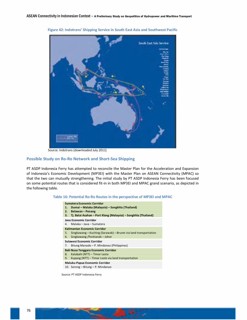
ASEAN Connectivity in Indonesian Context – A Preliminary Study on Geopolitics of Hydropower and Maritime Transport
76
Figure 42: Indotrans’ Shipping Service in South East Asia and Southwest Pacific
Source: Indotrans (downloaded July 2011)
Possible Study on Ro-Ro Network and Short-Sea Shipping
PT ASDP Indonesia Ferry has attempted to reconcile the Master Plan for the Acceleration and Expansion of Indonesia’s Economic Development (MP3EI) with the Master Plan on ASEAN Connectivity (MPAC) so that the two can mutually strengthening. The initial study by PT ASDP Indonesia Ferry has been focused on some potential routes that is considered fit-in in both MP3EI and MPAC grand scenario, as depicted in the following table.
Table 16: Potential Ro-Ro Routes in the perspective of MP3EI and MPAC
Sumatera Economic Corridor 1. Dumai – Malaka (Malaysia) – Songkhla (Thailand) 2. Belawan – Penang 3. Tj. Balai Asahan – Port Klang (Malaysia) – Songkhla (Thailand) Java Economic Corridor 4. Malaka – Java – Sumatera Kalimantan Economic Corridor 5. Singkawang – Kuching (Sarawak) – Brunei via land transportation 6. Singkawang /Pontianak – Johor Sulawesi Economic Corridor 7. Bitung Manado – P. Mindanao (Philippines) Bali-Nusa Tenggara Economic Corridor 8. Kalabahi (NTT) – Timor Leste 9. Kupang (NTT) – Timor Leste via land transportation Maluku-Papua Economic Corridor 10. Sorong – Bitung – P. Mindanao
Source: PT ASDP Indonesia Ferry
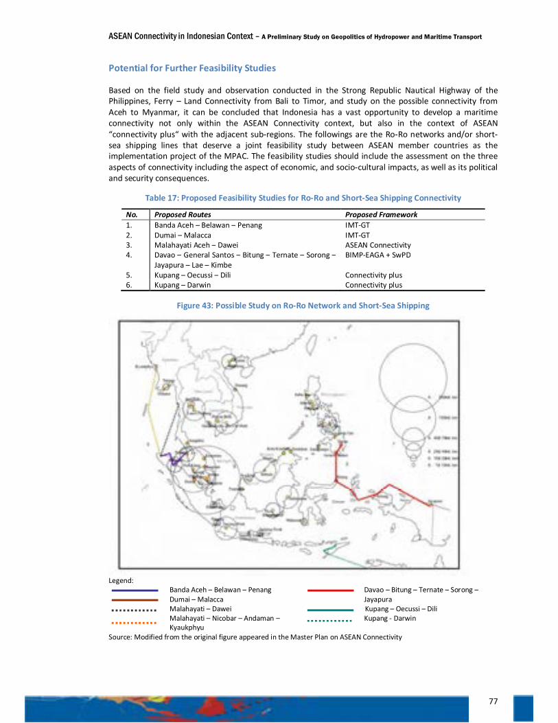
ASEAN Connectivity in Indonesian Context – A Preliminary Study on Geopolitics of Hydropower and Maritime Transport
77
Potential for Further Feasibility Studies
Based on the field study and observation conducted in the Strong Republic Nautical Highway of the Philippines, Ferry – Land Connectivity from Bali to Timor, and study on the possible connectivity from Aceh to Myanmar, it can be concluded that Indonesia has a vast opportunity to develop a maritime connectivity not only within the ASEAN Connectivity context, but also in the context of ASEAN “connectivity plus“ with the adjacent sub-regions. The followings are the Ro-Ro networks and/or short-sea shipping lines that deserve a joint feasibility study between ASEAN member countries as the implementation project of the MPAC. The feasibility studies should include the assessment on the three aspects of connectivity including the aspect of economic, and socio-cultural impacts, as well as its political and security consequences.
Table 17: Proposed Feasibility Studies for Ro-Ro and Short-Sea Shipping Connectivity
No. Proposed Routes Proposed Framework 1. Banda Aceh – Belawan – Penang IMT-GT 2. Dumai – Malacca IMT-GT 3. Malahayati Aceh – Dawei ASEAN Connectivity 4. Davao – General Santos – Bitung – Ternate – Sorong –
Jayapura – Lae – Kimbe BIMP-EAGA + SwPD
5. Kupang – Oecussi – Dili Connectivity plus 6. Kupang – Darwin Connectivity plus
Figure 43: Possible Study on Ro-Ro Network and Short-Sea Shipping
Legend: Banda Aceh – Belawan – Penang Dumai – Malacca Malahayati – Dawei
Malahayati – Nicobar – Andaman – Kyaukphyu
Davao – Bitung – Ternate – Sorong – Jayapura
Kupang – Oecussi – Dili Kupang - Darwin
Source: Modified from the original figure appeared in the Master Plan on ASEAN Connectivity
ASEAN Connectivity in Indonesian Context – A Preliminary Study on Geopolitics of Hydropower and Maritime Transport
78
Pitfalls
Some identified challenges facing the Ro-Ro network in Indonesia are: 1) frequent weather irregularities and rough waters en-route and on harbours; 2) frequent delay on operating schedule; 3) un-standardized vehicle modification that does not meet the production design of the Ro-Ro vessels; 4) Ro-Ro’s specification with limited capability to serve as an inter-island transport throughout Indonesia; 5) the problems of safety of navigation on several ports due to sedimentation of harbour; 6) the problems of abrasion that continue to damage the assets and operational of the Ro-Ro vessels; 7) low load factor of passengers and vehicles which does not cover the actual operational costs.
There is a development gap on physical connectivity in the form of infrastructures of highways, ports, as well as the frequency of ferry services. As mentioned above, Bali and Lombok have a good physical infrastructures and port facilities, with ferry services available every hour 24/7. In contrast, the infrastructures and facilities in Sumbawa Island, Flores Island, and Timor Island are very poor. To name a few are damaged roads, poor conditions of ports with limited facilities, the absence of connecting public transports such as inter-island buses via Ro-Ro and low frequency of Ro-Ro service on Sumbawa – Flores routes (daily) and Ende – Kupang routes (weekly).
Thus, land and sea transport connectivity development, particularly in Sumbawa, Flores and Timor, has not contributed significantly to the local economic growth along this corridor. For example, the demand for construction materials, as well as nine daily living necessities (or the ‘sembako’), is still heavily dependent on supplies from Java. Actually, the primary commodities from East and West Nusa Tenggara Provinces such as rice, cloves, nutmeg, cacao, red onion, copra, live cattle, as well as tourism spots outside Lombok Island, such as Komodo Island, Rinca Island, Kelimutu Lake, and Mount Inerie, have a better potential for development if better inter-island connectivity is presence. For that reason, the next major challenge is how to overcome the development gap between the islands in the Eastern Part of Indonesia, and how to translate the existing transport connectivity into economic connectivity that support economic development in this area.
In this regard, the government should render its support to ferry operator in Indonesia to enhance comfort, safety and reliability of Ro-Ro services in Indonesia, by improving both hardware infrastructure as well as its software aspects. Such improvement includes the improvement of quality standards of services, capacity building, on-time schedule, safety regulation according to the ISM codes, as well as eliminating irrelevant cost for passengers and vessels at the port. The efforts to improve this infrastructure can be attributed to the priority projects mentioned in the Master Plan on ASEAN Connectivity especially to anticipate the rising number of international passengers when the ASEAN Connectivity through the Ro-Ro network would be implemented. In the current development, PT Ferry Indonesia has implemented a joint public-private partnership between Ferry Indonesia, as a state owned enterprise that manages the ports and vessels, with the local government for the development of roads, bridges, and highway to the ports, and with the private sector for the procurement of the vessels and the associated land transport connectivity.
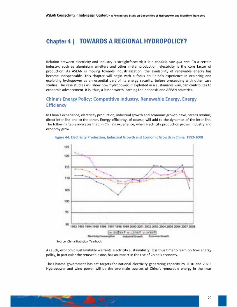
ASEAN Connectivity in Indonesian Context – A Preliminary Study on Geopolitics of Hydropower and Maritime Transport
79
Chapter 4 | TOWARDS A REGIONAL HYDROPOLICY?
Relation between electricity and industry is straightforward; it is a conditio sine qua non. To a certain industry, such as aluminium smelters and other metal production, electricity is the core factor of production. As ASEAN is moving towards industrialization, the availability of renewable energy has become indispensable. This chapter will begin with a focus on China’s experience in exploring and exploiting hydropower as an essential part of its energy security, before proceeding with other case studies. The case studies will show how hydropower, if exploited in a sustainable way, can contributes to economic advancement. It is, thus, a lesson worth learning for Indonesia and ASEAN countries.
China’s Energy Policy: Competitive Industry, Renewable Energy, Energy Efficiency
In China’s experience, electricity production, industrial growth and economic growth have, ceteris paribus, direct inter-link one to the other. Energy efficiency, of course, will add to the dynamics of the inter-link. The following table indicates that, in China’s experience, when electricity production grows, industry and economy grow.
Figure 44: Electricity Production, Industrial Growth and Economic Growth in China, 1992-2008
Source: China Statistical Yearbook
As such, economic sustainability warrants electricity sustainability. It is thus time to learn on how energy policy, in particular the renewable one, has an impact in the rise of China’s economy.
The Chinese government has set targets for national electricity generating capacity by 2010 and 2020. Hydropower and wind power will be the two main sources of China’s renewable energy in the near
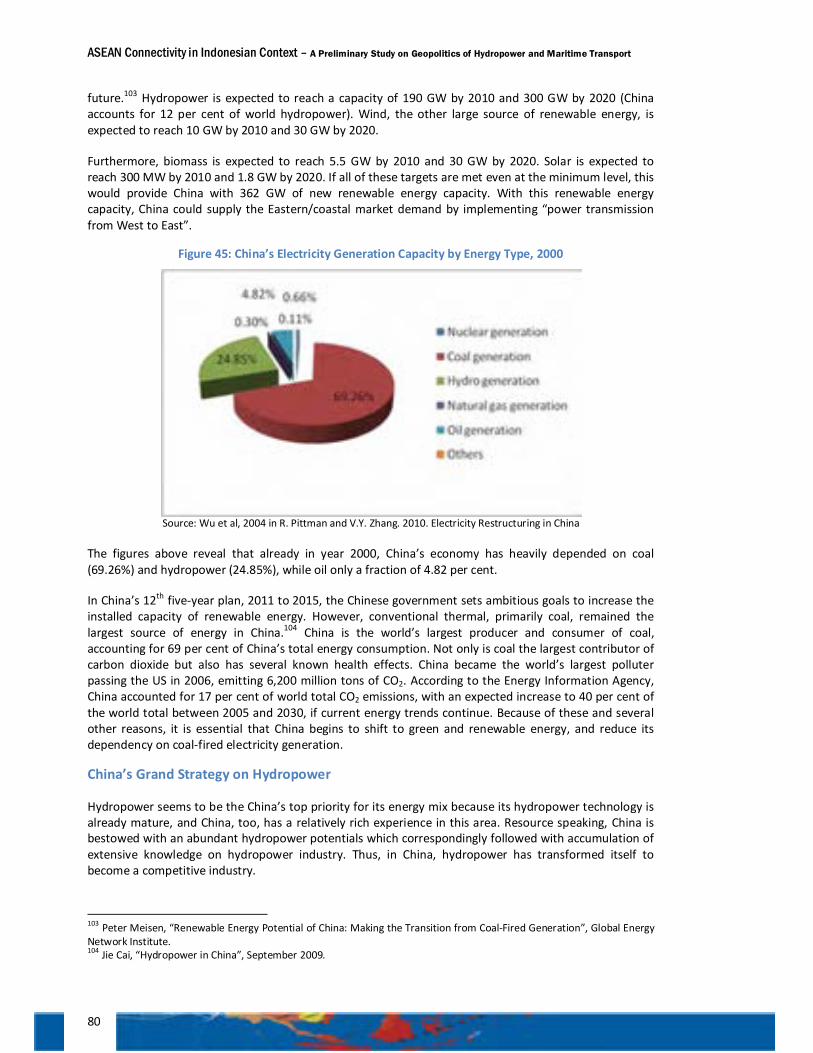
ASEAN Connectivity in Indonesian Context – A Preliminary Study on Geopolitics of Hydropower and Maritime Transport
80
future.103 Hydropower is expected to reach a capacity of 190 GW by 2010 and 300 GW by 2020 (China accounts for 12 per cent of world hydropower). Wind, the other large source of renewable energy, is expected to reach 10 GW by 2010 and 30 GW by 2020.
Furthermore, biomass is expected to reach 5.5 GW by 2010 and 30 GW by 2020. Solar is expected to reach 300 MW by 2010 and 1.8 GW by 2020. If all of these targets are met even at the minimum level, this would provide China with 362 GW of new renewable energy capacity. With this renewable energy capacity, China could supply the Eastern/coastal market demand by implementing “power transmission from West to East”.
Figure 45: China’s Electricity Generation Capacity by Energy Type, 2000
Source: Wu et al, 2004 in R. Pittman and V.Y. Zhang. 2010. Electricity Restructuring in China
The figures above reveal that already in year 2000, China’s economy has heavily depended on coal (69.26%) and hydropower (24.85%), while oil only a fraction of 4.82 per cent.
In China’s 12th five-year plan, 2011 to 2015, the Chinese government sets ambitious goals to increase the installed capacity of renewable energy. However, conventional thermal, primarily coal, remained the largest source of energy in China.104 China is the world’s largest producer and consumer of coal, accounting for 69 per cent of China’s total energy consumption. Not only is coal the largest contributor of carbon dioxide but also has several known health effects. China became the world’s largest polluter passing the US in 2006, emitting 6,200 million tons of CO2. According to the Energy Information Agency, China accounted for 17 per cent of world total CO2 emissions, with an expected increase to 40 per cent of the world total between 2005 and 2030, if current energy trends continue. Because of these and several other reasons, it is essential that China begins to shift to green and renewable energy, and reduce its dependency on coal-fired electricity generation.
China’s Grand Strategy on Hydropower
Hydropower seems to be the China’s top priority for its energy mix because its hydropower technology is already mature, and China, too, has a relatively rich experience in this area. Resource speaking, China is bestowed with an abundant hydropower potentials which correspondingly followed with accumulation of extensive knowledge on hydropower industry. Thus, in China, hydropower has transformed itself to become a competitive industry.
103 Peter Meisen, “Renewable Energy Potential of China: Making the Transition from Coal-Fired Generation”, Global Energy Network Institute. 104 Jie Cai, “Hydropower in China”, September 2009.
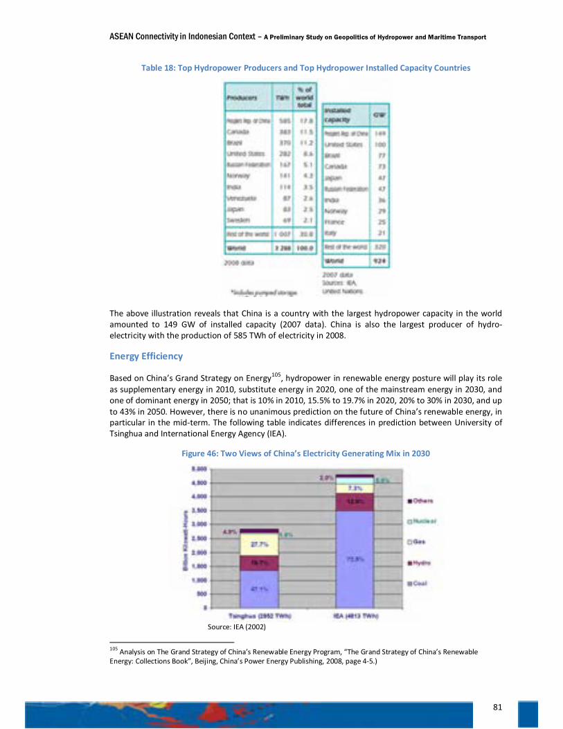
ASEAN Connectivity in Indonesian Context – A Preliminary Study on Geopolitics of Hydropower and Maritime Transport
81
Table 18: Top Hydropower Producers and Top Hydropower Installed Capacity Countries
The above illustration reveals that China is a country with the largest hydropower capacity in the world amounted to 149 GW of installed capacity (2007 data). China is also the largest producer of hydro-electricity with the production of 585 TWh of electricity in 2008.
Energy Efficiency
Based on China’s Grand Strategy on Energy105, hydropower in renewable energy posture will play its role as supplementary energy in 2010, substitute energy in 2020, one of the mainstream energy in 2030, and one of dominant energy in 2050; that is 10% in 2010, 15.5% to 19.7% in 2020, 20% to 30% in 2030, and up to 43% in 2050. However, there is no unanimous prediction on the future of China’s renewable energy, in particular in the mid-term. The following table indicates differences in prediction between University of Tsinghua and International Energy Agency (IEA).
Figure 46: Two Views of China’s Electricity Generating Mix in 2030
Source: IEA (2002)
105 Analysis on The Grand Strategy of China’s Renewable Energy Program, “The Grand Strategy of China’s Renewable Energy: Collections Book”, Beijing, China’s Power Energy Publishing, 2008, page 4-5.)
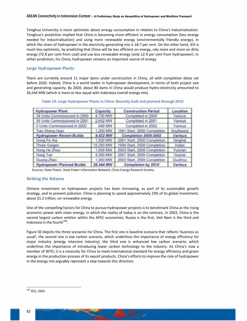
ASEAN Connectivity in Indonesian Context – A Preliminary Study on Geopolitics of Hydropower and Maritime Transport
82
Tsinghua University is more optimistic about energy consumption in relation to China’s industrialisation. Tsinghua’s prediction implied that China is becoming more efficient in energy consumption (less energy needed for industrialisation) and using more renewable energy (environmentally friendly energy), in which the share of hydropower in the electricity generating mix is 18.7 per cent. On the other hand, IEA is much less optimistic, by predicting that China will be less efficient on energy, rely more and more on dirty energy (72.8 per cent from coal) and use less renewable energy (only 12.9 per cent from hydropower). In either prediction, for China, hydropower remains an important source of energy.
Large Hydropower Plants
There are currently around 11 major dams under construction in China, all with completion dates set before 2020. Indeed, China is a world leader in hydropower development, in terms of both project size and generating capacity. By 2020, about 80 dams in China would produce hydro-electricity amounted to 26,544 MW (which is more or less equal with Indonesia overall energy mix).
Table 19: Large Hydropower Plants in China: Recently built and planned through 2010
Sources: State Power, State Power Information Network, China Energy Research Society
Striking the Balance
Chinese investment on hydropower projects has been increasing, as part of its sustainable growth strategy, and to prevent pollution. China is planning to spend approximately 23% of its global investment, about $1.2 trillion, on renewable energy.
One of the compelling factors for China to pursue hydropower projects is to benchmark China as the rising economic power with clean energy, in which the reality of today is on the contrary. In 2003, China is the second largest carbon emitter within the APEC economies; Russia is the first, Viet Nam is the third and Indonesia is the fourth106.
Figure 50 depicts the three scenarios for China. The first one is baseline scenario that reflects ‘business as usual’; the second one is low carbon scenario, which underlines the importance of energy efficiency for major industry (energy intensive industry); the third one is enhanced low carbon scenario, which underlines the importance of introducing lower carbon technology to the industry. As China’s now a member of WTO, it is a necessity for China to meet international standard for energy efficiency and green energy in the production process of its export products. China’s efforts to improve the role of hydropower in the energy mix arguably represent a step towards this direction.
106 IEEJ, 2003
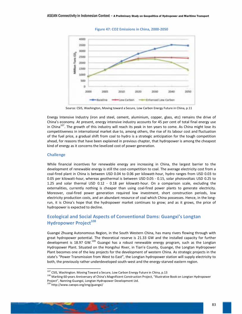
ASEAN Connectivity in Indonesian Context – A Preliminary Study on Geopolitics of Hydropower and Maritime Transport
83
Figure 47: CO2 Emissions in China, 2000-2050
Source: CSIS, Washington, Moving toward a Secure, Low Carbon Energy Future in China, p.11
Energy Intensive Industry (iron and steel, cement, aluminium, copper, glass, etc) remains the drive of China’s economy. At present, energy intensive industry accounts for 45 per cent of total final energy use in China107. The growth of this industry will reach its peak in ten years to come. As China might lose its competitiveness in international market due to, among others, the rise of its labour cost and fluctuation of the fuel price, a gradual shift from coal to hydro is a strategic anticipation for the tough competition ahead, for reasons that have been explained in previous chapter, that hydropower is among the cheapest kind of energy as it concerns the levelized cost of power generation.
Challenge
While financial incentives for renewable energy are increasing in China, the largest barrier to the development of renewable energy is still the cost-competition to coal. The average electricity cost from a coal-fired plant in China is between USD 0.04 to 0.06 per kilowatt-hour, hydro ranges from USD 0.03 to 0.05 per kilowatt-hour, whereas geothermal is between USD 0.05 - 0.15, solar photovoltaic USD 0.25 to 1.25 and solar thermal USD 0.12 - 0.18 per kilowatt-hour. On a comparison scale, excluding the externalities, currently nothing is cheaper than using coal-fired power plants to generate electricity. Moreover, coal-fired power generation required low investment, short construction periods, low electricity production costs, and an abundant resource of coal which China possesses. Hence, in the long-run, it is China’s hope that the hydropower market continues to grow; and as it grows, the price of hydropower is expected to decline.
Ecological and Social Aspects of Conventional Dams: Guangxi’s Longtan Hydropower Project108
Guangxi Zhuang Autonomous Region, in the South Western China, has many rivers flowing through with great hydropower potential. The theoretical reserve is 21.33 GW and the installed capacity for further development is 18.97 GW.109 Guangxi has a robust renewable energy program, such as the Longtan Hydropower Plant. Situated on the Hongshui River, in Tian’e County, Guangxi, the Longtan Hydropower Plant becomes one of the key projects for the development of western China. As strategic projects in the state’s “Power Transmission from West to East”, the Longtan hydropower station will supply electricity to both, the previously rather underdeveloped south-west and the energy-starved eastern region.
107 CSIS, Washington. Moving Toward a Secure, Low Carbon Energy Future in China, p.13 108 Marking 60-years Anniversary of China’s Magnificent Construction Project, “Illustrative Book on Longtan Hydropower Project”, Nanning-Guangxi, Longtan Hydropower Development Ltd. 109 http://www.caexpo.org/eng/guangxi/
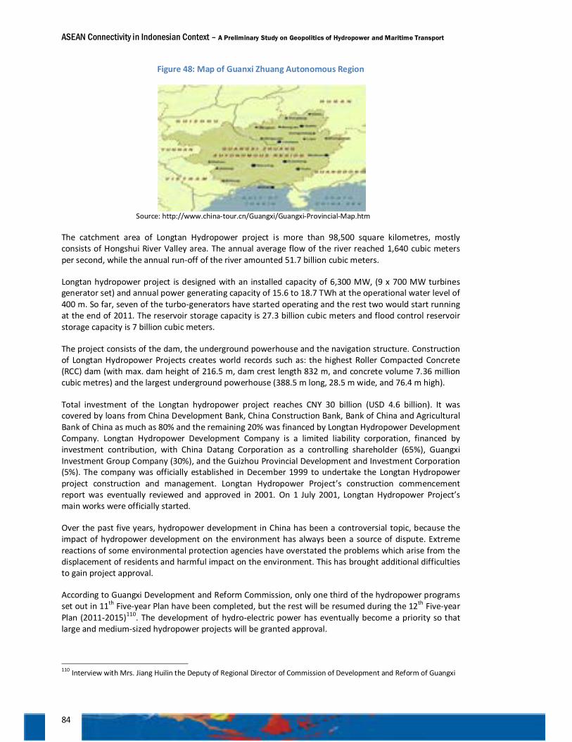
ASEAN Connectivity in Indonesian Context – A Preliminary Study on Geopolitics of Hydropower and Maritime Transport
84
Figure 48: Map of Guanxi Zhuang Autonomous Region
Source: http://www.china-tour.cn/Guangxi/Guangxi-Provincial-Map.htm
The catchment area of Longtan Hydropower project is more than 98,500 square kilometres, mostly consists of Hongshui River Valley area. The annual average flow of the river reached 1,640 cubic meters per second, while the annual run-off of the river amounted 51.7 billion cubic meters.
Longtan hydropower project is designed with an installed capacity of 6,300 MW, (9 x 700 MW turbines generator set) and annual power generating capacity of 15.6 to 18.7 TWh at the operational water level of 400 m. So far, seven of the turbo-generators have started operating and the rest two would start running at the end of 2011. The reservoir storage capacity is 27.3 billion cubic meters and flood control reservoir storage capacity is 7 billion cubic meters.
The project consists of the dam, the underground powerhouse and the navigation structure. Construction of Longtan Hydropower Projects creates world records such as: the highest Roller Compacted Concrete (RCC) dam (with max. dam height of 216.5 m, dam crest length 832 m, and concrete volume 7.36 million cubic metres) and the largest underground powerhouse (388.5 m long, 28.5 m wide, and 76.4 m high).
Total investment of the Longtan hydropower project reaches CNY 30 billion (USD 4.6 billion). It was covered by loans from China Development Bank, China Construction Bank, Bank of China and Agricultural Bank of China as much as 80% and the remaining 20% was financed by Longtan Hydropower Development Company. Longtan Hydropower Development Company is a limited liability corporation, financed by investment contribution, with China Datang Corporation as a controlling shareholder (65%), Guangxi Investment Group Company (30%), and the Guizhou Provincial Development and Investment Corporation (5%). The company was officially established in December 1999 to undertake the Longtan Hydropower project construction and management. Longtan Hydropower Project’s construction commencement report was eventually reviewed and approved in 2001. On 1 July 2001, Longtan Hydropower Project’s main works were officially started.
Over the past five years, hydropower development in China has been a controversial topic, because the impact of hydropower development on the environment has always been a source of dispute. Extreme reactions of some environmental protection agencies have overstated the problems which arise from the displacement of residents and harmful impact on the environment. This has brought additional difficulties to gain project approval.
According to Guangxi Development and Reform Commission, only one third of the hydropower programs set out in 11th Five-year Plan have been completed, but the rest will be resumed during the 12th Five-year Plan (2011-2015)110. The development of hydro-electric power has eventually become a priority so that large and medium-sized hydropower projects will be granted approval.
110 Interview with Mrs. Jiang Huilin the Deputy of Regional Director of Commission of Development and Reform of Guangxi
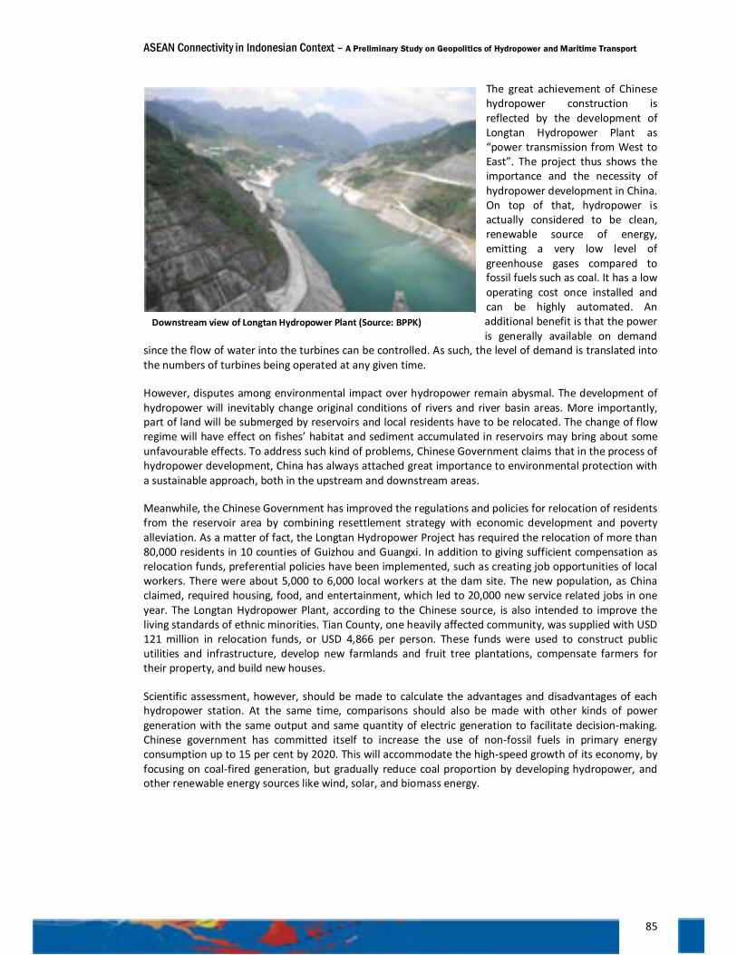
ASEAN Connectivity in Indonesian Context – A Preliminary Study on Geopolitics of Hydropower and Maritime Transport
85
The great achievement of Chinese hydropower construction is reflected by the development of Longtan Hydropower Plant as “power transmission from West to East”. The project thus shows the importance and the necessity of hydropower development in China. On top of that, hydropower is actually considered to be clean, renewable source of energy, emitting a very low level of greenhouse gases compared to fossil fuels such as coal. It has a low operating cost once installed and can be highly automated. An additional benefit is that the power is generally available on demand
since the flow of water into the turbines can be controlled. As such, the level of demand is translated into the numbers of turbines being operated at any given time.
However, disputes among environmental impact over hydropower remain abysmal. The development of hydropower will inevitably change original conditions of rivers and river basin areas. More importantly, part of land will be submerged by reservoirs and local residents have to be relocated. The change of flow regime will have effect on fishes’ habitat and sediment accumulated in reservoirs may bring about some unfavourable effects. To address such kind of problems, Chinese Government claims that in the process of hydropower development, China has always attached great importance to environmental protection with a sustainable approach, both in the upstream and downstream areas.
Meanwhile, the Chinese Government has improved the regulations and policies for relocation of residents from the reservoir area by combining resettlement strategy with economic development and poverty alleviation. As a matter of fact, the Longtan Hydropower Project has required the relocation of more than 80,000 residents in 10 counties of Guizhou and Guangxi. In addition to giving sufficient compensation as relocation funds, preferential policies have been implemented, such as creating job opportunities of local workers. There were about 5,000 to 6,000 local workers at the dam site. The new population, as China claimed, required housing, food, and entertainment, which led to 20,000 new service related jobs in one year. The Longtan Hydropower Plant, according to the Chinese source, is also intended to improve the living standards of ethnic minorities. Tian County, one heavily affected community, was supplied with USD 121 million in relocation funds, or USD 4,866 per person. These funds were used to construct public utilities and infrastructure, develop new farmlands and fruit tree plantations, compensate farmers for their property, and build new houses.
Scientific assessment, however, should be made to calculate the advantages and disadvantages of each hydropower station. At the same time, comparisons should also be made with other kinds of power generation with the same output and same quantity of electric generation to facilitate decision-making. Chinese government has committed itself to increase the use of non-fossil fuels in primary energy consumption up to 15 per cent by 2020. This will accommodate the high-speed growth of its economy, by focusing on coal-fired generation, but gradually reduce coal proportion by developing hydropower, and other renewable energy sources like wind, solar, and biomass energy.
Downstream view of Longtan Hydropower Plant (Source: BPPK)
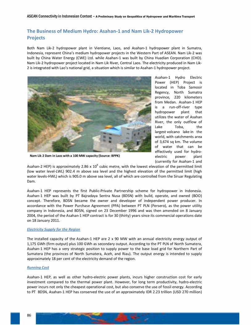
ASEAN Connectivity in Indonesian Context – A Preliminary Study on Geopolitics of Hydropower and Maritime Transport
86
The Business of Medium Hydro: Asahan-1 and Nam Lik-2 Hydropower Projects
Both Nam Lik-2 hydropower plant in Vientiane, Laos, and Asahan-1 hydropower plant in Sumatra, Indonesia, represent China’s medium hydropower projects in the Western Part of ASEAN. Nam Lik-2 was built by China Water Energy (CWE) Ltd. while Asahan-1 was built by China Huadian Corporation (CHD). Nam Lik-2 hydropower project located in Nam Lik River, Central Laos. The electricity produced in Nam Lik-2 is integrated with Lao’s national grid, a situation which is similar to Asahan-1 hydropower project.
Asahan-1 Hydro Electric Power (HEP) Project is located in Toba Samosir Regency, North Sumatra province, 220 kilometers from Medan. Asahan-1 HEP is a run-off-river type hydropower plant that utilizes the water of Asahan River, the only outflow of Lake Toba, the largest volcano lake in the world, with catchments area of 3,674 sq km. The volume of water that can be effectively used for hydro-electric power plant (currently for Asahan-1 and
Asahan-2 HEP) is approximately 2.86 x 10⁹ cubic metre, with the lowest elevation of the permitted limit (low water level-LWL) 902.4 m above sea level and the highest elevation of the permitted limit (high water levels-HWL) which is 905.0 m above sea level, all of which are controlled from the Siruar Regulating Dam.
Asahan-1 HEP represents the first Public-Private Partnership scheme for hydropower in Indonesia. Asahan-1 HEP was built by PT Bajradaya Sentra Nusa (BDSN) with build, operate, and owned (BOO) concept. Therefore, BDSN became the owner and developer of independent power producer. In accordance with the Power Purchase Agreement (PPA) between PT PLN (Persero), as the power utility company in Indonesia, and BDSN, signed on 23 December 1996 and was then amended on 8 January 2004, the period of the Asahan-1 HEP contract is for 30 (thirty) years since its commercial operations date on 18 January 2011.
Electricity Supply for the Region
The installed capacity of the Asahan-1 HEP are 2 x 90 MW with an annual electricity energy output of 1,175 GWh (firm output) plus 100 GWh as secondary output. According to the PT PLN of North Sumatera, Asahan-1 HEP has a very strategic position to supply power to the base load grid for Northern Part of Sumatera (the provinces of North Sumatera, Aceh, and Riau). The output energy is intended to supply approximately 18 per cent of the electricity demand of the region.
Running Cost
Asahan-1 HEP, as well as other hydro-electric power plants, incurs higher construction cost for early investment compared to the thermal power plant. However, for long term productivity, hydro-electric power incurs not only the cheapest operational cost, but also conserve the use of fossil energy. According to PT BDSN, Asahan-1 HEP has conserved the use of an approximately IDR 2.23 trillion (USD 270 million)
Nam Lik 2 Dam in Laos with a 100 MW capacity (Source: BPPK)
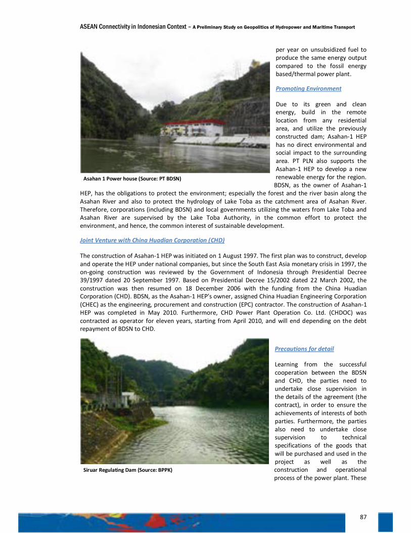
ASEAN Connectivity in Indonesian Context – A Preliminary Study on Geopolitics of Hydropower and Maritime Transport
87
per year on unsubsidized fuel to produce the same energy output compared to the fossil energy based/thermal power plant.
Promoting Environment
Due to its green and clean energy, build in the remote location from any residential area, and utilize the previously constructed dam; Asahan-1 HEP has no direct environmental and social impact to the surrounding area. PT PLN also supports the Asahan-1 HEP to develop a new renewable energy for the region.
BDSN, as the owner of Asahan-1 HEP, has the obligations to protect the environment; especially the forest and the river basin along the Asahan River and also to protect the hydrology of Lake Toba as the catchment area of Asahan River. Therefore, corporations (including BDSN) and local governments utilizing the waters from Lake Toba and Asahan River are supervised by the Lake Toba Authority, in the common effort to protect the environment, and hence, the common interest of sustainable development.
Joint Venture with China Huadian Corporation (CHD)
The construction of Asahan-1 HEP was initiated on 1 August 1997. The first plan was to construct, develop and operate the HEP under national companies, but since the South East Asia monetary crisis in 1997, the on-going construction was reviewed by the Government of Indonesia through Presidential Decree 39/1997 dated 20 September 1997. Based on Presidential Decree 15/2002 dated 22 March 2002, the construction was then resumed on 18 December 2006 with the funding from the China Huadian Corporation (CHD). BDSN, as the Asahan-1 HEP’s owner, assigned China Huadian Engineering Corporation (CHEC) as the engineering, procurement and construction (EPC) contractor. The construction of Asahan-1 HEP was completed in May 2010. Furthermore, CHD Power Plant Operation Co. Ltd. (CHDOC) was contracted as operator for eleven years, starting from April 2010, and will end depending on the debt repayment of BDSN to CHD.
Precautions for detail
Learning from the successful cooperation between the BDSN and CHD, the parties need to undertake close supervision in the details of the agreement (the contract), in order to ensure the achievements of interests of both parties. Furthermore, the parties also need to undertake close supervision to technical specifications of the goods that will be purchased and used in the project as well as the construction and operational process of the power plant. These
Asahan 1 Power house (Source: PT BDSN)
Siruar Regulating Dam (Source: BPPK)
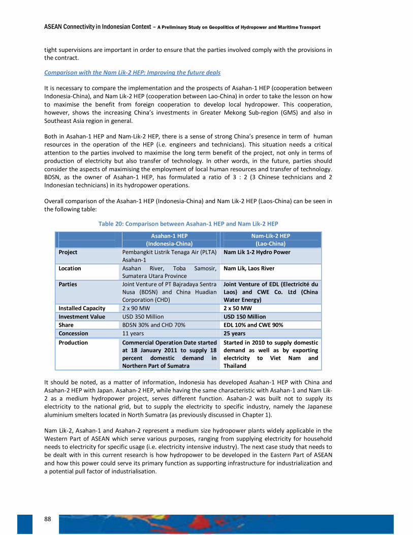
ASEAN Connectivity in Indonesian Context – A Preliminary Study on Geopolitics of Hydropower and Maritime Transport
88
tight supervisions are important in order to ensure that the parties involved comply with the provisions in the contract.
Comparison with the Nam Lik-2 HEP: Improving the future deals
It is necessary to compare the implementation and the prospects of Asahan-1 HEP (cooperation between Indonesia-China), and Nam Lik-2 HEP (cooperation between Lao-China) in order to take the lesson on how to maximise the benefit from foreign cooperation to develop local hydropower. This cooperation, however, shows the increasing China’s investments in Greater Mekong Sub-region (GMS) and also in Southeast Asia region in general.
Both in Asahan-1 HEP and Nam-Lik-2 HEP, there is a sense of strong China’s presence in term of human resources in the operation of the HEP (i.e. engineers and technicians). This situation needs a critical attention to the parties involved to maximise the long term benefit of the project, not only in terms of production of electricity but also transfer of technology. In other words, in the future, parties should consider the aspects of maximising the employment of local human resources and transfer of technology. BDSN, as the owner of Asahan-1 HEP, has formulated a ratio of 3 : 2 (3 Chinese technicians and 2 Indonesian technicians) in its hydropower operations.
Overall comparison of the Asahan-1 HEP (Indonesia-China) and Nam Lik-2 HEP (Laos-China) can be seen in the following table:
Table 20: Comparison between Asahan-1 HEP and Nam Lik-2 HEP
Asahan-1 HEP (Indonesia-China)
Nam-Lik-2 HEP (Lao-China)
Project Pembangkit Listrik Tenaga Air (PLTA) Asahan-1
Nam Lik 1-2 Hydro Power
Location Asahan River, Toba Samosir, Sumatera Utara Province
Nam Lik, Laos River
Parties Joint Venture of PT Bajradaya Sentra Nusa (BDSN) and China Huadian Corporation (CHD)
Joint Venture of EDL (Electricité du Laos) and CWE Co. Ltd (China Water Energy)
Installed Capacity 2 x 90 MW 2 x 50 MW Investment Value USD 350 Million USD 150 Million Share BDSN 30% and CHD 70% EDL 10% and CWE 90% Concession 11 years 25 years Production Commercial Operation Date started
at 18 January 2011 to supply 18 percent domestic demand in Northern Part of Sumatra
Started in 2010 to supply domestic demand as well as by exporting electricity to Viet Nam and Thailand
It should be noted, as a matter of information, Indonesia has developed Asahan-1 HEP with China and Asahan-2 HEP with Japan. Asahan-2 HEP, while having the same characteristic with Asahan-1 and Nam Lik-2 as a medium hydropower project, serves different function. Asahan-2 was built not to supply its electricity to the national grid, but to supply the electricity to specific industry, namely the Japanese aluminium smelters located in North Sumatra (as previously discussed in Chapter 1).
Nam Lik-2, Asahan-1 and Asahan-2 represent a medium size hydropower plants widely applicable in the Western Part of ASEAN which serve various purposes, ranging from supplying electricity for household needs to electricity for specific usage (i.e. electricity intensive industry). The next case study that needs to be dealt with in this current research is how hydropower to be developed in the Eastern Part of ASEAN and how this power could serve its primary function as supporting infrastructure for industrialization and a potential pull factor of industrialisation.
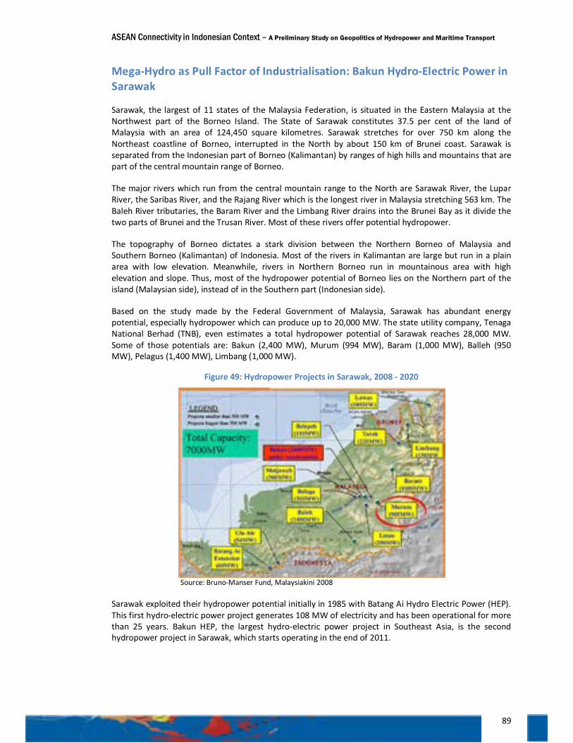
ASEAN Connectivity in Indonesian Context – A Preliminary Study on Geopolitics of Hydropower and Maritime Transport
89
Mega-Hydro as Pull Factor of Industrialisation: Bakun Hydro-Electric Power in Sarawak
Sarawak, the largest of 11 states of the Malaysia Federation, is situated in the Eastern Malaysia at the Northwest part of the Borneo Island. The State of Sarawak constitutes 37.5 per cent of the land of Malaysia with an area of 124,450 square kilometres. Sarawak stretches for over 750 km along the Northeast coastline of Borneo, interrupted in the North by about 150 km of Brunei coast. Sarawak is separated from the Indonesian part of Borneo (Kalimantan) by ranges of high hills and mountains that are part of the central mountain range of Borneo.
The major rivers which run from the central mountain range to the North are Sarawak River, the Lupar River, the Saribas River, and the Rajang River which is the longest river in Malaysia stretching 563 km. The Baleh River tributaries, the Baram River and the Limbang River drains into the Brunei Bay as it divide the two parts of Brunei and the Trusan River. Most of these rivers offer potential hydropower.
The topography of Borneo dictates a stark division between the Northern Borneo of Malaysia and Southern Borneo (Kalimantan) of Indonesia. Most of the rivers in Kalimantan are large but run in a plain area with low elevation. Meanwhile, rivers in Northern Borneo run in mountainous area with high elevation and slope. Thus, most of the hydropower potential of Borneo lies on the Northern part of the island (Malaysian side), instead of in the Southern part (Indonesian side).
Based on the study made by the Federal Government of Malaysia, Sarawak has abundant energy potential, especially hydropower which can produce up to 20,000 MW. The state utility company, Tenaga National Berhad (TNB), even estimates a total hydropower potential of Sarawak reaches 28,000 MW. Some of those potentials are: Bakun (2,400 MW), Murum (994 MW), Baram (1,000 MW), Balleh (950 MW), Pelagus (1,400 MW), Limbang (1,000 MW).
Figure 49: Hydropower Projects in Sarawak, 2008 - 2020
Source: Bruno-Manser Fund, Malaysiakini 2008
Sarawak exploited their hydropower potential initially in 1985 with Batang Ai Hydro Electric Power (HEP). This first hydro-electric power project generates 108 MW of electricity and has been operational for more than 25 years. Bakun HEP, the largest hydro-electric power project in Southeast Asia, is the second hydropower project in Sarawak, which starts operating in the end of 2011.
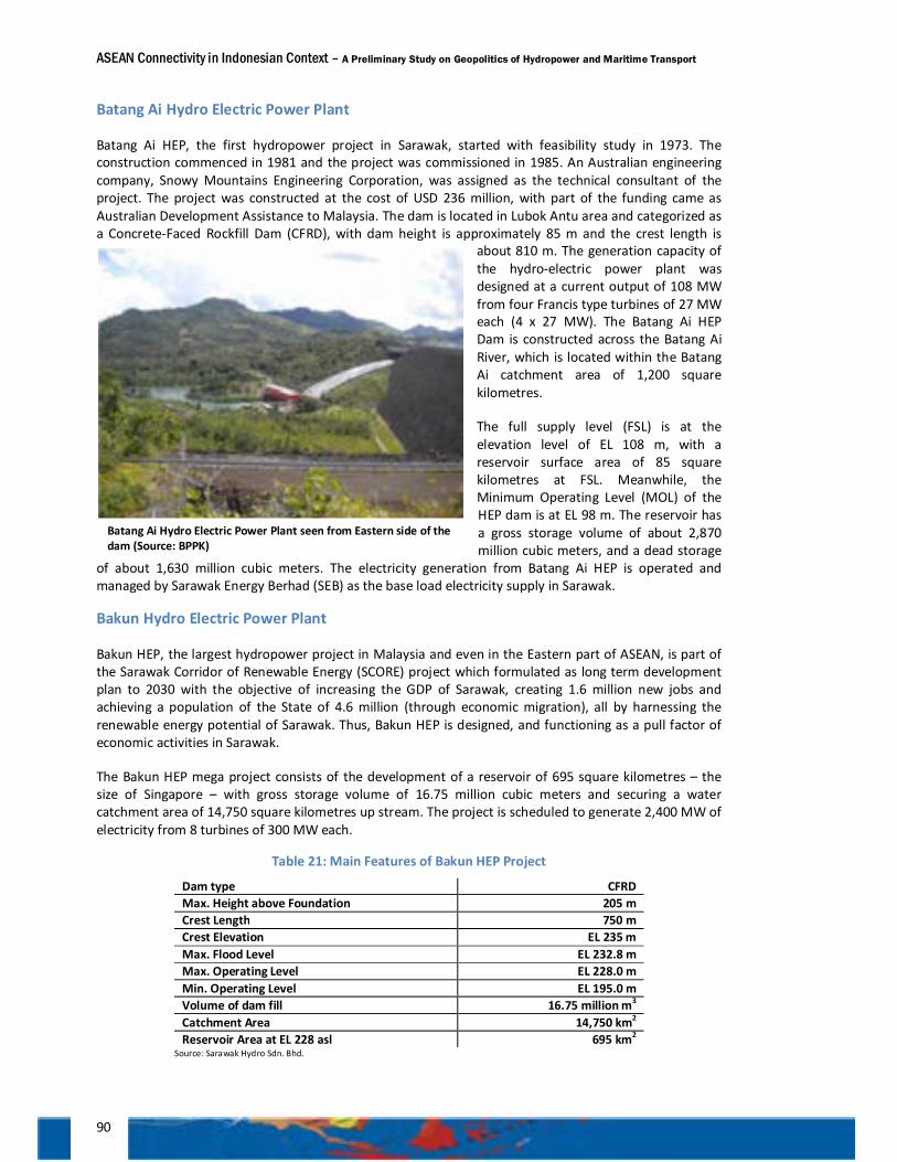
ASEAN Connectivity in Indonesian Context – A Preliminary Study on Geopolitics of Hydropower and Maritime Transport
90
Batang Ai Hydro Electric Power Plant
Batang Ai HEP, the first hydropower project in Sarawak, started with feasibility study in 1973. The construction commenced in 1981 and the project was commissioned in 1985. An Australian engineering company, Snowy Mountains Engineering Corporation, was assigned as the technical consultant of the project. The project was constructed at the cost of USD 236 million, with part of the funding came as Australian Development Assistance to Malaysia. The dam is located in Lubok Antu area and categorized as a Concrete-Faced Rockfill Dam (CFRD), with dam height is approximately 85 m and the crest length is
about 810 m. The generation capacity of the hydro-electric power plant was designed at a current output of 108 MW from four Francis type turbines of 27 MW each (4 x 27 MW). The Batang Ai HEP Dam is constructed across the Batang Ai River, which is located within the Batang Ai catchment area of 1,200 square kilometres.
The full supply level (FSL) is at the elevation level of EL 108 m, with a reservoir surface area of 85 square kilometres at FSL. Meanwhile, the Minimum Operating Level (MOL) of the HEP dam is at EL 98 m. The reservoir has a gross storage volume of about 2,870 million cubic meters, and a dead storage
of about 1,630 million cubic meters. The electricity generation from Batang Ai HEP is operated and managed by Sarawak Energy Berhad (SEB) as the base load electricity supply in Sarawak.
Bakun Hydro Electric Power Plant
Bakun HEP, the largest hydropower project in Malaysia and even in the Eastern part of ASEAN, is part of the Sarawak Corridor of Renewable Energy (SCORE) project which formulated as long term development plan to 2030 with the objective of increasing the GDP of Sarawak, creating 1.6 million new jobs and achieving a population of the State of 4.6 million (through economic migration), all by harnessing the renewable energy potential of Sarawak. Thus, Bakun HEP is designed, and functioning as a pull factor of economic activities in Sarawak.
The Bakun HEP mega project consists of the development of a reservoir of 695 square kilometres – the size of Singapore – with gross storage volume of 16.75 million cubic meters and securing a water catchment area of 14,750 square kilometres up stream. The project is scheduled to generate 2,400 MW of electricity from 8 turbines of 300 MW each.
Table 21: Main Features of Bakun HEP Project
Dam type CFRD Max. Height above Foundation 205 m Crest Length 750 m Crest Elevation EL 235 m Max. Flood Level EL 232.8 m Max. Operating Level EL 228.0 m Min. Operating Level EL 195.0 m Volume of dam fill 16.75 million m3 Catchment Area 14,750 km2 Reservoir Area at EL 228 asl 695 km2
Source: Sarawak Hydro Sdn. Bhd.
Batang Ai Hydro Electric Power Plant seen from Eastern side of the dam (Source: BPPK)
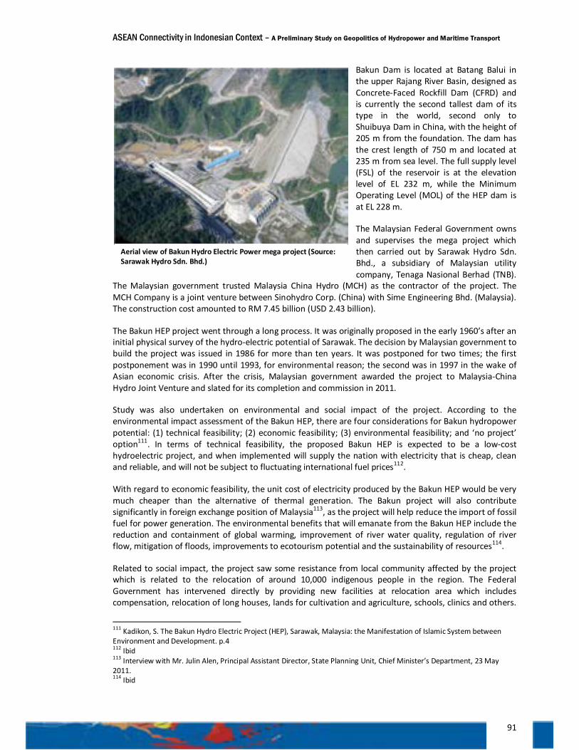
ASEAN Connectivity in Indonesian Context – A Preliminary Study on Geopolitics of Hydropower and Maritime Transport
91
Bakun Dam is located at Batang Balui in the upper Rajang River Basin, designed as Concrete-Faced Rockfill Dam (CFRD) and is currently the second tallest dam of its type in the world, second only to Shuibuya Dam in China, with the height of 205 m from the foundation. The dam has the crest length of 750 m and located at 235 m from sea level. The full supply level (FSL) of the reservoir is at the elevation level of EL 232 m, while the Minimum Operating Level (MOL) of the HEP dam is at EL 228 m.
The Malaysian Federal Government owns and supervises the mega project which then carried out by Sarawak Hydro Sdn. Bhd., a subsidiary of Malaysian utility company, Tenaga Nasional Berhad (TNB).
The Malaysian government trusted Malaysia China Hydro (MCH) as the contractor of the project. The MCH Company is a joint venture between Sinohydro Corp. (China) with Sime Engineering Bhd. (Malaysia). The construction cost amounted to RM 7.45 billion (USD 2.43 billion).
The Bakun HEP project went through a long process. It was originally proposed in the early 1960’s after an initial physical survey of the hydro-electric potential of Sarawak. The decision by Malaysian government to build the project was issued in 1986 for more than ten years. It was postponed for two times; the first postponement was in 1990 until 1993, for environmental reason; the second was in 1997 in the wake of Asian economic crisis. After the crisis, Malaysian government awarded the project to Malaysia-China Hydro Joint Venture and slated for its completion and commission in 2011.
Study was also undertaken on environmental and social impact of the project. According to the environmental impact assessment of the Bakun HEP, there are four considerations for Bakun hydropower potential: (1) technical feasibility; (2) economic feasibility; (3) environmental feasibility; and ‘no project’ option111. In terms of technical feasibility, the proposed Bakun HEP is expected to be a low-cost hydroelectric project, and when implemented will supply the nation with electricity that is cheap, clean and reliable, and will not be subject to fluctuating international fuel prices112.
With regard to economic feasibility, the unit cost of electricity produced by the Bakun HEP would be very much cheaper than the alternative of thermal generation. The Bakun project will also contribute significantly in foreign exchange position of Malaysia113, as the project will help reduce the import of fossil fuel for power generation. The environmental benefits that will emanate from the Bakun HEP include the reduction and containment of global warming, improvement of river water quality, regulation of river flow, mitigation of floods, improvements to ecotourism potential and the sustainability of resources114.
Related to social impact, the project saw some resistance from local community affected by the project which is related to the relocation of around 10,000 indigenous people in the region. The Federal Government has intervened directly by providing new facilities at relocation area which includes compensation, relocation of long houses, lands for cultivation and agriculture, schools, clinics and others.
111 Kadikon, S. The Bakun Hydro Electric Project (HEP), Sarawak, Malaysia: the Manifestation of Islamic System between Environment and Development. p.4 112 Ibid 113 Interview with Mr. Julin Alen, Principal Assistant Director, State Planning Unit, Chief Minister’s Department, 23 May 2011. 114 Ibid
Aerial view of Bakun Hydro Electric Power mega project (Source: Sarawak Hydro Sdn. Bhd.)
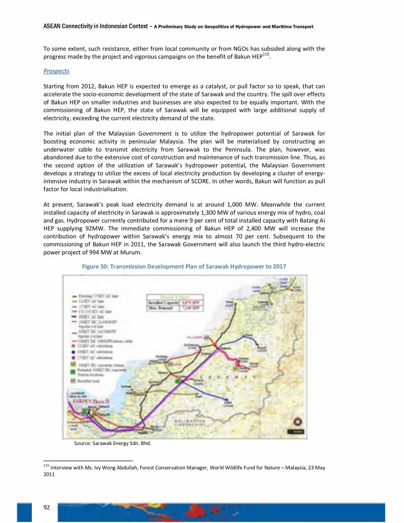
ASEAN Connectivity in Indonesian Context – A Preliminary Study on Geopolitics of Hydropower and Maritime Transport
92
To some extent, such resistance, either from local community or from NGOs has subsided along with the progress made by the project and vigorous campaigns on the benefit of Bakun HEP115.
Prospects
Starting from 2012, Bakun HEP is expected to emerge as a catalyst, or pull factor so to speak, that can accelerate the socio-economic development of the state of Sarawak and the country. The spill over effects of Bakun HEP on smaller industries and businesses are also expected to be equally important. With the commissioning of Bakun HEP, the state of Sarawak will be equipped with large additional supply of electricity, exceeding the current electricity demand of the state.
The initial plan of the Malaysian Government is to utilize the hydropower potential of Sarawak for boosting economic activity in peninsular Malaysia. The plan will be materialised by constructing an underwater cable to transmit electricity from Sarawak to the Peninsula. The plan, however, was abandoned due to the extensive cost of construction and maintenance of such transmission line. Thus, as the second option of the utilization of Sarawak’s hydropower potential, the Malaysian Government develops a strategy to utilize the excess of local electricity production by developing a cluster of energy-intensive industry in Sarawak within the mechanism of SCORE. In other words, Bakun will function as pull factor for local industrialisation.
At present, Sarawak’s peak load electricity demand is at around 1,000 MW. Meanwhile the current installed capacity of electricity in Sarawak is approximately 1,300 MW of various energy mix of hydro, coal and gas. Hydropower currently contributed for a mere 9 per cent of total installed capacity with Batang Ai HEP supplying 92MW. The immediate commissioning of Bakun HEP of 2,400 MW will increase the contribution of hydropower within Sarawak’s energy mix to almost 70 per cent. Subsequent to the commissioning of Bakun HEP in 2011, the Sarawak Government will also launch the third hydro-electric power project of 994 MW at Murum.
Figure 50: Transmission Development Plan of Sarawak Hydropower to 2017
Source: Sarawak Energy Sdn. Bhd.
115 Interview with Ms. Ivy Wong Abdullah, Forest Conservation Manager, World Wildlife Fund for Nature – Malaysia, 23 May 2011
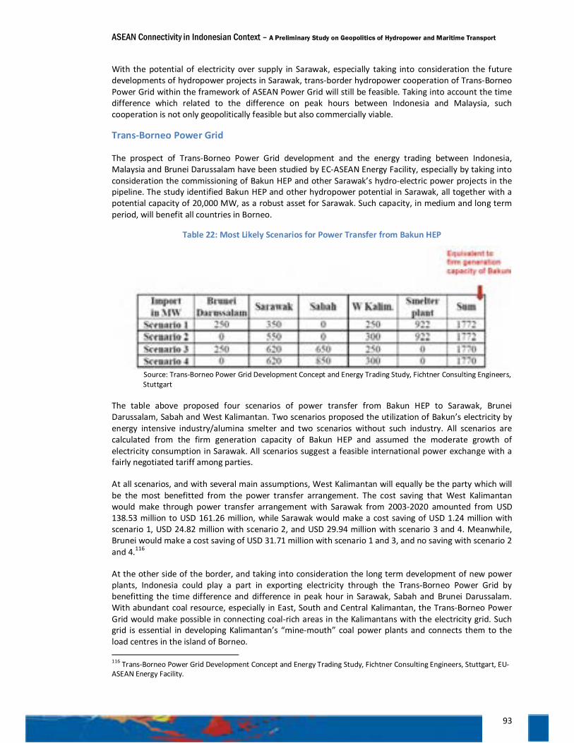
ASEAN Connectivity in Indonesian Context – A Preliminary Study on Geopolitics of Hydropower and Maritime Transport
93
With the potential of electricity over supply in Sarawak, especially taking into consideration the future developments of hydropower projects in Sarawak, trans-border hydropower cooperation of Trans-Borneo Power Grid within the framework of ASEAN Power Grid will still be feasible. Taking into account the time difference which related to the difference on peak hours between Indonesia and Malaysia, such cooperation is not only geopolitically feasible but also commercially viable.
Trans-Borneo Power Grid
The prospect of Trans-Borneo Power Grid development and the energy trading between Indonesia, Malaysia and Brunei Darussalam have been studied by EC-ASEAN Energy Facility, especially by taking into consideration the commissioning of Bakun HEP and other Sarawak’s hydro-electric power projects in the pipeline. The study identified Bakun HEP and other hydropower potential in Sarawak, all together with a potential capacity of 20,000 MW, as a robust asset for Sarawak. Such capacity, in medium and long term period, will benefit all countries in Borneo.
Table 22: Most Likely Scenarios for Power Transfer from Bakun HEP
Source: Trans-Borneo Power Grid Development Concept and Energy Trading Study, Fichtner Consulting Engineers, Stuttgart
The table above proposed four scenarios of power transfer from Bakun HEP to Sarawak, Brunei Darussalam, Sabah and West Kalimantan. Two scenarios proposed the utilization of Bakun’s electricity by energy intensive industry/alumina smelter and two scenarios without such industry. All scenarios are calculated from the firm generation capacity of Bakun HEP and assumed the moderate growth of electricity consumption in Sarawak. All scenarios suggest a feasible international power exchange with a fairly negotiated tariff among parties.
At all scenarios, and with several main assumptions, West Kalimantan will equally be the party which will be the most benefitted from the power transfer arrangement. The cost saving that West Kalimantan would make through power transfer arrangement with Sarawak from 2003-2020 amounted from USD 138.53 million to USD 161.26 million, while Sarawak would make a cost saving of USD 1.24 million with scenario 1, USD 24.82 million with scenario 2, and USD 29.94 million with scenario 3 and 4. Meanwhile, Brunei would make a cost saving of USD 31.71 million with scenario 1 and 3, and no saving with scenario 2 and 4.116
At the other side of the border, and taking into consideration the long term development of new power plants, Indonesia could play a part in exporting electricity through the Trans-Borneo Power Grid by benefitting the time difference and difference in peak hour in Sarawak, Sabah and Brunei Darussalam. With abundant coal resource, especially in East, South and Central Kalimantan, the Trans-Borneo Power Grid would make possible in connecting coal-rich areas in the Kalimantans with the electricity grid. Such grid is essential in developing Kalimantan’s “mine-mouth” coal power plants and connects them to the load centres in the island of Borneo. 116 Trans-Borneo Power Grid Development Concept and Energy Trading Study, Fichtner Consulting Engineers, Stuttgart, EU-ASEAN Energy Facility.
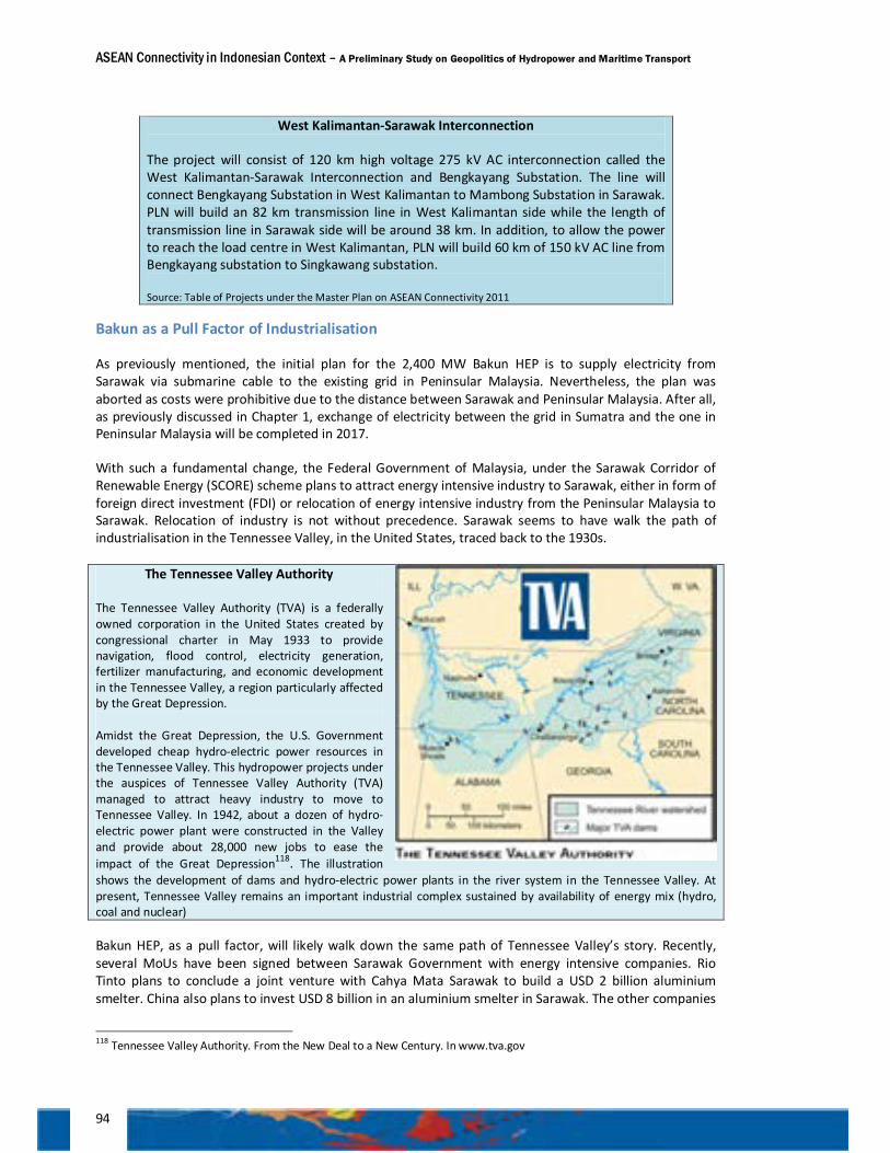
ASEAN Connectivity in Indonesian Context – A Preliminary Study on Geopolitics of Hydropower and Maritime Transport
94
West Kalimantan-Sarawak Interconnection
The project will consist of 120 km high voltage 275 kV AC interconnection called the West Kalimantan-Sarawak Interconnection and Bengkayang Substation. The line will connect Bengkayang Substation in West Kalimantan to Mambong Substation in Sarawak. PLN will build an 82 km transmission line in West Kalimantan side while the length of transmission line in Sarawak side will be around 38 km. In addition, to allow the power to reach the load centre in West Kalimantan, PLN will build 60 km of 150 kV AC line from Bengkayang substation to Singkawang substation.
Source: Table of Projects under the Master Plan on ASEAN Connectivity 2011
Bakun as a Pull Factor of Industrialisation
As previously mentioned, the initial plan for the 2,400 MW Bakun HEP is to supply electricity from Sarawak via submarine cable to the existing grid in Peninsular Malaysia. Nevertheless, the plan was aborted as costs were prohibitive due to the distance between Sarawak and Peninsular Malaysia. After all, as previously discussed in Chapter 1, exchange of electricity between the grid in Sumatra and the one in Peninsular Malaysia will be completed in 2017.
With such a fundamental change, the Federal Government of Malaysia, under the Sarawak Corridor of Renewable Energy (SCORE) scheme plans to attract energy intensive industry to Sarawak, either in form of foreign direct investment (FDI) or relocation of energy intensive industry from the Peninsular Malaysia to Sarawak. Relocation of industry is not without precedence. Sarawak seems to have walk the path of industrialisation in the Tennessee Valley, in the United States, traced back to the 1930s.
The Tennessee Valley Authority The Tennessee Valley Authority (TVA) is a federally owned corporation in the United States created by congressional charter in May 1933 to provide navigation, flood control, electricity generation, fertilizer manufacturing, and economic development in the Tennessee Valley, a region particularly affected by the Great Depression.
Amidst the Great Depression, the U.S. Government developed cheap hydro-electric power resources in the Tennessee Valley. This hydropower projects under the auspices of Tennessee Valley Authority (TVA) managed to attract heavy industry to move to Tennessee Valley. In 1942, about a dozen of hydro-electric power plant were constructed in the Valley and provide about 28,000 new jobs to ease the impact of the Great Depression118. The illustration shows the development of dams and hydro-electric power plants in the river system in the Tennessee Valley. At present, Tennessee Valley remains an important industrial complex sustained by availability of energy mix (hydro, coal and nuclear)
Bakun HEP, as a pull factor, will likely walk down the same path of Tennessee Valley’s story. Recently, several MoUs have been signed between Sarawak Government with energy intensive companies. Rio Tinto plans to conclude a joint venture with Cahya Mata Sarawak to build a USD 2 billion aluminium smelter. China also plans to invest USD 8 billion in an aluminium smelter in Sarawak. The other companies
118 Tennessee Valley Authority. From the New Deal to a New Century. In www.tva.gov
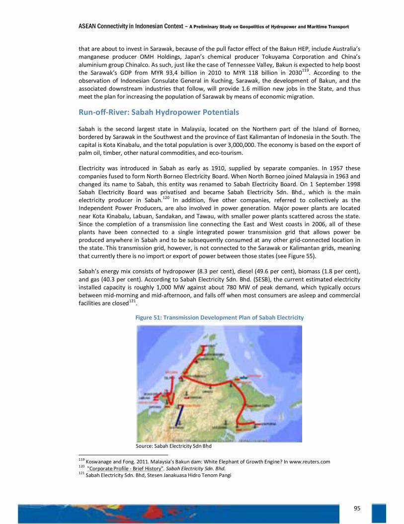
ASEAN Connectivity in Indonesian Context – A Preliminary Study on Geopolitics of Hydropower and Maritime Transport
95
that are about to invest in Sarawak, because of the pull factor effect of the Bakun HEP, include Australia’s manganese producer OMH Holdings, Japan’s chemical producer Tokuyama Corporation and China’s aluminium group Chinalco. As such, just like the case of Tennessee Valley, Bakun is expected to help boost the Sarawak’s GDP from MYR 93,4 billion in 2010 to MYR 118 billion in 2030119. According to the observation of Indonesian Consulate General in Kuching, Sarawak, the development of Bakun, and the associated downstream industries that follow, will provide 1.6 million new jobs in the State, and thus meet the plan for increasing the population of Sarawak by means of economic migration.
Run-off-River: Sabah Hydropower Potentials
Sabah is the second largest state in Malaysia, located on the Northern part of the Island of Borneo, bordered by Sarawak in the Southwest and the province of East Kalimantan of Indonesia in the South. The capital is Kota Kinabalu, and the total population is over 3,000,000. The economy is based on the export of palm oil, timber, other natural commodities, and eco-tourism.
Electricity was introduced in Sabah as early as 1910, supplied by separate companies. In 1957 these companies fused to form North Borneo Electricity Board. When North Borneo joined Malaysia in 1963 and changed its name to Sabah, this entity was renamed to Sabah Electricity Board. On 1 September 1998 Sabah Electricity Board was privatised and became Sabah Electricity Sdn. Bhd., which is the main electricity producer in Sabah.120 In addition, five other companies, referred to collectively as the Independent Power Producers, are also involved in power generation. Major power plants are located near Kota Kinabalu, Labuan, Sandakan, and Tawau, with smaller power plants scattered across the state. Since the completion of a transmission line connecting the East and West coasts in 2006, all of these plants have been connected to a single integrated power transmission grid that allows power be produced anywhere in Sabah and to be subsequently consumed at any other grid-connected location in the state. This transmission grid, however, is not connected to the Sarawak or Kalimantan grids, meaning that currently there is no import or export of power between those states (see Figure 55).
Sabah’s energy mix consists of hydropower (8.3 per cent), diesel (49.6 per cent), biomass (1.8 per cent), and gas (40.3 per cent). According to Sabah Electricity Sdn. Bhd. (SESB), the current estimated electricity installed capacity is roughly 1,000 MW against about 780 MW of peak demand, which typically occurs between mid-morning and mid-afternoon, and falls off when most consumers are asleep and commercial facilities are closed121.
Figure 51: Transmission Development Plan of Sabah Electricity
Source: Sabah Electricity Sdn Bhd
119 Koswanage and Fong. 2011. Malaysia’s Bakun dam: White Elephant of Growth Engine? In www.reuters.com 120 "Corporate Profile - Brief History". Sabah Electricity Sdn. Bhd. 121 Sabah Electricity Sdn. Bhd, Stesen Janakuasa Hidro Tenom Pangi
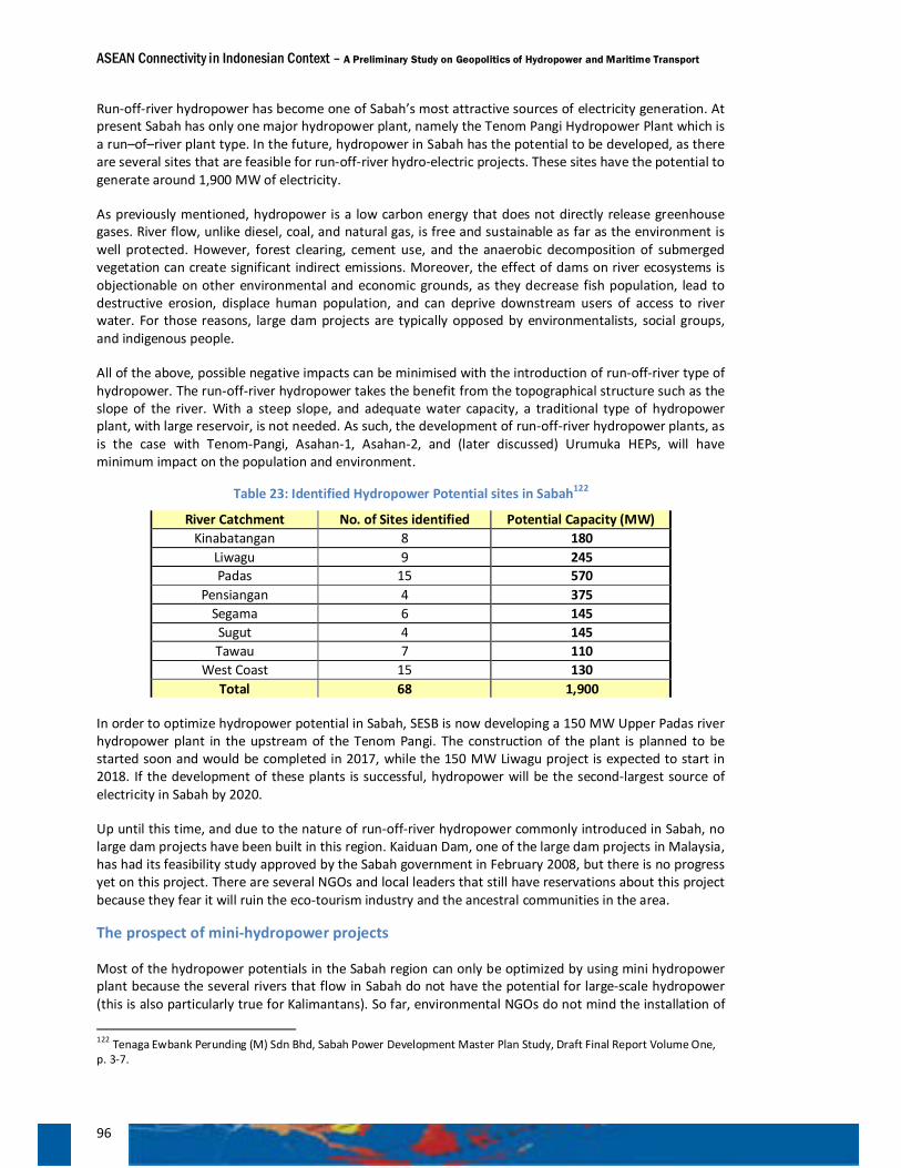
ASEAN Connectivity in Indonesian Context – A Preliminary Study on Geopolitics of Hydropower and Maritime Transport
96
Run-off-river hydropower has become one of Sabah’s most attractive sources of electricity generation. At present Sabah has only one major hydropower plant, namely the Tenom Pangi Hydropower Plant which is a run–of–river plant type. In the future, hydropower in Sabah has the potential to be developed, as there are several sites that are feasible for run-off-river hydro-electric projects. These sites have the potential to generate around 1,900 MW of electricity.
As previously mentioned, hydropower is a low carbon energy that does not directly release greenhouse gases. River flow, unlike diesel, coal, and natural gas, is free and sustainable as far as the environment is well protected. However, forest clearing, cement use, and the anaerobic decomposition of submerged vegetation can create significant indirect emissions. Moreover, the effect of dams on river ecosystems is objectionable on other environmental and economic grounds, as they decrease fish population, lead to destructive erosion, displace human population, and can deprive downstream users of access to river water. For those reasons, large dam projects are typically opposed by environmentalists, social groups, and indigenous people.
All of the above, possible negative impacts can be minimised with the introduction of run-off-river type of hydropower. The run-off-river hydropower takes the benefit from the topographical structure such as the slope of the river. With a steep slope, and adequate water capacity, a traditional type of hydropower plant, with large reservoir, is not needed. As such, the development of run-off-river hydropower plants, as is the case with Tenom-Pangi, Asahan-1, Asahan-2, and (later discussed) Urumuka HEPs, will have minimum impact on the population and environment.
Table 23: Identified Hydropower Potential sites in Sabah122
River Catchment No. of Sites identified Potential Capacity (MW) Kinabatangan 8 180
Liwagu 9 245 Padas 15 570
Pensiangan 4 375 Segama 6 145 Sugut 4 145 Tawau 7 110
West Coast 15 130 Total 68 1,900
In order to optimize hydropower potential in Sabah, SESB is now developing a 150 MW Upper Padas river hydropower plant in the upstream of the Tenom Pangi. The construction of the plant is planned to be started soon and would be completed in 2017, while the 150 MW Liwagu project is expected to start in 2018. If the development of these plants is successful, hydropower will be the second-largest source of electricity in Sabah by 2020.
Up until this time, and due to the nature of run-off-river hydropower commonly introduced in Sabah, no large dam projects have been built in this region. Kaiduan Dam, one of the large dam projects in Malaysia, has had its feasibility study approved by the Sabah government in February 2008, but there is no progress yet on this project. There are several NGOs and local leaders that still have reservations about this project because they fear it will ruin the eco-tourism industry and the ancestral communities in the area.
The prospect of mini-hydropower projects
Most of the hydropower potentials in the Sabah region can only be optimized by using mini hydropower plant because the several rivers that flow in Sabah do not have the potential for large-scale hydropower (this is also particularly true for Kalimantans). So far, environmental NGOs do not mind the installation of
122 Tenaga Ewbank Perunding (M) Sdn Bhd, Sabah Power Development Master Plan Study, Draft Final Report Volume One, p. 3-7.
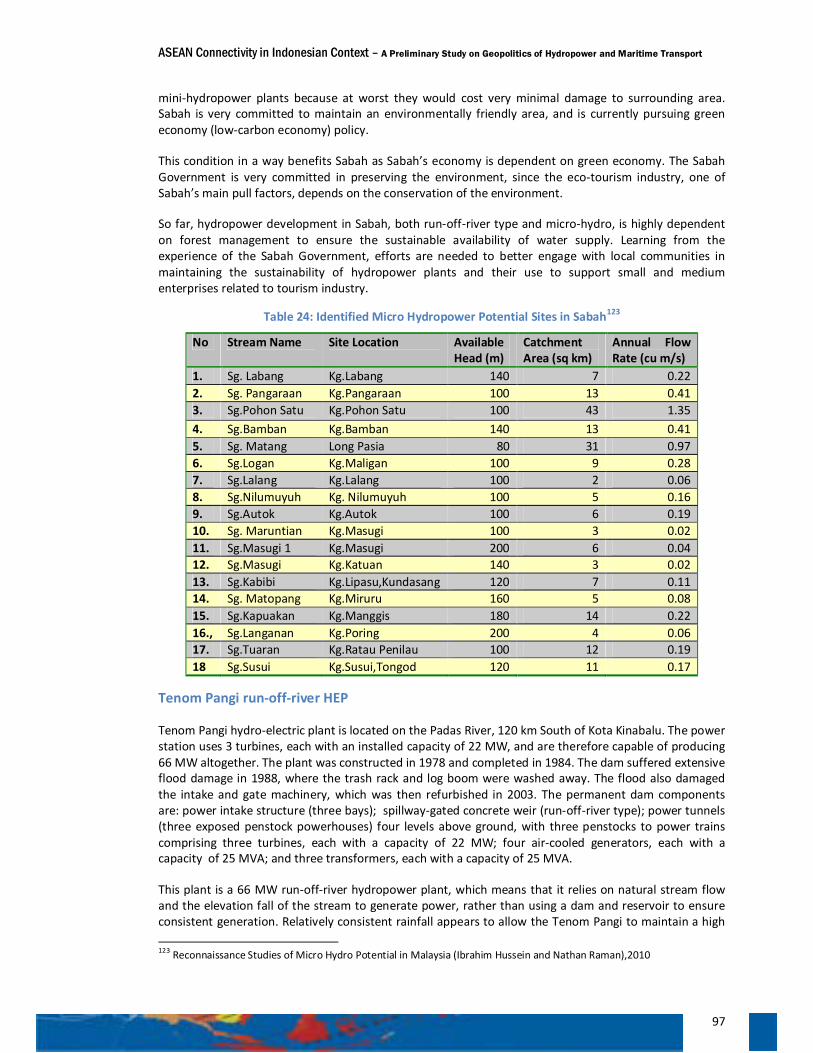
ASEAN Connectivity in Indonesian Context – A Preliminary Study on Geopolitics of Hydropower and Maritime Transport
97
mini-hydropower plants because at worst they would cost very minimal damage to surrounding area. Sabah is very committed to maintain an environmentally friendly area, and is currently pursuing green economy (low-carbon economy) policy.
This condition in a way benefits Sabah as Sabah’s economy is dependent on green economy. The Sabah Government is very committed in preserving the environment, since the eco-tourism industry, one of Sabah’s main pull factors, depends on the conservation of the environment.
So far, hydropower development in Sabah, both run-off-river type and micro-hydro, is highly dependent on forest management to ensure the sustainable availability of water supply. Learning from the experience of the Sabah Government, efforts are needed to better engage with local communities in maintaining the sustainability of hydropower plants and their use to support small and medium enterprises related to tourism industry.
Table 24: Identified Micro Hydropower Potential Sites in Sabah123
No Stream Name Site Location Available Head (m)
Catchment Area (sq km)
Annual Flow Rate (cu m/s)
1. Sg. Labang Kg.Labang 140 7 0.22 2. Sg. Pangaraan Kg.Pangaraan 100 13 0.41 3. Sg.Pohon Satu Kg.Pohon Satu 100 43 1.35 4. Sg.Bamban Kg.Bamban 140 13 0.41 5. Sg. Matang Long Pasia 80 31 0.97 6. Sg.Logan Kg.Maligan 100 9 0.28 7. Sg.Lalang Kg.Lalang 100 2 0.06 8. Sg.Nilumuyuh Kg. Nilumuyuh 100 5 0.16 9. Sg.Autok Kg.Autok 100 6 0.19 10. Sg. Maruntian Kg.Masugi 100 3 0.02 11. Sg.Masugi 1 Kg.Masugi 200 6 0.04 12. Sg.Masugi Kg.Katuan 140 3 0.02 13. Sg.Kabibi Kg.Lipasu,Kundasang 120 7 0.11 14. Sg. Matopang Kg.Miruru 160 5 0.08 15. Sg.Kapuakan Kg.Manggis 180 14 0.22 16., Sg.Langanan Kg.Poring 200 4 0.06 17. Sg.Tuaran Kg.Ratau Penilau 100 12 0.19 18 Sg.Susui Kg.Susui,Tongod 120 11 0.17
Tenom Pangi run-off-river HEP
Tenom Pangi hydro-electric plant is located on the Padas River, 120 km South of Kota Kinabalu. The power station uses 3 turbines, each with an installed capacity of 22 MW, and are therefore capable of producing 66 MW altogether. The plant was constructed in 1978 and completed in 1984. The dam suffered extensive flood damage in 1988, where the trash rack and log boom were washed away. The flood also damaged the intake and gate machinery, which was then refurbished in 2003. The permanent dam components are: power intake structure (three bays); spillway-gated concrete weir (run-off-river type); power tunnels (three exposed penstock powerhouses) four levels above ground, with three penstocks to power trains comprising three turbines, each with a capacity of 22 MW; four air-cooled generators, each with a capacity of 25 MVA; and three transformers, each with a capacity of 25 MVA.
This plant is a 66 MW run-off-river hydropower plant, which means that it relies on natural stream flow and the elevation fall of the stream to generate power, rather than using a dam and reservoir to ensure consistent generation. Relatively consistent rainfall appears to allow the Tenom Pangi to maintain a high 123 Reconnaissance Studies of Micro Hydro Potential in Malaysia (Ibrahim Hussein and Nathan Raman),2010
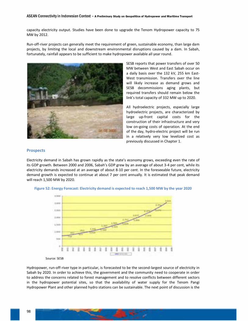
ASEAN Connectivity in Indonesian Context – A Preliminary Study on Geopolitics of Hydropower and Maritime Transport
98
capacity electricity output. Studies have been done to upgrade the Tenom Hydropower capacity to 75 MW by 2012.
Run-off-river projects can generally meet the requirement of green, sustainable economy, than large dam projects, by limiting the local and downstream environmental disruptions caused by a dam. In Sabah, fortunately, rainfall appears to be sufficient to make hydropower available all year round.
SESB reports that power transfers of over 50 MW between West and East Sabah occur on a daily basis over the 132 kV, 255 km East-West transmission. Transfers over the line will likely increase as demand grows and SESB decommissions aging plants, but required transfers should remain below the link’s total capacity of 332 MW up to 2020.
All hydroelectric projects, especially large hydroelectric projects, are characterized by large up-front capital costs for the construction of their infrastructure and very low on-going costs of operation. At the end of the day, hydro-electric project will be run in a relatively very low levelized cost as previously discussed in Chapter 1.
Prospects
Electricity demand in Sabah has grown rapidly as the state’s economy grows, exceeding even the rate of its GDP growth. Between 2000 and 2006, Sabah’s GDP grew by an average of about 3-4 per cent, while its electricity demands increased at an average of about 8-10 per cent. In the foreseeable future, electricity demand growth is expected to continue at about 7 per cent annually. It is estimated that peak demand will reach 1,500 MW by 2020.
Figure 52: Energy Forecast: Electricity demand is expected to reach 1,500 MW by the year 2020
Source: SESB
Hydropower, run-off-river type in particular, is forecasted to be the second-largest source of electricity in Sabah by 2020. In order to achieve this, the government and the community need to cooperate in order to address the concerns related to forest management and to resolve conflicts between different sectors in the hydropower potential sites, so that the availability of water supply for the Tenom Pangi Hydropower Plant and other planned hydro stations can be sustainable. The next point of discussion is the
Padas River – Tenom Pangi Hydropower Plant (Source BPPK)
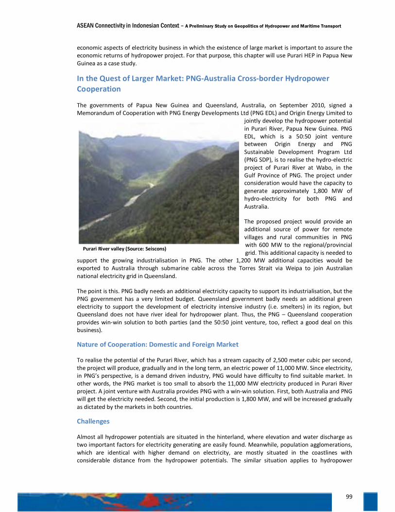
ASEAN Connectivity in Indonesian Context – A Preliminary Study on Geopolitics of Hydropower and Maritime Transport
99
economic aspects of electricity business in which the existence of large market is important to assure the economic returns of hydropower project. For that purpose, this chapter will use Purari HEP in Papua New Guinea as a case study.
In the Quest of Larger Market: PNG-Australia Cross-border Hydropower Cooperation
The governments of Papua New Guinea and Queensland, Australia, on September 2010, signed a Memorandum of Cooperation with PNG Energy Developments Ltd (PNG EDL) and Origin Energy Limited to
jointly develop the hydropower potential in Purari River, Papua New Guinea. PNG EDL, which is a 50:50 joint venture between Origin Energy and PNG Sustainable Development Program Ltd (PNG SDP), is to realise the hydro-electric project of Purari River at Wabo, in the Gulf Province of PNG. The project under consideration would have the capacity to generate approximately 1,800 MW of hydro-electricity for both PNG and Australia.
The proposed project would provide an additional source of power for remote villages and rural communities in PNG with 600 MW to the regional/provincial grid. This additional capacity is needed to
support the growing industrialisation in PNG. The other 1,200 MW additional capacities would be exported to Australia through submarine cable across the Torres Strait via Weipa to join Australian national electricity grid in Queensland.
The point is this. PNG badly needs an additional electricity capacity to support its industrialisation, but the PNG government has a very limited budget. Queensland government badly needs an additional green electricity to support the development of electricity intensive industry (i.e. smelters) in its region, but Queensland does not have river ideal for hydropower plant. Thus, the PNG – Queensland cooperation provides win-win solution to both parties (and the 50:50 joint venture, too, reflect a good deal on this business).
Nature of Cooperation: Domestic and Foreign Market
To realise the potential of the Purari River, which has a stream capacity of 2,500 meter cubic per second, the project will produce, gradually and in the long term, an electric power of 11,000 MW. Since electricity, in PNG’s perspective, is a demand driven industry, PNG would have difficulty to find suitable market. In other words, the PNG market is too small to absorb the 11,000 MW electricity produced in Purari River project. A joint venture with Australia provides PNG with a win-win solution. First, both Australia and PNG will get the electricity needed. Second, the initial production is 1,800 MW, and will be increased gradually as dictated by the markets in both countries.
Challenges
Almost all hydropower potentials are situated in the hinterland, where elevation and water discharge as two important factors for electricity generating are easily found. Meanwhile, population agglomerations, which are identical with higher demand on electricity, are mostly situated in the coastlines with considerable distance from the hydropower potentials. The similar situation applies to hydropower
Purari River valley (Source: Seiscons)
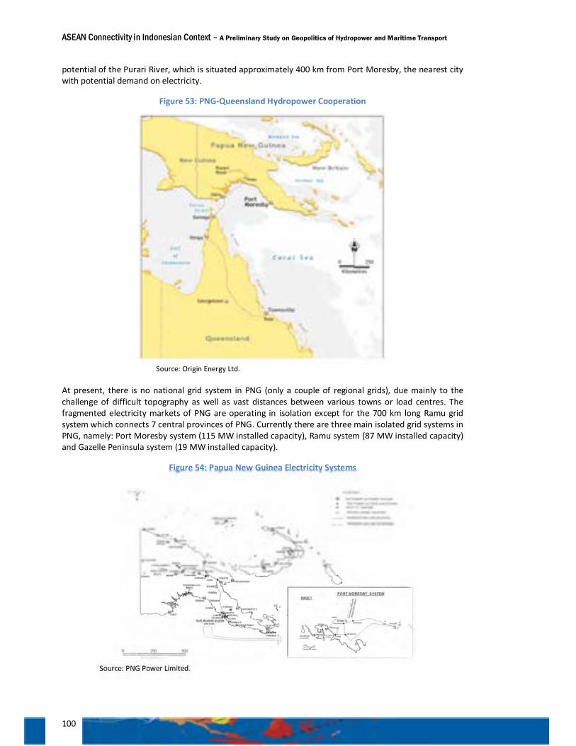
ASEAN Connectivity in Indonesian Context – A Preliminary Study on Geopolitics of Hydropower and Maritime Transport
100
potential of the Purari River, which is situated approximately 400 km from Port Moresby, the nearest city with potential demand on electricity.
Figure 53: PNG-Queensland Hydropower Cooperation
Source: Origin Energy Ltd.
At present, there is no national grid system in PNG (only a couple of regional grids), due mainly to the challenge of difficult topography as well as vast distances between various towns or load centres. The fragmented electricity markets of PNG are operating in isolation except for the 700 km long Ramu grid system which connects 7 central provinces of PNG. Currently there are three main isolated grid systems in PNG, namely: Port Moresby system (115 MW installed capacity), Ramu system (87 MW installed capacity) and Gazelle Peninsula system (19 MW installed capacity).
Figure 54: Papua New Guinea Electricity Systems
Source: PNG Power Limited.
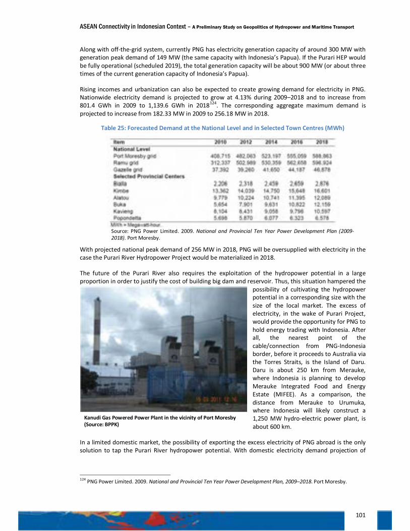
ASEAN Connectivity in Indonesian Context – A Preliminary Study on Geopolitics of Hydropower and Maritime Transport
101
Along with off-the-grid system, currently PNG has electricity generation capacity of around 300 MW with generation peak demand of 149 MW (the same capacity with Indonesia’s Papua). If the Purari HEP would be fully operational (scheduled 2019), the total generation capacity will be about 900 MW (or about three times of the current generation capacity of Indonesia’s Papua).
Rising incomes and urbanization can also be expected to create growing demand for electricity in PNG. Nationwide electricity demand is projected to grow at 4.13% during 2009–2018 and to increase from 801.4 GWh in 2009 to 1,139.6 GWh in 2018124. The corresponding aggregate maximum demand is projected to increase from 182.33 MW in 2009 to 256.18 MW in 2018.
Table 25: Forecasted Demand at the National Level and in Selected Town Centres (MWh)
Source: PNG Power Limited. 2009. National and Provincial Ten Year Power Development Plan (2009-2018). Port Moresby.
With projected national peak demand of 256 MW in 2018, PNG will be oversupplied with electricity in the case the Purari River Hydropower Project would be materialized in 2018.
The future of the Purari River also requires the exploitation of the hydropower potential in a large proportion in order to justify the cost of building big dam and reservoir. Thus, this situation hampered the
possibility of cultivating the hydropower potential in a corresponding size with the size of the local market. The excess of electricity, in the wake of Purari Project, would provide the opportunity for PNG to hold energy trading with Indonesia. After all, the nearest point of the cable/connection from PNG-Indonesia border, before it proceeds to Australia via the Torres Straits, is the Island of Daru. Daru is about 250 km from Merauke, where Indonesia is planning to develop Merauke Integrated Food and Energy Estate (MIFEE). As a comparison, the distance from Merauke to Urumuka, where Indonesia will likely construct a 1,250 MW hydro-electric power plant, is about 600 km.
In a limited domestic market, the possibility of exporting the excess electricity of PNG abroad is the only solution to tap the Purari River hydropower potential. With domestic electricity demand projection of
124 PNG Power Limited. 2009. National and Provincial Ten Year Power Development Plan, 2009–2018. Port Moresby.
Kanudi Gas Powered Power Plant in the vicinity of Port Moresby (Source: BPPK)
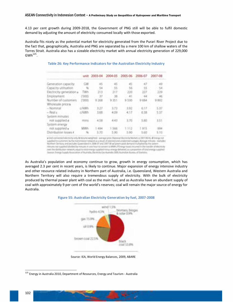
ASEAN Connectivity in Indonesian Context – A Preliminary Study on Geopolitics of Hydropower and Maritime Transport
102
4.13 per cent growth during 2009-2018, the Government of PNG still will be able to fulfil domestic demand by adjusting the amount of electricity consumed locally with those exported.
Australia fits nicely as the potential market for electricity generated from the Purari River Project due to the fact that, geographically, Australia and PNG are separated by a mere 100 km of shallow waters of the Torres Strait. Australia also has a sizeable electricity market with annual electricity generation of 229,000 GWh125.
Table 26: Key Performance Indicators for the Australian Electricity Industry
As Australia’s population and economy continue to grow, growth in energy consumption, which has averaged 2.3 per cent in recent years, is likely to continue. Major expansion of energy intensive industry and other resource related industry in Northern part of Australia, i.e. Queensland, Western Australia and Northern Territory will also require a tremendous supply of electricity. With the bulk of electricity produced by thermal power plant with coal as the main fuel, and as Australia have an abundant supply of coal with approximately 9 per cent of the world’s reserves; coal will remain the major source of energy for Australia.
Figure 55: Australian Electricity Generation by fuel, 2007-2008
Source: IEA, World Energy Balances, 2009, ABARE
125 Energy in Australia 2010, Department of Resources, Energy and Tourism - Australia
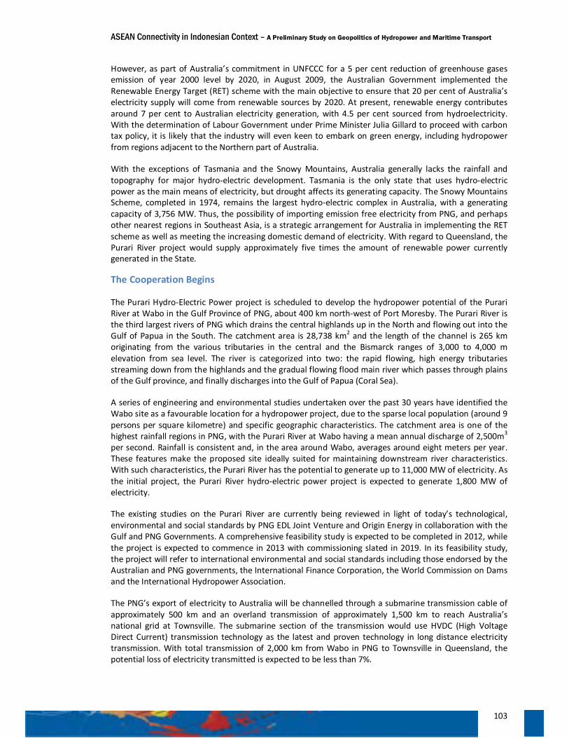
ASEAN Connectivity in Indonesian Context – A Preliminary Study on Geopolitics of Hydropower and Maritime Transport
103
However, as part of Australia’s commitment in UNFCCC for a 5 per cent reduction of greenhouse gases emission of year 2000 level by 2020, in August 2009, the Australian Government implemented the Renewable Energy Target (RET) scheme with the main objective to ensure that 20 per cent of Australia’s electricity supply will come from renewable sources by 2020. At present, renewable energy contributes around 7 per cent to Australian electricity generation, with 4.5 per cent sourced from hydroelectricity. With the determination of Labour Government under Prime Minister Julia Gillard to proceed with carbon tax policy, it is likely that the industry will even keen to embark on green energy, including hydropower from regions adjacent to the Northern part of Australia.
With the exceptions of Tasmania and the Snowy Mountains, Australia generally lacks the rainfall and topography for major hydro-electric development. Tasmania is the only state that uses hydro-electric power as the main means of electricity, but drought affects its generating capacity. The Snowy Mountains Scheme, completed in 1974, remains the largest hydro-electric complex in Australia, with a generating capacity of 3,756 MW. Thus, the possibility of importing emission free electricity from PNG, and perhaps other nearest regions in Southeast Asia, is a strategic arrangement for Australia in implementing the RET scheme as well as meeting the increasing domestic demand of electricity. With regard to Queensland, the Purari River project would supply approximately five times the amount of renewable power currently generated in the State.
The Cooperation Begins
The Purari Hydro-Electric Power project is scheduled to develop the hydropower potential of the Purari River at Wabo in the Gulf Province of PNG, about 400 km north-west of Port Moresby. The Purari River is the third largest rivers of PNG which drains the central highlands up in the North and flowing out into the Gulf of Papua in the South. The catchment area is 28,738 km2 and the length of the channel is 265 km originating from the various tributaries in the central and the Bismarck ranges of 3,000 to 4,000 m elevation from sea level. The river is categorized into two: the rapid flowing, high energy tributaries streaming down from the highlands and the gradual flowing flood main river which passes through plains of the Gulf province, and finally discharges into the Gulf of Papua (Coral Sea).
A series of engineering and environmental studies undertaken over the past 30 years have identified the Wabo site as a favourable location for a hydropower project, due to the sparse local population (around 9 persons per square kilometre) and specific geographic characteristics. The catchment area is one of the highest rainfall regions in PNG, with the Purari River at Wabo having a mean annual discharge of 2,500m3 per second. Rainfall is consistent and, in the area around Wabo, averages around eight meters per year. These features make the proposed site ideally suited for maintaining downstream river characteristics. With such characteristics, the Purari River has the potential to generate up to 11,000 MW of electricity. As the initial project, the Purari River hydro-electric power project is expected to generate 1,800 MW of electricity.
The existing studies on the Purari River are currently being reviewed in light of today’s technological, environmental and social standards by PNG EDL Joint Venture and Origin Energy in collaboration with the Gulf and PNG Governments. A comprehensive feasibility study is expected to be completed in 2012, while the project is expected to commence in 2013 with commissioning slated in 2019. In its feasibility study, the project will refer to international environmental and social standards including those endorsed by the Australian and PNG governments, the International Finance Corporation, the World Commission on Dams and the International Hydropower Association.
The PNG’s export of electricity to Australia will be channelled through a submarine transmission cable of approximately 500 km and an overland transmission of approximately 1,500 km to reach Australia’s national grid at Townsville. The submarine section of the transmission would use HVDC (High Voltage Direct Current) transmission technology as the latest and proven technology in long distance electricity transmission. With total transmission of 2,000 km from Wabo in PNG to Townsville in Queensland, the potential loss of electricity transmitted is expected to be less than 7%.
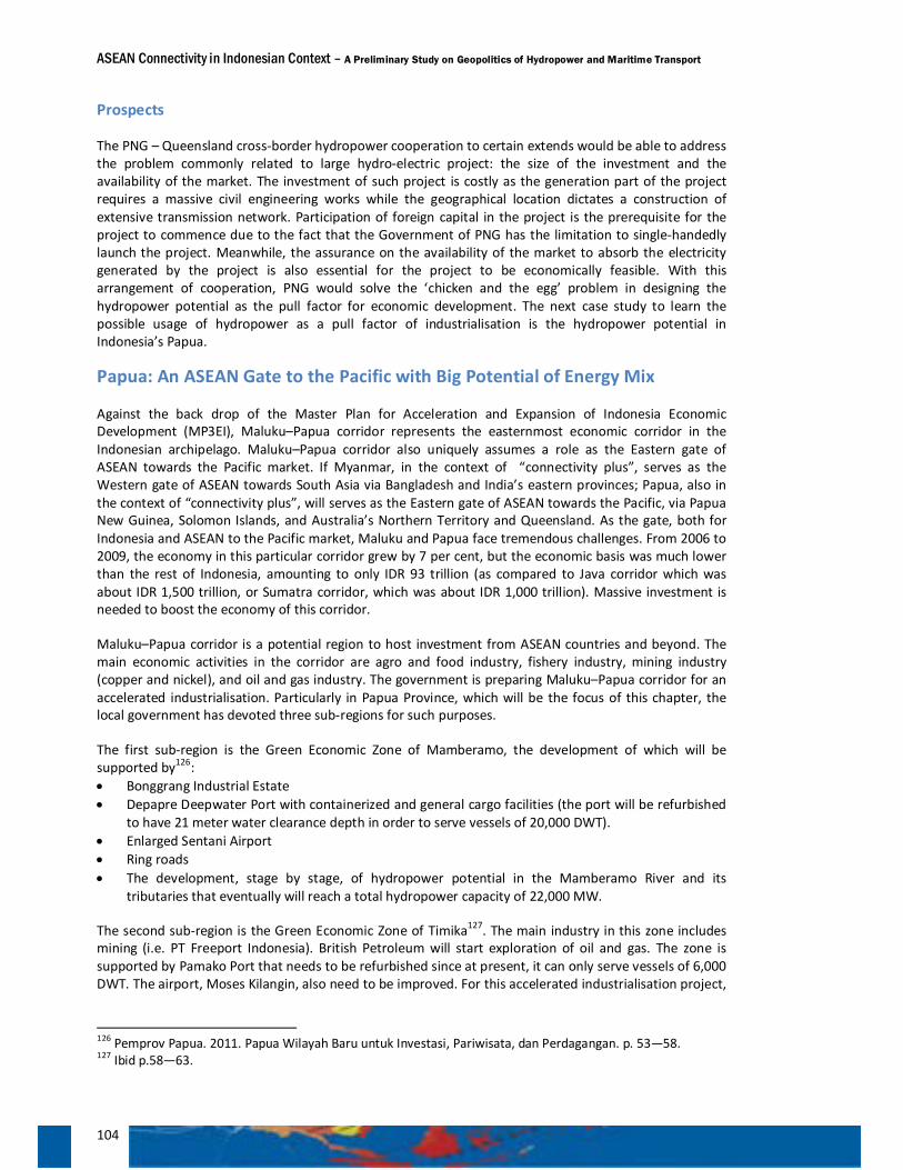
ASEAN Connectivity in Indonesian Context – A Preliminary Study on Geopolitics of Hydropower and Maritime Transport
104
Prospects
The PNG – Queensland cross-border hydropower cooperation to certain extends would be able to address the problem commonly related to large hydro-electric project: the size of the investment and the availability of the market. The investment of such project is costly as the generation part of the project requires a massive civil engineering works while the geographical location dictates a construction of extensive transmission network. Participation of foreign capital in the project is the prerequisite for the project to commence due to the fact that the Government of PNG has the limitation to single-handedly launch the project. Meanwhile, the assurance on the availability of the market to absorb the electricity generated by the project is also essential for the project to be economically feasible. With this arrangement of cooperation, PNG would solve the ‘chicken and the egg’ problem in designing the hydropower potential as the pull factor for economic development. The next case study to learn the possible usage of hydropower as a pull factor of industrialisation is the hydropower potential in Indonesia’s Papua.
Papua: An ASEAN Gate to the Pacific with Big Potential of Energy Mix
Against the back drop of the Master Plan for Acceleration and Expansion of Indonesia Economic Development (MP3EI), Maluku–Papua corridor represents the easternmost economic corridor in the Indonesian archipelago. Maluku–Papua corridor also uniquely assumes a role as the Eastern gate of ASEAN towards the Pacific market. If Myanmar, in the context of “connectivity plus”, serves as the Western gate of ASEAN towards South Asia via Bangladesh and India’s eastern provinces; Papua, also in the context of “connectivity plus”, will serves as the Eastern gate of ASEAN towards the Pacific, via Papua New Guinea, Solomon Islands, and Australia’s Northern Territory and Queensland. As the gate, both for Indonesia and ASEAN to the Pacific market, Maluku and Papua face tremendous challenges. From 2006 to 2009, the economy in this particular corridor grew by 7 per cent, but the economic basis was much lower than the rest of Indonesia, amounting to only IDR 93 trillion (as compared to Java corridor which was about IDR 1,500 trillion, or Sumatra corridor, which was about IDR 1,000 trillion). Massive investment is needed to boost the economy of this corridor.
Maluku–Papua corridor is a potential region to host investment from ASEAN countries and beyond. The main economic activities in the corridor are agro and food industry, fishery industry, mining industry (copper and nickel), and oil and gas industry. The government is preparing Maluku–Papua corridor for an accelerated industrialisation. Particularly in Papua Province, which will be the focus of this chapter, the local government has devoted three sub-regions for such purposes.
The first sub-region is the Green Economic Zone of Mamberamo, the development of which will be supported by126: • Bonggrang Industrial Estate • Depapre Deepwater Port with containerized and general cargo facilities (the port will be refurbished
to have 21 meter water clearance depth in order to serve vessels of 20,000 DWT). • Enlarged Sentani Airport • Ring roads • The development, stage by stage, of hydropower potential in the Mamberamo River and its
tributaries that eventually will reach a total hydropower capacity of 22,000 MW.
The second sub-region is the Green Economic Zone of Timika127. The main industry in this zone includes mining (i.e. PT Freeport Indonesia). British Petroleum will start exploration of oil and gas. The zone is supported by Pamako Port that needs to be refurbished since at present, it can only serve vessels of 6,000 DWT. The airport, Moses Kilangin, also need to be improved. For this accelerated industrialisation project,
126 Pemprov Papua. 2011. Papua Wilayah Baru untuk Investasi, Pariwisata, dan Perdagangan. p. 53—58. 127 Ibid p.58—63.
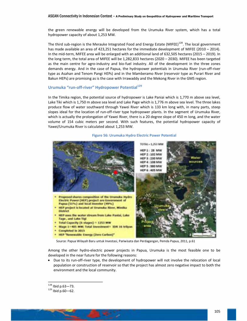
ASEAN Connectivity in Indonesian Context – A Preliminary Study on Geopolitics of Hydropower and Maritime Transport
105
the green renewable energy will be developed from the Urumuka River system, which has a total hydropower capacity of about 1,253 MW.
The third sub-region is the Merauke Integrated Food and Energy Estate (MIFEE)128. The local government has made available an area of 423,251 hectares for the immediate development of MIFEE (2010 – 2014). In the mid-term, MIFEE area will be enlarged with an additional land of 632,505 hectares (2015 – 2019). In the long term, the total area of MIFEE will be 1,282,833 hectares (2020 – 2030). MIFEE has been targeted as the main centre for agro-industry and bio-fuel industry. All of the development in the three zones demands energy. And in the case of Papua, the hydropower potentials in Urumuka River (run-off-river type as Asahan and Tenom Pangi HEPs) and in the Mamberamo River (reservoir type as Purari River and Bakun HEPs) are promising as is the case with Irrawaddy and the Mekong River in the GMS region.
Urumuka “run-off-river” Hydropower Potential129
In the Timika region, the potential source of hydropower is Lake Paniai which is 1,770 m above sea level, Lake Tiki which is 1,750 m above sea level and Lake Page which is 1,776 m above sea level. The three lakes produce flow of water southward through Yawei River which is 133 km long with, in many parts, steep slopes ideal for the location of run-off-river type hydropower plants. In the segment of Urumuka River, which is actually the prolongation of Yawei River, there is a 20 degree slope of 450 m long, and the water volume of 154 cubic meters per second. With such features, the potential hydropower capacity of Yawei/Urumuka River is calculated about 1,253 MW.
Figure 56: Urumuka Hydro Electric Power Potential
Source: Papua Wilayah Baru untuk Investasi, Pariwisata dan Perdagangan, Pemda Papua, 2011, p.61
Among the other hydro-electric power projects in Papua, Urumuka is the most feasible one to be developed in the near future for the following reasons: • Due to its run-off-river type, the development of hydropower will not involve the relocation of local
population or construction of reservoir so that the project has almost zero negative impact to both the environment and the local community.
128 Ibid p.63—73. 129 Ibid p.60—62.
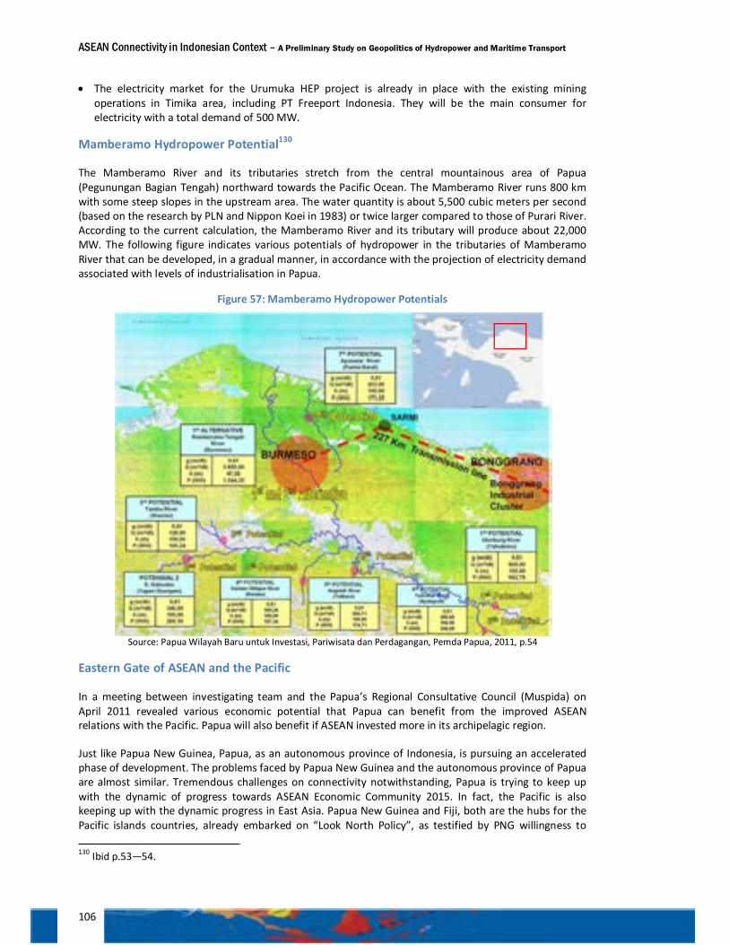
ASEAN Connectivity in Indonesian Context – A Preliminary Study on Geopolitics of Hydropower and Maritime Transport
106
• The electricity market for the Urumuka HEP project is already in place with the existing mining operations in Timika area, including PT Freeport Indonesia. They will be the main consumer for electricity with a total demand of 500 MW.
Mamberamo Hydropower Potential130
The Mamberamo River and its tributaries stretch from the central mountainous area of Papua (Pegunungan Bagian Tengah) northward towards the Pacific Ocean. The Mamberamo River runs 800 km with some steep slopes in the upstream area. The water quantity is about 5,500 cubic meters per second (based on the research by PLN and Nippon Koei in 1983) or twice larger compared to those of Purari River. According to the current calculation, the Mamberamo River and its tributary will produce about 22,000 MW. The following figure indicates various potentials of hydropower in the tributaries of Mamberamo River that can be developed, in a gradual manner, in accordance with the projection of electricity demand associated with levels of industrialisation in Papua.
Figure 57: Mamberamo Hydropower Potentials
Source: Papua Wilayah Baru untuk Investasi, Pariwisata dan Perdagangan, Pemda Papua, 2011, p.54
Eastern Gate of ASEAN and the Pacific
In a meeting between investigating team and the Papua’s Regional Consultative Council (Muspida) on April 2011 revealed various economic potential that Papua can benefit from the improved ASEAN relations with the Pacific. Papua will also benefit if ASEAN invested more in its archipelagic region.
Just like Papua New Guinea, Papua, as an autonomous province of Indonesia, is pursuing an accelerated phase of development. The problems faced by Papua New Guinea and the autonomous province of Papua are almost similar. Tremendous challenges on connectivity notwithstanding, Papua is trying to keep up with the dynamic of progress towards ASEAN Economic Community 2015. In fact, the Pacific is also keeping up with the dynamic progress in East Asia. Papua New Guinea and Fiji, both are the hubs for the Pacific islands countries, already embarked on “Look North Policy”, as testified by PNG willingness to 130 Ibid p.53—54.
ASEAN Connectivity in Indonesian Context – A Preliminary Study on Geopolitics of Hydropower and Maritime Transport
107
benefit from ASEAN market, following the Timor Leste application to be part of ASEAN. Fiji has expressed its willingness to be an “observer” in ASEAN. As such, the central government should give the opportunity for Papua to engage more with ASEAN Economic Programs, including the implementation of the Master Plan on ASEAN Connectivity.
The triangular complex relations between industrial development/resources management, development of energy mix, and development of maritime connectivity also apply to Papua. On the development of hydropower potentials, to support industrialisation, the realization of hydro potential in Urumuka (run-off) River is the most feasible one. Learning from the experience of Sabah in the development of Tenom Pangi as a run-off river hydropower plant, the development of Urumuka will not incur social and environmental costs. The development of Urumuka is usually associated with the available market in Timika, in particular PT Freeport Indonesia. The energy for PT Freeport Indonesia, so far, has been sustained by the supply of coals from Kalimantan corridor. With the determinations of the Provincial Government of Papua to proceed with the green economy, a purpose which also serves the best interest of PT Freeport Indonesia, the company will likely shift the energy option from the Kalimantan’s coal to the Urumuka’s hydropower. After all, with the existing problems of maritime connectivity, which all ports in the Southern Part of Papua can only serve vessels of 6,000 DWT (i.e. Pomako Port), and thus hamper the smooth transportation of coals, Urumuka hydro-electric project is the most feasible alternative for PT Freeport Indonesia, and other energy intensive industry in Timika region.
However, when one relates the development of Urumuka hydro-electric project with the need of electricity for the development of MIFEE (Merauke Integrated Food and Energy Estate), a reference to the progress of Australia-PNG Purari hydro-electric project is also needed. Merauke is closer to Daru (the PNG’s outermost point of interconnection with Queensland) than to Urumuka. It is thus quite possible, in the future, to consider electricity trade with Purari hydro-electric plant, to supply the electricity needed for MIFEE’s agro industry projects, when the Purari plant is fully operational in 2019. A thorough anticipatory feasibility study is needed to see to what extent, MIFEE could benefit economically from both Urumuka hydro-electric project and Purari hydro-electric project.
With the same token, the development of Mamberamo Green Economic Zone should take the dynamic towards ASEAN Economic Community 2015 into account. The planning for the developments of hydro potential in Mamberamo River, Bonggrang Industrial Cluster, the Port of Depapre, and Sentani Airport should be synergic and comprehensive, and its implementation should at best surf the dynamic wave of ASEAN Economic Integration.
Learning from the experience of Sarawak, in which the development of Bakun Hydro-Electric Power Plant is purported to attract foreign direct investment and relocation of energy intensive industry to Sarawak, the development of Mamberamo Hydro-Electric Power Projects should be in line with intensified effort to conclude preliminary agreements (MoUs or otherwise) with energy intensive industry, in particular smelters, to invest or to relocate their operations, into Bonggrang Industrial Cluster.
The possibility of electric trading with neighbouring economies to absorb the power excess from Mamberamo hydroelectric power plants, as is planned in the case of PNG-Queensland’s Purari project or possibly Sarawak’s Bakun, is the pragmatic outlet for Papua. If Papua managed to have an arrangement like Purari, or Bakun, then the development of the Mamberamo potential can be initiated step by step from the tributary rivers, instead of the main river, in accordance with both domestic demand level (as sustained by power purchase agreements with energy intensive industries) and demand from neighbouring economies. Energy intensive industries (i.e. those like PT Inalum/Asahan-2) are potential candidates to be offered this win-win opportunity.
ASEAN Connectivity in Indonesian Context – A Preliminary Study on Geopolitics of Hydropower and Maritime Transport
108
Chapter 5 | CONCLUDING ESSAY: Lessons Learned and Recommendation
Lesson Learned from the GMS: what is relevant to IMT-GT and BIMP-EAGA? 1. The development of Cross Border Infrastructure (CBI) is very critical to support growth and
promote cross border trade and investment, provided that it is well supported by institutional connectivity. It is also critical for achieving the goal of an economically integrated ASEAN Economic Community in 2015, by addressing inequalities in infrastructure development and differences in infrastructure quality to reduce development gaps among ASEAN countries, and to reduce income inequality and poverty within each country131. In this connection, a lesson learned from the GMS is how to translate the Master Plan on ASEAN Connectivity as a concept into operational strategies and practices. And in the Indonesian context, is how the implementation of the Master Plan on ASEAN Connectivity can progress in harmony (i.e. mutually reinforcing) with the implementation of the Master Plan on Economic Development and Expansion of Indonesia (MP3EI).
2. CBI development in the mainland region of ASEAN has been successful in establishing connectivity to large markets, such as China in East Asia and India in South Asia. It also assisted the process of ASEAN +3 and ASEAN +India cooperation. As such, ASEAN infrastructure can act as a building block for pan-Asia cooperation and integration132.
3. Binding ASEAN countries through efficient infrastructural linkages in transportation, telecommunications, and energy would require a shared strategic vision with strong commitment from all member countries. Considering the region’s geography, size, and economic diversity, a multi-track and multi-speed approach should be applied for ASEAN infrastructure integration133. Meanwhile, individual ASEAN economies need to enhance their infrastructure quality to become more globally competitive and to improve ASEAN’s competitiveness.
4. At the sub-regional level, Indonesia may take a leadership role in accelerating the initiatives of sub-regional infrastructure cooperation programme within the frameworks of the Brunei – Indonesia – Malaysia – Philippine East Asia Growth Area (BIMP – EAGA) and the Indonesia – Malaysia – Thailand Growth Triangle (IMT – GT). For the BIMP – EAGA, the government sectors should take the lead in all top-down processes, which is why the BIMP-EAGA Summit should come up with a leader’s commitment and direction to accelerate the cross-border infrastructure development between Brunei - Indonesia- Malaysia – Philippines. In turn, the respective ministers and provincial governors will translate the leaders’ commitment into an action plan through a series of consultation in the technical level, namely Business Forums, Governors Forum, Technical Working Groups, Senior Officials’ Meetings, Ministerial Conferences, and Leaders’ Summits.
5. Whereas for the IMT-GT, where business-to-business linkages are already well established among the private sectors of Indonesia, Malaysia, and Thailand (even much better if to be compared with the BIMP-EAGA), the Indonesian government may play a role in promoting public-private partnership or in facilitating a business forum as a side-event of the IMT-GT Summit.
6. For financing, Indonesia should intensify communication with ASEAN’s Dialogue Partners and Multilateral Development Banks such as the ADB or World Bank to seek effective and flexible resources to address gaps in financing when the private sector funds prove to be inadequate. This
131 Bhattacharyay, p. 207. 132 Bhattacharyay, p. 217. 133 Bhattacharyay, p. 202.
ASEAN Connectivity in Indonesian Context – A Preliminary Study on Geopolitics of Hydropower and Maritime Transport
109
can be done by mobilizing long-term funds through capital market, co-financing, and stimulating market activities.
7. An effective coordination mechanism within the GMS that could be applied in the BIMP-EAGA or IMT-GT is the consultation process. In order to identify and consolidate the concerns of stakeholders in defining the strategy and action plan for the cross-border infrastructure development, the consultation process should involve all stakeholders, namely the government officials of the member countries, the representatives of the private sector, non-government organizations (NGOs), and development partners134. The roles of each stakeholder are as follows:
a. Government Sector: For the government sector, the national and provincial development plans should be explicitly linked to the sub-region’s connectivity development program.
b. Private Sector: The private sector’s interests can be generally classified into two components. The first refers to the use of the transport system, while the second concerns the opportunities and possible costs of socioeconomic development of the area surrounding the corridor. The developmental aspects of the corridor are often distinct from its commercial viability. As the development targets some of the poorer areas of the countries, that feature is reflected in the relatively low level of private sector development and the low skill levels in some of the poorer areas of the corridor. It is therefore important to recognize the distinction between commercial and development interests as well as the possible conflicts and competitive interests that can exist between the corridors which have greater commercial viability in the region.
c. Development Partners: Most development partners in the GMS share a common vision of the socioeconomic development of the regions that the corridor traverses. As such, the initial stage of the EWEC’s development concentrated on the establishment and improvement of the transport infrastructure needed to efficiently transport goods, services, and people across borders. Improvement of this type of infrastructure has been considered to be essential in furthering linkages along the corridor. The second stage of the corridor’s development is now focusing on the reduction of poverty, the development of rural and border areas, the improvements in the earnings of low income and vulnerable groups, and the promotion of tourism along the corridor.
8. For trade facilitation, each country in the sub-region must amend its domestic rules and regulations concerning cross-border movement. In the GMS’ case, the agreement at the sub-regional and regional level of ASEAN cannot readily result in practical effect. Therefore, attempts must be made at each member’s domestic level, and one way to begin is by accelerating the process of giving driver visas. To encourage cross-border transport, each country must support a base of movements of goods within the connecting points in each country. This will help increase value of resources and provide further benefit for each of the countries involved.
9. Parallel to physical connectivity development, member countries of the BIMP-EAGA and the IMT-GT should start drafting a compact and comprehensive multilateral instrument that covers all the relevant aspects of cross-border facilitation similar to the Cross-Border Transport Agreement in the GMS. This instrument should include the arrangement for single-stop/single-window inspections, cross-border movement of people, transit traffic regime, vehicles making cross-border trips, the exchange of commercial traffic rights, and issues related to the design standards of roads, bridges, signs, and signals. For the BIMP – EAGA in particular, this arrangement in the sub-region should also be integrated with the arrangements for cross-border movement through sea links and maritime services.
Finally, other sub-regions can learn from the success story of GMS in promoting economic integration through connectivity while making progress toward ASEAN Community building and in strengthening cooperation with other sub-regions beyond ASEAN, such as BIMSTEC (which consists of Bangladesh, India, Myanmar, Sri Lanka, Thailand, Bhutan, and Nepal). In this context, as the biggest archipelagic nation and 134 ADB, p.14.
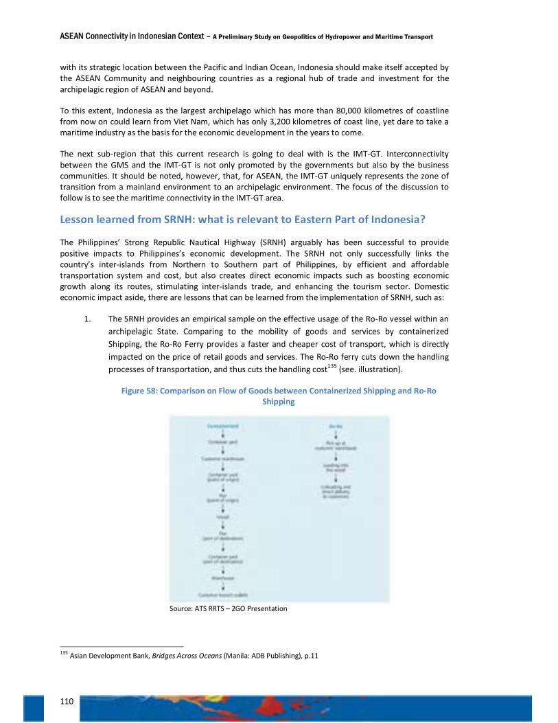
ASEAN Connectivity in Indonesian Context – A Preliminary Study on Geopolitics of Hydropower and Maritime Transport
110
with its strategic location between the Pacific and Indian Ocean, Indonesia should make itself accepted by the ASEAN Community and neighbouring countries as a regional hub of trade and investment for the archipelagic region of ASEAN and beyond.
To this extent, Indonesia as the largest archipelago which has more than 80,000 kilometres of coastline from now on could learn from Viet Nam, which has only 3,200 kilometres of coast line, yet dare to take a maritime industry as the basis for the economic development in the years to come.
The next sub-region that this current research is going to deal with is the IMT-GT. Interconnectivity between the GMS and the IMT-GT is not only promoted by the governments but also by the business communities. It should be noted, however, that, for ASEAN, the IMT-GT uniquely represents the zone of transition from a mainland environment to an archipelagic environment. The focus of the discussion to follow is to see the maritime connectivity in the IMT-GT area.
Lesson learned from SRNH: what is relevant to Eastern Part of Indonesia?
The Philippines’ Strong Republic Nautical Highway (SRNH) arguably has been successful to provide positive impacts to Philippines’s economic development. The SRNH not only successfully links the country’s inter-islands from Northern to Southern part of Philippines, by efficient and affordable transportation system and cost, but also creates direct economic impacts such as boosting economic growth along its routes, stimulating inter-islands trade, and enhancing the tourism sector. Domestic economic impact aside, there are lessons that can be learned from the implementation of SRNH, such as:
1. The SRNH provides an empirical sample on the effective usage of the Ro-Ro vessel within an archipelagic State. Comparing to the mobility of goods and services by containerized Shipping, the Ro-Ro Ferry provides a faster and cheaper cost of transport, which is directly impacted on the price of retail goods and services. The Ro-Ro ferry cuts down the handling processes of transportation, and thus cuts the handling cost135 (see. illustration).
Figure 58: Comparison on Flow of Goods between Containerized Shipping and Ro-Ro Shipping
Source: ATS RRTS – 2GO Presentation
135 Asian Development Bank, Bridges Across Oceans (Manila: ADB Publishing), p.11

ASEAN Connectivity in Indonesian Context – A Preliminary Study on Geopolitics of Hydropower and Maritime Transport
111
2. Private sectors participation has played pivotal roles in developing and financing the SRNH. The Private sectors are engaged to finance the development of commercial and non-commercial infrastructures and facilities such as in the SRNH’s ports and related transport services. With this, the SRNH can be an example how Public Private Partnership (PPP) has been successfully developed in the Philippines’ case.
3. Last but not least, the success of the SRNH arguably cannot be separated from the external assistance of its development. For example, the Asian Development Bank, the Asia Foundation, World Bank, and the United States Agency for International Development (USAID) play significant roles in conducting research to develop an intermodal planning approach, to provide clear policy advices for the Government of the Philippines and others. Specifically in providing finance assistance, the Japan Bank for International Cooperation (JBIC) in cooperation with the Philippines Development Bank (PDB) acts as major source of external financing assistance to finance the construction of the ports and to acquire intermodal transport network system (Ro-Ro, Ferry and other maritime mode of transportation).
Viewed from the development of the SRNH in the Philippines, it can be concluded that this approach of connectivity has successfully provided positive impacts on the people of the Philippines. However, in spite of creating benefits, there remain some challenges such as how to sustain the development, policy reform of the SRNH. The Administration of the SRNH which involves many stakeholders and parties, with diverse vested interests exist, should nurture a common understanding that the reforms would benefit all parties.
The security aspect of inter-lands connectivity in the SRNH should be maintained and developed in such a way that open connectivity and convenient mobility would not jeopardizes security such as people smuggling, trans-border crime or even terrorism.
The next challenge of the SRNH is how the system of connectivity can be used as model of ASEAN’s archipelagic connectivity, linking wider network to neighbouring islands like Eastern Indonesia, Eastern Malaysia, Papua New Guinea islands, Timor-Leste, or even several Pacific Islands. It calls for commitment and synergy among the parties or governments in this region. By establishing the connectivity in this region, a new growth centre would be created. This is thus time to observe the development of maritime connectivity in the Eastern Part of Indonesia.
More lessons learned on maritime connectivity
Geopolitically, the development of inter-islands connectivity in Indonesia is in line with its archipelagic outlook. Ferries and short sea-shipping are not only to provide public transportation service, but also to support the integrity and sovereignty of the Republic of Indonesia through regular visits to the outer islands. The lack of attention to the outer islands can lead to vulnerability of national security. It is suggested that in order to reach particular outer islands of Indonesia, which are those strictly under political security considerations, the government provides greater subsidies to the ferry operators, since the existing market in that particular line is still not profitable for operators.
The implementation of the Master Plan on ASEAN Connectivity, for Indonesia, should be mutually supportive to the need to develop connectivity among islands in the Indonesian archipelago. The concept of ASEAN Connectivity should be viewed as external driving factor in realizing the concept of archipelagic state in accordance with the Djuanda Declaration 1958.
The Indonesian government should take into consideration positive support rendered by ASEAN's dialogue partners like China, Japan, Australia, and India in the development of transport infrastructure projects that may improve inter and intra-connectivity in the archipelagic region of ASEAN as a counterweight towards the massive connectivity infrastructure development in the Greater Mekong sub-
ASEAN Connectivity in Indonesian Context – A Preliminary Study on Geopolitics of Hydropower and Maritime Transport
112
region. Indonesia should play a leading role in proposing projects for the implementation of MPAC in Indonesia, particularly in the realization of Mainland-Archipelagic ASEAN connectivity to promote inclusive economic growth that evenly reach all areas in ASEAN region.
Recommendations
Dissemination of ASEAN connectivity needed
1. Learning from the Indonesia’s experience in the preparation for, and implementation of, ASEAN-China Free Trade, in which, despite the considerable time for the preparation, with the signing of the framework in 2002 and the implementation of the free trade in 2010 for the six original members of ASEAN, many in the Indonesia’s business community were in fact not well prepared to fully benefit from the FTA. It is thus advisable that Indonesia undertakes not only a thorough study on the consequences of ASEAN Connectivity to the Indonesian economy but also dissemination on how Indonesia can benefit from such connectivity. Equally important, it is advisable for Indonesia to comprehend the synergy between the implementation of Master Plan on ASEAN Connectivity and Master Plan on the Acceleration and Expansion of Indonesia Economic Development (MP3EI)
MPAC is to help attain MP3EI
2. The lesson learned from the GMS progress on connectivity is that the GMS countries manage to win regional support for Vientiane Plan of Action 2008 (which is actually a concept of GMS connectivity) through the ASEAN Leaders’ Statement on ASEAN Connectivity in Hua Hin in 2009 and the adoption of the Master Plan on ASEAN Connectivity (MPAC) in Hanoi 2010; with the same perspective, it is advisable for Indonesia to use the MPAC to help support the implementation of Master Plan for Acceleration and Expansion of Indonesia Economic Development (MP3EI). The Implementation of the two Master Plans should always be in synergy.
Learning the success and failures of connectivity in the GMS
3. In implementing MP3EI, particularly in the development of internal and external connectivity, it is advisable for Indonesia to learn from the success and failure of the connectivity projects in the GMS region. From the experience of the GMS in the development of East West Economic Corridor (EWEC), with the associated projects of ASEAN Highway Network, Savan Park Industrial Zone and Da Nang International Port, more thorough study is needed to understand to what extent the availability of highways, sites dedicated for industrial zone, and international ports, failed to bring about economic connectivity and integration.
Maritime connectivity and development of hydropower needs leaders’ strong commitment
4. The lesson learned from the GMS progress on connectivity is that the projects of cross border infrastructures are endorsed and supported by leaders’ strong commitment (at the level of Head of States). It is advisable for Indonesia to promote leaders’ commitment for the development of maritime Ro-Ro/short sea-shipping connectivity and for the development of hydropower as an essential part of energy mix security, following natural gas and coal, for BIMP-EAGA.
Hydropower projects should not be prejudicial to the environment
5. The lesson learned from China is that a mega hydropower project with a conventional technology, such as dams and reservoirs, can be prejudicial to the environment and the livelihood of the society. The development of big dams and reservoirs might result in inundation of large area, forest or otherwise, as well as relocation of sizeable population. It is also advisable for Indonesia to learn on how China and other countries with mega hydropower projects such as
ASEAN Connectivity in Indonesian Context – A Preliminary Study on Geopolitics of Hydropower and Maritime Transport
113
Brazil, Canada, United States, Norway, Russia, etc., and reconcile the development of hydropower with the protection of the environment (i.e. the protection of the river basin, the protection of the migratory species of fish, biodiversity in the river system, etc.). It is also advisable for Indonesia to meet international standard of hydropower projects by among other, consulting with International Hydropower Association and World Commission on Dams. Large-sized conventional hydropower should only be developed when the negative impact in terms of the protection of environment, relocation of population and high-cost land acquisition, can be minimized.
Hydropower project should be in harmony with the surrounding community
6. The lesson learned from the experience of Australia-PNG Purari River project is that land ownership and the associated financial compensation are usually sensitive and complicated when the acquisition of land is confronted with native title (hak ulayat). Concerning the acquisition of land for hydropower projects in Papua, it is advisable for Indonesia to learn the resolution of such challenge from the on-going Australia-PNG Purari River project (2011—2019).
Run-off-river and pumped storage hydro electric power plants are feasible options
7. Learning from the experience of Sabah’s Tenom Pangi and Indonesia’s upper Cisokan, in which good supply of energy is sustained either by run-off-river or pumped storage hydro-electric power plants, it is advisable for Indonesia to study and compile data on run-off-river type hydropower potential and potential sites for pumped storage in the economic corridors of Kalimantan, Sulawesi, and Maluku-Papua. Asahan 1, Asahan 2 and the coming Urumuka Project represent the ideal run-of-river type HEP for future development hydropower of Indonesia. While realizing the environmental and social advantages of run-off-river and pumped storage hydro-electric plants, the development of the conventional (reservoir) hydro-electric plant should not be left out. hydro-electric plants with reservoir also have their own merit.
MP3EI should utilise ASEAN power grid
8. Indonesia needs to learn from the success of electricity interchange in GMS. It is advisable for Indonesia to promote the maximum use of ASEAN Power Grid to help the sufficient supply of electricity in the economic corridors (MP3EI) bordering with other ASEAN countries. It is advisable for the Indonesian economic corridors to promote exchange of electricity, for the sake of efficiency and related economic benefit, with the neighbouring economies such as: (1) Sumatra – Peninsular Malaysia (Pekanbaru-Dumai-Rupat Island-Malaka); (2) Kalimantan – Sarawak (West Kalimantan-Sarawak/in anticipation to the full operation of Bakun HEP project); (3) Papua – Papua New Guinea (Merauke – Daru/in anticipation to Purari River HEP project).
As such, it is also advisable for Indonesia to reconsider the possible development of Trans-Borneo Power Grid. A new feasibility study on Trans-Borneo Power Grid needs to be considered to study the economic merit of such grid. In line with this advice, Indonesia needs to take a feasibility study for the development of mine-mouth power plants to support such grid. Equally important, it is advisable for Indonesia to undertake feasibility study on the possibility of Trans-New Guinea Island Power Grid (Papua and PNG) and to see how the huge geographical distance as well as prohibitive development costs can be overcome.
BIMP-EAGA and SwPD should promote sub-regional power grids
9. Indonesia needs to learn from the GMS experience on how sub-regional arrangement is helpful for the development of sub-regional grid; in the Eastern Part of ASEAN the promotion of cross-border power grid (which is already an established practice in ASEAN) should be studied at length in the framework of BIMP-EAGA (in particular for the possible exchange of electricity in Borneo Island) and in the Southwest Pacific Dialogue/SwPD (for the possible exchange of electricity
ASEAN Connectivity in Indonesian Context – A Preliminary Study on Geopolitics of Hydropower and Maritime Transport
114
through Trans-New Guinea Power Grid). At the same token, the development of hydropower, together with that of natural gas and coal, should be part of the framework of Heart of Borneo Initiative, and a similar scheme should be developed for the Island of New Guinea. It should be noted, however, that high level frameworks might help, but at the end, any project development would be treated as a business, involving parties like companies and banks. Therefore, feasibility of such development is the key factor to draw the interests among the parties. In this particular case leadership is the determining factor.
Enabling environment needed for hydropower development
10. In accordance with the common practice in Indonesia and Sarawak, a production cost per kWh for hydropower represents the incremental of: (1) operational cost; (2) maintenance cost; (3) depreciation of capital and project ‘return’; and (4) water tax imposed by local government. It should be noted, as discussed in the previous chapter, cheaper that the advantage of hydropower vis-à-vis other type of power, is the absence of the expensive and fluctuated fossil fuel cost. Thus, to optimize the competitiveness of hydropower in the Eastern Part of ASEAN, and make the sub-region attractive for national and international investors on hydropower, it is advisable for Indonesia to promote a sub-regional understanding (i.e. within the BIMP-EAGA scheme) on the regulation of national and local water tax, to create better enabling environment for hydropower developments.
Building market for hydropower; providing competitive energy for industry
11. Indonesia needs to learn from Sarawak’s experience in supporting development of Bakun hydropower mega-project by concluding MoU with some energy intensive companies to secure energy market for Bakun. The direct effect of the MoU is the development and, to some extent, the relocation of energy intensive industry into Sarawak. Thus, it is advisable for Indonesia to support the development of hydro mega-project in the Eastern Part of Indonesia (i.e. potential development of Urumuka and Mamberamo Rivers in Papua) with “hydro-diplomacy”, the aims of which are to invite direct investment for the development of energy intensive industry to the Economic Zone of Timika and the Green Economic Zone of Mamberamo. It is also advisable for Indonesia to look at the feasibility for relocating some energy intensive industries from the economic corridors of Sumatra and Java to the economic corridors of Kalimantan, which is rich with high caloric value, and abundant water resources in Malaysia’s Sarawak, as well as Sulawesi and Maluku-Papua, which are also rich in hydropower.
Feasibility study on ASEAN Ro-Ro network
12. Learning from the pressing need to improving the maritime connectivity, it is advisable that the study of Ro-Ro Networks as suggested in the MPAC, and possibly also short sea-shipping, can be implemented immediately with the support from dialog partners and MDBs. It is also advisable that Indonesia and the Philippines to take the leading role in the implementation and execution of the study, while the dialog partners and MDBs shall assume role as donors.
Lifting potential connectivity into feasibility study projects
13. Learning from the GMS experience, Indonesia should propose to ASEAN Connectivity Coordinating Committee (ACCC) to undertake feasibility studies of the following potentials connectivity:
a. Western Part of Northern Ferry Belt: 1. Ulee Lheue/Aceh—Belawan—Penang/Malaysia (under IMT-GT framework); 2. Dumai/Riau—Malacca/Malaysia (under IMT-GT framework); 3. Malahayati/Aceh—Dawei/Myanmar (under ASEAN Connectivity framework);

ASEAN Connectivity in Indonesian Context – A Preliminary Study on Geopolitics of Hydropower and Maritime Transport
115
4. Malahayati/Aceh—Nicobar-Andaman/India—Kyaukphyu/Myanmar, with possible extension via multimodal transport to Yunnan (under ASEAN connectivity plus framework);
b. Eastern Part of Northern Ferry Belt: Davao (SRNH)—Bitung—Ternate—Sorong—Jayapura—Lae/PNG—Kimbe/PNG (under ASEAN connectivity plus framework);
c. Southern Ferry Belt, in particular the segment connecting Bali—Lombok—Sumbawa—Flores—Kupang; with an extension to:
d. Kupang—Oecussi—Dili (under SwPD/ASEAN connectivity plus framework); e. Kupang—Darwin (under SwPD/ASEAN connectivity plus framework).
Ro-Ro pricing policy
14. Learning from the experience of the Philippines in implementing SRNH, it is advisable for Indonesia to review the current practice of ferry ticket pricing. Ferry commercial line (which mostly operates in Indonesia’s Western ferry belts) should be accorded to market price calculated by the operator (i.e. PT ASDP Indonesia Ferry) based on the operation cost, free from the interference of central and local government.
Dealing with the complexity of financial support for Ro-Ro project
15. It is advisable for Indonesia to anticipate the possible complexity on financial support scheme in the development of cross border ferry connectivity. For such cross border project, for instance between Indonesia (Dumai or Belawan) and Malaysia (Malacca or Penang), Indonesia as a developing country will likely win soft loan from Multilateral Development Banks (MDB). While Malaysia as a developed country will likely have to rely on commercial loan. It is advisable that the matter to be discussed by the governments of Indonesia and Malaysia; and in doing so, the two governments should provide the opportunity for the operators to negotiate the price of the cross border Ro-Ro line.
Ro-Ro connectivity must be supported by institutional connectivity
16. Learning from the experience of cross border connectivity in the GMS, in particular in the East-West Economic Corridor, it is advisable that the development of physical connectivity (hardware infrastructure) should be adequately supported by institutional connectivity (software infrastructure), such as bilateral custom regulation among Indonesia, Malaysia, Singapore, Thailand, and other ASEAN members, in the case of Ro-Ro connectivity.
BIMP-EAGA is to be transformed into a production network
17. With the same token, the MPAC has identified challenges faced by the BIMP-EAGA sub-regional initiative. One of the challenges is that the participation of private sector which is dominated by small and medium size enterprises and thus its capacity to capitalize on opportunities in BIMP-EAGA, are very weak. The economic ties within the BIMP-EAGA sub-region remains dependent heavily on primary resource-based economic activities with the manufacturing sector contributing less than 20% of the regional gross domestic product. It is advisable that the Leaders of BIMP to push forward the efforts to establish production networks and/or value chains in selected commodities through the enhancement of an intra-EAGA transport services that allow for better movement of goods across borders. Learnt from the experience in the GMS, the leaders should take a lead to encourage the public-private partnership and to promote the participation of dialogue partners and MDBs.
ASEAN Connectivity in Indonesian Context – A Preliminary Study on Geopolitics of Hydropower and Maritime Transport
116
Better coordination in the development of Ro-Ro land network
18. Learning from the experience of the Philippines in the development of Ro-Ro-Land Networks, it is also advisable that Indonesia promotes better coordination between PT ASDP Indonesia Ferry, the local government (Pemerintah Daerah), Ministry of Public Works (Kementerian Pekerjaan Umum) and local land transport operators such as Organda, to support maritime connectivity networks (i.e. nautical highway network).
Ro-Ro network needs to include inland waterways
19. Learning from the characteristic of the archipelagic region of ASEAN, it is advisable that the introduction of Ro-Ro system should not be limited to maritime connectivity but also to support inland waterways transport including the trans-border ones. Such connectivity needs be enhance by promoting cooperation on short-sea shipping. Moreover, as it concerns Indonesia, PT ASDP is national development agent that is also providing pioneer and remote area transportation access to promote national economic development and serve inland rivers. PT ASDP operates several routes in West Borneo and Papua regions. There are several ASDP’s waterway routes at West Borneo: Kuala Tebas – Tebas Seberang, Rasau Jaya – Teluk Batang, Tayan – Terayu, Parit Sarem – Sungai Nipah & Tanjung Harapan – Teluk Kalong. Furthermore, in Papua region, PT ASDP develops a line that connects Sorong – Seget – Seremuk – Konda – Teminabuan – Mugim – Kais – Inawatan – Kokoda through rivers and sea.
Optimising the strategic role of archipelagic sea lanes
20. Learning from the pressing needs to improving maritime connectivity based on economic consideration, it is advisable for Indonesia to tap benefit from the strategic role of the archipelagic sea lane (ALKI); it is thus also advisable for Indonesia to figure out whether the sea lane would keep its conventional function as a mere waterway for international navigation within the archipelago or should the sea lane assume additional function as trade route, considering the ASEAN commitment toward the attainment of an Economic Community in 2015.
Strategic ties between Eastern Part of ASEAN with Southwest Pacific
21. Learning from the strategic values between the Eastern Part of Indonesia and the Southwest Pacific, Indonesia should optimize the development of maritime connectivity in the Eastern Part of Indonesia so that this region could function as a gate of connectivity plus with Southwest Pacific Countries. While investment to boost the development of maritime connectivity and potential hydropower in the eastern part of ASEAN remains open to all dialogue partners, in particular those belongs to East Asia Summit, geographical proximity and strategic ties between Eastern Part of ASEAN (i.e. the Philippines and the Eastern Part of Indonesia) and economies in Southwest Pacific (i.e. in the context of sub-regional South West Pacific Dialogue) should be considered.
ASEAN needs to promote maritime industry
22. Learning from the lacuna of maritime transport and its associated industry, that eventually hampered the connectivity of the Eastern Part of ASEAN, it is advisable for Indonesia to promote cooperation among the ASEAN countries for the development of reliable maritime industry, including ship building and shipyard. It should be noted that, ASEAN once developed cooperation to promote regional industry for fertilizer and cement.
23. To develop the ASEAN Ro-Ro network, the relevant ferry operators in Indonesia, Philippines, Sabah, and Northern Territory-Australia, Timor Leste and Papua New Guinea need to meet and discuss the technical aspect about the possibility to establish this Ro-Ro network. The meeting can be facilitated within the framework of sub-regional cooperation such as BIMP-EAGA, ASEAN +

ASEAN Connectivity in Indonesian Context – A Preliminary Study on Geopolitics of Hydropower and Maritime Transport
117
Australia, ASEAN Transport Ministerial Meeting or even Southwest Pacific Dialogue (SwPD). To accelerate the realization of ASEAN Ro-Ro network as mandated in the Master Plan on ASEAN Connectivity, some have regarded the necessity to address this issue at a Summit level or a Ministerial Meeting, as was undertaken by the countries in the Greater Mekong Sub-region (GMS), where the leaders firmly showed their commitment on connectivity development in this sub-region
118
List of Abbreviations AANZFTA ASEAN – Australia – New Zealand Free Trade Area ACCC ASEAN Connectivity Coordinating Committee ACFTA ASEAN – China Free Trade Arrangement ACMECS Ayeyawady - Chao Phraya - Mekong Economic Cooperation Strategy ADB Asian Development Bank AHN ASEAN Highway Networks ALKI Indonesian Sea Lanes of Communication AMSs ASEAN Member States APEC Asia-Pacific Economic Cooperation ARI Asia Research Institute ASEAN Association of Southeast Asian Nations BIMP-EAGA the Brunei-Indonesia-Malaysia-the Philippines - East ASEAN Growth Area BIMSTEC Bay of Bengal Initiative for Multi-Sectoral Technical and Economic Cooperation BOO build, operate and owned BPPK Policy Analysis and Development Agency BRR Agency for Rehabilitation and Reconstruction of Aceh CBI cross border infrastructure CBTA Cross Border Transport Agreement CBU completely build up CCS carbon capture and sequestration CEIEC China National Electronics Imp & Exp Corp. CEPEA Comprehensive Economic Partnership on East Asia CFRD concrete-faced rock fill dam CHD China Huadian Corporation CHDOC CHD Power Plant Operation Co. Ltd. CHEC China Huadian Engineering Corporation CHMC China National Heavy Machinery Corporation CIQ customs, immigration and quarantine CKD completely knocked down CLMV Cambodia, Lao, Myanmar, Vietnam CNEEC China National Electric Engineering Co. Ltd. CNY Chinese Yuan CO2 Carbon dioxide CPIC China Pacific Insurance (Group) Co. Ltd. CSG China Southern Power Grid CWE China Water Energy DoTC Department of Transportation and Communication DPB Development Bank of the Philippines DPWH Department of Public Works and Highways DTI Department of Trade and Industry DWT dead weight tonnage EAFTA East Asia Free Trade Area EDL Électricité de Lao EGAT Electricity Generation Authority of Thailand EL elevation EPC engineering, procurement and construction ERIA Economic Research Institute for ASEAN and East Asia
119
esl elevation from sea level EVN Electricity of Viet Nam EWEC East-West Economic Corridor FDI foreign direct investment FSL full supply level FTA free trade agreement GDP gross domestic product GMS Greater Mekong Sub-regions GRT gross register tonnage GSSC Greater Sulu Sulawesi Corridor GW gigawatt GWh gigawatt-hour HEP hydro-electric power HEPP hydro-electric power plant HLTF High Level Task Force HWL high water levels ICT information and communication technology IDR Indonesian Rupiah IEA International Energy Agency IMT-GT Indonesia-Malaysia-Thailand Growth Triangle ISEAS Institute of Southeast Asian Studies ISM International Safety Management IWT inland waterways transport JBIC Japan Bank for International Cooperation JICA Japan International Cooperation Agency KBI Western part of Indonesia KTI Eastern part of Indonesia kV Kilo Volt kWh kilowatt-hour LGU local government units LIPI Indonesian Institute of Science LMRB Lancang – Mekong River Basin LWL low water level MARINA Maritime Industry Authority MCH Malaysia China Hydro MIFEE Merauke Integrated Food and Energy Estate MOL minimum operating level MoU Memorandum of Understanding MP3EI Master Plan for Acceleration and Expansion of Indonesia Economic Development MPAC Master Plan on ASEAN Connectivity Muspida Regional Consultative Council MVA million volt-amperes MW megawatt MYR Malaysian Ringgit NEDA National Economic Development Authority NGOs non-governmental organizations NO nitric oxide NSEC North-South Economic Corridor NTT East Nusa Tenggara P3K2 Aspasaf Centre for Policy Analysis and Development of Asia-Pacific and African Regions PDA Project Development Agreement
120
PNG Papua New Guinea PNG EDL PNG Energy Developments Ltd PPA Philippines Ports Authority PPA Power Purchase Agreement PPP Public Private Partnership PRC People’s Republic of China PT ASDP PT Angkutan Sungai Danau dan Penyeberangan PT BDSN PT Bajra Daya Sentra Nusa PT INALUM PT Indonesia Asahan Alumunium PT PLN PT Perusahaan Listrik Negara RCC roller compacted concrete RET Renewable Energy Target Ro-Ro roll-on and roll-off RSIS Rajaratnam School of International Studies SARS Severe Acute Respiratory Syndrome SCORE Sarawak Corridor of Renewable Energy SEB Sarawak Energy Berhad SEC Southern Economic Corridor SESB Sabah Electricity Sdn. Bhd SLoC Sea Lane of Communication SME small and medium enterprises SO2 sulphur dioxide SRNH Strong Republic Nautical Highway SSI single stop inspection SWI single window inspection SwPD Southwest Pacific Dialogue TBPG Trans-Borneo Power Grid TEUs twenty-foot equivalent units TNB Tenaga National Berhad TOR Terms of Reference TTRs transit transport routes TWh terawatt-hour UNFCCC United Nations Framework Convention on Climate Change USAID United States Agency for International Development USD United States Dollar VPOA Vientiane Plan of Action WBEC Western Borneo Economic Corridor YMEC Yunnan Machinery & Equipment Export & Import Co. Ltd.
121
List of Interviewees
Fiji
Solo Mara, Permanent Secretary, Ministry of Foreign Affairs and International Cooperation of Fiji, Suva
Peter C.L. Eafeare, High Commissioner of Papua New Guinea to Fiji and Kiribati, Papua New Guinea High Commission, Suva
C. Steven McGann, Ambassador of the United States of America to Fiji, Kiribati, Nauru, Tonga and Tuvalu, U.S. Embassy in Suva
Han Zhiqiang, Ambassador of the People’s Republic of China to Fiji, Suva
Feleti P. Teo, Deputy Secretary General, Pacific Islands Forum Secretariat, Suva
Richard K. Pruett, Deputy Chief of Mission, U.S. Embassy in Suva
Guangxi, China
Wang Xuetao, Economic Affairs Director, Longtan Hydropower Development Co. Ltd.
Jiang Huilin, Deputy Regional Director, Commission of Development and Reform of Guangxi
Gao Yisong, Director of ASEAN Affairs Division, Guangxi Foreign Affairs Office
Guo Yulu, Deputy Director, International Exchange Department, Guangxi University
Laos
Leninnakhone Rasasak, Deputy Head of Foreign Cooperation Division, ASEAN Affairs Coordinator, Savannakhet Provincial Government, Laos
North Sumatra, Indonesia
Bambang Purnomo Hidayat, Assistant Vice President, PT Bajra Daya Sentra Nusa, Asahan 1 Hydro Electricity Power Plant
Frans Wijaya Asistent Vice President, PT Bajra Daya Sentra Nusa, Asahan 1 Hydro Electricity Power Plant
Dr. Hidayati, Head, Environment Agency of North Sumatera
Krisna Simbaputra, General Manager, PT PLN (Persero) of North Sumatera
Nusa Tenggara, Indonesia
Head of Branch, Lembar Ferry Port
Head of Branch, Kayangan Ferry Port
Head of Branch, Sape Ferry Port
Operation Manager, Balobok Ferry Port
Papua New Guinea
John T. Kulala, National Programme Director, Mining Sector Support Programme, Mineral Resources Authority of PNG, Port Moresby
David Sode, Chief Executive Officer, PNG Sustainable Development Program Ltd., Port Moresby
Tamzin Wardley, Chief Operating Officer, PNG Sustainable Development Program Ltd., Port Moresby
Tony Carbry, Chief Operating Officer, PNG Energy Development Ltd., Port Moresby
Professor Ross Hynes, Vice Chancellor, University of Papua New Guinea, Port Moresby
122
Jae-Suk Jun, Manager of Operation and Maintenance, Kanudi Power Plant, Decco PNG Ltd., Port Moresby
Queensland, Australia
Peter Best, Executive Director, Infrastructure Projects Division, Department of Infrastructure and Planning, Queensland Government, Brisbane
Geoff Robson, Director, Environment and Resources Policy, Department of the Premier and Cabinet, Queensland Government, Brisbane
Russ Mackie, Business Manager – South East Asia, Trade and Investment Queensland, Queensland Government, Brisbane
Philippines
Dr.Jose Regin F. Regidor, Director, National Center for Transportation Studies, University of the Philippines.
Laurdes T. Pagtalunan, Senior Communication Development Officer, Department of Transportation and Communications (DoTC)
Melvin Navaro, Director for Planning Services, Department of Public Works and Highways (DPWH)
E. Miole, Chief of Staff, Philippine Ports Authority (PPA)
Major General Emmanuel T Bautista, Armed Forces of the Philippines
Henry J. Bensurto, Secretary General, Commission on Maritime and Ocean Affairs Secretariat, Department of Foreign Affairs, Republic of the Philippines
Prof. Rommel C. Banlaoi, Executive Director, Philippine Institute for Peace, Violence and Terrorism Research
Sabah, Malaysia
Richard, Local Prominent Figure, Kaiduan
Susanna Chew, Head of BIMP-EAGA Facilitation Center
Noor Amy Ajak, Project Officer BIMP-EAGA
Rahimatsah Amat, Chief Techincal Officer Borneo Programme, World Wildlife Fund (WWF)
Salavangi Musa, Vice Manager, Tenom Pangi Hydropower, Sabah Electricity Sdn. Bhd. (SESB)
Sarawak, Malaysia
Julin Alen, Principal Assistant Director, State Planning Unit, Chief Minister’s Department, State of Sarawak, Kuching
Dawend Jiwan, Executive Officer, Regional Corridor Development Authority (RECODA), State of Sarawak, Kuching
Ivy Wong Abdullah, HOB National Coordinator, Forest Conservation Manager, World Wide Fund for Nature (WWF)-Malaysia, Kuching
Manager, Batang Ai Hydro Electric Power Plant
Timor Leste
Helio Sinatra Tavares, Executive Director for External Trade, Ministry of Trade, Tourism and Industry, Timor Leste
Jose Quintas, Director for Tourism, Ministry of Trade, Tourism and Industry, Timor Leste
Domingos da Costa Guteres, Acting Director for Domestic Trade, Ministry of Trade, Tourism and Industry, Timor Leste
123
Carlito Martins, Director – General, Ministry of State Administration and Regional Planning
Thailand
Director of Division 3, ASEAN Department, Ministry of Foreign Affairs, Thailand.
Wanchai Parkluck, Deputy Director General, Department of Highways, Thailand.
Theerapong Ratithamkul, Civil Engineer, Department of Highways, Thailand.
Chayatan Phromsorn, Ph.D. Director, Bureau of International Highways Cooperation, Department of Highways, Thailand.
Vietnam
Hoang Thuy Duong, Deputy Director General, Economic Affairs Department, Ministry of Foreign Affairs, Vietnam
To Anh Tuan, Assistant Director – General, International Organizations Department, Ministry of Foreign Affairs, Vietnam
Duong Tri Hien, Director, Political and Security Cooperation Division ASEAN Department, Ministry of Foreign Affairs, Vietnam
Ayumi Konishi, Country Director for Viet Nam, Asian Development Bank
Chairman, Tourism Industry Association
Pham Van Minh, Deputy Director, Department of Industry and Trade, Quang Tri Provincial Government, Vietnam
Nguyen Ngoc Hai, Customs Officers, Quang Tri Provincial Government, Vietnam
Nguyen Van Binh, Deputy Head of the Board, Quang Tri Provincial Economic Zones, Vietnam.
Luong Minh Sam, Director, Da Nang Foreign Affairs Department, Vietnam
Pham Hong Nam, Deputy Chief of International Cooperation Division, City of Da Nang, Vietnam
Nguyen Huu Sia, Director of Sales and Marketing, Da Nang Port, Vietnam
Dr. Phan Thi Hong Xuan, Acting Dean, Faculty of Southeast Asian Studies, Ho Chi Minh City Open University
Vice Dean, Faculty of International Studies, Vietnam National University.
Hoang Nam, Vice Director, Department of Foreign Affairs, Quang Tri Provincial Government, Vietnam
Thai Huu Lieu, Officer, Quang Tri Provincial People’s Committee Department of Foreign Affairs
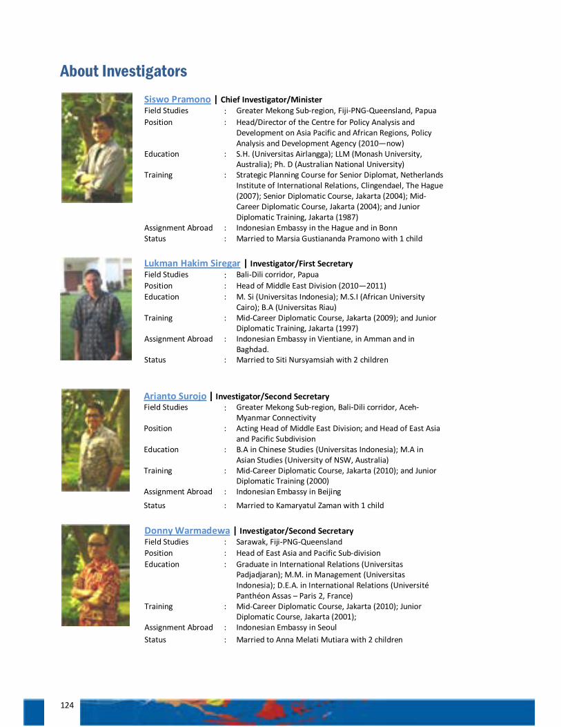
124
About Investigators
Siswo Pramono | Chief Investigator/Minister Field Studies : Greater Mekong Sub-region, Fiji-PNG-Queensland, Papua Position : Head/Director of the Centre for Policy Analysis and
Development on Asia Pacific and African Regions, Policy Analysis and Development Agency (2010—now)
Education : S.H. (Universitas Airlangga); LLM (Monash University, Australia); Ph. D (Australian National University)
Training : Strategic Planning Course for Senior Diplomat, Netherlands Institute of International Relations, Clingendael, The Hague (2007); Senior Diplomatic Course, Jakarta (2004); Mid-Career Diplomatic Course, Jakarta (2004); and Junior Diplomatic Training, Jakarta (1987)
Assignment Abroad : Indonesian Embassy in the Hague and in Bonn Status : Married to Marsia Gustiananda Pramono with 1 child
Lukman Hakim Siregar | Investigator/First Secretary Field Studies : Bali-Dili corridor, Papua Position : Head of Middle East Division (2010—2011) Education : M. Si (Universitas Indonesia); M.S.I (African University
Cairo); B.A (Universitas Riau) Training : Mid-Career Diplomatic Course, Jakarta (2009); and Junior
Diplomatic Training, Jakarta (1997) Assignment Abroad : Indonesian Embassy in Vientiane, in Amman and in
Baghdad. Status : Married to Siti Nursyamsiah with 2 children
Arianto Surojo | Investigator/Second Secretary Field Studies : Greater Mekong Sub-region, Bali-Dili corridor, Aceh-
Myanmar Connectivity Position : Acting Head of Middle East Division; and Head of East Asia
and Pacific Subdivision Education : B.A in Chinese Studies (Universitas Indonesia); M.A in
Asian Studies (University of NSW, Australia) Training : Mid-Career Diplomatic Course, Jakarta (2010); and Junior
Diplomatic Training (2000) Assignment Abroad : Indonesian Embassy in Beijing
Status : Married to Kamaryatul Zaman with 1 child
Donny Warmadewa | Investigator/Second Secretary Field Studies : Sarawak, Fiji-PNG-Queensland Position : Head of East Asia and Pacific Sub-division Education : Graduate in International Relations (Universitas
Padjadjaran); M.M. in Management (Universitas Indonesia); D.E.A. in International Relations (Université Panthéon Assas – Paris 2, France)
Training : Mid-Career Diplomatic Course, Jakarta (2010); Junior Diplomatic Course, Jakarta (2001);
Assignment Abroad : Indonesian Embassy in Seoul Status : Married to Anna Melati Mutiara with 2 children

125
Sigit Aris Prasetyo | Investigator/Third Secretary Field Studies : The Philippines, Aceh-Myanmar Connectivity Position : Head of Africa Subdivision Education : Graduate in English Literature (Universitas Islam
Indonesia); M.A. in American Studies (Universitas Gadjah Mada)
Training : Junior Diplomatic Training/Sekdilu XXXI, Jakarta (2006)
Assignment Abroad : Indonesian Consulate General in California, USA Status : Married with 1 child
Christine Refina | Investigator/Third Secretary Position : Staff Education : Graduate in Political Studies (Universitas Indonesia);
M.A in Public Policy (Ewha Womans University) Training : Junior Diplomatic Training/Sekdilu XXXI, Jakarta
(2006) Assignment Abroad : Indonesian Permanent Representative to UN, Geneva Status : Married to Tito Sianipar with 1 child
Adinda Hutabarat | Investigator/Third Secretary Field Studies : Guangxi, Thailand, the Philippines Position : Staff Education : Graduate in Chinese Studies (Universitas Indonesia); M.M.
(Tsinghua University, Beijing, China) Training : Junior Diplomatic Training/Sekdilu XXXII, Jakarta (2007),
Training on Chinese Language (August-Dec 2008) ASEAN Young Leaders Training Programme, Nanning – China (Nov-Dec 2011)
Assignment Abroad : Indonesian Consulate General in Johor Bahru, Malaysia Status : Single
Yudho Priambudi Asruchin | Investigator/Attaché Field Studies : Greater Mekong Sub-region Position : Staff Education : Graduate in Trade Law (Univeristas Pelita Harapan), now
undertaking Master degree program at Georgetown University, Washington D.C., 2011-2012
Training : Junior Diplomatic Training/Sekdilu XXXIII, Jakarta (2008) Assignment Abroad : Indonesian Embassy in Washington D.C Status : Single

126
Eva K. Situmorang | Investigator/Attaché Field Studies : Fiji, Sabah, Thailand, the Philippines Position : Staff Education : Graduate in Chinese Studies (Universitas Indonesia) Training : Junior Diplomatic Training/Sekdilu XXXIII, Jakarta (2008)
ASEAN Young Leaders Training Programme, Nanning – China (Nov-Dec 2011)
Assignment Abroad : Indonesian Consulate General in Guangzhou
Status : It’s less complicated now
M. Reza Adenan | Investigator/Attaché Field Studies : The Philippines, Papua Position : Staff Education : B.A in Development Study (University of Saskatchewan,
Canada) Training : Junior Diplomatic Training/Sekdilu XXXIV, Jakarta (2009) Assignment Abroad : Indonesian Consulate General in Marseille
Status : Married to Nina Dewi
Banga Malewa | Investigator/Attaché Field Studies : Sabah, Viet Nam, Cambodia Position : Staff Education : Graduate (Universitas Cendana, Kupang)
Training : Junior Diplomatic Training/Sekdilu XXXIV, Jakarta (2009) Assignment Abroad : Indonesian Embassy in Bratislava Status : Married to Yan Latanna
Indri Yanuarti | Investigator/Attaché Field Studies : Guangxi Position : Staff Education : Graduate in Mass Communication (Universitas Negeri
Sebelas Maret) Training : Junior Diplomatic Training/Sekdilu XXXIV, Jakarta (2009)
ASEAN Young Leaders Training Programme, Nanning – China (Nov-Dec 2011)
Assignment Abroad : Indonesian Embassy in Hanoi Status : Married to Ricky Ardiansyah
Adkhilni M. Sidqi | Investigator/Attaché Field Studies : North Sumatera, Singapore Position : Staff Education : Graduate in Political Studies (Universitas Gadjah Mada)
Training : Junior Diplomatic Training/Sekdilu XXXV, Jakarta (2010) Assignment Abroad : Indonesian Embassy in Cairo
Status : Married to Mia Ilmiawaty S. with 1 child

127
Imad Yousry | Investigator/Attaché Field Studies : North Sumatera, Singapore, Lao PDR Position : Staff Education : Graduate in Arabic Literature (University of Indonesia)
Training : Junior Diplomatic Training/Sekdilu XXXV, Jakarta (2010) International Center for Future and Strategic Studies, Fellowship Program, Cairo-Egypt (Sept-Nov 2011)
Assignment Abroad : Indonesian Embassy in Damascus Status : Single
Ivan Namanto | Investigator/Attaché Field Studies : Sarawak, Singapore, Lao PDR Position : Staff Education : Graduate in Chinese Language in Economy and Trade
(Beijing Union University) Training : Junior Diplomatic Training/Sekdilu XXXV, Jakarta (2010) Assignment Abroad : Indonesian Consulate General in Guangzhou
Status : Married to Selvia Andriani Hutabarat and soon-to-be father
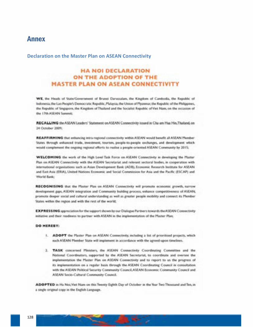
128
Annex
Declaration on the Master Plan on ASEAN Connectivity
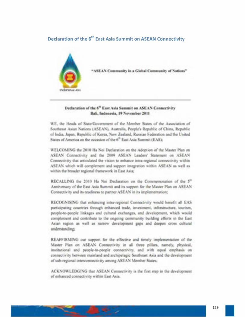
129
Declaration of the 6th East Asia Summit on ASEAN Connectivity
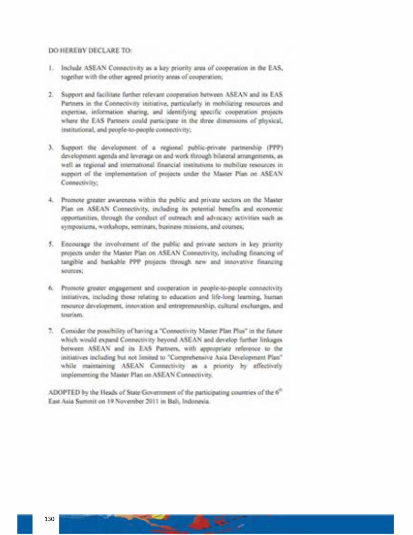
130
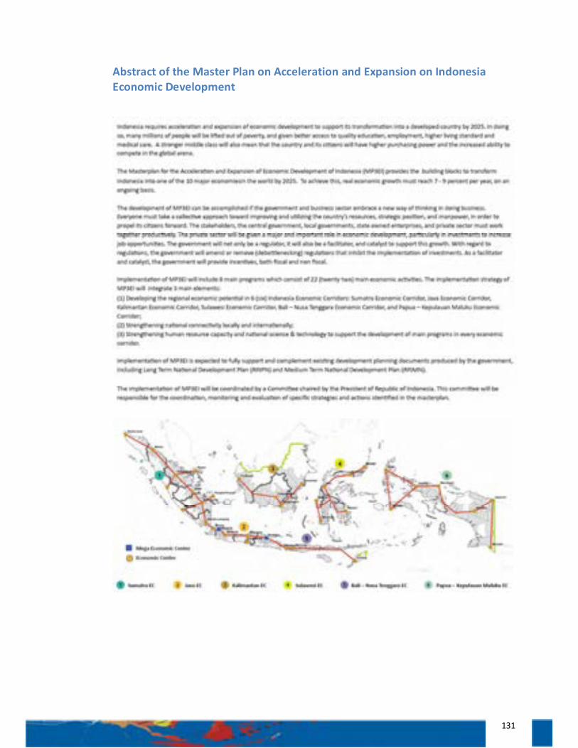
131
Abstract of the Master Plan on Acceleration and Expansion on Indonesia Economic Development