article a simple empirical band-ratio algorithm to assess
TRANSCRIPT

Article
A simple empirical band-ratio algorithm to assess suspended particulate matter from remote sensing over coastal and inland waters of Vietnam: application to the VNREDSat-1/NAOMI sensor.
Dat Dinh Ngoc 1,2,3,*, Hubert Loisel 1,2,3, Vincent Vantrepotte 1,2, Huy Chu Xuan 1, Ngoc Nguyen
Minh 1, Charles Verpoorter 2, Xavier Meriaux 2, Hanh Pham Thi Minh 4, Huong Le Thi 4, Hai Le
Vu Hong 6 and Thao Nguyen Van 5
1 Space Technology Institute, Vietnam Academy of Science and Technology, 18 Hoang Quoc Viet, Cau Giay,
Hanoi, Vietnam; [email protected], [email protected], [email protected] 2 Univ. Littoral Côte d’Opale, Univ. Lille, CNRS, UMR 8187, LOG, Laboratoire d’Océanologie et de
Géosciences, F 59000 Lille, France; [email protected], [email protected],
[email protected], [email protected] 3 LOTUS, University of Science and Technology of Hanoi, Vietnam Academy of Science and Technology, 18
Hoang Quoc Viet, Cau Giay, Hanoi, Vietnam 4 Institute of Mechanics, Viet Nam Academy of Science and Technology, 264 Doi Can, Ba Dinh, Hanoi,
Vietnam; [email protected], [email protected] 5 Institute of Marine Environment and Resources, Vietnam Academy of Science and Technology, 246 Da
Nang, Ngo Quyen, Haiphong, Vietnam; [email protected] 6 Institute of Techniques for Special Engineering, Le Quy Don University, 236 Hoang Quoc Viet, Bac Tu
Liem, Hanoi, Vietnam; [email protected]
* Correspondence: [email protected]; Tel: +84-915-089-159
Abstract: VNREDSat-1 is the first Vietnamese satellite enabling the survey of environmental
parameters such as vegetation and water coverages, or surface water quality at medium spatial
resolution (from 2.5 to 10 meters depending on the considered channel). The NAOMI sensor on
board VNREDSat-1 has the required spectral bands to assess the suspended particulate matter
concentration, SPM. Because recent studies have shown that the remote sensing reflectance, Rrs(),
at the blue (450 – 520 nm), green (530 – 600 nm), and red (620 – 690 nm) spectral bands can be
assessed from NAOMI with a good accuracy, the present study is dedicated to the development and
validation of an algorithm (hereafter referred to as V1SPM) to assess SPM from Rrs() over inland
and coastal waters of Vietnam. For that purpose, an in situ data set of hyper-spectral Rrs() and SPM
(from 0.47 to 240.14 g.m-3) measurements collected at 205 coastal and inland stations has been
gathered. Among the different approaches, including 4 historical algorithms, the polynomial
algorithms involving the red-to-green reflectance ratio presents the best performance on the
validation data set (MAPD of 18.7%). Compared to the use of a single spectral band, the band ratio
reduces the scatter around the polynomial fit as well as the impact of imperfect atmospheric
corrections. Due to the lack of matchup data points with VNREDSat-1, the full VNREDSat-1
processing chain (RED-NIR and V1SPM) aiming at estimating SPM from the top-of-atmosphere
signal was applied to the Landsat-8/OLI match-up data points with relatively low to moderate SPM
concentration (3.33-15.25 g.m-3) yielding a MAPD of 15,8%. An illustration of the use of this
VNREDSat-1 processing chain during a flooding event occurring in Vietnam is provided.
Keywords: VNREDSat-1/NAOMI; Landsat-8/OLI; Suspended particulate matter; algorithm
1. Introduction
Climate change, sea level rise, and human activities impact to Vietnam coastal regions which
spread over about 3200 km of coastline [1-3]. Climate change and sea level rise will impact Vietnam
Preprints (www.preprints.org) | NOT PEER-REVIEWED | Posted: 9 September 2020 doi:10.20944/preprints202009.0212.v1
© 2020 by the author(s). Distributed under a Creative Commons CC BY license.

coastal areas in the near future, natural hazards (sea water intrusion, flooding, typhons) and human
activities such as aquaculture, sand mining, dam construction, and urban development represent
current threats. For instance, human activities may bring pollutants into the waters [4], reduce the
sediment load especially in Red River [5] and Mekong River deltas [6, 7], or increase coastal erosion
through the cutting of mangrove for aquaculture activities [8]. Integrating risk assessment is essential
for the development of a suitable strategy for the protection of Vietnamese coastal areas [2]. In that
context, spatial remote sensing observation from which specific spatio-temporal patterns may be
identified, is one of the key elements to consider in synergy with in situ monitoring and numerical
modeling [9, 10].
Ocean color radiometry (OCR) from satellite remote sensing has recently been used for
monitoring water surface biogeochemical parameters of Vietnam coastal waters such as chlorophyll-
a [9], Chl-a, and suspended particulate matter [6,11], SPM. In contrast to offshore waters, where
inherent optical properties (IOPs) are mainly driven by phytoplankton and its associated material
(the Case-1 waters), coastal and inland waters are optically more complex due to the diversity of the
suspended and dissolved organic and inorganic substances, as well as the occurrence of multiple
coupled physical/biological/chemical/geological processes covering various temporal scales [12, 13].
In contrast to open ocean waters, coastal and inland surface waters are generally characterized by
large spatial heterogeneity in terms of bio-optical properties, requiring medium (about 250 m) to high
(about 10 m) spatial resolution sensors. SPM, which includes both organic and mineral suspended
particles, is one of the OCR parameters that has attracted the most attention, mainly due to its
implication in many different processes, such as sediment dynamics, coastal erosion processes, and
water quality monitoring. Different families of algorithms have then been developed to assess SPM
from the remote sensing reflectance, Rrs(), which is the radiometric parameter estimated after
atmospheric correction. Among these different approaches one may distinguish purely empirical
algorithms based on single band, multiple bands, or band ratios [14-18], to semi analytical algorithm
[19-21] generally involving IOPs.
Table 1. VNREDSat-1 spectral bands, spatial resolution, gain and bias values. The two later
coefficients are used to calculate the top of atmosphere radiometric signal from the measured digital
number using Equation (4) in [22].
Band Wavelength (nm) Resolution (m) Gain Bias
B1 – Blue 450 - 520 10 1.638 0
B2 – Green 530 - 600 10 1.621 0
B3 – Red 620 - 690 10 1.848 0
B4 - Near Infrared 760 - 890 10 2.511 0
B5 - Panchromatic 450 - 740 2.5 1.950 0
The first Vietnamese optical satellite, VNREDSat-1, which has been launched on May 7, 2013, carries
the New AstroSat Optical Modular Instrument (NAOMI) which has 4 multi-spectral bands (Table 1)
at 10 m of spatial resolution and 1 panchromatic band at 2.5 m [23, 24]. The water pixel extraction
(referred to as WiPE) and atmospheric correction (referred to as Red-NIR) algorithms for VNREDSat-
1 have recently been developed (Ngoc et al, 2019), allowing to estimate Rrs( ) at each NAOMI spectral
band. Bio-optical algorithms can now be used to assess biogeochemical properties of surface waters
from the NAOMI Rrs( ) spectra. For the different reasons mentioned above, the objective of the
current paper is to develop an algorithm to estimate SPM from NAOMI over Vietnam coastal and
inland waters (hereafter referred to as V1SPM). For that purpose, we first present the in situ data set
which has been used for the development and validation of the algorithm. Then, the performance of
Preprints (www.preprints.org) | NOT PEER-REVIEWED | Posted: 9 September 2020 doi:10.20944/preprints202009.0212.v1
V1SPM is evaluated and compared to existing algorithms on the in situ validation data set. Because,
unfortunately, no in situ SPM measurements have been collected during VNREDSat overpass, this
new SPM algorithm is applied to Landsat-8/OLI observations performed nearly simultaneously to
some water sampling in Vietnam and Cambodia coastal and inland waters. For that purpose, the OLI
scenes have been processed using the NAOMI algorithms, that is the NAOMI RED-NIR atmospheric
correction [22] and V1SPM algorithms, to first assess the coherence of NAOMI algorithms to assess
SPM. The pertinence of this match-up exercise procedure, developed from OLI observations but
processed using the NAOMI algorithms, has already been partly discussed in [22] for the validation
of the Red-NIR atmospheric correction algorithm. Inter-comparison of the NAOMI SPM products is
then performed at the Camau Peninsula (South of Vietnam) observed nearly simultaneously by
NAOMI, processed using the Red-NIR and V1SPM algorithms, and OLI, processed using the last
version of ACOLITE [25].
2. Material and methods
2.1. In situ data sets
In situ data (N=205) of remote sensing reflectance (Rrs) and SPM have been collected in Vietnam
coastal waters (Figure 2) from 2011 to 2015 during 7 field surveys performed during different time
periods of the year, as already described in [9]. . This in situ data set gathers data collected in 3
different locations. About 60% of the data set (N = 131, 1.05-147.69 g.m-3, 17.62 +/- 25.96) is composed
by data collected in the North Vietnam in water masses under the influence of the Red River as well
as in typical case 1 waters for which the inherent optical properties are driven by phytoplankton and
its associated material. . The second data set, which represents 22% of the whole data set, (N = 46,
1.01-240.14 g.m-3, 22.68 +/- 48.98) is composed by measurements performed in the South Vietnam in
water masses impacted by the Mekong River outputs [5, 20]. In these highly turbid waters, measured
SPM concentration reached up 240.14 g.m-3. In addition, samples have been collected in the Nhatrang
coastal waters where relative low SPM values (N = 28, 0.47-7.7 g.m-3, 1.85 +/- 1.74) have been sampled
[4]. The protocol used to calculate the Rrs() spectra from radiometric measurements is fully described
in [9]. Due to the large fluctuation of salinity in the data set (28.73 +/- 2.26), driven by impact of fresh
water inputs at some stations, and which may bias the SPM measurements [26, 27], a great care has
been taken to properly remove salt from the filters which have gently been washed with deionized
water. Three replicates have been made at each station, and only stations with standard deviation
lower than 20% have been kept, allowing to reduce the impact of measurements uncertainties.
The latter in situ data set has been divided into two subsets, one for developing the SPM
algorithm over coastal waters of Vietnam (D-DS, N=143) and the second for the validation exercise
(V-DS, N=62). D-DS and V-DS comprise 70% and 30% of initial in situ data set, respectively. SPM
distribution for the two latter data sets are similar (Figure 3) ensuring an unbiased evaluation of new
SPM algorithm for VNREDSat-1/NAOMI from V-DS. Hyperspectral Rrs spectra were measured in
situ using Trios radiometers (see the methodology in Loisel et al., 2017). Multi-spectral Rrs
corresponding to the bands of VNREDSat-1/NAOMI have been generated from these hyperspectral
data for each in situ samples as follows:
Preprints (www.preprints.org) | NOT PEER-REVIEWED | Posted: 9 September 2020 doi:10.20944/preprints202009.0212.v1

Figure 1. Spectral response functions for each VNREDSat-1 band.
Preprints (www.preprints.org) | NOT PEER-REVIEWED | Posted: 9 September 2020 doi:10.20944/preprints202009.0212.v1

Figure 2. Location of the in situ data collected over Vietnamese coastal waters (Yellow: Red River
influenced waters, Green: Mekong influenced waters, Pink: Nhatrang coastal waters)
𝑅𝑟𝑠(𝜆𝑖) =∫ 𝑊𝑗
𝑗=𝑞
𝑗=𝑝𝑅𝑟𝑠(𝜆𝑗)
∫ 𝑊𝑗𝑗=𝑞
𝑗=𝑝
(1)
where Rrs(λi) is the multispectral remote sensing reflectance for the VNREDSat-1 band i (i=1;2;3;4)
ranging over the spectral domain [p, q] (Table. 1). Wj is the hyperspectral weight applied to the
hyperspectral remote sensing reflectance Rrs(λj) spanning over each VNREDSat-1 band provided by
the satellite manufacturer (Figure 1). Sensor specific Rrs values were also computed (using the V-DS
Preprints (www.preprints.org) | NOT PEER-REVIEWED | Posted: 9 September 2020 doi:10.20944/preprints202009.0212.v1

validation dataset) for OLI and MODIS in order to able the evaluation of other sensor specific models
for estimating SPM concentration in the coastal waters of Vietnam using the respective spectral
response functions documented for these two latter sensors (OLI SRF: https://landsat.gsfc.nasa.gov/wp-
content/uploads/2013/06/Ball_BA_RSR.v1.1-1.xlsx; MODIS SRF:
https://oceancolor.gsfc.nasa.gov/docs/rsr/HMODISA_RSRs.txt).
Figure 3. In situ SPM frequency distribution histograms for the development (D-DS, N=143) and
validation (V-DS, N=62) subsets.
Table 2. SPM (g.m-3) statistics for the development (D-DS) and validation (V-DS) in situ subsets
collected over the Vietnamese coastal waters. N indicates the number of samples for each data set.
Data set N Min, Max Geometric mean Standard deviation
Development (D-DS) 143 0.47, 188.12 5.44 27.51
Validation (V-DS) 62 0.52, 240.14 6.84 42.77
Overall 205 0.47, 240.14 5.68 32.85
Table 3. SPM (g.m-3) statistics for the Landsat-8/OLI matchup dataset (M-DS). N indicates the number
of samples for each data set.
Data set Nr Min, Max Geometric mean Standard deviation
Tonlesap, Cambodia
[13rd October, 2018] 18 3.33, 15.25 5.85 3.00
Cuaviet estuary, Vietnam
[25th April, 2019] 20 8.30, 14.90 10.20 1.60
Han estuary, Vietnam
[4th May, 2019] 13 6.84, 14.58 10.54 2.37
Overall 51 3.33, 15.25 8.45 3.07
In addition to the two previous data sets, an independent SPM in situ matchup data set (M-DS,
N=51) for Landsat-8/OLI (Table 3) was also collected for validating the new SPM algorithm over
Vietnamese coastal waters and inland waters. This dataset covers three study areas (Tonlesap,
Cambodia, Cuaviet Estuary, Han Estuary) showing relatively low to moderate SPM concentration
(3.33-15.25 g.m-3, Table 3). The time difference between in situ and satellite over-pass is always lower
than 4 hours.
2.2. Satellite match-up data set
Preprints (www.preprints.org) | NOT PEER-REVIEWED | Posted: 9 September 2020 doi:10.20944/preprints202009.0212.v1

Landsat-8/OLI images Level-1 data were downloaded from the Glovis portal
(https://glovis.usgs.gov) of the U.S. Geological Survey (USGS). Water pixels were identified using the
WiPE masking procedure [28]. Since there was no direct matchup data for VNREDSat-1/NAOMI an
indirect evaluation of the VNREDSat-1/NAOMI derived SPM was performed using Landsat-8/OLI
images processed using the RED-NIR NAOMI atmospheric correction [22] and V1SPM algorithm.
2.3. Evaluated historical SPM inversion algorithms
Initially, four existing algorithms were considered. The selected SPM inversion algorithms differ
in terms of the sensor specific development assumption and also vary regarding the SPM range over
which each algorithm has been developed, as well as from the development data set used which may
different in terms of inherent optical properties driven by the concentration, chemical nature (mineral
vs. organic), and particulate size distribution of the optically significant matter
Doxaran et al. (2005) [29] developed a SPM inversion algorithm for an application on SPOT5
images which are relatively similar in terms of spatial and spectral resolution with those provided by
VNREDSat-1/NAOMI. This model (hereafter referred to as Doxaran-SPOT5) based on the NIR/green
band ratio is expressed as follows:
𝑆𝑃𝑀 = 26.083 × 𝑒(0.336𝑋) (21)
where X = [Rrs(865)/Rrs(555)]
Nechad et al. has developed a SPM inversion algorithm [19] that can be applied on diverse
sensors including Landsat-8/OLI and Sentinel-2/MSI [30, 31]. This model is based on the marine
reflectance in the red part of the spectrum. For applications on Landsat-8/OLI Nechad’s model
(hereafter referred to as Nechad-OLI) is expressed as follows:
𝑆𝑃𝑀 =384.11𝜌𝑤(655)
1 − 𝜌𝑤(655)0.1747
+ 1.44 (3)
where ρw(655) = πRrs(655)
A general semi analytical SPM algorithm documented by Han et al. [20] was designed for
estimating surface SPM at global scale from OCR based on a large in situ data set covering 3 orders
of magnitudes of SPM concentration which has been optimized for a variety of OCR sensors. The
model proposed by Han et al. [20] for Landsat-8/OLI applications (hereafter referred to as Han-OLI)
is expressed as follows:
𝑆𝑃𝑀 = 𝑊𝐿 . 𝑆𝑃𝑀𝐿 + 𝑊𝐻 . 𝑆𝑃𝑀𝐻
𝑊𝐿 + 𝑊𝐻
(4)
where
𝑊𝐿 = {
1, 𝑖𝑓 𝑅𝑟𝑠(655) ≤ 0.03
0, 𝑖𝑓 𝑅𝑟𝑠(655) ≥ 0.045
𝑙𝑜𝑔10(0.045) − 𝑙𝑜𝑔10[𝑅𝑟𝑠(655)], 𝑜𝑡ℎ𝑒𝑟𝑤𝑖𝑠𝑒
𝑊𝐻 = {
0, 𝑖𝑓 𝑅𝑟𝑠(655) ≤ 0.03
1, 𝑖𝑓 𝑅𝑟𝑠(655) ≥ 0.045
𝑙𝑜𝑔10[𝑅𝑟𝑠(655)] − 𝑙𝑜𝑔10(0.03), 𝑜𝑡ℎ𝑒𝑟𝑤𝑖𝑠𝑒
Finally, the multiband SPM algorithm developed by Siswanto for MODIS regional applications
[16] was also selected. It is expressed as follows:
𝑙𝑜𝑔10(𝑆𝑃𝑀) = 0.649 + 25.623𝑋1 − 0.646𝑋2 (5)
where X1 = Rrs(555) + Rrs(659), X2 = Rrs(490)/ Rrs(555)
The performance of the latter four historical models documented for different medium and low
spatial resolution sensor was assessed and compared to that of the SPM VNREDSat-1/NAOMI
specific model further developed in this work over the Vietnamese coastal waters.
2.4. Statistical indicators
Preprints (www.preprints.org) | NOT PEER-REVIEWED | Posted: 9 September 2020 doi:10.20944/preprints202009.0212.v1

These SPM algorithms have been evaluated considering diverse statistical indicators including
the root mean square deviation in log space (RMSDlog) and the mean absolute percent difference
(MAPD). RMSDlog and MAPD were computed as follows:
𝑅𝑀𝑆𝐷𝑙𝑜𝑔 = √∑ (𝑙𝑜𝑔(𝑆𝑃𝑀𝑘𝑒𝑠𝑡𝑖𝑚𝑎𝑡𝑒𝑑) − 𝑙𝑜𝑔(𝑆𝑃𝑀𝑘
𝑜𝑏𝑠𝑒𝑟𝑣𝑒𝑑))2𝑁
𝑘=1
𝑁 (6)
𝑀𝐴𝑃𝐷 = 100 . 1
𝑁∑ |
𝑆𝑃𝑀𝑘𝑒𝑠𝑡𝑖𝑚𝑎𝑡𝑒𝑑 − 𝑆𝑃𝑀𝑘
𝑜𝑏𝑠𝑒𝑟𝑣𝑒𝑑
𝑆𝑃𝑀𝑘𝑜𝑏𝑠𝑒𝑟𝑣𝑒𝑑
|𝑁
𝑘=1 (7)
where SPMkobserved and SPMkestimated represent the measurement and estimated SPM values for a
defined station k.
3. Results and discussion
3.1. Development of a SPM inversion algorithm for VNREDSat-1/NAOMI
Historical SPM algorithms have been developed for past ocean color sensors and were not
specifically optimized for Vietnamese coastal waters. A new SPM inversion algorithm (referred to as
V1SPM) was therefore developed to improve the accuracy of SPM estimation from VNREDSat-
1/NAOMI reflectance maps. SPM inversion algorithms have been evaluated considering various
possible VNREDSat-1/NAOMI single band or band ratios formalisms based on the D-DS data set.
Figure 5. (a) Cubic transformed relationships between in situ remote sensing reflectance
corresponding to the VNREDSat-1/NAOMI red band, Rrs(3), and in situ SPM and (b) between the
Cubic transformed relationship between the VNREDSat-1/NAOMI Red/Green band ratio, Rrs(3)/Rrs(2)
and in situ SPM.
The best single band algorithm found is based on a cubic transform relationship (Figure 5a)
between Log10[Rrs(3)] and Log10(SPM) (R2 = 0.904, Eq.8) although a relative high scatter was observed
around the mean. This scatter can be expected in coastal environments where the reflectance signal
at visible wavelengths is impacted by illumination condition [32-34] and sediment type [17] (Figure
5a). The use of band ratio formalisms allows such effects to be reduced [35]. The best band ratio found
from the D-DS data set correspond to a cubic transform relationship between Log10[Rrs(3)/Rrs(2)] and
Log10(SPM) (Eq. 9, R2 = 0.949, Figure 5b). Globally, a better performance (R2 = 0.949) and a lower scatter
is observed for this band ratio algorithm when compared to the single band one. The improvement
of the band ratio-based inversion model is particularly visible for the highest SPM loads (> 100 g.m-
3).
Preprints (www.preprints.org) | NOT PEER-REVIEWED | Posted: 9 September 2020 doi:10.20944/preprints202009.0212.v1

𝑙𝑜𝑔10(𝑉1𝑆𝑃𝑀) = 0.281𝑙𝑜𝑔103𝑅𝑟𝑠(3) + 2.48𝑙𝑜𝑔10
2𝑅𝑟𝑠(3) + 7.94𝑙𝑜𝑔10𝑅𝑟𝑠(3) + 9.35 (8)
𝑙𝑜𝑔10(𝑉1𝑆𝑃𝑀) = 0.663𝑙𝑜𝑔103 (
𝑅𝑟𝑠(3)
𝑅𝑟𝑠(2)) + 1.48𝑙𝑜𝑔10
2 (𝑅𝑟𝑠(3)
𝑅𝑟𝑠(2)) + 2.57𝑙𝑜𝑔10 (
𝑅𝑟𝑠(3)
𝑅𝑟𝑠(2))
+ 1.59
(9)
Considering the previous results, the VNREDSat-1/NAOMI regional SPM inversion algorithm
based on the Rrs(3)/Rrs(2) band ratio was selected for further computing VNREDSat-1/NAOMI images,
validating the SPM estimates and comparing the performance of this new formalism with that of
historical models.
3.2. Inter-comparison and validation of SPM inversion algorithms for medium spatial sensors over
Vietnamese coastal waters
Hyperspectral in situ remote sensing reflectance spectra were used to compute the reflectance
signal corresponding to the VNREDSat-1/NAOMI (this work), SPOT-5 [29] Landsat-8/OLI [19, 20]
and MODIS [16] bands using the spectral response function respective to each of the sensors in order
to compare the performance of the various sensor specific models proposed for estimating SPM in an
application over the Vietnamese coastal waters.
Results obtained on the V-DS validation data set are presented in the Figure 6 and Table 5. SPOT
5-Doxaran (MAPD =218%) show the lowest performance for retrieving SPM in the Vietnamese coastal
waters although the latter formulation provided relevant SPM retrievals in the most turbid waters
(SPM >35 g.m-“). This result was expected as the empirical SPOT-5-Doxaran algorithm was developed
from 42 in situ SPM data points with concentrations ranging from 35 to 2072 mg.l-1. Conversely, the
four other SPM algorithms evaluated on V-DS (namely Nechad-OLI, Siswanto, Han-OLI and V1SPM-
NAOMI) show relevant prediction accuracy due their general character and thus to the fact that they
have been developed on a more larger SPM range than the two previous models. V1SPM has the
highest prediction (MAPD = 18 %) and measurement accuracy (RMSDlog = 0.188) in comparison with
other selected SPM algorithms. Note that the use of single band formulation (eq. 8) tend to generate
a higher scatter in the SPM retrieval (MAPD=27.47%), underlining the interest of using band ratio
formulation for minimizing the impact of atmospheric correction imperfection. A gain in precision
provided by the V1SPM-NAOMI model when compared to Nechad-OLI, Siswanto and Han-OLI.
Indeed, Nechad-OLI (Figure 6b) estimates are sharply underestimated at SPM levels higher than 100
g.m-3 while an overestimation is found for SPM loads lower than the latter concentration. Siswanto
and Han-OLI (Figures 6c and 6, respectively) are conversely underestimating SPM over the whole
range of values in V-DS dataset. Although the general better performance for the V1SPM algorithm
(Figure 6e) , a slight under-estimation of the SPM loads is observed at the highest levels (> 100 g.m-3),
while a low SPM, where measurement uncertainties can occur (e.g. salt retention issues) are slightly
Preprints (www.preprints.org) | NOT PEER-REVIEWED | Posted: 9 September 2020 doi:10.20944/preprints202009.0212.v1

overestimated.
Figure 6. Inter-comparison of SPM inversion algorithms over Vietnamese coastal waters using the V-
DS validation data set (N=62) Doxaran SPOT 5 (a), Nechad algorithm OLI (b), Siswanto algorithm (c),
Han algorithm OLI (d), and V1SPM algorithm NAOMI (e). The dashed red line represents the 1:1 line
and the blue line the regression line between the measured and estimated values for each model.
Table 5. Performance statistics of the SPM retrieval on the validation data set (V-DS, N=62) for the
different historical and new inversion algorithms.
Algorithm MAPD [%] RMSDlog Slope Bias R-2
Doxaran 218 0.725 0.258 1.200 0.54
Nechad 36 0.255 0.670 0.304 0.86
Siswanto 46 0.45 0.831 -0.203 0.78
Preprints (www.preprints.org) | NOT PEER-REVIEWED | Posted: 9 September 2020 doi:10.20944/preprints202009.0212.v1

Bing Han 30 0.321 0.848 -0.064 0.81
V1SPM 18 0.188 0.877 0.058 0.91
3.3. Validation of the Red-NIR/V1SPM algorithms using OLI observations
Due to the lack of SPM match-up data points for VNREDSat-1, the V1SPM algorithm is applied
to the OLI sensor for which 51 SPM match-up data points are available (Figure 7). The considered
OLI scenes are here processed using the Red-NIR atmospheric correction algorithm [22] using only
the spectral bands in common between OLI and NAOMI. This latter configuration allows the
performance of the whole VNREDSat processing chain dedicated to the estimation of SPM to be fully
addressed. Considering the whole match-up data set built from the 3 different areas the Red-
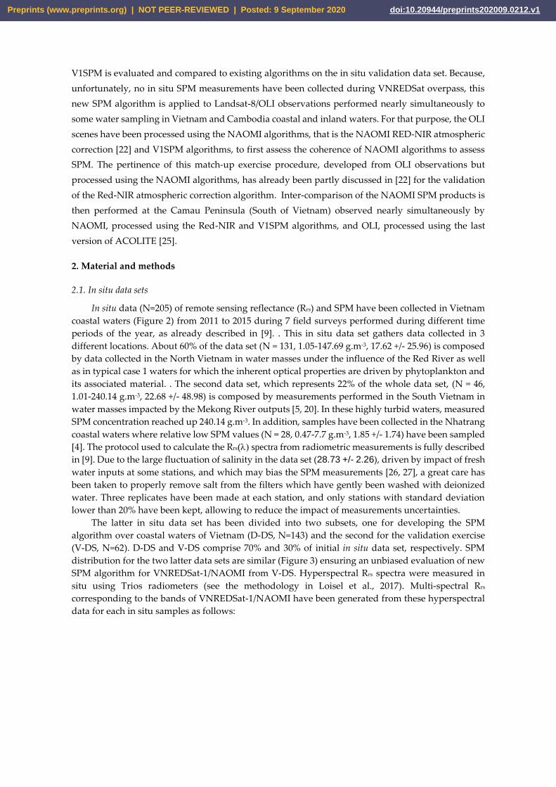
NIR/V1SPM algorithm is able to estimate SPM with excellent accuracy (Table 6 and Figure 8). For
instance, the MAPD and bias values are 15.79% and 1.43 g.m-3, respectively. Except for the Cuaviet
Estuary, the performance only slightly differs according to the sub-match-up data set used (Table 6),
which mainly reflects the impact of a different distribution of the data rather than a true regional
variability. The impact of the regional discrepancies could indeed only be addressed with a higher
number of match-up data points. The lowest performance of the algorithm observed at the Cuaviet
Estuary (smaller than the Han Estuary) could be explained by the complex hydrological condition of
the Estuary, bottom albedo effect, and adjacency effect.
Preprints (www.preprints.org) | NOT PEER-REVIEWED | Posted: 9 September 2020 doi:10.20944/preprints202009.0212.v1

Figure 7. RGB Landsat-8/OLI composited images acquired over (a) the Tonle Sap lake (Cambodia)
the 13 of October 2018, (b) the Quangtri province (Vietnam) the 25 of April 2019, and (c) in Danang
(Vietnam) the 4 of May 2019. Results of the V1SPM algorithm over the sub-areas delimited by the red
squares over the (d) Tonle Sap lake, (e) Cuaviet Estuary, and (f) Han Estuary. Black stars provide the
location of the different match-up stations.
Preprints (www.preprints.org) | NOT PEER-REVIEWED | Posted: 9 September 2020 doi:10.20944/preprints202009.0212.v1
Figure 8. Comparison of the measured and inversed SPM values from the Landsat-8/OLI match-up
data set (N = 51) at the three different locations as indicated (Tonle Sap, Cuaviet Estuary, and Han
Estuary). The solid line represents the best linear regression fit to data and the dashed line represents
the 1:1 line.
Table 6. Statistical indicators of the performance of the Red-NIR/V1SPM algorithm over the 51 SPM
match-up data points.
Data set MAPD [%] RMSDlog Slope Bias R2
Tonle Sap 15.87 0.13 0.979 0.515 0.793
Cuaviet 17.33 0.09 0.243 8.987 0.068
Han 13.86 0.08 0.931 -0.265 0.734
All 15.79 0.10 0.875 1.431 0.703
Satellite SPM products are now compared over the Camau (South of Vietnam) coastal area which
has been sampled almost simultaneously by Landsat-8/OLI (at 03:14:41.7 UTC time) (Figure 9a) and
VNREDSat-1/NAOMI (03:51:14.2 UTC time) (Figure 9b) on January 8th 2015, that is during the dry
season which generally occurs from November to April. During this period, suspended sediments
are generally concentrated along the Eastern Camau peninsula coast where the sediment dynamics
is basically controlled by the Mekong River inputs during summer and resuspension effects during
winter [6]. Other images were also available for this inter-comparison exercise but have not been
considered due to glitter contamination. The Landsat-8/OLI and VNREDSat-1/NAOMI images are
processed using the last version of ACOLITE (Vanhellemont, 2019), and Red-NIR/V1SPM algorithms,
respectively. Due to the different spatial resolution of the two considered sensors, the VNREDSat-
1/NAOMI pixels are resized from 10 m to 30 m, the nominal spatial resolution of Landsat-8/OLI. The
inter-comparison is performed on a sub-area of the images to limit the impact of white caps (but see
discussion in Ngoc et al., 2019). A relatively good agreement between the two SPM products can be
observed, with however more pixels with higher SPM values for OLI than NAOMI (Figure 9e).
Preprints (www.preprints.org) | NOT PEER-REVIEWED | Posted: 9 September 2020 doi:10.20944/preprints202009.0212.v1

Figure 9. Landsat-8/OLI (a) and VNREDSat-1/NAOMI (b) RGB composited at coastal of Camau
province in South of Vietnam on January 8th, 2015. The captured time at central scenes are 03:14:41.7
UTC time (Landsat-8) and 03:51:14.2 UTC time (VNREDSat-1). In the panel (e), VNREDSat-1/NAOMI
SPM (d) by V1SPM estimation is compared with Landsat-8/OLI SPM (c) estimation by the Nechad
algorithm used in ACOLITE over the red rectangle areas in (a) and (b). The 1:1 line is draw in red.
3.4. Illustration of the monitoring of a flooding event from VNREDSat-1
An illustration of how the Red-NIR and V1SPM algorithms can be used to monitor
environmental issues from VNREDSat-1 is provided in Figure 10. Due to heavy rainfall and water
released by the Vucmau hydro power dam, a large flooding event occurred in the Nghean province
(Figure 10a) from 22nd September 2013 to 1st October 2013. A serie of VNREDSat-1 images were
Preprints (www.preprints.org) | NOT PEER-REVIEWED | Posted: 9 September 2020 doi:10.20944/preprints202009.0212.v1

acquired during the flooding time period (Figure 10b), and 3 (Figure 10c) and 8 (Figure 10d) days
after this event. This very short time series captured by VNREDSat-1 shows the spatial coverage of
the flooding, as well as the rapid retreat of waters following this natural hazard event. Information
about the concentration of SPM is also provided over each flooded area, as well as at the outlet of the
Yen River where the River plum areas sharply decreases in two weeks.
Figure 10. (a) RGB map over the Nghean province showing the Vucmau reservoir. SPM maps
processed by the Red-NIR and V1SPM algorithms and acquired the (b) 22nd September, 2013, (c) 4th,
and (d) 8thOctober, 2013.
6. Concluding remarks
The present study was dedicated to the development of an SPM algorithm for the VNREDSat-
1/NAOMI sensor. The simple empirical formulation proposed here, based on a band-ratio approach,
offers, at least for the present data set, the best solution for the SPM retrieval at regional scale.
Additionally, this ratio allows to reduce the scatter around the adopted polynomial fit between
radiometric measurements and SPM. However, further researches should be under-taken to better
understand and qualify the origin of this scatter (measurements uncertainties vs. natural variability)
as previously done for instance with algorithms aiming at estimating Chl-a [36]. At last, we
recommend that a proper validation plan for NAOMI should also be undertaken in a very near future.
Author Contributions: Dat Dinh Ngoc developed final model and finished the original manuscript. Hubert
Loisel proposed idea of the work, gave permission to data at LOG and Writing - review & editing. Vincent
Vantrepotte validated final model and Writing - review & editing. Huy Chu Xuan and Ngoc Nguyen Minh
worked with VNREDSat-1/NAOMI database to search the match-ups with Landsat-8/OLI. Charles Verpoorter
and Xavier Mériaux collected in situ data over Tonlesap. Hanh Pham Thi Minh and Huong Le Thi collected in
situ data over Cuaviet Estuary and Han Estuary. Thao Nguyen Van, Hai Le Vu Hong made VNREDSat-1 quality
checking such as remove cloud scenes and processed satellite images.
Preprints (www.preprints.org) | NOT PEER-REVIEWED | Posted: 9 September 2020 doi:10.20944/preprints202009.0212.v1

Funding: This study is funded by VT-UD.02/17-20 project belong to Vietnam National Space Science and
Technology Program, QTRU04.07/18-19 project under Space Technology Institute and 2018.73.041 project under
Le Quy Don University.
Acknowledgments: The authors would like to thank satellite images distributors including USGS for Landsat-
8/OLI and center of control and exploitation of small satellite, Space Technology Institute, Vietnam Academy of
Science and Technology for distribution of Level-1 data products. The in situ data set used in this study has been
collected in the frame of the VITEL (CNES, TOSCA), Black Carbon, VolTransMEKONG (TOSCA/CNES) and
Vietnam National Space Science and Technology Program projects. The VITEL cruises in 2014 were performed
onboard the research vessel ALIS from IRD. The authors also thankful Vietnam National Space Science and
Technology Program, LOG/ULCO, University of Science and Technology of Hanoi, and Space Technology
Institute, and Institute of Technology of Technology of Cambodia, for funding and facilities for this research.
The authors thank to Quinten Vanhellemont and Kevin Ruddick for free ACOLITE contribution.
Conflicts of Interest: The authors declare no conflict of interest.
References
1. Pruszak, Z.; Szmytkiewicz, M.; Hung, N.M.; Ninh, P.V. Coastal processes in the Red river delta area,
Vietnam. Coast. Engineer. J. 2002, 44, 97-126.
2. Boateng, I. GIS assessment of coastal vulnerability to climate change and coastal adaption planning in
Vietnam. J. Coastal Conserv. 2012, 16, 25-36.
3. Dastgheib, A.; Reyns, J.; Thammasittirong, S.; Weesakul, S.; Thatcher, M.; Ranasinghe, R. Variations in the
Wave Climate and Sediment Transport Due to Climate Change along the Coast of Vietnam. J. Marine Sci.
and Engineering. 2016, 4, 86.
4. Du, H.T.; Kunzmann, A. The Sediment Load and Deposition by River Discharge and Their Relation to
Organochlorine Pesticides Pollutants in the Sediment Bottom of Nha Trang Bay, Vietnam. Ocean Sci. J. 2015,
50, 455-466.
5. Vinh, V.D.; Ouillon, S.; Thanh, T.D.; Chu, L.V. Impact of the Hoa Binh dam (Vietnam) on water and
sediment budgets in the Red River basin and delta. Hydro. Earth Syst. Sci. 2014, 18, 3987–4005.
6. Loisel, H.; Mangin, A.; Vantrepotte, V.; Dessailly, D.; Ngoc, D.D.; Garnesson, P.; Ouillon, S.; Lefebvre, J.P.;
Mériaux, X.; Phan, T.M.. Variability of suspended particulate matter concentration in coastal waters under
the Mekong’s influence from ocean color (MERIS) remote sensing over the last decade. Remote Sens. Environ.
2014, 150, 218-230.
7. Anthony, E. J.; Brunier, G.; Besset, M.; Goichot, M.; Dussouillez, P.; Nguyen, V. L.. Linking rapid erosion
of the Mekong River delta to human activities. Sci. Reports. 2015; doi:10.1038/srep14745.
8. Hauser, L.T.; Vu, G.N.; Nguyen, B.A.; Dade, E.; Nguyen, H.M.; Nguyen, T.T.Q.; Le, Q.T.; Vu, L.H.; Tong,
A.T.H.T.; Pham, H.V.. Uncovering the spatio-temporal dynamics of land cover change and fragmentation
of mangroves in the Ca Mau peninsula, Vietnam using multi-temporal SPOT satellite imagery (2004-2013).
Applied Geo. 2017, 86, 197-207.
9. Loisel, H.; Vantrepotte, V.; Ouillon, S.; Ngoc, D.D.; Herrmanm, M.; Tran, V.; Meriaux, X.; Dessailly, D.;
Jamet, C.; D, T.; Huan, N.H.; Nguyen. T.V.. Assessment and analysis of the chlorophyll-a concentration
variability over the Vietnamese coastal waters from the MERIS ocean color sensor (2002–2012). Remote Sens.
Environ. 2017, 190, 217-232.
10. Marchesiello, P.; Nguyen, M.; Gratiot, N.; Loisel, H.; Anthony, E.; Dinh, S.; Almar, R.; Kestenare, E.. Erosion
of the coastal Mekong delta: Assessing natural against man induced processes. Continental Shelf Research.
2019, 181, 72-89.
11. Tajima, Y.; Gunasekara, K.; Nguyen, H.T. Satellite-based monitoring of contrasting characteristics of
suspended sediment discharged from the Red and the Ma river systems along the northern coast of
Vietnam. Int. J. Sediment Res. 2018; doi:10.1016/j.ijsrc.2018.08.004.
12. IOCCG report Number 3. 2000; http://ioccg.org/wp-content/uploads/2015/10/ioccg-report-03.pdf.
13. Loisel, H.; Vantrepotte V.; Jamet, C.; Ngoc, D.D.. Challenges and New Advances in Ocean Color Remote
Sensing of Coastal Waters. Topics in Oceanography, 2013, Chapter; doi:10.5772/56414.
14. Tassan, S. Local algorithms using SeaWiFS data for the retrieval of phytoplankton, pigments, suspended
sediment, and yellow substance in coastal waters. Applied Opt. 1994, 33, 2369-2378.
15. Forget, P.; Ouillon, S. Surface suspended matter off the Rhone river mouth from visible satellite imagery.
Oceanologica Acta. 1998, 21, 739-749.
Preprints (www.preprints.org) | NOT PEER-REVIEWED | Posted: 9 September 2020 doi:10.20944/preprints202009.0212.v1

16. Siswanto, E.; Tang, J.; Yamaguchi, H.; Ahn, Y.H.; Ishizaka, J.; Yoo, S.; Kim, S.W.; Kiyomoto, Y.; Yamada, K.;
Chiang, C.; Kawamura, H. Empirical ocean-color algorithms to retrieve chlorophyll-a, total suspended
matter, and colored dissolved organic matter absorption coefficient in the Yellow and East China Seas. J.
Ocean. 2011; doi: 10.1007/s10872-011-0062-z.
17. Doxaran, D.; Froidefond, J.M.; Lavender, S.; Castaing, P. Spectral signature of highly turbid waters
Application with SPOT data to quantify suspended particulate matter concentrations. Remote Sens. Environ.
2002, 81, 149-161.
18. Yepez, S.; Laraque, A.; Martinez, J.-M.; Sa, J. D.; Carrera, J. M.; Castellanos, B.; Gallay, M.; Lopez, J. L.
Retrieval of suspended sediment concentrations using Landsat-8 OLI satellite images in the Orinoco River
(Venezuela). C. R. Geoscience. 2018, 350, 20-30.
19. Nechad, B.; Ruddick, K.G.; Park, Y. Calibration and validation of a generic multisensor algorithm for
mapping of total suspended matter in turbid waters. Remote Sens. Environ. 2010, 114, 854-866.
20. Han, B.; Loisel, H.; Vantrepotte, V.; Mériaux, X.; Bryère, P.; Ouillon, S.; Dessailly, D.; Xing, Q.; Zhu, J.
Development of a Semi-Analytical Algorithm for the Retrieval of Suspended Particulate Matter from
Remote Sensing over Clear to Very Turbid Waters. Remote Sens. 2016, 8, 211; doi:10.3390/rs8030211.
21. Balasubramanian, S.V.; Pahlevan, N.; Smith, B.; Binding, C.E.; Schalles J.; Loisel, H.; Gurlin, D.; Greb, S.;
Alikas, K.; Uusõue, M.; Bunkei, M.; Moses, W.S.; Nguyen, H.T.T.; Lehmann, M.K.; O’Donnell, D.M.;
Ondrusek, M.; Han, T.H.; Fichot, C.G.; Moore, T.; Boss, E.S.. Robust algorithm for estimating total
suspended solids (TSS) in inland and nearshore coastal waters. Remote sens. Environ. 2020, 246, 111768.
22. Ngoc, D.D.; Loisel, H.; Duforêt-Gaurier, L.; Jamet, C.; Vantrepotte, V.; Goyens, C.; Xuan, H.C.; Minh, N.N.;
Van, T.N. Atmospheric correction algorithm over coastal and inland waters based on the red and NIR
bands: application to Landsat-8/OLI and VNREDSat-1/NAOMI observations. Opt. Express. 2019, 27, 31676-
31697.
23. Minh, C.D.. Space Technology Development of Vietnam in 2011-2012. Proceedings of APRSAF-19. 2012.
24. Luquet, P.; Chikouche, A.; Benbouzid, A.B.; Arnoux, J.J.; Chinal, E.; Massol, C.; Rouchit, P.; Zotti, S.D..
NAOMI instrument: a product line of compact & versatile cameras designed for high resolution missions
in Earth observation. Proceedings of the 7th ICSO. 2008.
25. Vanhellemont, Q.. Adaptation of the dark spectrum fitting atmospheric correction for aquatic applications
of the Landsat and Sentinel-2 archives. Remote Sens. Environ. 2019, 225, 175-192.
26. Röttgers, R.; Heymann, K.; Krasemann. H.. Suspended matter concentrations in coastal waters:
Methodological improvements to quantify individual measurement uncertainty. Estuar. Coast. Shelf Sci.
2014, 151, 148-l55.
27. Stavn, R.H.; Rick, H.J.; Falster, A.V.. Correcting the errors from variable sea salt retention and water of
hydration in loss on ignition analysis: implications for studies of estuarine and coastal waters. Estuar. Coast.
Shelf Sci. 2009, 81, 575-582.
28. Ngoc, D.D; Loisel, H.; Jamet, C.; Vantrepotte, V.; Duforêt-Gaurier, L.; Minh, C.D.; Mangin, A.. Coastal and
inland water pixels extraction algorithm (WiPE) from spectral shape analysis and HSV transformation
applied to Landsat 8 OLI and Sentinel-2 MSI. Remote Sens. Environ. 2019, 223, 208-228.
29. Doxaran, D.; Cherukuru, N.C.; Lavender, S.J.. Use of reflectance band ratios to estimate suspended and
dissolved matter concentrations in estuarine waters. Int. J. Remote sens. 2005, 26, 1763-1769.
30. Vanhellemont, Q.; Ruddick, K. Turbid wakes associated with offshore wind turbines observed with
Landsat 8. Remote Sens. Environ. 2014, 145, 105-115.
31. Vanhellemont, Q.; Ruddick, K. Advantages of high quality SWIR bands for ocean colour processing:
Examples from Landsat-8. Remote Sens. Environ. 2015, 161, 89-106.
32. Morel, A. and B. Gentili. Diffuse reflectance of oceanic waters. II. Bidirectional aspects. Applied Opt. 1993,
32, 6864-6872.
33. Morel, A.; Gentili, B. Diffuse reflectance of oceanic waters. III. Implication of bidirectionality for the
remote-sensing problem. Applied Opt. 1996, 35, 4850-4862.
34. Loisel, H.; Morel, A. Non-isotropy of the upward radiance field in typical coastal (Case 2) waters. Int. J.
Remote Sens. 2001, 22, 275-295.
35. Doxaran, D.; Froidefond, J.M.; Castaing, P. A refectance band ratio used to estimate suspended matter
concentrations in sediment-dominated coastal waters. Int. J. Remote Sens. 2002b, 23, 5079-5085.
36. Loisel, H.; Vantrepotte, V.; Norkvist, K; Meriaux, X.; Kheireddine, M.; Ras, J.; Pujo-Pay, M.; Combet, Y.;
Leblanc, K.; Dall’Olmo G.; Mauriac, R.; Dessailly, D.; Moutin, T.. Characterization of the bio-optical
Preprints (www.preprints.org) | NOT PEER-REVIEWED | Posted: 9 September 2020 doi:10.20944/preprints202009.0212.v1

anomaly and diurnal variability of particulate matter, as seen from scattering and backscattering
coefficients, in ultra-oligotrophic eddies of the Mediterranean Sea. Biogeosciences. 2011, 8, 3295-3317.
Preprints (www.preprints.org) | NOT PEER-REVIEWED | Posted: 9 September 2020 doi:10.20944/preprints202009.0212.v1