ar.icp.doe.gov · pdf file-&i -i$ci(& pece;cr4s saa0-f~ -l-w wl7 ru)cpp 6-l; il&*...
TRANSCRIPT

.- ma i
si ‘1

INITIAL ASSESSMENT FORM !
I. SITE NAME AND LOCATION -,
01 SITE NAME
RWMC Septic Tank and Drainfield for SWEPP
02 ADDRESS Idaho National Engineering Laboratory (INEL)
03 CITY 04 STATE scoville Idaho
09 COORDINATES: NORTH EAST 669130 1269300
f 10 DIRECTIONS TO SITE (Starting from nearest public road) From US 20: SW on Van Buren Blvd; W on Adams Blvd.
II. OWNER/OPERATOR
01 OWNER (If known) Department of Energy (DOE)
03 CITY Idaho Falls
07 OPERATOR (If known) EG&G-Idaho, Inc.
.,,. 09 CITY
Idaho Falls
02 STREET ADDRESS 785 DOE Place
04 STATE 05 ZIP CODE 06 TELEPHONE NUMBER Idaho 83402 (208) 526-1122
08 STREET ADDRESS P.O. Box 1625
10 STATE 11 ZIP CODE 12 TELEPHONE NUMBER Idaho 83415 (208) 526-1014 i
III. CHARACTERIZATION OF POTENTIAL HAZARD
01 ON SITE INSPECTION __ YES s NO DATE / /
02 SITE STATUS (Check one) 03 YEARS RECEIVED HAZ WASTE/ none
u A. Active SWMU __ B. Inactive _ C. Unknown Start stop Unkzwn
04 DESCRIPTION OF SUBSTANCES POSSIBLY PRESENT, KNOWN, OR ALLEGED See Waste Information Section
05 DESCRIPTION OF POTENTIAL HAZARD TO ENVIRONMENT AND/OR POPULATION See Hazardous Conditions and Incidents Section
IV. INFORMATION AVAILABLE FROM
01 CONTACT 02 OF (Agency/Org.) Clifford Clark DOE-ID
03 TELEPHONE NUMBER (208) 526-1122
04 PERSON RESPONSIBLE FOR ASSESSMENT
Terry Alexander
08 DATE 10/01/86
Man Day Year
05 AGENCY 06 ORG. 07 TELEPHONE NUMBER
EG&G HWP (208) 526-8040
I I

WASTE INFORMATION
WASTE STATES, QUANTITIES, AND CHARACTERISTICS
01 PHYSICAL STATES (Check all that apply) 02 WASTE QUANTITY AT SITE -A. Solid -E- SlUrFj -B. Powder Fines =F. Liquid TONS XJC. Sludge -G. Gas CUBIC YARDS 9.9 -D. Other NO. OF DRUMS
03 WASTE CHARACTERISTICS (Check all that apply) -A. Toxic -D. Persistent -G. Flammable J. Explosive -5. Corrosive -E. Soluble -H. Ignitable -K. Reactive -C. Radioactive -F. Infectious -1. Highly Volatile -L. Incompatible
m. Not Applicable
II. WASTE TYPE
CATEGORY SUBSTANCE NAME 01 GROSS AMOUNT 02 UNIT COMMENTS
* cfe
gi?$ Waste SOL solvents PSD Pesticides occ Other orsanic chemicals _~ IOC Inorsanic chemicals ACD..- Acids BAS Eases ME.5 Heaw metals
. . HAZARDOUS CONSTITUENTS
01 CATEGORY 02 SUBSTANCE 03 CAS 04 STOR/DISP 05 CONC. 06 MEASURE NAME NUMBER METHOD
SOURCES OF INFORMATION ~l=e specific references, e.o.. state titles, sample analvsis reoorts.etc.1 Site inspections, personnel interviews, Process records, laboratory records.

HAZARDOUS CONDITIONS AND INCIDENTS
I. HAZARDOUS CONDITIONS AND INCIDENTS
01 A. GROUNDWATER CONT. 03 Nj;;RRATIVE DESCRIPTION:
02 - OBSERVED (Date ) __ POTENTIAL _ ALLEGED
Not Applicable
01 B. SURFACE WATER CONT. 03 r%RATIVE DESCRIPTION:
02 - OBSERVED (Date ) _ POTENTIAL _ ALLEGED
Not Applicable
01 C. CONTAMINATION OF AIR 03 P~ULATION POTENTIALLY AFFECTED
02 OBSERVED (Date ) _ POTENTIAL 04 NARRATIVE DESCRIPTION _ AL&EGED
Not Applicable
01 D. FIRE/EXPLOSIVE CONDITIONS 02 03 POPULATION POTENTIALLY AFFECTED
OBSERVED (Date -) _ POTENTIA i -04 NARRATIVE DESCRIPTION _ ALLEGED
Not Applicable
01 E. DImCT CONTACT 02 OBSERVED (Date 1 - POTENTIALS ,03 POPULATION POTENTIALLY AFFECTED -04 NARRATIVE DESCRIPTION 1 ALLEGED
Not Applicable
01 F. CONTAMINATION OF SOIL 03 FhRATIVE DESCRIPTION:
02 - OBSERVED (Date -) __ POTENTIAL/ _ ALLEGED ~
Not Applicable
01 G. DRINKING WATER CONTAMINATION 02 _ OBSERVED (Date 1 POTENTIAL 03 y&P.ATIVE DESCRIPTION: - : ALLEGED
Not Applicable

HAZARDOUS CONDITIONS AND INCIDENTS
. HAZARDOUS CONDITIONS AND INCIDENTS (Continued)
01 J. DAMAGE TO FLORA 04 ?%RATIVE DESCRIPTION:
Not Applicable
02 - OBSERVED (Date ) ___ POTENTIAL! i ALLEGED
01 _ K. DAMAGE TO FAUNA OBSERVED (Date 04 NARRATIVE DESCRIPTION: (include naiz(F of species)
Nat Applicable
) _ POTENTIAL _ ALLEGED
01 L. CONTAMINATION OF FOOD CHAIN 02 _ OBSERVED (Date 04 y&RATIVE DESCRIPTION:
) __ POTENTIAL/
Not Applicable _ ALLEGED ;
I
01 __ M. UNSTABLE CONTAINMENT OF WASTES 02 OBSERVED (Date - (SPILL RUNOFF, STANDING LIQUIDS/LEAKING DRUMS) -~ 03 NARRATIVE DESCRIPTION:
Not Applicable __ ALLEGED
N. DAMAGE TO OFFSITE PROPERTY 02 _ OBSERVED (Date -) _ POTENTIAL' iibRATIVE DESCRIPTION:
I
Not Applicable _ ALLEGED
01 a 0. CONTAMINATION OF SEWERS,STORM 02 _ OBSERVED(Date DRAINS, WWTPs
) Xx POTENTIAL
04 NARRATIVE DESCRIPTION: ALLEGED Since the possible waste entering the system is unknown, there is apotential ( for contamination of the sewer system from normal operations.
01 P. ILLEGAL/UNAUTHORIZED DUMPING 02 _ OBSERVED (Date 04 i?iilRATIVE DESCRIPTION:
1 __ POTENTIAL'
Not Applicable ___ ALLEGED
05 DESCRIPTION OF ANY OTHER KNOWN, POTENTIAL OR ALLEGED HAZARDS Not Applicable
I I
/III. COMMENTS NONE I
IV. SOURCES OF INFORMATION (List specific references, e.g., state titles, sample analysis, reports)
. ~
.e inspections, personnel interview, disposal quantity records, EG&G-WM-6875! installation Assessment Report, USGS Report IDO- TID-4500 The Influence / of Liquid Waste Disposal on the Geochemistry of Water at the NRTS. I

I~ PRIORITY RANKING SYSTEM
I. GENZRAL FACILITY INFORMATION
FACILITY NAME: &JWC &.~#ic -f-iiL r&& >u-Q;*
LOCATION: d o&h c, c 5 W&PP
POINT OF CONTACT: NAME:
ADDRESS:
PHONE:
REVIEWER: ?-iLOY &ka*zclec DATE: /Q//-i 41,
E'F. GENERAL FACILITY DESCRIPTION
GENERAL DESCRIPTION OF THE FACILIn: (For example: landfill, surface >oundment, pile, container: types of hazardous substances; location of
zility; contamination route of major concern; types of information needed for rating; agency action, etc.1
-&I -i$ci(& pece;Cr4s saa0-f~ -L-w wL7 ru)CPP
6-L; IL&* 7L ix A0 0-P Cbr d 04 kLCE(LFdU ~1e9f*
I III. SCORES
sPl= 0 ( sgw= 0 ssw= 0 Sa= d )
I SF-Z = 0 I
SDC= 0 I I

GROUND WATER ROUTE WORKSHEET
RATING FACTOR ASSIGNED VALUE (Circle one)
MULTI- SCORE MAX. REF. PLIER SCORE Sectic:
3.2
l.ROUTE CHARACTERISTICS Depth to Aquifer of a9 123 2
Concern 0 6
Net Precipitation ?:g
1 Permeability of the L 1 c3 :
Unsaturated Zone Physical State 0120 1 SY 3
Total Route Characteristics Score r 15
Z.CONTAINMENT 0124 1 3 3 3.3
3:WASTE CHARACTERISTICS Toxicity/Persistence @ 3 6 9 12 15 18 1 6 qazardous Waste a12345678 1
Quantity 0 I I Total Waste Characteristics Score 1 0
4.: d
Multiply lines 1 x 2 x 3
T 1 i
3.4 18
8
26 I
1170
5. Divide line 4 by 1170 and multiply by 100 sgw= 0

SURFACE WATER ROUTE WORKSHEET
RATING FACTOR ASSIGNED VALUE MULTI- SCORE MAX. REE (Circle one) PLIER SCORE Secti,
4.
l.ROUTE CHARACTERISTICS Facility Slope and a 123 1 0 3
Intervening Terrain l-yr. 24-hr. Rainfall 0023 1 Distance to Nearest 0023 2 i 2
Surface Water Physical State 0120 1 2 3
Total Route Characteristics Score + 15
Z.CONTAINMENT 0023 1 c 3 4.
3.WASTE CHARACTERISTICS 4.. .Toxicity/Persistence
8 3 6 9 12 15 18 1
' 8 18
Hazardous Waste 0'12345678 1 Quantity
I /Total Waste Characteristics Score ; 26 t
4. Multiply lines 1 x 2 x 3 0 1170
5. Divide line 4 by 1170 and multiply by 100 ssw= d

AIR ROUTE WORKSHEET
RATING FACTOR ASSIGNRD VALUE MULTI- SCORE MAX. REF. (Circle one) PLIER SCORE Sectio:
l.HISTORIC RELEASE 0 0 45 1 0 45 5.1
Date and Location: See attached supplement pages
If line 1 is 0, the Sa = 0. Enter on line 5.
If line 1 is 45, then proceed to line 2.
2.WASTE CHARACTERISTICS
Reactivity and 0 012 3
5.2
1 Incompatibility 0 3 Toxicity @ 123 3 0 9 Hazardous Waste a12345678 1 8 1 ., Quantity c,
I I Total Waste Characteristics Score 0 1 20 i - TARGETS
:
lpulation within 0 9 12 15 21 24 1 4-mile Radius 7
dl 30
&?j
Distance to Sensitive 123 2 Environment
Land Use 012a 1
/a 0
2
5.3 .30
6
3
Total Target Scores
4. Multiply lines 1 x 2 x 3
J/
t 0
5. Divide line 4 by 35100 and multiply by 100 Sa= 0
39
I- 35100

I 2
s s
I GROUNDWATER ROUTE SCORE (Sgw) 0 0 SURFACE WATER ROUTE SCORE (Ssw) 0 0
AIR ROUTE SCORE (Sal 6 a
2 2 2 sgw + ssw + sa iIiii:i:i:iiiipiii i~;~iirjr;;;i;;~;;:~ T1;.;:I::::::::::::::.~:~:~:::~: - . .:.:.I.:.:. :.:.:::.:I::.:II
2 2 2 iiiiiriiii~iriiiijiiiii!liiiii:s .-:rr:::-:,:i:i:::,::::::::::::
SQRtSqw + SsW + Sd) iiiii2ii:i::i::::::::::::::::::: . . . . . . . . . . ..-.i.i.i..-.::::::::: :::r:;jrtri.:......i:Il.r-l-r-r- iirii$;ip: '-:::.:....:-ii:i:I:I
2 2 2 ::::::: :.:.. ;:~~~;~~fpi~~~;;~~ ::::j::.:.:;.:.:.:.:-.-.-.-.-.:. r:::::~~i::::i:i:i:~:~~~:::~:::
SQR(Sqw t SSW + Sa)/1.73 = SN ~:::+..'::::.:::::.:....:.+: .::::::;:~:::::.....:.:.:::::... :::::-:::::::::i:~:~:~:~:~:~:~:~

DOCUMENTATION RECORDS FOR
HAZARD RANKING SYSTEM
INSTRUCTIONS: As briefly as possible, summarize the information you used to assign the score for each factor (e.g., "Waste quantity = 4,230 drums plus 800 cubic yards of sludges"). The source of information snould be provided for each entry and should be a bibliographic-type reference. Include the location of the document.
DATE SCORED: /Q /Y /'6
PERSON SCORING: T&-,-c/ /.eY &
PRIMARY SOURCE(S) OF INFORMATION:
sse vid, dr4u)+j5
FACTORS NOT SCORED DUE TO INSUFFICIENT INFORMATION:
COMMENTS OR QUALIFICATIONS:

GROUNOWATER ROUTE
1. OBSERVED RELEASE - Undertake Corrective Action
Contaminants detected (3 maximum):
Rationale for attributing the contaminants to the facility:
2. ROUTE CHARACTERISTICS
Depth to Aauifer of Concern
Name/description of aquifer(s) of concern:
Depth(s) from the ground surface to the highest seasonal level of the saturated zone [water table(s)] of the aquifer of concern:
Depth from the ground surface to the lowest point of waste disposal/ storage:

Net Precioitation
Mean annual or seasonal precipitation (list months for seasonal):
9.07 inches .
Mean annual lake or seasonal evaporation (list months for seasonal):
36 inches
Net precipitation (subtract the above figures):
- 26.93 inches
Permeability of Unsaturated Zone
Soil type in unsaturated zone:
An interbedded sequence of basaltic lava flows and sedimentary deposits.
Permeability associated with soil type:
10-7 to 10W3 cm/set
Physical State
Physical state of substances at time of disposal (or at present time for generated gases):

3. CONTAINMENT
Containment
Method(s) of waste or leachate containment evaluated:
Method of highest score:
4. WASTE CHARACTERISTICS
Toxicity and Persistence
Compound(s) evaluated:
Compound with highest score:
Hazardous Waste Quantity
Total quantity of hazardous substances at the facility, excluding those with a containment score of 0 (Give a reasonable estimate even if quantity is above maximum):
Basis of estimating and/or computing waste quantity:

Checklist for Groundwater Releases
Identifying Release
1. Potential for Groundwater Releases from the Unit
0 Unit type and design
Yes - No
Does the unit type (e.g., land-based) indicate the potential for release? J
-
Does the unit have engineered struc- tures (e.g., liners, leachate collec- tion systems, proper construction materials) designed to prevent releases to groundwater? -
0 Unit operation
Does the unit's age (e.g., old unit) or operating status (e.g., inactive, active) indicate the potential for release'? -
Does the unit have poor operating pro- cedures that increase the potential for release? -
Does the unit have compliance problems that indicate the potential for a release to groundwater? -
0 Physical condition
Does the unit's physical condition in- dicate the potential for release (e.g., lack of structural integrity, deterior- ating liners, etc.)? -
0 Locational characteristics
Is the unit located on permeable soil so the release could migrate through the unsaturated soil zone?
J -
Is the unit located in an arid area where the soil is less saturated and therefore a release has less potential for downward migration? -
Does the depth from the unit to the uppermost aquifer indicate the poten- tial for release? -
I/- -
J
J -
I
5

Checklist for Groundwater Releases
Does the rate of groundwater flow greatly inhibit the migration of a release from the facility?
Is the facility located in an area that recharges surface water?
0 Waste characteristics
Does the waste in the unit exhibit high or moderate characteristics of mobility (e.g., tendency not to sorb soil parti- cles or organic matter in the unsaturated zone)?
Does the waste exhibit high or moderate levels of toxicity?
2. Evidence of Groundwater Releases
0 Existing groundwater monitoring systems
Is there an existing system?
.Is the system adequate?
Are there recent analytical data that indicate a release?
0 Other evidence of groundwater releases
is there evidence of contamination around the unit (e.g., discolored soils! lack of or stressed vegetation) that indicates the potential for a release to groundwater!
Does local well water or spring water sampling data indicate a release from the unit?
Determining the Relative Effect of the Release on Human Health and the Environment
1. Exposure Potential
0 Conditions that indicate potential exposure
Are there drinking water well(s) located near the unit?
Yes -
/ -
-
-
-
-
-
-
-
-
-
Does the direction of groundwater flow in- dicate the potential for hazardous constitu- ents to migrate to drinking water wells? _
6
No
-
J
J
J

SURFACE WATER ROUTE
1. OBSERVED RELEASE - Undertake Corrective Action
Contaminants detected in surface water at the facility or downhill from it (3 maximum):
Rationale for attributing the contaminants to the facility:
2. ROUTE CHARACTERISTICS
Facility Slope and Intervening Terrain
Average slope of facility in percent:
2%
Name/description of nearest downslope surface water:
Average slope of terrain between facility and above cited surface water body in percent:
Is the facility located either totally or partially in surface water?

Is the facility completely surrounded by areas of high elevation?
P 6
l-year 24-Hour Rainfall in Inches
less than 2 inches
Distance to Nearest DownsloDe Surface Water
Physical State of Waste
3. CONTAINMENT
Containment
Method(s) of waste or leachate containment evaluated:
Method with highest score:
a

Checklist for Surface Water/Surface Drainage R~eleases
Identifying Releases
1. Potential for Surface Water/Surface Drainage Release from the Facility
0 Proximity to Surface Water and/or to Off-site Receptors
Could surface run-off from the unit reach the nearest downgradient surface water body? -d
Could surface run-off from the unit reach off-site receptors (e.g., if facility is located adjacent to populated areas and no barrier exists to prevent overland surface run-off migration)? -
0 Release Migration Potential
Does the slope of the facility and inter- vening terrain indicate potential for release? -
Is the intervening terrain characterized by soils and vegetation that allow over- land migration (e.g., clayey soils, and sparse vegetation)? -
Does data on one-year 24-hour rainfall indicate the potential for area storms to cause surface water or surface drainage contamination as a result of run-off? -
0 Unit Design and Physical Condition
Are engineered features (e.g., run-off control systems) designed to prevent release from the unit? -
Does the operational history of the unit indicate that a release has taken place (e.g., old, closed or inactive unit, not inspected regularly, improperly maintained)? __
Does the physical condition of the unit in- dicate that releases may have occurred (e.g., cracks or stress factures in tanks or erosion of earthen dikes of surface impoundments)? -
-
-
J
J
(s -

Checklist for Surface Water/Surface Drainage Releases
Yes - No
0 Waste Characteristics
Is the volume of discharge high relative to the size and flow rate of the surface water body?
Do constituents in the discharge tend to sorb to sediments (e.g., metals)?
Do constituents in the discharge tend to be transported downstream?
Do waste constituents exhibit moderate or high characteristics of persistence (e.g., PCBs, dioxins, etc.)?
Do waste constituents exhibit moderate or nigh characteristics of toxicity (e.g., metals, chlorinated pesticides, etc.)?
2. Evidence of Surface Water/Surface Drainage Releases
0 Are there unpermitted discharges from the facility to surface water that require an NPDES or a Section 404 permit?
0 Is there visible evidence of uncontrolled run-off from units at the facility?
Determining the Relative Effect of the Release on Human tlealth and the Environment
1. 0 Are there drinking water intakes nearby?
0 Could human and/or environmental receptors come into contact with surface drainage from the facility?
0 Are there irrigation water intakes nearby?
0 Could a sensitive environment (e.g., critical habitat, wetlands) be affected by the discharge (if it is nearby)?
J -
v/ - J -
-
J -
/ -
J -
-
-
e/ -
/ -
10

AIR ROUTE
1. OBSERVED RELEASE
Contaminants detected:
Date and Location of detection of contaminants:
Methods used to detect the contaminants:
Rationale for attributing the contaminants to the site:
2. WASTE CHARACTERISTICS
Reactivity and Incompatibility
Most reactive compound:
Most incompatible pair of compounds:
PJ--
11

Toxicity
Most toxic compound:
Hazardous Waste Quantity
Total quantity of hazaidous waste:
IJ W-Q
Basis of estimating and/or computing waste quantity:
12

Checklist for Air Releases
Yes - No
Identifying Releases
1. Potential for Air Releases from the Facility
0 Unit Characteristics
Is the unit operating and does is expose waste to the atmosphere? -
Does the size of the unit (e.g., depth and surface area) create a potential for air release? -
0 Ooes the unit contain waste that exhibits a moderate or high potential for vapor phase release?
Does the unit contain hazardous constitu- ents of concern as vapor releases? -
Do waste constituents have a high poten- tial for volatilization (e.g., physical form, concentrations, and constituent- specific physical and chemical parameters that contribute to volatilization)? -
0 Does the unit contain waste and exhibit site conditions that suggest a moderate or high potential for particulate release?
Does the unit contain hazardous constitu- ents of concern as particulate releases? -
Do constituents of concern as particulate releases (e.g., smaller, inhalable particu- lates) have potential for release via wind erosion, reentrainment by moving vehicles, or operational activities? -
Are particulate releases comprised of small particles that tend to travel off-site? -
0 Do certain environmental and geographic factors affect the concentrations of airborne contaminants?
00 atmospheric/geographic conditions limit constituent dispersion (e.g., areas with atmospheric conditions that result in inversions)?
Is the facility located in a hot, dry area? \/ -
13
J
L/ -
J -
v
L,
J -
I -
-

Checklist for Air Releases
Yes - No
2. Evidence of Air Releases
0 Does on-site monitoring data show that releases have occurred or are occurring (e.g., OSHA data)? t/-
- -
0 Have particulate emissions been observed at the site?
M - -
0 Have there been citizen complaints concerning odors or observed particulate emissions from the site? 4
- -
Determininq the Relative Effect of the Release on Human Health and the Environment
1. Exposure Potential
0 Is a populated area located near the site?
14

Checklist for Subsurface Gas Releases
Identifying a Release
1. Potential for Subsurface Gas Releases
0 Does the unit contain waste that generates methane or generates volatile constituents that may be carried by methane (e.g., decom- posable refuse/volatile organic wastes)?
0 Is the unit an active or closed landfill or a unit closed as a landfill (e.g., surface impoundments and waste piles)?
2. Migration of Subsurface Gas to On-site or Off-site Buildings
0 A're on-site or off-site buildings close to the unit?
0 Do natural or engineered barriers'prevent gas migration from the unit to on-site or off-site buildings (e.g., low soil permeability and porosity hydrogeoiogic barriers/liners, slurry walls, gas control .systems)?
0 Go natural site characteristics or man-made structures (e.g., underground power trans- mission lines, sewer pipes/sand and gravel lenses) facilitate gas migration from the unit to buildings?
Determininq the Relative Effect of the Release on Human Health and the Environment
1. Exposure Potential
0 Does building usage (e.g., residential, commercial) exhibit high potential for exposure?
Yes -
J
No
J -
J -
/ -
15

FIRE AND EXPLOSION
1. CONTAINMENT
Hazardous substances present:
Type of containment, if applicable:
2. WASTE CHARACTERISTICS
Direct Evidence
Type of instrument and measurements:
dccn-0
Ignitability
Compound used:
Reactivity
Most reactive compound:
Incompatibility
Most incompatible pair of compounds:
16

Hazardous Waste Quantity
Total quantity of hazardous substances at the facility:
Basis of estimating and/or computing waste quantity:
3. TARGETS
Distance to Nearest Pooulation
/o-6 Jf
Distance to Nearest Building
30 o-
Distance to Sensitive Environment
Distance to wetlands:
Greater than 100 feet
Distance to critical habitat:
Greater than l/2 mile
Land Use
Distance to commercial/industrial area, if 1 mile or less:
The INEL is a research facility. There are no commercial/ industrial facilities within 1 mile.
Distance to national or state park, forest, or wildlife reserve, if 2 miles or less:
Greater than 2 miles
Distance to residential area, if 2 miles or less:
Greater than 2 miles
Distance to agricultural land in production within past 3 years, if 1 mile or less:
Greater than 1 mile
17

Distance to prima agricultural land in production within past 3 years, if 2 miles or less:
Greater than 2 miles
If a historic or landmark site (National Register or Historic Places and National Natural Landmarks) within the view of the site?
Population Within 2-Mile Radius
Buildings Within Z-Mile Radius
18

DIRECT CONTACT
1. OBSERVED INCIDENT
Date, location, and pertinent' details of incident:
2. ACCESSIBILITY
Describe type of barrier(s):
3. CONTAINMENT
Type of containment, if applicable:
4. WASTE CHARACTERISTICS
Toxicity
Compounds evaluated:
Compound with highest score:
19

5. TARGETS
Population within one-mile radius
33 Distance to critical habitat (of endanqered species)
Greater than 1 mile

TRACX 1 RI& EVALUATION SUMMARY
-

TRACX 1 RISK EVALUATION SUMMAfiY
DATE: 09123192
SITE: RWMC-01
SUMMARY:
A Track 1 assessment was conducted to establish risk-based soii screening concentrations to evaluate potential hazardous conraminanrs at RWMC-01. The dimensions oi the contaminated region are: 22.96 m long, 7.28 m wide, and 0.91 m deep. It should be noted that the greatest distance was set parallel to the grounawarer flow direction. The following contaminants were evaluated:
Inorganics: barium
Crganics: 2-butanone. m-cresol. and p-cresol
Radionuclides: none
Some toxicity data are inadequate and are so indicated in the attached tables. Noncarcinogenic factor for inhalatron of banum is uncer review by an E?A Reference Dose/Reference Concentration Work Group. None of the corncounas evaluated are classiiied by the E?A as a c!ass A or E? carcinogen. Toxicity data were obtained from the EPA’s lnregrared Risk lnfmmarion S.y.s:em and the Heaifh Elfecrs Surnrrrary Table, 1992. No credft was taken for any chemical aegraaation that may occur.
Summary tables of risk-based soil screening concentra;!ons for each contaminant evaluated in the Track 1 assessment are attached. The evaluation followed the atoproach outlined in the Track 1 Sites: Guidance for Assess;ng iow ProbaLMy Hzzzrd Sites at INEL. Final. [DOE/ID-l 0340(91), April 19921. The cal&ation of soii screening concentrations was based on a target risk level representing a hazarti quotient of 1 (based on noncarcinogenic effects) or a cancer risk of 1 .OE-06 (based on carc:nogenic effects).
Four potential exposure pathways were considered, as aonlicable to the contaminants: soil ingestion, inhalation of fugitive oust. inhalation of volatile organic compounds and groundwater ingestion. The shaded box in the attached tables shows the lowest risk-based concentration soil concentration for each contaminant. The ing:$s:ion ot groundwater pathway provided the most significant risk (lowest risk-based screening soil concentrationj for all the evaluated contaminants except for 2-butanone. The innalation oi the volatiles was the exposure pathway of concern ior this ccmpound.
--

SUMMIIIIY 1flOI.E OF IllSK-RIISEII SOIL SCnEENlNfi CllNCENTnllTlllNS Fan IIIUMC-01 SIIIL CnNrllMlNn~llflN FIllI llllIllllM
at 1 E-II6 nisk
Soil lnflcslion
I- --I **
1iiiiiilXiGi~o~ Fuqitiue llu~l ** TiihtiI~Ttill of
Unlaliles Nil IZiiiiiii~Xer
I?llcsfIO!! _. - E!
1.40E+J5 **
3.36E+05 **
?!!! **
Nil = Not flpplicahle ** = Calculation not performed bcca~~se rhie to lack of a puhlishetl touicitg value Shaded bou = Lowest risk-based soil conccntratinn

SllMMnflY TflULE flF ltlSK-lIftSEll SOII. SCnEENlNlj CflNCENTflflTlflNS FOll IIIIJMC-Ill SfllL CflNTIIMINIIlIIIN FIIII Z-IIIITflNllNE
I atll
Nn = Not npplicable ** = Calculalinn ml performer1 IICC~IISC there is nn EiV-accepled lonicil!l ualue Shaded bore = Lowest risk-based soil concentraIion
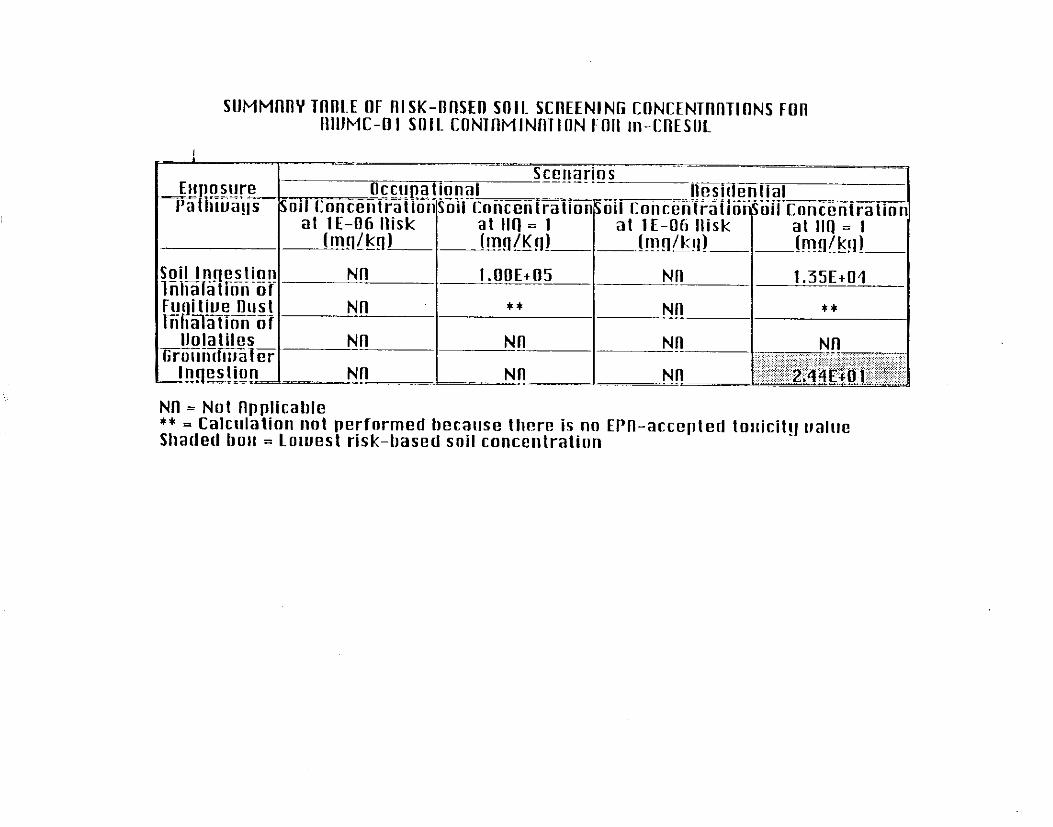
SUMMllflY TflR1.E OF fllSK-lIftSEll VIII. SCIlEENlNli CflNCENTnltTlilNS FOn IIIIJMC-01 SOIL CONlflMlNflTlflN Fflll m-CIIESIIL
**
Nfl = Not llpplicable ** = Calculation not performed because there is no EPfl-accepted tollicit!l oalrle Shaded borl = Lowest risk-based snil concentration

SIIMMWIY TllIlLE IIF IllSK-lIftSEn SOII. SCITEENING CIlNCENTilllTlflNS Ffln IIIUMC-Ul SIIIL CIINTIIMINIITION Fllfl p-CIIEWL
I
Nil = Net flpplicable ** = Calculation nnt performcrl hecause there is no EPn-accepted toiiicit!l ualae Shaded 110~ = Lowest risk-based soil concentration

TiiACK 1 RISK EVALUATION SUMMARY
DATE: 09/23:92
SITE: RWMC-02
SUMMARY:
A Track 1 assessment was conoucred to establish risk-based soil screening concentrations to evaluate potentral hazarcous contaminants at RWMC-32. The dimensions of the contaminated region are: 30.43 m long, 3.64 m wide. and 0.91 m dcoq. It should be noted that the greatest distance was set parallel to the gmunowater flow direction. The following contaminants were evaluated:
Inorganics: barium
Crganics: 2-butanone. m-cresol. and p-cresol
Radionuclides: none
Some tc::icity data are inadequate and are so indicated in the attached tables. Noncarcinogenic factc: tc: inhaiation oi barium is unoer review by an E?A Reference DoselRererence Concentration Work Group None ot the compounds evaiuated are ciassified by the E?A as a class A or B carcinogen. Toxicity data were obtained from the E?A’s lnregrared Risk inrormarion Sysren: and the Heaim Elfecrs Summary Table, 1 9C.2. No credit was taken for any chemical degradation that may occ~:.
Summary tables of risk-based soil screening concenrrations for each contaminant evaluated in the Track 1 assessment are attached. The evaluation followed the abproach outlined in the Tracic 1 Sires: Gu’uicfance for Assessing Low Prooabiiify Hazard Sifes ar INK, Fina/, [DOE’ID-10340fC;). April :932]. Tile calcuiation of soil screening concentrations was based on a target risk level representing a hazard quo:ient of 1 (based on noncarcinogenic effects) or a cancer risk of l.OE-36 (basea on carcinogenic effects).
Four potential exposure pathways were considered, as applicable to the contaminants: soil ingesticr.. inhalation of fugttive dust, inha!ation of volatile organic compounds and grounawater ingestion. The shaded box in the attached tables shows, ‘he lowest risk-based concentration soil concentration for eacn comaminant. The ingestion of grountiater pathway provided the most significant risk (lowec: risk-based screening soil concentration] for all the evaluated contamrnanrs excep for 2-butanone. The Inhalation of the volariies was the exposure pathway o! concern for this compound.
--

SlJMMltttY TftIJLE OF ttlSK-lIftSED SOIL SIXtEENIN CONCENTttIlTlfJNS FfJtl IIIIJMC-02 SOIL CCJNTttMINtlTIlJN Ftlll IJlltllllM
I-.. _ --^- -~--- -~-~-----
Euposurc -RXi~~~~~Soit
at t E-06 nisk ~!!!!l/krl)
Soil lnqestion ** 1 .IOE+fl!i IiiiiXthtii~GV
-__
Fugttiue Dust +* ---- liilialation of
- 6.72Et05
L.L, - Uolatile_~- Nn Nn IZiii3iiater
Inpstion NC Nn .-I NIT = Not npplicable ** = Calculation not performed because due to lack of a pul)lished toldcity ualue Shaded boll = Lowest risk-based soil concentration

SllMMftttY TflDLE flF tllSK-tJflSElJ StJlL SCttEENINI; CfJNCENTllltTltJNS rtJIl nltJMC-02 SOIL CONTIIMIN~lllJN FlJtl 2-Illll~ttNONE
I Soil tnqestion -1niaatinn of
Nn = Not npplicablc ** = Calculation not performetl becalrse there is nn Em-accepted torlicit!J ualuc Shaded botr = Lorirnst risk-based soil concentratiun

SllMMtttlY Tfttl1.E OF ttlSK-lTflSED SIllI. SCltEENlNti CnNCENTttftTIftNS FOtl WLIMC-02 SOIL CONTftMlNllTlflN FOII in-CItESIlL
ltesidential
Nn = Not ftpplicable ** = Calculation nut performed because there is no Em-accepted tuuicit!t ualue Shaded bou = Lowest risk-based soil concentratiun

SllMMftRY TtlllLE OF IllSK-tlftSFll SOIL SCnEENINli CnNCENTltftlltlNS FOR IIIIJMC-ti2 sniL wimMiNmnr4 rm p-ciik3ni.
I ._
I at IE-06 ttisk at 1 E-n6 Ilisk r!!!rl!lin)_-
Nil = Not ftpplicatxle ** = Calculation nnt perfornicd tlccause there is no FPn-accepted toliicit!t ualrie Shaded llnli = Lowest risk-based soil concentration

TRACK 1 RISK EVALUATION SU!!MARY
DATE: 09123/92
SITE: RWMC-03
SUM!.’ ARY:
A Track 1 assessment was conducted to es:ablish risk-based soil screening coxen!:a:ions to evaluate potential hazardous contaminants at RWMC-03. The dimensions of the conraminared region are: 11.43 m long, 6.37 m wide. and 0.01 m deep. It should be noted that the greatest distance was set parallel to the groundwater flow direction. The following contaminants were evaluatec:
Inorganics: barium
Organics: 2-butanone. m-cresol. and p-cress1
Radionuclides: none
Some toxicity data are inadequate and are so indicated in the attached tables. No:.carcinoge?ic factor for inhalarion of barium is under review by an E?A Reference Ccse/Reierence Concentration Work Group. None of the compounds evaluated aie c:assiiied by the E?A as a c!ass A or B carcinogen. Toxicity daIa were otialned from the E3A’s inrqrared Risk :niormar;on Sys:em and the Health Elfeczs Summary Table, 1 332. No credit wzs taken for any chemical aegradation that may ocw.
Summary tables of risk-based szii screening concentrations for each contaminant evaluated in the Track 1 assessmenr are attached. The evaluation followed the approach outlined iii the Track 7 Sites: Guidance for Assessing Low ProbaNity Hazz-6 Sites at /NT% Final, [DOBID- 0340(91), April 1992]. The calcuiattion 01 soil screwing concentrations was based on a target risk ,evel representing a haxrd quotient of i !based on noncarcinogenic efiecs) or a cancer risk of 1.3~~96 (based on carcmo?enic effec:s).
Four potential exposure pathways were considered, as applicable to the wntaminants: soil ingestion, inhalation o! fugitive cusi. inhalation of volatile organic compounds and groundwater inges;ion. The shaded ho> in the artached tables snows the lowest rfsk-based concentration soil concentration for each cor:aminani. The ingestion of groundwater pathway provided the most significant risk (lowesl risk-oased screening soil concentration) for all the evalxiteti x%aminants except for 2-buranone. The inhaialion oi the v;iatiles was the exposure pa:‘lway oi mnce-n for this compound.

SUMMflRY TflD1.E tlF tllSK-llflSED Sllll. SCREENING CtlNCENTtlftTIONS FOll lllUMC-03 SOIL CtlNTllMlNflTltlN FIJI1 IllllllllM
I .4OE+05 ** I .[19E+O4
3.04E+05 ** _ 2.711E+05 --
Nn = Not nppticablc ** = Calculation not perforrnecl because due tn lack of a puhlishcd touicitg ualuc Shaded LIOII = Lowest risk-based soil coucentratinu

SIiMMnnY TIIIJLE OF IIISK-onsEn snlL SCnEENINli r.nNCENTnnTlnNs rnn nlUMC-03 SillL CflN~I1IMINnTIiiN Fllll 2-IIIIIIINnNE
Nil = Nol npplicable ** = Calculation nnl performed I)cca~~se there is no w-accepted lnrficily tialuc Shaded bolr = Lowest risk-based soil concentration

SUMMflllY TflRLE OF fllSK-flflSEll SlllL SCREENING CONCENTnllTlONS l-nil IIIUMC-03 SOIL CONTnMlNflTlON FOII m-CnESIIL
at IE-06 nisk al lE-46 llisk
1 35EtO4 -2--.- **
Nfl = Not flpplical~le ** = Calculation not performed because there is no EPfl-accepted lotlicit! ~~aluc Shaded borr = LOUJCS~ risk-based snil concenlralion

SllMMnIlY TflffLE OF RISK-OnSEll SOIL SCllEENlNli CONCENTllllll~NS FOll fllllMC-03 SOIL CONlnMlNI1Tl~N Ffln p-CIIEWL
Euposure -s-*-e- Pathways
al IE-06 Risk --!!!!!l&!l)~
Soil Inqcslion 7iiiiiiiilTiiii-O~- Wgitiue Dusl _- __..=. -..- Inhalation OS
Ilolaliles ~Ei’iiliZhiZfer
_-
bngiKq1 -_ __
I .OOE+llFi --- t*
N!!
Nn =---
I 1.35E+04 I
Nn t* I I
Nil = Not llpplicahle ** = Calculatioii nut performed hecause there is nn El’fl-accepted Inuicitg IJ~IIIC Shaded bou = Lo~ucst risk-based soil concentration

APPENDIX C METHOD OF CONVERTING TCLP VALUES TO MG/KG OF SOIL

cc: -gfzmy Beason iiaren Izbicki Sandy Sollezder Sk&. Steeie
1

EC&G !dano, Ix.
Form: c.22 ^ ,-.‘L.56i
MEMO OF CONVEZSAi-ION
Person Calling Shannon Waters
Representing OrC. Env. Tech.
Date 1 l/19:1
Time 940
Person Called Frank Calovini Phone No. i703) 821 -JX!O
Represenring Comoany E?A Office oi Solid Was% Meihod Iniorma;ion Communicarlon Exckance
cay
Subject Test Me!hods ccnversion
How do we canwvcompare the results from E? Tox and TCLP to concenrwjons in soil? We
nesd to talk with our reqJator. but basically, if we caiwiare the dilution facors in, then % should
be o.k. Talk this aqroacn over ,viih our re?uiatcr.
Signature
_ --

E*G&G Idaho, Inc.
Form: E,G&G-561
MEMO OF CONVERSATION
Person Calling Shannon Waters Date 1124191
Representing Org. Env. Tech. Time 1250
Person Called Lisa Green Phone No. 6-0417
Representing Company DCE-ID
city Idaho Falls
Subject Use oi Dilution Factors to caluculate ma!ka from ma/L E? !ox results
She said that she spoke with Dean Nygard and Wayne Pierre (Slate of idano and E?A) about
using the dilution facors to back-calculate the concentration in soils and that it sounds like a
reasonable approach. Go ahead and use that for the Track 1 s.

,EG& " Idaho. Inc. :Ol?M EG&G-2631 (Rev.lZ-88)
ENGINEERING DESIGN FILE
Project File No. EDF Serial No. RWMC-505 Functional File Number
Date 09-26-91
Froject/Task RADIOACTIVE WASTE MANAGEMENT COMPLEX Subtask SEWER SYTEMS EDF Page 1 of 1
/ Subject: Sample analysis results from sampling of the RWMC/SWEPP septic systems.
I
CTS Item 7100-02919, which was a TIGER TEAM Daily observation, stated that the three (3) septic systems have not been analyzed for radiation contamination, volatile organic constituents (VOC) or heavy metals.
SWRRS835x was written and seven (7) samples were taken from the RWMC septic systems. The samples were sent by EG&G Environmental Monitoring to Radiation Measurements Laboritory (RML) and VISTA Laboritories Inc. for the sample analysis. The sample results are attached with letter LJPW-76- 91. The summerized results of the samples were as follows: 1) no manmade radionuclides were detected in the samples, 2) TCLP constituents are summerized in letter LJPW-76-91, all detected concentrations are below the regulatory limits.
Attached to this EDF is the following information: - Letter, Closure of EMS-110-91 - LJPW-76-91 - Vista Laboritories Inc letter - Letter, GAMMA analysis of seven RWMC septic Tank Samples - TJH-75-91 - TCLP Test Data Sheets
I, /I j DISTRIBUTION (COMPLETE PACKAGE): PROJECT EDF FILE LOG I I
DISTRIBUTION (COVER SHEET ONLY): EDF SERIAL NO.LOG, D.L. French M/S 4201, S.B. French M/S ! 4202, J.C. Kvamme M/S 4201 I
/I AUTHORS - DEPT. 1 REVIEWED A DATE 1 APPROVED / DATE I

“Providing research and developmenr Services to the government” !Z;’ (:c , c-i &,7:,‘i
-&%ic5
INTEROFFICE CORRESPONDENCE
Date: July 29, 1991
To: J. A.
From: T. J.
Subject: GABHA
Four liquid and . .
Johnson, IG 4133
Haney, HS 7lll-fq(
ANALYSIS OF SEVEN RVHC SEPTIC TANX SAHPLES - TJH-75-91
three semi-solid septic tank samples from the RUHC were submitted to tne Radiation Weasurements Laboratory (BHL) for an analysis to determ ine whether any gamma-ray-emitting radionuclide contaminants were present. The solid samples were counted in the 5OOcc squat jar soil geometry for tvo hours. The liquid samples were counted for 16 hours in a 540ml liquid bottle geometry. The samples were counted on BhL gamma- spectrometers and vere analyzed by the gamma-spectrometric analysis pro- gram VAX/CBAT. The results of the analyses of these samples are listed below.
Banmade Activity(T) Sample ID RHL ID Radionuclides (W/v)
11007179106D A6072391024 None Detected N/A 11007179104D A5072591022 None Detected N/A 11007179101E A6072591023 None Detected N/A 11007179103D A5072691028 None Detected N/A 11007179102E . D3072291074 None Detected N/A 11007179105E D1072291072 None Detected N/A 11007179107E D2072291073 None Detected N/A
The analysis results were carefully examined by experienced and trained gamma spectroscopists. No manmade gamma-emitting radionuclide conta- m inants vere detected in these samples.
max
cc: L. D. Koeppen DY C. L. Rovsell Central Files T. J. Haney File

“Providing research and development services to the government
INTEROFFICE CORRESPONDENCE Date: September 13, 1991
To: S. B. French, MS 4202
From: L. J. Peterson-Wright, MS 41
Subject: CLOSURE OF EMS-110-91 - LJPW-76-91
This report is in response to your July 2, 1991, request for sampling and analysis of RWMC septic tank contents for TCLP and transuranic constituents.
On July 17, 1991, representative samples were collected following the procedures in Quality Assurance/Work Plan EMS-110-91 (see Attached). The samples were submitted under chain-of-custody to VISTA Laboratories Inc., of Broomfield, Colorado, for the requested analyses (See Attached).
There were no manmade radionuclides detected in the samples. Detection of TCLP constituents are summarized below. Please note that all detected concentrations are below the regulatory lim its.
distribution
WF 613 (solid)
VHF 613 (liquid)
VMF 601 (solid)
VHF 601 (liquid) ND
UHF 617 (solid) NO
YMF 617 (liquid) NO
NO
NO
ND
ND NO
Methylethyl m&p ketone (33 cresols (210 wb) wbl
Methylethyl NO ketone (42 wb 1
ND- not detected All data meets project data quality objectives as defined in Quality Assurance Sampling and Analysis Plan EMS-110 -91.

S. 6. French September 13, 1991 LJPW-76-91 Page 2
If there are any questions or if you have other sampling and analysis needs, please feel free to contact me at 6-8409.
cae
Attachments: As Stated
cc: (w/o Attach) T. G. Hedahl, MS J. M. Welch, MS 411
(with Attach) J. A. Johnson, MS 4110 Central Files, MS 1651 L. J. Peterson-Wright Files