area plan · truman plaza is urban. neighborhoods are dense and commercial and industrial areas are...
TRANSCRIPT
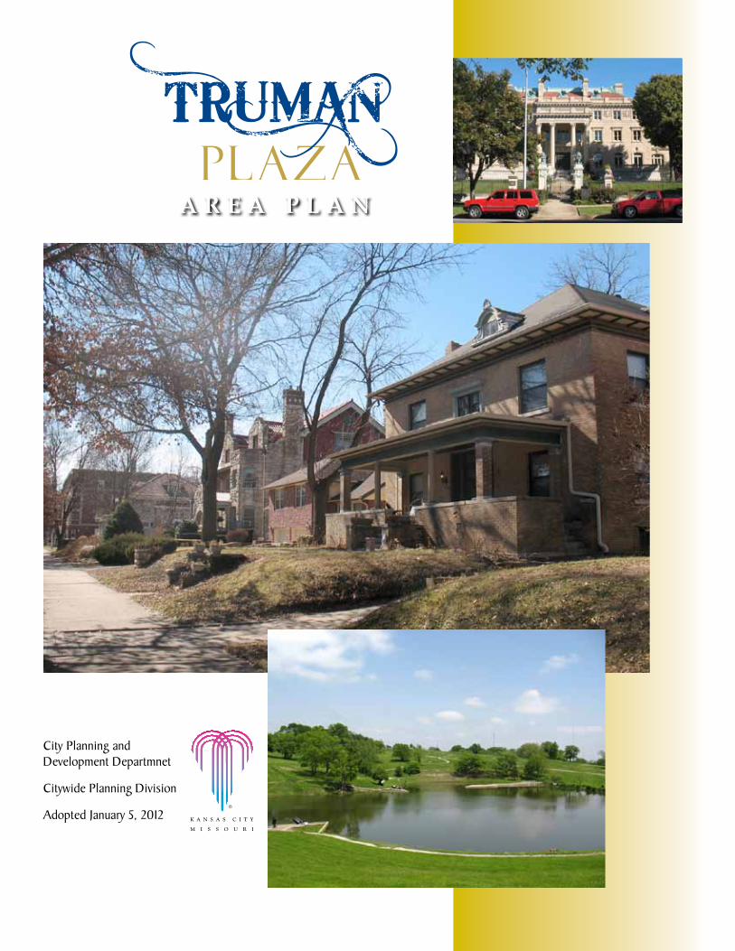
City Planning and Development Departmnet
Citywide Planning Division
Adopted January 5, 2012
A R E A P L A N

1T R U M A N P L A Z A A R E A P L A N
CREDITS and acknowledgments
Mayor: The Honorable Sly James
City Manager: Troy Schulte
City Council: Dick Davis ...................................................................................... 1st District
Scott Wagner ..................................................................... 1st District-at-Large
Russ Johnson .................................................................................2nd District
Ed Ford ........................................................................... 2nd District-at-Large
Jermaine Reed ................................................................................ 3rd District
Melba Curls ...................................................................... 3rd District-at-Large
Jan Marcason .................................................................................4th District
Jim Glover ........................................................................ 4th District-at-Large
Michael Brooks .............................................................................. 5th District
Cindy Circo ...................................................................... 5th District-at-Large
John A. Sharp ................................................................................ 6th District
Scott Taylor ...................................................................... 6th District-at-Large
PrePared by:
The City of Kansas City, Missouri Planning & Development Department
City Planning and development Contributing Staff:Tom Coyle, AICP, Director
Jade Liska, ASLA / RLA, Division Manager
Randy Dunn, Project Manager
Kellie Johnston, AICP, Project Manager
Bryan Foster, Planning Technician
Steve Lebofsky, AICP, Planner
Ron Simmons, Graphic Design Specialist
Bradley Wolf, Landmarks/Preservation Administrator
2 T R U M A N P L A Z A A R E A P L A N
Steering CoMMittee (persons appointed to or who participated with the Steering Committee)
Farah Abdi, Somali Foundation
Bobbi Baker-Hughes, Northeast Chamber of Commerce
Forestine Beasley, Independence Plaza Neighborhood Association
Gary Bertoncin, Passantino Brothers Funeral Home
David Biersmith, Truman Road Corridor Association
DeWayne Bright, Historic East Neighborhood Coalition
Dennis Caroll, Sheffield Neighborhood Association
Daniel Cline, Truman Road CID
Officer Jason Cooley, Kansas City Police Department
Rev. Daniel Doty, City Union Mission
John Engelmann, Northeast Industrial Association
Katie Greer, Indian Mound Neighborhood Association
Ron Heldstab, Lykins Neighborhood Association
Father Tom Holder, Holy Cross Church
John Freshnock, American Intsitute of Architects
John Jimmerson, CAM Neighborhood Association
Nancy Jones, Kansas City University of Medicine and Biosciences
Micah Kubic, LISC
Lee Lambert, Independence Plaza Neighborhood Association
Tracy Marriott, Indian Mound Neighborhood Association
Gary Marsh, Kansas City Museum
Kay Miller, Forgotten Homes Neighborhood Association
Bernardo Ramirez, Hispanic Economic Development Corporation
Crispin Rea, Mattie Rhodes Northeast / Kansas City Missouri School District
Joyce Riley, East 23rd Street PAC
Billie Robleado, Pendleton Heights Neighborhood Association
Jacky Ross, Blue Valley Neighborhood Association
Verniece Ross, Blue Valley Neighborhood Association
Adam Schieber, Scarritt Neighborhood Association
Nicholas Scielzo, Don Bosco Community Center
Daniel Silva, LISC
Robert Stout, East 23rd Street PAC
Charlotte Tillman, Forgotten Homes Neighborhood Association
Tim Vance, Blue Valley Business Association
Larry Williams, St. Paul School of Theology
aSSiSting teChniCal StaFFJocelyn Ball-Edson, Parks and Recreation Department
Diane Binkley, City Planning and Development Department
Clyde Bolton, Health Department
Officer Jason Cooley, Kansas City Missouri Police Department
John DeBauche, City Planning and Development Department
Tom Degenhardt, Public Works Department
Gerri Doyle, Missouri Department of Transportation
Kyle Elliott, City Planning and Development Department
Jared Gulbranson, Area Transportation Authority
Lee Ann Kell, Missouri Department of Transportation
David Macoubrie, Economic Development Corporation
Sherri McIntyre, City Manager’s Office; Public Works Department
Danny O’Connor, Area Transportation Authority
Scott Overbay, Parks and Recreation Department
David Park, Neighborhood and Community Services Department
James Walton, Water Services Department
Gerald Williams, City Planning and Development Department
Allan Zafft, Missouri Department of Transportation
3
CONTENTStable of
T R U M A N P L A Z A A R E A P L A N
introduction ............................................................................. 1Purpose of the Plan...................................................................... 5Truman Plaza Boundaries .............................................................. 6Introduction to the Area ............................................................... 7Vision Statement ......................................................................... 8Achieving the Vision - 5 Primary Goals ............................................ 8The Participation Process .............................................................10
housing and neighborhoods ..................................................... 11Vision Statement ........................................................................11Area Goals .................................................................................11Housing ans Neighborhoods Guiding Principles ................................12Recommendations by Neighborhood Classification ............................14
economic development ............................................................ 17Vision Statement ........................................................................17Area Goals .................................................................................17Economic Development Guiding Principles ......................................18
land Use and development ...................................................... 21Vision Statement ........................................................................21Area Goals .................................................................................21Land Use Guiding Principles .........................................................23Recommended Land Use Map ........................................................26Future Land Use Definitions ..........................................................27Independence & Prospect .............................................................30
transportation ......................................................................... 35Vision Statement ........................................................................35Area Goals .................................................................................35Transportation Guiding Principles ..................................................37
implementation ...................................................................... 43Area Plan Oversight Committee .............................................................43
Summary of Financing Programs ............................................................43
Implementation Matrix ........................................................................44

T R U M A N P L A Z A A R E A P L A N4

5T R U M A N P L A Z A A R E A P L A N
Purpose of an area PlanThe city is divided into 18 geographic areas for which area plans are prepared. These plans implement the policies of the FOCUS Kansas City Plan, Kansas City’s Comprehensive Plan, on an area basis. An area plan is a road map that recom-mends strategies to help a community reach their goals and vision for the future. Area Plans provide a proactive, comprehensive framework to guide public deci-sions on land use, housing, infrastructure, community development, and public services. Area plans also provide reactive guidelines, to direct the evaluation of projects and proposals. The map below shows the 18 area plan boundaries and the boundaries for the Truman Plaza Area Plan.
INTRODUCTION
While the City of Kansas City, Missouri makes every effort to maintain and distribute accurate information, no warranties and/or representations of any kind are made regarding information, data or services provided. In no event shall the City of Kansas City, MO, be liable in any way to the users of this data. Users of this data shall hold the City of Kansas City, MO, harmless in all matters and accounts arising from the use and/or accuracy of this data.
§̈¦I-435
§̈¦I-435
Plat
te P
urch
ase
Cookingham
Gre
en H
ills
108th Oak
£¤US 169
Shoa
l Cre
ek
Map
lew
oods
Pase
o
Man
ches
ter
Troo
st
64th
Har
dest
y
Barry
Line
Cre
ek
Parvin
31st
Chouteau
Englewood
72nd
§̈¦I-29
§̈¦I-70
85th
Gregory
87th
23rd
Truman
55th
§̈¦I-435
§̈¦I-435
96th
75th
Bannister
£¤M-350
Ray
tow
n
Blue Ridge
Hol
mes
High Grove
155th
Nol
and
£¤M-291KCIA
Swope
Red Bridge
Shoal Creek Valley
Longview
Riverfront Industrial
Line Creek Valley
Stadium/Park East
Briarcliff/Winnwood
Truman Plaza
Gashland/Nashua
Little Blue Valley
GreaterDowntown
Hickman Mills
Heart of the CityMidtown/
Plaza
Martin City
Country Club/
Waldo
§̈¦I-35
§̈¦I-435
§̈¦I-470
§̈¦I-70
§̈¦I-635
§̈¦I-670
§̈¦I-435
31st
Hol
mes
Front
87thN
olan
d
Stat
e Li
ne
Chouteau
Blue Ridge
Long
view
Woo
dlan
d
109th
79th
126th
100th
Blue Ridg
e £¤M-350
£¤M-150
£¤M-291
£¤M-210
£¤US 169
£¤M-92
£¤M-152
£¤US 71
£¤US 71
£¤M-9
§̈¦I-29
§̈¦I-35
§̈¦I-470
Martha Truman
City LimitTruman PlazaRencently Completed Area PlansFuture Area Plans
± H:\P
LN&
UD
\Are
aPla
ns\M
indM
ixer
2011
Are
aPla
ns.m
xd F
eb. 1
, 201
1
Area Plan Locations within Kansas City, Mo.Prepared by: City Planning and Development Department City of Kansas City, Missouri February 2011
0 0.9 1.8Miles

T R U M A N P L A Z A A R E A P L A N6
truman Plaza boundaries:north: Union Pacific (UP) Railroad Tracks
South: Independence Avenue between The Paseo and Woodland Avenue; I-70 east of Woodland Avenue to the Big Blue River
east: Belmont Boulevard, the BNSF Railroad Tracks, and the Big Blue River
West: I-35 to The Paseo between UP Railroad Tracks and Independence Avenue; Woodland Avenue between Independence Avenue and I-70
7T R U M A N P L A Z A A R E A P L A N
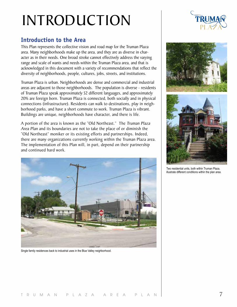
INTRODUCTIONintroduction to the areaThis Plan represents the collective vision and road map for the Truman Plaza area. Many neighborhoods make up the area, and they are as diverse in char-acter as in their needs. One broad stroke cannot effectively address the varying range and scale of wants and needs within the Truman Plaza area, and that is acknowledged in this document with a variety of recommendations that reflect the diversity of neighborhoods, people, cultures, jobs, streets, and institutions.
Truman Plaza is urban. Neighborhoods are dense and commercial and industrial areas are adjacent to those neighborhoods. The population is diverse - residents of Truman Plaza speak approximately 52 different languages, and approximately 20% are foreign born. Truman Plaza is connected, both socially and in physical connections (infrastructure). Residents can walk to destinations, play in neigh-borhood parks, and have a short commute to work. Truman Plaza is vibrant. Buildings are unique, neighborhoods have character, and there is life.
A portion of the area is known as the “Old Northeast.” The Truman Plaza Area Plan and its boundaries are not to take the place of or diminish the “Old Northeast” moniker or its existing efforts and partnerships. Indeed, there are many organizations currently working within the Truman Plaza area. The implementation of this Plan will, in part, depend on their partnership and continued hard work.
Two residential units, both within Truman Plaza, illustrate different conditions within the plan area.
Single family residences back to industrial uses in the Blue Valley neighborhood.

T R U M A N P L A Z A A R E A P L A N8
Vision StatementDuring the process of creating this plan, considerable thought was given to the future of Truman Plaza. The following vision statement emerged from public workshops, steering committee meetings, and the planning team’s observa-tions. The City, plan participants, area stakeholders, and residents will work to make the following vision statement a reality for Truman Plaza:
Truman Plaza residents, businesses, and stakeholders take pride in and promote their vibrant, self-sustained community which consists of diverse, safe, historic and affordable neighborhoods with easy access to area services, resources, and jobs.
achieving the Vision - 5 Primary goalsThe following goals support the Vision Statement and are the core components of the Plan. These are the goals by which all future recommendations and actions are based. To further develop the plan, a survey was conducted of area residents. The corresponding graphs show the respondents’ perception of the area as it relates to the 5 Primary Goals listed below. Guiding principles and specific rec-ommendations on how to achieve the goals are described in the chapters.
1. Promotesafeandcleanneighborhoodsanddecreasethecrimerates.
Truman Plaza experiences a high crime rate. Overcoming this is a top priority, because the accomplishments of all the other goals depend on having a safe and clean environment. Non-residents of the area also need to recognize the strengths of the area and respect the residents, property owners, and businesses.
Very Safe9%
Safe27%
Neutral27%
Unsafe37%
Perception of safety in your neighborhood
Source: ETC Institute (2011)
Very Safe6% Safe
15%
Neutral29%
Unsafe50%
Perception of safety in adjacent neighborhoods
Source: ETC Institute (2011)
Participants in the first Steering Committee identified the key statements for the Vision Statement.
9T R U M A N P L A Z A A R E A P L A N
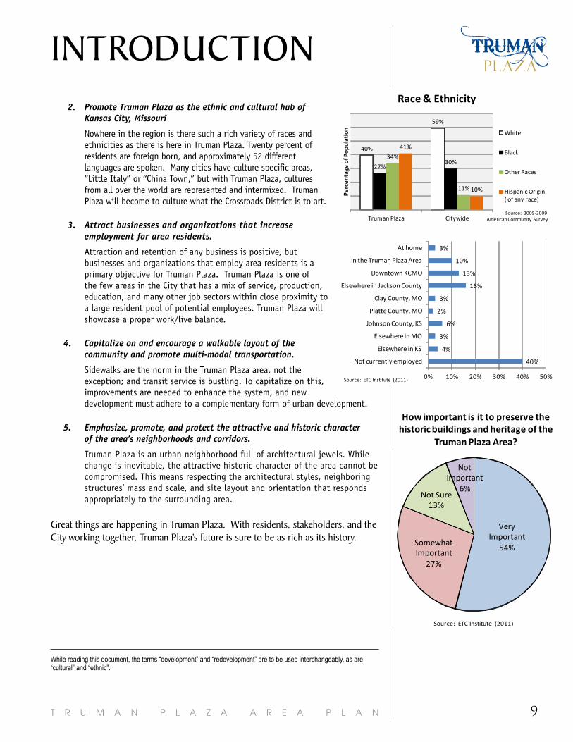
INTRODUCTION2. PromoteTrumanPlazaastheethnicandculturalhubof
KansasCity,Missouri
Nowhere in the region is there such a rich variety of races and ethnicities as there is here in Truman Plaza. Twenty percent of residents are foreign born, and approximately 52 different languages are spoken. Many cities have culture specific areas, “Little Italy” or “China Town,” but with Truman Plaza, cultures from all over the world are represented and intermixed. Truman Plaza will become to culture what the Crossroads District is to art.
3. Attractbusinessesandorganizationsthatincreaseemploymentforarearesidents.
Attraction and retention of any business is positive, but businesses and organizations that employ area residents is a primary objective for Truman Plaza. Truman Plaza is one of the few areas in the City that has a mix of service, production, education, and many other job sectors within close proximity to a large resident pool of potential employees. Truman Plaza will showcase a proper work/live balance.
4. Capitalizeonandencourageawalkablelayoutofthe communityandpromotemulti-modaltransportation.
Sidewalks are the norm in the Truman Plaza area, not the exception; and transit service is bustling. To capitalize on this, improvements are needed to enhance the system, and new development must adhere to a complementary form of urban development.
5. Emphasize,promote,andprotecttheattractiveandhistoriccharacter ofthearea’sneighborhoodsandcorridors.
Truman Plaza is an urban neighborhood full of architectural jewels. While change is inevitable, the attractive historic character of the area cannot be compromised. This means respecting the architectural styles, neighboring structures’ mass and scale, and site layout and orientation that responds appropriately to the surrounding area.
Great things are happening in Truman Plaza. With residents, stakeholders, and the City working together, Truman Plaza’s future is sure to be as rich as its history.
While reading this document, the terms “development” and “redevelopment” are to be used interchangeably, as are “cultural” and “ethnic”.
40%
4%
3%
6%
2%
3%
16%
13%
10%
3%
0% 10% 20% 30% 40% 50%
Not currently employed
Elsewhere in KS
Elsewhere in MO
Johnson County, KS
Platte County, MO
Clay County, MO
Elsewhere in Jackson County
Downtown KCMO
In the Truman Plaza Area
At home
Source: ETC Institute (2011)
Very Important
54%Somewhat Important
27%
Not Sure13%
Not Important
6%
How important is it to preserve the historic buildings and heritage of the
Truman Plaza Area?
Source: ETC Institute (2011)
Very Important
54%Somewhat Important
27%
Not Sure13%
Not Important
6%
How important is it to preserve the historic buildings and heritage of the
Truman Plaza Area?
Source: ETC Institute (2011)
40%
59%
27%30%
34%
11%
41%
10%
Truman Plaza Citywide
Perc
enta
ge o
f Pop
ulat
ion
Race & Ethnicity
White
Black
Other Races
Hispanic Origin ( of any race)
Source: 2005-2009 American Community Survey
T R U M A N P L A Z A A R E A P L A N10
the Participation ProcessPlanning is a process by which a community assesses what it is and what it wants to become, then decides how to make it happen. Specifically, planning guides public policy decisions on land use, infrastructure, public services, and zoning. In order to be successful, an area plan must address the community’s primary issues. Therefore, public participation was essential for preparing this plan. The concepts, direction and final recommendations in this plan are a result of an inclusive public process that identified and addressed the weaknesses, challenges, strengths and opportunities in the plan area. The planning process included the following:
Steering CoMMitteeA citizen-based steering committee appointed by the mayor articulated over-all directions and reviewed principles and concepts throughout the planning process. The steering committee included residents, property owners, busi-ness owners, and representatives from area institutions.
teChniCal adViSory CoMMitteeTechnical expertise and guidance was provided by staff members from the City of Kansas City, and representatives of the Economic Development Corporation of Kansas City, Missouri Department of Transportation (MoDOT), Kansas City Area Transportation Authority (KCATA), Northeast Chamber of Commerce, and Kansas City Missouri School District.
PUbliC MeetingSThree meetings with the public were held throughout the planning process to provide open dialogue and to help stakeholders and residents shape the vision of the area.
MindMixerUsing the MindMixer platform, an online town hall meeting was utilized throughout the planning process to gather additional feedback and facilitate a continued dialogue. This outlet was utilized at different stages of the planning process. This method was instrumental in gathering feedback from persons who do not attend public meetings or are not comfortable giving feedback during public meetings. This method also facilitated discussions among participants. Internet access was provided at the library for those with no access from home.
CoMMUnity SUrVeyA statistically significant survey was conducted by ETC Institute to further gage public opinions, wants, and needs while creating this Area Plan.
SUPPorting inForMationThe Truman Plaza Data Book provides a detailed analysis of existing conditions related to land use and development, demographics, housing and neighborhoods, transportation and infrastructure, economic incentives and other supporting infor-mation. This document provided a frame of reference for the plan vision and the foundation for the Plan’s recommendations.
Prior to the initial public meeting, staff attended the official neighborhood meetings for all of the neighborhood organizations within the Plan boundaries. Numerous one-on-one meetings were held with a variety individuals throughout the planning process. Their individual expertise on specific topics was utilized in developing the Plan.

11T R U M A N P L A Z A A R E A P L A N
Strong and stable neighborhoods help build successful and sustainable commu-nities. Thirteen distinct neighborhoods with unique characteristics are included in the Truman Plaza Plan Area. This chapter provides a framework from which to work to address their needs and help them ensure a successful future.
Vision StatementTruman Plaza residents, businesses, and stakeholders take pride in and promote their vibrant, self-sustained community which consists of diverse, safe, historic and affordable neighborhoods with easy access to area services, resources, and jobs.
With the Vision Statement as the end target, the City, stakeholders, and resi-dents, will reach the following area goals, guided by the following housing and neighborhood principles. All of the guiding principles are based on the area goals. Each guiding principle has a set of recommendations to implement that guiding principle, and thus, the area goals.
area goalsProMote SaFe and Clean neighborhoodS and deCreaSe the CriMe rateS. In order to realize the vision for the community, the crime rate in the area must decrease. A step to reduce crime is to clean up the neighborhoods and improve the image of the area.
ProMote trUMan Plaza aS the ethniC and CUltUral hUb in the City oF KanSaS City. The neighborhoods of Truman Plaza are some of the most ethnically and cultur-ally diverse of any in the City. Increasing cultural knowledge, understanding, and communication will help ensure this characteristic is an attribute to the area.
attraCt bUSineSSeS and organizationS that inCreaSe eMPloyMent For area reSidentS.Strong, safe and stable neighborhoods will attract new businesses. Appropriate new businesses will provide employment, services, and amenities that are desired by area residents.
CaPitalize on and enCoUrage a WalKable layoUt oF the CoMMUnity and ProMote MUlti-Modal tranSPortation.An important component of a livable community is an efficient multi-model transportation system (inclusive of pedestrian, bicycle, transit and automobile). The provision of infrastructure for these systems is not enough - the community must be safe and the systems must be maintained and easy to use.
eMPhaSize, ProMote, and ProteCt the attraCtiVe and hiStoriC CharaCter oF the area’S neighborhoodS and CorridorS.Truman Plaza is one of the most historic areas of the City and the unique hous-ing stock and styles, attractive corridors and boulevards, and registered historic districts and structures make Truman Plaza a true gem.
HOUSINGand neighborhoods
Vacant homes are negatively impacting the image of the area.
This mural on Independence Avenue shows various ethnic groups playing soccer.
The USPS Procsesing & Distribution Center is a major employer in the area.
Although sidewakls are present on this street, they are not maintained, therefore, not useable.
The Kansas City Museum is a gem within the city and icon of the Old Northeast.
T R U M A N P L A Z A A R E A P L A N12
housing and neighborhoods guiding Principles1. PreSerVe and enhanCe neighborhood CharaCter.
2. bUild CaPaCity and WorK With organizationS to Carry oUt the Plan goalS.
3. target StrategiC areaS For redeVeloPMent.
Below are recommended actions needed to accomplish or follow through on each guiding principle and goal. This is the recipe for how to implement the hous-ing and neighborhood goals and guiding principles for Truman Plaza. There are many other feasible and needed actions, but these are the priorities for the area for the next 7-10 years. These recommendations are intended to broadly cover the entire plan area. More specific, strategic recommendations are listed under “Recommendations by Neighborhood Classification.”
PreSerVe and enhanCe neighborhood CharaCter.• Incorporate minimum design standards into the development code and enforce
the standards equally throughout the area.• Encourage new market rate housing and ensure the design is consistent with the
character of the existing housing stock (architectural style, setbacks, massing, and scale).
• Support the development of the Northeast Community Center at 9th & Van Brunt Boulevard.
• Preserve and maintain existing and future parks and boulevards to the highest standards.
• Program area parks to fit the current and future needs and wants of area residents.• Perform a CPTED (Crime Prevention Through Environmental Design) review of all
area Parks and make recommended improvements.• Utilize CPTED when designing and redesigning area parks.
• Implement and enforce a curfew in Parks.
The floor lines, roof, windows, and entry of the house do not align with those typically found along this street.
Although the second house reflects alignment in the placement of the windows, entry, cornice, and roof – its proportion are not appropriate. Note the large horizontal windows, the double doors, and the overall width of the house.
This residence is a showcase of the historic character in Truman Plaza.

13T R U M A N P L A Z A A R E A P L A N
• Ensure that new non-residential development is respectful of the building design, site layout, density, massing and scale of surrounding neighborhoods. (See Land Use and Development Chapter for design recommendations.)
• Wherever feasible, rehabilitate vacant structures.
• Avoid concentrating subsidized housing, social service housing, and social ser-vices. Look at an entire neighborhood and its characteristics and needs prior to locating subsidized housing, social service housing, and social services. Focus on building neighborhoods, not houses or housing units.
• Market individual area neighborhoods for their unique character and assets.
• Maintain vacant lots and explore alternative uses such as urban agriculture and storm water retention.
• Improve sidewalk maintenance by repairing where needed, installing where missing, and cleaning where unpleasant.
• Discourage liquor permits for bars, nightclubs, and late-night operations; particu-larly when adjacent to residential neighborhoods.
• Work with regional municipalities to pass an ordinance (one for each municipal-ity) that requires retailers to stock spray paint behind glass (to reduce shoplifting of spray paint that could be used for graffiti).
bUild CaPaCity and WorK With organizationS to Carry oUt the Plan goalS.• Increase capacity of area organizations to implement the Plan.
• Support the creation of Community Improvement Districts (CIDs) along major corridors, including Independence Ave.
• Continue to host, expand, and start new community events within Truman Plaza (for example, the Ethnic Enrichment Festival).
• Create a marketing plan for the identified commercial nodes (see the identified commercial nodes in the Land Use & Development Chapter).
• Continue and expand the neighborhood/CDC program for mowing vacant lots.
• Continue and expand the neighborhood code enforcement for vacant properties.
• Implement a neighborhood/CDC program for graffiti removal.
• Teach neighborhoods how to track code violation complaints on the City’s website.
• Improve availability and accessibility of translation services to assist in communi-cation between non English speaking business owners, property owners, developers, City staff, and neighborhoods (to convey the regulations of the City and desires of the neighborhood).
• Proactively provide translation, visual documentation (pictures), and referrals to agencies for financial assistance with notices of code violations.
• Increase the understanding that building permits are required to better ensure enforcement of development code and special review district regulations.
• Provide opportunities for citizens to increase their knowledge of City property code requirements so they know what is required of/at their property and so persons know when they should report a violation.
• Provide and promote cultural education opportunities and classes to increase understanding between the various cultures. Classes should be available for both U.S. natives and the foreign born population. A greater understanding of each other will facilitate better relationships and a better community.
HOUSINGand neighborhoods
Sidewalk maintenance and replacement is needed throughout the plan area.
Graffiti on a stop sign along St. John Avenue.
Working with the Neighborhood and Community Services Department, neighborhood organizations can mow vacant lots - often a more timely solution.
Urban forestry, urban agriculture, and stormwater management are three ways to use vacant lots.
T R U M A N P L A Z A A R E A P L A N14
target StrategiC areaS For redeVeloPMent. • Create a Land Banking Program that proactively purchases, maintains, and sells
vacant/under utilized property. Target redevelopment areas as identified in the Land Use & Development Chapter.
• When incentives are used for new non-residential developments or redevelop-ments, initiate a program that will divert a portion of the financial benefits from the incentivised development into the surrounding neighborhood to fund improvements.
• When incentives are used for new non-residential development/redevelopment, include a requirement to employ a minimum percentage of persons residing within five miles of the site.
• Track neighborhood typology indicators listed below to identify changes in hous-ing and neighborhood livability.
recommendations by neighborhood ClassificationTruman Plaza neighborhoods vary greatly. Neighborhoods that are the most distressed (Rehabilitation Areas) require the most intervention. However, if all relevant resources are devoted to these areas, “Stable” and “Transitional” areas may fall prey to blighting influences. To avoid “pushing the problems,” a con-tinuum of care should be employed to ensure appropriate responses are targeted based upon neighborhood needs.
To determine neighborhood typology, the following indicators were tabulated by using data from the American Community Survey 2005-2009, 2010 Census, Police Depart-ment, Jackson County, and Neighborhood and Community Services Department:
1. Median Income 2. Unemployment Rate3. Poverty Rate4. Residential Vacancies5. Home Ownership6. Population Change
7. Median Housing Value8. Crime9. Dangerous Buildings10. Jackson County Land Trust Lots11. High School Education and Above
Information was available by Census Tract boundaries, not neighborhood boundaries. Therefore, in some neighborhoods there is more than one clas-sification. Neighborhoods should still work on the strategic recommendations where indicated on the map.
An analysis of the above factors resulted in the neighborhood classifications shown on the Neighborhood Classification Map. Stable - Areas identified as “Stable” generally score the best on the 11 indicators
listed above. While these tracks are the healthiest according to the indicators used, continued maintenance and actions are needed to ensure they remain “Stable.”
transitional - Areas identified as “Transitional” generally have average scores on the 11 indicators used. Attention is needed in these areas to ensure they im-prove to the “Stable” category and do not slip into the “Rehabilitation” category.
rehabilitation - Areas identified as “Rehabilitation” generally score the lowest on the 11 indicators and have the greatest need. The goal in the Rehabilitation area is to first stabilize the declining conditions.
The varying conditions of housing within the plan area was one reason nieghborhood indicators were analyzed.

15T R U M A N P L A Z A A R E A P L A N
HOUSINGand neighborhoods

T R U M A N P L A Z A A R E A P L A N16
To address the needs of the different types of neighborhoods in Truman Plaza, the following table gives actions for each neighborhood classification. These are the efforts upon which each classification of neighborhood should focus. A similar exercise (neighborhood assessments) was utilized in FOCUS Kansas City, but the neighborhood classifications were: Redevelopment, Stabilization, and Conservation. Plan participants felt Rehabilitation, Transitional, and Stable were better descriptors for the Plan.
Action Rehabilitation Transitional StableTarget clean sweeps. 1 XParticipate in the Trash Cart Program. 2 XPromote City’s Paint Program and Minor Home Repair Program. X X
Partner with area organizations to assist with the redevelopment and occupation of vacant properties.
X X
Establish neighborhood watch groups to cooperatively work with Police. X X X
Identify chronic problem areas with illegal dumping and other concerns and target for elimination.
X X
Target vacant lots for urban gardens, urban forestry and /or storm water management.
X
Redevelop vacant lots with infill housing. X XWork with area realtors to market neighborhoods. X
Promote and utilize existing tax incentive programs. X X
Establish new tax incentive programs to assist with renovations and redevel-opments.
X
1 Clean sweeps are targeted efforts for trash and bulky item pick up. 2 The Trash Cart Program is a curbside waste disposal program that utilizes City provided trash carts and recycle bins.
Agriculture is already replacing vacant lots in Lykins, infill housing is construced in South Round Top, and Pendleton Heights is already producing marketing materials.

17T R U M A N P L A Z A A R E A P L A N
ECONOMICDEVELOPMENT
This chapter is intended to provide an outline for economic development related strategies and provide a framework for priorities that support the guiding principles and area goals.
Vision StatementTruman Plaza residents, businesses, and stakeholders take pride in and promote their vibrant, self-sustained community which consists of diverse, safe, historic and affordable neighborhoods with easy access to area services, resources, and jobs.
With the Vision Statement as the end target, the City, stakeholders, and residents, will reach the following area goals, guided by the following economic development principles. All of the guiding principles are based on the area goals. Each guiding principle has a set of recommendations to implement that guiding principle, and thus, the area goals.
area goalsProMote SaFe and Clean neighborhoodS and deCreaSe the CriMe rateS.There are numerous ways economic development impacts the safety and cleanli-ness of an area. One of the most important impacts in Truman Plaza is improving the visual appearance of the area by redeveloping or reusing a property. Increasing productive uses within Truman Plaza will decrease the unproductive activities.
ProMote trUMan Plaza aS the ethniC and CUltUral hUb in the City oF KanSaS City. The unique ethnic and cultural diversity of the Truman Plaza should make it a destination within the City. Economic development strategies should be utilized to promote it as the hub of said activities.
attraCt bUSineSSeS and organizationS that inCreaSe eMPloyMent For area reSidentS.It is through economic development strategies that jobs can be created which could potentially be filled by area residents.
CaPitalize on and enCoUrage a WalKable layoUt oF the CoMMUnity and ProMote MUlti-Modal tranSPortation.New development in Truman Plaza should capitalize on and extend the connected street grid, network of sidewalks, planned bike accommodations and transit service.
eMPhaSize, ProMote, and ProteCt the attraCtiVe and hiStoriC CharaCter oF the area’S neighborhoodS and CorridorS.The attractive and historic character of the area’s neighborhoods and corridors should be respected by any new development which occurs. Architectural types, styles, building setbacks and building materials should be compatible with the area’s historic character and improve the overall aesthetics of the area.
Replacing the existing fence and adding landscap-ing, greatly improve the visual appearance along this street.
An existing ethnic business on Lexington Avenue.
Belefonte, an employer within the plan area.
Bike landes are desired within the plan area.
T R U M A N P L A Z A A R E A P L A N18
economic development guiding PrinciplesTarget key industries and focus job attraction efforts to sectors which show the most promise.
1. target Key indUStrieS and FoCUS job attraCtion eFFortS to SeCtorS that are More liKely to eMPloy exiSting and FUtUre area reSidentS.
2. ProMote the abUndanCe oF ethniC bUSineSSeS.
3. enSUre that deVeloPMent toolS and reVitalization PrograMS are addreSSing area needS and Plan goalS.
4. reVitalize CoMMerCial nodeS and CorridorS. The following lists are actions needed to achieve each guiding principle. There are many other feasible and needed actions, but the list states the priorities for the area for the next 7-10 years.
target Key indUStrieS and FoCUS job attraCtion eFFortS to SeCtorS that are More liKely to eMPloy FUtUre and exiSiting area reSidentS.• Utilize demographic data when determining which new businesses to solicite for
the plan area. Using this information effectively will maximize the compatibility of area residents’ skills and education with employer needs, to ensure that area residents have the opportunity to take advantage of new jobs.
• Encourage existing business assistance. Create the business environment that fos-ters business development and growth by proactively engaging with businesses and entrepreneurs to provide the necessary resources for successes.
• Encourage an incubation initiative for new businesses to build a customer base, business skills, and ensure future success.
• Provide recruiting and job training assistance to area businesses and residents by linking them with area organizations and agencies that offer the needed and appropriate resources.
• Attract and establish desired businesses and services in the planning area (see list below).
ProMote the abUndanCe oF ethniC bUSineSSeS.• Market the area as the hub of ethnic and cultural businesses.
• Target job attraction and retention efforts to ethnic businesses.
• Provide and promote cultural education opportunities and classes to increase understanding of U.S. business practices~ The classes should focus on teaching businesses practices that will help ensure success in the
local business market.
• Continue to host, expand, and start new community events (for example, the Ethnic Enrichment Festival).
• Continue and promote training and educational programs for new businesses.
19T R U M A N P L A Z A A R E A P L A N
ECONOMICDEVELOPMENT
enSUre that deVeloPMent toolS and reVitalization PrograMS are addreSSing area needS and Plan goalS.• Conduct a Citywide Economic Development Study to determine area strengths and
needs.
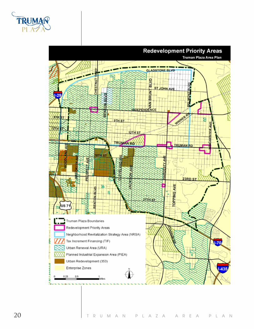
• Proactively promote and apply development incentive tools in target areas, as shown on the Redevelopment Priority Map (page 20).
• Research and implement a micro-lending program for area businesses.
• Ensure developments utilizing incentives and revitalization programs meet the standards and guidelines recommended in the Land Use and Development, Transportation, and Housing and Neighborhoods chapters.
reVitalize CoMMerCial nodeS and CorridorS.• Support the creation of a Community Improvement District (CID) along major
corridors, including Independence Ave.
• Utilize CIDs to help maintain commercial nodes and corridors, remove graffiti, provide security and address other needed activities and services. 1
• Focus large redevelopment efforts at the “Hardesty Federal Complex” at Indepen-dence Ave. and Hardesty Ave., and between Truman Road and the Railroad tracks, from Cleveland and Elmwood.
• Encourage funding for and utilization of a façade rebate program.
• Incorporate minimum design standards into the development code and enforce equally throughout the area.
• Revise the Independence Avenue Special Review Districts to include more stringent design guidelines for Independence Avenue.
Below is a list of desired businesses and services as determined by the Steering Committee and the community survey:
• Grocery
• Deli
• Multi-National Restaurants
• Coffee Shops
• Clothing Stores
• “World Markets”
• Ethnic Foods Grocery
• Italian Bakery
• “Nice” Liquor Store- Wine Store
• Boutiques
• Bed and Breakfasts
• Sports Bar
• Breakfast Restaurant (not fast food)
• Fine Dining
• Child Based Entertainment Center
• Recreation Center
• Spa
• Doctor or Dentist
• Clothing and clothing accessory store
1 There is one existing Community Improvement District in Truman Plaza, the Truman Road CID. Boundaries of the Truman Road CID are generally from Cleveland to Topping.
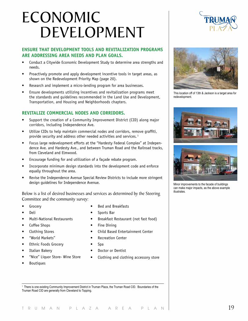
This location off of 13th & Jackson is a target area for redevelopment.
Minor improvements to the facade of buildings can make major impacts, as the above example illustrates.
T R U M A N P L A Z A A R E A P L A N20
21T R U M A N P L A Z A A R E A P L A N
LAND USEand development
Vision StatementThis chapter provides the guide for future development within the plan area which is based in economic reality, and balances protection of neighborhoods, the natural environment, infrastructure considerations, and the area’s existing character with the need to create jobs and improve economic conditions.
Truman Plaza residents, businesses, and stakeholders take pride in and promote their vibrant, self-sustained community which consists of diverse, safe, historic and affordable neighborhoods with easy access to area services, resources, and jobs.
With the Vision Statement as the end target, the City, stakeholders, and resi-dents, will reach the following area goals, guided by the following land use principles. All of the guiding principles are based on the area goals. Each guiding principle has a set of recommendations to implement that guiding principle, and thus, the area goals.
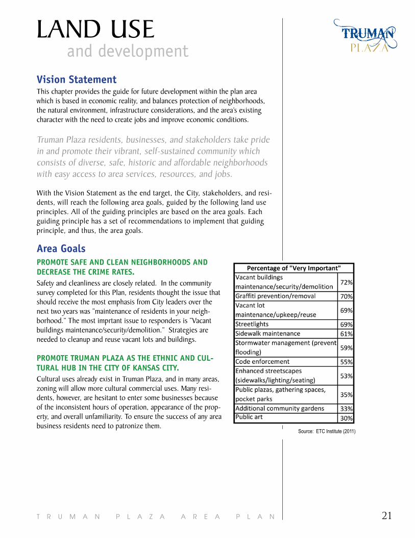
area goalsProMote SaFe and Clean neighborhoodS and deCreaSe the CriMe rateS.Safety and cleanliness are closely related. In the community survey completed for this Plan, residents thought the issue that should receive the most emphasis from City leaders over the next two years was “maintenance of residents in your neigh-borhood.” The most imprtant issue to responders is “Vacant buildings maintenance/security/demolition.” Strategies are needed to cleanup and reuse vacant lots and buildings.
ProMote trUMan Plaza aS the ethniC and CUl-tUral hUb in the City oF KanSaS City. Cultural uses already exist in Truman Plaza, and in many areas, zoning will allow more cultural commercial uses. Many resi-dents, however, are hesitant to enter some businesses because of the inconsistent hours of operation, appearance of the prop-erty, and overall unfamiliarity. To ensure the success of any area business residents need to patronize them.
Source: ETC Institute (2011)
T R U M A N P L A Z A A R E A P L A N22
attraCt bUSineSSeS and organizationS that inCreaSe eMPloyMent For area reSidentS.This plan recommend a variety of commercial and industrial locations within Truman Plaza. These businesses will find a ready pool of potential employees within a short distance. Truman Plaza is a dense urban environment, where places of employment and residences are within close proximity, a bonus for both employer and employee.
CaPitalize on and enCoUrage a WalKable layoUt oF the CoMMUnity and ProMote MUlti-Modal tranSPortation.A strength of Truman Plaza is its layout that easily allows a pedestrian, bicyclist, driver or transit user to meet their daily needs. All new development and redevel-opment must connect into the various modes of transportation and provide the most direct routes possible for pedestrians.
eMPhaSize, ProMote, and ProteCt the attraCtiVe and hiStoriC CharaCter oF the area’S neighborhoodS and CorridorS.Survey responses (discussed on page 9) clearly show the importance and desire to emphasize, promote, and protect the attractive and historic character of Truman Plaza. To do so, regulations must be adopted to regulate design.
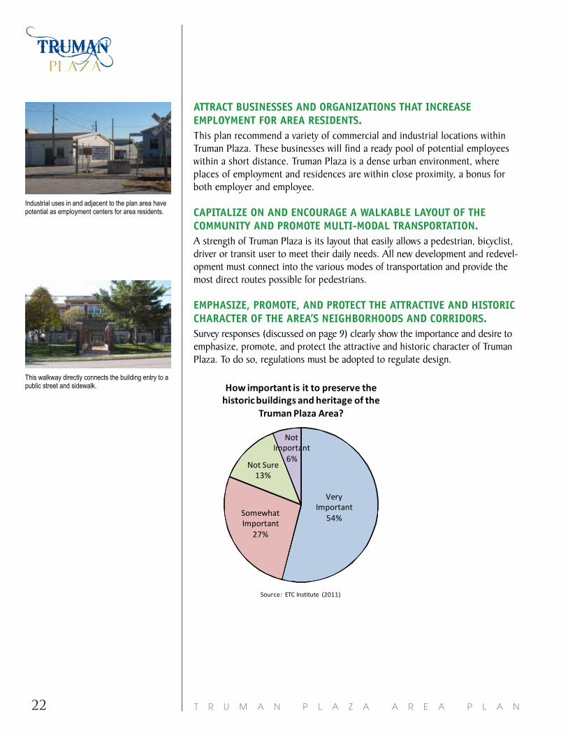
Industrial uses in and adjacent to the plan area have potential as employment centers for area residents.
This walkway directly connects the building entry to a public street and sidewalk.
Very Important
54%Somewhat Important
27%
Not Sure13%
Not Important
6%
How important is it to preserve the historic buildings and heritage of the
Truman Plaza Area?
Source: ETC Institute (2011)
Very Important
54%Somewhat Important
27%
Not Sure13%
Not Important
6%
How important is it to preserve the historic buildings and heritage of the
Truman Plaza Area?
Source: ETC Institute (2011)

23T R U M A N P L A Z A A R E A P L A N
LAND USEand development
land Use guiding Principles1. FoCUS CoMMerCial USeS at nodeS.
2. ProMote high qUality, CoMPatible deVeloPMent and PreVent enCroaChMent.
3. enCoUrage Urban deVeloPMent.
4. orient redeVeloPMent and neW deVeloPMent to FaCilitate the USe oF tranSit and MUlti-Modal tranSPortation.
5. redeVeloP VaCant/Under Utilized areaS.The following lists are actions needed to achieve each guiding principle. There are many other feasible and needed actions, but the list states the priorities for the area for the next 7-10 years.
FoCUS CoMMerCial USeS at nodeS.• Focus commercial and non-residential zoning at key nodes as recommended by
the Recommended Land Use Map (page 26).
• Downzone or re-zone properties to match the Recommended Land Uses Map.
• Do not support commercial expansion unless supported in the Recommended Land Use Map.
• Improve and coordinate infrastructure at targeted nodes.
ProMote high qUality, CoMPatible deVeloPMent and PreVent enCroaChMent.• Perform a Crime Prevention through Environmental Design (CPTED) review on all
site plans.~ CPTED examines the built environment and how criminal activity is facilitated or deterred
based on how space is designed.
• Increase the understanding that building permits are required to better ensure enforcement of development code and special review district regulations.
• Downzone or create overlay districts (neighborhood conservation, pedestrian, historic district) where supported by the Recommended Land Use Map and as recommended by neighborhood residents and leaders.
• Revise the Independence Avenue Special Review Districts to include more strin-gent design guidelines for Independence Avenue.
• Incorporate minimum design standards into the development code and enforce equally throughout the area.
• Enforce these design recommendations, specific to the Truman Plaza area with all new development and redevelopment proposals:~ Make buildings interesting to walk past. Ensure transparent windows are at the street
level of all buildings, reflective glass and widows covered with signs do not meet the intent of this recommendation.
~ Buildings should have a primary entrance facing and directly accessible from the public street, rather than oriented towards side or rear parking areas. For corner lots, building entrances on both sides are encouraged.
Very Important
49%Somewhat Important
31%
Not Sure12%
Not Important
8%
The importance of establishing design guidelines for new development and
redevelopment, so development is compatible
with current character.
Source: ETC Institute (2011)

T R U M A N P L A Z A A R E A P L A N24
~ Emphasize pedestrian access to buildings by placing parking lots behind buildings and plac-ing non-single-family buildings as close to the street as possible.
~ Ensure direct walkways are delineated from sidewalks and/or public right-of-way to entries, including through parking lots.
~ Large blank walls along streets should be avoided whenever possible. Where blank walls are unavoidable they should receive design treatment to increase pedestrian comfort and inter-est. Some possible treatments include art or vertical trellises for vines or plant materials.
~ Create transitions between areas of different scales and intensities that are as seamless as possible and avoid abrupt transitions.
~ Architectural materials should complement and improve the character of the existing built envi-ronment.
~ The design of signs should complement the character of the building or structure and the surrounding neighborhood, and not obscure important architectural features.
~ Access to non-residential uses should not be designed as to route non-residential traffic through residential areas.
enCoUrage Urban deVeloPMent.• Encourage a dense and diverse mix of buildings and uses situated on compact
pedestrian scale blocks with high lot converge, and typically at a higher scale and intensity than other areas of the City.
• Small pedestrian scale blocks should be utilized in development projects. Large “superblocks” degrade the existing street connections and are discouraged. Preserve, enhance, and restore the existing grid network of streets. Avoid street closures and vacations, as they erode the connectivity of the area.
• Promote the preservation of historically and/or architecturally significant structures.
• Support the listing of historically and/or architecturally significant structures on the National and/or Local Register of Historic Places.
• Add a dense, urban single family classification into the Development Code or promote the use of the neighborhood conservation overlays. ~ Currently, some neighborhoods in Truman Plaza (for example, Indian Mound) are zoned in
a way that does not allow new residential construction that is similar to the majority of existing residences. This places an increased burden on a person trying to build a home that is compatible with the existing neighborhood character. Also, almost all of the resi-dential zoning districts allow multi-family structures. An urban single family classification or neighborhood conservation district could allow smaller lots, smaller setbacks, (similar to the existing development pattern), while still ensuring new development is single family.
orient redeVeloPMent and neW deVeloPMent to FaCilitate the USe oF tranSit and MUlti-Modal tranSPortation.• Encourage new non-residential development/redevelopment to site buildings
abutting streets, orient building access points to streets and sidewalks, and provide a direct, delineated connection to transit locations, where relevant.
• Apply the concepts of transit-oriented development (TOD)1 along the primary transit corridors and near future transit stations. Independence is a primary tran-sit corridor, and stops at Belmont & St. John, and Hardesty & 24th are primary, due to the high number of boardings. The Redevelopment Priorities Map on Page 20 indicates key areas to redevelop, and should be explored for their potential redevelopment as a transit station/stop.
• Buildings should have a primary entrance facing and directly accessible from the public street, rather than oriented towards side or rear parking areas. For corner lots, building entrances on both sides are encouraged.
• Emphasize pedestrian access to buildings by placing parking lots behind build-ings and placing non-single-family buildings near the street.
This CVS is built up to the sidewalk, has a front entry at the street intersection, and has parking behind the store.
The back of this commercial structure faces residential uses in Indian Mound, and no screening is provided. This large blank wall offers no transition between the commercial structure and residential structures.
Improving screening and adding landscaping can create a transition between industrial uses and single family residences, as shown in the illustration.
This building entrance directly faces and is accessible from a public street.

25T R U M A N P L A Z A A R E A P L A N
LAND USEand development
redeVeloP VaCant/Under Utilized areaS.• Create a program that proactively purchases, maintains, and sells vacant/under
utilized property (Land Banking Program). ~ A Land Banking Program differs from the Jackson County Land Trust. A land banking program
would proactively purchase, maintain, combine (if necessary), market, and sell properties. The Jackson County Land Trust is a governmental corporation established to sell properties that have failed to sell on the courthouse steps to satisfy unpaid taxes.
• Implement the ordinance that allows the City to serve as the victim/prosecuting party when illegal activities occur on vacant properties.
• Identify vacant/underutilized properties and promote/incent redevelopment at these sites. Priority areas include:~ Redevelopment priorities (See Redevelopment Priority Map)
~ Employment areas
~ Lots with the greatest potential for a quick redevelopment
~ Lots that have the greatest negative impact on the attractive and historic character of the area’s neighborhoods and corridors
• Until redeveloped, utilize vacant lots for organized urban agriculture programs.
• Work with the Water Department to make improvements as outlined in the Overflow Control Plan to eliminate flooding in the plan area.
Among all property owners in the plan area, the Jackson County Land Trust owns the highest number of parcels and the third highest number of acres. A Land Banking program would have the ability to manage and sell vacant properties differently than the Land Trust.
The former “Hardesty Federal Complex” is a target area for redevelopment.
Urban agriculture is replacing vacant lots in Lykins.
1 Transit-oriented development:• Focuses density around a transit
stop or station
• Encourages a variety of uses and housing types and prices.
• Creates an environment that is accessible by and designed for cycling and walking, with ad-equate facilities and attractive street conditions.
• Reduces parking requirements.
• Includes a transit stop or sta-tion that is a center of activity, convenient, comfortable and secure.
• Provides transit supportive uses (those that cater to conve-nience goods and service needs of residents, employees, and transit stop users).
Nottransit“adjacent”development:• Development near transit that is
not oriented to or connected to transit and has the same parking ratio, roadway design, density, mix of uses and auto usage as any other development.
T R U M A N P L A Z A A R E A P L A N26
27T R U M A N P L A Z A A R E A P L A N
LAND USEand development
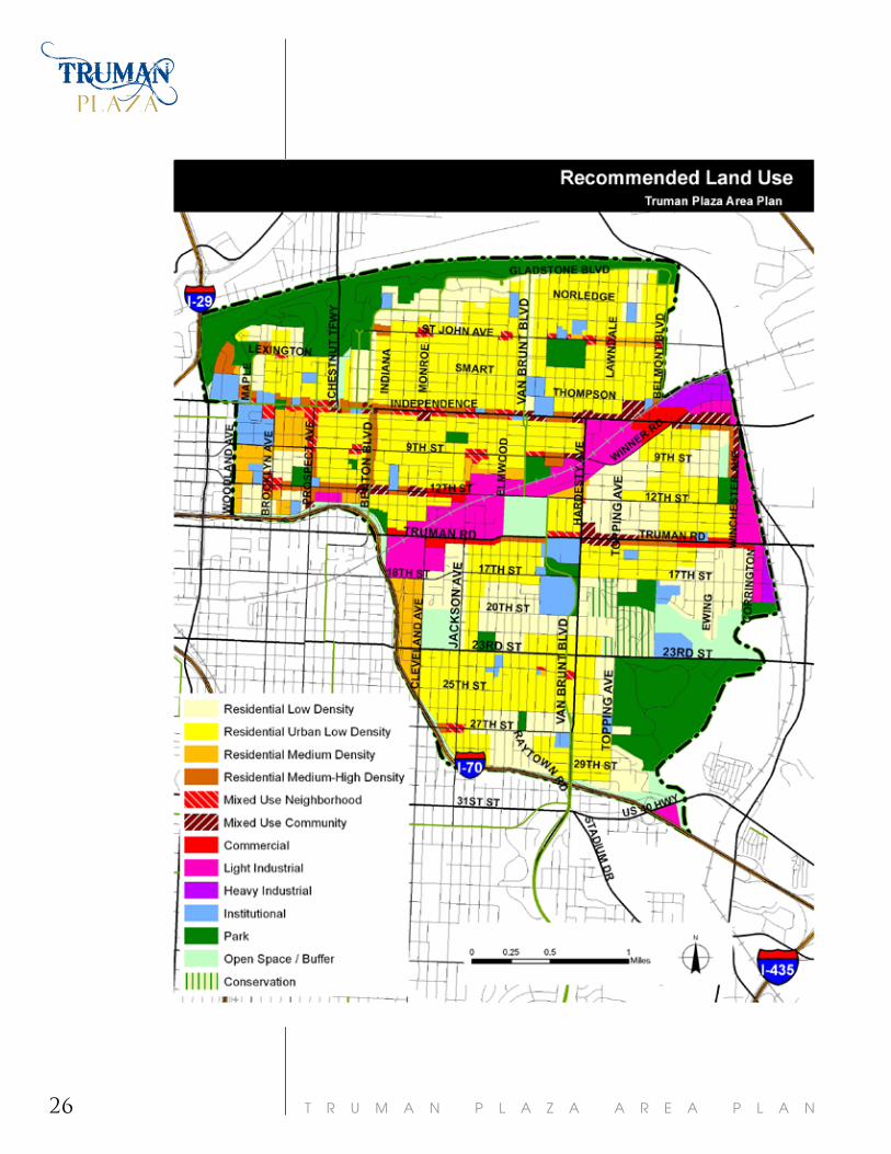
recommended land Use MapThe Recommended Land Use Map and tables provide the framework for the ap-propriate land use, character, scale, and intensity of future development.
The Recommended Land Use Map promotes dense single family throughout the area, neighborhood scale mixed-use developments that are consistent with the surrounding character, and transitions between industrial and residential uses.
The following Recommended Land Use Map is the guide for future land use and zoning decisions and does not represent a change to the existing zoning. The map is based upon the values and aspirations of area residents, stakeholders, and others who participated in the planning process. The land use categories, related zoning districts, and definitions are described on the following pages.
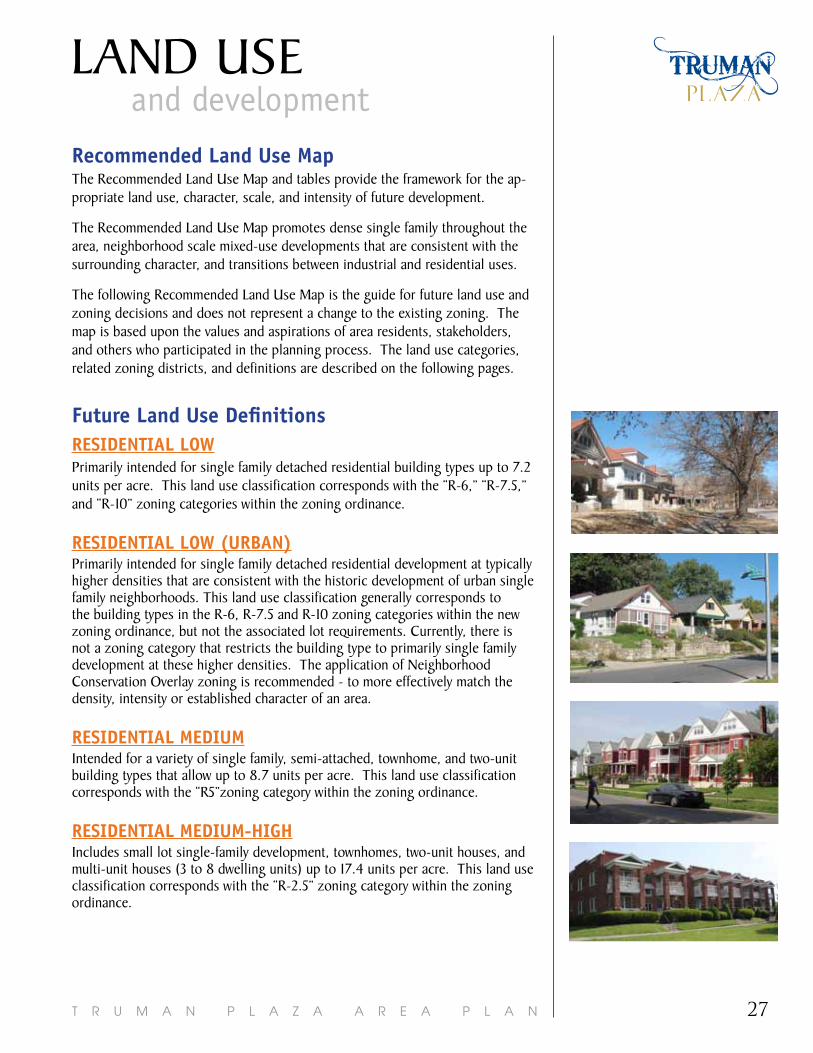
Future land Use definitions reSidential loWPrimarily intended for single family detached residential building types up to 7.2 units per acre. This land use classification corresponds with the “R-6,” “R-7.5,” and “R-10” zoning categories within the zoning ordinance.
reSidential loW (Urban)Primarily intended for single family detached residential development at typically higher densities that are consistent with the historic development of urban single family neighborhoods. This land use classification generally corresponds to the building types in the R-6, R-7.5 and R-10 zoning categories within the new zoning ordinance, but not the associated lot requirements. Currently, there is not a zoning category that restricts the building type to primarily single family development at these higher densities. The application of Neighborhood Conservation Overlay zoning is recommended - to more effectively match the density, intensity or established character of an area.
reSidential MediUMIntended for a variety of single family, semi-attached, townhome, and two-unit building types that allow up to 8.7 units per acre. This land use classification corresponds with the “R5”zoning category within the zoning ordinance.
reSidential MediUM-highIncludes small lot single-family development, townhomes, two-unit houses, and multi-unit houses (3 to 8 dwelling units) up to 17.4 units per acre. This land use classification corresponds with the “R-2.5” zoning category within the zoning ordinance.
T R U M A N P L A Z A A R E A P L A N28
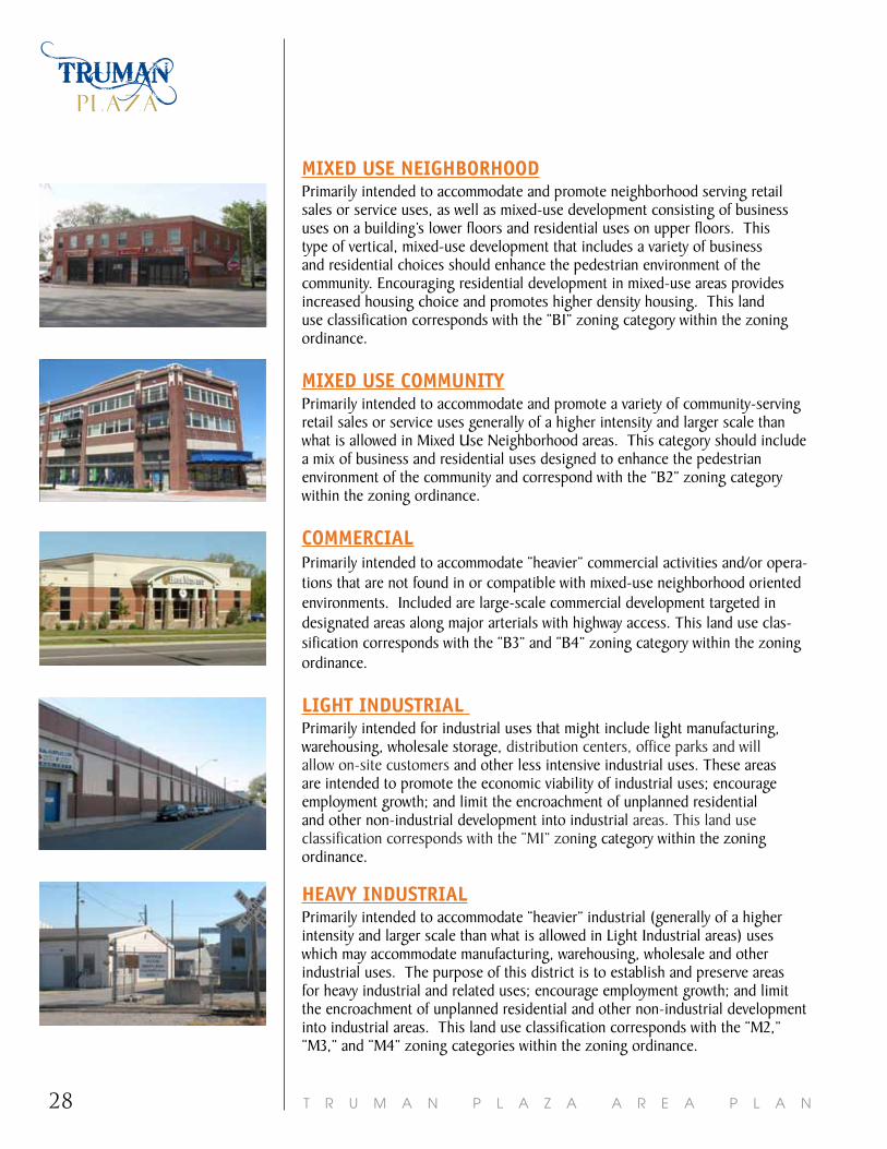
Mixed USe neighborhoodPrimarily intended to accommodate and promote neighborhood serving retail sales or service uses, as well as mixed-use development consisting of business uses on a building’s lower floors and residential uses on upper floors. This type of vertical, mixed-use development that includes a variety of business and residential choices should enhance the pedestrian environment of the community. Encouraging residential development in mixed-use areas provides increased housing choice and promotes higher density housing. This land use classification corresponds with the “B1” zoning category within the zoning ordinance.
Mixed USe CoMMUnityPrimarily intended to accommodate and promote a variety of community-serving retail sales or service uses generally of a higher intensity and larger scale than what is allowed in Mixed Use Neighborhood areas. This category should include a mix of business and residential uses designed to enhance the pedestrian environment of the community and correspond with the “B2” zoning category within the zoning ordinance.
CoMMerCialPrimarily intended to accommodate “heavier” commercial activities and/or opera-tions that are not found in or compatible with mixed-use neighborhood oriented environments. Included are large-scale commercial development targeted in designated areas along major arterials with highway access. This land use clas-sification corresponds with the “B3” and “B4” zoning category within the zoning ordinance.
light indUStrial Primarily intended for industrial uses that might include light manufacturing, warehousing, wholesale storage, distribution centers, office parks and will allow on-site customers and other less intensive industrial uses. These areas are intended to promote the economic viability of industrial uses; encourage employment growth; and limit the encroachment of unplanned residential and other non-industrial development into industrial areas. This land use classification corresponds with the “M1” zoning category within the zoning ordinance.
heaVy indUStrialPrimarily intended to accommodate “heavier” industrial (generally of a higher intensity and larger scale than what is allowed in Light Industrial areas) uses which may accommodate manufacturing, warehousing, wholesale and other industrial uses. The purpose of this district is to establish and preserve areas for heavy industrial and related uses; encourage employment growth; and limit the encroachment of unplanned residential and other non-industrial development into industrial areas. This land use classification corresponds with the “M2,” “M3,” and “M4” zoning categories within the zoning ordinance.

29T R U M A N P L A Z A A R E A P L A N
LAND USEand development
inStitUtionalAreas designated as Institutional include a variety of public and quasi-public uses and facilities including but not limited to: schools, churches, and public facilities that are government owned. More intensive uses like hospitals, and large government office buildings should be limited to appropriate non-residential areas. Institutional uses are allowed in a variety of zoning categories, depending on their specific use and intensity.
ParKSPublic or private land reserved for parks and parkways that is intended to accommodate active and passive parklands, trails, recreational uses, or any other lands reserved for permanent park or recreation purposes.
oPen SPaCe/bUFFerConsists of private or public lands that are in some way either temporarily or permanently reserved from development, including lands unsuitable for development. This includes but is not limited to creeks and stream buffers, floodplains, woodlands, severe slopes, and buffer zones around natural resources (areas difficult for development due to topography, hydrology, aged woodlands, archeological findings, etc.).
ConSerVation diStriCtConservation Districts are areas intended for conservation or open space developments. Conservation and Open Space Districts are intended to encourage flexibility in design standards (example: reduced lot sizes or increased density) in exchange for 60% or 30% open space preservation. These areas will provide additional open space and recreational amenities for residents, preserve environmentally sensitive resources as well as reduce stormwater runoff and water pollutants. This land use classification corresponds with the Conservation Development option for “R” Districts within the zoning ordinance.
oVerlaySOverlays may be used to further subdivide the established categories into subcategories or to indicate characteristics other than land use which may be significant on a particular map or in a particular plan. Examples of this are height, floor area ratio, special districts, types of structures (i.e. single family detached), and conservation areas.
T R U M A N P L A Z A A R E A P L A N30
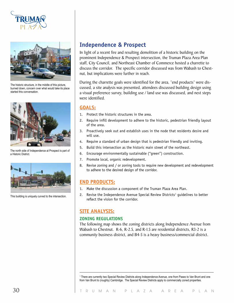
independence & ProspectIn light of a recent fire and resulting demolition of a historic building on the prominent Independence & Prospect intersection, the Truman Plaza Area Plan staff, City Council, and Northeast Chamber of Commerce hosted a charrette to discuss the corridor. The specific corridor discussed was from Wabash to Chest-nut, but implications were further in reach.
During the charrette goals were identified for the area, “end products” were dis-cussed, a site analysis was presented, attendees discussed building design using a visual preference survey, building use / land use was discussed, and next steps were identified.
goalS:1. Protect the historic structures in the area.
2. Require infill development to adhere to the historic, pedestrian friendly layout of the area.
3. Proactively seek out and establish uses in the node that residents desire and will use.
4. Require a standard of urban design that is pedestrian friendly and inviting.
5. Build this intersection as the historic main street of the northeast.
6. Encourage environmentally sustainable (“green”) construction.
7. Promote local, organic redevelopment.
8. Revise zoning and / or zoning tools to require new development and redevelopment to adhere to the desired design of the corridor.
end ProdUCtS:1. Make the discussion a component of the Truman Plaza Area Plan.
2. Revise the Independence Avenue Special Review Districts1 guidelines to better reflect the vision for the corridor.
Site analySiS:zoning regUlationSThe following map shows the zoning districts along Independence Avenue from Wabash to Chestnut. R-6, R-2.5, and R-1.5 are residential districts, R3-2 is a community business district, and B4-5 is a heavy business/commercial district.
1 There are currently two Special Review Districts along Independence Avenue, one from Paseo to Van Brunt and one from Van Brunt to (roughly) Cambridge. The Special Review Districts apply to commercially zoned properties.
The north side of Independence at Prospect is part of a Historic District.
This building is uniquely curved to the intersection.
The historic structure, in the middle of this picture, burned down, concern over what would take its place started this conversation.

31T R U M A N P L A Z A A R E A P L A N
LAND USEand development
SPeCial reVieW diStriCt gUidelineSCurrently, the commercial structures along the corridor are within the Indepen-dence Avenue West Special Review District (Paseo to Van Brunt).
A Special Review District (SRD) supplements zoning and defines physical characteristics of property. An SRD is an overlay district. It applies to property repair, rehabilitation or new construction. The review is triggered by building permit process.
Typical guideline elements include:
• Height, mass and location of buildings
• Landscaping of property and parking lots
• Building entrances
• Fencing materials
• Signage guidelines
• Building materials
• Awning materials and colors
• Roof lines
• Lighting
HowdoesanSRDwork?• Plans are submitted detailing
any proposed improvements.
• Staff determines confor-mance with guidelines. A SRD Committee reviews all applications for compli-ance with the guidelines and approves or denies the proposal.
• The committee is made up of property owners, employ-ees or others appointed by the Mayor. The committee must operate under rules and regulations establish by the City Council.
The committee is made up of property owners, employees or others appointed by the Mayor. The committee must operate under rules and regulations establish by the City Council. Typical guideline elements include: ▪ Height, mass and location of buildings ▪ Landscaping of property and parking
lots ▪ Building entrances ▪ Fencing materials
▪ Signage guidelines ▪ Building materials ▪ Awning materials and colors ▪ Roof lines ▪ Lighting
Building Design Attendees were shown a variety of buildings and were asked what they liked; their comments are below.
Pedestrian Friendly – Buildings built up to the street (sidewalk)
On-Street Parking A destination place (not a destination
building) where people can come and walk to many services
Transparent windows (not covered by signage)
Residential above businesses Unified signage City, not suburban layout Eco-friendly Transit friendly Businesses have individual uses and
hours More uses, less space
Character Different street materials (defined
pedestrian walkways) Buildings that complement the history
of the area Eclectic urban community Architecture/design that is specific to
Kansas City Landscaping on/around sidewalks and
in parking lots Shared Parking – not one lot for each
building or use Parking behind buildings Multi-use destination – not single use
or building destination Architectural design
Mon
tgal
l
Pros
pect
Wab
ash
Ches
tnut
Tfw
y
Oliv
e
Pros
pect
Ches
tnut
Ave
Comment [kj1]: Can you put this in a call out box or the outer margin?
This map shows the general boundaries for the discussion (Olive to Chestnut). The colors show the zoning and the zoning is labeled, as well.

T R U M A N P L A Z A A R E A P L A N32
bUilding deSignAttendees were shown a variety of buildings and were asked what they liked; their comments are below. • Pedestrian Friendly – Buildings built up to the street (sidewalk)
• On-Street Parking
• A destination place (not a destination building) where people can come and walk to many services
• Transparent windows (not covered by signage)
• Residential above businesses
• Unified signage
• City, not suburban layout
• Eco-friendly
• Transit friendly
• Businesses have individual uses and hours
• More uses, less space
• Character
• Different street materials (defined pedestrian walkways)
• Buildings that complement the history of the area
• Eclectic urban community
• Architecture/design that is specific to Kansas City
• Landscaping on/around sidewalks and in parking lots
• Shared Parking – not one lot for each building or use
• Parking behind buildings
• Multi-use destination – not single use or building destination
• Architectural design
• Historic architecture
• Unique facades
• Continuous storefronts (along street edge)
• Fewer access points – easier for traffic (fewer turning points into traffic), more continuous sidewalks (fewer interruptions)
• Wide sidewalks, ensure sidewalks are wide enough in future developments, may need wider sidewalks for sidewalk cafes
• Use roofs (for gardens, terraces, etc.) don’t waste the space
This building is built up to the street (sidewalk), and on-street parking is adjacent to the sidewalk.
Signage on windows blocks a persons view into a store and does not allow persons inside a store to keep an eye on the street.
Utilizing different materials and treatments on streets where pedestrians walk, will indicate to drivers that they are passing through a special area, and hope-fully slow down traffic.

33T R U M A N P L A Z A A R E A P L A N
LAND USEand development
Sketches were used to illustrate attendee’s ideas regarding the corridor. The following was the preferred illustration from Chestnut to Prospect (south side of Independence Boulevard). The south side of Independence was used in this exercise because the north side (in this location) is part of a Historic District. Historic Districts require an additional design review.
The illustrations were used purely for descriptive purposes; there are currently no plans to alter any structure, as they are privately owned.
bUilding USe / land USe
deSired USeS along the Corridor:• Coffee Shop
• Nice liquor store
• Small businesses
• Nice ethnic restaurant
• White table cloth restaurant
• Uses similar to 39th Street West and artisan businesses like on 18th Street
• Farming Coop (where neighborhood gardens could sell produce)
• Responsible Franchise (franchise that is successful and respects unique areas, does not just apply their “model”)
UndeSirable USeS along the Corridor:• Any “Adult” use
• Scrap Yards
• Junk Yards
• Check Cashing
• Pawn Shops
• Fast Food
iMPleMentationAttendees indicated their desire to revise the Independence Avenue Special Review District Guidelines. Revising the guidelines is included as an implemen-tation item of the Truman Plaza Area Plan.
structures built to the sidewalk
landscaping
adjacent to sidewalk unique, continuous
storefronts
on-street parking
wide
sidewalks
transparent windows
(not covered)
second story uses, such as residential
landscaping in parking lot
consolidated
driveways
shared parking
at rear of building

T R U M A N P L A Z A A R E A P L A N34

35T R U M A N P L A Z A A R E A P L A N
TRANSPORTATIONTruman Plaza has an existing street grid network, sidewalks, and bus service. However, improvements and maintenance are needed to ensure long-term sustainability and use of the systems. Also, additions are needed to accom-modate bicyclists, and alternative transit service is currently being studied.
Vision StatementTruman Plaza residents, businesses, and stakeholders take pride in and promote their vibrant, self-sustained community which consists of diverse, safe, historic and affordable neighborhoods with easy access to area services, resources, and jobs.
With the Vision Statement as the end target, the City, stakeholders, and residents, will reach the following area goals, guided by the following trans-portation principles. All of the guiding principles are based on the area goals. Each guiding principle has a set of recommendations to implement that guiding principle, and thus, the area goals.
area goalsProMote SaFe and Clean neighborhoodS and deCreaSe the CriMe rateS.In the resident survey completed while preparing this plan, over 67% of residents indicated a “reduction in crime” would make their neighborhood more pedestrian friendly. Having safe and clean neighborhoods will reduce crime, and a reduc-tion in crime will help residents leave their homes and cars and use sidewalks, bikes, and buses.
Source: ETC Institute (2011)
21%
23%
31%
47%
67%
0% 20% 40% 60% 80%
Stoplights / pedestrian signals
Street crossings / crosswalks
Speed of traffic
Sidewalks
Reduction in crime
What improvements would make your neighborhood
pedestrian friendly?
T R U M A N P L A Z A A R E A P L A N36
ProMote trUMan Plaza aS the ethniC and CUltUral hUb in the City oF KanSaS City. Truman Plaza is already home to the most diverse population in Kansas City. To function as a destination, Truman Plaza must be easily accessible to all residents.
attraCt bUSineSSeS and organizationS that inCreaSe eMPloyMent For area reSidentS.An interconnected multi-modal transportation system will not only aid in attract-ing businesses, but will also serve residents accessing jobs outside of Truman Plaza. Ideally, many Truman Plaza residents are employed within the area, but easy access through the boundaries of this plan area will serve those that do not.
CaPitalize on and enCoUrage a WalKable layoUt oF the CoMMUnity and ProMote MUlti-Modal tranSPortation.Sidewalks are the norm in the Truman Plaza area, not the exception; and transit service is bustling. Bike accommodations are planned and funded and boulevards are cherished. Better connections across barriers are needed to facilitate mobility throughout the plan area. Any new development will capitalize on these assets and must fit within the layout of the community.
eMPhaSize, ProMote, and ProteCt the attraCtiVe and hiStoriC CharaCter oF the area’S neighborhoodS and CorridorS.The attractive and historic character of the area’s neighborhoods and cor-ridors relate directly to the historic transportation system. Generations ago, corridors were established around the streetcar line and significant struc-tures were built on the Boulevard system. This shows the level of impact the transportation system has on how the community develops. With any changes to the transportation system, we must emphasize, promote, and protect the attractive and historic character of the area’s neighborhoods and corridors and make sure future transportation changes are sensitive to existing neighbor-hoods, businesses, institutions, and natural features.
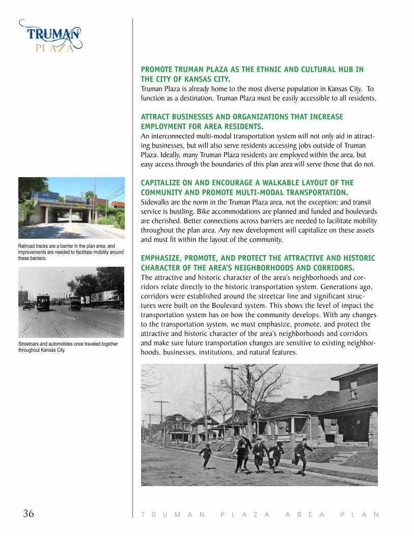
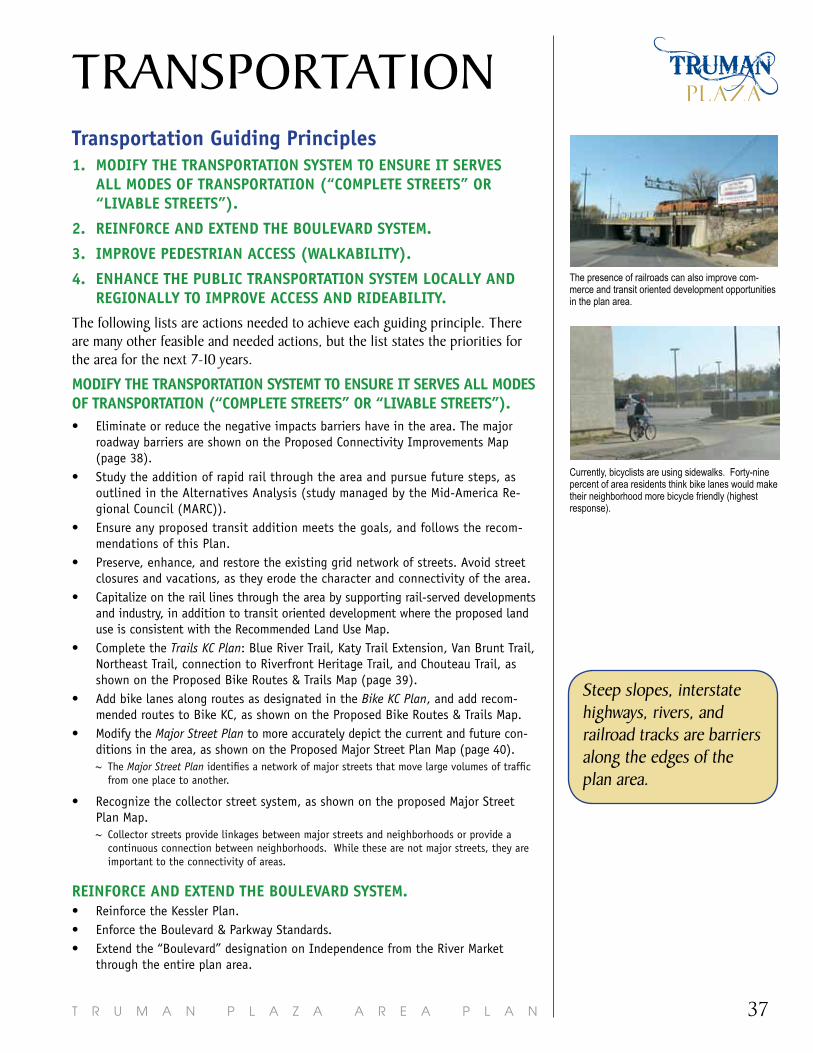
Railroad tracks are a barrier in the plan area, and improvements are needed to facilitate mobility around these barriers.
Streetcars and automobiles once traveled together throughout Kansas City.
37T R U M A N P L A Z A A R E A P L A N
TRANSPORTATIONtransportation guiding Principles1. ModiFy the tranSPortation SySteM to enSUre it SerVeS
all ModeS oF tranSPortation (“CoMPlete StreetS” or “liVable StreetS”).
2. reinForCe and extend the boUleVard SySteM.
3. iMProVe PedeStrian aCCeSS (WalKability).
4. enhanCe the PUbliC tranSPortation SySteM loCally and regionally to iMProVe aCCeSS and rideability.
The following lists are actions needed to achieve each guiding principle. There are many other feasible and needed actions, but the list states the priorities for the area for the next 7-10 years.
ModiFy the tranSPortation SySteMt to enSUre it SerVeS all ModeS oF tranSPortation (“CoMPlete StreetS” or “liVable StreetS”). • Eliminate or reduce the negative impacts barriers have in the area. The major
roadway barriers are shown on the Proposed Connectivity Improvements Map (page 38).
• Study the addition of rapid rail through the area and pursue future steps, as outlined in the Alternatives Analysis (study managed by the Mid-America Re-gional Council (MARC)).
• Ensure any proposed transit addition meets the goals, and follows the recom-mendations of this Plan.
• Preserve, enhance, and restore the existing grid network of streets. Avoid street closures and vacations, as they erode the character and connectivity of the area.
• Capitalize on the rail lines through the area by supporting rail-served developments and industry, in addition to transit oriented development where the proposed land use is consistent with the Recommended Land Use Map.
• Complete the Trails KC Plan: Blue River Trail, Katy Trail Extension, Van Brunt Trail, Northeast Trail, connection to Riverfront Heritage Trail, and Chouteau Trail, as shown on the Proposed Bike Routes & Trails Map (page 39).
• Add bike lanes along routes as designated in the Bike KC Plan, and add recom-mended routes to Bike KC, as shown on the Proposed Bike Routes & Trails Map.
• Modify the Major Street Plan to more accurately depict the current and future con-ditions in the area, as shown on the Proposed Major Street Plan Map (page 40).~ The Major Street Plan identifies a network of major streets that move large volumes of traffic
from one place to another.
• Recognize the collector street system, as shown on the proposed Major Street Plan Map.~ Collector streets provide linkages between major streets and neighborhoods or provide a
continuous connection between neighborhoods. While these are not major streets, they are important to the connectivity of areas.
reinForCe and extend the boUleVard SySteM.• Reinforce the Kessler Plan. • Enforce the Boulevard & Parkway Standards.• Extend the “Boulevard” designation on Independence from the River Market
through the entire plan area.
Steep slopes, interstate highways, rivers, and railroad tracks are barriers along the edges of the plan area.
The presence of railroads can also improve com-merce and transit oriented development opportunities in the plan area.
Currently, bicyclists are using sidewalks. Forty-nine percent of area residents think bike lanes would make their neighborhood more bicycle friendly (highest response).
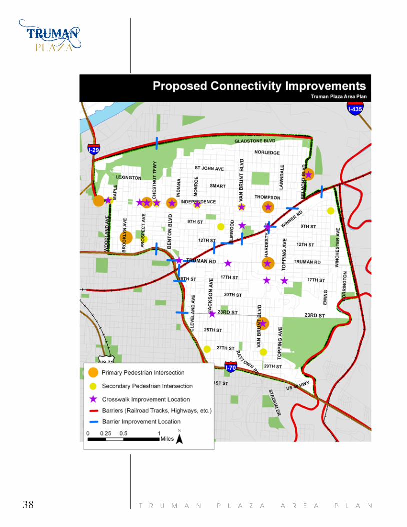
T R U M A N P L A Z A A R E A P L A N38
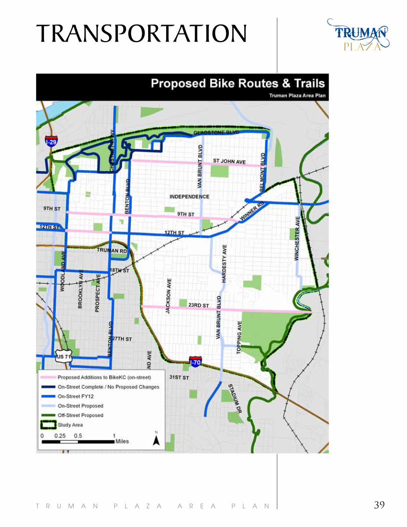
39T R U M A N P L A Z A A R E A P L A N
TRANSPORTATION

T R U M A N P L A Z A A R E A P L A N40

41T R U M A N P L A Z A A R E A P L A N
TRANSPORTATIONiMProVe PedeStrian aCCeSS (WalKability).• Perform a Crime Prevention through Environmental Design (CPTED) review on all
site plans.~ CPTED examines the built environment and how criminal activity is facilitated or deterred
based on how a space or thing is designed.
• Pursue traffic calming in neighborhoods. Traffic calming techniques are used to slow down automobile traffic. Key locations for traffic calming include:~ Benton Boulevard, south of 9th street (for southbound traffic)
~ Truman Road at Elmwood Avenue
~ 17th Street, between White Avenue and Belmont Avenue
~ 9th & Prospect
~ Independence Avenue/Boulevard
• Add and/or improve crosswalks in key locations, as shown on the Proposed Con-nectivity Improvements Map. Primary and Secondary Pedestrian Intersections (as identified on the Proposed Connectivity Map) should receive the best (most enhanced) crosswalk treatments. Key locations for improved crosswalks include:
• Using the Kansas City Walkability Plan as a guide, ensure new development provides adequate pedestrian access and connections. Ensure all buildings have primary access with direct and delineated pedestrian connections onto every street frontage, and sidewalks should run parallel to every abutting street.
enhanCe the PUbliC tranSPortation SySteM loCally and regionally to iMProVe aCeSS and rideability• Perform a Crime Prevention through Environmental Design (CPTED) review on
vertical transit improvements (shelters, benches, signage, etc.).
• Ensure transit stops are equipped with adequate lighting. ~ Considering there is more activity at transit stops, the typical City lighting standard may not
provide sufficient lighting. Perceptions of safety should be the primary consideration when determining transit stop lighting levels.
• Make it easier for people to know how to use the bus by increasing the availabil-ity of transit related information (maps, schedules, ticket purchasing locations, etc.) and market the recommended improvements.
• Evaluate the bus service to ensure service is efficient and accommodating, in this area there is currently a deficiency in North-South service.
• Make aesthetic improvements to bus stops, so they are consistent in design and complementary to the architecture and character of the area.
~ Independence & Paseo to Woodland
~ Independence & Prospect
~ Independence & Benton
~ St. John and Belmont
~ 24th Street, between Van Brunt & Hardesty
~ Independence & Wabash
~ Truman & Indiana
~ 23rd & Jackson (cemetery wall)
~ 17th & Topping
~ 17th & Hardesty (by Van Brunt Park)
~ Independence & Hardesty
~ Truman Road & Hardesty
~ Independence & Van Brunt
~ 9th & Van Brunt
~ 9th & Hardesty
~ Truman Road & Elmwood
Crosswalk improvements are needed throughout the plan area, priorities are mapped on page 38.

T R U M A N P L A Z A A R E A P L A N42
43T R U M A N P L A Z A A R E A P L A N
introductionThis section provides the tools and steps to implement the guidelines, recommendations and actions outlined within the Area Plan, and assigns responsibilities for implementation.
area Plan implementation CommitteeAlthough the City will be an active partner in efforts to implement the recommendations and strategies of the Area Plan, the success of the Plan will be the direct result of sustained leadership and support by citizens and other community groups. To begin the implementation process, it is recommended a planning leadership group be formed, hereafter referred to as the Truman Plaza Area Plan Implementation Committee. This community-based committee should include interested citizens, neighborhood organizations, business owners, business organizations, non-profits, and other community organizations/agencies. The Committee should be formed following the adoption of the Plan by the City Council.
Summary of Financing ProgramsThere are a variety of funding sources which governmental agencies, local business owners, and developers can pursue to meet the financial needs of the proposed recommendations. The following section lists the currently available financing techniques open to the community to pursue for implementation of the recommendations. It should be noted that this list is not exhaustive and other funding mechanisms may be available in the future.
1. CoMMUnity deVeloPMent bloCK grant (Cdbg)Eligible Projects/Programs: Housing and Neighborhood Improvements.
2. enterPriSe zone/eMPoWerMent zoneEligible Projects/Programs: Economic Development and Jobs Creation.
3. PUbliC iMProVeMent adViSory CoMMittee (PiaC)Eligible Projects/Programs: Transportation and Infrastructure.
4. SPeCial bUSineSS diStriCtSEligible Projects/Programs: Urban Design, Transportation and Infrastructure.
5. CoMMUnity iMProVeMent diStriCt (Cid)Eligible Projects/Programs: Urban Design, Transportation and Infrastructure Security.
6. neighborhood iMProVeMent diStriCt (nid)Eligible Projects/Programs: Urban Design, Transportation and Infrastructure.
7. tranSPortation deVeloPMent diStriCt (tdd)Eligible Projects/Programs: Transportation and Related Urban Design.
IMPLEMENTATION

T R U M A N P L A Z A A R E A P L A N44
8. the SaFe, aCCoUntable, Flexible and eFFiCienttranSPortation eqUity aCt (SaFetea)Eligible Projects/Programs: Transportation and Related Urban Design.
9. Planned indUStrial exPanSion aUthority (Piea)Eligible Projects/Programs: Economic Development and Housing (Abatement)
10. MiSSoUri hiStoriC tax CreditSEligible Projects/Programs: Economic Development (Historic Rehabilitation)
11. ChaPter 353 inCentiVe (Urban redeVeloPMentCorPorationS)Eligible Projects/Programs: Urban Design, Transportation, Infrastructure, Housing
implementation MatrixThe following matrix divides the recommendations from this Plan into three categories:
First year Priority Projects: The recommendations that, through the planning process, were identified as the first priorities to pursue.
ongoing implementation items: The recommendations that are ongoing and have no defined start or end date.
initiated implementation items: The recommendations that need someone to initiate the action.
The work plan for implementation is summarized in the following matrix elements:
aCtion StePSFirst steps in implementing Plan recommendations.
Page #The page number that specifically mentions the recommendation, the place to look for more details.
iMPleMentation reSPonSibilitieSLead organizations and partners responsible for initiation, oversight, and monitoring. These may include:
• City/govt agencies: various city and other governmental departments, boards, and commissions.
• implementation Committee: implementation committee, as defined above.
• neighborhoods: citizens and neighborhood organizations.
• Property owners/developers: property owners or developers.
• Community/Social Service agency: community, social services, faith-based, non-profit organizations, etc.
• business Community: businesses, business associations, chambers of commerce, community improvement district, etc.

45T R U M A N P L A Z A A R E A P L A N
Actions StepsSupport the development of the Northeast Community Center at 9th and Van Brunt Boulevard.
12 X O O O
Downzone or re-zone properties to match the Recommended Land Use Map.
23 O X O O O
Revise the Independence Avenue Special Review Districts to include more stringent design guidelines for Independence Avenue.
23 O X O O O O
Incorporate minimum design standards into the development code and enforce equally throughout the area.
23 X
Support the creation of a Community Improvement District (CID) along major corridors including Independence.
19 O O O O O X
Proactively promote and apply development incentive tools in target areas, as shown on the Economic Development Map on page (20). Including the research and implementation of a micro-lending program, and façade improvement program.
19 X O
Market the area as the hub of ethnic and cultural businesses.
18 O O O X O
Provide opportunities for citizens to increase their knowledge of City property code requirements so they know what is required of/at their property and so persons know when they should report a violation.
13 O X O O O O
Create a program that proactively purchases, maintains, and sells vacant / underutilized property (Land Banking Program).
25 X O O O O O
Identify vacant / underutilized properties and promote / incent redevelopment at these sites. Until redeveloped, maintain vacant lots and explore alternative uses such as urban agriculture and storm water retention.
13, 25 X O O O O O
Work with regional municipalities to pass an ordinance (one for each municipality) that requires retailers to stock spray paint behind glass (to reduce shoplifting of spray paint that could be used for graffiti).
13 X O O
Continue to expand the neighborhood / CDC program for mowing vacant lots, neighborhood code enforcement for vacant properties, and graffiti removal.
13 X O O O O O
Implement and enforce a curfew in Parks. 12 X O O
Com
mun
ity/
Soci
al
Serv
ice
Age
ncy
Busi
ness
Co
mm
unit
y
First Year Priority Projects
Page
# in
Pla
n (s
ee fo
r m
ore
deta
ils)
Responsible Party/Parties (X = Lead Party; O = Supporting
City
/Gov
t A
genc
ies
Impl
emen
tati
on
Com
mit
tee
Nei
ghbo
rhoo
ds
Prop
erty
O
wne
rs/D
evel
oper
s
IMPLEMENTATION
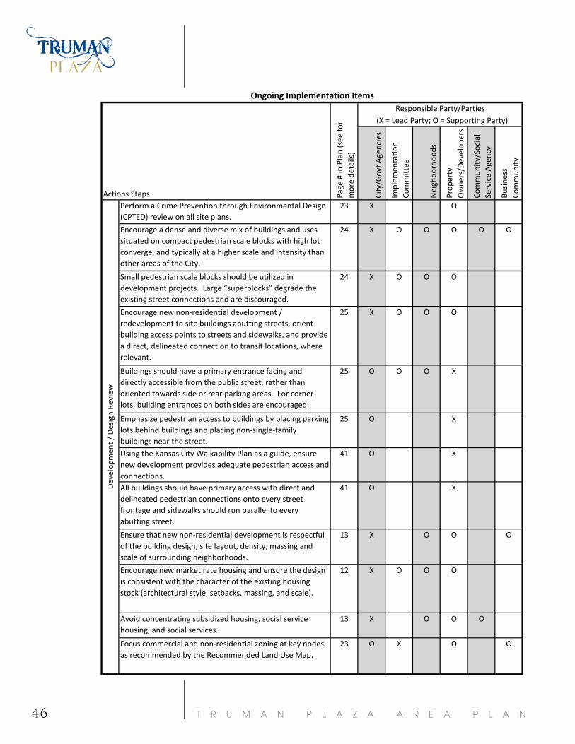
T R U M A N P L A Z A A R E A P L A N461
Perform a Crime Prevention through Environmental Design (CPTED) review on all site plans.
23 X O
Encourage a dense and diverse mix of buildings and uses situated on compact pedestrian scale blocks with high lot converge, and typically at a higher scale and intensity than other areas of the City.
24 X O O O O O
Small pedestrian scale blocks should be utilized in development projects. Large “superblocks” degrade the existing street connections and are discouraged.
24 X O O O
Encourage new non-residential development / redevelopment to site buildings abutting streets, orient building access points to streets and sidewalks, and provide a direct, delineated connection to transit locations, where relevant.
25 X O O O
Buildings should have a primary entrance facing and directly accessible from the public street, rather than oriented towards side or rear parking areas. For corner lots, building entrances on both sides are encouraged.
25 O O O X
Emphasize pedestrian access to buildings by placing parking lots behind buildings and placing non-single-family buildings near the street.
25 O X
Using the Kansas City Walkability Plan as a guide, ensure new development provides adequate pedestrian access and connections.
41 O X
All buildings should have primary access with direct and delineated pedestrian connections onto every street frontage and sidewalks should run parallel to every abutting street.
41 O X
Ensure that new non-residential development is respectful of the building design, site layout, density, massing and scale of surrounding neighborhoods.
13 X O O O
Encourage new market rate housing and ensure the design is consistent with the character of the existing housing stock (architectural style, setbacks, massing, and scale).
12 X O O O
Avoid concentrating subsidized housing, social service housing, and social services.
13 X O O O
Focus commercial and non-residential zoning at key nodes as recommended by the Recommended Land Use Map.
23 O X O O
Dev
elop
men
t / D
esig
n Re
view
Ongoing Implementation Items
(X = Lead Party; O = Supporting Party)
Actions Steps City
/Gov
t Age
ncie
s
Impl
emen
tatio
n Co
mm
ittee
Nei
ghbo
rhoo
ds
Prop
erty
O
wne
rs/D
evel
oper
s
Com
mun
ity/S
ocia
l Se
rvic
e A
genc
y
Busi
ness
Co
mm
unity
Page
# in
Pla
n (s
ee fo
r m
ore
deta
ils)
Responsible Party/Parties

47T R U M A N P L A Z A A R E A P L A N
Downzone or re-zone properties to match the Recommended Land Use Map.
23 O X O O O
Do not support commercial expansion unless supported in the Land Use Map.
23 X O O O O
Enforce the Boulevard & Parkway Standards. 37 X O O OPreserve, enhance, and restore the existing grid network of streets. Avoid street closures and vacations, as they erode the character and connectivity of the area.
24, 37 X O O
Recognize the collector street system, as shown on the Proposed Major Street Plan Map.
37 X O
Proactively promote and apply development incentive tools in target areas, as shown on the Economic Development Map on page (20).
19 X O
When incentives are used for new non-residential developments or redevelopments, initiate a program that will divert a portion of the financial benefits from the incentivized development into the surrounding neighborhoods to fund improvements.
14 X O O O O
When incentives are used for non-residential development/redevelopment, include a requirement to employ a minimum percentage of persons residing within five miles of the site.
14 O O X O O
Ensure developments utilizing incentives and revitalization programs meet the standards and guidelines recommended in the Land Use and Development and Transportation Chapters.
19 X O O O
18 X O
18 O O O X O
18 O O X O
18 X O O
18 X O O OUtilize demographic data when determining which new businesses to solicite for the plan area. Using this information effectively will maximize the compatibility of area residents' skills and education with employer needs to ensure area residents have the opportunity to take advantage of new jobs.
Ongoing Implementation Items
Page
# in
Pla
n (s
ee fo
r m
ore
deta
ils)
Responsible Party/Parties (X = Lead Party; O = Supporting Party)
City
/Gov
t Age
ncie
s
Actions Steps Impl
emen
tatio
n Co
mm
ittee
Nei
ghbo
rhoo
dsPr
oper
ty
Ow
ners
/Dev
elop
ers Co
mm
unity
/Soc
ial
Serv
ice
Age
ncy
Busi
ness
Co
mm
unity
Dev
elop
men
t / D
esig
n Re
view
Provide recruiting and job training assistance to area businesses and residents by linking them with area organizations and agencies that offer the needed and appropriate resources.
Target job attraction and retention efforts to the sectors that are more likely to employ existing and future area residents.
Market the area as the hub of ethnic and cultural businesses.
Continue and promote training and educational programs for new businesses.
IMPLEMENTATION
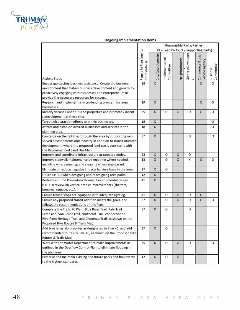
T R U M A N P L A Z A A R E A P L A N48
18 X O O
19 X O O
25 X O O O O O
18 X O
18 X O
37 X O O
23 X O O O13 O O O X O O
37 X O
12 X
41 X
41 X O O O O37 X O O O O O
37 X O O
37 X O
25 X O O O O
12 X O O
Complete the Trails KC Plan: Blue River Trail, Katy Trail Extension, Van Brunt Trail, Northeast Trail, connection to Riverfront Heritage Trail, and Chouteau Trail, as shown on the Proposed Bike Routes & Trails Map.
Actions Steps
Ongoing Implementation Items
Page
# in
Pla
n (s
ee fo
r m
ore
deta
ils)
Responsible Party/Parties (X = Lead Party; O = Supporting Party)
City
/Gov
t Age
ncie
s
Impl
emen
tatio
n Co
mm
ittee
Nei
ghbo
rhoo
dsPr
oper
ty
Ow
ners
/Dev
elop
ers Co
mm
unity
/Soc
ial
Serv
ice
Age
ncy
Busi
ness
Co
mm
unity
Add bike lanes along routes as designated in Bike KC, and add recommended routes to Bike KC, as shown on the Proposed Bike Routes & Trails Map.
Preserve and maintain existing and future parks and boulevards to the highest standards.
Attract and establish desired businesses and services in the planning area.
Encourage existing business assistance. Create the business environment that fosters business development and growth by proactively engaging with businesses and entrepreneurs to provide the necessary resources for success. Research and implement a micro-lending program for area businesses.Identify vacant / underutilized properties and promote / incent redevelopment at these sites. Target job attraction efforts to ethnic businesses.
Eliminate or reduce negative impacts barriers have in the area.
Utilize CPTED when designing and redesigning area parks.
Work with the Water Department to make improvements as outlined in the Overflow Control Plan to eliminate flooding in the plan area.
Perform a Crime Prevention through Environmental Design (CPTED) review on vertical transit improvements (shelters, benches, signage, etc.).
Capitalize on the rail lines through the area by supporting rail-served developments and industry in addition to transit oriented development, where the proposed land use is consistent with the Recommended Land Use Map.Improve and coordinate infrastructure at targeted nodes.Improve sidewalk maintenance by repairing where needed, installing where missing, and cleaning where unpleasant.
Ensure transit stops are equipped with adequate lighting. Ensure any proposed transit addition meets the goals, and follows the recommendations of this Plan.
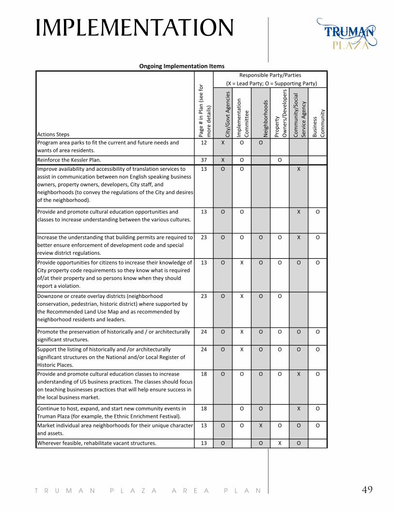
49T R U M A N P L A Z A A R E A P L A N
12 X O O
37 X O O
13 O O X
13 O O X O
23 O O O O X O
13 O X O O O O
23 O X O O
24 O X O O O O
24 O X O O O O
18 O O O O X O
18 O O X O
13 O O X O O O
13 O O X O
Actions Steps
Ongoing Implementation Items
Page
# in
Pla
n (s
ee fo
r m
ore
deta
ils)
Responsible Party/Parties (X = Lead Party; O = Supporting Party)
City
/Gov
t Age
ncie
s
Impl
emen
tatio
n Co
mm
ittee
Nei
ghbo
rhoo
ds
Prop
erty
O
wne
rs/D
evel
oper
s
Com
mun
ity/S
ocia
l Se
rvic
e A
genc
y
Busi
ness
Co
mm
unity
Market individual area neighborhoods for their unique character and assets.
Wherever feasible, rehabilitate vacant structures.
Promote the preservation of historically and / or architecturally significant structures.
Improve availability and accessibility of translation services to assist in communication between non English speaking business owners, property owners, developers, City staff, and neighborhoods (to convey the regulations of the City and desires of the neighborhood).
Provide and promote cultural education opportunities and classes to increase understanding between the various cultures.
Increase the understanding that building permits are required to better ensure enforcement of development code and special review district regulations.
Downzone or create overlay districts (neighborhood conservation, pedestrian, historic district) where supported by the Recommended Land Use Map and as recommended by neighborhood residents and leaders.
Provide opportunities for citizens to increase their knowledge of City property code requirements so they know what is required of/at their property and so persons know when they should report a violation.
Reinforce the Kessler Plan.
Program area parks to fit the current and future needs and wants of area residents.
Support the listing of historically and /or architecturally significant structures on the National and/or Local Register of Historic Places.
Provide and promote cultural education classes to increase understanding of US business practices. The classes should focus on teaching businesses practices that will help ensure success in the local business market.
Continue to host, expand, and start new community events in Truman Plaza (for example, the Ethnic Enrichment Festival).
IMPLEMENTATION

T R U M A N P L A Z A A R E A P L A N50
13, 25 X O O O O O
13 X O O O O O
13 X O O O O O
13 O O X
13 X O O O O
13 O O O O X O
13 X
24 X O O O O
25 X O O O O
25 O X
19 O O O O O X
13 X O O
13 X O O O
13 X O O O O
14 X O O
Actions Steps
Ongoing Implementation Items
Page
# in
Pla
n (s
ee fo
r m
ore
deta
ils)
Responsible Party/Parties (X = Lead Party; O = Supporting Party)
City
/Gov
t Age
ncie
s
Impl
emen
tatio
n Co
mm
ittee
Nei
ghbo
rhoo
ds
Prop
erty
O
wne
rs/D
evel
oper
s
Com
mun
ity/S
ocia
l Se
rvic
e A
genc
y
Busi
ness
Co
mm
unity
Until redeveloped, maintain vacant lots and explore alternative uses such as urban agriculture and storm water retention.
Proactively provide translation, visual documentation (pictures), and referrals to agencies for financial assistance information with notices of code violations.
Implement a neighborhood / CDC program for graffiti removal.
Track neighborhood typology indicators (listed in the Neighborhoods and Housing Chapter) to identify changes in housing and neighborhood livability.
Add a dense, urban single family classification into the Development Code or promote the use of the neighborhood conservation overlay. Implement the ordinance that allows the City to serve as the victim / prosecuting party when illegal activities occur on vacant properties.Apply the concepts of transit-oriented development (TOD) along the primary transit corridors and near future transit stations.
Utilize CIDs to maintain commercial nodes and corridors, remove graffiti, provide security and address other needed activities and services.
Continue to expand the neighborhood / CDC program for mowing vacant lots.
Continue and expand the neighborhood code enforcement program for vacant properties.
Discourage liquor permits for bars, nightclubs, and late-nigh operations; particularly when adjacent to residential neighborhoods.
Increase capacity of area organizations to implement the Plan.
Create a marketing plan for the identified commercial nodes as identified on the Economic Development Map.Teach neighborhoods how to track code violation complaints on the City's website.
Provide and promote cultural education opportunities and classes to increase understanding between the various cultures.
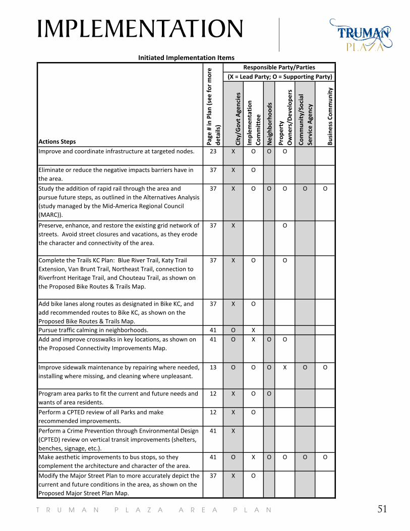
51T R U M A N P L A Z A A R E A P L A N
1
Actions Steps
Improve and coordinate infrastructure at targeted nodes. 23 X O O O
Eliminate or reduce the negative impacts barriers have in the area.
37 X O
Study the addition of rapid rail through the area and pursue future steps, as outlined in the Alternatives Analysis (study managed by the Mid-America Regional Council (MARC)).
37 X O O O O O
Preserve, enhance, and restore the existing grid network of streets. Avoid street closures and vacations, as they erode the character and connectivity of the area.
37 X O
Complete the Trails KC Plan: Blue River Trail, Katy Trail Extension, Van Brunt Trail, Northeast Trail, connection to Riverfront Heritage Trail, and Chouteau Trail, as shown on the Proposed Bike Routes & Trails Map.
37 X O O
Add bike lanes along routes as designated in Bike KC, and add recommended routes to Bike KC, as shown on the Proposed Bike Routes & Trails Map.
37 X O
Pursue traffic calming in neighborhoods. 41 O XAdd and improve crosswalks in key locations, as shown on the Proposed Connectivity Improvements Map.
41 O X O O
Improve sidewalk maintenance by repairing where needed, installing where missing, and cleaning where unpleasant.
13 O O O X O O
Program area parks to fit the current and future needs and wants of area residents.
12 X O O
Perform a CPTED review of all Parks and make recommended improvements.
12 X O
Perform a Crime Prevention through Environmental Design (CPTED) review on vertical transit improvements (shelters, benches, signage, etc.).
41 X
Make aesthetic improvements to bus stops, so they complement the architecture and character of the area.
41 O X O O O O
Modify the Major Street Plan to more accurately depict the current and future conditions in the area, as shown on the Proposed Major Street Plan Map.
37 X O
Initiated Implementation Items
(X = Lead Party; O = Supporting Party)
Page
# in
Pla
n (s
ee fo
r m
ore
deta
ils)
Responsible Party/Parties
City
/Gov
t A
genc
ies
Impl
emen
tati
on
Com
mit
tee
Nei
ghbo
rhoo
ds
Prop
erty
O
wne
rs/D
evel
oper
s
Com
mun
ity/
Soci
al
Serv
ice
Age
ncy
Busi
ness
Com
mun
ity
IMPLEMENTATION
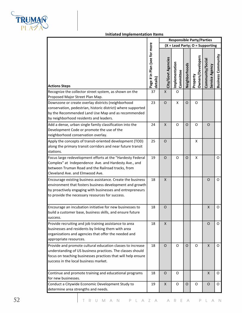
T R U M A N P L A Z A A R E A P L A N52
Actions Steps
Recognize the collector street system, as shown on the Proposed Major Street Plan Map.
37 X O
Downzone or create overlay districts (neighborhood conservation, pedestrian, historic district) where supported by the Recommended Land Use Map and as recommended by neighborhood residents and leaders.
23 O X O O
Add a dense, urban single family classification into the Development Code or promote the use of the neighborhood conservation overlay.
24 X O O O O
Apply the concepts of transit-oriented development (TOD) along the primary transit corridors and near future transit stations.
25 O X
Focus large redevelopment efforts at the "Hardesty Federal Complex" at Independence Ave. and Hardesty Ave., and between Truman Road and the Railroad tracks, from Cleveland Ave. and Elmwood Ave.
19 O O O X O
Encourage existing business assistance. Create the business environment that fosters business development and growth by proactively engaging with businesses and entrepreneurs to provide the necessary resources for success.
18 X O O
Encourage an incubation initiative for new businesses to build a customer base, business skills, and ensure future success.
18 O X O
Provide recruiting and job training assistance to area businesses and residents by linking them with area organizations and agencies that offer the needed and appropriate resources.
18 X O O
Provide and promote cultural education classes to increase understanding of US business practices. The classes should focus on teaching businesses practices that will help ensure success in the local business market.
18 O O O O X O
Continue and promote training and educational programs for new businesses.
18 O O X O
Conduct a Citywide Economic Development Study to determine area strengths and needs.
19 X O O O O O
Initiated Implementation Items
Page
# in
Pla
n (s
ee fo
r m
ore
deta
ils)
Responsible Party/Parties (X = Lead Party; O = Supporting
City
/Gov
t Age
ncie
s
Impl
emen
tati
on
Com
mit
tee
Nei
ghbo
rhoo
ds
Prop
erty
O
wne
rs/D
evel
oper
s
Com
mun
ity/
Soci
al
Serv
ice
Age
ncy
Busi
ness
Com
mun
ity

53T R U M A N P L A Z A A R E A P L A N
Actions Steps
Research and implement a micro-lending program for area businesses.
19 X O O
Encourage funding for and utilization of a façade improvement program.
19 O O O O X
Create a marketing plan for the identified commercial nodes.
13 O O X
Provide and promote cultural education opportunities and classes to increase understanding between the various cultures.
13 O O X O
Increase the understanding that building permits are required to better ensure enforcement of development code and special review district regulations.
23 O O O O X O
Proactively provide translation, visual documentation (pictures), and referrals to agencies for financial assistance information with notices of code violations.
13 X
Make it easier for people to know how to use the bus by increasing the availability of transit related information (maps, schedules, ticket purchasing locations, etc.) and market the recommended improvements.
41 X O
Evaluate the bus service to ensure service is efficient and accommodating.
41 X O O O O
Extend the “Boulevard” designation on Independence from the River Market through the entire plan area.
37 O X O O O O
Market individual area neighborhoods for their unique character and assets.
13 O O X O O O
Initiate actions recommended by neighborhood typology. 16 O X
Teach neighborhoods how to track code violation complaints on the City's website.
13 X O O O O
Provide and promote cultural education opportunities and classes to increase understanding between the various cultures.
13 O O O O X O
Work with the Water Department to make improvements as outlined in the Overflow Control Plan to eliminate flooding in the plan area.
25 X O O O O
Initiated Implementation Items
Page
# in
Pla
n (s
ee fo
r m
ore
deta
ils)
Responsible Party/Parties (X = Lead Party; O = Supporting
City
/Gov
t A
genc
ies
Impl
emen
tati
on
Com
mit
tee
Nei
ghbo
rhoo
ds
Prop
erty
O
wne
rs/D
evel
oper
s
Com
mun
ity/
Soci
al
Serv
ice
Age
ncy
Busi
ness
Com
mun
ity